Embed Size (px)
Citation preview
18
Tennessee Division of Water Resources, Nashville, 1972.
8. W.J. Perry and G.K. Moore. Availability of Water for 1ndustry in Montgomery County. Hydrologic Atlas HA-4. Tennessee Division of Water Resources, Nashville, 1965.
9. T. Aley and M.W. Fletcher. The Water Tracer's
Use of Sinkholes for Drainage
DAVID L. ROYSTER
ABSTRACT
Sink.holes have long been used for drainage in the design and construction of highways. Decisions to use them, however, seem to be based more on expediency than on engineering and scientific analysis. This practice has apparently resulted from the traditional notion that the processes and mechanisms of sinkhole development and proliferation are not totally analyzable and, therefore, not predictable. Although it is true that investigations of sinkholes and sinkhole-prone topography rarely produce absolute and finite data that can be applied in a strict quantitative sense, there are methods of analysis that, when coupled with experience and judgment, can be used with a high degree of success. In general, these analyses require information regarding such factors as geologic s ·tructure (e.g., joint orientation, dicection and angle of d ip) ; depth, direction of flow, and s lope of the groundwater table; thickness and makeup of the regolith; degree of solution development and present level of activity: relief and topographic expression; size of area being drained by the sinkhole; location of known or assumed points of discharge; precipitation and flood levels; well locations and level fluctuations; location and size of swallets; and potential for further residential or commercial development. As with sinkhole problems in general, problems resulting from their use for drainage fall into two categories: those related to subsidence, or collapse, and those related to flooding. Regardless of which of these problems is being considered, the designer must always be alert to the fact that the treatment being applied to one may result in the development of the other. The success of futu.re preventive and corrective measures will depend on more intensive geological and geotechn.ical investigations, as well as more stringent land use restrictions and building codes.
Much has been written about the cause and development of sinkholes and the recognition of flood- and
Transportation Research Record 978
Cookbook. Missouri Speleology, Vol. 16, No. 3, 1976, pp. 1-32.
Publication of this paper sponsored by Committee on Soil and Rock Properties.
collapse-prone sinkhole terrain in relation to highway planning and design, yet v ery little seems to have been published about their treatment. There are Probably several reasons for this, the principa.l one being that most treatments are viewed as tentative or expez imenta.l, and, because scientists and engineers are sometimes reluctant to write about things that are inconclusive or projects that are incomplete, case histories do not get written. A second reason, allied to the first, is that investigations of sinkholes rarely produce absolute and finite data that can be applied in strict quantitative analysis. Treatments, therefore, must be based on exper ience and judgment and a more or less qualitative analysis and evaluation of whatever information is available . Such a practice, in effect, involves "design without numbers," which runs contrary to the precise ana.lytical methods of most scientists and engineers.
In general, sinkhole problems can be placed in two categories: those related to subsidence, or collapse , and those related to flood ing. Regardless of which of these problems is being considered, it mus t always be kept i n mind that the treatment being applied to one problem may result in the development of the other. In other words, the treatment of a collapse problem may prod.uce flooding , and the treatment of a flooding problem may result in subsidence or collapse. It is important, therefore, that the designer be alert to any side effects that might result from a particular design.
Several experiences with both collapse and floodi ng problems associated with highway design and construction are described.
FACTORS TO BE CONSIDERED
Sinkholes have long been used for drainage in the design of highways. Unfortunately, however, little attention has been paid to the side or long-term effects of such practices, especially in areas of continuing commercial or reside ntial development. Furthermore, decisions to use sinkholes have been based more on expediency than on engineering and scientific analysis , apparently because, as indicated previously, sinkholes are not considered totally analyzable. There are several factors, however, that should be evaluated when traversing sinkhole topography, especially when considering the use of sinkholes for drainage. Among these are
Royster
Depth, direction of flow, degree of fluctuation, and slope of the groundwater table;
- Thickness and makeup of the regolith 'overburden) and depth to in-place rock;
- Geologic structure (e.g., joint orientation, direction and angle of dip) ;
- Relief and topographic expression; - Degree of solution development and present
level of activity; - Size of the area being drained by the sinkhole; - Presence and size of swallets; - Potential for further residential or commercial
development; - Location of known or assumed points of dis
charge (e.g., springs, seeps); and - Historical data (i.e., observed floodings,
subsidences or collapses versus amount and intensity of precipitation).
Probably the two most significant of these factors in determining the use of sinkholes for drainage are depth, direction of flow, degree of fluctuation, and slope of the groundwater table and thickness and makeup of the regolith and depth to in-place rock. With this information it is often possible to make a reasonable judgment about subsurface storage capacity and flow-through potential of a particular area.
APPLICATIONS
An example of the importance and application of the aforementioned factors involves the correction of a subsidence problem along TN-76 in Montgomery County, Tennessee.
In August 1975 the paving of a 2 .98-mile, fourlane section of TN-76, for which the grading and drainage had just been completed, was let to contract. The paving was completed in May 1976. By the following spring (1977), a 20-ft section of the southbound lane at Vaughn's Road began to subside (Figure 1). An investigation revealed that an approximate 200-ft section of both lanes had been constructed over a sinkhole that contained at least two swallets. The elevation of the lowest portion of the sink before filling was approximately 498 ft. The elevation of the finished pavement at this point was 518 ft, which meant that the maximum filling of the sink was 20± ft. The easternmost swallet had been left uncovered to accommodate drainage in this area. All drainage from an area of approximately 400,000 ft• was directed to this one swallet.
FIGURE 1 Subsidence caused by piping from water introduced into a sinkhole along TN-76.
19
The subsidence was repaired with a bituminous mix and the lane reopened to traffic. In the spring of 1978, however, the subsidence recurred, which resulted in the closing of the left southbound lane and shoulder area. Soon thereafter a subsurface investigation was initiated. Fifteen borings were made in and around the area of the subsidence and around the perimeter of the sink to determine the type and condition of the fill material, overburden, and in-place rock. Standpipe piezometers were placed in a number of these borings to determine the depth, slope, and fluctuation of the water table.
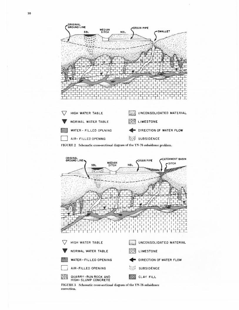
Because of the necessity of getting the project under contract by August, only 3 weeks of readings of water depths were possible. The water table--except for 1 day in which the elevation stood at 428 ft in response to 2.5 in. of rain over a 3-day period--remained steady at elevation 426 ft. The easternmost piezometer generally read 0.2± in. higher than the one installed some 200 ft to the west. This was taken as an indication, supported by the surface contour configuration, that the water table sloped in a northwesterly direction. From this a determination was made that the subsidence was caused by piping from a localized high-water condition that occur red during periods of high and intense precipitation. Most of the water was introduced through the one remaining swallet in the sink area (Figure 2).
The corrective measure involved sealing the swallet and rerouting the surface drainage toward the Red River drainage area northwest of the project (Figure 3). It was theorized that, because any of the rerouted water entering the subsurface would do so on the downslope of the normal water table relative to the roadway and because there were at least 80 ft of "freeboard" between the surface and the normal water table, the localized high-water condition would be eliminated. This, in turn, was expected to eliminate the piping problem. In the 5 years since the completion of the project (constructed at a cost of $91,316) no further problems have developed (Figure 4).
Another example of subsidence resulting from directing surface water into a swallet on the upslope side of the water table occurred approximately 1 mile from the TN-76 and Vaughn Road project. This problem, which has not been corrected, affects the eastbound on-ramp of Interstate 24 at TN-76 (Figure 5). All of the surface water in the southeast quadrant of the interchange is directed into a sinkhole approximately 100 ft south of the on-ramp. Although a subsurface investigation has not been conducted, indications are that the surface water entering the swallet is flowing back under the ramp in a northeastern direction and producing a piping action that is causing the subsidence. The problem will be corrected as soon as funds become available.
Several other subsidence and collapse problems have occurred in and around the I-24 and TN-76 interchange since construction began in 1975. A large portion of the entire interchange lies within the sink area. One of the more serious problems involved one of the piers on the I-24 bridge that carries the westbound lane across TN-76 (Figures 6 and 7). During construction, water collecting around the pile cap following a heavy rainstorm resulted in collapse of the soil around the cap. The collapse was caused by a piping action along the H-piles that penetrated to bedrock. The situation posed no great problem for the pier; problems did, however, involve the falsework that supported the beams and other structural components that were being placed. Bad the collapse enlarged, some of the falsework would definitely have been affected_. The problem was solved by filling and sealing the collapse and by diverting the
20
\} HIGH WATER TABLE lmill . UNCONSOLIDATED MATERIAL
• NORMAL WATER TABLE ~ LIMESTONE
WATER - Fl L LED OPENING + DIRECTION OF WATER FLOW
D AIR- FILLED OPENING ~~:J ,_ SUBSIDENCE
FIGURE 2 Schematic cross-sectional diagram of the TN-76 subsidence problem.
ORIGINAL GROUND LINE
. . .. . ~ · .. ~ . . . . : . . . . .
•. ·.·:; :· ·.: ... . . .
\J HIGH WATER TABLE
• NORMAL WATER TABLE
~ WATER- FILLED OPENING
D AIR-FILLED OPENING
L;;,,,J UNCONSOLIDATED MATERIAL
~ LIMESTONE
+ DIRECTION OF WATER FLOW
rn QUARRY-RUN ROCK AND ~ CLAY FILL HIGH- SLUMP CONCRETE
FIGURE 3 Schematic cross-sectional diagram of the TN-76 subsidence correction.

Royster
FIGURE 4 The corrective measure involved sealing and filling the sinkhole and re-directing the surface water toward the Red River drainage area.
FIGURE 5 Subsidence of the I-24 eastbound on-ramp as viewed in April 1980.
surface water away from the area. This treatment seems to work well where there is a thick soil overburden (50± ft. in this case), where the normal water table is well below the soil-rock interface (25± ft in this example), where the water table does not fluctuate excessively (piezometers instaUed in the problem area indicated variations of no more than 5 ft over a 3-month period), where there are significant voids in the in-place rock caused by the solution of joints and bedding planes (several eorings at the bridge site proved this to be the· case), and where there are no major swallets in the immediate area on the up-slope side of the water table relative to the problem area.
Kemmerly (1), who has done considerable work .in the Montgomery County, Tennessee, area writes: "Na-
21
FIGURE 6 Collapse of soil around a pile cap along westbound I-24 over TN-76 bridge in Montgomery County.
FIGURE 7 Close-up view of the collapsed condition shown in Figure 6.
tural and artificially induced wa\:er-table fluctuations and the alteration of natural drainage patterns art! Lhe major cauoc of sinkhole coll ~PRP." !1,p.20). Th is observation is supported in the writings of Newton <1-il , Williams and Vineyard (2_) , Sowers <&>• Foose and Uumphreville <1>• and Poland (~) as well as in those of various others writing on the subject in recent years.
Although collapse and subsidence usually produce the most dramatic and dev·astating problems caused by water table fluctuations and drainage pattern alterations in karst areas, flooding can also be a problem. Flooding occurs when water flowing into the subsurface exceeds the storage and flow-through capacity of the internal drainage system, or when swallets and caves and other openings to the subsurface become blocked through natural or man-made causes.
Tennessee has experienced a number of flooding problems in recent years due pr imacily to development along highways that traverse karst areas. Sinkholes and caves that have been used for drainage along hig.hway alignments, and that have functioned effectively for many years, frequently reach a point where they can no longer accommodate the additional
22
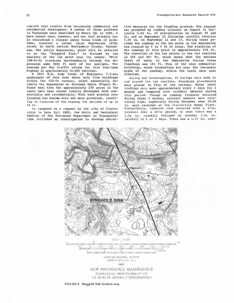
run-off that results from increasing commercial and residential development. A number of these problems in Tennessee were described by Moore (~) in 1980. A more recent case, however, and one that probably can be considered a classic among these kinds o f problems, i nvolves a rather lazge depression (270~ acres) in north central Montgomery County, Tennessee . The entire depression, which will be referred to as the ftRinggold Sink, 8 is drained by two swallets at the low point near its center . TN-12 (US-4 1-Al traverses northwesterly through the depression some 500± ft west of the swallets . The average per day traffic volume for th is four-la ne highway is approximately 30 ,000 vehicles.
A 1957 U.S. Army Corps of Engineers 7.S-min quadrangle of this area shows only five buildings within the 515-ft contour, which essentially delimits the depression or drainage basin (Figur e B) • Since that time the approximately 270 acres in the basin have been almost totally developed both commercially and residentially . With each passing year flooding has become more and more prevalent, resulting in closures of the highway for periods of up to 24 hr.
In response to a request by the city of Clarksville in late fal l 1982, the Soils a nd Geological Section of the Tennessee Department of Transportation initiated an investigation to develop correc-
Transportation Research Record 978
tive measures for the ·flooding problem. The request was prompted by roadway closures on August 31 following 4 .03 in. of precipitation on August 30 and n, and on September 13 following rainfall totaling 3 .26 in. on September 11 and 13. During these periods the roadway at tbe low point in the depression was covered by 4 to 5 ft of water. The elevation 0£ the roadway at this point is approximately 478 ft. Tbe elevation of the low points in the two swallets is 464 and 467 ft , which means that the maximum depth of water in the depression during these floodings was 18± ft. Four of the nine commercial buildings, whose foundations are near the low-point grade of i::he roadway, within the basin were also affected .
During the investigation, 22 borings were made in and around the two swallets. Standpipe piezometers were placed in five of the borings . Water level readings we e ade pproximately every 3 days for 3 months and compared with rainfall amounts during this period. Tbough no roadway closures occurred during these 3 months, rainfall amounts were relatively high, especially during December when 10 .0 6 in. were recorded at the Clarksville Sewer Plant. Historically, closures have occurred with a 4-in. rainfall over a 24-hr period, or when there was a 3.5± in. rainfall followed by another 3.5± in. rainfall in 2 or 3 days. There was a 1.57 in. rain-
SCALE 124 000
1000
CONTOUR INTERVAL 10 FEET DATUM IS MEAN SEA LEVEL
1957
NEW PROVIDENCE QUADRANGLE TENNESSEE-MONTGOMERY CO.
7.5 MINUTE SERIES (TOPOGRAPHIC)
FIGURE 8 Ringgold Sink location map.
Royster
fall on December 3-4, 1.80 in. on December 10, 1.45 in. on December 14, and 0.83 in. on December 15. In addition, 3.96 in. fell between December 24 and 27. (As a comparison, the next closure occurred on May 19, 1983, when 4.6 in. fell in a 24-hr period. This had been preceded by 2.63 in. on May 15-16.) Piezometer readings on December 26, during the rainy period, showed only a 1.5 to 2.0 ft rise in the water table. By December 29, all levels were back to normal. It is possible that during the investigation the overall drainage of the swallets was improved somewhat by the borings and by the clean-out work that was necessary to gain access for the drilling equipment. A number of dead trees, as well as considerable refuse (discarded rubber tires and so forth), were removed in the clean-out operation.
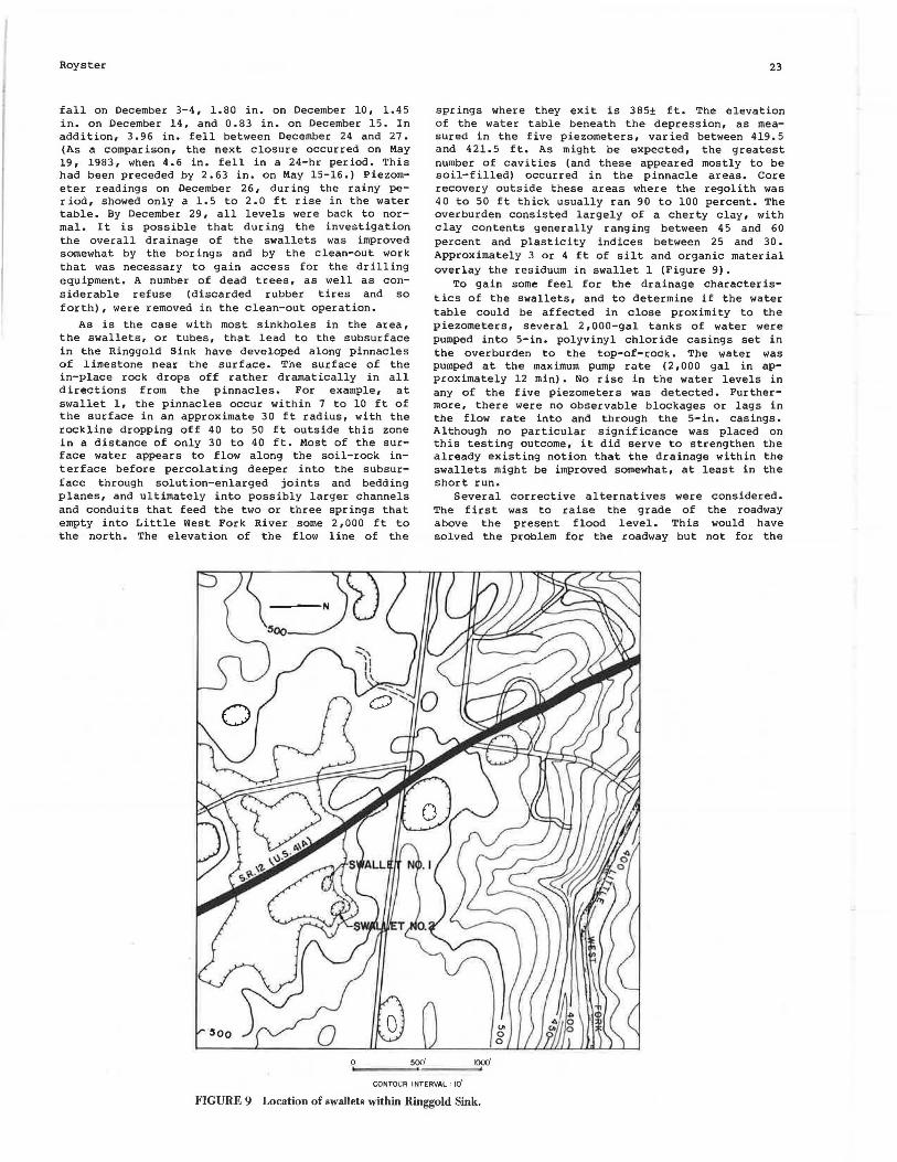
As is the case with most sinkholes in the area, the swallets, or tubes, that lead to the subsurface in the Ringgold Sink have developed along pinnacles of limestone near the surface. The surface of the in-place rock drops off rather dramatically in all directions from the pinnacles. For example, at swallet 1, the pinnacles occur within 7 to 10 ft of the surface in an approximate 30 ft radius, with the rockline dropping off 40 to 50 ft outside this zone in a distance of only 30 to 40 ft. Most of the surface water appears to flow along the soil-rock interface before percolating deeper into the subsurface through solution-enlarged joints and bedding planes, and ultimately into possibly larger channels and conduits that feed the two or three springs that empty into Little West Fork River some 2,000 ft to the north. The elevation of the flow line of the
0 ~oo·
23
springs where they exit is 385± ft. The elevation of the water table beneath the depression, as measured in the five piezometers, varied between 419. 5 and 421.5 ft. As might be expected, the greatest number of cavities (and these appeared mostly to be soil-filled) occurred in the pinnacle areas. Core recovery outside these areas where the regolith was 40 to 50 ft thick usually ran 90 to 100 percent. The overburden consisted largely of a cherty clay, with clay contents generally ranging between 45 and 60 percent and plasticity indices between 25 and 30. Approximately 3 or 4 ft of silt and organic material overlay the residuum in swallet 1 (Figure 9).
To gain some feel for the drainage characteristics of the swallets, and to determine if the water table could be affected in close proximity to the piezometers, several 2, 000-gal tanks of water were pumped into 5-in. polyvinyl chloride casings set in the overburden to the top-of-rock. The water was pumped at the maximum pump rate (2,000 gal in approximately 12 min). No rise in the water levels in any of the five piezometers was detected. Furthermore, there were no observable blockages or lags in the flow rate into and through the 5-in. casings. Although no particular significance was placed on this testing outcome, it did serve to strengthen the already existing notion that the drainage within the swallets might be improved somewhat, at least in the short run.
Several The first above the solved the
1000'
corrective alternatives were considered. was to raise the grade of the roadway present flood level. This would have
problem for the roadway but not for the
CONTO~R INTERVAL' 10'
FIGURE 9 Location of swallets within Ringgold Sink.
24
adjoining commercial establishments. Too, there was a problem of access that could not be reasonably handled. The Hydraulics Office of the Division of Structures considered a pumping station alternative. The pumps would have been activated when flood levels came within 2 or 3 ft of the roadway. The cost of the pumps and installation was estimated to be around $225 ,000. This did not include drainage easements that would have been necessary, nor did it include the cost of maintaining the system. A third alternative involved the excavation of holding ponds. This idea was eliminated, however, because of the limited area for construction, because of pollution problems that would probably develop, and because of the danger of collapse due to piping.
The most obvious alternative considered involved the construction of a storm sewer installed in a cut-and-cover trench, or a combination of cut-andcover and tunneling. The excavation would have extended to a maximum depth of 35 to 40 ft and would have been 2, 000± ft in length. It would have required a 72-in. pipe. The cost of this alternative, excluding drainage easements, which would have been rather substantial, was estimated at around $300,000.
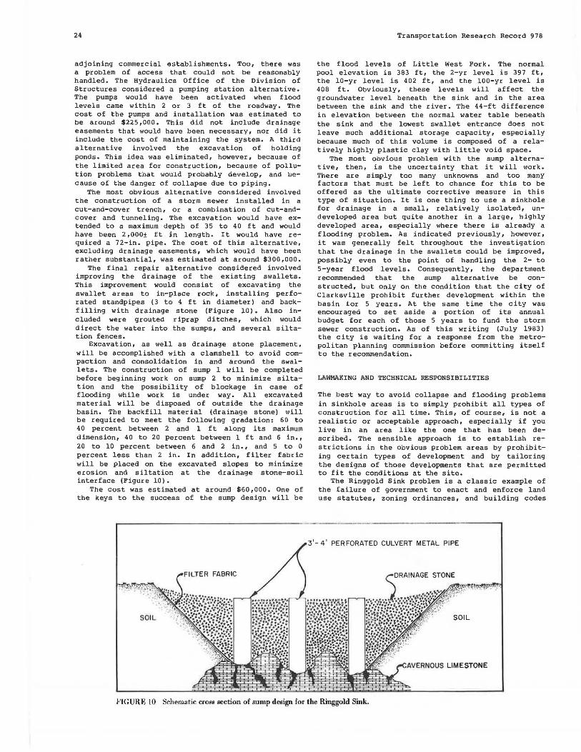
The final repair alternative considered involved improving the drainage of the existing swallets. This improvement would consist of excavating the swallet areas to in-place rock, installing perforated standpipes (3 to 4 ft in diameter) and backfilling with drainage stone (Figure 10). Also included were grouted riprap ditches, which would direct the water into the sumps, and several siltation fences.
Excavation, as well as drainage stone placement, will be accomplished with a clamshell to avoid compaction and consolidation in and around the swallets. The construction of sump 1 will be completed before beginning work on sump 2 to minimize siltation and the possibility of blockage in case of flooding while work is under way. All excavated material will be disposed of outside the drainage basin. The backfill material (drainage stone) will be required to meet the following gradation: 60 to 40 percent between 2 and 1 ft along its maximum dimension, 40 to 20 percent between 1 ft and 6 in., 20 to 10 percent between 6 and 2 in., and 5 to O percent less than 2 in. In addition, filter fabric will be placed on the excavated slopes to minimize erosion and siltation at the drainage stone-soil interface (Figure 10).
The cost was estimated at around $60,000. One of the keys to the success of the sump design will be
Transportation Research Record 978
the flood levels of Little West Fork. The normal pool elevation is 383 ft, the 2-yr level is 397 ft, the 10-yr level is 402 ft, and the 100-yr level is 408 ft. Obviously, these levels will affect the groundwater level beneath the sink and in the area between the sink and the river. The 44-ft difference in elevation between the normal water table beneath the sink and the lowest swallet entrance does not leave much additional storage capacity, especially because much of this volume is composed of a relatively highly plastic clay with little void space.
The most obvious problem with the sump alternative, then, is the uncertainty that it will work. There are simply too many unknowns and too many factors that must be left to chance for this to be offered as the ultimate corrective measure in this type of situation. It is one thing to use a sinkhole for drainage in a small, relatively isolated, undeveloped area but quite another in a large, highly developed area, especially where there is already a f loading problem. As indicated previously, however, it was generally felt throughout the investigation that the drainage in the swallets could be improved, possibly even to the point of handling the 2- to 5-year flood levels. Consequently, the department recommended that the sump alternative be constructed, but only on the condition that the city of Clarksville prohibit further development within the basin for 5 years. At the same time the city was encouraged to set aside a portion of its annual budget for each of those 5 years to fund the storm sewer construction. As of this writing (July 1983) the city is waiting for a response from the metropolitan planning commission before committing itself to the recommendation.
LAWMAKING AND TECHNICAL RESPONSIBILITIES
The best way to avoid collapse and flooding problems in sinkhole areas is to simply prohibit all types of construction for all time. This, of course, is not a realistic or acceptable approach, especially if you live in an area like the one that has been described. The sensible approach is to establish restrictions in the obvious problem areas by prohibiting certain types of development and by tailoring the designs of those developments that are permitted to fit the conditions at the site.
The Ringgold Sink problem is a classic example of the failure of government to enact and enforce land use statutes, zoning ordinances, and building codes
3'- 41
PERFORATED CULVERT METAL PIPE
SOIL
AVEANOUS LIMESTONE
FIGURE 10 Schematic cross section of sump design for the Ringgold Sink.
Royster
relative to geologic hazards. Al though the problems are not generally as catastrophic or serious as are those discussed here, developments in major sinkhole areas must be controlled in much the same way as those in flood plains, those near active geologic faults, those near active volcanoes, and those in avalanche and landslide areas. If the public good is to be served, all levels of government must put politics and special interests aside and make the hard decisions that so often are associated with land use questions, especially where geologic hazards are involved.
Those people with technical responsibilities-geologists, engineers, planners, and architects-must do a better job of communicating their knowledge and understanding of sinkholes to both the lawmakers and the public. They must also improve their own skills and expertise through research and investigation. As stated previously, a great deal of information has been published about the cause and development of sinkholes and the recognition of flood- and collapse-prone terrain in relation to planning and design, yet very little has been published with regard to treatment. Simply identifying a problem or problem area is not enough. Professionals and technologists in both the public and pr iv ate sectors must always take that second step: the development of cost-effective alternatives for solving the problem.
CONCLUSION
Sinkholes have long been used for drainage in the design and construction of highways. Decisions about their use, however, seem to be based more on expediency than on engineering and scientific analysis and planning. Furthermore, little attention is paid to the long-term effects of such practices, especially in areas of continuing residential or commercial development.
Although sinkholes can, and sometimes must, be used for drainage in certain areas and in certain situations, decisions about their use should be based on site-specific geologic and geomorphologic information. To fail to consider such factors (e.g., depth, direction of flow, degree of fluctuation, and slope of the groundwater table; geologic structure; thickness of overburden and depth to in-place rock; relief and topographic expression; degree of solution development and present level of activity) may very often result in future, if not immediate, problems.
In addition to thP. nP.P.d for improvP.d analytic methods in collapse and flood preventive and corrective considerations, governmental lawmaking bodies must assume a greater responsibility for enacting and enforcing zoning ordinances and building codes in sinkhole areas. There are places where total restriction on development is the only answer to collapse or flooding problems. In others, only minimal limitations are all that may be required. In either case, and for all situations in between, such re-
25
strictions can only be instituted by governments-preferably the local government. How responsive they are will depend on the concern of the public and the persuasiveness of the local scientific and engineering community.
ACKNOWLEDGMENTS
Acknowledgments for assistance in the preparation of this paper are due to Department of Transportation employees Ken Brinkley who prepared the illustrations, George Hornal who provided the photographs, and Kay Brown who typed the manuscript.
REFERENCES
1. P.R. Kemmerly. Sinkhole Collapse in Montgomery County, Tennessee. Environmental Geology Series 6. State of Tennessee, Division of Geology, Nashville, 1980.
2 . J .G. Newton. Induced Sinkholes--A Continuing Problem Along Alabama Highways. Publication 121. International Association of Hydrological Sciences, Proc., Anaheim Symposium, Dec. 1976.
3 . J.G. Newton. Induced and Natural Sinkholes in Alabama--A Continuing Problem Along Highway Corridors. In Transportation Research Record 612, TRB, National Research Council, Washington, D.c., 1976, pp. 9-16.
4. J .G. Newton. Induced Sinkholes: An Engineering Problem. Journal of the Irrigation and Drainage Division of ASCE, Vol. 107, No. IR2, June 1981, pp. 175-185.
5 . J .H. Williams and J .D. Vineyard. Geologic Indicators of Catastrophic Collapse in Karst Terrain in Missouri. In Transportation Research Record 612, TRB, National Research Council, Washington, D.c., 1976, pp. 31-37.
6. G.F. Sowers. Mechanisms of Subsidence Due to Underground Openings. In Transportation Research Record 612, TRB, National Research Council, Washington, o.c., 1976, pp. 2-8.
7 . R.M. Foose and J.A. Humphreville. Engineering Geological Approaches to Foundations in the Karst Terrain of the Hershey Valley. Bulletin of the Association of Engineering Geologists, Vol. 16, No. 3, Summer 1979, pp. 355-381.
8 . J.F. Poland. Subsidence in United States Due to Ground-Water Withdrawal. Journal of the Irrigation and Drainage Division of ASCE, Vol. 107, No. IR2, June 1981, pp. 115-135.
9. H.L. Moore. Kar&t Problem& Alon~ Tenne&&ee Hi~hways: An Overview. Proc., 31st Annual Highway Geology Symposium, Austin, Texas, Aug. 1981, pp. 1-28.
Publication of this paper sponsored by Committee on Soil and Rock Properties.