Embed Size (px)
DESCRIPTION
статья
Citation preview
Page 1 of 68
Digital Train Radio System
Bankstown - Mt Lewis (Punchbowl) Site
Review of Environmental Factors
June 2012
Page 2 of 68
Table of Contents
Executive Summary .................................................................................................................... 4
1 Introduction ....................................................................................................................... 6
1.1 Background to the Project ......................................................................................... 6
1.2 Background to Bankstown - Mt Lewis (Punchbowl) Site ........................................... 7
1.3 Location and Land Use.............................................................................................. 8
1.4 Consultation............................................................................................................. 11
2 Statutory Position and Requirements........................................................................... 14
2.1 Environmental Planning and Assessment Act 1979................................................ 14
2.2 State Environmental Planning Policy (Infrastructure) 2007..................................... 15
2.3 Confirmation of Statutory Position ........................................................................... 15
2.4 Other Relevant Environmental Planning Instruments ............................................. 16
2.5 Other NSW Legislation ............................................................................................ 17
2.6 Commonwealth Legislation...................................................................................... 19
2.7 Ecological Sustainable Development ...................................................................... 20
2.8 Other Guidelines...................................................................................................... 21
2.9 Licences and Approvals........................................................................................... 21
3 Description of the Proposed Work................................................................................ 22
3.1 Scope of Proposed Works....................................................................................... 22
3.2 Construction Methodology....................................................................................... 24
3.3 Timing and Costing.................................................................................................. 25
3.4 Alternatives to DTRS ............................................................................................... 26
3.5 Alternatives to the Bankstown - Mt Lewis (Punchbowl) Site ................................... 28
3.6 Justification of the Preferred Option ........................................................................ 30
4 Environmental Impact & Risks ...................................................................................... 31
4.1 Landforms, Geology and Soils ................................................................................ 31
4.2 Water Quality and Hydrology................................................................................... 32
4.3 Air Quality ................................................................................................................ 33
4.4 Biodiversity............................................................................................................... 34
4.5 Noise and Vibration ................................................................................................. 36
4.6 Heritage ................................................................................................................... 38
4.7 Waste....................................................................................................................... 39
4.8 Contaminated Land ................................................................................................. 40
4.9 Hazardous Materials................................................................................................ 42
4.10 Visual Aesthetics and Urban Design ....................................................................... 43
4.11 Land Use.................................................................................................................. 46
Page 3 of 68
4.12 Socio-Economic Effects........................................................................................... 46
4.13 Electromagnetic Energy (EME) ............................................................................... 47
4.14 Traffic and Access ................................................................................................... 48
4.15 Utilities and Services ............................................................................................... 49
4.16 Light spill .................................................................................................................. 49
4.17 Demand on Resources ............................................................................................ 49
4.18 Cumulative Environmental Effects........................................................................... 49
4.19 Consideration of Clause 228 of EP&A Regulations and EPBC Act ........................ 50
4.20 Summary of Control Measures................................................................................ 54
4.21 Implementation Process .......................................................................................... 59
5 References....................................................................................................................... 60
Appendix 1: Principles from the Telecommunication Facilities Guideline ......................... 61
Appendix 2: Design Plans ........................................................................................................ 66
Appendix 3: Database searches .............................................................................................. 67
Extracts from the NSW Wildlife Atlas................................................................................ 67
Flora………….................................................................................................................... 67
Fauna ................................................................................................................................ 67
Aboriginal Heritage Information Management System Report ......................................... 67
Section 170: RailCorp Heritage Register .......................................................................... 67
NSW Heritage Register..................................................................................................... 67
Australian Heritage Database ........................................................................................... 67
EPBC Act 1999 Protected Matters Report........................................................................ 67
Appendix 4: Electro-Magnetic Energy (EME) Reports........................................................... 68
Page 4 of 68
Executive Summary
Need for the Proposal
RailCorp currently operates an analogue train radio system known as MetroNet for operational
communications between signallers and train drivers. This system has reached the end of its
serviceable life and requires replacement.
The New South Wales Government and RailCorp have begun work on the implementation of a
Digital Train Radio System (DTRS) which will replace this analogue system and address a
number of recommendations from the Waterfall Special Commission of Inquiry (WSCOI). The
DTRS will be a secure digital train radio system designed to provide reliable voice and data
communications on a Global Systems Mobile – Railway (GSM-R) platform.
The DTRS will provide 100% radio coverage for approximately 1,455 kilometres of the RailCorp
electrified network as well as 66 tunnels covering approximately 70 kilometres and has an
expected design life of at least 15 years. UGL has been contracted to design and construct the
DTRS.
Proposal Description
The Bankstown - Mt Lewis (Punchbowl) base transceiver station (BTS) will be installed in the
rail corridor adjacent to Punchbowl railway station as part of the DTRS project. It will provide
communications coverage along a 3.42 kilometre section of track for trains travelling between
Lakemba and Bankstown on the Bankstown Line. Construction will take about six weeks.
The proposal will involve the following.
• A 10 metre tall steel monopole with a bored pile foundation. The pole will be hinged
approximately 1200 - 1400 millimetres from the base to assist in the erection of the pole,
but once in place the hinge will be bolted in order to fix the monopole in place.
• Two Yagi antennas mounted onto the monopole whilst the pole is on the ground. Once
erect, the antennas will be situated at a height of 9 metres.
• An aboveground DBS cabinet (approximately 880 millimetres wide, 1000 millimetres long
and 1700 millimetres tall) which contains the DBS baseband control unit, power supply
equipment and fibre interfaces which will be installed on a concrete base slab,
approximately 4.2 metres away from the monopole.
• New isolating transformer (approximately 1200 millimetres wide, 2000 millimetres long and
1500 millimetres tall) for power requirements installed near the existing power supply pole
(approximately 38 metres northeast of the monopole and cabinets).
• Installation of an underground earth grid that comprises a series of copper stakes and
earth wires that form a circuit attached to the earth rod.
Page 5 of 68
• Conduit feeder cables to connect to the new isolating transformer and fibre supply,
installed at a depth of at least 1000 millimetres.
• Other associated and necessary activities to ensure the proper functioning of RailCorp’s
radio communications facility including safe access, signage and bollards for vehicle
protection.
Approval Process
The proposal is being assessed under Part 5 of the Environmental Planning and Assessment
Act 1979 (EP&A Act). Part 5 requires RailCorp to consider the environmental impacts of the
proposal.
This Review of Environmental Factors (REF) has been prepared to address the requirements of
the EP&A Act. It assesses the potential environmental impacts of the proposal within the
context of Clause 228 of the Environmental Planning and Assessment Regulation 2000 and the
Threatened Species Conservation Act 1995 (TSC Act). The requirements of the Commonwealth
Environment Protection and Biodiversity Conservation Act 1999 (EPBC Act) are also
considered.
Environmental Impact Assessment
The benefits of the proposal cannot be achieved without some degree of environmental impact.
The impacts resulting from construction and operation of the radio facility have been assessed
in this REF. This REF concludes that, subject to the implementation of mitigation measures,
potential environmental impacts can be controlled and reduced to acceptable levels and,
therefore, will not compromise the health, diversity and productivity of the environment for the
benefit of future generations.
The main environmental issues relate to construction impacts such as erosion and
sedimentation risks as well as short-term traffic, air quality and noise issues for nearby
receivers. Proposed works will have minor traffic impacts to Urunga Parade. Such impacts will
be managed through the implementation of a traffic management plan.
In the long term, a new monopole will be introduced into the visual landscape. The monopole
and its antennas will not be bulky and will be partially screened by vegetation along the rail
corridor. However, the top of the monopole may be visible to residents along and near Urunga
Parade. Electromagnetic energy (EME) impacts have also been considered and the EME levels
for the proposal will be well within the limits set by the Australian Radiation Protection and
Nuclear Safety Agency (ARPANSA).
Environmental Management
The proposed control measures described at the end of each environmental impact section in
this REF will be incorporated into a Construction Environmental Management Plan (CEMP).
Page 6 of 68
1 Introduction
1.1 Background to the Project
RailCorp currently operates an analogue train radio system known as MetroNet for operational
communications between signallers and train drivers. This system has reached the end of its
serviceable life and requires replacement. The New South Wales Government and RailCorp
have begun work on the implementation of a Digital Train Radio System (DTRS) which will
replace this analogue system and address a number of recommendations from the Waterfall
Special Commission of Inquiry (WSCOI).
The primary objectives of the DTRS project are to:
provide continuous radio coverage 100% radio of RailCorp’s electric network;
replace and improve on the current RailCorp MetroNet communications system;
provide a technology platform for the introduction of an automatic train protection system
(ATP); and
adopt best management and administrative practices while complying with the principles of
ecologically sustainable development.
The DTRS will provide secure and reliable voice and data communications via a Global
Systems Mobile – Railway (GSM-R) platform. It will be used by train controllers, train drivers,
train guards and signallers. The system is designed to allow for growth in both the size of the
network and the number of services using it. It will be compatible with communications systems
used by other users of the network, e.g. freight operators.
The DTRS will provide 100% radio coverage along approximately 1,455 kilometres of the
RailCorp electric network as well as 66 tunnels covering approximately 70 kilometres and has
an expected design life of at least 15 years.
The DTRS will include:
a main switching centre in the Sydney CBD;
a geographically separated back-up switching centre at Homebush;
on-train equipment in approximately 675 train cabs;
approximately 255 base transceiver stations (BTS) as well as other base stations in tunnels;
approximately 65 dispatcher terminal units; and
capability to provide staff with handheld terminals.
The DTRS will provide continuous coverage along the entire RailCorp network for on-train
radios and permit at least 14 simultaneous voice calls from each base station.
Page 7 of 68
DTRS systems are now widely used as a standard by major rail operators in Europe and Asia.
In Australia, GSM-R is being installed on the Melbourne train network by the Victorian
government.
1.2 Background to Bankstown - Mt Lewis (Punchbowl) Site
The proposed base transceiver station (BTS) at Bankstown - Mt Lewis (Punchbowl) is part of
the DTRS that is being developed along the RailCorp’s electrified train lines. The proposal for
Bankstown - Mt Lewis (Punchbowl) is to build a new installation, which aims to provide
coverage along a 3.42 kilometre section of track between Lakemba and Bankstown on the
Bankstown Line.
The Bankstown - Mt Lewis (Punchbowl) BTS is one of 255 radio facilities which will provide
enhanced, efficient and reliable communication.
This REF describes a proposal to construct a BTS at Bankstown - Mt Lewis (Punchbowl),
documents the likely impacts on the environment and details the environmental safeguards
required to address those impacts.
Page 8 of 68
1.3 Location and Land Use
Site Name Bankstown (Mt Lewis)
Street address In the rail corridor, off Urunga Parade, Punchbowl NSW 2196
Property Description Bankstown Line
Bankstown Line Railway Line
Chainage B16+389
Latitude: -33.925250 Site co-ordinates
Longitude: 151.05647
Local Government Area Canterbury City Council
NSW State electorate Lakemba
Catchment Salt Pan Creek
Nearest Railway Station Punchbowl
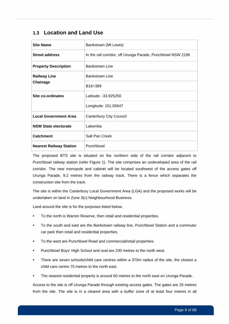
The proposed BTS site is situated on the northern side of the rail corridor adjacent to
Punchbowl railway station (refer Figure 1). The site comprises an undeveloped area of the rail
corridor. The new monopole and cabinet will be located southwest of the access gates off
Urunga Parade, 9.2 metres from the railway track. There is a fence which separates the
construction site from the track.
The site is within the Canterbury Local Government Area (LGA) and the proposed works will be
undertaken on land in Zone 3(c) Neighbourhood Business.
Land around the site is for the purposes listed below.
• To the north is Warren Reserve, then retail and residential properties.
• To the south and east are the Bankstown railway line, Punchbowl Station and a commuter
car park then retail and residential properties.
• To the west are Punchbowl Road and commercial/retail properties.
• Punchbowl Boys’ High School and oval are 230 metres to the north west.
• There are seven schools/child care centres within a 370m radius of the site, the closest a
child care centre 75 metres to the north east.
• The nearest residential property is around 60 metres to the north east on Urunga Parade.
Access to the site is off Urunga Parade through existing access gates. The gates are 25 metres
from the site. The site is in a cleared area with a buffer zone of at least four metres in all
Page 9 of 68
directions between the site and vegetation within the rail corridor. The proposed works will take
place on land that has a slight slope.
The climate in the area is similar to other parts of the Sydney Basin. The Bankstown Airport
weather station is the closest station. The area experiences extremes of climate, having a peak
monthly precipitation of 106.4 millimetres in February and the least rainfall in July with an
average rainfall of 44.6 millimetres. The majority of the annual rainfall occurs in the summer and
early autumn months. The area has a mean annual maximum temperature of 21.3 degrees and
a mean annual minimum of 12.0 degrees.
There are mature trees at the corridor boundary. There are no nearby national parks or other
natural heritage reserves, bushland or heritage sites. Warren Reserve is 15 metres north of the
site, however there are few trees offering little habitat to wildlife. There are no waterways on or
in close proximity of the site.
N
Figure 1 Proposed site and surrounds
© 2011 Google – Image © 2011 Sinclair Knight Merz © 2011 Whereis® Sensis Pty Ltd
Page 10 of 68
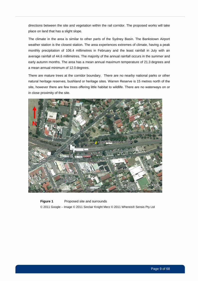
Figure 2 Site location map
Map Section reproduced with permission of UBD.
Copyright Universal Publishers PTY LTD DD 06/11.
Page 11 of 68
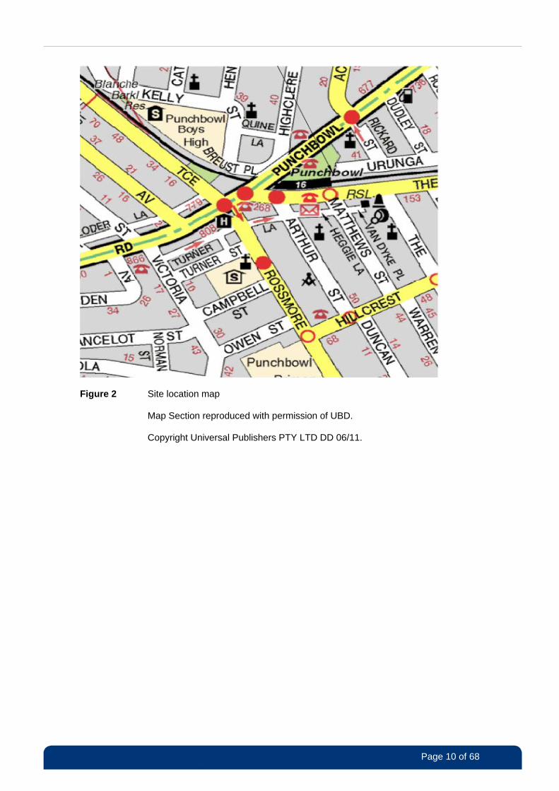
Figure 3 Photo of proposed site looking west along northern side of the rail corridor
1.4 Consultation
The consultation activities for the proposed work are outlined below. These measures will help
ensure stakeholders are informed of the proposal and that RailCorp meets its obligations under
the State Environmental Planning Policy (Infrastructure) 2007 (ISEPP). Consultation activities
and work practices will be undertaken in accordance with community relation protocols and
requirements as per RailCorp’s Communications Management Plan.
Three main consultation activities will take place.
1) Communication with local councils and regulatory authorities
Consultation with the local council and other regulatory authorities is required under the SEPP
(Infrastructure) 2007. This will include notification of and liaison with Canterbury City
Council/other government agencies/utilities is required with regard to temporary work impacts
may have on nearby community (traffic, parks, stormwater etc).
2) Communication with impacted residents and businesses within a 500 metre radius of the site
Consultation with directly impacted residents, nearby schools and other nearby community
facilities is required. A number of consultation activities will be undertaken and are outlined
below.
Page 12 of 68
• Letter: a letter will be sent to all properties within a 500 metre radius, detailing the DTRS
project and the scope of works that will be undertaken for the Bankstown - Mt Lewis
(Punchbowl) BTS site.
• Display of REF: the final REF will be made available at www.railcorp.info before work
begins. Council will also be given a copy and a link to the DTRS section of the RailCorp
website.
• “Face to face” consultation: direct consultation will be undertaken with nearby residents
and they will be given opportunities to discuss the DTRS works.
• Contact hotline: a telephone line will be established for the community to obtain further
information.
Community relations will be specifically be targeted at:
• residents on Urunga Parade, Rosemont Street North, Rickard, Dudley, Matthews, Arthur,
Owen, Campbell, Turner, Hillcrest, Waratah, Henry and Kelly streets; Turner, Heggie and
Quine lanes and Clarke and Breust places;
• residents on Rossmore Avenue between Punchbowl Road and Hillcrest Street;
• residents and businesses on The Boulevard between Punchbowl Road and Robinson
Street South;
• residents on The Broadway between The Boulevard and Hillcrest Street;
• residents and businesses on Punchbowl Road between Waratah and Myall Streets; and
• schools, child care centres and community facilities close to the site.
3) Notification and community relations during construction and commissioning works with Council and nearby community
Additional information about the upcoming work will be provided to the nearby community and
Canterbury City Council five business days before work begins. This information will include
specific detail regarding activities, works hours, traffic control measures and
compound/assembly location.
Communication with the community will take place before and during construction. Activities will
include “face to face” communications with directly affected community members, notifications,
contact phone line and fact sheets.

Page 13 of 68
4) Summary Report
Feedback received during pre-construction consultation will be compiled into a summary report
and taken into consideration. It will then be used, along with the REF, to determine whether the
development should proceed and what, if any, changes need to be made.
Page 14 of 68
2 Statutory Position and Requirements
The description of the proposed works and the associated environmental impacts has been
undertaken in the context of Clause 228 of the Environmental Planning and Assessment
Regulation 2000, the Threatened Species Conservation Act 1995 (TSC Act), and the
(Commonwealth) Environment Protection and Biodiversity Conservation Act 1999 (EPBC Act).
In doing so, this REF helps fulfil the requirements of Section 111 of the Environmental Planning
and Assessment Act 1979 (EP&A Act), that RailCorp must examine and take into account, to
the fullest extent possible, all matters affecting or likely to affect the environment by reason of
the activity. The legislative framework relevant to the proposed works and associated approvals
is set out in the following sections.
2.1 Environmental Planning and Assessment Act 1979
The Environmental Planning and Assessment Act 1979 (EP&A Act) establishes the statutory
framework for planning and environmental assessment in NSW. Implementation of the EP&A
Act is the responsibility of the Minister for Planning and Infrastructure, statutory authorities and
local councils.
The EP&A Act contains three parts which impose requirements for planning approval.
• Part 3A provides for control of ‘major infrastructure and other projects’ that require approval
from the Minister for Planning and Infrastructure.
• Part 4 generally provides for the control of local ‘development that requires development
consent from the local Council’.
• Part 5 provides for the control of ‘activities’ that do not require development consent and
are undertaken or approved by a determining authority.
The applicable approval process is generally determined by reference to the relevant
environmental planning instruments and other controls. These include Local Environmental
Plans (LEPs) and State Environmental Planning Policies (SEPPs). Pursuant to Section 36 of
the EP&A Act there is a general presumption that a SEPP prevails over a LEP in the event of an
inconsistency.
As RailCorp is the determining authority and this site falls under the definition of activities that
do not require consent, the approval of this site will be sought under Part 5 of the EP&A Act.
Page 15 of 68
2.2 State Environmental Planning Policy (Infrastructure) 2007
The State Environmental Planning Policy (Infrastructure) 2007 (ISEPP) provides a consistent
planning regime for infrastructure and the provision of services across NSW, along with
providing for consultation with relevant public authorities during the assessment process.
The ISEPP provides for the development of certain activities for a range of infrastructure types.
The ISEPP indicates whether an activity is permissible with or without consent, and on what
land the activity is permissible.
Section 76 of the EP&A Act states that “if an environmental planning instrument provides that
specified development may be carried out without the need for development consent, a person
may carry the development out, in accordance with the instrument, on land to which the
provision applies.” However environmental assessment of the development may nevertheless
be required under Part 5.
2.3 Confirmation of Statutory Position
Clause 79(1) of the State Environmental Planning Policy (Infrastructure) 2007 (ISEPP) provides:
“Development for the purpose of a railway or rail infrastructure facilities may be
carried out by or on behalf of a public authority without consent on any land.”
The proposal is for the installation of a new base transceiver station (new monopole, antennas
and power and BTS cabinets), which is consistent with the definition of a rail infrastructure
facility under Clause 78, which includes “signalling, train control, communication and security
systems”.
In addition Clause 114(1) provides:
“Development for the purposes of telecommunications facilities (including radio facilities) may
be carried out by a public authority without consent on any land.”
The proposal also meets the definition of a telecommunication facility under Clause 113 of the
ISEPP.
RailCorp is a state-owned operating entity in the transport portfolio. It is classified as a public
authority under Section 4 of the EP&A Act.
Accordingly, this proposal (construction of a new BTS at Bankstown (Mt Lewis)) is being
assessed under Part 5 of the EP&A Act. RailCorp is the proponent and determining authority as
per the provisions of Section 110 of the EP&A Act.
Page 16 of 68
2.4 Other Relevant Environmental Planning Instruments
State Environmental Planning Policy No. 4 Development Without Consent and Miscellaneous Complying Development
The proposal is not classified as “exempt development” or “complying development” under the
provisions of SEPP 4.
State Environmental Planning Policy No. 14 Coastal Wetlands
This policy applies to local government areas outside the Sydney metropolitan area that fronts
the Pacific Ocean and is, therefore, not applicable.
State Environmental Planning Policy No. 19 Bushland in Urban Areas
This SEPP protects and preserves bushland within certain urban areas, as part of the natural
heritage or for recreational, educational and scientific purposes. Canterbury LGA is listed in
Schedule 1 as an area where bushland needs to be preserved. However, the proposed work
will not require the removal of vegetation, so no further consideration of this SEPP is required.
State Environmental Planning Policy No. 26 Littoral Rainforests
This policy applies to local government areas outside the Sydney metropolitan area that front
the Pacific Ocean (the same area which SEPP 14 applies to) and is, therefore, not applicable.
State Environmental Planning Policy No. 44 – Koala Habitat Protection
The proposed site is not located in an area nominated or classified by this SEPP as habitat for
koalas, therefore the proposal is not subject to the provisions of SEPP 44.
State Environmental Planning Policy No. 55 – Remediation of Land
SEPP 55 provides for a consistent state-wide planning approach to the remediation of
contaminated land. The policy states that land must not be developed if it is unsuitable for a
proposed use because it is contaminated. If the land is unsuitable, remediation must take place
before the land is developed. The presence of contamination will be determined during
excavation works, and a suitable remediation plan will be developed, if required.
State Environmental Planning Policy No. 71 – Coastal Protection
The proposed site falls outside the coastal protection zone designated in the Coastal Protection
SEPP, and therefore does not apply.
State Environmental Planning Policy (Major Development) 2005
This SEPP identifies certain developments which are deemed major projects under Part 3A of
the EP&A Act and which are then determined by the Minister for Planning and Infrastructure.
The proposal does not meet the criteria listed in Schedule 1 Section 23 (Rail and related
transport facilities), nor does the proposal meet any of the other requirements listed in
Schedules 2, 3 or 5. This SEPP does not apply to the proposal.
State Environmental Planning Policy (Sydney Drinking Water Catchment) 2011
Page 17 of 68
The proposal is located in the Salt Pan Creek catchment and is not part of a drinking water
catchment. This SEPP does not apply to the proposal.
Canterbury Local Environmental Plan 1994
The proposed site is located within the Canterbury LGA and is subject to the Canterbury Local
Environment Plan – 138, 1994 (Canterbury LEP). The proposed works will be undertaken in the
rail corridor, which is located in Zone 3(c) – Neighbourhood Business.
Development for the purposes of utility installations is permissible in Zone 3(c) – Neighbourhood
Business with consent under the Canterbury LEP.
The State Environmental Planning Policy Infrastructure 2007 (ISEPP) also allows for the
proposal to proceed without development consent (refer section 2.2 and section 2.3 for more
detail).
2.5 Other NSW Legislation
Crown Lands Act 1989
The proposal will not be undertaken on crown land and the provisions of this act are not
applicable.
Electricity Supply Act 1995
The Electricity Supply Act 1995 and Electricity Supply (General) Regulation 2001 sets out
certain notification and procedural requirements in relation to excavation.
Section 63Z provides:
(1) A person must not commence to carry out excavation work to which this section
applies, or authorise such excavation work to be commenced, unless the person has
first:
(a) contacted the designated information provider and requested information as to the
location and type of any underground electricity power lines in the vicinity of the
proposed work, and
(b) complied with any reasonable procedures of the designated information provider as
to the manner of contacting the designated information provider and the information to
be provided by the person in connection with the person’s request for information, and
(c) allowed a reasonable period for the requested information to be provided.
Clause 104B of the Electricity Supply (General) Regulation 2001 provides:
(1) Work of the following kind, that is carried out within the distribution district of a
distribution network service provider, is excavation work to which section 63Z of the Act
applies…
(b) excavation that is, or is carried out in connection with, an activity within the meaning
of Part 5 of the Environmental Planning and Assessment Act 1979.

Page 18 of 68
Consultation with the relevant service provider will occur in accordance with these provisions.
Heritage Act 1977
Section 57(1) of the Heritage Act 1977 lists the types of activities/works that require approval
from the Heritage Office when working on/in an item/place listed on the State Heritage Register.
An application for an exemption can also be made under some circumstances.
The proposal is to be undertaken in an area where no State heritage items are located and
approval under the Heritage Act is not required. More information about heritage is included in
Section 4.6.
National Parks and Wildlife Act 1974
The excavating, moving or exhibiting of Aboriginal objects requires a permit under Section 87 of
the National Parks and Wildlife Act 1974 (NPW Act). The harming or desecration of Aboriginal
objects or places is an offence under Section 86 of the NPW Act. Under Section 90, an
Aboriginal heritage impact permit may be issued in relation to a specified Aboriginal object,
Aboriginal place, land, activity or person or specified types or classes of Aboriginal objects,
Aboriginal places, land, activities or persons.
There are no Aboriginal objects or places known to occur in the immediate vicinity of the
proposed site and no known items or places will be affected by the proposal. Further, the
likelihood of uncovering Aboriginal heritage items is considered low (refer Section 4.6).
Safeguards have been proposed to address circumstances where an unexpected find occurs.
All native birds, reptiles, amphibians and mammals, except the dingo, are protected in NSW
under the NPW Act. The harming of protected fauna is prohibited under the NPW Act, but an
exemption applies in relation to things that are essential to the carrying out of an activity to
which Part 5 of the EP&A Act applies and where the determining authority has complied with
the provisions of that part. Potential impacts to fauna are considered in Section 4.4.
Protection of the Environment Operations Act 1997
In accordance with Section 55 of the Protection of the Environment Operations Act 1997 (POEO
Act), RailCorp holds an Environment Protection Licence (EPL), number 12208. The EPL applies
to the NSW rail network as defined in the Transport Administration Act 1988 for the purposes of
‘railway systems’, which is a scheduled activity under the POEO Act.
Under the provisions of the licence, RailCorp is required to seek a modification to the licence for
certain ‘scheduled’ activities. However, the proposed works are not listed as a scheduled
activity under the POEO Act and, hence, RailCorp is not required to seek a modification to its
licence under the POEO Act. Also, the works associated with the proposal will be confined to
land on which the rail undertaking is currently being carried out. As such, the proposed works
can be undertaken without requiring a variation to the EPL. Notwithstanding, the existing licence
requires that the licensee must comply with Section 120 of the POEO Act with regard to the
pollution of waters and must manage dust-generating activities.
Page 19 of 68
Roads Act 1993
Under Section 138 of the Roads Act 1993, a person must not “erect a structure or carry out a
work in, on or over a public road, or dig up or disturb the surface of a public road...” otherwise
than with the consent of the appropriate roads authority.
No works are proposed on public roads as part of these works therefore consent under the
Roads Act is not required.
Threatened Species Conservation Act 1995
The Threatened Species Conservation Act 1995 (TSC Act) is directed at conserving threatened
species, populations and ecological communities of animals and plants. Threatened species,
populations, endangered ecological communities are not likely to occur at the site and further
consideration under the Act is not required.
2.6 Commonwealth Legislation
Environment Protection and Biodiversity Conservation Act 1999
The primary legislation at the Commonwealth level is the Environment Protection and
Biodiversity Conservation Act 1999 (EPBC Act). Part 3 of the EPBC Act requires approval from
the Commonwealth Minister for Sustainability, Environment, Water, Population and
Communities if a development is likely to have, or will have, a significant effect on a matter of
National Environmental Significance (NES).
For the purposes of the EPBC Act, matters of NES are defined as:
• world heritage properties;
• national heritage places;
• Ramsar wetlands;
• nationally threatened species and ecological communities;
• migratory species;
• commonwealth marine areas; and
• nuclear actions.
There are no matters of national environmental significance that will be affected as a result of
this proposal. No Commonwealth land will be affected, either directly or indirectly, as a result of
this proposal. A summary of EPBC factors is included in Table 4.
Civil Aviation (Building Control) Regulation 1988
The proposed site is within the height restriction zone of Bankstown Airport; however the
monopole is lower than the airport Obstacle Limitation Surface. Therefore CASA approval is not
required.
Page 20 of 68
2.7 Ecologically Sustainable Development
Ecologically sustainable development (ESD) entails using, conserving and enhancing the
community’s environmental resources in a manner that sustains and improves ecological
processes and, hence, the quality of life, for present and future generations. The basis for
achieving ecologically sustainable development involves the application of four principles:
• the precautionary principle;
• intra- and inter-generational equity;
• conservation of biological diversity and ecological integrity; and
• improved valuation and pricing of environmental resources.
RailCorp is committed to ensuring its projects are consistent with the principles of ESD and
these have been considered for this proposal (refer Table 1).
Table 1 Consideration of ESD for the proposal
ESD Principle Application to the proposal
Precautionary principle The site selection and design process aims to avoid areas where there will be a significant environmental impact or impacts that are irreversible. The site selected is within a previously disturbed area in the rail corridor. In addition, some of the potential impacts are reversible as the monopole and cabinets can be removed, if no longer required.
Any adverse impacts associated with the site and construction will be minor and measures to reduce impacts as far as practicable identified within this REF will be implemented during construction.
Intergenerational equity This proposal and the overarching DTRS project will contribute towards RailCorp’s strategic benefits for current and future generations, including safer public transport by improving on the current communications system, providing coverage and reliable communications services to all parts of the electrified rail corridor and acting as the basis for the introduction of an Automatic Train Protection System.
The economic, social and safety considerations of the DTRS have been integrated with the consideration and assessment of potential environmental impacts regarding the development and operation of the DTRS.
Conservation of biological diversity and ecological integrity
The proposed site is on disturbed land that has been previously cleared. There is no major clearing or other disturbance to the biodiversity or ecological significance of the area. The proposed activity is not expected to result in any loss of biodiversity or ecological integrity.
Page 21 of 68
ESD Principle Application to the proposal
Improved valuation and pricing of environmental resources
RailCorp recognises the value of environmental sustainability and will minimise the impacts of its activities by ensuring that appropriate mitigation measures are implemented for all aspects of the DTRS project. The potential environmental costs of the proposal have been considered in conjunction with the costs of design, construction and operation
2.8 Other Guidelines
Consideration of the NSW Telecommunication Facilities Guideline including Broadband NSW
(DoP 2010) is a requirement when Clause 114 or Clause 115 (development of a
telecommunications facility) of the ISEPP is applied. The requirements of the guidelines have
been considered and are included in Appendix 1.
2.9 Licences and Approvals
Responsible Authority Approval/Licence/Permit
RailCorp Determination under Part 5 of the Environmental Planning and Assessment Act 1979
Page 22 of 68
3 Description of the Proposed Work
3.1 Scope of Proposed Works
3.1.1 Summary
The outdoor BTS site at Bankstown - Mt Lewis (Punchbowl) will consist of the following
components:
a 10 metre high monopole;
a 1.5 metre high lightning rod at the apex of the monopole;
two Yagi antennas mounted on the monopole;
a DBS cabinet located on a slab 4.2 metres from the monopole;
power supply cable from a new 25kVA isolating transformer/distribution supply main switch
board (DSMSB) to the northeast of the site fed from the Ausgrid network;
a new low voltage underground power supply cable from the existing metering panel pole to
the new distribution board and BTS location; and
fibre optic cable connection into the existing RailCorp Network Access Point (NAP)
2ATJ0030 (B14+345) located 33m from the site.
These components of the proposal are described in the sections below. Plan drawings of the
proposal are provided in Appendix 2. All aspects of the proposal will be earthed in line with all
relevant standards.
3.1.2 BTS Site
DBS Cabinet
The DBS cabinet will be placed on a concrete slab. The cabinet will be painted stainless steel,
approximately 1700 millimetres high by 1000 millimetres long by 880 millimetres wide, and will
be placed on a stainless steel plinth which will have a minimum height of 200 millimetres to
allow for the management of cables entering the cabinet. The cabinet will contain the internal
DBS equipment which will be connected to an internal -48V supply. DC supplies at this point will
be surge protected and protected by Electromagnetic Interference (EMI) filter. Internal DC
distribution is provided via miniature circuit breakers. Refer to Huawei DBS3900 GSM-R
Product Description documentation for further details of the DBS equipment.
The DBS cabinet will include the following equipment:
DBS equipment (BBU3900);
DC distribution (including EMI filter and surge protection);
Page 23 of 68
transmission interface (Huawei PTN 910);
fibre optic distribution frame;
monitoring and reporting capability of power cabinet conditions; and
field monitoring device for radio frequency coverage. This requires a 12V DC input so is
installed with a 48V to 12V DC power converter. The requirement for a field monitoring
device at this site has yet to be finalised.
Base Band Unit (BBU)
The base station to be used at this site will be a Huawei DBS3900 GSM-R in the S3
configuration (2+1) that comprises of a BBU3900 baseband control unit connected via fibre
optic patch leads to two externally located RRUs mounted on the monopole.
Remote Radio Unit (RRU)
Two DC RRU3004 radio remote units will be mounted externally on the monopole
approximately 14m from ground level. A -48V DC supply will be reticulated to the two RRUs
from the DBS cabinet by individual cables. This 1-sector site configuration requires one 2:2
hybrid combiner and will support up to 4 TRXs (including the redundant TRX) as each RRU
supports 2 TRXs.
Monopole
A 10 metre monopole will be erected approximately four metres to the east of the DBS cabinet
in the rail corridor 9.2 metres from the track. Two Yagi antennas will be mounted nine metres
above the ground with azimuths of 85° and 280°. The antennas will be installed to have a zero
degree tilt, but will be able to be remotely adjusted to different degrees of tilt, without the need
to climb the monopole for such adjustments.
Due to the position of the proposal adjacent to the railway in an area frequently used for access
to the rail corridor, bollards are to be provided around the facility to minimise the risk of
collisions.
3.1.3 Power Supply
The supply to the Bankstown - Mt Lewis (Punchbowl) power cabinet will be via a new 25kVA
isolation transformer/distribution supply main switch board (DSMSB). The DSMSB will be
supplied via an underground cable from an existing Ausgrid metering panel located adjacent to
Urunga Parade. An underground LV cable will run from the isolating transformer to the power
cabinet. The DSMSB is within the new isolating transformer cover, shown in the design
drawings in Appendix 2.

Page 24 of 68
3.1.4 Fibre Optics
The OCDN fibre network is north of the track and the nearest NAP is 2ATJ0030 (B14+345). A
new two duct buried cable route will be provided to the NAP from the DBS site, a distance of 33
metres. Two new fibre optic cables will then be routed from the DBS, one in each new duct, to
the NAP and left ready for splicing into the bearer network.
3.1.5 Earthing
The earthing installation will comprise six earth stakes at a pre-determined distance apart. The
grid will be nominally four by two metres, placing the six earth stakes two metres apart. Once
these earth stakes have been installed, the system will be tested and modified if needed.
The initial extent of the trenching for earthing grid will be around 20 metres. However, it can be
extended if the results show that the earthing arrangement is insufficient.
3.2 Construction Methodology
The construction of the BTS site will require the use of approximately 10 square metres of land
within the northern side of the rail corridor. This area will allow for the erection of the monopole
and the slab containing the DBS cabinet. The area of ground disturbance at the BTS site is
likely to be in the vicinity of five square metres. The monopole foundation will require an
excavation approximately five metres deep with a diameter of approximately one metre. This will
result in approximately four cubic metres of excavated material which may include rock.
Installation of the power and fibre optic cables will require excavation of trenches approximately
1000mm and 500mm wide.
The indicative construction methodology of the proposal will include elements outlined below.
Excavation of the foundation for the monopole using excavator, drills or auger.
Delivery and pouring of concrete on site for the monopole foundation.
Installation of concrete slab brought to site for BTS and power cabinets.
Excavation of trenches for power and fibre optic cables.
Installation of conduit within trenches, followed by installation of cables within conduits.
Transport and installation of monopole sections using trucks, cranes and riggers.
Assembly of monopole and attachment of antenna mounts and cables before erection of
pole using the built in hinge joint.
Connection of power and fibre optic cables to the transformer and communications pit,
respectively, (to be undertaken by RailCorp).
Installation of earth grid using drills, shovels or excavator and connection of the radio facility
to the electrical supply and optical fibre communications cable.
Page 25 of 68
Installation and commissioning of radio equipment, batteries, antennas, cables and other
equipment.
Materials used for construction and installation include concrete, gravel, steel plinth, steel
mounts, antennas, batteries, cables and radio equipment. It is not envisaged that any chemicals
or hazardous materials will be used during construction.
The majority of material brought to the site will remain there once installed. Any excess material
will be removed and disposed of, reused or recycled. Any excess concrete will be removed. The
batteries to be used are sealed, limiting the risk of leaking battery acid. All excavated material
not required for backfilling will be stockpiled, removed from site and disposed of at a licensed
facility or used elsewhere on the site.
The following equipment will potentially be used during construction.
Pile borer
Hi-Abb truck 10T
Trencher (chain digger)
Excavators
Bobcat
Vacuum excavator (Sucker Truck)
Wacker packer
Earth rod drill
Concrete delivery truck
Delivery truck VLC (semi trailer)
Crane where required (sized to suit the
application)
1.5 tonne come-a-long
17 metre sling
Assorted slings and shackles
Assorted large spanners and hand tools
Hydraulic pack and ram
Portable generator (with RCD)
Cable striping tools
Hydraulic hole punch (sized to suit
cable gland)
Crimpers ratchet type
Battery drill
Multimeter
Electrical hand tools
Hand digging tools (shovels etc)
The skip bin and the site compound area will be within the rail corridor near the site. The
construction process will require an average of four to six vehicle movements and a team of
three to six people on site per day.
3.3 Timing and Costing
Construction work for the proposal is planned to begin in the third quarter of 2012 and
scheduled to run for a period of six weeks.
Proposed construction timing:
Page 26 of 68
Standard working hours
Monday to Friday 7.00am to 6.00pm
Saturday 8.00am to 1.00pm
Evening/weekends/out of hours: No out of hours work is expected.
Note: separate approval will be required if works are to take place outside standard hours.
The DTRS project has an overarching value of $225 million. This includes the design, supply,
and installation of the DTRS on the RailCorp electrified network plus a five-year life support
component.
3.4 Alternatives to DTRS
As discussed earlier, the Waterfall Special Commission of Inquiry precipitated the
recommendations regarding communications in NSW rail operations and within RailCorp. The
NSW Government then committed to a state-wide strategy for all rail communications.
RailCorp investigated a number of alternatives already used by the state government or
available commercially, looking for a system that met its own safety and reliability requirements
as well as the recommendations of the Waterfall inquiry.
The government alternatives were the existing MetroNet system or the Government Radio
Network (GRN).
The existing MetroNet communication system was not deemed a feasible solution for the
reasons listed below.
• It uses out dated technology and cannot be expanded due to its limited capacity.
• It does not have the ability to support the requirements of Automatic Train Protection.
• It only has one main supplier and this, combined with obsolete technology, means the cost
of using and maintaining the MetroNet system is increasing at a substantial rate.
• It cannot facilitate a communications platform that can be used by all necessary RailCorp
personnel.
• It could not meet interoperability requirements.
The Department of Commerce’s Government Radio Network (GRN) was not deemed a feasible
solution for the reasons listed below.
• It has to be shared with other NSW Government agencies.
• Priority is given to emergency services which could result in a failure of 100% rail network
coverage.
• The network is both inside and outside the rail corridor.
• GRN would require a substantial upgrade, including new base stations, to ensure 100%
network coverage of the rail corridor.
Page 27 of 68
• The cost of this upgrade is comparable to the development of an entire new network.
The radio communications marketplace responded with three systems: APCO-25, TETRA and
GSM-R.
APCO-25 is a proven standard for emergency services but was rejected for the reasons listed
below.
• It has no proven history of usage in a rail environment.
• It does not support a functional addressing system that maps train run numbers to mobile
subscribers’ numbers, which is a key requirement.
• It does not meet the interoperability requirements.
• It relies on a dispatch terminal for functionality, which does not meet RailCorp’s reliability
requirements.
• It is not scalable in regards to the future growth of the rail network.
TETRA is also a proven emergency services communications system and is deployed in a
number metropolitan rail networks. However, it was rejected for the reasons listed below.
• This application is confined primarily to underground metro networks that are not
comparable to RailCorp’s network.
• It relies on a dispatch terminal for functionality, which does not meet the RailCorp reliability
requirements.
• It does not meet the interoperability requirements.
• There is no commercialised Automatic Train Protection (ATP) solution available.
GSM-R was deemed the platform most suitable for RailCorp’s train network and system
requirements for the reasons listed below.
• It is the only rail-specific communications standard and has the highest levels of safety and
reliability in its design.
• It is an open standard with a large number of equipment suppliers.
• It achieved a higher level of compliance with the RailCorp functional requirements when
compared to the other systems.
• It is deployed by major rail operators in Europe and Asia, some with networks comparable
in size and complexity to RailCorp’s network.
• It operates on a spectrum of 1800 MHz which was available for purchase by RailCorp. The
other options would have required the leasing of a radio spectrum from a
telecommunications licence holder.
• It is a scalable network that can grow in step with RailCorp operations and network.
Page 28 of 68
• It is compatible with the Australian Rail Track Corporation’s communication system.
• It provides a platform for future enhancements and increased operational safety, including
a Level 2 Automatic Train Protection (ATP) System, as per the recommendations of the
Waterfall inquiry.
• It will deliver the best value for money solution with the least risk.
3.5 Alternatives to the Bankstown - Mt Lewis (Punchbowl) Site
The following options were considered for the development of the Bankstown - Mt Lewis
(Punchbowl) proposal.
• To do nothing.
• Install the proposed site further up or down the track.
The do nothing option was rejected for the reasons listed below.
• The inability to meet the requirement of 100% network coverage.
• A ‘black spot’ in the DTRS network, resulting in a significant safety issue in the event of an
emergency call or a train incident.
• The increasing maintenance costs of the MetroNet facility and its limited ability to adequate
operate adequately for the next 10 to 15 years.
Possible locations to the east and west were rejected for the reasons listed below.
• The radio frequency modelling indicated that a DTRS site in an alternative location will not
provide coverage to 100% of the rail corridor.
• An additional DTRS site would be required to ensure 100% network coverage. This would
incur additional costs and, potentially, increase the risk of environmental impacts of the
proposal.
Other infrastructure options were considered, but were not feasible for the proposed facility due
to the reasons listed below.
• The proposed monopole is less obtrusive, requires less space and is cheaper to maintain
than a lattice tower or guyed mast.
• A monopole uses a foundation design that is better suited for the spatial limitations within
the rail corridor, is thinner at the top and less obtrusive than a lattice tower, helping to
minimise visual impacts.
• A monopole can be installed using a hinge mechanism, which removes the need for large
cranes.

Page 29 of 68
• The installation of a walk-in equipment hut would use more space and is more expensive.
Outdoor cabinets are the most suitable solution, given the cost, limited space and
minimisation of environmental impacts.
Page 30 of 68
3.6 Justification of the Preferred Option
It was decided to construct a BTS at this location in Bankstown - Mt Lewis (Punchbowl)
because this site will be consistent with the whole RailCorp DTRS network. Consistent
technology choice will enable RailCorp to improve its existing quality of service, reliability and
emergency responsiveness. The reasons for selecting the technology are discussed above.
The Bankstown - Mt Lewis (Punchbowl) site was selected for the reasons listed below.
It will cover the 3.42 kilometre section of track between Lakemba and Bankstown.
The RF modelling performed identified the selected site as the most suitable location for this
section of track. It also meets the requirement to minimise the number of base transceiver
stations along the network.
The site will not impact on existing RailCorp infrastructure such as overhead and
underground services and will not impact on train drivers line of sight or signalling
equipment.
The site also has a number of trees and other vegetation along the edge of the rail corridor
and this will limit the visual impact of the site on the local community.
The proposed antenna height (approximately 10 metres) is the minimum height required to
provide optimum radio frequency coverage across this section of track.
The site is close to existing fibre and power supply and has good construction and
maintenance access.
Developing the site will not require the removal of vegetation.
The location of this site is necessary for satisfactory handover between adjacent BTS sites due
to the curvature of the rail corridor and any movement may necessitate an additional BTS with
associated costs.
Page 31 of 68
4 Environmental Impact & Risks
4.1 Landforms, Geology and Soils
Existing Situation
The site is within the existing railway corridor approximately nine metres north of the track,
adjacent to Punchbowl Station. The site is in a cleared area with bitumen, gravel and grass
surface cover and an underlying geology comprising Wianamatta Group, Ashfield Shale.
There has been significant disturbance in the area resulting from the establishment of the
railway line, the installation of underground communication cables and the maintenance of the
track. The site is within the Blacktown soil landscape. Limitations of this soil include moderately
reactive highly plastic subsoil, low soil fertility, poor soil drainage.
The site is on a slight slope and there is a drainage line along the edge of the ballast, which is
where surface water may accumulate.
The proposal area is mapped as having a low probability of Acid Sulfate Soil occurrence.
Potential Impacts
Less than 10 square metres of ground will be disturbed during the proposed works. Soil and
rock from the excavation will that is not to be used for backfilling will be placed into skip bins
and removed from the site. The foundation for the monopole will result in approximately five
cubic metres of spoil will be placed into a skip bin and removed from site at the completion of
construction works.
Excavation could result in some erosion if appropriate mitigation measures are not in place.
However, given the relatively small level of disturbance, it is anticipated that erosion risks will be
managed using the standard measures outlined in the Landcom/Department of Housing
Managing Urban Stormwater, Soils and Construction Guidelines (the Blue Book) (Landcom
2004).
No operational impacts are expected.
Possible Control Measures
A site specific erosion and sediment control plan will be prepared as part of CEMP. This plan
will detail appropriate erosion and sedimentation control measures which will be implemented
during the construction phase. The measures will include, but not be limited to, those outlined
below.
All spoil will be transferred directly to skip bins or stockpiled appropriately.
Appropriate stockpiling of materials will take place away from drainage lines, waterways and
drains.

Page 32 of 68
Any soil that may be contaminated or weed infested will be stockpiled separately before
being removed from the site.
Sediment fences and bunds will be installed and inspected regularly.
The tracking of soils on public roads will be prevented by using appropriate shaker
grids/ballast pads.
Soil will be removed from public roads and other paved areas using dry street sweepers or
other measures.
Disturbed areas will be replanted, if required.
During maintenance activities, any spills will be attended to and treated in an appropriate
and timely fashion in accordance with normal RailCorp procedures.
4.2 Water Quality and Hydrology
Existing Situation
The nearest water body is Salt Pan Creek, 1.8 kilometres southwest of the proposed site. It is
part of the Salt Pan Creek catchment which feeds into Georges River. A drainage line for rainfall
is along the ballast of the railway line. The suburban stormwater system is situated along the
main roads and some stormwater drains may be present around the construction footprint in
Urunga Parade. The groundwater is estimated to be more than
10 metres below the surface
Potential Impacts
Without appropriate safeguards, pollutants (e.g. fuel/chemicals from accidental spills and
sediment from excavations and stockpiles) may reach nearby drains and discharge into local
waterways. Fuel/chemicals and increased sedimentation have the potential to harm aquatic life
and affect the quality of water downstream. However, the risk of such an occurrence is low,
given the distance between the construction and drains and creeks.
Rain or groundwater may enter the excavations. If inappropriately managed, this sediment-
laden water could be discharged into local water bodies and/or the nearby stormwater system.
Excavation for the monopole foundations is approximately five metres and the water table is
more than 10 metres below the surface. As a result, it is unlikely that groundwater will be
encountered.
No operational impacts expected. The proposal will not affect the landform or the flow of water
in the area.
Page 33 of 68
Possible Control Measures
During construction water quality impacts will be minimised through a range of control measures
in addition to the erosion and sedimentation controls included in Section 4.1. The water quality
measures may include, but will not be limited to those outlined below.
Ensure construction materials are not left in the vicinity of storm water drains.
Trenches and excavations will be covered to prevent rain water entering.
Plant and equipment will be checked regularly for oil leaks.
Plant and equipment will not be refuelled on site.
Wash down areas will be off site
Liquid waste generated during non-destructive excavation will be removed from the-site for
treatment and disposal.
Groundwater/rainwater in trenches and/or the pit will be disposed of appropriately. The following
options have been identified:
disposal at an appropriate waste facility;
discharge to the public sewer;
discharge to the existing storm water system;
land disposal; and
reuse for vehicle cleaning and wash down.
A water management plan will be prepared before construction begins to determine the most
appropriate method for water disposal.
4.3 Air Quality
Existing Situation
Canterbury City Council’s State of the Environment Report 2009-2010 reported that the regional
air quality in greater metropolitan Sydney area was generally ‘good’. Major sources of air
pollution in the Canterbury LGA are motor vehicles, wood fire heaters and industrial and
commercial activities.
Potential Impacts
Local and regional air quality can be affected during construction by dust, construction vehicle
emissions and odour. Dust may be generated from the disturbance of soils or poorly maintained
stockpile areas, which can affect human health or property. Poorly maintained vehicles could
produce excess emissions.
The works will require energy to power vehicles (e.g. construction, delivery and staff vehicles)
and construction plant. The energy requirements will primarily be in the form of fuel (petrol and
Page 34 of 68
diesel). Fuel use will emit greenhouse gases with about 2.3 to 2.7 kilograms of carbon dioxide
equivalent (CO2-e) emitted per litre of fuel consumed (DEWHA 2008). In addition, indirect and
third party emissions will be generated as a result of energy used to produce materials (for
example steel and concrete) – which is known as ‘embodied energy’.
During operation, electricity will be required to power the facility, but the energy use will form
only a small contribution to RailCorp’s overall greenhouse gas emissions.
Possible Control Measures
Air quality impacts throughout construction will be minimised through a range of control
measures, which may include, but will not be limited to those outlined below.
Plant and equipment will be maintained in accordance with manufacturers’ specifications.
Regular inspection of plant and equipment will be undertaken to ascertain that fitted
emission controls are operating efficiently.
Plant or machinery will not be left idling.
Stockpiles will be maintained and contained appropriately, which could include covering or
regular watering to minimise dust.
Minimal work will be undertaken during high wind periods.
Trucks and train carriages transporting spoil and other waste materials from site will be
covered appropriately.
Disturbed areas will be rehabilitated after construction.
4.4 Biodiversity
Existing Situation
At a national level there are two ecological communities, 20 species of fauna, seven species of
flora and 19 migratory species that may occur in the Canterbury LGA listed as threatened under
the Environment Protection and Biodiversity Act 1999 (EPBC Act). These species or their
habitat may occur in the search area (refer Appendix 3). At a state level there are records of six
threatened fauna species and two threatened flora species listed under the Threatened Species
Conservation Act 1995 (TSC Act) within the search area (refer Appendix 3).
The immediate area around the proposed monopole and cabinets has been cleared previously.
There are a few mature trees both within the rail corridor and in Warren Reserve immediately
north of the site.
There are 83 species that are declared noxious weeds in the Canterbury LGA. Weed control is
enforceable by Canterbury City Council, as the local control authority under the Noxious Weeds
Act 1993.
Potential Impacts
Page 35 of 68
While there are several threatened species known to be present in the Canterbury LGA, the site
is in a disturbed area adjacent to the rail corridor, an area where there is no bushland or dense
vegetation.
The works are not expected to impact on any listed threatened species or endangered
ecological communities (EECs). Given the absence of suitable habitat, it is unlikely that any
threatened fauna species will be present in the area.
As such, the proposed works will not affect, threaten or have a significant impact on any
ecological communities, plants or animals listed under the EPBC Act and/or TSC Act. Referral
to the Commonwealth Minister for Sustainability, Environment, Water, Population and
Communities for further consideration or approval in relation to potential flora and fauna impacts
associated with the works is not considered necessary. Similarly, the preparation of a Species
Impact Statement under NSW legislation to further consider the impacts of the proposal on any
threatened plants or animals is not considered necessary.
Excavation works have the potential to affect nearby trees if roots are damaged during
excavation or equipment collides with trees. The nearest trees are approximately five metres
from some excavation sites, which should be a sufficient distance to avoid adverse impacts.
Once soil has been disturbed there is the potential for the spread of weeds. Noxious weeds are
known to occur in the Canterbury area.
With regards to fauna, the works will not remove vegetation or any other features considered as
potential habitat for fauna (threatened or otherwise). Animals could potentially fall into an open
trench and become trapped or injured. Trenches/excavations will be covered at the end of each
day, and inspected before they are backfilled to ensure that no fauna species are harmed.
No operational impacts are expected.
Possible Control Measures
Impacts to flora and fauna throughout construction will be minimised through a range of control
measures, which may include, but will not be limited to those outlined below.
• No trees will be removed.
• Care will be taken not to damage the existing trees and tree roots.
• Care will be taken to minimise the spread of weeds. Appropriate management and disposal
of any noxious weeds, will be undertaken in consultation with Canterbury City Council.
• The work site will be inspected for any trapped or injured fauna at the start of each day.
• Trenches/excavations will be covered at the end of each day and inspected before they are
backfilled.
Page 36 of 68
4.5 Noise and Vibration
Existing Situation
The adjacent railway line, Punchbowl Road, The Boulevard and local traffic are the major
sources of noise in the area.
The closest receivers to the site are residences around 60 metres away on Urunga Parade.
Construction Noise
The Interim Construction Noise Guideline (ICNG) (DECC 2009) defines noise management
levels (measured in decibels) for residential receivers and other types of receivers including
commercial, retail and schools.
The ICNG states:
• that where the predicted or measured noise level is greater than the noise management
level, the proponent should apply all feasible and reasonable work practices to meet the
noise affected level;
• that the proponent should also inform all potentially affected residents of the nature of
works to be carried out, the expected noise levels and duration, and contact details; and
• that for works above the highly affected noise criteria respite periods may be required, and
for works outside standard hours there needs to be a strong justification and negotiation
with the community (DECC 2009).
Noise is likely to be created by construction trucks, machinery and, in particular, boring activities
required to establish the foundations for the monopole. These activities will be of a short
duration.
Construction is expected to take between four and six weeks and all works will be undertaken
during standard working hours. Given this, background noise monitoring and the establishment
of noise management levels for residential receivers is not proposed. The ICNG does, however,
prescribe a highly noise affected criteria of 75 dBA LAeq, 15min, which is the point where there may
be strong community reaction to noise. Given the offset distance and the natural vegetation
barrier, it is unlikely that dwellings, commercial premises or schools will experience a noise level
above the highly affected level of 75 dBA LAeq, 15min during the noisiest works.
A range of standard construction noise mitigation measures is proposed to minimise noise (refer
Table 2), and the community will be notified and provided with details of the works before
construction begins.
Page 37 of 68
Construction Vibration
Vibration effects from the operation of heavy machinery, such as vibratory rollers or large earth
moving equipment have the potential to cause structural disturbance or discomfort. The
proposed work will not require the use of vibration causing heavy machinery.
Discomfort effects are not expected given the types of machinery required for construction
works. Similarly, structural damage to buildings is not expected as the nearest buildings are
adjacent to the railway and already experience vibration from trains on a regular basis.
Operational Noise and Vibration
No operational impacts are expected.
Possible Control Measures
Construction works will adopt Best Management Practice (BMP) and Best Available Technology
Economically Achievable (BATEA) practices as addressed in the ICNG (DECC 2009).
In addition to the control measures listed in Table 2, the community will be notified of the works,
duration and provided with contact details before work begins. Any noise complaints received
will be addressed by the Project Manager as soon as possible.
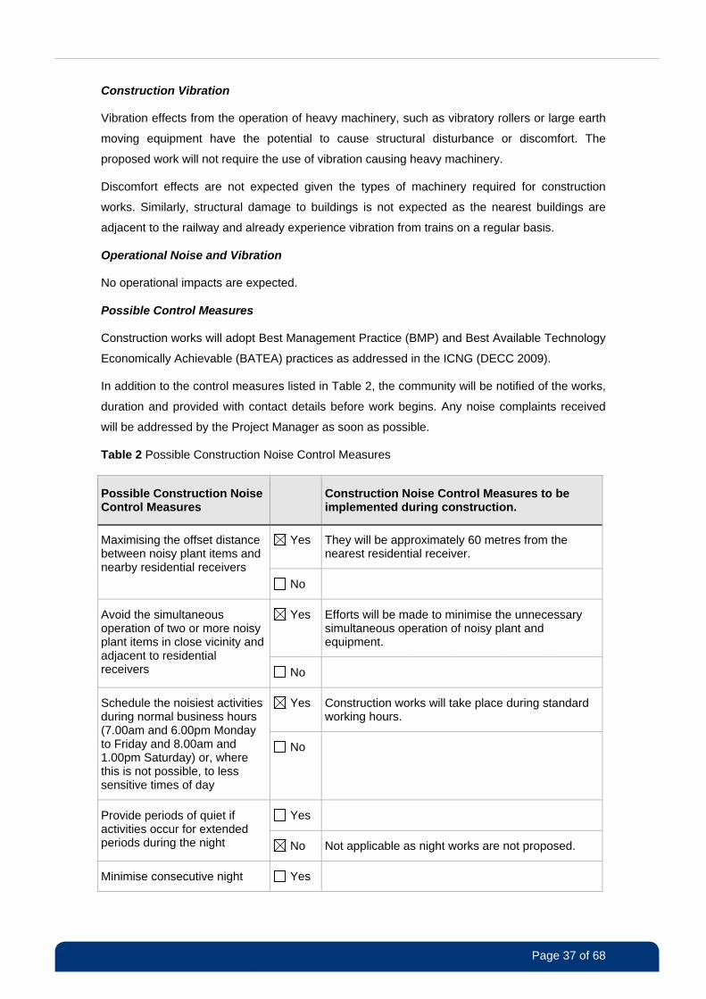
Table 2 Possible Construction Noise Control Measures
Possible Construction Noise Control Measures
Construction Noise Control Measures to be implemented during construction.
Yes They will be approximately 60 metres from the nearest residential receiver.
Maximising the offset distance between noisy plant items and nearby residential receivers
No
Yes Efforts will be made to minimise the unnecessary simultaneous operation of noisy plant and equipment.
Avoid the simultaneous operation of two or more noisy plant items in close vicinity and adjacent to residential receivers No
Yes Construction works will take place during standard working hours.
Schedule the noisiest activities during normal business hours (7.00am and 6.00pm Monday to Friday and 8.00am and 1.00pm Saturday) or, where this is not possible, to less sensitive times of day
No
Yes Provide periods of quiet if activities occur for extended periods during the night No Not applicable as night works are not proposed.
Minimise consecutive night Yes
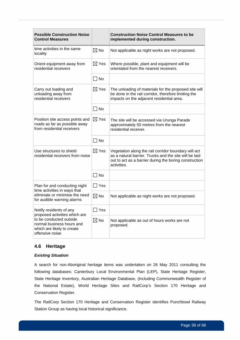
Page 38 of 68
Possible Construction Noise Control Measures
Construction Noise Control Measures to be implemented during construction.
time activities in the same locality
No Not applicable as night works are not proposed.
Yes Where possible, plant and equipment will be orientated from the nearest receivers.
Orient equipment away from residential receivers
No
Yes The unloading of materials for the proposed site will be done in the rail corridor, therefore limiting the impacts on the adjacent residential area.
Carry out loading and unloading away from residential receivers
No
Yes The site will be accessed via Urunga Parade approximately 50 metres from the nearest residential receiver.
Position site access points and roads as far as possible away from residential receivers
No
Yes Vegetation along the rail corridor boundary will act as a natural barrier. Trucks and the site will be laid out to act as a barrier during the boring construction activities.
Use structures to shield residential receivers from noise
No
Yes Plan for and conducting night time activities in ways that eliminate or minimise the need for audible warning alarms
No Not applicable as night works are not proposed.
Yes Notify residents of any proposed activities which are to be conducted outside normal business hours and which are likely to create offensive noise
No Not applicable as out of hours works are not proposed.
4.6 Heritage
Existing Situation
A search for non-Aboriginal heritage items was undertaken on 26 May 2011 consulting the
following databases: Canterbury Local Environmental Plan (LEP), State Heritage Register,
State Heritage Inventory, Australian Heritage Database, (including Commonwealth Register of
the National Estate), World Heritage Sites and RailCorp’s Section 170 Heritage and
Conservation Register.
The RailCorp Section 170 Heritage and Conservation Register identifies Punchbowl Railway
Station Group as having local historical significance.
Page 39 of 68
A search for known items of Aboriginal heritage value was undertaken for the proposal site,
(with a 50 metre buffer) on 26 May 2011 using the Office of Environment and Heritage’s
Aboriginal Heritage Information Management System (AHIMS). No Aboriginal sites or places
were found at the proposal location or in the surrounds (refer Appendix 3).
Potential Impacts
The works are unlikely to impact on any known items or places of non-Aboriginal heritage value.
All works will be undertaken away from known items. No permits or approvals will be required.
The construction works will not impact any known items of Aboriginal heritage significance.
The potential to uncover unidentified Aboriginal heritage items is low. The site is in an area that
has been disturbed previously. However, there is some potential for previously unidentified
items to be uncovered during construction.
Possible Control Measures
Impacts to heritage throughout construction will be minimised through a range of control
measures, which may include, but will not be limited to those outlined below.
If a non-Aboriginal historical relic is discovered, all work likely to affect it will cease and the
Project Manager will be contacted. RailCorp heritage staff and the NSW Heritage Branch
(formerly Heritage Office) in the Office of Environment and Heritage will be notified as
required. An investigation will be undertaken by a suitably qualified archaeologist to identify
suitable measures to reduce the impact on the relic discovered, before work resumes.
Should Aboriginal heritage items be uncovered, all work in the vicinity will cease and the
Project Manager and RailCorp heritage staff will be notified immediately. The Manager of
the Planning and Aboriginal Heritage Section, Metropolitan Branch, Environment Protection
and Regulation Division, Office of Environment and Heritage (OEH) will be notified in
accordance with Section 89A of the National Parks and Wildlife Act 1974. The Local
Aboriginal Land Council will be notified and an assessment by an archaeologist will be
arranged to determine the significance of the objects and any other requirements before
work resumes.
4.7 Waste
Existing Situation
RailCorp is required to manage waste in accordance with the Waste Avoidance and Resource
Recovery Act 2001 (WARR Act). The waste hierarchy (Avoid, Reuse, Recycle, Energy
Recovery and Disposal) should be followed for all projects. No current waste has been identified
on site.
Potential Impact
The main waste streams that may be generated during construction include:
Page 40 of 68
spoil from excavation;
asphalt;
vegetation;
packaging;
general litter including glass, plastic, metal and paper waste;
wiring; and
groundwater (if encountered during excavation)
No operational impacts are expected.
Possible Control Measures
A waste management plan will be prepared as part of CEMP to detail waste types and
quantities as well as methods for segregation, handling, storing and disposal. Furthermore,
waste impacts will be minimised through a range of control measures, (consistent with the
WARR Act) which may include, but not be limited to, those outlined below.
All waste will be classified in accordance with the Waste Classification Guidelines (DECCW
2009) and transported to a place that can lawfully accept the waste.
Any material that may be classified as a hazardous waste will be dealt appropriately and in
accordance with RailCorp procedures.
Packaging will be minimised, where possible and where the safety and delivery of services
is not compromised.
Wherever possible, suitable excavated spoil will be reused on site for backfilling,
landscaping and other purposes.
Any spoil or waste material tracked onto roads will be swept up immediately.
Adequate numbers of bins and waste containers will be placed at the site. The site
manager will ensure bins are not overflowing and are appropriately covered.
Waste water generated by non-destructive excavation will be taken off site for treatment
and disposal.
All waste will be removed from the site when work is completed.
4.8 Contaminated Land
Existing Situation
The site has been investigated for potential land contamination. The investigation included:
a visual inspection for signs of potential land contamination;
Page 41 of 68
a search of OEH register of contaminated sites;
a search of RailCorp records; and
a review of all materials to be used at the site to establish their potential for land
contamination.
The initial investigation did not find any signs of potential land contamination, other than those
typically associated with rail corridors. There are no visible and/or obvious signs of
contamination in the vicinity of the site. No waste dumping, soil discoloration, odours and/or
similar were noticed.
RailCorp does not have any record or evidence that the site can be contaminated. The closest
site subject to an EPA notice is approximately 2.2km north-northeast of the site and it is
considered highly unlikely that it will impact the subject site.
Hazardous materials will not be used during construction and operation and, therefore, the
proposed work will not result in any new site contamination.
Potential Impact
It is highly unlikely that the site can be contaminated by known activities or by contaminants
migrating from the known contaminated site.
However, the limited investigation cannot exclude potential contamination as the result of
unknown past activities, either on the site or in the vicinity. There is a risk that contaminants
could be encountered during the proposed work. If encountered, contaminants may pose a risk
to the health of workers and the environment in general.
Risk Management and Possible Controls
The risk of encountering unknown contaminants during excavation will be managed in
accordance with RailCorp procedures (see References), the Environmental Management Plan
for DTRS project and land contamination legislation.
The impact of potential contaminants will be minimised through a range of control measures
including, but not limited to, those outlined below.
During excavation, site workers will look for signs of potential contamination such as the
presence of waste and/or other imported materials, odours, soil colouring, floating
layers in groundwater etc.
If any contamination is encountered or suspected, work will stop immediately and the
site will be fenced off.
Any potential contamination will be investigated and work resumed only after approval
from HSE Manager is obtained.
A remedial action plan (RAP) will be prepared before clean up operations begin.
The site will be validated before work begins.
Page 42 of 68
Contaminated soil will be segregated in a special container before classification and
disposal.
The CEMP will further detail the proposed control measures.
4.9 Hazardous Materials
Existing Situation
Construction, operation and maintenance of the proposed facility will not require the use of any
chemicals and/or hazardous materials. However, if required for any unforeseen reason, a
hazardous waste management plan will have to be prepared. The plan will detail terms applying
to the purchase, storage, use, handling and disposal of such materials.
Potential Impact
If not properly used, chemicals may present a risk to the safety of workers and the environment
in general.
Safe use of chemicals is regulated and subject to numerous standards, including a need for a
dangerous goods licence.
Possible Control Measures
The impact of any hazardous materials will be minimised through a range of control measures
including, but not limited to, those outlined below.
Hazardous materials will be properly classified and managed in accordance with
requirements for their particular class.
An evaluation of alternative materials will be undertaken before any use of chemicals is
approved.
Hazardous materials will be transported, stored and used in accordance with the
corresponding material safety data sheets which will be available on the site.
Hazardous materials will be stored in a locked and bunded area at the site;
incompatible chemicals will not be stored together.
No fuels will be stored on site. Any refuelling will be undertaken at off-site facilities.
Adequate spill prevention, containment and response measures (e.g. drip trays) will be
provided on site if needed.
Construction personnel will be trained in spill containment and response procedures.
All storage and handling equipment on site will be maintained properly.
The site CEMP will further detail these measures, should they be required.
Page 43 of 68
4.10 Visual Aesthetics and Urban Design
Existing Situation
The visual landscape surrounding the proposed site includes Punchbowl Station, Bankstown
railway line and associated overtrack power lines. There is vegetation lining the fence of the rail
corridor.
There are dwellings north east of the proposal site along Urunga Parade. However, their views
of the railway are screened by existing vegetation. A commuter car park is south of the station
and Warren Reserve is north of the site.
Potential Impacts
During construction the visual environment will be altered temporarily through the presence of
work buildings, plant and equipment, such as cranes and trucks.
When the site is operational, a new 10 metre high monopole will be partially visible from Urunga
Parade and Warren Reserve. The 1.7 metre high cabinets and isolating transformer will be
screened from Urunga Parade.
Both the visual sensitivity and magnitude of the monopole have been considered. Figure 4 and
Figure 5 show how the monopole will look.
Visual sensitivity relates to the number of people who are likely to see the facility and their
possible expectations of visual quality. For example, commercial properties are generally
considered less sensitive than private residences. The site is in an area of moderate sensitivity
given the close proximity to residential receivers, relatively few of whom will have direct views of
the monopole. Most of these receivers are shielded by vegetation and, depending on the
viewing angle, only the top section of the pole will be visible.
The visual magnitude is derived from the scale and level of visual contrast between the
proposed facility and existing visual environment. The new steel monopole will be approximately
10 metres high. It is not a bulky structure and is consistent with elements of the existing visual
environment, such as the overhead cables and other communications poles in the area and
around the railway line. The new monopole will not be a dominant part of the visual landscape.
Visual impact is then generally determined by reference to both visual sensitivity and visual
magnitude. Various combinations of visual sensitivity and visual magnitude produce low,
moderate and high levels of impact. For this proposal the sensitivity of the area is moderate
given the presence of residential receivers; however the magnitude of the impact area will be
low given the existing visual environment and presence of vegetation screening. The overall
impact is considered to be low-moderate.
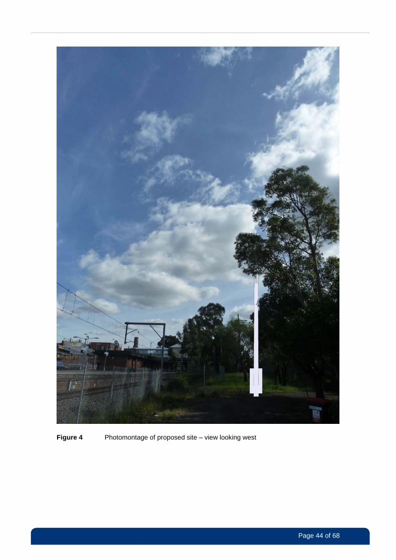
Page 44 of 68
Figure 4 Photomontage of proposed site – view looking west
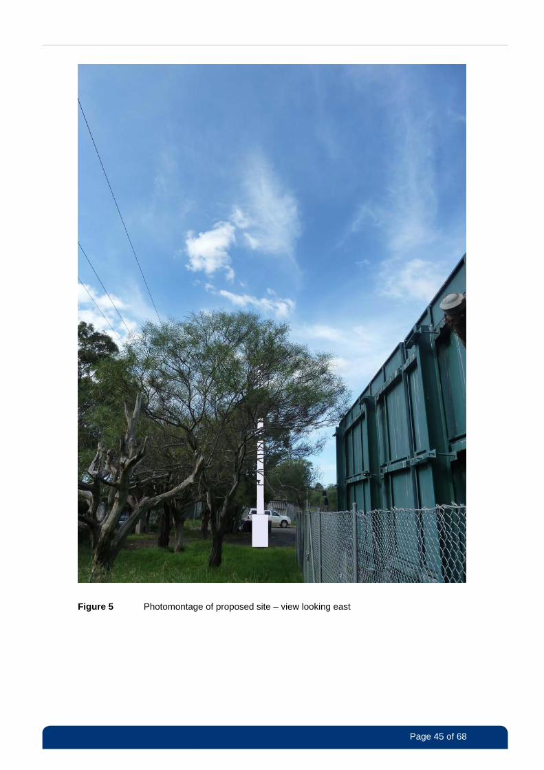
Page 45 of 68
Figure 5 Photomontage of proposed site – view looking east
Page 46 of 68
Possible Control Measures
Visual impact will be minimised through a range of control measures, which may include, but will
not be limited to those outlined below.
The construction site will be kept tidy and rubbish free.
The site will be rehabilitated as soon as possible.
On completion of work, all vehicles, materials and refuse relating to the works will be
removed.
4.11 Land Use
Existing Situation
The proposed site is on land owned by RailCorp within the rail corridor adjacent to Punchbowl
railway station. A reserve is immediately north of the site and the surrounding area generally
consists of residential and commercial/retail properties. Punchbowl Boys High School and
playing fields are 230 metres north west of the site.
Potential Impacts
The proposal will not affect or alter the current use of the site or the immediate surrounding area
as a rail corridor. The proposal will not have any effects on the use of the neighbouring
properties.
Possible Control Measures
No specific control measures are required.
4.12 Socio-Economic Effects
Existing Situation
The proposed site is in the Canterbury LGA which, in the 2006 census, had a population of
around 135,000 with 51.3% of the population born overseas. The suburb of Punchbowl is
mostly a residential suburb with some commercial and retail properties along major roads.
Residential dwellings are approximately 90 metres away along Urunga Parade and other
surrounding streets. The closest residential receiver is 65 metres away from the proposed site.
Warren Reserve is immediately north of the site and a childcare centre is 75 metres away
adjacent to the reserve.
Potential Impacts
Social and economic considerations typically focus on the effect on the local community as a
whole, and on any local businesses. Amenity issues such as noise, visual impacts and traffic
are some of the key areas that can affect the community and are discussed in detail in Sections
4.10 and 4.14.
Page 47 of 68
The nearest residential receivers are 65 metres from the proposed site and may be temporarily
affected by noise. There will be some minor traffic impacts due to trucks accessing the site;
however, access to driveways for dwellings on Urunga Parade will be maintained. The work will
not affect any other known community services, including Warren Reserve.
As works will occur during normal construction hours, no additional track possessions are
required, so there will be no additional interruptions to train services as a result of the work.
The site will be appropriately fenced off during construction. When operational, the facility will
behind an existing fencing and will not pose a risk to public safety.
There will be positive long-term effects resulting from the proposal, as the new DTRS will
provide a more effective communication service and improve the safety of the rail network.
There may be minor short-term positive impacts for the surrounding area as a result of the need
for materials, transport, food, services and accommodation.
The DTRS project has a capital value of approximately $225 million and will generate over 100
jobs over the life of the project.
Possible Control Measures
In addition to the control measures proposed in the noise, traffic and visual sections, other
control measures are outlined below.
Nearby residents and businesses will be informed about the nature and timing of works.
If any out of hours works is required, surrounding receivers will be notified at least five
days in advance.
Signage will notify the public about the works.
Appropriate fencing around the site will help maintain public safety during construction.
4.13 Electromagnetic Energy (EME)
Existing Situation
Electromagnetic energy (EME) is the energy stored in an electromagnetic field. Radio frequency
EME refers to the EME generated by radio waves. EME is a factor of everyday life and is
emitted by natural sources such as the sun and earth and by man-made sources operating on
radio waves, e.g. TV and radio broadcasts, baby monitors, model planes, mobile phone base
stations and radio communication facilities.
The Australian Radiation Protections and Nuclear Safety Agency (ARPANSA) has established a
radiation protection standard specifying limits for continuous exposure of the general public and
occupational workers to radio frequency emissions.
Page 48 of 68
Potential Impacts
EME levels emitted by the new BTS have been estimated at 1.5 metres above ground level at
various distances from the proposed antennas. It should be noted that the actual EME levels
will be significantly less than predicted due to path losses and that the BTS automatically
minimises transmitter power to serve only established phone calls. The maximum cumulative
EME level at 1.5 metres above the ground is estimated to be 0.0066% of the ARPANSA
exposure limits. EME impacts are unlikely when the facility is operational. The ARPANSA report
is included at Appendix 4.
Possible Control Measures
The BTS will be in RailCorp land in an area which is not accessible by the public and has been
designed so that it cannot be climbed. However, the following control measures are also
recommended to minimise and health and safety risks.
• Appropriate signage is placed around the site to warn people of the potential hazards.
• All people required to work around occupationally hazardous radio frequencies will undergo
RadHaz training.
4.14 Traffic and Access
Existing Situation
Access to the proposed site will be through an existing RailCorp gate, off Urunga Parade.
Urunga Parade is a local residential cul-de-sac with one lane of traffic flowing in each direction.
Potential Impacts
During construction, there will be an increased number of vehicles using local streets. However,
the anticipated volume of traffic is relatively small (approximately four to six truck movements
per day) when compared to the existing volumes of traffic. The 2002 annual average daily traffic
volume for Punchbowl Road at the intersection Bankstown railway line (which is close to the
proposal) was around 25,461 vehicles per day (RTA 2003).
There will be some traffic movement associated with maintenance vehicles that will need
access to the facility when it is operational. This will be via the access gate off Urunga Parade.
However, the volume of traffic will be very small and will not adversely impact the surrounding
road network. It is expected that the monopole and antennas will be accessed via an elevated
work platform, or a ladder and dual lanyard system.
Possible Control Measures
Impacts associated with traffic and access will be minimised through a range of control
measures, which may include, but will not be limited to those outlined below.
• UGL will notify Canterbury City Council of works within or adjacent to roadways and comply
with any traffic control requirements.
Page 49 of 68
• All pavement and road surfaces damaged during construction will be restored when work is
finished.
• The Traffic Management Plan will ensure compliance with Australian Standard AS1742.3-
2002 Manual of uniform traffic control devices – traffic control devices on roads.
4.15 Utilities and Services
Existing Situation
There are high voltage overhead power lines that run adjacent to the site and across the site
access track.
Potential Impacts
The facility will be connected to the existing fibre supply and to the Ausgrid electricity supply.
The facility will not require connections to water or gas. RailCorp has an existing metered power
supply and will continue to use this existing supply.
A number of public utilities are close to the site and there is potential for some known or
unknown services to be impacted during excavation or relocation/connections. Depending on
the service, outages or interruptions could affect nearby properties or the rail network.
No overhead wires will need to be relocated.
Possible Control Measures
Ensure that a Dial Before You Dig call and RailCorp services search are undertaken to
identify services.
Public utility providers will be consulted to minimise impacts during any utility relocations or
readjustments.
4.16 Light spill
Existing Situation
Light spill impacts for the proposal will not occur as night works are not proposed. In addition,
there is no new permanent lighting proposed. No further consideration of light spill is considered
necessary.
4.17 Demand on Resources
Construction materials are readily available and will be sourced from local contractors where
possible.
4.18 Cumulative Environmental Effects
Cumulative impacts can result when several different construction projects are scheduled for
similar times and locations.
Page 50 of 68
A search of the Department of Planning’s Major Projects register was undertaken and no major
projects were identified in the vicinity of the proposed site. A search of major development
applications around the area currently on exhibition and recently determined was undertaken
and did not identify any large projects nearby that might be constructed at a similar time.
There is also a risk of cumulative impacts if unscheduled work, e.g. emergency work by other
utilities or developers, is required. Such situations will be monitored and addressed by the
Project Manager.
The Bankstown (Mt Lewis) BTS site is one of a large number of radio communications facilities
being installed across the RailCorp network as part of the DTRS project. In terms of localised
cumulative construction impacts, the nearest construction work for the DTRS project is the
Bankstown Station site, which is approximately 1.5 kilometres northwest of the Bankstown (Mt
Lewis) site. Even if both facilities were constructed simultaneously, it is not likely cumulative
noise or local traffic impacts will result.
Overall this work, as part of the DTRS project, will result in significant benefits by providing a
more effective communications systems for the RailCorp network. The GSM-R system is in use
around the world and allows for continuous communications coverage, the capacity to make
simultaneous calls and greatly improved emergency calling capabilities. Once active, the DTRS
will provide a more effective communications system that will assist in the safe and efficient
operation of RailCorp’s electrified rail network.
Proposed Control Measures
Any other major development or works planned in the vicinity of the proposal will be
investigated before work begins.
Canterbury City Council and any other relevant stakeholders will be consulted regarding
other developments will be undertaken on an ongoing basis.
4.19 Consideration of Clause 228 of EP&A Regulations and EPBC Act
Clause 228 Factors
Clause 228(2) of the EP&A Regulation 2000 details factors that must be taken into account
when considering the likely impact of an activity on the environment, Table 3 below provides a
summary of how each of these factors has been considered.
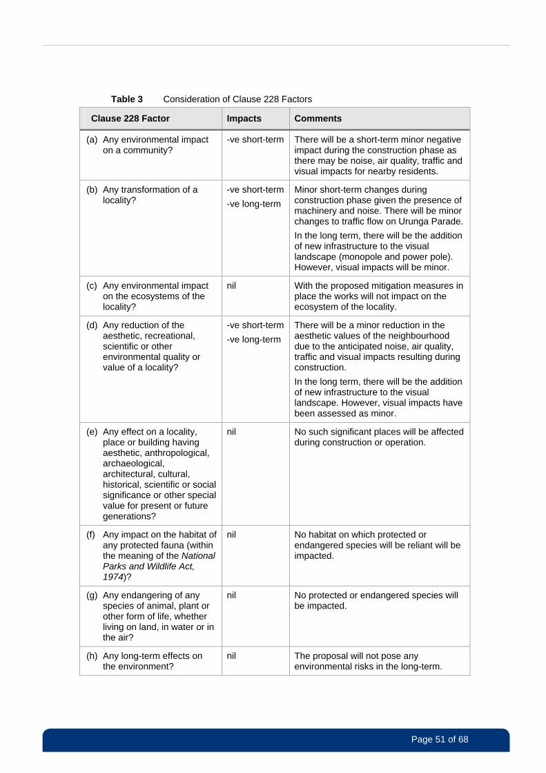
Page 51 of 68
Table 3 Consideration of Clause 228 Factors
Clause 228 Factor Impacts Comments
(a) Any environmental impact on a community?
-ve short-term There will be a short-term minor negative impact during the construction phase as there may be noise, air quality, traffic and visual impacts for nearby residents.
(b) Any transformation of a locality?
-ve short-term
-ve long-term
Minor short-term changes during construction phase given the presence of machinery and noise. There will be minor changes to traffic flow on Urunga Parade.
In the long term, there will be the addition of new infrastructure to the visual landscape (monopole and power pole). However, visual impacts will be minor.
(c) Any environmental impact on the ecosystems of the locality?
nil With the proposed mitigation measures in place the works will not impact on the ecosystem of the locality.
(d) Any reduction of the aesthetic, recreational, scientific or other environmental quality or value of a locality?
-ve short-term
-ve long-term
There will be a minor reduction in the aesthetic values of the neighbourhood due to the anticipated noise, air quality, traffic and visual impacts resulting during construction.
In the long term, there will be the addition of new infrastructure to the visual landscape. However, visual impacts have been assessed as minor.
(e) Any effect on a locality, place or building having aesthetic, anthropological, archaeological, architectural, cultural, historical, scientific or social significance or other special value for present or future generations?
nil No such significant places will be affected during construction or operation.
(f) Any impact on the habitat of any protected fauna (within the meaning of the National Parks and Wildlife Act, 1974)?
nil No habitat on which protected or endangered species will be reliant will be impacted.
(g) Any endangering of any species of animal, plant or other form of life, whether living on land, in water or in the air?
nil No protected or endangered species will be impacted.
(h) Any long-term effects on the environment?
nil The proposal will not pose any environmental risks in the long-term.
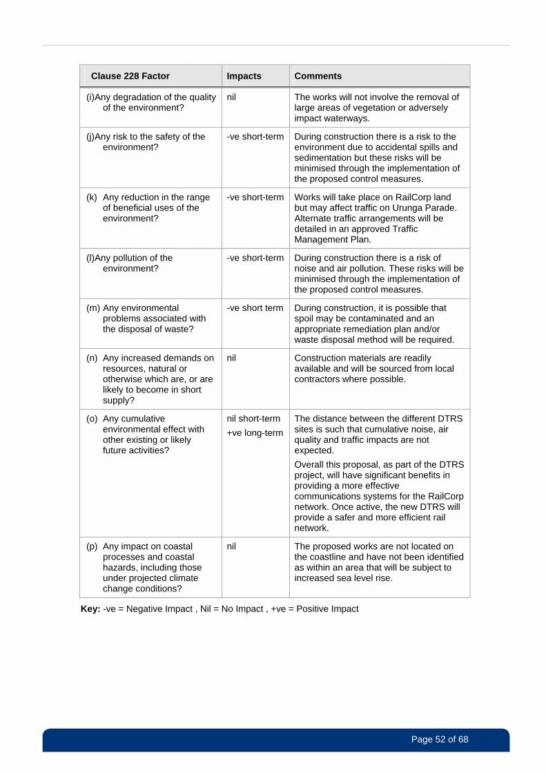
Page 52 of 68
Clause 228 Factor Impacts Comments
(i) Any degradation of the quality of the environment?
nil The works will not involve the removal of large areas of vegetation or adversely impact waterways.
(j) Any risk to the safety of the environment?
-ve short-term During construction there is a risk to the environment due to accidental spills and sedimentation but these risks will be minimised through the implementation of the proposed control measures.
(k) Any reduction in the range of beneficial uses of the environment?
-ve short-term Works will take place on RailCorp land but may affect traffic on Urunga Parade. Alternate traffic arrangements will be detailed in an approved Traffic Management Plan.
(l) Any pollution of the environment?
-ve short-term During construction there is a risk of noise and air pollution. These risks will be minimised through the implementation of the proposed control measures.
(m) Any environmental problems associated with the disposal of waste?
-ve short term During construction, it is possible that spoil may be contaminated and an appropriate remediation plan and/or waste disposal method will be required.
(n) Any increased demands on resources, natural or otherwise which are, or are likely to become in short supply?
nil Construction materials are readily available and will be sourced from local contractors where possible.
(o) Any cumulative environmental effect with other existing or likely future activities?
nil short-term
+ve long-term
The distance between the different DTRS sites is such that cumulative noise, air quality and traffic impacts are not expected.
Overall this proposal, as part of the DTRS project, will have significant benefits in providing a more effective communications systems for the RailCorp network. Once active, the new DTRS will provide a safer and more efficient rail network.
(p) Any impact on coastal processes and coastal hazards, including those under projected climate change conditions?
nil The proposed works are not located on the coastline and have not been identified as within an area that will be subject to increased sea level rise.
Key: -ve = Negative Impact , Nil = No Impact , +ve = Positive Impact
Page 53 of 68
EPBC Act 1999 Factors
Matters of national environmental significance must also be considered as a requirement of the
EPBC Act. Table 4 provides a summary of how these factors have been considered.
Table 4 Consideration of EPBC Factors
Factor (Commonwealth
Legislation)
Impacts Comments
(a) Any environmental impact on a
World Heritage property?
No There are no World Heritage properties
in the vicinity of the works.
(b) Any impact on the National Heritage values of a National
Heritage Place?
No There are no National Heritage Places in the vicinity of the works.
(c) Any environmental impact on
wetlands of international importance?
No The nature, scale and location of the
works are such that impacts on any RAMSAR wetland are not expected. Indirect impacts are also not expected.
(d) Any environmental impact on Commonwealth listed
threatened species or ecological communities?
No The nature, scale and location of the works are such that impacts on any
Commonwealth listed threatened species or ecological communities or their habitats are not expected. Indirect
impacts are also not expected.
(e) Any environmental impact on
Commonwealth listed migratory species?
No The nature, scale and location of the
works are such that impacts on any Commonwealth listed threatened species or ecological communities or
their habitats are not expected. Indirect impacts are also not expected.
(f) Does any part of the proposal involve a nuclear action?
No The proposal does not involve any nuclear actions.
(g) Any environmental impact on a Commonwealth marine area?
No The proposal is not located within the vicinity of any Commonwealth marine areas.
(h) Any direct or indirect effect on Commonwealth land?
No The proposal is not located within or in close proximity to any Commonwealth
land.
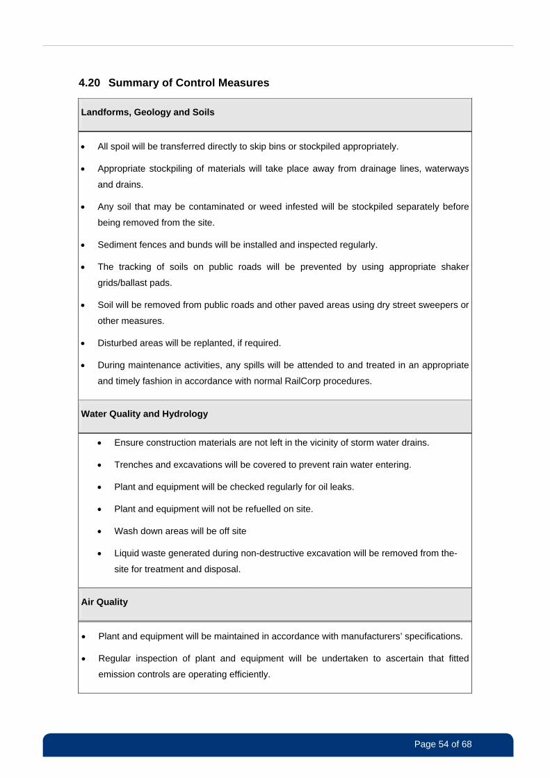
Page 54 of 68
4.20 Summary of Control Measures
Landforms, Geology and Soils
All spoil will be transferred directly to skip bins or stockpiled appropriately.
Appropriate stockpiling of materials will take place away from drainage lines, waterways
and drains.
Any soil that may be contaminated or weed infested will be stockpiled separately before
being removed from the site.
Sediment fences and bunds will be installed and inspected regularly.
The tracking of soils on public roads will be prevented by using appropriate shaker
grids/ballast pads.
Soil will be removed from public roads and other paved areas using dry street sweepers or
other measures.
Disturbed areas will be replanted, if required.
During maintenance activities, any spills will be attended to and treated in an appropriate
and timely fashion in accordance with normal RailCorp procedures.
Water Quality and Hydrology
Ensure construction materials are not left in the vicinity of storm water drains.
Trenches and excavations will be covered to prevent rain water entering.
Plant and equipment will be checked regularly for oil leaks.
Plant and equipment will not be refuelled on site.
Wash down areas will be off site
Liquid waste generated during non-destructive excavation will be removed from the-
site for treatment and disposal.
Air Quality
Plant and equipment will be maintained in accordance with manufacturers’ specifications.
Regular inspection of plant and equipment will be undertaken to ascertain that fitted
emission controls are operating efficiently.

Page 55 of 68
Plant or machinery will not be left idling.
Stockpiles will be maintained and contained appropriately, which could include covering or
regular watering to minimise dust.
Minimal work will be undertaken during high wind periods.
Trucks and train carriages transporting spoil and other waste materials from site will be
covered appropriately.
Disturbed areas will be rehabilitated after construction.
Biodiversity
No trees will be removed.
Care will be taken not to damage the existing trees and tree roots.
Care will be taken to minimise the spread of weeds. Appropriate management and
disposal of any noxious weeds, will be undertaken in consultation with Canterbury City
Council.
The work site will be inspected for any trapped or injured fauna at the start of each day.
Trenches/excavations will be covered at the end of each day and inspected before they
are backfilled.
Noise and Vibration
Please refer to Table 2 Possible Construction Noise Control Measures.
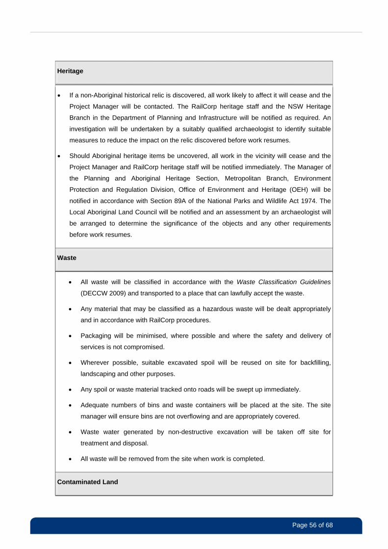
Page 56 of 68
Heritage
If a non-Aboriginal historical relic is discovered, all work likely to affect it will cease and the
Project Manager will be contacted. The RailCorp heritage staff and the NSW Heritage
Branch in the Department of Planning and Infrastructure will be notified as required. An
investigation will be undertaken by a suitably qualified archaeologist to identify suitable
measures to reduce the impact on the relic discovered before work resumes.
Should Aboriginal heritage items be uncovered, all work in the vicinity will cease and the
Project Manager and RailCorp heritage staff will be notified immediately. The Manager of
the Planning and Aboriginal Heritage Section, Metropolitan Branch, Environment
Protection and Regulation Division, Office of Environment and Heritage (OEH) will be
notified in accordance with Section 89A of the National Parks and Wildlife Act 1974. The
Local Aboriginal Land Council will be notified and an assessment by an archaeologist will
be arranged to determine the significance of the objects and any other requirements
before work resumes.
Waste
All waste will be classified in accordance with the Waste Classification Guidelines
(DECCW 2009) and transported to a place that can lawfully accept the waste.
Any material that may be classified as a hazardous waste will be dealt appropriately
and in accordance with RailCorp procedures.
Packaging will be minimised, where possible and where the safety and delivery of
services is not compromised.
Wherever possible, suitable excavated spoil will be reused on site for backfilling,
landscaping and other purposes.
Any spoil or waste material tracked onto roads will be swept up immediately.
Adequate numbers of bins and waste containers will be placed at the site. The site
manager will ensure bins are not overflowing and are appropriately covered.
Waste water generated by non-destructive excavation will be taken off site for
treatment and disposal.
All waste will be removed from the site when work is completed.
Contaminated Land
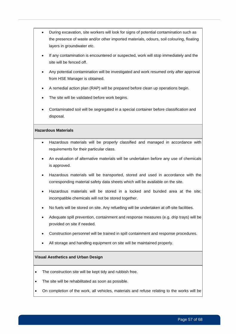
Page 57 of 68
During excavation, site workers will look for signs of potential contamination such as
the presence of waste and/or other imported materials, odours, soil colouring, floating
layers in groundwater etc.
If any contamination is encountered or suspected, work will stop immediately and the
site will be fenced off.
Any potential contamination will be investigated and work resumed only after approval
from HSE Manager is obtained.
A remedial action plan (RAP) will be prepared before clean up operations begin.
The site will be validated before work begins.
Contaminated soil will be segregated in a special container before classification and
disposal.
Hazardous Materials
Hazardous materials will be properly classified and managed in accordance with
requirements for their particular class.
An evaluation of alternative materials will be undertaken before any use of chemicals
is approved.
Hazardous materials will be transported, stored and used in accordance with the
corresponding material safety data sheets which will be available on the site.
Hazardous materials will be stored in a locked and bunded area at the site;
incompatible chemicals will not be stored together.
No fuels will be stored on site. Any refuelling will be undertaken at off-site facilities.
Adequate spill prevention, containment and response measures (e.g. drip trays) will be
provided on site if needed.
Construction personnel will be trained in spill containment and response procedures.
All storage and handling equipment on site will be maintained properly.
Visual Aesthetics and Urban Design
The construction site will be kept tidy and rubbish free.
The site will be rehabilitated as soon as possible.
On completion of the work, all vehicles, materials and refuse relating to the works will be
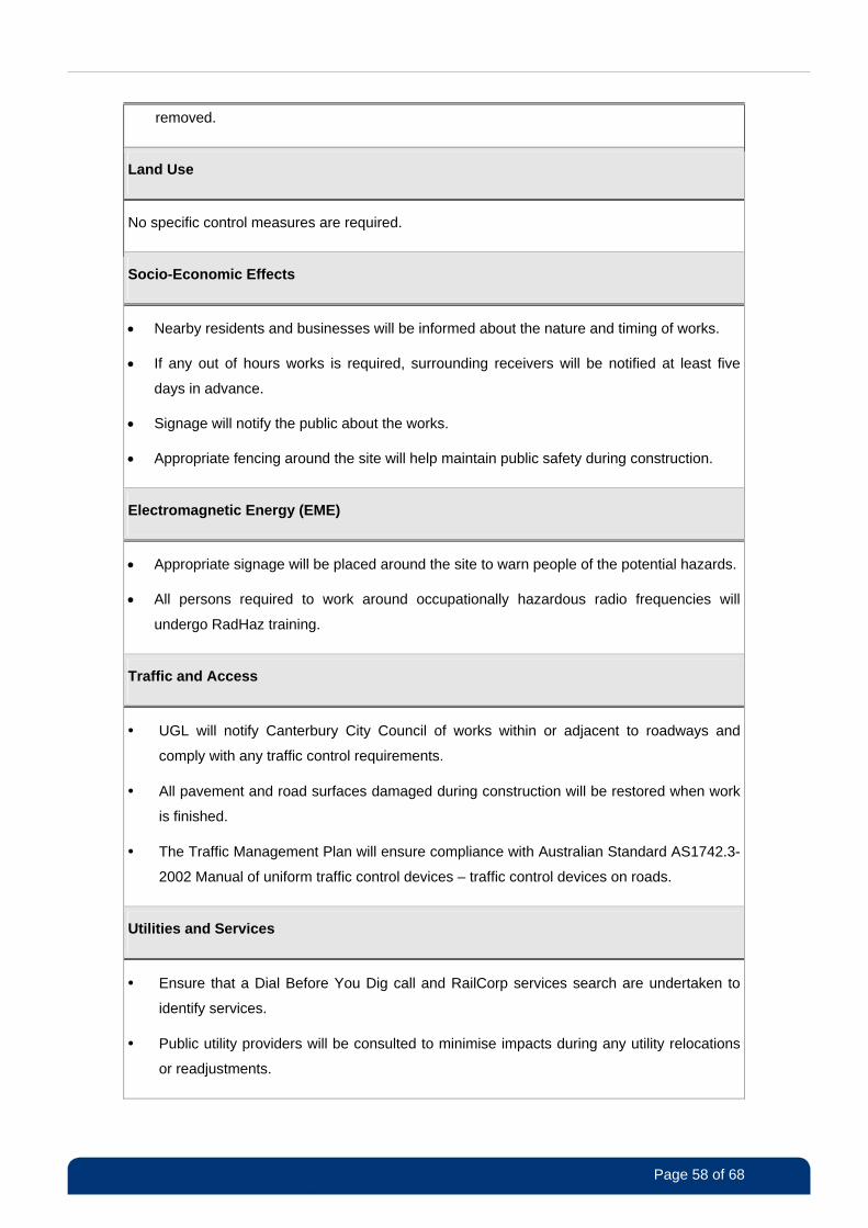
Page 58 of 68
removed.
Land Use
No specific control measures are required.
Socio-Economic Effects
Nearby residents and businesses will be informed about the nature and timing of works.
If any out of hours works is required, surrounding receivers will be notified at least five
days in advance.
Signage will notify the public about the works.
Appropriate fencing around the site will help maintain public safety during construction.
Electromagnetic Energy (EME)
Appropriate signage will be placed around the site to warn people of the potential hazards.
All persons required to work around occupationally hazardous radio frequencies will
undergo RadHaz training.
Traffic and Access
• UGL will notify Canterbury City Council of works within or adjacent to roadways and
comply with any traffic control requirements.
• All pavement and road surfaces damaged during construction will be restored when work
is finished.
• The Traffic Management Plan will ensure compliance with Australian Standard AS1742.3-
2002 Manual of uniform traffic control devices – traffic control devices on roads.
Utilities and Services
• Ensure that a Dial Before You Dig call and RailCorp services search are undertaken to
identify services.
• Public utility providers will be consulted to minimise impacts during any utility relocations
or readjustments.
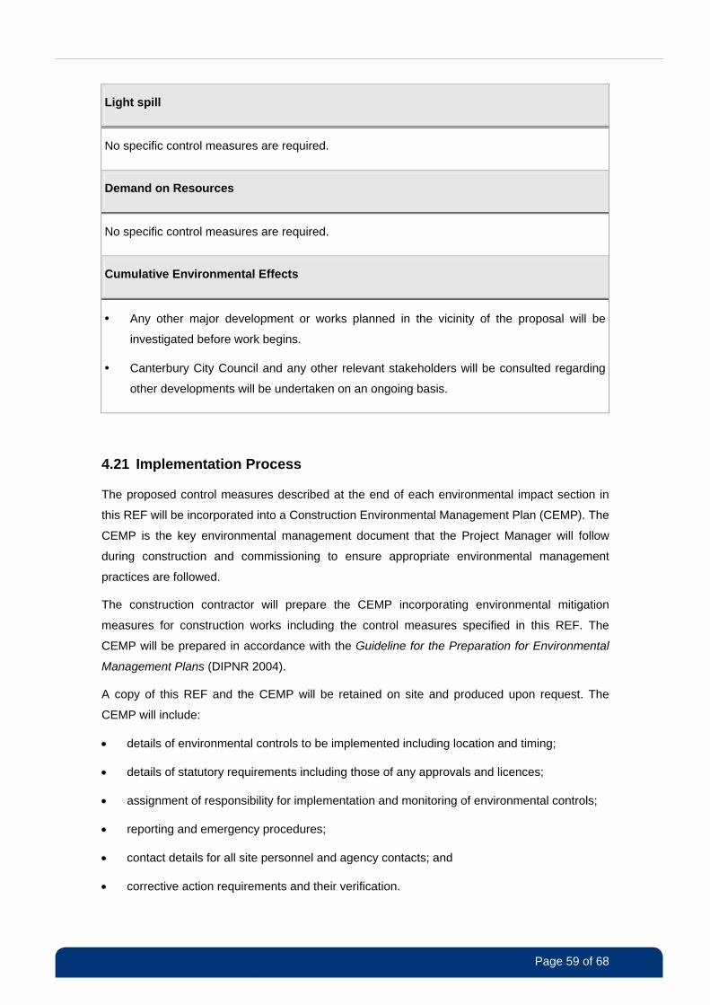
Page 59 of 68
Light spill
No specific control measures are required.
Demand on Resources
No specific control measures are required.
Cumulative Environmental Effects
• Any other major development or works planned in the vicinity of the proposal will be
investigated before work begins.
• Canterbury City Council and any other relevant stakeholders will be consulted regarding
other developments will be undertaken on an ongoing basis.
4.21 Implementation Process
The proposed control measures described at the end of each environmental impact section in
this REF will be incorporated into a Construction Environmental Management Plan (CEMP). The
CEMP is the key environmental management document that the Project Manager will follow
during construction and commissioning to ensure appropriate environmental management
practices are followed.
The construction contractor will prepare the CEMP incorporating environmental mitigation
measures for construction works including the control measures specified in this REF. The
CEMP will be prepared in accordance with the Guideline for the Preparation for Environmental
Management Plans (DIPNR 2004).
A copy of this REF and the CEMP will be retained on site and produced upon request. The
CEMP will include:
details of environmental controls to be implemented including location and timing;
details of statutory requirements including those of any approvals and licences;
assignment of responsibility for implementation and monitoring of environmental controls;
reporting and emergency procedures;
contact details for all site personnel and agency contacts; and
corrective action requirements and their verification.
Page 60 of 68
5 References
• DECC (2009) Interim Construction Noise Guideline. Prepared by the Department of
Environment and Climate Change, Sydney.
• DECCW (2009) Waste Classification Guidelines. Prepared by the Department of
Environment, Climate Change and Water, Sydney.
• DEWHA (2010) Reducing Greenhouse Gas Emissions. Accessed on 9 June 2011 at:
http://www.environment.gov.au/settlements/transport/fuelguide/environment.html
• DIPNR (2004) Guideline for the Preparation of Environmental Management Plans.
Prepared by the Department of Infrastructure, Planning and Natural Resources, Sydney.
• DoP (2010) NSW Telecommunication Facilities Guideline including Broadband. Prepared
by Department of Planning, Sydney.
• Landcom (2004) Managing Urban Stormwater, Soils and Construction Guidelines (the Blue
Book). Prepared by Landcom/Department of Housing, Sydney.
• RTA (2003) Traffic Volume Data for Sydney Region 2002. Accessed on 11 August 2011 at:
http://www.rta.nsw.gov.au/trafficinformation/downloads/aadtdata_dl1.html
• Canterbury City Council (2010) State of the Environment Report 2009/2010. Prepared by
Canterbury City Council, Sydney.
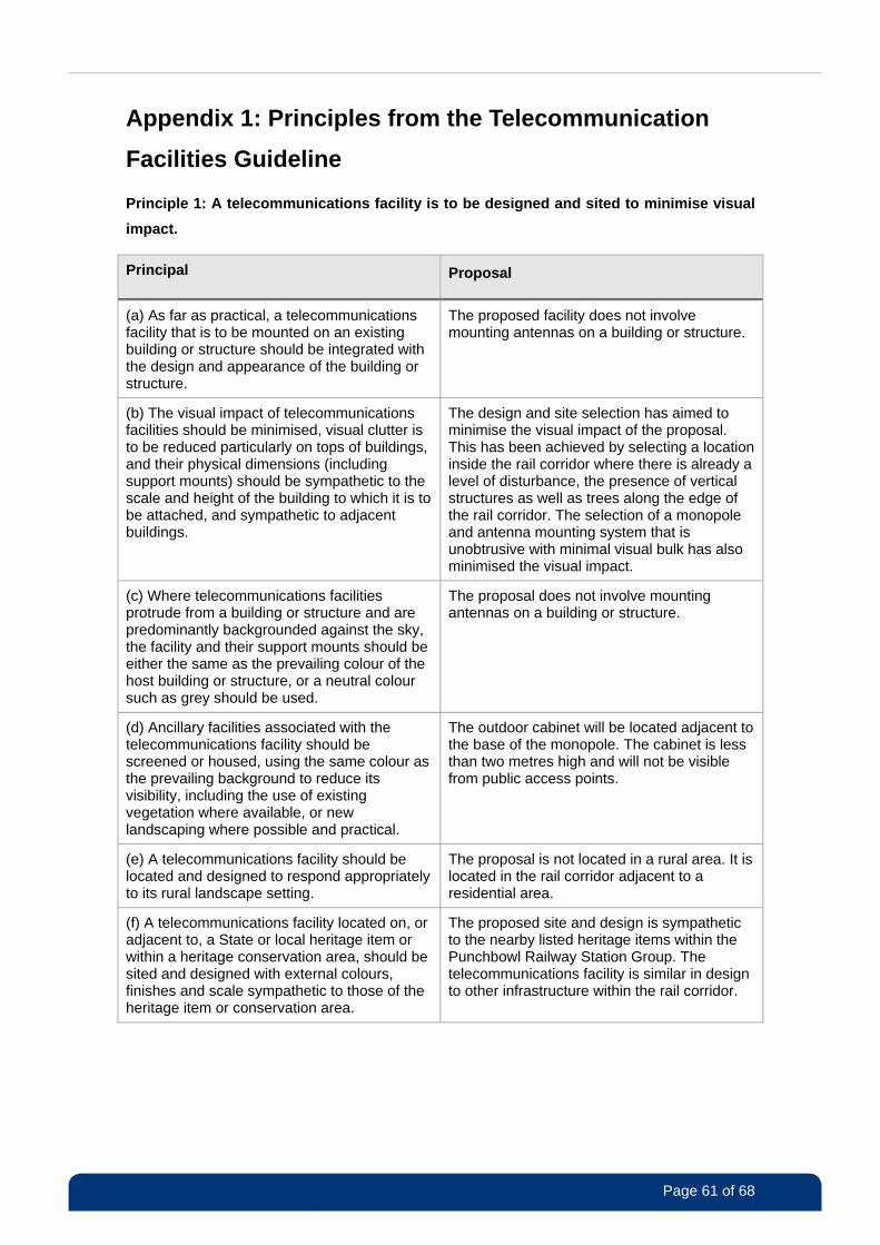
Page 61 of 68
Appendix 1: Principles from the Telecommunication
Facilities Guideline
Principle 1: A telecommunications facility is to be designed and sited to minimise visual
impact.
Principal Proposal
(a) As far as practical, a telecommunications facility that is to be mounted on an existing building or structure should be integrated with the design and appearance of the building or structure.
The proposed facility does not involve mounting antennas on a building or structure.
(b) The visual impact of telecommunications facilities should be minimised, visual clutter is to be reduced particularly on tops of buildings, and their physical dimensions (including support mounts) should be sympathetic to the scale and height of the building to which it is to be attached, and sympathetic to adjacent buildings.
The design and site selection has aimed to minimise the visual impact of the proposal. This has been achieved by selecting a location inside the rail corridor where there is already a level of disturbance, the presence of vertical structures as well as trees along the edge of the rail corridor. The selection of a monopole and antenna mounting system that is unobtrusive with minimal visual bulk has also minimised the visual impact.
(c) Where telecommunications facilities protrude from a building or structure and are predominantly backgrounded against the sky, the facility and their support mounts should be either the same as the prevailing colour of the host building or structure, or a neutral colour such as grey should be used.
The proposal does not involve mounting antennas on a building or structure.
(d) Ancillary facilities associated with the telecommunications facility should be screened or housed, using the same colour as the prevailing background to reduce its visibility, including the use of existing vegetation where available, or new landscaping where possible and practical.
The outdoor cabinet will be located adjacent to the base of the monopole. The cabinet is less than two metres high and will not be visible from public access points.
(e) A telecommunications facility should be located and designed to respond appropriately to its rural landscape setting.
The proposal is not located in a rural area. It is located in the rail corridor adjacent to a residential area.
(f) A telecommunications facility located on, or adjacent to, a State or local heritage item or within a heritage conservation area, should be sited and designed with external colours, finishes and scale sympathetic to those of the heritage item or conservation area.
The proposed site and design is sympathetic to the nearby listed heritage items within the Punchbowl Railway Station Group. The telecommunications facility is similar in design to other infrastructure within the rail corridor.
Page 62 of 68
Principal Proposal
(g) A telecommunications facility should be located so as to minimise or avoid the obstruction of a significant view of a heritage item or place, a landmark, a streetscape, vista or a panorama, whether viewed from public or private land.
The proposed facility is close to residential areas. However, views are partially screened by vegetation along the border of the rail corridor.
The proposed facility will not block or significantly obstruct any views of heritage items or other landmarks of state significance.
The proposed monopole is less than 500 millimetres wide at the top and there is no headframe supporting the antennas. The monopole and new power pole will not represent a dominant structure in the view lines of people occupying the residential properties in the surrounding area.
(h) The relevant local government authority must be consulted where the pruning, lopping, or removal of any tree or other vegetation would contravene a Tree Preservation Order applying to the land or where a permit or development consent is required.
It is unlikely any trees will need to be removed. However, any trees that may need removal will be located on RailCorp land and are not subject to tree preservation orders. Tree replanting will be investigated, should tree removal be required.
(i) A telecommunications facility that is no longer required is to be removed and the site restored, to a condition that is similar to its condition before the facility was constructed.
Should the facility ever become redundant, RailCorp will decommissioned and remove the applicable components and following the removal, the land will be restored as close as practicable to its condition before work began.
(j) The siting and design of telecommunications facilities should be in accordance with any relevant Industry Design Guides.
The proposed design has been completed using “best industry practice” and complies with the relevant standards regarding structural engineering, EME and construction procedures.
Principle 2: Telecommunications facilities should be co-located wherever practical.
Principal Proposal
(a) Telecommunications lines are to be located, as far as practical, underground or within an existing underground conduit or duct.
The optical fibre for the DTRS network will be located in new underground conduits.
(b) Overhead lines, antennas and ancillary telecommunications facilities should, where practical, be co-located or attached to existing structures such as buildings, public utility structures, poles, towers or other radio communications equipment to minimise the proliferation of telecommunication facilities and unnecessary clutter.
The co-location of the proposal on other communications towers has been considered. No other towers were deemed appropriate or in a location to provide sufficient network coverage. As such a new monopole is proposed.
Page 63 of 68
Principal Proposal
(c) Towers may be extended for the purposes of co-location.
The proposal does not involve the use of an existing tower. The extension of existing towers in the area was considered, and deemed unsuitable.
(d) The extension of an existing tower must be considered as a practical co-location solution prior to building new towers.
The proposal does not involve the use of an existing tower. However, the extension of existing towers in the area was considered and deemed unsuitable.
(e) If a facility is proposed not to be co-located the proponent must demonstrate that co-location is not practicable.
There are no suitable communications towers in the target coverage area that will satisfy the coverage objectives as well as the network requirements of the DTRS project.
(f) If the development is for a co-location purpose, then any new telecommunications facility must be designed, installed and operated so that the resultant cumulative levels of radio frequency emissions of the co-located telecommunications facilities are within the maximum human exposure levels set out in the Radiation Protection Standard.
The proposal is not a co-location.
Principle 3: Health standards for exposure to radio emissions will be met.
Principal Proposal
(a) A telecommunications facility must be designed, installed and operated so that the maximum human exposure levels to radiofrequency emissions comply with Radiation Protection Standard.
The facility will comply with the ARPANSA standard in relation to human exposure to EME. An EME report has been completed and is found at Appendix 4.
This report demonstrates compliance with the ARPANSA standard for the operation of a radio communications facility in Australia.
(b) An EME Environmental Report shall be produced by the proponent of development to which the Mobile Phone Network Code applies in terms of design, siting of facilities and notifications.
The Report is to be in the format required by the Australian Radiation Protection Nuclear Safety Agency (ARPANSA). It is to show the predicted levels of electromagnetic energy surrounding the development comply with the safety limits imposed by the Australian Communications and Media Authority and the Electromagnetic Radiation Standard, and demonstrate compliance with the Mobile Phone Networks Code.
The proposal is not for a mobile phone network and is not subject to the Code for the Development of Mobile Phone Network Infrastructure commonly known as the ACIF Code.
An EME report has been completed and is found at Appendix 4.
Page 64 of 68
Principle 4: Minimise disturbance and risk, and maximise compliance
Principal Proposal
(a) The siting and height of any telecommunications facility must comply with any relevant site and height requirements specified by the Civil Aviation Regulations 1988 and the Airports (Protection of Airspace) Regulations 1996 of the Commonwealth. It must not penetrate any obstacle limitation surface shown on any relevant Obstacle Limitation Surface Plan that has been prepared by the operator of an aerodrome or airport operating within 30 kilometres of the proposed development and reported to the Civil Aviation Safety Authority Australia.
The provisions of the Civil Aviation Regulations 1988 and the Airports (Protection of Airspace) Regulations 1996 have been considered during design and siting. There is no need for the installation of a warning light or aircraft navigation light, as the proposal does not penetrate the Obstacle Limitation Surface.
(b) The telecommunications facility is not to cause adverse radio frequency interference with any airport, port or Commonwealth Defence navigational or communications equipment, including the Morundah Communication Facility, Riverina.
RailCorp will operate the radio facility with its own spectrum and the facility will not cause any interference with other networks. All radio transmitters will use the frequency assigned to RailCorp for the exclusive use of RailCorp.
(c) The telecommunications facility and ancillary facilities are to be carried out in accordance with the applicable specifications (if any) of the manufacturers for the installation of such equipment.
The installation and operation of the radio equipment and antennas will be carried out in accordance with the manufacturers’ specifications.
(d) The telecommunications facility is not to affect the structural integrity of any building on which it is erected.
The proposal is not connected to an existing building.
(e) The telecommunications facility is to be erected wholly within the boundaries of a property where the landowner has agreed to the facility being located on the land.
The proposal will be located within the rail corridor that is owned and used by RailCorp. RailCorp is the proponent of the network and agrees to the use of the land for the proposed radio equipment.
(f) The carrying out of construction of the telecommunications facilities must be in accordance with all relevant regulations of the Blue Book – ‘Managing Urban Storm water: Soils and Construction’ (Landcom 2004), or its replacement.
The activities associated with construction and installation will be done in accordance with sediment controls, erosion controls, stormwater controls and other controls outlined in the Blue Book (refer Section 4.1).
Page 65 of 68
Principal Proposal
(g) Obstruction or risks to pedestrians or vehicles caused by the location of the facility, construction activity or materials used in construction are to be mitigated.
Construction activities will take place in the rail corridor. However, traffic flow on Urunga Parade may be impacted. Any traffic changes will be implemented in accordance with an approved Traffic Management Plan
There will be no risks to traffic or pedestrians when the facility is operational.
(h) Where practical, work is to be carried out during times that cause minimum disruption to adjoining properties and public access. Hours of work are to be restricted to between 7.00am and 6.00pm, Mondays to Saturdays, with no work on Sundays and public holidays.
Where possible, all work associated with the development and installation will take place between 7.00am and 6.00pm, Mondays to Fridays and 8.00am to 1.00pm Saturdays, with no work on Sundays and public holidays.
(i) Traffic control measures are to be taken during construction in accordance with Australian Standard AS1742.3-2002 Manual of uniform traffic control devices – Traffic control devices on roads.
A Traffic Management Plan will be developed and implemented during construction and installation activities. The procedures and mitigation measures in the plan will ensure compliance with Australian Standard AS1742.3-2002 Manual of uniform traffic control devices – traffic control devices on roads (refer Section 4.14).
(j) Open trenching should be guarded in accordance with Australian Standard Section 93.080 – Road Engineering AS1165 – 1982 – Traffic hazard warning lamps.
All trenches will be covered or filled so that they are not open over night.
(k) Disturbance to flora and fauna should be minimised and the land is to be restored to a condition that is similar to its condition before the work was carried out.
Tree removal is not proposed as part of the works. However, should the works require the removal of any trees, suitable replanting will be undertaken (refer Section 4.4).
(l) The likelihood of impacting on threatened species and communities should be identified in consultation with relevant state or local government authorities and disturbance to identified species and communities avoided wherever possible.
The proposed activities will not require the removal of significant amounts of vegetation. A search of threatened species has been completed (refer Appendix 3) and there is not expected to be any significance impacts on any threatened species.
(m) The likelihood of harming an Aboriginal Place and / or Aboriginal object should be identified. Approvals from the Office of Environment & Heritage (OEH) must be obtained where impact is likely, or Aboriginal objects are found.
A search of the AHIMS has been completed and there are no known items or places of archaeological significance on the site or in the immediate surrounding area (refer Appendix 3).
If there are any suspicious items or objects found during any excavation works, work will cease immediately and the OEH will be consulted and works will not resume until OEH has granted its consent.
(n) Street furniture, paving or other existing facilities removed or damaged during construction should be reinstated (at the telecommunications carrier’s expense) to at least the same condition as that which existed prior to the telecommunications facility being installed.
All works are to occur in the rail corridor. Any street furniture or paving and walkways that are damaged during construction will be re-instated at the end of construction to at least the same condition as they were in before work began.
Page 66 of 68
Appendix 2: Design Plans
Refer attached documents:
DTRS-D-078-BS-0003: Bankstown (Mt Lewis) Outdoor Design – Rail Corridor Site
Layout Plan
DTRS-D-078-BS-0004: Bankstown (Mt Lewis) Outdoor Design – Rail Corridor BTS Set
out Design
DTRS-D-078-BS-0005: Bankstown (Mt Lewis) Outdoor Design – Rail Corridor BTS
Elevation and Antenna Table
DTRS-D-078-TR-0001: Bankstown (Mt Lewis) Transmission Diagram
DTRS-D-078-BS-0031: Bankstown (Mt Lewis) Electrical Site Layout Plan
Page 67 of 68
Appendix 3: Database searches
Extracts from the NSW Wildlife Atlas - Flora
Extracts from the NSW Wildlife Atlas - Fauna
Aboriginal Heritage Information Management System Report
Section 170: RailCorp Heritage Register
NSW Heritage Register
Australian Heritage Database
EPBC Act 1999 Protected Matters Report

Page 68 of 68
Appendix 4: Electro-Magnetic Energy (EME) Reports
Refer attached document:
DTRS-R-078-EM-0001: Bankstown (Mt Lewis) Electro-Magnetic Energy Report
(ARPANSA Report)
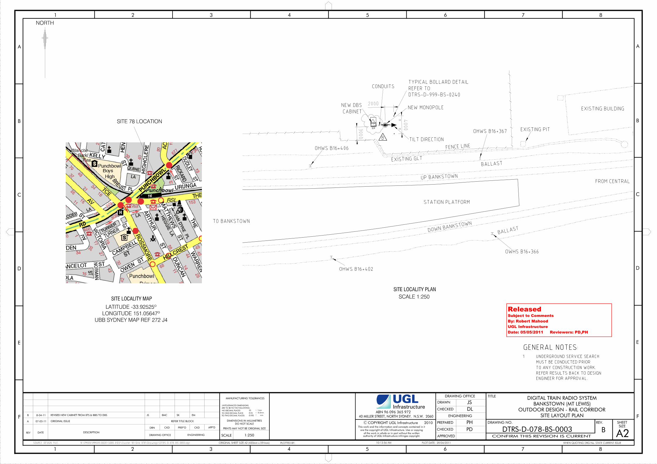
ReleasedSubject to CommentsBy: Robert MahoodUGL InfrastructureDate: 05/05/2011 Reviewers: PD,PH
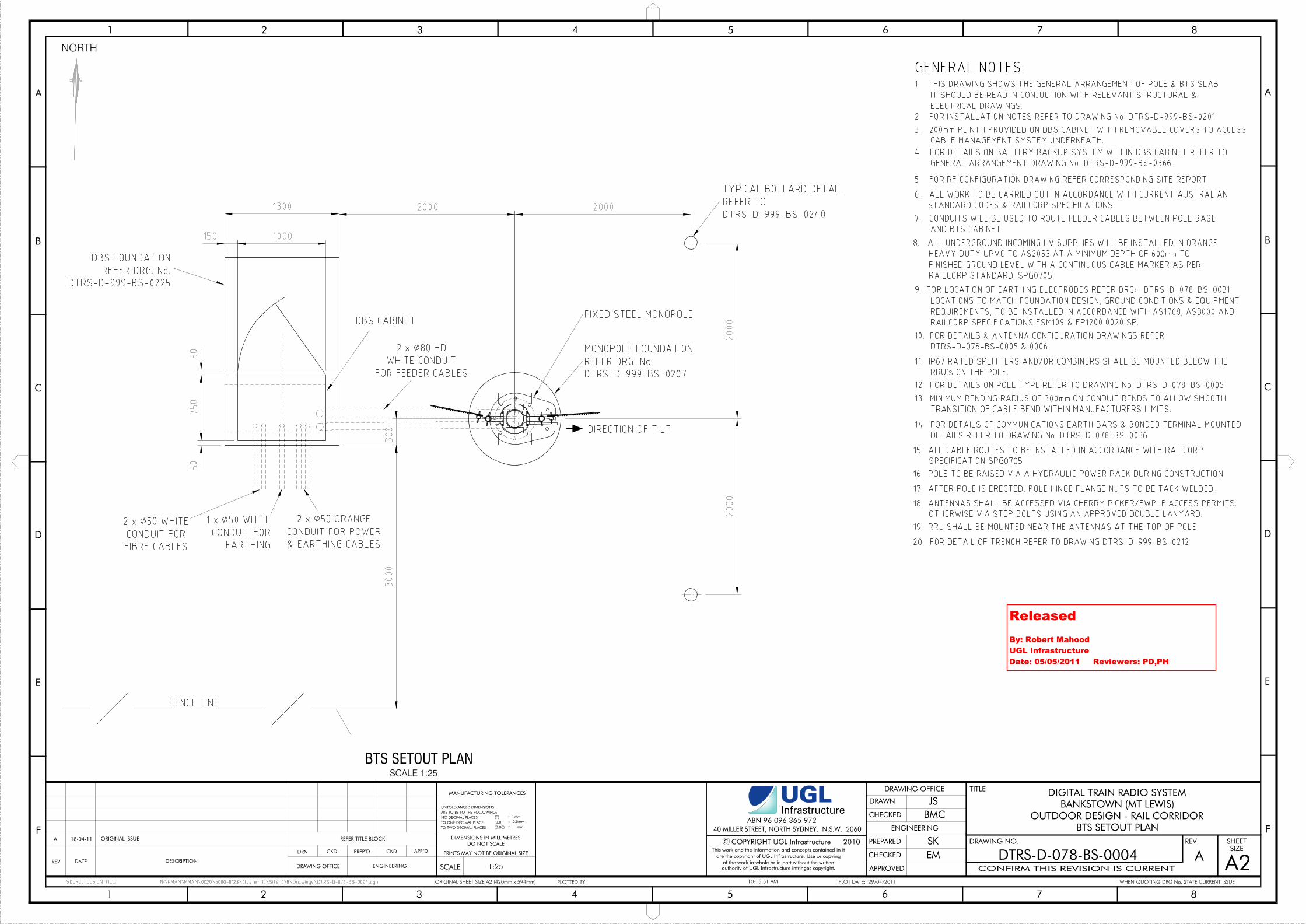
ReleasedBy: Robert MahoodUGL InfrastructureDate: 05/05/2011 Reviewers: PD,PH
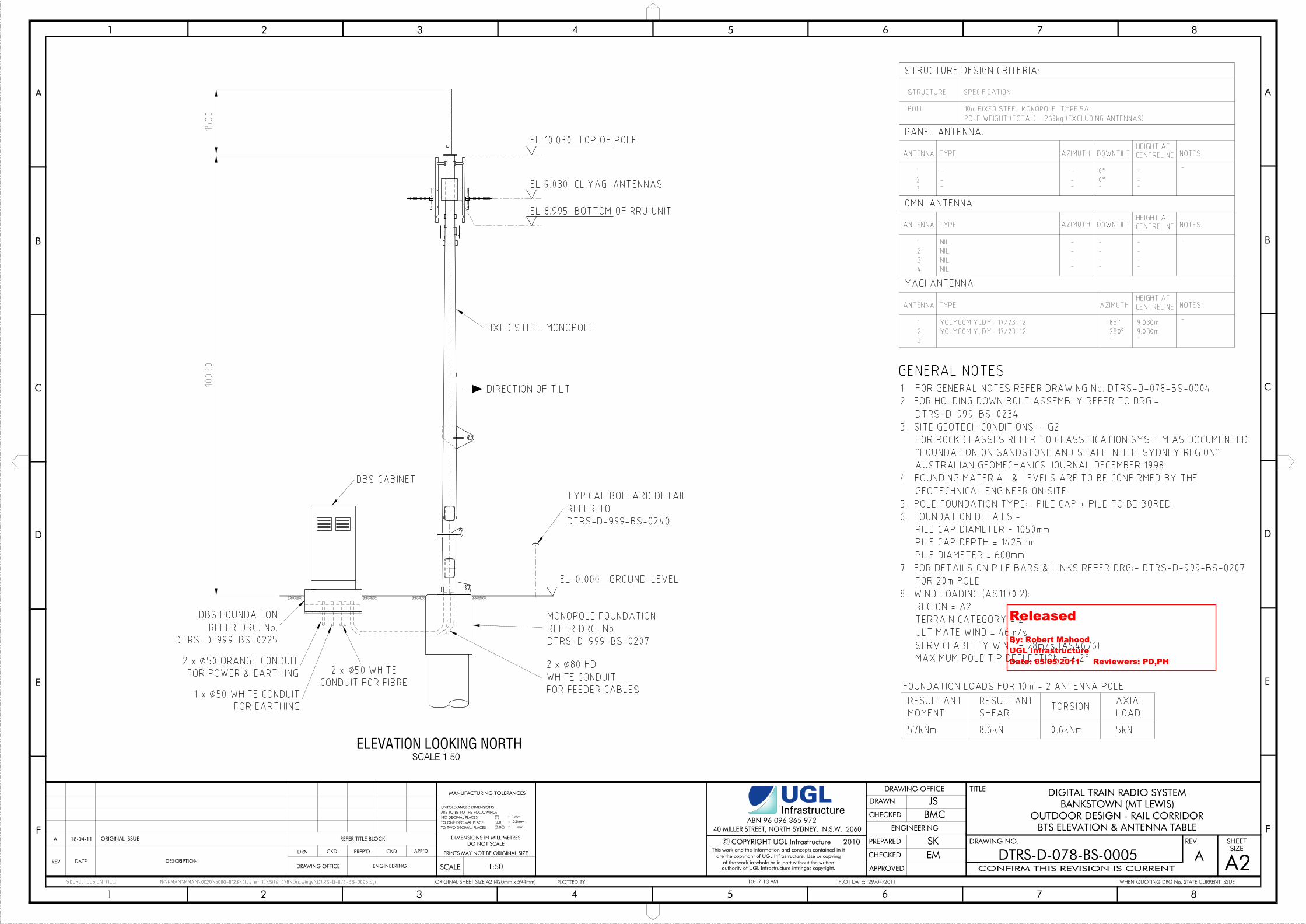
ReleasedBy: Robert MahoodUGL InfrastructureDate: 05/05/2011 Reviewers: PD,PH
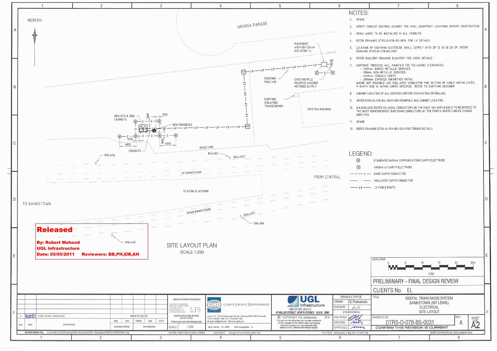
ReleasedBy: Robert MahoodUGL InfrastructureDate: 05/05/2011 Reviewers: BB,PH,EM,AH
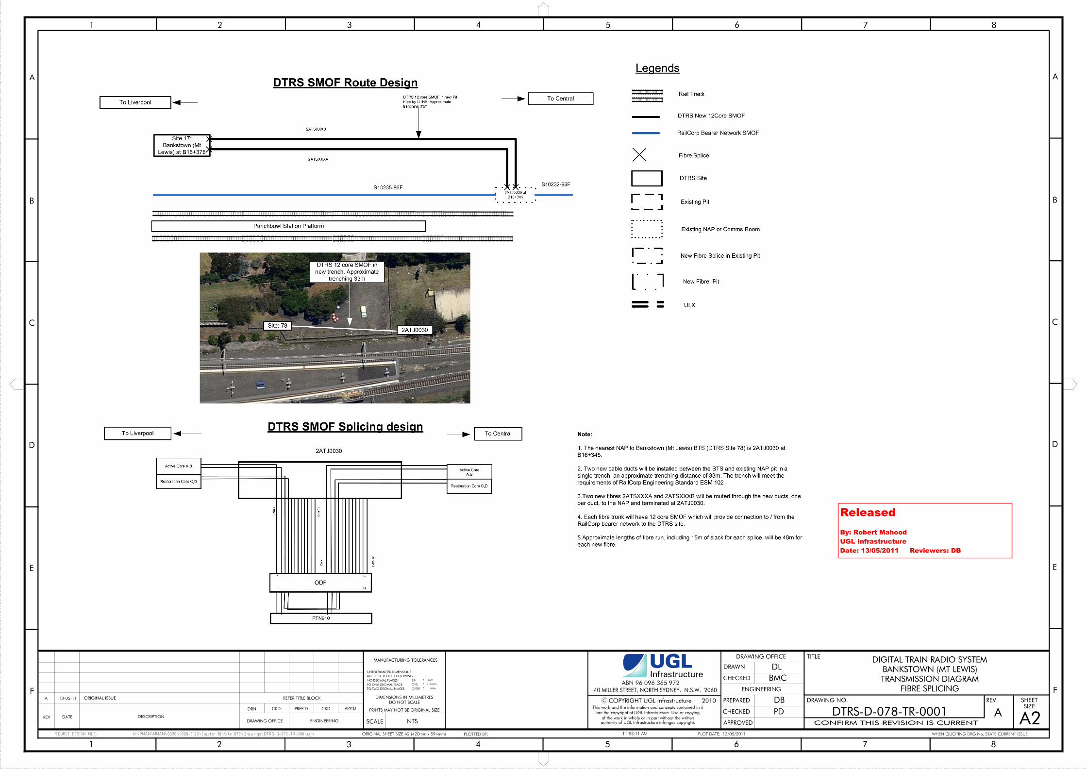
ReleasedBy: Robert MahoodUGL InfrastructureDate: 13/05/2011 Reviewers: DB
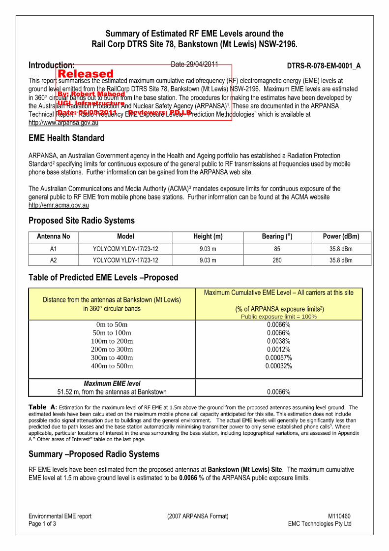
Environmental EME report (2007 ARPANSA Format) M110460Page 1 of 3 EMC Technologies Pty Ltd
Summary of Estimated RF EME Levels around theRail Corp DTRS Site 78, Bankstown (Mt Lewis) NSW-2196.
Introduction: Date 29/04/2011 DTRS-R-078-EM-0001_A
This report summarises the estimated maximum cumulative radiofrequency (RF) electromagnetic energy (EME) levels atground level emitted from the RailCorp DTRS Site 78, Bankstown (Mt Lewis) NSW-2196. Maximum EME levels are estimatedin 360 circular bands out to 500m from the base station. The procedures for making the estimates have been developed bythe Australian Radiation Protection And Nuclear Safety Agency (ARPANSA)1. These are documented in the ARPANSATechnical Report; “Radio Frequency EME Exposure Levels - Prediction Methodologies” which is available athttp://www.arpansa.gov.au
EME Health Standard
ARPANSA, an Australian Government agency in the Health and Ageing portfolio has established a Radiation ProtectionStandard2 specifying limits for continuous exposure of the general public to RF transmissions at frequencies used by mobilephone base stations. Further information can be gained from the ARPANSA web site.
The Australian Communications and Media Authority (ACMA)3 mandates exposure limits for continuous exposure of thegeneral public to RF EME from mobile phone base stations. Further information can be found at the ACMA websitehttp://emr.acma.gov.au
Proposed Site Radio Systems
Antenna No Model Height (m) Bearing (°) Power (dBm)
A1 YOLYCOM YLDY-17/23-12 9.03 m 85 35.8 dBm
A2 YOLYCOM YLDY-17/23-12 9.03 m 280 35.8 dBm
Table of Predicted EME Levels –Proposed
Distance from the antennas at Bankstown (Mt Lewis)in 360 circular bands
Maximum Cumulative EME Level – All carriers at this site
(% of ARPANSA exposure limits2)Public exposure limit = 100%
0m to 50m50m to 100m
100m to 200m200m to 300m300m to 400m400m to 500m
0.0066%0.0066%0.0038%0.0012%
0.00057%0.00032%
Maximum EME level51.52 m, from the antennas at Bankstown 0.0066%
Table_A: Estimation for the maximum level of RF EME at 1.5m above the ground from the proposed antennas assuming level ground. Theestimated levels have been calculated on the maximum mobile phone call capacity anticipated for this site. This estimation does not includepossible radio signal attenuation due to buildings and the general environment. The actual EME levels will generally be significantly less thanpredicted due to path losses and the base station automatically minimising transmitter power to only serve established phone calls5. Whereapplicable, particular locations of interest in the area surrounding the base station, including topographical variations, are assessed in AppendixA “ Other areas of Interest” table on the last page.
Summary –Proposed Radio Systems
RF EME levels have been estimated from the proposed antennas at Bankstown (Mt Lewis) Site. The maximum cumulativeEME level at 1.5 m above ground level is estimated to be 0.0066 % of the ARPANSA public exposure limits.
ReleasedBy: Robert MahoodUGL InfrastructureDate: 06/05/2011 Reviewers: PD,LB
Environmental EME report (2007 ARPANSA Format) M110460Page 2 of 3 EMC Technologies Pty Ltd
Existing Site Radio Systems
There are currently no existing radio systems for this site.
Issued by: EMC Technologies Pty Ltd, Data reference file – Bankstown_M110460
Reference Notes:1. The Australian Radiation Protection and Nuclear Safety Agency (ARPANSA) is a Federal Government agency incorporated under
the Health and Ageing portfolio. ARPANSA is charged with responsibility for protecting the health and safety of people, and theenvironment, from the harmful effects of radiation (ionising and non-ionising).
2. Australian Radiation Protection and Nuclear Safety Agency (ARPANSA), 2002, ‘Radiation Protection Standard: Maximum ExposureLevels to Radiofrequency Fields — 3 kHz to 300 GHz’, Radiation Protection Series Publication No. 3, ARPANSA, Yallambie Australia.[Printed version: ISBN 0-642-79400-6 ISSN 1445-9760][Web version: ISBN 0-642-79402-2 ISSN 1445-9760]
3. The Australian Communications and Media Authority (ACMA) is responsible for the regulation of broadcasting,radiocommunications, telecommunications and online content. Information on EME is available at http://emr.acma.gov.au/
4. The EME predictions in this report assume a near worst-case scenario including:- base station transmitters operating at maximum power (no automatic power reduction)- simultaneous telephone calls on all channels- an unobstructed line of sight view to the antennas.In practice a worst-case scenario is rarely the case. There are often trees and buildings in the immediate vicinity, and cellularnetworks automatically adjust transmit power to suit the actual telephone traffic. The level of EME may also be affected wheresignificant landscape features are present and predicted EME levels might not be the absolute maximum at all locations.
5. Further explanation of this report may be found in “Understanding the ARPANSA Environmental EME Report” and other documentson the ARPANSA web site, http://www.arpansa.gov.au
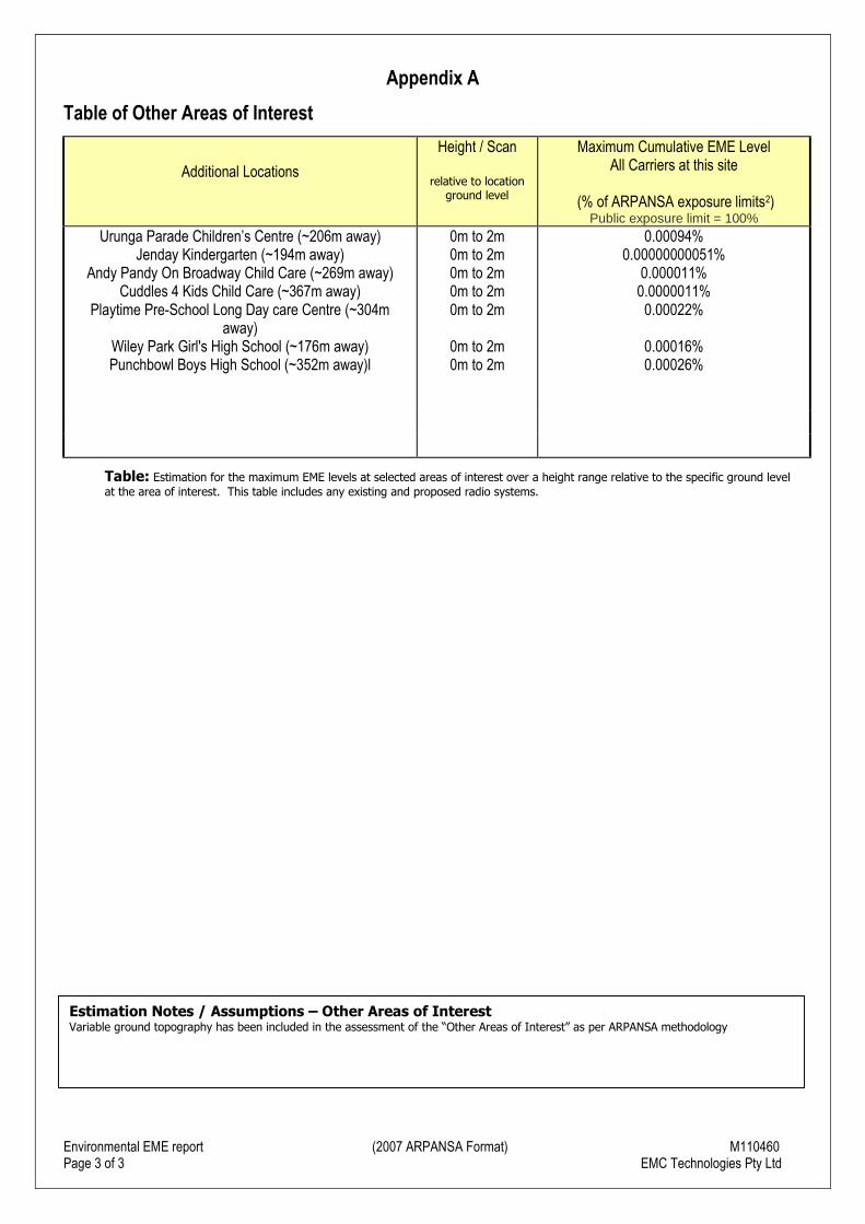
Environmental EME report (2007 ARPANSA Format) M110460Page 3 of 3 EMC Technologies Pty Ltd
Appendix A
Table of Other Areas of Interest
Additional Locations
Height / Scan
relative to locationground level
Maximum Cumulative EME LevelAll Carriers at this site
(% of ARPANSA exposure limits2)Public exposure limit = 100%
Urunga Parade Children’s Centre (~206m away)Jenday Kindergarten (~194m away)
Andy Pandy On Broadway Child Care (~269m away)Cuddles 4 Kids Child Care (~367m away)
Playtime Pre-School Long Day care Centre (~304maway)
Wiley Park Girl's High School (~176m away)Punchbowl Boys High School (~352m away)l
0m to 2m0m to 2m0m to 2m0m to 2m0m to 2m
0m to 2m0m to 2m
0.00094%0.00000000051%
0.000011%0.0000011%
0.00022%
0.00016%0.00026%
Table: Estimation for the maximum EME levels at selected areas of interest over a height range relative to the specific ground levelat the area of interest. This table includes any existing and proposed radio systems.
Estimation Notes / Assumptions – Other Areas of InterestVariable ground topography has been included in the assessment of the “Other Areas of Interest” as per ARPANSA methodology
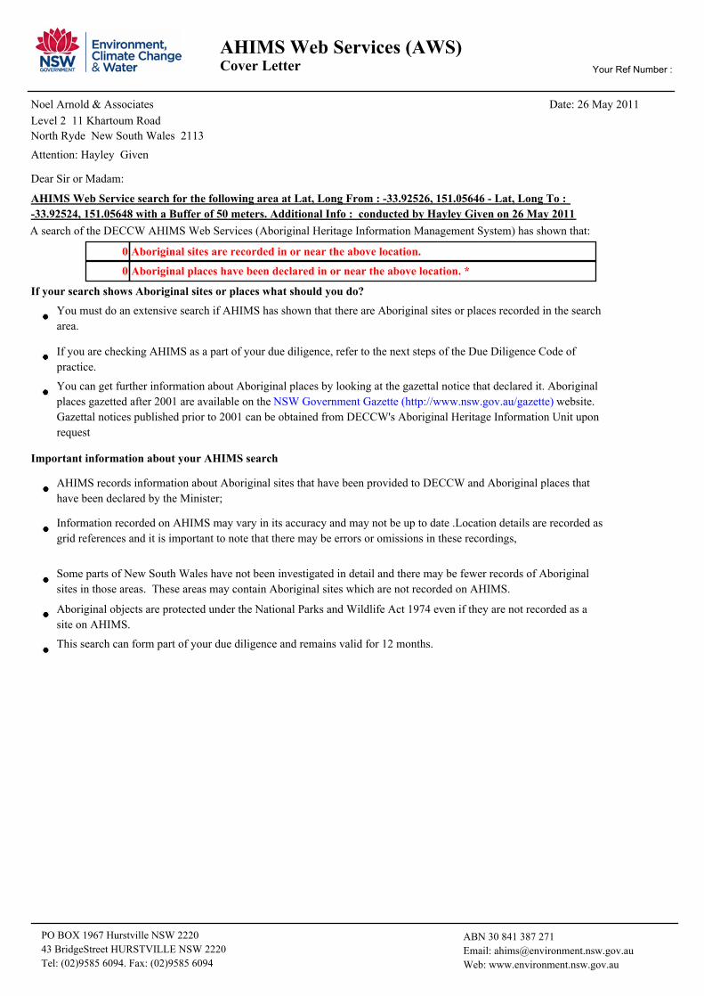
AHIMS Web Services (AWS)Cover Letter Your Ref Number :
Date: 26 May 2011Noel Arnold & Associates
North Ryde New South Wales 2113
Level 2 11 Khartoum Road
AHIMS Web Service search for the following area at Lat, Long From : -33.92526, 151.05646 - Lat, Long To :
-33.92524, 151.05648 with a Buffer of 50 meters. Additional Info : conducted by Hayley Given on 26 May 2011
Dear Sir or Madam:
Attention: Hayley Given
Aboriginal places have been declared in or near the above location. * 0
Aboriginal sites are recorded in or near the above location. 0
A search of the DECCW AHIMS Web Services (Aboriginal Heritage Information Management System) has shown that:
Important information about your AHIMS search
If your search shows Aboriginal sites or places what should you do?
You can get further information about Aboriginal places by looking at the gazettal notice that declared it. Aboriginal
places gazetted after 2001 are available on the NSW Government Gazette (http://www.nsw.gov.au/gazette) website.
Gazettal notices published prior to 2001 can be obtained from DECCW's Aboriginal Heritage Information Unit upon
request
Aboriginal objects are protected under the National Parks and Wildlife Act 1974 even if they are not recorded as a
site on AHIMS.
You must do an extensive search if AHIMS has shown that there are Aboriginal sites or places recorded in the search
area.
If you are checking AHIMS as a part of your due diligence, refer to the next steps of the Due Diligence Code of
practice.
AHIMS records information about Aboriginal sites that have been provided to DECCW and Aboriginal places that
have been declared by the Minister;
Information recorded on AHIMS may vary in its accuracy and may not be up to date .Location details are recorded as
grid references and it is important to note that there may be errors or omissions in these recordings,
Some parts of New South Wales have not been investigated in detail and there may be fewer records of Aboriginal
sites in those areas. These areas may contain Aboriginal sites which are not recorded on AHIMS.
This search can form part of your due diligence and remains valid for 12 months.
PO BOX 1967 Hurstville NSW 2220
43 BridgeStreet HURSTVILLE NSW 2220
Tel: (02)9585 6094. Fax: (02)9585 6094
ABN 30 841 387 271
Email: [email protected]
Web: www.environment.nsw.gov.au

Search Results
26 results found.
ASC Sugar Mill (former) Church St Canterbury, NSW, Australia
(Registered)
Register of the National Estate
Andrews Avenue Urban Conservation Area Ashbury, NSW, Australia
(Indicative Place)
Register of the National Estate
Ashbury Brickworks Kiln and Chimney Stack Trevenar St Ashbury, NSW, Australia
(Removed from Register or
IL)
Register of the National Estate
Ashbury Urban Conservation Area Ashbury, NSW, Australia
(Indicative Place)
Register of the National Estate
Belfield Urban Conservation Area Belfield, NSW, Australia
(Indicative Place)
Register of the National Estate
Belmore Urban Conservation Area Belmore, NSW, Australia
(Indicative Place)
Register of the National Estate
Campsie Fire Station Beamish St Campsie, NSW, Australia
(Indicative Place)
Register of the National Estate
Canarys Road Urban Conservation Area Roselands, NSW, Australia
(Indicative Place)
Register of the National Estate
Canterbury Post Office 193 Canterbury Rd Canterbury, NSW, Australia
(Indicative Place)
Register of the National Estate
Clemton Park Urban Conservation Area Homer St Clemton Park, NSW, Australia
(Indicative Place)
Register of the National Estate
Cooks River Sewer Aqueduct Thornley St Marrickville, NSW, Australia
(Registered)
Register of the National Estate
Defoe Street Urban Conservation Area Defor St Wiley Park, NSW, Australia
(Indicative Place)
Register of the National Estate
Dennis Street Urban Conservation Area Lakemba, NSW, Australia
(Indicative Place)
Register of the National Estate
Earlwood North Urban Conservation Area Earlwood, NSW, Australia
(Indicative Place)
Register of the National Estate
Earlwood Urban Conservation Area Earlwood, NSW, Australia
(Indicative Place)
Register of the National Estate
Page 1 of 2Australian Heritage Database
26/05/2011http://www.environment.gov.au/cgi-bin/ahdb/search.pl

Report Produced: Thu May 26 16:45:59 2011
Hillview Street Urban Conservation Area Roselands, NSW, Australia
(Indicative Place)
Register of the National Estate
Jackson Place Cottages 2 - 12 Jackson Pl Undercliffe, NSW, Australia
(Indicative Place)
Register of the National Estate
Lawn Avenue Urban Conservation Area Campsie, NSW, Australia
(Indicative Place)
Register of the National Estate
Moorfields Methodist Cemetery 98-100 Moorefields Rd Kingsgrove, NSW, Australia
(Indicative Place)
Register of the National Estate
Paxton Avenue Urban Conservation Area Belmore, NSW, Australia
(Indicative Place)
Register of the National Estate
Punchbowl Urban Conservation Area Punchbowl, NSW, Australia
(Indicative Place)
Register of the National Estate
Redman Parade Urban Conservation Area Belmore, NSW, Australia
(Indicative Place)
Register of the National Estate
Robert Street Urban Conservation Area Belmore, NSW, Australia
(Indicative Place)
Register of the National Estate
Undercliffe Urban Conservation Area Undercliffe, NSW, Australia
(Indicative Place)
Register of the National Estate
Welfare Avenue Urban Conservation Area Beverly Hills, NSW, Australia
(Indicative Place)
Register of the National Estate
Wolli Creek Sewer Aqueduct Unwin St Undercliffe, NSW, Australia
(Registered)
Register of the National Estate
Accessibility | Disclaimer | Privacy | © Commonwealth of Australia
Page 2 of 2Australian Heritage Database
26/05/2011http://www.environment.gov.au/cgi-bin/ahdb/search.pl
EPBC Act Protected Matters ReportThis report provides general guidance on matters of national environmental significance and other mattersprotected by the EPBC Act in the area you have selected.
Information on the coverage of this report and qualifications on data supporting this report are containedin the caveat at the end of the report.
Information about the EPBC Act including significance guidelines, forms and application process detailscan be found at http://www.environment.gov.au/epbc/assessmentsapprovals/index.html
This map may contain data which are©Commonwealth of Australia (GeoscienceAustralia), ©PSMA 2010
LGA CANTERBURY, NSW
Report created: 26/05/11 17:50:55
Summary
DetailsMatters of NESOther matters protected by theEPBC ActExtra Information
Caveat
Acknowledgements
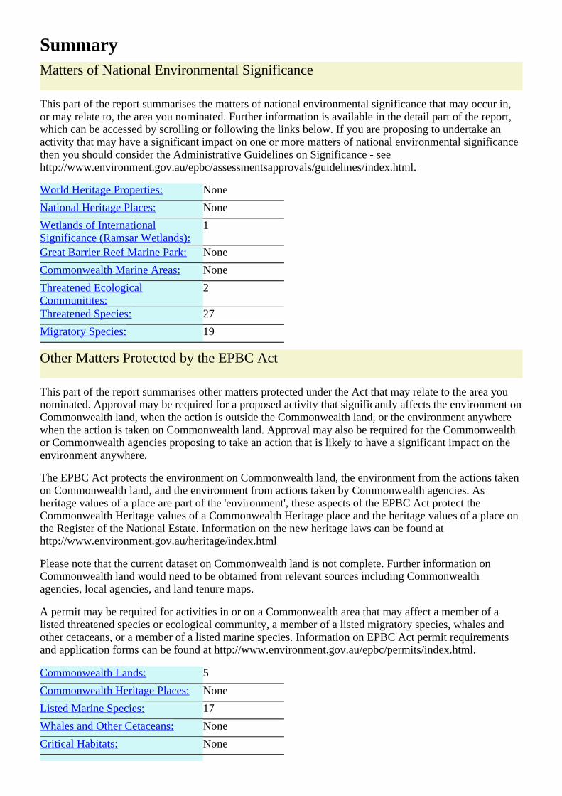
SummaryMatters of National Environmental Significance
This part of the report summarises the matters of national environmental significance that may occur in,or may relate to, the area you nominated. Further information is available in the detail part of the report,which can be accessed by scrolling or following the links below. If you are proposing to undertake anactivity that may have a significant impact on one or more matters of national environmental significancethen you should consider the Administrative Guidelines on Significance - seehttp://www.environment.gov.au/epbc/assessmentsapprovals/guidelines/index.html.
World Heritage Properties: None
National Heritage Places: None
Wetlands of InternationalSignificance (Ramsar Wetlands):
1
Great Barrier Reef Marine Park: None
Commonwealth Marine Areas: None
Threatened EcologicalCommunitites:
2
Threatened Species: 27
Migratory Species: 19
Other Matters Protected by the EPBC Act
This part of the report summarises other matters protected under the Act that may relate to the area younominated. Approval may be required for a proposed activity that significantly affects the environment onCommonwealth land, when the action is outside the Commonwealth land, or the environment anywherewhen the action is taken on Commonwealth land. Approval may also be required for the Commonwealthor Commonwealth agencies proposing to take an action that is likely to have a significant impact on theenvironment anywhere.
The EPBC Act protects the environment on Commonwealth land, the environment from the actions takenon Commonwealth land, and the environment from actions taken by Commonwealth agencies. Asheritage values of a place are part of the 'environment', these aspects of the EPBC Act protect theCommonwealth Heritage values of a Commonwealth Heritage place and the heritage values of a place onthe Register of the National Estate. Information on the new heritage laws can be found athttp://www.environment.gov.au/heritage/index.html
Please note that the current dataset on Commonwealth land is not complete. Further information onCommonwealth land would need to be obtained from relevant sources including Commonwealthagencies, local agencies, and land tenure maps.
A permit may be required for activities in or on a Commonwealth area that may affect a member of alisted threatened species or ecological community, a member of a listed migratory species, whales andother cetaceans, or a member of a listed marine species. Information on EPBC Act permit requirementsand application forms can be found at http://www.environment.gov.au/epbc/permits/index.html.
Commonwealth Lands: 5
Commonwealth Heritage Places: None
Listed Marine Species: 17
Whales and Other Cetaceans: None
Critical Habitats: None

Commonwealth Reserves: None
Report Summary for Extra Information
This part of the report provides information that may also be relevant to the area you have nominated.
Place on the RNE: 28
State and Territory Reserves: 1
Regional Forest Agreements: None
Invasive Species: 17
Nationally Important Wetlands: None
DetailsMatters of National Environmental Significance
Wetlands of International Significance (RAMSARSites)
[ Resource Information ]
Name ProximityTowra point nature reserve Within 10km of Ramsar site
Threatened Ecological Communities [ Resource Information ]
For threatened ecological communities where the distribution is well known, maps are derived fromrecovery plans, State vegetation maps, remote sensing imagery and other sources. Where threatenedecological community distributions are less well known, existing vegetation maps and point location dataare used to produce indicative distribution maps.
Name Status Type of PresenceTurpentine-Ironbark Forest in theSydney Basin Bioregion
CriticallyEndangered
Community likely to occur within area
Shale/Sandstone Transition Forest Endangered Community likely to occur within area
Threatened Species [ Resource Information ]
Name Status Type of PresenceBIRDSAnthochaera phrygiaRegent Honeyeater [82338] Endangered Species or species habitat likely to occur within area
Lathamus discolorSwift Parrot [744] Endangered Species or species habitat may occur within areaNeophema chrysogasterOrange-bellied Parrot [747] Critically
EndangeredSpecies or species habitat may occur within area
Rostratula australisAustralian Painted Snipe [77037] Vulnerable Species or species habitat may occur within areaFROGSHeleioporus australiacusGiant Burrowing Frog [1973] Vulnerable Species or species habitat likely to occur within area
Litoria aureaGreen and Golden Bell Frog [1870] Vulnerable Species or species habitat may occur within areaLitoria raniformisGrowling Grass Frog, Southern BellFrog, Green and Golden Frog, Warty
Vulnerable Species or species habitat may occur within area
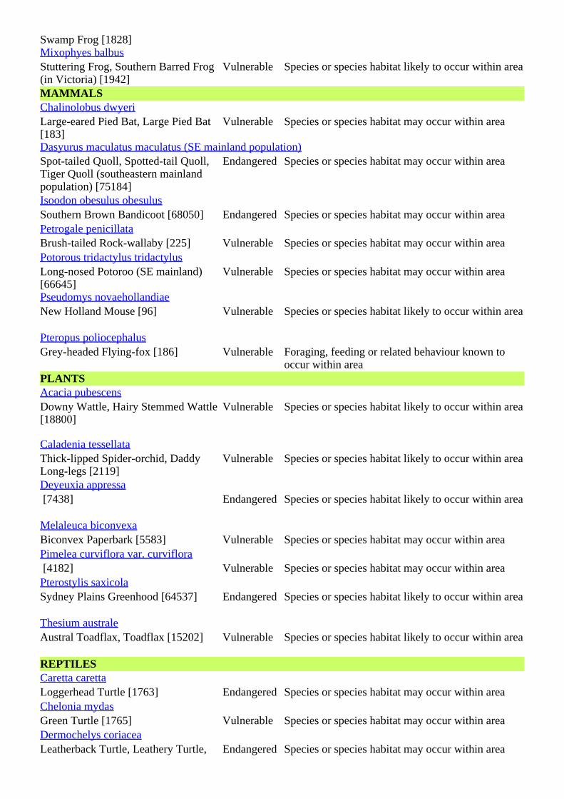
Swamp Frog [1828]Mixophyes balbusStuttering Frog, Southern Barred Frog(in Victoria) [1942]
Vulnerable Species or species habitat likely to occur within area
MAMMALSChalinolobus dwyeriLarge-eared Pied Bat, Large Pied Bat[183]
Vulnerable Species or species habitat may occur within area
Dasyurus maculatus maculatus (SE mainland population)Spot-tailed Quoll, Spotted-tail Quoll,Tiger Quoll (southeastern mainlandpopulation) [75184]
Endangered Species or species habitat may occur within area
Isoodon obesulus obesulusSouthern Brown Bandicoot [68050] Endangered Species or species habitat may occur within areaPetrogale penicillataBrush-tailed Rock-wallaby [225] Vulnerable Species or species habitat may occur within areaPotorous tridactylus tridactylusLong-nosed Potoroo (SE mainland)[66645]
Vulnerable Species or species habitat may occur within area
Pseudomys novaehollandiaeNew Holland Mouse [96] Vulnerable Species or species habitat likely to occur within area
Pteropus poliocephalusGrey-headed Flying-fox [186] Vulnerable Foraging, feeding or related behaviour known to
occur within areaPLANTSAcacia pubescensDowny Wattle, Hairy Stemmed Wattle[18800]
Vulnerable Species or species habitat likely to occur within area
Caladenia tessellataThick-lipped Spider-orchid, DaddyLong-legs [2119]
Vulnerable Species or species habitat likely to occur within area
Deyeuxia appressa [7438] Endangered Species or species habitat likely to occur within area
Melaleuca biconvexaBiconvex Paperbark [5583] Vulnerable Species or species habitat may occur within areaPimelea curviflora var. curviflora [4182] Vulnerable Species or species habitat may occur within areaPterostylis saxicolaSydney Plains Greenhood [64537] Endangered Species or species habitat likely to occur within area
Thesium australeAustral Toadflax, Toadflax [15202] Vulnerable Species or species habitat likely to occur within area
REPTILESCaretta carettaLoggerhead Turtle [1763] Endangered Species or species habitat may occur within areaChelonia mydasGreen Turtle [1765] Vulnerable Species or species habitat may occur within areaDermochelys coriaceaLeatherback Turtle, Leathery Turtle, Endangered Species or species habitat may occur within area
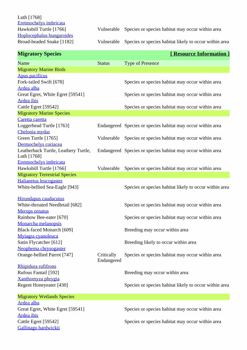
Luth [1768]Eretmochelys imbricataHawksbill Turtle [1766] Vulnerable Species or species habitat may occur within areaHoplocephalus bungaroidesBroad-headed Snake [1182] Vulnerable Species or species habitat likely to occur within area
Migratory Species [ Resource Information ]
Name Status Type of PresenceMigratory Marine BirdsApus pacificusFork-tailed Swift [678] Species or species habitat may occur within areaArdea albaGreat Egret, White Egret [59541] Species or species habitat may occur within areaArdea ibisCattle Egret [59542] Species or species habitat may occur within areaMigratory Marine SpeciesCaretta carettaLoggerhead Turtle [1763] Endangered Species or species habitat may occur within areaChelonia mydasGreen Turtle [1765] Vulnerable Species or species habitat may occur within areaDermochelys coriaceaLeatherback Turtle, Leathery Turtle,Luth [1768]
Endangered Species or species habitat may occur within area
Eretmochelys imbricataHawksbill Turtle [1766] Vulnerable Species or species habitat may occur within areaMigratory Terrestrial SpeciesHaliaeetus leucogasterWhite-bellied Sea-Eagle [943] Species or species habitat likely to occur within area
Hirundapus caudacutusWhite-throated Needletail [682] Species or species habitat may occur within areaMerops ornatusRainbow Bee-eater [670] Species or species habitat may occur within areaMonarcha melanopsisBlack-faced Monarch [609] Breeding may occur within areaMyiagra cyanoleucaSatin Flycatcher [612] Breeding likely to occur within areaNeophema chrysogasterOrange-bellied Parrot [747] Critically
EndangeredSpecies or species habitat may occur within area
Rhipidura rufifronsRufous Fantail [592] Breeding may occur within areaXanthomyza phrygiaRegent Honeyeater [430] Species or species habitat likely to occur within area
Migratory Wetlands SpeciesArdea albaGreat Egret, White Egret [59541] Species or species habitat may occur within areaArdea ibisCattle Egret [59542] Species or species habitat may occur within areaGallinago hardwickii
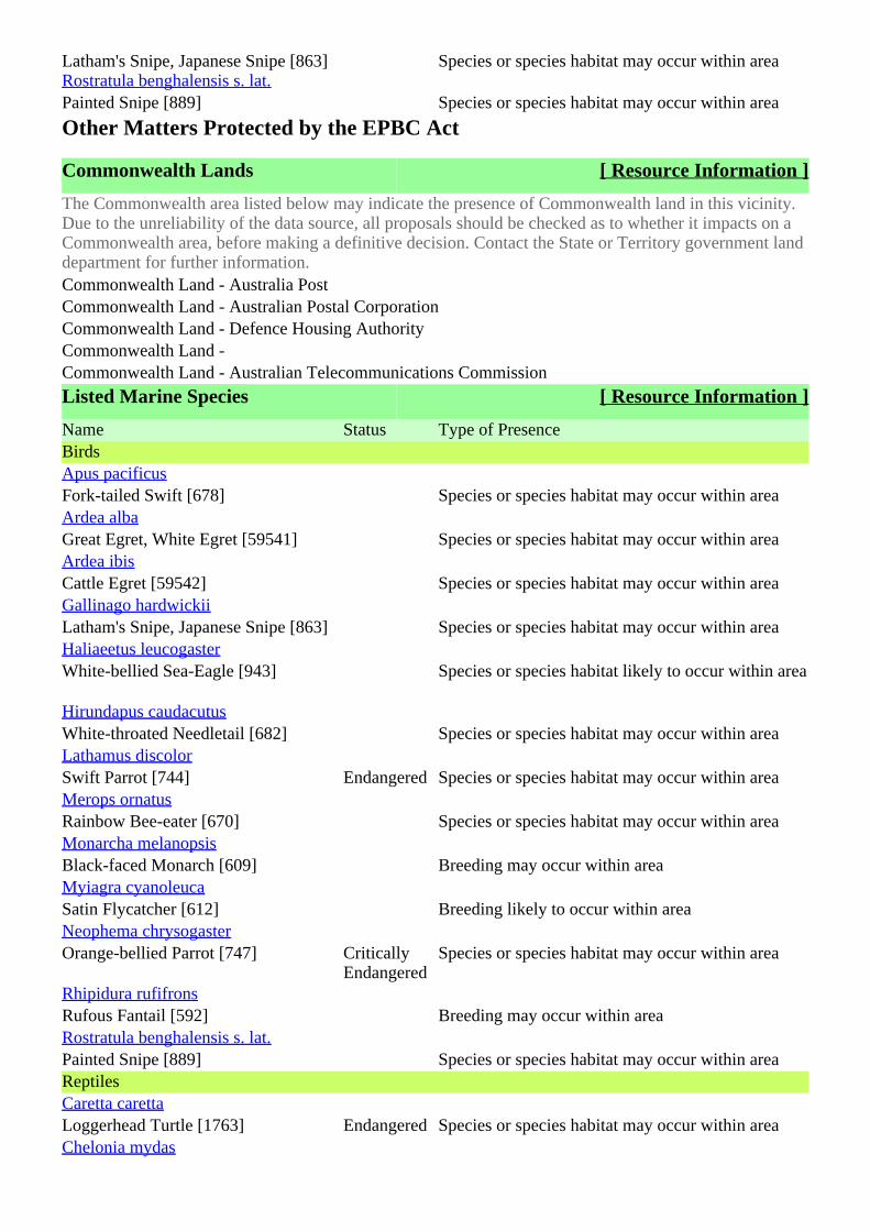
Latham's Snipe, Japanese Snipe [863] Species or species habitat may occur within areaRostratula benghalensis s. lat.Painted Snipe [889] Species or species habitat may occur within area
Other Matters Protected by the EPBC Act
Commonwealth Lands [ Resource Information ]
The Commonwealth area listed below may indicate the presence of Commonwealth land in this vicinity.Due to the unreliability of the data source, all proposals should be checked as to whether it impacts on aCommonwealth area, before making a definitive decision. Contact the State or Territory government landdepartment for further information.Commonwealth Land - Australia PostCommonwealth Land - Australian Postal CorporationCommonwealth Land - Defence Housing AuthorityCommonwealth Land -Commonwealth Land - Australian Telecommunications Commission
Listed Marine Species [ Resource Information ]
Name Status Type of PresenceBirdsApus pacificusFork-tailed Swift [678] Species or species habitat may occur within areaArdea albaGreat Egret, White Egret [59541] Species or species habitat may occur within areaArdea ibisCattle Egret [59542] Species or species habitat may occur within areaGallinago hardwickiiLatham's Snipe, Japanese Snipe [863] Species or species habitat may occur within areaHaliaeetus leucogasterWhite-bellied Sea-Eagle [943] Species or species habitat likely to occur within area
Hirundapus caudacutusWhite-throated Needletail [682] Species or species habitat may occur within areaLathamus discolorSwift Parrot [744] Endangered Species or species habitat may occur within areaMerops ornatusRainbow Bee-eater [670] Species or species habitat may occur within areaMonarcha melanopsisBlack-faced Monarch [609] Breeding may occur within areaMyiagra cyanoleucaSatin Flycatcher [612] Breeding likely to occur within areaNeophema chrysogasterOrange-bellied Parrot [747] Critically
EndangeredSpecies or species habitat may occur within area
Rhipidura rufifronsRufous Fantail [592] Breeding may occur within areaRostratula benghalensis s. lat.Painted Snipe [889] Species or species habitat may occur within areaReptilesCaretta carettaLoggerhead Turtle [1763] Endangered Species or species habitat may occur within areaChelonia mydas
Green Turtle [1765] Vulnerable Species or species habitat may occur within areaDermochelys coriaceaLeatherback Turtle, Leathery Turtle,Luth [1768]
Endangered Species or species habitat may occur within area
Eretmochelys imbricataHawksbill Turtle [1766] Vulnerable Species or species habitat may occur within area
Extra Information
Places on the RNE [ Resource Information ]
Note that not all Indigenous sites may be listed.
Name StatusHistoricAndrews Avenue Urban Conservation Area NSW Indicative PlaceAshbury Urban Conservation Area NSW Indicative PlaceBardwell Park Urban Conservation Area NSW Indicative PlaceBelfield Urban Conservation Area NSW Indicative PlaceBelmore Urban Conservation Area NSW Indicative PlaceCampsie Fire Station NSW Indicative PlaceCanarys Road Urban Conservation Area NSW Indicative PlaceCanterbury Post Office NSW Indicative PlaceClemton Park Urban Conservation Area NSW Indicative PlaceDefoe Street Urban Conservation Area NSW Indicative PlaceDennis Street Urban Conservation Area NSW Indicative PlaceEarlwood North Urban Conservation Area NSW Indicative PlaceEarlwood Urban Conservation Area NSW Indicative PlaceHillview Street Urban Conservation Area NSW Indicative PlaceJackson Place Cottages NSW Indicative PlaceLawn Avenue Urban Conservation Area NSW Indicative PlaceMoorfields Methodist Cemetery NSW Indicative PlacePallamanna Parade Urban Conservation Area NSW Indicative PlacePaxton Avenue Urban Conservation Area NSW Indicative PlacePunchbowl Urban Conservation Area NSW Indicative PlacePunchbowl Urban Conservation Area NSW Indicative PlaceRedman Parade Urban Conservation Area NSW Indicative PlaceRobert Street Urban Conservation Area NSW Indicative PlaceUndercliffe Urban Conservation Area NSW Indicative PlaceWelfare Avenue Urban Conservation Area NSW Indicative PlaceASC Sugar Mill (former) NSW RegisteredCooks River Sewer Aqueduct NSW RegisteredWolli Creek Sewer Aqueduct NSW Registered
State and Territory Reserves [ Resource Information ]
Wolli Creek, NSW
Invasive Species [ Resource Information ]
Weeds reported here are the 20 species of national significance (WoNS), along with other introducedplants that are considered by the States and Territories to pose a particularly significant threat tobiodiversity. The following feral animals are reported: Goat, Red Fox, Cat, Rabbit, Pig, Water Buffaloand Cane Toad. Maps from Landscape Health Project, National Land and Water Resouces Audit, 2001.Name Status Type of PresenceMammals
Capra hircusGoat [2] Species or species habitat may occur within areaFelis catusCat, House Cat, Domestic Cat [19] Species or species habitat likely to occur within area
Oryctolagus cuniculusRabbit, European Rabbit [128] Species or species habitat likely to occur within area
Sus scrofaPig [6] Species or species habitat may occur within areaVulpes vulpesRed Fox, Fox [18] Species or species habitat likely to occur within area
Alternanthera philoxeroidesAlligator Weed [11620] Species or species habitat may occur within areaAsparagus asparagoidesBridal Creeper, Bridal Veil Creeper,Smilax, Florist's Smilax, SmilaxAsparagus [22473]
Species or species habitat may occur within area
Chrysanthemoides moniliferaBitou Bush, Boneseed [18983] Species or species habitat may occur within areaGenista sp. X Genista monspessulanaBroom [67538] Species or species habitat may occur within areaLantana camaraLantana, Common Lantana, KamaraLantana, Large-leaf Lantana, PinkFlowered Lantana, Red FloweredLantana, Red-Flowered Sage, WhiteSage, Wild Sage [10892]
Species or species habitat likely to occur within area
Lycium ferocissimumAfrican Boxthorn, Boxthorn [19235] Species or species habitat may occur within areaNassella trichotomaSerrated Tussock, Yass River Tussock,Yass Tussock, Nassella Tussock (NZ)[18884]
Species or species habitat may occur within area
Pinus radiataRadiata Pine Monterey Pine, InsignisPine, Wilding Pine [20780]
Species or species habitat may occur within area
Rubus fruticosus aggregateBlackberry, European Blackberry[68406]
Species or species habitat likely to occur within area
Salix spp. except S.babylonica, S.x calodendron & S.x reichardtijiWillows except Weeping Willow,Pussy Willow and Sterile Pussy Willow[68497]
Species or species habitat may occur within area
Salvinia molestaSalvinia, Giant Salvinia, AquariumWatermoss, Kariba Weed [13665]
Species or species habitat may occur within area
Ulex europaeusGorse, Furze [7693] Species or species habitat may occur within area
Caveat
The information presented in this report has been provided by a range of data sources as acknowledged atthe end of the report.
This report is designed to assist in identifying the locations of places which may be relevant indetermining obligations under the Environment Protection and Biodiversity Conservation Act 1999. Itholds mapped locations of World Heritage and Register of National Estate properties, Wetlands ofInternational Importance, Commonwealth and State/Territory reserves, listed threatened, migratory andmarine species and listed threatened ecological communities. Mapping of Commonwealth land is notcomplete at this stage. Maps have been collated from a range of sources at various resolutions.
Not all species listed under the EPBC Act have been mapped (see below) and therefore a report is ageneral guide only. Where available data supports mapping, the type of presence that can be determinedfrom the data is indicated in general terms. People using this information in making a referral may need toconsider the qualifications below and may need to seek and consider other information sources.
For threatened ecological communities where the distribution is well known, maps are derived fromrecovery plans, State vegetation maps, remote sensing imagery and other sources. Where threatenedecological community distributions are less well known, existing vegetation maps and point location dataare used to produce indicative distribution maps.
For species where the distributions are well known, maps are digitised from sources such as recoveryplans and detailed habitat studies. Where appropriate, core breeding, foraging and roosting areas areindicated under 'type of presence'. For species whose distributions are less well known, point locations arecollated from government wildlife authorities, museums, and non-government organisations; bioclimaticdistribution models are generated and these validated by experts. In some cases, the distribution maps arebased solely on expert knowledge.
Only selected species covered by the following provisions of the EPBC Act have been mapped:- migratory and- marine
The following species and ecological communities have not been mapped and do not appear in reportsproduced from this database:
- threatened species listed as extinct or considered as vagrants- some species and ecological communities that have only recently been listed- some terrestrial species that overfly the Commonwealth marine area- migratory species that are very widespread, vagrant, or only occur in small numbers.
The following groups have been mapped, but may not cover the complete distribution of the species:- non-threatened seabirds which have only been mapped for recorded breeding sites;- seals which have only been mapped for breeding sites near the Australian continent.
Such breeding sites may be important for the protection of the Commonwealth Marine environment.
AcknowledgementsThis database has been compiled from a range of data sources. The department acknowledges thefollowing custodians who have contributed valuable data and advice:
-Department of Environment, Climate Change and Water, New South Wales-Department of Sustainability and Environment, Victoria-Department of Primary Industries, Parks, Water and Environment, Tasmania-Department of Environment and Natural Resources, South Australia-Parks and Wildlife Service NT, NT Dept of Natural Resources, Environment and the Arts-Environmental and Resource Management, Queensland-Department of Environment and Conservation, Western Australia-Department of the Environment, Climate Change, Energy and Water
-Birds Australia-Australian Bird and Bat Banding Scheme-Australian National Wildlife Collection-Natural history museums of Australia-Museum Victoria-Australian Museum-SA Museum-Queensland Museum-Online Zoological Collections of Australian Museums-Queensland Herbarium-National Herbarium of NSW-Royal Botanic Gardens and National Herbarium of Victoria-Tasmanian Herbarium-State Herbarium of South Australia-Northern Territory Herbarium-Western Australian Herbarium-Australian National Herbarium, Atherton and Canberra-University of New England-Ocean Biogeographic Information System-Australian Government, Department of Defence-State Forests of NSW-Other groups and individuals
The Department is extremely grateful to the many organisations and individuals who provided expertadvice and information on numerous draft distributions.
Please feel free to provide feedback via the page.Contact Us
Accessibility | | | | Disclaimer Privacy © Commonwealth of Australia HelpLast updated: Thursday, 16-Sep-2010 09:13:25 EST
Department of Sustainability, Environment, Water, Population and CommunitiesGPO Box 787Canberra ACT 2601 Australia+61 2 6274 1111 ABN
| |Australian Government
About Us Listings Development
Heritage Council Publications & Forms
Conservation & Technical
About Heritage Research Funding
Punchbowl Railway Station Group
Home Listings Heritage Databases Heritage Database Search Heritage Item
Click on the BACK button of your browser to return to the previous page.
ItemName of Item: Punchbowl Railway Station Group
Type of Item: Built
Group/Collection: Transport - Rail
Category: Railway Platform/ Station
Primary Address: Punchbowl Road, Punchbowl, NSW 2196
Local Govt. Area: Canterbury
Property Description: Lot/Volume Code Lot/Volume Number Section Number Plan/Folio Code Plan/Folio Number
Boundary: North: Property boundary along Warren Reserve South: Property boundary to rear of private properties along The Boulevard East: 5 metres from eastern end of island platform West: 5 metres from end of western end of island platform (excluding overbridge on Punchbowl Road)
All Addresses
Street Address Suburb/Town LGA Parish County TypePunchbowl Road Punchbowl Canterbury Primary
Owner/s Organisation Name Owner Category Date Ownership UpdatedRailCorp State Government
RailCorp State Government
Statement of Significance
Punchbowl Railway Station has local historical significance as it was one of the stations to be located on the Sydenham to Bankstown Line which was built to take pressure off the traffic on the Main South Line as well as promote agriculture and suburban development in the late 19th and early 20th centuries. The station reflects the extension of the line to Bankstown in 1909 and the overhead booking office, footbridge and stairs, reflect the development of suburbs in the area during the Interwar period. The overhead booking office has local aesthetic and technical significance as an example of the design by NSW Railways of these timber overhead structures built between 1910 and the 1950s. The overhead booking office is also significant as it is a fine example of its type, and because it is relatively intact with an unaltered lamp room. Date Significance Updated: 25 Jun 09 Note: There are incomplete details for a number of items listed in NSW.
Page 1 of 6Heritage Branch Website - Online Database
26/05/2011http://www.heritage.nsw.gov.au/07_subnav_04_2.cfm?itemid=4802009
The Heritage Branch intends to develop or upgrade statements of significance and other information for these items as resources become available.
DescriptionDesigner/Maker: NSW Government Railways
Builder/Maker: George Leggo
Construction Years: 1909 - 1929
Physical Description: BUILDINGS Platform building, Platform 1/2 (early 1980s) Toilet block, Platform 1/2 (1970s) Overhead Booking Office (1929) STRUCTURES Platforms 1/2, (1909) Footbridge, (1930) Canopies and extensions to Overhead Booking Office, (c.2000s) CONTEXT Punchbowl Railway Station consists of a single island platform with two later built station buildings. The platforms are accessed by a central set of stairs which lead down from the footbridge associated with the original timber framed and weatherboard overhead booking office. The station can be accessed by steps either from the south by The Boulevard, which is a major shopping street, or from the north via Warren Reserve and Punchbowl Road. Immediately to the west of the overhead booking office the Punchbowl Road overbridge crosses the rail line. PLATFORM BUILDING (1980s) External: Simple rectangular face brick building with a flat metal deck roof and high profiled metal fascia which extends as a cantilever awning on both sides. The windows are timber double hung and the doors are flush. Internal: The building consists of a Station Master's office, sign-on room a store and waiting room. Inside the waiting room the walls are face brick with a concrete floor, while the other rooms have their internal walls rendered. The metal clad soffit of the awning continues through as the internal ceiling to all rooms. TOILET BLOCK (1970s) The male and female toilets originally had a hipped roof which was replaced with a flat roof matching the adjacent main platform building. The roof spans between both buildings. Like the main building, the toilet is a simple rectangular building, with external walls of face brick, while the windows are aluminium framed. OVERHEAD BOOKING OFFICE (1929) The overhead booking office is a timber framed, weatherboard clad building with a hipped corrugated steel clad roof. The original 1929 roof configuration consisted of a simple hipped roof with Dutch gables on the eastern and western ends and which covered the booking office, the parcels office, the booking hall and the eastern and western footbridges. The later lamp room addition extended the western side of the building to the north to make the building L shaped. A bookstall was added which added a further northern but smaller extension with an awning roof. The ticket collection cabin connected to the main booking office has been removed. PLATFORMS (1909) One island platform with asphalt surface and original brick face and
Page 2 of 6Heritage Branch Website - Online Database
26/05/2011http://www.heritage.nsw.gov.au/07_subnav_04_2.cfm?itemid=4802009
edge. FOOTBRIDGE (1930) Standard concrete platform supported on steel beams bearing on steel platform trestles and steel trestles on each side of the tracks. Stairs give access from the north and south with a single stair leading down to the island platform. The footbridge structure and stairs have been modified. CANOPIES (c2000s) A modern steel framed and steel roofed canopy has been erected over the platform access stairs and extends from the end of the main station building up to the overhead booking office. A contemporaneous canopy with glazed walling also extends across the southern footbridge. ARCHAEOLOGICAL POTENTIAL Based on the surviving documentation and the evidence on site it is unlikely there would be any potential archaeological remains at Punchbowl Railway Station.
Physical Condition and/or Archaeological Potential:
PLATFORM BUILDINGS Good condition. PLATFORM Generally good condition. CANOPIES Good condition. FOOTBRIDGE Good condition. Date Condition Updated: 09 Sep 08
Modifications and Dates: 1917: Covering erected over platform signal levers. 1919: Goods shed opened. 1924: Station building awning erected. 1926: Railway electrified. 1929: Overhead booking office erected; platforms lengthened. 1930: Steel beam footbridge erected. 1941: Erection of new lamp room 1947: New parcels office opened. 1980s: Parcels office within the overhead booking office closed
Further Information: PUNCBOWL ROAD OVERBRIDGE (1979) Modern concrete girder overbridge. Excluded from listing.
Current Use: Railway Station
Former Use: Nil
HistoryHistorical Notes: The Sydenham to Bankstown Railway was opened with the initial
terminus station at Belmore on 1 February 1895. The line had its origins in Railway Commissioner Goodchap’s 1882 recommendation that an additional line was needed between Newtown and Liverpool to relieve traffic on the Southern Line and to encourage agriculture and suburban settlement. Lobbying by local interests and land speculators achieved Parliamentary approval by 1890 and construction commenced in 1892. The most important stations on the line, Belmore, Canterbury and Marrickville, were built with impressive near-identical brick buildings, the other intermediate stations (Campsie, Dulwich Hill and Hurlstone Park) receiving more modest timber buildings (later replaced), possibly reflecting economies of the depression of the 1890s. The depression suppressed the profitability of the line and the extension to Liverpool did not proceed. However, suburban development followed in the early twentieth century, particularly during the interwar period when many War Service homes were built west of Canterbury. The line was extended to Bankstown in 1909 (and then to Regents Park in 1928, making it part of a loop line through Lidcombe), its justification by then being the servicing of suburban development. Punchbowl Station was opened along with the line extension on 14 April 1909, at the same time as Bankstown and Lakemba. The contract for construction of station buildings was awarded to G Leggo
Page 3 of 6Heritage Branch Website - Online Database
26/05/2011http://www.heritage.nsw.gov.au/07_subnav_04_2.cfm?itemid=4802009
of Paddington. Block signalling was introduced in 1916, and a covering erected over the platform signal levers the next year. A goods siding was opened in 1919 (removed 1981) and a station building awning added in 1924. In 1929 following electrification that occurred in 1926, there were further modifications with an overhead booking office erected, platforms lengthened, and the removal of the stairway to the overbridge. There were further developments in the 1940s, with the construction of a new lamp room and a new parcels office. A notable railway development in proximity of the station was the opening of an electric train depot in 1926. The depot closed in 1995.
Assessment of SignificanceSHR Criteria a) [Historical Significance]
Punchbowl Railway Station has local historical significance as it is one of the railway stations on the Sydenham to Bankstown Line built to relieve the crowding on the Main Southern Line and encourage agriculture and suburban growth in the late 1800s and early 20th century. The station represents the extension of the line to Bankstown in 1909 and the overhead booking office and associated footbridge and stairs the suburban development after the First World War when many War Services Homes were built in the area.
SHR Criteria c) [Aesthetic Significance]
The platform station buildings have no aesthetic significance as they are later additions, but the overhead booking office and associated spaces have local aesthetic and technical significance in deonstrating the particular design and style of timber overhead booking structures erected by the NSW Railways between 1910 and the 1950s.
SHR Criteria d) [Social Significance]
The place has the potential to contribute to the local community's sense of place, and can provide a connection to the local community's past.
SHR Criteria e) [Research Potential]
The timber overhead booking office, because of its relative intactness, and the presence of the early lamp room does give some ability for further understanding of the design of these building types constructed by the railways in the first half of the 20th century.
SHR Criteria g) [Representativeness]
While the platform buildings at Punchbowl do not qualify, the timber overhead booking office, being relatively intact and possessing an unaltered lamp room, as well as the associated footbridge and stairs is a good example of this type of structure built by NSW Railways in the Sydney Metropolitan area between 1910 and the 1950s.
Integrity/Intactness: Overall the station has lost integrity due to the replacement of the station buildings. The overhead booking office however retains its original configuration, being the enclosed booking office, the semi-enclosed booking hall and the connections to the footbridge and stairs down to the island platform, as well as most of the original weatherboard and cement sheet wall and ceiling linings. The early addition of the lamp room and the bookstall also remain. Internally, while the original timber wall panelling remains, the ceiling is new plasterboard. The ticket windows have been replaced as has the parcels office enclosure and the original fitout within the booking office. New ripple iron has replaced the original glazing at the western and eastern ends overlooking the railway lines. The footbridge and stairs have been modified by the addition of a new balustrade, new concrete treads and risers, the glass enclosure as well as the roofing canopies.
Assessment Criteria Items are assessed against the State Heritage Register (SHR) Criteria to determine the level of significance. Refer to the Listings below for the level of statutory protection.
Page 4 of 6Heritage Branch Website - Online Database
26/05/2011http://www.heritage.nsw.gov.au/07_subnav_04_2.cfm?itemid=4802009
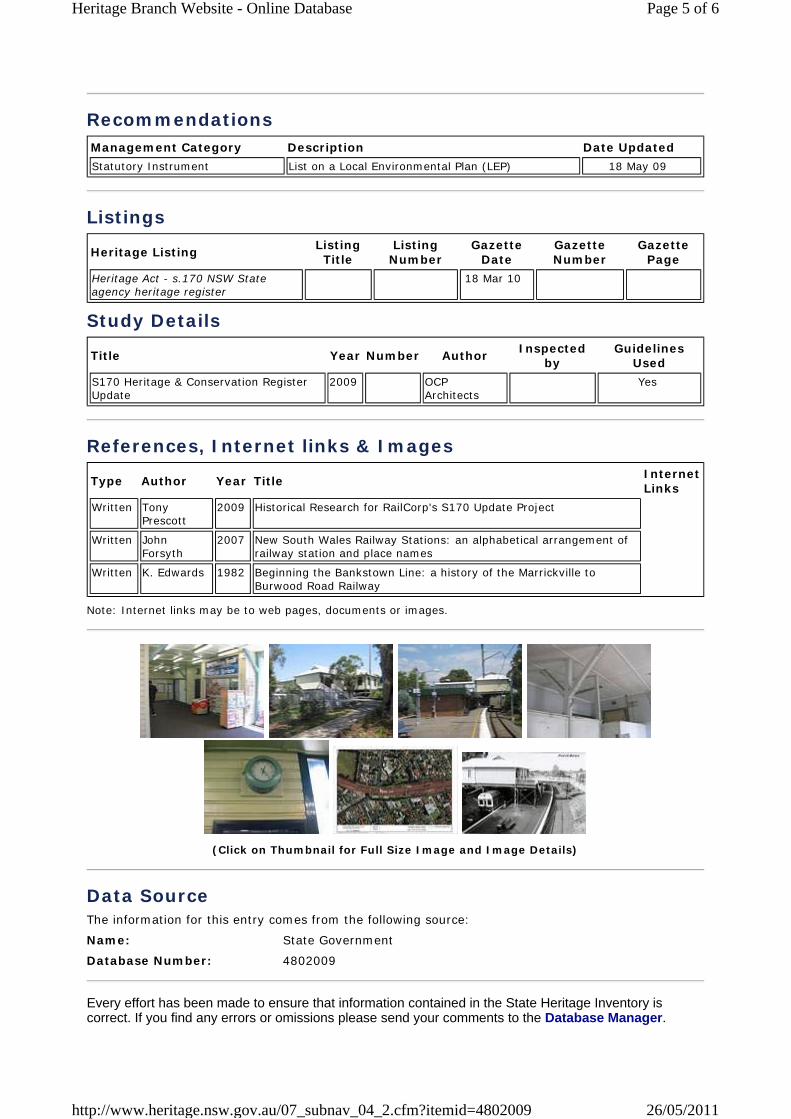
Recommendations Management Category Description Date UpdatedStatutory Instrument List on a Local Environmental Plan (LEP) 18 May 09
Listings
Heritage Listing Listing Title
Listing Number
Gazette Date
Gazette Number
Gazette Page
Heritage Act - s.170 NSW State agency heritage register
18 Mar 10
Study Details
Title Year Number Author Inspected by
Guidelines Used
S170 Heritage & Conservation Register Update
2009 OCP Architects
Yes
References, Internet links & Images
Type Author Year Title Internet Links
Written Tony Prescott
2009 Historical Research for RailCorp's S170 Update Project
Written John Forsyth
2007 New South Wales Railway Stations: an alphabetical arrangement of railway station and place names
Written K. Edwards 1982 Beginning the Bankstown Line: a history of the Marrickville to Burwood Road Railway
Note: Internet links may be to web pages, documents or images.
(Click on Thumbnail for Full Size Image and Image Details)
Data SourceThe information for this entry comes from the following source:
Name: State Government
Database Number: 4802009
Every effort has been made to ensure that information contained in the State Heritage Inventory is correct. If you find any errors or omissions please send your comments to the Database Manager.
Page 5 of 6Heritage Branch Website - Online Database
26/05/2011http://www.heritage.nsw.gov.au/07_subnav_04_2.cfm?itemid=4802009

All information and pictures on this page are the copyright of the Heritage Branch or respective copyright owners.
NSW Government | Site Map | Contact Us | Copyright | Disclaimer | Privacy
Page 6 of 6Heritage Branch Website - Online Database
26/05/2011http://www.heritage.nsw.gov.au/07_subnav_04_2.cfm?itemid=4802009
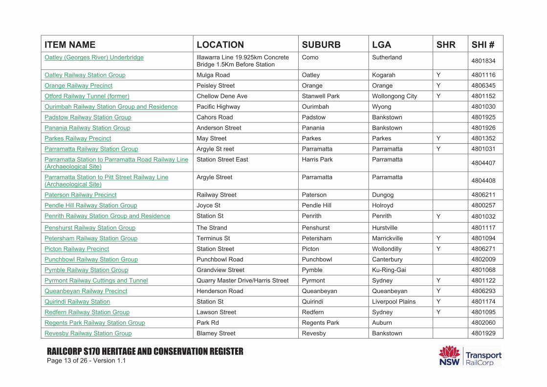
RAILCORP S170 HERITAGE AND CONSERVATION REGISTER Page 13 of 26 - Version 1.1
ITEM NAME LOCATION SUBURB LGA SHR SHI # Oatley (Georges River) Underbridge Illawarra Line 19.925km Concrete
Bridge 1.5Km Before Station Como Sutherland 4801834
Oatley Railway Station Group Mulga Road Oatley Kogarah Y 4801116
Orange Railway Precinct Peisley Street Orange Orange Y 4806345
Otford Railway Tunnel (former) Chellow Dene Ave Stanwell Park Wollongong City Y 4801152
Ourimbah Railway Station Group and Residence Pacific Highway Ourimbah Wyong 4801030
Padstow Railway Station Group Cahors Road Padstow Bankstown 4801925
Panania Railway Station Group Anderson Street Panania Bankstown 4801926
Parkes Railway Precinct May Street Parkes Parkes Y 4801352
Parramatta Railway Station Group Argyle St reet Parramatta Parramatta Y 4801031
Parramatta Station to Parramatta Road Railway Line (Archaeological Site)
Station Street East Harris Park Parramatta 4804407
Parramatta Station to Pitt Street Railway Line (Archaeological Site)
Argyle Street Parramatta Parramatta 4804408
Paterson Railway Precinct Railway Street Paterson Dungog 4806211
Pendle Hill Railway Station Group Joyce St Pendle Hill Holroyd 4800257
Penrith Railway Station Group and Residence Station St Penrith Penrith Y 4801032
Penshurst Railway Station Group The Strand Penshurst Hurstville 4801117
Petersham Railway Station Group Terminus St Petersham Marrickville Y 4801094
Picton Railway Precinct Station Street Picton Wollondilly Y 4806271
Punchbowl Railway Station Group Punchbowl Road Punchbowl Canterbury 4802009
Pymble Railway Station Group Grandview Street Pymble Ku-Ring-Gai 4801068
Pyrmont Railway Cuttings and Tunnel Quarry Master Drive/Harris Street Pyrmont Sydney Y 4801122
Queanbeyan Railway Precinct Henderson Road Queanbeyan Queanbeyan Y 4806293
Quirindi Railway Station Station St Quirindi Liverpool Plains Y 4801174
Redfern Railway Station Group Lawson Street Redfern Sydney Y 4801095
Regents Park Railway Station Group Park Rd Regents Park Auburn 4802060
Revesby Railway Station Group Blamey Street Revesby Bankstown 4801929
About Us Listings Development
Heritage Council Publications & Forms
Conservation & Technical
About Heritage Research Funding
Home Listings Heritage Databases Heritage Database Search Search Results
Click on the BACK button of your browser to return to the search.
Statutory Listed Items
Information and items listed in the State Heritage Inventory come from a number of sources. This means that there may be several entries for the same heritage item in the database. For clarity, the search results have been divided into two sections.
Section 1. contains items listed by the Heritage Council under the NSW Heritage Act. This includes listing on the State Heritage Register, an Interim Heritage Order or protected under section 136 of the NSW Heritage Act. This information is provided by the Heritage Branch.
Section 2. contains items listed by Local Councils & Shires and State Government Agencies. This section may also contain additional information on some of the items listed in the first section.
Section 1. Items listed under the NSW Heritage Act.
Click on an item name to view the full details. The search results can be re-sorted by clicking on the (sort) option at the top of each column.
Item Name (sort) Address (sort) Suburb (sort) LGA (sort) Listed Under
Heritage ActAshfield Reservoir (Elevated) (WS 0003) Holden Street Ashbury Canterbury Yes
Belmore Railway Station Group Bankstown railway Belmore Canterbury Yes
Bethungra 9 Fore Street Canterbury Canterbury Yes
Campsie Railway Station group Bankstown railway Campsie Canterbury Yes
Canterbury Railway Station group Bankstown railway Canterbury Canterbury Yes
Cooks River Sewage Aqueduct Pine Street Undercliffe Canterbury Yes
Earlwood Aboriginal Art Site Earlwood Canterbury Yes
Old Sugarmill Sugar House Road Canterbury Canterbury Yes
Pressure Tunnel and Shafts Potts Hill Bankstown Yes
Wolli Creek Aqueduct Unwin Street Undercliffe Canterbury Yes
There were 10 records in this section matching your search criteria.
Section 2. Items listed by Local Government and State agencies.
Item Name (sort) Address (sort) Suburb (sort) LGA (sort) Information
Source (sort)
Page 1 of 6Heritage Branch Website - Online Database
26/05/2011http://www.heritage.nsw.gov.au/07_subnav_01_1.cfm
Ashfield Reservoir (Elevated) (WS 0003) Holden Street Ashbury Canterbury SGOV
Belmore Railway Station Group Belmore Canterbury LGOV
Belmore Railway Station Group Burwood Road Belmore Canterbury SGOV
Bethungra 9 Fore Street Canterbury Canterbury LGOV
Beulah Vista Church Street Canterbury Canterbury LGOV
Brick Paving Church Street Canterbury Canterbury LGOV
Brick Post Office Building 54 (Part) The Boulevarde Lakemba Canterbury LGOV
Brighton Avenue Palm Trees Brighton Avenue Croydon Park Canterbury LGOV
Broadway and War Memorial The Broadway Punchbowl Canterbury LGOV
Bushland and Park Girrahween Park Earlwood Canterbury LGOV
But-har-gra 106-114 Georges River Road Croydon Park Canterbury LGOV
Campsie Court House Building 56 Campsie Street Campsie Canterbury LGOV
Campsie Fire Station Beamish and Claremont Streets Campsie Canterbury SGOV
Campsie Park Estate Subdivision Carrington Square Campsie Canterbury LGOV
Campsie Railway Station Group Beamish Street Campsie Canterbury SGOV
Canterbury (Cooks River) Underbridge
Charles Street, Brick Arches Past Station For The Goods Lines
Canterbury Canterbury SGOV
Canterbury Hospital (Buildings Facing Canterbury Rd)
575 Canterbury Road Campsie Canterbury LGOV
Canterbury Park Racecourse King Street Canterbury Canterbury LGOV
Canterbury Post Office 193 Canterbury Road Canterbury Canterbury LGOV
Canterbury Public School Church Street Canterbury Canterbury LGOV
Canterbury Railway Station Group
Canterbury Rd and Broughton St Canterbury Canterbury SGOV
Canterbury Sugar Works Hutton Street Canterbury Canterbury LGOV
Community Facilities Redman Parade Belmore Canterbury LGOV
Cooks River Sewage Aqueduct Pine Street Undercliffe Canterbury SGOV
Cul De Sac and Plantings Lovat Avenue Earlwood Canterbury LGOV
Cup and Saucer Creek Culvert Bexley Road Campsie Canterbury SGOV
Dan's Corner Canterbury Road Campsie Canterbury LGOV
Page 2 of 6Heritage Branch Website - Online Database
26/05/2011http://www.heritage.nsw.gov.au/07_subnav_01_1.cfm
Doctor's Surgery 481 Burwood Road Belmore Canterbury LGOV
Electricity Substation No. 143 23 Railway Parade Lakemba Canterbury SGOV
Electricity Substation No. 266 92 William Street Earlwood Canterbury SGOV
Electricity Substation No. 271 South Parade Campsie Canterbury SGOV
Electricity Substation No. 273 2 Close Street Canterbury Canterbury SGOV
Electricity Substation No. 274 543 Burwood Road Belmore Canterbury SGOV
Electricity Substation No. 275 94 Church Street Canterbury Canterbury SGOV
Electricity Substation No. 276 5 Knox Street Belmore Canterbury SGOV
Electricity Substation No. 279 2A Remly Street Roselands Canterbury SGOV
Electricity Substation No. 304 1A Shackel Avenue Kingsgrove Canterbury SGOV
Electricity Substation No. 311 1A Fourth Avenue Campsie Canterbury SGOV
Electricity Substation No. 57 12 Floss Street Hurlstone Park Canterbury SGOV
Euston House 67 Floss Street Hurlstone Park Canterbury LGOV
Euston Road Group 1, 3, 7, 9, 11, 13, 15 & 21 Euston Road Canterbury Canterbury LGOV
Fire Station Beamish Street Campsie Canterbury LGOV
Garnet Street Group 12, 14, 16, 18 Garnet Street Canterbury Canterbury LGOV
Highway Patrol Office Church Street Canterbury Canterbury LGOV
Hillview 24 Willeroo Street Lakemba Canterbury LGOV
Hopetoun Street Group 19, 23, 25 & 27 Hopetoun Street Hurlstone Park Canterbury LGOV
Hotel Canterbury 208 Canterbury road Canterbury Canterbury LGOV
House 59 Minter Street Canterbury Canterbury LGOV
House 51 Amy Street Campsie Canterbury LGOV
House 97 Eighth Avenue Campsie Canterbury LGOV
House 99 Eighth Avenue Campsie Canterbury LGOV
House 65 Gould Street Campsie Canterbury LGOV
House 52 Albert Street Belmore Canterbury LGOV
House 12 Oxford Street Belmore Canterbury LGOV
House 43 Gould Street Campsie Canterbury LGOV
House 23 McCourt Street Lakemba Canterbury LGOV
Page 3 of 6Heritage Branch Website - Online Database
26/05/2011http://www.heritage.nsw.gov.au/07_subnav_01_1.cfm
House 78 Kingsgrove Road Belmore Canterbury LGOV
House 37 Wilson Avenue Belmore Canterbury LGOV
House 43 Wilson Avenue Belmore Canterbury LGOV
House 116 Homer Street Earlwood Canterbury LGOV
House 173 Riverview Road Earlwood Canterbury LGOV
House 66 Undercliffe Road Earlwood Canterbury LGOV
House 78 Quigg Street Lakemba Canterbury LGOV
House 12 The Boulevarde Lakemba Canterbury LGOV
House 123 Yangoora Road Lakemba Canterbury LGOV
House 66 Remly Street Roselands Canterbury LGOV
House 99 Eighth Avenue Campsie Canterbury LGOV
House 43 Wilson Avenue Belmore Canterbury LGOV
House 23 McCourt Street Lakemba Canterbury LGOV
Houses 53-55 Windsor Avenue Croydon Park Canterbury LGOV
Houses 60-62 Windsor Avenue Croydon Park Canterbury LGOV
Houses 24 & 30 Garnet Street Hurlstone Park Canterbury LGOV
Houses 58-60 Garnet Street Hurlstone Park Canterbury LGOV
Houses 61-65 Eighth Avenue Campsie Canterbury LGOV
Houses 126, 128, 132 & 134 Ninth Avenue Campsie Canterbury LGOV
Houses 40 & 44 South Parade Campsie Canterbury LGOV
Houses 35, 37 & 39 Isabel Street Belmore Canterbury LGOV
Houses 2, 4, 6, 8, 10, 12, 14, 16, 18 Lakemba Street Belmore Canterbury LGOV
Houses 15 & 19 High Street Canterbury Canterbury LGOV
Houses 7-17 Hocking Avenue Earlwood Canterbury LGOV
Houses 2-12 Jackson Place Earlwood Canterbury LGOV
Houses 28, 30 and 32 Yerrick Road Lakemba Canterbury LGOV
Hurlstone Park (Foord Ave - M24+M25) Underbridge
Railway location, Bankstown Line 9.084km Foord Avenue
Hurlstone Park Canterbury SGOV
Hurlstone Park Railway Station Group Floss Street Hurlstone Park Canterbury SGOV
Iserbrook 10 Fore Street Canterbury Canterbury LGOV
Jessamine 20 Garnet Street Hurlstone Park Canterbury LGOV
Lakemba Fire Station 208 Haldon Street Lakemba Canterbury SGOV
Lakemba Railway Station Group The Boulevarde Lakemba Canterbury SGOV
Page 4 of 6Heritage Branch Website - Online Database
26/05/2011http://www.heritage.nsw.gov.au/07_subnav_01_1.cfm
Lakemba Water Pumping Station (WP0003) Hillcrest Street Wiley Park Canterbury SGOV
Lynwood 25 Baltimore Street Belfield Canterbury LGOV
Methodist Church 301 & 301A Canterbury Road Canterbury Canterbury LGOV
Montrose House 128 Croydon Avenue Croydon Park Canterbury LGOV
Moorefields Cemetery 98-100 Moorefields Road (rear of) Kingsgrove Canterbury LGOV
Narwee Railway Station Group Hannans Road Narwee Canterbury SGOV
Orion Centre 153-155 Beamish Street Campsie Canterbury LGOV
Palm Trees Eighth Avenue Campsie Canterbury LGOV
Palm Trees Fifth Avenue Campsie Canterbury LGOV
Park Dennis Street Lakemba Canterbury LGOV
Park Simpson Reserve Canterbury Road Canterbury Canterbury LGOV
Post Office Building (Former) 370 Burwood Road Belmore Canterbury LGOV
Prouts Bridge Over Cooks River Canterbury Road Canterbury Canterbury SGOV
Punchbowl Baby Health Care Centre Punchbowl Road Punchbowl Canterbury LGOV
Punchbowl Pumping Station Hillcrest Street Punchbowl Canterbury LGOV
Punchbowl Railway Station Group Punchbowl Road Punchbowl Canterbury SGOV
Quarry Face Karool Avenue Canterbury Canterbury LGOV
Riverwood Railway Station Group Phillip Street Riverwood Canterbury SGOV
S.e.c Plating Pty Ltd 103-105 Lakemba Street Belmore Canterbury LGOV
Scout Hall (Since Demolished) 47-49 Canterbury Road Canterbury Canterbury LGOV
Second Street Group 5-15 Second Street Canterbury Canterbury LGOV
Service Station 184 Canterbury Road Canterbury Canterbury LGOV
Sewerage Aqueduct Wanstead Avenue Earlwood Canterbury LGOV
Shop 63 Balmoral Avenue Croydon Park Canterbury LGOV
Shop 146 William Street Earlwood Canterbury LGOV
Shop and Dwelling 37 & 39 Undercliffe Road Earlwood Canterbury LGOV
Shop and Residence 60 Balmoral Avenue Croydon Park Canterbury LGOV
Shops 2-16 Anglo Road Campsie Canterbury LGOV
Shops 158-160 Beamish Street Campsie Canterbury LGOV
Shops 191-197 Beamish Street Campsie Canterbury LGOV
Page 5 of 6Heritage Branch Website - Online Database
26/05/2011http://www.heritage.nsw.gov.au/07_subnav_01_1.cfm
Shops 196-200 Beamish Street Campsie Canterbury LGOV
Shops 293-295 Canterbury Road Canterbury Canterbury LGOV
Shops and Dwellings 118 Wardell Road Earlwood Canterbury LGOV
St. Mels Catholic Church and Buildings Evaline Street Campsie Canterbury LGOV
St. Paul's Church and Churchyard Church Street Canterbury Canterbury LGOV
St. Saviour Cemetery 1353 (rear of) Canterbury Road Punchbowl Canterbury LGOV
Station House 201-203 Beamish Street Campsie Canterbury LGOV
Timothy Daniel's House 5-7-9 Canterbury Road Canterbury Canterbury LGOV
Towers (The) Inc. Grounds, House and Meat House
31 Forsyth Street Belmore Canterbury LGOV
Unwins Bridge Over Cooks River Bayview Avenue Tempe Canterbury SGOV
Vacant Land On Wolli Creek Jackson Place Turella Canterbury SGOV
Waratah 15 Albert Street Campsie Canterbury LGOV
Water Tower Canary's Road (off) Roselands Canterbury LGOV
Western Outfall Main Sewer (part of SWSOOS)
Valda Avenue to Homebush
Rockdale To Homebush Canterbury SGOV
Western Outfall Main Sewer (part of SWSOOS)
Valda Avenue to Homebush
Rockdale To Homebush Rockdale SGOV
White House Bakery 2 Wilson Avenue Belmore Canterbury LGOV
Wiley Park Railway Station Group King Georges Road Wiley Park Canterbury SGOV
Wiley Park Reservoir (WS 0174) Canary's Road Wiley Park Canterbury SGOV
Wolli Creek Conservation Area Earlwood Canterbury LGOV
Wolli Creek Culvert Bexley Road Earlwood Canterbury SGOV
Wolli Creek Sewage Aqueduct Unwin Street Undercliffe Canterbury SGOV
World War 1 Memorial Clock Tower Beamish Street Campsie Canterbury LGOV
There were 140 records in this section matching your search criteria.
There was a total of 150 records matching your search criteria.
Key: LGA = Local Government Area GAZ= NSW Government Gazette (statutory listings prior to 1997), HGA = Heritage Grant Application, HS = Heritage Study, LGOV = Local Government, SGOV = State Government Agency.
Note: The Heritage Branch seeks to keep the State Heritage Inventory (SHI) up to date, however the latest listings in Local and Regional Environmental Plans (LEPs and REPs) may not yet be included. Always check with the relevant Local Council or Shire for the most recent listings.
NSW Government | Site Map | Contact Us | Copyright | Disclaimer | Privacy
Page 6 of 6Heritage Branch Website - Online Database
26/05/2011http://www.heritage.nsw.gov.au/07_subnav_01_1.cfm
DECCW home | help | about the atlas
Search Results
Your selection: Fauna, threatened species, recorded since 1980, LGA - CANTERBURY returned a total of 10 records of 6 species. Report generated on 26/05/2011 - 16:53 (Data valid to 25/04/2010)
Choose up to 3 species to map.
* Exotic (non-native) species
Aves Map Scientific Name Common Name Legal Status Count Info
AccipitridaeHieraaetus morphnoides Little Eagle V 1
PsittacidaeLathamus discolor Swift Parrot E1 1
Neophema pulchella Turquoise Parrot V 1Strigidae
Ninox strenua Powerful Owl V 1Tytonidae
Tyto novaehollandiae Masked Owl V 1
Mammalia Map Scientific Name Common Name Legal Status Count Info
PteropodidaePteropus poliocephalus Grey-headed Flying-fox V 5
* Exotic (non-native) species Choose up to 3 species to map.
DISCLAIMER: The Atlas of New South Wales Wildlife contains data from a number of sources including government agencies, non-government organisations and private individuals. These data are only indicative and cannot be considered a
comprehensive inventory, and may contain errors and omissions. Find out more about the Atlas.
[ Atlas of NSW Wildlife Home ] [ DECCW Home | Feedback | Copyright | Disclaimer | Privacy ]
© Copyright, NSW Department of Environment, Climate Change and Water
Page 1 of 1NPWS - Atlas of NSW Wildlife
26/05/2011http://www.wildlifeatlas.nationalparks.nsw.gov.au/wildlifeatlas/watlasSpecies.jsp
DECCW home | help | about the atlas
Search Results
Your selection: Flora, threatened species, recorded since 1980, LGA - CANTERBURY returned a total of 6 records of 2 species. Report generated on 26/05/2011 - 16:53 (Data valid to 25/04/2010)
Choose up to 3 species to map.
* Exotic (non-native) species
Plants Map Scientific Name Common Name Legal Status Count Info
Fabaceae (Mimosoideae)Acacia pubescens Downy Wattle V 4
MyrtaceaeSyzygium paniculatum Magenta Lilly Pilly E1 2
* Exotic (non-native) species Choose up to 3 species to map.
DISCLAIMER: The Atlas of New South Wales Wildlife contains data from a number of sources including government agencies, non-government organisations and private individuals. These data are only indicative and cannot be considered a
comprehensive inventory, and may contain errors and omissions. Find out more about the Atlas.
[ Atlas of NSW Wildlife Home ] [ DECCW Home | Feedback | Copyright | Disclaimer | Privacy ]
© Copyright, NSW Department of Environment, Climate Change and Water
Page 1 of 1NPWS - Atlas of NSW Wildlife
26/05/2011http://www.wildlifeatlas.nationalparks.nsw.gov.au/wildlifeatlas/watlasSpecies.jsp