Embed Size (px)
Citation preview
8/21/2019 Durham Region Arterial Corridor Guideline
http://slidepdf.com/reader/full/durham-region-arterial-corridor-guideline 1/119
February 2007
Arterial
Corridor Guidelines

8/21/2019 Durham Region Arterial Corridor Guideline
http://slidepdf.com/reader/full/durham-region-arterial-corridor-guideline 2/119
8/21/2019 Durham Region Arterial Corridor Guideline
http://slidepdf.com/reader/full/durham-region-arterial-corridor-guideline 3/119
February 2007
Arterial
Corridor Guidelines

8/21/2019 Durham Region Arterial Corridor Guideline
http://slidepdf.com/reader/full/durham-region-arterial-corridor-guideline 4/119
8/21/2019 Durham Region Arterial Corridor Guideline
http://slidepdf.com/reader/full/durham-region-arterial-corridor-guideline 5/119
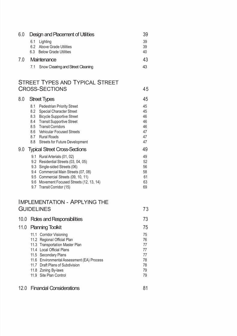
T ABLE OF CONTENTS
THE VISION 1
1.0 Purpose of the Guidelines 1
1.1 Study Purpose 1
1.2 Approach and application of Guidelines 1
2.0 An Evolving Vision for Arterial Roads 3
2.1 Policy Background 3
2.2 The Arterial Network 5
2.3 A Renewed Vision for Arterial Roads 5
2.4 A Broad Range of Objectives for the Design of Arterial 6
Roadways
THE GUIDELINES 11
3.0 The Design of the Road Network 11
3.1 Continuous and Connected Network 13
3.2 Frequency of Intersections 15
3.3 Mid-Block Access - Driveways and Drive-Throughs 18
4.0 Supporting Adjacent Land Uses - The Design of Places
Adjacent to the Road Right-of-Way 194.1 Spatial Definition of the Road Corridor 19
4.2 Building Orientation and Location 21
4.3 Adjacent Parking Lot and Site Design 22
4.4 Main Streets, Historic and Natural Areas 24
4.5 Noise Attenuation Strategies 25
5.0 Street Element Design Criteria 27
5.1 Sidewalks 27
5.2 Crosswalks and Intersections 28
5.3 Landscaping 30
5.4 Landscaped Medians 315.5 Street Furniture and other Amenities 33
5.6 On-Street Parking 34
5.7 Accommodating Bicycles 35
5.8 Transit Shelters 35
5.9 Public Signage 36
5.10 Private Signage 37

8/21/2019 Durham Region Arterial Corridor Guideline
http://slidepdf.com/reader/full/durham-region-arterial-corridor-guideline 6/119
8/21/2019 Durham Region Arterial Corridor Guideline
http://slidepdf.com/reader/full/durham-region-arterial-corridor-guideline 7/119
6.0 Design and Placement of Utilities 39
6.1 Lighting 39
6.2 Above Grade Utilities 39
6.3 Below Grade Utilities 40
7.0 Maintenance 437.1 Snow Clearing and Street Cleaning 43
STREET TYPES AND TYPICAL STREET
CROSS-SECTIONS 45
8.0 Street Types 45
8.1 Pedestrian Priority Street 45
8.2 Special Character Street 45
8.3 Bicycle Supportive Street 468.4 Transit Supportive Street 46
8.5 Transit Corridors 46
8.6 Vehicular Focused Streets 47
8.7 Rural Roads 47
8.8 Streets for Future Development 47
9.0 Typical Street Cross-Sections 49
9.1 Rural Arterials (01, 02) 49
9.2 Residential Streets (03, 04, 05) 52
9.3 Single-sided Streets (06) 56
9.4 Commercial Main Streets (07, 08) 58
9.5 Commercial Streets (09, 10, 11) 61 9.6 Movement Focused Streets (12, 13, 14) 63 9.7 Transit Corridor (15) 69
IMPLEMENTATION - APPLYING THE
GUIDELINES 73
10.0 Roles and Responsibilities 73
11.0 Planning Toolkit 75
11.1 Corridor Visioning 7511.2 Regional Official Plan 76
11.3 Transportation Master Plan 77
11.4 Local Official Plans 77
11.5 Secondary Plans 77
11.6 Environmental Assessment (EA) Process 78
11.7 Draft Plans of Subdivision 78
11.8 Zoning By-laws 79
11.9 Site Plan Control 79
12.0 Financial Considerations 81

8/21/2019 Durham Region Arterial Corridor Guideline
http://slidepdf.com/reader/full/durham-region-arterial-corridor-guideline 8/119

8/21/2019 Durham Region Arterial Corridor Guideline
http://slidepdf.com/reader/full/durham-region-arterial-corridor-guideline 9/119
GLOSSARY 83
APPENDIX A - Arterial Road Classification Review
APPENDIX B - Street Tree Species Possibilities

8/21/2019 Durham Region Arterial Corridor Guideline
http://slidepdf.com/reader/full/durham-region-arterial-corridor-guideline 10/119
8/21/2019 Durham Region Arterial Corridor Guideline
http://slidepdf.com/reader/full/durham-region-arterial-corridor-guideline 11/119
1 Arterial Corridor Guidelines
1.0 Purpose Of The Guidelines
THE VISION
1.1 Study Purpose
Through the preparation of the Durham Transportation Master Plan, it was determined
that there is a need to develop guidelines and implementation strategies for arterial
corridors that will result in Rights-of-way becoming more responsive to the character of
local and adjacent land uses while recognizing the specific activities that occur within,
and adjacent to, arterial road Rights-of-way.
The Arterial Corridor Guidelines will assist in promoting a balance between mobility
and liveability in the planning, design and construction of features within and abutting
the public road allowance. These guidelines represent a toolbox of potential strategies
and common reference points to be applied in the process of the planning and designof arterial road corridors by the Region of Durham, the various municipalities, the public
and other interested parties. The guidelines are intended to supplement, not replace,
existing transportation guidelines and design standards – broadening the conditions
and issues that are considered in the design of arterial roads. For this reason, the
emphasis of this document has been the integration of transportation issues with those
of land use planning, development formats and the design of the public realm.
1.2 Approach and Application of the Guidelines
The Arterial Corridor Guidelines offer a variety of options that will assist in guiding the
development of arterials over time. Local municipalities, elected officials, residents,private developers and other stakeholders will all play a role in implementing the
recommendations and strategies outlined in these Guidelines. With this in mind, the
guideline document has been organized so that it can be used in several ways:
1. The first portion of the Guidelines, Sections 2 through 7, address the theory and
specific standards that should be considered in the planning of street networks
and specific elements within these networks. For those who are interested in
general issues regarding the planning of arterial roadways, these sections can be
read sequentially, or one can refer to the table of contents for an index to items of
specific interest.
2. Sections 8 and 9 illustrate the range and potential of various street types that mayresult from the application of the Guidelines. These street types build upon the
Type A, B and C arterial road designations to show the diversity and complexity that
can be created. For those who are interested in the application of the Guidelines
to a specific arterial road, a matrix highlighting the potential interpretation and
combination of these options is included in Section 9. Referring to the various
categories listed, one can determine the illustrative section, or sections that are
most relevant to the conditions they are working with.
8/21/2019 Durham Region Arterial Corridor Guideline
http://slidepdf.com/reader/full/durham-region-arterial-corridor-guideline 12/119
2 Durham Region
3. For those interested in a more comprehensive process, and application of the
Guidelines to unique conditions, Sections 10 through 12 outline the processes
and the mechanisms under which the Guidelines may be applied. Due to the
infinite variety of mobility and liveability characteristics along a road corridor, the
illustrative cross-sections may not relate directly to a particular circumstance. By
focusing on a design and visioning process rather than the application of a specificpredetermined cross-sectional standard, this approach will allow guideline users to
assess the corridor section and apply the appropriate corridor elements to achieve
the desired “place” and function for their unique arterial corridor.
The Guidelines have been written in an action-oriented manner, rather than passive
terms such as “may” or “should” consider. As such, they project a strong, affirmative
message emphasizing the importance of effective actions for achieving a balanced
transportation system. It is acknowledged that the Guidelines are not the only
means of meeting this objective and applicability will be influenced by local
conditions, requirements and constraints. The Guidelines can be adapted to such
situations based on professional judgement.
8/21/2019 Durham Region Arterial Corridor Guideline
http://slidepdf.com/reader/full/durham-region-arterial-corridor-guideline 13/119
3 Arterial Corridor Guidelines
2.0 An Evolving Vision for Arterial Roadways
2.1 Policy Background
Over the next 25 years, the number of people living in the Region of Durham is projected
to grow substantially. Almost 470,000 new residents will call Durham home and over
230,000 new jobs will be created. To accommodate this growth, the Region has put in
place a series of plans that set priorities for building strong, prosperous communities,
healthy environments and an enviable quality of life.
Community Strategic Plan - lays out the community’s vision for the future and
indicates where the Region will focus its energies over the next three to five years
to support achievement of this vision.
Regional Official Plan – provides policies and designations to address how land
should be used and ensures that future planning and development will meet thespecific needs of the Region and its residents.
Transportation Master Plan - identifies policies, programs and infrastructure
improvements needed to manage anticipated transportation demands to 2021
and beyond, and to support the development pattern designated in the Regional
Official Plan.
In concert with the Region’s Community Strategic Plan, Official Plan and Transportation
Master Plan, the Arterial Corridor Guidelines provides a guidance for the development
of arterial roadway environment in Durham. Communities that are well-designed and
planned from both a transportation and land use planning perspective are better able toattract jobs and investment. This is achieved through a planning process that is simple
and streamlined, allowing the Region and its local municipalities to each play a key
role in decision making. The guidelines that have been developed identify and protect
Regional interests while promoting sound infrastructure planning, environmental
protection, economic development and safe communities.
The Arterial Corridor Guidelines will help achieve compact, attractive, transit-oriented
communities as envisioned in the Community Strategic Plan and Regional Official
Plan. These guidelines will be a vehicle for coordinating decision-making on land-use
planning, urban development, housing, transportation, and economic development,
and for prioritizing infrastructure investments on transportation and other capital works
initiatives.
Throughout the course of the development of the guidelines, meetings have taken place
with key stakeholders and input has been collected from municipalities, community
groups, other stakeholders and the public. Ensuring the guidelines are realistic and
easily implemented requires collaboration among many groups: the development
community, environmental, agricultural and transportation organizations, community
groups, public officials and citizens. Working together, the Region and its local
municipalities can make better decisions about our communities and the transportation
infrastructure that supports them.
8/21/2019 Durham Region Arterial Corridor Guideline
http://slidepdf.com/reader/full/durham-region-arterial-corridor-guideline 14/119
4 Durham Region
The guidelines provide a strategy and identify the tools necessary for implementation
by:
● Defining the role of the arterial road system;
● Establishing public space principles;
● Determining an appropriate approach for balancing mobility objectivesfor vehicular movement and property access with liveability objectives for
community design, landscape character, and non-auto modes;
● Defining roadway access management criteria;
● Providing design criteria for the roadway, boulevard and adjacent lands, such
as road allowance widths, cross-sections, location of utilities and connections,
in advance of development, where possible;
● Considering the most appropriate placement for pedestrian, cycling and transit
facilities within the road allowance, subject to financial considerations; and
● Defining implementation measures.
The guidelines provide a further step in meeting the Region’s community strategic
objectives for a more integrated transportation system and liveable communities.Furthermore, the guidelines are consistent with recent Provincial and Federal initiatives
(i.e., Places to Grow, Greenbelt Plan, Strong Communities, Brownfield Development,
Kyoto Protocol, etc.) that aim towards protecting the countryside through greater
controls on development within designated settlement areas. The guidelines will also
assist in implementing the Province’s objectives for centres and corridors, and greater
intensification within settlement areas, by ensuring the optimal use of the Region’s
current transportation infrastructure and by accommodating new growth in an effective
manner.
8/21/2019 Durham Region Arterial Corridor Guideline
http://slidepdf.com/reader/full/durham-region-arterial-corridor-guideline 15/119
5 Arterial Corridor Guidelines
B a s i c F u n c t i o n a l C l a s se s
T h e A r t e r i a l C o r r i d o r G u i d e l i n e sa c c om m o d a t e a b r o a d r a n ge o ft y p e s o f m o v em e n t .
2.2 The Arterial Network
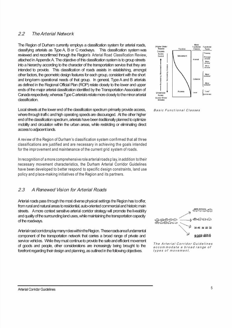
The Region of Durham currently employs a classification system for arterial roads,
classifying arterials as Type A, B or C roadways. This classification system was
reviewed and reconfirmed through the Region’s Arterial Road Classification Review,
attached in Appendix A. The objective of this classification system is to group streets
into a hierarchy according to the character of the transportation service that they are
intended to provide. This classification of roads assists in establishing, amongst
other factors, the geometric design features for each group, consistent with the short
and long-term operational needs of that group. In general, Type A and B arterials
as defined in the Regional Official Plan (ROP) relate closely to the lower and upper
ends of the major arterial classification identified by the Transportation Association of
Canada respectively, whereas Type C arterials relate more closely to the minor arterial
classification.
Local streets at the lower end of the classification spectrum primarily provide access,
where through traffic and high operating speeds are discouraged. At the other higherend of the classification spectrum, arterials have been traditionally planned to optimize
mobility and circulation within the urban areas, while restricting or eliminating direct
access to adjacent lands.
A review of the Region of Durham’s classif ication system confi rmed that all three
classifications are justified and are necessary in achieving the goals intended
for the improvement and maintenance of the current grid system of roads.
In recognition of a more comprehensive role arterial roads p lay, in addition to their
necessary movement characteristics, the Durham Arterial Corridor Guidelines
have been developed to better respond to specific design constraints, land use
policy and p lace-making initiatives of the Region and its partners.
2.3 A Renewed Vision for Arterial Roads
Arterial roads pass through the most diverse physical settings the Region has to offer,
from rural and natural areas to residential, auto-oriented commercial and historic main
streets. A more context sensitive arterial corridor strategy will promote the liveability
and quality of the surrounding land uses, while maintaining the transportation capacity
of the roadways.
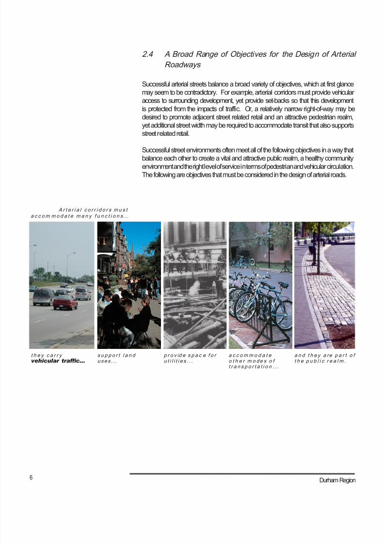
Arterial road corridors play many roles within the Region. These roads are a fundamentalcomponent of the transportation network that carries a broad range of private and
service vehicles. While they must continue to provide the safe and efficient movement
of goods and people, other considerations are increasingly being brought to the
forefront regarding their design and planning, as outlined in the following objectives.
8/21/2019 Durham Region Arterial Corridor Guideline
http://slidepdf.com/reader/full/durham-region-arterial-corridor-guideline 16/119
6 Durham Region
A r t e r i a l c o r r i d o r s m u s ta c c om m o d a t e m a n y f u n c t i o n s.. .
t h e y c a r r yvehicular trafc...
s u p p o r t l a n duses . . .
p r o v id e s p a c e f o ru t i l i t i e s . . .
a c c o mm o d a t eo t h e r m o de s o ft r a n s p o r t a t i o n . . .
a n d t h e y a re p a r t o ft h e p u b l i c r e a l m .
2.4 A Broad Range of Objectives for the Design of Arterial
Roadways
Successful arterial streets balance a broad variety of objectives, which at first glance
may seem to be contradictory. For example, arterial corridors must provide vehicularaccess to surrounding development, yet provide set-backs so that this development
is protected from the impacts of traffic. Or, a relatively narrow right-of-way may be
desired to promote adjacent street related retail and an attractive pedestrian realm,
yet additional street width may be required to accommodate transit that also supports
street related retail.
Successful street environments often meet all of the following objectives in a way that
balance each other to create a vital and attractive public realm, a healthy community
environment and the right level of service in terms of pedestrian and vehicular circulation.
The following are objectives that must be considered in the design of arterial roads.
8/21/2019 Durham Region Arterial Corridor Guideline
http://slidepdf.com/reader/full/durham-region-arterial-corridor-guideline 17/119
7 Arterial Corridor Guidelines
G r ea t s t r e e t s c a n b e c om e t h eh a l lm a r k o f a c om m u n i t y, su c ha s Com mo n w e a l t h A ve n u e i nB o s t o n .
U r b a n a r t e r i a l s s h o u l d p r ov i d e aq u a l i t y p u b l i c r e a lm .
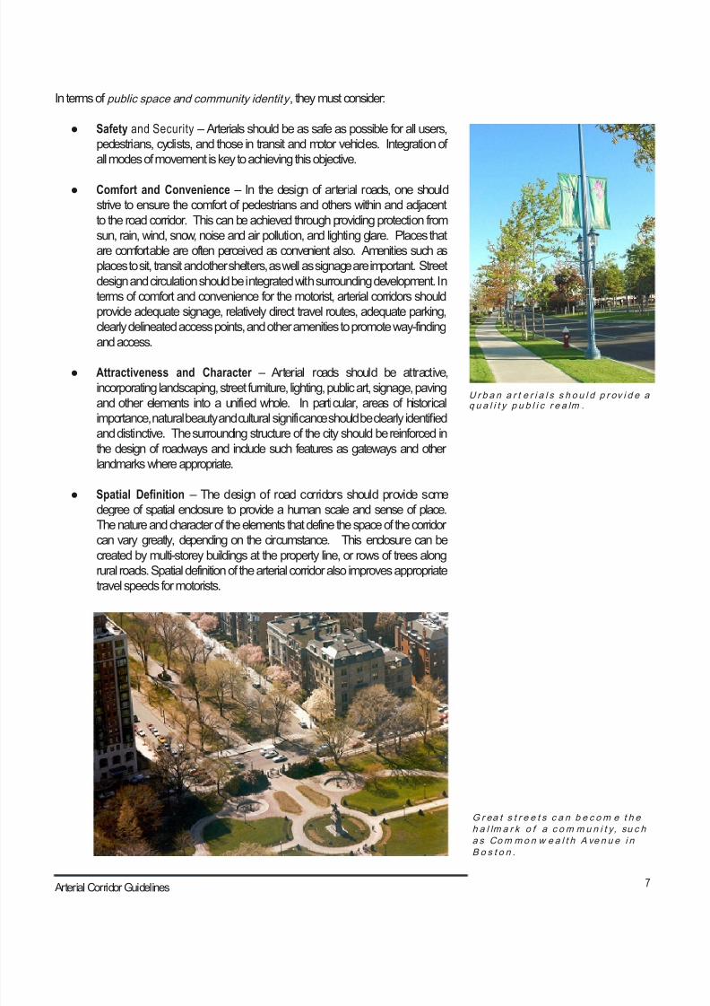
In terms of public space and community identity , they must consider:
● Safety and Security – Arterials should be as safe as possible for all users,
pedestrians, cyclists, and those in transit and motor vehicles. Integration of
all modes of movement is key to achieving this objective.
● Comfort and Convenience – In the design of arterial roads, one should
strive to ensure the comfort of pedestrians and others within and adjacent
to the road corridor. This can be achieved through providing protection from
sun, rain, wind, snow, noise and air pollution, and lighting glare. Places that
are comfortable are often perceived as convenient also. Amenities such as
places to sit, transit and other shelters, as well as signage are important. Street
design and circulation should be integrated with surrounding development. In
terms of comfort and convenience for the motorist, arterial corridors should
provide adequate signage, relatively direct travel routes, adequate parking,
clearly delineated access points, and other amenities to promote way-finding
and access.
● Attractiveness and Character – Arterial roads should be attractive,
incorporating landscaping, street furniture, lighting, public art, signage, paving
and other elements into a unified whole. In particular, areas of historical
importance, natural beauty and cultural significance should be clearly identified
and distinctive. The surrounding structure of the city should be reinforced in
the design of roadways and include such features as gateways and other
landmarks where appropriate.
● Spatial Definition – The design of road corridors should provide some
degree of spatial enclosure to provide a human scale and sense of place.
The nature and character of the elements that define the space of the corridorcan vary greatly, depending on the circumstance. This enclosure can be
created by multi-storey buildings at the property line, or rows of trees along
rural roads. Spatial definition of the arterial corridor also improves appropriate
travel speeds for motorists.
8/21/2019 Durham Region Arterial Corridor Guideline
http://slidepdf.com/reader/full/durham-region-arterial-corridor-guideline 18/119
8 Durham Region
B a l a n c e d M u l t i -m o d a l M o vem e n ta c c om m o d a t e s p e d e s t r i a n s ,t r a n s it a n d o t h e r m o d e s o f
t r a v e l
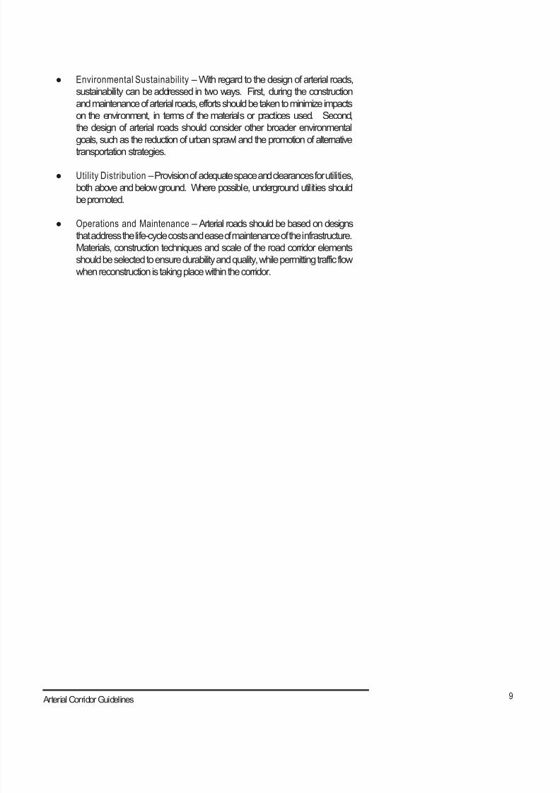
S om e a r t e r i a l s s h o u l d b ed e s i g n e d t o h a n d l e t r u c k i n g
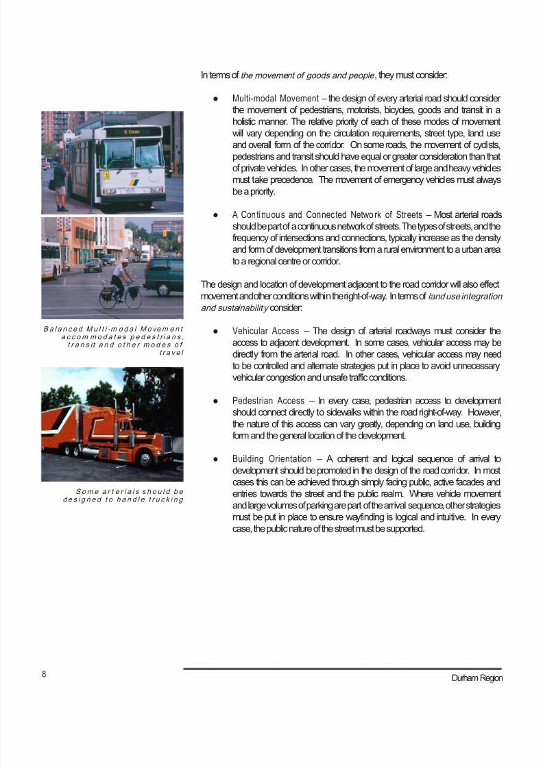
In terms of the movement of goods and people , they must consider:
● Multi-modal Movement – the design of every arterial road should consider
the movement of pedestrians, motorists, bicycles, goods and transit in a
holistic manner. The relative priority of each of these modes of movement
will vary depending on the circulation requirements, street type, land useand overall form of the corridor. On some roads, the movement of cyclists,
pedestrians and transit should have equal or greater consideration than that
of private vehicles. In other cases, the movement of large and heavy vehicles
must take precedence. The movement of emergency vehicles must always
be a priority.
● A Continuous and Connected Network of Streets – Most arterial roads
should be part of a continuous network of streets. The types of streets, and the
frequency of intersections and connections, typically increase as the density
and form of development transitions from a rural environment to a urban area
to a regional centre or corridor.
The design and location of development adjacent to the road corridor will also effect
movement and other conditions within the right-of-way. In terms of land use integration
and sustainability consider:
● Vehicular Access – The design of arterial roadways must consider the
access to adjacent development. In some cases, vehicular access may be
directly from the arterial road. In other cases, vehicular access may need
to be controlled and alternate strategies put in place to avoid unnecessary
vehicular congestion and unsafe traffic conditions.
● Pedestrian Access – In every case, pedestrian access to developmentshould connect directly to sidewalks within the road right-of-way. However,
the nature of this access can vary greatly, depending on land use, building
form and the general location of the development.
● Building Orientation – A coherent and logical sequence of arrival to
development should be promoted in the design of the road corridor. In most
cases this can be achieved through simply facing public, active facades and
entries towards the street and the public realm. Where vehicle movement
and large volumes of parking are part of the arrival sequence, other strategies
must be put in place to ensure wayfinding is logical and intuitive. In every
case, the public nature of the street must be supported.
8/21/2019 Durham Region Arterial Corridor Guideline
http://slidepdf.com/reader/full/durham-region-arterial-corridor-guideline 19/119
9 Arterial Corridor Guidelines
● Environmental Sustainability – With regard to the design of arterial roads,
sustainability can be addressed in two ways. First, during the construction
and maintenance of arterial roads, efforts should be taken to minimize impacts
on the environment, in terms of the materials or practices used. Second,
the design of arterial roads should consider other broader environmental
goals, such as the reduction of urban sprawl and the promotion of alternativetransportation strategies.
● Utility Distribution – Provision of adequate space and clearances for utilities,
both above and below ground. Where possible, underground utilities should
be promoted.
● Operations and Maintenance – Arterial roads should be based on designs
that address the life-cycle costs and ease of maintenance of the infrastructure.
Materials, construction techniques and scale of the road corridor elements
should be selected to ensure durability and quality, while permitting traffic flow
when reconstruction is taking place within the corridor.

8/21/2019 Durham Region Arterial Corridor Guideline
http://slidepdf.com/reader/full/durham-region-arterial-corridor-guideline 20/119
10 Durham Region
8/21/2019 Durham Region Arterial Corridor Guideline
http://slidepdf.com/reader/full/durham-region-arterial-corridor-guideline 21/119
11 Arterial Corridor Guidelines
3.0 The Design of the Road Network
THE GUIDELINES
The overall pattern of streets and the relative ease of connection between all places
within a region, city, or community, is directly related to the variety of land uses and
types of development (e.g., historic downtowns, main streets, power centres and big
boxes, entertainment districts, etc.) a community is able to support. The ability to
provide effective transit service, efficient vehicular movement and a safe and convenient
pedestrian environment is also linked to the character of the roadway network.
The regional arterial road network in Durham is based on the grid of existing concession
roads, resulting in a connected higher-order arterial road network. The further sub-
division of this network into an even finer grid of minor arterial, collector and local
streets has resulted in urban and sub-urban environments. Where a finer graineddivision of arterials in urban areas has not been created, the following problems exist
or are emerging:
8/21/2019 Durham Region Arterial Corridor Guideline
http://slidepdf.com/reader/full/durham-region-arterial-corridor-guideline 22/119
12 Durham Region
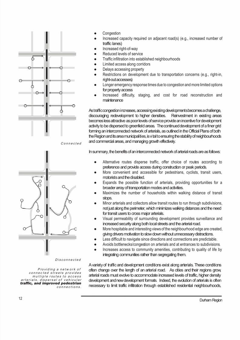
P ro vi d in g a n e t w o r k o fc o n n e c t e d s t r e e t s p r o vi d e s
m u l t i p l e r ou t e s t o a c c e s sa r t e r i a l s , d is p e r s a l o f v e h i c u l a rtrafc, and improved pedestrian
c o n n e c t i o n s .
C o n n e c t e d
D i s c o n n e c t e d
● Congestion
● Increased capacity required on adjacent road(s) (e.g., increased number of
traffic lanes)
● Increased right-of-way
● Reduced levels of service
● Traffic infiltration into established neighbourhoods● Limited access along corridors
● Delays accessing property
● Restrictions on development due to transportation concerns (e.g., right-in,
right-out accesses)
● Longer emergency response times due to congestion and more limited options
for property access
● Increased difficulty, staging, and cost for road reconstruction and
maintenance
As traffic congestion increases, accessing existing developments becomes a challenge,
discouraging redevelopment to higher densities. Reinvestment in existing areas
becomes less attractive as poor levels of service provide an incentive for developmentactivity to be dispersed to greenfield areas. The continued development of a finer grid
forming an interconnected network of arterials, as outlined in the Official Plans of both
the Region and its area municipalities, is vital to ensuring the stability of neighbourhoods
and commercial areas, and managing growth effectively.
In summary, the benefits of an interconnected network of arterial roads are as follows:
● Alternative routes disperse traffic, offer choice of routes according to
preference and provide access during construction or peak periods.
● More convenient and accessible for pedestrians, cyclists, transit users,
motorists and the disabled.● Expands the possible function of arterials, providing opportunities for a
broader array of transportation modes and activities.
● Maximizes the number of households within walking distance of transit
stops.
● Minor arterials and collectors allow transit routes to run through subdivisions,
not just along the perimeter, which minimizes walking distances and the need
for transit users to cross major arterials.
● Visual permeability of surrounding development provides surveillance and
increased security along both local streets and the arterial road.
● More hospitable and interesting views of the neighbourhood edge are created,
giving drivers motivation to slow down without unnecessary distractions.
● Less difficult to navigate since directions and connections are predictable.● Avoids bottlenecks/congestion on arterials and at entrances to subdivisions.
● Increases access to community amenities, contributing to quality of life by
integrating communities rather than segregating them.
A variety of traffic and development conditions exist along arterials. These conditions
often change over the length of an arterial road. As cities and their regions grow,
arterial roads must evolve to accommodate increased levels of traffic, higher density
development and new development formats. Indeed, the evolution of arterials is often
necessary to limit traffic infiltration through established residential neighbourhoods,
8/21/2019 Durham Region Arterial Corridor Guideline
http://slidepdf.com/reader/full/durham-region-arterial-corridor-guideline 23/119
13 Arterial Corridor Guidelines
provide the setting for new development and promote transit. When viewed in this
context, it is not surprising that a great deal of attention should be paid to the creation
of a roadway network that is flexible, accommodating change over time in response to
future development and transportation objectives.
Achieving this flexibility in the design of an arterial network requires coordinationbetween private development and public infrastructure. In particular, the development
and movement networks adjacent to the intersections of major arterials will require
comprehensive planning. The following are the guidelines that pertain to the design of
the arterial network.
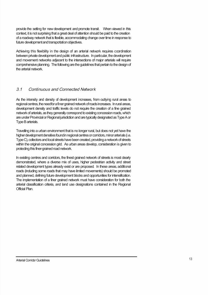
3.1 Continuous and Connected Network
As the intensity and density of development increases, from outlying rural areas to
regional centres, the need for a finer grained network of roads increases. In rural areas,development density and traffic levels do not require the creation of a fine grained
network of arterials, as they generally correspond to existing concession roads, which
are under Provincial or Regional jurisdiction and are typically designated as Type A or
Type B arterials.
Travelling into a urban environment that is no longer rural, but does not yet have the
higher development densities found in regional centres or corridors, minor arterials (i.e.
Type C), collectors and local streets have been created, providing a network of streets
within the original concession grid. As urban areas develop, consideration is given to
protecting this finer-grained road network.
In existing centres and corridors, the finest grained network of streets is most clearly
demonstrated, where a diverse mix of uses, higher pedestrian activity and street
related development types already exist or are proposed. In these areas, additional
roads (including some roads that may have limited movements) should be promoted
and planned, defining future development blocks and opportunities for intensification.
The implementation of a finer grained network must have consideration for both the
arterial classification criteria, and land use designations contained in the Regional
Official Plan.
8/21/2019 Durham Region Arterial Corridor Guideline
http://slidepdf.com/reader/full/durham-region-arterial-corridor-guideline 24/119
14 Durham Region
L im i t e d a l t e r n a t i v e r o u t e sa n d s e g r e g a t e d u s e s
p r o m o t e s p r a w l a n d l i m i toptions for addressing trafc
c o n c e r n s .
A l t e r n a t i v e r o u t e s a n dm i x e d l a n d u s e s p r o v i d e
more exibility in ther a n g e o f d e ve l o pm e n t a n d
t r a n s p o r t a t i o n s o l u t i o np o s s i b i l i t i e s .
1. Integrate the planning of arterial roads with individual community/neighbourhood
plans.
2. Design arterials to promote, not prohibit, the creation of a finer grained networkof secondary arterial, collectors and local roads. This is particularly important in
regional centres and areas identified for development intensification. Such a finer
grained network may contain minor “T” intersections and streets with limited turn
movements.
3. Locate higher-density development along transit routes. Encourage compact
mixed-use development through zoning, including residential, commercial and
employment uses.
4. Ensure arterials do not act as physical barriers between open spaces and
development on each side of the road. Minimizing the width of the arterial road
and aligning local road intersections can help achieve this.
5. Provide walking routes to transit stops as directly as possible (i.e., a maximum 400
m walking distance from any residence to a transit stop).
6. Consider the creation of frequent pedestrian connections across arterial roads
and ensure the permeability of pedestrian routes through neighbourhoods.
The frequency and location of pedestrian crossings will vary, depending on the
traffic characteristics, development type and format. The design and location of
pedestrian crossings must be addressed on a site-specific basis.
8/21/2019 Durham Region Arterial Corridor Guideline
http://slidepdf.com/reader/full/durham-region-arterial-corridor-guideline 25/119
15 Arterial Corridor Guidelines
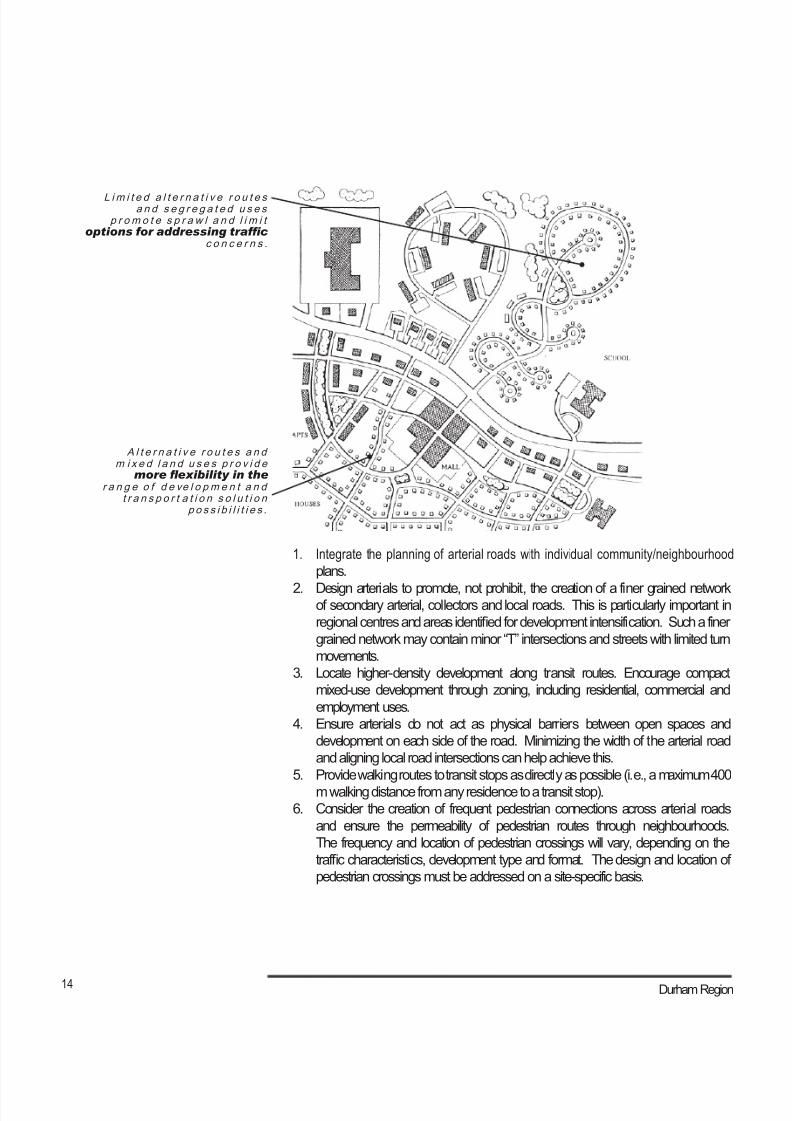
W i n d ow c o n d i t i o n - c r e s c e n t“ l o o p ”
W i n d ow c o n d i t i o n - c u l -d e -s a c
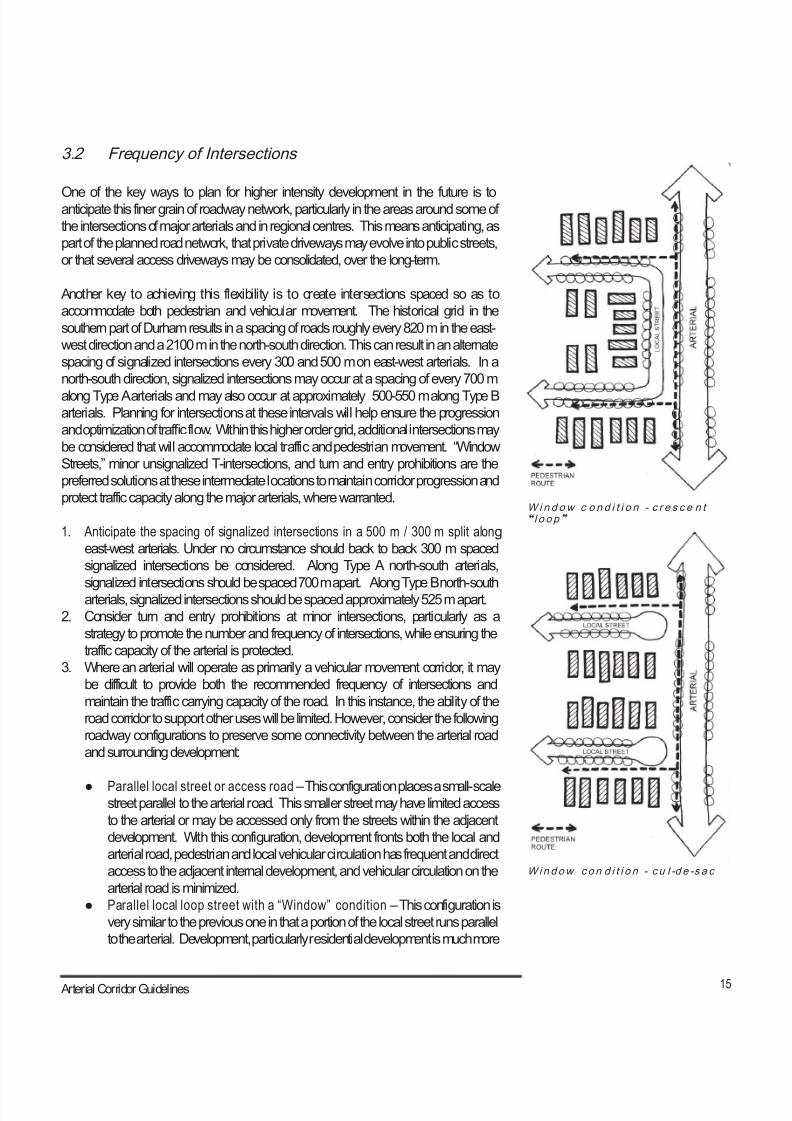
3.2 Frequency of Intersections
One of the key ways to plan for higher intensity development in the future is toanticipate this finer grain of roadway network, particularly in the areas around some of
the intersections of major arterials and in regional centres. This means anticipating, as
part of the planned road network, that private driveways may evolve into public streets,
or that several access driveways may be consolidated, over the long-term.
Another key to achieving this flexibility is to create intersections spaced so as to
accommodate both pedestrian and vehicular movement. The historical grid in the
southern part of Durham results in a spacing of roads roughly every 820 m in the east-
west direction and a 2100 m in the north-south direction. This can result in an alternate
spacing of signalized intersections every 300 and 500 m on east-west arterials. In a
north-south direction, signalized intersections may occur at a spacing of every 700 m
along Type A arterials and may also occur at approximately 500-550 m along Type Barterials. Planning for intersections at these intervals will help ensure the progression
and optimization of traffic flow. Within this higher order grid, additional intersections may
be considered that will accommodate local traffic and pedestrian movement. “Window
Streets,” minor unsignalized T-intersections, and turn and entry prohibitions are the
preferred solutions at these intermediate locations to maintain corridor progression and
protect traffic capacity along the major arterials, where warranted.
1. Anticipate the spacing of signalized intersections in a 500 m / 300 m split along
east-west arterials. Under no circumstance should back to back 300 m spaced
signalized intersections be considered. Along Type A north-south arterials,
signalized intersections should be spaced 700 m apart. Along Type B north-southarterials, signalized intersections should be spaced approximately 525 m apart.
2. Consider turn and entry prohibitions at minor intersections, particularly as a
strategy to promote the number and frequency of intersections, while ensuring the
traffic capacity of the arterial is protected.
3. Where an arterial will operate as primarily a vehicular movement corridor, it may
be difficult to provide both the recommended frequency of intersections and
maintain the traffic carrying capacity of the road. In this instance, the ability of the
road corridor to support other uses will be limited. However, consider the following
roadway configurations to preserve some connectivity between the arterial road
and surrounding development:
● Parallel local street or access road – This configuration places a small-scalestreet parallel to the arterial road. This smaller street may have limited access
to the arterial or may be accessed only from the streets within the adjacent
development. With this configuration, development fronts both the local and
arterial road, pedestrian and local vehicular circulation has frequent and direct
access to the adjacent internal development, and vehicular circulation on the
arterial road is minimized.
● Parallel local loop street with a “Window” condition – This configuration is
very similar to the previous one in that a portion of the local street runs parallel
to the arterial. Development, particularly residential development is much more
8/21/2019 Durham Region Arterial Corridor Guideline
http://slidepdf.com/reader/full/durham-region-arterial-corridor-guideline 26/119
16 Durham Region
2 . .. .. t h e r e i s a r e c om me n d e ds p a c i n g o f s i g n a l iz e d a n d n o n -
s i g n a l iz e d i n t e r s e c t i o n s t h a t w i l lbest facilitate trafc movement
a n d s u p p o r t d e v e l o pm e n t
1 . Wo r k i n g w i t h i n t h e e x i s t i n gg r id o f c o n c e s s i o n r o a ds
8/21/2019 Durham Region Arterial Corridor Guideline
http://slidepdf.com/reader/full/durham-region-arterial-corridor-guideline 27/119
17 Arterial Corridor Guidelines
likely to flank these roads however. The creation of the “Window” condition
refers to the establishment of a direct visual and pedestrian connection from
the local street to the arterial road. This connection serves as the spatial, if
not vehicular, connection of the local street to the arterial road. This spatial
connection should be generous in width and clearly identifiable as a public
route.
● Cul-de-sacs with a “Window” condition – This configuration adapts the
typical cul-de-sac or dead-end street to a situation where once again a strong
spatial connection is made from the local street to the arterial road.
These street configurations are often applied as a means of avoiding the introduction
of rear lotting, also known as reverse lot frontage, which requires sound attenuation
walls or fences. Please see the further discussion of these conditions in Section 6.2,
Building Orientation and Deployment.
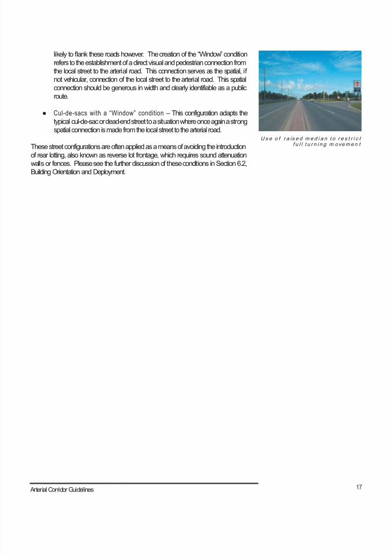
U s e o f r a is e d m e d i a n t o r e s t r i c tf u l l t u r n i n g m o vem e n t

8/21/2019 Durham Region Arterial Corridor Guideline
http://slidepdf.com/reader/full/durham-region-arterial-corridor-guideline 28/119
18 Durham Region
3.3 Mid-Block Access - Driveways and Drive-Throughs
Mid-block vehicular access is often required on arterial roads. The nature of this
access can vary from individual residential driveways to parking lot entrances for large-
scale development. In most instances, this vehicular access is both desirable and
necessary.
As traffic levels increase on an arterial, mid-block vehicular access can become
problematic for both pedestrians and drivers. Vehicles turning into and out of driveways
present a hazard for pedestrians and cyclists and interrupt their travel. These unsafe
conditions become even more acute if the land use and form of development are
out of keeping with traffic and travel conditions of the roadway. In the most extreme
conditions, traffic turning from the arterial will disrupt traffic flows on the arterial itself.
1. Consider the creation of an access management plan for areas where mid-block
driveways and drive-throughs are in conflict with on-street vehicular movement.
In urban areas, as roads become busier, vehicle access via driveways and drive-throughs may be limited and/or consolidated to avoid conflicts between turning
vehicles and other users of the road.
2. Discourage driveways and drive-throughs in regional centres and corridors.
3. Consolidate driveways and drive-throughs to access more than one development
where possible.
4. Consider the introduction of landscaped medians as a means of controlling
driveway and drive-through access where traffic volumes are higher.
D ev e lo pm e n t o f a c c e s s m a n a g em e n t p l a n
Full Movement Access - Restricted Zone
Full Movement Access - (shared access or cross-access easements ifunobtainable)
Controlled Access - (limited to right in/right out due to raised median)
Recommended Full Access Points to Main Central Area
8/21/2019 Durham Region Arterial Corridor Guideline
http://slidepdf.com/reader/full/durham-region-arterial-corridor-guideline 29/119
19 Arterial Corridor Guidelines
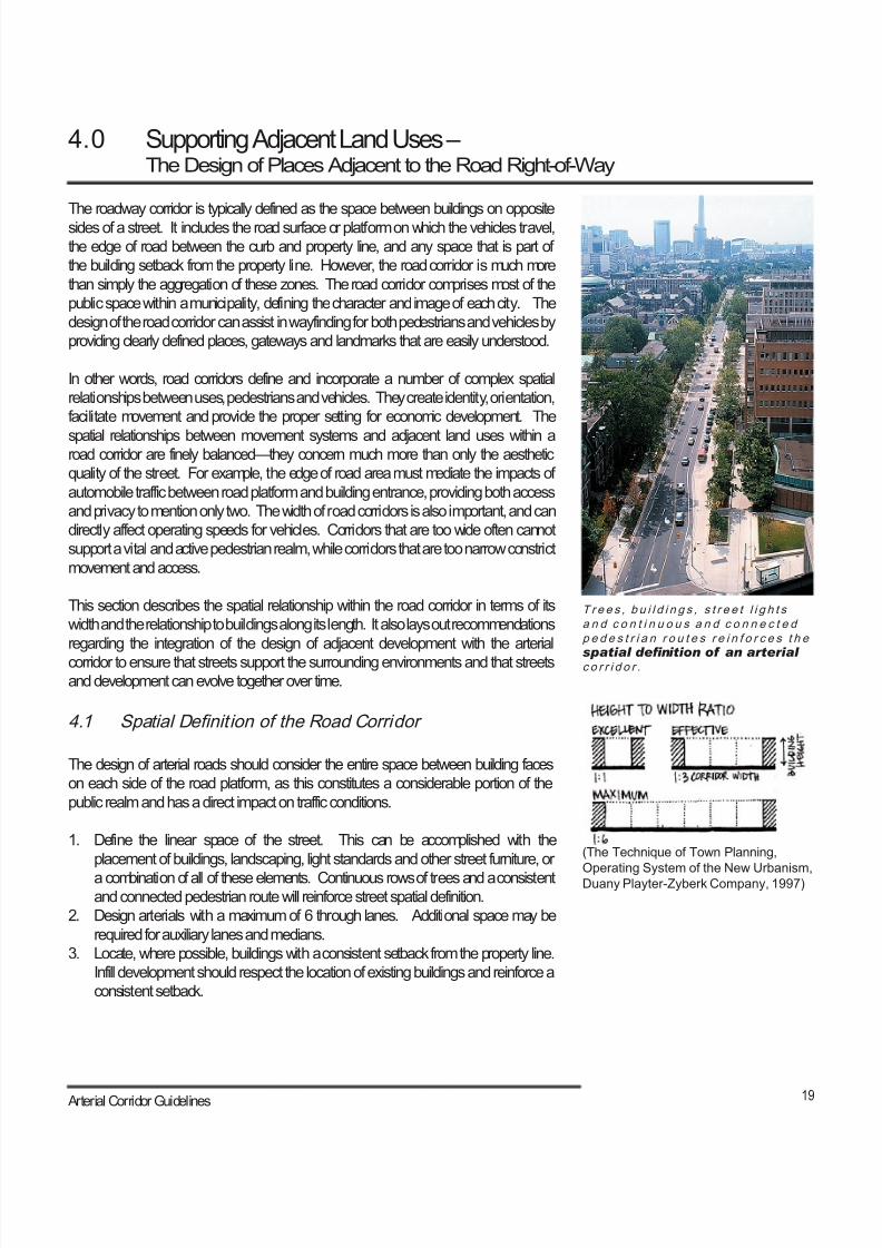
T r e e s , b u i l d i n g s , s t r e e t l i g h t sa n d c o n t i n u o u s a n d c o n n e c t e dp e d e s t r i a n r o u t e s r e i n f o r c e s t h e
spatial denition of an arterialc o r r i d o r .
(The Technique of Town Planning,
Operating System of the New Urbanism,Duany Playter-Zyberk Company, 1997)
4.0 Supporting Adjacent Land Uses –The Design of Places Adjacent to the Road Right-of-Way
The roadway corridor is typically defined as the space between buildings on opposite
sides of a street. It includes the road surface or platform on which the vehicles travel,
the edge of road between the curb and property line, and any space that is part of
the building setback from the property line. However, the road corridor is much more
than simply the aggregation of these zones. The road corridor comprises most of the
public space within a municipality, defining the character and image of each city. The
design of the road corridor can assist in wayfinding for both pedestrians and vehicles by
providing clearly defined places, gateways and landmarks that are easily understood.
In other words, road corridors define and incorporate a number of complex spatial
relationships between uses, pedestrians and vehicles. They create identity, orientation,
facilitate movement and provide the proper setting for economic development. The
spatial relationships between movement systems and adjacent land uses within aroad corridor are finely balanced—they concern much more than only the aesthetic
quality of the street. For example, the edge of road area must mediate the impacts of
automobile traffic between road platform and building entrance, providing both access
and privacy to mention only two. The width of road corridors is also important, and can
directly affect operating speeds for vehicles. Corridors that are too wide often cannot
support a vital and active pedestrian realm, while corridors that are too narrow constrict
movement and access.
This section describes the spatial relationship within the road corridor in terms of its
width and the relationship to buildings along its length. It also lays out recommendations
regarding the integration of the design of adjacent development with the arterial
corridor to ensure that streets support the surrounding environments and that streetsand development can evolve together over time.
4.1 Spatial Definit ion of the Road Corridor
The design of arterial roads should consider the entire space between building faces
on each side of the road platform, as this constitutes a considerable portion of the
public realm and has a direct impact on traffic conditions.
1. Define the linear space of the street. This can be accomplished with the
placement of buildings, landscaping, light standards and other street furniture, or
a combination of all of these elements. Continuous rows of trees and a consistentand connected pedestrian route will reinforce street spatial definition.
2. Design arterials with a maximum of 6 through lanes. Additional space may be
required for auxiliary lanes and medians.
3. Locate, where possible, buildings with a consistent setback from the property line.
Infill development should respect the location of existing buildings and reinforce a
consistent setback.
8/21/2019 Durham Region Arterial Corridor Guideline
http://slidepdf.com/reader/full/durham-region-arterial-corridor-guideline 30/119
20 Durham Region
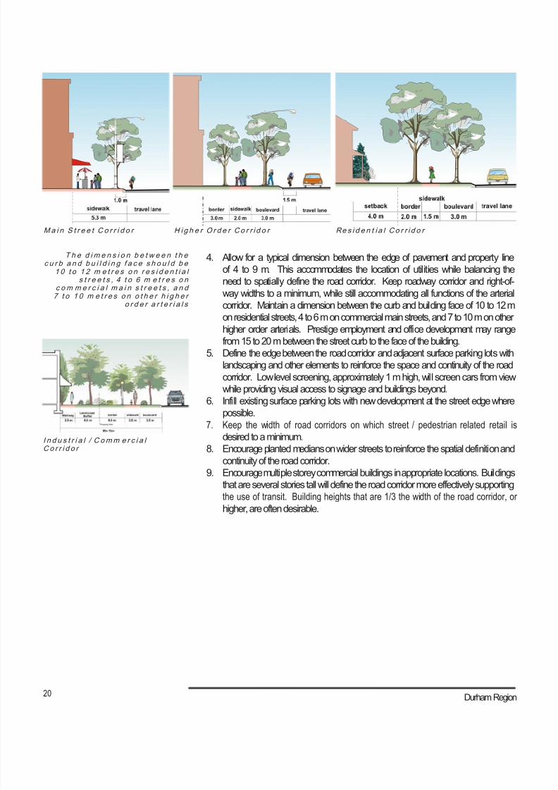
H ig h e r O r d e r Co r r i d o r Re s i d e n t i a l Co r r i d o r M a i n S t r e e t C o r r i d o r
T h e d i m e n s i o n b e t w e e n t h ec u r b a n d b u i l d i n g f a c e s h o u l d b e
1 0 t o 1 2 m e t r e s o n r e s i d e n t i a ls t r e e t s , 4 t o 6 m e t r e s o n
c om m e r c i a l m a i n s t r e e t s , a n d7 t o 1 0 m e t r e s o n o t h e r h i g h e r
o r d e r a r t e r i a l s
4. Allow for a typical dimension between the edge of pavement and property line
of 4 to 9 m. This accommodates the location of utilities while balancing the
need to spatially define the road corridor. Keep roadway corridor and right-of-
way widths to a minimum, while still accommodating all functions of the arterial
corridor. Maintain a dimension between the curb and building face of 10 to 12 m
on residential streets, 4 to 6 m on commercial main streets, and 7 to 10 m on other
higher order arterials. Prestige employment and office development may range
from 15 to 20 m between the street curb to the face of the building.
5. Define the edge between the road corridor and adjacent surface parking lots with
landscaping and other elements to reinforce the space and continuity of the road
corridor. Low level screening, approximately 1 m high, will screen cars from view
while providing visual access to signage and buildings beyond.
6. Infill existing surface parking lots with new development at the street edge where
possible.7. Keep the width of road corridors on which street / pedestrian related retail is
desired to a minimum.
8. Encourage planted medians on wider streets to reinforce the spatial definition and
continuity of the road corridor.
9. Encourage multiple storey commercial buildings in appropriate locations. Buildings
that are several stories tall will define the road corridor more effectively supporting
the use of transit. Building heights that are 1/3 the width of the road corridor, or
higher, are often desirable.
I n d u s t r i a l / C omm e r c i a lC o r r i d o r
8/21/2019 Durham Region Arterial Corridor Guideline
http://slidepdf.com/reader/full/durham-region-arterial-corridor-guideline 31/119
21 Arterial Corridor Guidelines
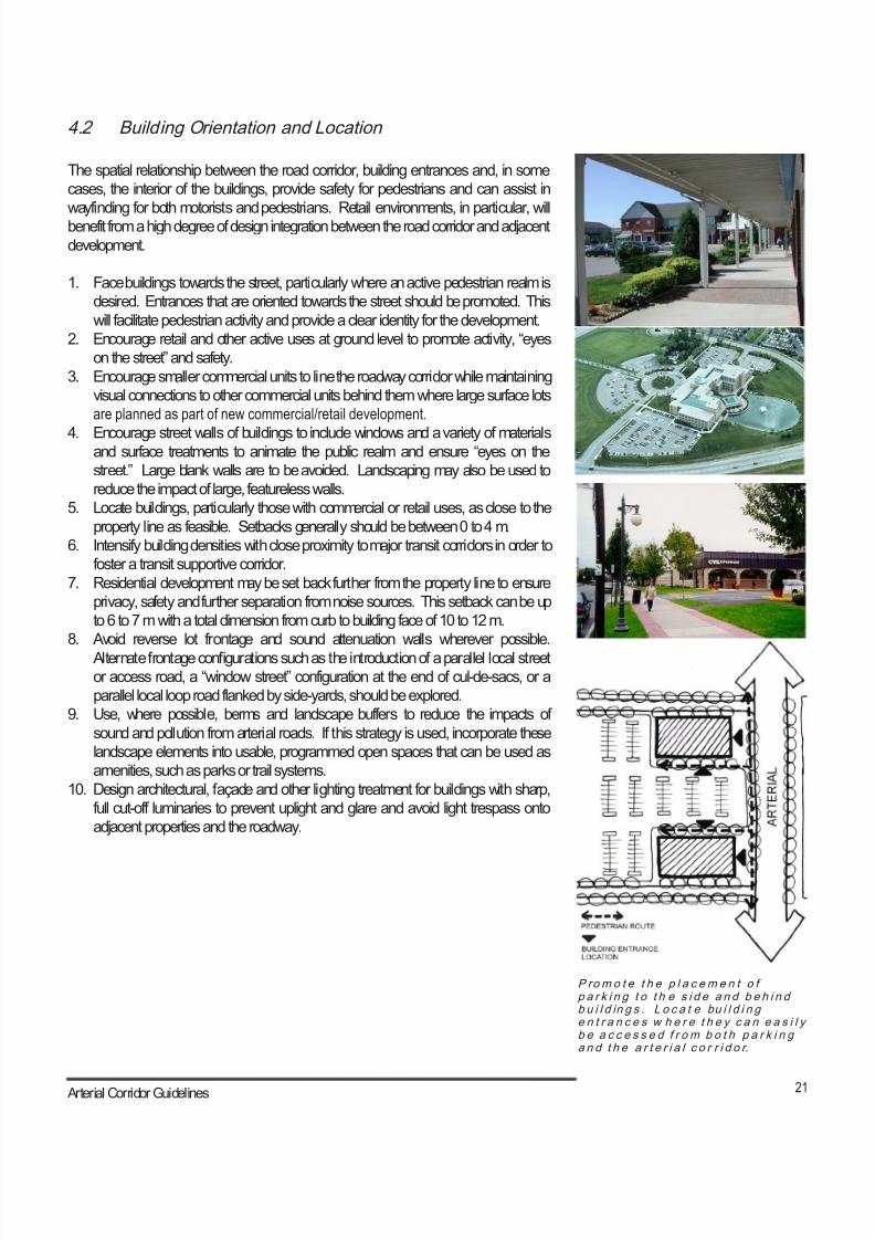
P rom o t e t h e p l a c em e n t o fp a r k i n g t o t h e s i d e a n d b e h i n db u i l d in g s . L o c a t e bu i l d i n ge n t r a n c e s w h e r e t h e y c a n e a s i l yb e a c c e s s e d f r o m b o t h p a r k i n ga n d t h e a r t e r i a l c o r r i d o r.
4.2 Building Orientation and Location
The spatial relationship between the road corridor, building entrances and, in some
cases, the interior of the buildings, provide safety for pedestrians and can assist in
wayfinding for both motorists and pedestrians. Retail environments, in particular, will
benefit from a high degree of design integration between the road corridor and adjacent
development.
1. Face buildings towards the street, particularly where an active pedestrian realm is
desired. Entrances that are oriented towards the street should be promoted. This
will facilitate pedestrian activity and provide a clear identity for the development.
2. Encourage retail and other active uses at ground level to promote activity, “eyes
on the street” and safety.
3. Encourage smaller commercial units to line the roadway corridor while maintaining
visual connections to other commercial units behind them where large surface lots
are planned as part of new commercial/retail development.
4. Encourage street walls of buildings to include windows and a variety of materialsand surface treatments to animate the public realm and ensure “eyes on the
street.” Large blank walls are to be avoided. Landscaping may also be used to
reduce the impact of large, featureless walls.
5. Locate buildings, particularly those with commercial or retail uses, as close to the
property line as feasible. Setbacks generally should be between 0 to 4 m.
6. Intensify building densities with close proximity to major transit corridors in order to
foster a transit supportive corridor.
7. Residential development may be set back further from the property line to ensure
privacy, safety and further separation from noise sources. This setback can be up
to 6 to 7 m with a total dimension from curb to building face of 10 to 12 m.
8. Avoid reverse lot frontage and sound attenuation walls wherever possible.
Alternate frontage configurations such as the introduction of a parallel local street
or access road, a “window street” configuration at the end of cul-de-sacs, or a
parallel local loop road flanked by side-yards, should be explored.
9. Use, where possible, berms and landscape buffers to reduce the impacts of
sound and pollution from arterial roads. If this strategy is used, incorporate these
landscape elements into usable, programmed open spaces that can be used as
amenities, such as parks or trail systems.
10. Design architectural, façade and other lighting treatment for buildings with sharp,
full cut-off luminaries to prevent uplight and glare and avoid light trespass onto
adjacent properties and the roadway.
8/21/2019 Durham Region Arterial Corridor Guideline
http://slidepdf.com/reader/full/durham-region-arterial-corridor-guideline 32/119
22 Durham Region
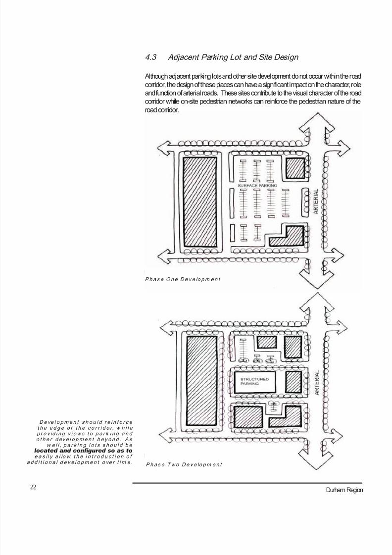
De ve l o pm e n t s h o u l d r e i n f o r c et h e e d g e o f t h e c o r r i d o r, w h i l ep r o v id i n g v i e w s t o p a r k i n g a n do t h e r d ev e l o pm e n t b e y o n d . A s
w e l l , p a r k i n g l o t s s h o u l d b elocated and congured so as toe a s i l y a l lo w t h e i n t r o d u c t i o n o f
a d d i t i o n a l d e v e l o pm e n t o ve r t i m e .
P h a s e On e D e v e lo pm e n t
P h a s e Tw o D e v e lo pm e n t
4.3 Adjacent Parking Lot and Site Design
Although adjacent parking lots and other site development do not occur within the road
corridor, the design of these places can have a significant impact on the character, role
and function of arterial roads. These sites contribute to the visual character of the road
corridor while on-site pedestrian networks can reinforce the pedestrian nature of the
road corridor.
8/21/2019 Durham Region Arterial Corridor Guideline
http://slidepdf.com/reader/full/durham-region-arterial-corridor-guideline 33/119
23 Arterial Corridor Guidelines
“S t r e e t -l i k e ” d r i ve w a y s w i t hs u b s t a n t i a l v e g e t a t i o n .
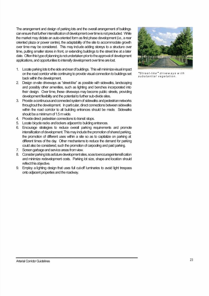
The arrangement and design of parking lots and the overall arrangement of buildings
can ensure that further intensification of development over time is not precluded. While
the market may dictate an auto-oriented form as first phase development (i.e., a rear
oriented plaza or power centre), the adaptability of the site to accommodate growth
over time may be considered. This may include adding storeys to a structure over
time, putting smaller stores in front, or extending buildings to the street line at a laterdate. Often this type of planning is not undertaken prior to the approval of development
applications, and opportunities to intensify development over time are lost.
1. Locate parking lots to the side and rear of buildings. This will minimize visual impact
on the road corridor while continuing to provide visual connection to buildings set
back within the development.
2. Design on-site driveways as “street-like” as possible with sidewalks, landscaping
and possibly other amenities, such as lighting and benches incorporated into
their design. Over time, these driveways may become public streets, providing
development flexibility and the potential to further sub-divide sites.
3. Provide a continuous and connected system of sidewalks and pedestrian networks
throughout the development. In particular, direct connections between sidewalkswithin the road corridor to all building entrances should be made. Sidewalks
should be a minimum of 1.5 m wide.
4. Provide direct pedestrian connections to transit stops.
5. Locate bicycle racks and lockers adjacent to building entrances.
6. Encourage strategies to reduce overall parking requirements and promote
intensification of development. This may include the promotion of shared parking,
the promotion of different uses within a site so as to capitalize on parking at
different times of the day. Other mechanisms to reduce the demand for parking
could also be considered, such the promotion of carpooling and paid parking.
7. Screen garbage and service areas from view.
8. Consider parking lots as future development sites, so as to encourage intensificationand minimize redevelopment costs. Parking lot size, shape and location should
reflect this objective.
9. Employ a lighting design that uses full cut-off luminaries to avoid light trespass
onto adjacent properties and the roadway.
8/21/2019 Durham Region Arterial Corridor Guideline
http://slidepdf.com/reader/full/durham-region-arterial-corridor-guideline 34/119
24 Durham Region
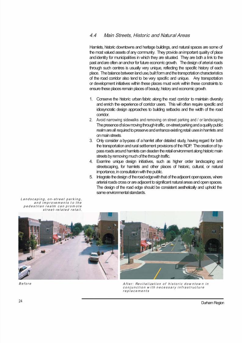
B e f o r e A f t e r : Re v i t a l i za t i o n o f h i s t o r i c d ow n t o w n i nc o n j u n c t i o n w i t h n e c e s s a r y i n f r a s t r uc t u r er e p l a c em e n t s
L a n d s c a p i n g , o n - st r e e t p a r k i n g ,a n d i m p r o vem e n t s t o t h e
p e d e s t r i a n r e a lm c a n p r o m o t es t r e e t - re l a t e d r e t a i l .
4.4 Main Streets, Historic and Natural Areas
Hamlets, historic downtowns and heritage buildings, and natural spaces are some of
the most valued assets of any community. They provide an important quality of place
and identity for municipalities in which they are situated. They are both a link to the
past and are often an anchor for future economic growth. The design of arterial roads
through such centres is usually very unique, reflecting the specific history of each
place. The balance between land use, built form and the transportation characteristics
of the road corridor also tend to be very specific and unique. Any transportation
or development initiatives within these places must work within these constraints to
ensure these places remain places of beauty, history and economic growth.
1. Conserve the historic urban fabric along the road corridor to maintain diversity
and enrich the experience of corridor users. This will often require specific and
idiosyncratic design approaches to building setbacks and the width of the road
corridor.
2. Avoid narrowing sidewalks and removing on street parking and / or landscaping.The presence of slow moving through-traffic, on-street parking and a quality public
realm are all required to preserve and enhance existing retail uses in hamlets and
on main streets.
3. Only consider a by-pass of a hamlet after detailed study, having regard for both
the transportation and rural settlement provisions of the ROP. The creation of by-
pass roads around hamlets can deaden the retail environment along historic main
streets by removing much of the through traffic.
4. Examine unique design initiatives, such as higher order landscaping and
streetscaping, for hamlets and other places of historic, cultural, or natural
importance, in consultation with the public.
5. Integrate the design of the road edge with that of the adjacent open spaces, where
arterial roads cross or are adjacent to significant natural areas and open spaces.
The design of the road edge should be consistent aesthetically and uphold the
same environmental standards.
8/21/2019 Durham Region Arterial Corridor Guideline
http://slidepdf.com/reader/full/durham-region-arterial-corridor-guideline 35/119
25 Arterial Corridor Guidelines
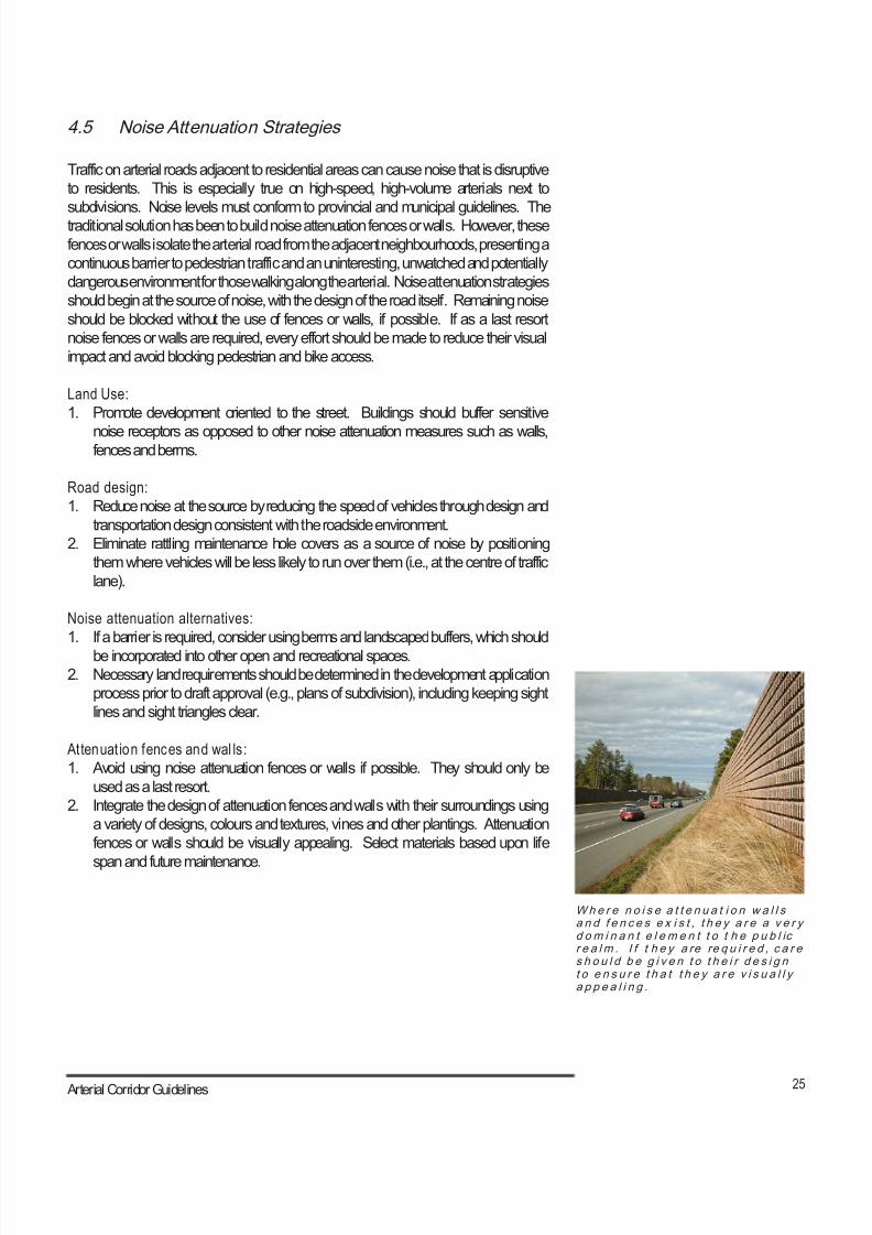
Whe r e n o i s e a t t e n u a t i o n w a l l sa n d f e n c e s e x i s t , t h e y a r e a v e r yd om i n a n t e l e m e n t t o t h e p u b l icr e a l m . I f t h e y a re re q u i r e d , c a r es h o u l d b e g i v e n t o t h e i r d e s i g nt o e n s u r e t h a t t h e y a r e v i s u a l l ya p p e a l i n g .
4.5 Noise Attenuation Strategies
Traffic on arterial roads adjacent to residential areas can cause noise that is disruptive
to residents. This is especially true on high-speed, high-volume arterials next to
subdivisions. Noise levels must conform to provincial and municipal guidelines. The
traditional solution has been to build noise attenuation fences or walls. However, these
fences or walls isolate the arterial road from the adjacent neighbourhoods, presenting a
continuous barrier to pedestrian traffic and an uninteresting, unwatched and potentially
dangerous environment for those walking along the arterial. Noise attenuation strategies
should begin at the source of noise, with the design of the road itself. Remaining noise
should be blocked without the use of fences or walls, if possible. If as a last resort
noise fences or walls are required, every effort should be made to reduce their visual
impact and avoid blocking pedestrian and bike access.
Land Use:
1. Promote development oriented to the street. Buildings should buffer sensitive
noise receptors as opposed to other noise attenuation measures such as walls,fences and berms.
Road design:
1. Reduce noise at the source by reducing the speed of vehicles through design and
transportation design consistent with the roadside environment.
2. Eliminate rattling maintenance hole covers as a source of noise by positioning
them where vehicles will be less likely to run over them (i.e., at the centre of traffic
lane).
Noise attenuation alternatives:
1. If a barrier is required, consider using berms and landscaped buffers, which should
be incorporated into other open and recreational spaces.
2. Necessary land requirements should be determined in the development application
process prior to draft approval (e.g., plans of subdivision), including keeping sight
lines and sight triangles clear.
Attenuat ion fences and wal ls:
1. Avoid using noise attenuation fences or walls if possible. They should only be
used as a last resort.
2. Integrate the design of attenuation fences and walls with their surroundings using
a variety of designs, colours and textures, vines and other plantings. Attenuation
fences or walls should be visually appealing. Select materials based upon life
span and future maintenance.

8/21/2019 Durham Region Arterial Corridor Guideline
http://slidepdf.com/reader/full/durham-region-arterial-corridor-guideline 36/119
26 Durham Region
8/21/2019 Durham Region Arterial Corridor Guideline
http://slidepdf.com/reader/full/durham-region-arterial-corridor-guideline 37/119
27 Arterial Corridor Guidelines
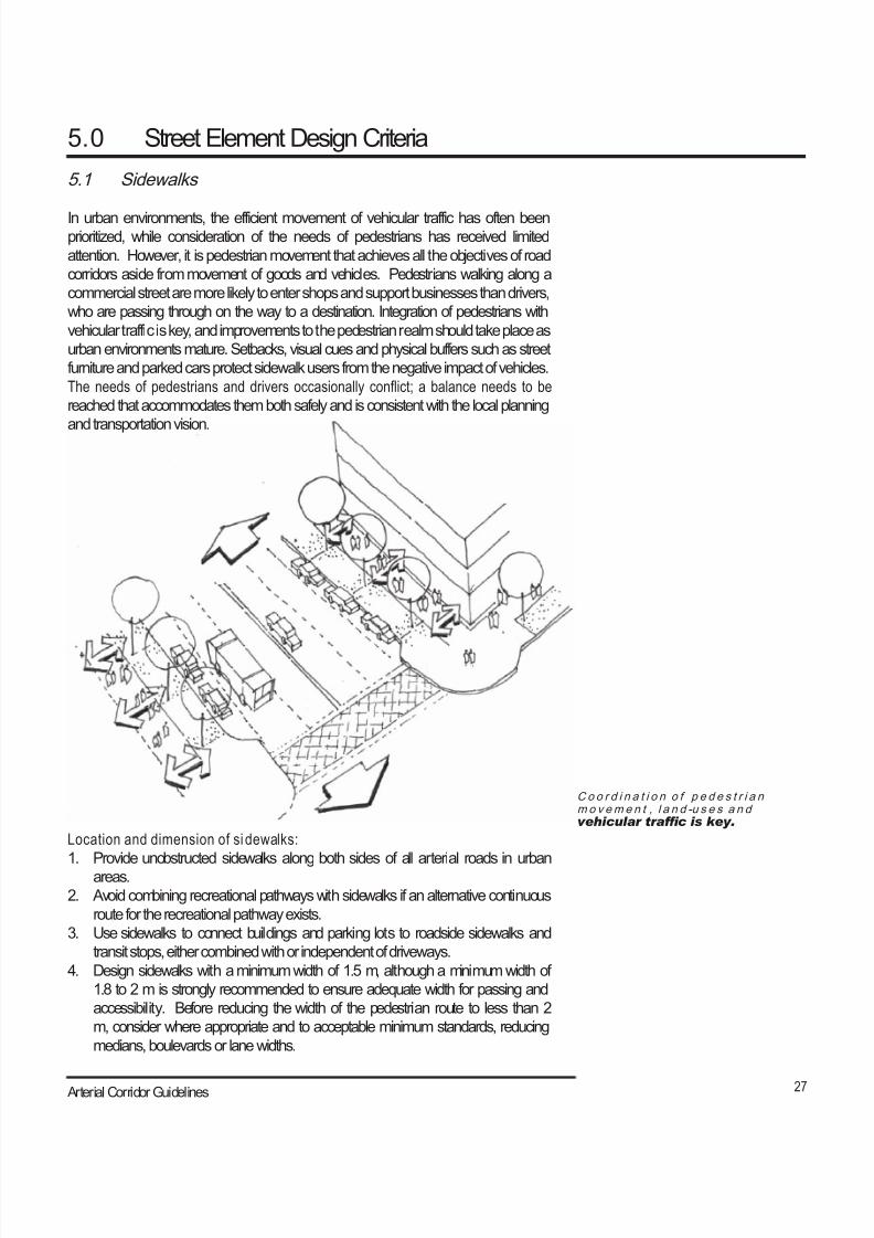
Co o r d i n a t i o n o f p e d e s t r i a nm o v em e n t , l a n d -u s e s a n dvehicular trafc is key.
5.0 Street Element Design Criteria
5.1 Sidewalks
In urban environments, the efficient movement of vehicular traffic has often beenprioritized, while consideration of the needs of pedestrians has received limited
attention. However, it is pedestrian movement that achieves all the objectives of road
corridors aside from movement of goods and vehicles. Pedestrians walking along a
commercial street are more likely to enter shops and support businesses than drivers,
who are passing through on the way to a destination. Integration of pedestrians with
vehicular traffic is key, and improvements to the pedestrian realm should take place as
urban environments mature. Setbacks, visual cues and physical buffers such as street
furniture and parked cars protect sidewalk users from the negative impact of vehicles.
The needs of pedestrians and drivers occasionally conflict; a balance needs to be
reached that accommodates them both safely and is consistent with the local planning
and transportation vision.
Location and dimension of si dewalks:
1. Provide unobstructed sidewalks along both sides of all arterial roads in urban
areas.
2. Avoid combining recreational pathways with sidewalks if an alternative continuous
route for the recreational pathway exists.
3. Use sidewalks to connect buildings and parking lots to roadside sidewalks and
transit stops, either combined with or independent of driveways.
4. Design sidewalks with a minimum width of 1.5 m, although a minimum width of
1.8 to 2 m is strongly recommended to ensure adequate width for passing and
accessibility. Before reducing the width of the pedestrian route to less than 2
m, consider where appropriate and to acceptable minimum standards, reducing
medians, boulevards or lane widths.
8/21/2019 Durham Region Arterial Corridor Guideline
http://slidepdf.com/reader/full/durham-region-arterial-corridor-guideline 38/119
28 Durham Region
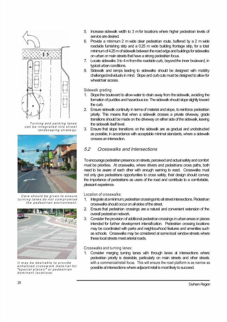
I t m a y b e d e s i r a b l e t o p r o v id ee n h a n c e d c r o s s w a l k m a t e r i a l f o r“s p e c i a l p l a c e s ” o r p e d e s t r i a nd om i n a n t l o c a t i o ns .
C a r e s h o u l d b e g i v e n t o e n s u r et u r n i n g l a ne s d o n o t c om p r om i s e
t h e p e d e s t r i a n e nv i r o nm e n t .
T u r n i n g a n d p a r k i n g l a n e sc a n b e i n t e g r a t e d i n t o s t r e e t
l a n d s c a p i n g s t r a t e g y.
5. Increase sidewalk width to 3 m for locations where higher pedestrian levels of
service are desired.
6. Provide a minimum 2 m wide clear pedestrian route, buffered by a 2 m wide
roadside furnishing strip and a 0.25 m wide building frontage strip, for a total
minimum of 4.25 m of sidewalk between the road edge and buildings for sidewalks
on urban or main streets that have a strong pedestrian focus.7. Locate sidewalks 3 to 4 m from the roadside curb, beyond the inner boulevard, in
typical urban conditions.
8. Sidewalk and ramps leading to sidewalks should be designed with mobility
challenged individuals in mind. Slope and curb cuts must be designed to allow for
wheelchair access.
Sidewalk grading:
1. Slope the boulevard to allow water to drain away from the sidewalk, avoiding the
formation of puddles and hazardous ice. The sidewalk should slope slightly toward
the curb.
2. Ensure sidewalk continuity in terms of material and slope, to reinforce pedestrian
priority. This means that when a sidewalk crosses a private driveway, gradetransitions should be made on the driveway on either side of the sidewalk, leaving
the sidewalk itself level.
3. Ensure that slope transitions on the sidewalk are as gradual and unobstructed
as possible, in accordance with acceptable minimal standards, where a sidewalk
crosses an intersection.
5.2 Crosswalks and Intersections
To encourage pedestrian presence on streets, perceived and actual safety and comfort
must be priorities. At crosswalks, where drivers and pedestrians cross paths, both
need to be aware of each other with enough warning to react. Crosswalks mustnot only give pedestrians opportunities to cross safely, their design should convey
the importance of pedestrians as users of the road and contribute to a comfortable,
pleasant experience.
Location of crosswalks:
1. Integrate at a minimum, pedestrian crossings into all street intersections. Pedestrian
crosswalks should occur on all sides of the street.
2. Ensure that pedestrian crossings are a natural and convenient extension of the
overall pedestrian network.
3. Consider the provision of additional pedestrian crossings in urban areas or places
intended for further development intensification. Pedestrian crossing locationsmay be coordinated with parks and neighbourhood features and amenities such
as schools. Crosswalks may be considered at some local window streets where
these local streets meet arterial roads.
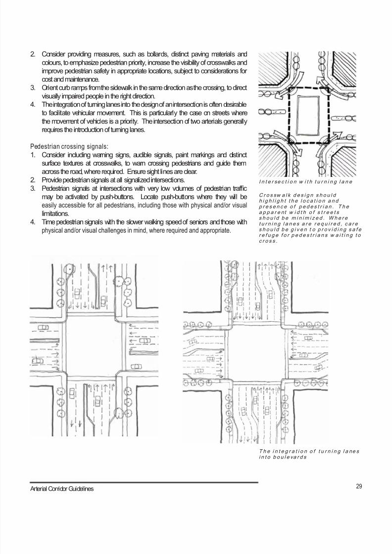
Crosswalks and tu rning lanes:
1. Consider merging turning lanes with through lanes at intersections where
pedestrian priority is desirable, particularly on main streets and other streets
with a commercial/retail focus. This will ensure the road platform is as narrow as
possible at intersections where adjacent retail is most likely to succeed.
8/21/2019 Durham Region Arterial Corridor Guideline
http://slidepdf.com/reader/full/durham-region-arterial-corridor-guideline 39/119
29 Arterial Corridor Guidelines
C r o s sw a l k d e s i g n s h o u l dh i g h l i g h t t h e l o c a t i o n a n dp r e s e n c e o f p e d e s t r i a n . T h ea p p a r e nt w i d t h o f s t r e e t ss h o u l d b e m i n i m i z e d . Wh e r et u r n i n g l a n e s a r e r e q u i r e d , c a r es h o u l d b e g i v e n t o p r o v i d i n g s a f er e f u g e f o r p e d e s t r i a n s w a i t i n g t oc r o s s .
I n t e r se c t i o n w i t h t u r n i n g l a n e
2. Consider providing measures, such as bollards, distinct paving materials and
colours, to emphasize pedestrian priority, increase the visibility of crosswalks and
improve pedestrian safety in appropriate locations, subject to considerations for
cost and maintenance.
3. Orient curb ramps from the sidewalk in the same direction as the crossing, to direct
visually impaired people in the right direction.4. The integration of turning lanes into the design of an intersection is often desirable
to facilitate vehicular movement. This is particularly the case on streets where
the movement of vehicles is a priority. The intersection of two arterials generally
requires the introduction of turning lanes.
Pedestrian crossing signals:
1. Consider including warning signs, audible signals, paint markings and distinct
surface textures at crosswalks, to warn crossing pedestrians and guide them
across the road, where required. Ensure sight lines are clear.
2. Provide pedestrian signals at all signalized intersections.
3. Pedestrian signals at intersections with very low volumes of pedestrian traffic
may be activated by push-buttons. Locate push-buttons where they will beeasily accessible for all pedestrians, including those with physical and/or visual
limitations.
4. Time pedestrian signals with the slower walking speed of seniors and those with
physical and/or visual challenges in mind, where required and appropriate.
T h e i n t e g r a t i o n o f t u r n i n g l a ne si n t o b o u l e va r d s
8/21/2019 Durham Region Arterial Corridor Guideline
http://slidepdf.com/reader/full/durham-region-arterial-corridor-guideline 40/119
30 Durham Region
T h e u s e o f p l a n t e r s , p a v e r s a n dg a r d e n s r e in f o r c e t h e s e n s e o f
“ p l a c e ” .
T r e e s a n d s h r u b s c a n h e l ps o f t e n t h e h a r d s u r f a c e s a l o n g
a n a r t e r i a l .
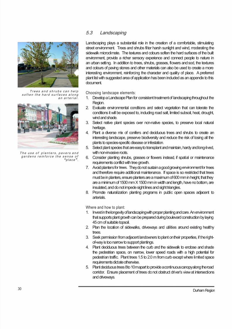
5.3 Landscaping
Landscaping plays a substantial role in the creation of a comfortable, stimulating
street environment. Trees and shrubs filter harsh sunlight and wind, moderating the
sidewalk microclimate. The textures and colours soften the hard surfaces of the built
environment, provide a richer sensory experience and connect people to nature inan urban setting. In addition to trees, shrubs, grasses, flowers and sod, the textures
and colours of paving stones and other materials can also be used to create a more
interesting environment, reinforcing the character and quality of place. A preferred
plant list with suggested area of application has been included as an appendix to this
document.
Choosing landscape elements:
1. Develop a Landscape Plan for consistent treatment of landscaping throughout the
Region.
2. Evaluate environmental conditions and select vegetation that can tolerate the
conditions it will be exposed to, including road salt, limited subsoil, heat, drought,
wind and shade.
3. Select native plant species over non-native species, to preserve local natural
heritage.
4. Plant a diverse mix of conifers and deciduous trees and shrubs to create an
interesting landscape, preserve biodiversity and reduce the risk of losing all the
plants to species-specific disease or infestation.
5. Select plant species that are easy to transplant and maintain, hardy and long-lived,
with non-invasive roots.
6. Consider planting shrubs, grasses or flowers instead, if spatial or maintenance
requirements conflict with tree growth.
7. Avoid planters for trees. They do not sustain a good growing environment for trees
and therefore require additional maintenance. If space is so restricted that treesmust be in planters, ensure planters are a maximum of 600 mm in height, that they
are a minimum of 1500 mm X 1500 mm in width and length, have no bottom, are
insulated, and do not impede sight lines and sight triangles.
8. Promote naturalization planting programs in public open spaces adjacent to
arterials.
Where and how to plant:
1. Invest in the longevity of landscaping with proper planting and care. An environment
that supports plant growth can be prepared during boulevard construction by laying
45 cm of suitable topsoil.
2. Plan the location of sidewalks, driveways and utilities around existing healthy
trees.
3. Seek permission from adjacent landowners to plant on their properties, if the right-
of-way is too narrow to support plantings.
4. Plant deciduous trees between the curb and the sidewalk to enclose and shade
the pedestrian space, on narrow, lower speed roads with a high potential for
pedestrian traffic. Plant trees 1.5 to 2.0 m from curb except where limited space
requirements dictate otherwise.
5. Plant deciduous trees 8 to 10 m apart to provide a continuous canopy along the road
corridor. Ensure placement of trees do not obstruct driver’s view at intersections
and driveways.
8/21/2019 Durham Region Arterial Corridor Guideline
http://slidepdf.com/reader/full/durham-region-arterial-corridor-guideline 41/119
31 Arterial Corridor Guidelines
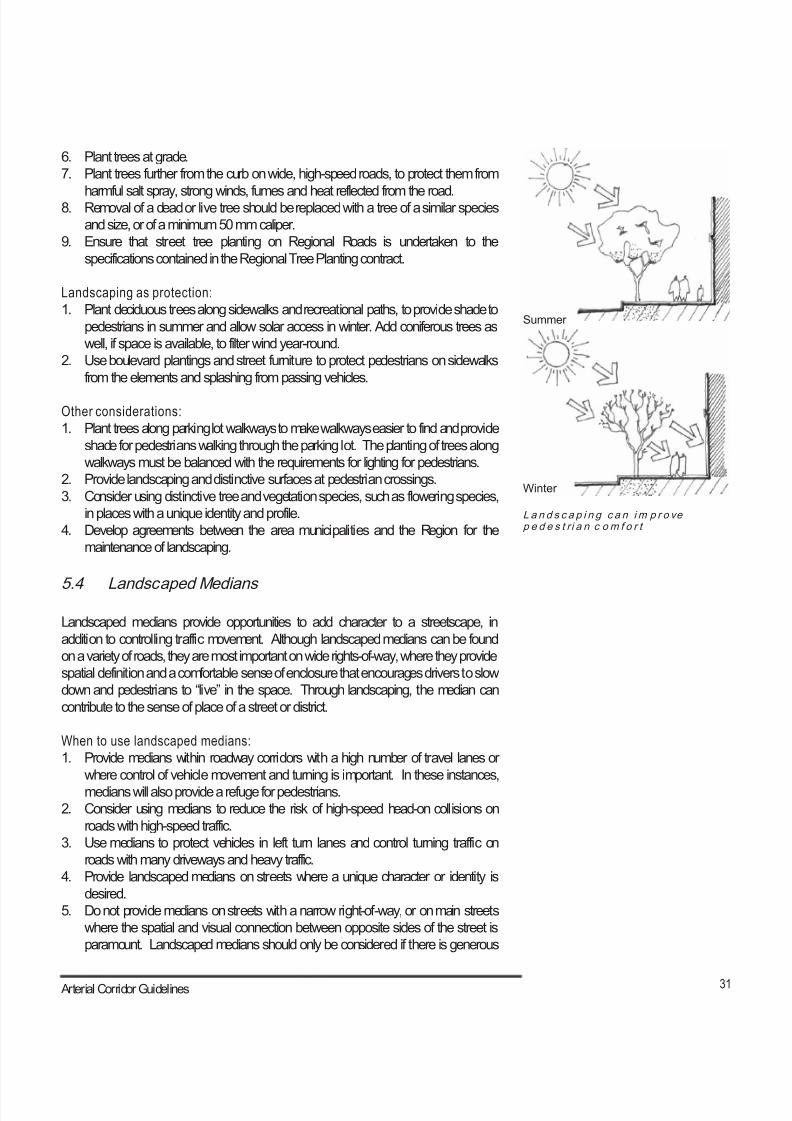
Summer
L a n d s c a p i n g c a n im p r o vep e d e s t r i a n c om f o r t
Winter
6. Plant trees at grade.
7. Plant trees further from the curb on wide, high-speed roads, to protect them from
harmful salt spray, strong winds, fumes and heat reflected from the road.8. Removal of a dead or live tree should be replaced with a tree of a similar species
and size, or of a minimum 50 mm caliper.
9. Ensure that street tree planting on Regional Roads is undertaken to the
specifications contained in the Regional Tree Planting contract.
Landscaping as protection:
1. Plant deciduous trees along sidewalks and recreational paths, to provide shade to
pedestrians in summer and allow solar access in winter. Add coniferous trees as
well, if space is available, to filter wind year-round.
2. Use boulevard plantings and street furniture to protect pedestrians on sidewalks
from the elements and splashing from passing vehicles.
Other considerations:
1. Plant trees along parking lot walkways to make walkways easier to find and provide
shade for pedestrians walking through the parking lot. The planting of trees along
walkways must be balanced with the requirements for lighting for pedestrians.
2. Provide landscaping and distinctive surfaces at pedestrian crossings.
3. Consider using distinctive tree and vegetation species, such as flowering species,
in places with a unique identity and profile.
4. Develop agreements between the area municipalities and the Region for the
maintenance of landscaping.
5.4 Landscaped Medians
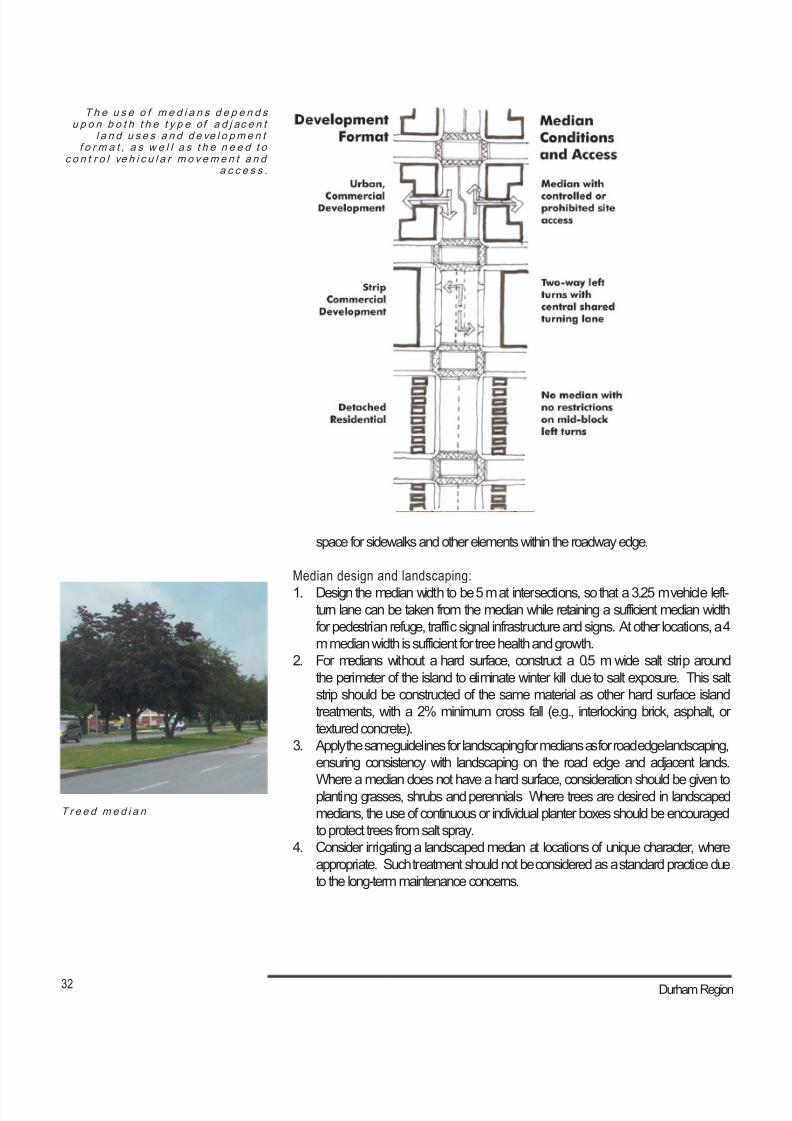
Landscaped medians provide opportunities to add character to a streetscape, in
addition to controlling traffic movement. Although landscaped medians can be found
on a variety of roads, they are most important on wide rights-of-way, where they provide
spatial definition and a comfortable sense of enclosure that encourages drivers to slow
down and pedestrians to “live” in the space. Through landscaping, the median can
contribute to the sense of place of a street or district.
When to use landscaped medians:
1. Provide medians within roadway corridors with a high number of travel lanes or
where control of vehicle movement and turning is important. In these instances,
medians will also provide a refuge for pedestrians.
2. Consider using medians to reduce the risk of high-speed head-on collisions on
roads with high-speed traffic.
3. Use medians to protect vehicles in left turn lanes and control turning traffic on
roads with many driveways and heavy traffic.
4. Provide landscaped medians on streets where a unique character or identity is
desired.
5. Do not provide medians on streets with a narrow right-of-way, or on main streets
where the spatial and visual connection between opposite sides of the street is
paramount. Landscaped medians should only be considered if there is generous
8/21/2019 Durham Region Arterial Corridor Guideline
http://slidepdf.com/reader/full/durham-region-arterial-corridor-guideline 42/119
32 Durham Region
T h e u s e o f m e d i a n s d e p e n d su p o n b o t h t h e t y p e of a d j ac e n t
l a n d u s e s a n d d e ve l o pm e n tf o r m a t , a s w e l l a s t h e n e e d t o
c o n t r o l ve h i c u l a r m o v em e n t a n da c c e s s .
T r e e d m e d i a n
space for sidewalks and other elements within the roadway edge.
Median design and landscaping:
1. Design the median width to be 5 m at intersections, so that a 3.25 m vehicle left-turn lane can be taken from the median while retaining a sufficient median width
for pedestrian refuge, traffic signal infrastructure and signs. At other locations, a 4
m median width is sufficient for tree health and growth.
2. For medians without a hard surface, construct a 0.5 m wide salt strip around
the perimeter of the island to eliminate winter kill due to salt exposure. This salt
strip should be constructed of the same material as other hard surface island
treatments, with a 2% minimum cross fall (e.g., interlocking brick, asphalt, or
textured concrete).
3. Apply the same guidelines for landscaping for medians as for road edge landscaping,
ensuring consistency with landscaping on the road edge and adjacent lands.
Where a median does not have a hard surface, consideration should be given toplanting grasses, shrubs and perennials Where trees are desired in landscaped
medians, the use of continuous or individual planter boxes should be encouraged
to protect trees from salt spray.
4. Consider irrigating a landscaped median at locations of unique character, where
appropriate. Such treatment should not be considered as a standard practice due
to the long-term maintenance concerns.
8/21/2019 Durham Region Arterial Corridor Guideline
http://slidepdf.com/reader/full/durham-region-arterial-corridor-guideline 43/119
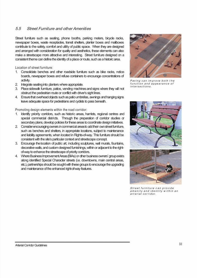
33 Arterial Corridor Guidelines
S t r e e t f u r n i t u r e c a n p r o v i d eam e n i t y a n d i d e n t i t y w i t h i n a n
a r t e r i a l c o r r i d o r.
P av i n g c a n im p r o ve b o t h t h ef u n c t i o n a n d a p pe a r a n c e o fi n t e r s e c t i o n s .
5.5 Street Furniture and other Amenities
Street furniture such as seating, phone booths, parking meters, bicycle racks,
newspaper boxes, waste receptacles, transit shelters, planter boxes and mailboxes
contribute to the safety, comfort and utility of public space. When they are designed
and arranged with consideration for quality and aesthetics, these elements can also
make a streetscape more attractive and interesting. Street furniture designed on a
consistent theme can define the identity of a place or route, such as a historic area.
Location of street furniture:
1. Consolidate benches and other roadside furniture such as bike racks, notice
boards, newspaper boxes and refuse containers to encourage concentrations of
activity.
2. Integrate seating into planters where appropriate.
3. Place sidewalk furniture, patios, vending machines and signs where they will not
obstruct the pedestrian route or conflict with driver’s sight lines.
4. Ensure that overhead objects such as patio umbrellas, awnings and hanging signsleave adequate space for pedestrians and cyclists to pass beneath.
Promoting design elements within the road corridor:
1. Identify priority corridors, such as historic areas, hamlets, regional centres and
special commercial districts. Through the preparation of corridor studies or
secondary plans, develop policies for these areas to coordinate design initiatives.
2. Consider encouraging owners in commercial areas to add their own street furniture,
such as benches and shelters, in appropriate locations, subject to maintenance
and liability agreements, when located in Rights-of-way. This furniture should be
consistent with the site’s particular context and streetscape concept.
3. Encourage the location of public art, including sculptures, wall murals, fountains,
decorative walls, and custom designed furnishings, within or adjacent to the right-
of-way to enhance the streetscape of priority corridors.
4. Where Business Improvement Areas (BIAs) or other business owners’ group exists
along identified Special Character streets (i.e. downtowns, main central areas,
etc.), partnerships should be sought with these groups to encourage the upgrading
and maintenance of the enhanced right-of-way features.
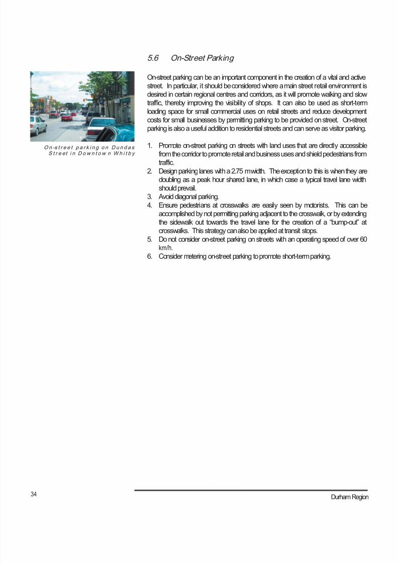
8/21/2019 Durham Region Arterial Corridor Guideline
http://slidepdf.com/reader/full/durham-region-arterial-corridor-guideline 44/119
34 Durham Region
On -s t r e e t p a r k i n g o n D u n d a sS t r e et i n D o w n t o w n W h i t b y
5.6 On-Street Parking
On-street parking can be an important component in the creation of a vital and active
street. In particular, it should be considered where a main street retail environment is
desired in certain regional centres and corridors, as it will promote walking and slow
traffic, thereby improving the visibility of shops. It can also be used as short-term
loading space for small commercial uses on retail streets and reduce development
costs for small businesses by permitting parking to be provided on street. On-street
parking is also a useful addition to residential streets and can serve as visitor parking.
1. Promote on-street parking on streets with land uses that are directly accessible
from the corridor to promote retail and business uses and shield pedestrians from
traffic.
2. Design parking lanes with a 2.75 m width. The exception to this is when they are
doubling as a peak hour shared lane, in which case a typical travel lane width
should prevail.
3. Avoid diagonal parking.4. Ensure pedestrians at crosswalks are easily seen by motorists. This can be
accomplished by not permitting parking adjacent to the crosswalk, or by extending
the sidewalk out towards the travel lane for the creation of a “bump-out” at
crosswalks. This strategy can also be applied at transit stops.
5. Do not consider on-street parking on streets with an operating speed of over 60
km/h.
6. Consider metering on-street parking to promote short-term parking.
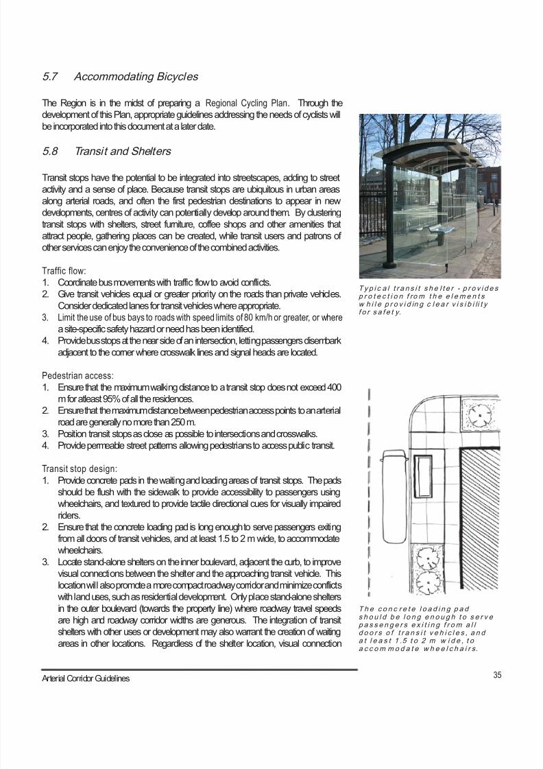
8/21/2019 Durham Region Arterial Corridor Guideline
http://slidepdf.com/reader/full/durham-region-arterial-corridor-guideline 45/119
35 Arterial Corridor Guidelines
Ty p i c a l t r a n s i t s h e l t e r - p r o v i d e sp r o t e c t i o n f ro m t h e e l e m e n t sw h i l e p r o v i d in g c l e a r v i s i b i li t yf o r s a f e t y.
T h e c o n c r e t e l o a d i n g p a ds h o u l d b e l o n g e n o u g h t o s e r v ep a s s e n g e r s e x i t i n g f r om a l ld o o r s o f t r a n s i t v e h i c l e s , a n da t l e a s t 1 .5 t o 2 m w i d e , t oa c c om m o d a t e w h e e l c h a i r s.
5.7 Accommodating Bicycles
The Region is in the midst of preparing a Regional Cycling Plan. Through the
development of this Plan, appropriate guidelines addressing the needs of cyclists will
be incorporated into this document at a later date.
5.8 Transit and Shelters
Transit stops have the potential to be integrated into streetscapes, adding to street
activity and a sense of place. Because transit stops are ubiquitous in urban areas
along arterial roads, and often the first pedestrian destinations to appear in new
developments, centres of activity can potentially develop around them. By clustering
transit stops with shelters, street furniture, coffee shops and other amenities that
attract people, gathering places can be created, while transit users and patrons of
other services can enjoy the convenience of the combined activities.
Traffic flow:1. Coordinate bus movements with traffic flow to avoid conflicts.
2. Give transit vehicles equal or greater priority on the roads than private vehicles.
Consider dedicated lanes for transit vehicles where appropriate.
3. Limit the use of bus bays to roads with speed limits of 80 km/h or greater, or where
a site-specific safety hazard or need has been identified.
4. Provide bus stops at the near side of an intersection, letting passengers disembark
adjacent to the corner where crosswalk lines and signal heads are located.
Pedestrian access:
1. Ensure that the maximum walking distance to a transit stop does not exceed 400
m for atleast 95% of all the residences.
2. Ensure that the maximum distance between pedestrian access points to an arterial
road are generally no more than 250 m.
3. Position transit stops as close as possible to intersections and crosswalks.
4. Provide permeable street patterns allowing pedestrians to access public transit.
Transit stop design:
1. Provide concrete pads in the waiting and loading areas of transit stops. The pads
should be flush with the sidewalk to provide accessibility to passengers using
wheelchairs, and textured to provide tactile directional cues for visually impaired
riders.
2. Ensure that the concrete loading pad is long enough to serve passengers exiting
from all doors of transit vehicles, and at least 1.5 to 2 m wide, to accommodatewheelchairs.
3. Locate stand-alone shelters on the inner boulevard, adjacent the curb, to improve
visual connections between the shelter and the approaching transit vehicle. This
location will also promote a more compact roadway corridor and minimize conflicts
with land uses, such as residential development. Only place stand-alone shelters
in the outer boulevard (towards the property line) where roadway travel speeds
are high and roadway corridor widths are generous. The integration of transit
shelters with other uses or development may also warrant the creation of waiting
areas in other locations. Regardless of the shelter location, visual connection
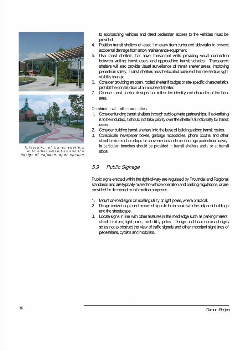
8/21/2019 Durham Region Arterial Corridor Guideline
http://slidepdf.com/reader/full/durham-region-arterial-corridor-guideline 46/119
36 Durham Region
I n t e g r a t i on o f t r a n s i t s h e l t e r sw i t h o t h e r am e n i t ie s a n d t h e
d e s ig n o f a d j ac e n t o p e n s p a c e s
to approaching vehicles and direct pedestrian access to the vehicles must be
provided.
4. Position transit shelters at least 1 m away from curbs and sidewalks to prevent
accidental damage from snow maintenance equipment.
5. Use transit shelters that have transparent walls providing visual connection
between waiting transit users and approaching transit vehicles. Transparentshelters will also provide visual surveillance of transit shelter areas, improving
pedestrian safety. Transit shelters must be located outside of the intersection sight
visibility triangle.
6. Consider providing an open, roofed shelter if budget or site-specific characteristics
prohibit the construction of an enclosed shelter.
7. Choose transit shelter designs that reflect the identity and character of the local
area.
Combining with other amenities:
1. Consider funding transit shelters through public-private partnerships. If advertising
is to be included, it should not take priority over the shelter’s functionality for transit
users.2. Consider building transit shelters into the base of buildings along transit routes.
3. Consolidate newspaper boxes, garbage receptacles, phone booths and other
street furniture at bus stops for convenience and to encourage pedestrian activity.
In particular, benches should be provided in transit shelters and / or at transit
stops.
5.9 Public Signage
Public signs erected within the right-of-way are regulated by Provincial and Regional
standards and are typically related to vehicle operation and parking regulations, or areprovided for directional or information purposes.
1. Mount on-road signs on existing utility or light poles, where practical.
2. Design individual ground-mounted signs to be in scale with the adjacent buildings
and the streetscape.
3. Locate signs in line with other features in the road edge such as parking meters,
street furniture, light poles, and utility poles. Design and locate on-road signs
so as not to obstruct the view of traffic signals and other important sight lines of
pedestrians, cyclists and motorists.
8/21/2019 Durham Region Arterial Corridor Guideline
http://slidepdf.com/reader/full/durham-region-arterial-corridor-guideline 47/119
37 Arterial Corridor Guidelines
5.10 Private Signage
Private signs erected within the right-of-way are regulated by Regional or local by-laws,
depending on the jurisdiction of the road. Private signs erected outside the right-of-
way are regulated by local municipal by-laws and are typically related to business
exposure and promotion. In addition to providing this economic benefit, they can alsoprovide the benefit of enhancing a corridor.
1. Locate signs such that their setback provides adequate sight lines for motorists,
pedestrians and cyclists. Ensure by-laws regulating private signs incorporate a
minimum set back of 1.0 m from the property line and appropriately sized sight
triangle protection at vehicle and pedestrian access/egress points.
2. Where corridors are given “Special Consideration” such as a Main Central Area
or historic downtown, regulate signage to be compatible with the area and/or
recommendations developed through Secondary Plans or Corridor Studies with
the adoption of new signage by-laws or amendments to the existing by-laws.
3. Promote the use of shared-use or joint-use signs to reduce corridor clutter.4. Provide natural or other landscaped features at the base of ground mounted
signs.
5. Design ground or wall-mounted signs to be in scale with adjacent buildings, land
use and corridor “Street Type”. Regulate sign area, mounting height and movement
of signs (e.g. rotating signs).
6. Regulate the provision of portable or temporary signs to limit their numbers,
location, set back from the right-of-way and size in order to reduce corridor clutter
and ensure clear sight lines for motorists, cyclists and pedestrians.
7. Promote the use of wall-mounted over-head signs at a minimum height of 2.4 m to
ensure adequate clearance for pedestrians and service vehicles that may use the
sidewalks in pedestrian-oriented areas such as main streets.

8/21/2019 Durham Region Arterial Corridor Guideline
http://slidepdf.com/reader/full/durham-region-arterial-corridor-guideline 48/119
38 Durham Region
8/21/2019 Durham Region Arterial Corridor Guideline
http://slidepdf.com/reader/full/durham-region-arterial-corridor-guideline 49/119
39 Arterial Corridor Guidelines
6.0 Design and Placement of Utilities
6.1 Lighting
The Region is in the midst of preparing aRegional Roadway Lighting Policy and Design
Specifications. Through the development of this Policy, appropriate guidelines will be
prepared addressing lighting on roads and sidewalks, and will be incorporated into this
document at a later date.
6.2 Above Grade Utilities
Utilities must be integrated into the right-of-way of arterial road corridors. Safety
standards and concerns related to their placement must be observed, but utilitiesshould not dictate the design of these spaces.
Visual impact:
1. Bury services and utilities, where practical, to minimize their visual impact.
2. Provide a 1.5 m to 2.5 m setback from the back of curb for hydro poles in typical
urban settings. There must be a minimum 3 m separation between power lines
and any physical development. For main streets and historical districts, a minimum
setback from the back of curb for hydro poles is 0.25 m.
3. Locate utility poles 3 to 4 m from the property line on rural roads, and in accordance
with existing guidelines for minimum sightline and sight triangle distances.
4. Minimize the visibility of utility accessories, such as utility boxes. This can be
achieved by placing accessories in inconspicuous places, and/or by screening
them with plantings. Ensure such screening does not interfere with access to the
accessories. Utility providers should also be encouraged to consider innovative
methods of containing utilities and determining locations for large utility equipment
and utility cluster sites.
Consolidation:
1. Maximize the joint use of utility poles to minimize their number.
2. Maximize the shared use of utility trenches in new construction by planning for
and installing them on a coordinated and integrated basis to be more efficient,
cost effective, reduce right-of-way requirements and provide additional space for
landscaping.
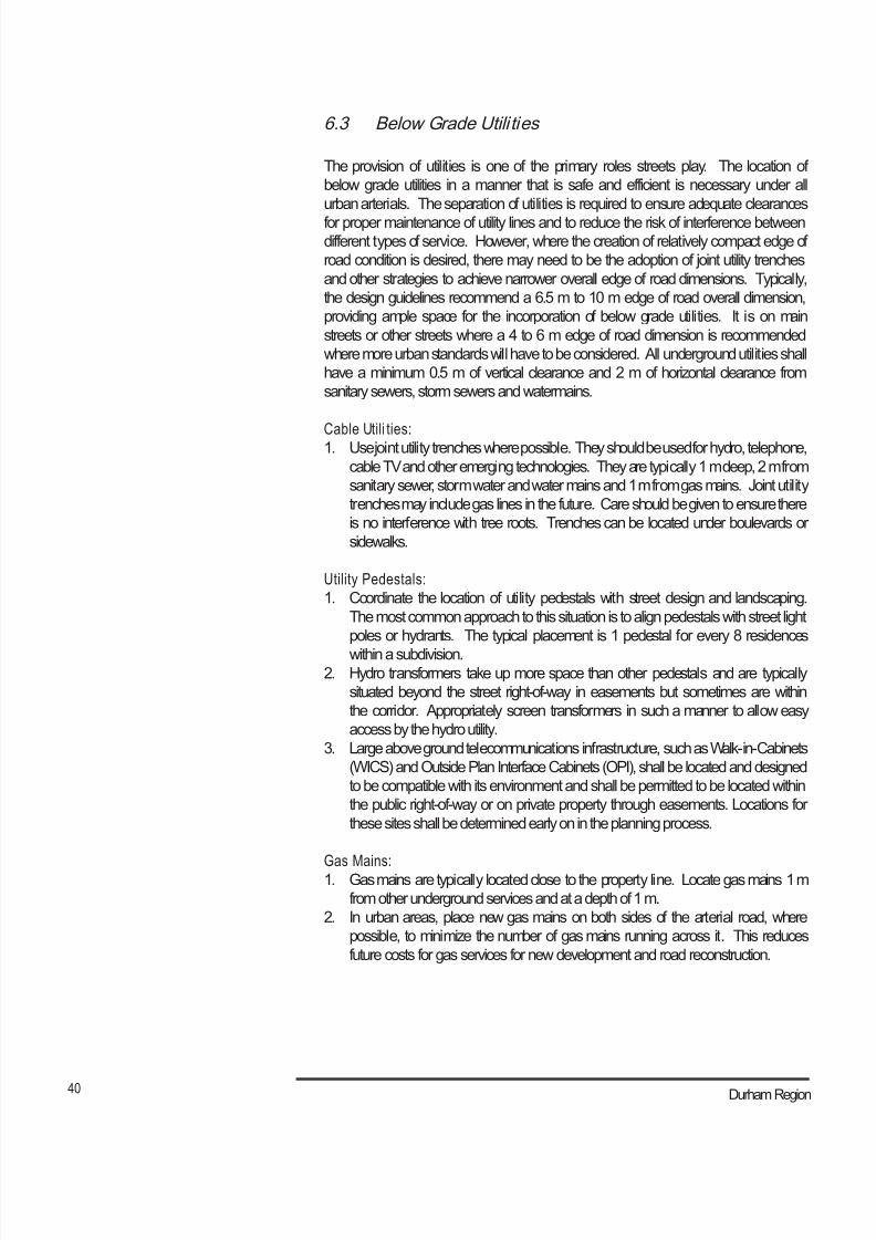
8/21/2019 Durham Region Arterial Corridor Guideline
http://slidepdf.com/reader/full/durham-region-arterial-corridor-guideline 50/119
40 Durham Region
6.3 Below Grade Utili ties
The provision of utilities is one of the primary roles streets play. The location of
below grade utilities in a manner that is safe and efficient is necessary under all
urban arterials. The separation of utilities is required to ensure adequate clearances
for proper maintenance of utility lines and to reduce the risk of interference betweendifferent types of service. However, where the creation of relatively compact edge of
road condition is desired, there may need to be the adoption of joint utility trenches
and other strategies to achieve narrower overall edge of road dimensions. Typically,
the design guidelines recommend a 6.5 m to 10 m edge of road overall dimension,
providing ample space for the incorporation of below grade utilities. It is on main
streets or other streets where a 4 to 6 m edge of road dimension is recommended
where more urban standards will have to be considered. All underground utilities shall
have a minimum 0.5 m of vertical clearance and 2 m of horizontal clearance from
sanitary sewers, storm sewers and watermains.
Cable Utili ties:1. Use joint utility trenches where possible. They should be used for hydro, telephone,
cable TV and other emerging technologies. They are typically 1 m deep, 2 m from
sanitary sewer, storm water and water mains and 1 m from gas mains. Joint utility
trenches may include gas lines in the future. Care should be given to ensure there
is no interference with tree roots. Trenches can be located under boulevards or
sidewalks.
Utility Pedestals:
1. Coordinate the location of utility pedestals with street design and landscaping.
The most common approach to this situation is to align pedestals with street light
poles or hydrants. The typical placement is 1 pedestal for every 8 residences
within a subdivision.2. Hydro transformers take up more space than other pedestals and are typically
situated beyond the street right-of-way in easements but sometimes are within
the corridor. Appropriately screen transformers in such a manner to allow easy
access by the hydro utility.
3. Large above ground telecommunications infrastructure, such as Walk-in-Cabinets
(WICS) and Outside Plan Interface Cabinets (OPI), shall be located and designed
to be compatible with its environment and shall be permitted to be located within
the public right-of-way or on private property through easements. Locations for
these sites shall be determined early on in the planning process.
Gas Mains:1. Gas mains are typically located close to the property line. Locate gas mains 1 m
from other underground services and at a depth of 1 m.
2. In urban areas, place new gas mains on both sides of the arterial road, where
possible, to minimize the number of gas mains running across it. This reduces
future costs for gas services for new development and road reconstruction.
8/21/2019 Durham Region Arterial Corridor Guideline
http://slidepdf.com/reader/full/durham-region-arterial-corridor-guideline 51/119
41 Arterial Corridor Guidelines
Sanitary and Storm Sewers:
1. Sanitary sewers are typically installed under the road platform in the middle of one
traffic lane.
2. Storm sewers are typically installed with a minimum separation of 3 m from sanitary
sewers and they typically are placed under the curb and gutter.
3. Sewer lines must be at least 2.5 m from a water main.
Water Mains:
1. Water mains are typically installed within the edge of road, and are preferably
located on the opposite edge of the road from a sanitary sewer line. Where existing
utilities are in conflict with the proposed watermain location, the watermain shall be
shifted as necessary. They should be 2 m from cable, gas and hydro utilities and
2.5 m from sewers.
Conflicts:
1. Coordinate landscape plans with service/utility plans to minimize long-term
conflicts with tree roots and branches.
2. Consider placing utility infrastructure 2 m underground or away from tree driplines, considering the reach of the tree’s roots at maturity to avoid damage from
tree roots.
3. Consider subsurface or trenchless technology installation rather than tree removal
to address conflicts with underground utilities if existing trees are larger than 150
mm caliper.
4. Replace trees that are removed as a result of utility works, with trees of the same
or greater caliper where practical.

8/21/2019 Durham Region Arterial Corridor Guideline
http://slidepdf.com/reader/full/durham-region-arterial-corridor-guideline 52/119
42 Durham Region
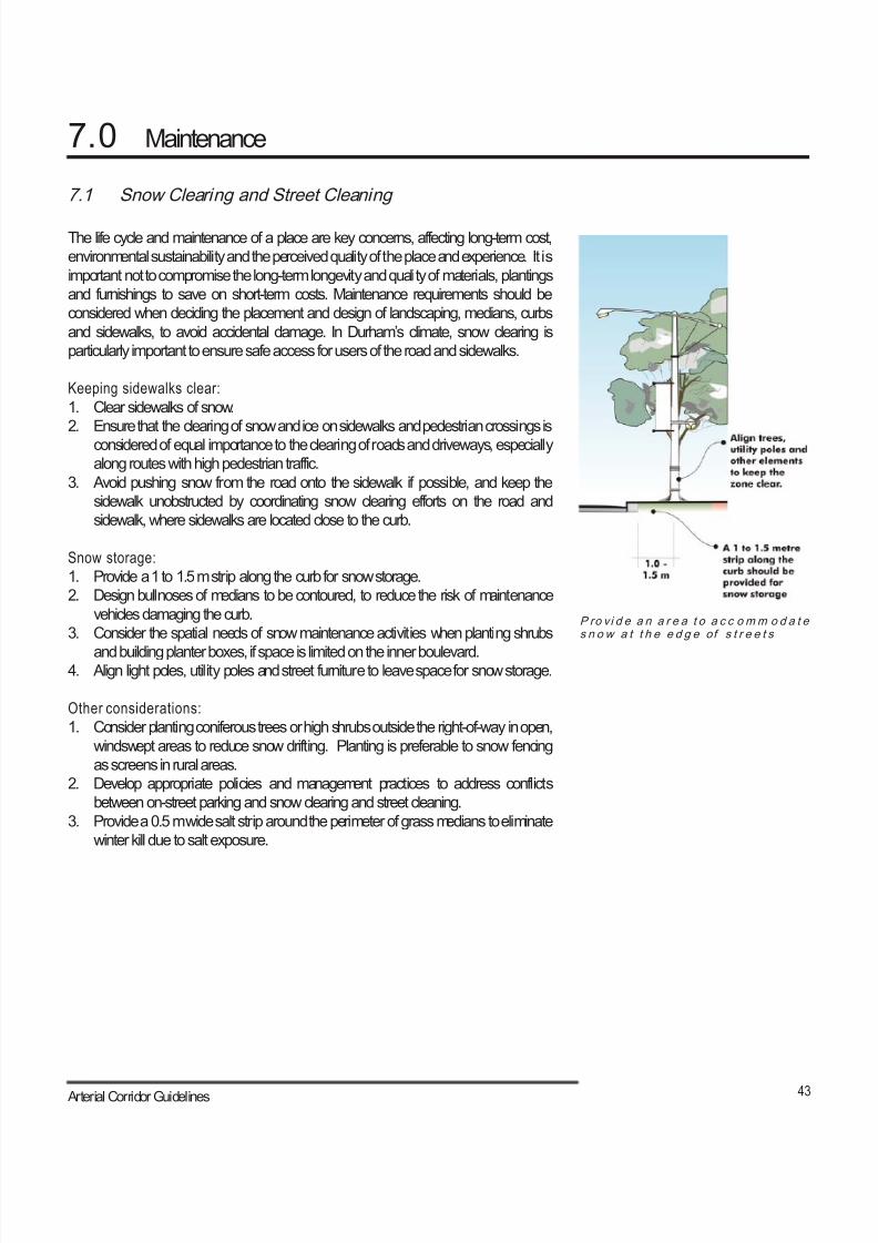
8/21/2019 Durham Region Arterial Corridor Guideline
http://slidepdf.com/reader/full/durham-region-arterial-corridor-guideline 53/119
43 Arterial Corridor Guidelines
7.0 Maintenance
P ro vi d e a n a r e a t o a c c omm o d a t es n o w a t t h e e d g e of s t r e e t s
7.1 Snow Clearing and Street Cleaning
The life cycle and maintenance of a place are key concerns, affecting long-term cost,
environmental sustainability and the perceived quality of the place and experience. It is
important not to compromise the long-term longevity and quality of materials, plantings
and furnishings to save on short-term costs. Maintenance requirements should be
considered when deciding the placement and design of landscaping, medians, curbs
and sidewalks, to avoid accidental damage. In Durham’s climate, snow clearing is
particularly important to ensure safe access for users of the road and sidewalks.
Keeping sidewalks clear:
1. Clear sidewalks of snow.
2. Ensure that the clearing of snow and ice on sidewalks and pedestrian crossings is
considered of equal importance to the clearing of roads and driveways, especially
along routes with high pedestrian traffic.
3. Avoid pushing snow from the road onto the sidewalk if possible, and keep the
sidewalk unobstructed by coordinating snow clearing efforts on the road and
sidewalk, where sidewalks are located close to the curb.
Snow storage:
1. Provide a 1 to 1.5 m strip along the curb for snow storage.
2. Design bullnoses of medians to be contoured, to reduce the risk of maintenance
vehicles damaging the curb.
3. Consider the spatial needs of snow maintenance activities when planting shrubs
and building planter boxes, if space is limited on the inner boulevard.4. Align light poles, utility poles and street furniture to leave space for snow storage.
Other considerations:
1. Consider planting coniferous trees or high shrubs outside the right-of-way in open,
windswept areas to reduce snow drifting. Planting is preferable to snow fencing
as screens in rural areas.
2. Develop appropriate policies and management practices to address conflicts
between on-street parking and snow clearing and street cleaning.
3. Provide a 0.5 m wide salt strip around the perimeter of grass medians to eliminate
winter kill due to salt exposure.

8/21/2019 Durham Region Arterial Corridor Guideline
http://slidepdf.com/reader/full/durham-region-arterial-corridor-guideline 54/119
44 Durham Region
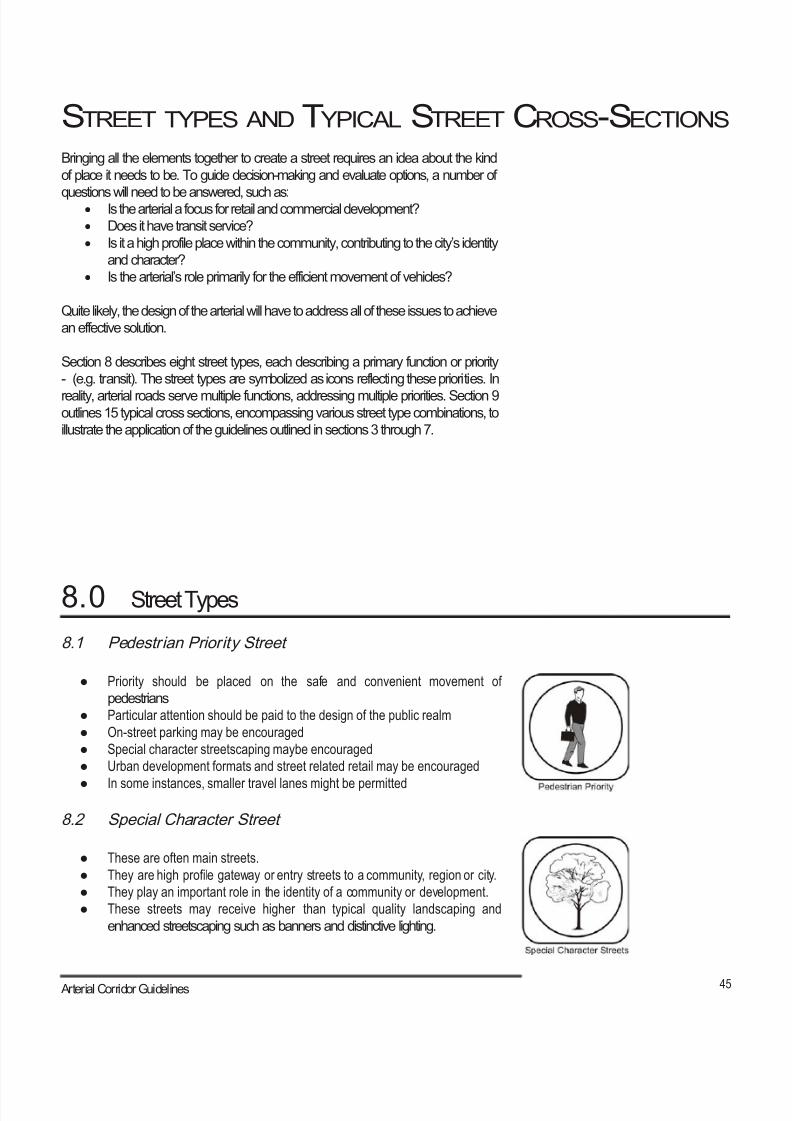
8/21/2019 Durham Region Arterial Corridor Guideline
http://slidepdf.com/reader/full/durham-region-arterial-corridor-guideline 55/119
45 Arterial Corridor Guidelines
STREET TYPES AND TYPICAL STREET CROSS-SECTIONS
8.0 Street Types
Bringing all the elements together to create a street requires an idea about the kind
of place it needs to be. To guide decision-making and evaluate options, a number of
questions will need to be answered, such as:• Is the arterial a focus for retail and commercial development?• Does it have transit service?
• Is it a high profile place within the community, contributing to the city’s identity
and character?• Is the arterial’s role primarily for the efficient movement of vehicles?
Quite likely, the design of the arterial will have to address all of these issues to achieve
an effective solution.
Section 8 describes eight street types, each describing a primary function or priority
- (e.g. transit). The street types are symbolized as icons reflecting these priorities. In
reality, arterial roads serve multiple functions, addressing multiple priorities. Section 9outlines 15 typical cross sections, encompassing various street type combinations, to
illustrate the application of the guidelines outlined in sections 3 through 7.
8.1 Pedestrian Priority Street
● Priority should be placed on the safe and convenient movement of
pedestrians
● Particular attention should be paid to the design of the public realm
● On-street parking may be encouraged
● Special character streetscaping maybe encouraged
● Urban development formats and street related retail may be encouraged
● In some instances, smaller travel lanes might be permitted
8.2 Special Character Street
● These are often main streets.
● They are high profile gateway or entry streets to a community, region or city.
● They play an important role in the identity of a community or development.
● These streets may receive higher than typical quality landscaping and
enhanced streetscaping such as banners and distinctive lighting.
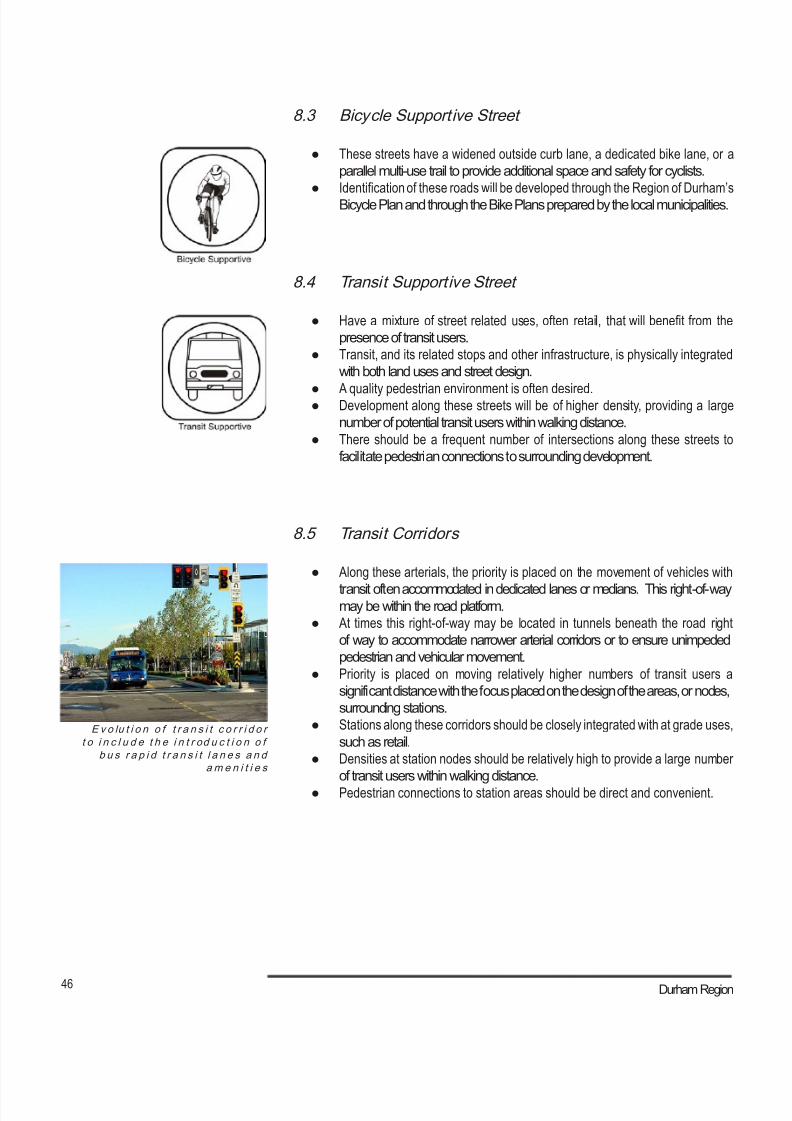
8/21/2019 Durham Region Arterial Corridor Guideline
http://slidepdf.com/reader/full/durham-region-arterial-corridor-guideline 56/119
46 Durham Region
E v o lu t i o n o f t r a n s i t c o r r i d o rt o i n c l u d e t h e i n t r od u c t i o n o f
b u s r a p i d t r a n s i t l a n e s a n dam e n i t i e s
8.3 Bicycle Supportive Street
● These streets have a widened outside curb lane, a dedicated bike lane, or a
parallel multi-use trail to provide additional space and safety for cyclists.
● Identification of these roads will be developed through the Region of Durham’s
Bicycle Plan and through the Bike Plans prepared by the local municipalities.
8.4 Transit Supportive Street
● Have a mixture of street related uses, often retail, that will benefit from the
presence of transit users.
● Transit, and its related stops and other infrastructure, is physically integrated
with both land uses and street design.
● A quality pedestrian environment is often desired.● Development along these streets will be of higher density, providing a large
number of potential transit users within walking distance.
● There should be a frequent number of intersections along these streets to
facilitate pedestrian connections to surrounding development.
8.5 Transit Corridors
● Along these arterials, the priority is placed on the movement of vehicles with
transit often accommodated in dedicated lanes or medians. This right-of-waymay be within the road platform.
● At times this right-of-way may be located in tunnels beneath the road right
of way to accommodate narrower arterial corridors or to ensure unimpeded
pedestrian and vehicular movement.
● Priority is placed on moving relatively higher numbers of transit users a
significant distance with the focus placed on the design of the areas, or nodes,
surrounding stations.
● Stations along these corridors should be closely integrated with at grade uses,
such as retail.
● Densities at station nodes should be relatively high to provide a large number
of transit users within walking distance.
● Pedestrian connections to station areas should be direct and convenient.
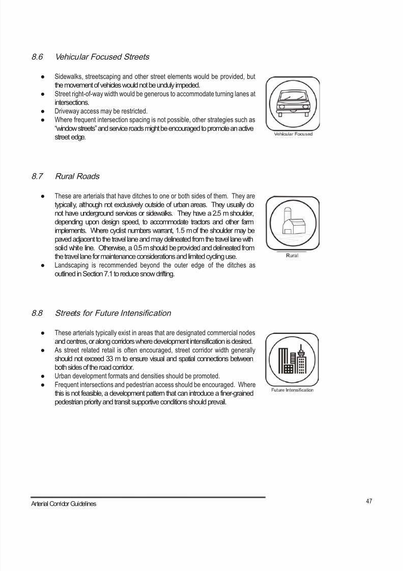
8/21/2019 Durham Region Arterial Corridor Guideline
http://slidepdf.com/reader/full/durham-region-arterial-corridor-guideline 57/119
47 Arterial Corridor Guidelines
8.6 Vehicular Focused Streets
● Sidewalks, streetscaping and other street elements would be provided, but
the movement of vehicles would not be unduly impeded.
● Street right-of-way width would be generous to accommodate turning lanes at
intersections.● Driveway access may be restricted.
● Where frequent intersection spacing is not possible, other strategies such as
“window streets” and service roads might be encouraged to promote an active
street edge.
8.7 Rural Roads
● These are arterials that have ditches to one or both sides of them. They are
typically, although not exclusively outside of urban areas. They usually do
not have underground services or sidewalks. They have a 2.5 m shoulder,
depending upon design speed, to accommodate tractors and other farm
implements. Where cyclist numbers warrant, 1.5 m of the shoulder may be
paved adjacent to the travel lane and may delineated from the travel lane with
solid white line. Otherwise, a 0.5 m should be provided and delineated from
the travel lane for maintenance considerations and limited cycling use.
● Landscaping is recommended beyond the outer edge of the ditches as
outlined in Section 7.1 to reduce snow drifting.
8.8 Streets for Future Intensification
● These arterials typically exist in areas that are designated commercial nodes
and centres, or along corridors where development intensification is desired.
● As street related retail is often encouraged, street corridor width generally
should not exceed 33 m to ensure visual and spatial connections between
both sides of the road corridor.
● Urban development formats and densities should be promoted.
● Frequent intersections and pedestrian access should be encouraged. Where
this is not feasible, a development pattern that can introduce a finer-grained
pedestrian priority and transit supportive conditions should prevail.

8/21/2019 Durham Region Arterial Corridor Guideline
http://slidepdf.com/reader/full/durham-region-arterial-corridor-guideline 58/119
48 Durham Region
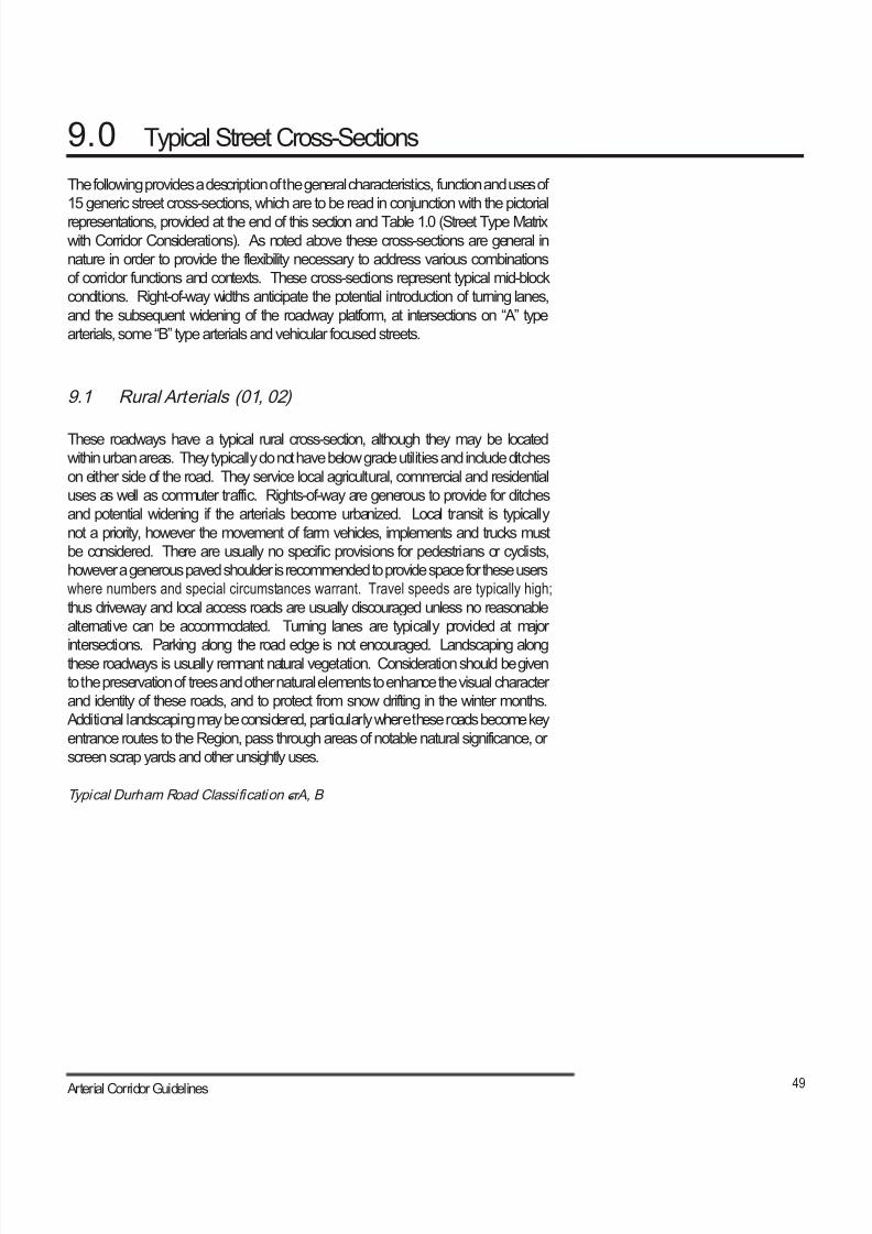
8/21/2019 Durham Region Arterial Corridor Guideline
http://slidepdf.com/reader/full/durham-region-arterial-corridor-guideline 59/119
49 Arterial Corridor Guidelines
9.0 Typical Street Cross-Sections
The following provides a description of the general characteristics, function and uses of
15 generic street cross-sections, which are to be read in conjunction with the pictorial
representations, provided at the end of this section and Table 1.0 (Street Type Matrixwith Corridor Considerations). As noted above these cross-sections are general in
nature in order to provide the flexibility necessary to address various combinations
of corridor functions and contexts. These cross-sections represent typical mid-block
conditions. Right-of-way widths anticipate the potential introduction of turning lanes,
and the subsequent widening of the roadway platform, at intersections on “A” type
arterials, some “B” type arterials and vehicular focused streets.
9.1 Rural Arterials (01, 02)
These roadways have a typical rural cross-section, although they may be located
within urban areas. They typically do not have below grade utilities and include ditches
on either side of the road. They service local agricultural, commercial and residential
uses as well as commuter traffic. Rights-of-way are generous to provide for ditches
and potential widening if the arterials become urbanized. Local transit is typically
not a priority, however the movement of farm vehicles, implements and trucks must
be considered. There are usually no specific provisions for pedestrians or cyclists,
however a generous paved shoulder is recommended to provide space for these users
where numbers and special circumstances warrant. Travel speeds are typically high;
thus driveway and local access roads are usually discouraged unless no reasonable
alternative can be accommodated. Turning lanes are typically provided at major
intersections. Parking along the road edge is not encouraged. Landscaping alongthese roadways is usually remnant natural vegetation. Consideration should be given
to the preservation of trees and other natural elements to enhance the visual character
and identity of these roads, and to protect from snow drifting in the winter months.
Additional landscaping may be considered, particularly where these roads become key
entrance routes to the Region, pass through areas of notable natural significance, or
screen scrap yards and other unsightly uses.
Typical Durham Road Classification – A, B
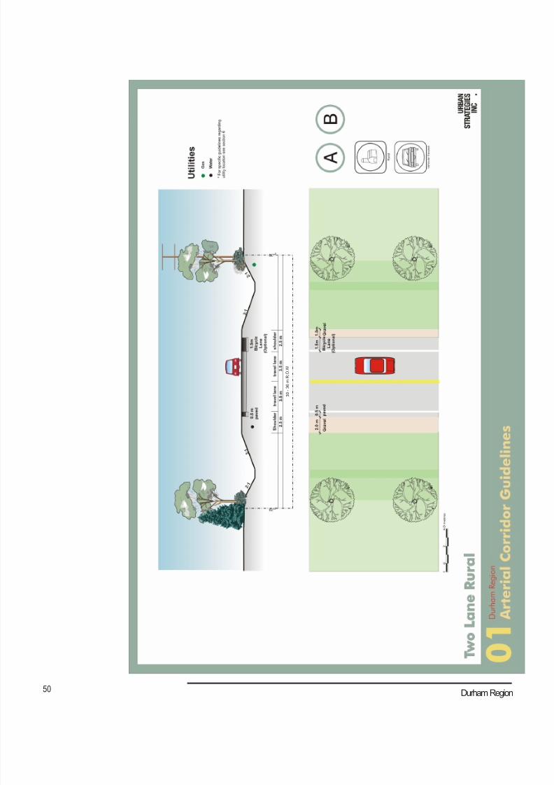
8/21/2019 Durham Region Arterial Corridor Guideline
http://slidepdf.com/reader/full/durham-region-arterial-corridor-guideline 60/119
50 Durham Region
3 0 - 3 6 m R . O . W
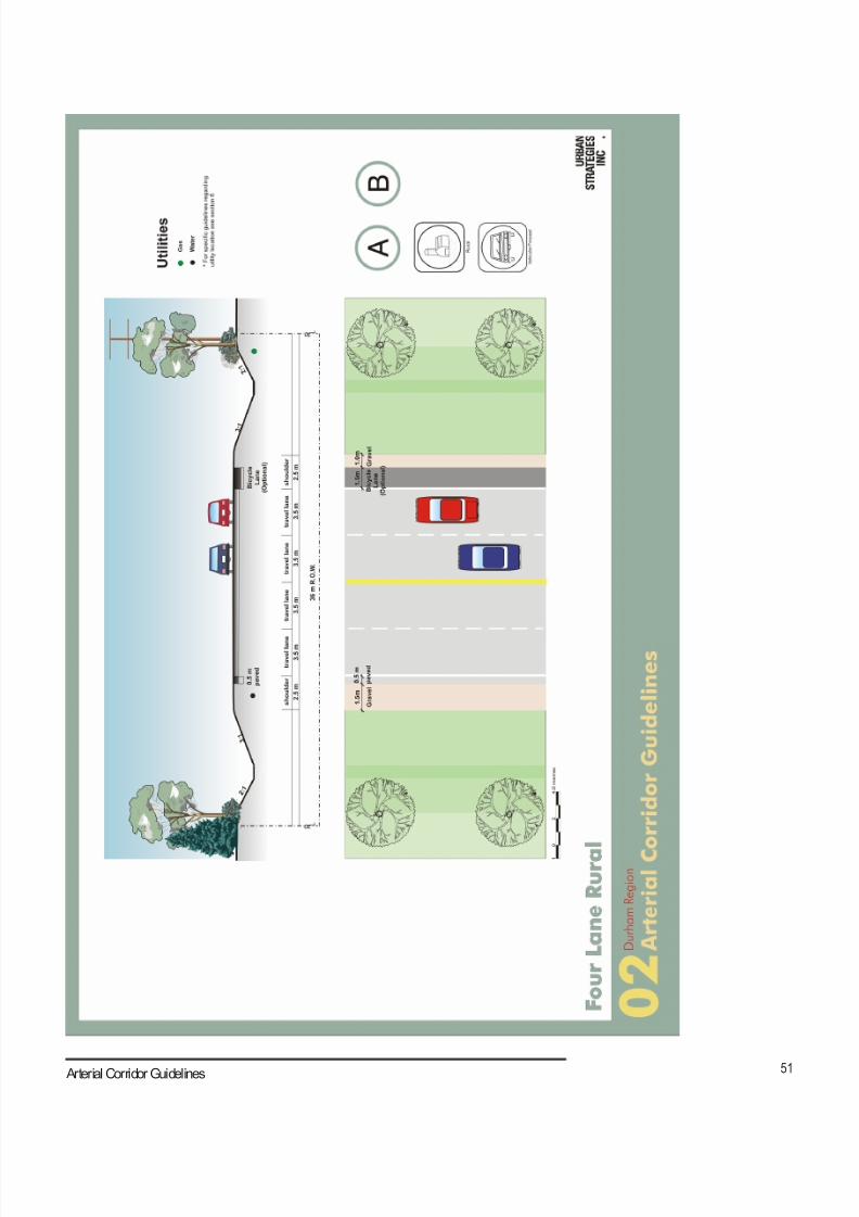
8/21/2019 Durham Region Arterial Corridor Guideline
http://slidepdf.com/reader/full/durham-region-arterial-corridor-guideline 61/119
51 Arterial Corridor Guidelines
8/21/2019 Durham Region Arterial Corridor Guideline
http://slidepdf.com/reader/full/durham-region-arterial-corridor-guideline 62/119
52 Durham Region
9.2 Residential Streets (03, 04, 05)
These arterials are typically lined with low to medium density residential development,
however higher density residential development and a broader mix of uses may exist
on wider roads. Rights-of-way are usually less than 30 m with a 10 to 12 m edge of
road dimension between the street curb and the building face. On-street parking is
typically encouraged as a source of visitor parking. Transit may exist on residential
streets, but travel lane widths and other aspects of the street’s design usually do not
reflect this beyond signage and transit shelters. These streets are often considered
good environments for cyclists, but specific improvements for cyclists are typically
not required, as vehicular traffic is not heavy. The pedestrian environment is often
a priority on these streets and the presence of children, the elderly and handicapped
should be considered. Turning lanes are typically discouraged, but provided where
warranted, particularly if they can be created through such measures as the conversion
of a parking lane into a turning lane. Increased attention to landscaping and lighting
may be considered. However, pedestrian level lighting may be recommended. Travel
speeds should be relatively low and the introduction of driveways is usually easilyaccommodated.
Typical Durham Road Classification – B, C
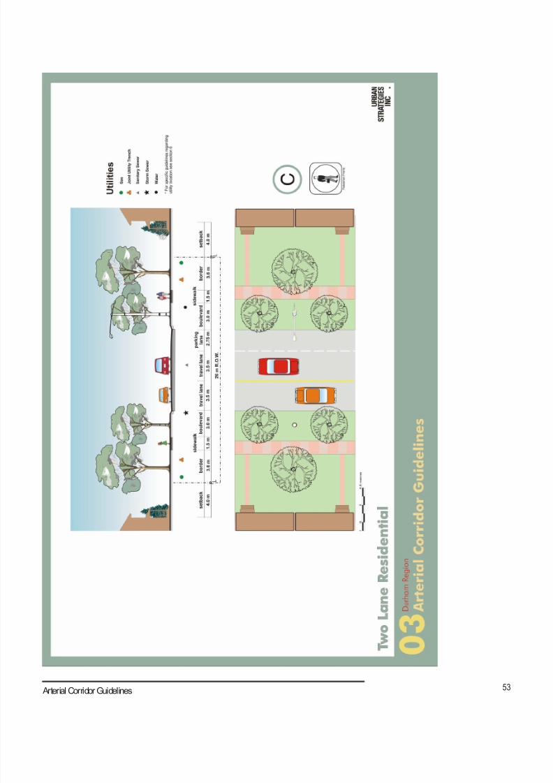
8/21/2019 Durham Region Arterial Corridor Guideline
http://slidepdf.com/reader/full/durham-region-arterial-corridor-guideline 63/119
53 Arterial Corridor Guidelines
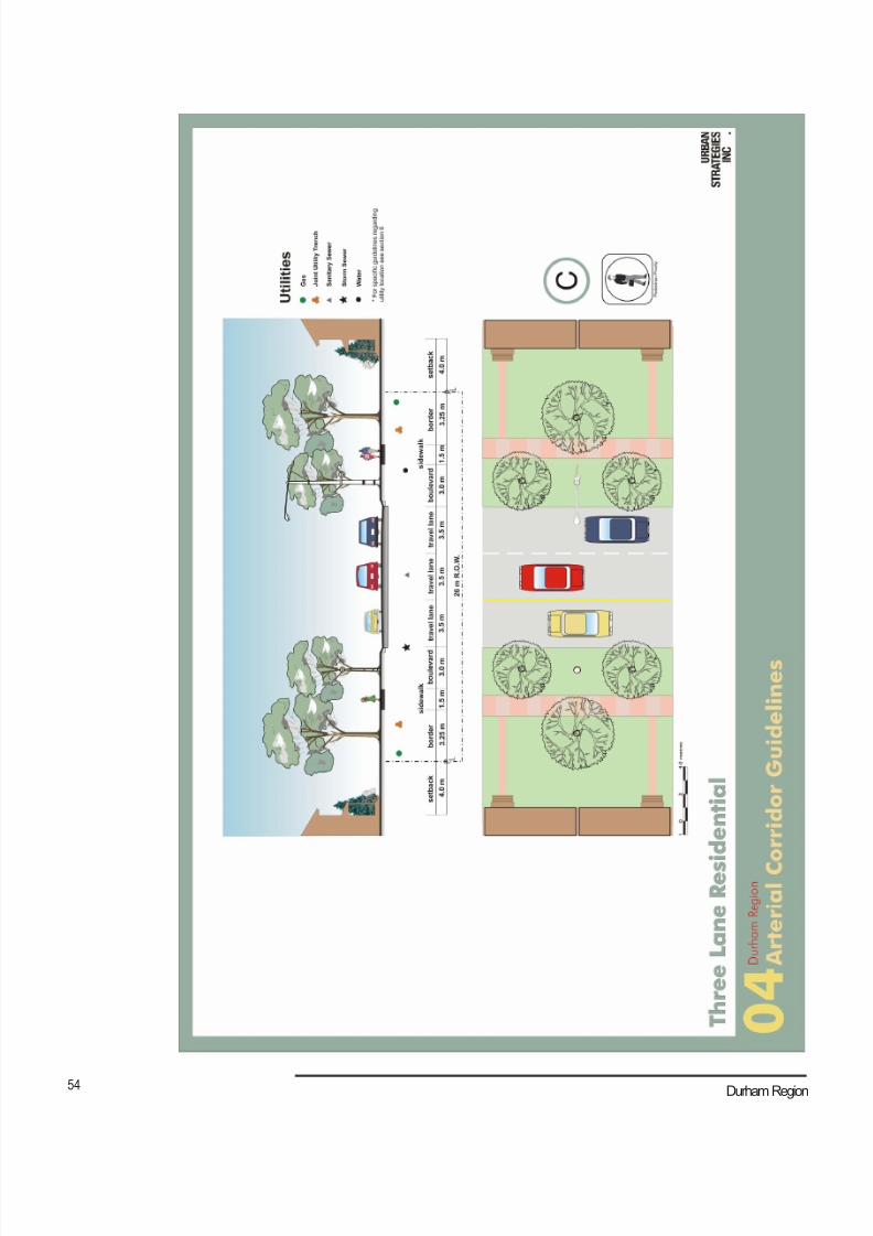
8/21/2019 Durham Region Arterial Corridor Guideline
http://slidepdf.com/reader/full/durham-region-arterial-corridor-guideline 64/119
54 Durham Region
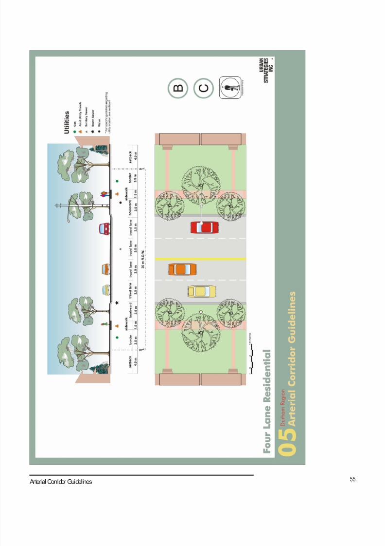
8/21/2019 Durham Region Arterial Corridor Guideline
http://slidepdf.com/reader/full/durham-region-arterial-corridor-guideline 65/119
55 Arterial Corridor Guidelines

8/21/2019 Durham Region Arterial Corridor Guideline
http://slidepdf.com/reader/full/durham-region-arterial-corridor-guideline 66/119
56 Durham Region
9.3 Single-sided Streets (06)
These streets are usually unique and high profile places within a community or
development. The presence of the open space provides a distinctive character and
level of amenity. For these reasons, these streets are often the setting for high-profile
employment or institutional uses, but they may also include residential uses. Given
their higher profile, these streets are often good candidates for special landscaping
and streetscaping, which should be integrated with the design of the adjacent open
spaces.
Typical Durham Road Classification – B, C
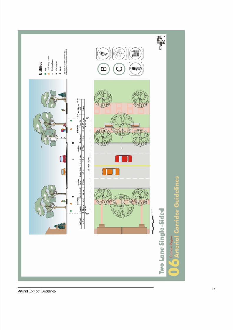
8/21/2019 Durham Region Arterial Corridor Guideline
http://slidepdf.com/reader/full/durham-region-arterial-corridor-guideline 67/119
57 Arterial Corridor Guidelines

8/21/2019 Durham Region Arterial Corridor Guideline
http://slidepdf.com/reader/full/durham-region-arterial-corridor-guideline 68/119
58 Durham Region
9.4 Main Streets (07, 08)
These mixed-use streets are typically found in hamlets and established urban areas,
but they are increasingly emerging in new development as well. Street related retail
is the predominant use, with direct spatial and visual connection to and across the
street. There is also a high degree of integration between modes of travel with anemphasis on a generous pedestrian environment. These are transit supportive streets
with higher density development. On-street parking is often provided with additional
parking located nearby in structures or on surface lots at the rear of buildings. Due to
lower travel speeds and/or the presence of parked cars, dedicated bicycle lanes are
usually not present. Right-turn lanes may be provided where warrented, but pedestrian
safety and the continuity of the public realm are priorities.
There is a great deal of diversity in the character and design of these streets, but
their width is very consistent. These street corridors are usually a minimum width of
23 m, as narrower dimensions cannot accommodate the required volume of vehicles,
pedestrians and transit necessary to support street related retail. Their maximumwidth is typically no more than 33 m, as greater distances between shop fronts are not
conducive to street related retail.
Typical Durham Road Classification – B, C
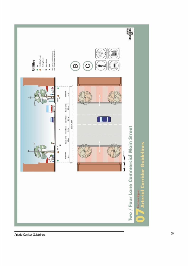
8/21/2019 Durham Region Arterial Corridor Guideline
http://slidepdf.com/reader/full/durham-region-arterial-corridor-guideline 69/119
59 Arterial Corridor Guidelines
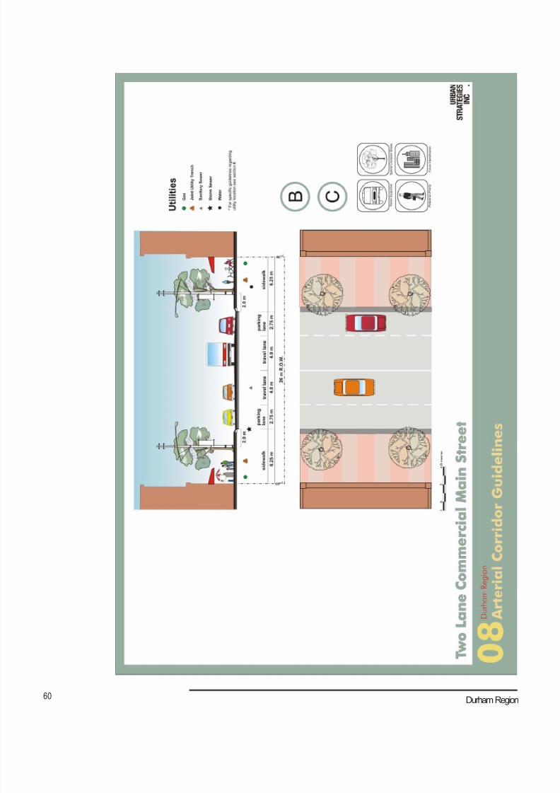
8/21/2019 Durham Region Arterial Corridor Guideline
http://slidepdf.com/reader/full/durham-region-arterial-corridor-guideline 70/119
60 Durham Region
8/21/2019 Durham Region Arterial Corridor Guideline
http://slidepdf.com/reader/full/durham-region-arterial-corridor-guideline 71/119
61 Arterial Corridor Guidelines
9.5 Commercial Streets (09, 10, 11)
These streets have relatively wide Rights-of-way (30 to 36 m) with a mixture of uses
along their length. On-street parking is typically prohibited with surface parking located
adjacent to development. Transit is often present on these streets and there may be
opportunities for the introduction of bicycle lanes. Driveway access should be limitedor restricted and the introduction of medians may be considered where additional
traffic control is desired. Turning lanes are common, and the width of right-of-ways
accommodate the widening of the road platform at intersections.
Typical Durham Road Classification – A, B, C

8/21/2019 Durham Region Arterial Corridor Guideline
http://slidepdf.com/reader/full/durham-region-arterial-corridor-guideline 72/119
62 Durham Region
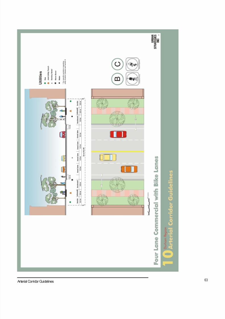
8/21/2019 Durham Region Arterial Corridor Guideline
http://slidepdf.com/reader/full/durham-region-arterial-corridor-guideline 73/119
63 Arterial Corridor Guidelines
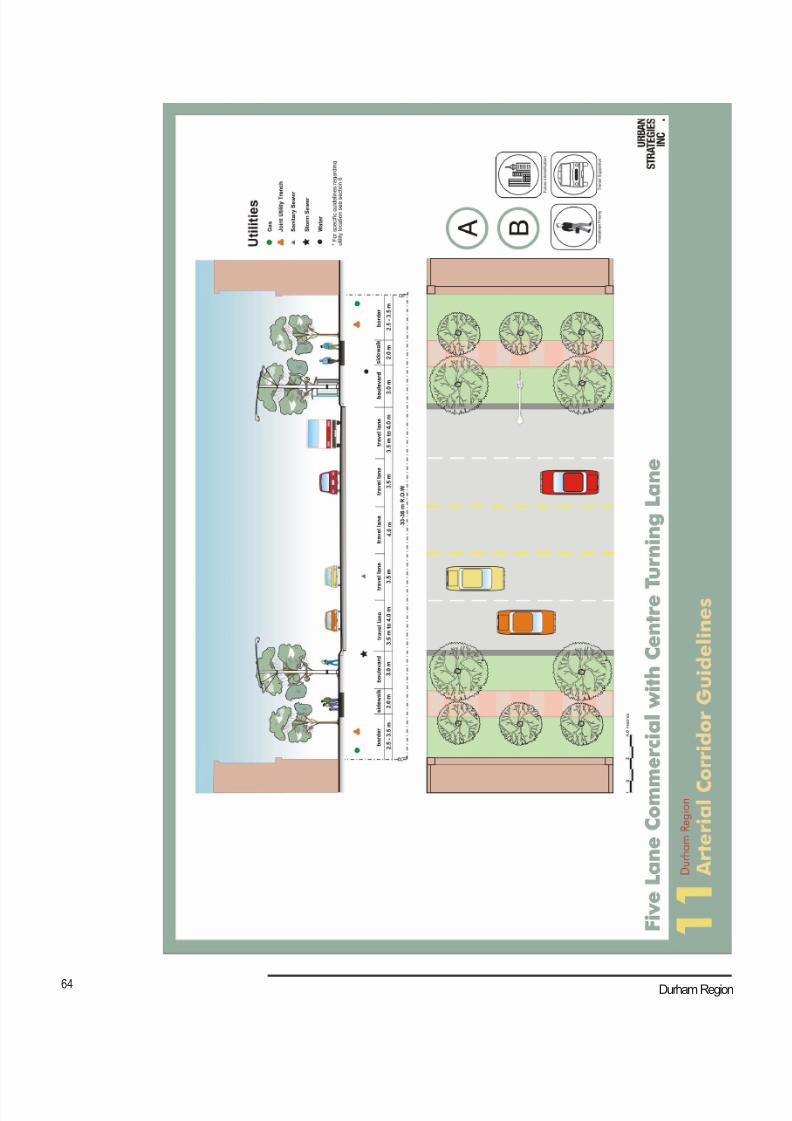
8/21/2019 Durham Region Arterial Corridor Guideline
http://slidepdf.com/reader/full/durham-region-arterial-corridor-guideline 74/119
64 Durham Region
8/21/2019 Durham Region Arterial Corridor Guideline
http://slidepdf.com/reader/full/durham-region-arterial-corridor-guideline 75/119
65 Arterial Corridor Guidelines
9.6 Movement Focused Streets (12, 13, 14)
These streets may also have a significant commercial presence along their length,
but their width usually implies traffic volumes are high and the potential for pedestrianand cycling volumes are low to moderate. Development is typically set further back
from the curb line and wider right-of ways (36 to 50 m) are required to accommodate
turning lanes at intersections. Parking is located adjacent to development. Transit
may be included on these streets, but the width of the street and relatively larger
distances between intersections and connections into surrounding neighbourhoods
makes pedestrian oriented retail difficult to sustain. The provision of turning lanes is
typical and the width of right-of-ways accommodates the widening of the road platform
at intersections.
Typical Durham Road Classification – A, B
8/21/2019 Durham Region Arterial Corridor Guideline
http://slidepdf.com/reader/full/durham-region-arterial-corridor-guideline 76/119
66 Durham Region
8/21/2019 Durham Region Arterial Corridor Guideline
http://slidepdf.com/reader/full/durham-region-arterial-corridor-guideline 77/119
67 Arterial Corridor Guidelines
8/21/2019 Durham Region Arterial Corridor Guideline
http://slidepdf.com/reader/full/durham-region-arterial-corridor-guideline 78/119
68 Durham Region
8/21/2019 Durham Region Arterial Corridor Guideline
http://slidepdf.com/reader/full/durham-region-arterial-corridor-guideline 79/119
69 Arterial Corridor Guidelines
9.7 Transit Corridor (15)
Transit corridors dedicate a portion of the right-of-way for higher order transit use,
which can potentially evolve over time from dedicated bus lanes to light rail. A 45-
metre right-of-way would allow for this evolution, accommodating a six-lane cross-section that includes two dedicated transit lanes and a platform/median. Through an
intersection, this right-of-way width can accommodate turning lanes in the road platform
at major intersections. Although these streets tend to be movement-focused, transit
stop locations and transit-oriented development should be focused at the intersections
with cross-streets.
Typical Durham Road Classification – A
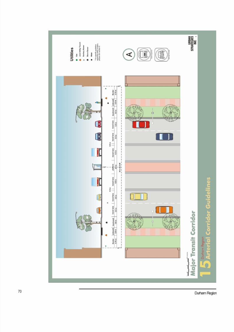
8/21/2019 Durham Region Arterial Corridor Guideline
http://slidepdf.com/reader/full/durham-region-arterial-corridor-guideline 80/119
70 Durham Region
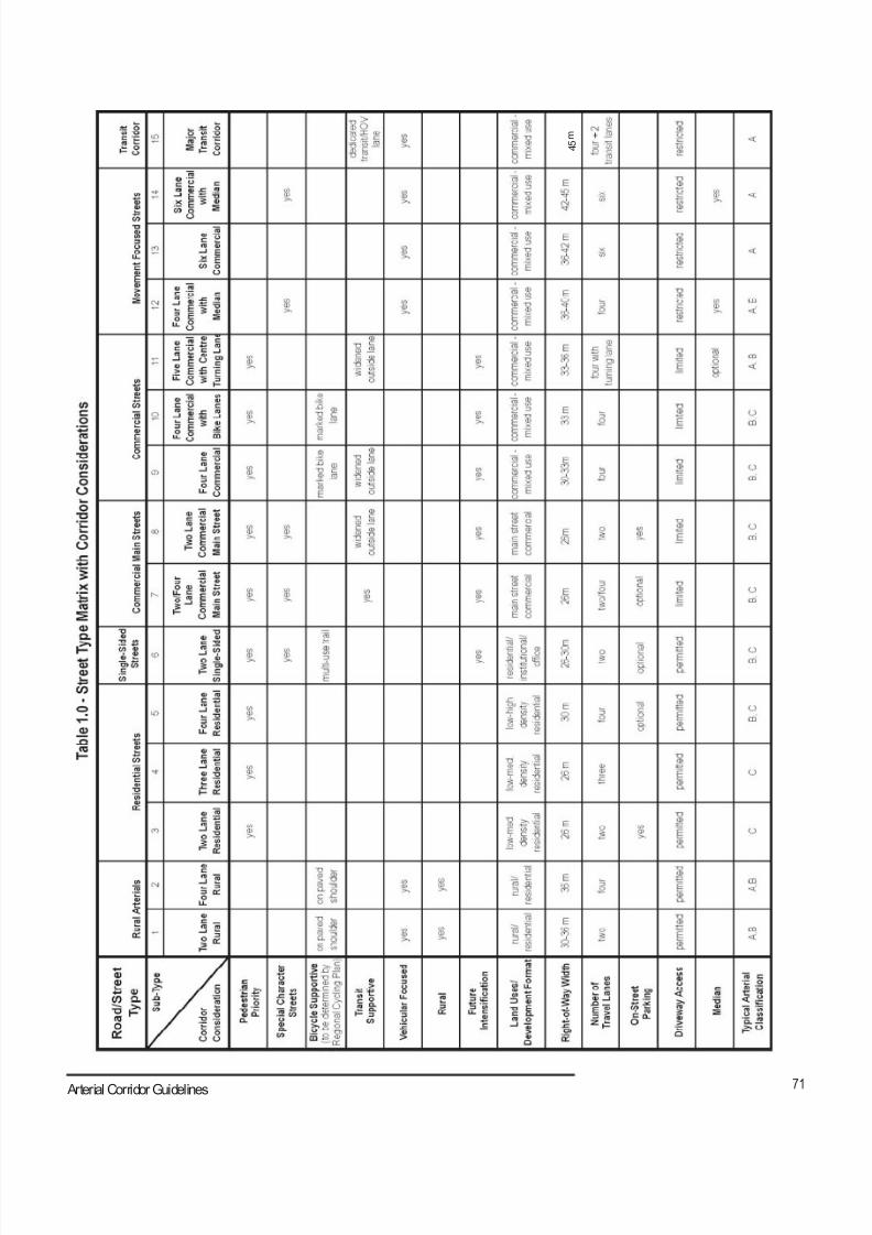
8/21/2019 Durham Region Arterial Corridor Guideline
http://slidepdf.com/reader/full/durham-region-arterial-corridor-guideline 81/119
71 Arterial Corridor Guidelines
4 5
m

8/21/2019 Durham Region Arterial Corridor Guideline
http://slidepdf.com/reader/full/durham-region-arterial-corridor-guideline 82/119
72 Durham Region
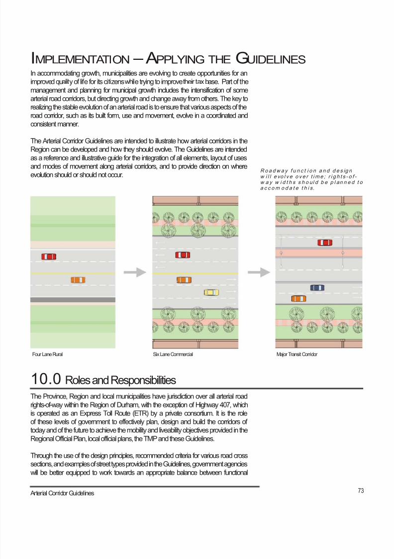
8/21/2019 Durham Region Arterial Corridor Guideline
http://slidepdf.com/reader/full/durham-region-arterial-corridor-guideline 83/119
73 Arterial Corridor Guidelines
IMPLEMENTATION – APPLYING THE GUIDELINESIn accommodating growth, municipalities are evolving to create opportunities for an
improved quality of life for its citizens while trying to improve their tax base. Part of the
management and planning for municipal growth includes the intensification of some
arterial road corridors, but directing growth and change away from others. The key torealizing the stable evolution of an arterial road is to ensure that various aspects of the
road corridor, such as its built form, use and movement, evolve in a coordinated and
consistent manner.
The Arterial Corridor Guidelines are intended to illustrate how arterial corridors in the
Region can be developed and how they should evolve. The Guidelines are intended
as a reference and illustrative guide for the integration of all elements, layout of uses
and modes of movement along arterial corridors, and to provide direction on where
evolution should or should not occur.
The Province, Region and local municipalities have jurisdiction over all arterial road
rights-of-way within the Region of Durham, with the exception of Highway 407, which
is operated as an Express Toll Route (ETR) by a private consortium. It is the role
of these levels of government to effectively plan, design and build the corridors of
today and of the future to achieve the mobility and liveability objectives provided in the
Regional Official Plan, local official plans, the TMP and these Guidelines.
Through the use of the design principles, recommended criteria for various road cross
sections, and examples of street types provided in the Guidelines, government agencies
will be better equipped to work towards an appropriate balance between functional
10.0 Roles and Responsibilities
Ro a dw a y f u n c t i o n a n d d e s ig nw i l l e vo l v e o v e r t im e ; r i g h t s - o f - w a y w i d t h s s h o ul d b e p l an n e d t oa c c om o d a t e t h i s.
Four Lane Rural Six Lane Commercial Major Transit Corridor
8/21/2019 Durham Region Arterial Corridor Guideline
http://slidepdf.com/reader/full/durham-region-arterial-corridor-guideline 84/119
74 Durham Region
and aesthetic requirements of the various street types. This sense of balance is an
important consideration in the Regional policy framework, including the Community
Strategic Plan (CSP). As an “umbrella” document that establishes the framework for
other Regional strategies, one of the six objectives in the CSP is to strengthen and
integrate the transportation system. In this context, the role of the Region and area
municipalities is to ensure that new policies and regulations are established in a manner
consistent with the Guidelines. This undertaking would better guide development of
adjacent lands in support of the types of corridor development envisioned in these
Guidelines for a more balanced transportation system.
It is intended that the private sector will apply these Guidelines in the development
application process, which essentially determines the built form, infrastructure and
associated amenities provided adjacent to the right-of-way. Development applications
for new and redevelopment of an arterial road corridor must be consistent with theprinciples set out in these Guidelines, and vision for the corridor developed through
the public consultation process under various planning studies. The full extent of the
corridor vision will take place incrementally, and may take a long time (i.e., 20 to 30
years) to complete.
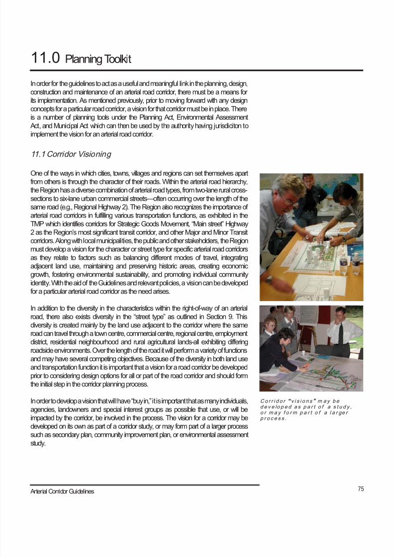
8/21/2019 Durham Region Arterial Corridor Guideline
http://slidepdf.com/reader/full/durham-region-arterial-corridor-guideline 85/119
75 Arterial Corridor Guidelines
11.0 Planning Toolkit
Co r r i d o r “ v i s i o n s ” m ay b ed e v e lo p e d a s p a r t o f a s t u d y ,o r m a y f o r m p a r t o f a l a r ge rp r o c e s s .
In order for the guidelines to act as a useful and meaningful link in the planning, design,
construction and maintenance of an arterial road corridor, there must be a means for
its implementation. As mentioned previously, prior to moving forward with any design
concepts for a particular road corridor, a vision for that corridor must be in place. There
is a number of planning tools under the Planning Act, Environmental Assessment
Act, and Municipal Act which can then be used by the authority having jurisdiciton to
implement the vision for an arterial road corridor.
11.1 Corridor Visioning
One of the ways in which cities, towns, villages and regions can set themselves apart
from others is through the character of their roads. Within the arterial road hierarchy,
the Region has a diverse combination of arterial road types, from two-lane rural cross-
sections to six-lane urban commercial streets—often occurring over the length of the
same road (e.g., Regional Highway 2). The Region also recognizes the importance of
arterial road corridors in fulfilling various transportation functions, as exhibited in the
TMP which identifies corridors for Strategic Goods Movement, “Main street” Highway
2 as the Region’s most significant transit corridor, and other Major and Minor Transit
corridors. Along with local municipalities, the public and other stakeholders, the Region
must develop a vision for the character or street type for specific arterial road corridors
as they relate to factors such as balancing different modes of travel, integrating
adjacent land use, maintaining and preserving historic areas, creating economic
growth, fostering environmental sustainability, and promoting individual community
identity. With the aid of the Guidelines and relevant policies, a vision can be developed
for a particular arterial road corridor as the need arises.
In addition to the diversity in the characteristics within the right-of-way of an arterial
road, there also exists diversity in the “street type” as outlined in Section 9. This
diversity is created mainly by the land use adjacent to the corridor where the same
road can travel through a town centre, commercial centre, regional centre, employment
district, residential neighbourhood and rural agricultural lands-all exhibiting differing
roadside environments. Over the length of the road it will perform a variety of functions
and may have several competing objectives. Because of the diversity in both land use
and transportation function it is important that a vision for a road corridor be developed
prior to considering design options for all or part of the road corridor and should form
the initial step in the corridor planning process.
In order to develop a vision that will have “buy in,” it is important that as many individuals,
agencies, landowners and special interest groups as possible that use, or will be
impacted by the corridor, be involved in the process. The vision for a corridor may be
developed on its own as part of a corridor study, or may form part of a larger process
such as secondary plan, community improvement plan, or environmental assessment
study.
8/21/2019 Durham Region Arterial Corridor Guideline
http://slidepdf.com/reader/full/durham-region-arterial-corridor-guideline 86/119
76 Durham Region
The development of the vision for a corridor should typically include the following
steps:
● Identification of the corridor;
● Identify stakeholders;
● Form a steering committee;
● Review existing and planned conditions;● In consultation with stakeholders and steering committee, determine the
strengths, weaknesses, opportunities and challenges for the corridor;
● Prepare and evaluate various design concepts for the corridor;
● Solicit input through charettes, workshops, seminars, meetings, surveys,
etc.;
● Develop vision based on input and solicit comment from all parties associated
with the corridor; and
● Review, finalize and gain endorsement of the vision.
Upon completion of a successful visioning process, “buy-in” from those parties impacted
by the evolution of the corridor will be achieved towards establishing a clear vision for
the corridor. Future detailed design and construction will become much easier as moststakeholders will have a firm grasp on the goals of the project. In addition, by having a
vision in place for an arterial road corridor, it allows for smaller sections or components
of the corridor, such as sidewalks or intersections, to be improved independently
while maintaining a consistent vision of the corridor. By gaining endorsement of the
corridor vision by the various levels of government, public, associated stakeholders
and approval agencies, it provides a clear guide for the future evolution of the corridor
regardless of future changes in councils and/or staff. Should it be decided that the
vision be changed due to unforeseen circumstances, then the entire vision process
should be revisited again prior to proceeding with the design or corridor modifications.
11.2 Regional Official Plan
The Regional Official Plan (ROP) defines the intent of Regional Council for the guidance
of growth and development in Durham. The goals of the ROP include developing an
integrated, safe and efficient transportation system, and achieving a balance between
the provision of an accessible transportation system, comprised of an integrated public
transit and road network, and the development of the Region. In building upon the
ROP, the Guidelines articulate the broader goals and policies contained in the ROP
for future planning of the transportation system and design considerations for adjacent
land uses. The ROP also sets the functional classifications and general criteria
designated for arterial roads and other facilities in the transportation network. Policydirections identified in the ongoing Regional Official Plan Review are consistent with,
and supportive of the Guidelines.
8/21/2019 Durham Region Arterial Corridor Guideline
http://slidepdf.com/reader/full/durham-region-arterial-corridor-guideline 87/119
77 Arterial Corridor Guidelines
11.3 Transportation Master Plan
The Regional Transportation Master Plan (TMP) is a strategic planning document
designed to identify and address Durham’s transportation needs to the year 2021 and
beyond. The TMP proposed directions to refine ROP policies, with some of those
directions related to the re-designation of several arterial road sections, a strategic
goods movement and transit priority network, and the further development of centres
and corridors. Other elements of the TMP, however, are independent of the ROP
and its review; these elements include Regional road improvements, the establishment
of a Transportation Demand Management program, and the development of a safety
management strategy.
The Guidelines help to further detail the recommended directions for elements included
in the TMP, in support of providing a greater balance in mobility between different
modes of transportation.
11.4 Local Official Plans
In conformity with the ROP, local official plans provide further detail in designating
land uses and the structure of the transportation system in planning for future growth
and development. With respect to the transportation system, the local official plans
not only reflect the Regional arterial road network, but also provide policies and
designations for roads of local significance. With respect to land use, local official plans
can designate sub-area plans such as special study areas, secondary plans, and/or
community improvement areas, which provides much greater detail on the types of
new or redevelopment adjacent to arterial road corridors. The local official plans, and
process involved in the amendment of the plans, provide an important implementationframework for applying the Guidelines.
Amendments to a local official plan, which can include the development of the above
sub-area plans, are important tools for implementation of the Guidelines. This
is particularly true for development applications of a minor nature. For the Lake
Ontario shoreline municipalities, the Region is the approval authority for “major” local
official plan amendments, but the area municipalities are the approval authority for
“minor” amendments. For Brock, Scugog, and Uxbridge, the Region is the approval
authority for all local official plan amendments. Since many incremental decisions on
development are made at a local municipal level, application of the guidelines in the
overall development application process is essential in meeting both area municipal
and Regional visions for specific arterial road corridors.
11.5 Secondary Plans
While more specific than the ROP or a local official plan, secondary plan policies
are intended to provide guidance on the preparation of more detailed regulations for
reviewing development applications such as draft plans of subdivision, zoning by-laws,
and site plan control in a particular area of a municipality. As an integral component
of the corridor visioning process, secondary plans are an important implementation

8/21/2019 Durham Region Arterial Corridor Guideline
http://slidepdf.com/reader/full/durham-region-arterial-corridor-guideline 88/119
78 Durham Region
tool, and provide the framework for the design of specific arterial road corridors within
a planning area. The design of communities and neighbourhoods at the secondary
plan level is at a level of detail in which the Guidelines can have a significant degree
of influence. A vision for arterial road corridors at the secondary plan level provides
an opportunity for the comprehensive implementation of the Guidelines for a particular
corridor, as opposed to a “piecemeal” basis at the development application stage (e.g.,draft plans of subdivision or zoning by-laws).
11.6 Environmental Assessment (EA) Process
Road expansion projects, such as widening or extending an arterial road, are subject
to the Municipal Class EA process. Phases 1, 2 and 3 of the 5-phase Municipal
Class EA process provide an opportunity for establishing a community vision for an
arterial road corridor, which include public consultation. As these three phases require
an examination of the need and justification for the project, and an examination of
alternatives and assessment of potential environmental effects, a vision for a roadexpansion or extension can be determined for a corridor area with public buy-in to
the process. Once a vision is established, the detailed design and construction of the
arterial road can be implemented in a holistic manner, and compatibility of that road
with existing or future land uses can be better achieved.
Where possible, the EA process for road expansion projects should occur in tandem
with the development of secondary plans, subdivision approvals, and other relevant
development applications. This will help to ensure consistency in applying the
Guidelines towards a vision for the corridor.
11.7 Draft Plans of Subdivision
The creation and review of draft plans of subdivision needs to incorporate the vision
and directions set out in the Guidelines. Not only are lands adjacent to arterial road
corridors and local streets included in draft plans of subdivision, but sections of arterial
roads can also be implemented through the subdivision approval process. In the
context of Durham, the authority for subdivision approval has been delegated to the
Lake Ontario shoreline municipalities, while the Region is the approval authority for
Brock, Scugog, and Uxbridge. For the delegated municipalities, the Region provides
comments to the area municipality at various stages of approval to ensure that the
subdivisions are being implemented in a manner consistent with Regional goals and
policies.
The orientation of lots and local streets adjacent to arterial roads, and the frequency of
intersections of local streets or collector roads to arterial roads, is largely determined in
developing areas through the subdivision approval process. The Guidelines can further
refine policies contained in the Regional and local official plans by providing criteria for
achieving street front oriented development, such as window streets (avoiding reverse
lot frontage), frequency of intersections, and pedestrian access from subdivisions to
adjacent arterial roads.
8/21/2019 Durham Region Arterial Corridor Guideline
http://slidepdf.com/reader/full/durham-region-arterial-corridor-guideline 89/119
79 Arterial Corridor Guidelines
11.8 Zoning By-laws
A zoning by-law controls land use within an area municipality by articulating how land
and buildings may be used, where buildings and other structures can be located, and
regulating lot sizes/dimensions, parking requirements, and building heights. While a
local official plan (which may contain a secondary plan, community improvement, or
special study area) sets out a municipality’s general policies for future land use, the
zoning by-law implements the local official plan by providing specific regulations for
addressing new uses, or changes in existing uses, on developable lands.
Area municipal zoning by-laws are important as an implementation tool for the Guidelines
with respect to the design and format of adjacent land uses. Recommendations made
in the Guidelines (i.e., Section 5) can be incorporated in specific zones by amendment
to the zoning by-law, allowing the corridor vision to be reflected in the zoning regulations
in advance of the built form developing, or redeveloping.
11.9 Site Plan Control
Many types of new development are subject to site plan control, which further
implements the zoning by-law and draft plan of subdivision (if applicable) by providing
detailed designs and specifications for new construction or redevelopment. Site plan
control is particularly relevant for commercial and mixed-use areas, which is important
in consideration of the Guidelines as these areas generally front arterial roads. The
design of sites have a significant impact on the character of an arterial road corridor;
elements subject to site plan control can include the arrangement and design of parking
lots, access driveways, orientation of buildings, walkways, landscaping and so forth.
For development applications such as plans of subdivision/condominium, zoning by-
laws, and site plan control, a development application checklist for the Region and area
municipalities would assist the implementation of the Guidelines by:
● Maintaining consistency in the approach of interpreting and implementing the
Guidelines for different development applications in achieving a particular vision
for an arterial road corridor; and
● Allowing for a standard set of elements to be included in site plan applications
to better enable a comprehensive review of the development (e.g., the roadway
centreline, right-of-way, building setbacks, sign details, landscape plans,utility
placement, etc.).

8/21/2019 Durham Region Arterial Corridor Guideline
http://slidepdf.com/reader/full/durham-region-arterial-corridor-guideline 90/119
80 Durham Region
8/21/2019 Durham Region Arterial Corridor Guideline
http://slidepdf.com/reader/full/durham-region-arterial-corridor-guideline 91/119
81 Arterial Corridor Guidelines
12.0 Financial Considerations
The implementation of the Guidelines has implications on the costs for the construction,
rehabilitation and maintenance of arterial roads. While certain sections of arterial
roads will require upgrading to be consistent with a vision for that section over time, the
Guidelines will also prevent “over-building” of infrastructure that may not necessarily
be required for a section or type of arterial road. Through establishing a vision for
sections or arterial road corridors, costs for road expansion or rehabilitation can be
better anticipated as specific work projects are scheduled in Annual Servicing and
Financing Studies containing the five-year capital works program. Text and a graphic
representation will be added to explain how arterial corridors can evolve from existing
sections - e.g. 2 Lane Rural evolution to 4 Lane Commercial with Median.
A vision for an arterial road corridor allows conditions to be set for adjacent new
development, which can offset the costs of constructing new sidewalks, road widening,
boulevards, and so forth. By anticipating costs for upgrading arterial roads and sharingthose costs with the private sector, conditions for development approval can be better
set “up front” rather than incrementally. Savings can also be potentially achieved in that
more construction work is known ahead of time, and can be undertaken at the same
time (helping to achieve “economies of scale”) rather than over a period of several
years.

8/21/2019 Durham Region Arterial Corridor Guideline
http://slidepdf.com/reader/full/durham-region-arterial-corridor-guideline 92/119
82 Durham Region
8/21/2019 Durham Region Arterial Corridor Guideline
http://slidepdf.com/reader/full/durham-region-arterial-corridor-guideline 93/119
83 Arterial Corridor Guidelines
GLOSSARY
Access management : the management of the location and basic dimensions ofaccess to property, from a roadway.
Arter ial road: a main road with relatively continuous routes that primarily serve through
traffic, high traffic volumes and long average trip lengths.
Attenuat ion (no ise/sound attenuation walls): structures such as walls or berms
beside roads or railway lines, which serve to reduce noise.
Berm: A mound or small hill of earth constructed alongside roads or railway lines to
reduce noise and/or hide the road from view.
Bike lane: a lane intended for the exclusive use of bicycles, within a roadway used by
motorized vehicles.
Bike path: a bicycle facility, physically separated from roadways, where motor vehicle
traffic, except maintenance vehicles, is excluded.
Bikeway: a roadway, or part of a roadway, intended for the use of bicycles, either
exclusively or shared with other vehicular traffic or pedestrians.
Border: in the edge of road, the space between the sidewalk and the property line.
Boulevard: in the edge of road, the space between the travel lane and the sidewalk.
Boulevards are usually planted with grass or trees.
Buffer: see Landscape Buffer.
Capacity (of roads): the maximum number of cars that a road can carry without
becoming congested.
Centres (Regional Centres) and Corridors: corresponding to Central Areas and
some arterial corridors where an appropriate mix of various land uses exists
(or is planned to exist) without a single dominant land use or form, and contain
development densities and patterns that support high levels of pedestrian activity
and public transit service.
Central Area: as defined in policy 9.2.2 of the Regional Official Plan as areas where
the main concentration of activities at the highest densities within urban areas
are to be developed, providing a fully integrated mix of community, service, retail,
recreational and residential uses. Central areas contain development patterns
supporting direct pedestrian access to buildings and high levels of public transitservice and pedestrian activity. Central areas are also focal points for art, culture,
entertainment and assembly, containing public spaces and parks.
Collector roads: a type of road that funnels traffic from residential or rural areas to
arterial roads.
Controlled access: the condition where the opportunity for access to a roadway is
controlled by public authority.
Commuter cyclist: who is cycling between destinations as an alternative to driving or
taking transit
8/21/2019 Durham Region Arterial Corridor Guideline
http://slidepdf.com/reader/full/durham-region-arterial-corridor-guideline 94/119
84 Durham Region
Corridor (street corridor/road corridor): the space between buildings on opposite
sides of a street. Includes the road platform and the edge of road.
Cross-section (or section): A diagram or drawing that shows features transected by
a given plane. The transverse profile of a road showing horizontal and vertical
dimensions.
Crosswalk: any part of a roadway specifically intended for pedestrian crossing, which
may be so indicated by signs, lines, markings or other devices.
Curb: a structure with a vertical or sloping face along the edge of a lane or shoulder
strengthening or protecting the edge of clearly defining the edge.
Curb cut: a ramp leading smoothly down from a sidewalk to an intersecting street or
driveway.
Curb drop: the transition length required to decrease the curb height to accommodate
a driveway or sidewalk ramp.
Curb return: the curved section of curb used at intersections or driveways in joining
straight sections of curb.
Edge of road/street: the space between the curb and the property line.
Design speed: a speed selected for purposes of design and correlation of the geometric
features of a road.
Façade: The face of the building, in particular the principal face of the building.
Frontage: The full length of a plot of land or a building measured alongside the road
on to which the plot or building fronts. Lots with reverse frontage are situated with
the road running along the back of the property.
Gateway: an area of special identity that serves as an entrance point to a definable
part of a town or city such as central area or a unique historical area.
Geometric design: the selection of the visible dimensions of the elements of a
roadway.
Grade: the height of the ground, expressed as a measurement above sea level. Grade
is also used to describe the slope of a road. “At grade” means ground level.
Gutter: a paved shallow waterway provided for carrying surface drainage.
High-occupancy-vehicle (HOV) lane: a lane designated for the exclusive use of high-
occupancy vehicles.
Infill: development on empty lots of land within an urban area (rather than on new
undeveloped land outside the city or town).Infiltration (traffic infiltration): the appearance of increased traffic on local roads
resulting from congestion on arterial roads
Intersection: the general area where two or more roads join or cross, within which are
included the roadway and roadside facilities for traffic movements.
Island: a defined area between traffic lanes for control of vehicle movements or for
pedestrian refuge.
8/21/2019 Durham Region Arterial Corridor Guideline
http://slidepdf.com/reader/full/durham-region-arterial-corridor-guideline 95/119
85 Arterial Corridor Guidelines
Landscape Buffer: a landform comprised of earth and / or vegetation that separates
potentially antagonistic elements, as an area between two riviling zones that
serves to lessen the danger of conflict.
Lane: a part of the travelled way intended for the movement of a single file of
vehicles.
Local roadway: a roadway with the primary function of providing land access.
LRT: light rail transit.
Median: in the street platform, a planted or paved space between travel lanes. Medians
usually separate travel lanes going in opposite directions. Not for vehicular use.
Mode: the manner of travel.
Network (road network, street network): a system of interconnecting roads.
Node: a connecting point in a network. In a street network, nodes are intersections or
places that have special prominence or significance.
Parking lane: a supplementary lane intended for parking.
Platform (road platform/street platform): the surface on which vehicles travel.
Platform intersection: an intersection in which the area common to the two roadways
is at the same elevation as the top of curb or sidewalk.
Property line: the legal boundary between different properties or between a property
and the public realm.
Public lane: a narrow minor street, usually without sidewalks, located at the rear of
lots for vehicle access to garages or other parking spaces and which also serves
as a utility right of way.
Raised crosswalk: a crosswalk on a curbed street whose elevation is the same as thetop of curb or sidewalk.
Recreational cyclist: often children or others who are cycling primarily for the
experience of cycling in and of itself. It is a leisure activity.
Regional Centres: see Centres and Corridors
Retrofit: the reconstruction of an existing roadway with geometric improvements.
Reverse Lot Fron tage: see Frontage
Right-of-way: the areas of land acquired for or devoted to the provision of a road
which includes all travel lanes, sidewalks, boulevards and borders.
Roadside: the area adjoining the outer edge of the travelled way.
Roadway: that portion of a street or highway which is improved, designed or ordinarily
used for vehicular travel, inclusive of the shoulder.
Salt Strip: a paved surface within the boulevard of a street or on a median, along
the edge of the curb, opposite the travel lane. It is often difficult to sustain plant
and grass life in these locations and the paved surface provides a durable and
attractive alternative to bare soil.
8/21/2019 Durham Region Arterial Corridor Guideline
http://slidepdf.com/reader/full/durham-region-arterial-corridor-guideline 96/119
86 Durham Region
Section (or cross-section): A diagram or drawing that shows features transected by
a given plane. It identifies the transverse profile of a road showing horizontal and
vertical dimensions.
Sapling: a young tree that has been recently planted.
Setback: the space between the property line and the building face.
Shoulder: that part of a roadway contiguous with the travelled way intended for
emergency stopping, and/or lateral support of the roadway structure.
Sidewalk: a travelled way intended for pedestrian use, following an alignment generally
parallel to that of the adjacent roadway.
Sight triangle: the triangle formed by the line of sight and the two sight distances of
drivers, cyclists or pedestrians approaching an intersection on two intersecting
streets.
Signalization: the use of traffic lights at an intersection to control the flow of vehicular,
bicycle and pedestrian traffic.
Standard: a value for a specific design feature, which practice or theory has shown to
be appropriate for a specific set of circumstances, where no unusual constraints
influence the design.
Street furniture: equipment such as lights, planting boxes or furniture, such as
benches, which are placed off the street to improve or enhance the comfort,
convenience and aesthetic quality of the roadway environment. Street furniture
can include bicycle racks, newspaper boxes, garbage and recycling containers.
Streetscape: the overall character, design quality, and particular physical elements
of a street. Streetscape elements may include the paving materials, curbs,
landscaping, lighting, and street furniture such as benches, water fountains, or
bicycle racks.
Streetscaping: the practice of applying aesthetic treatments to the street and its
facilities intended to enhance the quality of the roadway environment.
Subdivision: A housing development that is created by dividing a large parcel of land
into many individual lots for sale.
Through lane: a lane intended for through traffic movement.
Transit lane: a lane intended primarily for public transit vehicles.
8/21/2019 Durham Region Arterial Corridor Guideline
http://slidepdf.com/reader/full/durham-region-arterial-corridor-guideline 97/119
87 Arterial Corridor Guidelines
Travel lane: the part of the road on which vehicles travel. Arterial roads usually have
one to three travel lanes in each direction.

8/21/2019 Durham Region Arterial Corridor Guideline
http://slidepdf.com/reader/full/durham-region-arterial-corridor-guideline 98/119
88 Durham Region

8/21/2019 Durham Region Arterial Corridor Guideline
http://slidepdf.com/reader/full/durham-region-arterial-corridor-guideline 99/119
89 Arterial Corridor Guidelines
Appendix A:
Ar ter ial Road Classi fi cat ion Review
Arterial Road Classification System Review

8/21/2019 Durham Region Arterial Corridor Guideline
http://slidepdf.com/reader/full/durham-region-arterial-corridor-guideline 100/119
90 Durham Region
8/21/2019 Durham Region Arterial Corridor Guideline
http://slidepdf.com/reader/full/durham-region-arterial-corridor-guideline 101/119
91 Arterial Corridor Guidelines
February 2007
Arterial Road
Classifcation Review
Arterial Road Classification Review

8/21/2019 Durham Region Arterial Corridor Guideline
http://slidepdf.com/reader/full/durham-region-arterial-corridor-guideline 102/119
92 Durham Region
8/21/2019 Durham Region Arterial Corridor Guideline
http://slidepdf.com/reader/full/durham-region-arterial-corridor-guideline 103/119
93 Arterial Corridor Guidelines
Table of Contents
1. Introduction .......................................................................................................................................................1
2. Need for a Functional Road Classification System ..........................................................................2
3. ITE Road Classif ication System................................................................................................................3
4. TAC Road Classification System ..............................................................................................................6
5. Agency Practices ............................................................................................................................................7
6. Review of the Regional Road Classif ication System .......................................................................8
7. Recommended Classification System and Criteria ........................................................................11
8. Implications fo r the Regional Arterial Road Network ....................................................................13
9. Conclusions and Recommendations ...................................................................................................14
Arterial Road Classification Review

8/21/2019 Durham Region Arterial Corridor Guideline
http://slidepdf.com/reader/full/durham-region-arterial-corridor-guideline 104/119
8/21/2019 Durham Region Arterial Corridor Guideline
http://slidepdf.com/reader/full/durham-region-arterial-corridor-guideline 105/119
1 Arterial Corridor Guidelines
1. Introduction
A goal of the Durham Regional Official Plan (ROP) is to develop an integrated, safe and efficient transportation
system facilitating the movement of people and goods within the Region, and between the Region and other areas.
The road network is a key element of this system, accommodating vehicular travel between points of trip origin anddestination and providing direct access to abutting property.
A road network generally consists of a hierarchy of roads that provides for a gradation in function from access to
movement. For example, the primary function of a freeway is movement, whereas at the other extreme it is the
primary function of a local road to provide access. The network operates most efficiently if each class of road in the
hierarchy is designed to serve its intended function and purpose (e.g. goods movement). Most roads are designed
to serve multiple functions and purposes. However, mixing incompatible functions and purposes can impact
mobility and liveability within a community. For this reason, roads are classified and designed based on their
function and purpose, so that suitable design and operating criteria can be established to minimize, if not alleviate,
conflicts between competing objectives.
The purpose of this report is to review and confirm the road classification system and criteria in the ROP, primarily
as it relates to arterial roads. Specifically, the document:
• Describes the need for a road classification system;
• Reviews the current arterial road classification system and criteria in the ROP; and
• Provides direction for their refinement.
The results derived through this assessment will be used to update the transportation policies and schedules of
the ROP through the ongoing Official Plan Review. The document will also serve as the basis for the development
of detailed Ar terial Corridor Guidelines for Durham. It is intended that the Region and area municipalities use
the Guidelines as a reference in the preparation of corridor studies, land use plans, road improvement projectsand Class Environmental Assessment studies, and in the review of development applications. The Guidelines
recommend best practices and provide a matrix of road design strategies that are adaptable over time in both the
urban and rural contexts.
It is expected that the application of the Arterial Corridor Guidelines will result in arterial roads that:
• Accommodate a wide range of transportation options;
• Support and are compatible with abutting land uses; and
• Create an inter- and intra-regional network that serves the diverse economic, social and environmental
needs of the Region.
Preparation of this report relied largely upon literature from the Institute of Transportation Engineers (ITE) and
the Transportation Association of Canada (TAC), supplemented with a research of current practices in other GTA
municipalities.
Arterial Road Classification Review
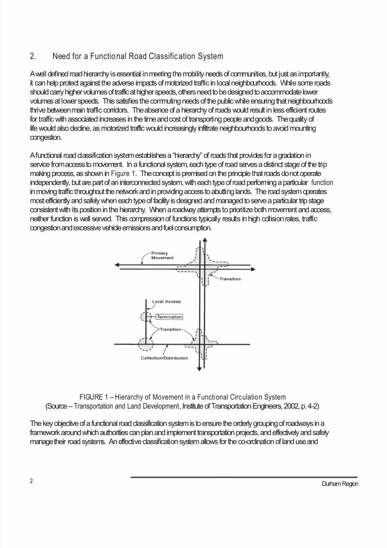
8/21/2019 Durham Region Arterial Corridor Guideline
http://slidepdf.com/reader/full/durham-region-arterial-corridor-guideline 106/119
2 Durham Region
2. Need for a Functional Road Classification System
A well defined road hierarchy is essential in meeting the mobility needs of communities, but just as importantly,
it can help protect against the adverse impacts of motorized traffic in local neighbourhoods. While some roads
should carry higher volumes of traffic at higher speeds, others need to be designed to accommodate lowervolumes at lower speeds. This satisfies the commuting needs of the public while ensuring that neighbourhoods
thrive between main traffic corridors. The absence of a hierarchy of roads would result in less efficient routes
for traffic with associated increases in the time and cost of transporting people and goods. The quality of
life would also decline, as motorized traffic would increasingly infiltrate neighbourhoods to avoid mounting
congestion.
A functional road classification system establishes a “hierarchy” of roads that provides for a gradation in
service from access to movement. In a functional system, each type of road serves a distinct stage of the trip
making process, as shown in Figure 1. The concept is premised on the principle that roads do not operate
independently, but are part of an interconnected system, with each type of road performing a particular function
in moving traffic throughout the network and in providing access to abutting lands. The road system operatesmost efficiently and safely when each type of facility is designed and managed to serve a particular trip stage
consistent with its position in the hierarchy. When a roadway attempts to prioritize both movement and access,
neither function is well served. This compression of functions typically results in high collision rates, traffic
congestion and excessive vehicle emissions and fuel consumption.
FIGURE 1 – Hierarchy of Movement in a Functional Circulation System
(Source – Transportation and Land Development, Institute of Transportation Engineers, 2002, p. 4-2)
The key objective of a functional road classification system is to ensure the orderly grouping of roadways in a
framework around which authorities can plan and implement transportation projects, and effectively and safely
manage their road systems. An effective classification system allows for the co-ordination of land use and
8/21/2019 Durham Region Arterial Corridor Guideline
http://slidepdf.com/reader/full/durham-region-arterial-corridor-guideline 107/119
3 Arterial Corridor Guidelines
transportation, and helps in establishing appropriate right-of-way widths, roadway and boulevard design standards,
traffic operations guidelines, and maintenance operations practices. It can also influence:
• The character of a community;
• Auto-dependency or the use of non-car modes such as walking, cycling and public transit;
• Access to facilities;
• Opportunities for locally-based business and employment; and
• The potential for social interaction and community formation.
The outcome of a properly classified road system is a network that safely and efficiently moves people and goods,
and preserves the communities that exist between primary traffic corridors. A well-defined hierarchy of road types
also assists in:
• Planning for the provision of a variety of modes and functions within road corridors;
• Identifying the effects of development in and on surrounding areas and roadways within the hierarchy, prior
to making decisions;• Designing roadways that have regard for accessibility, continuity, connectivity, efficiency, amenity and
safety;
• Simplifying traffic control measures;
• Targeting roadway design to a specific range of traffic types and volumes, eliminating the need to “over-
design” lower class roads, as major traffic is accommodated on higher order facilities;
• Providing road users and abutting communities a clearer understanding of the intended function and
characteristics of particular roads; and
• Reducing overall network costs.
Two of the leaders in defining industry standards for road classification systems are the Institute of Transportation
Engineers (ITE) and the Transportation Association of Canada (TAC). ITE is an international educational and scientificassociation, and one of the largest and fastest-growing multimodal professional transportation organizations in the
world. TAC is a national association and forum for gathering and exchanging ideas, information and knowledge on
technical guidelines and best practices. Both organizations have a mission to promote the provision of safe, efficient,
effective and environmentally and financially sustainable transportation services in support of social and economic
goals.
3. ITE Road Classification System
As with most classification systems, ITE supports a hierarchy of facility types based on road function.1 The basic
function is established based upon the relationship and trade-off between land access and traffic movement, asshown in Figure 2. Roads are classified into two broad classes:
• Higher o rder roads where traffic movement is the primary purpose and access is stringently managed.
These routes are intended to carry through traffic and serve longer distance trips between centres; and
1 Transportation and Land Development, Institute of Transportation Engineers, 2002.
Arterial Road Classification Review
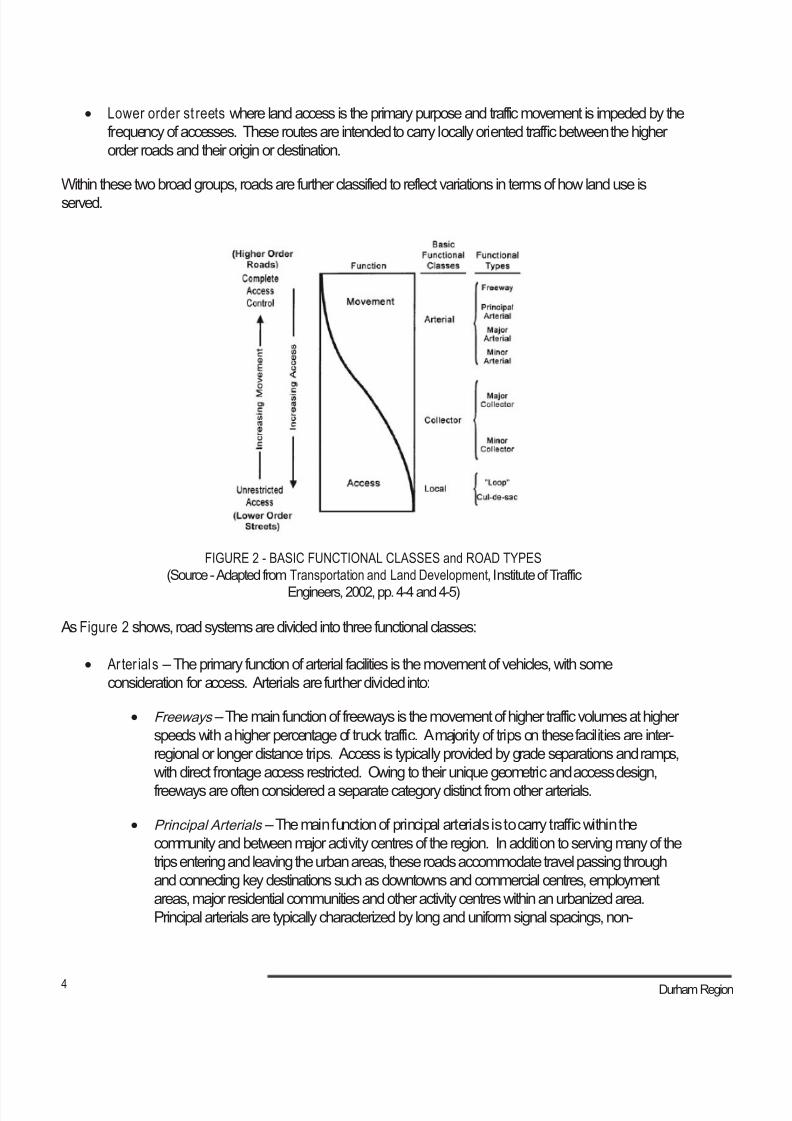
8/21/2019 Durham Region Arterial Corridor Guideline
http://slidepdf.com/reader/full/durham-region-arterial-corridor-guideline 108/119
4 Durham Region
• Lower order st reets where land access is the primary purpose and traffic movement is impeded by the
frequency of accesses. These routes are intended to carry locally oriented traffic between the higher
order roads and their origin or destination.
Within these two broad groups, roads are further classified to reflect variations in terms of how land use is
served.
FIGURE 2 - BASIC FUNCTIONAL CLASSES and ROAD TYPES
(Source - Adapted from Transportation and Land Development, Institute of Traffic
Engineers, 2002, pp. 4-4 and 4-5)
As Figure 2 shows, road systems are divided into three functional classes:
• Ar ter ials – The primary function of arterial facilities is the movement of vehicles, with some
consideration for access. Arterials are further divided into:
• Freeways – The main function of freeways is the movement of higher traffic volumes at higher
speeds with a higher percentage of truck traffic. A majority of trips on these facilities are inter-
regional or longer distance trips. Access is typically provided by grade separations and ramps,
with direct frontage access restricted. Owing to their unique geometric and access design,
freeways are often considered a separate category distinct from other arterials.
• Principal Arterials – The main function of principal arterials is to carry traffic within the
community and between major activity centres of the region. In addition to serving many of the
trips entering and leaving the urban areas, these roads accommodate travel passing through
and connecting key destinations such as downtowns and commercial centres, employment
areas, major residential communities and other activity centres within an urbanized area.
Principal arterials are typically characterized by long and uniform signal spacings, non-
8/21/2019 Durham Region Arterial Corridor Guideline
http://slidepdf.com/reader/full/durham-region-arterial-corridor-guideline 109/119
5 Arterial Corridor Guidelines
traversable medians restricting unsignalized access, flared intersections with channelization and
auxiliary lanes, and higher posted speed limits. They play strategic roles in accommodating goods
movement and higher-order transit facilities, and need to be operated with a focus on vehicular
travel. Strident and proactive access management strategies are important to preserve the
capacity and role of these roads, since abutting development densities are often relatively high due
to their transportation capacity and transit potential.
• Major Arterials – These roads connect with the principal arterial system to accommodate trips
of moderate length with a lower level of travel mobility and a slightly higher level of access.
They distribute trips to geographic areas and serve major commercial and industrial areas.
Major arterials typically vary from principal arterials with respect to intersection spacing and the
frequency and design of unsignalized entranceways.
• Minor Arterials – On the arterial road hierarchy, minor arterial roads augment the higher order
arterial system, carrying through traffic between communities within an urbanized area. They
typically operate at the community level connecting local residential, shopping, employment and
recreational facilities. The minor arterial system places relatively more emphasis on land access
but still has specific limits on access points. Minor arterials may carry local bus routes and provide
inter-community continuity but ideally do not penetrate identifiable neighbourhoods. Minor arterials
also often act as “relief valves” for the higher-order arterials during peak travel periods and in
the event of non-recurring incidents (e.g. collisions, emergencies, construction). As a result of
the wider range of functions they provide and the broader range of land uses they serve, minor
arterials can be very diverse in their cross-sectional composition.
• Collectors – Collector streets provide both access and movement within residential, commercial and
industrial areas. They are typically discontinuous between residential areas, so as to avoid traffic
infiltration through neighbourhoods. Lower density developments and community land uses such asschools and convenience retail are often located on collector streets.
• Locals – Local streets provide direct property access in residential, industrial, commercial and downtown
areas. With local streets connecting primarily to collector roads, travel distances are short, speeds are
relatively low and volumes are modest, as they serve their primary function of accommodating traffic from
adjacent lands.
The final level in defining road classification relates to the development of more specific performance and design
criteria, by suggesting typical cross-sections associated with the various road classes. ITE suggests an ultimate
6-lane divided cross-section for principal arterials, 4-6 lane divided cross-section for major arterials, and 4-5 lane
undivided cross-section for minor arterials.
Arterial Road Classification Review
8/21/2019 Durham Region Arterial Corridor Guideline
http://slidepdf.com/reader/full/durham-region-arterial-corridor-guideline 110/119
6 Durham Region
4. TAC Road Classification System
The TAC classification system separates roads on the basis of differences in traffic service, land service, design
features, and operational needs associated primarily with adjacent land use. It is generally comparable to the ITE
system in that roads are classified into freeways, arterials, collectors and locals. The design characteristics arespecified separately for urban and rural roads. The TAC classification system is oriented more towards design
applications, rather than for planning purposes.
In 1999, TAC updated its Geometric Design Guide.2 This involved an extensive review of literature on safety
aspects related to geometric design components including: alignments, intersections, interchanges, cross-section
elements, roadside safety and other components of roadway design. The new guide provides a generic standard
that municipalities and other government agencies can tailor and use to meet their specific road needs.
In describing the design characteristics, the TAC guide classifies arterials as major and minor, with specific criteria
as described in Table 1.
Table 1 – TAC Geometric Design Guide for Canadian Roads
Criteria Art erial Class es
Major Minor
Traffic Service
ObjectiveTraffic Movement Primary Consideration Traffic Movement Major Consideration
Land Service/
Acc ess Rigid access control Some access control
Travel Speed
Design Speed of 60-100 kph (urban) and 80-130 kph (rural)
Average Speed of 50-90 kph (urban) and 60-100 kph (rural)
Design Speed of 50-70 kph (urban)
Average Speed of 40-60 kph (urban)
Goods
Movement Accommodate all vehicle types, up to 20% trucks Accommodate all types of trucks
Connectivity Desirable connections - Collectors, Arterials, Expressways and Freeways
TransitExpress and local buses permitted
Cycling and
Pedestrian
Provisions
Cycling - Lane widening or separate facilities desirable
Pedestrians - Sidewalks may be provided, separate facilities desirable
Right-of-Way
Width20*-45** m
Traffic Volume 10,000-30,000 vehicles per day (urban)
Less than 12,000 per day (rural)5,000-20,000 vehicles per day (urban)
Flow
CharacteristicsUninterrupted flow except at signals and crosswalks
Parking Prohibited or Peak Hour Restrictions Peak Hour Restrictions
Minimum
IntersectionSpacing 400 m 200 m
Notes: * 20 m right of way is acceptable for retrofit conditions.** Wider rights of way may be required to accommodate other facilities such as utilities, noise attenuation installation,
bikeways and landscaping. For new roads, the immediate provision of wider rights of way may be considered to
accommodate such facilities.
2 Geometric Design Guide for Canadian Roads, Transportation Association of Canada, 1999.
8/21/2019 Durham Region Arterial Corridor Guideline
http://slidepdf.com/reader/full/durham-region-arterial-corridor-guideline 111/119
7 Arterial Corridor Guidelines
5. Agency Practices
The Cities of Toronto and Hamilton, and the Regional Municipalities of York, Peel and Halton each define a
functional hierarchy of highways, arterials and local roads within their respective Official Plans and supporting
policy documents. In reviewing the designation of their arterial road networks, it was revealed that eachmunicipality has established classification systems containing a range of functional, performance and design
criteria:
• The City of Toronto designates a system of Major Streets, and classifies them in eight right-of-way widths,
ranging from less than 20 metres to 45 metres or greater. The City has also adopted a new road classification
system to consolidate and replace the various road classification systems inherited from its seven former
municipalities. This classification system provides a full range of criteria for Major (having stronger access
controls and rights-of-way ranging from 20-45 metres) and Minor Arterials (allowing more flexible property
access with rights-of-way ranging from 20-30 metres). The criteria includes traffic movement versus property
access, typical daily traffic volume (both directions), minimum number of peak period lanes (excluding
bicycle lanes), desirable connections, flow characteristics, legal speed limit, accommodation of pedestrians,accommodation of cyclists, surface transit, surface transit daily passengers, heavy truck restrictions, typical
spacing between traffic control devices, and typical right-of-way width.
• The Regional Municipality of York designates a road network comprised of eight right-of-way widths, ranging
from 20-60 metres. The planned basic road widths shown in the York Regional Official Plan indicate the
maximum widths that may be necessary to construct the roadway and ancillary utilities. The Region has also
prepared a report entitled Regional Streets: Standards for Rights-of-Way and Boulevards which matches road
rights-of-way to their expected function and use. This document refers to the TAC Geometric Design Guide for
Canadian Roads in defining an integrated and enhanced approach to road design. Such approach balances
considerations for traffic with those of urban design and livability.
• The Regional Municipality of Peel designates Major Roads in their Official Plan, and classifies them in nine
right of way widths, ranging from 20-50 metres. The Region is in the midst of completing a strategic update
of their Official Plan. The current Peel Official Plan provides general direction regarding access control,
intersection spacing, and the accommodation of cyclists and haul routes. Peel Regional Council has also
adopted a “Level of Service Policy” to ensure adequate transportation capacity on Regional roads. This policy
outlines thresholds for the ratio of traffic volume to the capacity of the road.
• The Regional Municipality of Halton designates a network of Major Arterials and Minor Arterials. Major Arterials
provide a high degree of access control, up to 6 lanes, with rights-of-way up to 42 metres. Minor Arterials
provide an intermediate degree of access control, up to 6 lanes, with rights-of-way of up to 35 metres. The
Region also designates Multi-Purpose Arterials that run through nodes or connect nodes. The Official Planprovides both functional (i.e. level of travel demand, goods movement, transit accommodation) and general
design guidelines (i.e. level of access control, right-of-way width, number of travel lanes, requirements for HOV
and/or transit priority lanes, adjacent land uses).
• The City of Hamilton designates arterial roads with rights-of-way ranging from 60 metres, where there is
complete control of access to abutting land use, to 26-36 metres, when there is only partial or no control of
access to abutting land use. The City defines arterial roads as strategic links in the road network needed to
Arterial Road Classification Review
8/21/2019 Durham Region Arterial Corridor Guideline
http://slidepdf.com/reader/full/durham-region-arterial-corridor-guideline 112/119
8 Durham Region
carry out relatively high volumes of long distance traffic within, between or through Area Municipalities, and/
or to provide access past major geographic barriers and to inter-regional highways.
As illustrated above, although there are similarities among the municipal arterial road classification systems,
each of them has developed a system tailored to meet their own needs. The range of arterials varies between
municipalities; however, right-of-way width, access control and travel speeds appear to be the most commonlyused criteria to distinguish arterial road classes. To provide a framework for the development and management
of the road system, particularly for use by planning and transportation staff, the City of Toronto and the Region of
York have undertaken further studies to expand the array of criteria for arterials.
6. Review of the Regional Road Classification System
The Region and the area municipalities designate road networks in their Official Plans based on functional
classification. The plans identify a freeway network, under the jurisdiction of the Province, intended to carry
longer-distance travel to, from and through the Region. The freeway network forms the backbone of the
Region’s transportation system and connects to the arterial road network at grade-separated locations. The
area municipal official plans also define local and collector road networks that serve abutting land uses. These
roads, solely under the jurisdiction of the local municipalities, provide land access and collect traffic from the
lower order streets and distribute it to the arterial road network.
Although the freeway, collector road and local road networks play an important role in the overall road system
for Durham Region, the focus of this report is the arterial road network. Arterial roads fall under the jurisdiction
of the Region, the area municipalities, or the Ministry of Transportation. The arterial road network in the
southern part of the Region is based on the land survey system of Ontario, which resulted in basic spacing of
approximately 2.1 km between east/west roads (concessions) and 0.82 km between north/south roads (lots).
As development occurred and population and employment densities increased, the spacing of arterial roadsin this part of the Region became more frequent to accommodate the increased traffic volumes. The more
frequent spacing of arterial roads in the southern urban areas of the Region, and the less dense spacing in the
northern and eastern rural areas, provides evidence of this evolution.
The 1976 ROP designated a road network of Type A and Type B arterials. During the 1991 ROP review, the
network was refined to include Type C arterial roads. Criteria associated with the Type A, Type B and Type C
road classes are contained in section 16 of the ROP (see Table 2).
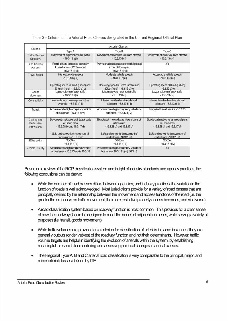
8/21/2019 Durham Region Arterial Corridor Guideline
http://slidepdf.com/reader/full/durham-region-arterial-corridor-guideline 113/119
9 Arterial Corridor Guidelines
Table 2 – Criteria for the Arterial Road Classes designated in the Current Regional Official Plan
Criteria Art erial Class es
Type A Type B Type C
Traffic ServiceObjective Movement of large volumes of traffic- 16.3.13 a) i) Movement of moderate volumes of traffic- 16.3.13 b) i) Movement of lower volumes of traffic- 16.3.13 c) i)
Land Service/
Acc ess
Permit private accesses generally
located a min. of 200m apart
- 16.3.13 a) vii)
Permit private accesses generally located
a min. of 80m apart
- 16.3.13 b) vii)
n/a
Travel Speed
Highest vehicle speeds
- 16.3.13 a) iii)
Operating speed 70 km/h (urban) and
80 km/h (rural) - 16.3.13 a) v)
Moderate vehicle speeds
- 16.3.13 b) iii)
Operating speed 60 km/h (urban) and
80kph (rural) - 16.3.13 b) v)
Acceptable vehicle speeds
- 16.3.13 c) iii)
Operating speed 50 km/h (urban)
- 16.3.13 c) v)Goods
Movement
Large volume of truck traffic
- 16.3.13 a) i)
Moderate volume of truck traffic
- 16.3.13 b) i)
Lower volume of truck traffic
- 16.3.13 c) i)
Connectivity Intersects with Freeways and other
Arterials - 16.3.13 a) ii)
Intersects with other Arterials and
collectors- 16.3.13 b) ii)
Intersects with other Arterials and
collectors- 16.3.13 c) ii)
Transit Accommodate high occupancy vehicle
or bus lanes - 16.3.13 a) vi)
Accommodate high occupancy vehicle or
bus lanes - 16.3.13 b) vi)
Integrated transit service - 16.3.20
Cycling and
Pedestrian
Provisions
Bicycle path networks as integral parts
of urban area
- 16.3.28 b) and 16.3.17 d)
Safe and convenient movement of
pedestrians - 16.3.28 a)
Bicycle path networks as integral parts of
urban area
- 16.3.28 b) and 16.3.17 d)
Safe and convenient movement of
pedestrians - 16.3.28 a)
Bicycle path networks as integral parts
of urban area
- 16.3.28 b) and 16.3.17 d)
Safe and convenient movement of
pedestrians - 16.3.28 a)ROW width 36-50m
- 16.3.13 a) iv)
30-36m
- 16.3.13 b) iv)
26-30m
- 16.3.13 c) iv)
Vehicle Priority Accommodate high occupancy vehicle
or bus lanes - 16.3.13 a) vi), 16.3.18
Accommodate high occupancy vehicle or
bus lanes - 16.3.13 b) vi), 16.3.18
n/a
Based on a review of the ROP classification system and in light of industry standards and agency practices, thefollowing conclusions can be drawn:
• While the number of road classes differs between agencies, and industry practices, the variation in the
function of roads is well acknowledged. Most jurisdictions provide for a variety of road classes that are
principally defined by the relationship between the movement and access functions of the road (i.e. the
greater the emphasis on traffic movement, the more restrictive property access becomes, and vice versa).
• A road classification system based on roadway function is most common. This provides for a clear sense
of how the roadway should be designed to meet the needs of adjacent land uses, while serving a variety of
purposes (i.e. transit, goods movement).
• While traffic volumes are provided as a criterion for classification of arterials in some instances, they are
generally outputs (or derivatives) of the roadway function and not their determinants. However, traffic
volume targets are helpful in identifying the evolution of arterials within the system, by establishing
meaningful thresholds for monitoring and assessing potential changes in arterial classes.
• The Regional Type A, B and C arterial road classification is very comparable to the principal, major, and
minor arterial classes defined by ITE.
Arterial Road Classification Review
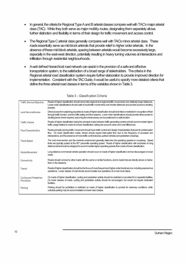
8/21/2019 Durham Region Arterial Corridor Guideline
http://slidepdf.com/reader/full/durham-region-arterial-corridor-guideline 114/119
10 Durham Region
• In general, the criteria for Regional Type A and B arterial classes compare well with TAC’s major arterial
class (TAC). While they both serve as major mobility routes, designating them separately allows
further distinction and flexibility in terms of their design for traffic movement and access control.
• The Regional Type C arterial class generally compares well with TAC’s minor arterial class. These
roads essentially serve as mid-block arterials that provide relief to higher order arterials. In theabsence of these mid-block arterials, spacing between arterials would become excessively large,
especially in the east-west direction, potentially resulting in heavy turning volumes at intersections and
infiltration through residential neighbourhoods.
• A well defined hierarchical road network can assist in the provision of a safe and effective
transportation system, to the satisfaction of a broad range of stakeholders. The criteria in the
Regional arterial road classification system require further elaboration to provide improved direction for
implementation. Consistent with the TAC Guide, it would be useful to specify more detailed criteria that
define the three arterial road classes in terms of the variables shown in Table 3.
Table 3 – Classifi cation Crit eria
Traffic Service Objective Roads of higher classification should serve inter-regional and regional traffic movements over relatively longer distances.
Lower order classifications should cater to local traffic movements over shorter distances and provide access to abutting
property.
Land Service/Access Direct access from adjoining properties to roads of higher classification should be limited or restricted in recognition of their
through traffic function, and for traffic safety and flow reasons. Lower order classifications should provide direct access to
abutting lands where required, assuming the entranceway can be positioned in a safe location.
Traffic Volume Roads of higher classification being the principal routes between traffic generating centres should accommodate higher
traffic usage relative to roads of a lower classification, taking into account urban and rural differences.
Flow Characteristics Roads primarily serving traffic movement should have traffic control and design characteristics that permit uninterrupted
flow. On lower classification roads, drivers should expect interrupted flow due to the frequency of accesses and
intersections, and the presence of more traffic control devices, parked vehicles and pedestrian crossings.
Travel Speed The road cross-section and the roadside environment generally determine the operating speeds on a roadway. Speed
limits are typically posted at the 85th percentile operating speed. Roads of higher classification with emphasis on long
distance travel should be designed to accommodate higher operating speeds than roads of lower classification.
Goods Movement Long distance commercial vehicle operation should occur on roads of higher classification and be discouraged on local
roads.
Connectivity Roads should connect to other roads with the same or similar functions, and to roads that are directly above or below
them in the hierarchy.
Transit Roads of higher classification should be the focus of more frequent and higher-order transit service, including express bus
operations. Lower classes of road should accommodate bus operations of a more local nature.
Cycling and Pedestrian
Provisions
On roads of higher classification, cycling and pedestrian activity should be restricted or provided for in separate facilities.
On lower classes of roads, cycling and pedestrian activity should be encouraged, but would not require dedicated
facilities.
Parking Parking should be prohibited or restricted on roads of higher classification to provide for clearway conditions, while
curbside parking may be accommodated on lower road classes.
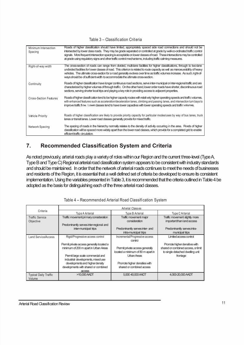
8/21/2019 Durham Region Arterial Corridor Guideline
http://slidepdf.com/reader/full/durham-region-arterial-corridor-guideline 115/119
11 Arterial Corridor Guidelines
Table 3 – Classification Criteria
Minimum Intersection
Spacing
Roads of higher classification should have limited, appropriately spaced side road connections and should not be
intersected by lower class roads. They may be grade separated or controlled at grade by well-co-ordinated traffic control
signals. More frequent intersection spacing is acceptable on lower classes of road. These intersections may be controlled
at grade using regulatory signs and other traffic control mechanisms, including traffic calming measures.
Right-of-way width The cross-section of roads can range from divided, multi-lane facilities for higher classifications, through to two-lane
undivided facilities for lower classes of road. This criterion is related to route capacity as well as manoeuvrability of heavy
vehicles. The ultimate cross-section for a road generally evolves over time as traffic volumes increase. As such, right-of-
ways should be of sufficient width to accommodate the ultimate cross-section.
Continuity Roads of higher classification have longer continuous road sections, serve inter-municipal or inter-regional traffic and are
characterized by higher volumes of through traffic. On the other hand, lower order roads have shorter, discontinuous road
sections, serving shorter local trips and playing a key role in providing access to adjacent properties.
Cross-Section Features Roads of higher classification tend to be higher capacity routes with relatively higher operating speeds and traffic volumes,
with enhanced features such as acceleration/deceleration lanes, climbing and passing lanes, and intersection turn bays to
improve traffic flow. Lower classes tend to have lower capacities with lower operating speeds and traffic volumes.
Vehicle Priority Roads of higher classification are likely to provide priority capacity for particular modes/uses by way of bus lanes, truck
lanes or transit lanes. Lower road classes generally provide for mixed traffic.
Network Spacing The spacing of roads in the hierarchy normally relates to the density of activity occurring in the area. Roads of higher
classification will be spaced more widely apart than the lower road classes, which provide for a completed grid to enable
efficient traffic circulation.
7. Recommended Classifcation System and Criteria
As noted previously, arterial roads play a variety of roles within our Region and the current three-level (Type A,
Type B and Type C) Regional arterial road classification system appears to be consistent with industry standards
and should be maintained. In order that the network of arterial roads continues to meet the needs of businesses
and residents of the Region, it is essential that a well defined set of criteria be developed to ensure its consistent
implementation. Using the variables presented in Table 3, it is recommended that the criteria outlined in Table 4 beadopted as the basis for distinguishing each of the three arterial road classes.
Table 4 – Recommended Arterial Road Classifi cation System
Criteria Art erial Class es
Type A Arterial Type B Arterial Type C Arterial
Traffic Service
Objective
Traffic movement primary consideration
Predominantly serves inter-regional and
inter-municipal trips
Traffic movement major
consideration
Predominantly serves inter- and
intra-municipal trips
Traffic movement slightly more
important than land access
Predominantly serves intra-
municipal trips
Land Service/Access Rigid/Progressive access control
Permit private access generally located a
minimum of 200 m apart in Urban Areas
Permit large scale commercial and
industrial developments, mixed use
developments and higher density
developments with shared or combined
access
Incremental/Progressive access
control
Permit private access generally
located a minimum of 80 m apart in
Urban Areas
Promote higher densities with
shared or combined access
Limited access control
Promote higher densities with
shared or combined access, or limit
to single detached dwelling unit
frontage
Typical Daily Traffic
Volume
>10,000 AADT 5,000-40,000 AADT 4,000-20,000 AADT
Arterial Road Classification Review
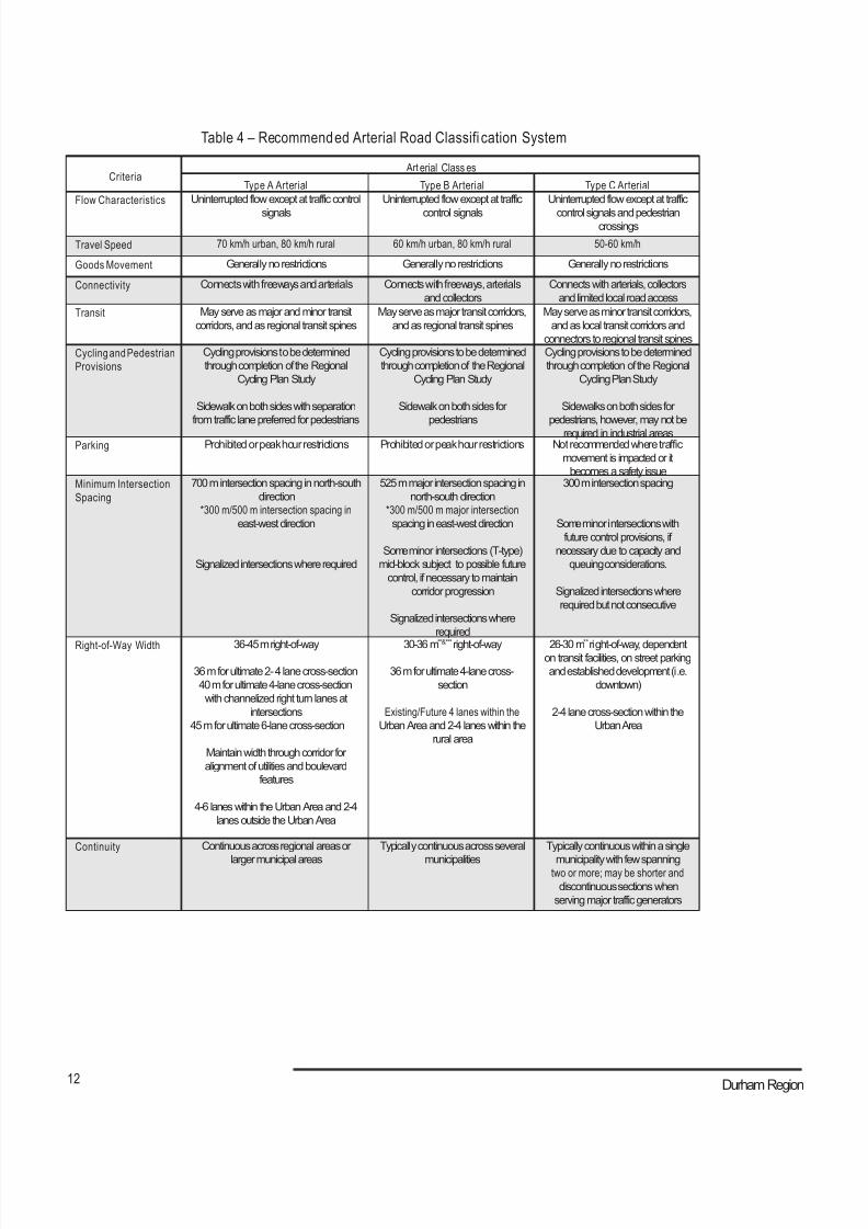
8/21/2019 Durham Region Arterial Corridor Guideline
http://slidepdf.com/reader/full/durham-region-arterial-corridor-guideline 116/119
12 Durham Region
Table 4 – Recommended Arterial Road Classifi cation System
Criteria Art erial Class es
Type A Arterial Type B Arterial Type C Arterial
Flow Characteristics Uninterrupted flow except at traffic control
signals
Uninterrupted flow except at traffic
control signals
Uninterrupted flow except at traffic
control signals and pedestriancrossings
Travel Speed 70 km/h urban, 80 km/h rural 60 km/h urban, 80 km/h rural 50-60 km/h
Goods Movement Generally no restrictions Generally no restrictions Generally no restrictions
Connectivity Connects with freeways and arterials Connects with freeways, arterials
and collectors
Connects with arterials, collectors
and limited local road access
Transit May serve as major and minor transit
corridors, and as regional transit spines
May serve as major transit corridors,
and as regional transit spines
May serve as minor transit corridors,
and as local transit corridors and
connectors to regional transit spines
Cycling and Pedestrian
Provisions
Cycling provisions to be determined
through completion of the Regional
Cycling Plan Study
Sidewalk on both sides with separation
from traffic lane preferred for pedestrians
Cycling provisions to be determined
through completion of the Regional
Cycling Plan Study
Sidewalk on both sides for
pedestrians
Cycling provisions to be determined
through completion of the Regional
Cycling Plan Study
Sidewalks on both sides for
pedestrians, however, may not be
required in industrial areasParking Prohibited or peak hour restrictions Prohibited or peak hour restrictions Not recommended where traffic
movement is impacted or it
becomes a safety issueMinimum Intersection
Spacing
700 m intersection spacing in north-south
direction
*300 m/500 m intersection spacing in
east-west direction
Signalized intersections where required
525 m major intersection spacing in
north-south direction
*300 m/500 m major intersection
spacing in east-west direction
Some minor intersections (T-type)
mid-block subject to possible future
control, if necessary to maintain
corridor progression
Signalized intersections where
required
300 m intersection spacing
Some minor intersections with
future control provisions, if
necessary due to capacity and
queuing considerations.
Signalized intersections where
required but not consecutive
Right-of-Way Width
36-45 m right-of-way
36 m for ultimate 2- 4 lane cross-section
40 m for ultimate 4-lane cross-section
with channelized right turn lanes at
intersections
45 m for ultimate 6-lane cross-section
Maintain width through corridor for
alignment of utilities and boulevard
features
4-6 lanes within the Urban Area and 2-4
lanes outside the Urban Area
30-36 m**&***
right-of-way
36 m for ultimate 4-lane cross-
section
Existing/Future 4 lanes within the
Urban Area and 2-4 lanes within the
rural area
26-30 m**
right-of-way, dependenton transit facilities, on street parking
and established development (i.e.
downtown)
2-4 lane cross-section within the
Urban Area
Continuity Continuous across regional areas or
larger municipal areas
Typically continuous across several
municipalities
Typically continuous within a single
municipality with few spanningtwo or more; may be shorter and
discontinuous sections when
serving major traffic generators
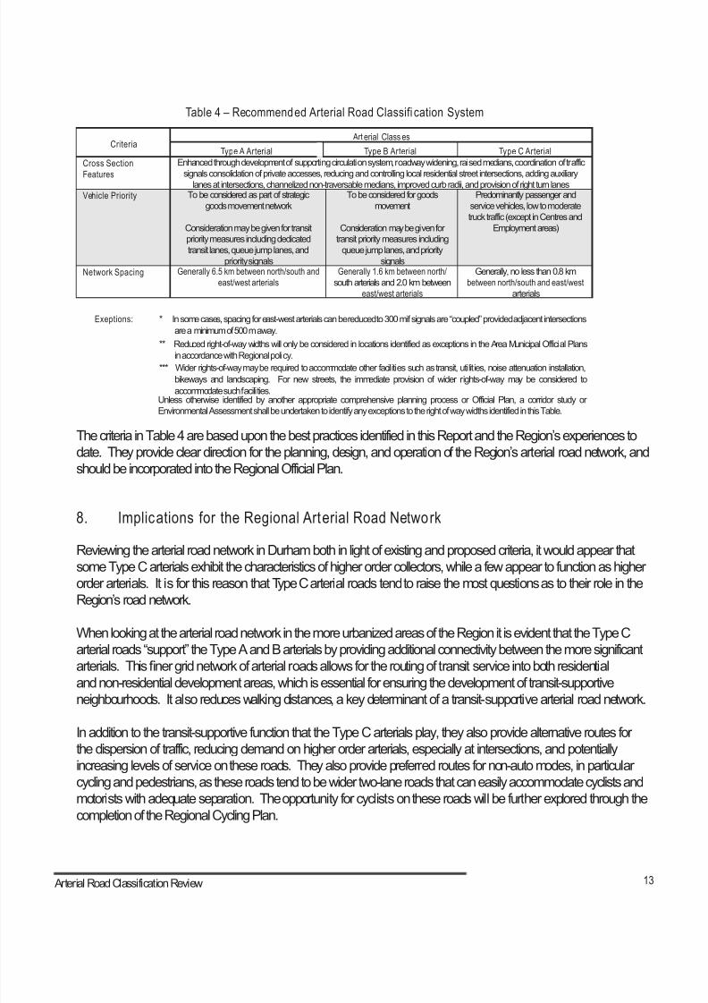
8/21/2019 Durham Region Arterial Corridor Guideline
http://slidepdf.com/reader/full/durham-region-arterial-corridor-guideline 117/119
13 Arterial Corridor Guidelines
Table 4 – Recommended Arterial Road Classifi cation System
Criteria Art erial Class es
Type A Arterial Type B Arterial Type C Arterial
Cross Section
Features
Enhanced through development of supporting circulation system, roadway widening, raised medians, coordination of traffic
signals consolidation of private accesses, reducing and controlling local residential street intersections, adding auxiliarylanes at intersections, channelized non-traversable medians, improved curb radii, and provision of right turn lanes
Vehicle Priority To be considered as part of strategic
goods movement network
Consideration may be given for transit
priority measures including dedicated
transit lanes, queue jump lanes, and
priority signals
To be considered for goods
movement
Consideration may be given for
transit priority measures including
queue jump lanes, and priority
signals
Predominantly passenger and
service vehicles, low to moderate
truck traffic (except in Centres and
Employment areas)
Network Spacing Generally 6.5 km between north/south and
east/west arterials
Generally 1.6 km between north/
south arterials and 2.0 km between
east/west arterials
Generally, no less than 0.8 km
between north/south and east/west
arterials
Exeptions: * In some cases, spacing for east-west arterials can be reduced to 300 m if signals are “coupled” provided adjacent intersections
are a minimum of 500 m away.
** Reduced right-of-way widths will only be considered in locations identified as exceptions in the Area Municipal Official Plans
in accordance with Regional policy.
*** Wider rights-of-way may be required to accommodate other facilities such as transit, utilities, noise attenuation installation,
bikeways and landscaping. For new streets, the immediate provision of wider rights-of-way may be considered to
accommodate such facilities.Unless otherwise identified by another appropriate comprehensive planning process or Official Plan, a corridor study or
Environmental Assessment shall be undertaken to identify any exceptions to the right of way widths identified in this Table.
The criteria in Table 4 are based upon the best practices identified in this Report and the Region’s experiences to
date. They provide clear direction for the planning, design, and operation of the Region’s arterial road network, and
should be incorporated into the Regional Official Plan.
8. Implications for the Regional Arterial Road Network
Reviewing the arterial road network in Durham both in light of existing and proposed criteria, it would appear that
some Type C arterials exhibit the characteristics of higher order collectors, while a few appear to function as higher
order arterials. It is for this reason that Type C arterial roads tend to raise the most questions as to their role in the
Region’s road network.
When looking at the arterial road network in the more urbanized areas of the Region it is evident that the Type C
arterial roads “support” the Type A and B arterials by providing additional connectivity between the more significant
arterials. This finer grid network of arterial roads allows for the routing of transit service into both residential
and non-residential development areas, which is essential for ensuring the development of transit-supportive
neighbourhoods. It also reduces walking distances, a key determinant of a transit-supportive arterial road network.
In addition to the transit-supportive function that the Type C arterials play, they also provide alternative routes for
the dispersion of traffic, reducing demand on higher order arterials, especially at intersections, and potentially
increasing levels of service on these roads. They also provide preferred routes for non-auto modes, in particular
cycling and pedestrians, as these roads tend to be wider two-lane roads that can easily accommodate cyclists and
motorists with adequate separation. The opportunity for cyclists on these roads will be further explored through the
completion of the Regional Cycling Plan.
Arterial Road Classification Review
8/21/2019 Durham Region Arterial Corridor Guideline
http://slidepdf.com/reader/full/durham-region-arterial-corridor-guideline 118/119
14 Durham Region
Considering that there is a significant difference between the functions of some of the current Type C arterial roads, it
is recommended that the current network of Type C arterials be reviewed in light of the classification criteria for minor
arterials presented in Table 4, with additional consideration of the benefits outlined above.
9. Conclusions and Recommendations
The concept of the three-level hierarchy of arterial roads defined in the current Regional Official Plan remains valid.
However, it is recommended that the Arterial Road Classification System be refined to clarify the differences between the
three arterial road classes.
With the proposed refinement of the Arterial Road Classification System, the framework is now set for the development of
Arterial Corridor Guidelines - the second phase of this study. This phase will focus on the development of more specific
design criteria that are applicable to each road type, pairing objectives formovement (i.e. roadway design criteria in terms
of travel patterns, speeds and connectivity) with those for activity (i.e. urban design criteria in terms of levels of activity,
location of access, and relationship to the street). The guidelines will provide a matrix of design opportunities that areadaptable over time in both urban and rural contexts, and will be used by the Region and its area municipalities during the
preparation of site specific corridor studies and secondary plans, and the review of development applications.
To move forward with the review of the Regional Official Plan and the development of the guidelines, it is recommended
that:
1. The current three-level (Type A, Type B and Type C) arterial road classi fication system be
maintained in the Regional and area municipal Official Plans.
2. Type C Arterial Roads cont inue to be designated on Map B2 (Transpor tation System) of the
Regional Official Plan.
3. The current network of Type C arterials be re-examined based on the classif ication and functional
criteria recommended in this report, and accordingly, inappropriately designated roads be
reclassified.
4. The classification and functional criteria for arterial roads contained in Table 4 be incorporated
into the Regional Official Plan.
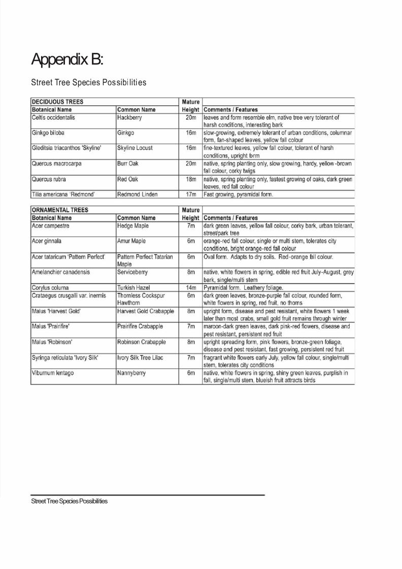
8/21/2019 Durham Region Arterial Corridor Guideline
http://slidepdf.com/reader/full/durham-region-arterial-corridor-guideline 119/119
Appendix B:
Street Tree Species Possibi liti es