Embed Size (px)
Citation preview
ECLAI (PART B) page 1 / 28
European Landscape Character Assessment Initiative
E L C A I
Project Proposal for financial support for an Accompanying Measure
EU 5 th Framework Programme Work Programme: EESD-2000- 2.2.1
Part B
Description of scientific/technological objectivesand work-plan
01.04.2002
ECLAI (PART B) page 2 / 28
Content list
B3. Objectives
B4. Contribution to programme/key action objectives
B5. Innovation
B6. Project workplan
a. Introduction – explaining the structure of the workplan and the overall methodology used to achieve the objectives
b. Project planning and time tablec. Graphical presentation of the project’s components;
(interconnection diagram)d. Detailed project description broken down into work packages
ECLAI (PART B) page 3 / 28
B3. Objectives
Landscape character is an expression of the way in which the natural and cultural elements of terrestrial ecosystems combine to create unique places with specific ecological, economic as well as social functions and values. If the multiple functions and values of these landscape character types are reduced, disturbed or are getting out of balance, their overall sustainability is at stake: landscapes cease to provide support for biodiversity, against erosion or for recreational and economic services. In the light of increasing landscape changes, many national agencies have developed sophisticated landscape character assessment tools that are scientifically sound, region-specific and stakeholder-oriented – qualities that are considered as key issues for the future implementation of the EU policy and research agenda as well. The experiences with the Landscape Character Assessment undertaken in the United Kingdom, the long history of high level landscape research in countries such as Denmark, The Netherlands, Germany, Switzerland and Austria, as well as many outstanding achievements during recent years in Central European and Mediterranean countries, have created a wealth of scientific knowledge that offer a wide range of policy applications. However, other than the scientific knowledge in the field of environmental media (soil, water, air) or in nature conservation, the broad knowledge base of landscape science has not been made available for a number of relevant initiatives such as the European Landscape Convention, ESPON or the agri-environmental indicator approaches in the European context.
At the European level, most assessments have taken a sectoral approach by focussing on driving forces (e.g. land use change), environmental state (biodiversity, water, air) or impacts (e.g. on human health). However, there appears to be lack of understanding of what has already been done in the emerging field of landscape science at the national level, what could be learned from these experiences and how future European landscape policy could be based on existing national approaches. This accounts especially for the role of existing spatial concepts that reflect regional and national identity, for the selection and benchmarking of indicators for the vulnerability of landscapes and for the participatory processes that are in place when implementing landscape policies.
In awareness of the increasing needs for consolidated research in support of European landscapes, the creation of this project team is also a preparatory step in the formation of a ‘Network of Excellence” under the 6th Environmental Framework Programme. Drawing upon information, concepts and standards that are readily available and/or have been developed by the participating partners for their countries or for European institutions, this Accompanying Measure is designed to generate new insights in what appears to be an advanced field of policy-oriented research. The project will follow a sequence of 4 main phases:
1. Inventory2. Synthesis3. Inter-disciplinary debate4. Dissemination
The main goal is to demonstrate the use of landscape character assessment as a tool for linking regional/national bottom-up approaches with European top-down processes in support of future policy implementation. The objectives are as follows:
To provide a systematic review on state-of-the-art approaches to typologies, indicators and participatory concepts in landscape character assessments for both natural and semi-natural landscapes at:- the national level for governmental agencies and scientific bodies of at least 15
European countries;- the European level for international institutions such as the Joint Research Centre,
Eurostat, the European Environment Agency and its newly established ETC Terrestrial Environment;
Provide examples on practical applications of these concepts.
To analyse the policy framework for landscape conservation, assessment and monitoring both at the national as well as at the European level with special focus on European
ECLAI (PART B) page 4 / 28policies such as Agenda 2000, Natura 2000, European Spatial Development Initiative, the European Landscape Convention and others;
To initiate stakeholder contacts (involving scientists, policy makers, and economic sectors). The goal is to identify focal points at the regional/national level (ideally for example areas selected in the previous task) who can inform about the decision-making process of land use, landscape planning, regional and spatial development, and zoning affecting the landscape.
To generate a core set of landscape indicators for wider policy implementation and monitoring activities that are derived from new forms of inter-agency cooperation in support of sectoral integration and stakeholder involvement;
To identify needs for a future map of European landscapes by referring to existing national approaches (bottom-up) and linking these to the international scientific and policy frameworks (top down) deriving from biogeographic and geo-morphological information.
To write an interim report presenting the collected information including the draft map and indicators, illustrating current approaches to landscape character assessment at the regional/national levels for the participating countries.
To organise an international workshop on the project’s interim findings in order to seek cross-disciplinary exchange with a wider group of invited international experts from the fields of landscape, agriculture, biodiversity, cultural heritage, social studies and private stakeholders (for specific case studies);
To publish a scientific report, a policy brochure and to launch an Internet database (concepts, map and candidate indicators) that can provide methodological and policy-oriented guidance for future landscape character assessments at various levels of scale.
This Accompanying Measure project is hence designed to demonstrate the capacity of a landscape expertise network to develop landscape character assessment as an interactive tool for guiding the implementation of those European policies that affect landscapes at various scales. At the national level, landscape character assessment has a long history in the field of impact assessments, regional planning, land use development (e.g. agriculture) as well as nature and landscape conservation.
The European Landscape Character Assessment Initiative starts from the following premises:
The overarching landscape character assessment concepts build upon multi-disciplinary cooperation, are rooted in sustainability and have both a strongly spatial-scientific as well as a social dimension.
European landscapes are special because of their diversity and variation in character (see environmental reports such as Dobris and the forthcoming EEA Technical Report on landscapes);
Landscapes are exposed to a set of supra-regional driving forces such as EU polices and large-scale economic developments (see OECD and EU agri-environmental indicator schemes);
Landscapes are cross-boundary phenomena that are increasingly appreciated as a common good rather than as a matter of only national or regional concern (see European Landscape Convention);
While many landscape impacts such as in the pollution of water, the loss of species, the increase of soil erosion or the shrinking of the ozone layer are occurring at a rate or in a form that makes it difficult to notice for many (even environmentally conscious) people, environmental reporting at the European level is facing a number of severe problems: Scale: missing adequate geographic and topical specifications for the concrete regional
context; Integration: insufficient cooperation between sectoral agencies at various levels of the
hierarchy;
ECLAI (PART B) page 5 / 28 Ownership: detachment from national and regional decision-makers (stakeholders)
Because European landscapes are the visible expression of many – partly colliding or competing – environmental, economic and cultural processes, landscape character assessment techniques can offer the tools for identifying the spatially and socially relevant vectors for guiding future policy implementations at the regional, national and European level.
B4. Contribution to programme/key action objectivesFocussing at Europe’s terrestrial ecosystems at the landscape level, the Accompanying Measure project ELCAI is specifically designed to meet Key Action 2.2.2 on “Ecosystem vulnerability” of the 5th Environmental Framework Programme on Environment, Energy and Sustainable Development. The crucial linkage between the environmental dimension and the socio-economic aspect of sustainability is provided by developing indicators, area typologies and participatory processes as parts of an overarching landscape concept that links human activities and terrestrial ecosystems.
European-wide significanceThe wide majority of the European countryside is of anthropogenic origin in which biophysical properties have been remodelled over time and are closely interwoven with cultural features. Despite and in many cases just because of centuries of human intervention, Europe’s semi-natural landscapes have become what can be considered a “life laboratory” in which terrestrial ecosystems form the basis of sustainable life. In the face of increasing pressures due to land use intensification and abandonment, the vulnerability of these terrestrial ecosystems have become obvious to researchers, policy makers as well as to many stakeholders. There is an increasing recognition that the adequate maintenance and management of sustainable landscapes will provide substantial support to the associated terrestrial ecosystems and their associated biodiversity services.
Threats and PoliciesA decade of environmental reporting on the state and trends of biodiversity has demonstrated that the protection of species and habitat in isolation does not guarantee the sustainable development of landscapes. The fragmentation of semi-natural habitats that has taken place in agricultural landscapes is a major issue in this context. It is only at the landscape level that comprehensive planning of natural resources, including their cultural values, can be adequately carried out.Following recent European policy documents, such as Agenda 2000, the European Spatial Development Perspective, the Pan-European Biological and Landscape Diversity Strategy, or the upcoming European Landscape Convention, issues such as rural development, cultural landscapes and regional identity form a set of policy-relevant values that give new meaning to the concept of sustainability. Throughout these issues socio-economic considerations play a vital role when defining environmental objectives.
Spatial-temporal dimensionAn analysis of the existing monitoring programmes at the national level shows that “Landscape Character Assessments” have become an important tool for the conceptual and spatial integration of a wide range of factors relevant for the state and trends of terrestrial ecosystems. The large diversity of landscapes characteristics – especially at the European level – must be considered as a key methodological challenge when assessing the vulnerability and resilience of terrestrial ecosystems with regard to pressures from land use and land cover changes. Landscape characteristics such as topography, soil type, vegetation, structural elements (e.g. hedges, trees) and land use patterns form the life-support systems for terrestrial ecosystems. The objective of a harmonised landscape character assessment is to develop reliable indicators and a geographic reference base that allows to assess the role and function of landscape-management for the protection/conservation of important natural and semi-natural landscapes in Europe.
ECLAI (PART B) page 6 / 28
B5. InnovationAs the project title indicates, the European Landscape Character Assessment Initiative is meant to mark the beginning of a Europe-wide inter-agency and network cooperation on developing a systematic approach towards assessing landscapes. The emphasis is on “systematic” as ELCAI is designed to go beyond a mere compilation and review process, but to contribute to the development of methodological advances in a number of fields, namely:
The identification of landscape indicators as tools for policy implementation: During the implementation of the 5th Environmental Framework Programme, landscape indicators have received increasing attention by both the policy and research community. The European Commission, OECD, Eurostat and the Joint Research Centre started to develop candidate landscape indicator and landscape assessment prototypes. The lesson learned from these activities is that the methodological progress that has been achieved was lacking operational tools for concrete applications. Complex indicator types such as “landscape coherence”, “cultural heritage” and even “adequateness of land use type” confronted the practitioners with difficulties in terms of data harmonisation, data interpretation and geographic referencing. Though various large-scale, computer-based assessment procedures have been run, the results proved to be too generic, omitting regional characteristics and hence lacking policy relevance. ELCAI is meant to fill this gap by putting much more emphasis on analysing the regional context and to build upon existing landscape indicators as they are already used in national programmes. Indicators deriving from this analysis are meant to be organised on the basis of agreed-upon criteria, taking into account international standards and policy requirements.
The drafting of a European draft landscape typology and map: A recent review on existing national approaches to landscape typology and mapping has demonstrated that many countries have developed such tools and are making already active use of them for their reporting and policy implementation. While some of the developed techniques and concepts are rather sophisticated, there is a lack of integration into wider European approaches. At the European level, wider international cooperation is needed in order to achieve common standards for widely applicable spatial references. Current international approaches (e.g. the landscape map of the EEA’s Dobris State-of-the-Environment report) are rather generic (frequently lacking the cultural dimension) and stand isolated from most national approaches, blocking the exchange of data and lacking policy relevance. It is a wider set of policy-oriented objectives that should drive the process rather than purely technical or scientific considerations.
ELCAI is meant to fill the identified gap by initiating a bottom-up process towards European landscape mapping and typology development, guided by international data management criteria and targeting at European policy objectives. Though it cannot be expected that the project will result in a complete European map of landscapes (not all countries can participate), the adequate methodological approach will be developed and a draft map for the participating countries shall be delivered.
The development of early participatory decision-making techniques:One of key objectives of the ELCAI project is to explore new avenues in inter-agency cooperation, linking activities and decision-making processes at the regional, national and international level. In the light of the growing significance of the role of the regions in the context of European policy development and implementation, this project intends to use its partnership consortium as ‘focal points’ for a wider cooperation between regional and national authorities when providing contributions to the emerging landscape character assessment. Especially the identification of suitable landscape indicators including the benchmarks for data interpretation shall go beyond the boundaries of the project network by establishing anchors in the wider policy field. It is also intended that ELCAI network partners develop a multi-disciplinary approach by consulting experts from related fields such as agriculture, regional planning, tourism or others. The goal is to create a wider sense of ownership within the regions of concern and to use network
ECLAI (PART B) page 7 / 28partners not only as data suppliers but also as communicators for stakeholders at the interface between regional, national and international assessment processes.
This project on landscape character assessment provides another step in developing indicators and area typologies towards state-of-the-art communication tools. As demonstrated through previous research project, a wide range of policy-relevant landscape issues need to be addressed – for many of which there is no existing explicit political endorsement. The amount and accuracy of data is actually a lesser limiting factor than the lack of clearly defined implementation targets. The term ‘implementation targets’ relates to the policy field and points at the need to set priorities and to define clear objectives when developing landscape assessment schemes. Policy choices, however, demand transparent arguments that are backed and understood by the majority of stakeholders, scientists and policy makers involved in the process. If societal groups are confronted with a wide range of random assessment procedures of different philosophies and orientation, there is little chance that messages can be communicated in constructive (policy-relevant) ways.
B6. Project workplan
a) Introduction – explaining the structure of the workplan and the overall methodology used to achieve the objectives
The ELCAI project is divided into four distinct but inter-related project phases. The first phase is on reviewing the existing scientific, strategic and policy context in the field of landscape assessment; the second phase is on drafting a European approach for the development of a draft landscape typology, a prototype map and a core set of candidate indicators; the third phase is on opening a wider international debate on the findings by organising an international workshop, and the fourth phase is on disseminating the final results by means of a publication and the opening of an internet-based project database.
Phase 1: Inventory
WP 1 Scientific review
Objective: to provide information for recent landscape character assessments at the national (for as many European countries as possible, but at least for the participating countries) and international level, examine including the underlying scientific and geographical basis (e.g. indicators, landscape typologies, maps), and examples for their practical applications (2 –3) with illustrations in mapped format. Identify gaps and differences in approaches.
WP 2 Policy review
Objective: to review landscape conservation, assessment and monitoring both at the national as well as at the European level with special focus on European policies such as Agenda 2000, Natura 2000, European Spatial Development Initiative, the European Landscape Convention and others;
WP 3 Establish stakeholder contacts
Objective: to identify focal points (other sectoral experts, decision-makers) and involve stakeholders at the regional/national level (ideally for example areas selected under 1.1) who can inform about the decision-making process of land use, landscape planning, regional and spatial development, and zoning affecting the landscape; seek contact to national and international representatives of the “Europe of the Regions” initiative.
ECLAI (PART B) page 8 / 28
Phase 2: Synthesis
WP 4 Demonstration of European landscape typology and map
Objective: examine possible methodological approaches for integrating existing national approaches to landscape mapping into a wider European concept. Based on decision-making processes identified under 2.1 and making reference to the geographical data on national landscape maps, the compiled material should be analysed regarding its suitability for supporting the future development of a European landscape map. Make proposals for a useful classification and give a technical description of the underlying typology.
WP 5 Demonstration of European landscape indicators
Objective: to examine possible methodological approaches for selecting landscape indicators as part of a wider European concept. Taking into account the decision-making processes developed under 2.1 and using the information gathered under Phase 1, suggestions should be made how to arrive at a core set of candidate landscape indicators. Based on the underlying methodological rationales, their reliability, geo-regional relevance, data availability and role for European-wide assessments make suggestions for such a core list.. The indicators should be in line with the driving forces – pressure – state – impact – response mechanism, or – if necessary – with other relevant mechanisms.
WP 6 Interim Report (including maps)
Objective: compile all existing information in a draft report and draft map, illustrating current approaches to landscape character assessment at the regional/national levels for the participating countries.
Phase 3: Inter-disciplinary debate
WP 7 Organise a workshop
Participation of all project partners plus other invited experts from other countries and other disciplines (such as rural areas, agriculture, regional planning, environmental reporting, terrestrial environment, biodiversity) to widen the discussion these and other countries and always 1 representative of the policy-maker/stakeholder group of this country (total size: 35 – 45 participants from at least 20 countries).
Objective: develop (in group workshops) possible ways for future cooperation between national landscape experts, European expert groups and stakeholders with the goal to draft guidelines for information needs and exchange processes, with special emphasis on the use of common methodologies, geographic references and indicators for the implementation of EU and CoE policy implementation.
Phase 4: Dissemination
WP 8 Project report
Objective: provide a full compilation of all findings, target audience is scientific community, experts and practitioners. Report should be illustrative (graphs, pictures, maps), giving recommendations for future activities.
WP 9 Policy Brochure
ECLAI (PART B) page 9 / 28Objective: provide a brief, illustrated report (30 pages) targeting at policy makers at the regional, national and European level, demonstrating possible applications of landscape assessment techniques and especially participatory procedures in landscape policy implementation.
WP 10 Launching of ELCAI internet database
Objective: make all findings and principle data sets (including digital geographic information) accessible through an interactive project database that can be quarried through password entry.
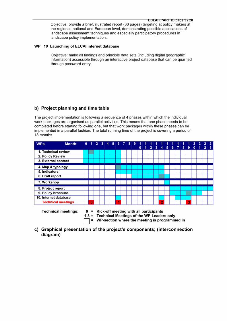
b) Project planning and time table
The project implementation is following a sequence of 4 phases within which the individual work packages are organised as parallel activities. This means that one phase needs to be completed before starting following one, but that work packages within these phases can be implemented in a parallel fashion. The total running time of the project is covering a period of 18 months.
WPs Month: 0 1 2 3 4 5 6 7 8 9 10
11
12
13
14
15
16
17
18
19
20
21
22
23
1. Technical review 2. Policy Review 3. External contact
4. Map & typology 5. Indicators 6. Draft report
7. Workshop
8. Project report 9. Policy brochure10. Internet database Technical meetings 0 1 2 3
Technical meetings: 0 = Kick-off meeting with all participants 1-3 = Technical Meetings of the WP-Leaders only
= WP-section where the meeting is programmed in
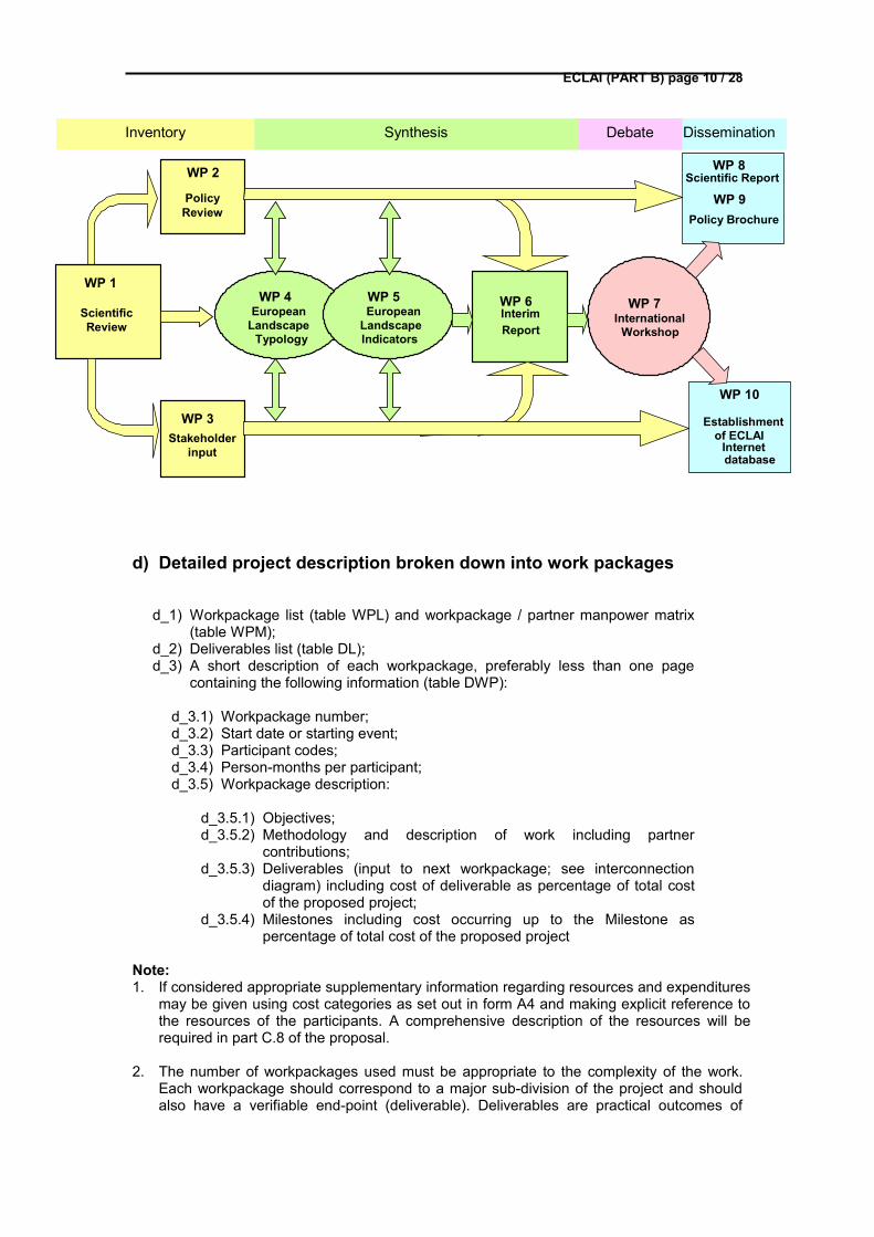
c) Graphical presentation of the project’s components; (interconnection diagram)
ECLAI (PART B) page 10 / 28
d) Detailed project description broken down into work packages
d_1) Workpackage list (table WPL) and workpackage / partner manpower matrix (table WPM);
d_2) Deliverables list (table DL);d_3) A short description of each workpackage, preferably less than one page
containing the following information (table DWP):
d_3.1) Workpackage number;d_3.2) Start date or starting event;d_3.3) Participant codes;d_3.4) Person-months per participant;d_3.5) Workpackage description:
d_3.5.1) Objectives;d_3.5.2) Methodology and description of work including partner
contributions;d_3.5.3) Deliverables (input to next workpackage; see interconnection
diagram) including cost of deliverable as percentage of total cost of the proposed project;
d_3.5.4) Milestones including cost occurring up to the Milestone as percentage of total cost of the proposed project
Note:1. If considered appropriate supplementary information regarding resources and expenditures
may be given using cost categories as set out in form A4 and making explicit reference to the resources of the participants. A comprehensive description of the resources will be required in part C.8 of the proposal.
2. The number of workpackages used must be appropriate to the complexity of the work. Each workpackage should correspond to a major sub-division of the project and should also have a verifiable end-point (deliverable). Deliverables are practical outcomes of
DisseminationInventory
WP 7International
Workshop
WP 3Stakeholder
input
WP 4European
LandscapeTypology
WP 5European
LandscapeIndicators
WP 1
ScientificReview
WP 2
PolicyReview
WP 6InterimReport
WP 8 Scientific Report
WP 9
WP 10
Establishmentof ECLAI
Internetdatabase
Policy Brochure
Synthesis Debate
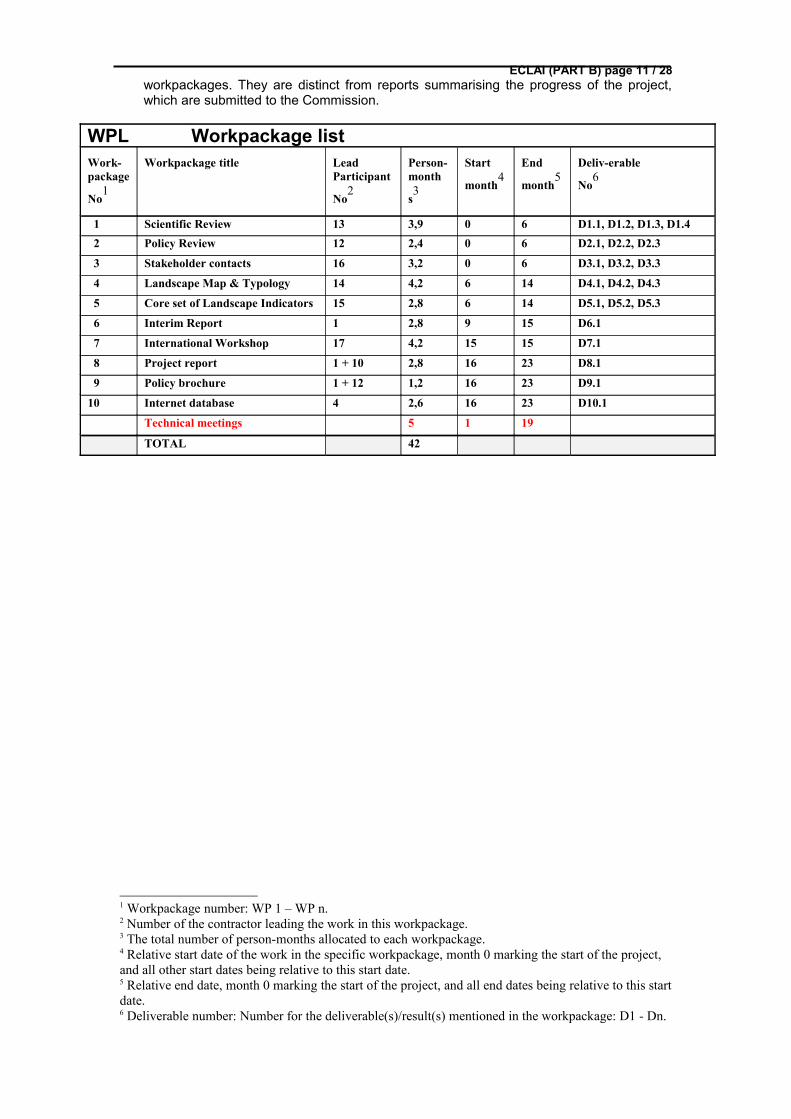
ECLAI (PART B) page 11 / 28workpackages. They are distinct from reports summarising the progress of the project, which are submitted to the Commission.
WPL Workpackage listWork-package
No1
Workpackage title Lead Participant
No2
Person-month
s3
Start
month4
End
month5
Deliv-erable
No6
1 Scientific Review 13 3,9 0 6 D1.1, D1.2, D1.3, D1.4 2 Policy Review 12 2,4 0 6 D2.1, D2.2, D2.3
3 Stakeholder contacts 16 3,2 0 6 D3.1, D3.2, D3.3
4 Landscape Map & Typology 14 4,2 6 14 D4.1, D4.2, D4.3
5 Core set of Landscape Indicators 15 2,8 6 14 D5.1, D5.2, D5.3
6 Interim Report 1 2,8 9 15 D6.1
7 International Workshop 17 4,2 15 15 D7.1
8 Project report 1 + 10 2,8 16 23 D8.1
9 Policy brochure 1 + 12 1,2 16 23 D9.1
10 Internet database 4 2,6 16 23 D10.1
Technical meetings 5 1 19
TOTAL 42
1 Workpackage number: WP 1 – WP n.2 Number of the contractor leading the work in this workpackage.3 The total number of person-months allocated to each workpackage.4 Relative start date of the work in the specific workpackage, month 0 marking the start of the project, and all other start dates being relative to this start date.5 Relative end date, month 0 marking the start of the project, and all end dates being relative to this start date.6 Deliverable number: Number for the deliverable(s)/result(s) mentioned in the workpackage: D1 - Dn.
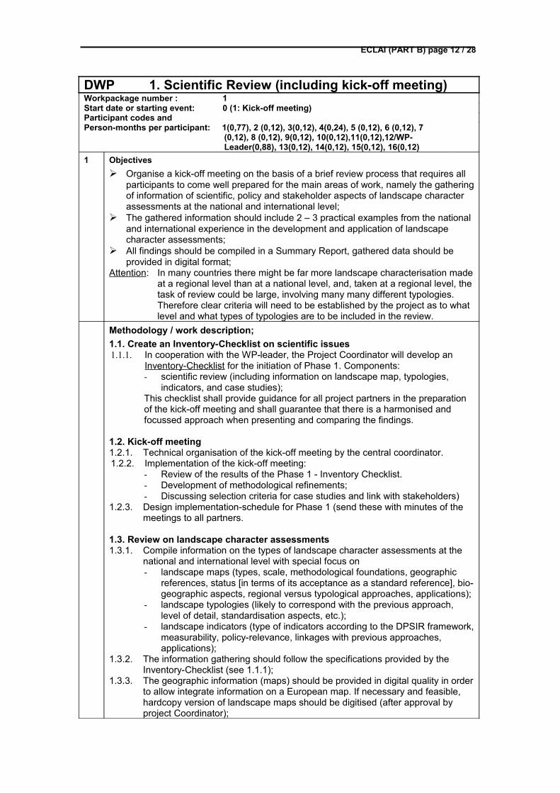
ECLAI (PART B) page 12 / 28
DWP 1. Scientific Review (including kick-off meeting)Workpackage number : 1Start date or starting event: 0 (1: Kick-off meeting)Participant codes and Person-months per participant: 1(0,77), 2 (0,12), 3(0,12), 4(0,24), 5 (0,12), 6 (0,12), 7
(0,12), 8 (0,12), 9(0,12), 10(0,12),11(0,12),12/WP-Leader(0,88), 13(0,12), 14(0,12), 15(0,12), 16(0,12)
1 Objectives Organise a kick-off meeting on the basis of a brief review process that requires all
participants to come well prepared for the main areas of work, namely the gathering of information of scientific, policy and stakeholder aspects of landscape character assessments at the national and international level;
The gathered information should include 2 – 3 practical examples from the national and international experience in the development and application of landscape character assessments;
All findings should be compiled in a Summary Report, gathered data should be provided in digital format;
Attention: In many countries there might be far more landscape characterisation made at a regional level than at a national level, and, taken at a regional level, the task of review could be large, involving many many different typologies. Therefore clear criteria will need to be established by the project as to what level and what types of typologies are to be included in the review.
Methodology / work description;1.1. Create an Inventory-Checklist on scientific issues1.1.1. In cooperation with the WP-leader, the Project Coordinator will develop an
Inventory-Checklist for the initiation of Phase 1. Components:- scientific review (including information on landscape map, typologies,
indicators, and case studies);This checklist shall provide guidance for all project partners in the preparation of the kick-off meeting and shall guarantee that there is a harmonised and focussed approach when presenting and comparing the findings.
1.2. Kick-off meeting1.2.1. Technical organisation of the kick-off meeting by the central coordinator.1.2.2. Implementation of the kick-off meeting:
- Review of the results of the Phase 1 - Inventory Checklist.- Development of methodological refinements;- Discussing selection criteria for case studies and link with stakeholders)
1.2.3. Design implementation-schedule for Phase 1 (send these with minutes of the meetings to all partners.
1.3. Review on landscape character assessments1.3.1. Compile information on the types of landscape character assessments at the
national and international level with special focus on - landscape maps (types, scale, methodological foundations, geographic
references, status [in terms of its acceptance as a standard reference], bio-geographic aspects, regional versus typological approaches, applications);
- landscape typologies (likely to correspond with the previous approach, level of detail, standardisation aspects, etc.);
- landscape indicators (type of indicators according to the DPSIR framework, measurability, policy-relevance, linkages with previous approaches, applications);
1.3.2. The information gathering should follow the specifications provided by the Inventory-Checklist (see 1.1.1);
1.3.3. The geographic information (maps) should be provided in digital quality in order to allow integrate information on a European map. If necessary and feasible, hardcopy version of landscape maps should be digitised (after approval by project Coordinator);
ECLAI (PART B) page 13 / 281.3.4. For illustrating the landscape types (under 1.2.1), high quality photographs
should be provided for some selected examples.
1.4. Provide 2 – 3 practical examples for landscape character assessment (involving landscape typologies, maps and indicators)
1.4.1. Each partner institute should provide 2 – 3 practical examples for the application of LCAs from environmental/regional planning, environmental impact assessment, reporting on the state of an environmental theme (e.g. biodiversity) according to the specifications provided by the Inventory-Checklist (see 1.1.1);
1.4.2. The choice of examples should exemplify a high level of policy relevance and high regional/national significance;
1.4.3. The quoted examples should be provided with illustrations (photographs, maps, and graphs) in high quality digital format.
1.4.4. The choice of examples should link to WP 3 (stakeholder involvement), the goal being to illustrate the stakeholder point of view with these concrete examples.
1.4.5. Provision of country reports (at national and international level)
1.5. Identify gaps and differences in approaches1.5.1. Use the specifications provided by the Inventory-Checklist (see 1.1.1) for
creating a comparative overview on the different national and international approaches (findings of 1.2 – 1.3);
1.5.2. Undertake a comparative analysis on the basis of 1.4.1, identifying gaps, differences and commonalties;
1.6. Write the scientific summary report1.6.1. Compile all gathered information (including maps, graphs, and photos) in one
conclusive report that meets scientific standards in form and quality and which is written in good English language;
1.6.2. Make hard copies for circulating results among all project partners and member of the Steering Committee;
1.6.3. Provide all results (including digital material to the Project Coordinator) and follow instructions of the Lead Institute of WP 10).
3 Deliverables including cost of deliverable as percentage of total cost of the proposed project;
Percentage of WP 1 – costs from total project costs: 17.5 %
D1.1 Inventory Checklist
Description: highly structured document that includes definition of terms, technical specifications and formal requirements for the gathering of information by the partners;
Format: written document (10 – 15 pages)
Cost: 1,5 % of total project costs
D1.2 Country reports
Description: responses to the checklist, with descriptive texts that explains the findings, graphs, maps and photos are included;
Format: Report and digital data
Cost: 3,5 % of total project costs
D1.4 Summary report (and coordinating tasks)
Description: compilation of all country reports and international reports;
Format: document (75 - 100 pages) and in digital format (also as hard copies)
Costs: 5 % of total project costs
4 Milestones including cost of the Milestone as percentage of total cost of the proposed
ECLAI (PART B) page 14 / 28project
M1.1 Kick-off Meeting (7.5 % of total costs)
M1.2 Summary Report (5 % of costs)
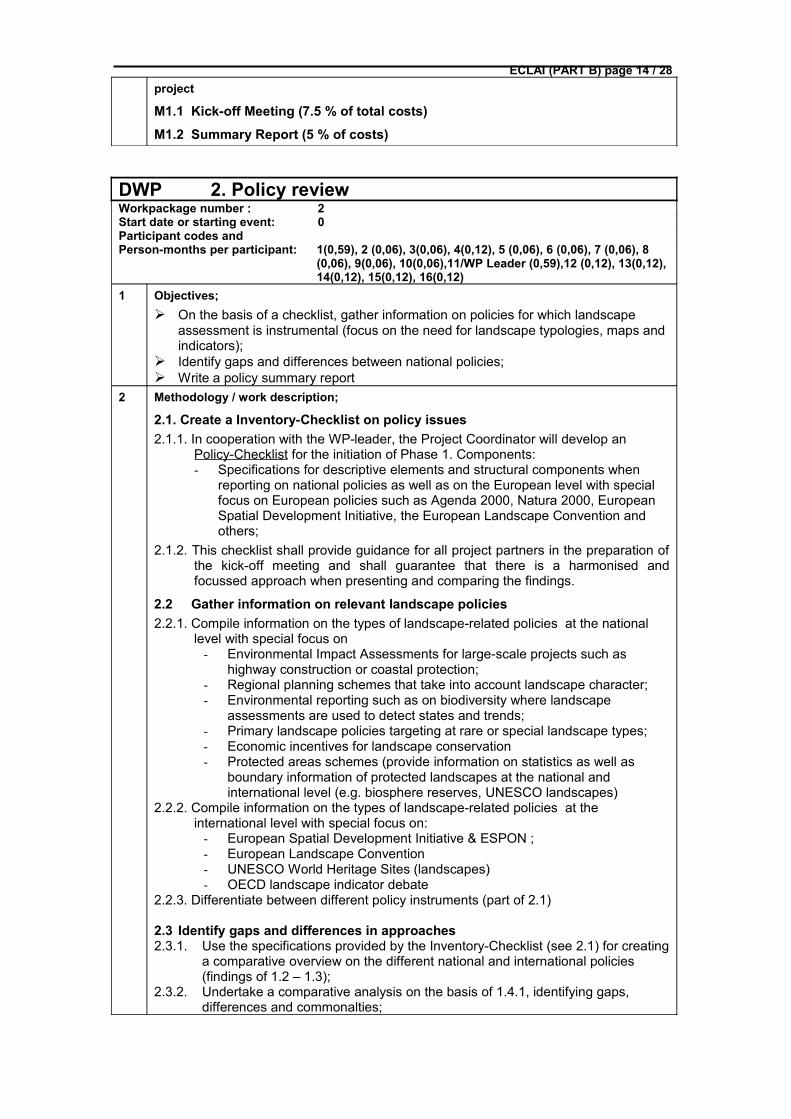
DWP 2. Policy reviewWorkpackage number : 2Start date or starting event: 0 Participant codes andPerson-months per participant: 1(0,59), 2 (0,06), 3(0,06), 4(0,12), 5 (0,06), 6 (0,06), 7 (0,06), 8
(0,06), 9(0,06), 10(0,06),11/WP Leader (0,59),12 (0,12), 13(0,12), 14(0,12), 15(0,12), 16(0,12)
1 Objectives; On the basis of a checklist, gather information on policies for which landscape
assessment is instrumental (focus on the need for landscape typologies, maps and indicators);
Identify gaps and differences between national policies; Write a policy summary report
2 Methodology / work description;
2.1. Create a Inventory-Checklist on policy issues2.1.1. In cooperation with the WP-leader, the Project Coordinator will develop an
Policy-Checklist for the initiation of Phase 1. Components:- Specifications for descriptive elements and structural components when
reporting on national policies as well as on the European level with special focus on European policies such as Agenda 2000, Natura 2000, European Spatial Development Initiative, the European Landscape Convention and others;
2.1.2. This checklist shall provide guidance for all project partners in the preparation of the kick-off meeting and shall guarantee that there is a harmonised and focussed approach when presenting and comparing the findings.
2.2 Gather information on relevant landscape policies2.2.1. Compile information on the types of landscape-related policies at the national
level with special focus on - Environmental Impact Assessments for large-scale projects such as
highway construction or coastal protection;- Regional planning schemes that take into account landscape character;- Environmental reporting such as on biodiversity where landscape
assessments are used to detect states and trends;- Primary landscape policies targeting at rare or special landscape types;- Economic incentives for landscape conservation- Protected areas schemes (provide information on statistics as well as
boundary information of protected landscapes at the national and international level (e.g. biosphere reserves, UNESCO landscapes)
2.2.2. Compile information on the types of landscape-related policies at the international level with special focus on:
- European Spatial Development Initiative & ESPON ;- European Landscape Convention- UNESCO World Heritage Sites (landscapes)- OECD landscape indicator debate
2.2.3. Differentiate between different policy instruments (part of 2.1)
2.3 Identify gaps and differences in approaches2.3.1. Use the specifications provided by the Inventory-Checklist (see 2.1) for creating
a comparative overview on the different national and international policies (findings of 1.2 – 1.3);
2.3.2. Undertake a comparative analysis on the basis of 1.4.1, identifying gaps, differences and commonalties;
ECLAI (PART B) page 15 / 28
2.4 Write the policy summary report2.4.1 Compile all gathered information in one conclusive report that meets scientific
standards in form and quality and which is written in good English language;2.4.2 Make hard copies for circulating results among all project partners and member
of the Steering Committee;2.4.3 Provide all results (including digital material to the Project Coordinator) and
follow instructions of the Lead Institute of WP 10).3 Deliverables including cost of deliverable as percentage of total cost of the proposed
project;
Percentage of WP 2 – costs from total project costs: 5.5 %
D2.1 Inventory Checklist on policy issues
Description: highly structured document that includes definition of terms, technical specifications and formal requirements for the gathering of information by the partners;
Format: written document (10 pages)
Cost: 1 % of total project costs
D2.2 Country reports
Description: responses to the checklist, with descriptive texts that explains the findings, graphs, maps and photos are included;
Format: Report and digital data
Cost: 1,5 % of total project costs
D2.2 Summary report (and co-ordinating tasks)
Description: compilation of all country reports and international reports;
Format: document (75 - 100 pages) and in digital format (also as hard copies)
Cost: 3 % of total project costs
4 Milestones including cost of the Milestone as percentage of total cost of the proposed project
M2.1 Summary Report on policies (3 % of costs)
ECLAI (PART B) page 16 / 28
DWP 3. Stakeholder contactsWorkpackage number : 3Start date or starting event: 0Participant codes and Person-months per participant: 1(0,59), 2 (0,12), 3(0,18), 4(0,12), 5 (0,12), 6 (0,12), 7 (0,12), 8
(0,12), 9(0,12), 10(0,12),11(0,12),12 (0,12), 13(0,12), 14(0,12), 15/WP Leader (0,88), 16(0,12)
1 Objectives: Based on a checklist, gather information on stakeholders that are likely to have
interest in landscape assessments and who must be considered as important partners when implementing landscape assessments and proposing policy decisions;
Identify focal points for information exchange during the project implementation; Write a stakeholder summary report
2 Methodology / work description;
3.1 Create a Inventory-Checklist on stakeholder issues3.1.1 In cooperation with the WP-leader, the Project Coordinator will develop an
Inventory-Checklist for the initiation of Phase 1. 3.1.2 Specifications for descriptive elements and structural components when
reporting on stakeholders (individuals representing sectoral interest) at the national and international level, differentiating between:
- scientific stakeholders (could be individuals from other research organisations who are also engaged in landscape-related assessment tools and who might have developed their own approaches (e.g. hydrologists, having developed an operational drainage basin concept) – hence the emphasis is on cross-disciplinary aspects;
- policy stakeholders (could be members of national agencies, administrative bodies, also ministries in charge of landscape-related policy development or implementation), a link with 1.4 (examples) is desirable;
- economic stakeholders (representative of the economic sectors, such as members of the tourist boards, agricultural industry, traffic associations, etc.)
- level as well as on the European level with special focus on European policies such as Agenda 2000, Natura 2000, European Spatial Development Initiative, the European Landscape Convention and others;
3.1.3 At the international level, special attention should be to given to representatives of “Europe of the Regions” initiative, of the Council of Europe, Eurostat, OECD and others.
3.1.4 This checklist shall provide guidance for all project partners in the preparation of the kick-off meeting and shall guarantee that there is a harmonised and focussed approach when presenting and comparing the findings.
3.2 Gather information on relevant landscape policies3.2.1. Provide information on the activity-fields of the identified stakeholders, as well
as on the type of influence they have on landscape issues; 3.2.2. describe possible linkages with the project;
3.3 Identify focal points3.3.2 Identify for each category of stakeholder (scientific, policy, economic) one focal
point – a role that makes the person stand out as a primary communicator during the project implementation;
3.3.3 Some focal points could be invited to the International Workshop.3.3.4 The selected focal points need to be officially nominated and the individuals
need to be informed about their role;3.3.5 Establish personal contacts with focal points, if necessary pay a visit or meet
on occasion to discuss possible involvement;
ECLAI (PART B) page 17 / 283.4 Write the stakeholder summary report3.4.2 Compile all gathered information in one conclusive report that meets scientific
standards in form and quality and which is written in good English language;3.4.3 Make hard copies for circulating results among all project partners and member
of the Steering Committee;3.4.4 Provide all results (including digital material to the Project Coordinator) and
follow instructions of the Lead Institute of WP 11).3 Deliverables including cost of deliverable as percentage of total cost of the proposed
project;
Percentage of WP 3 – costs from total project costs: 8.5 %
D3.1 Inventory Checklist on stakeholder issues
Description: highly structured document that includes definition of terms, technical specifications and formal requirements for the gathering of information by the partners;
Format: written document (5 pages)
Cost: 1 % of total project costs
D3.2 Country reports & Focal point nominations
Description: responses to the checklist, with descriptive texts that explains the findings, graphs, maps and photos are included;
Format: Report and digital data
Cost: 4,5 % of total project costs
D3.3 Summary report (and coordinating tasks)
Description: compilation of all country reports and international reports;
Format: document (75 - 100 pages) and in digital format (also as hard copies)
Cost: 3 % of total project costs
4 Milestones including cost of the Milestone as percentage of total cost of the proposed project
M3.1 Summary Report on stakeholders (3 % of costs)
ECLAI (PART B) page 18 / 28
DWP 4. Demonstration: European map & typology Workpackage number : 4Start date or starting event: 6Participant codes andPerson-months per participant: 1(1,18), 2 (0,12), 3(0,12), 4(0,18), 5 (0,29), 6 (0,12), 7 (0,12), 8
(0,12), 9(0,12), 10(0,12),11(0,12),12 (0,18), 13/WP leader (0,88), 14(0,18), 15(0,18), 16(0,18)
1 Objectives;
Based on the inventory implemented in Phase 1 (WP 1), existing approaches in the field of landscape mapping and typologies shall be further examined with the goal to determine which technical and methodological requirements are needed for integrating national activities into a European-wide approach that can serve both national and international levels;
Make the comparisons between the different landscape character assessments (WP 1) more concrete by generating area-specific information on concrete landscape units on the basis of both natural and cultural characteristics.
Examine in which way bottom-up versus top-down approaches could be combined in order to reach a high level of compatibility between region/national approaches and the European level (with special attention to the notion of “hierarchy of scales”, to the development of indicators [see WP 5] and to data availability);
Propose those European data sources that would qualify to take a top-ranking position in the hierarchy of scales for future landscape mapping and that could serve as the main structure for integrating bottom-up approaches.
Demonstrate – if technically possible – the spatial integration of bottom-up approaches with the help of simple overlay techniques (hence no data modelling or aggregations) in order to illustrate the proposed conceptual approaches.
In order to reach a high level of ownership and wide policy integration, the activities should follow a successive work programme which allows the identified focal points of stakeholders (WP 3) to comment and interact on draft concepts.
Summarise the finding in a Conceptual Report.
2 Methodology / work description;
4.1 Organisation of a WP-Leader Meeting (#1)
4.1.1. The goal is to discuss with all WP-Leaders scientific and conceptual questions of a future European landscape map, typology and indicators (in support of WP 5) in the context of the findings from Phase 1;
4.1.2 Agree on a draft conceptual framework for the development of a European landscape map and typology, focussing on research requirements, data and knowledge gaps, possible policy applications;
4.1.3 Send the draft concept (that should have an explanatory chapter that can easily be understood also by the non-expert) to all project partners and the focal points (stakeholders) for comments.
4.2 Elaborate a conceptual framework
4.2.1. The WP-Leader together with the Project Coordinator is going to further elaborate the conceptual framework on the basis of the comments by the partners and focal points.
4.2.2. The further elaboration should result in clear suggestions regarding the selection of data sets, addressing reliability (quality) and accessibility and should set the implementation targets for the future development of a European landscape map.
4.2.3. Develop the technical instructions for demonstrating the spatial integration of
ECLAI (PART B) page 19 / 28bottom-up procedures into hierarchically high ranking European information.
4.3 Demonstrate spatial integration
4.3.1. Based on the technical instruction (4.2.3), the Geographic Information Expert teams of the WP-Leader and the Project Coordinator will produce the required demonstrations on spatial integration between different levels of scale.
4.3.2. An effort should be made to assemble ‘spatial clusters’ of landscape types from those countries, based on the same or very similar methodological approaches with special attention to cross-boundary situations.
4.3.3 Produce at least 4 maps, namely (1) a European overview map in which national approaches are integrated, (2) a spatial cluster map of at least three countries bordering at each other and sharing a common landscape typology, (3) a comparison for integrating the regional approach (based on e.g. administrative or historical boundaries) and hierarchical-typological approach (based on scientific criteria).
4.4 Map Synthesis Report
4.4.1 Produce a Synthesis Report in which the elaborated Conceptual Frameworks and the results of the demonstration exercise are included and explained
4.4.2 Send this report with a set of policy-oriented questions to the focal points for comments.
4.4.3. Mail the digital files of the demonstration exercise to leader of WP 10.
3 Deliverables including cost of deliverable as percentage of total cost of the proposed project;
Percentage of WP 4 – costs from total project costs: 12 %
D4.1 Conceptual framework
Description: a document that provides guidance on how and on which basis a future European landscape character assessment could be carried out;
Format: written document (15 – 20 pages)
Cost: 2 % of total project costs
D4.2 Production of 3 demonstration maps
Description: (1) European map in 1 : 10 Mill, colour; (2) Cluster map in 1:5 mill, colour; (3) 2-Country map in 1:5 – 1:10 mill, colour; all maps with legends relating to landscape typology
Format: digital maps and colour hard copies
Cost: 8 % of total project costs
D4.3 Map Synthesis Report
Description: presentation of the conceptual framework and map products, plus explanatory text;
Format: document (20 - 30 pages) with fold-out maps
Cost: 3 % of total project costs
4 Milestones including cost of the Milestone as percentage of total cost of the proposed project
M4.1 Map Synthesis Report (3 % of costs)
ECLAI (PART B) page 20 / 28
DWP 5. Demonstration: Landscape indicatorsWorkpackage number : 5Start date or starting event: 6Participant codes andPerson-months per participant: 1(0,29), 2 (0,47), 3(0,06), 4(0,18), 5 (0,06), 6 (0,06), 7 (0,12), 8
(0,06), 9(0,06), 10(0,06),11(0,06),12(0,12), 13(0,12), 14/WP Leader (0,88), 15(0,12), 16(0,12)
1 Objectives; Based on the Summary Reports on scientific and policy issues, further elaborate on
the criteria for selecting and applying indicators for landscape character assessments at the European level, taking into account both national and international experiences and data availability.
Propose criteria for selecting a core set of landscape indicators at the European level with special emphasis on the Driving Force – Pressure – State – Impact – Response mechanism.
On the basis of definitions and objectives laid down in recent EU policy documents such as Agenda 2000, European Spatial Development Perspective, the European Landscape Convention, make suggestions for how landscape indicators could contribute to future policy implementation.
Link up with WP 4 by testing (possibly in a fictive context, hence without real data) the application and interpretation of the proposed core indicator sets, taking into account the area-specific natural and cultural context associated with the landscape units.
In order to reach a high level of ownership and wide policy integration, the activities should follow a successive work programme which allows the identified focal points of stakeholders (WP 3) to comment and interact on draft concepts.
Organise a WP-Leader Meeting to discuss the results
Summarise the finding in a Synthesis Report.
2 Methodology / work description;
5.1 Elaborate a conceptual framework
5.1.1. The WP-Leader together with the Project Coordinator is going to further elaborate the conceptual framework on the basis of the comments by the partners and focal points.
5.1.2. The further elaboration should result in clear suggestions regarding the selection of data sets, addressing reliability (quality) and accessibility and should set the implementation targets for the future development of a European landscape map.
5.1.3. Develop the technical instructions for demonstrating the spatial referencing of for selected landscape indicator (2 – 3 indicators for driving force – pressure – state – impact – response).
5.2 Demonstrate spatial referencing
5.2.1. Based on the technical instruction (5.1.3), the Geographic Information Expert teams of the WP-Leader and the Project Coordinator produce a demonstration on spatial referencing for 5 landscape indicators. Main goal is to demonstrate the advantage of region-specific benchmarking and interpretation.
5.2.2. An effort should be made to assess causal effects of landscape changes through the chosen indicators.
5.2.3 Produce at least 1 map, namely on the indicator-based assessment of landscape character that links with one of the landscape maps from WP 4 (preferably type (2) or (3).
5.3 Organisation of a WP-Leader Meeting (#2)
5.3.1. The goal is to discuss with all WP-Leaders the result of the demonstration
ECLAI (PART B) page 21 / 28studies and the feedback by stakeholders for both the landscape map/typology as well as for the indicators. scientific and conceptual questions of a future European landscape map;
5.3.2 Prepare the contents and recommendations for the Interim Report (WP 6)
5.3.3 Discuss the planning and invitations for the International Workshop (WP 7)
5.4 Indicator Synthesis Report
5.4.1 Produce a Synthesis Report in which the results of the demonstration exercise are included and explained
5.4.2 Send this report with a set of policy-oriented questions to the focal points for comments.
5.4.3. Mail the digital files of the demonstration exercise to leader of WP 10.
3 Deliverables including cost of deliverable as percentage of total cost of the proposed project;
Percentage of WP 5 – costs from total project costs: 8 %
D5.1 Conceptual framework
Description: a document that provides guidance on how and on which basis a future European landscape character assessment could be carried out;
Format: written document (15 – 20 pages)
Cost: 1 % of total project costs
D5.2 Production of 1 demonstration map
Description: 2 -3 Countries-map in 1:5 – 1:10 mill, colour, demonstrating how landscape typologies can contribute to indicator-based assessments;
Format: digital map and colour hard copies
Cost: 4 % of total project costs
D5.3 Indicator Synthesis Report
Description: presentation of the conceptual framework and map product, plus explanatory text;
Format: document (20 - 30 pages) with fold-out map
Cost: 2 % of total project costs
4 Milestones including cost of the Milestone as percentage of total cost of the proposed project
M5.1 Technical Meeting (#2) of WP-Leaders (1 % of costs)
M5.2 Indicator Synthesis Report (2 % of costs)
ECLAI (PART B) page 22 / 28
DWP 6. Interim ReportWorkpackage number : 6Start date or starting event: 15Participant codes andPerson-months per participant: 1(0,88), 2 (0,18), 3(0,06), 4(0,18), 5 (0,06), 6 (0,06), 7 (0,12), 8
(0,06), 9(0,06), 10(0,06),11(0,18),12(0,18), 13(0,29), 14(0,18), 15(0,18), 16(0,12)
1 Objectives;
Compile all existing information deriving from WP 1 - 5 in one conclusive Interim Report, illustrating current approaches to landscape character assessment at the regional/national levels for the participating countries.
Circulate this report in preparation of WP 7
2 Methodology / work description;
6.1 Compilation and selection of project materials
6.1.1. Put special emphasis on providing linkages between the finding of the different WPs.
6.1.2. Integrate the case studies at functionally adequate places
6.1.3. Formulate recommendations for future research, stakeholder involvement and policy application
6.1.4. Circulate draft among project partners and ask for comments and additions.
6.2 Editing and printing
6.2.1. Edit structure and English language
6.2.2. Print 100 copies in colour copy-quality (no print quality)
6.3. Mailing to wider audience
6.3.1 Mail documents to all partners, focal points and participants of the International Workshop (WP 7).
3 Deliverables including cost of deliverable as percentage of total cost of the proposed project;
Percentage of WP 6 – costs from total project costs: 6,5 %
D6.1 Interim Report
Description: a document that comprises all findings of the first 5 WPs ;
Format: colour copy-quality report (200 – 250 pages)
Cost: 6,5 % of total project costs
4 Milestones including cost of the Milestone as percentage of total cost of the proposed project
M6.1 Interim Report (6,5 % of costs)
ECLAI (PART B) page 23 / 28
DWP 7. International WorkshopWorkpackage number : 7Start date or starting event: 15Participant codes andPerson-months per participant: 1(0,48), Partner 2 - 15 (0,24), 16 (0,47)1 Objectives;
Presentations by a wider range of experts and stakeholders in response to the Interim Report (maps, illustrations, data examples, texts, scientific references to other projects)
discussion of the results with the wider expert field (not the public) in order to receive adequate feed-back for the further project implementation;
stimulation of the policy discussion on future opportunities for agri-environmental assessments at the European level;
multiplication of ideas and concepts through various expert networks.
2 Methodology / work description;
7.1 Technical organisation of the workshop
7.1.1 invitations (EU institutions, Council of Europe, OECD, JRC, Eurostat, Europe of the Regions, national experts), reservations, bookings
7.2 Implementation of workshop
7.2.1 presentations and discussions
7.2.2 analytical work on methodological questions in work sessions
7.2.3. policy analysis in specific work sessions
7.2.4. stakeholder role in specific work sessions (and as horizontal input)
7.3 Summarising the results
7.3.1 Minutes of the Workshop
7.3.2 Circulation of the Workshop results for feed-back by participants
3 Deliverables including cost of deliverable as percentage of total cost of the proposed project;
Percentage of WP 7 – costs from total project costs: 7,5 %
D7.1 International Workshop
Description: workshop implementation ;
Format: 30 – 40 participants, English language
Cost: 7,5 % of total project costs
4 Milestones including cost of the Milestone as percentage of total cost of the proposed project
M7.1 Workshop implementation (7,5 % of costs)
ECLAI (PART B) page 24 / 28
DWP 8. Project reportWorkpackage number : 8Start date or starting event: 16Participant codes andPerson-months per participant: 1(1,17), 2 (0,06), 3(0,06), 4(0,12), 5 (0,06), 6 (0,29), 7 (0,06), 8
(0,06), 9(0,06), 10(0,06),11(0,12),12(0,12), 13(0,12), 14(0,29), 15(0,12), 16(0,12)
1 Objectives Publication of the relevant project findings encompassing the scientific work
undertaken for all previous WPs – including the results of the workshop into one conclusive document
dissemination of free copies of the publication to all project members, focal points, stakeholders, and workshop participants among international experts from research and policy;
dissemination of the publication through a commercial publisher;2 Methodology / work description;
8.1 Draft Project Report
8.1.1 Compile and select all relevant material for the final Project Report (will contain scientific, stakeholder and policy issues)
8.1.2 Mail draft project report to all project members for final comments and input, working in all comments;
8.1.3 Technical preperation for getting all graphs, photos and maps print-ready
8.1.4. Final English editing
8.2 Printing of final Project Report
8.2.1 Agree with publisher on layout
8.2.2 Final proof reading
8.2.3 Printing of the report
8.3 Dissemination
8.3.1 Mailing of free copies to project partners, stakeholders; conference participants and European Commission
8.3.2 Sales of publications on free book market
3 Deliverables including cost of deliverable as percentage of total cost of the proposed project;
Percentage of WP 8 – costs from total project costs: 10,5 %
D7.1 Project Report
Description: publication of the final project report ;
Format: high quality print with colour images of graphs, maps and photos, English language, 1000 copies
Cost: 10,5 % of total project costs (includes 3.5% for printing, a moderate price level due to inhouse capacities of partner 5)
4 Milestones including cost of the Milestone as percentage of total cost of the proposed project
M8.1 Publication of the final Project Report
ECLAI (PART B) page 25 / 28
DWP 9. Policy BrochureWorkpackage number : 9Start date or starting event: 16Participant codes andPerson-months per participant: 1 (0,59), 3 (o,18), 11 (o,29), 15 (0,18)1 Objectives
Publication of brochure undertaken for all previous WPs – including the results of the workshop into one conclusive document
dissemination of free copies of the publication to all project members, focal points, stakeholders, and workshop participants among international experts from research and policy;
dissemination of the publication through a commercial publisher;2 Methodology / work description;
9.1 Technical Meeting (#3) of WP-leaders
9.1.1 Review of all status of all three WP 8 products
9.1.2 Identification of key policy partners for final review
9.1 Drafting of Project Report
9.1.1 Compile and select all relevant material for the final Project Report (will contain scientific, stakeholder and policy issues)
9.1.2 Mail draft project report to identified policy partners, stakeholders and project members for final comments and input, working in all comments;
9.1.3 Technical preperation for getting all graphs, photos and maps print-ready
9.1.4 Final English, Spanish & German editing
9.3 Printing of final Project Report
9.3.1 Agree with publisher on policy-oriented layout
9.3.2 Final proof reading
9.3.3 Printing of the brochure
9.4 Dissemination
9.4.1 Mailing of free copies to project partners, stakeholders; conference participants and European Commission
9.4.2 Sales of publications on free book market
3 Deliverables including cost of deliverable as percentage of total cost of the proposed project;
Percentage of WP 9 – costs from total project costs: 8,5 %
D9.1 Policy brochure
Description: publication of the policy brochure;
Format: high quality print (glossy) with colour images of graphs, maps and photos, if possible in three languages (English, Spanish, German), 30 pages, 2000 copies
Cost: 8,5 % of total project costs (includes 4.5% for printing and translations, price level due to inhouse capacities of partner 5)
4 Milestones including cost of the Milestone as percentage of total cost of the proposed project
M9.1 Publication of the Policy Brochure
DWP 10. Internet Database
ECLAI (PART B) page 26 / 28Workpackage number : 10Start date or starting event: 6 + 14 + 17Participant codes andPerson-months per participant: 1(0,47), 2 (0,06), 3(0,06), 4/WP Leader(0,88), 5 (0,18), 6 (0,06), 7
(0,06), 8 (0,06), 9(0,06), 10(0,06),11(0,12),12(0,12), 13(0,12), 14(0,12), 15(0,12), 16(0,12)
1 Objectives
Establish a state-of-the-art Internet-database the functions on the principles of a search-engine-driven, hierarchically structured and easy to navigate access-port for all relevant information deriving from the project implementation
Place project-output from all WPs periodically on this project Internet-database.
Ensure user-friendly software functioning and intellecual property rights issues
2 Methodology / work description;
10.1 Technically establish the Internet-database
10.1.1 Choose adequate software programme that allows to load substantial ammounts of (graphic) data
10.1.2 Register site on the Internet;
10.1.3 Ensure that property rights issues are respected by making the relevant parts password-accessible only for project participants;
10.1.4 Allow the wider use community to apply for password access;
10.1.5 Provide sufficient linkages with other relevant web-pages
10.1.6 Provide basic information on ECLAI open to the whole public
10.1.7 Choose for an attractive design
10.2 Update the Internet-database periodically
10.2.1 Be in contact with the WP-leaders to ensure that relevant project information is periodically updated (at the end of WP implementation)
10.2.2 Allow all project partners to place information in a structured way on the site, ensure quality control (approval)
10.3 Instructions on Internet-Database configuration
10.3.1 provide a brief technical instructions on the future development of the project Internet-site (in case the site is supposed to be maintained and managed by third parties)
3 Deliverables including cost of deliverable as percentage of total cost of the proposed project
Percentage of WP 10 – costs from total project costs: 7,5 %
D10.1 Internet database
Description: opening of the project internet-database;
Format:
Cost: 7,5 % of total project costs (includes 1% for computing)
4 Milestones including cost of the Milestone as percentage of total cost of the proposed project
M10.1 Internet database
DL Deliverable list
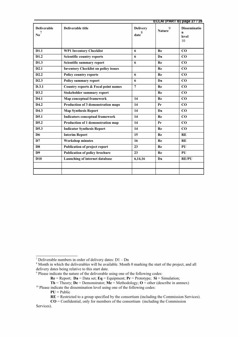
ECLAI (PART B) page 27 / 28
Deliverable
No7
Deliverable title Delivery
date8 Nature
9 Disseminationlevel10
D1.1 WP1 Inventory Checklist 6 Re COD1.2 Scientific country reports 6 Da CO
D1.3 Scientific summary report 6 Re CO
D2.1 Inventory Checklist on policy issues Re CO
D2.2 Policy country reports 6 Re CO
D2.3 Policy summary report 6 Da CO
D.3.1 Country reports & Focal point names 7 Re CO
D3.2 Stakeholder summary report Re CO
D4.1 Map conceptual framework 14 Re CO
D4.2 Production of 3 demonstration maps 14 Pr CO
D4.3 Map Synthesis Report 14 Da CO
D5.1 Indicators conceptual framework 14 Re CO
D5.2 Production of 1 demonstration map 14 Pr CO
D5.3 Indicator Synthesis Report 14 Re CO
D6 Interim Report 15 Re RE
D7 Workshop minutes 16 Re RE
D8 Publication of project report 23 Re PU
D9 Publication of policy brochure 23 Re PU
D10 Launching of internet database 6,14,16 Da RE/PU
7 Deliverable numbers in order of delivery dates: D1 – Dn8 Month in which the deliverables will be available. Month 0 marking the start of the project, and all delivery dates being relative to this start date.9 Please indicate the nature of the deliverable using one of the following codes:
Re = Report; Da = Data set; Eq = Equipment; Pr = Prototype; Si = Simulation;Th = Theory; De = Demonstrator; Me = Methodology; O = other (describe in annnex)
10 Please indicate the dissemination level using one of the following codes:PU = PublicRE = Restricted to a group specified by the consortium (including the Commission Services).CO = Confidential, only for members of the consortium (including the Commission
Services).

ECLAI (PART B) page 28 / 28