Embed Size (px)
Citation preview
I:\NCSR\05\NCSR 5-INF.24.docx
E
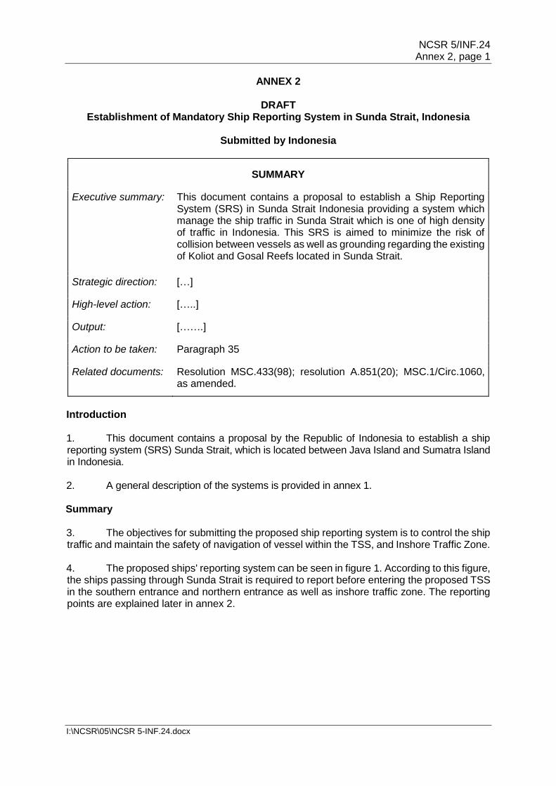
SUB-COMMITTEE ON NAVIGATION, COMMUNICATIONS AND SEARCH AND RESCUE 5th session Agenda item 3
NCSR 5/INF.24
15 December 2017 ENGLISH ONLY
ROUTEING MEASURES AND MANDATORY SHIP REPORTING SYSTEMS
Information on Routeing Measures and Mandatory Ship Reporting Systems in Sunda Strait, Indonesia
Submitted by Indonesia
SUMMARY
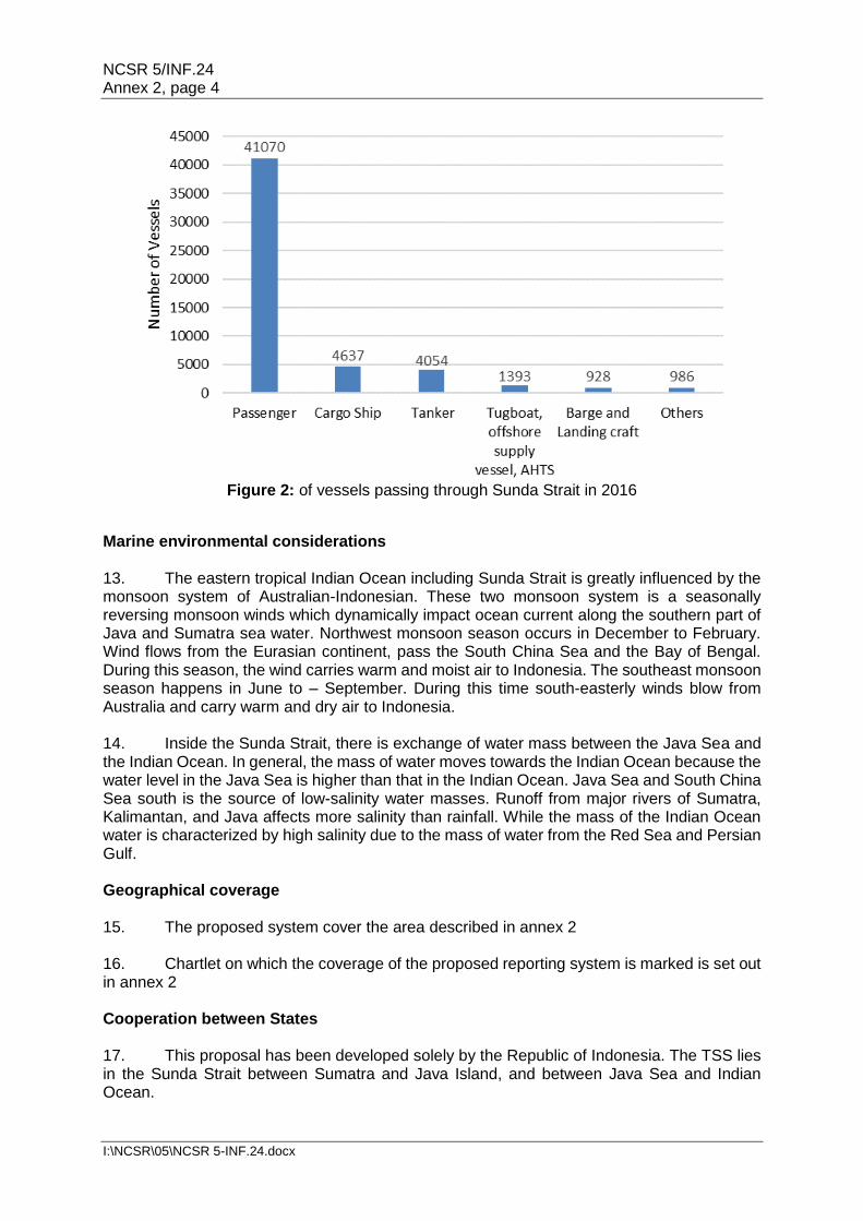
Executive summary: Based on the need to ensure safety of navigation and to reduce the event of ship collision, the Government of Indonesia is preparing for proposals for ship routeing measures and a mandatory ship reporting system for Sunda Strait. The routeing measures in Sunda Strait are proposed in order to establish an IMO-adopted Traffic Separation Scheme (TSS), Precautionary Area, and Inshore Traffic Zone. The proposed routeing measures have been analysed using IWRAP (IALA Waterways Risk Assessment Program) and the designed measures could maintain the traffic in the acceptable risk of collision. The mandatory ship reporting system (SRS) is also proposed as a guidance for ships in entering the strait and to minimize the risk of collision in the areas.
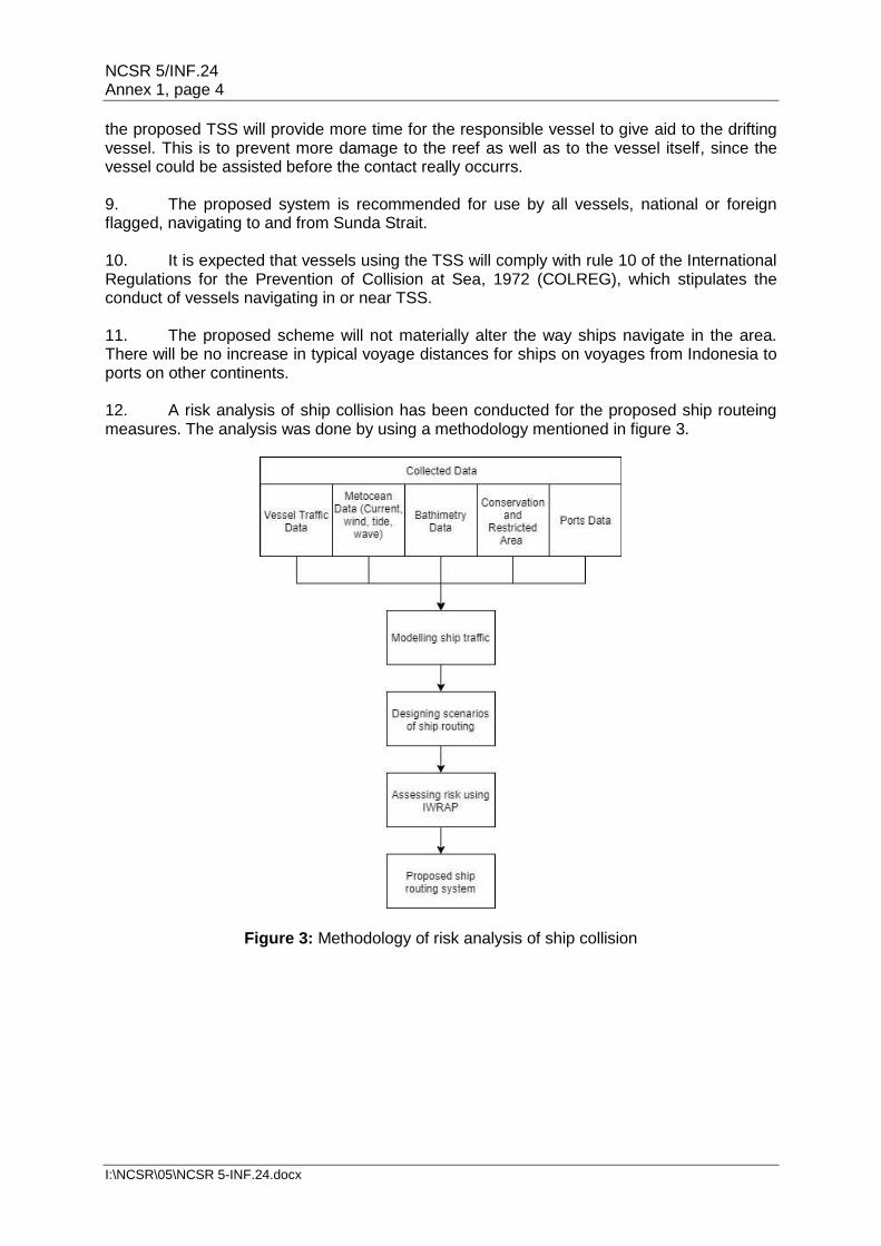
Strategic direction: Other Work
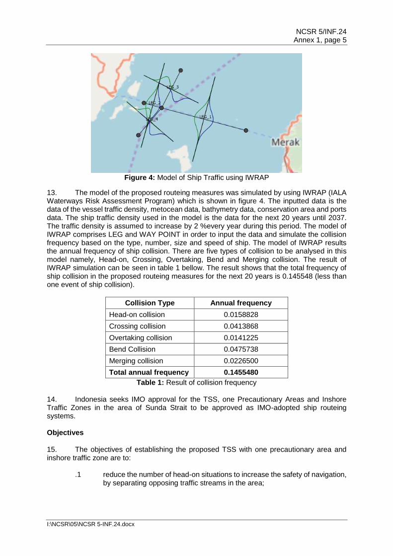
High-level action:
Output: OW 4
Action to be taken: Paragraph 19
Related documents: Resolution A.572(14), as amended; resolution MSC 71(69); resolution MSC 72(69); MSC.1/Circ.1060, as amended;
resolution MSC.433(98) and resolution A.851(20)
Introduction 1 Sunda Strait is considered as one of water areas with the highest traffic density of ships serving national and international shipping. The national ferry routes which cross the strait also one of the busiest ferry traffic in Indonesia. The number of ships passing and crossing the strait is predicted to increase in the future regarding to the economic growth
NCSR 5/INF.24 Page 2
I:\NCSR\05\NCSR 5-INF.24.docx
among the nations. The international shipping is fluctuated by the transportation commodity between Southeast Asia, East Asia and Middle Asia to Australia. Both national and international shipping lane intersects in the straits which induces a risk of collision. There are several history of incidents involving ships in these straits including collision, grounding and fire.
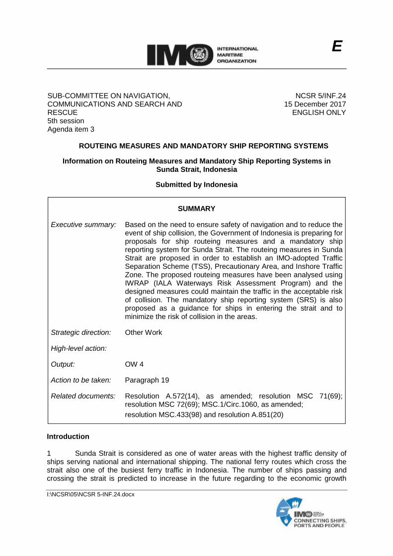
Figure 1: Location of Sunda Strait
2 Sunda Strait lies between Java Island and Sumatra Island. This Strait connects Indian Ocean and Java Sea. Sunda Strait is one of the most important strait in Indonesia which lies a ship traffic lane categorized as IASL I from southbound to northbound of Sunda Strait while there is a high density crossing lane from Java Island and Sumatra Island that mainly passenger vessels utilize. The IASL is also adopted by the IMO through resolution MSC.72(69) in 1998. 3 Indonesia, as the Archipelagic State, has rights to prescribe the Traffic Separation Scheme to enhance the safety of navigation on the Archipelagic Sea Lane, based on Article 53(6) of United Nations Convention on the Law of the Sea (UNCLOS), 1982 and also based on the IMO's General Provisions for the Adoption, Designation and Substitution of Archipelagic Sea Lanes. The designation of the Traffic Separation Scheme will not affect the ships which are exercising the rights of Archipelagic Sea Lane Passage in the Sunda Strait
4 The bathymetry of Sunda Strait has a variation of depth. It includes angular sub basin and steep slopes that the formation is controlled by faulting which makes the contour of bathymetry much more complex. The western part bathymetry of Sunda Strait is constructed of an array of four main ridges, they are the Semangko Horst, the Tabuan, Panaitan and Krakatau Ridges; and two pronounced grabens: the Semangko Graben and the Krakatau Graben. The depth of Semangko Graben variates from less than 800 to 1500 m, while the bathymetry of Krakatau Graben is relatively flat caused by abundance of volcanic deposition since in this area the Krakatau Volcano is located. There is also Koliot reef which is located approximately 1 nautical mile northeast of the shaft IASL I. Koliot reef is a coral reef located in the northwest of Sangiang Island located in the waters of the Sunda Strait. Koliot reefs are very dangerous for the ships that pass through the IASL I that will go to the Indian Ocean from the Java Sea or vice versa.
NCSR 5/INF.24 Page 3
I:\NCSR\05\NCSR 5-INF.24.docx
5 Based on the Indonesian Hydro-Oceanography chart number 12, September 2008 edition, Sunda Strait also contains flora and fauna nature reserve area, such as Sangiang Island, Panaitan Island and Ujung Kulon (Java Island). The waters around Krakatau Island, Krakatau Kecil Island, and Sertung Island are declared as dangerous areas because at any time there is hazard of eruption since these are in the active volcanic area which has the biggest eruption in history. In addition, there is Navy Training Area located in Lampung Bay. Objective 6 The main objective is to propose and establish routing measures and ship reporting systems in Sunda Strait. The routing measures are done by means of Traffic Separation Scheme (TSS), Precautionary Area and Inshore Traffic Zone. Ship reporting system (SRS) is proposed by determining the ship's reporting points for ship entering or crossing the TSS and Precautionary Area. 7 The objectives of establishing TSS with precautionary area, inshore traffic zone and SRS are to:
.1 reduce the number of head-on situations to increase the safety of navigation, by separating opposing traffic streams in the area;
.2 reduce, if not eliminate, the risk of accidental ship grounding by keeping ships well away from coral reef atolls/structures as well as the marine protected areas (MPA);
.3 reduce, if not eliminate, the risk of crossing collision between ships by recommending precautionary area;
.4 prevent and reduce the risk to the environment caused by pollution coming from unlikely event of marine traffic accident; and
.5 ship reporting systems contribute to safety and efficiency of navigation and/or protection of the marine environment in water area of Sunda Strait.
8 Indonesia intends to submit the proposals on establishment of Traffic Separation Scheme (TSS), Inshore Traffic Zone, Area to be Avoided (ATBA), and Ship Reporting System in Sunda Strait on the sixth session of the NCSR Sub-Committee on 2019. 9 Details of the following ship routeing and ship reporting systems in Lombok Strait are provided as follows:
.1 the draft proposal on the Traffic Separation Scheme is provided in annex 1; and
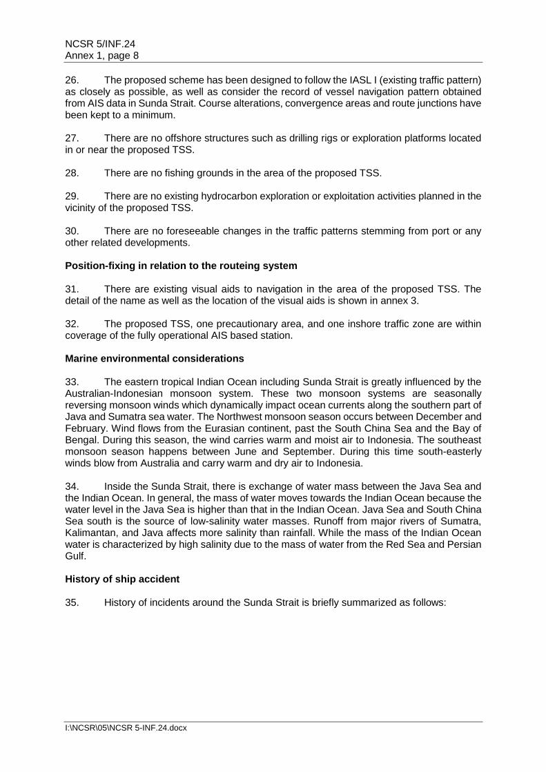
.2 the draft proposal on the Ship Reporting Systems is provided in annex 2.
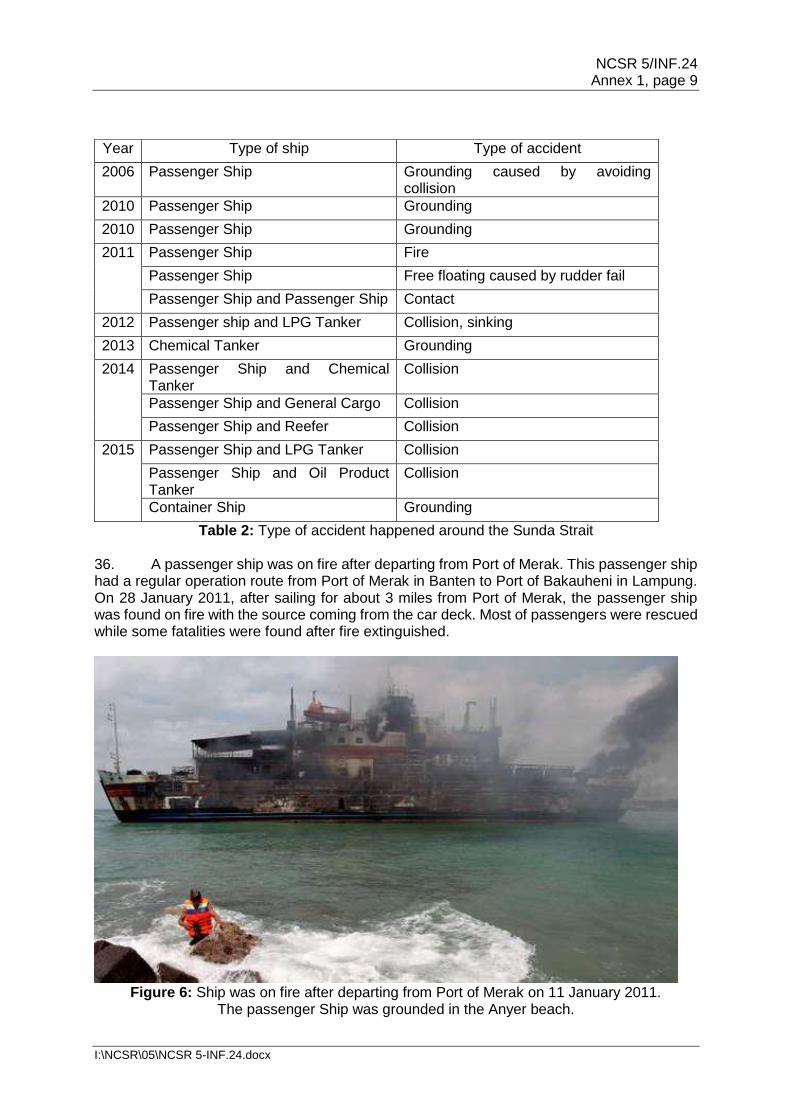
NCSR 5/INF.24 Page 4
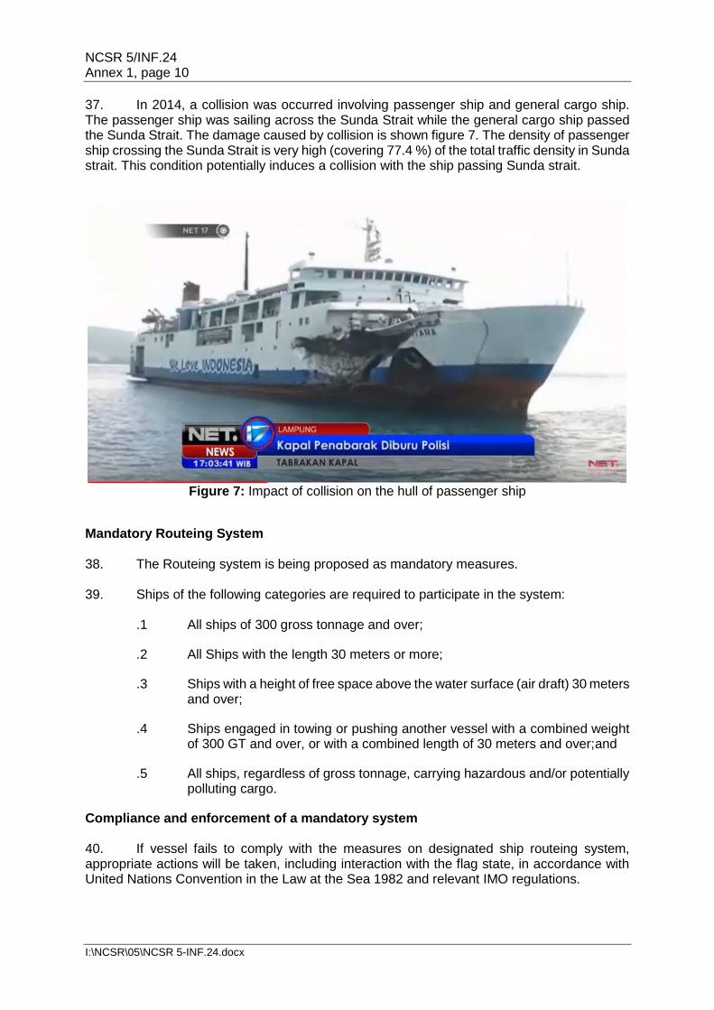
I:\NCSR\05\NCSR 5-INF.24.docx
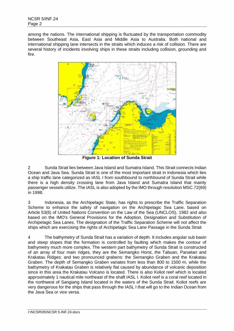
Figure 2: Ship routeing and reporting system in Sunda Strait
Methodology
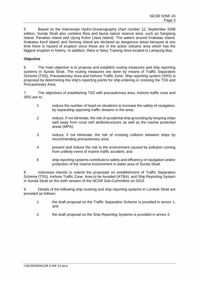
10 The risk assessment was conducted according to methodology as shown in figure 3. Several data are collected and employed in the risk assessment study such as vessel traffic data, metocean data (current, wind, tide, wave), bathymetry data, and location of ports in vicinity of Sunda Strait. Based on these data, routeing measures were designed and modelled. The designed routeing measures and scenario of traffic are then to be assessed using IWRAP.
Figure 3: Routeing design and risk assessment using IWRAP
NCSR 5/INF.24 Page 5
I:\NCSR\05\NCSR 5-INF.24.docx
11 The advantage of using IWRAP software is the ability to accommodate some parameters that cannot be included in manual calculations such as the distribution of traffic density and water depth data which of course will affect the accuracy of the calculation results. 12 Data for traffic pattern and traffic density of Sunda Strait are obtained from port authorities in vicinity of Sunda Strait. Verification of traffic density was done using data provided by an AIS data provider (https://www.marinetraffic.com). The traffic pattern is then to be used as input for designing routeing measures and to be translated and assessed using IWRAP. 13 Three main scenarios of collision were analysed, such as head-on collision, crossing collision and over taking collision. Two scenarios of collision in addition from IWRAP also considered such as bend collision and merging collision. The acceptance criteria for total annual frequency of collision less than unity (annual frequency of 1). 14 The routing measures are modelled to accommodate the future 20 years of vessel traffic until the year 2037. It is assumed that there is 2 % increase of the number of vessel passing and crossing the water area every year.
Mandatory Ship Reporting System (SRS) 15 The SRS is proposed to be mandatory for designated ships according to the proposed routeing measure in Sunda Strait. This SRS provides a system that manage the ship traffic in the strait. SRS guides the vessel to minimize the risk of collision between vessels as well as grounding on the existing coral reefs and the existence of marine protected areas. 16 The proposed routeing measures and SRS are aimed to increase the safety of navigation in the strait by controlling the two-way traffic route as well as the crossing area in order to avoid the event of grounding and collision. Conclusion
17 As mentioned, the risk assessment is employed in order to design the routing measures in Sunda Strait. Several scenarios are constructed during the assessment. Three collision scenarios such as head-on, crossing, overtaking collision including two scenarios given by IWRAP namely bend and merging collision were examined. Given marine traffic data, environmental condition and incident history, the routeing measures that could maintain the safe navigation in these areas are proposed. 18 Feedback and comments on the proposal of the Traffic Separation Scheme (TSS), Inshore Traffic Zone, Area to be Avoided (ATBA), and Ship Reporting System could be further addressed to [email protected], [email protected], and [email protected]. Action requested of the Sub-Committee 19 The Sub-Committee is invited to note the information contained in this document.
***

NCSR 5/INF.24 Annex 1, page 1
I:\NCSR\05\NCSR 5-INF.24.docx
ANNEX 1
DRAFT
Establishment of a new Traffic Separation Scheme, Precautionary Area and Inshore Traffic Zone in Sunda Strait, Indonesia
Submitted by Indonesia
SUMMARY
Executive summary: This document contains a proposal to establish a Traffic Separation Scheme (TSS) in Sunda Strait Indonesia providing the separation of the two streams of routes by using separation line. A precautionary area and inshore traffic zone are also provided for managing the intersection of shipping lane in Sunda Strait. These are aimed to minimize the risk of collision between vessels as well as grounding regarding the existing of Koliot and Gosal Reefs located in Sunda Strait.
Strategic direction:
High-level action:
Planned output:
Action to be taken: Paragraph 46
Related documents: Resolution A.572(14), as amended; resolution MSC 71(69); resolution MSC 72(69) and MSC.1/Circ.1060, as amended
Introduction 1. This document contains a proposal by the Republic of Indonesia to establish an IMO-adopted Traffic Separation Scheme (TSS), one Precautionary Area and one Inshore Traffic Zone, in Sunda Strait, located between Sumatera Island and Java Island in Indonesia. 2. Details of the proposed TSS, Precautionary Area and Inshore Traffic Zone are provided as follows:
.1 a general description of the TSS and the Inshore Traffic Zones is provided in annex 1;
.2 the names, numbers, editions and geodetic datum of the reference charts as well as the geographical coordinates that define the TSS, Precautionary Area and Inshore Traffic Zone are provided in annex 2; and
.3 the existing visual aids to navigation in the area are provided in annex 3.
NCSR 5/INF.24 Annex 1, page 2
I:\NCSR\05\NCSR 5-INF.24.docx
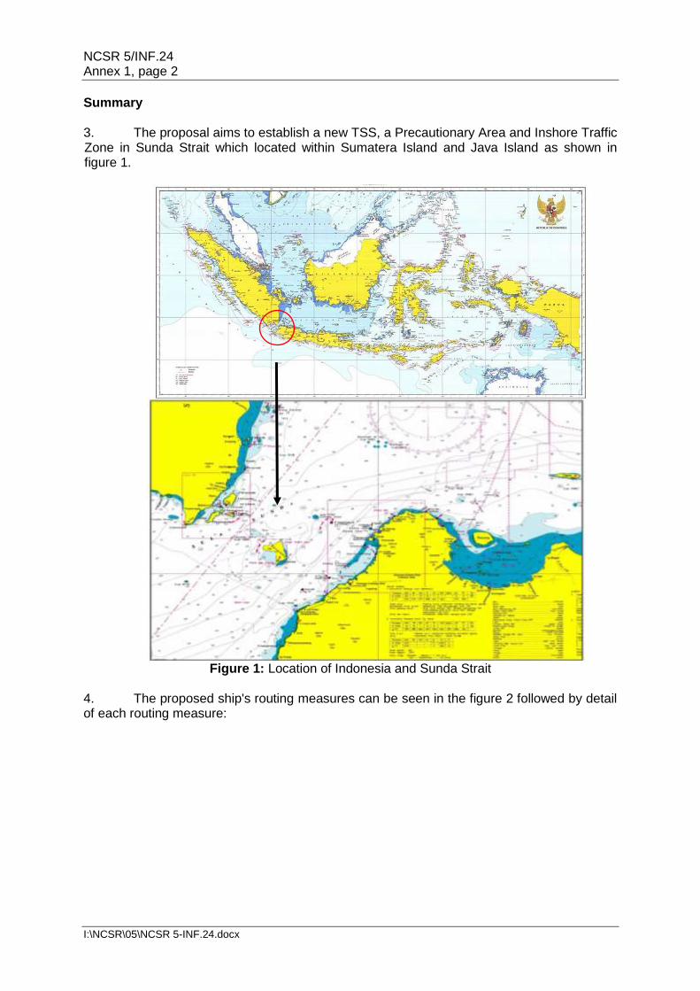
Summary 3. The proposal aims to establish a new TSS, a Precautionary Area and Inshore Traffic Zone in Sunda Strait which located within Sumatera Island and Java Island as shown in figure 1.
Figure 1: Location of Indonesia and Sunda Strait
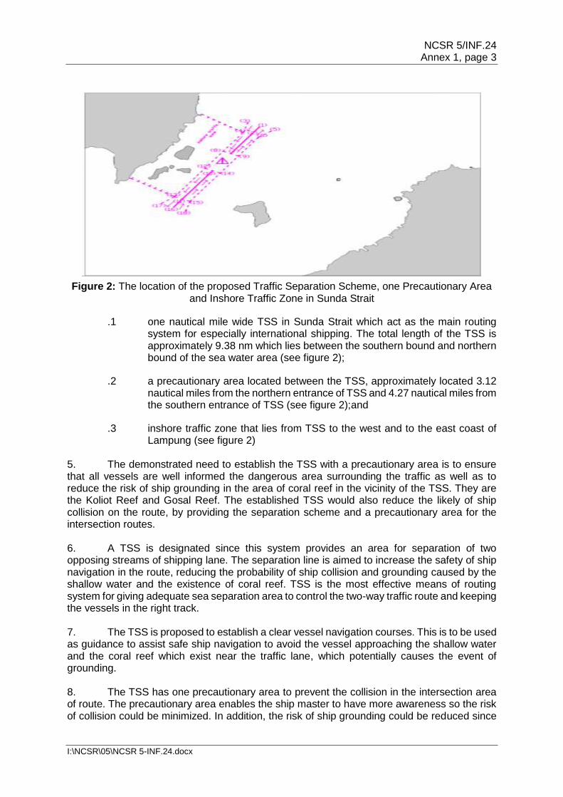
4. The proposed ship's routing measures can be seen in the figure 2 followed by detail of each routing measure:
NCSR 5/INF.24 Annex 1, page 3
I:\NCSR\05\NCSR 5-INF.24.docx
Figure 2: The location of the proposed Traffic Separation Scheme, one Precautionary Area and Inshore Traffic Zone in Sunda Strait
.1 one nautical mile wide TSS in Sunda Strait which act as the main routing system for especially international shipping. The total length of the TSS is approximately 9.38 nm which lies between the southern bound and northern bound of the sea water area (see figure 2);
.2 a precautionary area located between the TSS, approximately located 3.12 nautical miles from the northern entrance of TSS and 4.27 nautical miles from the southern entrance of TSS (see figure 2);and
.3 inshore traffic zone that lies from TSS to the west and to the east coast of Lampung (see figure 2)
5. The demonstrated need to establish the TSS with a precautionary area is to ensure that all vessels are well informed the dangerous area surrounding the traffic as well as to reduce the risk of ship grounding in the area of coral reef in the vicinity of the TSS. They are the Koliot Reef and Gosal Reef. The established TSS would also reduce the likely of ship collision on the route, by providing the separation scheme and a precautionary area for the intersection routes. 6. A TSS is designated since this system provides an area for separation of two opposing streams of shipping lane. The separation line is aimed to increase the safety of ship navigation in the route, reducing the probability of ship collision and grounding caused by the shallow water and the existence of coral reef. TSS is the most effective means of routing system for giving adequate sea separation area to control the two-way traffic route and keeping the vessels in the right track. 7. The TSS is proposed to establish a clear vessel navigation courses. This is to be used as guidance to assist safe ship navigation to avoid the vessel approaching the shallow water and the coral reef which exist near the traffic lane, which potentially causes the event of grounding. 8. The TSS has one precautionary area to prevent the collision in the intersection area of route. The precautionary area enables the ship master to have more awareness so the risk of collision could be minimized. In addition, the risk of ship grounding could be reduced since
NCSR 5/INF.24 Annex 1, page 4
I:\NCSR\05\NCSR 5-INF.24.docx
the proposed TSS will provide more time for the responsible vessel to give aid to the drifting vessel. This is to prevent more damage to the reef as well as to the vessel itself, since the vessel could be assisted before the contact really occurrs. 9. The proposed system is recommended for use by all vessels, national or foreign flagged, navigating to and from Sunda Strait. 10. It is expected that vessels using the TSS will comply with rule 10 of the International Regulations for the Prevention of Collision at Sea, 1972 (COLREG), which stipulates the conduct of vessels navigating in or near TSS. 11. The proposed scheme will not materially alter the way ships navigate in the area. There will be no increase in typical voyage distances for ships on voyages from Indonesia to ports on other continents. 12. A risk analysis of ship collision has been conducted for the proposed ship routeing measures. The analysis was done by using a methodology mentioned in figure 3.
Figure 3: Methodology of risk analysis of ship collision
NCSR 5/INF.24 Annex 1, page 5
I:\NCSR\05\NCSR 5-INF.24.docx
Figure 4: Model of Ship Traffic using IWRAP
13. The model of the proposed routeing measures was simulated by using IWRAP (IALA Waterways Risk Assessment Program) which is shown in figure 4. The inputted data is the data of the vessel traffic density, metocean data, bathymetry data, conservation area and ports data. The ship traffic density used in the model is the data for the next 20 years until 2037. The traffic density is assumed to increase by 2 %every year during this period. The model of IWRAP comprises LEG and WAY POINT in order to input the data and simulate the collision frequency based on the type, number, size and speed of ship. The model of IWRAP results the annual frequency of ship collision. There are five types of collision to be analysed in this model namely, Head-on, Crossing, Overtaking, Bend and Merging collision. The result of IWRAP simulation can be seen in table 1 bellow. The result shows that the total frequency of ship collision in the proposed routeing measures for the next 20 years is 0.145548 (less than one event of ship collision).
Collision Type Annual frequency
Head-on collision 0.0158828
Crossing collision 0.0413868
Overtaking collision 0.0141225
Bend Collision 0.0475738
Merging collision 0.0226500
Total annual frequency 0.1455480
Table 1: Result of collision frequency 14. Indonesia seeks IMO approval for the TSS, one Precautionary Areas and Inshore Traffic Zones in the area of Sunda Strait to be approved as IMO-adopted ship routeing systems. Objectives 15. The objectives of establishing the proposed TSS with one precautionary area and inshore traffic zone are to:
.1 reduce the number of head-on situations to increase the safety of navigation, by separating opposing traffic streams in the area;
NCSR 5/INF.24 Annex 1, page 6
I:\NCSR\05\NCSR 5-INF.24.docx
.2 reduce, if not eliminate, the risk of accidental ship grounding by keeping ships well away from the Sangiang Island and their component coral reef atolls/structures;
.3 ensure that ships follow routes absolutely free from the known dangers posed by the coral reef atolls/structures in the Sangiang Island by recommending TSS;
.4 reduce, if not eliminate, the risk of collision between ships by recommending one precautionary area; and
.5 prevent and reduce the risk to the environment caused by pollution coming from the unlikely event of a marine traffic accident.
Description of the area 16. Sunda Strait lies between Java Island and Sumatra Island. This Strait connects Indian Ocean and Java Sea. Sunda Strait is one of the most important straits in Indonesia which lies a ship traffic lane categorized as IASL I from southbound to northbound of Sunda Strait, while there is a high density crossing lane from Java Island and Sumatra Island that is mainly used by passenger vessels. 17. The bathymetry of Sunda Strait has a variation of depth. It includes angular sub basin and steep slopes that the formation is controlled by faulting which makes the contour of bathymetry much more complex. The western part bathymetry of Sunda Strait is constructed of an array of four main ridges, they are the Semangko Horst, the Tabuan, Panaitan and Krakatau Ridges; and two pronounced grabens: the Semangko Graben and the Krakatau Graben. The depth of Semangko Graben variates from less than 800 to 1500 m, while the bathymetry of Krakatau Graben is relatively flat caused by abundance of volcanic deposition since the Krakatau Volcano is located in this area. There is also Koliot reef which is located approximately 1 nautical mile northeast of the shaft IASL I. Koliot reef is a coral reef located in the northwest of Sangiang Island located in the waters of the Sunda Strait. Koliot reefs are very dangerous for the ships that pass through the IASL I that will go to the Indian Ocean from the Java Sea or vice versa. 18. Based on the Indonesian Hydro-Oceanography chart number 12, September 2008 edition, Sunda Strait also contain flora and fauna nature reserve area, such as Sangiang Island, Panaitan Island and Ujung Kulon (Java Island). The waters around Krakatau Island, Krakatau Kecil Island, and Sertung Island are declared as dangerous areas because at any time there is hazard of eruption, since these are active volcanic areas which have had the biggest eruption in history. In addition, there is Navy Training Area located in Lampung Bay. 19. There is one inshore lane that has been proposed, as there is a lot of coastal traffic in the eastern bound and western bound of the Sunda Strait. Cooperation between States 20. This proposal has been developed solely by the Republic of Indonesia. The TSS lies in the Sunda Strait between Sumatra and Java Island, and between Java Sea and Indian Ocean. 21. The Indonesian government has deeply communicated with all the stakeholders which are concerned with the existence of the route, namely government agencies, shipping companies, ship owners, port management, ship operator association.
NCSR 5/INF.24 Annex 1, page 7
I:\NCSR\05\NCSR 5-INF.24.docx
Traffic considerations 22. According to the Indonesian Law Number 6 Year 1996 on Indonesian Waters and Government Regulation Number 37 Year 2002 on Rights and Obligations of Foreign Ship and Aircraft Exercising Archipelagic Sea Lanes Passage in Designated Archipelagic Sea Lanes, Sunda Strait is designated as Indonesian Archipelagic Sea Lanes (IASL) II. This Strait serves as a domestic and international sea lane and also crossed by ferries between Java and Sumatra islands. The IASL also adopted by the IMO through the resolution MSC.72(69) on 1998. 23. Indonesia as the Archipelagic State has the right to prescribe the Traffic Separation Scheme to enhance the safety of navigation, based on the Article 53(6) of United Nations Convention on the Law of the Sea (UNCLOS) 1982 and also based on the IMO's General Provisions for the Adoption, Designation and Substitution of Archipelagic Sea Lanes. The designation of the Traffic Separation Scheme will not be affecting the ships which exercising the rights of Archipelagic Sea Lane Passage in the Sunda Strait. 24. There were 53,068 vessel voyages made through the area of Sunda Strait in 2016. This translates to about 145 ships per day. Of these, 77.4% were passenger ships, 8.7% were cargo ships, 7.6% were tanker, 2.6% tugboat, offshore supply vessel and AHTS, 1.7 % were barge and landing craft, and 1.9% others (Chips, bitumen, wood, cement, vehicle, livestock, urea, carrier, research, fishing, and sailing vessel etc.). 25. There is fluctuation in the shipping activity near the Sunda Strait. The fluctuation is caused by two main shipping routes which intersect at the middle of Sunda Strait. An international shipping route which lies on the north – south bound intersects with national shipping route which lies on the east – west bound of Sunda Strait. The international shipping route is fluctuated by the transportation of commodities between South East, East Asia and middle Asia country to Australia. While the national shipping route is fluctuated by the crossing of shipping routes between Port of Merak, Port of Tanjung Priok, Port of Bakauheni and other port in district of Banten. Ship traffic density between these routes is likely to grow since the Indonesian government are speeding up the Indonesia maritime development by proposing sea highway.
Figure 5: Number of vessels passing through Sunda Strait in 2016
NCSR 5/INF.24 Annex 1, page 8
I:\NCSR\05\NCSR 5-INF.24.docx
26. The proposed scheme has been designed to follow the IASL I (existing traffic pattern) as closely as possible, as well as consider the record of vessel navigation pattern obtained from AIS data in Sunda Strait. Course alterations, convergence areas and route junctions have been kept to a minimum. 27. There are no offshore structures such as drilling rigs or exploration platforms located in or near the proposed TSS. 28. There are no fishing grounds in the area of the proposed TSS. 29. There are no existing hydrocarbon exploration or exploitation activities planned in the vicinity of the proposed TSS. 30. There are no foreseeable changes in the traffic patterns stemming from port or any other related developments. Position-fixing in relation to the routeing system 31. There are existing visual aids to navigation in the area of the proposed TSS. The detail of the name as well as the location of the visual aids is shown in annex 3. 32. The proposed TSS, one precautionary area, and one inshore traffic zone are within coverage of the fully operational AIS based station. Marine environmental considerations 33. The eastern tropical Indian Ocean including Sunda Strait is greatly influenced by the Australian-Indonesian monsoon system. These two monsoon systems are seasonally reversing monsoon winds which dynamically impact ocean currents along the southern part of Java and Sumatra sea water. The Northwest monsoon season occurs between December and February. Wind flows from the Eurasian continent, past the South China Sea and the Bay of Bengal. During this season, the wind carries warm and moist air to Indonesia. The southeast monsoon season happens between June and September. During this time south-easterly winds blow from Australia and carry warm and dry air to Indonesia. 34. Inside the Sunda Strait, there is exchange of water mass between the Java Sea and the Indian Ocean. In general, the mass of water moves towards the Indian Ocean because the water level in the Java Sea is higher than that in the Indian Ocean. Java Sea and South China Sea south is the source of low-salinity water masses. Runoff from major rivers of Sumatra, Kalimantan, and Java affects more salinity than rainfall. While the mass of the Indian Ocean water is characterized by high salinity due to the mass of water from the Red Sea and Persian Gulf. History of ship accident 35. History of incidents around the Sunda Strait is briefly summarized as follows:
NCSR 5/INF.24 Annex 1, page 9
I:\NCSR\05\NCSR 5-INF.24.docx
Table 2: Type of accident happened around the Sunda Strait 36. A passenger ship was on fire after departing from Port of Merak. This passenger ship had a regular operation route from Port of Merak in Banten to Port of Bakauheni in Lampung. On 28 January 2011, after sailing for about 3 miles from Port of Merak, the passenger ship was found on fire with the source coming from the car deck. Most of passengers were rescued while some fatalities were found after fire extinguished.
Figure 6: Ship was on fire after departing from Port of Merak on 11 January 2011.
The passenger Ship was grounded in the Anyer beach.
Year Type of ship Type of accident
2006 Passenger Ship Grounding caused by avoiding collision
2010 Passenger Ship Grounding
2010 Passenger Ship Grounding
2011 Passenger Ship Fire
Passenger Ship Free floating caused by rudder fail
Passenger Ship and Passenger Ship Contact
2012 Passenger ship and LPG Tanker Collision, sinking
2013 Chemical Tanker Grounding
2014 Passenger Ship and Chemical Tanker
Collision
Passenger Ship and General Cargo Collision
Passenger Ship and Reefer Collision
2015 Passenger Ship and LPG Tanker Collision
Passenger Ship and Oil Product Tanker
Collision
Container Ship Grounding
NCSR 5/INF.24 Annex 1, page 10
I:\NCSR\05\NCSR 5-INF.24.docx
37. In 2014, a collision was occurred involving passenger ship and general cargo ship. The passenger ship was sailing across the Sunda Strait while the general cargo ship passed the Sunda Strait. The damage caused by collision is shown figure 7. The density of passenger ship crossing the Sunda Strait is very high (covering 77.4 %) of the total traffic density in Sunda strait. This condition potentially induces a collision with the ship passing Sunda strait.
Figure 7: Impact of collision on the hull of passenger ship
Mandatory Routeing System 38. The Routeing system is being proposed as mandatory measures. 39. Ships of the following categories are required to participate in the system:
.1 All ships of 300 gross tonnage and over;
.2 All Ships with the length 30 meters or more;
.3 Ships with a height of free space above the water surface (air draft) 30 meters and over;
.4 Ships engaged in towing or pushing another vessel with a combined weight of 300 GT and over, or with a combined length of 30 meters and over;and
.5 All ships, regardless of gross tonnage, carrying hazardous and/or potentially polluting cargo.
Compliance and enforcement of a mandatory system 40. If vessel fails to comply with the measures on designated ship routeing system, appropriate actions will be taken, including interaction with the flag state, in accordance with United Nations Convention in the Law at the Sea 1982 and relevant IMO regulations.
NCSR 5/INF.24 Annex 1, page 11
I:\NCSR\05\NCSR 5-INF.24.docx
Management 41. There are risk management measures in place in the Sunda Strait. These include:
.1 fit for purpose navigational charts (both paper and electronic); and
.2 adequate visual and electronic aids to navigation.
42. The proposed TSS can be reasonably expected to reduce the risk of collision, reduce and delay the risk of pollution or other harm to the marine environment. 43. There are AIS based stations operated by Directorate General of Sea Transportation which are able to reach the AIS signal from ships located in the area, namely VTS Merak, VTS Jakarta and VTS Center Panjang. These AIS based stations recognize all the ship located in the TSS as well as the ships which are out of TSS. By using this AIS data, there is the possibility to make every effort to force the vessels which are out of TSS to maintain their voyage in the right track. Miscellaneous information 44. Extensive consultation has taken place with Indonesia government departments and agencies, shipowners and managers and other local interests. Proposed date of implementation 45. It is proposed that the TSS will enter into force six months after adoption by the Maritime Safety Committee. Action requested of the Sub-Committee [46 The Sub-Committee is invited to consider the proposal and recommend the proposal to the Maritime Safety Committee for adoption.]
NCSR 5/INF.24 Annex 1, page 12
I:\NCSR\05\NCSR 5-INF.24.docx
Annex 1
Description of the Proposed Traffic Separation Scheme and Inshore Traffic Zones General Description of the Traffic Separation Scheme The traffic separation scheme "Sunda Strait'' consists of three parts: a) A separation line connects the following geographical positions: (1) 5° 48.83'S, 105° 51.31'E (2) 5° 49.62'S, 105° 50.82'E b) A traffic lane for southbound traffic is established between the separation line in paragraph (a) above and a line connecting the following geographical positions: (3) 5° 48.38'S, 105° 50.65'E (4) 5° 49.37'S, 105° 50.38'E c) A traffic lane for northbound traffic is established between the separation line in paragraph (a) above and a line connecting the following geographical positions: (5) 5° 49.22'S, 105° 51.98'E (6) 5° 49.87'S, 105° 51.25'E d) A separation line connects the following geographical positions: (2) 5° 49.62'S, 105° 50.82'E (7) 5° 51.50'S, 105° 49.67'E e) A traffic lane for southbound traffic is established between the separation line in paragraph (d) above and a line connecting the following geographical positions: (4) 5° 49.37'S, 105° 50.38'E (8) 5° 51.27'S, 105° 49.22'E f) A traffic lane for northbound traffic is established between the separation line in paragraph (d) above and a line connecting the following geographical positions: (6) 5° 49.87'S, 105° 51.25'E (9) 5° 51.73'S, 105° 50.10'E g) A precautionary area is established bounded by a line joining the following geographical positions: (8) 5° 51.27'S, 105° 49.22'E (12) 5° 53.11'S, 105° 48.08'E (9) 5° 51.73'S, 105° 50.10'E (14) 5° 53.59'S, 105° 48.96'E h) A separation line connects the following geographical positions: (10) 5° 53.35'S, 105° 48.53'E (11) 5° 56.03'S, 105° 46.85'E i) A traffic lane for southbound traffic is established between the separation line in paragraph (h) above and a line connecting the following geographical positions: (12) 5° 53.11'S, 105° 48.08'E (13) 5° 55.82'S, 105° 46.40'E j) A traffic lane for northbound traffic is established between the separation line in paragraph (h) above and a line connecting the following geographical positions: (14) 5° 53.59'S, 105° 48.96'E (15) 5° 56.27'S, 105° 47.30'E
NCSR 5/INF.24 Annex 1, page 13
I:\NCSR\05\NCSR 5-INF.24.docx
k) A separation line connects the following geographical positions: (11) 5° 56.03'S, 105° 46.85'E (16) 5° 56.85'S, 105° 46.35'E l) A traffic lane for southbound traffic is established between the separation line in paragraph (k) above and a line connecting the following geographical positions: (13) 5° 55.82'S, 105° 46.40'E (17) 5° 56.47'S, 105° 45.64'E m) A traffic lane for northbound traffic is established between the separation line in paragraph (k) above and a line connecting the following geographical positions: (15) 5° 56.27'S, 105° 47.30'E (18) 5° 57.27'S, 105° 47.07'E Inshore traffic zone The area between the western landward boundary of the traffic separation scheme and Ruguk, Ketapang, South Lampung coast and between a line drawn in the direction of 307° from position (4), and a line drawn from position (13) in the direction 306° to Tanjung Tua, Bakauheni, South Lampung coast, is designated as an inshore traffic zone.
NCSR 5/INF.24 Annex 1, page 14
I:\NCSR\05\NCSR 5-INF.24.docx
Annex 2
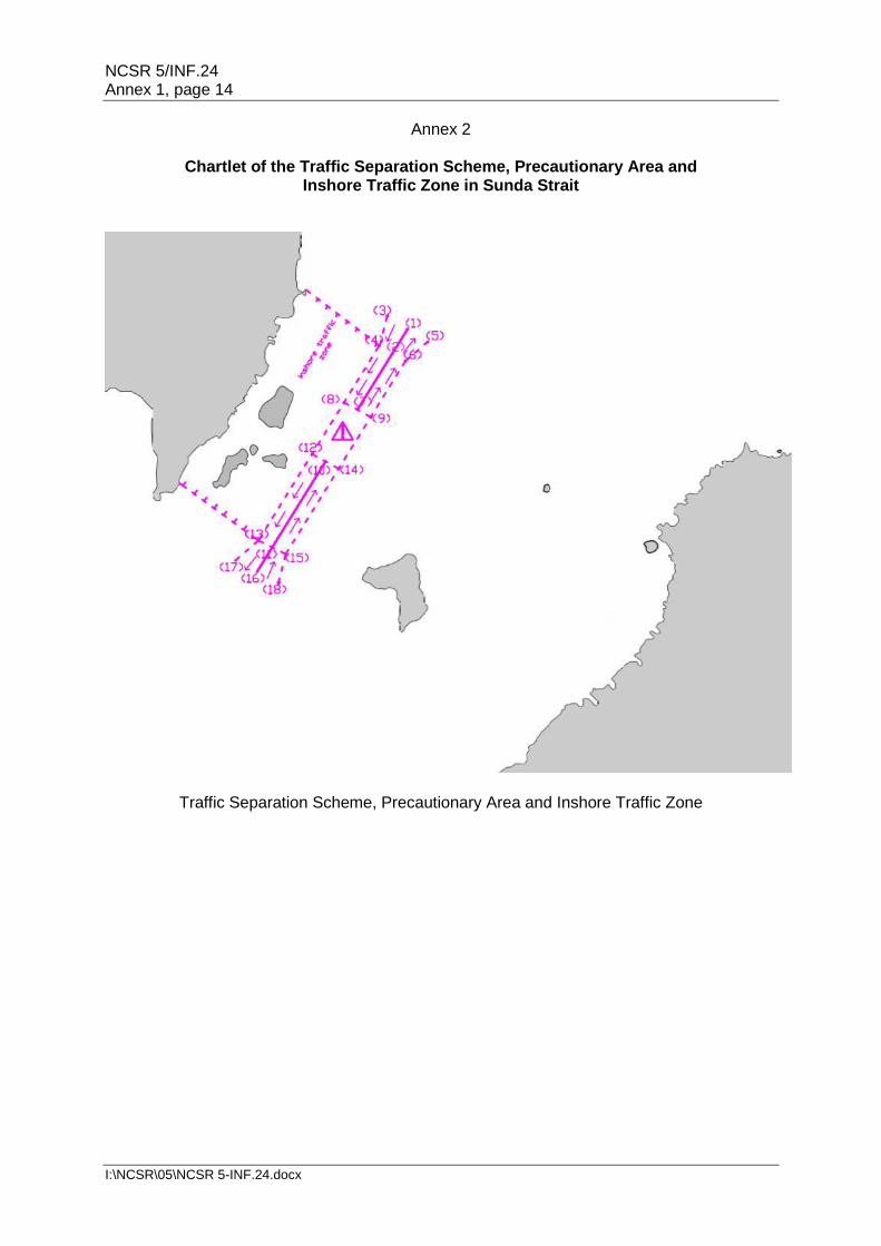
Chartlet of the Traffic Separation Scheme, Precautionary Area and Inshore Traffic Zone in Sunda Strait
Traffic Separation Scheme, Precautionary Area and Inshore Traffic Zone
NCSR 5/INF.24 Annex 1, page 15
I:\NCSR\05\NCSR 5-INF.24.docx
Annex 3
Coordinates of Existing Navigation Aids
The name as well as the location of the existing visual aids to navigation in the area of the proposed TSS are listed in detail as follow:
.1 Cikoneng light 06° 04.00'S/ 105° 53.00'E
.2 Tempurung light 05° 54.05'S/ 105° 56.00'E
.3 Serdang light 05° 49.33'S/ 105° 23.50'E
.4 Merak Besar beacon light 05° 56.08'S/ 105° 59.53'E
.5 Gosong Serdang beacon light 05° 04.50'S/ 106° 16.60'E
.6 Pulau Ular beacon light 06° 28.31'S/ 105° 39.88'E
.7 Sangiyang beacon light 05° 58.33'S/ 105° 51.13'E
.8 Sebeku beacon light 05° 51.00'S/ 105° 32.00'E
.9 Pulau Rakata beacon light 06° 09.74'S/ 105° 27.53'E
.10 Tanjung Tua beacon light 05° 54.37'S/ 105° 43.00'E
.11 Pulau Tiga beacon light 05° 49.17'S/ 105° 32.54'E
.12 Pasir Brower buoy light 05° 56.74'S/ 105° 58.80'E
.13 Karang Ayer Serdang buoy light 05° 59.23'S/ 106° 46.50'E
***

NCSR 5/INF.24 Annex 2, page 1
I:\NCSR\05\NCSR 5-INF.24.docx
ANNEX 2
DRAFT
Establishment of Mandatory Ship Reporting System in Sunda Strait, Indonesia
Submitted by Indonesia
SUMMARY
Executive summary: This document contains a proposal to establish a Ship Reporting System (SRS) in Sunda Strait Indonesia providing a system which manage the ship traffic in Sunda Strait which is one of high density of traffic in Indonesia. This SRS is aimed to minimize the risk of collision between vessels as well as grounding regarding the existing of Koliot and Gosal Reefs located in Sunda Strait.
Strategic direction: […]
High-level action: […..]
Output: […….]
Action to be taken: Paragraph 35
Related documents: Resolution MSC.433(98); resolution A.851(20); MSC.1/Circ.1060, as amended.
Introduction 1. This document contains a proposal by the Republic of Indonesia to establish a ship reporting system (SRS) Sunda Strait, which is located between Java Island and Sumatra Island in Indonesia. 2. A general description of the systems is provided in annex 1. Summary 3. The objectives for submitting the proposed ship reporting system is to control the ship traffic and maintain the safety of navigation of vessel within the TSS, and Inshore Traffic Zone. 4. The proposed ships' reporting system can be seen in figure 1. According to this figure, the ships passing through Sunda Strait is required to report before entering the proposed TSS in the southern entrance and northern entrance as well as inshore traffic zone. The reporting points are explained later in annex 2.
NCSR 5/INF.24 Annex 2, page 2
I:\NCSR\05\NCSR 5-INF.24.docx
Figure 1: Proposed ships' reporting system in Sunda Strait
5. The demonstrated need for its establishment as a mandatory system is the Sunda Strait has two main traffic flow, i.e national crossing traffic and international passing traffic, which have high traffic density. The SRS is required to manage the traffic as well as maintain the safety of the ship navigation in the area. 6. The categories of ships required to participate in the proposed system are
.1 all ships of 300 gross tonnage and over;
.2 all Ships with the length 30 meters or more;
.3 ships with a height of free space above the water surface (airdraft) 30 meters and over;
.4 ships engaged in towing or pushing another vessel with a combined weight of 300 GT and over, or with a combined length of 30 meters and over;
.5 all ships, regardless of gross tonnage, carrying hazardous and/or potentially polluting cargo, as defined in paragraph 1.4 of the Guidelines and criteria for ship reporting systems (resolution MSC.43(64));
.6 all passenger ships equipped with VHF, regardless to its length or weight; and
.7 all categories of ships less than 30 meters in length, or less than 300 GT equipped with VHF which is using the appropriate traffic lane or separation zone in an emergency in order to avoid immediate danger.
NCSR 5/INF.24 Annex 2, page 3
I:\NCSR\05\NCSR 5-INF.24.docx
Hydrographical, meteorological and environmental consideration 7. Existing and proposed aids to navigation in the reporting area are stated in annex 3. 8. Sunda Strait lies between Java Island and Sumatra Island. This Strait connects Indian Ocean and Java Sea. Sunda Strait is one of the most important strait in Indonesia which lies a ship traffic lane categorized as IASL I from southbound to northbound of Sunda Strait while there is a high density crossing lane from Java Island and Sumatra Island that mainly passenger vessel use this lane. 9. The bathymetry of Sunda Strait has a variation of depth. It includes angular sub basin and steep slopes that the formation is controlled by faulting which makes the contour of bathymetry much more complex. The western part bathymetry of Sunda Strait is constructed of an array of four main ridges, they are the Semangko Horst, the Tabuan, Panaitan and Krakatau Ridges; and two pronounced grabens: the Semangko Graben and the Krakatau Graben. The depth of Semangko Graben variates from less than 800 to 1500 m, while the bathymetry of Krakatau Graben is relatively flat caused by abundance of volcanic deposition since the Krakatau Volcano is located in this area. There is also Koliot reef which is located approximately 1 nautical mile northeast of the shaft IASL I. Koliot reef is a coral reef located in the northwest of Sangiang Island located in the waters of the Sunda Strait. Koliot reefs are very dangerous for the ships that pass through the IASL I that will go to the Indian Ocean from the Java Sea or vice versa. 10. Based on the Indonesian Hydro-Oceanography chart number 12, September 2008 edition, Sunda Strait also contain flora and fauna nature reserve area, such as Sangiang Island, Panaitan Island and Ujung Kulon (Java Island). The waters around Krakatau Island, Krakatau Kecil Island, and Sertung Island are declared as dangerous areas because at any time there is hazard of eruption since these are active volcanic area which has the biggest eruption in history. In addition, there is Navy Training Area located in Lampung Bay.
Characteristics of ship traffic 11. There were fifty-three thousand sixty-eight / 53,068 vessel voyages made through the area of Sunda Strait in 2016. This translates to about one hundred forty-five (145) ships per day. Of these, 77.4% were passenger ships, 8.7% were cargo ships, 7.6% were tanker, 2.6 % tugboat, offshore supply vessel and AHTS, 1.7 % were barge and landing craft, and 1.9 % others (Chips, bitumen, wood, cement, vehicle, livestock, urea, carrier, research, fishing, and sailing vessel etc.). 12. There is fluctuation in the shipping activity near the Sunda Strait. The fluctuation is caused by two main shipping routes which intersect at the middle of Sunda Strait. An international shipping route which lies on the north – south bound intersects with national shipping route which lies on the east – west bound of Sunda Strait. The international shipping route is fluctuated by the transportation of commodity between South East, East Asia and middle Asia country to Australia. While the national shipping route is fluctuated by the crossing of shipping route between Port of Merak, Port of Tanjung Priok, Port of Bakauheni and other port in district of Banten. Ship traffic density between these routes would be likely growing since the Indonesian government are speeding the Indonesia maritime development by proposing sea highway.
NCSR 5/INF.24 Annex 2, page 4
I:\NCSR\05\NCSR 5-INF.24.docx
Figure 2: of vessels passing through Sunda Strait in 2016
Marine environmental considerations 13. The eastern tropical Indian Ocean including Sunda Strait is greatly influenced by the monsoon system of Australian-Indonesian. These two monsoon system is a seasonally reversing monsoon winds which dynamically impact ocean current along the southern part of Java and Sumatra sea water. Northwest monsoon season occurs in December to February. Wind flows from the Eurasian continent, pass the South China Sea and the Bay of Bengal. During this season, the wind carries warm and moist air to Indonesia. The southeast monsoon season happens in June to – September. During this time south-easterly winds blow from Australia and carry warm and dry air to Indonesia. 14. Inside the Sunda Strait, there is exchange of water mass between the Java Sea and the Indian Ocean. In general, the mass of water moves towards the Indian Ocean because the water level in the Java Sea is higher than that in the Indian Ocean. Java Sea and South China Sea south is the source of low-salinity water masses. Runoff from major rivers of Sumatra, Kalimantan, and Java affects more salinity than rainfall. While the mass of the Indian Ocean water is characterized by high salinity due to the mass of water from the Red Sea and Persian Gulf. Geographical coverage 15. The proposed system cover the area described in annex 2 16. Chartlet on which the coverage of the proposed reporting system is marked is set out in annex 2 Cooperation between States 17. This proposal has been developed solely by the Republic of Indonesia. The TSS lies in the Sunda Strait between Sumatra and Java Island, and between Java Sea and Indian Ocean.
NCSR 5/INF.24 Annex 2, page 5
I:\NCSR\05\NCSR 5-INF.24.docx
18. The Indonesian government has deeply communicated with all the stakeholders which are concerned with the proposed SRS, namely government agencies, shipping companies, ship owners, port management, ship operator association. Format, content of reports, times and geographical positions for submitting reports, Authority to whom reports should be sent and available services 19. The reporting formats used in this system are shown in annex 2. 20. A radio communication VHF Channel 68 should be performed by ships heading for VTS of Merak with limitation of:
.1 In the north of Sunda Strait, a line connecting 05° 40.78'S / 105° 50.20'E to
05° 40.48'S / 106° 02.15'E expanding across the strait
.2 In the south of Sunda Strait, a line connecting 06° 09.75'S / 105° 27.52'E to 06° 28.30'S / 105° 39.95'E expanding across the strait
.3 In the west of Sunda Strait, a line connecting 05° 59.85'S / 105° 30.00'E to 05° 54.42'S / 105° 43.02'E expanding to shore area
.4 In the east of Sunda Strait, a line connecting 05° 52.98'S / 106° 02.40'E to 05° 40.48'S / 106° 02.15'E
21. Every reporting message must begin with the word SUNDASTRAIT and include a two-letter prefix to enable identification, i.e. sailing plan SP., final report FR. or deviation report DR. 22. The reports must be written in accordance with the following table:
.1 Designators A, B, C, E, F, G, I, P, T, W and X are compulsory for sailing plans;
.2 Designators A, B, C, E and F must be used for final reports;
.3 Designators A, B, C, E, F and I must be used for deviation reports; and
.4 Designator Q is included whenever a problem arises in the reporting area, whether defects, damage, deficiencies or circumstances that affect normal navigation in the reporting area.
Designator Function Text
System name Code word SUNDASTRAIT
Type of report: Sailing plan: Final report: Deviation report
One of the following 2-letter identifiers: SP FR (on finally leaving reporting area) to include only A, B, C, E and F. DR to include only A, B, C, E, F and I.
A Ship Name and call sign
(Name of ship, call sign, IMO No. and MMSI No.), (e.g. TAURUS/HC4019/T-04-0561)
B Date and time corresponding to
A six-digit group followed by a Z. The first two digits indicate day of the month, the second two the
NCSR 5/INF.24 Annex 2, page 6
I:\NCSR\05\NCSR 5-INF.24.docx
position at C, expressed as UTC.
hours and the last two the minutes. The Z indicates that the time is given in UTC (e.g. 081340Z).
C Position (latitude and longitude)
A 4-digit group giving latitude in degrees and minutes, with the suffix S, and a 5-digit group giving longitude in degrees and minutes, with the suffix E (e.g. 0820S 11552E).
E Course True course. A 3-digit group (e.g. 270).
F Speed Speed in knots. A 2-digit group (e.g.14).
G Name of last port of call
Name of the last port of call (e.g. Makassar)
I Destination and ETA (UTC)
Name of destination and date and time group as expressed in B (e.g. Merak 082200Z)
P Cargo Type(s) of oil cargo, quantity, quality and density of heavy crude, heavy fuel, asphalt and coal tar. If the ships are carrying other potentially hazardous cargoes, indicate type, quantity and IMO classification (e.g. 10,000 TN DIESEL OIL).
Q Defects, damage, deficiencies, limitations.
Brief details of defects, including damage, deficiencies and other circumstances that impair normal navigation.
T Address for the communication of cargo information
Name, tel No., and either fax or e-mail
W Total no. of people on board
State how many
X Miscellaneous Miscellaneous information concerning these ships: Characteristics and approximate quantity of bunker fuel for tankers carrying an amount of it greater than 5,000 tonnes Navigational status (e.g. at anchor, moving under own propulsion, no steering, limited maneuverability, depth restriction, moored, aground, etc.)
23. The sailing plan (SP) is sent as an initial report:
.1 When entering the reporting area, as defined in annex 2;
.2 On leaving the last port of call located in the reporting area.
24. The final report (FR) is sent:
.1 On leaving the reporting area.
.2 On arrival at a destination located in the reporting area.
25. The deviation report (DR) is sent:
.1 When deviating from the route leading to the originally declared destination or anchorage or position for orders given on entry into the reporting area.
.2 When it is necessary to deviate from the planned route owing to weather conditions, damage to equipment or a change in navigational status.
NCSR 5/INF.24 Annex 2, page 7
I:\NCSR\05\NCSR 5-INF.24.docx
Information to be provided to ships and procedures to be followed 26. The MERAK VTS must provide ships with the information necessary for safe navigation in the reporting area as required, using the radio transmission resources available in the area. 27. If necessary, a specific ship may be informed individually about particular local weather conditions. Communication required for the system 28. The reports should be transmitted through the radio communication VHF channel 68 in the following VHF channels: 156.425 MHZ H-24 SIMPLEX C-68
Rules, regulations and recommendations in force in the area of the system
29. The International Regulations for Preventing Collisions At Sea, 1972, as amended, are applicable in the PSSA covered by this system. 30. All national and international shipping with prior authorization sailing towards or leaving a port or anchorage located in the Sunda Strait must comply with the Traffic separation scheme, Precautionary Area and inshore traffic zone described in annex 2. Shore-based facilities to support the operation of the system
31. The accepted means of radio communication that are available are listed in annex 2; they have all been approved by IMO. 32. Training complies with the national and international recommendations, and consists of a general study of navigational safety measures and the relevant national and international (IMO) regulations. Measures to be taken if a ship fails to comply
33. If vessel fail to comply with the measures on a designated ship routeing system and ship reporting system, appropriate action will be taken, including interaction with the flag state, in accordance with United Nations Convention in the Law at the Sea 1982 and relevant IMO regulations.
Proposed date of implementation
34. It is proposed that the ship reporting system proposed will enter into force six months after the adoption by the Committee.
Action requested of the Sub-Committee
[35 The Sub-Committee is invited to consider and endorse the proposal and recommend the proposal to the Maritime Safety Committee for adoption.]

NCSR 5/INF.24 Annex 2, page 8
I:\NCSR\05\NCSR 5-INF.24.docx
Annex 1
DRAFT RESOLUTION MSC.[..(..)] (Adopted on […])
ADOPTION OF A NEW MANDATORY SHIP REPORTING SYSTEM
OF SUNDA STRAIT, INDONESIA THE MARITIME SAFETY COMMITTEE, RECALLING Article 28(b) of the Convention on the International Maritime Organization concerning the functions of the Committee, RECALLING ALSO regulation V/11 of the International Convention for the Safety of Life at Sea, 1974 (SOLAS Convention), in relation to the adoption of mandatory ship reporting systems by the Organization, RECALLING FURTHER resolution A.858(20) resolving that the function of adopting ship reporting systems shall be performed by the Committee on behalf of the Organization, TAKING INTO ACCOUNT the guidelines and criteria for ship reporting systems adopted by resolution MSC.43(64), as amended by resolutions MSC.111(73) and MSC.189(79), HAVING CONSIDERED the recommendations of the Sub-Committee on Navigation, Communication and Search and Rescue at its [...] session, 1 ADOPTS in accordance with SOLAS regulation V/11, [a new/the amendments to the
existing] mandatory ship reporting system [Off …..]", as set out in the annex; 2 DECIDES that the above-mentioned amended mandatory ship reporting system will
enter into force at 0000 hours UTC on [date (as early as 6 months after adoption)]; 3 REQUESTS the Secretary-General to bring this resolution and its annex to the
attention of Contracting Governments to the SOLAS Convention and to members of the Organization.
NCSR 5/INF.24 Annex 2, page 9
I:\NCSR\05\NCSR 5-INF.24.docx
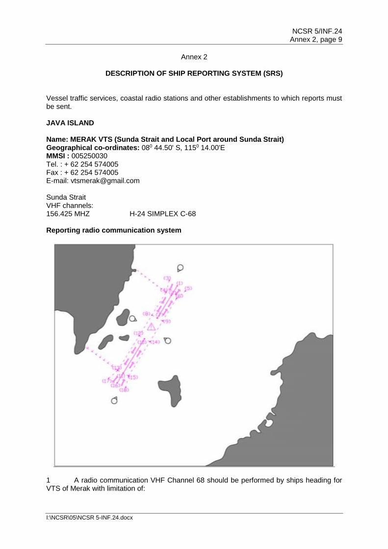
Annex 2
DESCRIPTION OF SHIP REPORTING SYSTEM (SRS) Vessel traffic services, coastal radio stations and other establishments to which reports must be sent. JAVA ISLAND Name: MERAK VTS (Sunda Strait and Local Port around Sunda Strait) Geographical co-ordinates: 080 44.50' S, 1150 14.00'E MMSI : 005250030 Tel. : + 62 254 574005 Fax : + 62 254 574005 E-mail: [email protected] Sunda Strait VHF channels: 156.425 MHZ H-24 SIMPLEX C-68 Reporting radio communication system
1 A radio communication VHF Channel 68 should be performed by ships heading for VTS of Merak with limitation of:
NCSR 5/INF.24 Annex 2, page 10
I:\NCSR\05\NCSR 5-INF.24.docx
.1 In the north of Sunda Strait, a line connecting 05° 40.78'S / 105° 50.20'E to 05° 40.48'S / 106° 02.15'E expanding across the strait
.2 In the south of Sunda Strait, a line connecting 06° 09.75'S / 105° 27.52'E to 06° 28.30'S / 105° 39.95'E expanding across the strait
.3 In the west of Sunda Strait, a line connecting 05° 59.85'S / 105° 30.00'E to 05° 54.42'S / 105° 43.02'E expanding to shore area
.4 In the east of Sunda Strait, a line connecting 05° 52.98'S / 106° 02.40'E to 05° 40.48'S / 106° 02.15'E
2 A radio communication VHF Channel 68 should be performed by all ship before departure and arrival from Bakahueni Port and Merak Port. Categories of ships required to report Ships in the following categories that are entering, leaving, or moving within the Merak VTS operation area are required to participate by reporting their activities to Merak VTS by radio or other means as defined in the Notices to Mariners, Law, Regulations or Handbook.
.1 All ships of 300 gross tonnage and over;
.2 All Ships with the length 30 meters or more;
.3 Ships engaged in towing or pushing another vessel with a combined weight of 300 GT and over, or with a combined length of 30 meters and over;
.4 All ships, regardless of gross tonnage, carrying hazardous and/or potentially polluting cargo, as defined in paragraph 1.4 of the Guidelines and criteria for ship reporting systems (resolution MSC.43(64));
.5 All passenger ships equipped with VHF, regardless to its length or weight; and
.6 All categories of ships less than 30 meters in length, or less than 300 GT equipped with VHF which is using the appropriate traffic lane or separation zone in an emergency in order to avoid immediate danger.
Reporting regulations 1 Ships heading for the Sunda Strait reporting area or leaving it must send a report:
.1 on entering the reporting area;
.2 immediately after leaving a port or anchorage located in the reporting area;
.3 when altering from the route leading to the port of destination or anchorage reported originally, owing to instructions received on entering the reporting area;
.4 when it is necessary to alter from the planned route because of weather conditions, damaged equipment or change in navigational status;
NCSR 5/INF.24 Annex 2, page 11
I:\NCSR\05\NCSR 5-INF.24.docx
.5 at the request of the Island Region coastal stations; and
.6 on leaving the reporting area.
2 On entering the Sunda Strait mandatory reporting area, ships must send a message to notify via Merak VTS. 3 Every reporting message must begin with the word SUNDASTRAIT and include a two-letter prefix to enable identification, i.e. sailing plan.SP final report .FR. or deviation report .DR. 4 The reports must be written in accordance with the following table:
.1 Designators A, B, C, E, F, G, I, P, T, W and X are compulsory for sailing plans;
.2 Designators A, B, C, E and F must be used for final reports;
.3 Designators A, B, C, E, F and I must be used for deviation reports; and
.4 Designator Q is included whenever a problem arises in the reporting area, whether defects, damage, deficiencies or circumstances that affect normal navigation in the reporting area.
Designator Function Text
System name Code word SUNDASTRAIT
Type of report: Sailing plan: Final report: Deviation report
One of the following 2-letter identifiers: SP FR (on finally leaving reporting area) to include only A, B, C, E and F. DR to include only A, B, C, E, F and I.
A Ship Name and call sign
(Name of ship, call sign, IMO No. and MMSI No.), (e.g. TAURUS/HC4019/T-04-0561)
B Date and time corresponding to position at C, expressed as UTC.
A six-digit group followed by a Z. The first two digits indicate day of the month, the second two the hours and the last two the minutes. The Z indicates that the time is given in UTC (e.g. 081340Z).
C Position (latitude and longitude)
A 4-digit group giving latitude in degrees and minutes, with the suffix S, and a 5-digit group giving longitude in degrees and minutes, with the suffix E (e.g. 0820S 11552E).
E Course True course. A 3-digit group (e.g. 270).
F Speed Speed in knots. A 2-digit group (e.g.14).
G Name of last port of call
Name of the last port of call (e.g. Makassar)
I Destination and ETA (UTC)
Name of destination and date and time group as expressed in B (e.g. Merak 082200Z)
P Cargo Type(s) of oil cargo, quantity, quality and density of heavy crude, heavy fuel, asphalt and coal tar. If the ships are carrying other potentially hazardous
NCSR 5/INF.24 Annex 2, page 12
I:\NCSR\05\NCSR 5-INF.24.docx
cargoes, indicate type, quantity and IMO classification (e.g. 10,000 TN DIESEL OIL).
Q Defects, damage, deficiencies, limitations.
Brief details of defects, including damage, deficiencies and other circumstances that impair normal navigation.
T Address for the communication of cargo information
Name, tel No., and either fax or e-mail
W Total no. of people on board
State how many
X Miscellaneous Miscellaneous information concerning these ships: Characteristics and approximate quantity of bunker fuel for tankers carrying an amount of it greater than 5,000 tonnes Navigational status (e.g. at anchor, moving under own propulsion, no steering, limited maneuverability, depth restriction, moored, aground, etc.)
6 The sailing plan (SP) is sent as an initial report:
.1 When entering the reporting area, as defined in annex 2;
.2 On leaving the last port of call located in the reporting area.
Example: MERAK VTS (Name of station to which report is sent) SUNDASTRAIT. SP A TAURUS/HC4919/T-04-0561 B 081340Z C 0820S 11552E E 270 F 14 G MAKASSAR I MERAK 082200Z P 10.000 TNS DIESEL OIL T PEDRO GARCIA, 593 4 2320400, FAX 593 4 2324827 W 10 X 1.000 TNS DIESEL OIL / MOVING UNDER OWN PROPULSION NO CHANGE
7 The final report (FR) is sent:
.1 On leaving the reporting area.
.2 On arrival at a destination located in the reporting area.
Example: MERAK VTS (Name of station to which report is sent) SUNDASTRAIT. FR A TAURUS/HC4919/T-04-0561
NCSR 5/INF.24 Annex 2, page 13
I:\NCSR\05\NCSR 5-INF.24.docx
B 082200Z C 0856S 11544E E 120 F 14
8 The deviation report (DR) is sent:
.1 When deviating from the route leading to the originally declared destination or anchorage or position for orders given on entry into the reporting area.
.2 When it is necessary to deviate from the planned route owing to weather conditions, damage to equipment or a change in navigational status.
Example: MERAK VTS (Name of station to which report is sent) SUNDASTRAIT. DR A TAURUS/HC4919/T-04-0561 B 081700Z C 0842S 11546E E 280 F 14 I MERAK 082400Z X CHANGE IN ARRIVAL TIME ENGINE DEFECT
NCSR 5/INF.24 Annex 2, page 14
I:\NCSR\05\NCSR 5-INF.24.docx
Annex 3
Coordinates of Existing Navigation Aids
The name as well as the location of the existing visual aids to navigation in the area of the proposed TSS are listed in detail as follow: .1 Cikoneng light 06° 04.00'S/ 105° 53.00'E
.2 Tempurung light 05° 54.05'S/ 105° 56.00'E
.3 Serdang light 05° 49.33'S/ 105° 23.50'E
.4 Merak Besar beacon light 05° 56.08'S/ 105° 59.53'E
.5 Gosong Serdang beacon light 05° 04.50'S/ 106° 16.60'E
.6 Pulau Ular beacon light 06° 28.31'S/ 105° 39.88'E
.7 Sangiyang beacon light 05° 58.33'S/ 105° 51.13'E
.8 Sebeku beacon light 05° 51.00'S/ 105° 32.00'E
.9 Pulau Rakata beacon light 06° 09.74'S/ 105° 27.53'E
.10 Tanjung Tua beacon light 05° 54.37'S/ 105° 43.00'E
.11 Pulau Tiga beacon light 05° 49.17'S/ 105° 32.54'E
.12 Pasir Brower buoy light 05° 56.74'S/ 105° 58.80'E
.13 Karang Ayer Serdang buoy light 05° 59.23'S/ 106° 46.50'E
___________


![Untitled-2 [hubla.dephub.go.id]hubla.dephub.go.id/publikasi/Maklumat Pelayaran/Maklumat Pelayaran... · 11 jan 2015 12 jan 2015 pe-rairan barat sama dg tgl 10 jan perairan kep.anambas-](https://img.pdfslide.net/doc/110x75/5c7c7a2e09d3f2812a8b47b1/untitled-2-hubla-hubla-pelayaranmaklumat-pelayaran-11-jan-2015-12-jan.jpg)