Embed Size (px)
Citation preview
i
EARLY PALEOZOIC POST-BREAKUP MAGMATISM
ALONG THE CORDILLERAN MARGIN OF WESTERN
NORTH AMERICA: NEW GEOCHRONOLOGICAL AND
GEOCHEMICAL RESULTS FROM THE KECHIKA GROUP,
YUKON, CANADA
By © Roderick William Campbell
A Thesis submitted to the School of Graduate Studies
in partial fulfilment of the requirements for the degree of
Master of Science, Department of Earth Sciences
Memorial University of Newfoundland
August 2018
St. John’s Newfoundland and Labrador
ii
Abstract
Lower Paleozoic igneous rocks were emplaced along the Cordilleran margin of
western North America following lithospheric breakup. Several competing rift models have
been proposed to explain the significance of this magmatism to Cordilleran passive margin
evolution. New field and laboratory studies of the Kechika group, south-central Yukon, were
conducted to test these rift models and constrain the timing and tectonic setting of post-
breakup magmatism. The Kechika group contains vent-proximal and sediment-sill facies that
developed outboard of continental margin shelf and trough basins. Zircon U-Pb dates indicate
that Kechika group rocks crystallized during the late Cambrian (488-483 Ma) and Early
Ordovician (473 Ma). Whole-rock trace element and Nd-Hf isotope results are consistent
with the low-degree partial melting of a lithospheric mantle source during margin-scale
extension. Post-breakup rocks emplaced along the magma-poor North Atlantic margins,
including the Orphan Knoll and Galicia Bank crustal blocks, are likely modern analogues for
the Kechika group.
iii
Acknowledgments
Firstly, I would like to thank my supervisor Dr Luke P. Beranek. He provided me with
the opportunity to work on fascinating outstanding scientific questions in the beautiful Pelly
Mountains, to present at conferences with those whom wrote the book on Cordilleran
geology, and provided constant support, help, and advice throughout the course of the
project. I frequently took advantage of an open-door policy and was always greeted with
enthusiastic discussion. I would also like to thank Dr Stephen J. Piercey for providing
valuable insight during fieldwork, in discussions, for being on my committee, and reviewing
this manuscript. Thank you to Dr. Richard Friedman for providing the U-Pb analysis for this
work. I would also like to thank various people at the Yukon Geological Survey, for their
assistance in the field and providing such a welcoming experience in the Yukon. In particular
thank you to Maurice Colpron for putting me up on my first trip to Yukon, and to Rosie Cobbett
for assistance with the YEG manuscript, in the field and being a welcoming host in
Whitehorse. Thank you to Will Tompson of TransNorth Turbo Air for providing excellent
helicopter support. Thank you to the graduate students and friends whom have made living in
a Newfoundland such a welcoming and memorable experience. Finally thank you to my family
whom have provided unending support.
This project was supported by research grants from the Geo-mapping for Energy and
Minerals program (Natural Resources Canada) to Beranek and NSERC Discovery Grants to
Beranek and Piercey. The Yukon Geological Survey generously supported field logistics and
helicopter support. We are grateful to Dominique Weis, Corey Wall, and Bruno Kieffer for
their assistance at the Pacific Centre for Isotopic and Geochemical Research.
iv
Table of Contents
Abstract ...................................................................................................................... ii
Acknowledgments .................................................................................................... iii
List of Tables ............................................................................................................ vii
List of Figures ........................................................................................................ viii
List of Abbreviations ................................................................................................. xi
List of Appendices .................................................................................................. xiv
Chapter 1 Introduction and purpose of study ................................................................. 1
1.1 Introduction .......................................................................................................... 1
1.2 Geological Background ........................................................................................ 6
1.2.1 Cordilleran margin development .................................................................. 6
1.2.2 Pure-shear rift models ................................................................................... 7
1.2.3 Simple-shear rift models ............................................................................... 7
1.2.4 Magma-poor rift models ............................................................................... 9
1.2.5 Cambrian-Ordovician margin architecture ................................................. 11
1.2.6 Cambrian to Ordovician extension ............................................................. 13
1.2.7 Cambrian-Ordovician magmatism .............................................................. 14
1.2.8 Geology of the Pelly Mountains, south-central Yukon .............................. 15
1.3 Thesis Objectives ............................................................................................... 21
1.4 Methods .............................................................................................................. 22
1.4.1 Fieldwork and sample collection ................................................................ 22
1.4.2 CA-TIMS zircon U-Pb geochronology ....................................................... 22
1.4.3 Major, trace and Nd isotope geochemistry ................................................. 23
1.5 Co-Authorship Statement ................................................................................... 24
1.6 Thesis presentation ............................................................................................. 25
Chapter 2 Volcanic stratigraphy of the Cambrian-Ordovician Kechika group, Pelly Mountains, south-central Yukon* ............................................................................................ 27
2.1 Abstract .............................................................................................................. 27
2.2 Introduction ........................................................................................................ 28
2.3 Geological framework ........................................................................................ 35
2.3.1 Ketza group ................................................................................................. 35
2.3.2 Kechika group ............................................................................................. 38
2.3.3 Askin group ................................................................................................. 40
v
2.4 Field studies........................................................................................................ 40
2.4.1 Groundhog formation stratigraphy ............................................................. 43
2.4.2 Cloutier formation stratigraphy .................................................................. 45
2.5 Preliminary analytical results ............................................................................. 50
2.6 Stratigraphic interpretation ................................................................................. 52
2.6.1 Basaltic facies association .......................................................................... 52
2.6.2 Volcanogenic sedimentary facies association ............................................. 52
2.6.3 Limestone-argillite facies association ......................................................... 54
2.6.4 Intrusive rocks ............................................................................................. 54
2.7 Regional correlations and future work ............................................................... 55
2.8 Acknowledgements ............................................................................................ 56
2.9 References .......................................................................................................... 56
Chapter 3 Early Paleozoic post-breakup magmatism along the Cordilleran margin of western North America: new geochronological and geochemical results from the Kechika group, Yukon, Canada* ........................................................................................................... 72
3.1 Abstract .............................................................................................................. 72
3.2 Introduction ........................................................................................................ 74
3.3 Lower Paleozoic Stratigraphy of the Northern Cordillera ................................. 81
3.3.1 Overview ..................................................................................................... 81
3.3.2 Pelly Mountains, south-central Yukon ....................................................... 87
3.4 Methods .............................................................................................................. 93
3.4.1 CA-TIMS zircon U-Pb geochronology ....................................................... 93
3.4.2 Whole-rock lithogeochemistry.................................................................... 94
3.5 Results ................................................................................................................ 96
3.5.1 CA-TIMS zircon U-Pb geochronology ....................................................... 96
3.5.2 Lithogeochemistry .................................................................................... 100
3.6 Discussion ........................................................................................................ 113
3.6.1 Timing and emplacement history of the Kechika group ........................... 113
3.6.2 Petrogenesis and magma source components ........................................... 113
3.6.3 Syn- to post-breakup volcanism along the Cordilleran margin ................ 116
3.6.4 Implications for Cordilleran rift models ................................................... 117
3.6.5 Future work ............................................................................................... 136
3.7 Conclusions ...................................................................................................... 137
3.8 Acknowledgments ............................................................................................ 138
vi
3.9 References ........................................................................................................ 138
Chapter 4 Summary and Future Research ................................................................. 178
4.1 Summary .......................................................................................................... 178
4.2 Future Research ................................................................................................ 181
4.3 References ........................................................................................................ 181
Appendices ................................................................................................................. 225
Appendix 1 ............................................................................................................. 225
Appendix 2 ............................................................................................................. 225
Appendix 3 ............................................................................................................. 225
Appendix 4 ............................................................................................................. 225
vii
List of Tables
Chapter 2
Table 2-1 Principal lithofacies of the Kechika group, Pass Peak and Cloutier Creek map
areas, Pelly Mountains, south central Yukon…………………………………………......69
viii
List of Figures
Chapter 1
Figure 1-1 Ediacaran to early Paleozoic magmatic rocks, tectonic elements, and crustal
lineaments of the North American Cordillera and Canadian Cordillera .................................. 3
Figure 1-2 Simplified kinematic models for Cordilleran rift evolution .................................... 4
Figure 1-3 Paleozoic stratigraphy of the Pelly Mountains ..................................................... 18
Figure 1-4 Distribution of thrust sheets, and Ketza, Kechika and Askin group rocks in the
Pelly Mountains ....................................................................................................................... 19
Chapter 2
Figure 2-1 Terrane map of the Canadian Cordillera ............................................................ 30
Figure 2-2 Distribution of major faults, lower Paleozoic igneous rocks and Ordovician-
Silurian paleogeography in the Canadian Cordillera ............................................................. 34
Figure 2-3 Schematic cross section of an asymmetric rift system........................................... 35
Figure 2-4 Paleozoic stratigraphy of the Pelly Mountains ..................................................... 37
Figure 2-5 Distribution of thrust sheets, and Ketza, Kechika and Askin group rocks in the
Pelly Mountains ....................................................................................................................... 38
Figure 2-6 Measured stratigraphic sections of the Kechika group. ....................................... 43
Figure 2-7 Field photographs of Kechika group units at field localities 1-3.. ....................... 48
Figure 2-8 Field photographs of Kechika group units at field localities 4-6. ........................ 49
Figure 2-9 Field photographs of Kechika group units at field localities 7 and 8 ................... 50
Figure 2-10 Primitive mantle-normalized multi-element plots of mafic rocks from the
Kechika group and global magmatic system. .......................................................................... 52
ix
Chapter 3
Figure 3-1 Ediacaran to early Paleozoic magmatic rocks, tectonic elements, and crustal
lineaments of the North American Cordillera and Canadian Cordillera ................................ 76
Figure 3-2 Simplified kinematic models for Cordilleran rift evolution .................................. 80
Figure 3-3 Simplified Ediacaran to lower Silurian stratigraphy of the Canadian Cordillera
from central Yukon to southern British Columbia ................................................................... 86
Figure 3-4 Paleozoic stratigraphy of the Pelly Mountains ..................................................... 89
Figure 3-5 Distribution of thrust sheets, and Ketza, Kechika and Askin group rocks in the
Pelly Mountains ....................................................................................................................... 90
Figure 3-6 Wetherill concordia plots of CA-TIMS U-Pb ages and weighted mean plots ..... 100
Figure 3-7 Key trace elements and elements ratios of the Kechika group rocks plotted
against the Spitz-Darling Al2O3/Na2O alteration index......................................................... 102
Figure 3-8 Nb/Y vs. Zr/Ti plot ............................................................................................... 107
Figure 3-9 (a) Mg # vs. Cr, and (b) Mg # vs. Ni, (c) Al2O3/TiO2 vs. TiO2 plot after Piercey et
al. (2012). (d) The Ti-V discrimination diagram of Shervais (1982)..................................... 108
Figure 3-10 Primitive-mantle–normalized multi-element plots of the Kechika group volcanic
(a) and intrusive rocks (b) with modern analogues for comparison ..................................... 109
Figure 3-11 (a) Nb/Thmn vs. Nb/Lamn diagram for Kechika group rocks. (b) Zr/Yb vs. Nb/Yb
diagram of Pearce and Peate (1995) ..................................................................................... 111
Figure 3-12 (a) Initial εHft vs. εNdt for the Kechika group volcanic, intrusive and fine
grained clastic rocks. (b) εNdt against time for the Kechika volcanic, and intrusive rocks.. (c).
εHft against time for the Kechika volcanic, and intrusive rocks ............................................ 112
Figure 3-13 (a) Initial εNdt vs. Nb/Th, and (b) Initial εHft vs. Nb/Th for the Kechika group
volcanic, intrusive and fine grained clastic rocks. ................................................................ 113
Figure 3-14 Rift evolution model…………………………………………………………………..128
x
Figure 3-15 Continental margin maps, and schematic cross sections of the Newfoundland
margin (a, b), and Iberian margin (c, d); (e) Schematic diagram of the northwestern North
American ancestral margin during late Cambrian to Early Ordovician time; (f) Magma-poor
rift model after Beranek (2017) with elements in the Canadian Cordillera .......................... 133
Figure 3-16 Primitive mantle-normalized multi-element plots of mafic rock units .............. 135
xi
List of Abbreviations
Back. R. Backbone Ranges
CA-TIMS Chemical Abrasion – Thermal Ionization
Mass Spectrometry
CGVP Charlie Gibbs volcanic province
CHUR Chondritic Uniform Reservoir
CP Cassiar platform
CT Cassiar terrane
DR Data repository
EBA Eagle Bay assemblage
EBG Eagle Bay greenstone
Fm Formation (formal)
fm formation (informal)
FZ Fracture zone
GEM Geo-mapping for Energy and Minerals
Gp Group (formal)
gp group (informal)
GSC Geological Survey of Canada
GSSZ Great Slave Lake Shear Zone
HFSE High field strength elements
HREE Heavy rare earth elements
HR-ICPMS High resolution – Inductively coupled
plasma-mass spectrometry
KP Kakwa platform
xii
KT Kootenay trough
LIP Large igneous province
Lk Lake
LOI Loss on ignition
LREE Light rare earth elements
MCE Misty Creek embayment
MC-ICPMS Multi-collector - Inductively Coupled
Plasma Mass Spectrometer
Mid- Middle
MORB Mid-ocean ridge basalt
MP McEvoy platform
MP MacDonald platform
MRE Meilleur River embayment
MSWD Mean square of weighted deviates
Mtns. Mountains
NSERC Natural Sciences and Engineering
Research Council
NTS National Topographic System
NWT Northwest Territories
OA Ogilvie Arch
OE Ospika embayment
OIB Ocean island basalt
PA Purcell arch
RT Richardson Trough
xiii
SEDEX Sedimentary exhalative
Sil Silurian
TDM Depleted mantle model age
Vol Volcanics
WRE White River embayment
YEG Yukon Exploration and Geology
YTT Yukon-Tanana terrane
xiv
List of Appendices
Appendix 1 – Compilation of Ediacaran-early Paleozoic magmatic ages and
stratigraphic relationships
Appendix 2 – CA-TIMS zircon U-Pb isotope results
Appendix 3 – Whole-rock major and trace element geochemical results, and
additional major-element geochemistry plots (TAS and AFM).
Appendix 4 – Whole-rock Nd-Hf isotope geochemical results
1
Chapter 1 Introduction and purpose of study
1.1 Introduction
The western or Cordilleran margin of ancestral North America formed after protracted
Tonian-Ediacaran rifting and Ediacaran-Cambrian breakup of the supercontinent Rodinia
(Stewart, 1972; Colpron et al., 2002; Li et al., 2008; Macdonald et al., 2012; Yonkee et al.,
2014). Several rift-related rock units of uncertain tectonic significance outcrop within the
Cryogenian-lower Paleozoic succession of western North America (e.g., Goodfellow et al.,
1995), including Cambrian to Ordovician volcanic rocks that post-date the inferred rift to
post-rift transition in southern British Columbia and Utah by up to 40 m.y. (Bond et al., 1985;
Devlin and Bond, 1988; Hein and McMechan, 1994). These rocks are volumetrically minor
compared to most large igneous provinces associated with continental breakup, which
suggests that a plume-related origin is unlikely (e.g., Goodfellow et al., 1995). The oldest
rocks that record the initiation of east-dipping subduction under the western Cordilleran
margin are Late Devonian (e.g., Piercey et al., 2004, 2006) and possibly as old as Late
Ordovician-Silurian in some of the outboard peri-Laurentian terranes (e.g., Pecha et al.,
2016). Processes related to the establishment of the Cordilleran passive margin therefore
appear the most likely cause of Cambrian to mid-Ordovician extension and magmatism along
western North America. However, the processes responsible for producing these syn- to post-
breakup volcanic rocks (Fig. 1-1) are poorly understood and not fully examined in published
pure-shear and simple-shear rift models for the development of the Cordilleran margin (e.g.,
Goodfellow et al., 1997; Lund, 2008).
The primary objectives of this thesis are to constrain the physical volcanology,
crystallization age, and mantle-crustal source of lower Paleozoic magmatic rocks of the
Kechika group, south-central Yukon, Canada. These igneous rocks are representative
2
examples of post-breakup magmatism in the Canadian Cordillera (Goodfellow et al., 1997;
Tempelman-Kluit, 2012). These new results, in addition to published data from coeval units
in western North America, enable the examination of whether published pure-, simple-shear,
and magma-poor rift scenarios for Cordilleran passive margin development (Fig. 1-2; e.g.,
Bond et al., 1985; Cecile et al., 1997; Yonkee et al., 2014; Beranek, 2017) can suitably
explain post-breakup volcanism. The following sections provide a brief overview of the
history of geological research in the central Pelly Mountains of south-central Yukon, the
Neoproterozoic to early Paleozoic stratigraphy of western North America, and previously
published rift models for the Cordilleran rifted margin.
3
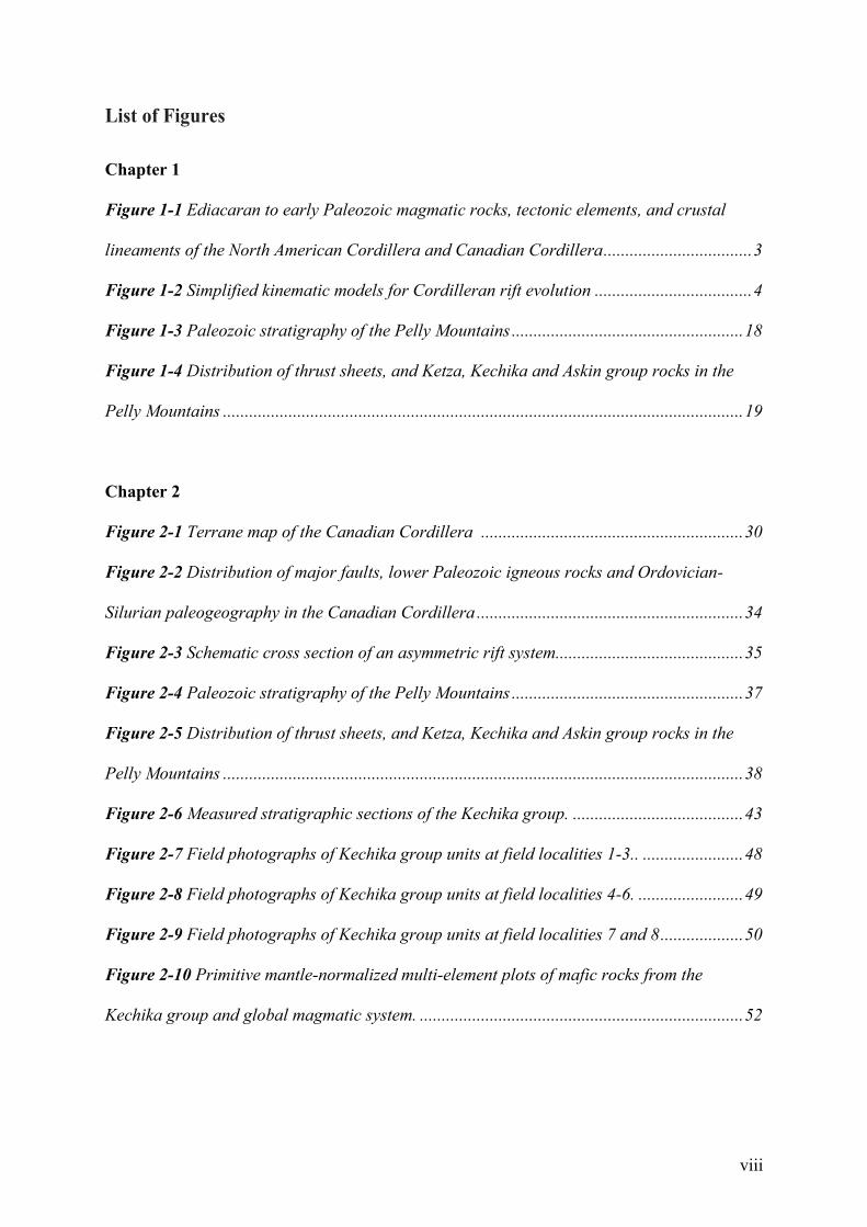
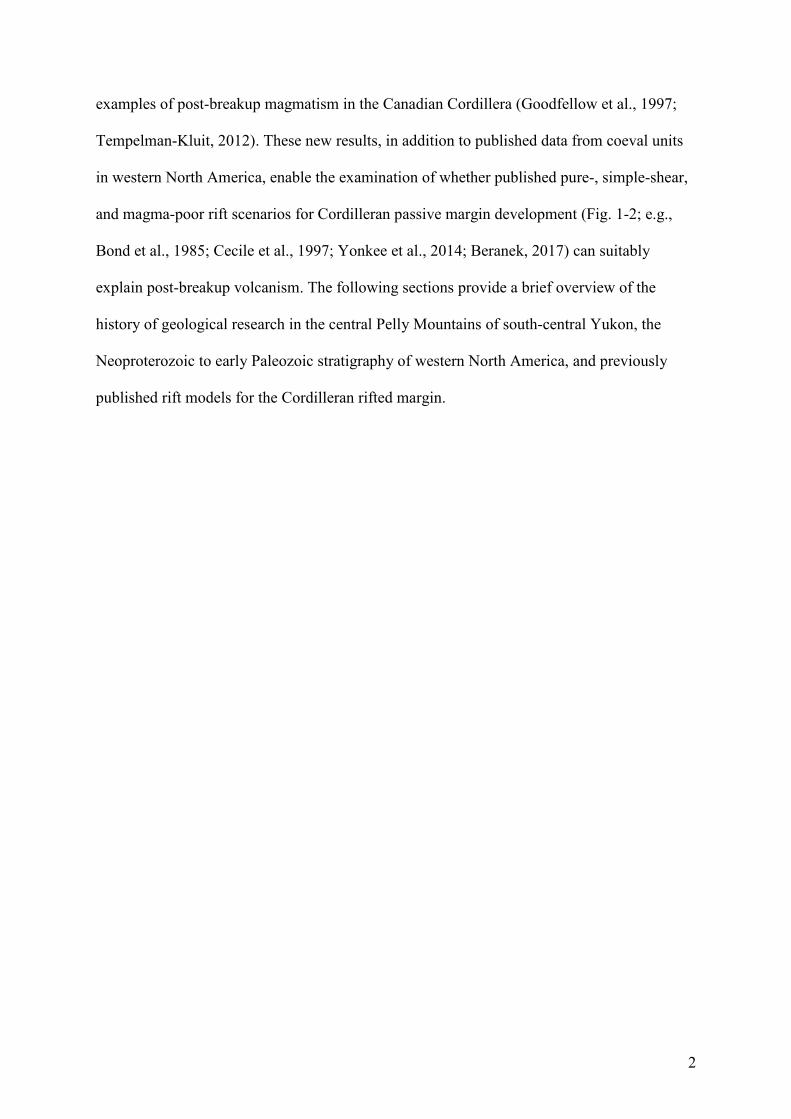
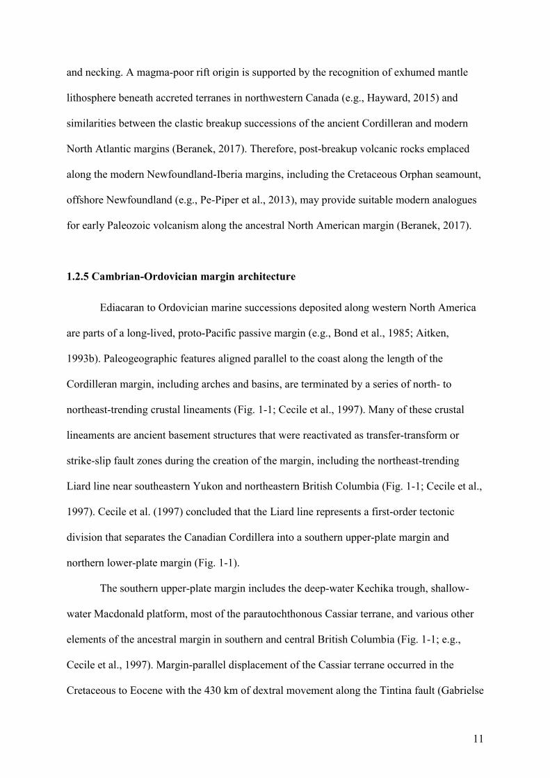
Figure 1-1(A) Ediacaran to early Paleozoic magmatic rocks, tectonic elements, and crustal
lineaments of the North American Cordillera adapted from Goodfellow et al. (1995), Lund
(2008), and Colpron and Nelson (2009). Lower- and upper-plate divisions are from Lund
(2008). (B) Map of the Canadian Cordillera highlighting the locations of Ediacaran to early
Paleozoic magmatic rocks and key paleogeographic features. Numbers from 1-28 are
references for Cordilleran margin magmatism provided in Appendix 1. CP - Cassiar
platform, MP - McEvoy platform, MRE - Meilleur River embayment, Mtns. - Mountains, MP
- McEvoy platform, R. - river.
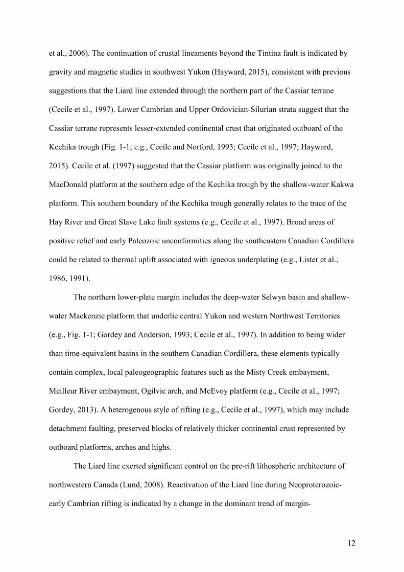
4
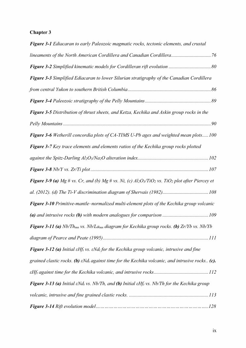
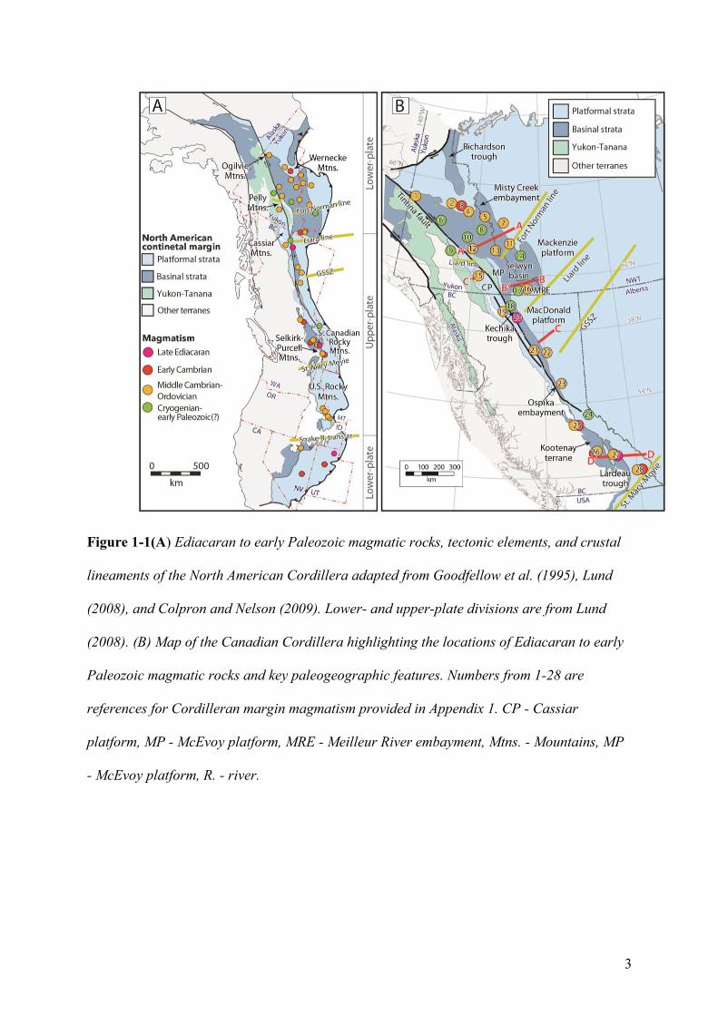
Figure 1-2 Simplified kinematic models for Cordilleran rift evolution adapted from Yonkee et
al. (2014). (A) Pure-shear rift model with uniform, homogeneous thinning of crust and
mantle based on McKenzie (1978). Margins that form through mostly pure-shear rifting
display very limited evidence for post-rift magmatism when contrasted with evidence for syn-
rift magmatism. (B) Simple-shear rift model with heterogeneous thinning of upper and lower
lithosphere based on Lister et al. (1986, 1991). Magmatism in the simple-shear model mostly
occurs beneath upper-plate margins during the syn- to post-rift phase. (C) Magma-poor rift
model with depth-dependent lithospheric thinning and necking based on Davis and Kusznir

5
(2004). This figure represents the period after lithospheric thinning but prior to lithospheric
breakup. Syn-breakup magmatism is more voluminous in outboard areas where it is
dominated by tholeiitic volcanism sourced from the depleted asthenospheric mantle. In
contrast post-breakup magmatism occurs across the nascent plate boundary including
throughout the rifted margin and is represented by low volume alkaline volcanism, derived
from enriched mantle sources.
6
1.2 Geological Background
1.2.1 Cordilleran margin development
The cratonic basement of paleocontinent Laurentia (ancestral North America) formed
as a result of the collision of Archean microcontinents, early Proterozoic island arcs, and
related oceanic terranes around 1.96-1.81 Ga (Hoffman, 1988). The western Laurentian
craton likely extends beneath the eastern half of the Yukon and British Columbia Cordillera
(e.g., Nelson et al., 2013). This hypothesis is consistent with geophysical evidence for
lithospheric scale lineaments that extend as far west as the Denali fault in southwestern
Yukon (Hayward, 2015).
Rifting associated with the development of the Cordilleran margin began during
Tonian-Cryogenian time (e.g., Christie-Blick and Levy, 1989; Yonkee et al., 2014). These
early rift episodes thinned and weakened Cordilleran lithosphere (Yonkee et al., 2014) and
were likely associated with strike-slip deformation in some regions of western Laurentia
(Strauss et al., 2015). Within the Canadian Cordillera, initial rifting was represented by the
Gunbarrel magmatic event (ca. 780 Ma; Harlan et al., 2003; Sandeman et al., 2014) and
deposition of the 723-716 Ma Windermere Supergroup (e.g., Stewart, 1972; Link et al., 1993;
Nelson et al., 2013). Rifting along the western Laurentian margin was contemporaneous with
the emplacement of the Franklin magmatic event along the ancestral northern margin of
North America (ca. 723 Ma; Heaman et al., 1992; Macdonald et al., 2010). Magmatic activity
continued through the Cryogenian (ca. 720-640 Ma) in southeastern Yukon (Pigage and
Mortensen, 2004), northern British Columbia (Ferri et al., 1999), and western United States
(Lund et al., 2003, 2010; Fanning and Link, 2004).
Ediacaran to lower Cambrian siliciclastic and volcanic strata within southwestern
Canada and western United States, including rift-related 570 Ma alkalic volcanic rocks
(Colpron et al., 2002) of the Hamill Group in southeastern British Columbia, represent the
7
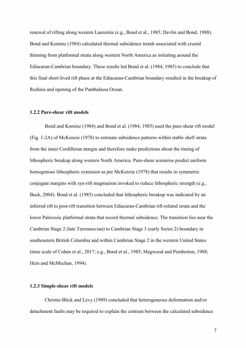
renewal of rifting along western Laurentia (e.g., Bond et al., 1985; Devlin and Bond, 1988).
Bond and Kominz (1984) calculated thermal subsidence trends associated with crustal
thinning from platformal strata along western North America as initiating around the
Ediacaran-Cambrian boundary. These results led Bond et al. (1984, 1985) to conclude that
this final short-lived rift phase at the Ediacaran-Cambrian boundary resulted in the breakup of
Rodinia and opening of the Panthalassa Ocean.
1.2.2 Pure-shear rift models
Bond and Kominz (1984) and Bond et al. (1984, 1985) used the pure-shear rift model
(Fig. 1-2A) of McKenzie (1978) to estimate subsidence patterns within stable shelf strata
from the inner Cordilleran margin and therefore make predictions about the timing of
lithospheric breakup along western North America. Pure-shear scenarios predict uniform
homogenous lithospheric extension as per McKenzie (1978) that results in symmetric
conjugate margins with syn-rift magmatism invoked to reduce lithospheric strength (e.g.,
Buck, 2004). Bond et al. (1985) concluded that lithospheric breakup was indicated by an
inferred rift to post-rift transition between Ediacaran-Cambrian rift-related strata and the
lower Paleozoic platformal strata that record thermal subsidence. The transition lies near the
Cambrian Stage 2 (late Terreneuvian) to Cambrian Stage 3 (early Series 2) boundary in
southeastern British Columbia and within Cambrian Stage 2 in the western United States
(time scale of Cohen et al., 2017; e.g., Bond et al., 1985; Magwood and Pemberton, 1988;
Hein and McMechan, 1994).
1.2.3 Simple-shear rift models
Christie-Blick and Levy (1989) concluded that heterogeneous deformation and/or
detachment faults may be required to explain the contrast between the calculated subsidence
8
patterns of Bond et al. (1984) and the relative lack of field evidence for late Ediacaran-early
Cambrian crustal extension. The postulated role of detachment faulting and recognition of
asymmetry along western North America led to comparisons with the simple-shear or
asymmetric rift scenarios of Lister et al. (1986, 1991) to explain the development of the
Cordilleran margin (e.g., Cecile et al., 1997; Lund, 2008).
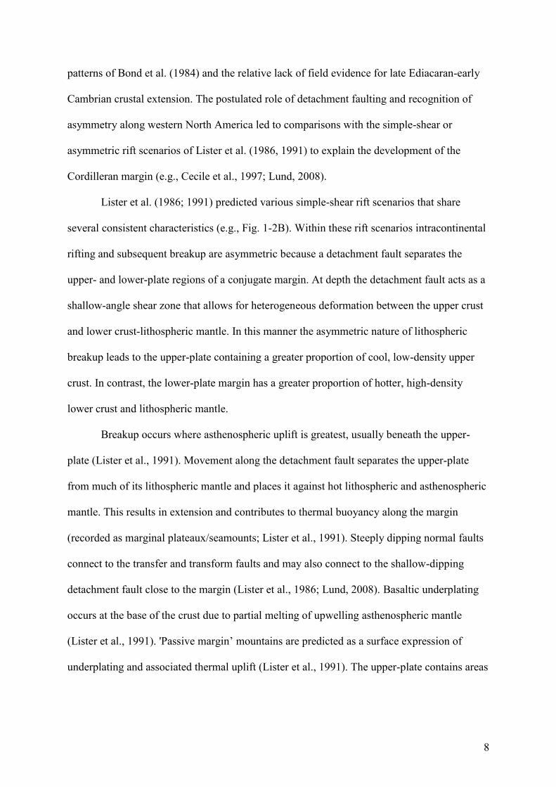
Lister et al. (1986; 1991) predicted various simple-shear rift scenarios that share
several consistent characteristics (e.g., Fig. 1-2B). Within these rift scenarios intracontinental
rifting and subsequent breakup are asymmetric because a detachment fault separates the
upper- and lower-plate regions of a conjugate margin. At depth the detachment fault acts as a
shallow-angle shear zone that allows for heterogeneous deformation between the upper crust
and lower crust-lithospheric mantle. In this manner the asymmetric nature of lithospheric
breakup leads to the upper-plate containing a greater proportion of cool, low-density upper
crust. In contrast, the lower-plate margin has a greater proportion of hotter, high-density
lower crust and lithospheric mantle.
Breakup occurs where asthenospheric uplift is greatest, usually beneath the upper-
plate (Lister et al., 1991). Movement along the detachment fault separates the upper-plate
from much of its lithospheric mantle and places it against hot lithospheric and asthenospheric
mantle. This results in extension and contributes to thermal buoyancy along the margin
(recorded as marginal plateaux/seamounts; Lister et al., 1991). Steeply dipping normal faults
connect to the transfer and transform faults and may also connect to the shallow-dipping
detachment fault close to the margin (Lister et al., 1986; Lund, 2008). Basaltic underplating
occurs at the base of the crust due to partial melting of upwelling asthenospheric mantle
(Lister et al., 1991). 'Passive margin’ mountains are predicted as a surface expression of
underplating and associated thermal uplift (Lister et al., 1991). The upper-plate contains areas
9
of localized extension, such as in the outer portion of the margin, but overall significantly less
extension than the corresponding lower-plate (Lister et al., 1986).
The lower-plate comprises the footwall of the detachment fault (Lister et al., 1991)
and may experience initial uplift associated with the removal of crustal material. However,
the lower-plate features a much greater level of subsidence and significant crustal attenuation.
Progressive extension leads to the rotation of crustal fault blocks (Lister et al., 1986; Cecile et
al., 1997). Such extension and the lack of shallow crustal cover may expose crystalline rocks
at the surface. The greater degrees of crustal extension may allow for long-lived marine
basins to develop.
Simple-shear models predict that upper- and lower-plate margins create a zigzag
geometry of promontories and embayments divided by transform and transfer faults (Lister et
al., 1986, 1991). As these structures represent the locus of lithospheric extension, it is feasible
that they are important for controlling the timing and locations of mafic magmatism and
massive sulphide mineralization (e.g., Lund, 2008).
Published simple-shear rift models (e.g., Lister et al., 1986; 1991) do not specifically
detail the expected timing and geochemical composition of igneous rocks within upper- and
lower-plate margins. Lund (2008) concluded that transfer-transform zones may localize
subsequent magmatism and that alkalic volcanism is characteristic of the upper-plate margin.
However, lower Paleozoic alkalic volcanic rocks occur on both sides of the major crustal
lineaments that are inferred to represent transfer-transform zones along the Cordilleran
margin (Fig. 1-1). Furthermore, published simple-shear rift models do not provide a
mechanism that can explain post-breakup volcanism.
1.2.4 Magma-poor rift models
10
Yonkee et al. (2014) and Beranek (2017) proposed magma-poor rift scenarios,
comparable to those for the modern Newfoundland-Iberia rift system, to explain the
development of the Cordilleran margin. Magma-poor rift margins (Fig. 1-2C) are
characterized by extreme lithospheric thinning related to slow protracted extension,
lithospheric rupture prior to breakup, and limited syn-rift volcanism (e.g., Peron-Pinvidic et
al., 2013; Doré and Lundin, 2015). Although Figure 1-2C displays two symmetric rift
margins these rift margins are often asymmetric in nature. The protracted rift history and
minor syn-rift magmatism prior to lithospheric breakup have been related to the inability to
produce sufficient magma at shallow crustal levels (e.g., Manatschal et al., 2015). The initial
rift phase comprises a depth-dependent ‘stretching’ phase that can heat and weaken the
lithosphere but does not lead to extensive lithospheric thinning (e.g., Peron-Pinvidic et al.,
2013). This is succeeded by the ‘thinning’ phase where the lithosphere is thinned through
detachment faulting in a manner comparable to the asymmetric, simple-shear rift scenario of
Lister et al. (1986, 1991). Lithospheric thinning eventually reaches a point termed
hyperextension where the entire crust is thinned to <10 km and is incapable of ductile
deformation (e.g., Peron-Pinvidic et al., 2013). This enables faults to penetrate the crust and
result in the exhumation of continental lithospheric mantle (e.g., Peron-Pinvidic et al., 2013).
Lithospheric breakup is associated with the emplacement of a major magmatic pulse (e.g.,
Bronner et al., 2011; Eddy et al., 2017) and the generation of a lithospheric breakup surface
(e.g., Soares et al., 2012). During the subsequent initiation of seafloor spreading, basin-wide
alkalic magmatism can occur for at least 30 m.y. (e.g., Eddy et al., 2017) and be associated
with the deposition of breakup-related clastic successions that preserve the transition from
breakup to thermal subsidence (Soares et al., 2012).
Yonkee et al. (2014) suggested that the Tonian-early Paleozoic polyphase rift history
of western North America was related to depth-dependent extension and lithospheric thinning
11
and necking. A magma-poor rift origin is supported by the recognition of exhumed mantle
lithosphere beneath accreted terranes in northwestern Canada (e.g., Hayward, 2015) and
similarities between the clastic breakup successions of the ancient Cordilleran and modern
North Atlantic margins (Beranek, 2017). Therefore, post-breakup volcanic rocks emplaced
along the modern Newfoundland-Iberia margins, including the Cretaceous Orphan seamount,
offshore Newfoundland (e.g., Pe-Piper et al., 2013), may provide suitable modern analogues
for early Paleozoic volcanism along the ancestral North American margin (Beranek, 2017).
1.2.5 Cambrian-Ordovician margin architecture
Ediacaran to Ordovician marine successions deposited along western North America
are parts of a long-lived, proto-Pacific passive margin (e.g., Bond et al., 1985; Aitken,
1993b). Paleogeographic features aligned parallel to the coast along the length of the
Cordilleran margin, including arches and basins, are terminated by a series of north- to
northeast-trending crustal lineaments (Fig. 1-1; Cecile et al., 1997). Many of these crustal
lineaments are ancient basement structures that were reactivated as transfer-transform or
strike-slip fault zones during the creation of the margin, including the northeast-trending
Liard line near southeastern Yukon and northeastern British Columbia (Fig. 1-1; Cecile et al.,
1997). Cecile et al. (1997) concluded that the Liard line represents a first-order tectonic
division that separates the Canadian Cordillera into a southern upper-plate margin and
northern lower-plate margin (Fig. 1-1).
The southern upper-plate margin includes the deep-water Kechika trough, shallow-
water Macdonald platform, most of the parautochthonous Cassiar terrane, and various other
elements of the ancestral margin in southern and central British Columbia (Fig. 1-1; e.g.,
Cecile et al., 1997). Margin-parallel displacement of the Cassiar terrane occurred in the
Cretaceous to Eocene with the 430 km of dextral movement along the Tintina fault (Gabrielse
12
et al., 2006). The continuation of crustal lineaments beyond the Tintina fault is indicated by
gravity and magnetic studies in southwest Yukon (Hayward, 2015), consistent with previous
suggestions that the Liard line extended through the northern part of the Cassiar terrane
(Cecile et al., 1997). Lower Cambrian and Upper Ordovician-Silurian strata suggest that the
Cassiar terrane represents lesser-extended continental crust that originated outboard of the
Kechika trough (Fig. 1-1; e.g., Cecile and Norford, 1993; Cecile et al., 1997; Hayward,
2015). Cecile et al. (1997) suggested that the Cassiar platform was originally joined to the
MacDonald platform at the southern edge of the Kechika trough by the shallow-water Kakwa
platform. This southern boundary of the Kechika trough generally relates to the trace of the
Hay River and Great Slave Lake fault systems (e.g., Cecile et al., 1997). Broad areas of
positive relief and early Paleozoic unconformities along the southeastern Canadian Cordillera
could be related to thermal uplift associated with igneous underplating (e.g., Lister et al.,
1986, 1991).
The northern lower-plate margin includes the deep-water Selwyn basin and shallow-
water Mackenzie platform that underlie central Yukon and western Northwest Territories
(e.g., Fig. 1-1; Gordey and Anderson, 1993; Cecile et al., 1997). In addition to being wider
than time-equivalent basins in the southern Canadian Cordillera, these elements typically
contain complex, local paleogeographic features such as the Misty Creek embayment,
Meilleur River embayment, Ogilvie arch, and McEvoy platform (e.g., Cecile et al., 1997;
Gordey, 2013). A heterogenous style of rifting (e.g., Cecile et al., 1997), which may include
detachment faulting, preserved blocks of relatively thicker continental crust represented by
outboard platforms, arches and highs.
The Liard line exerted significant control on the pre-rift lithospheric architecture of
northwestern Canada (Lund, 2008). Reactivation of the Liard line during Neoproterozoic-
early Cambrian rifting is indicated by a change in the dominant trend of margin-
13
perpendicular structures from north to northeast and the asymmetry of outboard marginal
basins (e.g., Cecile et al., 1997). However, the extent of later reactivation is uncertain. Cecile
et al. (1997) concluded that varied preservation of lower Paleozoic rocks across the Liard line
is as much controlled by early Paleozoic tectonics and paleogeography, including extensional
faulting, as it is influenced by younger erosional factors.
1.2.6 Cambrian to Ordovician extension
The outer continental basins of the Cordilleran margin developed through periodic,
heterogeneous crustal extension rather than purely thermal subsidence (Fig. 1-1; e.g., Cecile
and Norford, 1993; Goodfellow et al., 1995; Cecile et al., 1997; Pyle and Barnes, 2003;
Pigage, 2004; Lund, 2008; Pigage et al., 2015). The Cambrian and Ordovician periods are
generally associated with regional facies changes throughout the northern Cordillera.
Transgressive cycles (MacIntyre, 1998) inferred by calcareous shale/argillaceous limestone
units overlain by black shale (typically associated with turbidite and/or chert units) are
recognized within the Kechika Formation to lower Road River Group in the Kechika trough
(Ferri et al., 1995; Pyle and Barnes, 2003), parts of the Lardeau Group in the Selkirk
Mountains (Logan and Colpron, 2006), and Rabbitkettle to Duo Lake formations of the
Selwyn basin (Gordey and Anderson, 1993). The Misty Creek embayment, which forms an
entrant of Selwyn basin into the Mackenzie platform, comprises Middle to Upper Ordovician
strata with a steer's-head rift profile and associated mafic alkaline volcanic rocks (Cecile et
al., 1997). A change from a broad transitional ramp to narrow Middle Ordovician platform is
also observed in the southern Canadian Cordillera (Cecile et al., 1997). Extensional faulting
was likely important for the development of second-order euxinic basins that were sites for
syngenetic and epigenetic sediment-hosted base-metal deposits in western Canada (e.g., the
Anvil District of central Yukon, Goodfellow, 2007). The scale and spatial extent of early
14
Paleozoic crustal extension and its importance on the development of Ordovician-Silurian
architecture are uncertain.
1.2.7 Cambrian-Ordovician magmatism
The majority of early Paleozoic basins along the Cordilleran margin contain minor
accumulations of mafic lava flows, sills, and related volcaniclastic rocks (Fig. 1-1; Appendix
1; e.g., Ospika Volcanics, Index Formation, Menzie Creek formation; Goodfellow et al.,
1995). These pulses of magmatism have been linked to intermittent extension along the rifted
margin (e.g., Lund et al., 2010; Millonig et al., 2012; Pyle, 2012; Nelson et al., 2013). This is
evidenced by the spatial association of volcanic rocks with local normal faults (e.g., the
Menzie Creek formation of central Yukon, Pigage, 2004; and the Crow Formation,
southeastern Yukon; Pigage et al., 2015) and reactivated transfer-transform zones (e.g., Big
Creek-Beaverhead belt and Snake River transfer fault, central Idaho; e.g., Link et al., 2017).
These faults allowed volumetrically limited, incompatible element-enriched, low-degree
partial melts to rise into the upper crust (e.g., Sykes, 1978; Goodfellow et al., 1995).
Cambrian-Ordovician volcanic rocks are herein divided into four geochemical groups.
The majority are alkali basalt with OIB-like (ocean island basalt) geochemical signatures that
mostly occur west of the continental margin platform-to-basin transition (e.g., Fig. 1-1;
Goodfellow et al., 1995), either in the basin itself (e.g., Selwyn basin) or within embayments
into the western platform (e.g., Misty Creek embayment). Highly incompatible element-
enriched magmatic rocks are observed within extensional basins along the eastern Canadian
Cordillera, including ultrapotassic to alkalic diatremes in eastern Yukon and western NWT
(e.g., Mountain diatreme, Goodfellow et al., 1995), various alkalic – carbonatite diatremes in
southeastern British Columbia (e.g., Mt. Dingley Diatreme, Norford and Cecile, 1994;
Millonig et al., 2012), and alkaline intrusive rocks in Idaho (e.g., Big Creek-Beaverhead belt,
15
Lund et al., 2010). Cambrian tholeiites with MORB-like (mid-ocean ridge basalt) signatures
underlie or are laterally equivalent to Cambrian-Ordovician alkali basalts with OIB-like
signatures within the Lardeau Group and the Eagle Bay assemblage of the Kootenay terrane
of southeastern British Columbia (e.g., Logan and Colpron, 2006; Paradis et al., 2006).
Volumetrically limited felsic volcanic rocks occur within central and southeast Yukon in
association with alkali basalts (e.g., Pigage et al., 2015).
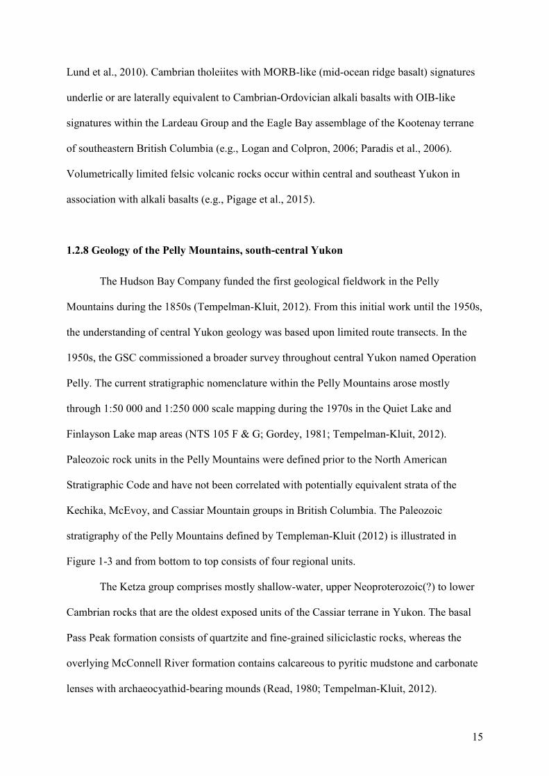
1.2.8 Geology of the Pelly Mountains, south-central Yukon
The Hudson Bay Company funded the first geological fieldwork in the Pelly
Mountains during the 1850s (Tempelman-Kluit, 2012). From this initial work until the 1950s,
the understanding of central Yukon geology was based upon limited route transects. In the
1950s, the GSC commissioned a broader survey throughout central Yukon named Operation
Pelly. The current stratigraphic nomenclature within the Pelly Mountains arose mostly
through 1:50 000 and 1:250 000 scale mapping during the 1970s in the Quiet Lake and
Finlayson Lake map areas (NTS 105 F & G; Gordey, 1981; Tempelman-Kluit, 2012).
Paleozoic rock units in the Pelly Mountains were defined prior to the North American
Stratigraphic Code and have not been correlated with potentially equivalent strata of the
Kechika, McEvoy, and Cassiar Mountain groups in British Columbia. The Paleozoic
stratigraphy of the Pelly Mountains defined by Templeman-Kluit (2012) is illustrated in
Figure 1-3 and from bottom to top consists of four regional units.
The Ketza group comprises mostly shallow-water, upper Neoproterozoic(?) to lower
Cambrian rocks that are the oldest exposed units of the Cassiar terrane in Yukon. The basal
Pass Peak formation consists of quartzite and fine-grained siliciclastic rocks, whereas the
overlying McConnell River formation contains calcareous to pyritic mudstone and carbonate
lenses with archaeocyathid-bearing mounds (Read, 1980; Tempelman-Kluit, 2012).
16
Upper Cambrian to Ordovician strata of the Kechika group sit unconformably on the
Ketza group (Tempelman-Kluit, 2012). The Kechika group consists of four formations that
Tempelman-Kluit (2012) described as "laterally equivalent” and “interfingered". The four
formations from NE to SW (Fig. 1-4A, B) are the Ram, Cloutier, Groundhog, and Gray Creek
formations (Tempelman-Kluit, 2012). These units are discontinuously capped by the
Magundy formation, which contains an almost complete sequence of Ordovician graptolites
(Gordey, 1981; Tempelman-Kluit, 2012). Limited Cambrian to Ordovician fossil ages within
the Kechika group are the only pre-existing constraints on the timing of mafic magmatism
(Tempelman-Kluit, 2012).
The Cloutier formation consists of at least 500 m of basalt and volcaniclastic rocks
that are intercalated with variably metamorphosed grey to black argillaceous shale, silty
limestone, and tuffaceous shale. Primary volcanic facies include 2-20 m-thick units of
vesicular to amygdaloidal massive flows, pillow lavas, and sediment-matrix basalt breccia.
Sediment-matrix basalt breccia units typically contain amoeboid to angular lapilli-sized clasts
and are interpreted as fluidal peperite units (e.g., Skilling et al., 2002). The volcaniclastic
facies includes at least 60 m thick units of lapilli tuff, tuffaceous sandstone, monomictic
basalt breccia, and volcanic conglomerate. The monomictic basalt breccias feature lapilli to
bomb-sized clasts. Tempelman-Kluit (2012) inferred that the concentration of eruptive
components in the Cloutier formation represented a volcanic centre that decreased to the
northeast and southwest and transitioned laterally into the Groundhog and Ram formations.
The Groundhog formation is at least 800 m thick and contains fine-grained
argillaceous and calcareous shale and siltstone units that are intercalated with minor volcanic
and volcaniclastic rocks. Volcanic and volcaniclastic facies include tuffaceous sandstone,
shale, and vesicular to amygdaloidal basalt flows. Pyroxene gabbro sills and stocks (1 to 30
m thick) intrude these layered units throughout the Pelly Mountains. The Groundhog
17
formation features large mafic stocks and sills, but volcanic facies comparable to the Cloutier
formation only occur within the upper Groundhog formation (Tempelman-Kluit, 2012).
The regionally extensive Magundy formation mostly contains black, graptolite-
bearing shale, but also contains minor quartz sandstone, greenstone, and tuff units that are
comparable with those of the Cloutier formation (Gordey, 1981).
The Ram formation is bounded by the Tintina and St. Cyr faults and contains
calcareous slate with local minor limestone. The Gray Creek formation consists of
greenstone, biotite quartz schist, and black graphitic muscovite siltstone that Tempelman-
Kluit (2012) correlated with more metamorphosed equivalents of the Cloutier and Pass Peak,
formations, respectively (Tempelman-Kluit, 2012).
The Harvey group is named for poorly understood, variably deformed and
metamorphosed siliciclastic, carbonate, and volcanic rocks that crop out between the Tintina
and St. Cyr faults (Fig. 1-4). Tempelman-Kluit (2012) proposed that the lower two units
(Canyon and Danger formations) correlate with Kechika and Askin group strata, respectively
(Fig. 1-3).
Shallow-water sedimentary rocks and volumetrically limited volcanic strata of the
Silurian Askin group overlie the Kechika group. Within the Pelly Mountains, the basal Askin
group (Orange Volcanics member, Platy Siltstone formation of Tempelman-Kluit, 2012)
contains mafic to intermediate lava flows, volcanic breccia, and tuff (Campbell and Beranek,
2017). The Askin group, along with the Sandpile Formation in the Cassiar Mountains,
comprises part of the Silurian-Devonian Cassiar platform (Gabrielse, 1963, 1998; Cecile et
al., 1997; Tempelman-Kluit, 2012).
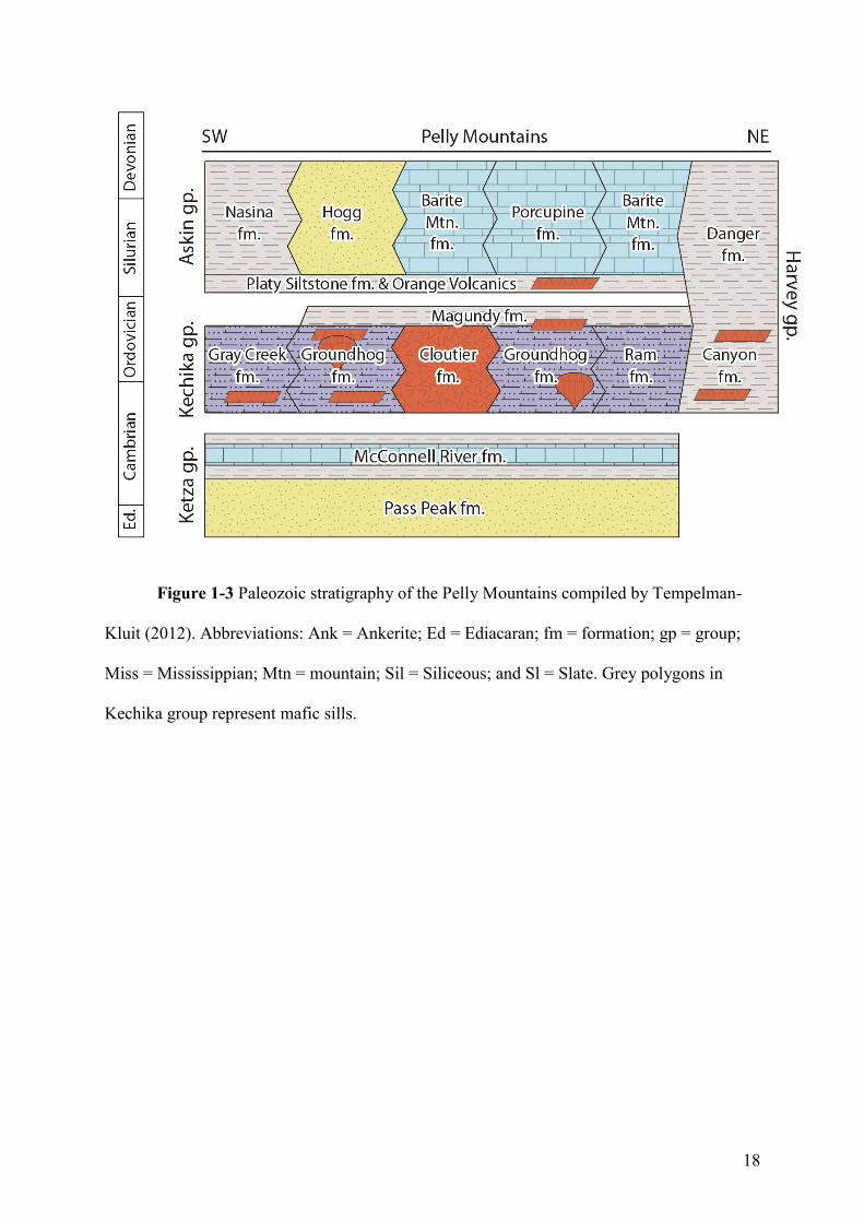
18
Figure 1-3 Paleozoic stratigraphy of the Pelly Mountains compiled by Tempelman-
Kluit (2012). Abbreviations: Ank = Ankerite; Ed = Ediacaran; fm = formation; gp = group;
Miss = Mississippian; Mtn = mountain; Sil = Siliceous; and Sl = Slate. Grey polygons in
Kechika group represent mafic sills.
19
20
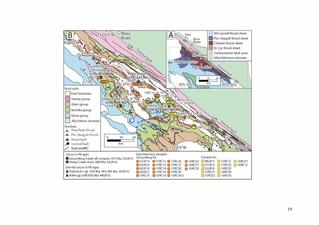
Figure 1-4 (a) Distribution of thrust sheets within the Quiet Lake (NTS 105F) and Finlayson Lake (NTS 105G) map areas, Pelly Mountains,
south-central Yukon (modified from Tempelman-Kluit, 2012). (b) Distribution of Ketza, Kechika and Askin group rocks in the Pelly Mountains
(modified from Tempelman-Kluit, 2012). Numbers refer to localities where samples were collected for geochronology and geochemistry, and are
referenced in Appendix 2, 3, and 4.
21
1.3 Thesis Objectives
The aim of this thesis is to constrain the precise timing, depositional environment, and
lithogeochemistry of Kechika group volcanic rocks and intrusive equivalents. New field and
laboratory results, in conjunction with a review of available data on coeval volcanic strata,
provide opportunities to test and develop ideas for early Paleozoic rifting and post-breakup
volcanism along the Cordilleran margin. The following points highlight the field and
analytical objectives for this study:
1) Constrain the physical stratigraphy and depositional setting of Kechika group using
lithofacies observations and facies relationships (e.g., Cas and Wright, 1988). This
objective was completed by field analysis of Groundhog and Cloutier formation
stratigraphy in the central Pelly Mountains during the summers of 2015 and 2016.
These field results were published in Yukon Exploration and Geology 2016 (Campbell
and Beranek, 2017) and appear in modified form in Chapter 2.
2) Constrain the petrogenesis, tectonic setting, and timing of Kechika group
magmatism. This objective was achieved through high-precision CA-TIMS zircon U-
Pb geochronology, whole-rock major and trace element lithogeochemistry, whole-
rock Hf-Nd isotope geochemistry, and thin section petrography.
3) Use the available data to examine the published rift models for western North
America and hypotheses for post-breakup magmatism and sedimentation in the
Canadian Cordillera. This analysis required a detailed understanding of potentially
analogous post-breakup strata emplaced along modern rifted margins for the process
of comparison.
22
4) Write, submit, and publish a peer-reviewed, international journal article that
encompasses the objectives listed in points 2 and 3. The submitted version of the
manuscript appears as Chapter 3 of this thesis.
1.4 Methods
1.4.1 Fieldwork and sample collection
Helicopter-supported fieldwork and sample collection in the Pelly Mountains of
south-central Yukon, ~20-50 km south and southeast of Ross River (Fig. 1-4), were
completed during July 2015 and June 2016. The first field season focused on contact
relationships, primary lithofacies, and the collection of rock samples for whole-rock
geochemistry and thin section petrography. The second field season allowed for the
construction of detailed stratigraphic logs and further sample collection of Groundhog and
Cloutier formation facies.
1.4.2 CA-TIMS zircon U-Pb geochronology
Zircons from five rock samples, selected to characterize the precise timing of Kechika
group magmatism, were analysed by CA-TIMS U-Pb geochronology at the Pacific Centre for
Isotopic and Geochemical Research, University of British Columbia, following the
procedures outlined in Scoates and Friedman (2008). Three Kechika group intrusive rocks
were selected to determine the timing and duration of Kechika group magmatism and two
detrital zircon samples were selected to constrain the maximum depositional age of
uppermost Kechika group-lowermost Askin group strata (Appendix 2; see Fig. 1-4 for sample
locations).
23
Zircon crystals were concentrated from rock samples using standard crushing,
gravimetric, and magnetic separation methods, handpicked in alcohol under the binocular
microscope, and annealed in quartz glass crucibles at 900ºC for 60 hours. Annealed zircons
were rinsed in ultrapure acetone and water, transferred into screwtop beakers, and chemically
abraded in ultrapure HF and HNO3 at ~175ºC for 12 hours. The remaining zircon crystals
were separated from the leachate, rinsed, weighed, and dissolved in HF and HNO3 at ~240ºC
for 40 hours. Ion-exchange column techniques were used to separate and purify Pb and U.
Isotopic ratios were measured with a modified single-collector VG-54R thermal ionization
mass spectrometer equipped with analog Daly photomultipliers. U-Pb isotopic data were
calibrated by replicate analyses of the NBS-982 reference material and values recommended
by Thirwall (2000). Data reduction was completed with the Microsoft Excel software of
Schmitz and Schoene (2007). The Isoplot program of Ludwig (2003) was used to make
Wetherill concordia diagrams and calculate weighted mean averages and MSWD (mean
square of weighted deviates) values.
1.4.3 Major, trace and Nd isotope geochemistry
Thirty samples were collected from intrusive, volcanic, and volcaniclastic units of the
Groundhog and Cloutier formations for whole-rock major- and trace-element geochemical
analysis (Appendix 3). Samples were photographed, washed, and trimmed with a rock saw to
remove weathered material. Major element oxide concentrations were acquired at Activation
Laboratories in Ancaster, Ontario, by fused-bead x-ray fluorescence. Trace element
concentrations for six samples were acquired at the Pacific Centre for Isotopic and
Geochemical Research by HR-ICPMS (Element 2, Thermo Finnigan, Germany), whereas
twenty-four samples were analyzed at Activation Laboratories using a research grade
analytical package (4LITHO RESEARCH package).
24
Eight of the samples were selected for whole-rock Nd and Hf isotope geochemistry
(Appendix 4). Isotopic analyses were carried out at the Pacific Centre for Isotopic and
Geochemical Research on a Nu Plasma II MC-ICP-MS (Nu Instruments Ltd, UK). Sample
introduction followed the methods described in Weis et al. (2006, 2007) and occurred under
dry plasma conditions using a membrane desolvator (DSN-100). For each analytical session,
the standard solution JDNi (for Nd analyses) yielded average values of 143Nd/144Nd =
0.512088 ± 0.000008 (n = 24), and 143Nd/144Nd = 0.282157 ± 0.000011 (n = 41) for 2014 and
2015 samples, respectively. The JMC 475 standard solution (for Hf analyses) yielded average
values of 176Hf/177Hf = 0.282156 ± 0.000004 (n = 11), and 176Hf/177Hf = 0.282157 ± 0.000011
(n = 41) for 2014 and 2015 samples, respectively. The results were corrected for
instrumentation mass fractionation by exponentially normalizing to 146Nd/144Nd = 0.7219
(O’Nions et al., 1979), and 179Hf/177Hf = 0.7325 (Patchett and Tatsumoto, 1981).
1.5 Co-Authorship Statement
Roderick W. Campbell:
The fieldwork portion of this thesis was completed with the assistance of Luke
Beranek and Stephen Piercey. I am the lead author of both manuscripts (Chapters 2 and 3)
and the project itself benefited from continuous discussion and constructive criticism from
my supervisor Luke Beranek. Co-authors Luke Beranek, Stephen Piercey, and Richard
Friedman reviewed and provided edits for the Chapter 3 manuscript.
Luke Beranek:
Luke Beranek designed this M.Sc. project, assisted with fieldwork and sample
collection, and provided commentary and guidance throughout all aspects of this thesis.
25
Beranek was the primary editor on the two manuscripts, wrote parts of the zircon U-Pb
results in Chapter 3, and aided the completion of this project.
Stephen Piercey:
Steve Piercey assisted with fieldwork and sample collection, provided insight on the
physical stratigraphy and geochemistry of basalt units, and aided Chapter 3 through
discussion and review.
Richard Friedman:
Richard Friedman completed the zircon U-Pb analysis at the Pacific Centre for
Isotopic and Geochemical Research, University of British Columbia, and provided edits for
the Chapter 3 manuscript.
1.6 Thesis presentation
This thesis consists of four chapters and four appendices. Chapter 1 presents a brief
geological background on the Cordilleran margin, pre-existing rift models, previous work on
lower Paleozoic rocks in the central Pelly Mountains, an overview of the purpose of the thesis
and the methods used in this study.
Chapter 2 is a modified version of a geological fieldwork article that was published in
Yukon Exploration and Geology 2016 by Campbell and Beranek (2017). This article reported
results from two field seasons and included detailed descriptions of observed lithofacies and
stratigraphic logs.
Chapter 3 is intended for publication in an international peer-reviewed journal with
the author list being Campbell, Beranek, Piercey, and Friedman. This chapter presents new
geochronological and geochemical results from the Kechika group and provides a detailed
26
overview of the Cordilleran margin and published rift models. This chapter discusses the
validity of published rift models to explain the origin of Kechika group magmatic rocks and
post-breakup tectonism along the Cordilleran margin.
Chapter 4 presents a summary of the thesis results and outlines some unanswered
questions and areas for future research.
The appendices include new compilations and supporting data for the thesis.
Appendix 1 contains a compilation of Ediacaran-early Paleozoic magmatic ages and
stratigraphic relationships along the Cordilleran margin. Appendix 2 contains the CA-TIMS
zircon U-Pb isotope results from five rocks in the Pelly Mountains. Appendix 3 contains
whole-rock major and trace element geochemical results of 30 rock samples. Appendix 4
contains the whole-rock Nd-Hf isotope geochemical results from eight rock samples.
27 *a version of this chapter was published in Yukon Exploration and Geology 2016
Chapter 2 Volcanic stratigraphy of the Cambrian-Ordovician
Kechika group, Pelly Mountains, south-central Yukon*
2.1 Abstract
Volcanic rocks occur throughout the lower Paleozoic passive margin successions
of western Canada. The tectonic significance of post-breakup magmatism is uncertain;
however, some volcanic rocks are spatially associated with margin-parallel normal faults.
At the plate-scale, such magmatism is consistent with asymmetric rift models for passive
margins, including those with lineaments or transform-transfer zones that form at high
angles to the rifted margin. A two-year project was conducted to define the stratigraphy
of post-breakup volcanism in the Pelly Mountains, south-central Yukon, and test genetic
relationships with the adjacent Liard line lineament. Field studies targeted Cambrian-
Ordovician volcanic strata of the Kechika group in the Quiet Lake map area (NTS 105F).
Observed lithofacies are indicative of submarine volcanic edifices and sediment-sill
complexes that develop during continental extension. Analogous margin-parallel
extension is recognized along the length of the Canadian Cordillera, but the influence of
the Liard line on Cambrian-Ordovician magmatism requires further testing.
28
2.2 Introduction
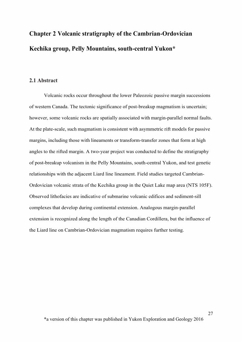
The ancestral Pacific margin of western North America (Fig. 2-1) was created
during the protracted rifting of Rodinia (e.g., Bond et al., 1984, 1985). An initial
Neoproterozoic rifting event in the Canadian Cordillera is in part recorded by the
Franklin LIP and Windermere Supergroup (Heaman et al., 1992; Colpron et al., 2002).
The Hamill and Gog groups are the inferred products of the final stage of continental
breakup within the southern Canadian Rocky Mountains and the Selkirk and Purcell
Mountains, southeastern British Columbia (Fig. 2-1; e.g., Bond et al., 1985; Devlin and
Bond, 1988; Nelson et al., 2013). In this region, the timing of final rifting is constrained by
late Ediacaran (ca. 570 Ma) volcanic rocks of the Hamill Group (Colpron et al., 2002). The
rift to post-rift transition did not occur until at least the early Cambrian based on
Tommotian to Atdabanian (Terreneuvian to Cambrian Series 2) fossils in the Gog Group
and McNaughton Formation (Bond et al., 1985; Magwood and Pemberton, 1988; Hein
and McMechan, 1994) and thermal subsidence trends (e.g., Bond and Kominz, 1984).
Ediacaran to lower Cambrian strata similarly record the establishment of shallow-water
Mackenzie platform and deep-water Selwyn basin in eastern Yukon and adjacent
Northwest Territories (Fig. 2-1; e.g., Gordey and Anderson, 1993; Moynihan, 2014).
29
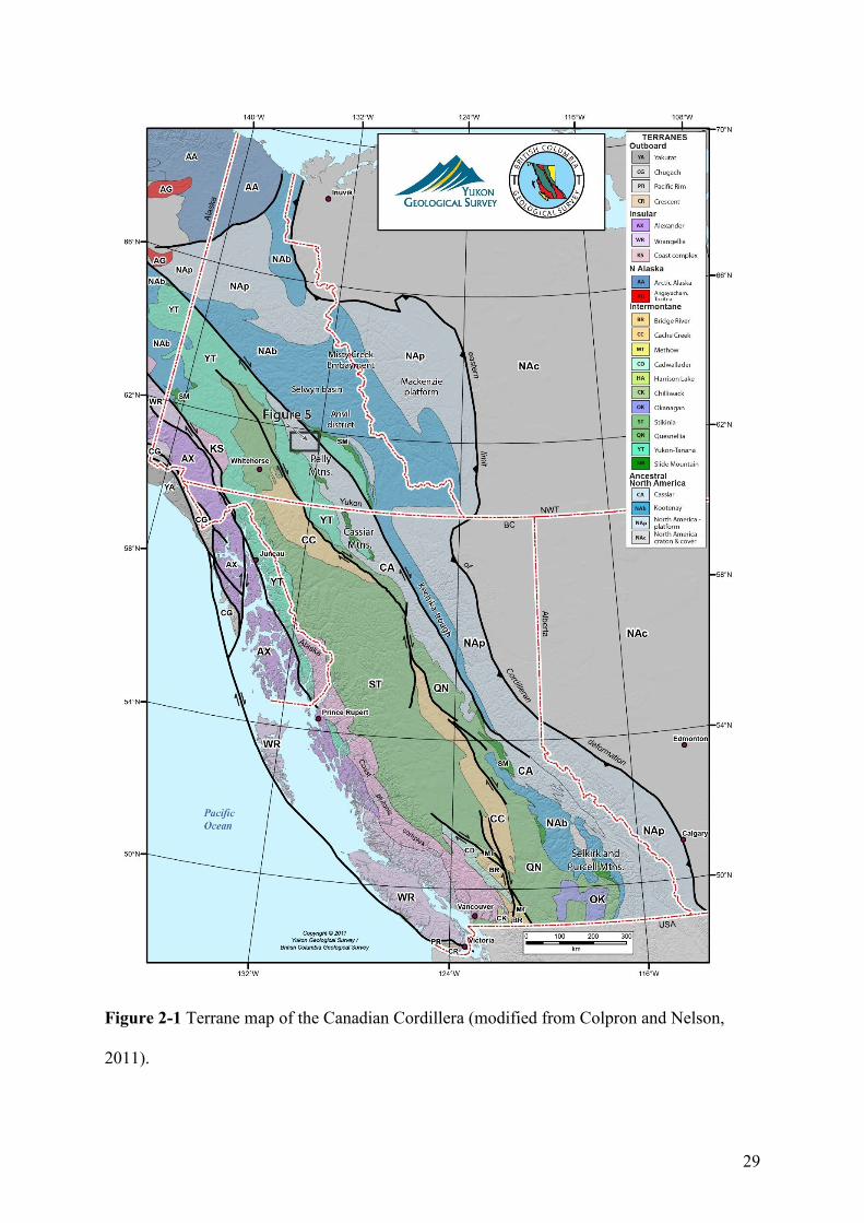
Figure 2-1 Terrane map of the Canadian Cordillera (modified from Colpron and Nelson,
2011).
30
Magmatism along the western Laurentian margin did not cease with continental
breakup and remains an outstanding problem in Cordilleran geology. For example, upper
Cambrian-Ordovician volcanic rocks observed along the length of the North American
Cordillera (e.g., Goodfellow et al., 1995; Lund et al., 2010; Millonig et al., 2012; Pigage
et al., 2012) are seemingly inconsistent with simplistic models for post-breakup, passive
margin sedimentation (e.g., Aitken, 1993). Goodfellow et al. (1995) suggested a spatial
association between lower Paleozoic volcanic rocks and margin-parallel normal faults that
define the western extent of the basin to the basin-platform transition zone (2- 2; Hayward,
2015). Early Paleozoic volcanism in the region has therefore been linked to periodic
extension (e.g., Fritz et al., 1991; MacIntyre, 1998; Pyle and Barnes, 2003). For example,
Marmot Formation rocks in the Misty Creek embayment, Northwest Territories (Fig. 2-1) are
associated with a “steer’s head” rift profile (Cecile et al., 1982, 1997; Leslie, 2009). Menzie
Creek formation volcanic rocks in the Anvil District, central Yukon (Fig. 2-1), are adjacent to
sedimentary exhalative (SEDEX) base-metal deposits (Faro, Grum, Vangorda and others)
and probably related to local faulting (e.g., Pigage, 2004; Cobbett, 2016). Early
Paleozoic faults allowed volumetrically small, incompatible element-enriched, low
degree partial mantle melts to erupt onto the surface or crystallize in the upper crust
(Goodfellow et al., 1995; Millonig et al., 2012).
The inferred volume of early Paleozoic magmatism is minor compared to that
associated with continental breakup and no other major tectonic event is recorded within
Cambrian-Ordovician rocks along the ancient Pacific margin (e.g., Bond et al., 1984;
Devlin and Bond, 1988; Cecile and Norford, 1993). Periodic, late Cambrian to
Ordovician volcanism is therefore unlikely to result from subduction or plume-related
magmatism. Instead, post-breakup magmatism is consistent with asymmetric rift models
for passive continental margins (e.g., Lister et al., 1986, 1991). Such models combine
31
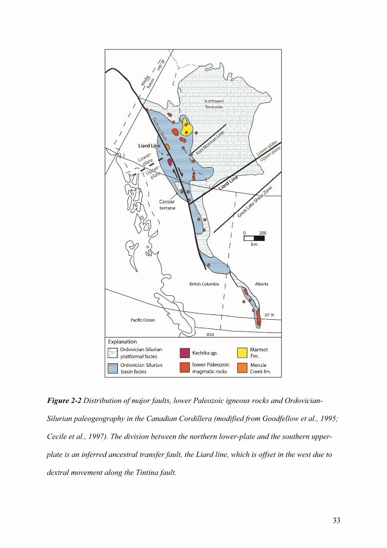
lithospheric-scale detachment faults and related low-angle shear zones with crustal
thinning to achieve continental breakup. In most versions of this model, the hanging wall
of the detachment fault, termed the upper-plate, undergoes less extension and is
dominated by upper crust. Conversely the footwall, termed the lower-plate, undergoes a
greater degree of extension and is more dominated by lower and middle crust (Fig. 2-3;
e.g., Lister et al., 1986). In some of these rift scenarios the majority of the lithospheric
mantle is removed from beneath the upper-plate margin and replaced with
asthenospheric mantle (e.g., Lister et al., 1991). Along the length of a rifted margin,
upper and lower-plate segments are separated by lithospheric-scale transform-transfer
faults (e.g., Lister et al., 1986). Such structural zones may provide a pathway for mantle-
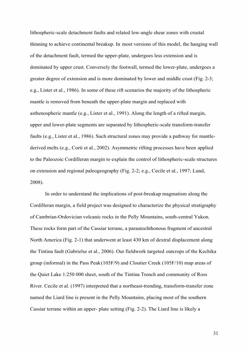
derived melts (e.g., Corti et al., 2002). Asymmetric rifting processes have been applied
to the Paleozoic Cordilleran margin to explain the control of lithospheric-scale structures
on extension and regional paleogeography (Fig. 2-2; e.g., Cecile et al., 1997; Lund,
2008).
In order to understand the implications of post-breakup magmatism along the
Cordilleran margin, a field project was designed to characterize the physical stratigraphy
of Cambrian-Ordovician volcanic rocks in the Pelly Mountains, south-central Yukon.
These rocks form part of the Cassiar terrane, a parautochthonous fragment of ancestral
North America (Fig. 2-1) that underwent at least 430 km of dextral displacement along
the Tintina fault (Gabrielse et al., 2006). Our fieldwork targeted outcrops of the Kechika
group (informal) in the Pass Peak (105F/9) and Cloutier Creek (105F/10) map areas of
the Quiet Lake 1:250 000 sheet, south of the Tintina Trench and community of Ross
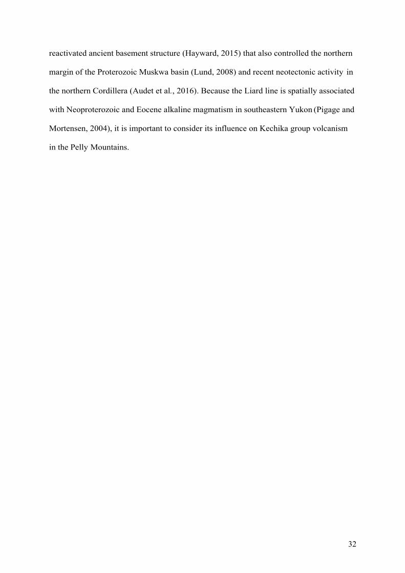
River. Cecile et al. (1997) interpreted that a northeast-trending, transform-transfer zone
named the Liard line is present in the Pelly Mountains, placing most of the southern
Cassiar terrane within an upper- plate setting (Fig. 2-2). The Liard line is likely a
32
reactivated ancient basement structure (Hayward, 2015) that also controlled the northern
margin of the Proterozoic Muskwa basin (Lund, 2008) and recent neotectonic activity in
the northern Cordillera (Audet et al., 2016). Because the Liard line is spatially associated
with Neoproterozoic and Eocene alkaline magmatism in southeastern Yukon (Pigage and
Mortensen, 2004), it is important to consider its influence on Kechika group volcanism
in the Pelly Mountains.
33
Figure 2-2 Distribution of major faults, lower Paleozoic igneous rocks and Ordovician-
Silurian paleogeography in the Canadian Cordillera (modified from Goodfellow et al., 1995;
Cecile et al., 1997). The division between the northern lower-plate and the southern upper-
plate is an inferred ancestral transfer fault, the Liard line, which is offset in the west due to
dextral movement along the Tintina fault.
34
Figure 2-3 Schematic cross section of an asymmetric rift system (modified from Lister et al., 1991; Lund, 2008).
35
2.3 Geological framework
2.3.1 Ketza group
The Ketza group consists of upper Neoproterozoic to lower Cambrian rocks that
are the oldest exposed units of the Cassiar terrane in the Quiet Lake map area (Figs. 2-4
and 2-5a; Tempelman-Kluit, 2012). The basal Pass Peak formation is 200-700 m thick
and comprises green to tan shale, siltstone, and quartzite. The overlying McConnell
River formation is 600-800 m-thick and consists of calcareous mudstone and siltstone,
carbonate lenses with archaeocyathid-bearing mounds, and black pyritic slate
(Tempelman-Kluit, 2012). The late early Cambrian archaeocyathid mounds are also
recognized within post- rift successions of the southern Canadian Cordillera (e.g.,
Devlin, 1989). In the Cloutier Creek map area, the upper contact of the Ketza group near
the Ketza River Mine (Fig. 2-5b) is poorly exposed and structurally deformed. A distinct
mid-Cambrian fossil gap between upper Ketza and lower Kechika group strata suggests the
presence of an unconformity (Tempelman-Kluit, 2012). A similar mid-Cambrian
unconformity has been inferred within the Cassiar terrane of the Cassiar Mountains and
the Kechika trough of the northern Canadian Rocky Mountains (Fig. 2-1; e.g., Gabrielse,
1963; Taylor and Stott, 1973; Gabrielse et al., 2006). In the Cassiar Mountains, the
contact between the lower Cambrian Rosella Formation and upper Cambrian to
Ordovician Kechika group is obscured by faulting (Gabrielse, 1963; Fritz et al., 1991). In
the Canadian Rockies, mid- to late Cambrian deposition occurred within an active horst
and graben system named the Kechika graben (e.g., Gabrielse and Taylor, 1982; Post and
Long, 2008). This graben later evolved into the Kechika trough (Post and Long, 2008).
36
Figure 2-4 Paleozoic stratigraphy of the Pelly Mountains compiled by Tempelman-Kluit
(2012). Abbreviations: Ank = Ankerite; Ed = Ediacaran; fm = formation; gp = group; Miss
= Mississippian; Mtn = mountain; Sil = Siliceous; and Sl = Slate. Grey polygons in Kechika
group represent mafic sills.
37
Figure 2-5 (a) Distribution of thrust sheets within the Quiet Lake (NTS 105F) and Finlayson Lake (NTS 105G) map areas, Pelly Mountains,
south-central Yukon (modified from Tempelman-Kluit, 2012). (b) Distribution of Ketza, Kechika and Askin group rocks in the Pelly Mountains
(modified from Tempelman-Kluit, 2012). Measured stratigraphic sections on map are displayed in Figure 2-6.
38
2.3.2 Kechika group
The Kechika group (Fig. 2-4; Beranek et al., 2016) is an upper Cambrian to
Ordovician succession of four formations that Tempelman-Kluit (2012) described as
laterally equivalent and interfingered. The four formations from northeast to southwest
(Fig. 2-5a, b) comprise the Ram, Cloutier, Groundhog, and Gray Creek formations
(Tempelman-Kluit, 2012) and occur as narrow, northwest- trending, discontinuous belts
across the Pelly Mountains. The Groundhog, Cloutier and Ram formations are
discontinuously capped by the Magundy formation (Fig. 2-4).
Tempelman-Kluit (2012) defined the Groundhog formation as at least 800 m-
thick and consisting of thinly bedded, “darker, non-calcareous phyllite or slate” as
opposed to the “orange or buff platy limestone and phyllite” of the Ram formation and
the volcanic tuff of the Cloutier formation. Our fieldwork has instead shown that
Groundhog formation strata are characterized by interbedded argillaceous shale, silty
limestone, tuffaceous shale (phyllite) to sandstone, and lapilli tuff. Silty limestone occurs
throughout the Groundhog formation, but tuffaceous rocks are generally restricted to the
middle to upper part of the sequence.
Massive basalt and gabbro sills that are 0.5 to 30 m-thick occur throughout the
Groundhog formation and typically show intrusive contacts with enclosing fine-grained
clastic rocks. Up to 20 m-thick sections of volcanic and volcaniclastic rocks occur within
the Groundhog and Magundy formations in the northern Quiet Lake map area, especially
near Ram Creek and south of Mt. Green (Fig. 2-5b). Volcanic and volcanogenic
sedimentary lithofacies include massive amygdaloidal basalt, lapilli tuff, monomictic
volcanic breccia, sediment-matrix (volcanic and sedimentary lithic) breccia, and
polymictic (volcanic and sedimentary clast) conglomerate (Table 2-1).
39
The Cloutier formation is 500 to 1000 m-thick and comprises resistant, mafic
volcanic and volcaniclastic rocks that vary in lateral extent (Tempelman-Kluit, 2012).
Primary volcanic facies include massive vesicular to amygdaloidal basalt, pillow basalt,
and sediment-matrix basalt breccia (Table 2-1). Volcanogenic sedimentary facies include
lapilli tuff, tuffaceous shale (phyllite) to sandstone, monomictic volcanic breccia,
monomictic volcanic conglomerate and polymictic (volcanic and sedimentary clast)
conglomerate (Table 2-1). These facies are intercalated with fine-grained argillaceous
and calcareous rocks (comparable to those that define the Groundhog and Ram
formations, respectively) and black shale (Table 2-1).
The Magundy formation is up to 400 m-thick and mostly consists of recessive
graphitic shale with minor quartz sandstone, massive basalt, and tuff comparable with
those of the Cloutier formation (Gordey, 1981; Tempelman-Kluit, 2012). Ordovician
graptolites provide an upper age constraint for the Magundy formation (Gordey, 1981;
Tempelman-Kluit, 2012).
The Ram formation is at least 1000 m-thick and crops out between the Tintina
and St. Cyr faults. The depositional age of the Ram formation is constrained by late
Cambrian and Early Ordovician trilobite fossils (Tempelman-Kluit, 2012). The Gray
Creek formation is a 400 m-thick unit that consists of greenstone, quartz mica schist, and
siltstone that Tempelman-Kluit (2012) related to more metamorphosed equivalents of the
Cloutier, Pass Peak, and Nasina formations (Askin group), respectively.
Equivalents of the magmatic rocks of the Groundhog and Cloutier formations in
the Pelly Mountains are recognized elsewhere in the Cassiar terrane. In the Cassiar
Mountains, Gabrielse (1963) mapped greenstone units that are similar to the mafic sills
within the Quiet Lake map area (Tempelman-Kluit, 2012). In the Glenlyon area of central

40
Yukon, minor amphibolite has been interpreted as high-grade equivalents of the Kechika
group sills (e.g., Black et al., 2003; Gladwin et al., 2002).
2.3.3 Askin group
Shallow-marine strata of the Askin group (Fig. 2-4) comprise part of the Silurian
and Early Devonian Cassiar platform (e.g., Gabrielse, 1963; Cecile et al., 1997;
Tempelman-Kluit, 2012). A basal 100-500 m-thick unit of dolomitic siltstone (Platy
Siltstone formation) locally contains mafic to intermediate volcanic rocks (Orange
Volcanics member). Our field observations suggest that the Orange Volcanics member
near Ram Creek and Mt. Green (Fig. 2-5b) contains pillow basalt and intermediate
volcanic breccia. This basal unit is overlain by four formations (Porcupine, Barite
Mountain, Hogg and Nasina formations; Fig. 2-4) with gradational to angular discordant
contacts and rapid facies and thickness changes (Tempelman-Kluit, 2012). The Grey
Limestone formation caps these four formations.
2.4 Field studies
Lower Paleozoic rocks of the Pelly Mountains crop out within four structural-
stratigraphic zones that from west to east comprise the McConnell, Porcupine-Seagull,
Cloutier, and St. Cyr thrust sheets (Fig. 2-5a). Seven of the stratigraphic sections (Figs.
2-6.1 to 2-6.7) discussed below occur within the Porcupine-Seagull thrust sheet, whereas
one stratigraphic section (Fig. 2-6.8) occurs within the overlying Cloutier thrust sheet.
The locations of field sites are shown in Figure 2-5b and sequentially numbered therein
from northeast to southwest. Facies associations and estimated thicknesses are
documented through stratigraphic measurement and description. Volcanic and intrusive
rocks were systematically sampled for whole-rock geochemistry, Nd-Hf isotope

41
geochemistry, and zircon U-Pb geochronology to constrain the genesis and crustal-
mantle sources of early Paleozoic magmatism.
42
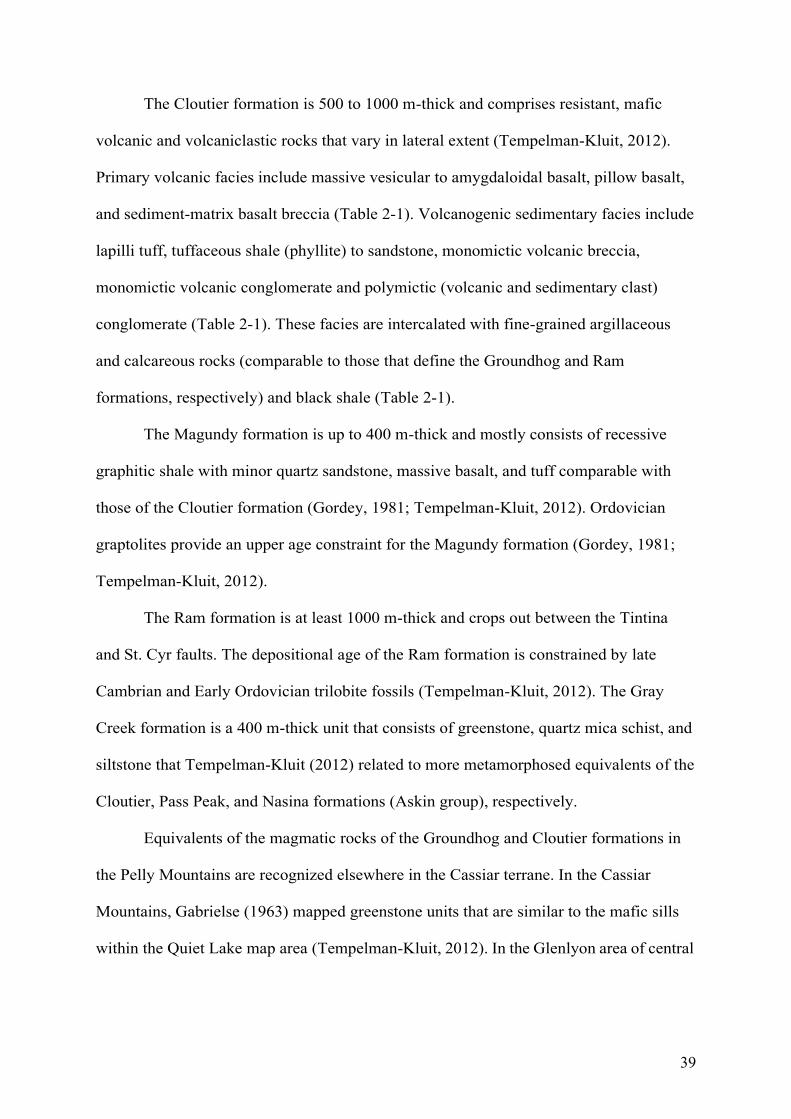
Figure 2-6 Measured stratigraphic sections of the Kechika group, Pass Peak and Cloutier Creek map areas, Pelly Mountains, south-central
Yukon.
43
2.4.1 Groundhog formation stratigraphy
East of Lapie Lakes - Figure 2-6, location 1
This section is exposed along a series of northeast-trending ridges immediately
east of Lapie Lakes and the South Canol Road in the western Pass Peak map area (base
of section: zone 08V 603248E 6843697N NAD83). Although exposure is patchy and
complex folding is common, 50% of the outcrop throughout >200 m-thick section
consists of interbedded steel-grey argillaceous and calcareous shale (phyllite; Fig. 2-7a,
b) with rare 5-30 cm fine sandstone beds. Approximately 40% of the exposure consists of
resistant, 1 to >30 m thick basaltic to gabbroic sills. Rare (<10% of outcrop), up to 2 m-
thick lapilli tuff beds form resistant units within the shale.
Ram Creek - Figure 2-6, location 2
Exposures of the upper Groundhog formation were examined along a northwest-
trending ridge near the headwaters of Ram Creek in the northern Pass Peak map area
(base of section: zone 08V 626236E 6844619N NAD83). The section is >130 m-thick
and features two distinct components. The basal 60% of the section consists of steel grey
to black argillaceous and tuffaceous shale (phyllite), with medium-bedded silty limestone
and 1 to >10 m-thick massive amygdaloidal basalt, and gabbroic sills (Fig. 2-7c).
Volcanic and volcaniclastic rocks are intercalated within the upper 40% of the section
and mostly consist of massive basalt, monomictic volcanic breccia, and sediment-matrix
(volcanic and sedimentary lithic) breccia (Fig. 2-7d-f). These rocks are interbedded with
metre-thick units of grey shale, limestone and poorly exposed black shale of the
Magundy formation. The overlying Askin group at this location consists of volcaniclastic
breccia and dolomitic sandstone of the Orange Volcanics member of the Platy Siltstone
formation.
44
South of Mt. Green - Figure 2-6, location 3
Groundhog and Magundy formation strata were examined along a northeast-
trending ridge ~3 km south of Mt. Green in the northwest Cloutier Creek map area. The
basal contact of the Groundhog formation is a thrust fault that places Kechika group
rocks on top of the Devonian- Mississippian Black Slate formation (base of section: zone
08V 0636780E 6843033N NAD83). This section is at least 50 m-thick and lithologically
similar to that exposed in the Ram Creek area. The basal 50% consists of interbedded
steel-grey argillaceous and calcareous shale (phyllite) and >10 m-thick gabbro intrusion.
The upper 50% consists of monomictic volcanic breccia, sediment-matrix (volcanic and
sedimentary lithic) breccia (Fig. 2-7g) and lapilli tuff (Fig. 2-7h).
Cloutier Creek area - Figure 2-6, location 4
Groundhog formation rocks were examined ~8 km north of the Ketza River Mine,
along a northwest-trending ridge between Cloutier Creek and the Ketza River, in the
central Cloutier Creek map area (base of section: zone 08V 645712E 6834820N
NAD83). This section is at least 150 m-thick and consists of a gabbroic stock (mapped as
Cloutier formation) that intrudes >20 m of interbedded tuffaceous shale (Fig. 2-8a), thin
to medium- bedded silty limestone (Fig. 2-8b), tuffaceous sandstone (Fig. 2-8c), and
interbedded steel-grey argillaceous to calcareous shale (phyllite). Several metre-thick
gabbroic sills occur throughout the succession. The erosional top of the section consists
of green, polymictic (volcanic and limestone clast) conglomerate.
45
Northwest of Ketza River Mine - Figure 2-6, location 8
A succession of Groundhog formation strata overlies the Ketza group ~6 km
northwest of the Ketza River Mine in the southern Cloutier Creek map area (base of the
Groundhog formation: 08V 637814E 6829108N NAD83). Ketza group strata at this
location comprise archaeocyathid-bearing limestone, silty limestone and pyritic
mudstone. The contact with the overlying Groundhog formation is poorly exposed and
the Ketza group shows evidence of structural duplication and local faulting. The
Groundhog formation is >100 m-thick and consists of interbedded steel-grey shale and
silty limestone units (Fig. 2-8d, e) that are intruded by 0.5-2 m-thick, typically
amygdaloidal, basalt to gabbroic sills (Fig. 2-8f; >10% of the total outcrop). Strongly
deformed and complexly folded tuffaceous green phyllitic shale and lesser fine-grained
sandstone comprise the top of the section (<10% of sequence).
2.4.2 Cloutier formation stratigraphy
Northeast of Ketza River Mine - Figure 2-6, location 5
This section is >90 m-thick and exposed along a ridge ~6 km northeast of the
Ketza River Mine, near peak 6762 in the eastern Cloutier Creek map area (base of the
section: 08V 652511E 6831507N NAD83). The basal 70% of the section consists of
tuffaceous shale (phyllite), normally graded beds of coarse to fine-grained volcanic
sandstone (Fig. 2-8g), and lapilli tuff (Fig. 2-8h). The tuffaceous rocks are locally
intercalated with medium-bedded limestone. The upper 30% of the section consists of
complexly folded, massive metre-scale amygdaloidal basalt sills that are intercalated
with steel-grey argillaceous and calcareous shale (phyllite) and lapilli tuff.
46
East of Ketza River Mine - Figure 2-6, location 6
This 140 m-thick section is exposed along a southwest- trending ridge ~10 km
east of the Ketza River Mine (base of section: zone 08V 654218E 6829014N NAD83).
The basal part of the sequence consists of 2 to 10 m-thick units of vesicular to
amygdaloidal massive basalt (Fig. 2-9a), vesicular pillow basalt (Fig. 2-9b), sediment-
matrix basalt breccia (Fig. 2-9c), and up to 8 m-thick units of monomictic volcanic
breccia (Fig. 2-9d) and monomictic volcanic conglomerate (Fig. 2-9e). The top of the
succession is variably deformed and consists of black shale, limestone and up to 2 m-
thick massive basalt lava flows that are capped by granule to cobble polymictic (mafic-
intermediate volcanic and limestone clast) conglomerate (Fig. 2-9f).
South of Ketza River - Figure 2-6, location 7
At least 90 m of Cloutier formation strata are exposed along a north-trending
ridge at the headwaters of the Ketza River in the southern Cloutier Creek map area (base
of section: zone 08V 654352E 6823223N NAD83). The basal 70% of this sequence
consists of interbedded steel-grey argillaceous and calcareous shale (phyllite), 1 to 3 m-
thick basalt to gabbro sills, and up to 3 m-thick beds of lapilli tuff. The upper 30%
consists of a 20 m-thick sequence of pillow basalt (Fig. 2-9g, h) and sheared mafic rocks
that are intercalated with silty limestone and argillaceous shale.
47
Figure 2-7 Field photographs of Kechika group units. (a) tight folding of grey-shale, east of
Lapie Lakes, Pass Peak map area; (b) steel-grey argillaceous shale; (c) resistant 8 m-thick
gabbroic sill within shale, Ram Creek, Cloutier Creek map area; (d) sediment-matrix lithic
(limestone and tuffaceous rock) breccia; (e) massive amygdaloidal basalt in contact with
sediment-matrix volcanic and sedimentary lithic breccia (contact outlined in yellow) (f)
sediment-matrix volcanic and sedimentary lithic breccia; (g) sediment-matrix lithic
(limestone, shale, mafic tuff, amygdaloidal basalt) breccia, south of Mt. Green, Cloutier
Creek map area; and (h) lapillistone to lapilli tuff with rounded lapilli clasts.
48
Figure 2-8 Field photographs of Kechika group units. (a) Interbedded tuffaceous shale and
silty limestone, near Cloutier Creek, Cloutier Creek map area (b) medium-bedded silty
limestone; (c) green tuffaceous sandstone; (d) interbedded steel-grey argillaceous shale and
silty limestone, northwest of Ketza River Mine, Cloutier Creek map area; (e) thin to medium-
bedded silty limestone; (f) intrusive contact of 2 m-thick amygdaloidal basalt sill; (g)
irregular lapilli clasts in graded tuffaceous sandstone and shale, northeast of Ketza River,
Cloutier Creek map area; and (h) lapilli tuff with elongate lapilli clasts.
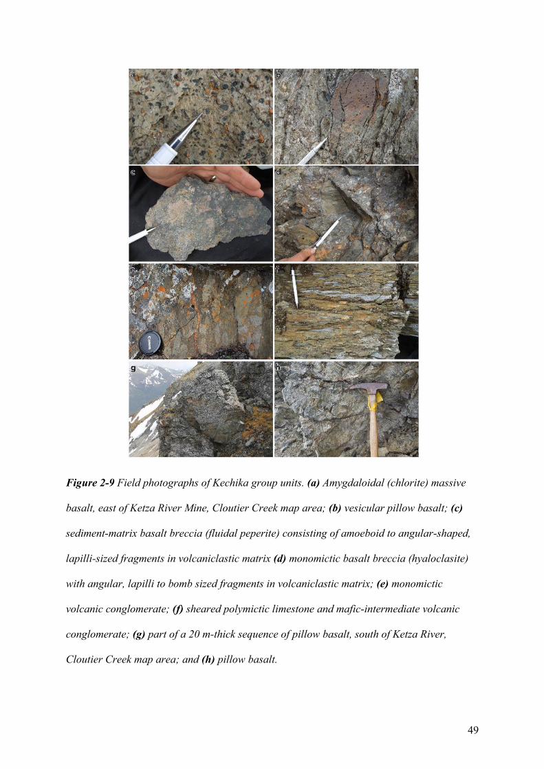
49
Figure 2-9 Field photographs of Kechika group units. (a) Amygdaloidal (chlorite) massive
basalt, east of Ketza River Mine, Cloutier Creek map area; (b) vesicular pillow basalt; (c)
sediment-matrix basalt breccia (fluidal peperite) consisting of amoeboid to angular-shaped,
lapilli-sized fragments in volcaniclastic matrix (d) monomictic basalt breccia (hyaloclasite)
with angular, lapilli to bomb sized fragments in volcaniclastic matrix; (e) monomictic
volcanic conglomerate; (f) sheared polymictic limestone and mafic-intermediate volcanic
conglomerate; (g) part of a 20 m-thick sequence of pillow basalt, south of Ketza River,
Cloutier Creek map area; and (h) pillow basalt.
50
2.5 Preliminary analytical results
Preliminary lithogeochemical results indicate that Kechika group rocks have
ocean island basalt-like (OIB) affinities (Fig. 2-10a; Sun and McDonough, 1989) that are
typical of some alkali basalt to foidite rocks in the Canadian Cordillera (Fig. 2-10b) and
around the globe (Winchester and Floyd 1977; Sykes, 1978; Pearce 1996). High-precision
zircon U-Pb studies have determined late Cambrian and Early Ordovician crystallization ages
for gabbro in the Pass Peak map area (work in progress).
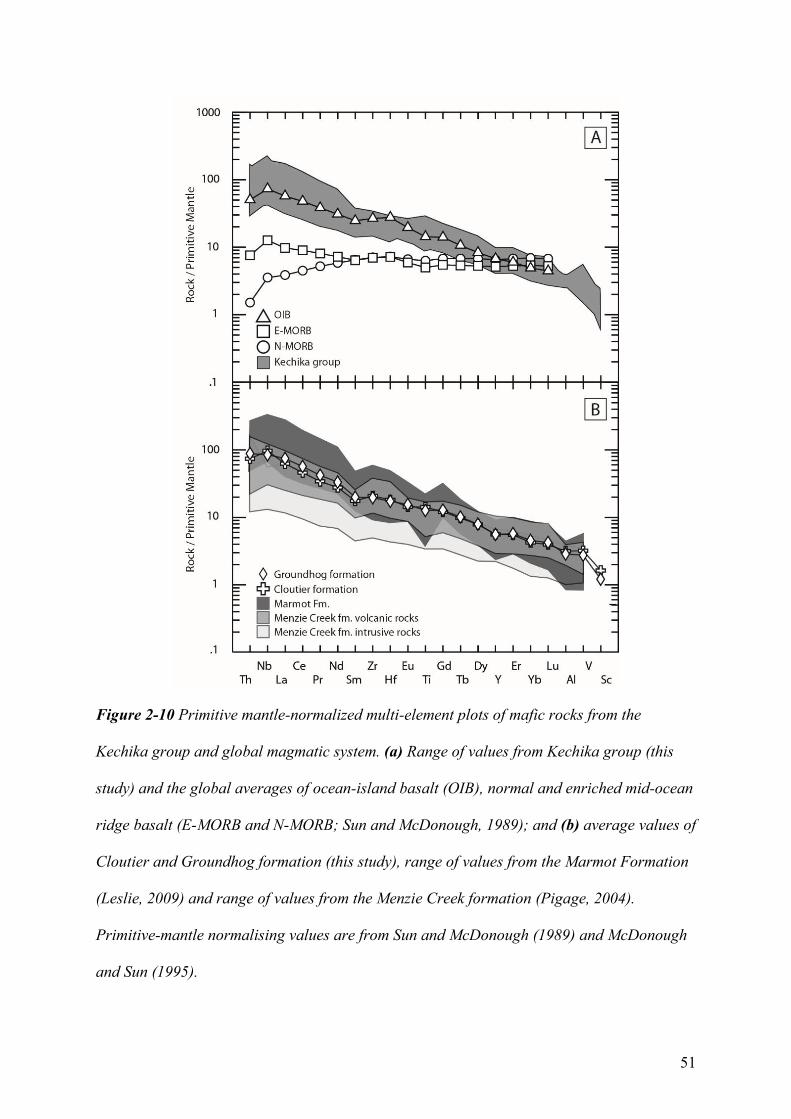
51
Figure 2-10 Primitive mantle-normalized multi-element plots of mafic rocks from the
Kechika group and global magmatic system. (a) Range of values from Kechika group (this
study) and the global averages of ocean-island basalt (OIB), normal and enriched mid-ocean
ridge basalt (E-MORB and N-MORB; Sun and McDonough, 1989); and (b) average values of
Cloutier and Groundhog formation (this study), range of values from the Marmot Formation
(Leslie, 2009) and range of values from the Menzie Creek formation (Pigage, 2004).
Primitive-mantle normalising values are from Sun and McDonough (1989) and McDonough
and Sun (1995).
52
2.6 Stratigraphic interpretation
Four principal lithofacies (basaltic, volcanogenic sedimentary, limestone-argillite,
intrusive rock) are recognized within the Cloutier and Groundhog formations (Table 2-1).
Volcanic and proximal volcanogenic lithofacies of the middle to upper Cloutier formation
and parts of the upper Groundhog and lower Magundy formations are consistent with a
submarine vent proximal succession. The lower Cloutier formation and much of the
Groundhog formation may comprise part of a sediment- sill complex based on the
prevalence of concordant mafic rocks that intruded into, or were erupted onto, wet
marine sediment (e.g., Einsele, 1986; Batiza and White, 2000).
2.6.1 Basaltic facies association
The basaltic facies association is related to the eruption of primary volcanic
products. Basaltic lithofacies consist of massive amygdaloidal to vesicular basalt,
pillowed basalt and peperite (Table 2-1). The massive amygdaloidal to vesicular basalts
are predominantly sills, but some lava flows are locally recognized. Pillowed lava flows
are consistent with subaqueous volcanism and most common within low effusivity
systems (Moore, 1975; Batiza and White, 2000). Sediment-matrix basalt breccia
lithofacies, with lapilli-sized, amoeboid to angular-shaped clasts, are interpreted as
fluidal peperite units that formed through the interaction of basaltic lava and fluid-
saturated sediment during emplacement (e.g., Skilling et al., 2002).
2.6.2 Volcanogenic sedimentary facies association
Volcanogenic sedimentary rocks are interpreted to have formed by the reworking
of primary volcanic units. Volcanogenic sedimentary facies mostly include monomictic
volcanic breccia, monomictic volcanic conglomerate, sediment-matrix volcanic and
53
sedimentary lithic breccia, polymictic volcanic and limestone clast conglomerate, lapilli
tuff and tuffaceous shale to sandstone (Table 2-1).
Monomictic volcanic breccia units consist of lapilli to bomb-sized, irregular-
shaped, basaltic clasts. These strata likely represent resedimented hyaloclastite units that
form due to the rapid cooling and fragmentation of basaltic lava during interaction with
water (e.g., Batiza and White, 2000; Simpson and McPhie, 2001). Fragmentation
processes can also occur due to the expansion of volatiles (Fisher and Schminke, 1984).
Hyaloclastite units with bomb-sized fragments occur adjacent to pillow basalt and are
inferred to represent pillow breccia, a deposit formed by the gravitational or mechanical
detachment of pillows (e.g., Batiza and White, 2000; Simpson and McPhie, 2001).
Hyaloclastite units are typical of shallow-water deposits and/or within areas of steep
relief such as seamount flanks (Batiza and White, 2000).
Sediment-matrix lithic breccia and polymictic conglomerate units contain rock
fragments that are representative of underlying volcanic, volcaniclastic, and marine
sedimentary strata. For example, the limestone-bearing conglomerate units have clasts
that are comparable to exposures of blue-grey carbonate and limy clastic rocks within the
Cloutier and Groundhog formations. The large clast sizes and locally sourced material
indicate proximal reworking and deposition with limited transport. These coarse-grained
units were likely caused by slope collapse processes and may be unrelated to volcanic
processes (e.g., McPhie and Cas, 2015).
Tuffaceous rocks are inferred to record both pyroclastic and epiclastic processes
(e.g., Fisher and Schmincke, 1984). Tuffaceous sandstone and shale are indicative of
epiclastic processes, especially when beds show evidence for normally graded bedding
(e.g., Cas and Wright, 1988). Tuffaceous shale, often interbedded with argillaceous and
calcareous layers, likely formed through the deposition of “relatively dilute suspensions
54
of ash” in the water column during periods of low volcanic activity (e.g., McPhie and
Cas, 2015).
2.6.3 Limestone-argillite facies association
The limestone-argillite facies likely resulted from the suspension sedimentation of
mud, silty carbonate and volcanic ash below wave-base. Interbedded steel-grey argillaceous
shale and blue-grey to tan silty limestone are the most common facies. Black shale with rare
limestone occurs near the top of the Groundhog and Cloutier formations. Metre-thick,
medium-bedded limestone units are intercalated within the tuffaceous-rich successions. Silty
limestone predominates over argillaceous shale for tens of metres near the base of the
Kechika group.
2.6.4 Intrusive rocks
Intrusive rocks of the Kechika group are associated with the emplacement of
magma within shallow or unconsolidated sedimentary strata. The intrusive rocks consist
of tabular, 1 to 30 m-thick basaltic to gabbroic rocks that are concordant with bedding.
Gabbroic rocks are dark grey to green, with coarse porphyritic pyroxene (altered to
chlorite) and more rarely plagioclase. The intrusive contacts are typically irregular and
often display chilled margins and baked contacts with enclosing shale units that are 10s
of centimetres thick.
The geochemical similarities of Kechika group units support the interpretation
that intrusive rocks (mostly in the Groundhog formation) were subvolcanic feeders to
coeval extrusive rocks (mostly in the Cloutier formation). Metre-thick to tens of metres
thick sills within the Groundhog and lower Cloutier formations are inferred to represent
part of a sill-sediment complex (e.g., Einsele, 1986). Such complexes occur in areas of
55
thick unconsolidated (wet) sediment, although intrusive, not peperite contacts,
predominate within the Kechika group sills. Sill-sediment complexes can form during the
rifting of thinned continental crust and are frequently associated with transform-transfer
zones (e.g., Einsele, 1986; Naylor et al., 1999).
2.7 Regional correlations and future work
Based on the available geochemical results (Fig. 2-10a), our working hypothesis
calls for Kechika group magmatism to have resulted from the low-degree partial melting
of a mantle source with fertile components (e.g., Fitton, 1987; Pearce 1996; Niu et al.,
2011), perhaps due to periodic extensional faulting along the Cordilleran margin.
Although no direct field evidence is yet recognized for Cambrian-Ordovician faults in
the Pelly Mountains (Tempelman-Kluit, 2012), the Kechika group is characterized by
lithofacies and geochemical signatures that are analogous to coeval mafic rocks within
the Selwyn basin and Misty Creek embayment (Fig. 2-10b), which are demonstrably
linked to local extension (e.g., Pigage, 2004; Leslie, 2009). These correlations imply that
similar post-breakup, rift-related processes occurred to the north and south of the Liard
line during the early Paleozoic. Similar to the Kechika group, Menzie Creek formation
rocks in the Anvil District are overlain by younger volcanic rocks that may be related to
the reactivation of pre-existing structures along the Cordilleran margin (Beranek et al.,
2016; Cobbett, 2016). The influence of the Liard line on Paleozoic magmatism in south-
central Yukon remains an open question and requires future testing.
Potential analogues for Kechika group volcanism include syn to post-breakup
rocks associated with the Orphan, Fogo, and Newfoundland Seamounts in the Grand
Banks area, offshore Newfoundland (Pe-Piper et al., 2007, 2013). The Newfoundland
continental margin is a magma-poor, hyperextended, asymmetric rift margin that evolved
56
from Late Triassic to mid-Cretaceous time (e.g., Peron-Pinvidic et al., 2007; Brune et al.,
2014). This margin has volcanic centres with OIB-like, alkaline mafic rocks that were
emplaced into extended continental crust (Jagoutz et al., 2007; Pe-Piper et al., 2013). The
seamounts are generally linear features that are bounded by margin-parallel extensional
faults. In the case of the Orphan and Fogo Seamounts, volcanic centres are spatially
associated with the Charlie Gibbs fracture zone and Southwest Grand Banks transform
margin, respectively (Pe-Piper et al., 2007). These structures are major transfer zones
that are at high angles to the rifted margin, analogous to the Liard line in the Canadian
Cordillera.
2.8 Acknowledgements
This project is supported by the GEM (Geo-mapping for Energy and Minerals)
program at Natural Resources Canada, Yukon Geological Survey, and NSERC Discovery
Grant program. Will Tompson of TransNorth Turbo Air provided excellent helicopter
support. Rosie Cobbett provided thoughtful and constructive comments that improved
this manuscript.
2.9 References
Aitken, J.D., 1993, Cambrian and lower Ordovician-Sauk sequence, in Stott, D.F., and Aitken, J.D.,
eds., Sedimentary Cover of the North American Craton in Canada: Geological Survey of
Canada, Geology of Canada, v. 5, p. 96-124, doi:10.4095/192360.
57
Audet, P., Sole, C. and Schaeffer, A.J., 2016, Control of lithospheric inheritance on neotectonic
activity in northwestern Canada?: Geology, v. 44, p. 807-810, doi:10.1130/G38118.1
Batiza, R., and White, J.D.L., 2000, Submarine lavas and hyaloclastite, in Sigurdsson, H., ed.,
Encyclopedia of Volcanics: Academic, San Diego, California, p. 361-381.
Beranek, L.P., Piercey, S.J., Campbell, R., and Wawrzonkowski, P., 2016, Paleozoic
stratigraphy, tectonics and metallogeny of the Pelly Mountains, Quiet Lake and
Finlayson Lake map areas (NTS 105F and G), central Yukon: Project outline and
preliminary field results, in MacFarlane, K.E., and Nordling, M.G., eds., Yukon
Exploration and Geology 2015: Yukon Geological Survey, p. 17-28.
Black, R., Gladwin, K., and Johnston, S.T., 2003, Geology and metamorphic conditions in rocks of
the Cassiar terrane, Glenlyon map area (105L/1), south-central Yukon, in Emond, D.S., and
Lewis, L.L., eds., Yukon Exploration and Geology 2002: Exploration and Geological
Services Division, Yukon Region, Indian and Northern Affairs Canada, p. 65-76.
Bond, G.C., and Kominz, M.A., 1984, Construction of tectonic subsidence curves for the early
Paleozoic miogeocline, southern Canadian Rocky Mountains: Implications for subsidence
mechanisms, age of breakup, and crustal thinning: Geological Society of America Bulletin, v.
95, p. 155-173, doi:10.1130/0016-7606(1984)95<155:cotscf>2.0.co;2.
Bond, G.C., Nickeson, P.A., and Kominz, M.A., 1984, Breakup of a supercontinent between 625 Ma
and 555 Ma: new evidence and implications for continental histories: Earth and Planetary
Science Letters, v. 70, p. 325-345, doi:10.1016/0012-821x(84)90017-7.
58
Bond, G.C., Christie-Blick, N., Kominz, M.A., and Devlin, W.J., 1985, An Early Cambrian rift to
post-rift transition in the Cordillera of western North America: Nature, v. 315, p. 742-746,
doi:10.1038/315742a0.
Brune, S., Heine, C., Pérez-Gussinyé, M., and Sobolev, S.V., 2014, Rift migration explains
continental margin asymmetry and crustal hyper-extension: Nature Communications, v. 5, p.
1-9, doi:10.1038/ncomms5014.
Cas, R.A.F., and Wright, J.V., 1988, Volcanic successions, Modern and Ancient: A geological
approach to processes, products and successions: Allen and Unwin, London 528 p.
Cecile, M.P., Fritz, W.H., Norford, B.S. and Tipnis, R.S., 1982. The Lower Paleozoic Misty Creek
embayment, Selwyn Basin, Yukon and Northwest Territories. Geological Survey of
Canada, Bulletin 335, 78 p.
Cecile, M.P., Norford, B.S., Stott, D.F., and Aitken, J.D., 1993, Ordovician and Silurian, in Stott,
D.F., and Aitken, J.D., eds., Sedimentary cover of the craton in Canada: Geology of Canada:
Geological Survey of Canada, v.5, p.125-149, doi:10.1130/dnag-gna-d1.125.
Cecile, M.P., Morrow, D.W., and Williams, G.K., 1997, Early Paleozoic (Cambrian to Early
Devonian) tectonic framework, Canadian Cordillera: Bulletin of Canadian Petroleum
Geology, v. 45, p. 54-74.
59
Cobbett, R., 2016, Preliminary observations on the geology of Tay Mountain Area (parts of NTS
105K/12 and 13, 105L/09 and 16), central Yukon, in MacFarlane, K.E., and Nordling, M.G.,
eds., Yukon Exploration and Geology 2015: Yukon Geological Survey, p. 79-98.
Colpron, M., Logan, J.M., and Mortensen, J.K., 2002, U-Pb zircon age constraint for late
Neoproterozoic rifting and initiation of the lower Paleozoic passive margin of western
Laurentia: Canadian Journal of Earth Sciences, v. 39, p. 133-143, doi:10.1139/E01-069.
Colpron, M., and Nelson, J.L., 2011, A Digital Atlas of Terranes for the Northern Cordillera. Yukon
Geological Survey, <www.geology.gov.yk.ca> [accessed November 2016].
Corti, G., Bonini, M., Mazzarini, F., Boccaletti, M., Innocenti, F., Manetti, P., Mulugeta, G.,
and Sokoutis, D., 2002, Magma-induced strain localization in centrifuge models of
transfer zones: Tectonophysics, vol. 348, p. 205-218, doi:/10.1016/s0040-1951(02)00063-
x.
Devlin, W.J., 1989, Stratigraphy and Sedimentology of the Hamill Group in the northern Selkirk
Mountains, British Columbia: evidence for latest Proterozoic-Early Cambrian extensional
tectonism: Canadian Journal of Earth Sciences, v. 26, p. 515-533, doi:10.1139/e89-044.
Devlin, W.J., and Bond, G.C., 1988, The initiation of the early Paleozoic Cordilleran miogeocline:
evidence from the uppermost Proterozoic-Lower Cambrian Hamill Group of southeastern
British Columbia: Canadian Journal of Earth Sciences, v. 25, p. 1-19, doi:10.1139/e88-001.
60
Einsele, G., 1986, Interaction between sediments and basalt injections in young Gulf of California-
type spreading centers: Geologische Rundschau, v. 75, p. 197-208, doi:10.1007/bf01770188.
Fisher, R.V., and Schmincke, H.U., 1984, Pyroclastic rocks: Springer-Verlag, Berlin, 472 p,
doi:10.1007/978-3-642-74864-6.
Fitton, J.G., 1987, The Cameroon line, West Africa: a comparison between oceanic and continental
alkaline volcanism, in Fitton, J.G., and Upton B.G.J., eds., Alkaline Igneous Rocks:
Geological Society, London, Special Publications, v. 30, p. 273-291,
doi:10.1144/gsl.sp.1987.030.01.13.
Fritz, W.H., Cecile, M.P., Norford, B.S., Morrow, D.W., and Geldsetzer, H.H.J., 1991, Cambrian to
Middle Devonian assemblages, in Gabrielse, H., and Yorath, C.J., eds., The Cordilleran
Orogen: Canada: Geological Survey of Canada, Geology of Canada, no. 4, p. 151-218,
doi:10.4095/134087
Gabrielse, H., 1963, McDame map area, Cassiar District, British Columbia: Geological Survey of
Canada, Memoir 319, 138 p, doi:10.4095/100546.
Gabrielse, H., and Taylor, G.C., 1982, Geological maps and cross-sections of the Cordillera
from near Fort Nelson, British Columbia to Gravina Island, southeastern Alaska:
Geological Survey of Canada, Open File 864, doi:10.4095/129756.
Gabrielse, H., Murphy, D.C., and Mortensen, J.K., 2006, Cretaceous and Cenozoic dextral orogen-
parallel displacements, magmatism, and paleogeography, northcentral Canadian Cordillera, in
61
Haggart, J.W., Enkin, R.J., and Monger, J.W.H., eds., Paleogeography of the North American
Cordillera: evidence for and against large-scale displacements: Geological Association of
Canada, Special Paper, 46, p. 255-276.
Gladwin, K., Colpron, M., Black, R., and Johnston, S.T., 2003, Bedrock geology at the boundary
between Yukon-Tanana and Cassiar terranes, Truitt Creek map area (NTS 105L/1), south
central Yukon, in Emond, D.S., and Lewis, L.L., eds., Yukon Exploration and Geology 2002:
Exploration and Geological Services Division, Yukon Region, Indian and Northern Affairs
Canada, p. 135-148.
Goodfellow, W.D., Cecile, M.P., and Leybourne, M.I., 1995, Geochemistry, petrogenesis, and
tectonic setting of lower Paleozoic alkalic and potassic volcanic rocks, Northern Canadian
Cordilleran Miogeocline: Canadian Journal of Earth Sciences, v. 32, p. 1236-1254,
doi:10.1139/e95-101.
Gordey, S.P., 1981, Stratigraphy, structure, and tectonic evolution of the southern Pelly Mountains in
the Indigo Lake area, Yukon Territory: Geological Survey of Canada, Bulletin 318, 44 p,
doi:10.4095/111359.
Gordey, S.P., and Anderson, R.G., 1993, Evolution of the northern Cordilleran miogeocline, Nahanni
map area (105 I), Yukon and Northwest Territories: Geological Survey of Canada, Memoir
428, 214 p, doi:10.4095/183983.
62
Hayward, N., 2015, Geophysical investigation and reconstruction of lithospheric structure and its
control on geology, structure, and mineralization in the Cordillera of northern Canada and
eastern Alaska: Tectonics, v. 34, doi:10.1002/2015TC003871.
Heaman, L.M., LeCheminant, A.N., and Rainbird, R.H., 1992, Nature and timing of Franklin
igneous events, Canada: implications for a Late Proterozoic mantle plume and the break-up
of Laurentia: Earth and Planetary Science Letters, v. 109, p.117-131, doi:10.1016/0012-
821X(92)90078-A.
Hein, F.J., and McMechan, M.E., 1994, Proterozoic and Lower Cambrian strata of the Western
Canada sedimentary basin, in Mossop, G.D., and Shetsen, I., eds., Geological Atlas of the
Western Canada Sedimentary Basin: Canadian Society of Petroleum Geologists and Alberta
Research Council, p. 57-67.
Jagoutz, O., Munterer, O., Manatschal, G., Rubatto, D., Peron-Pinvidic, G., Turrin, B.D., and Villa,
I.M., 2007, The rift-to-drift transition in the North Atlantic: A stuttering start of the MORB
machine?: Geology, v. 35, p. 1087-1090, doi:10.1130/G23613A.1.
Leslie, C.D., 2009, Detrital zircon geochronology and rift-related magmatism: central Mackenzie
Mountains, Northwest Territories [M.Sc. thesis] University of British Columbia, 224 p.
Lister, G.S., Etheridge, M.A., and Symonds, P.A., 1986, Detachment faulting and the evolution of
passive continental margins: Geology, v. 14, p. 246-250, doi:10.1130/0091-
7613(1986)14<246:dfateo>2.0.co;2.
63
Lister, G.S., Etheridge, M.A., and Symonds, P.A., 1991, Detachment models for the formation of
passive continental margins: Tectonics, v. 10, p. 1038-1064, doi:10.1029/90tc01007.
Lund, K., 2008, Geometry of the Neoproterozoic and Paleozoic rift margin of western Laurentia:
Implications for mineral deposit settings: Geosphere, v. 4, p. 429-444,
doi:10.1130/GES00121.1.
Lund, K., Aleinikoff, J.N., Evans, K.V., Dewitt, E.H., and Unruh, D.M., 2010, SHRIMP U-Pb dating
of recurrent Cryogenian and Late Cambrian–Early Ordovician alkalic magmatism in central
Idaho: Implications for Rodinian rift tectonics: Geological Society of America Bulletin, v.
122, p. 430-453, doi:10.1130/B26565.1.
MacIntyre, D.G., 1998, Geology, geochemistry and mineral deposits of the Akie River Area,
northeast British Columbia: British Columbia, Ministry of Energy and Mines, Bulletin 103,
p. 1-91.
Magwood, J.P.A., and Pemberton, S.G., 1988, Trace fossils of the Gog Group, a lower Cambrian
tidal sand body, Lake Louise, Alberta, in Landing, E., Narbonne, G.M., and Myrow, P., eds.,
Trace fossils, small shelly fossils and the Precambrian-Cambrian boundary-proceedings: New
York State Museum Bulletin 463, 14 p.
McDonough, W.F., and Sun, S.S., 1995, The composition of the Earth: Chemical Geology, vol. 120,
p. 223-253, doi:10.1016/0009-2541(94)00140-4.
64
McPhie, J., and Cas, R., 2015, Volcanic Successions Associated with Ore Deposits: Facies
Characteristics and Ore–Host Relationships, Chapter 49, in Sigurdsson, H., ed., The
Encyclopedia of Volcanoes (Second Edition): Academic Press, Amsterdam, p. 865-879,
doi:10.1016/b978-0-12-385938-9.00049-3.
Millonig, L.J., Gerdes, A., and Groat, L.A., 2012, U–Th–Pb geochronology of meta-carbonatites and
meta-alkaline rocks in the southern Canadian Cordillera: a geodynamic perspective: Lithos,
v. 152, p. 202-217, doi:10.1016/j.lithos.2012.06.016.
Moore, J.G., 1975, Mechanism of formation of pillow lava: pillow lava, produced as fluid lava
cools underwater, is the most abundant volcanic rock on earth, but only recently have
divers observed it forming: American Scientist, vol. 63, no. 3, p. 269-277.
Moynihan, D., 2014, Bedrock Geology of NTS 106B/04, Eastern Rackla Belt, in MacFarlane,
K.E., Nordling, M.G., and Sack, P.J., eds., Yukon Exploration and Geology 2013: Yukon
Geological Survey, p. 147-167.
Naylor, P.H., Bell, B.R., Jolley, D.W., Durnall, P., and Fredsted, R., 1999, Palaeogene magmatism in
the Faeroe–Shetland Basin: influences on uplift history and sedimentation, in Fleet, A.J., and
Boldy, S.A.R., eds., Petroleum Geology of Northwest Europe: Proceedings of the 5th
Conference: Geological Society, London, p. 545-558, doi:10.1144/0050545
Nelson, J.L., Colpron, M., and Israel, S., 2013, The Cordillera of British Columbia, Yukon, and
Alaska: Tectonics and metallogeny, in Colpron, M., Bissing, T., Rusk, B.G., and Thompson,
J.F.H., eds., Tectonics, Metallogeny, and Discovery: The North American Cordillera and
65
Similar Accretionary Settings: Society of Economic Geologists Special Publication 17, p. 53-
109.
Niu, Y., Wilson, M., Humphreys, E.R., and O’Hara, M.J., 2011, The origin of intra-plate ocean
island basalts (OIB): the lid effect and its geodynamic implications: Journal of Petrology, v.
52, p. 1443-1468, doi:10.1093/petrology/egr030.
Pe-Piper, G., Piper, D.J.W., Jansa, L.F., and de Jonge, A., 2007, Early Cretaceous opening of the
North Atlantic Ocean: Implications of the petrology and tectonic setting of the Fogo
Seamounts off the SW Grand Banks, Newfoundland: Geological Society of America
Bulletin, v. 119, p. 712-724, doi:10.1130/B26008.1.
Pe-Piper, G., Meredyk, S., Zhang, Y., Piper, D.J., and Edinger, E., 2013, Petrology and tectonic
significance of seamounts within transitional crust east of Orphan Knoll, offshore eastern
Canada: Geo-Marine Letters, v. 33, p. 433-447, doi:10.1007/s00367-013-0342-2.
Pearce, J.A., 1996, A user’s guide to basalt discrimination diagrams. Trace element geochemistry of
volcanic rocks: applications for massive sulphide exploration: Geological Association of
Canada, Short Course Notes, v. 12, 113 p.
Peron-Pinvidic, G., Manatschal, G., Minshull, T.A., and Sawyer, D.S., 2007, Tectonosedimentary
evolution of the deep Iberia-Newfoundland margins: Evidence for a complex breakup
history: Tectonics, v. 26, doi:10.1029/2006TC001970.
66
Pigage, L.C., 2004, Bedrock geology compilation of the Anvil District (parts of NTS 105K/2, 3, 4, 5,
6, 7 and 11), central Yukon: Yukon Geological Survey, Bulletin 15, 103 p.
Pigage, L.C., and Mortensen, J.K., 2004, Superimposed Neoproterozoic and early Tertiary alkaline
magmatism in the La Biche River area, southeast Yukon Territory: Bulletin of Canadian
Petroleum Geology, v. 52, p. 325-342, doi:10.2113/52.4.325.
Pigage, L.C., Crowley, J.L., Pyle, L.J., Abbott, J.G., Roots, C.F., and Schmitz, M.D., 2012, U–Pb
zircon age of an Ordovician tuff in southeast Yukon: implications for the age of the
Cambrian–Ordovician boundary: Canadian Journal of Earth Sciences, v. 49, p. 732-741,
doi:10.1139/e2012-017.
Post, R.T., and Long, D.G., 2008, The middle Cambrian Mount Roosevelt Formation (new) of
northeastern British Columbia: evidence for rifting and development of the Kechika graben
system: Canadian Journal of Earth Sciences, v. 45, p. 483-498, doi:10.1139/E08-014.
Pyle, L.J., and Barnes, C.R., 2003, Lower Paleozoic stratigraphic and biostratigraphic correlations in
the Canadian Cordillera: implications for the tectonic evolution of the Laurentian margin:
Canadian Journal of Earth Sciences, v. 40, p. 1739-1753, doi:10.1139/e03-049.
Simpson, K., and McPhie, J., 2001, Fluidal-clast breccia generated by submarine fire
fountaining, Trooper Creek Formation, Queensland, Australia: Journal of Volcanology
and Geothermal research, vol. 109, p. 339-355, doi:10.1016/s0377-0273(01)00199-8.
67
Skilling, I.P., White, J.D.L., and McPhie, J., 2002, Peperite: a review of magma-sediment mingling:
Journal of Volcanology and Geothermal Research, v. 114, p. 1-17, doi:10.1016/s0377-
0273(01)00278-5.
Sun, S.S., and McDonough, W.S., 1989, Chemical and isotopic systematics of oceanic basalts:
implications for mantle composition and processes: Geological Society, London, Special
Publications, v. 42, p. 313-345, doi:10.1144/gsl.sp.1989.042.01.19.
Sykes, L.R., 1978, Intraplate seismicity, reactivation of preexisting zones of weakness, alkaline
magmatism, and other tectonism postdating continental fragmentation: Reviews of
Geophysics, v. 16, p. 621-688, doi:10.1029/rg016i004p00621.
Taylor, G.C., and Stott, D.F., 1973, Tuchodi Lakes map-area, British Columbia (94K): Geological
Survey of Canada, Memoir 373. 37 p, doi:10.4095/102437.
Tempelman-Kluit, D.J., 2012, Geology of Quiet Lake and Finlayson Lake map areas, south-central
Yukon: An early interpretation of bedrock stratigraphy and structure: Geological Survey of
Canada, Open File 5487, 103 p, doi:10.4095/291931.
Winchester, J.A., and Floyd, P.A., 1977, Geochemical discrimination of different magma series and
their differentiation products using immobile elements: Chemical Geology, v. 20, p. 325-343,
doi:10.1016/0009-2541(77)90057-2
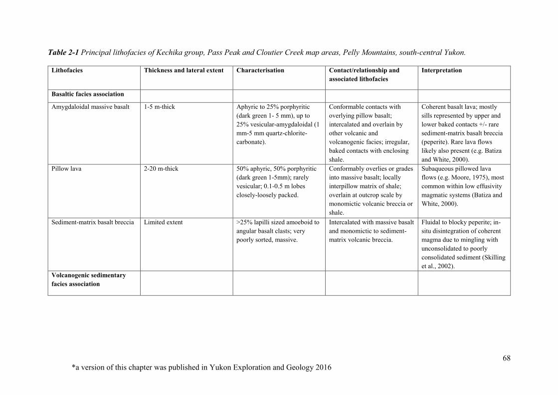
68 *a version of this chapter was published in Yukon Exploration and Geology 2016
Table 2-1 Principal lithofacies of Kechika group, Pass Peak and Cloutier Creek map areas, Pelly Mountains, south-central Yukon.
Lithofacies Thickness and lateral extent Characterisation Contact/relationship and associated lithofacies
Interpretation
Basaltic facies association
Amygdaloidal massive basalt 1-5 m-thick Aphyric to 25% porphyritic (dark green 1- 5 mm), up to 25% vesicular-amygdaloidal (1 mm-5 mm quartz-chlorite-carbonate).
Conformable contacts with overlying pillow basalt; intercalated and overlain by other volcanic and volcanogenic facies; irregular, baked contacts with enclosing shale.
Coherent basalt lava; mostly sills represented by upper and lower baked contacts +/- rare sediment-matrix basalt breccia (peperite). Rare lava flows likely also present (e.g. Batiza and White, 2000).
Pillow lava 2-20 m-thick 50% aphyric, 50% porphyritic (dark green 1-5mm); rarely vesicular; 0.1-0.5 m lobes closely-loosely packed.
Conformably overlies or grades into massive basalt; locally interpillow matrix of shale; overlain at outcrop scale by monomictic volcanic breccia or shale.
Subaqueous pillowed lava flows (e.g. Moore, 1975), most common within low effusivity magmatic systems (Batiza and White, 2000).
Sediment-matrix basalt breccia Limited extent >25% lapilli sized amoeboid to angular basalt clasts; very poorly sorted, massive.
Intercalated with massive basalt and monomictic to sediment-matrix volcanic breccia.
Fluidal to blocky peperite; in-situ disintegration of coherent magma due to mingling with unconsolidated to poorly consolidated sediment (Skilling et al., 2002).
Volcanogenic sedimentary facies association
69
Table 2-1 (continued)
Monomictic volcanic breccia Up to 8 m-thick >30% lapilli- to bomb-sized, angular basalt clasts (1 cm to 16 cm); very poorly sorted, massive.
Overlies massive and pillow basalt facies; intercalated with volcanic breccia and conglomerate.
In-situ to wholly to partly resedimented hyaloclasite (Batiza and White, 2000); +/- pillow basalt breccia due to detachment of pillows by mechanical/gravitational means (e.g. Simpson and McPhie, 2001).
Monomictic volcanic conglomerate
Up to 2 m-thick Rounded to sub-angular, granule- to cobble-sized volcanic clasts (25%); very poorly sorted, massive.
Intercalated within monomictic volcanic breccia and sediment-matrix lithic breccia.
Resedimented volcanic conglomerate formed by proximal reworking and transport of unstable volcanic facies.
Sediment-matrix volcanic and sedimentary lithic breccia
20 m-thick Up to 70% angular to subrounded, granule- to cobble-sized (0.5 cm to >20 cm) clasts of amygdaloidal basalt, dark green (chloritic) tuff, grey-black shale and blue-grey limestone; very poorly sorted, massive.
Underlain by tuff, shale and sills; intercalated with black shale; irregular contacts with massive basalt.
Resedimented volcanic breccia formed through gravity-driven collapse of volcanic facies and erosion of underlying sedimentary facies.
Polymictic volcanic and limestone clast conglomerate
20 m-thick Up to 30% granule- to boulder-sized, rounded to subangular; blue-grey limestone and mafic-intermediate volcanic clasts based on colour index.
Intercalated with volcanic strata and shale of the Cloutier formation and tuff, sills and shale of the Groundhog formation.
Reworking and transport of underlying volcanic and sedimentary facies.
70
Table 2-1 (continued)
Lapilli tuff 0.1 m- to 3 m-thick beds and lenses
Up to 30% pale to dark green (chlorite) lapilli clasts; often elongate, irregular to wispy to rounded (0.1-3 cm); within dark grey, resistant, sandy to phyllitic volcaniclastic matrix; 1 m-thick beds of normally graded lapillistone.
Forms solitary beds within limestone-argillite facies and tuffaceous sequences.
Formed through pyroclastic processes and/or epiclastic processes (e.g. Fisher and Schminke, 1984).
Tuffaceous shale to sandstone >50 m-thick sequences; laterally continuous over 10s of meters
Mostly green-orange, tuffaceous shale-siltstone and rare fine-medium sandstone; finely laminated to thinly bedded; normally graded beds of sandstone.
Intercalated with >3 m-thick, laminated to thinly bedded limestone, m-thick (steel-grey) phyllite and lapilli tuff.
Suspension and turbidity current sedimentation of volcanic-derived and limestone-argillite units, most likely below wave base.
Limestone-argillite facies association
Argillaceous shale <1 m- to >2 m-thick Finely laminated, grey-steel to black argillaceous shale.
Typically interbedded with silty limestone; dominates lower and middle parts of Groundhog and Cloutier formations.
Suspension sedimentation of clay and volcanic ash; likely below wave base.
Silty limestone <1 m- to >2 m-thick Finely laminated to medium-bedded, blue-grey to tan limestone.
Typically interbedded with argillaceous shale; m-thick beds intercalated with tuffaceous shale and sandstone.
Suspension sedimentation of silt and carbonate mud.
71
Table 2-1 (continued)
Intrusive rocks
Mafic intrusive 0.5 m- to 30 m-thick; continuous over 100's of meters
Coherent, dark grey-green, fine- (basalt) to coarse-grained (gabbro) intrusive rocks; tabular, concordant bodies; contacts are irregular and baked; coarse porphyritic chlorite/pyroxene and more rarely plagioclase in thicker intrusions; 0.1 - 0.5 mm quartz-chlorite amygdales found in m-thick bodies.
Predominantly emplaced within limestone-argillite facies.
Concordant and tabular nature of bodies infers they are sills; may be comparable to sediment-sill complexes where thick packages of unconsolidated sediment prevent coherent magma movement through fracture propagation, therefore resulting in magma spreading laterally through the sediment (Einsele, 1986; Batiza and White, 2000).
* a version of this chapter will be submitted to an international, peer-reviewed journal
72
Chapter 3 Early Paleozoic post-breakup magmatism along the
Cordilleran margin of western North America: new geochronological
and geochemical results from the Kechika group, Yukon, Canada*
3.1 Abstract
Lower Paleozoic volcanic rocks occur throughout the Cordilleran passive margin
successions of western North America. These volcanic rocks were deposited after Ediacaran-
Cambrian lithospheric breakup and several competing pure-shear, simple-shear, and magma-
poor rift models have been proposed to explain the significance of early Paleozoic
magmatism to Cordilleran tectonic evolution. New zircon U-Pb age and whole-rock
geochemical studies were conducted on the lower Paleozoic Kechika group (informal), south-
central Yukon, to test these rift models and constrain the timing, mantle source, and tectonic
setting of post-breakup magmatism in the Canadian Cordillera. The Kechika group consists
of vent-proximal and sediment-sill complexes within the Cassiar platform, a linear
paleogeographic high that developed outboard of continental shelf and trough basins.
Chemical abrasion (CA-TIMS) U-Pb dates indicate that Kechika group mafic rocks were
generated during the late Cambrian (488-483 Ma) and Early Ordovician (473 Ma). Whole-
rock trace element and Nd-Hf isotope results are consistent with the low-degree partial
melting of an enriched lithospheric mantle source, likely during margin-scale extension.
Coeval volcanic rocks with similar geochemical signatures occur throughout continental shelf
and trough strata from Yukon to Nevada and are spatially associated with transfer-transform
zones and faults that were episodically reactivated during Cordilleran rift evolution. We

73
propose that post-breakup rocks emplaced along the North Atlantic margins, such as those in
the Orphan and Newfoundland basins, are modern analogues of the Kechika group. This
magma-poor rift scenario calls for the release of in-plane tensile stresses and off-axis, post-
breakup magmatism along the nascent plate boundary, after lithospheric breakup, but prior to
the onset of seafloor spreading.
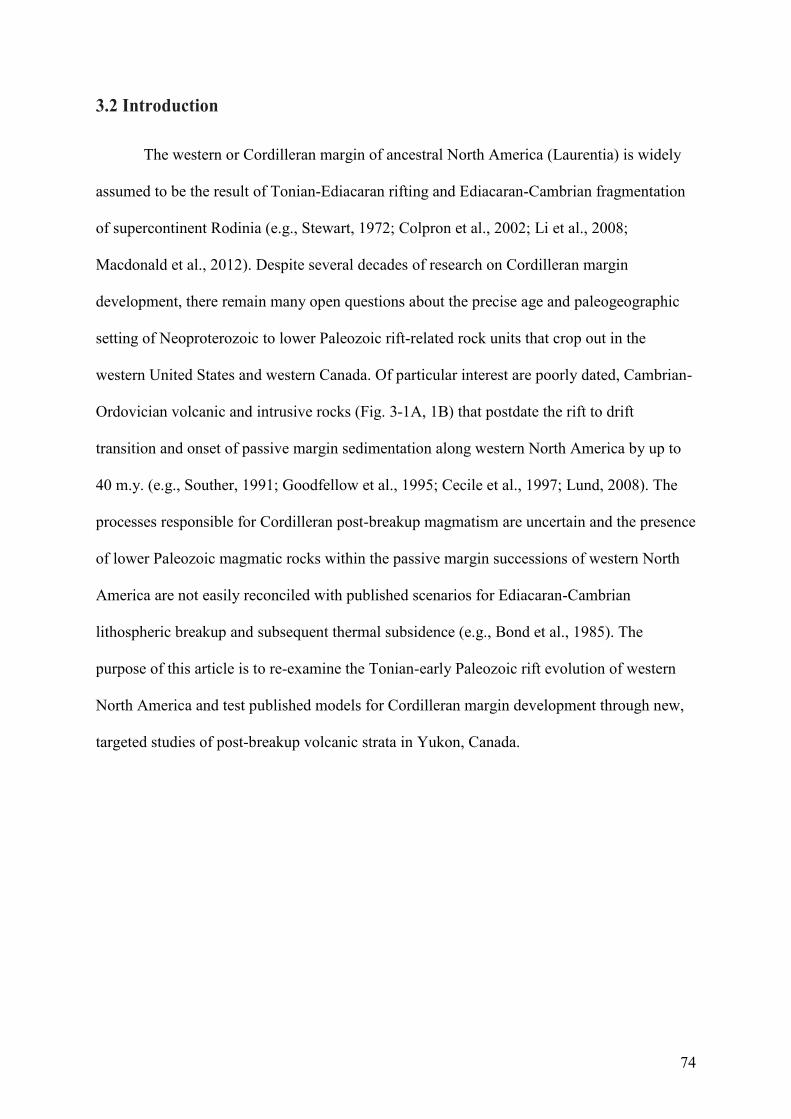
74
3.2 Introduction
The western or Cordilleran margin of ancestral North America (Laurentia) is widely
assumed to be the result of Tonian-Ediacaran rifting and Ediacaran-Cambrian fragmentation
of supercontinent Rodinia (e.g., Stewart, 1972; Colpron et al., 2002; Li et al., 2008;
Macdonald et al., 2012). Despite several decades of research on Cordilleran margin
development, there remain many open questions about the precise age and paleogeographic
setting of Neoproterozoic to lower Paleozoic rift-related rock units that crop out in the
western United States and western Canada. Of particular interest are poorly dated, Cambrian-
Ordovician volcanic and intrusive rocks (Fig. 3-1A, 1B) that postdate the rift to drift
transition and onset of passive margin sedimentation along western North America by up to
40 m.y. (e.g., Souther, 1991; Goodfellow et al., 1995; Cecile et al., 1997; Lund, 2008). The
processes responsible for Cordilleran post-breakup magmatism are uncertain and the presence
of lower Paleozoic magmatic rocks within the passive margin successions of western North
America are not easily reconciled with published scenarios for Ediacaran-Cambrian
lithospheric breakup and subsequent thermal subsidence (e.g., Bond et al., 1985). The
purpose of this article is to re-examine the Tonian-early Paleozoic rift evolution of western
North America and test published models for Cordilleran margin development through new,
targeted studies of post-breakup volcanic strata in Yukon, Canada.
75
Figure 3-1(A) Ediacaran to early Paleozoic magmatic rocks, tectonic elements, and crustal
lineaments of the North American Cordillera adapted from Goodfellow et al. (1995), Lund
(2008), and Colpron and Nelson (2009). Lower- and upper-plate divisions are from Lund
(2008). (B) Map of the Canadian Cordillera highlighting the locations of Ediacaran to early
Paleozoic magmatic rocks and key paleogeographic features. Numbers from 1-28 are
references for Cordilleran margin magmatism provided in Appendix 1. CP - Cassiar
platform, MP - McEvoy platform, MRE - Meilleur River embayment, Mtns. - Mountains, R. -
river.
76
The Gunbarrel magmatic event (780 Ma; e.g., Harlan et al., 2003; Sandeman et al.,
2014) and deposition of the Windermere Supergroup (e.g., Stewart, 1972; Link et al., 1993)
record the Tonian-Cryogenian stages of Cordilleran rift evolution. These early rift episodes
thinned and weakened Cordilleran lithosphere (Yonkee et al., 2014) and were likely
associated with strike-slip deformation in some regions of western Laurentia (Strauss et al.,
2015). Magmatic activity continued through the Cryogenian (ca. 720-640 Ma) in southeastern
Yukon (Pigage and Mortensen, 2004), northern British Columbia (Ferri et al., 1999; Eyster et
al., 2018), and western United States (Lund et al., 2003, 2010; Fanning and Link, 2004).
Ediacaran (ca. 570 Ma) volcanic rocks and Ediacaran-lower Cambrian siliciclastic strata were
deposited after a period of thermal subsidence and are considered to be the products of a
second rift phase that resulted in lithospheric breakup (e.g., Devlin and Bond, 1988; Devlin,
1989; Lickorish and Simony, 1995; Warren, 1997; Colpron et al., 2002). Siliciclastic strata of
this second rift phase unconformably overlie rocks of the Cryogenian rift episode throughout
western North America (e.g., Stewart and Suczek, 1977; Aitken, 1993; Prave, 1999; Lund,
2008) and are spatially associated with volcanic rocks in parts of southern British Columbia
and northern Utah (Fig. 3-1A; Christie-Blick, 1997; Colpron et al., 2002; Ferri and
Schiarizza, 2006).
An early Paleozoic age for lithospheric breakup is predicted from the thermal
subsidence trends of upper Cambrian to Lower Ordovician platformal strata in the southern
Canadian and U.S. Rocky Mountains (Armin and Mayer, 1983; Bond and Kominz, 1984;
Bond et al., 1985; Levy and Christie-Blick, 1991). The inferred rift to post-rift transition is
typically associated with an unconformity between coarse, locally feldspathic rocks and
mature, shallow-water quartz sandstone (Bond et al., 1985; Devlin and Bond, 1988; Hein and
McMechan, 1994). The transition lies near the Cambrian Stage 2 (late Terreneuvian) to
Cambrian Stage 3 (early Series 2) boundary in southeastern British Columbia and within
77
Cambrian Stage 2 in the western United States (time scale of Cohen et al., 2017; e.g., Bond et
al., 1985; Magwood and Pemberton, 1988; Hein and McMechan, 1994). Post-rift, lower
Cambrian carbonate strata with archaeocyathid-bearing horizons overlie this syn-rift,
siliciclastic sequence (Read, 1980; Fritz et al., 1991; Paradis et al., 2006). Lower Cambrian
successions also include poorly dated mafic volcanic rocks with OIB- (ocean island basalt) to
N-MORB-like (normal mid-ocean ridge basalt) geochemical signatures in Yukon (e.g.,
Murphy, 1997; Abbott, 1997; Milidragovic et al., 2006), southern British Columbia (e.g.,
Kubli and Simony, 1992; Ferri and Schiarizza, 2006; Logan and Colpron, 2006; Paradis et
al., 2006), and western United States (e.g., Morris and Lovering, 1961; Kellogg, 1963).
Post-breakup volcanism is not a predicted outcome of pure- or simple-shear rift
scenarios that have populated the Cordilleran literature since the early 1980s. For example,
Bond and Kominz (1984) and Bond et al. (1984, 1985) used the pure-shear rift model of
McKenzie (1978) to estimate subsidence patterns within stable Cordilleran shelf strata (Fig.
3-2A). Pure-shear scenarios predict uniform lithospheric extension that results in symmetric
conjugate margins, with syn-rift magmatism invoked to reduce lithospheric strength (e.g.,
Buck, 2004). The simple-shear rift models of Lister et al. (1986, 1991) were subsequently
used to explain the asymmetry of the Cordilleran margin (Fig. 3-2B) and continued
reactivation of lithospheric-scale lineaments during the Paleozoic (e.g., Christie-Blick and
Levy, 1989; Hansen et al., 1993; Cecile et al., 1997; Tosdal et al., 2000; Lund, 2008).
Simple-shear models predict that detachment faults separate the rifted margin into conjugate,
upper- and lower-plate margin pairs, with transfer-transform zones bounding different plate-
margin segments (Fig. 3-2B). These zones of lithospheric weakness offset contrasting
structural domains and provide focal points for mantle-derived magmatism (Thomas, 2006).
Upper-plate regions undergo less crustal extension and result in narrow margins with syn-rift
uplift being accommodated by magmatic underplating. The lower-plate undergoes a greater
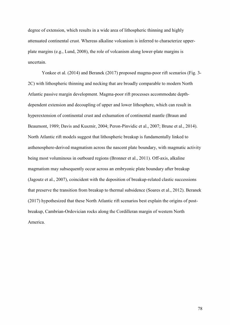
78
degree of extension, which results in a wide area of lithospheric thinning and highly
attenuated continental crust. Whereas alkaline volcanism is inferred to characterize upper-
plate margins (e.g., Lund, 2008), the role of volcanism along lower-plate margins is
uncertain.
Yonkee et al. (2014) and Beranek (2017) proposed magma-poor rift scenarios (Fig. 3-
2C) with lithospheric thinning and necking that are broadly comparable to modern North
Atlantic passive margin development. Magma-poor rift processes accommodate depth-
dependent extension and decoupling of upper and lower lithosphere, which can result in
hyperextension of continental crust and exhumation of continental mantle (Braun and
Beaumont, 1989; Davis and Kusznir, 2004; Peron-Pinvidic et al., 2007; Brune et al., 2014).
North Atlantic rift models suggest that lithospheric breakup is fundamentally linked to
asthenosphere-derived magmatism across the nascent plate boundary, with magmatic activity
being most voluminous in outboard regions (Bronner et al., 2011). Off-axis, alkaline
magmatism may subsequently occur across an embryonic plate boundary after breakup
(Jagoutz et al., 2007), coincident with the deposition of breakup-related clastic successions
that preserve the transition from breakup to thermal subsidence (Soares et al., 2012). Beranek
(2017) hypothesized that these North Atlantic rift scenarios best explain the origins of post-
breakup, Cambrian-Ordovician rocks along the Cordilleran margin of western North
America.
79
Figure 3-2 Simplified kinematic models for Cordilleran rift evolution adapted from Yonkee et
al. (2014). (A) Pure-shear rift model with uniform, homogeneous thinning of crust and
mantle based on McKenzie (1978). Margins that form through mostly pure-shear rifting
display very limited evidence for post-rift magmatism when contrasted with evidence for syn-
rift magmatism. (B) Simple-shear rift model with heterogeneous thinning of upper and lower
lithosphere based on Lister et al. (1986, 1991). Magmatism in the simple-shear model mostly
occurs beneath upper-plate margins during the syn- to post-rift phase. (C) Magma-poor rift
model with depth-dependent lithospheric thinning and necking based on Davis and Kusznir
(2004). This figure represents a snapshot of the period after extensive lithospheric thinning
but prior to lithospheric breakup. Syn-breakup magmatism is more voluminous in outboard

80
areas where it is dominated by tholeiitic volcanism sourced from the depleted asthenospheric
mantle. In contrast post-breakup magmatism occurs across the nascent plate boundary
including throughout the rifted margin and is represented by low volume alkaline volcanism,
derived from enriched mantle sources.
81
New high-precision analytical studies of Cambrian-Ordovician igneous rocks are
required to establish the significance of post-breakup magmatism in the North American
Cordillera. In this article, we use a combination of CA-TIMS (chemical abrasion-thermal
ionization mass spectrometry) zircon U-Pb geochronology and whole-rock trace element and
Nd-Hf isotope geochemistry to constrain the precise age and origin of the Kechika group, an
aerially extensive volcanic-sedimentary succession in south-central Yukon that is
representative of post-breakup magmatism in the Canadian Cordillera (Goodfellow et al.,
1995; Tempelman-Kluit, 2012). The new results allow us to test the three end-member rift
scenarios for the Cordilleran margin and develop new working models for the
Neoproterozoic-early Paleozoic evolution of western North America.
3.3 Lower Paleozoic Stratigraphy of the Northern Cordillera
3.3.1 Overview
The Cordilleran margin during Cambrian Series 2 to Ordovician time consisted of broad
carbonate platforms that passed seaward into deep-water embayments and margin-parallel
troughs (e.g., Fritz et al., 1991; Cecile and Norford, 1991; Nelson et al., 2013). Several
paleogeographic highs, defined by areas with a history of non-deposition and/or thin shallow-
water strata, periodically emerged during the early Paleozoic and include the long-lived
Peace River arch of western Alberta (e.g., McMechan, 1990; Norford, 1990; Cecile and
Norford, 1993; Cecile et al., 1997). The outer continental margin basins developed through
periodic, heterogeneous early Paleozoic crustal extension rather than purely thermal
subsidence and locally have abundant volcanic deposits (Fig. 3-3; Cecile and Norford, 1993;
Cecile et al., 1997; Lund, 2008; see also stratigraphic compilation and volcanic rock
occurrences in Appendix 1). Coeval volcanism is also recognised within inner continental
margin areas, although it is volumetrically restricted and represented by ultrapotassic and
82
alkaline rocks and carbonatites (Pell, 1987, 1994; Mott, 1989; Norford and Cecile, 1994;
Goodfellow et al., 1995; Leslie, 2009; Lund et al., 2010; Millonig et al., 2012).
Lithospheric-scale lineaments, including the northeast-trending Snake River transfer
zone and the Liard line (Figs. 3-1A, 3-1B), border most of the significant Cambrian-
Ordovician basins (Abbott et al., 1986; Turner et al., 1989; Roots and Thompson, 1992;
Cecile and Norford, 1991; MacIntyre, 1998; Pyle and Barnes, 2003; Lund, 2008; Pigage,
2009; McMechan, 2012; Hayward, 2015). The spatial association of these transfer-transform
faults with Proterozoic, Paleozoic, and Cenozoic volcanic rocks implies that these structures
represent long-lived, leaky zones that were continually reactivated (Goodfellow et al., 1995;
MacIntyre, 1998; Lund, 2008; McMechan, 2012; Millonig et al., 2012; Audet et al., 2016;
Cobbett, 2016). The Liard line is the most prominent lineament in the Canadian Cordillera
and subdivides a wide, lower-plate margin from a narrow, upper-plate margin (Cecile et al.,
1997).
Several margin-parallel basins were established within the upper-plate region of
western Canada during the early Paleozoic. The Kechika graben of northern British Columbia
(Figs. 3-1B, 3-2) was a precursor to the Kechika trough that developed during middle to late
Cambrian extensional faulting and local uplift (e.g., Douglas et al., 1970; Fritz et al., 1991;
Ferri et al., 1999; Post and Long, 2008; Pyle, 2012). Late Cambrian to Early Ordovician
extension was associated with regional volcanism in the Ospika embayment (Fig. 3-1B) and
adjacent MacDonald platform (MacIntyre, 1998; Ferri et al., 1999; Pyle and Barnes, 2000,
2003). The parautochthonous Kootenay terrane of southeastern British Columbia contains a
Cambrian-Ordovician deep-water rift basin, the Lardeau trough (Fig. 3-1B), that developed
adjacent to the St. Mary-Moyie transfer-transform zone and hosts at least three pulses of
tholeiitic to alkalic magmatism (Smith and Gehrels, 1992; Ferri and Schiarizza, 2006; Logan
and Colpron, 2006; Paradis et al., 2006; Nelson et al., 2013). East of the Kootenay terrane,
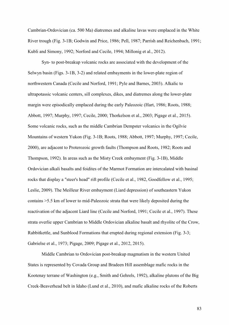
83
Cambrian-Ordovician (ca. 500 Ma) diatremes and alkaline lavas were emplaced in the White
River trough (Fig. 3-1B; Godwin and Price, 1986; Pell, 1987; Parrish and Reichenbach, 1991;
Kubli and Simony, 1992; Norford and Cecile, 1994; Millonig et al., 2012).
Syn- to post-breakup volcanic rocks are associated with the development of the
Selwyn basin (Figs. 3-1B, 3-2) and related embayments in the lower-plate region of
northwestern Canada (Cecile and Norford, 1991; Pyle and Barnes, 2003). Alkalic to
ultrapotassic volcanic centers, sill complexes, dikes, and diatremes along the lower-plate
margin were episodically emplaced during the early Paleozoic (Hart, 1986; Roots, 1988;
Abbott, 1997; Murphy, 1997; Cecile, 2000; Thorkelson et al., 2003; Pigage et al., 2015).
Some volcanic rocks, such as the middle Cambrian Dempster volcanics in the Ogilvie
Mountains of western Yukon (Fig. 3-1B; Roots, 1988; Abbott, 1997; Murphy, 1997; Cecile,
2000), are adjacent to Proterozoic growth faults (Thompson and Roots, 1982; Roots and
Thompson, 1992). In areas such as the Misty Creek embayment (Fig. 3-1B), Middle
Ordovician alkali basalts and foidites of the Marmot Formation are intercalated with basinal
rocks that display a "steer's head" rift profile (Cecile et al., 1982, Goodfellow et al., 1995;
Leslie, 2009). The Meilleur River embayment (Liard depression) of southeastern Yukon
contains >5.5 km of lower to mid-Paleozoic strata that were likely deposited during the
reactivation of the adjacent Liard line (Cecile and Norford, 1991; Cecile et al., 1997). These
strata overlie upper Cambrian to Middle Ordovician alkaline basalt and rhyolite of the Crow,
Rabbitkettle, and Sunblood Formations that erupted during regional extension (Fig. 3-3;
Gabrielse et al., 1973; Pigage, 2009; Pigage et al., 2012, 2015).
Middle Cambrian to Ordovician post-breakup magmatism in the western United
States is represented by Covada Group and Bradeen Hill assemblage mafic rocks in the
Kootenay terrane of Washington (e.g., Smith and Gehrels, 1992), alkaline plutons of the Big
Creek-Beaverhead belt in Idaho (Lund et al., 2010), and mafic alkaline rocks of the Roberts
84
Mountain allochthon in Nevada (e.g., Watkins and Browne, 1989). Volcanic rocks in the
southern Kootenay terrane and Roberts Mountain allochthon were probably deposited in an
outer continental margin setting that underwent extensional or transtensional faulting (e.g.,
Turner et al., 1989). Late Cambrian detrital zircons with intermediate to evolved Hf isotope
compositions occur in the upper Cambrian St. Charles Formation of Idaho and likely indicate
the uplift of the Lemhi arch and erosion of the Big Creek-Beaverhead belt during reactivation
of Snake River transfer fault (Link et al., 2017).
Early Paleozoic crustal extension resulted in local hydrothermal activity and massive
sulfide occurrences along the length of the Cordilleran margin (e.g., Goodfellow and
Jonasson, 1986; Jennings and Jilson, 1986; Logan and Colpron, 2006). For example, mafic
volcanic rocks and sills in the Anvil district of central Yukon (Menzie Creek and Vangorda
formations, Fig. 3-3) overlie sedimentary exhalative base-metal deposits that were likely
cogenetic with local normal faulting (Allen et al., 2000; Pigage, 2004; Cobbett, 2016). In
southeastern British Columbia, the Cu-Zn Goldstream deposit is intercalated with post-
breakup volcanic rocks of the Index Formation (Fig. 3-3; Logan and Colpron, 2006). Similar
base-metal occurrences are associated with Ordovician strata in the Roberts Mountain
allochthon (e.g., Turner et al., 1989). Intrusive rocks and diatremes within the platform and
adjacent craton are also linked with enrichments of rare earth elements and other critical
metals in southern British Columbia and micro-diamonds in northern Yukon (Godwin and
Price, 1986; Pell, 1987; Norford and Cecile, 1994; Goodfellow et al., 1995; Leslie, 2009;
Millonig et al., 2012).
85
Figure 3-3 Simplified Ediacaran to lower Silurian stratigraphy of the Canadian Cordillera from central Yukon to southern British Columbia
(see lines A-A’, B-B’, C-C’, and D-D’ in Figure 1B). Italicized numbers are zircon U-Pb crystallization ages for igneous or tuffaceous rock units
86
in the Hamill Group (569.6 ± 5.3 Ma; Colpron et al.., 2002), Crow Formation (490.04 ± 0.13 Ma; Pigage et al., 2012), Kechika group (488.25 ±
0.45 Ma and 472.99 ± 0.70 Ma, this study), Askin group (ca. 435 Ma, this study), and southern Canadian Rocky Mountains (497.6 ± 2 Ma and
489.7 ± 8.4 Ma; Millonig et al., 2012). Stratigraphic compilations: Selwyn basin-Mackenzie platform (Gabrielse et al., 1973; Gordey and
Anderson, 1993; Narbonne and Aitken, 1995; Pigage, 2004; Gordey, 2013; Ootes et al., 2013; Pigage et al., 2015; Cobbett, 2016), Meilleur
River embayment (Pigage et al., 2015), Cassiar terrane (Tempelman-Kluit, 2012), Kechika trough-MacDonald platform (Fritz et al., 1991; Ferri
et al., 1999; Pyle and Barnes, 2003; Pyle, 2012), Kootenay terrane (Hein and McMechan, 1994; Colpron et al., 2002; Ferri and Schiarizza,
2006; Logan and Colpron, 2006; Paradis et al., 2006), southern Canadian Rocky Mountains (Bond and Kominz, 1984; Hein and McMechan,
1994; Millonig et al., 2012; Nelson et al., 2013). A. - assemblage, Back. R. - Backbone Ranges, Fm - Formation (formal), fm. formation
(informal), Gp. - Group (formal), gp. - group (informal), Lk. - Lake, Mid. - Middle, MORB - mid-ocean ridge basalt, Mtns. - Mountains, OIB -
ocean island basalt, R. - River, S. - Southern, Sil. - Silurian, Vol. – Volcanics.
87
3.3.2 Pelly Mountains, south-central Yukon
The lower Paleozoic stratigraphy of the Pelly Mountains (Figs. 3-4, 3-5), south-
central Yukon, consists of four depositional successions that from oldest to youngest are the
Ketza, Kechika, Askin, and Harvey groups (all units informal, Tempelman-Kluit, 2012). The
Pelly Mountains region is mostly underlain by the Cassiar terrane, a parautochthonous block
of the ancestral North American margin that underwent at least 430 km of post-Cretaceous
dextral displacement along the Tintina fault (Gabrielse et al., 2006). Lower Paleozoic strata
of the Cassiar terrane comprise part of a linear paleogeographic feature named the Cassiar or
Pelly-Cassiar platform (CP in Fig. 3-1B, Gabrielse, 1967; Fritz et al., 1991) or Pelly high
(Cecile and Norford, 1993) that was located to the west of inboard elements such as the
Selwyn basin, Kechika trough, and MacDonald platform. Allochthonous units of the
pericratonic Yukon-Tanana and Slide Mountain terranes that evolved to the west of the North
American margin occur in faulted contact with the Cassiar terrane along its western edge and
as overlying klippen (e.g., Gordey, 1981). The western extent of the Liard line, which is
offset by the Tintina fault, apparently transects the Pelly Mountains region and places most of
the Cassiar terrane within an upper-plate setting (Fig. 3-1B; Cecile et al., 1997; Hayward,
2015).
88
Figure 3-4 Paleozoic stratigraphy of the Pelly Mountains compiled by Tempelman-Kluit (2012). Abbreviations: Ank = Ankerite; Ed =
Ediacaran; fm = formation; gp = group; Miss = Mississippian; Mtn = mountain; Sil = Siliceous; and Sl = Slate. Red polygons in Kechika
group represent mafic sills.
89

90
Figure 3-5 (a) Distribution of thrust sheets within the Quiet Lake (NTS 105F) and Finlayson Lake (NTS 105G) map areas, Pelly Mountains,
south-central Yukon (modified from Tempelman-Kluit, 2012). (b) Distribution of Ketza, Kechika and Askin group rocks in the Pelly Mountains
(modified from Tempelman-Kluit, 2012). Numbers refer to localities where samples were collected for geochronology and geochemistry, and are
referenced in Appendix 2, 3, and 4.
91
Ketza group
Upper Neoproterozoic(?) to lower Cambrian rocks of the Ketza group represent the
oldest exposed Cassiar terrane units in Yukon. The basal Pass Peak formation consists of
quartzite and fine-grained siliciclastic rocks, whereas the overlying McConnell River
formation contains calcareous to pyritic mudstone and carbonate lenses with archaeocyathid-
bearing mounds (Read, 1980; Tempelman-Kluit, 2012). The contact between the Ketza group
and overlying Kechika group is poorly exposed and typically obscured by faulting (Campbell
and Beranek, 2017). A middle Cambrian fossil gap in the Pelly Mountains region, however,
suggests the presence of an unconformity (Tempelman-Kluit, 2012); a mid-Furongian
unconformity is similarly inferred within the Cassiar terrane of northern British Columbia
(Gabrielse, 1963, 1998; Taylor and Stott, 1973; Pyle and Barnes, 2001). The lower Cambrian
Rosella Formation in the Cassiar Mountains, northern British Columbia, is correlative to the
McConnell River formation and locally intruded by m-thick mafic sills (Gabrielse, 1998).
Kechika group
The Kechika group, the focus of the present study, is an upper Cambrian to
Ordovician succession that includes the Cloutier, Groundhog, Ram, and Gray Creek
formations (Fig. 3-4; Tempelman-Kluit, 2012; Campbell and Beranek, 2017). Tempelman-
Kluit (2012) defined these four formations as being laterally equivalent and interfingered. A
fifth stratigraphic unit, the Magundy formation, discontinuously caps the Groundhog,
Cloutier, and Ram formations. Kechika group strata generally occur as narrow, northwest-
trending, discontinuous belts across the Pelly Mountains (Fig. 3-5).
The Groundhog formation mostly consists of argillaceous to tuffaceous shale, silty
limestone, and mafic tuff (Tempelman-Kluit, 2012). Basaltic to gabbroic sills occur
throughout the unit, whereas subordinate volcanic and volcaniclastic rocks occur locally
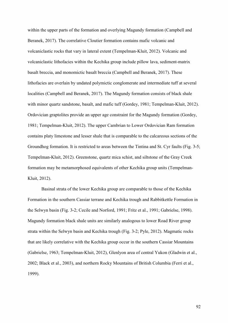
92
within the upper parts of the formation and overlying Magundy formation (Campbell and
Beranek, 2017). The correlative Cloutier formation contains mafic volcanic and
volcaniclastic rocks that vary in lateral extent (Tempelman-Kluit, 2012). Volcanic and
volcaniclastic lithofacies within the Kechika group include pillow lava, sediment-matrix
basalt breccia, and monomictic basalt breccia (Campbell and Beranek, 2017). These
lithofacies are overlain by undated polymictic conglomerate and intermediate tuff at several
localities (Campbell and Beranek, 2017). The Magundy formation consists of black shale
with minor quartz sandstone, basalt, and mafic tuff (Gordey, 1981; Tempelman-Kluit, 2012).
Ordovician graptolites provide an upper age constraint for the Magundy formation (Gordey,
1981; Tempelman-Kluit, 2012). The upper Cambrian to Lower Ordovician Ram formation
contains platy limestone and lesser shale that is comparable to the calcareous sections of the
Groundhog formation. It is restricted to areas between the Tintina and St. Cyr faults (Fig. 3-5;
Tempelman-Kluit, 2012). Greenstone, quartz mica schist, and siltstone of the Gray Creek
formation may be metamorphosed equivalents of other Kechika group units (Tempelman-
Kluit, 2012).
Basinal strata of the lower Kechika group are comparable to those of the Kechika
Formation in the southern Cassiar terrane and Kechika trough and Rabbitkettle Formation in
the Selwyn basin (Fig. 3-2; Cecile and Norford, 1991; Fritz et al., 1991; Gabrielse, 1998).
Magundy formation black shale units are similarly analogous to lower Road River group
strata within the Selwyn basin and Kechika trough (Fig. 3-2; Pyle, 2012). Magmatic rocks
that are likely correlative with the Kechika group occur in the southern Cassiar Mountains
(Gabrielse, 1963; Tempelman-Kluit, 2012), Glenlyon area of central Yukon (Gladwin et al.,
2002; Black et al., 2003), and northern Rocky Mountains of British Columbia (Ferri et al.,
1999).
93
Askin group
The Askin group, along with the Sandpile Formation in the Cassiar Mountains,
comprises part of the Silurian-Devonian Cassiar platform (Figs. 3-2, 3-4; Gabrielse, 1963,
1998; Cecile et al., 1997; Tempelman-Kluit, 2012). The McEvoy platform of eastern Yukon
(EP in Fig. 3-1B) consists of similar shallow-water strata and likely represents a northern
equivalent to the northeast of the Tintina fault (Gordey, 2013). Within the Pelly Mountains,
the basal Askin group (Orange Volcanics member, Platy Siltstone formation of Tempelman-
Kluit, 2012) contains mafic to intermediate lava flows, volcanic breccia, and tuff (Campbell
and Beranek, 2017). Ordovician to Silurian shallow-water strata of the Sunblood and
Haywire Formations are intercalated with similar volcanic rocks in the Meilleur River
embayment area of southeastern Yukon (Fig. 3-2; Goodfellow et al., 1995; Pigage et al.,
2015). The significance of the Silurian volcanism is beyond the scope of this paper but may
be related to early convergent margin tectonism along northwestern Laurentia (e.g., Pecha et
al., 2016).
Harvey group
The Harvey group is named for poorly understood, variably deformed and
metamorphosed siliciclastic, carbonate, and volcanic rocks that crop out between the Tintina
and St. Cyr faults. Tempelman-Kluit (2012) proposed that the lower two units (Canyon and
Danger formations) correlate with Kechika and Askin group strata, respectively (Fig. 3-5).
3.4 Methods
3.4.1 CA-TIMS zircon U-Pb geochronology
Zircons from five rock samples that represent the broad regional extent of early
Paleozoic magmatism in the Pelly Mountains were analyzed for CA-TIMS U-Pb
94
geochronology (Appendix 2) at the Pacific Centre for Isotopic and Geochemical Research
(Vancouver, British Columbia) following procedures outlined in Scoates and Friedman
(2008). U-Pb dating studies of three gabbro units within the Groundhog formation were
conducted to determine the precise timing of Kechika group magmatism, whereas detrital
zircons from two volcaniclastic rock samples were examined to constrain the depositional
ages of upper Kechika group – lower Askin group strata (see Fig. 3-5 for sample locations).
Zircon crystals were concentrated from rock samples using standard crushing, gravimetric,
and magnetic separation methods, handpicked in alcohol under the binocular microscope, and
annealed in quartz glass crucibles at 900ºC for 60 hours. Annealed zircons were rinsed in
ultrapure acetone and water, transferred into screwtop beakers, and chemically abraded in
ultrapure HF and HNO3 at ~175ºC for 12 hours. The remaining zircon crystals were separated
from the leachate, rinsed, weighed, and dissolved in HF and HNO3 at ~240ºC for 40 hours.
Ion-exchange column techniques were used to separate and purify Pb and U. Isotopic ratios
were measured with a modified single-collector VG-54R thermal ionization mass
spectrometer equipped with analog Daly photomultipliers. U-Pb isotopic data were calibrated
by replicate analyses of the NBS-982 reference material and values recommended by
Thirwall (2000). Data reduction was completed with the Microsoft Excel software of Schmitz
and Schoene (2007). The Isoplot program of Ludwig (2003) was used to make Wetherill
concordia diagrams and calculate weighted mean averages and MSWD (mean square of
weighted deviate) values.
3.4.2 Whole-rock lithogeochemistry
Thirty mafic volcanic and intrusive rocks from the Kechika group were analyzed for
whole-rock major- and trace-element geochemistry (Appendix 3). Major element oxide
concentrations were acquired at Activation Laboratories (Ancaster, Ontario) by fused-bead x-
95
ray fluorescence. Trace element concentrations for six samples were acquired at the Pacific
Centre for Isotopic and Geochemical Research by HR-ICPMS (Element 2, Thermo Finnigan,
Germany), whereas twenty-four samples were analysed at Activation Laboratories using a
research grade analytical package (4LITHO RESEARCH).
Eight of the samples were selected for whole-rock Nd and Hf isotope geochemistry
(Appendix 4). Isotopic analyses were carried out at the Pacific Centre for Isotopic and
Geochemical Research on a Nu Plasma II MC-ICP-MS (Nu Instruments Ltd, United
Kingdom). Sample introduction followed the methods described in Weis et al. (2006, 2007)
and occurred under dry plasma conditions using a membrane desolvator (DSN-100). For each
analytical session, the standard solution JDNi (for Nd analyses) yielded average values of
143Nd/144Nd = 0.512088 ± 0.000008 (n = 24), and 143Nd/144Nd = 0.282157 ± 0.000011 (n =
41) for 2014 and 2015 samples, respectively. The JMC 475 standard solution (for Hf
analyses) yielded average values of 176Hf/177Hf = 0.282156 ± 0.000004 (n = 11), and
176Hf/177Hf = 0.282157 ± 0.000011 (n = 41) for 2014 and 2015 samples, respectively. The
results were corrected for instrumentation mass fractionation by exponentially normalising to
146Nd/144Nd = 0.7219 (O’Nions et al., 1979), and 179Hf/177Hf = 0.7325 (Patchett and
Tatsumoto, 1981).
Sampling and alteration
Rocks that preserve primary volcanic and intrusive textures were preferentially
selected for geochemical analysis, whereas those containing veining, alteration, and textures
associated with extensive fluid-rock interaction were avoided to limit post-crystallization
geochemical modification. Fluid-rock interaction can lead to the mobility of elements that are
otherwise thought to be immobile such as P2O5 and Y during the alteration of volcanic glass
to clays (e.g., Price et al., 1991; Murton et al., 1992). Kechika group rock samples typically
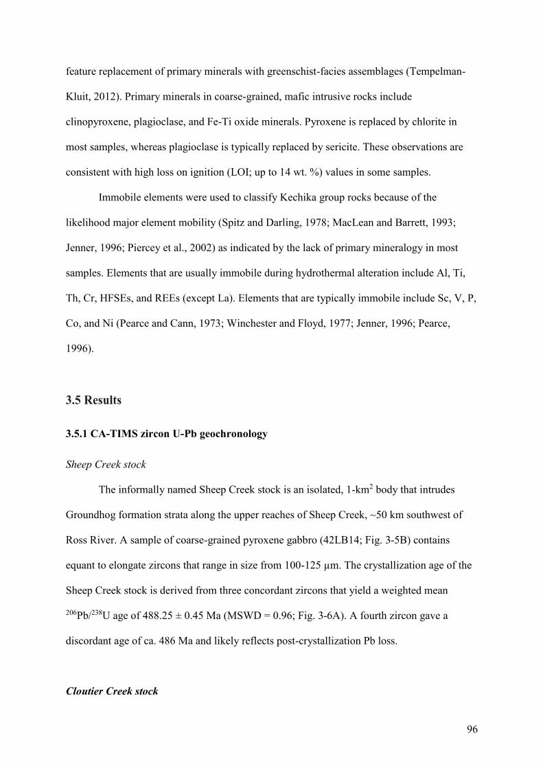
96
feature replacement of primary minerals with greenschist-facies assemblages (Tempelman-
Kluit, 2012). Primary minerals in coarse-grained, mafic intrusive rocks include
clinopyroxene, plagioclase, and Fe-Ti oxide minerals. Pyroxene is replaced by chlorite in
most samples, whereas plagioclase is typically replaced by sericite. These observations are
consistent with high loss on ignition (LOI; up to 14 wt. %) values in some samples.
Immobile elements were used to classify Kechika group rocks because of the
likelihood major element mobility (Spitz and Darling, 1978; MacLean and Barrett, 1993;
Jenner, 1996; Piercey et al., 2002) as indicated by the lack of primary mineralogy in most
samples. Elements that are usually immobile during hydrothermal alteration include Al, Ti,
Th, Cr, HFSEs, and REEs (except La). Elements that are typically immobile include Sc, V, P,
Co, and Ni (Pearce and Cann, 1973; Winchester and Floyd, 1977; Jenner, 1996; Pearce,
1996).
3.5 Results
3.5.1 CA-TIMS zircon U-Pb geochronology
Sheep Creek stock
The informally named Sheep Creek stock is an isolated, 1-km2 body that intrudes
Groundhog formation strata along the upper reaches of Sheep Creek, ~50 km southwest of
Ross River. A sample of coarse-grained pyroxene gabbro (42LB14; Fig. 3-5B) contains
equant to elongate zircons that range in size from 100-125 µm. The crystallization age of the
Sheep Creek stock is derived from three concordant zircons that yield a weighted mean
206Pb/238U age of 488.25 ± 0.45 Ma (MSWD = 0.96; Fig. 3-6A). A fourth zircon gave a
discordant age of ca. 486 Ma and likely reflects post-crystallization Pb loss.
Cloutier Creek stock
97
The informally named Cloutier Creek stock is a ca. 1-km2 body that intrudes
Groundhog formation strata on the south side of Cloutier Creek, ~40 km southeast of Ross
River. Coarse-grained pyroxene gabbro (15RC14; Fig. 5) from this location contains opaque,
high U zircons that dissolved completely during chemical abrasion leaching at standard
conditions. Five zircons survived a relatively gentle leach and yielded strongly discordant
data (20-23%) that define a linear array interpreted to result from Pb loss, with an upper
intercept of 486 ± 19 Ma and lower intercept of 167 ± 17 Ma (MSWD = 1.14). Five
additional zircons that survived the first step underwent a second, higher temperature leach to
assess whether less disturbed, possibly concordant sectors of grains exist. One of these
dissolved completely and only minor traces of material survived for the other four. The latter
gave relatively imprecise results that lie along the same discordia array defined by gently
leached grains. A discordia line constructed through results for all nine analyses yields
intercepts of 487 ± 19 Ma and 167 ± 16 Ma (MSWD = 0.56). Based on these data a
crystallization age of ca. 487 Ma is estimated for the Cloutier Creek stock.
Groundhog Creek sill complex
The informally named Groundhog Creek sill complex consists of well-exposed, 1 to
>30 m-thick sills that intrude Groundhog formation strata along the north side of Groundhog
Creek, ~40 km southwest of Ross River. The sills consist of fine- to coarse-grained mafic
rocks that underlie an area of ~12 km2. A sample of medium-grained pyroxene gabbro
(24LB15; Fig. 3-5B) contains mostly equant zircons that range in size from 75-125 µm. The
crystallization age of the Groundhog Creek sill complex is constrained by two concordant
zircons that yield a weighted mean 206Pb/238U age of 472.99 ± 0.70 Ma (MSWD = 0.85; Fig.
3-6B). An upper intercept age of ca. 1742 Ma is estimated for the core of a third, highly
discordant zircon.
98
Polymictic conglomerate
Cloutier formation strata to the east of the Ketza River Mine, ~50 km southeast of
Ross River, mostly consist of vesicular to amygdaloidal massive basalt, pillow basalt, and
associated volcanogenic rock units that were deposited in a submarine, vent proximal
environment (Campbell and Beranek, 2017). Variably deformed shale, limestone, and
polymictic (limestone, mafic-intermediate volcanic rock) conglomerate units immediately
overlie these Cloutier formation strata but have uncertain contact relationships with the
underlying volcanic sequence. Six detrital zircons analyzed from a sample of the polymictic
conglomerate (20LB15; Fig. 3-5B) yielded concordant 206Pb/238U ages of 428.92 ± 0.87 Ma,
483.43 ± 0.65 Ma, 484.34 ± 0.89 Ma, 485.01 ± 1.12 Ma, 1820.29 ± 4.23 Ma, and 2687.25 ±
7.73 Ma (Fig. 3-6C). Two zircons yielded discordant ages of ca. 432 Ma and 1745 Ma.
Askin group tuff
Kechika group strata within the upper reaches of Ram Creek, ~30 km south-southeast
of Ross River, consist of a lower section of well-exposed, Groundhog formation shale, silty
limestone, mafic intrusions, and volcanic to sedimentary lithic breccia, and an upper section
of poorly exposed, Magundy formation black shale (Campbell and Beranek, 2017). Mafic to
intermediate lava flows and tuff of the basal Askin group (Orange Volcanics member of
Tempelman-Kluit, 2012) overlie the Kechika group rocks. Four detrital zircons analyzed
from a sample of orange-weathering Askin group tuff (44LB15; Fig. 3-5B) yielded
concordant 206Pb/238U ages of 435.37 ± 0.86 Ma, 1375.99 ± 3.37 Ma, 1840.66 ± 4.26 Ma, and
2023.17 ± 9.20 Ma (Fig. 3-6D). Two zircons yielded discordant ages of ca. 1658 Ma and
2677 Ma.
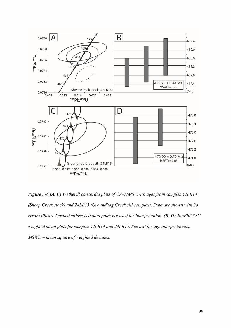
99
Figure 3-6 (A, C) Wetherill concordia plots of CA-TIMS U-Pb ages from samples 42LB14
(Sheep Creek stock) and 24LB15 (Groundhog Creek sill complex). Data are shown with 2σ
error ellipses. Dashed ellipse is a data point not used for interpretation. (B, D) 206Pb/238U
weighted mean plots for samples 42LB14 and 24LB15. See text for age interpretations.
MSWD – mean square of weighted deviates.
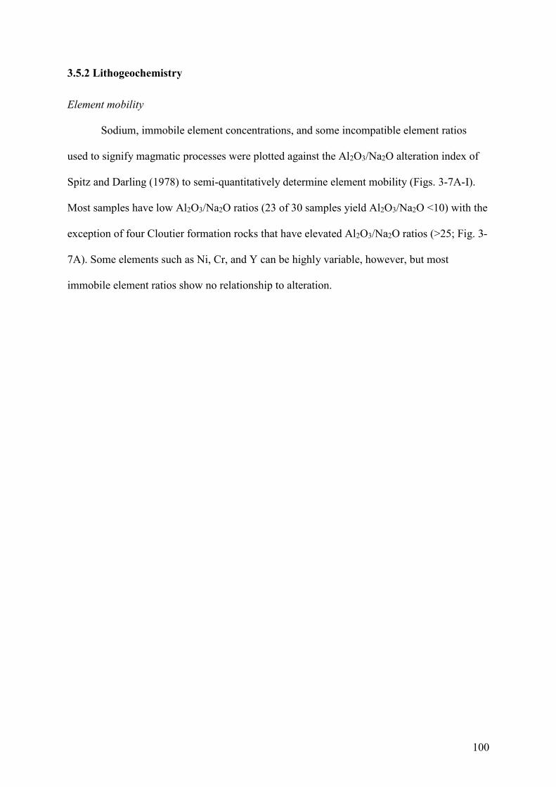
100
3.5.2 Lithogeochemistry
Element mobility
Sodium, immobile element concentrations, and some incompatible element ratios
used to signify magmatic processes were plotted against the Al2O3/Na2O alteration index of
Spitz and Darling (1978) to semi-quantitatively determine element mobility (Figs. 3-7A-I).
Most samples have low Al2O3/Na2O ratios (23 of 30 samples yield Al2O3/Na2O <10) with the
exception of four Cloutier formation rocks that have elevated Al2O3/Na2O ratios (>25; Fig. 3-
7A). Some elements such as Ni, Cr, and Y can be highly variable, however, but most
immobile element ratios show no relationship to alteration.
101
Figure 3-7 (a-i) Key trace elements and elements ratios of the Kechika group rocks plotted
against the Spitz-Darling Al2O3/Na2O alteration index (Spitz and Darling, 1978). Most
elements and elemental ratios feature a lack of correlation with the alteration index
suggesting that elemental variation is independent of alteration. Five of the volcanic rock
samples feature a slight negative correlation for Ni, Cr, Sc and Y but this is not present in the
remaining samples. Red triangle = Cloutier fm. volcanic rocks, orange triangle = Cloutier
fm. intrusive rocks, blue triangle = Groundhog fm. intrusive rocks, and purple triangle =
Groundhog fm. volcanic rocks.
102
Cloutier and Groundhog formation volcanic rocks
Volcanic rock samples from the Cloutier formation (n = 11) and Groundhog
formation (n = 3) consist of pillow basalt and massive vesicular to amygdaloidal basalt.
Kechika group volcanic rocks have basaltic affinities (Zr/Ti = 0.011-0.013), are moderately
to extremely alkalic (Nb/Y = 1.6-8.8) and classified as alkali basalts to foidites (Fig. 3-8).
The Zr/Ti ratio may signify crystal fractionation analogous to silica in a total alkali-silica
diagram (Pearce, 1996). Zr behaves in a highly incompatible manner up to “acid-
intermediate” composition magmas, whereas the compatibility of Ti increases during
fractional crystallisation of intermediate composition magmas (specifically due to
crystallization of Fe-Ti oxide minerals; e.g., Cann, 1970; Pearce, 1996; Piercey et al., 2002).
Kechika group volcanic rocks display a broad range of transition metal contents such
as Ni (18-400 ppm), Cr (15-1140 ppm), and Co (17-62 ppm) with moderate to low
magnesium numbers (61 to 20; Fig. 3-9A). Aside from one basalt sample with high Ni and
two with high Cr (400ppm, 1102ppm, and 1140 ppm respectively) the majority of Kechika
group volcanic rocks have transition metal contents, and magnesium numbers, that are below
the expected values of primary melts (e.g., Ni = 400-500 and Cr > 1000 ppm; Mg # > 70).
The variability of these elements is most likely linked to olivine and clinopyroxene (+/-
chromite) fractionation for Ni and Cr, respectively. A decreasing Cr/Ni ratio with increasing
Zr is consistent with field and petrographic identification of clinopyroxene phenocrysts in
volcanic rocks, and therefore clinopyroxene fractionation. Therefore, these values are
consistent with high to moderate degrees of crystal fractionation and/or crustal assimilation.
The Kechika group volcanic rocks are therefore unlikely to represent primary mantle melts.
TiO2, Al2O3, V, and Eu show increasing trends with increasing Zr content, although
samples with elevated Zr contents (>300 ppm) have significant variability. This is possibly
related to crystal fractionation and/or accumulation of Fe-Ti oxide minerals and plagioclase
103
in more evolved samples. The Al2O3/TiO2 ratio of the volcanic rocks (2.2-6.5; Fig. 3-9C) is
relatively low, comparable to modern ocean-island basalts (OIB = ~5; Piercey et al., 2004)
and enriched mid-ocean ridge basalts (E-MORB = ~10; Sun and McDonough, 1989; Piercey
et al., 2004), and likely due to relatively elevated TiO2 contents.
The Nb/Y ratio indicates the degree of alkalinity (broadly analogous to Na in the total
alkali silica diagram) because the behaviour of Nb is broadly comparable to Na during
anhydrous mantle melting (e.g., Pearce, 1996). Nb and Y become fractionated due to Y
becoming more compatible during mantle melting in the presence of residual garnet (Pearce,
1996). The degree of alkalinity of basaltic magmas is controlled by factors including the
enrichment of the mantle source area, degree of partial melting, and depth of melting (e.g.,
Pearce, 1996; Humphreys and Niu, 2009). The Ti/V ratio (46-85; Fig. 3-9D) is comparable to
modern non-arc, transitional tholeiites to alkaline basaltic rocks (alkaline basalts = >50;
Shervais, 1982).
Cloutier and Groundhog formation volcanic rocks have steep, negative sloping,
primitive mantle–normalised trace-element patterns (Figs. 3-10A, 3-10B) that are
characterized by light rare earth element (LREE) enrichment (La/Smmn = 1.9-6.3) relative to
heavy rare earth element (HREE) depletion (Sm/Ybmn = 3.3-6.5) and a flat to positive Nb
anomaly (Nb/Thmn = 1.0-1.6). These geochemical signatures are broadly comparable to
global average OIB (La/Smmn = 2.4, Nb/Thmn = 1.4 and Sm/Ybmn = 5.14; Sun and
McDonough, 1989) with more LREE-depleted samples approaching global E-MORB
compositions (La/Smmn = 1.6, Nb/Thmn = 1.6, and Sm/Ybmn = 1.2; Sun and McDonough,
1989).
The immobile element ratios (Zr/Yb, Nb/Yb and Nb/Th ratios; Figs. 3-11A, 3-11B) of
some Cloutier and Groundhog formation volcanic rocks suggest derivation from a fertile,
incompatible element-enriched mantle source (e.g., Sun and McDonough, 1989; Pearce and
104
Peate, 1995; Piercey and Colpron, 2009; Piercey et al., 2012). The Nb/Ta (13-17) and Zr/Hf
(36-48) ratios show evidence of fractionation relative to the chondritic uniform reservoir
(CHUR; Nb/Ta = 17.6; Zr/Hf = 36.3; Sun and McDonough, 1989), and composition of global
OIB and NMORB (Zr/Hf for OIB = 35.9 and NMORB = 36, and Nb/Ta for OIB = 17.8 and
NMORB = 17.7; Sun and McDonough, 1989). This process is consistent with low-degree
mantle partial melting processes (~1-3%; Green, 1995; David et al., 2000).
Cloutier and Groundhog formation intrusive rocks
Mafic intrusive rocks of the Groundhog formation (n =14) and Cloutier formation (n
= 2) consist of medium- to coarse-grained, >1 m-thick sills and stocks. Kechika group
intrusive rocks are mostly classified as alkali basalts (Fig. 3-8), however, these can range
from basaltic to intermediate affinities (Zr/Ti = 0.005-0.036) and be subalkalic to foiditic in
composition (Nb/Y = 0.56-3.8). The intrusive rocks show a greater degrees of fractionation
than comagmatic lava flows based on the increased variability within the Zr/Ti ratio.
The intrusive rocks show a broad range of Ni (<20-190 ppm), Cr (<20-720 ppm), and
Co (9-49 ppm) contents with moderate to low magnesium numbers (59 to 23; Fig. 3-9B). The
transition metal contents, and magnesium numbers are generally lower than those observed in
the volcanic rocks, and lower than the expected values from primary mantle melts. Some of
the more fractionated gabbros (Zr >300 ppm) have Ni concentrations below the limit of
detection (<20 ppm). Kechika group intrusive rocks therefore do not represent primary
mantle melts. The range of Cr contents and steep Cr vs. Ni ratios with increasing
fractionation provide evidence for clinopyroxene fractionation, which is consistent with field
and petrographic observations of clinopyroxene phenocrysts.
The elevated levels of magma evolution in some intrusive rocks (e.g., Zr contents
>250 ppm) are associated with either a relative depletion or enrichment in Ti, Eu, V, and
105
Al2O3 contents. Gabbro samples with enrichments in Ti, Eu, V, and Al2O3 relative to Zr are
associated with field and petrographic observations of plagioclase and skeletal to interstitial
Fe-Ti oxides. The Al2O3/TiO2 ratio (2.5-12; Fig. 3-9C) is greater than that of volcanic rocks,
but comparable to modern OIB to E-MORB.
Nb/Y values are consistent with Kechika group volcanic rocks values and imply
similar mantle source regions and mantle melting processes. Elevated Ti/V (46-154) ranges
from the values associated with modern alkaline basalts (alkaline array) to transitional
tholeiites (Fig. 3-9D; Shervais, 1982).
Kechika group intrusive rocks have steep, negative sloping, primitive-mantle
normalized multi-element patterns with high to moderate LREE enrichment (La/Smmn = 1.7-
5.9) and relatively steep HREE profiles (Sm/Ybmn = 3.0-6.4) that are comparable to the
Kechika group volcanic rocks and modern OIB to E-MORB (Figs. 3-10A, 3-10B). Some of
the samples (n = 8) have a negative Nb/Thmn ratio (0.46-1.6) in addition to reduced LREE
enrichment compared to other Kechika group rocks.
Zr/Yb and Nb/Yb ratios reflect derivation from a fertile, incompatible element-
enriched mantle source (Figs. 3-11A, 3-11B). The Nb/La vs. Nb/Th plot indicates the
significance of crustal contamination in many of these rocks (Fig. 3-11A). Fractionation of
the Nb/Ta and Zr/Hf ratio relative to CHUR is also present in the intrusive rocks of the
Kechika group (e.g., Nb/Ta = 13 to 6.5; Zr/Hf = 39 to 48; Sun and McDonough, 1989; Green,
1995).
106
Figure 3-8 Nb/Y vs. Zr/Ti plot of Winchester and Floyd (1977) as modified by Pearce (1996)
for Kechika group rocks.
107
Figure 3-9 (a) Mg number vs. Cr, (b) Mg number vs. Ni, (c) Al2O3/TiO2 vs. TiO2 plot after
Piercey et al. (2012). Included in this diagram are global average values for normal mid-
ocean ridge basalt (MORB), enriched mid-ocean ridge basalt (E-MORB), and ocean-island
basalt (OIB) from Sun and McDonough (1989). (d) The Ti-V discrimination diagram of
Shervais (1982) indicating the alkaline to transitional tholeiite character of the Kechika
group rocks.
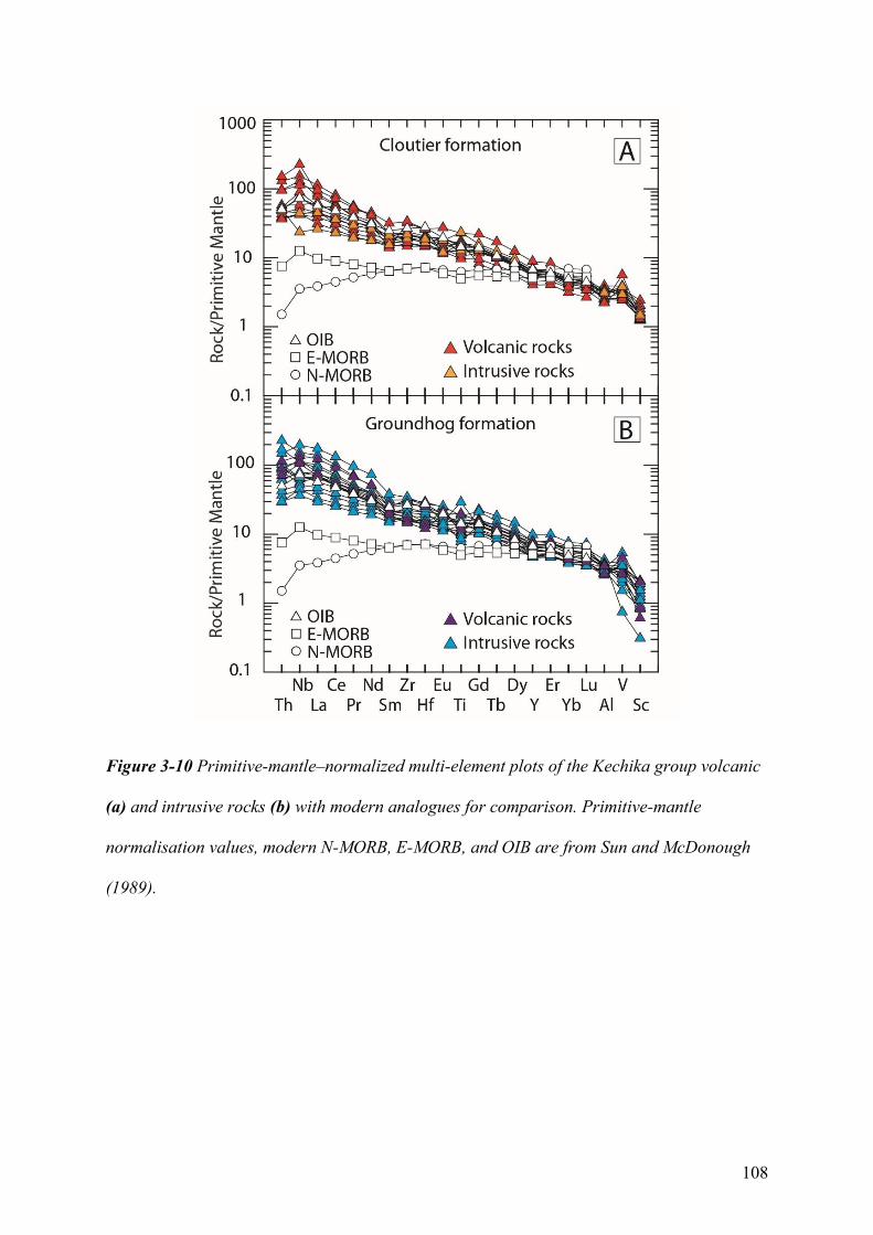
108
Figure 3-10 Primitive-mantle–normalized multi-element plots of the Kechika group volcanic
(a) and intrusive rocks (b) with modern analogues for comparison. Primitive-mantle
normalisation values, modern N-MORB, E-MORB, and OIB are from Sun and McDonough
(1989).
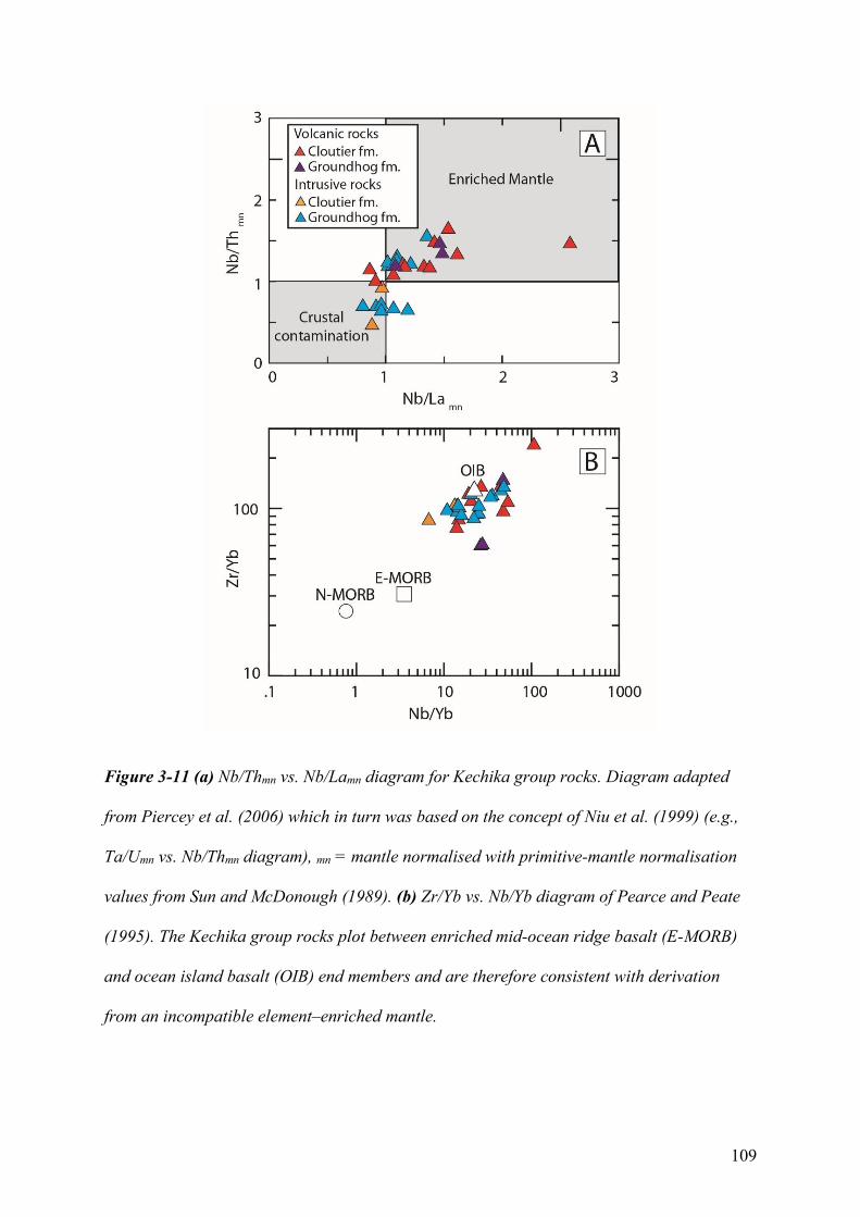
109
Figure 3-11 (a) Nb/Thmn vs. Nb/Lamn diagram for Kechika group rocks. Diagram adapted
from Piercey et al. (2006) which in turn was based on the concept of Niu et al. (1999) (e.g.,
Ta/Umn vs. Nb/Thmn diagram), mn = mantle normalised with primitive-mantle normalisation
values from Sun and McDonough (1989). (b) Zr/Yb vs. Nb/Yb diagram of Pearce and Peate
(1995). The Kechika group rocks plot between enriched mid-ocean ridge basalt (E-MORB)
and ocean island basalt (OIB) end members and are therefore consistent with derivation
from an incompatible element–enriched mantle.
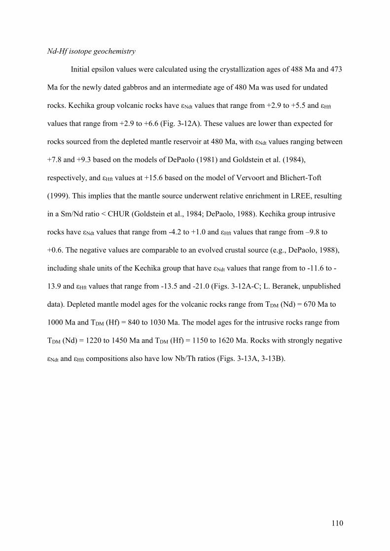
110
Nd-Hf isotope geochemistry
Initial epsilon values were calculated using the crystallization ages of 488 Ma and 473
Ma for the newly dated gabbros and an intermediate age of 480 Ma was used for undated
rocks. Kechika group volcanic rocks have εNdt values that range from +2.9 to +5.5 and εHft
values that range from +2.9 to +6.6 (Fig. 3-12A). These values are lower than expected for
rocks sourced from the depleted mantle reservoir at 480 Ma, with εNdt values ranging between
+7.8 and +9.3 based on the models of DePaolo (1981) and Goldstein et al. (1984),
respectively, and εHft values at +15.6 based on the model of Vervoort and Blichert-Toft
(1999). This implies that the mantle source underwent relative enrichment in LREE, resulting
in a Sm/Nd ratio < CHUR (Goldstein et al., 1984; DePaolo, 1988). Kechika group intrusive
rocks have εNdt values that range from -4.2 to +1.0 and εHft values that range from –9.8 to
+0.6. The negative values are comparable to an evolved crustal source (e.g., DePaolo, 1988),
including shale units of the Kechika group that have εNdt values that range from to -11.6 to -
13.9 and εHft values that range from -13.5 and -21.0 (Figs. 3-12A-C; L. Beranek, unpublished
data). Depleted mantle model ages for the volcanic rocks range from TDM (Nd) = 670 Ma to
1000 Ma and TDM (Hf) = 840 to 1030 Ma. The model ages for the intrusive rocks range from
TDM (Nd) = 1220 to 1450 Ma and TDM (Hf) = 1150 to 1620 Ma. Rocks with strongly negative
εNdt and εHft compositions also have low Nb/Th ratios (Figs. 3-13A, 3-13B).
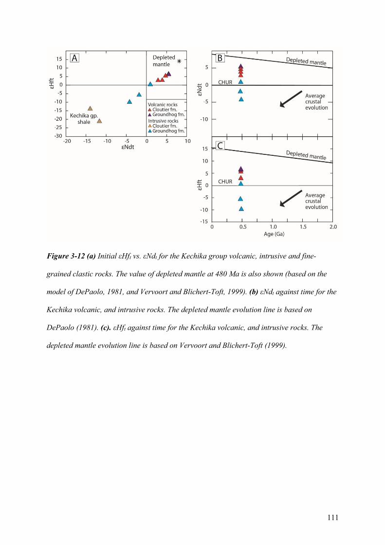
111
Figure 3-12 (a) Initial εHft vs. εNdt for the Kechika group volcanic, intrusive and fine-
grained clastic rocks. The value of depleted mantle at 480 Ma is also shown (based on the
model of DePaolo, 1981, and Vervoort and Blichert-Toft, 1999). (b) εNdt against time for the
Kechika volcanic, and intrusive rocks. The depleted mantle evolution line is based on
DePaolo (1981). (c). εHft against time for the Kechika volcanic, and intrusive rocks. The
depleted mantle evolution line is based on Vervoort and Blichert-Toft (1999).
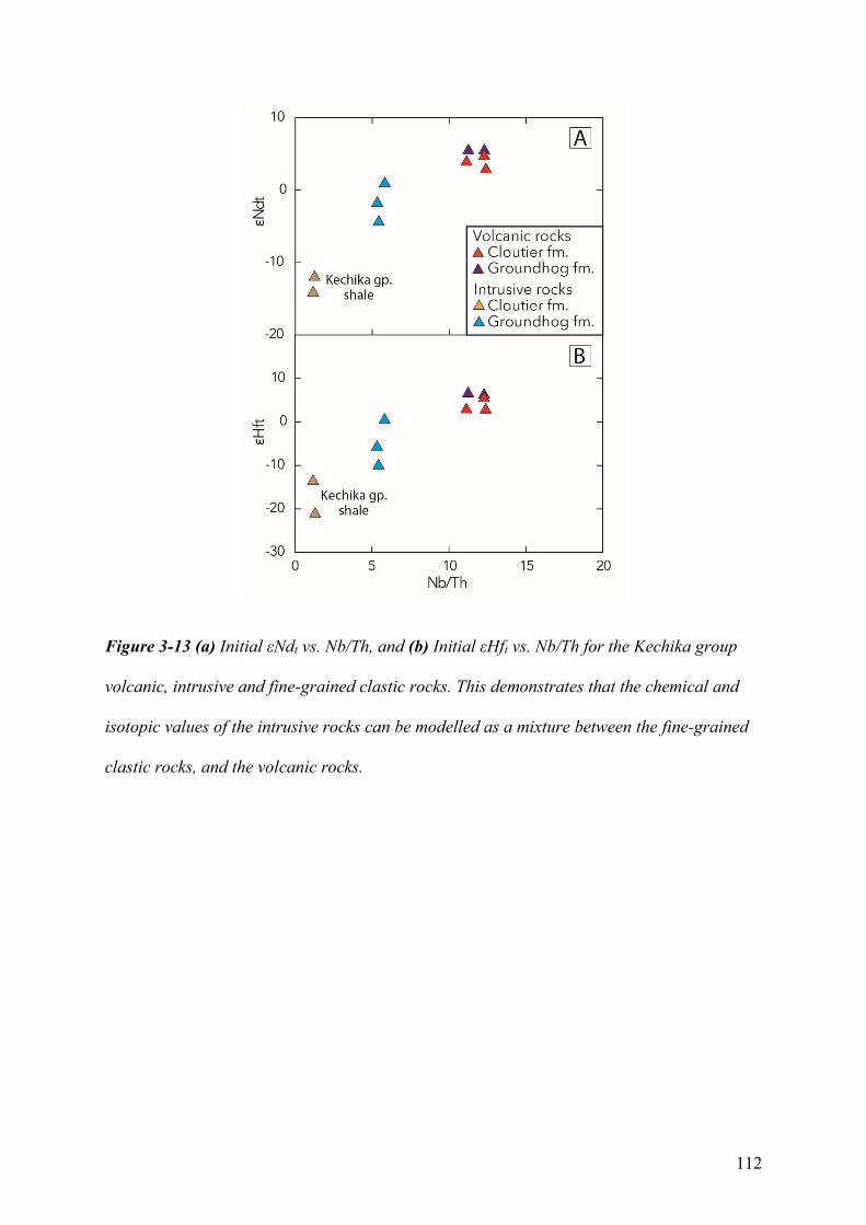
112
Figure 3-13 (a) Initial εNdt vs. Nb/Th, and (b) Initial εHft vs. Nb/Th for the Kechika group
volcanic, intrusive and fine-grained clastic rocks. This demonstrates that the chemical and
isotopic values of the intrusive rocks can be modelled as a mixture between the fine-grained
clastic rocks, and the volcanic rocks.
113
3.6 Discussion
3.6.1 Timing and emplacement history of the Kechika group
The Sheep Creek and Cloutier Creek stocks, Groundhog Creek sill complex, and other
Kechika group intrusive rocks likely originated as sill-sediment complexes (Campbell and
Beranek, 2017) that were periodically emplaced into the outer Cordilleran margin during the
latest Cambrian (ca. 488-487 Ma) to Early Ordovician (473 Ma). The sill-sediment
complexes represent syn-sedimentary volcanism in sediment-rich basins that formed during
the rifting of thinned continental crust and are spatially associated with transform-transfer
zones like the Liard line (e.g., Einsele, 1986; Naylor et al., 1999). The geochemistry and
observed field relationships strongly suggest that these crystallization ages are also
appropriate for the overlying and comagmatic extrusive rocks, which originated at
subaqueous volcanic centers. These U-Pb dates confirm the limited Cambrian to Ordovician
fossil ages for the upper Kechika group (Tempelman-Kluit, 2012). Silurian detrital zircons
within the polymictic conglomerate and Askin group tuff samples provide an upper age limit
for Kechika group deposition. The presence of 485, 484, and 483 Ma detrital zircons in the
polymictic conglomerate sample is consistent with local uplift and erosion of Kechika group
rocks during the early Silurian (Tempelman-Kluit, 2012).
3.6.2 Petrogenesis and magma source components
The non-arc primitive mantle-normalized signatures of the Kechika group rocks (Fig.
3-10) indicates that melt generation was likely associated with decompression melting
associated with upwelling mantle. The OIB- to E-MORB-like primitive mantle-normalized
signatures and alkaline geochemistry of Kechika group rocks indicates the enrichment of
incompatible elements during mantle melting (e.g., Pearce, 1996). This enrichment is a
114
function of both the mantle source, as indicated by Nd-Hf isotopic compositions, and melting
processes, as indicated by trace element data (e.g., Fitton, 1987; Pearce, 1996; MacDonald et
al., 2001; Niu et al., 2011, 2012). Similar incompatible element-enriched basalts are found in
extensional settings, including continental rifts (e.g., Furman, 2007), attenuated continental
margins (e.g., Pe-Piper et al., 2013), exhumed continental mantle lithosphere (e.g. Merle et
al., 2009; Miranda et al., 2009), and areas with thickened oceanic lithosphere (e.g., Sun and
McDonough, 1989; Niu et al., 2011). An increase in lithospheric thickness can inhibit
asthenospheric mantle upwelling and therefore increase the overall depth of the melting
interval. This increase in depth will increase the pressure of melting and reduce the volume of
melt (the lid effect; e.g., McKenzie and Bickle, 1988; Niu and O'Hara, 2007; Humphrey and
Niu, 2009). A reduction in melt volume will therefore further concentrate incompatible
elements and volatiles, such as Na, Nb, HFSE, Ti, P, H2O, and CO2 present in the mantle
source region (e.g., Edgar 1987; Pearce, 1996; Kogiso et al., 2003; Niu et al., 2011). Melting
at sufficient depth produces the characteristic OIB signature with LREE enrichment relative
to HREE. This signature likely reflects the melting of clinopyroxene in the presence of
residual garnet (e.g., Ionov et al., 1993; Hirschmann et al., 2003; Sobolev et al., 2005) and
implies that some amount of melting occurred within or below the garnet-spinel transition
zone.
Kechika group volcanic rocks yield moderately juvenile εNdt and εHft values that are
lower than those of the depleted mantle array at ~480 Ma, but greater than CHUR. Published
Nd isotope datasets from OIB- and E-MORB-like mafic rocks along the Cordilleran margin
similarly indicate mantle sources with a long history of incompatible element enrichment
(e.g., Piercey et al., 2006; Piercey and Colpron, 2009). Kechika group intrusive rocks,
however, yield moderately juvenile to evolved εNdt and εHft values that imply the involvement
of an evolved crustal source. In addition to the negative Nb/Th ratios, relative Ti depletions,
115
and relatively high Zr/Ti ratios, these gabbroic rocks have broadly similar incompatible
element-enrichment as the volcanic rocks. Whilst the Kechika volcanic rocks could be
slightly older than the intrusive rocks, there is no observed field relationship that supports a
significant difference in age, the available stratigraphic data (e.g., Tempelman-Kluit, 2012)
agrees with the U-Pb dates of the gabbroic rocks, and the strong similarities in trace-element
support a comagmatic relationship between the volcanic and intrusive rocks. A plot of εNdt
and εHft composition versus Nb/Th ratio (Figs. 3-13A, 3-13B) forms a mixing line between
volcanic, intrusive, and coeval sedimentary rocks and is therefore consistent with magma
chamber or emplacement processes such as crustal assimilation (e.g., Pearce, 1996; Piercey et
al., 2006; Meade et al., 2009).
There are several mantle sources that could explain the Nd-Hf isotopic compositions
and incompatible element-enrichment of Kechika group volcanic rocks, including a mantle
plume (e.g., Morgan, 1971), enriched ‘blobs’ within the asthenospheric mantle (Fitton, 2007),
and metasomatised mantle in the subcontinental lithosphere (Lloyd and Bailey, 1975;
Halliday et al., 1995; Pearce, 1996) and/or within the lithosphere-asthenosphere boundary
(e.g., Green et al., 2010; Niu et al., 2011; Schmerr, 2012). A plume origin for early Paleozoic
volcanism along the Cordilleran margin has been discounted previously (Goodfellow et al.,
1995) due to the margin-length scale of magmatism, duration and minor volume of
magmatism, and proximity of volcanic rocks to major lineaments or faults.
The repeated melting of a metasomatised subcontinental lithospheric mantle source is
consistent with the highly incompatible element-enriched composition of early to mid-
Paleozoic lavas (including ultrapotassic melts) along the inner Cordilleran margin (e.g.,
Foley, 1992; Goodfellow et al., 1995; Leslie, 2009; Millonig et al., 2012) and is presumably a
significant contributor to the incompatible element-enriched nature of mafic alkalic volcanic
rocks in more outboard regions (e.g., Piercey et al., 2006; Piercey and Colpron, 2009).
116
Metasomatism of Cordilleran lithospheric mantle could be linked with prolonged rifting and
magmatic episodes that affected western North America during the Mesoproterozoic to
Neoproterozoic (Piercey et al., 2006). For example, the Tonian (780 Ma) Muncho Lake dykes
form part of the Gunbarrel magmatic event in British Columbia and are spatially associated
with the Liard line (LeCheminant and Heaman, 1994; Ross et al., 2001; Harlan et al., 2003).
Metasomatism at the lithosphere-asthenosphere boundary by melt and/or volatiles
may explain the incompatible element-enrichment of off-axis alkaline rocks and geophysical
signature of the low velocity zone (Niu et al., 2011; Keller et al., 2017). This melt and/or
volatile rich region occurs at depths of <90 km along the eastern North American margin
(Rychert et al., 2005). This depth is at or below the spinel-garnet transition in peridotite (~85
km; Wood et al., 2013), which consistent with the formation of the OIB-like signature.
Goodfellow et al. (1995) concluded that potassic-ultrapotassic rocks in the northwestern
Selwyn basin were sourced from the lithospheric mantle, whereas alkali basalts in the central
Selwyn basin partially sampled an OIB-like asthenospheric domain.
3.6.3 Syn- to post-breakup volcanism along the Cordilleran margin
The high-precision zircon U-Pb ages reported from the Pelly Mountains provide
unequivocal evidence for continued volcanic activity at least 40 m.y. after lithospheric
breakup along western North America. From a stratigraphic perspective, post-breakup rocks
in the Pelly Mountains are analogous to other Cambrian-Ordovician volcano-sedimentary
successions in British Columbia, Yukon, Washington, Idaho, and Nevada. For example,
sediment-sill complexes similarly underlie the Menzie Creek and Crow Formations in central
and southeastern Yukon, respectively (Pigage, 2004; Pigage et al., 2015; Cobbett, 2016). The
principal lithofacies of these volcanic successions are akin to those of Kechika group and
consist of pillow basalt, basalt breccia, lapilli tuff, and epiclastic sandstone (Pigage, 2004,
117
2009). At the margin-scale, there is evidence for middle Cambrian to Ordovician normal
faults to be related to mafic volcanism throughout the Selwyn basin, Meilleur River
embayment, Misty Creek embayment, Kechika trough, and Roberts Mountain allochthon
(Cecile et al., 1982; Turner et al., 1989; MacIntyre, 1998; Pigage, 2004; Pigage et al., 2015).
From central Yukon to northern British Columbia, Cambrian-Ordovician volcanism was
coincident with shale deposition in relatively anoxic conditions (Fig. 3-3; Cecile et al., 1982;
Abbott et al., 1986; Cecile and Norford, 1991; MacIntyre, 1998; Pyle and Barnes, 2000;
Pigage, 2009; Gordey, 2013), suggesting that at least some sedimentation occurred in deep-
marine environments (e.g., Goodfellow et al., 1995; MacIntyre, 1998). Farther south in the
Roberts Mountain allochthon of Nevada, Middle to Late Ordovician greenstone and faulting
are associated with a chert-argillite basinal sequence (Madrid, 1987; Turner et al., 1989).
Field evidence for Cambrian-Ordovician faults in the Pelly Mountains is lacking
(Tempelman-Kluit, 2012) although the lithofacies, stratigraphic trends, and geochemical
signatures of the Kechika group are analogous to extension-related depocenters in the Selwyn
basin, Meilleur River embayment, and Misty Creek embayment. The similarities between
these coeval volcanic centers suggest that analogous post-breakup, rift-related processes
occurred throughout the early Paleozoic development of the Cordilleran margin. In the
Gataga district of northern British Columbia, MacIntyre (1998) inferred that major facies
boundaries between lower Paleozoic rock units formed through the reactivation of listric
normal faults that originally bounded tilted fault blocks. It is therefore plausible that the basal
units of the Kechika group (Cloutier, Groundhog, Gray Creek formations), now separated by
Mesozoic thrust faults, may have originally been deposited in an analogous setting.
3.6.4 Implications for Cordilleran rift models
118
The Cordilleran margin has a protracted rift evolution that includes >300 m.y. of
crustal stretching and thinning, lithospheric breakup, and pre-, syn-, and post-breakup
magmatism (e.g., Stewart, 1972; Colpron et al., 2002; Yonkee et al., 2014; Strauss et al.,
2015). Although post-breakup, early Paleozoic magmatism has long been recognized in
western North America (e.g., Goodfellow et al., 1995; Lund, 2008), there are many open
questions about the tectonic significance of Cambrian-Ordovician volcanic strata assigned to
the Cordilleran passive margin. New CA-TIMS zircon U-Pb age and whole-rock geochemical
data from south-central Yukon, in concert with published studies from western Canada and
United States, allow us to test the three end-member rift models for the Cordilleran margin.
Pure-shear rift models
Pure-shear rift models propose that Cordilleran lithosphere underwent uniform,
homogeneous extension as per McKenzie (1978). Within this framework, Bond et al. (1985)
used thermal subsidence curves to conclude that the final development of the Cordilleran
passive margin occurred during a short-lived rift phase at the Ediacaran-Cambrian boundary.
Christie-Blick and Levy (1989), however, noted the lack of evidence for late Ediacaran-early
Cambrian crustal extension in locations with significant early Paleozoic subsidence. It
follows that the field localities of Bond et al. (1985) were either inboard of the hinge zone
between stretched and unstretched lithosphere or that pure-shear thinning is inappropriate and
heterogeneous deformation and/or detachment faults may be important (Christie-Blick and
Levy, 1989).
The timing of Cambrian-Ordovician magmatism, extension, and tectonic subsidence
along the length of the Cordilleran margin, including that recorded by Kechika group, is not
consistent with that predicted by pure-shear rift models. For example, there is no obvious
mechanism to explain the timing of Tonian-Cryogenian rifting and basin development with
119
respect to late Ediacaran and younger lithospheric breakup and magmatism (e.g., Yonkee et
al., 2014). The marked asymmetry of the Cordilleran margin is also problematic for pure-
shear rift models (Cecile et al., 1997), which typically predict symmetrical rift settings.
Simple-shear rift models
Simple-shear or asymmetric rift models (Lister et al., 1986, 1991) assume that crustal-
scale detachment faults result in upper- and lower-plate segments along continental margins.
Cecile et al. (1997) and Lund (2008) used these ideas to conclude that Ediacaran-early
Paleozoic subsidence trends and alkaline magmatism across lithospheric-scale lineaments in
western Canada and United States were consistent with such asymmetric rifting models. For
example, Ediacaran alkaline rocks associated with inboard (platformal) siliciclastic strata and
erosional unconformities in British Columbia, Idaho, and Utah (e.g., Yonkee et al., 2014), are
consistent with igneous underplating in an upper-plate margin setting. Lower Cambrian
tholeiitic rocks in the outboard (basinal) regions of southern British Columbia (e.g. Kootenay
terrane, Paradis et al., 2006) are furthermore consistent with lithospheric thinning and
asthenospheric upwelling during lithospheric breakup (e.g., Lister et al., 1991; Lund, 2008).
The spatial proximity of these mafic volcanic rocks with Cordilleran transfer-transform zones
is consistent with the role of inherited lineaments in modern rifts which can accommodate
along-axis flow of asthenospheric mantle-derived melts (Georgen and Lin, 2003; Bronner et
al., 2011).
There are several outstanding problems in Cordilleran margin development that are
not fully explained by simple-shear rift models. Firstly, simple-shear scenarios do not
adequately explain how Tonian-Cryogenian rifting along western North America is related to
the timing of Ediacaran-early Cambrian lithospheric breakup, similar to pure-shear rift
models. Secondly, simple-shear rift models do not provide a mechanism to generate
120
Cambrian-Ordovician alkaline magmas and accommodate coeval extension along the length
of the margin after Ediacaran-early Cambrian lithospheric breakup and the onset of seafloor
spreading. As a result, rift models for the Cordilleran margin must propose how post-breakup,
lithospheric-scale processes occurred simultaneously in both upper- and lower-plate regions.
Magma-poor rift models
Modern passive margins are subdivided into magma-rich and magma-poor rift
systems based on the volume of syn-rift magmatism, timing and location of lithospheric
rupture, and lithospheric architecture (e.g., Franke, 2013; Doré and Lundin, 2015). Magma-
poor rift margins have low volumes of syn-rift magmatism and undergo significant thinning
through depth-dependent extension and necking of the crust and lithospheric mantle. The
Newfoundland-Iberia system is the type example of a magma-poor rift and comprises a
conjugate set of hyperextended, asymmetric margins that formed during the protracted
opening of the North Atlantic Ocean (e.g., Fig. 3-14; 3-15A-D; Peron-Pinvidic et al., 2007,
2013; Peron-Pinvidic and Manatschal, 2009; Brune et al., 2014). Our preferred rift model
follows the magma-poor rift framework for the modern Newfoundland-Iberia system; below,
we first present a comprehensive overview of North Atlantic rift evolution and then secondly
propose ancient corollaries along the Cordilleran margin using modern analogues (Fig. 3-
15E, F).
The initial Late Triassic to Early Jurassic crustal stretching phase of North Atlantic
rift evolution resulted in half-graben basins within the Grand Banks (offshore Newfoundland)
and Lusitanian basin (onshore and offshore Portugal) platforms in the so-called proximal
domain (e.g., Peron-Pinvidic et al., 2013). These basins formed part of a major rift system
that developed between Europe, Africa, and North America prior to the opening of the North
and Central Atlantic (Klitgord and Schouten, 1986). South of the Newfoundland-Iberia rift
121
system, the Central Atlantic Magmatic Province was emplaced at the Triassic-Jurassic
boundary after initial rifting, but prior to seafloor spreading (e.g., Marzoli et al., 1999;
Nomade et al., 2007). The Central Atlantic Magmatic Province mostly consists of dikes and
sills in Atlantic Canada, Iberia, and Morocco (e.g., Dunn et al., 1998; Verati et al., 2007).
After a brief hiatus, renewed Late Jurassic-Early Cretaceous rifting and detachment
faulting resulted in a necking zone or a region of major lithospheric thinning (e.g., Unternehr
et al., 2010; Peron-Pinvidic et al., 2013). The development of the necking zone was
coincident Middle Jurassic-Early Cretaceous alkaline and ultrapotassic magmatism within the
proximal zone, including alkaline volcanic rocks in the Lusitanian basin (ca. 145 Ma; Grange
et al., 2008) and Budgell Harbour Stock and related dikes in central Newfoundland (ca. 139-
135 Ma; Helwig et al., 1974; Strong and Harris, 1974). Depth-dependent extension occurred
as a result of shear zones in the weak middle crust (e.g., Wernicke, 1985; Lister et al., 1986;
Lavier and Manatschal, 2006). These detachment faults likely reactivated long-lived
basement weaknesses, such as rheological boundaries along pre-existing basins (Masini et al.,
2013; Manatschal et al., 2015). Detachment faulting within necking zones leads to the
formation of a wedge of lesser extended crust, termed the H-block (hanging-wall) or keystone
block, that is underlain by ductile lower lithosphere (e.g., Lavier and Manatschal, 2006;
Peron-Pinvidic and Manatschal, 2010). One of the H-block-bounding conjugate faults
becomes preferentially weakened during strain softening and leads to the domination of one
shear-zone (Huismans and Beaumont, 2014). This process results in asymmetric, simple-
shear rifting within the necking and distal zones and broadly resembles the upper- and lower-
plate rift scenarios of Lister et al. (1986, 1991). Such rifting within relatively hot, pliable
lithosphere widens the necking zone and leads to a complicated crustal configuration that
includes failed rift or offset basins (Chenin and Beaumont, 2013; Manatschal et al., 2015).
These v-shaped to margin-parallel basins (e.g., Orphan, Galician, and Porcupine basins)
122
overlie thinned to locally ruptured lithosphere, are bounded by high-angle faults, and
associated with major lineaments such as the Charlie Gibbs Fracture Zone (e.g., Whitmarsh et
al., 1996; O’Reilly et al., 2006; Dafoe et al., 2017). These basins can result in partial or
complete separation of the continental margin from outboard areas of thick crust, such as the
Flemish Cap and Galicia Bank continental ribbons (Peron-Pinvidic and Manatschal, 2010).
The failure of these rift basins to proceed to lithospheric breakup has been linked to various
causes including the role of depleted zones of subcontinental lithospheric mantle restricting
the supply of magma (e.g., Manatschal et al., 2015), reduced mantle temperature, and as a
function of the spreading rate (e.g., Dore and Lundin, 2015). Early Cretaceous thinning led to
hyperextended (<10 km thick) crust and penetration of faults into the continental lithospheric
mantle (e.g., Peron-Pinvidic et al., 2013). This resulted in coupled extension and Valanginian
(ca. 140 Ma) and younger exhumation of continental lithospheric mantle along detachment
faults (e.g., Boillot et al., 1980; Whitmarsh et al., 2001; Tucholke et al., 2007). The ocean-
continent transition region is termed the distal domain and variably composed of
hyperextended crust, exhumed lithospheric mantle, embryonic oceanic crust, and magmatic
intrusions (e.g., Peron-Pinvidic et al., 2013). Mantle exhumation was accompanied by the
progressive emplacement of Lower Cretaceous (138-121 Ma) magmatic rocks towards the
future site of breakup in the Gorringe and Galicia Bank areas, offshore Portugal (Schärer et
al., 2000; Bronner et al., 2011; Eddy et al., 2017). Lower Cretaceous alkaline and tholeiitic
rocks with N-MORB- to E-MORB-like signatures yield εHft values that range from +12 to
+20, comparable to modern rocks along this segment of the Mid-Atlantic ridge (+14 to +21;
Blichert-Toft et al., 2005), suggesting derivation from the depleted asthenospheric mantle
(e.g., Cornen et al., 1999; Schärer et al. 2000, Eddy et al., 2017). Coeval tholeiitic and lesser
alkalic volcanic rocks in the Fogo Seamounts, offshore Newfoundland, have εNdt values that
range from +1 to +6 and were emplaced along the Grand Banks leaky transform margin (e.g.,
123
Pe-Piper et al., 2007). These Nd isotope values are lower than MORB along this segment of
the Mid-Atlantic ridge (e.g. +7.5 to +11.5; Blichert-Toft et al., 2005). Pe-Piper et al. (2007)
concluded that Upper Jurassic-Lower Cretaceous volcanic rocks were generated by edge-
driven convection along the Grand Banks transform margin.
Aptian-Albian lithospheric breakup was time-transgressive and occurred first in the
south and migrated north (e.g., Bronner et al., 2011). Breakup was associated with the
generation of a lithospheric breakup surface and overlying Albian-Cenomanian breakup
succession that records the transition from breakup tectonism to thermal subsidence (Soares
et al., 2012). Syn-breakup activity included a large pulse of mafic magmatism in the distal
domain (J-anomaly; Bronner et al., 2011) that was likely derived from the depleted mantle
(Eddy et al., 2017). The delayed melt extraction may indicate that the lithospheric mantle
acted as a sponge to melts derived from the upwelling asthenosphere (e.g., Müntener et al.,
2010). Evidence for mafic magma emplacement within exhumed lithospheric mantle of the
Newfoundland-Iberia rift system (e.g., Cornen et al., 1999; Müntener and Manatschal, 2006)
and Alpine ophiolites (e.g., Müntener et al., 2010) supports this hypothesis.
Alkaline volcanic rocks with OIB-like signatures were emplaced along the
Newfoundland-Iberia margins for at least 30 m.y. after Aptian-Albian lithospheric breakup,
prior to the first seafloor spreading magnetic anomaly ca. 84 Ma (Schärer et al. 2000; Hart
and Blusztajn, 2006; Jagoutz et al., 2007). Widespread alkalic magmatism is a seemingly
consistent component of the post-breakup stratigraphy of magma-poor rift margins (e.g.,
Manatschal and Müntener, 2009; Bronner et al., 2011). Post-breakup volcanism along the
Newfoundland margin probably consisted of volcanic centers and sills that were spatially
associated with transform-transfer faults and related margin-parallel faults. This includes the
Newfoundland seamounts in the Newfoundland basin (Sullivan and Keen, 1977) and Charlie
Gibbs Volcanic Province (Keen et al., 2014), and Orphan seamount (Pe-Piper et al., 2013) in
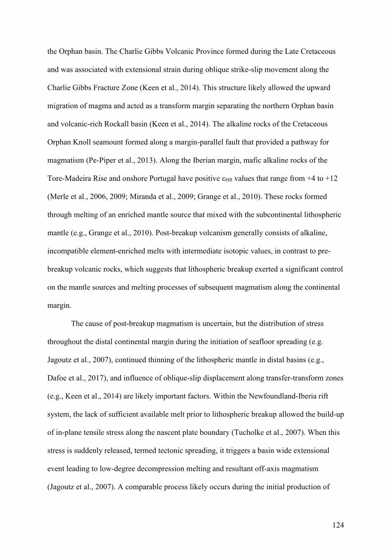
124
the Orphan basin. The Charlie Gibbs Volcanic Province formed during the Late Cretaceous
and was associated with extensional strain during oblique strike-slip movement along the
Charlie Gibbs Fracture Zone (Keen et al., 2014). This structure likely allowed the upward
migration of magma and acted as a transform margin separating the northern Orphan basin
and volcanic-rich Rockall basin (Keen et al., 2014). The alkaline rocks of the Cretaceous
Orphan Knoll seamount formed along a margin-parallel fault that provided a pathway for
magmatism (Pe-Piper et al., 2013). Along the Iberian margin, mafic alkaline rocks of the
Tore-Madeira Rise and onshore Portugal have positive εHft values that range from +4 to +12
(Merle et al., 2006, 2009; Miranda et al., 2009; Grange et al., 2010). These rocks formed
through melting of an enriched mantle source that mixed with the subcontinental lithospheric
mantle (e.g., Grange et al., 2010). Post-breakup volcanism generally consists of alkaline,
incompatible element-enriched melts with intermediate isotopic values, in contrast to pre-
breakup volcanic rocks, which suggests that lithospheric breakup exerted a significant control
on the mantle sources and melting processes of subsequent magmatism along the continental
margin.
The cause of post-breakup magmatism is uncertain, but the distribution of stress
throughout the distal continental margin during the initiation of seafloor spreading (e.g.
Jagoutz et al., 2007), continued thinning of the lithospheric mantle in distal basins (e.g.,
Dafoe et al., 2017), and influence of oblique-slip displacement along transfer-transform zones
(e.g., Keen et al., 2014) are likely important factors. Within the Newfoundland-Iberia rift
system, the lack of sufficient available melt prior to lithospheric breakup allowed the build-up
of in-plane tensile stress along the nascent plate boundary (Tucholke et al., 2007). When this
stress is suddenly released, termed tectonic spreading, it triggers a basin wide extensional
event leading to low-degree decompression melting and resultant off-axis magmatism
(Jagoutz et al., 2007). A comparable process likely occurs during the initial production of
125
oceanic crust and prior to the first seafloor-spreading magnetic anomaly (e.g., Bronner et al.,
2011).
Modelling results from modern mid-ocean ridge systems suggest that some volatile-
and trace element-rich melts sourced from upwelling asthenosphere undergo along-axis flow
beneath the adjacent lithosphere (Keller et al., 2017). This would be consistent with seismic
interpretations of melt at the lithosphere-asthenosphere boundary and provide an enriched
metasomatised mantle source for alkalic, off-axis seamounts in modern margins (e.g., Niu et
al., 2012; Keller et al., 2017). Although these ideas are developed on modern mid-ocean
ridges it is not inconceivable that similar metasomatic processes occur along highly
attenuated continental margins, especially during periods with evidence for tholeiitic
magmatism. This would be consistent with post-breakup magmatic rocks in Portugal that
resulted from the mixing of the subcontinental lithospheric mantle and an enriched
asthenospheric mantle component (Grange et al., 2010).
The Neoproterozoic-early Paleozoic Cordilleran margin may have developed in a
manner not unlike that of the modern North Atlantic rift system (Yonkee et al., 2014,
Hayward, 2015; Beranek, 2017). Although no two margins develop in an identical manner,
the major aim of our comparison here is to recognize analogous processes that occurred
during Cordilleran and Newfoundland-Iberia rift evolution (Fig. 3-14). The early or Tonian-
Cryogenian rift phase of Cordilleran development included magmatism (Gunbarrel event),
intracratonic basin deposition (Windermere Supergroup), and pure-shear stretching that
weakened an initially strong lithosphere relative to the cratonic interior (Yonkee et al., 2014).
We propose that this initial rift event is analogous to the Triassic-Jurassic stretching phase in
the North Atlantic, including that of the Grand Banks and Lusitanian basins. The failure to
proceed to breakup in the North Atlantic has been suggested to relate to a heterogeneous
126
lithospheric mantle that was unable to produce sufficient melt during these early rift stages
(Manatschal et al., 2015).
127
Figure 3-14 Rift evolution model modified from Beranek (2017); A: Magma-poor rift model for the North Atlantic margins (Péron-Pinvidic et al., 2013 and references therein). B: Existing rift models for the Cordilleran margin (Lund, 2008 and references therein).
128
Ediacaran and early Cambrian rifting led to the initial development of the Kechika
trough, Selwyn basin, Lardeau trough, and other basins with intermittent extensional histories
(Gordey and Anderson, 1993; Logan and Colpron, 2006; Post and Long, 2008). This rift
stage was probably related to formation of the necking zone and significant lithospheric
thinning, analogous to the development of outboard Jurassic-Cretaceous basins in the North
Atlantic Ocean (e.g., Orphan basin; Dafoe et al., 2017). Cordilleran basins also likely evolved
along transform-transfer zones and some outboard areas with periodic shallow-water
deposition. Such outboard platforms, including the Cassiar platform, reflect lesser-extended
crust and are likely analogous to continental ribbons like the Flemish Cap. This is consistent
with published observations for minimally extended, outboard crustal blocks in the northern
Cordillera (Hansen et al., 1993; Cecile et al., 1997). Ediacaran alkaline volcanic rocks of the
Hamill Group in British Columbia (Colpron et al., 2002), Browns Hole Formation in Utah
(Crittenden and Wallace, 1973) and lower Cambrian Quartet Mountain lamprophyre suite in
northern Yukon (Milidragovic et al., 2006) are proposed equivalents to Jurassic alkaline and
ultrapotassic volcanic rocks in the North Atlantic.
Lithospheric breakup along western Laurentia is widely thought to have occurred by
the early Cambrian (e.g., Bond et al., 1984, 1985). Recent studies have furthermore proposed
that late Ediacaran-early Cambrian rift evolution involved mantle exhumation (Yonkee et al.
2014; Hayward, 2015) and the deposition of breakup successions like those along the modern
North Atlantic margins (Beranek, 2017). Exhumed continental mantle blocks and
hyperextended crust produced during late rift evolution are now located beneath accreted
Cordilleran terranes (Fig. 3-15E, F; e.g., Hayward, 2015). Beranek (2017) predicted that a
sequence boundary at the base of the Sauk I megasequence represents a lithospheric breakup
surface along western North America. The breakup succession includes early Fortunian to
Cambrian Stage 5 strata (ca. 535-505 Ma) that from bottom to top consist of lowstand,
129
transgressive, and highstand system tract deposits, analogous to the Albian-Cenomanian
depositional histories of offshore Portugal and Newfoundland (Soares et al., 2012).
Lower Cambrian volcanic rocks that were deposited in distal margin settings range in
composition from tholeiitic to alkalic and broadly overlap with the inferred timing of
breakup. Tholeiites in the Kootenay terrane near Shuswap Lake, southern British Columbia,
yield N-MORB-like signatures and εNdt values (+8; unit EBG of the Eagle Bay assemblage,
Paradis et al., 2006) that are close to the predicted values for the Cambrian depleted mantle
(εNd540 = +9.1; Goldstein et al., 1984). Kootenay terrane strata that comprise sediment-sill
complexes in the northern Selkirk Mountains (Index Formation) yield intermediate E-
MORB- to N-MORB-like signatures and are locally associated with chlorite schist and
serpentinized ultramafic rocks (e.g., Zwanzig, 1973; Logan and Colpron, 2006). Similar
fault-bounded mafic and ultramafic units are associated with lower Cambrian volcanic and
sedimentary rocks in the northern Kootenay terrane (Showshoe Group; e.g., Ferri and
Schiarizza, 2006) and southern Kootenay terrane (e.g., Smith and Gehrels, 1992; Logan and
Colpron, 2006). The juvenile mafic volcanic rocks, sediment-sill complexes, and association
with Cu-rich base metal deposits led Logan and Colpron (2002) to suggest a Gulf of
California analogue for the Lardeau trough, implying that these rocks were emplaced during
rift-related lithospheric thinning. Lardeau trough tholeiitic rocks are probably analogous to
the depleted mantle-derived rocks that erupted during mantle exhumation and lithospheric
breakup in the Gorringe, Galicia, and Grand Banks regions. Tholeiitic volcanism in the
Kootenay terrane continued into the middle to late Cambrian (Ferri and Schiarizza, 2006;
Logan and Colpron, 2006). Analogous to Early Cretaceous tholeiites in the Newfoundland-
Iberia rift system, the emplacement of these Cambrian volcanic rocks and associated mafic to
ultramafic intrusive rocks may have contributed to lithospheric heating and weakening. Other
pre- to syn-breakup rocks that crop out between Ediacaran volcanic and clastic strata and
130
lower Cambrian archaeocyathid horizons are expected to show depleted asthenospheric
mantle contributions (e.g., Paradis et al., 2006). Lower Cambrian volcanic strata, however,
are mostly exposed in the eastern or inboard regions of the Cordillera that may not have
undergone sufficient lithospheric attenuation to expect only depleted mantle inputs. Example
rock units include the Fish Lake volcanics (Donald Formation) of southern British Columbia
(Kubli and Simony, 1992) and olivine basalt flows within the Prospect Mountain and Tintic
Quartzites of Nevada and Utah (Morris and Lovering, 1961; Kellogg, 1963).
Upper Cambrian to Middle Ordovician volcanic strata form parts of the Sauk II, III,
and Tippecanoe sequences and their syn- to post-breakup nature is therefore consistent with a
magma-poor rift origin (e.g., Fig. 3-15E; Cecile et al., 1997; Beranek, 2017). Most Cambrian
Series 2 to Ordovician volcanic rocks in Yukon and western United States are alkali basalts
with OIB-like to E-MORB-like signatures (Fig. 3-16A). Post-breakup volcanic rocks of the
Kootenay terrane have lower overall LREE-enrichment than volcanic rocks in other parts of
the Cordilleran margin (Fig. 3-16A), however, they display geochemical trends consistent
with increasing LREE-enrichment and alkalinity following breakup. This is shown in British
Columbia by the contrast between the Index Formation and overlying alkali basalts of the
Jowett Formation (Logan and Colpron, 2006) and lower and upper parts of the Eagle Bay
assemblage (Paradis et al., 2006), although this transition appears slightly more complex
within Cambrian volcanic strata of the Snowshoe Group (e.g., Ferri and Schiarizza, 2006).
Within the upper section of the Eagle Bay assemblage, Cambrian Series 2 alkali basalts yield
intermediate εNdt values (range from +4 to +6; Paradis et al., 2006), which suggests the
involvement of incompatible element-enriched mantle following breakup. The generation of
syn- to post-breakup alkaline volcanic rocks along western North America is akin to the
emplacement of post-Aptian magmatic rocks on both sides of the Newfoundland-Iberia (Fig.
3-16B; e.g., Jagoutz et al., 2007; Bronner et al., 2011) and other magma-poor rift systems
131
(e.g., Manatschal and Müntener, 2009). Notably, many occurrences of post-breakup
magmatic rocks along the Cordilleran and Newfoundland-Iberia margins are spatially
associated with leaky transfer-transform lineaments and extensional faults. These structures
are likely important for localizing basin-wide extension and associated off-axis magmatism
(Jagoutz et al., 2007). Therefore, the lack of sufficient melt to enable breakup, and initiate
seafloor spreading within a magma-poor rift system, could directly explain the wide
distribution and longevity of syn- to post-breakup magmatism along both rifted margins. The
major distinction in magmatism that follows lithospheric breakup is an increase in the
proportion of alkaline volcanic rocks with contributions from an enriched mantle source.
Whilst the overall length of rifting varies from the Cordilleran to Atlantic margin (Fig. 3-14;
e.g. >150 Ma in the Atlantic margin to ~ 300 Ma) this is not inconsistent with the length of
time for the evolution of the Carboniferous–Paleocene magma-poor, East Greenland–Mid-
Norwegian rift system (~ 300Ma; e.g. Peron-Pinvidic et al., 2013). Furthermore, the length of
time suggested for individual components of the Cordilleran rift system such as the period of
Ediacaran-early Cambrian rifting prior to breakup (~80 Ma), and the subsequent breakup to
post-breakup period (~65 Ma) strongly compares to the length of time for the comparable
process in the Newfoundland-Iberia rift system (Fig. 3-14; e.g., ~60Ma, and ~40 Ma
respectively; e.g., Peron-Pinvidic et al., 2013).
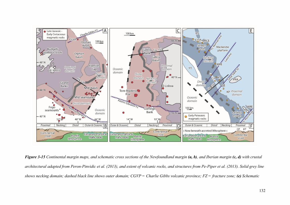
132
Figure 3-15 Continental margin maps, and schematic cross sections of the Newfoundland margin (a, b), and Iberian margin (c, d) with crustal
architectural adapted from Peron-Pinvidic et al. (2013), and extent of volcanic rocks, and structures from Pe-Piper et al. (2013). Solid grey line
shows necking domain; dashed black line shows outer domain; CGVP = Charlie Gibbs volcanic province; FZ = fracture zone; (e) Schematic
133
diagram of the northwestern North American ancestral margin during late Cambrian to Early Ordovician time. Lithospheric structures based on
Cecile et al. (1997), platformal, and basinal strata from Cecile and Norford (1993), and Pyle (2012), and with inferred restoration of the Tintina
fault based on ~400 km of dextral displacement from Gabrielse et al. (2006). See Figure 1, and Appendix 1 for data on volcanic rocks. RT =
Richardson Trough; OA = Ogilvie Arch; MCE = Misty Creek embayment; MRE = Meilleur River embayment; YTT = Yukon Tanana terrane;
GSSZ; Great Slavelake Shear Zone; KT = Kootenay trough; OE = Ospika embayment; CT = Cassiar terrane; KP = Kakwa platform; PA =
Purcell arch; WRE = White River embayment; (f) Magma-poor rift model after Beranek (2017) with elements in the Canadian Cordillera. CT—
Cassiar platform, KT—Kechika trough, MP—MacDonald platform.
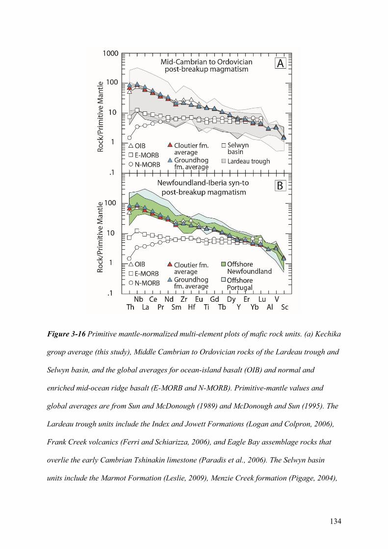
134
Figure 3-16 Primitive mantle-normalized multi-element plots of mafic rock units. (a) Kechika
group average (this study), Middle Cambrian to Ordovician rocks of the Lardeau trough and
Selwyn basin, and the global averages for ocean-island basalt (OIB) and normal and
enriched mid-ocean ridge basalt (E-MORB and N-MORB). Primitive-mantle values and
global averages are from Sun and McDonough (1989) and McDonough and Sun (1995). The
Lardeau trough units include the Index and Jowett Formations (Logan and Colpron, 2006),
Frank Creek volcanics (Ferri and Schiarizza, 2006), and Eagle Bay assemblage rocks that
overlie the early Cambrian Tshinakin limestone (Paradis et al., 2006). The Selwyn basin
units include the Marmot Formation (Leslie, 2009), Menzie Creek formation (Pigage, 2004),
135
and Crow, Rabbitkettle, and Sunblood Formations (Pigage et al., 2015). (b) The Cretaceous
syn- to post-breakup volcanic rocks of the Newfoundland margin include the ODP site 1276
(Hart and Blusztajn, 2006), and Orphan Knoll seamount (Pe-Piper et al., 2013). The range of
values from Cretaceous syn- to post-breakup volcanic rocks of the Iberian margin include
volcanic rocks from the western Iberian continental margin (Miranda et al., 2009), and the
Tore–Madeira Rise (Merle et al., 2009).
136
3.6.5 Future work
Many key observations of the North Atlantic Ocean basin, including the presence of
hyperextended crust and exhumed lithospheric mantle, are preserved in deep-water regions
that represent the necking and distal domains of the Newfoundland-Iberia rift (Fig. 3-15B,
D). In the North American Cordillera, such elements are structurally beneath accreted
allochthons (Hayward, 2015; Beranek, 2017), but we propose that outer continental margin
remnants may be preserved in both parautochthonous and allochthonous fragments with ties
to the western Laurentian margin (Fig. 3-15F). For example, the Yukon-Tanana terrane is
demonstrably of northwest Laurentian margin affinity, but its pre-Devonian magmatic and
tectonic histories are uncertain (e.g., Colpron et al., 2007). In central Yukon, the exposed
metasedimentary basement of Yukon-Tanana (Snowcap assemblage) includes amphibolite
units with OIB- to E-MORB-like signatures, εNdt and εHft values that indicate an enriched
mantle source, and Proterozoic depleted mantle model ages (Piercey and Colpron, 2009).
These amphibolites are analogous to Neoproterozoic to lower Paleozoic mafic rocks of the
Cordilleran margin (Piercey and Colpron, 2009), including alkaline to tholeiitic rocks of the
parautochthonous Kootenay terrane and Kechika group. The chondritic to juvenile Nd-Hf
isotope signatures of metamorphosed carbonate rocks intercalated with the amphibolites have
been used to infer emplacement during a major magmatic pulse such as the Gunbarrel
magmatic event (e.g., Piercey et al., 2006). If early Cambrian lithospheric breakup along
western Laurentia was accompanied by a significant outboard magmatic pulse, comparable to
that of the Aptian-Albian magmatic pulse along the outboard Newfoundland-Iberia rift
system, then an argument could be made to correlate Yukon-Tanana basement rocks with
lower Cambrian syn-breakup successions of northwestern Laurentia.
137
3.7 Conclusions
Cambrian-Ordovician igneous rocks of the Pelly Mountains, south-central Yukon,
have zircon U-Pb crystallization ages and geochemical compositions that provide new
constraints on the tectonic significance of post-breakup magmatism in western North
America. Comagmatic gabbro and basalt units of the Kechika group that post-date
lithospheric breakup by >40 m.y. were generated by the low-degree partial melting of
enriched mantle and emplaced within submarine volcanic centers and sill-sediment
complexes during margin-scale extension. The Liard line, a long-lived basement feature that
defines a transfer-transform zone in the northern Canadian Cordillera, likely accommodated
Cambrian-Ordovician magmatism in the Pelly Mountains and adjacent areas of southeastern
Yukon and northern British Columbia. Our preferred model for Cordilleran rift evolution
features a magma-poor rift scenario not unlike that of the Newfoundland-Iberia system and
includes Tonian-Cryogenian stretching and thinning, late Ediacaran-early Cambrian mantle
exhumation and tholeiitic-dominated breakup magmatism, and middle Cambrian to
Ordovician alkaline-dominated post-breakup magmatism. The Kechika group likely
originated in a manner akin to mid- to Late Cretaceous sills and seamounts within the distal
margins of Newfoundland (e.g., Orphan and Newfoundland basins) and Portugal (e.g., Tore-
Madeira Rise). Following the models of Tucholke et al. (2007) and Jagoutz et al. (2007), it is
predicted that the Kechika group and related off-axis volcanic units were generated during
the release of in-plane tensile stresses after lithospheric breakup, but prior the establishment
of a spreading ridge and formation of new ocean crust along northwestern Laurentia.
138
3.8 Acknowledgments
This project was supported by research grants from the Geo-mapping for Energy and
Minerals program (Natural Resources Canada) to Beranek and NSERC Discovery Grants to
Beranek and Piercey. The Yukon Geological Survey generously supported field logistics and
helicopter support. We are grateful to Dominique Weis, Corey Wall, and Bruno Kieffer for
their assistance at the Pacific Centre for Isotopic and Geochemical Research.
3.9 References
Abbott, G., 1997, Geology of the Upper Hart River Area, Eastern Ogilvie Mountains, Yukon
Territory 9116A/10, 116A/11: Exploration and Geological Services Division, Yukon, Indian
and Northern Affairs Canada, Bulletin 9, 92 p.
Abbott, J.G., Gordey, S.P., and Tempelman-Kluit, D.J., 1986, Setting of stratiform, sediment-hosted
lead-zinc deposits in Yukon and northeastern British Columbia: Geological Survey of Canada
Open File 2169, p. 69-98, doi:10.4095/132329.
Aitken, J.D., 1993, Cambrian and lower Ordovician-Sauk sequence, in Stott, D.F., and Aitken, J.D.,
eds., Sedimentary Cover of the North American Craton in Canada: Geological Survey of
Canada, Geology of Canada, v. 5, p. 96-124, doi:10.1130/dnag-gna-d1.96.
Allen, T.L., Pigage, L.C., and MacNaughton, R.B., 2000, Preliminary geology of the Pool Creek
map area (95C/5), southeastern Yukon: Yukon Exploration and Geology, p. 53-72.
139
Armin, R.A., and Mayer, L., 1983, Subsidence analysis of the Cordilleran miogeocline: Implications
for timing of late Proterozoic rifting and amount of extension: Geology, v. 11, p. 702-705,
doi:10.1130/0091-7613(1983)11<702:saotcm>2.0.co;2.
Audet, P., Sole, C. and Schaeffer, A.J., 2016, Control of lithospheric inheritance on neotectonic
activity in northwestern Canada?: Geology, v. 44, p. 807-810, doi:10.1130/G38118.1
Beranek, L.P., 2017, A magma-poor rift model for the Cordilleran margin of western North America:
Geology, v. 45, p. 1115-1118, doi:10.1130/G39265.1.
Black, R., Gladwin, K., and Johnston, S.T., 2003, Geology and metamorphic conditions in rocks of
the Cassiar terrane, Glenlyon map area (105L/1), south-central Yukon, in Emond, D.S., and
Lewis, L.L., eds., Yukon Exploration and Geology 2002: Exploration and Geological
Services Division, Yukon Region, Indian and Northern Affairs Canada, p. 65-76.
Blichert-Toft, J., Agranier, A., Andres, M., Kingsley, R., Schilling, J.G., and Albarède, F., 2005,
Geochemical segmentation of the Mid-Atlantic Ridge north of Iceland and ridge-hot spot
interaction in the North Atlantic: Geochemistry, Geophysics, Geosystems, v. 6, p. 1-27,
doi:10.1029/2004gc000788.
Boillot, G., Grimaud, S., Mauffret, A., Mougenot, D., Kornprobst, J., Mergoil-Daniel, J., and
Torrent, G., 1980, Ocean-continent boundary off the Iberian margin: a serpentinite diapir
west of the Galicia Bank: Earth and Planetary Science Letters, v. 48, p. 23-34,
doi:10.1029/2004gc000788.
140
Bond, G.C., and Kominz, M.A., 1984, Construction of tectonic subsidence curves for the early
Paleozoic miogeocline, southern Canadian Rocky Mountains: Implications for subsidence
mechanisms, age of breakup, and crustal thinning: Geological Society of America Bulletin, v.
95, p. 155-173, doi:10.1130/0016-7606(1984)95<155:cotscf>2.0.co;2.
Bond, G.C., Nickeson, P.A., and Kominz, M.A., 1984, Breakup of a supercontinent between 625 Ma
and 555 Ma: new evidence and implications for continental histories: Earth and Planetary
Science Letters, v. 70, p. 325-345, doi:10.1016/0012-821x(84)90017-7.
Bond, G.C., Christie-Blick, N., Kominz, M.A., and Devlin, W.J., 1985, An Early Cambrian rift to
post-rift transition in the Cordillera of western North America: Nature, v. 315, p. 742-746,
doi:10.1038/315742a0.
Braun, J., and Beaumont, C., 1989, A physical explanation of the relation between flank uplifts and
the breakup unconformity at rifted continental margins: Geology, v. 17, p. 760-764,
doi:10.1130/0091-7613(1989)017<0760:apeotr>2.3.co;2.
Bronner, A., Sauter, D., Manatschal, G., Peron-Pinvidic, G., and Munschy, M., 2011, Magmatic
breakup as an explanation for magnetic anomalies at magma-poor rifted margins: Nature
Geoscience, v. 4, p. 549-553, doi:10.1038/ngeo1201.
Brune, S., Heine, C., Pérez-Gussinyé, M., and Sobolev, S.V., 2014, Rift migration explains
continental margin asymmetry and crustal hyper-extension: Nature Communications, v. 5, p.
1-9, doi:10.1038/ncomms5014.
141
Buck, W.R., 2004, Consequences of asthenospheric variability on continental rifting, in Karner,
G.D., Taylor, B., Driscoll, N.W., and Kohlstedt, D.L., eds., Rheology and deformation of the
lithosphere at continental margins: Columbia University Press, New York, v. 62, p. 1-30,
doi:10.7312/karn12738-002.
Campbell, R.W., and Beranek, L.P., 2017, Volcanic stratigraphy of the Cambrian-Ordovician
Kechika group, Pelly Mountains, south-central Yukon, in MacFarlane, K.E., and Weston,
L.H., eds., Yukon Exploration and Geology 2016: Yukon Geological Survey, p. 25-45.
Cann, J.R., 1970, Rb, Sr, Y, Zr and Nb in some ocean floor basaltic rocks: Earth and Planetary
Science Letters, v. 10, p. 7-11, doi:10.1016/0012-821x(70)90058-0.
Cecile, M.P., 2000, Geology of the northeastern Niddery Lake map area, east-central Yukon and
adjacent Northwest Territories: Geological Survey of Canada Bulletin, v. 553, 120 p,
doi:10.4095/211664.
Cecile, M.P., Fritz, W.H., Norford, B.S., and Tipnis, R.S., 1982, The Lower Paleozoic Misty Creek
embayment, Selwyn Basin, Yukon and Northwest Territories: Geological Survey of Canada,
Bulletin 335, 78 p, doi:10.4095/111346.
Cecile, M.P., and Norford, B.S., 1991, Ordovician and Silurian assemblages, in Cambrian to Middle
Devonian Assemblages, in Gabrielse, H., and Yorath, C.J., eds., Geology of the Cordilleran
Orogen in Canada: Geological Survey of Canada, Geology of Canada series, no. 4, p. 184-
196, doi:10.4095/134069.
142
Cecile, M.P., Norford, B.S., Stott, D.F., and Aitken, J.D., 1993, Ordovician and Silurian, in Stott,
D.F., and Aitken, J.D., eds., Sedimentary cover of the craton in Canada: Geology of Canada:
Geological Survey of Canada, v.5, p.125-149, doi:10.1130/dnag-gna-d1.125.
Cecile, M.P., Morrow, D.W., and Williams, G.K., 1997, Early Paleozoic (Cambrian to Early
Devonian) tectonic framework, Canadian Cordillera: Bulletin of Canadian Petroleum
Geology, v. 45, p. 54-74.
Chenin, P., and Beaumont, C., 2013, Influence of offset weak zones on the development of rift
basins: Activation and abandonment during continental extension and breakup: Journal of
Geophysical Research: Solid Earth, v. 118, p. 1698–1720, doi:10.1002/jgrb.50138.
Christie-Blick, N., 1997, Neoproterozoic sedimentation and tectonics in west-central Utah: Brigham
Young University Geological Studies, v. 42, p. 1-30.
Christie-Blick, N., and Levy, M., 1989, Stratigraphic and tectonic framework of upper Proterozoic
and Cambrian rocks in the western United States, in Christie-Blick, N., and Levy, M., eds.,
Late Proterozoic and Cambrian Tectonics, Sedimentation, and Record of Metazoan Radiation
in the western United States: American Geophysical Union, 28th International Geological
Congress Field Trip Guidebook T33, p. 7–22, doi:10.1029/FT331p0007.
Cobbett, R., 2016, Preliminary observations on the geology of Tay Mountain Area (parts of NTS
105K/12 and 13, 105L/09 and 16), central Yukon, in MacFarlane, K.E., and Nordling, M.G.,
eds., Yukon Exploration and Geology 2015: Yukon Geological Survey, p. 79-98.
143
Cohen, K.M., Finney, S.C., Gibbard, P.L., and Fan, J.-X., 2013 (updated): The ICS International
Chronostratigraphic Chart: Episodes, 36, 199-204.
Colpron, M., Logan, J.M., and Mortensen, J.K., 2002, U-Pb zircon age constraint for late
Neoproterozoic rifting and initiation of the lower Paleozoic passive margin of western
Laurentia: Canadian Journal of Earth Sciences, v. 39, p. 133-143, doi:10.1139/E01-069.
Colpron, M., Nelson, J.L., and Murphy, D.C., 2007, Northern Cordilleran terranes and their
interactions through time: GSA Today, v. 17, p. 4-10, doi:10.1130/gsat01704-5a.1.
Colpron, M., and Nelson, J.L., 2009, A Palaeozoic Northwest Passage: Incursion of Caledonian,
Baltican, and Siberian terranes into eastern Panthalassa, and the early evolution of the North
American Cordillera, in Cawood, P.A., and Kroner, A., eds., Earth accretionary systems in
space and time: Geological Society, London, Special Publication 318, p. 273–307,
doi:10.1144 /SP318.10.
Cornen, G., Girardeau, J., and Monnier, C., 1999, Basalts, underplated gabbros and pyroxenites
record the rifting process of the West Iberian margin: Mineralogy and Petrology, v. 67, p.
111-142, doi:10.1007/BF01161518
Crittenden, M.D., Jr., and Wallace, C.A., 1973, Possible equivalents of the Belt Supergroup in Utah,
Belt Symposium 1973, Volume 1: Moscow, Idaho, Idaho Bureau of Mines and Geology, p.
116–138.
144
Dafoe, L.T., Keen, C.E., Dickie, K., and Williams, G.L., 2017, Regional stratigraphy and subsidence
of Orphan Basin near the time of breakup and implications for rifting processes: Basin
Research, v. 29, p. 233-254, doi:10.1111/bre.12147.
David, K., Schiano, P., and Allegre, C.J., 2000, Assessment of the Zr/Hf fractionation in oceanic
basalts and continental materials during petrogenetic processes: Earth and Planetary Science
Letters, v. 178, p. 285–301, doi: 10.1016/S0012-821X(00)00088-1.
Davis, M., and Kusznir, N. J., 2004, Depth-Dependent Lithospheric Stretching at Rifted Continental
Margins, in G. D. Karner., ed., Proceedings of NSF Rifted Margins Theoretical Institute:
New York, Columbia University Press. p. 92-136, doi:10.7312/karn12738-005
DePaolo, D.J., 1981, Neodymium isotopes in the Colorado Front Range and crust–mantle evolution
in the Proterozoic: Nature, v. 291, p. 193-196, doi:10.1038/291193a0
Devlin, W.J., 1989, Stratigraphy and Sedimentology of the Hamill Group in the northern Selkirk
Mountains, British Columbia: evidence for latest Proterozoic-Early Cambrian extensional
tectonism: Canadian Journal of Earth Sciences, v. 26, p. 515-533, doi:10.1139/e89-044.
Devlin, W.J., and Bond, G.C., 1988, The initiation of the early Paleozoic Cordilleran miogeocline:
evidence from the uppermost Proterozoic-Lower Cambrian Hamill Group of southeastern
British Columbia: Canadian Journal of Earth Sciences, v. 25, p. 1-19, doi:10.1139/e88-001.
Doré, T., and Lundin, E., 2015, Research focus: Hyperextended continental margins—knowns and
unknowns: Geology, v. 43, p. 95-96, doi:10.1130/focus012015.1.
145
Douglas, R.J.W., Gabrielse, H., Wheeler, J.O., Stott, D.F., and Belyea, H.R., 1970, Geology of
Western Canada, in Douglas, R.J.W., ed., Geology and Economic Minerals of Canada:
Geological Survey of Canada, Economic Geology Report 1, 5th edition, p. 367-546,
doi:10.4095/106151.
Dunn, A.M., Reynolds, P.H., Clarke, D.B., and Ugidos, J.M., 1998, A comparison of the age and
composition of the Shelburne dyke, Nova Scotia, and the Messejana dyke, Spain: Canadian
Journal of Earth Sciences, v. 35, p. 1110-1115, doi:10.1139/e98-058.
Eddy, M.P., Jagoutz, O., and Ibañez-Mejia, M., 2017, Timing of initial seafloor-spreading in the
Newfoundland-Iberia rift: Geology, v. 45, p. 527-530, doi:10.1130/G38766.1.
Edgar, A.D., 1987, The genesis of alkaline magmas with emphasis on their source regions:
inferences from experimental studies, in Fitton, J.G., and Upton B.G.J., eds., Alkaline
Igneous Rocks:, Geological Society, London, Special Publications, v. 30, p. 29-52,
doi:10.1144/gsl.sp.1987.030.01.04.
Einsele, G., 1986, Interaction between sediments and basalt injections in young Gulf of California-
type spreading centers: Geologische Rundschau, v. 75, p. 197-208, doi:10.1007/bf01770188.
Eyster, A., Ferri, F., Schmitz, M.D., and Macdonald, F.A., 2018, One diamictite and two rifts:
stratigraphy and geochronology of the Gataga Mountain of northern British Columbia:
American Journal of Science, v. 318, p. 167-207, doi:10.2475/02.2018.1.
146
Fanning, C.M., and Link, P.K., 2004, U-Pb SHRIMP ages of Neoproterozoic (Sturtian) glaciogenic
Pocatello Formation, southeastern Idaho: Geology, v. 32, p. 881-884, doi:10.1130/G20609.1.
Ferri, F., Rees, C., Nelson, J., and Legun, A., 1999, Geology and Mineral Deposits of the Northern
Kechika Trough between Gataga River and the 60th Parallel: Geological Survey Branch,
Mineral Resources Division, British Columbia Ministry of Energy and Mines Bulletin 107,
122 p.
Ferri, F., and Schiarizza, P., 2006, Re-interpretation of Snowshoe group stratigraphy across a
southwest-verging nappe structure and its implications for regional correlations within the
Kootenay terrane, in Colpron, M., and Nelson, J.L., eds., Paleozoic Evolution and
Metallogeny of Pericratonic Terranes at the Ancient Pacific Margin of North America,
Canadian and Alaskan Cordillera: Geological Association of Canada, Special Paper, 45, p.
415-432.
Fitton, J.G., 1987, The Cameroon line, West Africa: a comparison between oceanic and continental
alkaline volcanism, in Fitton, J.G., and Upton B.G.J., eds., Alkaline Igneous Rocks:
Geological Society, London, Special Publications, v. 30, p. 273-291,
doi:10.1144/gsl.sp.1987.030.01.13.
Fitton, J.G., 2007, The OIB paradox, in Foulger, G.R., and Jurdy, D.M., eds., Plates, Plumes, and
Planetary Processes: Geological Society of America Special Papers 430, p. 387-412,
doi:10.1130/2007.2430(20)
147
Fitton, J.G., James, D., Kempton, P.D., Ormerod, D.S., and Leeman W.P., 1988, The Role of
Lithospheric Mantle in the Generation of Late Cenozoic Basic Magmas in the Western
United States: Journal of Petrology, Special Lithosphere Issue, v. 1, p. 331–349,
doi:10.1093/petrology/Special_Volume.1.331
Foley, S., 1992, Vein-plus-wall-rock melting mechanisms in the lithosphere and the origin of
potassic alkaline magmas: Lithos, v. 28, p. 435-453, doi:10.1016/0024-4937(92)90018-t.
Franke, D., 2013, Rifting, lithosphere breakup and volcanism: Comparison of magma-poor and
volcanic rifted margins: Marine and Petroleum Geology, v. 43, p. 63-87,
doi:10.1016/j.marpetgeo.2012.11.003.
Fritz, W.H., Cecile, M.P., Norford, B.S., Morrow, D.W., and Geldsetzer, H.H.J., 1991, Cambrian to
Middle Devonian assemblages, in Gabrielse, H., and Yorath, C.J., eds., The Cordilleran
Orogen: Canada: Geological Survey of Canada, Geology of Canada, no. 4, p. 151-218,
doi:10.4095/134087
Furman, T., 2007, Geochemistry of East African Rift basalts: an overview: Journal of African Earth
Sciences, v. 48, p. 147-160, doi:10.1016/j.jafrearsci.2006.06.009.
Gabrielse, H., 1963, McDame map area, Cassiar District, British Columbia: Geological Survey of
Canada, Memoir 319, 138 p, doi:10.4095/100546.
Gabrielse, H., 1967, Tectonic evolution of the northern Canadian Cordillera: Canadian Journal of
Earth Sciences, v. 4, p. 271-298, doi:10.1139/e67-013.
148
Gabrielse, H., 1998, Geology of the Cry Lake and Dease Lake map areas, north-central British
Columbia: Geological Survey of Canada, Bulletin 504, 147 p, doi:10.4095/210074.
Gabrielse, H., Blusson, S.L., and Roddick, J.A., 1973, Geology of Flat River, Glacier Lake, and
Wrigley Lake map-areas, District of Mackenzie and Yukon Territory: Geological Survey of
Canada, Memoir 366, 153 p, doi:10.4095/100705.
Gabrielse, H., and Yorath, C.J., 1991, Tectonic synthesis, in Gabrielse, H., and Yorath, C.J., eds.,
Geology of the Cordilleran Orogen in Canada: Geological Survey of Canada, Geology of
Canada, no. 4, p. 677-705, doi:10.4095/134069.
Gabrielse, H., Murphy, D.C., and Mortensen, J.K., 2006, Cretaceous and Cenozoic dextral orogen-
parallel displacements, magmatism, and paleogeography, northcentral Canadian Cordillera, in
Haggart, J.W., Enkin, R.J., and Monger, J.W.H., eds., Paleogeography of the North American
Cordillera: evidence for and against large-scale displacements: Geological Association of
Canada, Special Paper, 46, p. 255-276.
Georgen, J.E., and Lin, J., 2003, Plume-transform interactions at ultra-slow spreading ridges:
Implications for the Southwest Indian Ridge: Geochemistry, Geophysics, Geosystems, v. 4,
doi:10.1029/2003GC000542.
Gladwin, K., Colpron, M., Black, R., and Johnston, S.T., 2003, Bedrock geology at the boundary
between Yukon-Tanana and Cassiar terranes, Truitt Creek map area (NTS 105L/1), south
central Yukon, in Emond, D.S., and Lewis, L.L., eds., Yukon Exploration and Geology 2002:
149
Exploration and Geological Services Division, Yukon Region, Indian and Northern Affairs
Canada, p. 135-148.
Godwin, C.I., and Price, B.J., 1986, Geology of the Mountain diatreme kimberlite, north-central
Mackenzie Mountains, District of Mackenzie, Northwest Territories, in Morin, J.A., ed.,
Mineral Deposits of Northern Cordillera Symposium: Canadian Institute of Mining and
Metallurgy, Special Paper, v. 37, p. 87-99.
Goldstein, S.L., O'Nions, R.K., and Hamilton, P.J., 1984, A Sm-Nd isotopic study of atmospheric
dusts and particulates from major river systems: Earth and Planetary Science letters, v. 70, p.
221-236, doi:10.1016/0012-821x(84)90007-4.
Goodfellow, W.D., and Jonasson, I.R., 1986, Environment of formation of the Howards Pass (XY)
Zn-Pb deposit, Selwyn Basin, Yukon, in Morin, J.A., ed., Mineral Deposits of Northern
Cordillera Symposium: Canadian Institute of Mining and Metallurgy, Special Paper, v. 37, p.
19-50.
Goodfellow, W.D., Cecile, M.P., and Leybourne, M.I., 1995, Geochemistry, petrogenesis, and
tectonic setting of lower Paleozoic alkalic and potassic volcanic rocks, Northern Canadian
Cordilleran Miogeocline: Canadian Journal of Earth Sciences, v. 32, p. 1236-1254,
doi:10.1139/e95-101.
Gordey, S.P., 1981, Stratigraphy, structure, and tectonic evolution of the southern Pelly Mountains in
the Indigo Lake area, Yukon Territory: Geological Survey of Canada, Bulletin 318, 44 p,
doi:10.4095/111359.
150
Gordey, S.P., 2013, Evolution of the Selwyn Basin region, Sheldon Lake and Tay River map areas,
central Yukon: Geological Survey of Canada, Bulletin 599, 176 p, doi:10.4095/293034.
Gordey, S.P., and Anderson, R.G., 1993, Evolution of the northern Cordilleran miogeocline, Nahanni
map area (105 I), Yukon and Northwest Territories: Geological Survey of Canada, Memoir
428, 214 p, doi:10.4095/183983.
Grange, M., Schärer, U., Cornen, G., and Girardeau, J., 2008, First alkaline magmatism during
Iberia–Newfoundland rifting: Terra Nova, v. 20, p. 494-503, doi:10.1111/j.1365-
3121.2008.00847.x.
Grange, M., Schärer, U., Merle, R., Girardeau, J., and Cornen, G., 2010, Plume–lithosphere
interaction during migration of Cretaceous alkaline magmatism in SW Portugal: evidence
from U–Pb ages and Pb–Sr–Hf isotopes: Journal of Petrology, v. 51, p. 1143-1170,
doi:10.1093/petrology/egq018.
Green, T.H., 1995, Significance of Nb/Ta as an indicator of geochemical processes in the crust-
mantle system: Chemical Geology, v. 120, p. 347-359, doi:10.1016/0009-2541(94)00145-x.
Green, D.H., Hibberson, W.O., Kovács, I., and Rosenthal, A., 2010, Water and its influence on the
lithosphere-asthenosphere boundary: Nature, v. 467, p. 448-451, doi:10.1038/nature09369.
Halliday, A.N., Lee, D.C., Tommasini, S., Davies, G.R., Paslick, C.R., Fitton, J.G., and James, D.E.,
1995, Incompatible trace elements in OIB and MORB and source enrichment in the sub-
151
oceanic mantle: Earth and Planetary Science Letters, v. 133, p. 379-395, doi:10.1016/0012-
821x(95)00097-v.
Hansen, V.L., Goodge, J.W., Keep, M., and Oliver, D.H., 1993, Asymmetric rift interpretation of the
western North American margin: Geology, v. 21, p. 1067–1070, doi:10.1130/0 091-
7613(1993)021<1067:ARIOTW>2.3.CO;2.
Harlan, S.S., Heaman, L., LeCheminant, A.N., and Premo, W.R., 2003, Gunbarrel mafic magmatic
event: A key 780 Ma time marker for Rodinia plate reconstructions: Geology, v. 31, p. 1053-
1056, doi:10.1130/G19944.1.
Hart, J.R.C., 1986, Geology of the Old Cabin Creek Massif, Selwyn Basin, Yukon Territory [Ph.D.
thesis]: McMaster University, 135 p.
Hart, S.R., and Blusztajn, J., 2006, Age and geochemistry of the mafic sills, ODP site 1276,
Newfoundland margin: Chemical Geology, v. 235, p. 222-237,
doi:0.1016/j.chemgeo.2006.07.001.
Hayward, N., 2015, Geophysical investigation and reconstruction of lithospheric structure and its
control on geology, structure, and mineralization in the Cordillera of northern Canada and
eastern Alaska: Tectonics, v. 34, doi:10.1002/2015TC003871.
Heaman, L.M., LeCheminant, A.N., and Rainbird, R.H., 1992, Nature and timing of Franklin
igneous events, Canada: implications for a Late Proterozoic mantle plume and the break-up
152
of Laurentia: Earth and Planetary Science Letters, v. 109, p.117-131, doi:10.1016/0012-
821X(92)90078-A.
Hein, F.J., and McMechan, M.E., 1994, Proterozoic and Lower Cambrian strata of the Western
Canada sedimentary basin, in Mossop, G.D., and Shetsen, I., eds., Geological Atlas of the
Western Canada Sedimentary Basin: Canadian Society of Petroleum Geologists and Alberta
Research Council, p. 57-67.
Helwig, J., Aronson, J., and Day, D.S., 1974, A Late Jurassic mafic pluton in Newfoundland:
Canadian Journal of Earth Sciences, v. 11, p. 1314-1319, doi:10.1139/e74-123.
Hirschmann, M.M., Kogiso, T., Baker, M.B. and Stolper, E.M., 2003, Alkalic magmas generated by
partial melting of garnet pyroxenite: Geology, v. 31, p. 481-484, doi:10.1130/0091-
7613(2003)031.
Huismans, R.S., and Beaumont, C., 2014, Rifted continental margins: The case for depth-dependent
extension: Earth and Planetary Science Letters, v. 407, p. 148-162,
doi:10.1016/j.epsl.2014.09.032.
Humphreys, E.R., and Niu, Y., 2009, On the composition of ocean island basalts (OIB): The effects
of lithospheric thickness variation and mantle metasomatism: Lithos, v. 112, p. 118-136,
doi:10.1016/j.lithos.2009.04.038.
Ionov, D.A., Ashchepkov, I.V., Stosch, H.G., Witt-Eickschen, G., and Seck, H.A., 1993, Garnet
peridotite xenoliths from the Vitim Volcanic Field, Baikal Region: the nature of the garnet—
153
spinel peridotite transition zone in the continental mantle: Journal of Petrology, v. 34, p.
1141-1175, doi:10.1093/petrology/34.6.1141.
Jagoutz, O., Munterer, O., Manatschal, G., Rubatto, D., Peron-Pinvidic, G., Turrin, B.D., and Villa,
I.M., 2007, The rift-to-drift transition in the North Atlantic: A stuttering start of the MORB
machine?: Geology, v. 35, p. 1087-1090, doi:10.1130/G23613A.1.
Jenner, G.A., 1996, Trace element geochemistry of igneous rocks: geochemical nomenclature and
analytical geochemistry, in Wyman, D.A., ed., Trace element geochemistry of volcanic rocks:
applications for massive sulfide exploration. Geological Association of Canada, Short Course
Notes, v. 12, p. 51-77.
Jennings, D.S., and Jilson, G.A., 1986, Geology and sulfide deposits of Anvil Range, Yukon, in
Morin, J.A., ed., Mineral Deposits of Northern Cordillera Symposium: Canadian Institute of
Mining and Metallurgy, Special Paper, v. 37, p. 319–371.
Keen, C. E., Dafoe, L. T., and Dickie, K., 2014, A volcanic province near the western termination of
the Charlie-Gibbs Fracture Zone at the rifted margin, offshore northeast Newfoundland:
Tectonics, v. 33, p.1133–1153, doi:10.1002/2014TC003547.
Keller, T., Katz, R.F., and Hirschmann, M.M., 2017, Volatiles beneath mid-ocean ridges: Deep
melting, channelised transport, focusing, and metasomatism: Earth and Planetary Science
Letters, v. 464, p. 55–68, doi:10.1016/j.epsl.2017.02.006.
154
Kellogg, H.E., 1963, Paleozoic stratigraphy of the southern Egan Range, Nevada: Geological Society
of America Bulletin, v. 74, p. 685-708, doi:10.1130/0016-7606(1963)74[685:psotse]2.0.co;2.
Klitgord, K.D., and Schouten, H., 1986, Plate kinematics of the central Atlantic, in Vogt, P.R., and
Tucholke, B. E., eds., The Western North Atlantic Region: The Geology of North America:
The Geological Society of America, p. 351–378, doi:10.1130/dnag-gna-m.351.
Kogiso, T., Hirschmann, M.M., and Frost, D.J., 2003, High-pressure partial melting of garnet
pyroxenite: possible mafic lithologies in the source of ocean island basalts: Earth and
Planetary Science Letters, v. 216, p. 603-617, doi:10.1016/S0012-821X(03)00538-7.
Kubli, T.E., and Simony, P.S., 1992, The Dogtooth High, northern Purcell Mountains, British
Columbia: Bulletin of Canadian Petroleum Geology, v. 40, p. 36-51.
Lavier, L.L., and Manatschal, G., 2006, A mechanism to thin the continental lithosphere at magma-
poor margins: Nature, v. 440, p. 324-328, doi:10.1038/nature04608.
LeCheminant, A.N., and Heaman, L.M., 1994, 779 Ma mafic magmatism in the northwestern
Canadian Shield and northern Cordillera: a new regional time-marker: Eighth International
Conference on Geochronology, Cosmochronology and Isotope Geology, US Geological
Survey Circular, Berkeley, California, Abstracts, v. 1107, 197 p.
Leslie, C.D., 2009, Detrital zircon geochronology and rift-related magmatism: central Mackenzie
Mountains, Northwest Territories [M.Sc. thesis] University of British Columbia, 224 p.
155
Levy, M, and Christie-Blick, N., 1991, Tectonic subsidence of the early Paleozoic passive
continental margin in eastern California and southern Nevada: Geological Society of America
Bulletin, v. 103, p. 1590-1606, doi:10.1130/0016-7606(1991)103<1590:tsotep>2.3.co;2.
Li, Z.X., Bogdanova, S.V., Collins, A.S., Davidson, A., De Waele, B., Ernst, R.E., Fitzsimmons,
I.C.W., Fuck, R.A., Gladkochub, D.P., Jacobs, J., Karlstrom, K.E., Lu, S., Natapov, L.M.,
Pease, V., Pisarevsky, S.A., Thrane, K., and Vernikovsky, V., 2008, Assembly,
configuration, and break-up history of Rodinia: A synthesis: Precambrian Research, v. 160, p.
179-210, doi:10.1016/j.precamres.2007.04.021.
Lickorish, W.H., and Simony, P.S., 1995, Evidence for late rifting of the Cordilleran margin outlined
by stratigraphic division of the Lower Cambrian Gog Group, Rocky Mountain Main Ranges,
British Columbia and Alberta: Canadian Journal of Earth Sciences, v. 32, p. 860-874,
doi:10.1139/e95-072.
Link, P.K., Christie-Blick, N., Devlin, W.J., Elston, D.P., Horodyski, R.J., Levy, M., Miller, J.M.G.,
Pearson, R.C., Prave, A., Stewart, J.H., Winston, D., Wright, L.A., and Wrucke, C.T., 1993,
Middle and Late Proterozoic stratified rocks of the western U.S. Cordillera, Colorado Plateau,
and Basin and Range Province, in Reed, J.C., Jr., Bickford, M.E., Houston, R.S., Link, P.K.,
Rankin, D.W., Sims, P.K., and Van Schmus, W.R., eds., Precambrian: Conterminous U.S.:
Boulder, Colorado, Geological Society of America, The Geology of North America, v. C-2,
p. 463-595, doi:10.1130/dnag-gna-c2.463.
Link, P.K., Todt, M.K., Pearson, D.M., and Thomas, R.C., 2017, 500–490 Ma detrital zircons in
Upper Cambrian Worm Creek and correlative sandstones, Idaho, Montana, and Wyoming:
156
Magmatism and tectonism within the passive margin: Lithosphere, v. 9, p. 910-926,
doi:10.1130/l671.1.
Lister, G.S., Etheridge, M.A., and Symonds, P.A., 1986, Detachment faulting and the evolution of
passive continental margins: Geology, v. 14, p. 246-250, doi:10.1130/0091-
7613(1986)14<246:dfateo>2.0.co;2.
Lister, G.S., Etheridge, M.A., and Symonds, P.A., 1991, Detachment models for the formation of
passive continental margins: Tectonics, v. 10, p. 1038-1064, doi:10.1029/90tc01007.
Lloyd, F.E., and Bailey, D., 1975, Light element metasomatism of the continental mantle: the
evidence and the consequences: Physics and Chemistry of the Earth, v. 9, p. 389-416,
doi:10.1016/b978-0-08-018017-5.50033-x.
Logan, J.M., and Colpron, M., 2006, Stratigraphy, geochemistry, syngenetic sulphide occurrences
and tectonic setting of the lower Paleozoic Lardeau Group, northern Selkirk Mountains,
British Columbia, in Colpron, M., and Nelson, J.L., eds., Paleozoic Evolution and
Metallogeny of Pericratonic Terranes at the Ancient Pacific Margin of North America,
Canadian and Alaskan Cordillera: Geological Association of Canada, Special Paper 45, p.
361-382, doi:10.2113/gsecongeo.102.3.534.
Ludwig, K.R., 2003, User’s manual for Isoplox/Ex, version 3.00, a geochronological toolkit for
Microsoft Excel: Berkeley Geochronology Center Special Publication 4, 77 p.
157
Lund, K., 2008, Geometry of the Neoproterozoic and Paleozoic rift margin of western Laurentia:
Implications for mineral deposit settings: Geosphere, v. 4, p. 429-444,
doi:10.1130/GES00121.1.
Lund, K., Aleinikoff, J.N., Evans, K.V., and Fanning, C.M., 2003, SHRIMP U-Pb geochronology of
Neoproterozoic Windermere Supergroup, central Idaho: Implications for rifting of western
Laurentia and synchroneity of Sturtian glacial deposits: Geological Society of America
Bulletin, v. 115, p. 349-372, doi:10.1130/0016-7606(2003)115.
Lund, K., Aleinikoff, J.N., Evans, K.V., Dewitt, E.H., and Unruh, D.M., 2010, SHRIMP U-Pb dating
of recurrent Cryogenian and Late Cambrian–Early Ordovician alkalic magmatism in central
Idaho: Implications for Rodinian rift tectonics: Geological Society of America Bulletin, v.
122, p. 430-453, doi:10.1130/B26565.1.
MacDonald, R., Rogers, N.W., Fitton, J.G., Black, S., and Smith, M., 2001, Plume–lithosphere
interactions in the generation of the basalts of the Kenya Rift, East Africa: Journal of
Petrology, v. 42, p. 877-900, doi:10.1093/petrology/42.5.877.
Macdonald, F.A., Halverson, G.P., Strauss, J.V., Smith, E.F., Cox, G., Sperling, E.A., and Roots,
C.F., 2012, Early Neoproterozoic Basin Formation in Yukon, Canada: Implications for the
make-up and break-up of Rodinia: Geoscience Canada, v. 39, p. 77–97.
MacIntyre, D.G., 1998, Geology, geochemistry and mineral deposits of the Akie River Area,
northeast British Columbia: British Columbia, Ministry of Energy and Mines, Bulletin 103,
p. 1-91.
158
MacLean, W.H., and Barrett, T.J., 1993, Lithogeochemical techniques using immobile elements:
Journal of Geochemical Exploration, v. 48, p. 109-133, doi:10.1016/0375-6742(93)90002-4.
Madrid, R.J., 1987, Stratigraphy of the Roberts Mountain allochthon in north-central Nevada [Ph. D.
thesis]: Stanford University, 336 p.
Magwood, J.P.A., and Pemberton, S.G., 1988, Trace fossils of the Gog Group, a lower Cambrian
tidal sand body, Lake Louise, Alberta, in Landing, E., Narbonne, G.M., and Myrow, P., eds.,
Trace fossils, small shelly fossils and the Precambrian-Cambrian boundary-proceedings: New
York State Museum Bulletin 463, 14 p.
Manatschal, G., and Müntener, O., 2009, A type sequence across an ancient magma-poor ocean–
continent transition: the example of the western Alpine Tethys ophiolites: Tectonophysics, v.
473, p. 4-19, doi:10.1016/j.tecto.2008.07.021.
Manatschal, G., Lavier, L., and Chenin, P., 2015, The role of inheritance in structuring
hyperextended rift systems: Some considerations based on observations and numerical
modeling: Gondwana Research, v. 27, p. 140-164, doi:10.1016/j.gr.2014.08.006.
Marzoli, A., Renne, P.R., Piccirillo, E.M., Ernesto, M., Bellieni, G., and De Min, A., 1999, Extensive
200-million-year-old continental flood basalts of the Central Atlantic Magmatic Province:
Science, v. 284, p. 616-618, doi:10.1126/science.284.5414.616.
159
Masini, E., Manatschal, G., and Mohn, G., 2013, The Alpine Tethys rifted margins: reconciling old
and new ideas to understand the stratigraphic architecture of magma-poor rifted margins:
Sedimentology, v. 60, 174–196, doi:10.1111/sed.12017.
McDonough, W.F., and Sun, S.S., 1995, The composition of the Earth: Chemical Geology, vol. 120,
p. 223-253, doi:10.1016/0009-2541(94)00140-4.
McKenzie, D., 1978, Some remarks on the development of sedimentary basins: Earth and Planetary
Science Letters, v. 40, p. 25-32, doi:10.1016/0012-821x(78)90071-7.
McKenzie, D., and Bickle, M.J., 1988, The volume and composition of melt generated by extension
of the lithosphere: Journal of Petrology, v. 29, p. 625-679, doi:10.1093/petrology/29.3.625.
McMechan, M.E. 1990, Upper Proterozoic to Middle Cambrian history of the Peace River Arch:
evidence from the Rocky Mountains, in O' Connell, S.C., and Bell, J.S., eds., Geology of the
Peace River Arch: Bulletin of Canadian Petroleum Geology, Special Volume 38A, p. 36-44.
McMechan, M.E., 2012, Deep transverse basement structural control of mineral systems in the
southeastern Canadian Cordillera: Canadian Journal of Earth Sciences, v. 49, p. 693-708,
doi:10.1139/e2012-013.
Meade, F.C., Chew, D.M., Troll, V.R., Ellam, R.M., and Page, L.M., 2009, Magma ascent along a
major terrane boundary: crustal contamination and magma mixing at the Drumadoon
Intrusive complex, Isle of Arran, Scotland: Journal of Petrology, v. 50, p. 2345-2374,
doi:10.1093/petrology/egp081.
160
Merle, R., Schärer, U., Girardeau, J., and Cornen, G., 2006, Cretaceous seamounts along the
continent–ocean transition of the Iberian margin: U–Pb ages and Pb–Sr–Hf isotopes:
Geochimica et Cosmochimica Acta, v. 70, p. 4950-4976, doi:10.1016/j.gca.2006.07.004.
Merle, R., Jourdan, F., Marzoli, A., Renne, P.R., Grange, M., and Girardeau, J., 2009, Evidence of
multi-phase Cretaceous to Quaternary alkaline magmatism on Tore–Madeira Rise and
neighbouring seamounts from 40Ar/39Ar ages: Journal of the Geological Society, v. 166, p.
879-894, doi:10.1144/0016-76492008-060.
Milidragovic, D., Thorkelson, D.J., and Marshall, D.D., 2006, Geology of the Quartet Mountain
lamprophyre suite, Wernecke Mountains, Yukon, in Emond, D.S., Bradshaw, G.D., Lewis,
L.L., and Weston, L.H., eds., Yukon Exploration and Geology 2005: Yukon Geological
Survey, p. 231-245.
Millonig, L.J., Gerdes, A., and Groat, L.A., 2012, U–Th–Pb geochronology of meta-carbonatites and
meta-alkaline rocks in the southern Canadian Cordillera: a geodynamic perspective: Lithos,
v. 152, p. 202-217, doi:10.1016/j.lithos.2012.06.016.
Miranda, R., Valadares, V., Terrinha, P., Mata, J., do Rosario Azevedo, M., Gaspar, M., Kullberg,
J.C., and Ribeiro, C., 2009, Age constraints on the Late Cretaceous alkaline magmatism on
the West Iberian Margin: Cretaceous Research, v. 30, p. 575-586,
doi:10.1016/j.cretres.2008.11.002.
161
Morgan, W.J., 1971, Convection plumes in the lower mantle: Nature, v. 230, p. 42-43,
doi:10.1038/230042a0.
Morris, H.T., and Lovering, T.S., 1961, Stratigraphy of the east Tintic Mountains, Utah: United
States Geological Survey Professional Paper 361, 145 p.
Mott, J.A., 1989, Structural and stratigraphic relations in the White River region, eastern Main
Ranges, southern Rocky Mountains, British Columbia [Ph.D. thesis]: Queen’s University,
404 p.
Müntener, O., and Manatschal, G., 2006, High degrees of melt extraction recorded by spinel
harzburgite of the Newfoundland margin: The role of inheritance and consequences for the
evolution of the southern North Atlantic: Earth and Planetary Science Letters, v. 252, p. 437-
452, doi:10.1016/j.epsl.2006.10.009.
Müntener, O., Manatschal, G., Desmurs, L., and Pettke, T., 2010, Plagioclase peridotites in ocean–
continent transitions: refertilized mantle domains generated by melt stagnation in the shallow
mantle lithosphere: Journal of Petrology, v. 51, p. 255-294, doi:10.1093/petrology/egp087.
Murphy, D.C., 1997, Geology of the McQuesten River Region, northern McQuesten and Mayo Map
Areas, Yukon Territory (115P/14, 15, 16; 105M/13, 14): Yukon Geological Survey, Bulletin
6, 95 p.
Murton, B.J., Peate, D.W., Arculus, R.J., Pearce, J.A., and Van der Laan, S., 1992, Trace-element
geochemistry of volcanic rocks from site 786: The Izu-Bonin Forearc: Proceedings of the
162
Ocean Drilling Program Scientific Results, v. 125, p. 211-235,
doi:10.2973/odp.proc.sr.125.133.1992.
Narbonne, G. M., and Aitken, J. D., 1995, Neoproterozoic of the Mackenzie Mountains,
northwestern Canada: Precambrian Research, v. 73, p, 101-121, doi:10.1016/0301-
9268(94)00073-Z.
Naylor, P.H., Bell, B.R., Jolley, D.W., Durnall, P., and Fredsted, R., 1999, Palaeogene magmatism in
the Faeroe–Shetland Basin: influences on uplift history and sedimentation, in Fleet, A.J., and
Boldy, S.A.R., eds., Petroleum Geology of Northwest Europe: Proceedings of the 5th
Conference: Geological Society, London, p. 545-558, doi:10.1144/0050545
Nelson, J.L., Colpron, M., and Israel, S., 2013, The Cordillera of British Columbia, Yukon, and
Alaska: Tectonics and metallogeny, in Colpron, M., Bissing, T., Rusk, B.G., and Thompson,
J.F.H., eds., Tectonics, Metallogeny, and Discovery: The North American Cordillera and
Similar Accretionary Settings: Society of Economic Geologists Special Publication 17, p. 53-
109.
Niu, Y., and O’Hara, M.J., 2007, Global correlations of ocean ridge basalt chemistry with axial
depth: a new perspective: Journal of Petrology, v. 49, p.633-664,
doi:10.1093/petrology/egm051.
Niu, Y., Wilson, M., Humphreys, E.R., and O’Hara, M.J., 2011, The origin of intra-plate ocean
island basalts (OIB): the lid effect and its geodynamic implications: Journal of Petrology, v.
52, p. 1443-1468, doi:10.1093/petrology/egr030.
163
Niu, Y., Wilson, M., Humphreys, E.R., and O'Hara, M.J., 2012, A trace element perspective on the
source of ocean island basalts (OIB) and fate of subducted ocean crust (SOC) and mantle
lithosphere (SML): Episodes, v. 35, p. 310-327, doi:10.1093/petrology/egr030.
Nomade, S., Knight, K.B., Beutel, E., Renne, P.R., Verati, C., Féraud, G., Marzoli, A., Youbi, N.,
and Bertrand, H., 2007, Chronology of the Central Atlantic Magmatic Province: Implications
for the Central Atlantic rifting processes and the Triassic–Jurassic biotic crisis:
Palaeogeography, Palaeoclimatology, Palaeoecology, v. 244, p. 326-344,
doi:10.1016/j.palaeo.2006.06.034.
Norford, B.S., 1990, Ordovician and Silurian stratigraphy, paleogeography and depositional history
in the Peace River Arch area, Alberta and British Columbia: Bulletin of Canadian Petroleum
Geology, v. 38, p. 45-54.
Norford, B.S., and Cecile, M.P., 1994, Ordovician emplacement of the Mount Dingley Diatreme,
western ranges of the Rocky Mountains, southeastern British Columbia: Canadian Journal of
Earth Sciences, v. 31, p. 1491-1500, doi:10.1139/e94-132.
O'Reilly, B.M., Hauser, F., Ravaut, C., Shannon, P.M., and Readman, P.W., 2006, Crustal thinning,
mantle exhumation and serpentinization in the Porcupine Basin, offshore Ireland: evidence
from wide-angle seismic data: Journal of the Geological Society, v. 163, p. 775-787,
doi:10.1144/0016-76492005-079.
164
O'Nions, R.K., Evensen, N.M., and Hamilton, P.J., 1979, Geochemical modeling of mantle
differentiation and crustal growth: Journal of Geophysical Research, Solid Earth, v.84, p.
6091-6101, doi:10.1029/jb084ib11p06091.
Ootes, L., Gleeson, S.A., Turner, E., Rasmussen, K., Gordey, S., Falck, H., Martel, E., and Pierce,
K., 2013, Metallogenic evolution of the Mackenzie and eastern Selwyn Mountains of
Canada’s Northern Cordillera, Northwest Territories: A compilation and review: Geoscience
Canada, v. 40, p. 40–69, doi:10.12789/geocanj.2013.40.005.
Paradis, S., Bailey, S.L., Creaser, R.A., Piercey, S.J., Schiarizza, P., Colpron, M., and Nelson, J.L.,
2006, Paleozoic magmatism and syngenetic massive sulphide deposits of the Eagle Bay
assemblage, Kootenay terrane, southern British Columbia, in Colpron, M., and Nelson, J.L.,
eds., Paleozoic evolution and metallogeny of pericratonic terranes at the ancient Pacific
margin of North America, Canadian and Alaskan Cordillera: Geological Association of
Canada Special Paper, 45, p. 383-414, doi:10.2113/gsecongeo.102.3.534.
Parrish, R.R., and Reichenbach, I., 1991, Age of xenocrystic zircon from diatremes of western
Canada: Canadian Journal of Earth Sciences, v. 28, p. 1232-1238, doi:10.1139/e91-110.
Patchett, P.J., and Tatsumoto, M., 1981, A routine high-precision method for Lu-Hf isotope
geochemistry and chronology: Contributions to Mineralogy and Petrology, v. 75, p. 263-267,
doi:10.1007/bf01166766.
Pe-Piper, G., Piper, D.J.W., Jansa, L.F., and de Jonge, A., 2007, Early Cretaceous opening of the
North Atlantic Ocean: Implications of the petrology and tectonic setting of the Fogo
165
Seamounts off the SW Grand Banks, Newfoundland: Geological Society of America
Bulletin, v. 119, p. 712-724, doi:10.1130/B26008.1.
Pe-Piper, G., Meredyk, S., Zhang, Y., Piper, D.J., and Edinger, E., 2013, Petrology and tectonic
significance of seamounts within transitional crust east of Orphan Knoll, offshore eastern
Canada: Geo-Marine Letters, v. 33, p. 433-447, doi:10.1007/s00367-013-0342-2.
Pearce, J.A., 1996, A user’s guide to basalt discrimination diagrams. Trace element geochemistry of
volcanic rocks: applications for massive sulphide exploration: Geological Association of
Canada, Short Course Notes, v. 12, 113 p.
Pearce, J.A., and Cann, J.R., 1973, Tectonic setting of basic volcanic rocks determined using trace
element analyses: Earth and Planetary Science Letters, v. 19, p. 290-300, doi:10.1016/0012-
821x(73)90129-5.
Pearce, J.A., and Peate, D.W., 1995, Tectonic implications of the composition of volcanic arc
magmas: Annual Review of Earth and Planetary Sciences, v. 23, p. 251-285,
doi:10.1146/annurev.ea.23.050195.001343.
Pecha, M.E., Gehrels, G.E., McClelland, W.C., Giesler, D., White, C., and Yokelson, I., 2016,
Detrital zircon U-Pb geochronology and Hf isotope geochemistry of the Yukon-Tanana
terrane, Coast Mountains, southeast Alaska: Geosphere, v. 12, p. 1556–1574,
doi:10.1130/GES01303.1.
166
Pell, J. 1987, Alkaline ultrabasic rocks in British Columbia: carbonatites, nepheline syenites,
kimberlites, ultramafic lamprophyres and related rocks: British Columbia Ministry of Energy,
Mines, and Petroleum Resources, Geological Survey Branch, Open File 1987-17, p. 259-272.
Pell, J. 1994, Carbonatites, nepheline syenites, kimberlites and related rocks in British Columbia:
British Columbia Ministry of Energy, Mines and Petroleum Resources, Geological Survey
Branch, Bulletin 88, 136 p.
Peron-Pinvidic, G., and Manatschal, G., 2009, The final rifting evolution at deep magma-poor
passive margins from Iberia-Newfoundland: a new point of view: International Journal of
Earth Sciences, v. 98, p. 1581-1597, doi:10.1007/s00531-008-0337-9.
Peron-Pinvidic, G., and Manatschal, G., 2010, From microcontinents to extensional allochthons:
witnesses of how continents rift and break apart?: Petroleum Geoscience, v. 16, p. 189-197,
doi:10.1144/1354-079309-903.
Peron-Pinvidic, G., Manatschal, G., Minshull, T.A., and Sawyer, D.S., 2007, Tectonosedimentary
evolution of the deep Iberia-Newfoundland margins: Evidence for a complex breakup
history: Tectonics, v. 26, doi:10.1029/2006TC001970.
Peron-Pinvidic, G., Manatschal, G., and Osmundsen, P.T., 2013, Structural comparison of archetypal
Atlantic rifted margins: A review of observations and concepts: Marine and Petroleum
Geology, v. 43, p. 21-47, doi:10.1016/j.marpetgeo.2013.02.002.
167
Piercey, S.J., and Colpron, M., 2009, Composition and provenance of the Snowcap assemblage,
basement to the Yukon-Tanana terrane, northern Cordillera: Implications for Cordilleran
crustal growth: Geosphere, v. 5, p. 439-464, doi:10.1130/GES00505.1.
Piercey, S.J., Mortensen, J.K., Murphy, D.C., Paradis, S., and Creaser, R.A., 2002, Geochemistry
and tectonic significance of alkalic mafic magmatism in the Yukon-Tanana terrane, Finlayson
Lake region, Yukon: Canadian Journal of Earth Sciences, v. 39, p. 1729-1744,
doi:10.1139/e02-090.
Piercey, S.J., Murphy, D.C., Mortensen, J.K., and Creaser, R.A., 2004, Mid-Paleozoic initiation of
the northern Cordilleran marginal backarc basin: Geologic, geochemical, and neodymium
isotope evidence from the oldest mafic magmatic rocks in the Yukon-Tanana terrane,
Finlayson Lake district, southeast Yukon, Canada: Geological Society of America Bulletin, v.
116, p. 1087-1106, doi:10.1130/B25162.1.
Piercey, S.J., Nelson, J.L., Colpron, M., Dusel-Bacon, C., Simard, R.L., and Roots, C.F., 2006,
Paleozoic magmatism and crustal recycling along the ancient Pacific margin of North
America, northern Cordillera, in Colpron, M., and Nelson, J.L., eds., Paleozoic evolution and
metallogeny of pericratonic terranes at the ancient Pacific margin of North America,
Canadian and Alaskan Cordillera: Geological Association of Canada Special Paper, 45, p.
281-322, doi:10.2113/gsecongeo.102.3.534.
Piercey, S.J., Murphy, D.C., and Creaser, R.A., 2012, Lithosphere-asthenosphere mixing in a
transform-dominated late Paleozoic backarc basin: Implications for northern Cordilleran
crustal growth and assembly: Geosphere, v. 8, p. 716–739, doi:10.1130/GES00757.1
168
Pigage, L.C., 2004, Bedrock geology compilation of the Anvil District (parts of NTS 105K/2, 3, 4, 5,
6, 7 and 11), central Yukon: Yukon Geological Survey, Bulletin 15, 103 p.
Pigage, L.C., 2009, Bedrock geology of NTS 95C/5 (Pool Creek) and NTS 95D/8 map sheets,
southeast Yukon: Yukon Geological Survey, Bulletin 16, 150 p.
Pigage, L.C., and Mortensen, J.K., 2004, Superimposed Neoproterozoic and early Tertiary alkaline
magmatism in the La Biche River area, southeast Yukon Territory: Bulletin of Canadian
Petroleum Geology, v. 52, p. 325-342, doi:10.2113/52.4.325.
Pigage, L.C., Crowley, J.L., Pyle, L.J., Abbott, J.G., Roots, C.F., and Schmitz, M.D., 2012, U–Pb
zircon age of an Ordovician tuff in southeast Yukon: implications for the age of the
Cambrian–Ordovician boundary: Canadian Journal of Earth Sciences, v. 49, p. 732-741,
doi:10.1139/e2012-017.
Pigage, L.C., Roots, C.F., and Abbott, J.G., 2015, Regional bedrock geology for Coal River map area
(NTS 95D), southeast Yukon: Yukon Geological Survey, Bulletin 17, 155 p.
Post, R.T., and Long, D.G., 2008, The middle Cambrian Mount Roosevelt Formation (new) of
northeastern British Columbia: evidence for rifting and development of the Kechika graben
system: Canadian Journal of Earth Sciences, v. 45, p. 483-498, doi:10.1139/E08-014.
169
Prave, A.R., 1999, Two diamictites, two cap carbonates, two δ13C excursions, two rifts: the
Neoproterozoic Kingston Peak Formation, Death Valley, California: Geology, v. 27, p. 339-
342, doi:10.1130/0091-7613(1999)027<0339:tdtcct>2.3.co;2.
Price, R.C., Gray, C.M., Wilson, R.E., Frey, F.A., and Taylor, S.R., 1991, The effects of weathering
on rare-earth element, Y and Ba abundances in Tertiary basalts from southeastern Australia:
Chemical Geology, v. 93, p. 245-265, doi:10.1016/0009-2541(91)90117-a.
Pyle, L.J., 2012, Cambrian and Lower Ordovician Sauk Megasequence of northwestern Canada,
northern Rocky Mountains to the Beaufort Sea: American Association of Petroleum
Geologists Memoir, v. 98, p. 675–723, doi:10.1306/13331661M983511.
Pyle, L.J., and Barnes, C.R., 2000, Upper Cambrian to Lower Silurian stratigraphic framework of
platform-to-basin facies, northeastern British Columbia: Bulletin of Canadian Petroleum
Geology, v. 48, p. 123-149, doi:10.2113/48.2.123.
Pyle, L.J., and Barnes, C.R., 2001, Conodonts from the Kechika Formation and Road River Group
(Lower to Upper Ordovician) of the Cassiar Terrane, northern British Columbia: Canadian
Journal of Earth Sciences, v. 38, p. 1387-1401, doi:10.1139/e01-033.
Pyle, L.J., and Barnes, C.R., 2003, Lower Paleozoic stratigraphic and biostratigraphic correlations in
the Canadian Cordillera: implications for the tectonic evolution of the Laurentian margin:
Canadian Journal of Earth Sciences, v. 40, p. 1739-1753, doi:10.1139/e03-049.

170
Read, B.C., 1980, Lower Cambrian archaeocyathid buildups, Pelly Mountains, Yukon: Geological
Survey of Canada, Paper 78, 54 p, doi:10.4095/106346.
Roots, C.F. 1988, Cambro-Ordovician volcanic rocks in the eastern Dawson map area, Ogilvie
mountains, Yukon, in Abbott, G., ed., Yukon Geology, v. 2: Indian and Northern Affairs
Canada, Geology Section, Whitehorse, Yukon. p. 81-87.
Roots, C.F., and Thompson, R.I., 1992, Long-lived basement weak zones and their role in
extensional magmatism in the Ogilvie Mountains, Yukon Territory, in Bartholomew, M.J.,
Hyndman, D.W., Mogk, D.W., and Mason, R., eds., Basement Tectonics and
Characterization of Ancient and Mesozoic Continental Margins: Proceedings of the 8th
International Conference in Basement Tectonics: Dordrecht, Kluwer Academic Publishers, p.
359-372, doi:10.1007/978-94-011-1614-5_24.
Ross, G.M., Villeneuve, M.E., and Theriault, R.J., 2001, Isotopic provenance of the lower Muskwa
assemblage (Mesoproterozoic, Rocky Mountains, British Columbia): New clues to
correlation and source areas: Precambrian Research, v. 111, p. 57-77, doi:10.1016/s0301-
9268(01)00156-5.
Rychert, C.A., Fischer, K.M., and Rondenay, S., 2005, A sharp lithosphere–asthenosphere boundary
imaged beneath eastern North America: Nature, v. 436, p. 542-545, doi:10.1038/nature03904.
Sandeman, H.A., Ootes, L., Cousens, B., and Kilian, T., 2014, Petrogenesis of Gunbarrel magmatic
rocks: Homogeneous continental tholeiites associated with extension and rifting of
171
Neoproterozoic Laurentia: Precambrian Research, v. 252, p. 166-179,
doi:10.1016/j.precamres.2014.07.007.
Schärer, U., Girardeau, J., Cornen, G., and Boillot, G., 2000, 138–121 Ma asthenospheric
magmatism prior to continental break-up in the North Atlantic and geodynamic implications:
Earth and Planetary Science Letters, v. 181, p. 555-572, doi:10.1016/S0012-821X(00)00220-
X.
Schmerr, N., 2012, The Gutenberg discontinuity: Melt at the lithosphere-asthenosphere boundary:
Science, v. 335, p. 1480-1483: doi:10.1126/science.1215433.
Schmitz, M.D., and Schoene, B., 2007, Derivation of isotope ratios, errors, and error correlations for
U-Pb geochronology using 205Pb-235U-(233U)-spiked isotope dilution thermal ionization
mass spectrometric data: Geochemistry, Geophysics, Geosystems, v. 8,
doi:10.1029/2006GC001492.
Scoates, J.S., and Friedman, R.M., 2008, Precise age of the platiniferous Merensky Reef, Bushveld
Complex, South Africa, by the U-Pb zircon chemical abrasion ID-TIMS technique:
Economic Geology, v. 103, p. 465-471, doi:0.2113/gsecongeo.103.3.465.
Shervais, J.W., 1982, Ti-V plots and the petrogenesis of modern and ophiolitic lavas: Earth and
Planetary Science Letters, v. 59, p. 101-118, doi:10.1016/0012-821x(82)90120-0.
172
Smith, M.T., and Gehrels, G.E., 1992, Stratigraphic comparison of the Lardeau and Covada groups:
implications for revision of stratigraphic relations in the Kootenay Arc: Canadian Journal of
Earth Sciences, v. 29, p. 1320-1329, doi:10.1139/e92-105.
Soares, D.M., Alves, T.M., and Terrinha, P., 2012, The breakup sequence and associated lithospheric
breakup surface: Their significance in the context of rifted continental margins (West Iberia
and Newfoundland margins, North Atlantic): Earth and Planetary Science Letters, v. 355, p.
311-326, doi:10.1016/j.epsl.2012.08.036.
Sobolev, A.V., Hofmann, A.W., Sobolev, S.V., and Nikogosian, I.K., 2005, An olivine-free mantle
source of Hawaiian shield basalts: Nature, v. 434, p. 590-597, doi:10.1038/nature03411.
Souther, J.G., 1991, Volcanic regimes, in Gabrielse, H., and Yorath, C.J., eds., Geology of the
Cordilleran orogen in Canada: Geological Survey of Canada, Geology of Canada, no. 4, p.
459–490, doi:10.4095/134069.
Spitz, G., and Darling, R., 1978, Major and minor element lithogeochemical anomalies surrounding
the Louvem copper deposit, Val d'Or, Quebec: Canadian Journal of Earth Sciences, v. 157, p.
1161-1169, doi:10.1139/e78-122.
Stewart, J.H., 1972, Initial deposits in the Cordilleran geosyncline: Evidence of a late Precambrian (<
850 my) continental separation: Geological Society of America Bulletin, v. 83, p. 1345-1360,
doi:10.1130/0016-7606(1972)83[1345:iditcg]2.0.co;2.
173
Stewart, J.H., and Suczek, C.A., 1977, Cambrian and latest Precambrian paleogeography and
tectonics in the western United States, in Stewart, J.H., Stevens, C.H., and Fritsche, A.E.,
eds., Paleozoic Paleogeography of the Western United States: Society of Economic
Paleontologists and Mineralogists, Pacific section, Pacific Coast Paleogeography Symposium
l, p. 1-17.
Strauss, J.V., Macdonald, F.A., Halverson, G.P., Tosca, N.J., Schrag, D.P., and Knoll, A.H., 2015.
Stratigraphic evolution of the Neoproterozoic Callison Lake Formation: Linking the break-up
of Rodinia to the Islay carbon isotope excursion: American Journal of Science, v. 315, p.
881-944, doi:10.2475/10.2015.01
Strong, D.F., and Harris, A., 1974, The petrology of Mesozoic alkaline intrusives of central
Newfoundland: Canadian Journal of Earth Sciences, v. 11, p. 1208-1219, doi:10.1139/e74-
114.
Sullivan, K.D., and Keen, C.E., 1977, Newfoundland Seamounts: Petrology and geochemistry, in
Baragar, W.R.A., Coleman, L.C., and Hall, J.M., eds., Volcanic Regimes in Canada:
Geological Association of Canada Special Paper 16, p. 461–476.
Sun, S.S., and McDonough, W.S., 1989, Chemical and isotopic systematics of oceanic basalts:
implications for mantle composition and processes: Geological Society, London, Special
Publications, v. 42, p. 313-345, doi:10.1144/gsl.sp.1989.042.01.19.
Taylor, G.C., and Stott, D.F., 1973, Tuchodi Lakes map-area, British Columbia (94K): Geological
Survey of Canada, Memoir 373. 37 p, doi:10.4095/102437.
174
Tempelman-Kluit, D.J., 2012, Geology of Quiet Lake and Finlayson Lake map areas, south-central
Yukon: An early interpretation of bedrock stratigraphy and structure: Geological Survey of
Canada, Open File 5487, 103 p, doi:10.4095/291931.
Thirwall, M.F., 2000, Inter-laboratory and other errors in Pb isotope analyses investigated using a
207Pb-204Pb double spike: Chemical Geology, v. 163, p. 299-322, doi:10.1016/S0009-
2541(99)00135-7.
Thomas, W.A., 2006, Tectonic inheritance at a continental margin: GSA Today, v. 16, p. 4-11,
doi:10.1130/1052-5173(2006)016[4:tiaacm]2.0.co;2.
Thompson, R.I., and Roots, C.F., 1982, Ogilvie Mountains project, Yukon: a new regional mapping
program: Current Research, Part A, Geological Survey of Canada Paper, p. 403-411,
doi:10.4095/111324.
Thorkelson, D.J., Laughton, J.R., Hunt, J.A., and Baker, T., 2003, Geology and mineral occurrences
of the Quartet Lakes map area (NTS 106E/1), Wernecke and Mackenzie mountains, Yukon,
in Emond D.S., and Lewis L.L., eds., Yukon Exploration and Geology 2002: Exploration and
Geological Services Division, Yukon Region, Indian and Northern Affairs Canada, p. 223-
239.
Tosdal, R.M., Wooden, J.L., and Kistler, R.W., 2000, Inheritance of Nevadan mineral belts from
Neoproterozoic continental breakup, in Cluer, J.K., Price, J.G., Struhsacker, E.M., Hardyman,
R.F., and Morris, C.L., eds., Geology and ore deposits 2000: The Great Basin and beyond:
175
Geological Society of Nevada Symposium Proceedings, May 15–18, 2000: Reno, Nevada,
Geological Society of Nevada: v. 1, p. 451–466.
Tucholke, B.E., Sawyer, D.S., and Sibuet, J.C., 2007, Breakup of the Newfoundland-Iberia rift, in
Karner, G.D., Manatschal, G., and Pinheiro, L.M., eds., Imaging, Mapping, and Modelling
Continental Lithosphere Extension and Breakup: Geological Society, London, Special
Publication 282, p. 9–46, doi:10.1144 /SP282.2.
Turner, R.J., Madrid, R.J., and Miller, E.L., 1989, Roberts Mountains allochthon: Stratigraphic
comparison with lower Paleozoic outer continental margin strata of the northern Canadian
Cordillera: Geology, v. 17, p. 341-344, doi:10.1130/0091-
7613(1989)017<0341:rmascw>2.3.co;2.
Unternehr, P., Peron-Pinvidic, G., Manatschal, G., and Sutra E., 2010, Hyper-extended crust in the
South Atlantic: in search of a model: Petroleum Geoscience, v.16 p. 207–215,
doi:10.1144/1354-079309-904.
Verati, C., Rapaille, C., Féraud, G., Marzoli, A., Bertrand, H., and Youbi, N., 2007, 40 Ar/39 Ar ages
and duration of the Central Atlantic Magmatic Province volcanism in Morocco and Portugal
and its relation to the Triassic–Jurassic boundary: Palaeogeography, Palaeoclimatology,
Palaeoecology, v. 244, p. 308-325, doi:10.1016/j.palaeo.2006.06.033.
Vervoort, J.D., and Blichert-Toft, J., 1999, Evolution of the depleted mantle: Hf isotope evidence
from juvenile rocks through time: Geochimica et Cosmochimica Acta, v. 63, p. 533-556,
doi:10.1016/s0016-7037(98)00274-9.
176
Yonkee, W.A., Dehler, C.D., Link, P.K., Balgord, E.A., Keeley, J.A., Hayes, D.S., Wells, M.L.,
Fanning, C.M., and Johnston, S.M., 2014, Tectono-stratigraphic framework of
Neoproterozoic to Cambrian strata, west-central US: Protracted rifting, glaciation, and
evolution of the North American Cordilleran margin: Earth-Science Reviews, v. 136, p. 59-
95, doi:10.1016/j.earscirev.2014.05.004.
Warren, M.J., 1997, Crustal extension and subsequent crustal thickening along the Cordilleran rifted
margin of ancestral North America, western Purcell Mountains, southeastern British
Columbia [Ph.D. thesis]: Queen’s University, 361 p.
Watkins, R., and Browne, Q.J., 1989, An Ordovician continental-margin sequence of turbidite and
seamount deposits in the Roberts Mountain allochthon, Independence Range, Nevada:
Geological Society of America Bulletin, v. 101, p. 731-741, doi:10.1130/0016-
7606(1989)101<0731:AOCMSO>2.3.CO;2.
Weis, D., Kieffer, B., Maerschalk, C., Barling, J., de Jong, J., Williams, G.A., Hanano, D., Pretorius,
W., Mattielli, N., Scoates, J.S., and Goolaerts, A., 2006, High‐precision isotopic
characterization of USGS reference materials by TIMS and MC‐ICP‐MS: Geochemistry,
Geophysics, Geosystems, v. 7, doi:10.1029/2006GC001283.
Weis, D., Kieffer, B., Hanano, D., Nobre Silva, I., Barling, J., Pretorius, W., Maerschalk, C., and
Mattielli, N., 2007, Hf isotope compositions of US Geological Survey reference materials:
Geochemistry, Geophysics, Geosystems, v. 8, doi:10.1029/2006GC001473.
177
Wernicke, B., 1985, Uniform-sense normal simple shear of the continental lithosphere: Canadian
Journal of Earth Sciences, v. 22, p. 108-125, doi:10.1139/e85-009.
Whitmarsh, R.B., White, R.S., Horsefield, S.J., Sibuet, J.C., Recq, M., and Louvel, V., 1996, The
ocean-continent boundary off the western continental margin of Iberia: Crustal structure west
of Galicia Bank: Journal of Geophysical Research: Solid Earth, v. 101, p. 28291-28314,
doi:10.1029/96jb02579.
Winchester, J.A., and Floyd, P.A., 1977, Geochemical discrimination of different magma series and
their differentiation products using immobile elements: Chemical Geology, v. 20, p. 325-343,
doi:10.1016/0009-2541(77)90057-2.
Whitmarsh, R.B., Manatschal, G., and Minshull, T.A., 2001, Evolution of magma-poor continental
margins from rifting to seafloor-spreading: Nature, v. 413, p. 150-154,
doi:10.1038/35093085.
Wood, B.J., Kiseeva, E.S., and Matzen, A.K., 2013, Garnet in the Earth’s Mantle: Elements, v. 9, p.
421-426, doi:10.2113/gselements.9.6.421.
Zwanzig, H.V., 1973, Structural transition between the foreland zone and the core zone of the
Columbian orogen, Selkirk Mountains, British Columbia [Ph.D. thesis]: Kingston, Ontario,
Queen’s University, 158 p.
178
Chapter 4 Summary and Future Research
4.1 Summary
The Kechika group forms part of a suite of syn- to post-breakup magmatic rocks that
was emplaced following Tonian to early Cambrian rifting and the initiation of subsidence
along the ancestral margin of western North America. This study presents new data that
provide constraints on the precise timing of Kechika group magmatism and related
Cambrian-Ordovician marine depositional environments within the Cassiar terrane. In
particular, this thesis produced one of the most extensive whole-rock (major element, trace
element, Nd-Hf isotopes) datasets to date for the Canadian sector of the North American
Cordillera. The following conclusions are based on these new data:
• Kechika group basaltic and volcanogenic sedimentary lithofacies include pillow
lava, sediment-matrix basalt breccia, and monomictic basalt breccia. Pillowed lava
flows are consistent with subaqueous volcanism (Moore, 1975). Sediment-matrix
basalt breccia lithofacies are interpreted as fluidal peperite units (e.g., Skilling et
al., 2002). Monomictic volcanic breccia units likely represent resedimented
hyaloclastite units (e.g., Batiza and White, 2000; Simpson and McPhie, 2001).
Hyaloclastite units with bomb-sized fragments occur adjacent to pillow basalt and
are inferred to represent pillow breccia (e.g., Batiza and White, 2000; Simpson
and McPhie, 2001). Kechika group basaltic and volcanogenic sedimentary
lithofacies are indicative of submarine volcanic centres. Associated mafic sills are
likely comagmatic sediment-sill complexes.
179
• New CA-TIMS zircon U-Pb results have identified at least two episodes of mafic
magmatism during the latest Cambrian and Early Ordovician (ca. 488-483 Ma,
and 473 Ma), respectively. Silurian (435 and 428 Ma) detrital zircons provide a
maximum depositional age for rock units of the basal Askin group.
• Kechika group lavas were generated by the low-degree partial melting of an
enriched mantle source as indicated by high Nb/Y and Ti/V, OIB-like
geochemical signatures, and superchondritic to chondritic Nd-Hf isotope
compositions. Some comagmatic intrusive rocks show broadly similar results with
the exception of lower Nb/Th values and subchrondritic Nd-Hf isotope
compositions that suggest crustal contamination.
• The observed lithofacies and alkaline geochemistry of the Kechika group
magmatic rocks are comparable to coeval Cambrian Series 2 to Ordovician syn- to
post-breakup volcanic rocks that occur throughout the passive margin successions
of western North America.
• The continuation of periodic extension after Ediacaran-Cambrian lithospheric
breakup is supported by the occurrences of lower Paleozoic volcanic rocks,
normal faults, base-metal deposits, and basinal shale units that are representative
of deep-marine rift environments. Volcanic rocks typically occur along the trace
of lithospheric-scale structures such as the Liard line and Snake River transfer,
many of which underwent oblique-slip faulting during the early Paleozoic.
180
• Magma-poor scenarios with rift processes comparable to the modern
Newfoundland-Iberia rift system may more accurately explain the timing and
tectonic evolution of the early Paleozoic Cordilleran margin (e.g., Yonkee et al.,
2014; Hayward, 2015; Beranek, 2017) than previously published simple- and
pure-shear models (e.g., Bond et al., 1984; Cecile et al., 1997; Lund, 2008). Post-
breakup extensional tectonism and volcanism within the Newfoundland-Iberia rift
system continued within outboard basins during the initial ~30 m.y. of seafloor
spreading (e.g., Keen et al., 2014; Dafoe et al., 2017). These syn- to post-breakup
volcanic rocks include those within the Orphan Knoll of offshore Newfoundland
(e.g., Pe-Piper et al., 2013) and alkaline massifs of Portugal (e.g., Grange et al.,
2010), providing potential modern analogues for post-breakup volcanism along
the Cordilleran margin.
• An outstanding question in Cordilleran geology concerns the considerable
evidence for Cryogenian rifting and contrasting limited evidence for Ediacaran-
early Cambrian rifting associated with lithospheric breakup (e.g., Christie-Blick
and Levy, 1989). Early Paleozoic post-breakup magmatism indicates that
extensional tectonism in the outer continental margin persisted beyond the early
Cambrian likely due to the build-up and subsequent release of in-plane tensile
stresses during the transition between lithospheric breakup and the generation of
oceanic crust. This would suggest that the Ediacaran-Cambrian rift event
associated with breakup was a more significant, prolonged, and geographically
varied event than previously suggested.
181
4.2 Future Research
There are several unanswered questions that relate to the origins of lower Paleozoic strata
in the Pelly Mountains and ancient Pacific margin of western North America. Future
investigations in the Pelly Mountains may include: 1) detailed (1:50 000) mapping of lower
Paleozoic strata to revisit the regional stratigraphy defined by Tempelman-Kluit (2012),
determine the locations of type sections, and employ modern rules of the North American
Stratigraphic Code; 2) re-examine the structural geology and potential role of early Paleozoic
normal faults on Kechika group deposition; 3) examine the tectonic significance of Silurian
volcanism in the Pelly Mountains and its relationship to late Ordovician-Silurian magmatism
in the peri-Laurentian terranes of the northern Cordillera.
New high-precision zircon U-Pb and Nd-Hf geochemical studies in regions outside the
Pelly Mountains would be hugely beneficial for understanding temporal or along-strike
variations in pre-, syn- and post-breakup volcanism along the Cordilleran margin. Although
magma-poor rift scenarios provide several new hypotheses on the likely timing and
composition of these rocks, this hypothesis would benefit from further investigations.
Specific examples that require further examination include Cambrian tholeiitic volcanic rocks
in the Kootenay terrane and pre-Late Devonian magmatic rocks within the Snowcap
assemblage of Yukon-Tanana terrane.
4.3 References
Abbott, G., 1997, Geology of the Upper Hart River Area, Eastern Ogilvie Mountains, Yukon
Territory 9116A/10, 116A/11: Exploration and Geological Services Division, Yukon, Indian
and Northern Affairs Canada, Bulletin 9, 92 p.
182
Abbott, J.G., Gordey, S.P., and Tempelman-Kluit, D.J., 1986, Setting of stratiform, sediment-hosted
lead-zinc deposits in Yukon and northeastern British Columbia: Geological Survey of Canada
Open File 2169, p. 69-98, doi:10.4095/132329.
Aitken, J. D., 1993a, Proterozoic sedimentary rocks, in Stott, D.F., and Aitken, J.D., eds.,
Sedimentary Cover of the North American Craton in Canada: Geological Survey of Canada,
Geology of Canada, v. 5, p. 81-95, doi:10.1130/dnag-gna-d1.79.
Aitken, J.D., 1993b, Cambrian and lower Ordovician-Sauk sequence, in Stott, D.F., and Aitken, J.D.,
eds., Sedimentary Cover of the North American Craton in Canada: Geological Survey of
Canada, Geology of Canada, v. 5, p. 96-124, doi:10.4095/192360.
Allen, T.L., Pigage, L.C., and MacNaughton, R.B., 2000, Preliminary geology of the Pool Creek
map area (95C/5), southeastern Yukon: Yukon Exploration and Geology, p. 53-72.
Armin, R.A., and Mayer, L., 1983, Subsidence analysis of the Cordilleran miogeocline: Implications
for timing of late Proterozoic rifting and amount of extension: Geology, v. 11, p. 702-705,
doi:10.1130/0091-7613(1983)11<702:saotcm>2.0.co;2.
Audet, P., Sole, C. and Schaeffer, A.J., 2016, Control of lithospheric inheritance on neotectonic
activity in northwestern Canada?: Geology, v. 44, p. 807-810, doi:10.1130/G38118.1
Batiza, R., and White, J.D.L., 2000, Submarine lavas and hyaloclastite, in Sigurdsson, H., ed.,
Encyclopedia of Volcanics: Academic, San Diego, California, p. 361-381.
183
Beranek, L.P., 2017, A magma-poor rift model for the Cordilleran margin of western North America:
Geology, v. 45, p. 1115-1118, doi:10.1130/G39265.1.
Beranek, L.P., Piercey, S.J., Campbell, R., and Wawrzonkowski, P., 2016, Paleozoic
stratigraphy, tectonics and metallogeny of the Pelly Mountains, Quiet Lake and
Finlayson Lake map areas (NTS 105F and G), central Yukon: Project outline and
preliminary field results, in MacFarlane, K.E., and Nordling, M.G., eds., Yukon
Exploration and Geology 2015: Yukon Geological Survey, p. 17-28.
Black, R., Gladwin, K., and Johnston, S.T., 2003, Geology and metamorphic conditions in rocks of
the Cassiar terrane, Glenlyon map area (105L/1), south-central Yukon, in Emond, D.S., and
Lewis, L.L., eds., Yukon Exploration and Geology 2002: Exploration and Geological
Services Division, Yukon Region, Indian and Northern Affairs Canada, p. 65-76.
Blichert-Toft, J., Agranier, A., Andres, M., Kingsley, R., Schilling, J.G., and Albarède, F., 2005,
Geochemical segmentation of the Mid-Atlantic Ridge north of Iceland and ridge-hot spot
interaction in the North Atlantic: Geochemistry, Geophysics, Geosystems, v. 6, p. 1-27,
doi:10.1029/2004gc000788.
Boillot, G., Grimaud, S., Mauffret, A., Mougenot, D., Kornprobst, J., Mergoil-Daniel, J., and
Torrent, G., 1980, Ocean-continent boundary off the Iberian margin: a serpentinite diapir
west of the Galicia Bank: Earth and Planetary Science Letters, v. 48, p. 23-34,
doi:10.1029/2004gc000788.

184
Bond, G.C., and Kominz, M.A., 1984, Construction of tectonic subsidence curves for the early
Paleozoic miogeocline, southern Canadian Rocky Mountains: Implications for subsidence
mechanisms, age of breakup, and crustal thinning: Geological Society of America Bulletin, v.
95, p. 155-173, doi:10.1130/0016-7606(1984)95<155:cotscf>2.0.co;2.
Bond, G.C., Nickeson, P.A., and Kominz, M.A., 1984, Breakup of a supercontinent between 625 Ma
and 555 Ma: new evidence and implications for continental histories: Earth and Planetary
Science Letters, v. 70, p. 325-345, doi:10.1016/0012-821x(84)90017-7.
Bond, G.C., Christie-Blick, N., Kominz, M.A., and Devlin, W.J., 1985, An Early Cambrian rift to
post-rift transition in the Cordillera of western North America: Nature, v. 315, p. 742-746,
doi:10.1038/315742a0.
Braun, J., and Beaumont, C., 1989, A physical explanation of the relation between flank uplifts and
the breakup unconformity at rifted continental margins: Geology, v. 17, p. 760-764,
doi:10.1130/0091-7613(1989)017<0760:apeotr>2.3.co;2.
Bronner, A., Sauter, D., Manatschal, G., Peron-Pinvidic, G., and Munschy, M., 2011, Magmatic
breakup as an explanation for magnetic anomalies at magma-poor rifted margins: Nature
Geoscience, v. 4, p. 549-553, doi:10.1038/ngeo1201.
Brune, S., Heine, C., Pérez-Gussinyé, M., and Sobolev, S.V., 2014, Rift migration explains
continental margin asymmetry and crustal hyper-extension: Nature Communications, v. 5, p.
1-9, doi:10.1038/ncomms5014.
185
Buck, W.R., 2004, Consequences of asthenospheric variability on continental rifting, in Karner,
G.D., Taylor, B., Driscoll, N.W., and Kohlstedt, D.L., eds., Rheology and deformation of the
lithosphere at continental margins: Columbia University Press, New York, v. 62, p. 1-30,
doi:10.7312/karn12738-002.
Campbell, R.W., and Beranek, L.P., 2017, Volcanic stratigraphy of the Cambrian-Ordovician
Kechika group, Pelly Mountains, south-central Yukon, in MacFarlane, K.E., and Weston,
L.H., eds., Yukon Exploration and Geology 2016: Yukon Geological Survey, p. 25-45.
Cann, J.R., 1970, Rb, Sr, Y, Zr and Nb in some ocean floor basaltic rocks: Earth and Planetary
Science Letters, v. 10, p. 7-11, doi:10.1016/0012-821x(70)90058-0.
Cas, R.A.F., and Wright, J.V., 1988, Volcanic successions, Modern and Ancient: A geological
approach to processes, products and successions: Allen and Unwin, London 528 p.
Cecile, M.P., 2000, Geology of the northeastern Niddery Lake map area, east-central Yukon and
adjacent Northwest Territories: Geological Survey of Canada Bulletin, v. 553, 120 p,
doi:10.4095/211664.
Cecile, M.P., Fritz, W.H., Norford, B.S., and Tipnis, R.S., 1982, The Lower Paleozoic Misty Creek
embayment, Selwyn Basin, Yukon and Northwest Territories: Geological Survey of Canada,
Bulletin 335, 78 p, doi:10.4095/111346.
Cecile, M.P., and Norford, B.S., 1991, Ordovician and Silurian assemblages, in Cambrian to Middle
Devonian Assemblages, in Gabrielse, H., and Yorath, C.J., eds., Geology of the Cordilleran
186
Orogen in Canada: Geological Survey of Canada, Geology of Canada series, no. 4, p. 184-
196, doi:10.4095/134069.
Cecile, M.P., Norford, B.S., Stott, D.F., and Aitken, J.D., 1993, Ordovician and Silurian, in Stott,
D.F., and Aitken, J.D., eds., Sedimentary cover of the craton in Canada: Geology of Canada:
Geological Survey of Canada, v.5, p.125-149, doi:10.1130/dnag-gna-d1.125.
Cecile, M.P., Morrow, D.W., and Williams, G.K., 1997, Early Paleozoic (Cambrian to Early
Devonian) tectonic framework, Canadian Cordillera: Bulletin of Canadian Petroleum
Geology, v. 45, p. 54-74.
Chenin, P., and Beaumont, C., 2013, Influence of offset weak zones on the development of rift
basins: Activation and abandonment during continental extension and breakup: Journal of
Geophysical Research: Solid Earth, v. 118, p. 1698–1720, doi:10.1002/jgrb.50138.
Christie-Blick, N., 1997, Neoproterozoic sedimentation and tectonics in west-central Utah: Brigham
Young University Geological Studies, v. 42, p. 1-30.
Christie-Blick, N., and Levy, M., 1989, Stratigraphic and tectonic framework of upper Proterozoic
and Cambrian rocks in the western United States, in Christie-Blick, N., and Levy, M., eds.,
Late Proterozoic and Cambrian Tectonics, Sedimentation, and Record of Metazoan Radiation
in the western United States: American Geophysical Union, 28th International Geological
Congress Field Trip Guidebook T33, p. 7–22, doi:10.1029/FT331p0007.
187
Cobbett, R., 2016, Preliminary observations on the geology of Tay Mountain Area (parts of NTS
105K/12 and 13, 105L/09 and 16), central Yukon, in MacFarlane, K.E., and Nordling, M.G.,
eds., Yukon Exploration and Geology 2015: Yukon Geological Survey, p. 79-98.
Cohen, K.M., Finney, S.C., Gibbard, P.L., and Fan, J.-X., 2013 (updated): The ICS International
Chronostratigraphic Chart: Episodes, 36, 199-204.
Colpron, M., Logan, J.M., and Mortensen, J.K., 2002, U-Pb zircon age constraint for late
Neoproterozoic rifting and initiation of the lower Paleozoic passive margin of western
Laurentia: Canadian Journal of Earth Sciences, v. 39, p. 133-143, doi:10.1139/E01-069.
Colpron, M., Nelson, J.L., and Murphy, D.C., 2007, Northern Cordilleran terranes and their
interactions through time: GSA Today, v. 17, p. 4-10, doi:10.1130/gsat01704-5a.1.
Colpron, M., and Nelson, J.L., 2009, A Palaeozoic Northwest Passage: Incursion of Caledonian,
Baltican, and Siberian terranes into eastern Panthalassa, and the early evolution of the North
American Cordillera, in Cawood, P.A., and Kroner, A., eds., Earth accretionary systems in
space and time: Geological Society, London, Special Publication 318, p. 273–307,
doi:10.1144 /SP318.10.
Colpron, M., and Nelson, J.L., 2011, A Digital Atlas of Terranes for the Northern Cordillera. Yukon
Geological Survey, <www.geology.gov.yk.ca> [accessed November 2016].
188
Cornen, G., Girardeau, J., and Monnier, C., 1999, Basalts, underplated gabbros and pyroxenites
record the rifting process of the West Iberian margin: Mineralogy and Petrology, v. 67, p.
111-142, doi:10.1007/BF01161518
Corti, G., Bonini, M., Mazzarini, F., Boccaletti, M., Innocenti, F., Manetti, P., Mulugeta, G.,
and Sokoutis, D., 2002, Magma-induced strain localization in centrifuge models of
transfer zones: Tectonophysics, vol. 348, p. 205-218, doi:/10.1016/s0040-1951(02)00063-
x.
Crittenden, M.D., Jr., and Wallace, C.A., 1973, Possible equivalents of the Belt Supergroup in Utah,
Belt Symposium 1973, Volume 1: Moscow, Idaho, Idaho Bureau of Mines and Geology, p.
116–138.
Dafoe, L.T., Keen, C.E., Dickie, K., and Williams, G.L., 2017, Regional stratigraphy and subsidence
of Orphan Basin near the time of breakup and implications for rifting processes: Basin
Research, v. 29, p. 233-254, doi:10.1111/bre.12147.
David, K., Schiano, P., and Allegre, C.J., 2000, Assessment of the Zr/Hf fractionation in oceanic
basalts and continental materials during petrogenetic processes: Earth and Planetary Science
Letters, v. 178, p. 285–301, doi: 10.1016/S0012-821X(00)00088-1.
Davis, M., and Kusznir, N. J., 2004, Depth-Dependent Lithospheric Stretching at Rifted Continental
Margins, in G. D. Karner., ed., Proceedings of NSF Rifted Margins Theoretical Institute:
New York, Columbia University Press. p. 92-136, doi:10.7312/karn12738-005
189
DePaolo, D.J., 1981, Neodymium isotopes in the Colorado Front Range and crust–mantle evolution
in the Proterozoic: Nature, v. 291, p. 193-196, doi:10.1038/291193a0
Devlin, W.J., 1989, Stratigraphy and Sedimentology of the Hamill Group in the northern Selkirk
Mountains, British Columbia: evidence for latest Proterozoic-Early Cambrian extensional
tectonism: Canadian Journal of Earth Sciences, v. 26, p. 515-533, doi:10.1139/e89-044.
Devlin, W.J., and Bond, G.C., 1988, The initiation of the early Paleozoic Cordilleran miogeocline:
evidence from the uppermost Proterozoic-Lower Cambrian Hamill Group of southeastern
British Columbia: Canadian Journal of Earth Sciences, v. 25, p. 1-19, doi:10.1139/e88-001.
Doré, T., and Lundin, E., 2015, Research focus: Hyperextended continental margins—knowns and
unknowns: Geology, v. 43, p. 95-96, doi:10.1130/focus012015.1.
Douglas, R.J.W., Gabrielse, H., Wheeler, J.O., Stott, D.F., and Belyea, H.R., 1970, Geology of
Western Canada, in Douglas, R.J.W., ed., Geology and Economic Minerals of Canada:
Geological Survey of Canada, Economic Geology Report 1, 5th edition, p. 367-546,
doi:10.4095/106151.
Dunn, A.M., Reynolds, P.H., Clarke, D.B., and Ugidos, J.M., 1998, A comparison of the age and
composition of the Shelburne dyke, Nova Scotia, and the Messejana dyke, Spain: Canadian
Journal of Earth Sciences, v. 35, p. 1110-1115, doi:10.1139/e98-058.
Eddy, M.P., Jagoutz, O., and Ibañez-Mejia, M., 2017, Timing of initial seafloor-spreading in the
Newfoundland-Iberia rift: Geology, v. 45, p. 527-530, doi:10.1130/G38766.1.
190
Edgar, A.D., 1987, The genesis of alkaline magmas with emphasis on their source regions:
inferences from experimental studies, in Fitton, J.G., and Upton B.G.J., eds., Alkaline
Igneous Rocks, Geological Society, London, Special Publications, v. 30, p. 29-52,
doi:10.1144/gsl.sp.1987.030.01.04.
Einsele, G., 1986, Interaction between sediments and basalt injections in young Gulf of California-
type spreading centers: Geologische Rundschau, v. 75, p. 197-208, doi:10.1007/bf01770188.
Eyster, A., Ferri, F., Schmitz, M.D., and Macdonald, F.A., 2018, One diamictite and two rifts:
stratigraphy and geochronology of the Gataga Mountain of northern British Columbia:
American Journal of Science, v. 318, p. 167-207, doi:10.2475/02.2018.1.
Fanning, C.M., and Link, P.K., 2004, U-Pb SHRIMP ages of Neoproterozoic (Sturtian) glaciogenic
Pocatello Formation, southeastern Idaho: Geology, v. 32, p. 881-884, doi:10.1130/G20609.1.
Ferri, F., Nelson, J., and Rees, C., 1995, Geology and mineralization of the Gataga River Area,
northern Rocky Mountains (94l/7,8,9 and 10): Geological fieldwork 1994: British Columbia
Ministry of Energy, Mines and Petroleum Resources, Paper 1995-1, p. 277–295.
Ferri, F., Rees, C., Nelson, J., and Legun, A., 1999, Geology and Mineral Deposits of the Northern
Kechika Trough between Gataga River and the 60th Parallel: Geological Survey Branch,
Mineral Resources Division, British Columbia Ministry of Energy and Mines Bulletin 107,
122 p.
191
Ferri, F., and Schiarizza, P., 2006, Re-interpretation of Snowshoe group stratigraphy across a
southwest-verging nappe structure and its implications for regional correlations within the
Kootenay terrane, in Colpron, M., and Nelson, J.L., eds., Paleozoic Evolution and
Metallogeny of Pericratonic Terranes at the Ancient Pacific Margin of North America,
Canadian and Alaskan Cordillera: Geological Association of Canada, Special Paper, 45, p.
415-432.
Fisher, R.V., and Schmincke, H.U., 1984, Pyroclastic rocks: Springer-Verlag, Berlin, 472 p,
doi:10.1007/978-3-642-74864-6.
Fitton, J.G., 1987, The Cameroon line, West Africa: a comparison between oceanic and continental
alkaline volcanism, in Fitton, J.G., and Upton B.G.J., eds., Alkaline Igneous Rocks:
Geological Society, London, Special Publications, v. 30, p. 273-291,
doi:10.1144/gsl.sp.1987.030.01.13.
Fitton, J.G., 2007, The OIB paradox, in Foulger, G.R., and Jurdy, D.M., eds., Plates, Plumes, and
Planetary Processes: Geological Society of America Special Paper 430, p. 387-412,
doi:10.1130/2007.2430(20)
Fitton, J.G., James, D., Kempton, P.D., Ormerod, D.S., and Leeman W.P., 1988, The Role of
Lithospheric Mantle in the Generation of Late Cenozoic Basic Magmas in the Western
United States: Journal of Petrology, Special Lithosphere Issue, v. 1, p. 331–349,
doi:10.1093/petrology/Special_Volume.1.331
192
Foley, S., 1992, Vein-plus-wall-rock melting mechanisms in the lithosphere and the origin of
potassic alkaline magmas: Lithos, v. 28, p. 435-453, doi:10.1016/0024-4937(92)90018-t.
Franke, D., 2013, Rifting, lithosphere breakup and volcanism: Comparison of magma-poor and
volcanic rifted margins: Marine and Petroleum Geology, v. 43, p. 63-87,
doi:10.1016/j.marpetgeo.2012.11.003.
Fritz, W.H., Cecile, M.P., Norford, B.S., Morrow, D.W., and Geldsetzer, H.H.J., 1991, Cambrian to
Middle Devonian assemblages, in Gabrielse, H., and Yorath, C.J., eds., The Cordilleran
Orogen: Canada: Geological Survey of Canada, Geology of Canada, no. 4, p. 151-218,
doi:10.4095/134087
Furman, T., 2007, Geochemistry of East African Rift basalts: an overview: Journal of African Earth
Sciences, v. 48, p. 147-160, doi:10.1016/j.jafrearsci.2006.06.009.
Gabrielse, H., 1963, McDame map area, Cassiar District, British Columbia: Geological Survey of
Canada, Memoir 319, 138 p, doi:10.4095/100546.
Gabrielse, H., 1967, Tectonic evolution of the northern Canadian Cordillera: Canadian Journal of
Earth Sciences, v. 4, p. 271-298, doi:10.1139/e67-013.
Gabrielse, H., 1998, Geology of the Cry Lake and Dease Lake map areas, north-central British
Columbia: Geological Survey of Canada, Bulletin 504, 147 p, doi:10.4095/210074.
193
Gabrielse, H., and Taylor, G.C., 1982, Geological maps and cross-sections of the Cordillera
from near Fort Nelson, British Columbia to Gravina Island, southeastern Alaska:
Geological Survey of Canada, Open File 864, doi:10.4095/129756.
Gabrielse, H., Blusson, S.L., and Roddick, J.A., 1973, Geology of Flat River, Glacier Lake, and
Wrigley Lake map-areas, District of Mackenzie and Yukon Territory: Geological Survey of
Canada, Memoir 366, 153 p, doi:10.4095/100705.
Gabrielse, H., and Yorath, C.J., 1991, Tectonic synthesis, in Gabrielse, H., and Yorath, C.J., eds.,
Geology of the Cordilleran Orogen in Canada: Geological Survey of Canada, Geology of
Canada, no. 4, p. 677-705, doi:10.4095/134069.
Gabrielse, H., Murphy, D.C., and Mortensen, J.K., 2006, Cretaceous and Cenozoic dextral orogen-
parallel displacements, magmatism, and paleogeography, northcentral Canadian Cordillera, in
Haggart, J.W., Enkin, R.J., and Monger, J.W.H., eds., Paleogeography of the North American
Cordillera: evidence for and against large-scale displacements: Geological Association of
Canada, Special Paper, 46, p. 255-276.
Georgen, J.E., and Lin, J., 2003, Plume-transform interactions at ultra-slow spreading ridges:
Implications for the Southwest Indian Ridge: Geochemistry, Geophysics, Geosystems, v. 4,
doi:10.1029/2003GC000542.
Gladwin, K., Colpron, M., Black, R., and Johnston, S.T., 2003, Bedrock geology at the boundary
between Yukon-Tanana and Cassiar terranes, Truitt Creek map area (NTS 105L/1), south
central Yukon, in Emond, D.S., and Lewis, L.L., eds., Yukon Exploration and Geology 2002:
194
Exploration and Geological Services Division, Yukon Region, Indian and Northern Affairs
Canada, p. 135-148.
Godwin, C.I., and Price, B.J., 1986, Geology of the Mountain diatreme kimberlite, north-central
Mackenzie Mountains, District of Mackenzie, Northwest Territories, in Morin, J.A., ed.,
Mineral Deposits of Northern Cordillera Symposium: Canadian Institute of Mining and
Metallurgy, Special Paper, v. 37, p. 87-99.
Goldstein, S.L., O'Nions, R.K., and Hamilton, P.J., 1984, A Sm-Nd isotopic study of atmospheric
dusts and particulates from major river systems: Earth and Planetary Science letters, v. 70, p.
221-236, doi:10.1016/0012-821x(84)90007-4.
Goodfellow, W., 2007, Base metal metallogeny of the Selwyn basin, Canada, in Goodfellow, W. D.,
ed., Mineral Deposits of Canada: A Synthesis of Major Deposit Types, District Metallogeny,
the Evolution of Geological Provinces, and Exploration Methods: Mineral Deposit Division:
Geological Association of Canada, Special Publication 5, p. 553–580.
Goodfellow, W.D., and Jonasson, I.R., 1986, Environment of formation of the Howards Pass (XY)
Zn-Pb deposit, Selwyn Basin, Yukon, in Morin, J.A., ed., Mineral Deposits of Northern
Cordillera Symposium: Canadian Institute of Mining and Metallurgy, Special Paper, v. 37, p.
19-50.
Goodfellow, W.D., Cecile, M.P., and Leybourne, M.I., 1995, Geochemistry, petrogenesis, and
tectonic setting of lower Paleozoic alkalic and potassic volcanic rocks, Northern Canadian
195
Cordilleran Miogeocline: Canadian Journal of Earth Sciences, v. 32, p. 1236-1254,
doi:10.1139/e95-101.
Gordey, S.P., 1981, Stratigraphy, structure, and tectonic evolution of the southern Pelly Mountains in
the Indigo Lake area, Yukon Territory: Geological Survey of Canada, Bulletin 318, 44 p,
doi:10.4095/111359.
Gordey, S.P., 2013, Evolution of the Selwyn Basin region, Sheldon Lake and Tay River map areas,
central Yukon: Geological Survey of Canada, Bulletin 599, 176 p, doi:10.4095/293034.
Gordey, S.P., and Anderson, R.G., 1993, Evolution of the northern Cordilleran miogeocline, Nahanni
map area (105 I), Yukon and Northwest Territories: Geological Survey of Canada, Memoir
428, 214 p, doi:10.4095/183983.
Grange, M., Schärer, U., Cornen, G., and Girardeau, J., 2008, First alkaline magmatism during
Iberia–Newfoundland rifting: Terra Nova, v. 20, p. 494-503, doi:10.1111/j.1365-
3121.2008.00847.x.
Grange, M., Schärer, U., Merle, R., Girardeau, J., and Cornen, G., 2010, Plume–lithosphere
interaction during migration of Cretaceous alkaline magmatism in SW Portugal: evidence
from U–Pb ages and Pb–Sr–Hf isotopes: Journal of Petrology, v. 51, p. 1143-1170,
doi:10.1093/petrology/egq018.
Green, T.H., 1995, Significance of Nb/Ta as an indicator of geochemical processes in the crust-
mantle system: Chemical Geology, v. 120, p. 347-359, doi:10.1016/0009-2541(94)00145-x.
196
Green, D.H., Hibberson, W.O., Kovács, I., and Rosenthal, A., 2010, Water and its influence on the
lithosphere-asthenosphere boundary: Nature, v. 467, p. 448-451, doi:10.1038/nature09369.
Halliday, A.N., Lee, D.C., Tommasini, S., Davies, G.R., Paslick, C.R., Fitton, J.G., and James, D.E.,
1995, Incompatible trace elements in OIB and MORB and source enrichment in the sub-
oceanic mantle: Earth and Planetary Science Letters, v. 133, p. 379-395, doi:10.1016/0012-
821x(95)00097-v.
Hansen, V.L., Goodge, J.W., Keep, M., and Oliver, D.H., 1993, Asymmetric rift interpretation of the
western North American margin: Geology, v. 21, p. 1067–1070, doi:10.1130/0 091-
7613(1993)021<1067:ARIOTW>2.3.CO;2.
Harlan, S.S., Heaman, L., LeCheminant, A.N., and Premo, W.R., 2003, Gunbarrel mafic magmatic
event: A key 780 Ma time marker for Rodinia plate reconstructions: Geology, v. 31, p. 1053-
1056, doi:10.1130/G19944.1.
Hart, C.J.R., 1986, Geology of the Old Cabin Creek Massif, Selwyn Basin, Yukon Territory [B.Sc.
thesis]: McMaster University, 135 p.
Hart, S.R., and Blusztajn, J., 2006, Age and geochemistry of the mafic sills, ODP site 1276,
Newfoundland margin: Chemical Geology, v. 235, p. 222-237,
doi:0.1016/j.chemgeo.2006.07.001.
197
Hayward, N., 2015, Geophysical investigation and reconstruction of lithospheric structure and its
control on geology, structure, and mineralization in the Cordillera of northern Canada and
eastern Alaska: Tectonics, v. 34, doi:10.1002/2015TC003871.
Heaman, L.M., LeCheminant, A.N., and Rainbird, R.H., 1992, Nature and timing of Franklin
igneous events, Canada: implications for a Late Proterozoic mantle plume and the break-up
of Laurentia: Earth and Planetary Science Letters, v. 109, p.117-131, doi:10.1016/0012-
821X(92)90078-A.
Hein, F.J., and McMechan, M.E., 1994, Proterozoic and Lower Cambrian strata of the Western
Canada sedimentary basin, in Mossop, G.D., and Shetsen, I., eds., Geological Atlas of the
Western Canada Sedimentary Basin: Canadian Society of Petroleum Geologists and Alberta
Research Council, p. 57-67.
Helwig, J., Aronson, J., and Day, D.S., 1974, A Late Jurassic mafic pluton in Newfoundland:
Canadian Journal of Earth Sciences, v. 11, p. 1314-1319, doi:10.1139/e74-123.
Hirschmann, M.M., Kogiso, T., Baker, M.B. and Stolper, E.M., 2003, Alkalic magmas generated by
partial melting of garnet pyroxenite: Geology, v. 31, p. 481-484, doi:10.1130/0091-
7613(2003)031.
Hoffman, P. F., 1988, United plates of America, the birth of a craton: Annual Review of Earth and
Planetary Science, v. 16, p. 543-603, doi:10.1146/annurev.earth.16.1.543.
198
Huismans, R.S., and Beaumont, C., 2014, Rifted continental margins: The case for depth-dependent
extension: Earth and Planetary Science Letters, v. 407, p. 148-162,
doi:10.1016/j.epsl.2014.09.032.
Humphreys, E.R., and Niu, Y., 2009, On the composition of ocean island basalts (OIB): The effects
of lithospheric thickness variation and mantle metasomatism: Lithos, v. 112, p. 118-136,
doi:10.1016/j.lithos.2009.04.038.
Ionov, D.A., Ashchepkov, I.V., Stosch, H.G., Witt-Eickschen, G., and Seck, H.A., 1993, Garnet
peridotite xenoliths from the Vitim Volcanic Field, Baikal Region: the nature of the garnet—
spinel peridotite transition zone in the continental mantle: Journal of Petrology, v. 34, p.
1141-1175, doi:10.1093/petrology/34.6.1141.
Jagoutz, O., Munterer, O., Manatschal, G., Rubatto, D., Peron-Pinvidic, G., Turrin, B.D., and Villa,
I.M., 2007, The rift-to-drift transition in the North Atlantic: A stuttering start of the MORB
machine?: Geology, v. 35, p. 1087-1090, doi:10.1130/G23613A.1.
Jenner, G.A., 1996, Trace element geochemistry of igneous rocks: geochemical nomenclature and
analytical geochemistry, in Wyman, D.A., ed., Trace element geochemistry of volcanic rocks:
applications for massive sulfide exploration. Geological Association of Canada, Short Course
Notes, v. 12, p. 51-77.
Jennings, D.S., and Jilson, G.A., 1986, Geology and sulfide deposits of Anvil Range, Yukon, in
Morin, J.A., ed., Mineral Deposits of Northern Cordillera Symposium: Canadian Institute of
Mining and Metallurgy, Special Paper, v. 37, p. 319–371.
199
Keen, C. E., Dafoe, L. T., and Dickie, K., 2014, A volcanic province near the western termination of
the Charlie-Gibbs Fracture Zone at the rifted margin, offshore northeast Newfoundland:
Tectonics, v. 33, p.1133–1153, doi:10.1002/2014TC003547.
Keller, T., Katz, R.F., and Hirschmann, M.M., 2017, Volatiles beneath mid-ocean ridges: Deep
melting, channelised transport, focusing, and metasomatism: Earth and Planetary Science
Letters, v. 464, p. 55–68, doi:10.1016/j.epsl.2017.02.006.
Kellogg, H.E., 1963, Paleozoic stratigraphy of the southern Egan Range, Nevada: Geological Society
of America Bulletin, v. 74, p. 685-708, doi:10.1130/0016-7606(1963)74[685:psotse]2.0.co;2.
Klitgord, K.D., and Schouten, H., 1986, Plate kinematics of the central Atlantic, in Vogt, P.R., and
Tucholke, B. E., eds., The Western North Atlantic Region: The Geology of North America:
The Geological Society of America, p. 351–378, doi:10.1130/dnag-gna-m.351.
Kogiso, T., Hirschmann, M.M., and Frost, D.J., 2003, High-pressure partial melting of garnet
pyroxenite: possible mafic lithologies in the source of ocean island basalts: Earth and
Planetary Science Letters, v. 216, p. 603-617, doi:10.1016/S0012-821X(03)00538-7.
Kubli, T.E., and Simony, P.S., 1992, The Dogtooth High, northern Purcell Mountains, British
Columbia: Bulletin of Canadian Petroleum Geology, v. 40, p. 36-51.
Lavier, L.L., and Manatschal, G., 2006, A mechanism to thin the continental lithosphere at magma-
poor margins: Nature, v. 440, p. 324-328, doi:10.1038/nature04608.
200
LeCheminant, A.N., and Heaman, L.M., 1994, 779 Ma mafic magmatism in the northwestern
Canadian Shield and northern Cordillera: a new regional time-marker: Eighth International
Conference on Geochronology, Cosmochronology and Isotope Geology, US Geological
Survey Circular, Berkeley, California, Abstracts, v. 1107, 197 p.
Leslie, C.D., 2009, Detrital zircon geochronology and rift-related magmatism: central Mackenzie
Mountains, Northwest Territories [M.Sc. thesis] University of British Columbia, 224 p.
Levy, M, and Christie-Blick, N., 1991, Tectonic subsidence of the early Paleozoic passive
continental margin in eastern California and southern Nevada: Geological Society of America
Bulletin, v. 103, p. 1590-1606, doi:10.1130/0016-7606(1991)103<1590:tsotep>2.3.co;2.
Li, Z.X., Bogdanova, S.V., Collins, A.S., Davidson, A., De Waele, B., Ernst, R.E., Fitzsimmons,
I.C.W., Fuck, R.A., Gladkochub, D.P., Jacobs, J., Karlstrom, K.E., Lu, S., Natapov, L.M.,
Pease, V., Pisarevsky, S.A., Thrane, K., and Vernikovsky, V., 2008, Assembly,
configuration, and break-up history of Rodinia: A synthesis: Precambrian Research, v. 160, p.
179-210, doi:10.1016/j.precamres.2007.04.021.
Lickorish, W.H., and Simony, P.S., 1995, Evidence for late rifting of the Cordilleran margin outlined
by stratigraphic division of the Lower Cambrian Gog Group, Rocky Mountain Main Ranges,
British Columbia and Alberta: Canadian Journal of Earth Sciences, v. 32, p. 860-874,
doi:10.1139/e95-072.
201
Link, P.K., Christie-Blick, N., Devlin, W.J., Elston, D.P., Horodyski, R.J., Levy, M., Miller, J.M.G.,
Pearson, R.C., Prave, A., Stewart, J.H., Winston, D., Wright, L.A., and Wrucke, C.T., 1993,
Middle and Late Proterozoic stratified rocks of the western U.S. Cordillera, Colorado Plateau,
and Basin and Range Province, in Reed, J.C., Jr., Bickford, M.E., Houston, R.S., Link, P.K.,
Rankin, D.W., Sims, P.K., and Van Schmus, W.R., eds., Precambrian: Conterminous U.S.:
Boulder, Colorado, Geological Society of America, The Geology of North America, v. C-2,
p. 463-595, doi:10.1130/dnag-gna-c2.463.
Link, P.K., Todt, M.K., Pearson, D.M., and Thomas, R.C., 2017, 500–490 Ma detrital zircons in
Upper Cambrian Worm Creek and correlative sandstones, Idaho, Montana, and Wyoming:
Magmatism and tectonism within the passive margin: Lithosphere, v. 9, p. 910-926,
doi:10.1130/l671.1.
Lister, G.S., Etheridge, M.A., and Symonds, P.A., 1986, Detachment faulting and the evolution of
passive continental margins: Geology, v. 14, p. 246-250, doi:10.1130/0091-
7613(1986)14<246:dfateo>2.0.co;2.
Lister, G.S., Etheridge, M.A., and Symonds, P.A., 1991, Detachment models for the formation of
passive continental margins: Tectonics, v. 10, p. 1038-1064, doi:10.1029/90tc01007.
Lloyd, F.E., and Bailey, D., 1975, Light element metasomatism of the continental mantle: the
evidence and the consequences: Physics and Chemistry of the Earth, v. 9, p. 389-416,
doi:10.1016/b978-0-08-018017-5.50033-x.
202
Logan, J.M., and Colpron, M., 2006, Stratigraphy, geochemistry, syngenetic sulphide occurrences
and tectonic setting of the lower Paleozoic Lardeau Group, northern Selkirk Mountains,
British Columbia, in Colpron, M., and Nelson, J.L., eds., Paleozoic Evolution and
Metallogeny of Pericratonic Terranes at the Ancient Pacific Margin of North America,
Canadian and Alaskan Cordillera: Geological Association of Canada, Special Paper 45, p.
361-382, doi:10.2113/gsecongeo.102.3.534.
Ludwig, K.R., 2003, User’s manual for Isoplox/Ex, version 3.00, a geochronological toolkit for
Microsoft Excel: Berkeley Geochronology Center Special Publication 4, 77 p.
Lund, K., 2008, Geometry of the Neoproterozoic and Paleozoic rift margin of western Laurentia:
Implications for mineral deposit settings: Geosphere, v. 4, p. 429-444,
doi:10.1130/GES00121.1.
Lund, K., Aleinikoff, J.N., Evans, K.V., and Fanning, C.M., 2003, SHRIMP U-Pb geochronology of
Neoproterozoic Windermere Supergroup, central Idaho: Implications for rifting of western
Laurentia and synchroneity of Sturtian glacial deposits: Geological Society of America
Bulletin, v. 115, p. 349-372, doi:10.1130/0016-7606(2003)115.
Lund, K., Aleinikoff, J.N., Evans, K.V., Dewitt, E.H., and Unruh, D.M., 2010, SHRIMP U-Pb dating
of recurrent Cryogenian and Late Cambrian–Early Ordovician alkalic magmatism in central
Idaho: Implications for Rodinian rift tectonics: Geological Society of America Bulletin, v.
122, p. 430-453, doi:10.1130/B26565.1.
203
MacDonald, R., Rogers, N.W., Fitton, J.G., Black, S., and Smith, M., 2001, Plume–lithosphere
interactions in the generation of the basalts of the Kenya Rift, East Africa: Journal of
Petrology, v. 42, p. 877-900, doi:10.1093/petrology/42.5.877.
Macdonald, F.A., Schmitz, M.D., Crowley, J.L., Roots, C.F., Jones, D.S., Maloof, A.C., Strauss,
J.V., Cohen, P.A., Johnston, D.T., and Schrag, D.P., 2010, Calibrating the Cryogenian:
Science, v. 327, p. 1241-1243, doi: 10.1126/science.1183325.
Macdonald, F.A., Halverson, G.P., Strauss, J.V., Smith, E.F., Cox, G., Sperling, E.A., and Roots,
C.F., 2012, Early Neoproterozoic Basin Formation in Yukon, Canada: Implications for the
make-up and break-up of Rodinia: Geoscience Canada, v. 39, p. 77–97.
MacIntyre, D.G., 1998, Geology, geochemistry and mineral deposits of the Akie River Area,
northeast British Columbia: British Columbia, Ministry of Energy and Mines, Bulletin 103,
p. 1-91.
MacLean, W.H., and Barrett, T.J., 1993, Lithogeochemical techniques using immobile elements:
Journal of Geochemical Exploration, v. 48, p. 109-133, doi:10.1016/0375-6742(93)90002-4.
Madrid, R.J., 1987, Stratigraphy of the Roberts Mountain allochthon in north-central Nevada [Ph. D.
thesis]: Stanford University, 336 p.
Magwood, J.P.A., and Pemberton, S.G., 1988, Trace fossils of the Gog Group, a lower Cambrian
tidal sand body, Lake Louise, Alberta, in Landing, E., Narbonne, G.M., and Myrow, P., eds.,
204
Trace fossils, small shelly fossils and the Precambrian-Cambrian boundary-proceedings: New
York State Museum Bulletin 463, 14 p.
Manatschal, G., and Müntener, O., 2009, A type sequence across an ancient magma-poor ocean–
continent transition: the example of the western Alpine Tethys ophiolites: Tectonophysics, v.
473, p. 4-19, doi:10.1016/j.tecto.2008.07.021.
Manatschal, G., Lavier, L., and Chenin, P., 2015, The role of inheritance in structuring
hyperextended rift systems: Some considerations based on observations and numerical
modeling: Gondwana Research, v. 27, p. 140-164, doi:10.1016/j.gr.2014.08.006.
Marzoli, A., Renne, P.R., Piccirillo, E.M., Ernesto, M., Bellieni, G., and De Min, A., 1999, Extensive
200-million-year-old continental flood basalts of the Central Atlantic Magmatic Province:
Science, v. 284, p. 616-618, doi:10.1126/science.284.5414.616.
Masini, E., Manatschal, G., and Mohn, G., 2013, The Alpine Tethys rifted margins: reconciling old
and new ideas to understand the stratigraphic architecture of magma-poor rifted margins:
Sedimentology, v. 60, 174–196, doi:10.1111/sed.12017.
McDonough, W.F., and Sun, S.S., 1995, The composition of the Earth: Chemical Geology, vol. 120,
p. 223-253, doi:10.1016/0009-2541(94)00140-4.
McKenzie, D., 1978, Some remarks on the development of sedimentary basins: Earth and Planetary
Science Letters, v. 40, p. 25-32, doi:10.1016/0012-821x(78)90071-7.
205
McKenzie, D., and Bickle, M.J., 1988, The volume and composition of melt generated by extension
of the lithosphere: Journal of Petrology, v. 29, p. 625-679, doi:10.1093/petrology/29.3.625.
McMechan, M.E. 1990, Upper Proterozoic to Middle Cambrian history of the Peace River Arch:
evidence from the Rocky Mountains, in O' Connell, S.C., and Bell, J.S., eds., Geology of the
Peace River Arch: Bulletin of Canadian Petroleum Geology, Special Volume 38A, p. 36-44.
McMechan, M.E., 2012, Deep transverse basement structural control of mineral systems in the
southeastern Canadian Cordillera: Canadian Journal of Earth Sciences, v. 49, p. 693-708,
doi:10.1139/e2012-013.
McPhie, J., and Cas, R., 2015, Volcanic Successions Associated with Ore Deposits: Facies
Characteristics and Ore–Host Relationships, Chapter 49, in Sigurdsson, H., ed., The
Encyclopedia of Volcanoes (Second Edition): Academic Press, Amsterdam, p. 865-879,
doi:10.1016/b978-0-12-385938-9.00049-3.
Meade, F.C., Chew, D.M., Troll, V.R., Ellam, R.M., and Page, L.M., 2009, Magma ascent along a
major terrane boundary: crustal contamination and magma mixing at the Drumadoon
Intrusive complex, Isle of Arran, Scotland: Journal of Petrology, v. 50, p. 2345-2374,
doi:10.1093/petrology/egp081.
Merle, R., Schärer, U., Girardeau, J., and Cornen, G., 2006, Cretaceous seamounts along the
continent–ocean transition of the Iberian margin: U–Pb ages and Pb–Sr–Hf isotopes:
Geochimica et Cosmochimica Acta, v. 70, p. 4950-4976, doi:10.1016/j.gca.2006.07.004.
206
Merle, R., Jourdan, F., Marzoli, A., Renne, P.R., Grange, M., and Girardeau, J., 2009, Evidence of
multi-phase Cretaceous to Quaternary alkaline magmatism on Tore–Madeira Rise and
neighbouring seamounts from 40Ar/39Ar ages: Journal of the Geological Society, v. 166, p.
879-894, doi:10.1144/0016-76492008-060.
Milidragovic, D., Thorkelson, D.J., and Marshall, D.D., 2006, Geology of the Quartet Mountain
lamprophyre suite, Wernecke Mountains, Yukon, in Emond, D.S., Bradshaw, G.D., Lewis,
L.L., and Weston, L.H., eds., Yukon Exploration and Geology 2005: Yukon Geological
Survey, p. 231-245.
Millonig, L.J., Gerdes, A., and Groat, L.A., 2012, U–Th–Pb geochronology of meta-carbonatites and
meta-alkaline rocks in the southern Canadian Cordillera: a geodynamic perspective: Lithos,
v. 152, p. 202-217, doi:10.1016/j.lithos.2012.06.016.
Miranda, R., Valadares, V., Terrinha, P., Mata, J., do Rosario Azevedo, M., Gaspar, M., Kullberg,
J.C., and Ribeiro, C., 2009, Age constraints on the Late Cretaceous alkaline magmatism on
the West Iberian Margin: Cretaceous Research, v. 30, p. 575-586,
doi:10.1016/j.cretres.2008.11.002.
Moore, J.G., 1975, Mechanism of formation of pillow lava: pillow lava, produced as fluid lava
cools underwater, is the most abundant volcanic rock on earth, but only recently have
divers observed it forming: American Scientist, vol. 63, no. 3, p. 269-277.
Morgan, W.J., 1971, Convection plumes in the lower mantle: Nature, v. 230, p. 42-43,
doi:10.1038/230042a0.
207
Morris, H.T., and Lovering, T.S., 1961, Stratigraphy of the east Tintic Mountains, Utah: United
States Geological Survey Professional Paper 361, 145 p.
Mott, J.A., 1989, Structural and stratigraphic relations in the White River region, eastern Main
Ranges, southern Rocky Mountains, British Columbia [Ph.D. thesis]: Queen’s University,
404 p.
Moynihan, D., 2014, Bedrock Geology of NTS 106B/04, Eastern Rackla Belt, in MacFarlane,
K.E., Nordling, M.G., and Sack, P.J., eds., Yukon Exploration and Geology 2013: Yukon
Geological Survey, p. 147-167.
Müntener, O., and Manatschal, G., 2006, High degrees of melt extraction recorded by spinel
harzburgite of the Newfoundland margin: The role of inheritance and consequences for the
evolution of the southern North Atlantic: Earth and Planetary Science Letters, v. 252, p. 437-
452, doi:10.1016/j.epsl.2006.10.009.
Müntener, O., Manatschal, G., Desmurs, L., and Pettke, T., 2010, Plagioclase peridotites in ocean–
continent transitions: refertilized mantle domains generated by melt stagnation in the shallow
mantle lithosphere: Journal of Petrology, v. 51, p. 255-294, doi:10.1093/petrology/egp087.
Murphy, D.C., 1997, Geology of the McQuesten River Region, northern McQuesten and Mayo Map
Areas, Yukon Territory (115P/14, 15, 16; 105M/13, 14): Yukon Geological Survey, Bulletin
6, 95 p.
208
Murton, B.J., Peate, D.W., Arculus, R.J., Pearce, J.A., and Van der Laan, S., 1992, Trace-element
geochemistry of volcanic rocks from site 786: The Izu-Bonin Forearc: Proceedings of the
Ocean Drilling Program Scientific Results, v. 125, p. 211-235,
doi:10.2973/odp.proc.sr.125.133.1992.
Narbonne, G. M., and Aitken, J. D., 1995, Neoproterozoic of the Mackenzie Mountains,
northwestern Canada: Precambrian Research, v. 73, p, 101-121, doi:10.1016/0301-
9268(94)00073-Z.
Naylor, P.H., Bell, B.R., Jolley, D.W., Durnall, P., and Fredsted, R., 1999, Palaeogene magmatism in
the Faeroe–Shetland Basin: influences on uplift history and sedimentation, in Fleet, A.J., and
Boldy, S.A.R., eds., Petroleum Geology of Northwest Europe: Proceedings of the 5th
Conference: Geological Society, London, p. 545-558, doi:10.1144/0050545
Nelson, J.L., Colpron, M., and Israel, S., 2013, The Cordillera of British Columbia, Yukon, and
Alaska: Tectonics and metallogeny, in Colpron, M., Bissing, T., Rusk, B.G., and Thompson,
J.F.H., eds., Tectonics, Metallogeny, and Discovery: The North American Cordillera and
Similar Accretionary Settings: Society of Economic Geologists Special Publication 17, p. 53-
109.
Niu, Y., and O’Hara, M.J., 2007, Global correlations of ocean ridge basalt chemistry with axial
depth: a new perspective: Journal of Petrology, v. 49, p.633-664,
doi:10.1093/petrology/egm051.
209
Niu, Y., Wilson, M., Humphreys, E.R., and O’Hara, M.J., 2011, The origin of intra-plate ocean
island basalts (OIB): the lid effect and its geodynamic implications: Journal of Petrology, v.
52, p. 1443-1468, doi:10.1093/petrology/egr030.
Niu, Y., Wilson, M., Humphreys, E.R., and O'Hara, M.J., 2012, A trace element perspective on the
source of ocean island basalts (OIB) and fate of subducted ocean crust (SOC) and mantle
lithosphere (SML): Episodes, v. 35, p. 310-327, doi:10.1093/petrology/egr030.
Nomade, S., Knight, K.B., Beutel, E., Renne, P.R., Verati, C., Féraud, G., Marzoli, A., Youbi, N.,
and Bertrand, H., 2007, Chronology of the Central Atlantic Magmatic Province: Implications
for the Central Atlantic rifting processes and the Triassic–Jurassic biotic crisis:
Palaeogeography, Palaeoclimatology, Palaeoecology, v. 244, p. 326-344,
doi:10.1016/j.palaeo.2006.06.034.
Norford, B.S., 1990, Ordovician and Silurian stratigraphy, paleogeography and depositional history
in the Peace River Arch area, Alberta and British Columbia: Bulletin of Canadian Petroleum
Geology, v. 38, p. 45-54.
Norford, B.S., and Cecile, M.P., 1994, Ordovician emplacement of the Mount Dingley Diatreme,
western ranges of the Rocky Mountains, southeastern British Columbia: Canadian Journal of
Earth Sciences, v. 31, p. 1491-1500, doi:10.1139/e94-132.
O'Reilly, B.M., Hauser, F., Ravaut, C., Shannon, P.M., and Readman, P.W., 2006, Crustal thinning,
mantle exhumation and serpentinization in the Porcupine Basin, offshore Ireland: evidence
210
from wide-angle seismic data: Journal of the Geological Society, v. 163, p. 775-787,
doi:10.1144/0016-76492005-079.
O'Nions, R.K., Evensen, N.M., and Hamilton, P.J., 1979, Geochemical modeling of mantle
differentiation and crustal growth: Journal of Geophysical Research, Solid Earth, v.84, p.
6091-6101, doi:10.1029/jb084ib11p06091.
Ootes, L., Gleeson, S.A., Turner, E., Rasmussen, K., Gordey, S., Falck, H., Martel, E., and Pierce,
K., 2013, Metallogenic evolution of the Mackenzie and eastern Selwyn Mountains of
Canada’s Northern Cordillera, Northwest Territories: A compilation and review: Geoscience
Canada, v. 40, p. 40–69, doi:10.12789/geocanj.2013.40.005.
Paradis, S., Bailey, S.L., Creaser, R.A., Piercey, S.J., Schiarizza, P., Colpron, M., and Nelson, J.L.,
2006, Paleozoic magmatism and syngenetic massive sulphide deposits of the Eagle Bay
assemblage, Kootenay terrane, southern British Columbia, in Colpron, M., and Nelson, J.L.,
eds., Paleozoic evolution and metallogeny of pericratonic terranes at the ancient Pacific
margin of North America, Canadian and Alaskan Cordillera: Geological Association of
Canada Special Paper, 45, p. 383-414, doi:10.2113/gsecongeo.102.3.534.
Parrish, R.R., and Reichenbach, I., 1991, Age of xenocrystic zircon from diatremes of western
Canada: Canadian Journal of Earth Sciences, v. 28, p. 1232-1238, doi:10.1139/e91-110.
Patchett, P.J., and Tatsumoto, M., 1981, A routine high-precision method for Lu-Hf isotope
geochemistry and chronology: Contributions to Mineralogy and Petrology, v. 75, p. 263-267,
doi:10.1007/bf01166766.
211
Pe-Piper, G., Piper, D.J.W., Jansa, L.F., and de Jonge, A., 2007, Early Cretaceous opening of the
North Atlantic Ocean: Implications of the petrology and tectonic setting of the Fogo
Seamounts off the SW Grand Banks, Newfoundland: Geological Society of America
Bulletin, v. 119, p. 712-724, doi:10.1130/B26008.1.
Pe-Piper, G., Meredyk, S., Zhang, Y., Piper, D.J., and Edinger, E., 2013, Petrology and tectonic
significance of seamounts within transitional crust east of Orphan Knoll, offshore eastern
Canada: Geo-Marine Letters, v. 33, p. 433-447, doi:10.1007/s00367-013-0342-2.
Pearce, J.A., 1996, A user’s guide to basalt discrimination diagrams. Trace element geochemistry of
volcanic rocks: applications for massive sulphide exploration: Geological Association of
Canada, Short Course Notes, v. 12, 113 p.
Pearce, J.A., and Cann, J.R., 1973, Tectonic setting of basic volcanic rocks determined using trace
element analyses: Earth and Planetary Science Letters, v. 19, p. 290-300, doi:10.1016/0012-
821x(73)90129-5.
Pearce, J.A., and Peate, D.W., 1995, Tectonic implications of the composition of volcanic arc
magmas: Annual Review of Earth and Planetary Sciences, v. 23, p. 251-285,
doi:10.1146/annurev.ea.23.050195.001343.
Pecha, M.E., Gehrels, G.E., McClelland, W.C., Giesler, D., White, C., and Yokelson, I., 2016,
Detrital zircon U-Pb geochronology and Hf isotope geochemistry of the Yukon-Tanana
212
terrane, Coast Mountains, southeast Alaska: Geosphere, v. 12, p. 1556–1574,
doi:10.1130/GES01303.1.
Pell, J. 1987, Alkaline ultrabasic rocks in British Columbia: carbonatites, nepheline syenites,
kimberlites, ultramafic lamprophyres and related rocks: British Columbia Ministry of Energy,
Mines, and Petroleum Resources, Geological Survey Branch, Open File 1987-17, p. 259-272.
Pell, J. 1994, Carbonatites, nepheline syenites, kimberlites and related rocks in British Columbia:
British Columbia Ministry of Energy, Mines and Petroleum Resources, Geological Survey
Branch, Bulletin 88, 136 p.
Peron-Pinvidic, G., and Manatschal, G., 2009, The final rifting evolution at deep magma-poor
passive margins from Iberia-Newfoundland: a new point of view: International Journal of
Earth Sciences, v. 98, p. 1581-1597, doi:10.1007/s00531-008-0337-9.
Peron-Pinvidic, G., and Manatschal, G., 2010, From microcontinents to extensional allochthons:
witnesses of how continents rift and break apart?: Petroleum Geoscience, v. 16, p. 189-197,
doi:10.1144/1354-079309-903.
Peron-Pinvidic, G., Manatschal, G., Minshull, T.A., and Sawyer, D.S., 2007, Tectonosedimentary
evolution of the deep Iberia-Newfoundland margins: Evidence for a complex breakup
history: Tectonics, v. 26, doi:10.1029/2006TC001970.
213
Peron-Pinvidic, G., Manatschal, G., and Osmundsen, P.T., 2013, Structural comparison of archetypal
Atlantic rifted margins: A review of observations and concepts: Marine and Petroleum
Geology, v. 43, p. 21-47, doi:10.1016/j.marpetgeo.2013.02.002.
Piercey, S.J., and Colpron, M., 2009, Composition and provenance of the Snowcap assemblage,
basement to the Yukon-Tanana terrane, northern Cordillera: Implications for Cordilleran
crustal growth: Geosphere, v. 5, p. 439-464, doi:10.1130/GES00505.1.
Piercey, S.J., Mortensen, J.K., Murphy, D.C., Paradis, S., and Creaser, R.A., 2002, Geochemistry
and tectonic significance of alkalic mafic magmatism in the Yukon-Tanana terrane, Finlayson
Lake region, Yukon: Canadian Journal of Earth Sciences, v. 39, p. 1729-1744,
doi:10.1139/e02-090.
Piercey, S.J., Murphy, D.C., Mortensen, J.K., and Creaser, R.A., 2004, Mid-Paleozoic initiation of
the northern Cordilleran marginal backarc basin: Geologic, geochemical, and neodymium
isotope evidence from the oldest mafic magmatic rocks in the Yukon-Tanana terrane,
Finlayson Lake district, southeast Yukon, Canada: Geological Society of America Bulletin, v.
116, p. 1087-1106, doi:10.1130/B25162.1.
Piercey, S.J., Nelson, J.L., Colpron, M., Dusel-Bacon, C., Simard, R.L., and Roots, C.F., 2006,
Paleozoic magmatism and crustal recycling along the ancient Pacific margin of North
America, northern Cordillera, in Colpron, M., and Nelson, J.L., eds., Paleozoic evolution and
metallogeny of pericratonic terranes at the ancient Pacific margin of North America,
Canadian and Alaskan Cordillera: Geological Association of Canada Special Paper, 45, p.
281-322, doi:10.2113/gsecongeo.102.3.534.
214
Piercey, S.J., Murphy, D.C., and Creaser, R.A., 2012, Lithosphere-asthenosphere mixing in a
transform-dominated late Paleozoic backarc basin: Implications for northern Cordilleran
crustal growth and assembly: Geosphere, v. 8, p. 716–739, doi:10.1130/GES00757.1
Pigage, L.C., 2004, Bedrock geology compilation of the Anvil District (parts of NTS 105K/2, 3, 4, 5,
6, 7 and 11), central Yukon: Yukon Geological Survey, Bulletin 15, 103 p.
Pigage, L.C., 2009, Bedrock geology of NTS 95C/5 (Pool Creek) and NTS 95D/8 map sheets,
southeast Yukon: Yukon Geological Survey, Bulletin 16, 150 p.
Pigage, L.C., and Mortensen, J.K., 2004, Superimposed Neoproterozoic and early Tertiary alkaline
magmatism in the La Biche River area, southeast Yukon Territory: Bulletin of Canadian
Petroleum Geology, v. 52, p. 325-342, doi:10.2113/52.4.325.
Pigage, L.C., Crowley, J.L., Pyle, L.J., Abbott, J.G., Roots, C.F., and Schmitz, M.D., 2012, U–Pb
zircon age of an Ordovician tuff in southeast Yukon: implications for the age of the
Cambrian–Ordovician boundary: Canadian Journal of Earth Sciences, v. 49, p. 732-741,
doi:10.1139/e2012-017.
Pigage, L.C., Roots, C.F., and Abbott, J.G., 2015, Regional bedrock geology for Coal River map area
(NTS 95D), southeast Yukon: Yukon Geological Survey, Bulletin 17, 155 p.
215
Post, R.T., and Long, D.G., 2008, The middle Cambrian Mount Roosevelt Formation (new) of
northeastern British Columbia: evidence for rifting and development of the Kechika graben
system: Canadian Journal of Earth Sciences, v. 45, p. 483-498, doi:10.1139/E08-014.
Prave, A.R., 1999, Two diamictites, two cap carbonates, two δ13C excursions, two rifts: the
Neoproterozoic Kingston Peak Formation, Death Valley, California: Geology, v. 27, p. 339-
342, doi:10.1130/0091-7613(1999)027<0339:tdtcct>2.3.co;2.
Price, R.C., Gray, C.M., Wilson, R.E., Frey, F.A., and Taylor, S.R., 1991, The effects of weathering
on rare-earth element, Y and Ba abundances in Tertiary basalts from southeastern Australia:
Chemical Geology, v. 93, p. 245-265, doi:10.1016/0009-2541(91)90117-a.
Pyle, L.J., 2012, Cambrian and Lower Ordovician Sauk Megasequence of northwestern Canada,
northern Rocky Mountains to the Beaufort Sea: American Association of Petroleum
Geologists Memoir, v. 98, p. 675–723, doi:10.1306/13331661M983511.
Pyle, L.J., and Barnes, C.R., 2000, Upper Cambrian to Lower Silurian stratigraphic framework of
platform-to-basin facies, northeastern British Columbia: Bulletin of Canadian Petroleum
Geology, v. 48, p. 123-149, doi:10.2113/48.2.123.
Pyle, L.J., and Barnes, C.R., 2001, Conodonts from the Kechika Formation and Road River Group
(Lower to Upper Ordovician) of the Cassiar Terrane, northern British Columbia: Canadian
Journal of Earth Sciences, v. 38, p. 1387-1401, doi:10.1139/e01-033.
216
Pyle, L.J., and Barnes, C.R., 2003, Lower Paleozoic stratigraphic and biostratigraphic correlations in
the Canadian Cordillera: implications for the tectonic evolution of the Laurentian margin:
Canadian Journal of Earth Sciences, v. 40, p. 1739-1753, doi:10.1139/e03-049.
Read, B.C., 1980, Lower Cambrian archaeocyathid buildups, Pelly Mountains, Yukon: Geological
Survey of Canada, Paper 78, 54 p, doi:10.4095/106346.
Roots, C.F. 1988, Cambro-Ordovician volcanic rocks in the eastern Dawson map area, Ogilvie
mountains, Yukon, in Abbott, G., ed., Yukon Geology, v. 2: Indian and Northern Affairs
Canada, Geology Section, Whitehorse, Yukon. p. 81-87.
Roots, C.F., and Thompson, R.I., 1992, Long-lived basement weak zones and their role in
extensional magmatism in the Ogilvie Mountains, Yukon Territory, in Bartholomew, M.J.,
Hyndman, D.W., Mogk, D.W., and Mason, R., eds., Basement Tectonics and
Characterization of Ancient and Mesozoic Continental Margins: Proceedings of the 8th
International Conference in Basement Tectonics: Dordrecht, Kluwer Academic Publishers, p.
359-372, doi:10.1007/978-94-011-1614-5_24.
Ross, G.M., Villeneuve, M.E., and Theriault, R.J., 2001, Isotopic provenance of the lower Muskwa
assemblage (Mesoproterozoic, Rocky Mountains, British Columbia): New clues to
correlation and source areas: Precambrian Research, v. 111, p. 57-77, doi:10.1016/s0301-
9268(01)00156-5.
Rychert, C.A., Fischer, K.M., and Rondenay, S., 2005, A sharp lithosphere–asthenosphere boundary
imaged beneath eastern North America: Nature, v. 436, p. 542-545, doi:10.1038/nature03904.
217
Sandeman, H.A., Ootes, L., Cousens, B., and Kilian, T., 2014, Petrogenesis of Gunbarrel magmatic
rocks: Homogeneous continental tholeiites associated with extension and rifting of
Neoproterozoic Laurentia: Precambrian Research, v. 252, p. 166-179,
doi:10.1016/j.precamres.2014.07.007.
Schärer, U., Girardeau, J., Cornen, G., and Boillot, G., 2000, 138–121 Ma asthenospheric
magmatism prior to continental break-up in the North Atlantic and geodynamic implications:
Earth and Planetary Science Letters, v. 181, p. 555-572, doi:10.1016/S0012-821X(00)00220-
X.
Schmerr, N., 2012, The Gutenberg discontinuity: Melt at the lithosphere-asthenosphere boundary:
Science, v. 335, p. 1480-1483: doi:10.1126/science.1215433.
Schmitz, M.D., and Schoene, B., 2007, Derivation of isotope ratios, errors, and error correlations for
U-Pb geochronology using 205Pb-235U-(233U)-spiked isotope dilution thermal ionization
mass spectrometric data: Geochemistry, Geophysics, Geosystems, v. 8,
doi:10.1029/2006GC001492.
Scoates, J.S., and Friedman, R.M., 2008, Precise age of the platiniferous Merensky Reef, Bushveld
Complex, South Africa, by the U-Pb zircon chemical abrasion ID-TIMS technique:
Economic Geology, v. 103, p. 465-471, doi:0.2113/gsecongeo.103.3.465.
Shervais, J.W., 1982, Ti-V plots and the petrogenesis of modern and ophiolitic lavas: Earth and
Planetary Science Letters, v. 59, p. 101-118, doi:10.1016/0012-821x(82)90120-0.
218
Simpson, K., and McPhie, J., 2001, Fluidal-clast breccia generated by submarine fire
fountaining, Trooper Creek Formation, Queensland, Australia: Journal of Volcanology
and Geothermal research, vol. 109, p. 339-355, doi:10.1016/s0377-0273(01)00199-8.
Skilling, I.P., White, J.D.L., and McPhie, J., 2002, Peperite: a review of magma-sediment mingling:
Journal of Volcanology and Geothermal Research, v. 114, p. 1-17, doi:10.1016/s0377-
0273(01)00278-5.
Smith, M.T., and Gehrels, G.E., 1992, Stratigraphic comparison of the Lardeau and Covada groups:
implications for revision of stratigraphic relations in the Kootenay Arc: Canadian Journal of
Earth Sciences, v. 29, p. 1320-1329, doi:10.1139/e92-105.
Soares, D.M., Alves, T.M., and Terrinha, P., 2012, The breakup sequence and associated lithospheric
breakup surface: Their significance in the context of rifted continental margins (West Iberia
and Newfoundland margins, North Atlantic): Earth and Planetary Science Letters, v. 355, p.
311-326, doi:10.1016/j.epsl.2012.08.036.
Sobolev, A.V., Hofmann, A.W., Sobolev, S.V., and Nikogosian, I.K., 2005, An olivine-free mantle
source of Hawaiian shield basalts: Nature, v. 434, p. 590-597, doi:10.1038/nature03411.
Souther, J.G., 1991, Volcanic regimes, in Gabrielse, H., and Yorath, C.J., eds., Geology of the
Cordilleran orogen in Canada: Geological Survey of Canada, Geology of Canada, no. 4, p.
459–490, doi:10.4095/134069.
219
Spitz, G., and Darling, R., 1978, Major and minor element lithogeochemical anomalies surrounding
the Louvem copper deposit, Val d'Or, Quebec: Canadian Journal of Earth Sciences, v. 157, p.
1161-1169, doi:10.1139/e78-122.
Stewart, J.H., 1972, Initial deposits in the Cordilleran geosyncline: Evidence of a late Precambrian (<
850 my) continental separation: Geological Society of America Bulletin, v. 83, p. 1345-1360,
doi:10.1130/0016-7606(1972)83[1345:iditcg]2.0.co;2.
Stewart, J.H., and Suczek, C.A., 1977, Cambrian and latest Precambrian paleogeography and
tectonics in the western United States, in Stewart, J.H., Stevens, C.H., and Fritsche, A.E.,
eds., Paleozoic Paleogeography of the Western United States: Society of Economic
Paleontologists and Mineralogists, Pacific section, Pacific Coast Paleogeography Symposium
l, p. 1-17.
Strauss, J.V., Macdonald, F.A., Halverson, G.P., Tosca, N.J., Schrag, D.P., and Knoll, A.H., 2015.
Stratigraphic evolution of the Neoproterozoic Callison Lake Formation: Linking the break-up
of Rodinia to the Islay carbon isotope excursion: American Journal of Science, v. 315, p.
881-944, doi:10.2475/10.2015.01
Strong, D.F., and Harris, A., 1974, The petrology of Mesozoic alkaline intrusives of central
Newfoundland: Canadian Journal of Earth Sciences, v. 11, p. 1208-1219, doi:10.1139/e74-
114.
220
Sullivan, K.D., and Keen, C.E., 1977, Newfoundland Seamounts: Petrology and geochemistry, in
Baragar, W.R.A., Coleman, L.C., and Hall, J.M., eds., Volcanic Regimes in Canada:
Geological Association of Canada Special Paper 16, p. 461–476.
Sun, S.S., and McDonough, W.S., 1989, Chemical and isotopic systematics of oceanic basalts:
implications for mantle composition and processes: Geological Society, London, Special
Publications, v. 42, p. 313-345, doi:10.1144/gsl.sp.1989.042.01.19.
Sykes, L.R., 1978, Intraplate seismicity, reactivation of preexisting zones of weakness, alkaline
magmatism, and other tectonism postdating continental fragmentation: Reviews of
Geophysics, v. 16, p. 621-688, doi:10.1029/rg016i004p00621.
Taylor, G.C., and Stott, D.F., 1973, Tuchodi Lakes map-area, British Columbia (94K): Geological
Survey of Canada, Memoir 373. 37 p, doi:10.4095/102437.
Tempelman-Kluit, D.J., 2012, Geology of Quiet Lake and Finlayson Lake map areas, south-central
Yukon: An early interpretation of bedrock stratigraphy and structure: Geological Survey of
Canada, Open File 5487, 103 p, doi:10.4095/291931.
Thirwall, M.F., 2000, Inter-laboratory and other errors in Pb isotope analyses investigated using a
207Pb-204Pb double spike: Chemical Geology, v. 163, p. 299-322, doi:10.1016/S0009-
2541(99)00135-7.
Thomas, W.A., 2006, Tectonic inheritance at a continental margin: GSA Today, v. 16, p. 4-11,
doi:10.1130/1052-5173(2006)016[4:tiaacm]2.0.co;2.
221
Thompson, R.I., and Roots, C.F., 1982, Ogilvie Mountains project, Yukon: a new regional mapping
program: Current Research, Part A, Geological Survey of Canada Paper, p. 403-411,
doi:10.4095/111324.
Thorkelson, D. J., 2000, Geology and mineral occurrences of the Slats Creek, Fairchild Lake and
“Dolores Creek” areas, Wernecke Mountains 106D/16, 106C/13, 106C/14, Yukon Territory:
Exploration and Geological Services Division, Yukon, Indian and Northern Affairs
Canada. Bulletin, v.10, 73 p.
Thorkelson, D.J., Laughton, J.R., Hunt, J.A., and Baker, T., 2003, Geology and mineral occurrences
of the Quartet Lakes map area (NTS 106E/1), Wernecke and Mackenzie mountains, Yukon,
in Emond D.S., and Lewis L.L., eds., Yukon Exploration and Geology 2002: Exploration and
Geological Services Division, Yukon Region, Indian and Northern Affairs Canada, p. 223-
239.
Tosdal, R.M., Wooden, J.L., and Kistler, R.W., 2000, Inheritance of Nevadan mineral belts from
Neoproterozoic continental breakup, in Cluer, J.K., Price, J.G., Struhsacker, E.M., Hardyman,
R.F., and Morris, C.L., eds., Geology and ore deposits 2000: The Great Basin and beyond:
Geological Society of Nevada Symposium Proceedings, May 15–18, 2000: Reno, Nevada,
Geological Society of Nevada: v. 1, p. 451–466.
Tucholke, B.E., Sawyer, D.S., and Sibuet, J.C., 2007, Breakup of the Newfoundland-Iberia rift, in
Karner, G.D., Manatschal, G., and Pinheiro, L.M., eds., Imaging, Mapping, and Modelling
222
Continental Lithosphere Extension and Breakup: Geological Society, London, Special
Publication 282, p. 9–46, doi:10.1144 /SP282.2.
Turner, E. C., 2011, Stratigraphy of the Mackenzie Mountains supergroup in the Wernecke
Mountains, Yukon, in MacFarlane, K. E., Weston, L. H., and Relf, C., eds., Yukon
Exploration and Geology 2010: Whitehorse, Yukon, Yukon Geological Survey, p. 207-231.
Turner, E. C., and Long, D. G. F., 2008, Basin architecture and syndepositional fault activity during
depostion of the Neoproterozoic Mackenzie Mountains supergroup: Canadian Journal of
Earth Sciences, v. 45, p. 1159-1184, doi:10.1139/e08-062.
Turner, R.J., Madrid, R.J., and Miller, E.L., 1989, Roberts Mountains allochthon: Stratigraphic
comparison with lower Paleozoic outer continental margin strata of the northern Canadian
Cordillera: Geology, v. 17, p. 341-344, doi:10.1130/0091-
7613(1989)017<0341:rmascw>2.3.co;2.
Unternehr, P., Peron-Pinvidic, G., Manatschal, G., and Sutra E., 2010, Hyper-extended crust in the
South Atlantic: in search of a model: Petroleum Geoscience, v.16 p. 207–215,
doi:10.1144/1354-079309-904.
Verati, C., Rapaille, C., Féraud, G., Marzoli, A., Bertrand, H., and Youbi, N., 2007, 40 Ar/39 Ar ages
and duration of the Central Atlantic Magmatic Province volcanism in Morocco and Portugal
and its relation to the Triassic–Jurassic boundary: Palaeogeography, Palaeoclimatology,
Palaeoecology, v. 244, p. 308-325, doi:10.1016/j.palaeo.2006.06.033.
223
Vervoort, J.D., and Blichert-Toft, J., 1999, Evolution of the depleted mantle: Hf isotope evidence
from juvenile rocks through time: Geochimica et Cosmochimica Acta, v. 63, p. 533-556,
doi:10.1016/s0016-7037(98)00274-9.
Yonkee, W.A., Dehler, C.D., Link, P.K., Balgord, E.A., Keeley, J.A., Hayes, D.S., Wells, M.L.,
Fanning, C.M., and Johnston, S.M., 2014, Tectono-stratigraphic framework of
Neoproterozoic to Cambrian strata, west-central US: Protracted rifting, glaciation, and
evolution of the North American Cordilleran margin: Earth-Science Reviews, v. 136, p. 59-
95, doi:10.1016/j.earscirev.2014.05.004.
Warren, M.J., 1997, Crustal extension and subsequent crustal thickening along the Cordilleran rifted
margin of ancestral North America, western Purcell Mountains, southeastern British
Columbia [Ph.D. thesis]: Queen’s University, 361 p.
Watkins, R., and Browne, Q.J., 1989, An Ordovician continental-margin sequence of turbidite and
seamount deposits in the Roberts Mountain allochthon, Independence Range, Nevada:
Geological Society of America Bulletin, v. 101, p. 731-741, doi:10.1130/0016-
7606(1989)101<0731:AOCMSO>2.3.CO;2.
Weis, D., Kieffer, B., Maerschalk, C., Barling, J., de Jong, J., Williams, G.A., Hanano, D., Pretorius,
W., Mattielli, N., Scoates, J.S., and Goolaerts, A., 2006, High‐precision isotopic
characterization of USGS reference materials by TIMS and MC‐ICP‐MS: Geochemistry,
Geophysics, Geosystems, v. 7, doi:10.1029/2006GC001283.
224
Weis, D., Kieffer, B., Hanano, D., Nobre Silva, I., Barling, J., Pretorius, W., Maerschalk, C., and
Mattielli, N., 2007, Hf isotope compositions of US Geological Survey reference materials:
Geochemistry, Geophysics, Geosystems, v. 8, doi:10.1029/2006GC001473.
Wernicke, B., 1981, Low-angle normal faults in the Basin and Range Province: nappe tectonics in an
extending orogen: Nature, v. 291, p. 645-648, doi:10.1038/291645a0.
Wernicke, B., 1985, Uniform-sense normal simple shear of the continental lithosphere: Canadian
Journal of Earth Sciences, v. 22, p. 108-125, doi:10.1139/e85-009.
Whitmarsh, R.B., White, R.S., Horsefield, S.J., Sibuet, J.C., Recq, M., and Louvel, V., 1996, The
ocean-continent boundary off the western continental margin of Iberia: Crustal structure west
of Galicia Bank: Journal of Geophysical Research: Solid Earth, v. 101, p. 28291-28314,
doi:10.1029/96jb02579.
Winchester, J.A., and Floyd, P.A., 1977, Geochemical discrimination of different magma series and
their differentiation products using immobile elements: Chemical Geology, v. 20, p. 325-343,
doi:10.1016/0009-2541(77)90057-2.
Whitmarsh, R.B., Manatschal, G., and Minshull, T.A., 2001, Evolution of magma-poor continental
margins from rifting to seafloor-spreading: Nature, v. 413, p. 150-154,
doi:10.1038/35093085.
Wood, B.J., Kiseeva, E.S., and Matzen, A.K., 2013, Garnet in the Earth’s Mantle: Elements, v. 9, p.
421-426, doi:10.2113/gselements.9.6.421.
225
Zwanzig, H.V., 1973, Structural transition between the foreland zone and the core zone of the
Columbian orogen, Selkirk Mountains, British Columbia [Ph.D. thesis]: Kingston, Ontario,
Queen’s University, 158 p.
Appendices
Appendix 1 – Compilation of Ediacaran-early Paleozoic magmatic ages and stratigraphic
relationships
Appendix 2 – CA-TIMS zircon U-Pb isotopic results
Appendix 3 – Whole-rock major and trace element geochemical results
Appendix 4 – Whole-rock Nd-Hf isotope geochemical results
1
Appendix 1
Compilation of Ediacaran-early Paleozoic magmatic ages shown in Figure 1-1B and 3-1B.
Location 1
Dempster Volcanics (Rabbitkettle Fm.)
Middle Cambrian-Ordovician
Abbott, G., 1997, Geology of the Upper Hart River Area, Eastern Ogilvie Mountains, Yukon
Territory 116A/10, 116A/11: Exploration and Geological Services Division, Yukon, Indian
and Northern Affairs Canada, Bulletin 9, 92 p.
Green, L.H., 1972, Geology of Nash Creek, Larsen Creek, and Dawson map-areas, Yukon
Territory: Geological Survey of Canada, Memoir 364, doi:10.4095/100697.
Pigage, L.C., Roots, C.F., and Abbott, J.G., 2015, Regional bedrock geology for Coal River
map area (NTS 95D), southeast Yukon: Yukon Geological Survey, Bulletin 17, 155 p.
Roots, C.F. 1988, Cambro-Ordovician volcanic rocks in the eastern Dawson map area, Ogilvie
mountains, Yukon, in Abbott, G., ed., Yukon Geology, Indian and Northern Affairs Canada,
Geology Section, Whitehorse, Yukon. p. 81-87.
Strauss, J.V., Marmrol, P.J., Crowley, J.L., Colpron, M., King, J.D., Kamerer, W.T., and
Taylor, J.F., 2016, Middle Cambrian extensional tectonism in Yukon, Canada: New age
constraints and lithogeochemistry from the Dempster volcanics: American Geophysical Union
Fall Meeting Abstracts, http://adsabs.harvard.edu/abs/2016AGUFM.T11B2612S
Location 2
Gull Lake Formation mafic volcanic mbr.
Cambrian
Abbott, G., 1997, Geology of the Upper Hart River Area, Eastern Ogilvie Mountains, Yukon
Territory 9116A/10, 116A/11: Exploration and Geological Services Division, Yukon, Indian
and Northern Affairs Canada, Bulletin 9, 92 p.
Nash volcanics
Middle Ordovician-Silurian
2
Abbott, G., 1997, Geology of the Upper Hart River Area, Eastern Ogilvie Mountains, Yukon
Territory 9116A/10, 116A/11: Exploration and Geological Services Division, Yukon, Indian
and Northern Affairs Canada, Bulletin 9, 92 p.
Green, L.H., 1972, Geology of Nash Creek, Larsen Creek, and Dawson map-areas, Yukon
Territory: Geological Survey of Canada, Memoir 364, doi:10.4095/100697.
Dempster Volcanics
Cambrian-Ordovician
Abbott, G., 1997, Geology of the Upper Hart River Area, Eastern Ogilvie Mountains, Yukon
Territory 9116A/10, 116A/11: Exploration and Geological Services Division, Yukon, Indian
and Northern Affairs Canada, Bulletin 9, 92 p.
Location 3
Quartet Mountain suite lamprophyre
Upper Cambrian (ca. 532-522 Ma)
Milidragovic, D., Thorkelson, D.J., and Marshall, D.D., 2006, Geology of the Quartet
Mountain lamprophyre suite, Wernecke Mountains, Yukon, in Emond, D.S., Bradshaw, G.D.,
Lewis, L.L., and Weston, L.H., eds., Yukon Exploration and Geology 2005: Yukon Geological
Survey, p. 231-245.
Location 4
Old Cabin Formation (Craig Volcanics)
Middle Cambrian-Silurian
Moynihan, D., 2014, Bedrock Geology of NTS 106B/04, Eastern Rackla Belt, in K.E.
MacFarlane, M.G. Nordling, and P.J. Sack., eds., Yukon Exploration and Geology 2013:
Yukon Geological Survey, p. 147-167.
Tempelman-Kluit, D.J., 1981, Description of the Craig claim: Yukon geology and exploration
1979 -80, Indian and Northern Affairs Canada, Geology Section, Whitehorse, Yukon, p. 225 -
230.
Location 5
Marmot Formation (Arctic Red Volcanics/Porter Puddle/Duo lakes Formation)

3
Middle to Upper Ordovician (ca. 460-444 Ma)
Cecile, M.P., Fritz, W.H., Norford, B.S., and Tipnis, R.S., 1982, The Lower Paleozoic Misty
Creek Embayment, Selwyn Basin, Yukon and Northwest Territories: Geological Survey of
Canada, Bulletin 335, 78 p.
Goodfellow, W.D., Cecile, M.P., and Leybourne, M.I., 1995, Geochemistry, petrogenesis, and
tectonic setting of lower Paleozoic alkalic and potassic volcanic rocks, Northern Canadian
Cordilleran Miogeocline: Canadian Journal of Earth Sciences, v. 32, p. 1236-1254.
Leslie, C.D., 2009, Detrital zircon geochronology and rift-related magmatism: central
Mackenzie Mountains, Northwest Territories [M.Sc. thesis] University of British Columbia,
224 p.
Location 6
Gull Lake Formation mafic volcanic mbr.
Upper Cambrian-Upper Ordovician
Abbott, G., 1997, Geology of the Upper Hart River Area, Eastern Ogilvie Mountains, Yukon
Territory 9116A/10, 116A/11: Exploration and Geological Services Division, Yukon, Indian
and Northern Affairs Canada, Bulletin 9, 92 p.
Murphy, D.C., 1997, Geology of the McQuesten River Region, northern McQuesten and Mayo
Map Areas, Yukon Territory (115P/14, 15, 16; 105M/13, 14): Yukon Geological Survey,
Bulletin 6, 95 p.
Pigage, L.C., Roots, C.F., and Abbott, J.G., 2015, Regional bedrock geology for Coal River
map area (NTS 95D), southeast Yukon: Yukon Geological Survey, Bulletin 17, 155 p.
Location 7
Mountain Diatreme
Middle to Upper Ordovician (ca. 460-452 Ma)
McArthur, M.L., Tipnis, R.S., and Godwin, C.I., 1980, Early and Middle Ordovician conodont
fauna from the Mountain diatreme, northern Mackenzie Mountains, District of Mackenzie:
Geological Survey of Canada Paper 80-1A, p. 363–368.
4
Godwin, C.I., and Price, B.J., 1986, Geology of the Mountain diatreme kimberlite, north-
central Mackenzie Mountains, District of Mackenzie, Northwest Territories, in Morin, J.A.,
ed., Mineral Deposits of Northern Cordillera Symposium: Canadian Institute of Mining and
Metallurgy, Special Paper, v. 37, p. 87-99.
Leslie, C.D., 2009, Detrital zircon geochronology and rift-related magmatism: central
Mackenzie Mountains, Northwest Territories [M.Sc. thesis] University of British Columbia,
224 p.
Location 8
Old Cabin Formation (Niddery volcanics/Gull Lake Formation mafic volcanic member)
Upper Cambrian-Silurian
Cecile, M.P., 2000, Geology of the northeastern Niddery Lake map area, east-central Yukon
and adjacent Northwest Territories: Geological Survey of Canada Bulletin, v. 553, 120 p.
Cecile, M.P., and Abbott, J.G. 1992, Geology of the Niddery Lake Map-area (1 : 250000 scale):
Geological Survey of Canada, Open File Report 2465.
Hart, C.J.R., 1986, Geology of the Old Cabin Creek Massif, Selwyn Basin, Yukon Territory
[B.Sc. thesis]: McMaster University, 135 p.
Roots, C.F., Abbott, J.G., Cecile, M.P., Gordey, S.P., and Orchard, M.J., 1995, New
stratigraphy and structures in eastern Lansing map area, central Yukon: Current Research, Part
A; Geological Survey of Canada, Paper 1995A, p. 141-148
Roots, C.F., 2003, Bedrock geology of Lansing Range map area (NTS 105N), central Yukon:
Yukon Geological Survey, Geoscience Map 2003-1.
Location 10
Old Cabin Formation (Plateau Mtn. volcanics/ Gull Lake Formation mafic volcanic member)
Middle Cambrian-Ordovician
Roots, C.F., 1997, Bedrock geology of Mayo map area, central Yukon (NTS 105M).
Exploration and Geological Services Division, Indian and Northern Affairs Canada,
Geoscience Map 1997-1, 1:250 000-scale.
5
Roots, C.F., 2003, Bedrock geology of Lansing Range map area (NTS 105N), central Yukon.
Yukon Geological Survey, Geoscience Map 2003-1.
Location 11
Vulcan volcanics (Haywire Formation/Sapper volcanics)
Upper Cambrian-Middle Ordovician
Gordey, S.P., and Anderson, R.G., 1993, Evolution of the northern Cordilleran miogeocline,
Nahanni map area (105 I), Yukon and Northwest Territories: Geological Survey of Canada,
Memoir 428, 214 p.
Goodfellow, W.D., Cecile, M.P., and Leybourne, M.I., 1995, Geochemistry, petrogenesis, and
tectonic setting of lower Paleozoic alkalic and potassic volcanic rocks, Northern Canadian
Cordilleran Miogeocline: Canadian Journal of Earth Sciences, v. 32, p. 1236-1254.
Location 12
Menzie Creek Formation
Lower Ordovician-Lower Silurian
Gordey, S.P., 1983, Thrust faults in the Anvil Range and a new look at the Anvil Range Group,
south-central Yukon Territory: Current research, part A. Geological Survey of Canada, Paper
83-lA, p. 225-227.
Pigage, L.C., 2004, Bedrock geology compilation of the Anvil District (parts of NTS 105K/2,
3, 4, 5, 6, 7 and 11), central Yukon: Yukon Geological Survey, Bulletin 15, 103 p.
Cobbett, R., 2016, Preliminary observations on the geology of Tay Mountain Area (parts of
NTS 105K/12 and 13, 105L/09 and 16), central Yukon, in MacFarlane, K.E., and Nordling,
M.G., eds., Yukon Exploration and Geology 2015: Yukon Geological Survey, p. 79-98.
Location 13
Itsi Lake
Lower Ordovician-Lower Silurian
Goodfellow, W.D., Cecile, M.P., and Leybourne, M.I., 1995, Geochemistry, petrogenesis, and
tectonic setting of lower Paleozoic alkalic and potassic volcanic rocks, Northern Canadian
Cordilleran Miogeocline: Canadian Journal of Earth Sciences, v. 32, p. 1236-1254.
6
Location 14
Headwaters Volcanics (Sekwi Formation)
Ediacaran-Ordovician
Blusson, S.L. 1966, Frances Lake, Yukon Territory: Geological Survey of Canada, Map 6-
1966.
Blusson, S.L. 1968, Geology and tungsten deposits near the headwaters of Flat River, Yukon
Territory and southwestern District of Mackenzie: Geological Survey of Canada, Paper 67-22.
Gabrielse, H., Blusson, S.L., and Roddick, J.A., 1973, Geology of Flat River, Glacier Lake,
and Wrigley Lake map-areas, District of Mackenzie and Yukon Territory: Geological Survey
of Canada, Memoir 366, 153 p.
Gordey, S.P., and Anderson, R.G., 1993, Evolution of the northern Cordilleran miogeocline,
Nahanni map area (105 I), Yukon and Northwest Territories: Geological Survey of Canada,
Memoir 428, 214 p.
Location 15
Groundhog and Cloutier Formations
Upper Cambrian-Lower Ordovician (ca. 488-473 Ma)
Gordey, S.P., 1981, Stratigraphy, structure, and tectonic evolution of the southern Pelly
Mountains in the Indigo Lake area, Yukon Territory: Geological Survey of Canada, Bulletin
318, 44 p.
Tempelman-Kluit, D.J., 2012, Geology of Quiet Lake and Finlayson Lake map areas, south-
central Yukon: An early interpretation of bedrock stratigraphy and structure: Geological
Survey of Canada, Open File 5487, 103 p.
Beranek, L.P., Piercey, S.J., Campbell, R., and Wawrzonkowski, P., 2016, Paleozoic
stratigraphy, tectonics and metallogeny of the Pelly Mountains, Quiet Lake and Finlayson Lake
map areas (NTS105F and G), central Yukon: Project outline and preliminary field results, in
MacFarlane, K.E., and Nordling, M.G., eds., Yukon Exploration and Geology 2015: Yukon
Geological Survey, p. 17-28.
7
Campbell, R.W., and Beranek, L.P., 2017, Volcanic stratigraphy of the Cambrian-Ordovician
Kechika group, Pelly Mountains, south-central Yukon, in MacFarlane, K.E., and Weston, L.H.,
eds., Yukon Exploration and Geology 2016: Yukon Geological Survey, p. 25-45.
Location 16
Askin group Orange Volcanics mbr.
Silurian
Tempelman-Kluit, D.J., 2012, Geology of Quiet Lake and Finlayson Lake map areas, south-
central Yukon: An early interpretation of bedrock stratigraphy and structure: Geological
Survey of Canada, Open File 5487, 103 p.
Beranek, L.P., Piercey, S.J., Campbell, R., and Wawrzonkowski, P., 2016, Paleozoic
stratigraphy, tectonics and metallogeny of the Pelly Mountains, Quiet Lake and Finlayson Lake
map areas (NTS105F and G), central Yukon: Project outline and preliminary field results, in
MacFarlane, K.E., and Nordling, M.G., eds., Yukon Exploration and Geology 2015: Yukon
Geological Survey, p. 17-28.
Campbell, R.W., and Beranek, L.P., 2017, Volcanic stratigraphy of the Cambrian-Ordovician
Kechika group, Pelly Mountains, south-central Yukon, in MacFarlane, K.E., and Weston, L.H.,
eds., Yukon Exploration and Geology 2016: Yukon Geological Survey, p. 25-45.
Location 16
Crow Formation (Gusty Volcanics; Toobally Volcanics)
Upper Cambrian-Lower Ordovician
Gabrielse, H., and Blusson, S.L., 1969, Geology of Coal River map-area, Yukon Territory and
District of Mackenzie (95 D): Geological Survey of Canada, Paper 68-38, 22 p.
Goodfellow, W.D., Cecile, M.P., and Leybourne, M.I., 1995, Geochemistry, petrogenesis, and
tectonic setting of lower Paleozoic alkalic and potassic volcanic rocks, Northern Canadian
Cordilleran Miogeocline: Canadian Journal of Earth Sciences, v. 32, p. 1236-1254.
Pigage, L.C., 2009, Bedrock geology of NTS 95C/5 (Pool Creek) and NTS 95D/8 map sheets,
southeast Yukon: Yukon Geological Survey, Bulletin 16, 150 p.
8
Pigage, L.C., Crowley, J.L., Pyle, L.J., Abbott, J.G., Roots, C.F., and Schmitz, M.D., 2012, U–
Pb zircon age of an Ordovician tuff in southeast Yukon: implications for the age of the
Cambrian–Ordovician boundary. Canadian Journal of Earth Sciences, v. 49, p. 732-741,
doi:10.1139/e2012-017.
Pigage, L.C., Roots, C.F., and Abbott, J.G., 2015, Regional bedrock geology for Coal River
map area (NTS 95D), southeast Yukon: Yukon Geological Survey, Bulletin 17, 155 p.
Rabbitkettle Formation (Coal River Volcanics)
Upper Cambrian-Middle Ordovician
Gabrielse, H., and Blusson, S.L., 1969, Geology of Coal River map-area, Yukon Territory and
District of Mackenzie (95 D): Geological Survey of Canada, Paper 68-38, 22 p.
Goodfellow, W.D., Cecile, M.P., and Leybourne, M.I., 1995, Geochemistry, petrogenesis, and
tectonic setting of lower Paleozoic alkalic and potassic volcanic rocks, Northern Canadian
Cordilleran Miogeocline: Canadian Journal of Earth Sciences, v. 32, p. 1236-1254.
Pigage, L.C., Roots, C.F., and Abbott, J.G., 2015, Regional bedrock geology for Coal River
map area (NTS 95D), southeast Yukon: Yukon Geological Survey, Bulletin 17, 155 p.
Sunblood Formation
Middle Ordovician
Gabrielse, H., and Blusson, S.L., 1969, Geology of Coal River map-area, Yukon Territory and
District of Mackenzie (95 D): Geological Survey of Canada, Paper 68-38, 22 p.
Gabrielse, H., Blusson, S.L., and Roddick, J.A., 1973, Geology of Flat River, Glacier Lake,
and Wrigley Lake map-areas, District of Mackenzie and Yukon Territory: Geological Survey
of Canada, Memoir 366, 153 p.
Goodfellow, W.D., Cecile, M.P., and Leybourne, M.I., 1995, Geochemistry, petrogenesis, and
tectonic setting of lower Paleozoic alkalic and potassic volcanic rocks, Northern Canadian
Cordilleran Miogeocline: Canadian Journal of Earth Sciences, v. 32, p. 1236-1254.
9
Pigage, L.C., Roots, C.F., and Abbott, J.G., 2015, Regional bedrock geology for Coal River
map area (NTS 95D), southeast Yukon: Yukon Geological Survey, Bulletin 17, 155 p.
Location 17
Vampire-Narchilla Formation
Ediacaran-Upper Cambrian
Pigage, L.C., Roots, C.F., and Abbott, J.G., 2015, Regional bedrock geology for Coal River
map area (NTS 95D), southeast Yukon: Yukon Geological Survey, Bulletin 17, 155 p.
Location 18
Rabbit intrusives (Kechika Formation)
Lower Cambrian-Silurian
Gabrielse, H., 1963, Geology of Rabbit River, British Columbia: Geological Survey of Canada,
Map 46-1962
Location 19
Looncry Volcanics (Kechika Formation and Sandpile Group)
Upper Cambrian-Silurian
Gabrielse, H., 1963, McDame map-area, Cassiar District, British Columbia: Geological Survey
of Canada, Memoir 3 19.
Location 20
Matulka group (Upper Gatatga volcanics)
Ediacaran-Middle Cambrian
Eyster, A., Ferri, F., Schmitz, M.D., and Macdonald, F.A., 2018, One diamictite and two rifts:
Stratigraphy and geochronology of the Gataga Mountain of northern British Columbia:
American Journal of Science, v. 318, p. 167-207.
Ferri, F., Rees, C., Nelson, J., and Legun, A., 1999, Geology and Mineral Deposits of the
Northern Kechika Trough between Gataga River and the 60th Parallel: Geological Survey
Branch, Mineral Resources Division, British Columbia Ministry of Energy and Mines Bulletin
107, 122 p.
Location 21
10
Ospika Volcanics (Kechika Formation)
Middle-Upper Ordovician
Gabrielse, H., 1975, Geology of Fort Grahame E 112 map-area, British Columbia: Geological
Survey of Canada, Paper 75-33.
MacIntyre, D.G., 1998, Geology, geochemistry and mineral deposits of the Akie River Area,
northeast British Columbia: British Columbia, Ministry of Energy and Mines, Bulletin 103, p.
1-91.
Pyle, L.J., and Barnes, C.R., 2003, Lower Paleozoic stratigraphic and biostratigraphic
correlations in the Canadian Cordillera: implications for the tectonic evolution of the
Laurentian margin: Canadian Journal of Earth Sciences, v. 40, p. 1739-1753, doi:10.1139/e03-
049.
Location 22
Redfern Intrusives (Kechika Formation)
Upper Cambrian-Middle Ordovician
Taylor, G.C., and Stott, D.F., 1973, Tuchodi Lakes map-area, British Columbia (94K):
Geological Survey of Canada, Memoir 373, 37 p.
Location 23
Lady Laurier Volcanics (Skoki Formation)
Middle-Upper Ordovician
Thompson, R.I., 1989, Stratigraphy, tectonic evolution and structural analysis of the Halfway
River map-area (94 B), Northern Rocky Mountains, British Columbia. Geological Survey of
Canada, Memoir 425.
Location 24
Golden Columbia icefield diatremes
Cambrian-Upper Devonian
Pell, J., 1987, Alkaline ultrabasic rocks in British Columbia: carbonatites, nepheline syenites,
kimberlites, ultramafic lamprophyres and related rocks: British Columbia Ministry of Energy,
Mines, and Petroleum Resources, Geological Survey Branch, Open File 1987-17, p. 259-272.
11
Blue River area diatremes (Felix and little Chicago Carbonatites, and alkalic intrusive rocks)
Upper Cambrian (ca. 498-490 Ma)
Millonig, L.J., Gerdes, A., and Groat, L.A., 2012, U–Th–Pb geochronology of meta-
carbonatites and meta-alkaline rocks in the southern Canadian Cordillera: a geodynamic
perspective: Lithos, v. 152, p. 202-217, doi:10.1016/j.lithos.2012.06.016.
Location 25
Snowshoe Group
Ediacaran-Upper Cambrian(?)
Ferri, F., and Schiarizza, P., 2006, Re-interpretation of Snowshoe group stratigraphy across a
southwest-verging nappe structure and its implications for regional correlations within the
Kootenay terrane, in Colpron, M., and Nelson, J.L., eds., Paleozoic Evolution and Metallogeny
of Pericratonic Terranes at the Ancient Pacific Margin of North America, Canadian and
Alaskan Cordillera: Geological Association of Canada, Special Paper, 45, p. 415-432.
Location 26
Eagle Bay Assemblage
Ediacaran-Cambrian(?)
Paradis, S., Bailey, S.L., Creaser, R.A., Piercey, S.J., Schiarizza, P., Colpron, M., and Nelson,
J.L., 2006, Paleozoic magmatism and syngenetic massive sulphide deposits of the Eagle Bay
assemblage, Kootenay terrane, southern British Columbia, in Colpron, M., and Nelson, J.L.,
eds., Paleozoic evolution and metallogeny of pericratonic terranes at the ancient Pacific margin
of North America, Canadian and Alaskan Cordillera: Geological Association of Canada
Special Paper, 45, p. 383-414.
Location 27
Jowett Formation
Upper Ordovician-Silurian
Logan, J.M., and Colpron, M., 2006, Stratigraphy, geochemistry, syngenetic sulphide
occurrences and tectonic setting of the lower Paleozoic Lardeau Group, northern Selkirk
Mountains, British Columbia, in Colpron, M., and Nelson, J.L., eds., Paleozoic Evolution and
Metallogeny of Pericratonic Terranes at the Ancient Pacific Margin of North America,
Canadian and Alaskan Cordillera: Geological Association of Canada, Special Paper 45, p. 361-
382.
12
Index Formation (Lardeau volcanics)
Middle Cambrian-Lower Ordovician
Lane, L.S., 1977, Geology of the Gold-Stream River – Downie Creek area, Southeastern British
Columbia: British Columbia Ministry of Mines and Petroleum Resources, Preliminary Map 25.
Logan, J.M., and Colpron, M., 2006, Stratigraphy, geochemistry, syngenetic sulphide
occurrences and tectonic setting of the lower Paleozoic Lardeau Group, northern Selkirk
Mountains, British Columbia, in Colpron, M., and Nelson, J.L., eds., Paleozoic Evolution and
Metallogeny of Pericratonic Terranes at the Ancient Pacific Margin of North America,
Canadian and Alaskan Cordillera: Geological Association of Canada, Special Paper 45, p. 361-
382.
Hamill Group volcanics
Ediacaran (ca. 570 Ma)
Colpron, M., Logan, J.M., and Mortensen, J.K., 2002, U-Pb zircon age constraint for late
Neoproterozoic rifting and initiation of the lower Paleozoic passive margin of western
Laurentia: Canadian Journal of Earth Sciences, v. 39, no. 2, p. 133-143, doi:10.1139/E01-069.
Location 28
Southern Rocky Mountain diatremes (Mount Dingley diatreme, Summer diatreme, McKay
volcanics, Bear Lake-Rualt lake volcanics and diatremes)
Upper Cambrian-Middle Ordovician
Helmstaedt, H.H., Mott, J.A., Hall, D.C., Schulze, D.J., and Dixon, J.M. 1988, Stratigraphic
and structural setting of intrusive breccia diatremes in the White River - Bull River area,
southeastern British Columbia: British Columbia Ministry of Energy, Mines and Petroleum
Resources, Paper 1988-1, p. 363-368.
Norford, B.S., and Cecile, M.P, 1994a, Cambrian and Ordovician rocks in the McKay Group
and Beaverfoot Formation, Western Ranges of the Rocky Mountains, Southern British
Columbia, in Current research, part A. Geological Survey of Canada, Paper 94-lA, p. 83-90.
13
Norford, B.S., and Cecile, M.P., 1994b, Ordovician emplacement of the Mount Dingley
Diatreme, Western Ranges of the Rocky Mountains, southeastern British Columbia: Canadian
Journal of Earth Sciences, v. 31 p. 1491 - 1500.
Pell, J., 1987, Alkaline ultrabasic rocks in British Columbia: carbonatites, nepheline syenites,
kimberlites, ultramafic lamprophyres and related rocks: British Columbia Ministry of Energy,
Mines, and Petroleum Resources, Geological Survey Branch, Open File 1987-17, p. 259-272.
Fish Lake volcanics (Donald Formation)
Upper Cambrian
Kubli, T.E., and Simony, P.S., 1992, The Dogtooth High, northern Purcell Mountains, British
Columbia: Bulletin of Canadian Petroleum Geology, v. 40, p. 36-51.
Location 29
Snowcap assemblage, Yukon-Tanana terrane
Neoproterozoic-Devonian
Piercey, S.J., and Colpron, M., 2009, Composition and provenance of the Snowcap assemblage,
basement to the Yukon-Tanana terrane, northern Cordillera: Implications for Cordilleran
crustal growth: Geosphere, v. 5, p. 439-464, doi:10.1130/GES00505.1.
Appendix 2. Table of CA-ID-TIMS results from the Pacific Centre of Isotopic and Geochemical Research, University of British Columbia
Compositional Parameters
Wt. U Pb Th 206Pb* mol % Pb* Pbc206Pb 208Pb 207Pb 207Pb 206Pb corr. 207Pb 207Pb 206Pb
Sample mg ppm ppm U x10-13 mol 206Pb* Pbc(pg) 204Pb 206Pb 206Pb % err 235U % err 238U % err coef. 206Pb ± 235U ± 238U ±
(a) (b) (c) (c) (d) (e) (e) (e) (e) (f) (g) (g) (h) (g) (h) (g) (h) (i) (h) (i) (h) (i) (h)
42LB14: Groundhog formation pyroxene gabbro (Sheep Creek stock; 08V 615130E 6824768N NAD 83)A 0.0005 1412 154.0 1.476 2.3190 97.83% 17 4.22 853 0.461 0.0569 0.805 0.6174 0.876 0.07875 0.184 0.477 485.9 17.8 488.2 3.4 488.68 0.86
B 0.0007 1169 122.4 1.523 2.6746 99.65% 111 0.76 5352 0.479 0.0572 0.291 0.6182 0.353 0.07835 0.157 0.583 500.2 6.4 488.7 1.4 486.26 0.74
C 0.0012 855 85.7 1.315 3.3665 99.73% 136 0.75 6858 0.411 0.0569 0.564 0.6173 0.577 0.07870 0.182 0.229 487.4 12.4 488.2 2.2 488.34 0.85
E 0.0006 776 78.2 1.312 1.5260 99.47% 69 0.67 3494 0.411 0.0569 0.312 0.6169 0.359 0.07863 0.139 0.511 487.8 6.9 487.9 1.4 487.94 0.65
24LB15: Groundhog formation pyroxene gabbro (Groundhog Creek sill complex; 08V 604846E 6843856N NAD 83)A 0.0002 389 46.5 2.091 0.2105 97.44% 17 0.45 722 0.660 0.056991 1.393 0.597725 1.471 0.076066 0.241 0.399 491.19 30.72 475.79 5.59 472.60 1.10
B 0.0080 153 22.0 0.155 6.8493 97.62% 12 13.65 776 0.057 0.085550 0.675 1.594449 0.725 0.135173 0.172 0.401 1328.03 13.06 968.04 4.52 817.31 1.32
C 0.0004 208 25.2 2.255 0.2821 98.03% 22 0.46 940 0.706 0.056506 0.894 0.593487 0.948 0.076176 0.199 0.372 472.29 19.77 473.09 3.59 473.26 0.91
15RC14: Groundhog formation pyroxene gabbro (Cloutier Creek stock; 08V 645834E 6834843N NAD 83)A 0.0029 637 44.4 1.816 3.795 99.80% 207 0.62 9380 0.574 0.05464 0.121 0.3722 0.211 0.04940 0.122 0.869 397.6 2.7 321.25 0.58 310.82 0.37
B 0.0081 564 38.2 1.783 9.129 99.58% 96 3.17 4394 0.564 0.05454 0.166 0.3613 0.243 0.04805 0.118 0.793 393.4 3.7 313.18 0.66 302.51 0.35
C 0.0022 830 56.1 1.967 3.543 99.73% 153 0.80 6748 0.622 0.05426 0.134 0.3474 0.208 0.04644 0.098 0.857 381.8 3.0 302.80 0.54 292.64 0.28
D 0.0062 528 40.0 2.287 6.681 99.75% 178 1.38 7391 0.723 0.05467 0.120 0.3706 0.200 0.04917 0.104 0.881 398.7 2.7 320.11 0.55 309.41 0.31
E 0.0018 1016 79.9 2.218 4.021 99.79% 205 0.71 8610 0.701 0.05491 0.139 0.3915 0.217 0.05170 0.110 0.835 408.6 3.1 335.43 0.62 324.98 0.35
F 0.0001 238 21.9 1.309 0.063 94.95% 7 0.28 366 0.412 0.05640 3.504 0.4938 3.770 0.06349 0.421 0.665 468.3 77.6 407.49 12.65 396.83 1.62
G 0.0001 170 14.9 1.565 0.041 95.46% 8 0.16 407 0.493 0.05625 4.703 0.4528 5.047 0.05839 0.464 0.762 462.1 104.2 379.26 15.97 365.83 1.65
H 0.0001 262 18.2 1.336 0.051 94.12% 6 0.26 315 0.423 0.05425 3.060 0.3500 3.280 0.04678 0.314 0.724 381.6 68.8 304.69 8.63 294.74 0.91
J 0.0001 260 28.0 1.405 0.076 93.29% 5 0.45 276 0.441 0.05680 6.473 0.5486 6.946 0.07006 0.533 0.896 483.7 142.9 444.09 24.99 436.49 2.25
20LB15: Polymictic conglomerate (08V 653904E 6828411N NAD 83)A 0.005 98 7.8 0.850 1.2826 99.71% 115 0.30 6427 0.268 0.055662 0.158 0.528017 0.306 0.068800 0.210 0.876 438.92 3.53 430.49 1.07 428.92 0.87
B 0.0023 64 26.7 1.083 1.9895 98.83% 30 1.94 1575 0.316 0.112036 0.203 5.040132 0.375 0.326273 0.272 0.850 1832.71 3.68 1826.09 3.18 1820.29 4.32
C 0.0048 309 29.2 1.111 4.7947 99.87% 272 0.51 14299 0.348 0.056786 0.112 0.609741 0.231 0.077875 0.140 0.934 483.25 2.48 483.40 0.89 483.43 0.65
D 0.0038 30 2.7 0.683 0.3732 99.08% 34 0.28 2017 0.214 0.056878 0.361 0.611914 0.460 0.078027 0.190 0.673 486.80 7.96 484.77 1.77 484.34 0.89
E 0.0017 147 47.4 0.301 3.2466 99.72% 106 0.75 6562 0.089 0.108436 0.121 4.648161 0.260 0.310890 0.177 0.917 1773.31 2.20 1757.96 2.17 1745.08 2.70
F 0.0016 167 15.4 0.865 0.8642 98.91% 30 0.78 1702 0.272 0.057110 0.916 0.615290 0.965 0.078139 0.240 0.322 495.77 20.18 486.89 3.73 485.01 1.12
G 0.0017 90 7.6 0.845 0.4463 97.88% 15 0.79 873 0.272 0.057089 2.246 0.546186 2.392 0.069388 0.351 0.477 494.98 49.50 442.49 8.58 432.47 1.47
H 0.0015 49 30.9 0.740 1.6051 99.31% 50 0.91 2691 0.204 0.181592 0.536 12.949321 0.637 0.517190 0.352 0.541 2667.46 8.88 2675.97 6.01 2687.25 7.73
44LB15: Askin group tuff (08V 625978E 6845601N NAD 83)A 0.0010 21 10.0 0.877 0.3373 97.71% 15 0.65 807 0.252 0.124222 0.424 6.314569 0.732 0.368677 0.530 0.821 2017.73 7.51 2020.48 6.42 2023.17 9.20
B 0.0007 124 10.0 0.661 0.2379 97.82% 14 0.44 847 0.208 0.055753 0.782 0.537105 0.874 0.069870 0.204 0.545 442.55 17.38 436.51 3.10 435.37 0.86
C 0.0006 92 31.3 0.736 0.6519 99.40% 55 0.33 3067 0.217 0.102766 0.159 4.154888 0.330 0.293229 0.240 0.891 1674.68 2.94 1665.17 2.70 1657.65 3.51
D 0.0008 64 46.6 1.562 1.0543 99.42% 70 0.50 3203 0.437 0.187845 0.119 13.326878 0.314 0.514551 0.249 0.936 2723.38 1.97 2703.09 2.97 2676.03 5.45
E 0.0013 38 9.8 0.344 0.4939 97.84% 13 0.90 855 0.102 0.087611 0.447 2.874289 0.582 0.237941 0.272 0.673 1373.97 8.60 1375.20 4.39 1375.99 3.37
F 0.0018 122 47.4 0.834 3.0828 99.66% 99 0.87 5395 0.242 0.112193 0.505 5.112101 0.617 0.330471 0.266 0.598 1835.24 9.14 1838.12 5.24 1840.66 4.26
(a) A, B etc. are labels for fractions composed of single zircon grains or fragments; all fractions annealed and chemically abraded after Mattinson (2005) and Scoates and Friedman (2008).
(b) Nominal fraction weights estimated from photomicrographic grain dimensions, adjusted for partial dissolution during chemical abrasion.
(c) Nominal U and total Pb concentrations subject to uncertainty in photomicrographic estimation of weight and partial dissolution during chemical abrasion.
(d) Model Th/U ratio calculated from radiogenic 208Pb/206Pb ratio and 207Pb/235U age.
(e) Pb* and Pbc represent radiogenic and common Pb, respectively; mol % 206Pb* with respect to radiogenic, blank and initial common Pb.
(f) Measured ratio corrected for spike and fractionation only. Mass discrimination of 0.30 ± 0.05%/amu based on analysis of NBS-982; all Daly analyses.
(g) Corrected for fractionation, spike, and all common Pb was assumed to be procedural blank: 206Pb/204Pb = 18.50 ± 1.0%; 207Pb/204Pb = 15.50 ± 1.0%; 208Pb/204Pb = 38.40 ± 1.0% (all uncertainties 1-sigma).
(h) Errors are 2-sigma, propagated using the algorithms of Schmitz and Schoene (2007) and Crowley et al. (2007).
(i) Calculations are based on the decay constants of Jaffey et al. (1971). 206Pb/238U and 207Pb/206Pb ages corrected for initial disequilibrium in 230Th/238U using Th/U [magma] = 3.
Radiogenic Isotope Ratios Isotopic Ages
0.0780
0.0782
0.0784
0.0786
0.0788
0.0790
0.608 0.612 0.616 0.620 0.624
206 Pb/
238 U
Sheep Creek stock (42LB14)
489489
490490
488488
487487
486486
485485
207Pb/235U
487.4
487.8
488.2
488.6
489.0
489.4
488.25 ± 0.44 MaMSWD = 0.96
(Ma)
0.0757
0.0759
0.0761
0.0763
0.588 0.592 0.596 0.600 0.604 0.608
473473
471471
Groundhog Creek sill (24LB15)
472472
474474
472.99 ± 0.70 MaMSWD = 0.85
(Ma)
472.2
472.6
473.0
473.4
473.8
471.8
206 Pb/
238 U
207Pb/235U
0.045
0.047
0.049
0.051
0.053
0.33 0.35 0.37 0.39 0.41
300
310
320
330 Grains that underwent a single leach step only.
Cloutier Creek stock (15RC14)
206 Pb/
238 U
207Pb/235U
Intercepts at 167 ± 17 Ma& 486 ± 19 MaMSWD = 1.14
0.04
0.05
0.06
0.07
0.08
0.25 0.35 0.45 0.55 0.65
280
320
360
400
440
480 All analyses Four relatively large ellipses are associated with residual material that survived second leach step.
Intercepts at 167 ± 16 Ma& 486 ± 19 MaMSWD = 0.56
206 Pb/
238 U
207Pb/235U
Campbell et al. GSA Data Repository 2Concordia plots for CA-TIMS zircon U-Pb samples
Campbell et al. GSA Data Repository 2Concordia plots for CA-TIMS zircon U-Pb samples
0.066
0.068
0.070
0.072
0.074
0.076
0.078
0.080
0.50 0.52 0.54 0.56 0.58 0.60 0.62 0.64
430
470
Polymictic conglomerate (20LB15)
206 Pb/
238 U
207Pb/235U
428.92 ± 0.87 Ma
485-483 Ma
0.0776
0.0778
0.0780
0.0782
0.0784
0.604 0.608 0.612 0.616 0.620 0.624
484
486
206 Pb/
238 U
207Pb/235U
0.306
0.310
0.314
0.318
0.322
0.326
0.330
4.55 4.65 4.75 4.85 4.95 5.05 5.15
1760
1800
1840
206 Pb/
238 U
207Pb/235U
Maximum depositional age:
0.495
0.505
0.515
0.525
0.535
11.8 12.2 12.6 13.0 13.4 13.8 14.2
2640
2680
2720
206 Pb/
238 U
207Pb/235U
Askin group tu� (44LB15)
0.068
0.069
0.070
0.071
0.515 0.525 0.535 0.545 0.555
426
430
434
438
442
435.37 ± 0.86 MaMaximum depositional age:
206 Pb/
238 U
207Pb/235U
0.22
0.24
0.26
0.28
0.30
2.4 2.8 3.2 3.6 4.0 4.4
1350
1550
206 Pb/
238 U
207Pb/235U
0.28
0.32
0.36
0.40
0.44
0.48
0.52
0.56
3 5 7 9 11 13 15
2000
2400
2800
206 Pb/
238 U
207Pb/235U
Sample 15RC 26 21LB14 25LB14 15RC 10 15RC 11 15RC 12 15RC 14 15RC 16 15RC 19 15RC 27 15RC 28 15RC 30 24LB15 42LB14 16RC23Lithology amygdaloidal basalt basalt basalt gabbro sill gabbro sill gabbro sill gabbroic stock gabbro sill gabbro sill gabbro sill gabbro sill gabbro pyroxene gabbro Pyroxene gabbro gabbro
UTM Zone 08V 08V 08V 08V 08V 08V 08V 08V 08V 08V 08V 08V 08V 08V 08VEasting (NAD 83) 645297 626471 626414 604401 604503 605699 645712 645297 644934 626206 626012 625679 604846 615130 636380Northing (NAD 83) 6835602 6836926 6836907 6843672 6843715 6844480 6834820 6835602 6835719 6844674 6844841 6845219 6843856 6824768 6842919
Formation Groundhog Groundhog Groundhog/Magundy Groundhog Groundhog Groundhog Groundhog Groundhog Groundhog Groundhog Groundhog Groundhog Groundhog Groundhog GroundhogLocation Ram Creek McConnell River headwaters McConnell River headwaters East of Lapie Lakes East of Lapie Lakes East of Lapie Lakes Cloutier Creek area Cloutier Creek area Cloutier Creek area Ram Creek Ram Creek Ram Creek East of Lapie Lakes Pass Peak area South of Mount Green
SiO 2 66.8489.4541.0562.7417.1487.7306.8409.9495.5584.6538.6416.5498.4416.6405.83
Al2O 3 13.2162.5178.1133.4128.6122.1191.5115.5133.3168.8158.1133.2184.5120.6186.11
Fe 2O 3(T) 05.0170.866.721.3179.3145.2144.1191.1181.2137.679.0195.1173.1137.1122.11MnO 0.12 0.17 0.20 0.21 0.14 0.07 0.09 0.12 0.11 0.17 0.15 0.17 0.16 0.11 0.12MgO 5.36 4.14 4.04 9.44 9.68 2.76 3.25 5.33 6.34 8.97 6.59 5.77 10.01 3.37 4.76CaO 12.80 5.98 7.24 8.65 7.59 1.83 2.88 3.73 3.73 11.66 4.97 3.77 11.33 4.14 7.71Na 2O 30.488.480.235.433.416.043.459.424.407.503.269.222.578.488.1
K 2O 90.000.372.233.050.020.051.073.003.173.245.029.003.006.003.0
TiO 2 96.237.159.158.527.341.369.319.260.275.141.202.283.254.259.3Ti 23668 14688 14268 13207 12853 9406 12326 17415 23758 18830 22313 35041 11660 10371 16133
P 2O 5 43.083.082.063.049.025.044.034.097.083.023.013.047.018.007.0LOI 14.07 6.13 7.43 6.14 7.88 3.81 3.84 5.04 6.34 13.79 7.37 4.76 2.73 4.09 7.71
Total 101 100 99 100 100 101 100 99 101 100 101 100 101 100 99Sc 33.00 13.74 9.79 33.00 34.00 5.00 14.00 20.00 22.00 28.00 18.00 31.00 34.00 13.38 25.00Be 1.00 N.D. N.D. 3.00 2.00 2.00 2.00 2.00 1.00 2.00 2.00 1.00 2.00 1.00V 373 214 217 286 282 61 124 224 293 301 333 439 238 162 236Cr 410 15 15 540 550 20 < 20 110 30 420 30 40 720 90 310Co 48.00 30.99 28.22 48.00 43.00 9.00 21.00 30.00 33.00 49.00 37.00 46.00 35.00 19.52 38.00Ni 110 19 18 190 130 < 20 < 20 60 30 150 < 20 40 100 25 130Cu 120 10 28 20 30 < 10 30 80 100 100 20 230 30 15 110Zn 100 118 98 260 70 30 130 200 130 110 180 120 80 87 110Ga 18.00 19.45 17.64 20.00 17.00 23.00 26.00 25.00 24.00 18.00 24.00 23.00 16.00 19.76 19.00Ge 2.00 N.D. N.D. 2.00 1.80 1.50 1.60 1.60 1.40 1.80 1.60 1.60 1.70 N.D. 1.30As < 5 N.D. N.D. < 5 < 5 < 5 < 5 < 5 < 5 < 5 < 5 < 5 < 5 N.D. < 5Rb 10.00 10.64 3.70 12.00 9.00 79.00 19.00 6.00 3.00 < 1 1.00 7.00 51.00 106.33 2.00Sr 560 210 264 204 289 190 179 382 484 619 444 456 272 246 547Y 24.60 33.08 30.17 20.30 20.30 26.80 42.30 27.40 29.60 20.90 33.90 24.20 19.80 24.13 22.20Zr 284 179 154 162 165 338 331 195 232 216 361 174 182 253 174Nb 90.50 77.76 69.19 41.20 43.90 101.00 36.70 28.90 34.10 75.50 129.00 30.10 43.90 73.19 24.10Mo < 2 3.01 2.39 < 2 < 2 < 2 < 2 < 2 < 2 < 2 < 2 < 2 < 2 1.12 < 2Ag 1.80 N.D. N.D. 1.70 2.00 1.90 3.70 2.00 1.90 1.50 1.80 1.20 0.90 N.D. 0.50In < 0.1 N.D. N.D. < 0.1 < 0.1 < 0.1 0.10 < 0.1 < 0.1 < 0.1 < 0.1 < 0.1 < 0.1 N.D. < 0.1Sn 2.00 0.68 1.17 1.00 1.00 4.00 4.00 2.00 2.00 1.00 2.00 2.00 < 1 2.38 2.00Sb 4.40 0.25 0.35 9.30 8.20 5.30 8.00 12.20 5.40 1.30 1.60 3.50 1.30 0.19 < 0.2Cs 0.60 0.42 0.17 0.50 1.10 2.50 5.00 0.70 0.80 0.20 0.60 3.80 1.00 4.57 1.30Ba 116 705 337 314 221 722 697 387 155 38 124 511 1207 484 114La 80.40 50.39 45.51 43.20 43.90 91.10 43.90 27.30 31.00 65.00 113.00 21.40 43.90 59.25 19.10Ce 155 95 86 85 88 171 94 58 65 123 222 47 85 116 42Pr 17.20 11.21 10.10 9.72 9.76 17.90 11.40 7.22 8.12 13.30 24.40 6.10 9.50 12.37 5.39Nd 64.60 44.88 40.57 36.70 37.80 62.60 49.30 31.20 34.90 50.20 90.80 27.20 35.20 46.85 23.90Sm 11.20 8.61 7.85 7.09 7.00 10.00 12.70 7.90 8.69 8.87 15.40 7.23 6.42 8.02 6.02Eu 2.99 3.35 2.97 1.88 1.94 2.39 3.80 2.65 3.02 2.32 3.91 2.35 1.87 2.01 1.71Gd 8.48 8.21 7.38 5.77 5.86 7.50 12.30 8.06 8.35 7.13 11.60 7.11 5.51 6.39 6.37Tb 1.18 1.21 1.07 0.84 0.85 1.07 1.82 1.16 1.32 1.02 1.53 1.05 0.76 0.85 0.95Dy 6.21 6.45 5.87 4.38 4.67 5.79 9.94 6.30 6.81 5.04 7.90 5.62 4.23 4.96 5.07Ho 1.02 1.25 1.10 0.79 0.83 1.08 1.68 1.09 1.17 0.85 1.34 0.98 0.74 0.87 0.87Er 2.67 3.54 3.21 2.10 2.20 3.05 4.33 2.73 3.07 2.21 3.40 2.53 2.02 2.47 2.19Tm 0.33 0.47 0.42 0.29 0.29 0.44 0.57 0.35 0.41 0.29 0.47 0.32 0.28 0.36 0.28Yb 1.91 2.96 2.51 1.74 1.76 2.82 3.37 2.04 2.28 1.68 2.67 1.90 1.75 2.15 1.66Lu 0.27 0.40 0.36 0.27 0.26 0.42 0.49 0.29 0.32 0.24 0.35 0.26 0.27 0.30 0.23Hf 7.20 3.95 3.38 4.00 4.10 7.60 8.30 5.00 5.90 5.50 7.80 4.40 4.20 5.91 3.80Ta 6.50 4.66 4.20 2.98 3.14 7.07 2.47 2.15 2.53 5.15 9.37 2.38 3.16 4.44 1.74W 1.00 0.65 1.83 0.90 0.90 2.10 < 0.5 < 0.5 1.60 1.10 0.70 < 0.5 4.10 1.82 < 0.5Tl < 0.05 N.D. N.D. < 0.05 < 0.05 0.18 < 0.05 < 0.05 < 0.05 < 0.05 < 0.05 < 0.05 0.12 < 0.05Pb 9.00 0.62 0.90 91.00 10.00 7.00 7.00 20.00 11.00 7.00 11.00 5.00 8.00 7.36 < 5Bi < 0.1 0.01 0.01 0.10 0.10 0.10 0.20 0.30 < 0.1 < 0.1 < 0.1 < 0.1 < 0.1 0.01 < 0.1Th 9.08 6.91 5.63 7.12 7.33 18.10 6.31 2.91 3.41 7.50 11.80 2.31 8.23 13.49 2.37U 2.35 4.97 3.17 1.83 1.90 3.91 1.50 0.76 0.81 1.84 2.82 0.58 2.00 2.61 0.59
Cd N.D. 0.20 0.18 N.D. N.D. N.D. N.D. N.D. N.D. N.D. N.D. N.D. N.D. 0.53 N.D.Li N.D. 21.55 14.76 N.D. N.D. N.D. N.D. N.D. N.D. N.D. N.D. N.D. N.D. 38.34 N.D.
Mg number 34.68 28.17 28.31 47.51 49.51 31.31 22.87 34.61 38.12 44.29 34.39 32.83 59.22 31.70 33.50
Sample 15RC 26 21LB14 25LB14 15RC 10 15RC 11 15RC 12 15RC 14 15RC 16 15RC 19 15RC 27 15RC 28 15RC 30 24LB15 42LB14 16RC23Al2O 3/Na2O 1.31.37.52.39.34.815.31.30.33.32.52.40.33.32.6
Al2O 3/TiO 2 6.48.81.65.25.46.38.33.55.60.215.56.55.65.60.3Zr/Ti 0.0 0.0 0.0 0.0 0.0 0.0 0.0 0.0 0.0 0.0 0.0 0.0 0.0 0.0 0.0Zr/Y 11.5 5.4 5.1 8.0 8.1 12.6 7.8 7.1 7.8 10.3 10.6 7.2 9.2 10.5 7.8
Zr/Yb 148.7 60.4 61.3 93.1 93.8 119.9 98.2 95.6 101.8 128.6 135.2 91.6 104.0 117.7 104.8Zr/Sm 25.4 20.8 19.6 22.8 23.6 33.8 26.1 24.7 26.7 24.4 23.4 24.1 28.3 31.6 28.9Zr/Ni 2.6 9.4 8.5 0.9 1.3 <LOD <LOD 3.3 7.7 1.4 N.D. 4.4 1.8 10.2 1.3Cr/Ni 3.7 0.8 0.8 2.8 4.2 <LOD <LOD 1.8 1.0 2.8 N.D. 1.0 7.2 3.6 2.4Nb/Y 3.7 2.4 2.3 2.0 2.2 3.8 0.9 1.1 1.2 3.6 3.8 1.2 2.2 3.0 1.1Ti/V 63.5 68.7 65.6 46.2 45.6 154.2 99.4 77.7 81.1 62.6 67.0 79.8 49.0 64.2 68.4
La/Sm mn 1.28.44.49.17.47.43.22.22.29.51.49.37.38.36.4
Nb/Th mn 2.16.06.06.13.12.12.12.17.07.07.07.05.13.12.1
Sm/Yb mn 0.41.41.42.44.69.52.43.42.49.34.45.45.32.35.6Zr/Nb 3.1 2.3 2.2 3.9 3.8 3.3 9.0 6.7 6.8 2.9 2.8 5.8 4.1 3.5 7.2Nb/Yb 47.4 26.3 27.6 23.7 24.9 35.8 10.9 14.2 15.0 44.9 48.3 15.8 25.1 34.0 14.5Nb/Th 10.0 11.3 12.3 5.8 6.0 5.6 5.8 9.9 10.0 10.1 10.9 13.0 5.3 5.4 10.2Nb/Ta 13.9 16.7 16.5 13.8 14.0 14.3 14.9 13.4 13.5 14.7 13.8 12.6 13.9 16.5 13.9Zr/Hf 39.4 45.3 45.5 40.5 40.2 44.5 39.9 39.0 39.3 39.3 46.3 39.5 43.3 42.8 45.8
Appendix 3. Whole-rock geochemical data for basaltic rocks from the Kechika group and trace element results
Mg number = MgO/(FeOt+MgO)*100 where FeO = Fe2O3*0.8998
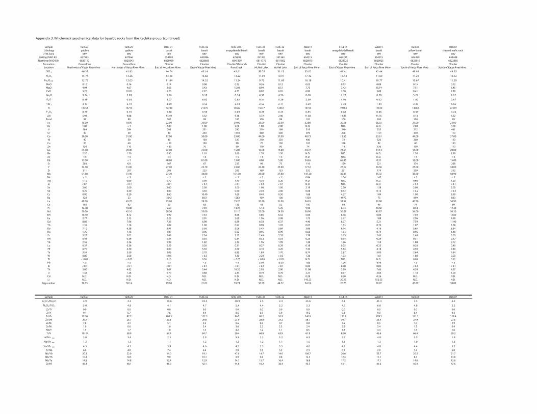
SampleLithology
UTM ZoneEasting (NAD 83)Northing (NAD 83)
FormationLocation
SiO 2
Al2O 3
Fe 2O 3(T)
MnOMgOCaONa 2O
K 2O
TiO 2
TiP 2O 5
LOITotal
ScBeVCrCoNiCuZnGaGeAsRbSrYZrNbMoAgInSnSbCsBaLaCePrNdSmEuGdTbDyHoErTmYbLuHfTaWTlPbBiThU
CdLi
Mg number
SampleAl2O 3/Na2O
Al2O 3/TiO 2
Zr/TiZr/Y
Zr/YbZr/SmZr/NiCr/NiNb/YTi/V
La/Sm mn
Nb/Th mn
Sm/Yb mn
Zr/NbNb/YbNb/ThNb/TaZr/Hf
Appendix 3. Whole-rock geochemical data for basaltic rocks from the Kechika group (continued)and trace element results
16RC27 16RC29 15RC 01 15RC 02 15RC 30.5 15RC 31 15RC 32 48LB14 51LB14 52LB14 16RC05 16RC07gabbro gabbro basalt basalt amygdaloidal basalt basalt basalt basalt amygdaloidal basalt basalt pillow basalt sheared ma�c rock
08V 08V 08V 08V 08V 09V 09V 08V 08V 08V 08V 08V637693 637566 654103 653996 625696 351363 351363 654215 654215 654215 654399 654448
6829110 6829243 6828969 6828683 6845399 6811775 6811802 6828915 6828925 6828925 6823016 6822885Groundhog Groundhog Cloutier Cloutier Cloutier/Magundy Cloutier Cloutier Cloutier Cloutier Cloutier Cloutier Cloutier
Northwest of Ketza River Mine Northwest of Ketza River Mine East of Ketza River Mine East of Ketza River Mine Ram Creek McNeil Lake McNeil Lake East of Ketza River Mine East of Ketza River Mine East of Ketza River Mine South of Ketza River Mine South of Ketza River Mine52.9429.9444.2414.1420.3331.1597.0519.2441.5447.4428.1432.64
21.0192.1106.1144.5124.7179.0110.1122.3128.6183.3162.3167.51
92.1176.0177.0114.0181.6196.1167.942.1123.4148.1130.2127.210.10 0.16 0.14 0.08 0.12 0.26 0.12 0.03 0.13 0.09 0.15 0.124.94 4.67 2.66 3.43 15.01 8.99 8.51 7.75 3.42 15.14 7.51 6.455.26 10.65 6.20 2.27 4.33 8.02 6.65 6.86 7.30 5.89 8.41 7.89
26.122.382.072.286.065.483.443.081.062.190.342.3
76.006.120.040.493.262.043.059.028.670.330.094.0
65.453.249.182.392.311.225.244.255.392.397.231.318758 16714 19748 21270 14622 15077 12661 19724 19664 11630 14082 27319
47.063.064.026.058.032.082.096.095.083.007.097.05.92 9.88 13.49 5.32 9.18 3.72 2.96 11.83 11.45 11.35 4.13 6.2299 99 100 99 100 100 99 101 100 100 100 99
15.00 18.00 22.00 20.00 39.00 25.00 22.00 32.86 20.58 25.92 21.00 23.001.00 < 1 2.00 1.00 2.00 1.00 2.00 N.D. N.D. N.D. 2.00 3.00184 284 293 251 290 219 198 319 240 255 212 46140 30 40 240 1140 460 500 976 208 1101 330 110
30.00 31.00 17.00 30.00 53.00 44.00 37.00 48.73 13.55 53.61 44.00 37.0040 50 40 100 320 210 220 400 72 326 200 12020 40 < 10 100 80 70 100 167 148 92 60 150
130 110 < 30 70 90 110 90 74 14 136 100 11025.00 20.00 22.00 25.00 15.00 16.00 13.00 20.72 23.65 13.14 18.00 20.002.20 1.70 0.90 1.10 1.60 1.70 1.30 N.D. N.D. N.D. 1.50 1.80< 5 < 5 < 5 < 5 < 5 < 5 < 5 N.D. N.D. N.D. < 5 < 5
17.00 < 1 48.00 81.00 13.00 4.00 5.00 34.65 65.86 0.31 18.00 15.00203 421 167 67 237 99 73 116 129 221 174 268
34.10 31.00 27.00 23.70 23.80 24.40 25.90 17.32 27.17 19.36 25.00 38.00311 207 205 223 205 169 153 332 251 174 209 352
51.80 51.90 27.70 34.80 101.00 28.90 27.80 147.20 49.45 85.32 38.60 58.90< 2 < 2 < 2 < 2 < 2 < 2 < 2 0.84 1.54 1.67 < 2 < 2
1.10 0.60 0.70 0.90 1.40 4.30 3.20 N.D. N.D. N.D. 0.60 1.20< 0.1 < 0.1 < 0.1 < 0.1 < 0.1 < 0.1 < 0.1 N.D. N.D. N.D. < 0.1 < 0.12.00 2.00 2.00 2.00 1.00 1.00 1.00 2.19 2.50 1.58 2.00 2.000.20 0.40 3.00 4.50 0.50 2.40 2.00 0.08 0.12 0.15 < 0.2 < 0.20.80 0.20 3.60 10.40 1.60 0.40 0.50 1.68 4.27 1.04 1.00 8.90128 23 3042 3651 1282 109 100 1350 4975 73 899 830
49.00 45.70 25.00 29.20 73.20 20.20 31.00 54.91 33.57 50.90 40.70 36.90103 92 53 63 135 43 52 100 68 96 74 89
12.30 10.80 6.60 7.49 14.20 5.13 5.76 9.90 8.33 10.60 8.54 12.4050.00 42.10 28.30 33.00 51.10 22.00 24.50 36.90 36.09 40.97 34.00 56.3010.40 8.72 6.99 7.53 8.56 5.86 6.32 5.66 8.18 6.86 7.50 12.802.77 2.13 2.25 2.01 2.60 1.96 2.08 1.75 2.77 1.88 2.96 4.188.89 7.96 7.36 6.98 6.89 6.38 6.37 4.46 8.07 5.21 7.59 11.901.31 1.16 1.09 1.00 0.97 0.98 1.03 0.63 1.13 0.76 1.07 1.687.10 6.38 5.91 5.56 5.06 5.45 5.69 3.66 6.14 4.16 5.65 8.341.25 1.16 1.07 0.96 0.92 0.95 0.99 0.66 1.03 0.74 0.96 1.403.27 3.02 2.68 2.34 2.52 2.48 2.52 1.78 2.65 2.03 2.48 3.650.44 0.39 0.34 0.30 0.34 0.32 0.33 0.25 0.34 0.29 0.31 0.472.55 2.36 1.98 1.82 2.12 1.96 1.99 1.38 1.86 1.59 1.88 2.720.37 0.36 0.29 0.26 0.31 0.27 0.29 0.18 0.25 0.25 0.28 0.406.70 4.30 5.00 5.30 4.60 4.10 4.20 7.34 5.84 4.18 4.50 7.403.51 3.50 2.06 2.70 6.85 1.84 1.70 8.74 2.87 5.00 2.64 4.340.80 2.00 < 0.5 < 0.5 1.30 2.20 < 0.5 1.36 1.03 1.61 1.80 0.50
< 0.05 < 0.05 0.16 0.36 < 0.05 < 0.05 < 0.05 N.D. N.D. N.D. 0.09 0.11< 5 < 5 < 5 < 5 < 5 5.00 13.00 1.65 1.26 8.46 < 5 < 5
< 0.1 < 0.1 < 0.1 < 0.1 < 0.1 < 0.1 < 0.1 0.00 0.00 0.02 < 0.1 < 0.15.00 4.92 3.07 3.44 10.20 2.95 2.90 11.98 3.99 7.66 4.59 4.271.32 1.26 0.70 0.68 2.34 0.79 0.76 2.27 0.97 3.64 1.18 1.00N.D. N.D. N.D. N.D. N.D. N.D. N.D. 0.28 0.20 0.26 N.D. N.D.N.D. N.D. N.D. N.D. N.D. N.D. N.D. 145.23 20.13 150.55 N.D. N.D.
30.15 30.14 19.98 21.02 59.74 50.59 44.72 34.74 26.75 60.97 43.89 38.83
16RC27 16RC29 15RC 01 15RC 02 15RC 30.5 15RC 31 15RC 32 48LB14 51LB14 52LB14 16RC05 16RC07
2.65.34.148.66.524.25.29.834.396.013.49.4
2.28.40.67.43.52.54.44.57.41.48.40.50.0 0.0 0.0 0.0 0.0 0.0 0.0 0.0 0.0 0.0 0.0 0.09.1 6.7 7.6 9.4 8.6 6.9 5.9 19.2 9.3 9.0 8.4 9.3
122.0 87.7 103.5 122.5 96.7 86.2 76.9 240.9 135.2 109.5 111.2 129.429.9 23.7 29.3 29.6 23.9 28.8 24.2 58.7 30.7 25.4 27.9 27.57.8 4.1 5.1 2.2 0.6 0.8 0.7 0.8 3.5 0.5 1.0 2.91.0 0.6 1.0 2.4 3.6 2.2 2.3 2.4 2.9 3.4 1.7 0.91.5 1.7 1.0 1.5 4.2 1.2 1.1 8.5 1.8 4.4 1.5 1.6
101.9 58.9 67.4 84.7 50.4 68.8 63.9 61.9 82.0 45.6 66.4 59.39.15.38.47.23.62.32.25.55.23.24.30.3
6.10.13.15.15.11.12.12.12.11.13.12.1
2.54.48.49.46.45.33.35.46.49.31.45.46.0 4.0 7.4 6.4 2.0 5.8 5.5 2.3 5.1 2.0 5.4 6.0
20.3 22.0 14.0 19.1 47.6 14.7 14.0 106.7 26.6 53.7 20.5 21.710.4 10.5 9.0 10.1 9.9 9.8 9.6 12.3 12.4 11.1 8.4 13.814.8 14.8 13.4 12.9 14.7 15.7 16.4 16.8 17.2 17.1 14.6 13.646.4 48.1 41.0 42.1 44.6 41.2 36.4 45.3 43.1 41.6 46.4 47.6
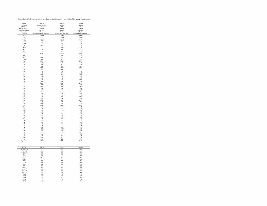
SampleLithology
UTM ZoneEasting (NAD 83)Northing (NAD 83)
FormationLocation
SiO 2
Al2O 3
Fe 2O 3(T)
MnOMgOCaONa 2O
K 2O
TiO 2
TiP 2O 5
LOITotal
ScBeVCrCoNiCuZnGaGeAsRbSrYZrNbMoAgInSnSbCsBaLaCePrNdSmEuGdTbDyHoErTmYbLuHfTaWTlPbBiThU
CdLi
Mg number
SampleAl2O 3/Na2O
Al2O 3/TiO 2
Zr/TiZr/Y
Zr/YbZr/SmZr/NiCr/NiNb/YTi/V
La/Sm mn
Nb/Th mn
Sm/Yb mn
Zr/NbNb/YbNb/ThNb/TaZr/Hf
Appendix 3. Whole-rock geochemical data for basaltic rocks from the Kechika group (continued)and trace element results
16RC12 16RC02 16RC04vesicular basalt sill gabbro gabbro
08V 08V 08V652074 654314 654386
6831774 6823099 6823055Cloutier Cloutier Cloutier
Northeast of Ketza River Mine South of Ketza River Mine South of Ketza River Mine78.9406.3501.83
87.3176.4148.9
87.1197.2186.310.13 0.11 0.178.42 7.20 4.94
13.23 1.65 4.1083.574.371.0
23.030.060.0
86.455.270.318411 15275 28051
05.072.025.011.22 4.42 4.19
98 101 10029.00 26.00 24.001.00 1.00 2.00309 241 312800 240 70
62.00 45.00 37.00240 140 110100 70 100100 140 120
17.00 24.00 22.001.90 1.80 1.40< 5 < 5 < 5
2.00 < 1 22.00549 94 383
23.20 27.50 29.80228 198 230
74.70 15.50 29.20< 2 < 2 < 2
0.60 0.60 0.70< 0.1 < 0.1 < 0.12.00 2.00 2.00< 0.2 < 0.2 < 0.20.50 0.20 12.2073 58 451
61.80 16.90 29.00120 38 60
13.50 4.95 7.5151.40 22.10 32.809.46 6.27 8.552.98 1.85 2.757.54 7.07 8.631.00 1.10 1.235.19 6.26 6.530.85 1.10 1.112.26 2.88 2.790.29 0.39 0.371.65 2.31 2.200.23 0.33 0.315.60 4.70 5.304.96 1.14 2.188.80 0.50 < 0.5
< 0.05 < 0.05 0.15< 5 < 5 < 5
< 0.1 < 0.1 < 0.17.56 4.00 3.791.88 0.94 0.95N.D. N.D. N.D.N.D. N.D. N.D.40.62 38.49 31.79
16RC12 16RC02 16RC04
6.22.49.75
9.28.52.30.0 0.0 0.09.8 7.2 7.7
138.2 85.7 104.524.1 31.6 26.91.0 1.4 2.13.3 1.7 0.63.2 0.6 1.0
59.6 63.4 89.92.27.12.4
9.05.02.1
3.40.34.63.1 12.8 7.9
45.3 6.7 13.39.9 3.9 7.7
15.1 13.6 13.440.7 42.1 43.4
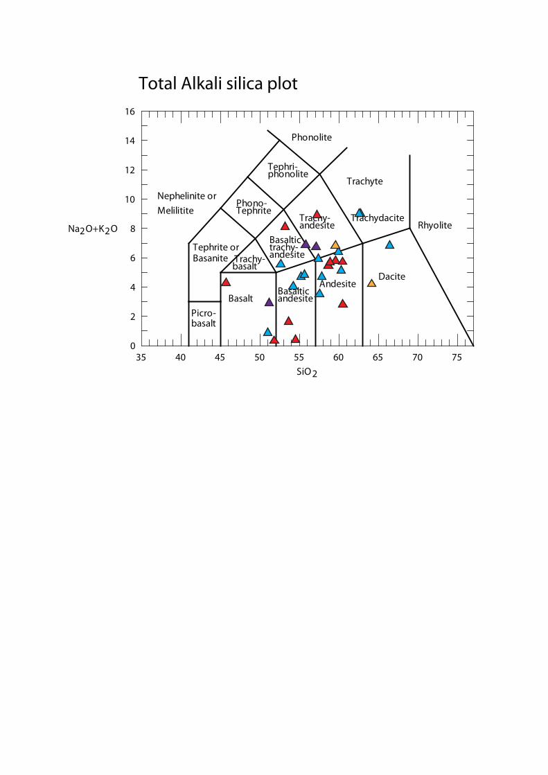
35 40 45 50 55 60 65 70 750
2
4
6
8
10
12
14
16
Na2O+K2O
SiO2
Picro-basalt
BasaltBasalticandesite
AndesiteDacite
Rhyolite
Trachyte
TrachydaciteTrachy-andesite
Basaltictrachy-andesiteTrachy-
basalt
Tephrite orBasanite
Phono-Tephrite
Tephri-phonolite
Phonolite
Nephelinite orMelilitite
Total Alkali silica plot
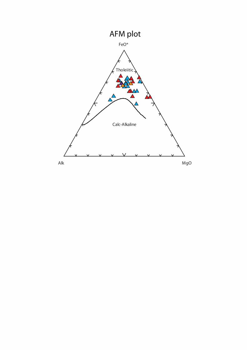
Alk MgO
FeO*
Calc-Alkaline
Tholeiitic
AFM plot

Sample Lithology Formation Age (m.y.) Sm (ppm) Nd (ppm) Lu (ppm) Hf (ppm) 147Sm/144Nd 143Nd/144Nd Uncertainty ±2sm εNdt0 εNdti TDM(Nd) 176Lu/177Hf 176Hf/177Hf Uncertainty ±2sm εHf(t=0) εHf(t) TDM(Hf)
21LB14 basalt Groundhog 480 8.61 44.88 0.40 3.95 0.1160 0.512660 0.000006 0.6 5.5 672 Ma 0.0144 0.282800 0.000004 0.5 6.6 936 Ma
25LB14 basalt Groundhog 480 7.85 40.57 0.36 3.38 0.1170 0.512665 0.000008 0.7 5.5 672 Ma 0.0153 0.282799 0.000003 0.5 6.3 975 Ma
42LB14 pyroxene gabbro Groundhog 488 8.02 46.85 0.30 5.91 0.1034 0.512117 0.000007 -10.0 -4.2 1359 Ma 0.0073 0.282268 0.000004 -18.3 -9.8 1618 Ma
48LB14 basalt Cloutier 480 5.66 36.90 0.18 7.34 0.0928 0.512548 0.000007 -1.6 4.7 685 Ma 0.0034 0.282670 0.000005 -4.1 5.5 841 Ma
51LB14 amygdaloidal basalt Cloutier 480 8.18 36.09 0.25 5.84 0.1369 0.512592 0.000006 -0.7 2.9 1000 Ma 0.0061 0.282619 0.000005 -5.9 2.9 992 Ma
52LB14 basalt Cloutier 480 6.86 40.97 0.25 4.18 0.1012 0.512533 0.000007 -1.9 3.9 758 Ma 0.0087 0.282644 0.000004 -5.0 3.0 1032 Ma
15RC14 gabbro Groundhog 480 12.70 49.30 0.49 8.30 0.1557 0.512553 0.000006 -1.5 1.0 1445 Ma 0.0084 0.282574 0.000005 -7.5 0.6 1145 Ma
24LB15 gabbro Groundhog 473 6.42 35.20 0.27 4.20 0.1102 0.512271 0.000005 -7.0 -1.8 1219 Ma 0.0090 0.282404 0.000005 -13.5 -5.8 1469 Ma
Appendix 4. Nd-Hf isotope results from the Pacific Centre of Isotopic and Geochemical Research, University of British Columbia