Embed Size (px)
Citation preview
Early Roman military fortifications and the origin ofTrieste, ItalyFederico Bernardinia,b,1, Giacomo Vincic, Jana Horvatd, Angelo De Mine, Emanuele Fortee, Stefano Furlanie,Davide Lenaze, Michele Pipane, Wenke Zhaoe, Alessandro Sgambatif, Michele Potlecag, Roberto Michelih,Andrea Fragiacomoi, and Claudio Tuniza,b,j
aMultidisciplinary Laboratory, The “Abdus Salam” International Centre for Theoretical Physics, 34014 Trieste, Italy; bCentro Fermi, Museo Storico della Fisicae Centro di Studi e Ricerche “Enrico Fermi,” 00184 Rome, Italy; cDepartment of History and Protection of Cultural Heritage, University of Udine, 33100Udine, Italy; dInstitute of Archaeology, Research Centre of the Slovenian Academy of Sciences and Arts, 1000 Ljubljana, Slovenia; eDepartment ofMathematics and Geosciences, University of Trieste, 34127 Trieste, Italy; fAgriculture and Forests Inspectorate of Trieste and Gorizia, 34134 Trieste, Italy;gCivil Protection of Friuli Venezia Giulia, 33057 Palmanova, Italy; hSoprintendenza per i Beni Archeologici del Friuli Venezia Giulia, Trieste, 34132 Trieste,Italy; iSociety for the Prehistory and Protohistory of Friuli Venezia Giulia, 34100 Trieste, Italy; and jCentre for Archaeological Science, University ofWollongong, Wollongong, NSW 2522, Australia
Edited by Mike Dobson, University of Exeter, Exeter, United Kingdom, and accepted by the Editorial Board February 17, 2015 (received for review October6, 2014)
An interdisciplinary study of the archaeological landscape of theTrieste area (northeastern Italy), mainly based on airborne lightdetection and ranging (LiDAR), ground penetrating radar (GPR),and archaeological surveys, has led to the discovery of an earlyRoman fortification system, composed of a big central camp (SanRocco) flanked by two minor forts. The most ancient archaeolog-ical findings, including a Greco–Italic amphora rim produced inLatium or Campania, provide a relative chronology for the firstinstallation of the structures between the end of the third centuryB.C. and the first decades of the second century B.C. whereas othermaterials, such as Lamboglia 2 amphorae and a military footwearhobnail (type D of Alesia), indicate that they maintained a strategicrole at least up to the mid first century B.C. According to archaeo-logical data and literary sources, the sites were probably establishedin connection with the Roman conquest of the Istria peninsula in178–177 B.C. They were in use, perhaps not continuously, at leastuntil the foundation of Tergeste, the ancestor of Trieste, in the midfirst century B.C. The San Rocco site, with its exceptional size andimposing fortifications, is the main known Roman evidence of theTrieste area during this phase and could correspond to the locationof the first settlement of Tergeste preceding the colony foundation.This hypothesis would also be supported by literary sources thatdescribe it as a phrourion (Strabo, V, 1, 9, C 215), a term used byancient writers to designate the fortifications of the Roman army.
airborne light detection and ranging | ground penetrating radar |archaeological surveys | early Roman military fortifications |Trieste (Italy) origin
The art of camp building is probably a key element behind thestrength of the Roman army (1) and its gradual expansion in
most Mediterranean regions and Western Europe, where nu-merous modern cities have developed from a Roman militaryfortress (2). Its origin, however, is not clear. The earliest archae-ological traces of military camps are so far provided by Spanishsites dating back to the last two decades of the third century B.C.and the beginning of second century B.C. (3–5). They mainlyconsist of relatively large concentrations of archaeological mate-rial, apparently not associated with any structure, that have beeninterpreted as remains of temporary camps (6, 7). The existence ofcoeval military permanent fortifications at Tarraco (Tarragona)and Emporion (Girona), reported by literary sources, has beenrecently confirmed by archaeological investigations (3–5).However, the most ancient secure and complete examples of
military camps date back to the mid to late second century B.C.(1, 3–5). Among them there are the sites from Numantia and itsarea, related to the Numantine War (154–133 B.C.) (8, 9) andthe Roman military complex of Pedrosillo, dated to the Lusita-nian Wars (155–138 B.C.) (10, 11).
Surprisingly enough, not a single Roman military fortificationhad been discovered in Italy until the recent identification of theMt. Grociana piccola fort in the northeastern part of the pen-insula close to Trieste (12). Further research, mainly based onLiDAR (light detection and ranging) remote sensing, groundpenetrating radar (GPR), and archaeological surveys, has shownthat the Mt. Grociana structures are just part of a Republicanfortification system, which includes two additional sites. Here, wepresent the plan of emerging and buried identified structures,their spatial relationship, and the associated archaeologicalmaterials to define their chronology and historical significance.According to ancient sources, the Latin words used to define the
fortifications of the Roman army are castra (in Greek, stratopedon)and its diminutive castellum (in Greek, phrourion), which have beengenerally translated by British archaeologists as “fortress/camp”and “fort,” respectively (1, 13). Following this conventional ter-minology, we use here the terms “camp” or “fortress” to designatesites larger than 10 ha, and the term “fort” to indicate the smallerfortifications, independently of the building techniques and possi-ble permanent or temporary functions.
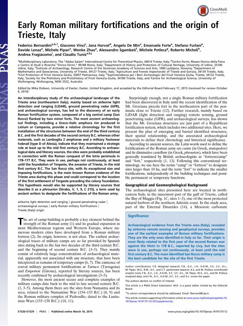
Geographical and Geomorphological BackgroundThe archaeological sites presented here are located in north-eastern Italy, in the innermost part of the gulf of Trieste, calledthe Bay of Muggia (Fig. 1C, sites 1–3), one of the most protectednatural harbors of the northern Adriatic coast. In the study area,part of the External Dinarides (14), a Mesozoic carbonate
Significance
Archaeological evidence from the Trieste area (Italy), revealedby airborne remote sensing and geophysical surveys, providesone of the earliest examples of Roman military fortifications.They are the only ones identified in Italy so far. Their origin ismost likely related to the first year of the second Roman waragainst the Histri in 178 B.C., reported by Livy, but the siteswere in use, perhaps not continuously, at least until the midfirst century B.C. The main identified San Rocco military camp isthe best candidate for the site of the first Trieste.
Author contributions: F.B. designed research; F.B., G.V., J.H., A.D.M., E.F., S.F., D.L.,M. Pipan, W.Z., R.M., A.F., and C.T. performed research; A.S. and M. Potleca contributedanalytic tools; F.B., G.V., J.H., A.D.M., E.F., S.F., D.L., M. Pipan, W.Z., A.S., and M. Potlecaanalyzed data; and F.B., G.V., A.D.M., E.F., S.F., and D.L. wrote the paper.
The authors declare no conflict of interest.
This article is a PNAS Direct Submission. M.D. is a guest editor invited by the EditorialBoard.1To whom correspondence should be addressed. Email: [email protected].
This article contains supporting information online at www.pnas.org/lookup/suppl/doi:10.1073/pnas.1419175112/-/DCSupplemental.
E1520–E1529 | PNAS | Published online March 16, 2015 www.pnas.org/cgi/doi/10.1073/pnas.1419175112
platform, overlays an Eocene turbiditic succession (Flysch ofTrieste) (Fig. 1C) (15).Two of the Roman fortifications, San Rocco and Montedoro,
are located at the top of marly-arenaceous hills divided by theQuaternary alluvial deposits of the Rosandra River (Fig. 1C).This area is part of a fertile semicircular territory delimited onthe north and the east by the steep slope karstic plateau and, onthe south, toward the Istrian peninsula, by the Montedoro ridge,gradually declining from its highest point, the Socerb village, tothe Stramare landing place (16). The San Rocco site is located ina central strategic position, 2 km away from the innermostpresent-day shore of Muggia Bay, and its southeast slope issurrounded by the Rosandra River. The Montedoro fort standson a large terrace of the Montedoro ridge, looking at the Zauleplain just in front of San Rocco hill (Fig. 1C). The Bay of Muggiawas affected by a tectonic down lift of about 1.6 m over the lasttwo millennia (17, 18) and has suffered considerable silting upsince the Roman Age, due to natural sedimentary alluvialprocesses and historic human-made landfills (19). AnotherRoman fortification, preliminarily described by Bernardiniet al. (12), stands on Mt. Grociana piccola, located in the Karstplateau (Fig. 1C), and overlooks both Muggia Bay and the
routes leading from the Trieste gulf to today’s Slovenia andQuarnero gulf (Croatia).
Historical BackgroundThe archaeological and literary sources available for the north-ern Adriatic territory during the second century B.C., corre-sponding to La Tène C2 and La Tène D1a of central Europeanchronology (20–22), do not allow a precise reconstruction of itscomplex cultural features but indicate that it was subject toseveral cultural influences. On the one hand, today’s WesternSlovenia, including part of the Karst, was occupied by Celtictribes (defined as Carni by literary sources) (22–24) belonging tothe Inner Carniolan (Notranjska)/Karst cultural group (25–27).From an archaeological viewpoint, the only remarkable evidenceof Celtic presence in the study area, starting at least from thethird century B.C., has been identified in the necropolis ofSocerb, Slovenia, in use, apparently without interruptions, be-tween the sixth century B.C. and the first century A.D. On theother hand, literary sources report that, at the beginning of thesecond century B.C., the area previously under the Veneticcultural influence (26) was controlled by the Histri (23), whosecentral territory included the entire Istrian peninsula delimitedon the east by the Ra�sa River, Mt. Ucka, and the Ciceria plateau,with the main capital town (Nesactium) located in the south-eastern coast of the peninsula (Fig. 1B).After a first conflict between Rome and the inhabitants of
Istria in 221 B.C., the area became subject to the direct Romaninfluence in the first half of the second century B.C. (24, 27–29).Literary sources report that, in 183 B.C., the Romans forceda Celtic tribe, perhaps the Taurisci (30), settled in 186 B.C. notfar from the future colony of Aquileia, to abandon their oppidumand come back to their territory beyond the Alps (31, 32). Otherclashes are reported between the Romans and the Histri duringthe foundation of Aquileia in 181 B.C. (24, 33), but it was onlya few years later, during 178–177 B.C., that Istria was conqueredand its people definitely subjected. The Roman military activitiescarried out during the first year of the conflict took place in thearea approximately corresponding to today’s province of Trieste,between the Timavo River and the first landing place in Istrianterritory, which could be identified somewhere in Muggia Bay(12, 34, 35). A few years later, in 176 B.C., a garrison of sociinominis Latini was stationed in the Istrian territory to control theindigenous population and prevent possible attacks againstAquileia (23). The area, in fact, continued to be politically un-stable until at least the mid first century. In 171 B.C., the consulG. Cassius Longinus mistreated the Histri, Carni, and Iapodes(24, 31, 32, 36). In 129 B.C., further military expeditions wereundertaken against the Taurisci, Histri, Carni, and Liburni (24,32, 36, 37) and, in 115 B.C., against the Carni (24).The colony of Tergeste was probably founded by Gaius Julius
Caesar during his proconsulship in Gaul (58–50 B.C.), a chro-nology accepted by most authors, or less likely during his dicta-torship (49–44 B.C.) (26). An incursion of Iapodes to Tergeste in52 B.C. (36, 38) might have caused Roman military reactions.
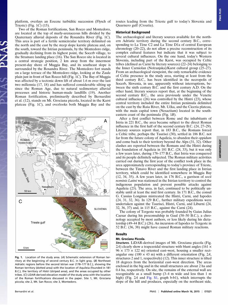
ResultsMt. Grociana Piccola.Structures. LiDAR-derived images of Mt. Grociana piccola (Fig.2A) clearly show a trapezoidal structure with blunt angles (161 ×96 × 173 × 122 m) oriented east–west, housing a smaller rect-angular one (100 × 43 m) with a different orientation (Fig. 2A,structures 2 and 1, respectively) (12). This inner structure is tilted18 degrees from the horizontal east–west direction. The areasenclosed in the big and in the small structures are about 2 ha and0.4 ha, respectively. On site, the remains of the external wall arerecognizable as a small bump (3–4 m wide and less than 1 mhigh) (Fig. 2A and Fig. S1, graph b-b1), which interrupts theslope of the hill and produces, especially on the northeast side,
Fig. 1. Location of the study area. (A) Schematic extension of Roman ter-ritory at the beginning of second century B.C. in light gray. (B) NortheastAdriatic regions before the second Istrian war (178–177 B.C.), showing theRoman territory (dotted area) with the location of Aquileia (founded in 181B.C.), the territory of Histri (striped area), and the areas occupied by othertribes. (C) LiDAR-derived elevation model of the study area with the locationof the Roman fortifications discussed in the paper. Site 1, Mt. Grocianapiccola; site 2, Mt. San Rocco; site 3, Montedoro.
Bernardini et al. PNAS | Published online March 16, 2015 | E1521
ANTH
ROPO
LOGY
PNASPL
US
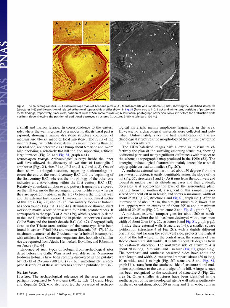
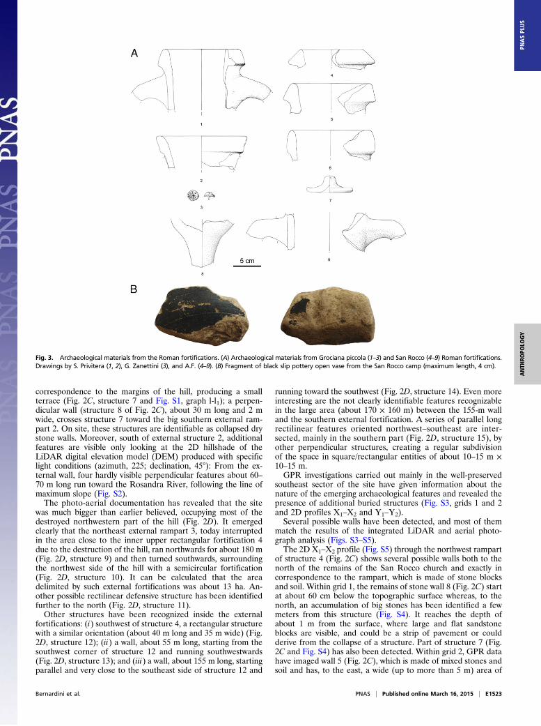
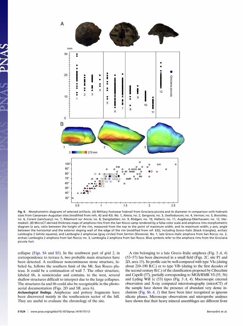
a small and narrow terrace. In correspondence to the easternside, where the wall is crossed by a modern path, its basal part isexposed, showing a simple dry stone structure composed ofmedium size blocks, made of local limestone. The ruins of theinner rectangular fortification, definitely more imposing than theexternal one, are detectable as a bump about 6 m wide and 1–2 mhigh enclosing a relatively flat hill top and supporting artificiallarge terraces (Fig. 2A and Fig. S1, graph a-a1).Archaeological findings. Archaeological surveys inside the innerwall have allowed the discovery of two rims of Lamboglia 2amphorae (Figs. 2A, sites P1 and P 2 and 3 A, 1 and A, 2). One ofthem shows a triangular section, suggesting a chronology be-tween the end of the second century B.C. and the beginning ofthe first century B.C., whereas the morphology of the other oneindicates a relative dating within the first century B.C. (12).Relatively abundant amphorae and pottery fragments are spreadon the hill top inside the rectangular upper fortification whereasthey are apparently absent in the area between the internal walland the external fortification. However, in the southwest sectorof this area (Fig. 2A, site P3) an iron military footwear hobnailhas been found (Figs. 3 A, 3 and 4A). Its underside shows distinctworkshop marks, a sort of cross with four little protuberances. Itcorresponds to the type D of Alesia (39), which is generally datedto the late Republican period and in particular between Caesar’sGallic Wars and the fourth decade B.C. (40–47). Geographicallyclose to the Trieste area, artifacts of the same type have beenfound in eastern Friuli (48) and western Slovenia (45–47). If themaximum diameter of the Grociana piccola hobnail is comparedwith artifacts from Caesarean–Augustan sites, hobnails of similarsize are reported from Alesia, Hermeskeil, Boviolles, and Ribemontsur Ancre (Fig. 4A).Evidence of such types of hobnail from archeological sites
dated before the Gallic Wars is not available so far. Numerousfootwear hobnails have been recently discovered in the putativebattlefield of Baecula (208 B.C.) (7), but, unfortunately, a com-plete description of these artifacts has not been published yet (49).
Mt. San Rocco.Structures. The archaeological relevance of the area was onlypartially recognized by Vattovani (50), Lettich (51), and Flegoand Župancic (52), who also reported the presence of archaeo-
logical materials, mainly amphorae fragments, in the area.However, no archaeological materials were collected and pub-lished. Unfortunately, since the first identification of the ar-chaeological structures, the morphology of the central part of thehill has been altered.The LiDAR-derived images have allowed us to visualize ef-
fectively the plan of the surviving emerging structures, showingadditional parts and many significant differences with respect tothe schematic topographic map produced in the 1990s (52). Theemerging archaeological features are mainly detectable as smalltopographic vertical anomalies (Fig. 2C).A southeast external rampart, tilted about 30 degrees from the
east—west direction, is easily identifiable across the slope of thehill (Fig. 2C, structures 1 and 2). As it runs from the southwest endtoward its middle part, its altitude increases and then graduallydecreases as it approaches the level of the surrounding plain.Starting from the southwest, a segment of this rampart is pre-served for about 60 m in length and shows a maximum width ofabout 25 m (Fig. 2C, structure 1 and Fig. S1, graph e-e1). After aninterruption of about 90 m, the straight structure 2, lower than1 m, appears with an extension of about 255 m and a maximumwidth of 20–25 m (Fig. 2C, structure 2 and Fig. S1, graph f-f1).A northeast external rampart goes for about 260 m north-
westwards to where the hill has been destroyed with a maximumwidth of about 20 m (Fig. 2C, structure 3 and Fig. S1, graph g-g1).Inside these external walls (structures 1–3), a smaller square
fortification (structure 4 of Fig. 2C), with a slightly differentorientation and lacking the southwest side, protects the highestpoint of the hill where, in the central area, the remains of SanRocco church are still visible. It is tilted about 50 degrees fromthe east–west direction. The northwest side of structure 4 isabout 70 m long, 15 m wide, and 1 m high (Fig. S1, graph h-h1).The northeast and southeast preserved sides have about thesame length and width. A transversal rampart, about 180 m long,10 m wide, and 1 m high (Fig. 2C, structure 5 and Fig. S1,graph i-i1), starts from the southeast side of structure 4 and endsin correspondence to the eastern edge of the hill. A large terracehas been recognized to the southwest of structure 5 (Fig. 2C,area 6). Other smaller structures have been identified in thesouthern part of the archaeological site: A wall with a southwest–northeast orientation, about 50 m long and 2 m wide, runs in
Fig. 2. The archeological sites. LiDAR-derived slope maps of Grociana piccola (A), Montedoro (B), and San Rocco (C) sites, showing the identified structures(structures 1–8) and the position of related orthogonal topographic profiles shown in Fig. S1 (from a-a1 to l-l1). Black and white stars, positions of pottery andmetal findings, respectively; black cross, position of ruins of San Rocco church. (D) A 1957 aerial photograph of the San Rocco site before the destruction of itsnorthern slope, showing the position of additional destroyed structures (structures 9–15). (Scale bars: 100 m.)
E1522 | www.pnas.org/cgi/doi/10.1073/pnas.1419175112 Bernardini et al.
correspondence to the margins of the hill, producing a smallterrace (Fig. 2C, structure 7 and Fig. S1, graph l-l1); a perpen-dicular wall (structure 8 of Fig. 2C), about 30 m long and 2 mwide, crosses structure 7 toward the big southern external ram-part 2. On site, these structures are identifiable as collapsed drystone walls. Moreover, south of external structure 2, additionalfeatures are visible only looking at the 2D hillshade of theLiDAR digital elevation model (DEM) produced with specificlight conditions (azimuth, 225; declination, 45°): From the ex-ternal wall, four hardly visible perpendicular features about 60–70 m long run toward the Rosandra River, following the line ofmaximum slope (Fig. S2).The photo-aerial documentation has revealed that the site
was much bigger than earlier believed, occupying most of thedestroyed northwestern part of the hill (Fig. 2D). It emergedclearly that the northeast external rampart 3, today interruptedin the area close to the inner upper rectangular fortification 4due to the destruction of the hill, ran northwards for about 180 m(Fig. 2D, structure 9) and then turned southwards, surroundingthe northwest side of the hill with a semicircular fortification(Fig. 2D, structure 10). It can be calculated that the areadelimited by such external fortifications was about 13 ha. An-other possible rectilinear defensive structure has been identifiedfurther to the north (Fig. 2D, structure 11).Other structures have been recognized inside the external
fortifications: (i) southwest of structure 4, a rectangular structurewith a similar orientation (about 40 m long and 35 m wide) (Fig.2D, structure 12); (ii) a wall, about 55 m long, starting from thesouthwest corner of structure 12 and running southwestwards(Fig. 2D, structure 13); and (iii) a wall, about 155 m long, startingparallel and very close to the southeast side of structure 12 and
running toward the southwest (Fig. 2D, structure 14). Even moreinteresting are the not clearly identifiable features recognizablein the large area (about 170 × 160 m) between the 155-m walland the southern external fortification. A series of parallel longrectilinear features oriented northwest–southeast are inter-sected, mainly in the southern part (Fig. 2D, structure 15), byother perpendicular structures, creating a regular subdivisionof the space in square/rectangular entities of about 10–15 m ×10–15 m.GPR investigations carried out mainly in the well-preserved
southeast sector of the site have given information about thenature of the emerging archaeological features and revealed thepresence of additional buried structures (Fig. S3, grids 1 and 2and 2D profiles X1–X2 and Y1–Y2).Several possible walls have been detected, and most of them
match the results of the integrated LiDAR and aerial photo-graph analysis (Figs. S3–S5).The 2D X1–X2 profile (Fig. S5) through the northwest rampart
of structure 4 (Fig. 2C) shows several possible walls both to thenorth of the remains of the San Rocco church and exactly incorrespondence to the rampart, which is made of stone blocksand soil. Within grid 1, the remains of stone wall 8 (Fig. 2C) startat about 60 cm below the topographic surface whereas, to thenorth, an accumulation of big stones has been identified a fewmeters from this structure (Fig. S4). It reaches the depth ofabout 1 m from the surface, where large and flat sandstoneblocks are visible, and could be a strip of pavement or couldderive from the collapse of a structure. Part of structure 7 (Fig.2C and Fig. S4) has also been detected. Within grid 2, GPR datahave imaged wall 5 (Fig. 2C), which is made of mixed stones andsoil and has, to the east, a wide (up to more than 5 m) area of
Fig. 3. Archaeological materials from the Roman fortifications. (A) Archaeological materials from Grociana piccola (1–3) and San Rocco (4–9) Roman fortifications.Drawings by S. Privitera (1, 2), G. Zanettini (3), and A.F. (4–9). (B) Fragment of black slip pottery open vase from the San Rocco camp (maximum length, 4 cm).
Bernardini et al. PNAS | Published online March 16, 2015 | E1523
ANTH
ROPO
LOGY
PNASPL
US
collapse (Figs. S4 and S5). In the southwest part of grid 2, incorrespondence to terrace 6, two probable main structures havebeen detected. A rectilinear noncontinuous stone structure, la-beled 6a, follows the southern limit of the Mt. San Rocco pla-teau. It could be a continuation of wall 7. The other structure,labeled 6b, is semicircular and contains, to the west, severalshallow structures difficult to interpret due to the large collapses.The structures 6a and 6b could also be recognizable in the photo-aerial documentation (Figs. 2D and 5B, area 6).Archaeological findings. Amphorae and pottery fragments havebeen discovered mainly in the southeastern sector of the hill.They are useful to evaluate the chronology of the site.
A rim belonging to a late Greco–Italic amphora (Fig. 3 A, 4)(53–57) has been discovered in a small field (Figs. 2C, site P1 and2D, area 15). Its profile can be well-compared with type VIa (datingabout 210–190 B.C.) or to type VIb (dating to the first decades ofthe second century B.C.) of the classification proposed by Cibecchiniand Capelli (57), partially corresponding to MGS/RMR VI (55, 56)and Lyding Will 1c (53) types (Fig. 3 A, 4). Macroscopic externalobservation and X-ray computed microtomography (microCT) ofthe sample have shown the presence of abundant very dense in-clusions (Fig. S6 A, 1) that have been later recognized as igneoussilicate phases. Microscope observations and microprobe analyseshave shown that their heavy mineral assemblages are different from
Fig. 4. Morphometric diagrams of selected artifacts. (A) Military footwear hobnail from Grociana piccola and its diameter in comparison with hobnailssizes from Caesarean–Augustan sites (modified from refs. 42 and 43). No. 1, Alesia; no. 2, Gergovia; no. 3, Uxellodunum; no. 4, Vernon; no. 5, Boviolles;no. 6, Corent (sanctuary); no. 7, Ribemont sur Ancre; no. 8, Dangstetten; no. 9, Rödgen; no. 10, Haltern; no. 11, Augsburg-Oberhausen; no. 12, Her-meskeil. (B) MicroCT-derived thickness maps of amphora rims from the San Rocco camp rendered by a false-color scale and amphora rims morphometricdiagram [x axis, ratio between the height of the rim, measured from the top to the point of maximum width, and its maximum width; y axis, anglebetween the horizontal and the exterior sloping wall of the edge of the rim (modified from ref. 63)], including Greco–Italic (black triangles), archaicLamboglia 2 (white squares), and Lamboglia 2 amphorae (gray circles) from Sermin (Slovenia). No. 1, late Greco–Italic amphora from San Rocco; no. 2,archaic Lamboglia 2 amphora from San Rocco; no. 3, Lamboglia 2 amphora from San Rocco. Blue symbols refer to the amphora rims from the Grocianapiccola fort.
E1524 | www.pnas.org/cgi/doi/10.1073/pnas.1419175112 Bernardini et al.
those of local pottery productions, being characteristics of the Ro-man Magmatic Province, including both Latium and Campania,
which are among the main original production centers of thesetransport vessels (57–60).
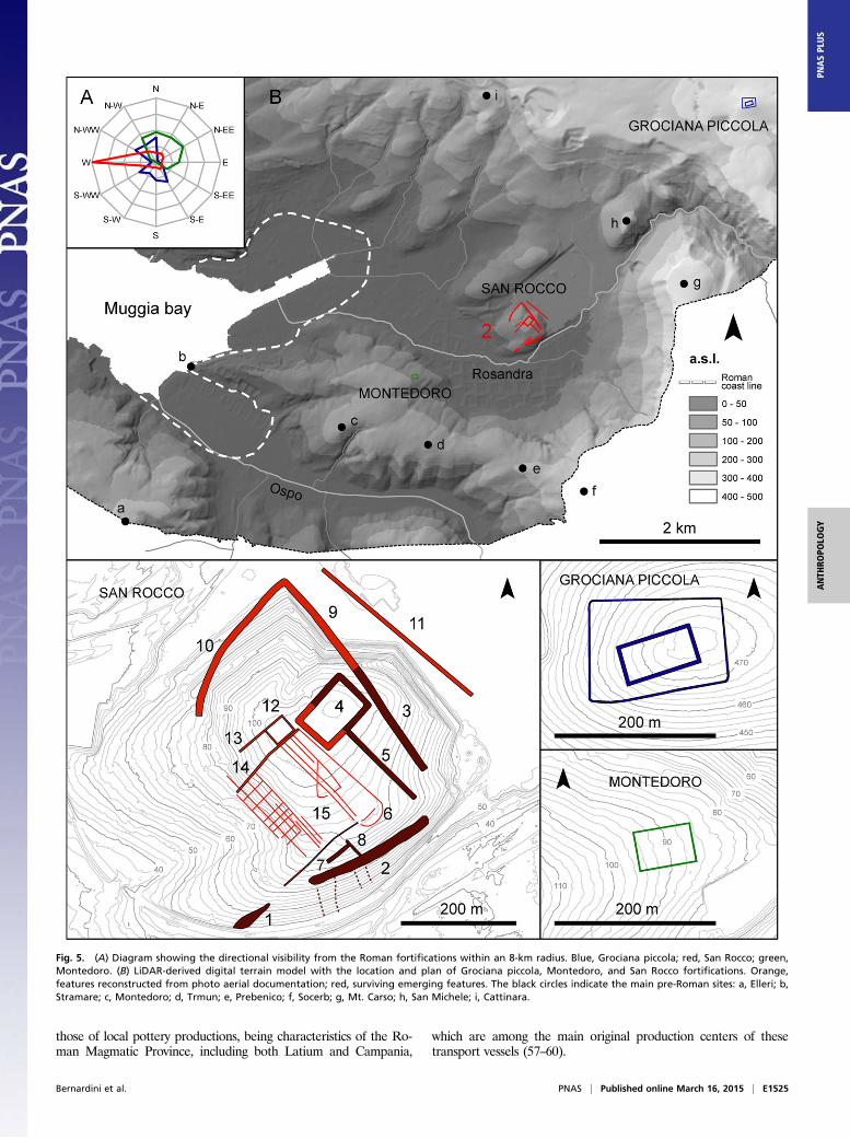
Fig. 5. (A) Diagram showing the directional visibility from the Roman fortifications within an 8-km radius. Blue, Grociana piccola; red, San Rocco; green,Montedoro. (B) LiDAR-derived digital terrain model with the location and plan of Grociana piccola, Montedoro, and San Rocco fortifications. Orange,features reconstructed from photo aerial documentation; red, surviving emerging features. The black circles indicate the main pre-Roman sites: a, Elleri; b,Stramare; c, Montedoro; d, Trmun; e, Prebenico; f, Socerb; g, Mt. Carso; h, San Michele; i, Cattinara.
Bernardini et al. PNAS | Published online March 16, 2015 | E1525
ANTH
ROPO
LOGY
PNASPL
US
Late Greco–Italic amphorae are rather rare in the site of theTrieste gulf (61). Greco–Italic amphorae or later archaic Lam-boglia 2 have been reported from Terzo Ramo del Timavo andVillaggio del Pescatore/Casa Pahor sites (19); a single rim ofa possible late Greco–Italic amphora has been discovered in theindigenous Cattinara hill fort (62) near the Roman fortificationspresented in this paper. On the other hand, abundant remains oflate Greco–Italic amphorae have been found in Sermin, a sitelocated along the Istrian coast north of Koper in Slovenia (63).However, most of the Sermin late Greco–Italic amphorae (64, 65)and probably all of the few dubious other specimens from theTrieste province (according to the macroscopic fabric descriptions)are made from clay that was formed from carbonate marl rocks,indicating an Adriatic production. Only one rim and a few frag-ments from Sermin (63) are macroscopically similar to the SanRocco sample, showing an orange color, rough fabric, and mainlyshiny black inclusions probably corresponding to volcanic minerals.From a typological viewpoint, the late Greco–Italic amphora
rim from San Rocco fits well the morphological features of theoldest amphorae from Sermin (Fig. 4B), which have been datedbetween the end of the third century B.C. and the first threequarters of the second century B.C. (63).In addition to the late Greco–Italic rim, six fragments of vessel
walls with a similar fabric, although richer in black sand, havebeen found close to positions P1 and P2 of Fig. 2C. They couldbe fragments of Greco–Italic amphorae, as suggested by theirconsiderable thickness, ranging from 100 to 150 mm, as well asremains of central Italian kitchenware. This high-quality potteryproduction, particularly suitable for cooking, given its resistance tohigh temperature, was spread across the Mediterranean mainlyduring the second and first centuries B.C., after the Roman ex-pansionism and emigration of the Italic population (66). Close tothe San Rocco site, central Italian kitchenware has been reportedfrom the Mandrga and Preval sites in the strategic Razdrto passarea, dated between the end of the second century B.C. and thebeginning of the first century B.C. (22), as well as in Aquileia (67).An amphora rim, attributable to the archaic Lamboglia 2 type
(Fig. 3 A, 5) and very similar to one of those recovered from theMt. Grociana piccola inner structure (Fig. 3 A, 1), has beendiscovered close to the late Greco–Italic one (Fig. 2C, site P1). Itis typologically comparable with Lamboglia 2 amphorae, witha triangular section from Sermin (63), probably datable betweenthe end of the second century B.C. and the beginning of the firstcentury B.C. (Fig. 4B). Such amphora types are reported fromrelatively numerous sites of northern Adriatic regions (12, 22,61). A last amphora rim, coming from position P2 (Fig. 2C),belongs to a late banded Lamboglia 2 type (Fig. 3 A, 6) and canbe therefore dated within the first century B.C. Lamboglia 2types, in fact, were produced along the Adriatic coast until ap-proximately the third decade B.C. (22).A fragmented amphora lid made on a potter’s wheel, found
near the other amphorae remains (Fig. 2C, site P3), shows anupper bottom with finger impressions, a deep concave underside,and turned-up edges (Fig. 3 A, 7). It is well comparable with typePA 2 from Sermin (63), a shape reported from many sites ofnorthern Italy (67, 68) and also from the Mandrga and Prevalsites near Razdrto Pass in Slovenia (22). It was used to closeboth late Greco–Italic and Lamboglia 2 amphorae types (22,63, 68). In the same area where the late Greco–Italic and archaicLamboglia 2 rims have been discovered, a handle, likely be-longing to the Lamboglia 2 type, also has been found (Fig. 3 A, 9).A base of a probable Lamboglia 2 amphora (Fig. 3 A, 8) has beendiscovered in correspondence to position P5 of Fig. 2C.Finally, a very small fragment of a black slip pottery vessel,
belonging to an open shape (Fig. 3B), has been collected fromarea P4 of Fig. 2C. Unfortunately, its bad state of preservationhinders a precise typological and chronological attribution withinthe Republican period.
Montedoro. A 54 × 74-m rectangular structure with a southwest–northeast orientation has been identified on the northern side ofthe Montedoro ridge (Fig. 2B). The structure orientation is verysimilar to that of the inner rectangular fortification of Mt.Grociana piccola although their building techniques are differ-ent. Montedoro fort is formed by a ditch and a contiguous in-ternal rampart according to the Roman building technique oftenused for military camps (Fig. 2B and Fig. S1, graphs c-c1 andd-d1). Unfortunately, LiDAR data of the area acquired in 2006and 2009 show the partial destruction of the site, whose north-eastern part has been leveled. The entire preserved sector of thesite is covered by grassland, which makes it very difficult toidentify surface findings. Nevertheless, the rectangular shape ofthe structure testifies it was built after the prehistoric period.
Viewshed Analysis and Directional Visibility. Single viewsheds re-sults show intervisibility between the three fortifications. In ad-dition, the analysis of directional visibility within a circular areawith an 8-km radius shows that all of them overlook only alimited percentage of territory. In fact, the nonvisible area cor-responds to 80.3% for Grociana piccola, 86.9% for San Rocco,and 90.8% for Montedoro. Nevertheless, the sites are visuallyinterconnected, thus strongly suggesting that their position infront of northern Istria was accurately chosen. Grociana piccolamainly overlooks part of the Karst plateau north and south of thesite, the southern sector of Muggia Bay up to the Stramarelanding place and the Socerb plateau; the main San Rocco campcontrols the Muggia bay; and the small Montedoro fort domi-nates Muggia Bay and, in particular, the valley of the RosandraRiver at the foot of San Rocco hill (Fig. 5A and Fig. S7).
DiscussionAccording to the imported late Greco–Italic amphorae remains(53–57), the first Roman settlement of the San Rocco site can bedated between the end of the third century B.C. and the firstdecades of the second century B.C. It was probably in use, per-haps not continuously, until the mid to late first century B.C., assuggested by archaic and late Lamboglia 2 amphora types.When comparing the general shape of the San Rocco site and
the building technique of its external ramparts with Spanishmilitary camps dated to the mid to late second century B.C. (3–5), common features can be recognized. Both Spanish camps andSan Rocco do not show a regular plan, they lack any ditch, andtheir defensive structures are built directly on the ground surfacewithout foundations and show a relatively low height. However,the emerging remains of the external ramparts of San Roccohave an exceptional width, between 20 and 25 m. They derivefrom the gradual collapse of the defensive walls, probably madeof turf, soil, and stones, which could be reinforced by woodenelements (69).Only archaeological excavations could give precise information
about the building technique of the ramparts, but it is possiblethat the stones detected by GPR investigations were used to buildthe outer faces of the wall, with the intervening space filled withsmall stones and soil, using a technique very similar to that rec-ognized in the Spanish military camps (5).At Grociana piccola, the few Lamboglia 2 amphora findings
from the inner fortification are comparable with those found inSan Rocco. In addition, the hobnail of type D from Alesiaconfirms the military function played by the site also during themid first century B.C. Although no archaeological artifacts havebeen discovered so far in the Montedoro fort, the spatialinterdependence of the three sites shown by visibility studies andthe similar orientation of the Montedoro site, the San Roccostructures, and the Grociana piccola inner fortification supportsthe hypothesis that at least parts of them were simultaneouslybuilt during the first half of the second century B.C. On the otherhand, the external fortification of Grociana piccola, showing
E1526 | www.pnas.org/cgi/doi/10.1073/pnas.1419175112 Bernardini et al.
a trapezoidal shape with a playing-card layout oriented north tosouth, could belong to a later building phase. This hypothesis issupported by some similarities with the close Roman strongholdat Nadle�ski hrib in western Slovenia, where some hobnails of thesame type have been recently discovered. This site is dated to themiddle or second half of the first century B.C. (70).Although the archaeological materials found so far in the
Trieste sites, exclusively through surface investigations, are notabundant, they give reliable chronological information. The his-torical context, the relative and absolute position of the sites, theirplan and the building techniques, their similarity with coeval Romancamps, and the presence of a military footwear hobnail leave littledoubt of the military origin of the Trieste fortifications. Future ar-chaeological excavations and magnetic surveys may be able to moreprecisely define the first settlement phase of the sites and theirdevelopment through time, perhaps revealing a nonmilitary reuti-lization of the main San Rocco camp.The origin of the fortifications is most likely related to the first
year of the second Roman war against the Histri in 178 B.C.,which, according to literary sources, is the only significant mili-tary episode of the first half of the second century B.C., havingtaken place in the area approximately corresponding to today’sprovince of Trieste (24). According to Livy (XLI, 1, 1–6), theRoman fleet moved to the first landing place at the border of theIstrian territory whereas the two consular legions camped atslightly less than five Roman miles from it. Toward Istria, be-tween the camp and the sea, a military unit was stationed also toprotect the soldiers involved in water supply. Moreover, about3,000 Celtic allies camped at about one Roman mile from themain camp, along the way to Aquileia. The landing place de-scribed by Livy could be identified in Muggia Bay (12, 34, 35).Grociana piccola stands at about five Roman miles from theshore of Muggia Bay, but its size is not consistent with a doublelegionary camp. On the contrary, the San Rocco site fits well thedimension of a large fortification, and its inner regular spacesubdivision recalls the plan of military barracks (Fig. 5) (1, 8, 9).If the San Rocco hill is identified with the main camp reportedby Livy (XLI, 1, 1–6), the location of the Montedoro site,overlooking the access to the Rosandra River at the foot of theSan Rocco hill, could correspond well to the position of the smallmilitary unit described by Livy (XLI, 1, 1) as stationed towardIstria, between the main camp and the sea.The first chronological phase proposed for San Rocco and,
more cautiously, for Grociana piccola and Montedoro predates bysome decades the military camps of the Pedrosillo and Numantiaareas (3–5).Considering that, after the second Roman Istrian war, the
northern Adriatic regions were an unstable border area for morethan 100 y, it is not surprising that the fortifications of Triestearea were in use, perhaps not continuously, at least until the midfirst century B.C. The San Rocco camp is certainly the mostsignificant archaeological site in the Trieste area in this historicphase. It includes an area wider than 13 ha, which was defendedby wide ramparts and strategically located very close to the mostprotected natural harbor of the northern Adriatic (Fig. 5). Se-cure archaeological evidence earlier than the first century B.C.has never been discovered in the historical center of Trieste,which corresponds to the site of the colony of Tergeste (26, 71).Also, for this reason, some scholars have hypothesized that thecolony was founded in a previously uninhabited location whereasthe original site of the first Tergeste would have been locatedsomewhere else, probably in the area in front of Muggia Bay(26). The San Rocco site, built in this area probably in connec-tion with the second Istrian war, is the most probable placewhere, in 176 B.C., a garrison of Latin allies was stationed by theRomans to control the indigenous population and prevent pos-sible attacks against Aquileia (Livy, XLI, 14, 6). Considering itsstrategic position, exceptional size, inner regular planning, and
imposing fortifications, it is very unlikely that it coexisted withanother site of similar importance. Therefore, the San Rocco hillis the most likely candidate for the site of the first Tergeste inaccordance with literary sources, which designate it as phrourion(Strabo, V, 1, 9, C 215), a term used by ancient writers to des-ignate the fortifications of the Roman Army (13).
Materials and MethodsLiDAR Data Acquisition and Elaboration. The LiDAR data covering FriuliVenezia Giulia were acquired by the Helica Company for the Civil Protectionof Friuli Venezia Giulia in 2009, using a airborne laser terrain mapper (ALTM)Optech 3100 mounted onto an AS350 helicopter. This system allows theacquisition of data from a maximum height of 3,000 m above ground levelwith a frequency of 33.000 kHz and a density of 4–5 laser shots per squaremeter. The resulting point-cloud data in LAS format were classified innonground (class 1) and ground points (class 2) through a filtering pro-cedure. The ground data covering the entire study area were processedusing free open-source software (SAGA, GRASS, and QGIS). The LAS fileswere imported into Saga GIS as point clouds, from which the points be-longing to the ground (class 2) were extracted. To merge different grids,a new grid system, covering the entire study area, was created, and the cellset at 50 cm. Then, the data were rasterized and interpolated through themodule available in SAGA software “grid tools, close gaps.” This operationproduces a continuous raster, which is called the digital terrain model (DTM).The DTMs created were then processed through the alternative use of theopen-source software mentioned above to maximize the quality of resultingmaps. These images mainly consist of multiple shaded reliefs at differentlight conditions, slope, and contour maps. Then, all of the raster maps de-riving from the DTMs previously created were digitized and integrated intoa single geographic information system (GIS) platform created in QGIS.
Viewshed Analysis and Directional Visibility. GIS-based visibility analysis wascarried out by calculating multiple viewsheds with the module r.viewshed inGrass GIS from the highest locations of each fortified site, adding 3 m heightfor the observer and 2 m for the target. Each viewshed was performedwithin an 8-km radius to cover the distance between the coast and theGrociana piccola fort, by considering a DEM additional buffer zone of 8 kmto limit the so-called “edge effect” (72, 73). For this purpose, the NASA AsterGDEM2m (1 arc-second grid resolution and an ∼20- to 30-m accuracy) wasused to cover the entire area considered. Additional viewsheds were calcu-lated by using the LiDAR-derived grids to compare results produced by dif-ferent grids. To represent the theoretical visible area from each site accordingto different directions, directional visibility was then calculated by dividing thewhole visible area into 30-degree sectors according to 12 different directions,following the method proposed by Wheatley and Gillings (74).
Historical Aerial Photography. Historical aerial photographs of the study area,taken by the Italian Military Geographical Institute in 1957, were used tocheck the visibility of the emerging archaeological structure and their pos-sible continuation in a destroyed sector of the San Rocco hill (aerial photo-graph IV, 2019). The aerial pictures were georeferenced to precisely overlapthem with the LiDAR-derived images.
GPR Data Acquisition and Processing. The GPR is a high-resolution geophysicaltechnique based on the propagation of electromagnetic (EM) waves withina frequency range usually between 1 MHz and 3 GHz. This method uses thereflections of an EM pulse, which are in turn related to variations in the dielectricproperties of the investigatedmaterials. GPR is increasingly used to image shallowsubsurfaces because it allows obtaining precise, high-resolution information. TheGPR data, after appropriate processing, which usually includes several algorithms,can be adopted for both 2D and 3D subsurface imaging. Application of suchtechnique for archaeological prospecting ranges from preliminary detection ofsubsurface structures to detailed mapping of archaeological levels and high-resolution characterization of buried remains in several different environments.
GPR data were acquired on November 26 and 27, 2013 with a ProEx MalåGeoscience GPR, equipped with 250-MHz shielded antennas, having a con-stant 0.7-m offset. Such antennas gave the best tradeoff between resolutionand penetration depth in the investigated site. A differential global posi-tioning system (DGPS) device was used for measurement (trace) positioningwhereas the GPR triggering was done by an odometer connected to theantennas; the mean trace interval was 0.1 m. Fifty-six GPR profiles wereacquired (22 within grid-1 and 34 within grid-2), with a nominal spacing of1 m and a trace interval of 0.1 m. The total profile length was more than3,250 m, with the length of each profile being different due to logistic
Bernardini et al. PNAS | Published online March 16, 2015 | E1527
ANTH
ROPO
LOGY
PNASPL
US
constraints (bushes, trees). The entire dataset was processed using ProMAXsoftware (Landmark), originally developed for reflection seismic, and Prismmodules, with a processing flow that included the following: DC removal,drift removal (zero time correction), geometrical-spreading correction,exponential-amplitude correction, bandpass filtering, and 2D migration(Kirchhoff). All of the available data were combined into a single pseudo 3Ddataset by using the OpendTect software, giving to each trace its actualspatial location. To better highlight, correlate, and characterize the sub-surface structures, we calculated GPR attributes. The concept of GPR attrib-utes stems from seismic-attribute analysis, a research topic originated in the early1970s for hydrocarbon exploration. Actually, seismic-attribute analysis is rou-tinely adopted, especially in the oil and gas industry (75). Similarities betweenthe kinematic properties of seismic and GPR data have been well-demonstrated,and the main difference regards the scale of applicability and the physicalparameters, such as velocity, frequency, and perturbing field. This formalequivalence suggests that processing and interpretation techniques developedfor seismic data may be applied to GPR data, usually with minor adjustments. Inthe last years the application of attribute analysis for different GPR data in-terpretation has increased, with a continuous implementation of new or opti-mized algorithms (76–78). Examples of applications related to archaeology havealso been reported (79–82).
X-Ray Computed Microtomography. Most of the archaeological pottery ma-terials discovered during the archaeological surveys in the considered siteswere analyzed by X-ray computed microtomography (microCT) to produce3D models and virtual sections, useful for the typological attribution, anda preliminary microtextural characterization (Fig. S6). The analyses werecarried out at the Multidisciplinary Laboratory (MLAB) of the Abdus Salam
International Centre of Theoretical Physics (ICTP), where a cone beammicroCT system has been specifically built to study paleontological and ar-chaeological material (83). It is based on a microfocus X-ray source (mini-mum focal spot size 5 mm, voltage up to 150 kV) and a large area flat-panelsensor. Exploiting the cone-beam geometry, a complete reconstruction ofseveral artifacts with variable isotropic voxel sizes was obtained. ThemicroCT scans were carried out with a source voltage of 145 kV and a currentof 200 μA, recording 2,400 projections of the sample over 360°.
ACKNOWLEDGMENTS. We thank the Comunella Jus-Vicinia Srenja BolliunzComune, in particular D. Stolli and president E. Zobec, and A. Kosmac of thehorse center Monte d’Oro-Dolga Krona for granting access to the San Roccohill and Montedoro sites, respectively. We also thank the Soprintendenzaper i Beni Archeologici del Friuli Venezia Giulia for the authorization to studyand publish the archaeological findings, the Italian Geographic MilitaryInstitute for aerial photographs (Fotografia Aerea dell’Istituto GeograficoMilitare; Autorizzazione n. 6822 in data 27.02.2015), the Civil Protection ofFriuli Venezia Giulia for the LiDAR data, and the Department of Math-ematics and Geosciences of Trieste University for technical and scientificsupport. Many thanks to D. Krizmancic and F. Stener for useful informa-tion concerning the sites, to G. Zanettini and S. Privitera for part of thedrawings of the archaeological material, to C. Zanolli for help during theelaboration of microCT data, to G. Giannini for the suggestions aboutLiDAR data elaboration, and to M. Di Giovannantonio and D. Grilli forthe language review of the paper. We gratefully acknowledge Halliburtonthrough a University of Trieste Landmark academic grant and dGB Earth Sci-ences for providing OpendTect open source software. This work is part of theInternational Centre for Theoretical Physics/Elettra Elemental X-Ray Anal-ysis and Computed Tomography Project funded by Regione Friuli VeneziaGiulia (Italy).
1. Keppie L (1984) The Making of the Roman Army from Republic to Empire (Routledge,London).
2. Watkins TH (1983) Roman legionary fortresses and the cities of modern Europe. MilAff 47(1):15–25.
3. Morillo Cerdán Á (2003) Los establecimientos militares temporales: Conquista y de-fensa del territorio en la Hispania republicana. Defensa y Territorio en Hispania de losEscipiones a Augusto: Espacios Urbanos y Rurales, Municipales y Provinciales, edsMorillo Á, Cadiou F, Hourcade D (Casa de Velázquez, Madrid), pp 41–80.
4. Morillo Á, Aurrecoechea J, eds (2006) The Roman Army in Hispania: An Archaeo-logical Guide (University of León, León, Spain).
5. Morillo Cerdán Á, Adroher Auroux AM (2014) Modelos de arquitectura militar eimplantación territorial de los campamentos republicanos en Hispania. La Gestaciónde los Paisajes Rurales entre la Protohistoria y el Período Romano, eds Mataloto R,Myoral Herrera V, Roque C (Consejo Superior de Investigaciones Cientificas, Mérida,Spain), pp 227–252.
6. Noguera Guillén J (2008) Los inicios de la conquista romana de Iberia: los campa-mentos de campaña del curso inferior del río Ebro. Archivo Español de Arqueología81:31–48.
7. Bellón JP, et al. (2009) Baecula: Análisis arqueológico del escenario de una batalla dela Segunda Guerra Púnica. Limes XX. Estudios Sobre la Frontera Romana, Anejos deGladius 13, eds Morillo A, Hanel NY, Martín Hernández E (Consejo Superior de Inves-tigaciones Científicas, Instituto Histórico Hoffmeyer, Instituto de Historia, Polifemo,Madrid), pp 17–29.
8. Dobson M (1996) The Roman camps at Numantia: A reappraisal in the light ofa critical analysis of Polybius’ discourse on the Roman army. PhD thesis (University ofExeter, Exeter, UK).
9. Dobson M (2008) The Army of the Roman Republic: The Second Century BC, Polybiusand the Camps at Numantia, Spain (Oxbow Books, Oxford).
10. Gorges JG, Morillo Á, Rodríguez Martín G, Martín Hernández E (2009) Le campementromano-républicain du “Pedrosillo” (Casas de Reina, Badajoz, Espagne) à l’épreuvedes sondages: Premiers résultats de la campagne 2006. Limes XX. Estudios Sobre laFrontera Romana, Anejos de Gladius 13, eds Morillo A, Hanel NY, Martín Hernández E(Consejo Superior de Investigaciones Científicas, Instituto Historicité Hoffmeyer, In-stituto de Historia, Polifemo, Madrid), pp 267–280.
11. Morillo Cerdán Á, Rodríguez Martín G, Martín Hernández E, Duran Cabello R (2011)The Roman republican battlefield at Pedrosillo (Casas de Reina, Badajoz, Spain): Newresearch (2007). Conimbriga 50:59–78.
12. Bernardini F, et al. (2013) Airborne LiDAR application to karstic areas: The example ofTrieste province (north-eastern Italy) from prehistoric sites to Roman forts. J ArchaeolSci 40(4):2152–2160.
13. Campbell DB (2009) Roman Auxiliary Forts 27 BC-AD 378 (Osprey, Oxford).14. Placer L (2008) Principles of the neotectonic subdivision of Slovenia. Geologija 51(2):
205–217.15. Regione Autonoma Friuli Venezia Giulia, Servizio Geologico (2008) Carta di Sintesi
Geologica GEO-C.G.T. 1:10000. Fogli 110 Trieste, 131 Caresana. DiSGAM, Universitàdegli Studi di Trieste, Servizio Geologico (R. A. Friuli Venezia Giulia, Trieste, Italy).
16. Betic A, Bernardini F, Montagnari Kokelj M (2008) I castellieri di Trieste tra Carso emare. Terre di Mare: L’Archeologia dei Paesaggi Costieri e le Variazioni Climatiche,eds Auriemma R, Karinja S (Università degli Studi di Trieste, Pomorski muzej - Museodel mare “Sergej Ma�sera” Piran - Pirano, Trieste, Italy), pp 25–37.
17. Antonioli F, et al. (2007) Sea level change during Holocene from Sardinia andNortheastern Adriatic from archaeological and geomorphological data. Quat Sci Rev26(19-21):2463–2486.
18. Furlani S, et al. (2011) Tectonic effects on Late-Holocene sea level changes in the Gulfof Trieste (NE Adriatic Sea, Italy). Quat Int 232(1-2):144–157.
19. Auriemma R, et al. (2008) Terre di mare: Paesaggi costieri dal Timavo alla penisolamuggesana. Terre di Mare: L’Archeologia dei Paesaggi Costieri e le Variazioni Climatiche,eds Auriemma R, Karinja S (Università degli Studi di Trieste, Pomorski muzej - Museodel mare “Sergej Ma�sera” Piran - Pirano, Trieste, Italy), pp 75–211.
20. Gebhardt R (1991) Die Fibeln aus dem Oppidum von Manching, Die Ausgrabungen inManching (Franz Steiner, Stuttgart, Germany).
21. Rieckhoff S (1995) Süddeutschland im Spannungsfeld von Kelten, Germanen undRömern: Studien zur Chronologie der Spätlatènezeit im Südlichen Mitteleuropa(Rheinisches Landesmuseum, Trier, Germany).
22. Horvat J, Bavdek A, eds (2009) Okra: The Gateway Between the Mediterranean andCentral Europe, Opera Instituti Archaeologici Sloveniae 17 (In�stitut za arheologijoZRC SAZU, Zalo�zba ZRC, Ljubljana, Slovenia).
23. Rossi RF (2001) Romani, Preromani, non Romani nel territorio di Tergeste. I Celtinell’Alto Adriatico, ed Cuscito G (Editreg, Trieste, Italy), Antichità Altoadriatiche 48,pp 119–139.
24. Bandelli G (2004) Momenti e forme nella politica illirica della repubblica romana (229-49 a.C.). Dall’Adriatico al Danubio: L’Illirico nell’età Greca e Romana, ed Urso G (Ed-izioni ETS, Pisa, Italy), pp 95–139.
25. Gu�stin M (1979) Notranjska: K Zacetkom Železne dobe na Severnem Jadranu (Zu denAnfängen der Eisenzeit an der nördlichen Adria) (Narodni Muzej, Ljubljana, Slovenia).
26. Càssola Guida P, Càssola F (2002) Tergeste preromana e romana: Nuove consid-erazioni. La Necropoli di San Servolo, ed Vidulli Torlo M (Civici Musei di Storia ed Artedi Trieste, Trieste, Italy), pp 7–16.
27. Horvat J (2002) The hoard of Roman Republican weapons from Grad near �Smihel.Arheolo�ski Vestnik 53:117–192.
28. Horvat J (2008) The beginning of Roman commerce along the main route Aquileia-Emona. Terre di Mare: L’archeologia dei paesaggi costieri e le variazioni climatiche,eds Auriemma R, Karinja S (Università degli Studi di Trieste, Pomorski muzej - Museodel mare “Sergej Ma�sera” Piran - Pirano, Trieste, Italy), pp 444–453.
29. Horvat J (2009) Selected aspects of Romanisation in Western and Central Slovenia.Aspetti e Problemi della Romanizzazione: Venetia, Histria e Arco Alpino Orientale, edCuscito G (Editreg, Trieste, Italy), Antichità Altoadriatiche 68, pp 355–381.
30. Cecovini R (2013) Galli transalpini transgressi in Venetiam: Riepilogo degli studiprecedenti e nuova ipotesi interpretativa. Arheolo�ski Vestnik 64:177–196.
31. Vedaldi Iasbez V (1994) La Venetia Orientale e l’Histria: Le Fonti Letterarie Greche eLatine Fino Alla Caduta dell’Impero Romano d’Occidente (Quasar, Rome).
32. Vedaldi Iasbez V (2001) I Celti in area adriatica nelle fonti letterarie greche e latine. ICelti nell’Alto Adriatico, ed Cuscito G (Editreg, Trieste, Italy), Antichità Altoadriatiche 48,pp 71–86.
33. Bandelli G (2003) Aquileia colonia latina dal senatus consultum del 183 a.C. al supple-mentum del 169 a.C. Aquileia dalle origini alla costituzione del ducato longobardo. Storia-Amministrazione-Società, ed Cuscito G (Editreg, Trieste, Italy), Antichità Altoadriatiche 54,pp 49–78.
34. Marchesetti C (1903) I castellieri preistorici di Trieste e della Regione Giulia. Atti delMuseo Civico di Storia Naturale di Trieste 4:1–206.
E1528 | www.pnas.org/cgi/doi/10.1073/pnas.1419175112 Bernardini et al.
35. Flego S, Rupel L (1993) I Castellieri della Provincia di Trieste (Editoriale StampaTriestina, Trieste, Italy).
36. Zaccaria C (1992) L’arco alpino orientale nell’età romana. Castelraimondo: Scavi 1988-1990. I. Lo scavo, Cataloghi e Monografie Archeologiche dei Civici Musei di Udine 2,ed Santoro Bianchi S (L’Erma di Bretschneider, Rome), pp 75–98.
37. Bandelli G (1989) Contributo all’interpretazione del cosiddetto elogium di C. Sem-pronio Tuditano. Aquileia Repubblicana e Imperiale (Arti Grafiche Friulane, Udine,Italy), Antichità Altoadriatiche 35, pp 111–131.
38. �Sa�sel Kos M (2000) Caesar, Illyricum, and the hinterland of Aquileia. L’Ultimo Cesare,ed Urso G (Centro Ricerche e Documentazione sull’Antichità Classica, Rome), Mono-grafie 20, pp 277–304.
39. Brouquier-Reddé V, Deyber A (2001) Fourniment, harnachement, quincaillerie, objetsdivers. Alesia, fouilles et recherches franco-allemandes sur les travaux militaires romainsautour du Mont-Auxois (1991-1997), eds Reddé M, von Schnurbein S (L’Académie desInscriptions et Belles-Lettres, Paris), pp 293–362.
40. Poux M, et al. (2007) Paire de fibules en or du I er s. av. J.-C.: Autour d’une découvertede l’oppidum de Corent (Puy-de-Dome). Gallia 64:191–225.
41. Poux M (2008) L’empreinte du militaire tardo-republicain dans les facies mobiliers deLa Tene finale. Sur les Traces de Cesar: Militaria Tardo-Republicains en ContexteGaulois, Collection Bibracte 14 (Bibracte, Saint-Leger-sous-Beuvray, France), pp299–432.
42. Martin-Kilcher S (2011) Romer und gentes Alpinae im Konflikt: Archaologische undhistorische Zeugnisse des 1. Jahr hunderts v. Chr. Fines Imperii-Imperium sine Fine?Romische Okkupations und Grenzpolitik im Fruhen Principat, eds Moosbauer G,Wiegels R (Marie Leidorf, Rahden, Westfalen, Germany), pp 27–62.
43. Hornung S (2012) Ein spätrepublikanisches Militärlager bei Hermeskeil (Lkr. Trier-Saarburg): Vorbericht über die Forschungen 2010-2011. Archäol Korrespondenzblatt42:205–224.
44. Ocharan Larrondo JA, Unzueta Portila M (2002) Andagoste (Cuartango, Alava): Unnuevo escenario de las guerras de conquista en el norte de Hispania. ArqueologíaMilitar Romana en Hispania, Anejos de Gladius 5 (Consejo Superior de InvestigacionesCientíficas, Instituto Histórico Hoffmeyer, Instituto de Historia, Polifemo, Madrid), pp311–325.
45. Istenic J (2005) Brooches of Alesia group in Slovenia. Arheolo�ski Vestnik 56:187–212.46. Laharnar B (2009) The Žerovni�scek Iron Age hillfort near Blocice in the Notranjska
region. Arheolo�ski Vestnik 60:97–157.47. Laharnar B (2010) Early roman military equipment from the fortified settlements in the
Notranjska region (sw Slovenia). XVII Roman Military Equipment Conference ZAGREB2010 eds Sanader M, Rendi�c-Miocevi�c A, Toncini�c D, Radman-Livaja I (Arheolo�ski muzej,Zagreb, Croatia), pp 379–392.
48. Tagliaferri A (1991) Cividale Prima di Cesare (Edizioni GEAP, Pordenone, Italy).49. Rodríguez Morales J, Fernández Montoro JL, Sánchez Sánchez J, Benítez De Lugo
Enrich L (2012) Los clavi caligarii o tachuelas de cáliga: Elementos identificadores delas calzadas romanas. Lucentum XXI:147–164.
50. Vattovani M (1976) Ancora del Risano o Formione. Vita Nuova 9:10.51. Lettich G (1979) Appunti per una storia del territorium originario di Tergeste. Ar-
cheografo Triestino XCIII:23–45.52. Flego S, Župancic M (1991) Topografia archeologica del comune di San Dorligo della
Valle (Provincia di Trieste) (Biblioteca Nazionale Slovena e degli Studi e Sezione storia,Trieste, Italy) (Znanstvenoraziskovalni Center Slovenske Akademije Znanosti inUmetnosti e Institut za Arheologijo, Ljubljana, Slovenia).
53. Lyding Will E (1982) Greco-Italic Amphoras. Hesperia LI:338–356.54. Manacorda D (1989) Le anfore dell’Italia repubblicana: aspetti economici e sociali.
Amphores Romaines et Histoire Économique: Dix Ans de Recherche (Ecole Françaisede Rome, Rome), pp 443–467.
55. Vandermersch C (1994) Vins et amphores de Grande Grèce et de Sicile: IV-III s. avantJ.C. (Ecole Française de Rome, Rome).
56. Vandermersch C (2001) Aux sources du vin romain dans le Latium et la Campania àl‘époque médio-républicaine. Ostraka 10:157–206.
57. Cibecchini F, Capelli C (2007) Nuovi dati archeologici e archeometrici sulle anforegrecoitaliche: I relitti di III secolo del Mediterraneo occidentale e la possibilità di unanuova classificazione. Itinéraires des Vins Romains en Gaule IIIe-Ier Siècles Avant J.-C.Confrontation de faciès, ed Olmer F (Monographies d’Archéologie Méditerranéenne,Lattes, France), pp 423–451.
58. Olcese G (2004) Anfore Greco-Italiche antiche: alcune osservazioni sull’origine e sullacircolazione alla luce di recenti ricerche archeologiche ed archeometriche. Archaeo-
logical Methods and Approaches: Industry and Commerce in Ancient Italy, BAR In-ternational Series 1262, eds De Sena E, Dessales, H (British Archaeological Reports,Oxford), pp 173–192.
59. Barone G, Mazzoleni P, Ingoglia C, Vanaria MG (2011) Archaeometric evidences of the4th-2nd century BC amphorae productions in north eastern Sicily. J Archaeol Sci 38(11):3060–3071.
60. Barone G, Belfiore CM, Mazzoleni P, Pezzino A, Viccaro M (2010) A volcanic inclusionsbased approach for provenance studies of archaeological ceramics: Application topottery from southern Italy. J Archaeol Sci 37(4):713–726.
61. Donat P (2009) La ceramica nella Cisalpina nordorientale dalla fondazione di Aquileiaad Augusto. Aspetti e Problemi Della Romanizzazione: Venetia, Histria e Arco AlpinoOrientale, ed Cuscito G (Editreg, Trieste, Italy), Antichità Altoadriatiche 68, pp 109–146.
62. Casari P (2005) Gli scavi di Marchesetti al castelliere di Cattinara: I materiali romani.Carlo Marchesetti e i Castellieri 1903-2003, eds Bandelli G, Montagnari Kokelj E(Editreg, Trieste, Italy), pp 617–625.
63. Horvat J (1997) Sermin: A Prehistoric and Early Roman Settlement in NorthwesternIstria, Opera Instituti Archaeologici Sloveniae 3 (In�stitut za Arheologijo ZRC SAZU,Zalo�zba ZRC, Ljubljana, Slovenia).
64. Županci�c N, Bole M (1997) The chemical and mineralogical analyses of the amphorae.Sermin: A Prehistoric and Early Roman Settlement in Northwestern Istria, OperaInstituti Archaeologici Sloveniae 3, ed Horvat J (In�stitut za Arheologijo ZRC SAZU,Zalo�zba ZRC, Ljubljana, Slovenia), pp 83–100.
65. Župancic N, Horvat J, Bole M (1998) The production of Greco-Italic amphorae in theAdriatic region. Materiali in Geookolje 45(3-4):345–357.
66. Olcese G (2003) Ceramiche Comuni A Roma e in Area Romana: Produzione, Circolazionee Tecnologia, Documenti di Archeologia 28 (SAP Societa Archeologica, Mantova, Italy).
67. Dobreva D (2012) Studio e analisi di alcuni contesti della domus centrale presso i fondiex Cossar. L’Architettura Privata ad Aquileia in Età Romana, Antenor Quaderni 24, edsBonetto J, Salvadori M (Padova Univ Press, Padua, Italy), pp 369–405.
68. Zulini E (2007) Coperchi e Tappi d’Anfora. Trieste Antica. Lo Scavo di Crosada. I Ma-teriali II, eds Morselli C, Auriemma R, Maggi P (Trieste, Italy), pp 171–172.
69. Johnson A (1987) Römische Kastelle des 1. und 2. Jahrhunderts n. Chr. in Britannienund in den Germanischen Provinzen des Römerreiches (Philipp Von Zabern, Mainz amRhein, Germany).
70. Laharnar B (2013) The Roman stronghold at Nadle�ski hrib, Notranjska region.Arheolo�ski Vestnik 64:123–147.
71. Morselli C, ed (2007) Trieste Antica. Lo Scavo di Crosada. Fonti e Studi per la StoriaDella Venezia Giulia (Editreg, Trieste, Italy).
72. Lake M, Woodman P, Mithen S (1998) Tailoring GIS software for ArchaeologicalApplication: An example concerning viewshed analysis. J Archaeol Sci 25:27–38.
73. Conolly J, Lake M (2006) Geographical Information Systems in Archaeology (Cam-bridge Univ Press, Cambridge, UK).
74. Wheatley DW, Gillings M (2000) Visual perception and GIS: Developing enrichedapproaches to the study of archaeological visibility. Beyond the Map: Archaeologyand Spatial Technologies, ed Lock G (IOS Press, Amsterdam), pp 1–27.
75. Chopra S, Marfurt KJ (2007) Seismic Attributes for Prospect Identification and Res-ervoir Characterization (Society of Exploration Geophysicists, Tulsa, OK).
76. McClymont AF, et al. (2008) Visualization of active faults using geometric attributesof 3D GPR data: An example from the Alpine Fault Zone, New Zealand. Geophysics73(2):B11–B23.
77. Bradford JH, Dickins DF, Brandvik PJ (2010) Assessing the potential to detect oil spillsin and under snow using airborne ground-penetrating radar. Geophysics 75(2):G1–G12.
78. Forte E, Pipan M, Casabianca D, Di Cuia R, Riva A (2012) Imaging and characterizationof a carbonate hydrocarbon reservoir analogue using GPR attributes. J Appl Geophys81(Special Issue):76–87.
79. Böniger U, Tronicke J (2010) Improving the interpretability of 3D GPR data usingtarget-specific attributes: Application to tomb detection. J Archaeol Sci 37(2):672–679.
80. Zhao WK, Tian G, Wang BB, Shi ZJ, Lin JX (2012) Application of 3D GPR attributetechnology in archaeological investigations. Appl Geophys 9(3):261–269.
81. Zhao WK, Forte E, Pipan M, Tian G (2013) Ground penetrating radar (GPR) attributeanalysis for archaeological prospection. J Appl Geophys 97:107–117.
82. Zhao WK, et al. (2013) 2-D and 3-D imaging of a buried prehistoric canoe using GPRattributes: A case study. Near Surface Geophys 11(4):359–366.
83. Tuniz C, et al. (2013) The ICTP-Elettra X-ray laboratory for cultural heritage andarchaeology. Nucl Instrum Methods Phys Res A 711:106–110.
Bernardini et al. PNAS | Published online March 16, 2015 | E1529
ANTH
ROPO
LOGY
PNASPL
US