Embed Size (px)
Citation preview
Earth Environmental & Geotechnical Ltd
Ashbourne House
334 Wellington Road North
Stockport, Cheshire, SK4 5DA
Tel : 0161 2824518
Email [email protected]
www.earthenvironmental.co.uk
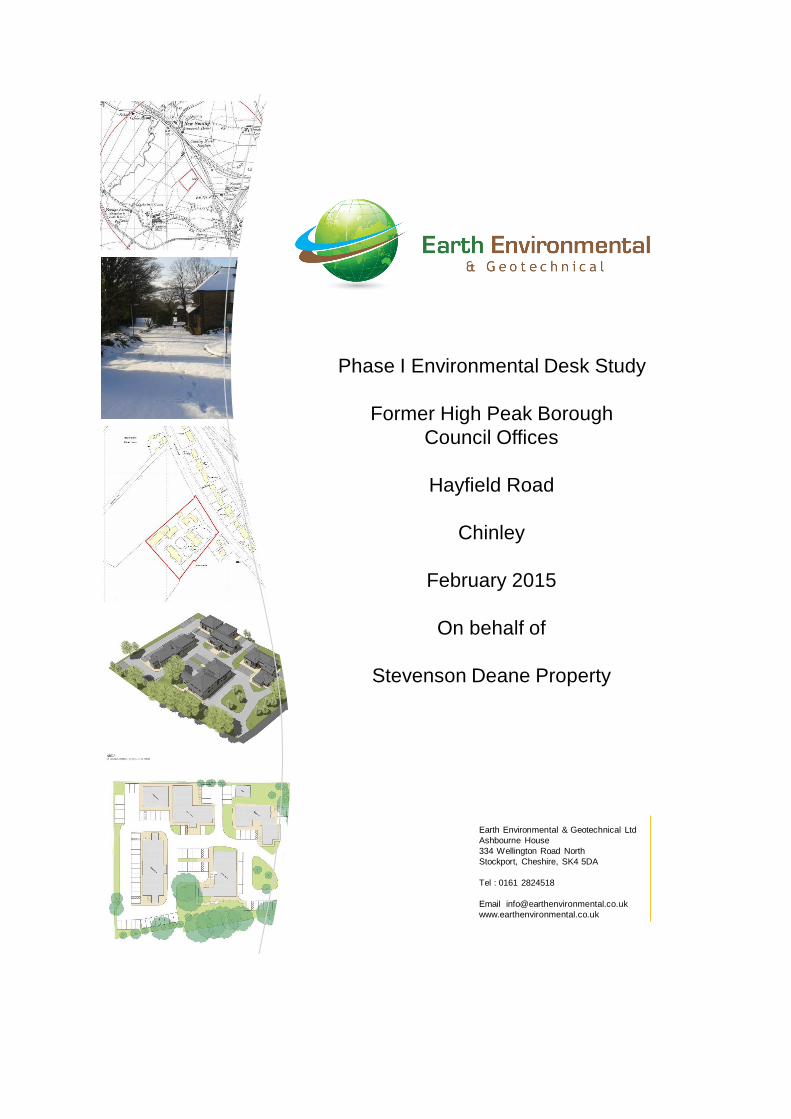
Phase I Environmental Desk Study
Former High Peak Borough
Council Offices
Hayfield Road
Chinley
February 2015
On behalf of
Stevenson Deane Property
FORMER HIGH PEAK BOROUGH COUNCIL OFFICES
HAYFIELD ROAD
CHINLEY
PHASE I ENVIRONMENTAL DESK STUDY
FOR
STEVENSON DEANE PROPERTY CO LTD.
Earth Environmental & Geotechnical Ltd 334 Wellington Road North Stockport Cheshire SK4 5DA Tel 0161 2824518 Report No. A0728/15 February 2015

Earth Environmental & Geotechnical i Former High Peak Borough Council Offices Report No. A0728/15 February 2015
Report Title: Former High Peak Borough Council Offices, Hayfield Road, Chinley, SK23 0SG
Phase I Environmental Desk Study
Report Reference: A0728/15
Client: Stevenson Deane Property Co Ltd
Issue Date: February 2015
Drafted By: J Carrick
Reviewed By: A Czarnecki
Authorised By: A Czarnecki
This document has been prepared for the titled project (or named part thereof) and should not be relied upon or used for any other project without an independent check being carried out as to its suitability and prior written authorisation being obtained from Earth Environmental & Geotechnical. Earth Environmental & Geotechnical accepts no responsibility or liability for the consequences of the use of this document, wholly or in part, for any other purpose than that for which it was commissioned. Any persons so using or relying upon this document for such other purpose do so at their own risk. This report was prepared for the sole use of the Client and shall not be relied upon or transferred to any other party without the express written authorisation of Earth Environmental & Geotechnical. It may contain material subject to copyright or obtained subject to license; unauthorised copying of this report will be in breach of copyright/license. The findings and opinions provided in this document are given in good faith and are subject to the limitations imposed by employing site assessment methods and techniques, appropriate to the time of investigation and within the limitations and constraints defined within this document. The findings and opinions are relevant to the dates when the assessment was undertaken, but should not necessarily be relied upon to represent conditions at a substantially later date. The findings and opinions conveyed in this report are based on information obtained from a variety of sources as detailed and which Earth Environmental & Geotechnical assumes to be reliable, but have not been independently confirmed. Therefore Earth Environmental & Geotechnical cannot and does not guarantee the authenticity or reliability of third party information it has relied upon. Where opinions expressed in this report are based on current available guidelines and legislation, no liability can be accepted by Earth Environmental & Geotechnical for the effects of any future changes to such guidelines and legislation. The limitations of liability of Earth Environmental & Geotechnical for the contents of this document have been agreed with the Client, as set out in the terms and conditions of offer and related contract documentation.
Earth Environmental & Geotechnical ii Former High Peak Borough Council Offices Report No. A0728/15 February 2015
CONTENTS 1.0 INTRODUCTION ........................................................................................................................ 1
Appointment ............................................................................................................................... 1 Proposed Development .............................................................................................................. 1 Objective .................................................................................................................................... 2
Scope ......................................................................................................................................... 2 2.0 SITE LOCATION AND DESCRIPTION...................................................................................... 3
Site Location .............................................................................................................................. 3
Site Description .......................................................................................................................... 4 Site Utility Services ..................................................................................................................... 4
3.0 ENVIRONMENTAL SETTING .................................................................................................... 5
Geology and Mining ................................................................................................................... 5 Radon Potential .......................................................................................................................... 5 Hydrogeology and Hydrology ..................................................................................................... 5 Landfill and Waste Management Activity .................................................................................... 6
Industrial Land Use Information.................................................................................................. 6 Environmental Permits, Incidents and Registers ........................................................................ 6 Environmentally Sensitive Sites ................................................................................................. 7 Archaeology ............................................................................................................................... 7
Potential Flood Risks .................................................................................................................. 7 Previous Site Investigations ....................................................................................................... 7
4.0 SITE HISTORY .......................................................................................................................... 8
5.0 PRELIMINARY CONTAMINATION RISK ASSESSMENT ...................................................... 10
Introduction .............................................................................................................................. 10 Preliminary Conceptual Model.................................................................................................. 10 Preliminary Risk Assessment ................................................................................................... 12
6.0 SUMMARY OF CONCLUSIONS AND RECOMMENDATIONS .............................................. 13
General .................................................................................................................................... 13
Recommendations ................................................................................................................... 13
APPENDICES Appendix 1 GroundSure Reports Appendix 2 Site Photographs Appendix 3 Site Walkover Notes Appendix 4 Limitations
FIGURES Figure 1 Development Layout Plan Figure 2 Site Location Plan Figure 3 Ordnance Survey 1897 Plan Extract Figure 4 Ordnance Survey 1924 Plan Extract Figure 5 Ordnance Survey 1978 Plan Extract
Earth Environmental & Geotechnical 1 Former High Peak Borough Council Offices Report No. A0728/15 February 2015
1.0 INTRODUCTION Appointment
1.1 Earth Environmental & Geotechnical was commissioned by Stevenson Deane Property Co Ltd (the client) to undertake a Phase I Environmental Desk Study at the former High Peak Borough Council Offices, Chinley.
Proposed Development
1.2 It is understood that Stevenson Deane Property Co Ltd has obtained planning permission from High Peak Borough Council to convert the former council offices to commercial use (planning reference: HPK/2014/0486). The proposed development composes refurbishing and extending existing office buildings, removal of temporary offices, creation of additional car parking areas and peripheral landscaped areas.
1.3 A preliminary environmental risk assessment (Phase I Environmental Desk Study) is required to support an application to discharge pre commencement planning conditions.
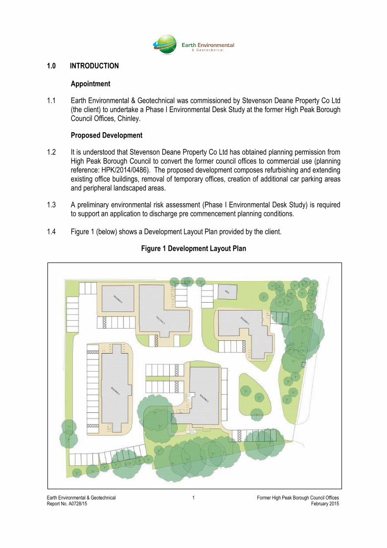
1.4 Figure 1 (below) shows a Development Layout Plan provided by the client.
Figure 1 Development Layout Plan
Earth Environmental & Geotechnical 2 Former High Peak Borough Council Offices Report No. A0728/15 February 2015
Objective
1.5 The purpose of the Desk Study is to collate available geological and environmental data for the site (and its environment) in order to provide a preliminary geotechnical and geo-environmental appraisal, together with a site specific conceptual model. This enables a preliminary assessment of geo-environmental risks to be undertaken and also provides information for the design of a Phase 2 Ground Investigation in accordance with the Environment Agency (2004) Model Procedures for the Management of Land Contamination, CLR11. Scope
1.6 The Phase I Environmental Desk Study comprises of a site reconnaissance visit and a review of the following information sources, some of which were provided by the client:
British Geological Survey online maps.
British Geological Survey Sheet 99, Chapel en le Frith, Solid & Drift Edition.
Google Earth imagery.
Environment Agency online mapping data.
Historical Ordnance Survey maps as provided by GroundSure (Appendix 1).
The site and surrounding areas environmental compliance history from data presented in the site specific GroundSure Report (Appendix 1).
Earth Environmental & Geotechnical 3 Former High Peak Borough Council Offices Report No. A0728/15 February 2015
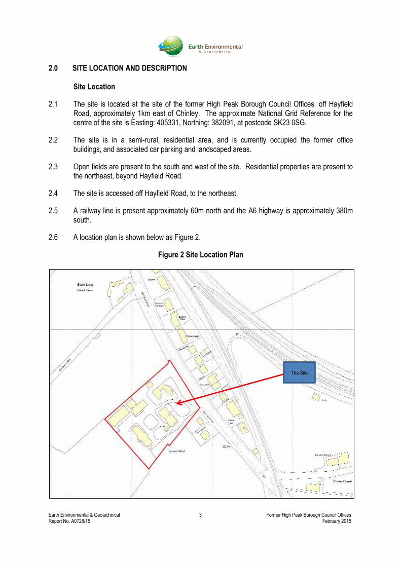
2.0 SITE LOCATION AND DESCRIPTION Site Location
2.1 The site is located at the site of the former High Peak Borough Council Offices, off Hayfield Road, approximately 1km east of Chinley. The approximate National Grid Reference for the centre of the site is Easting: 405331, Northing: 382091, at postcode SK23 0SG.
2.2 The site is in a semi-rural, residential area, and is currently occupied the former office buildings, and associated car parking and landscaped areas.
2.3 Open fields are present to the south and west of the site. Residential properties are present to the northeast, beyond Hayfield Road.
2.4 The site is accessed off Hayfield Road, to the northeast.
2.5 A railway line is present approximately 60m north and the A6 highway is approximately 380m south.
2.6 A location plan is shown below as Figure 2.
Figure 2 Site Location Plan
The Site
Earth Environmental & Geotechnical 4 Former High Peak Borough Council Offices Report No. A0728/15 February 2015
Site Description
2.7 The site was visited on the 4 February 2015 by Adam Czarnecki, Director, Earth Environmental & Geotechnical Ltd. There was a shallow covering of snow across the site during the site visit.
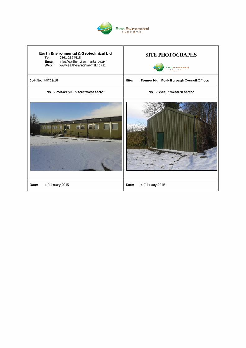
2.8 Appendix 2 provides site photographs taken during the walkover survey and Appendix 3 provides site walkover notes.
2.9 The site visit confirms the site is currently occupied by former council office buildings that are currently vacant, comprising 4no. stone buildings with slate roofs across the site and a portacabin in the southwest sector (see photograph nos 1 to 5 in Appendix 2). Basements are present in some of the buildings.
2.10 Access to the buildings was not available during the site visit.
2.11 A corrugated metal shed is present on the western boundary, to the rear of one of the stone buildings. Access to the shed was not available during the site visit, but it was probably used for storage (see photograph no. 6).
2.12 Hardcover is present across the majority of the site, associated with the former office land use, comprising building footprints, car parking and footpaths. Peripheral ‘soft’ landscaping areas are present in the northeast sector (see photograph no. 4).
2.13 The site is accessed via a locked metal gate from Hayfield Road to the north.
2.14 The ground level on the site slopes from the site entrance to the south west with an overall fall of approximately 3m to 4m (see photograph no. 4).
2.15 The site is located in a predominately semi-rural, residential setting. Neighbouring residential properties are present to the northeast and open fields to the south and west of the site.
2.16 No evidence of fuel tanks or invasive weeds was observed during the site visit.
2.17 The site boundaries are currently delineated stone walls, with mature trees present around the perimeter.
2.18 The total site occupies an area of approx. 0.78hectares (source GroundSure report).
Site Utility Services
2.19 A site service plan has been not provided by the client. The status of all services should be
checked with the statutory providers prior to any development (including site investigation)
commencing.
Earth Environmental & Geotechnical 5 Former High Peak Borough Council Offices Report No. A0728/15 February 2015
3.0 ENVIRONMENTAL SETTING Geology and Mining
3.1 The geology of the site is covered by British Geological Survey online data and the site specific GroundSure GeoInsight report (Appendix 1).
3.2 The Groundsure Report indicates that the site is not underlain by artificial/made ground.
3.3 The majority of the site is shown to be underlain by Glacial Till, of variable permeability.
3.4 According to the GroundSure GeoInsight report and British Geological Survey, superficial deposits are underlain by the Kinderscout Grit, of variable permeability.
3.5 Geological faults are identified 427m and 455m southwest of the site.
3.6 According to the Groundsure report, an area that may be affected by coal mining is present, approximately 908m north of the site. The site is within an area that may be affected by small scale vein mineral mining, although this is highly unlikely.
3.7 Historical ground workings associated with railway cuttings are identified 40m northeast, and associated with ponds 162m southwest of the site.
3.8 There are 2no. shallow (<1m depth) boreholes approximately 230m and 234m southwest of the site; no associated online records are available.
3.9 No natural cavities are identified in the vicinity of the site.
Radon Potential
3.10 The property is not in a Radon Affected Area as defined by the Health Protection Agency as less than 1% of properties are above the Action Level of exposure.
3.11 No radon protection measures are necessary for new properties (or extension to existing ones) as described in publication BR211 by the Building Research Establishment.
Hydrogeology and Hydrology
3.12 The superficial Glacial Till underlying the site is classified by the Environment Agency as an “Unproductive Aquifer”: rock layers or drift deposits with low permeability that have negligible significance for water supply or river base flow”.
3.13 The underlying Kinderscout Grit is classified by the Environment Agency as a “Secondary A Aquifer”: permeable layers capable of supporting water supplies at a local rather than strategic scale, and in some cases forming an important source of base flow to rivers.
3.14 There are 8no. groundwater abstraction licences within 1km of the site; all located 488m west at a forge for boiler feed and process water.
Earth Environmental & Geotechnical 6 Former High Peak Borough Council Offices Report No. A0728/15 February 2015
3.15 There are 10no. surface water abstraction licences within 1km of the site. The closest are 3no. licences located 429m west for boiler feed and process water.
3.16 There are no potable water abstraction licences within 1km and the site is not within 500m of a groundwater source protection zone.
3.17 There are 36no. detailed River Network records within 500m of the site; the closest is a drain 155m south of the site. Black Brook River is located 189m south of the site.
Landfill and Waste Management Activity
3.18 There are 2no. historical landfill sites are located within 1km of the site; the closest is an inert landfill 447m west of the site at Forge Bleach Works.
3.19 There are 2no. local authority landfill sites within 1km of the site; both are historical refuse tips 453m and 466m west of the site.
3.20 There are no operational or non-operational Waste Treatment, Transfer and Disposal sites identified within 500m of the site.
3.21 There is 1no. Environment Agency licensed waste site within 1km of the site, located 963m southeast.
Industrial Land Use Information
3.22 There are 2no. industrial sites identified within 250m of the site; a tank 154m east and a chimney 201m southwest.
3.23 There is 1no. Petrol Fuel Site identified within 500m of the site; Crown Garage on Hayfield Road, 401m northwest, which is now obsolete.
3.24 There is 1no. Underground High Pressure Oil and Gas pipeline recorded within 500m of the site boundary, located 401m northwest.
Environmental Permits, Incidents and Registers
3.25 There are no records of historical IPC Authorisations, Part A (1) and IPPC Authorised Activities, Water Industry Referrals, Red List Discharge Consents, Category 3 or 4 Radioactive Substance Authorisations (RAS), Planning Hazardous Substance Consents and Enforcements, Part A(2) and Part B Activities and Enforcements, or List 1 or 2 Dangerous Substances Inventory Sites identified within 500m of the site.
3.26 There are 24no. licenced discharge consents recorded within 500m of the site boundary; the closest are 4no. consents located 385m southeast of the site for miscellaneous and sewage discharges to Black Brook.
3.27 There are no Environment Agency Recorded Pollution Incidents within 500m of the site.
3.28 There are no sites within 500m of the site determined as contaminated land under Section 78R of the Environmental Protection Act 1990.
Earth Environmental & Geotechnical 7 Former High Peak Borough Council Offices Report No. A0728/15 February 2015
Environmentally Sensitive Sites
3.29 The site is within the Green belt.
3.30 The Peak District National Park boundary is located 442m east of the site.
3.31 There are no other designated, environmentally sensitive sites within 1km of the site.
3.32 It should be noted that an ecological assessment of the site falls outside the brief of this report and that an ecological specialist should be consulted in this regard.
3.33 During the walkover survey invasive plants were not noted, although it should be recognised that the site survey was conducted in winter with a covering of snow.
Archaeology
3.34 An archaeological assessment falls outside the brief of this report. Where considered necessary, advice should be sought from an archaeological specialist in this respect.
Potential Flood Risks
3.35 Detailed assessment of flood risk is outside the scope of this report. However, reference to Environment Agency records indicates that the site is not located within a Zone 2 (1 in 1000 year storm) and Zone 3 (1 in 100 year storm) floodplain.
3.36 The site is indicated on British Geological Survey records to have a potential susceptibility to groundwater flooding in the superficial deposits, based on the underlying geological conditions.
3.37 The British Geological Survey confidence of the rating is deemed as low.
Previous Site Investigations
3.38 We are not aware of any records of previous site investigations.

Earth Environmental & Geotechnical 8 Former High Peak Borough Council Offices Report No. A0728/15 February 2015
4.0 SITE HISTORY
4.1 The historical development of the site has been determined by reference to site specific historical plans provided by GroundSure and Google Earth imagery. The historical plans which have been reviewed comprise only readily available records and may be limited; however, the information available to date indicates that additional searches are unlikely to add to our understanding of the site.
4.2 The earliest available historical mapping covering the site dates back to 1879. Historical plans from 1879 to 1880 shows the site is within open fields. A railway is located 60m northeast, a paper staining mill 210m southwest and a forge mill 590m west.
4.3 By 1897 to 1898 the paper staining mill to the southwest is shown as a wadding mill. A smithy is shown approximately 260m north and a sewage farm is shown 360m southwest. Figure 3, below, provides an extract from 1897 mapping.
Figure 3 Ordnance Survey 1897 Plan
4.4 Historical mapping from 1921 to 1924 shows an isolation hospital has been developed on the site. A small pox hospital has been constructed 70m south of the site. Figure 4, overleaf, provides an extract from 1924 mapping.
Site
Earth Environmental & Geotechnical 9 Former High Peak Borough Council Offices Report No. A0728/15 February 2015
Figure 4 Ordnance Survey 1924 Plan
4.5 By 1938 residential houses have been construction beyond Hayfield Road, to the northeast.
4.6 By 1970 the buildings previously identified as an isolation hospital on the site are identified as council offices. The smallpox hospital to the south west is no longer shown, indicating demolition activities in the vicinity.
4.7 By 1978, ground works associated with the construction of the A6 highway is shown approximately 380m south.
4.8 Figure 5, below, provides an extract from 1978 mapping.
Figure 5 Ordnance Survey 1978 Plan
4.9 Historical mapping between 1984 and 2014 show no significant changes.
Site
Site
Earth Environmental & Geotechnical 10 Former High Peak Borough Council Offices Report No. A0728/15 February 2015
5.0 PRELIMINARY CONTAMINATION RISK ASSESSMENT
Introduction
5.1 The following paragraphs outline a Preliminary Risk Assessment (PRA) for the site as defined by DEFRA and the EA Model Procedures for the Management of Land Contamination, CLR11 (2004).
5.2 The table in Paragraph 5.4 provides a Preliminary Conceptual Model (PCM) which defines the site in terms of a potential pollution linkage, that is, whether a pathway exists between a contamination source and a sensitive environmental receptor (Source-Pathway-Receptor relationship).
5.3 The table considers whether a pollution linkage is potentially present or not and provides a preliminary qualitative assessment of risk based on the information currently available. Where a possible linkage is identified, it does not necessarily mean that a significant risk exists, but indicates that further information is required through appropriate site investigation to substantiate the conceptual model.
Preliminary Conceptual Model
5.4 The PCM/PRA is based on the planned development proposal that the site be prepared for a commercial end use.
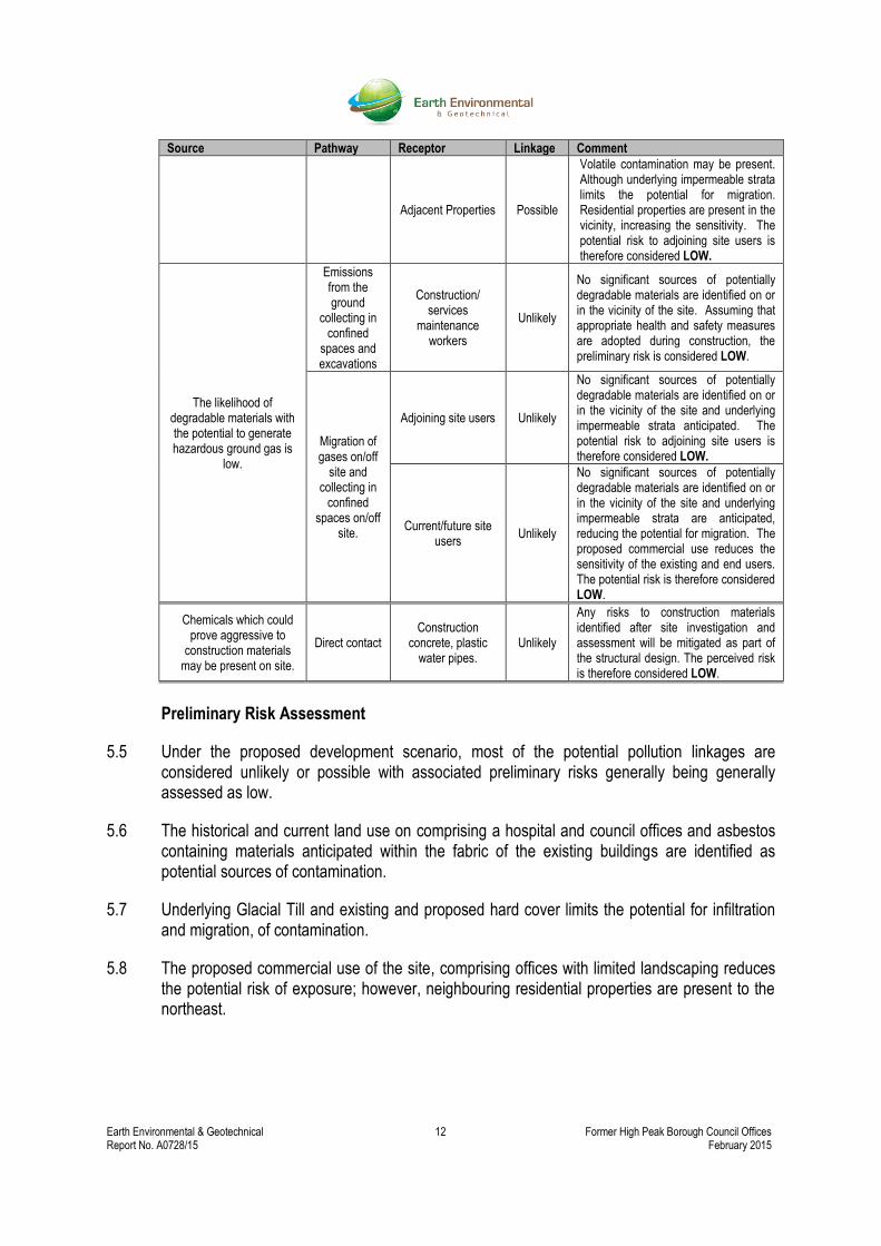
Source Pathway Receptor Linkage Comment
Historical commercial land use is identified on the site, comprising offices
and an isolation hospital. Asbestos Containing
Materials (AMCs) may be present within the fabric of the existing buildings. The
likelihood of significant ground contamination
sources being present at the site, associated with
these historical land uses, is considered low.
Direct contact,
ingestion of soil, dermal contact, dust
exposure pathways.
Current Site Users Unlikely
The site is currently vacant and hardcover is present across the majority of the site, with limited ‘soft areas’. The risk associated with current site users via direct exposure is considered to be LOW.
Site End Users Possible
Hardcover is proposed across the majority of the site, with limited ‘soft areas’. The risk associated with proposed site users via direct exposure in proposed ‘soft’ areas is considered to be LOW.
Construction Workers
Unlikely
Construction workers could potentially be exposed to contaminated soils and ACMs during development of the site. Perceived contamination risks will, however, be mitigated by adopting good site working practices including appropriate Health and Safety measures during the works, thus providing a LOW preliminary risk.
Adjacent land users Unlikely
Contact via wind-blown dust/ debris, particularly during the development phase is possible. The current risk is considered LOW although this would increase during construction works. Appropriate dust control measures will therefore be required as part of good site working practices during construction.
Earth Environmental & Geotechnical 11 Former High Peak Borough Council Offices Report No. A0728/15 February 2015
Source Pathway Receptor Linkage Comment
Historical commercial land use is identified on the site, comprising offices
and an isolation hospital. The likelihood of soluble
and/or liquid and therefore mobile contaminants
occurring at the site due to its past use is considered
low to medium.
Direct downward migration through leaching and/or mobile liquids.
Groundwater Possible
Mobile contamination may be present. However, underlying Glacial Till and proposed hard cover will reduce the potential for infiltration and migration of contamination, if present. Considering the underlying secondary A Aquifer, the perceived risk to groundwater is LOW.
Off-site migration in groundwater or surface water flow.
Surface water Unlikely
Mobile contamination may be present. However, underlying Glacial Till and proposed hard cover will reduce the potential for infiltration and migration of contamination, if present. The absence of surface water features in the immediate vicinity reduces the sensitivity of the environmental setting, therefore the perceived risk to surface water is considered LOW.
Groundwater / surface water abstractions
Unlikely
Underlying Glacial Till and proposed hard cover will reduce the potential for infiltration and migration of contamination, if present. The site is not within an Environment Agency Source Protection Zone or in the immediate vicinity of groundwater or surface water abstractions. The risk to groundwater/surface water abstractions is therefore considered LOW.
Adjacent Properties Possible
Underlying Glacial Till and proposed hard cover will reduce the potential for infiltration and migration of contamination, if present. Considering the neighbouring residential properties, the preliminary risk to adjacent properties is considered LOW.
Ecology Unlikely
There are no ecologically sensitive sites within influencing distance of the subject site. The risk to ecology is therefore considered LOW.
Considering the historical presence of offices and isolation hospital on the
site, the likelihood of volatile contaminants occurring at the site is
considered low.
Inhalation of harmful vapours
(indoor and outdoor
airspaces)
Current Site Users Unlikely
The site is currently vacant and underlying Glacial Till reduces the potential for migration. The risk associated with current site users is considered to be LOW.
Site End Users Possible
Volatile contamination may be present, however underlying Glacial Till reduces the potential for migration and the proposed commercial use reduces the sensitivity of the site users. The risk associated with the site end users is considered to be LOW.
Construction Workers
Unlikely
In the unlikely event of construction workers coming into contact with possible volatile compounds, the exposure time will be relatively short. The risk to construction workers, assuming that appropriate health and safety measures will be adopted, is therefore considered LOW.
Earth Environmental & Geotechnical 12 Former High Peak Borough Council Offices Report No. A0728/15 February 2015
Source Pathway Receptor Linkage Comment
Adjacent Properties Possible
Volatile contamination may be present. Although underlying impermeable strata limits the potential for migration. Residential properties are present in the vicinity, increasing the sensitivity. The potential risk to adjoining site users is therefore considered LOW.
The likelihood of degradable materials with the potential to generate hazardous ground gas is
low.
Emissions from the ground
collecting in confined
spaces and excavations
Construction/ services
maintenance workers
Unlikely
No significant sources of potentially degradable materials are identified on or in the vicinity of the site. Assuming that appropriate health and safety measures are adopted during construction, the preliminary risk is considered LOW.
Migration of gases on/off
site and collecting in
confined spaces on/off
site.
Adjoining site users Unlikely
No significant sources of potentially degradable materials are identified on or in the vicinity of the site and underlying impermeable strata anticipated. The potential risk to adjoining site users is therefore considered LOW.
Current/future site users
Unlikely
No significant sources of potentially degradable materials are identified on or in the vicinity of the site and underlying impermeable strata are anticipated, reducing the potential for migration. The proposed commercial use reduces the sensitivity of the existing and end users. The potential risk is therefore considered LOW.
Chemicals which could prove aggressive to
construction materials may be present on site.
Direct contact Construction
concrete, plastic water pipes.
Unlikely
Any risks to construction materials identified after site investigation and assessment will be mitigated as part of the structural design. The perceived risk is therefore considered LOW.
Preliminary Risk Assessment
5.5 Under the proposed development scenario, most of the potential pollution linkages are considered unlikely or possible with associated preliminary risks generally being generally assessed as low.
5.6 The historical and current land use on comprising a hospital and council offices and asbestos containing materials anticipated within the fabric of the existing buildings are identified as potential sources of contamination.
5.7 Underlying Glacial Till and existing and proposed hard cover limits the potential for infiltration and migration, of contamination.
5.8 The proposed commercial use of the site, comprising offices with limited landscaping reduces the potential risk of exposure; however, neighbouring residential properties are present to the northeast.

Earth Environmental & Geotechnical 13 Former High Peak Borough Council Offices Report No. A0728/15 February 2015
6.0 SUMMARY OF CONCLUSIONS AND RECOMMENDATIONS
General
6.1 Potentially contaminative land uses are identified on the site, associated with the former commercial land use as a hospital and offices. The likelihood of ground contamination is therefore considered low.
6.2 Considering the proposed commercial land use with limited ‘soft’ landscaping, and neighbouring residential properties, the potential pollution linkages assessed in the preliminary conceptual model identifies an overall low contamination risk.
6.3 Asbestos containing materials within the fabric of buildings are anticipated.
Recommendations
6.4 An intrusive investigation should be undertaken to establish geotechnical parameters for the design of any new foundations, floor slabs and pavement construction. As part of this investigation it would be prudent to obtain soil samples for contamination testing.
6.5 An asbestos survey is required within existing buildings prior to demolition or refurbishment.
APPENDIX 1
GROUNDSURE REPORTS

APPENDIX 2
SITE PHOTOGRAPHS

Earth Environmental & Geotechnical Ltd
Tel: 0161 2824518 Email: [email protected] Web: www.earthenvironmental.co.uk
SITE PHOTOGRAPHS
Job No. A0728/15
Site: Former High Peak Borough Council Offices
No .1 Stone Building; former council offices
No. 2 Stone Building; former council offices
Date: 4 February 2015
Date: 4 February 2015
No. 3 Stone Building; former council offices
No. 4 Site entrance; ground level falling to southwest
Date: 4 February 2015
Date: 4 February 2015
Earth Environmental & Geotechnical Ltd Tel: 0161 2824518 Email: [email protected] Web: www.earthenvironmental.co.uk
SITE PHOTOGRAPHS
Job No. A0728/15
Site: Former High Peak Borough Council Offices
No .5 Portacabin in southwest sector
No. 6 Shed in western sector
Date: 4 February 2015
Date: 4 February 2015

APPENDIX 3
SITE WALKOVER NOTES

WALK OVER SURVEY REPORT Site: Former High Peak Borough Council Offices Date: 4 February 2015 Job No: A0728/15 Undertaken By: Adam Czarnecki Purpose of Site Walkover: 1) Provide further information for the Desk Study Report; 2) Identify potential contamination sources, pathways and receptors; 3) Identify geotechnical features and potential geohazards; 4) Determine locations for exploratory boreholes. Desk Study features checked during site visit
Feature and Information required
Present
Description / Comments
Site Setting
Description required for: Town/Country/Suburb Setting Industrial/Residential/Retail Usage Current Site use (if undertaking security and access to the site)
Semi-rural, residential setting. Commercial land use. The site is currently occupied stone buildings and a portacabin, formally used as council offices.
Evidence of Past Activities
Are there: Any relevant street names in area? Features or relics which indicate past history?
Yes/No
Yes/No
Hayfield road to the north indicates rural, agricultural setting. Former office buildings across the site.
Geographic Setting
Description required for: Low lying flood plain/dry valley/rolling hills etc.
The site is located on a hillside; the ground level falls to the southwest.
Topography
Description required for: Are there apparent differences between site and surrounding area? (If yes describe the presence of retaining walls, and slopes). Is there evidence of Made Ground / Fill on site?
Yes/No
Yes/No
N/A N/A
Ground Conditions
Is there any evidence of: Mining, Mine entries Subsidence Landslip/slope erosion Former investigation works
Yes/No
Yes/No
Yes/No
N/A N/A N/A
Desk Study features checked during site visit
Feature and Information required
Present
Description / Comments
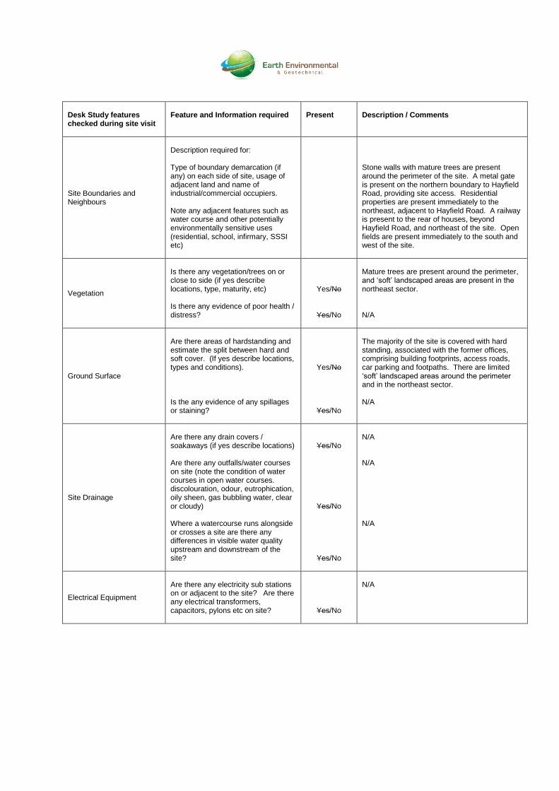
Site Boundaries and Neighbours
Description required for: Type of boundary demarcation (if any) on each side of site, usage of adjacent land and name of industrial/commercial occupiers. Note any adjacent features such as water course and other potentially environmentally sensitive uses (residential, school, infirmary, SSSI etc)
Stone walls with mature trees are present around the perimeter of the site. A metal gate is present on the northern boundary to Hayfield Road, providing site access. Residential properties are present immediately to the northeast, adjacent to Hayfield Road. A railway is present to the rear of houses, beyond Hayfield Road, and northeast of the site. Open fields are present immediately to the south and west of the site.
Vegetation
Is there any vegetation/trees on or close to side (if yes describe locations, type, maturity, etc) Is there any evidence of poor health / distress?
Yes/No
Yes/No
Mature trees are present around the perimeter, and ‘soft’ landscaped areas are present in the northeast sector. N/A
Ground Surface
Are there areas of hardstanding and estimate the split between hard and soft cover. (If yes describe locations, types and conditions). Is the any evidence of any spillages or staining?
Yes/No
Yes/No
The majority of the site is covered with hard standing, associated with the former offices, comprising building footprints, access roads, car parking and footpaths. There are limited ‘soft’ landscaped areas around the perimeter and in the northeast sector. N/A
Site Drainage
Are there any drain covers / soakaways (if yes describe locations) Are there any outfalls/water courses on site (note the condition of water courses in open water courses. discolouration, odour, eutrophication, oily sheen, gas bubbling water, clear or cloudy) Where a watercourse runs alongside or crosses a site are there any differences in visible water quality upstream and downstream of the site?
Yes/No
Yes/No
Yes/No
N/A N/A N/A
Electrical Equipment
Are there any electricity sub stations on or adjacent to the site? Are there any electrical transformers, capacitors, pylons etc on site?
Yes/No
N/A
Desk Study features checked during site visit
Feature and Information required
Present
Description / Comments
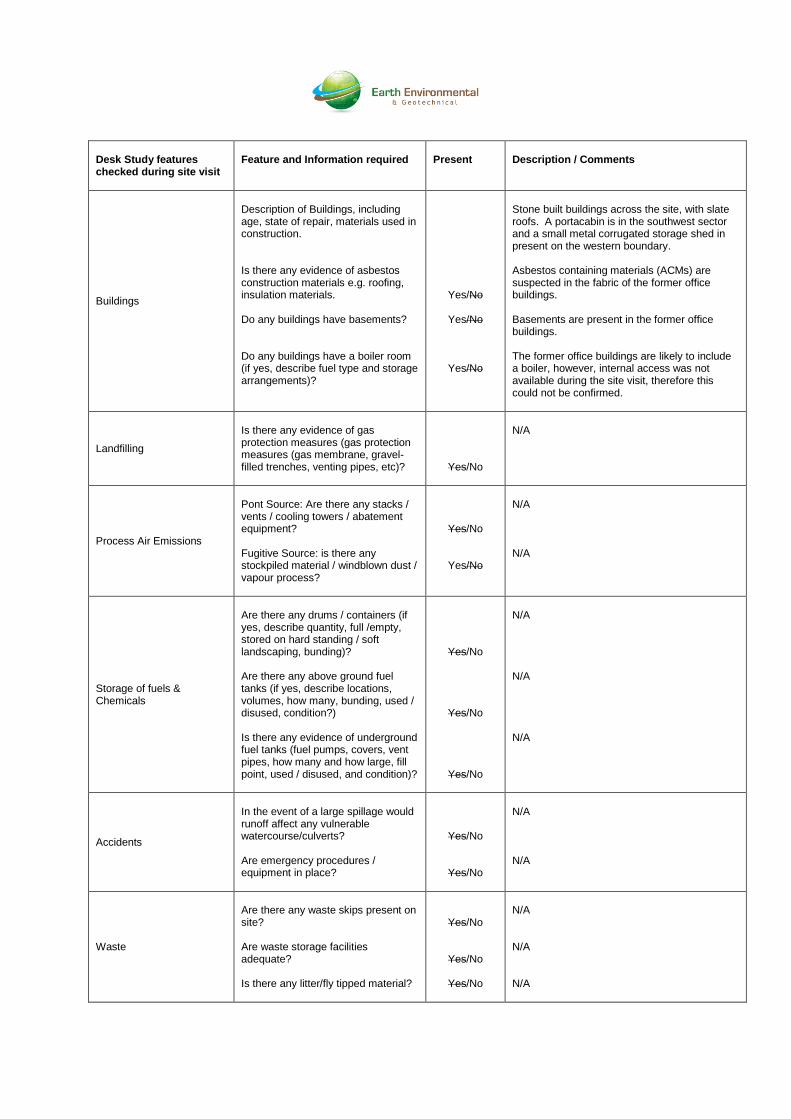
Buildings
Description of Buildings, including age, state of repair, materials used in construction. Is there any evidence of asbestos construction materials e.g. roofing, insulation materials. Do any buildings have basements? Do any buildings have a boiler room (if yes, describe fuel type and storage arrangements)?
Yes/No
Yes/No
Yes/No
Stone built buildings across the site, with slate roofs. A portacabin is in the southwest sector and a small metal corrugated storage shed in present on the western boundary. Asbestos containing materials (ACMs) are suspected in the fabric of the former office buildings. Basements are present in the former office buildings. The former office buildings are likely to include a boiler, however, internal access was not available during the site visit, therefore this could not be confirmed.
Landfilling
Is there any evidence of gas protection measures (gas protection measures (gas membrane, gravel-filled trenches, venting pipes, etc)?
Yes/No
N/A
Process Air Emissions
Pont Source: Are there any stacks / vents / cooling towers / abatement equipment? Fugitive Source: is there any stockpiled material / windblown dust / vapour process?
Yes/No
Yes/No
N/A N/A
Storage of fuels & Chemicals
Are there any drums / containers (if yes, describe quantity, full /empty, stored on hard standing / soft landscaping, bunding)? Are there any above ground fuel tanks (if yes, describe locations, volumes, how many, bunding, used / disused, condition?) Is there any evidence of underground fuel tanks (fuel pumps, covers, vent pipes, how many and how large, fill point, used / disused, and condition)?
Yes/No
Yes/No
Yes/No
N/A N/A N/A
Accidents
In the event of a large spillage would runoff affect any vulnerable watercourse/culverts? Are emergency procedures / equipment in place?
Yes/No
Yes/No
N/A N/A
Waste
Are there any waste skips present on site? Are waste storage facilities adequate? Is there any litter/fly tipped material?
Yes/No
Yes/No
Yes/No
N/A N/A N/A
Desk Study features checked during site visit
Feature and Information required
Present
Description / Comments
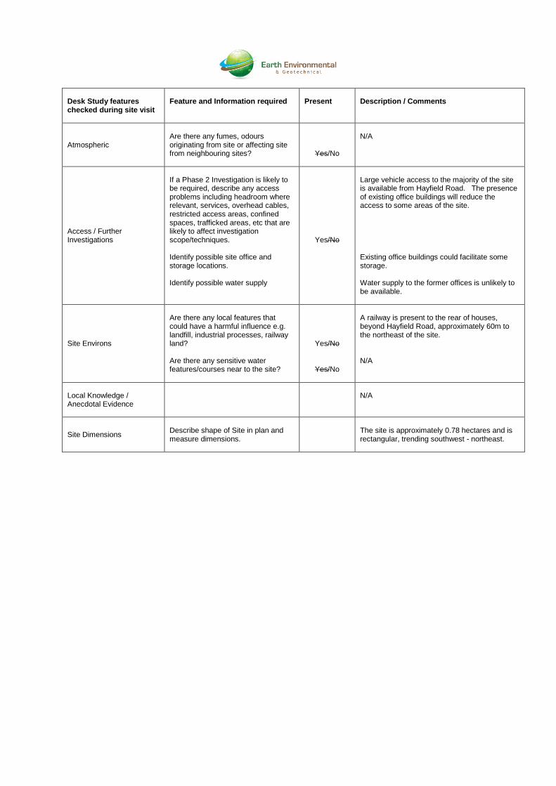
Atmospheric
Are there any fumes, odours originating from site or affecting site from neighbouring sites?
Yes/No
N/A
Access / Further Investigations
If a Phase 2 Investigation is likely to be required, describe any access problems including headroom where relevant, services, overhead cables, restricted access areas, confined spaces, trafficked areas, etc that are likely to affect investigation scope/techniques. Identify possible site office and storage locations. Identify possible water supply
Yes/No
Large vehicle access to the majority of the site is available from Hayfield Road. The presence of existing office buildings will reduce the access to some areas of the site. Existing office buildings could facilitate some storage. Water supply to the former offices is unlikely to be available.
Site Environs
Are there any local features that could have a harmful influence e.g. landfill, industrial processes, railway land? Are there any sensitive water features/courses near to the site?
Yes/No
Yes/No
A railway is present to the rear of houses, beyond Hayfield Road, approximately 60m to the northeast of the site. N/A
Local Knowledge / Anecdotal Evidence
N/A
Site Dimensions
Describe shape of Site in plan and measure dimensions.
The site is approximately 0.78 hectares and is rectangular, trending southwest - northeast.

APPENDIX 4
LIMITATIONS
LIMITATIONS
This contract was completed by Earth Environmental & Geotechnical Ltd on the basis of a defined
programme and scope of works and terms and conditions agreed with the client. This report was
compiled with all reasonable skill, and care, bearing in mind the project objectives, the agreed scope of
works, the prevailing site conditions, the budget and staff resources allocated to the project.
Other than that expressly contained in the above paragraph, Earth Environmental & Geotechnical Ltd
provides no other representation or warranty whether express or implied, is made in relation to the
services. Unless otherwise agreed this report has been prepared exclusively for the use and reliance
of the client in accordance with generally accepted consulting practices and for the intended purposes
as stated in the agreement under which this work was completed. This report may not be relied upon,
or transferred to, by any other party without the written agreement of a Director of Earth Environmental
& Geotechnical Ltd.
If a third party relies on this report, it does so wholly at its own and sole risk and Earth Environmental &
Geotechnical Ltd disclaims any liability to such parties.
It is Earth Environmental & Geotechnical Ltd understanding that this report is to be used for the
purpose described in the introduction to the report. That purpose was an important factor in
determining the scope and level of the services. Should the purpose for which the report is used, or the
proposed use of the site change, this report will no longer be valid and any further use of, or reliance
upon the report in those circumstances by the client without Earth Environmental & Geotechnical Ltd
review and advice shall be at the client's sole and own risk.
The report was written in 2014 and should be read in light of any subsequent changes in legislation,
statutory requirements and industry best practices. Ground conditions can also change over time and
further investigations or assessment should be made if there is any significant delay in acting on the
findings of this report. The passage of time may result in changes in site conditions, regulatory or other
legal provisions, technology or economic conditions which could render the report inaccurate or
unreliable. The information and conclusions contained in this report should not be relied upon in the
future without the written advice of Earth Environmental & Geotechnical Ltd. In the absence of such
written advice of Earth Environmental & Geotechnical Ltd, reliance on the report in the future shall be at
the client's own and sole risk. Should Earth Environmental & Geotechnical Ltd be requested to review
the report in the future, Earth Environmental & Geotechnical Ltd shall be entitled to additional payment
at the then existing rate or such other terms as may be agreed between Earth Environmental &
Geotechnical Ltd and the client.
The observations and conclusions described in this report are based solely upon the services that were
provided pursuant to the agreement between the client and Earth Environmental & Geotechnical Ltd.
Earth Environmental & Geotechnical Ltd has not performed any observations, investigations, studies or
testing not specifically set out or mentioned within this report.
Earth Environmental & Geotechnical Ltd is not liable for the existence of any condition, the discovery of
which would require performance of services not otherwise contained in the services. For the
avoidance of doubt, unless otherwise expressly referred to in the introduction to this report, Earth
Environmental & Geotechnical Ltd did not seek to evaluate the presence on or off the site of
electromagnetic fields, lead paint, radon gas or other radioactive materials.
The services are based upon Earth Environmental & Geotechnical Ltd observations of existing physical
conditions at the site gained from a walkover survey of the site together with Earth Environmental &
Geotechnical Ltd interpretation of information including documentation, obtained from third parties and
from the client on the history and usage of the site. The findings and recommendations contained in
this report are based in part upon information provided by third parties, and whilst Earth Environmental
& Geotechnical Ltd have no reason to doubt the accuracy and that it has been provided in full from
those it was requested from, the items relied on have not been verified.
No responsibility can be accepted for errors within third party items presented in this report. Further
Earth Environmental & Geotechnical Ltd was not authorised and did not attempt to independently verify
the accuracy or completeness of information, documentation or materials received from the client or
third parties, including laboratories and information services, during the performance of the services.
Earth Environmental & Geotechnical Ltd is not liable for any inaccurate information, misrepresentation
of data or conclusions, the discovery of which inaccuracies required the doing of any act including the
gathering of any information which was not reasonably available to Earth Environmental &
Geotechnical Ltd and including the doing of any independent investigation of the information provided
to Earth Environmental & Geotechnical Ltd save as otherwise provided in the terms of the contract
between the client and Earth Environmental & Geotechnical Ltd.
Where field investigations have been carried out these have been restricted to a level of detail required
to achieve the stated objectives of the work. Ground conditions can also be variable and as
investigation excavations only allow examination of the ground at discrete locations. The potential
exists for ground conditions to be encountered which are different to those considered in this report.
The extent of the limited area depends on the soil and groundwater conditions, together with the
position of any current structures and underground facilities and natural and other activities on site. In
addition, chemical analysis was carried out for a limited number of parameters [as stipulated in the
contract between the client and Earth Environmental & Geotechnical Ltd] based on an understanding of
the available operational and historical information, and it should not be inferred that other chemical
species are not present.
The groundwater conditions entered on the exploratory hole records are those observed at the time of
investigation. The normal speed of investigation usually does not permit the recording of an equilibrium
water level for any one water strike. Moreover, groundwater levels are subject to seasonal variation or
changes in local drainage conditions and higher groundwater levels may occur at other times of the
year than were recorded during this investigation.
Any site drawing(s) provided in this report is (are) not meant to be an accurate base plan, but is (are) used to present the general relative locations of features on, and surrounding, the site.