Embed Size (px)
Citation preview

Earth Observations for
Sustainable Water Management
Geospatial Technologies
For Sustainable Water Management
3 July 2017
Central European University
Budapest, Hungary
Douglas Cripe
GEO Secretariat

Observations – In, On, and Around the Earth

GEO Vision
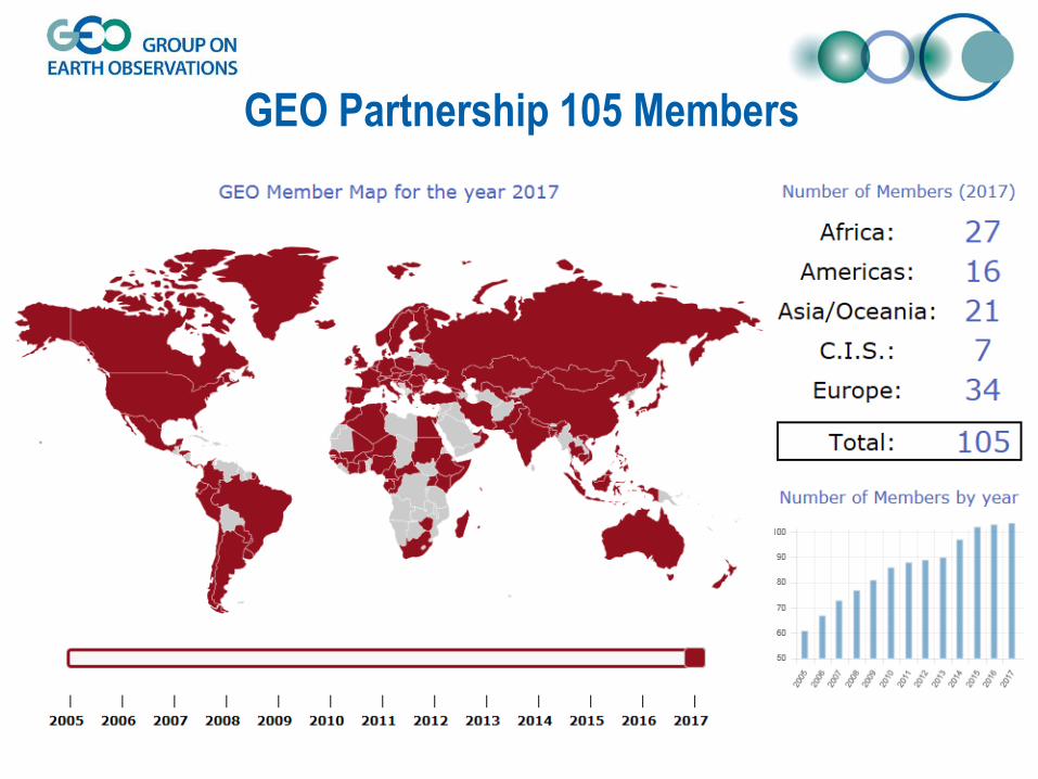
GEO Partnership 105 Members

GEO Partnership 109 Participating Organizations

GEOSS Implementation Requires:
Data Sharing Principles
• Free and Open Exchange of Data -- Open by Default
• Data and Products at Minimum Time Delay
and at Minimum Cost
• Free of Charge or Cost of Reproduction for
research/education

Societal Benefit Areas (SBAs)
Climate change and its impacts cut across all SBAs
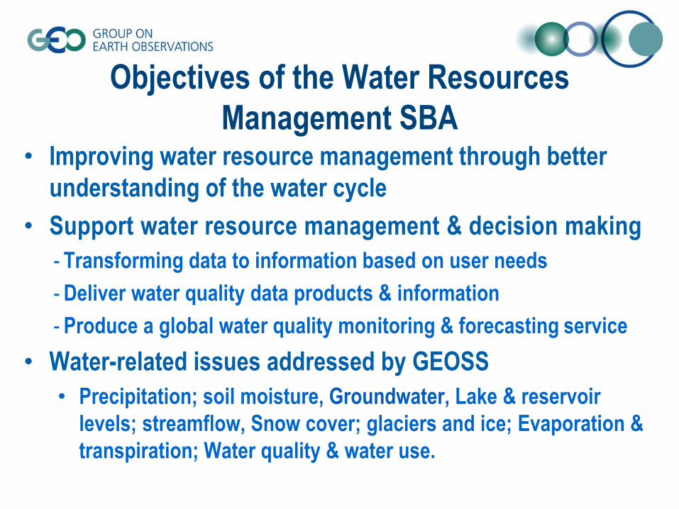
Objectives of the Water Resources
Management SBA• Improving water resource management through better
understanding of the water cycle
• Support water resource management & decision making
- Transforming data to information based on user needs
- Deliver water quality data products & information
- Produce a global water quality monitoring & forecasting service
• Water-related issues addressed by GEOSS
• Precipitation; soil moisture, Groundwater, Lake & reservoir
levels; streamflow, Snow cover; glaciers and ice; Evaporation &
transpiration; Water quality & water use.

Communities of Practice: Aquawatch & IGWCO
IGWCO CoPIntegrated Global Water Cycle Observations Community of Practice
Objectives
– Providing a framework for guiding decisions
– Promoting strategies
– Coordinating & facilitating the inputs
– Fostering the development of tools, applications & systems
– Supports the plans of the
International Groundwater Resource Assessment Centre (IGRAC)
& its Global Groundwater Monitoring Network (GGMN)

GEOSS Water Strategy (2014)
– Integration for data management &
observational & prediction systems
via the Water Cycle Integrator (WCI)
– Support policy goals
– Promotes integration for data products
bringing together
in-situ & satellite observations
– Provide a set of tools
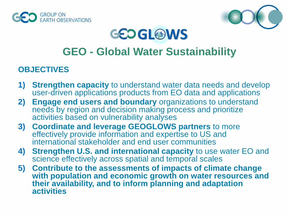
OBJECTIVES
1) Strengthen capacity to understand water data needs and develop user-driven applications products from EO data and applications
2) Engage end users and boundary organizations to understand needs by region and decision making process and prioritize activities based on vulnerability analyses
3) Coordinate and leverage GEOGLOWS partners to more effectively provide information and expertise to US and international stakeholder and end user communities
4) Strengthen U.S. and international capacity to use water EO and science effectively across spatial and temporal scales
5) Contribute to the assessments of impacts of climate change with population and economic growth on water resources and their availability, and to inform planning and adaptation activities
GEO - Global Water Sustainability
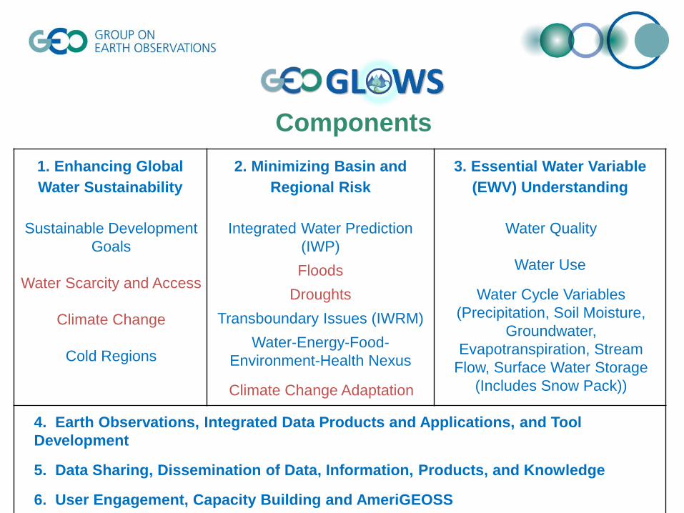
Components
1. Enhancing Global
Water Sustainability
Sustainable Development
Goals
Water Scarcity and Access
Climate Change
Cold Regions
2. Minimizing Basin and
Regional Risk
Integrated Water Prediction
(IWP)
Floods
Droughts
Transboundary Issues (IWRM)
Water-Energy-Food-
Environment-Health Nexus
Climate Change Adaptation
3. Essential Water Variable
(EWV) Understanding
Water Quality
Water Use
Water Cycle Variables
(Precipitation, Soil Moisture,
Groundwater,
Evapotranspiration, Stream
Flow, Surface Water Storage
(Includes Snow Pack))
4. Earth Observations, Integrated Data Products and Applications, and Tool
Development
5. Data Sharing, Dissemination of Data, Information, Products, and Knowledge
6. User Engagement, Capacity Building and AmeriGEOSS

2. Minimizing Basin and Regional Risks
• National water center - operations center
“Street Level” Water Prediction and Impact-Based Decision Support
WATER PREDICTION + GEO-INTELLIGENCE

2. Minimizing Basin and Regional Risks
Implementation of IWP in the Great Lakes
Exemplary transboundary effort

11

AmeriGEOSS Foundational Activities
• GEONETCast Americas (GNC-A): Delivering
Regional and National Data, Products, and
Observations
• Regional component of the Global
GEONETCast
• Provided by the U.S./NOAA
• Footprint covers– Most of North America Caribbean Region
Central South America
– Operational since Spring 2008
Red: Operational stations
Green: Installations in progress
Orange: EUMETCast-Americas in conversion to GNC-A
Yellow: In consideration by the organization
Blue: Acquiring equipment
Satellite Utilization and
Products Division
WMO Space Programme
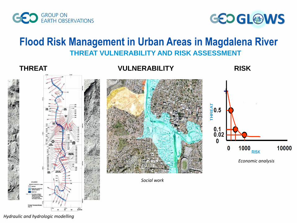
Flood Risk Management in Urban Areas in Magdalena RiverTHREAT VULNERABILITY AND RISK ASSESSMENT
THREAT VULNERABILITY RISK
Hydraulic and hydrologic modelling
Social work
Economic analysis

Global Drought Monitoring
• Currently no global, authoritative, and consistent information on
drought available that is easily accessible to all users
• GDIS (Global Drought Information System) under development
o coordinating global and regional information on drought monitoring, forecasting,
and management

Global Flood Awareness System
Pre-operational since 2011
Producing medium range probabilistic flood forecasts
Provides:
Global overviews of upcoming flood events in large river basins
Early warnings and info on upstream river conditions to downstream countries
GloFAS has >1000 registered users from:
Public authorities
NGOs
Private sector
Academic/training/research institutions

GloFAS: Making flood predictions on the Global scale
• ECMWF IFS
– 51 member ensemble
– 15 day lead time
– Runoff generated by the land surface component
(HTESSEL)
• Raster based hydrological model
• 1D flow routing
• Event magnitude thresholds based on model climatology
• Integrated web interface
20EUROPEAN CENTRE FOR MEDIUM-RANGE WEATHER
FORECASTS

GloFAS: Web interface
EUROPEAN CENTRE FOR MEDIUM-RANGE WEATHER
FORECASTS

GloFAS data availability
• Users/partners can register to access and analyse forecasts and warnings
– For decision-making purposes and research
• Open Data – can be provided on request
• Station locations can be added as reporting points
EUROPEAN CENTRE FOR MEDIUM-RANGE WEATHER
FORECASTS

An Information Service for Cold Regions (or GEO
Cold Regions), exploiting the GEOSS information
system, is needed to provide easy access to
observations and environmental information products by
users across the globe.

• Aiming to share the vision of GEO to address the global
environmental change, and its resulting impacts and challenges
on all aspects of society, an Information Service for Cold Regions
was established to broaden and share Earth observations for societal
benefits, and inform the decision makers, through strengthening
coordination with diverse communities, engagement and collaboration
of stakeholders including decision makers and etc..
• Scope - Global Cold Regions: Including the Arctic, Antarctic,
Himalaya-Third Pole, high-latitude oceans and high-mountain cold
region areas
• GEO Cold Regions Initiative > recommended to GEO WP 2017-2019,
which is the legacy of Information Service for Cold Regions in Water
SBA.
GEOCRI – GEO Cold Region Initiative

• More than 100 countries around the world have cryospheric
elements. These elements are a main source of fresh water.
• Cold regions are the most ecologically and environmentally
sensitive areas, and changes to these areas
comprehensively affect the dynamic earth system, impacting
many aspects of society in all parts of the world.
The cold regions of our planet influence our entire world.
Why GEO Cold Regions?
Scientific and Societal Importance

Objectives• Integrating, Brokering and Promoting Earth
Observations over Earth Cold Regions
• Advocating and Practicing Data Sharing
• Building Community Portal and Services
• Strengthening Capacity building and Partnerships
GEOCRI Mission and Objectives
Mission: Develop a user-driven approach for Cold
Regions information services to complement the
mainly current science-driven effort, and foster the
collaboration for improved earth observations and
information on a global scale.

Earth’s Cold Region

View From Northern Poles
Frozen Water and Phase changing
High Latitude High Altitude
PEEX

Climate & WeatherBiodiversity & Ecosystems
International Relations & CooperationSustainable Development, Indigenous Communities & Traditional Practices
HealthAgriculture, Fisheries, Hunting & Food
WaterPollution & Environmental Protection
HazardsBuilt Environment, Infrastructure & Transport
EnergyMining & Fossil Fuels
ForestryShippingTourism
Specific Earth observation needs and requirements
Environmental and socio-political challenges

Make Way for More Ships--
and More Species Invasions
Energy Resources in the Arctic Ocean Arctic: a new geopolitical arena
Example: The melting Arctic creates a new world of shipping
and resource opportunities

Mandate - Focus on Global Cold Regions GEOCRI is well aligned with the GEO mission and strategic objectives with
its contribution and support to international processes underway, including
the UN SDG, UNFCCC, UN Sendai Framework for Disaster Risk Reduction,
and its UN Convention on Biological Diversity.
• Example 1: Europe - ESA’s activities turning to the Polar regions –
economy, climate change, geo-political strategy and etc..
• Example 2: White House Arctic Science Ministerial, Sept 28, 2016
– Focus areas: Strengthening and Integrating Arctic Observations and Data
Sharing and Applying Expanded Scientific Understanding of the Arctic to Build
Regional Resilience and Shape Global Responses
• Example 3: SAON – Sustained Arctic Observing Networks, initiated by Arctic
Council and IASC in 2011 Ministerial Meeting
• Example 4: IPPI/IASC, IACS/IUCN, ECPHORS/WMO

Infrastructures
Monitoring Network and Data
Integrating in situ and Remote Sensing Observations
User Engagement and Communication
Capacity Buidling and Knowledge Transfer
Management and Monitoring
GEOCRI Task and Implentation Plan
Tasks:
Hierarchy structure of the activities

Countries
Canada
China
Finland
Germany
India
Italy
Japan
Netherlands
Norway
Spain
Sweden
Switzerland
United Kingdom
United States
Organisations/Projects– CAFF CBMP: Conservation of Arctic Flora and Fauna -
Circumpolar Biodiversity Monitoring Program
– CCIN: Canadian Cryospheric Information Network – Polar
Data Catalogue
– CliC: Climate and Cryosphere
– CryoClim Cryosphere Climate Monitoring Service
– ICIMOD: International Centre for Integrated Mountain
Development
– INTERACT: International Network for Terrestrial Research
and Monitoring in the Arctic
– ISDE : International Society for Digital Earth
– PEEX: Pan-Eurasian Experiment
– SAON: Sustaining Arctic Observing Network
– SIOS: Svalbard Integrated Earth Observing System
– SwissEx: Swiss Experiment Platform
– TPE: Third Pole Environment
– WMO GCW: Global Cryosphere Watch
– WMO WWRP PPP/YOPP
GEO Cold Regions participations

Finished the 1st Round Teleconf. in Jan., 2017
Identify the Priorities
1)Community Portal Development – GEOCRI
2)Essential Variables for Cold Regions
3)Integration: In-situ, Remote Sensing and Model
Progress of Tasks
Meeting on 4th, March, 2017
Welcome to join us!
Define the roadmaps and outcomes

https://www.earthobservations.org/documents/GEO_Strategic_Plan_2016_2025_Implementing_GEOSS.pdf
GEO promotes Broad Open Data Policy

GEOSS Portal: Search and Discover

Implementing GEOSS
• Some numbers on GEOSS Assets:152 brokered catalogs, approx discoverable and accessible 200 ml resources

Source: http://www.geodab.net/
OGC CSW 2.0.2 AP ISO 1.0 INPEOGC CSW 2.0.2 ebRIM EO CKANOGC CSW 2.0.2 ebRIM CIM DCATESRI GEOPORTAL 10 GI-catOAI-PMH 2.0 ESRI GEOPORTAL 10OpenSearch 1.1 NCML-ODOpenSearch 1.1 ESIP BCODMOOpenSearch GENESI DR NCML-CFCKAN NetCDF-CF 1.4
CUAHSI HIS-Central FTP populated with supported metadata typesESRI REST API 10.3 WAF Web Accessible FoldersOGC WCS GeoNetwork (2.2.0 or greater)OGC WMS Ecological Markup Language 2.1.1OGC WFS 1.0.0, 1.1.0, 2.0.0 NERRS (National Estuarine Research Reserve System)OGC WMTS HMA CSW 2.0.2 ebRIM/CIMOGC SOS 1.0.0, 2.0.0, 2.0.0 Hydro Profile HDFOGC WPS 1.0.0 IADC DB (MySQL)OGC CSW 2.0.0 Core GrADS-DSOGC CSW 2.0.2 AP ISO 1.0 FedEOOGC CSW 2.0.2 ebRIM/EO AP ARPA DB (based on Microsoft SQL)OGC CSW 2.0.2 ebRIM/CIM AP ESRI Map ServerIRIS Station SHAPE files (FTP)IRIS Event KISTERS Web - Environment of CanadaHYRAX THREDDS SERVER 1.9 Environment Canada Hydrometric data (FTP)OAI-PMH 2.0 - Harvesting OpenSearch 1.1GBIF Earth EngineDIF RASAQMHYDRO EGASKROUNAVCO SITAD (Sistema Informativo Territoriale Ambientale Diffuso)CDI 1.04, 1.3, 1.4 File SystemISO19115-2 GDACSTHREDDS 1.0.1, 1.0.2 GeoRSS 2.0THREDDS-NCISO 1.0.1, 1.0.2 Degree catalog service 2.2THREDDS-NCISO-PLUS 1.0.1, 1.0.2 OpenSearch GENESI DR
GEO DAB Suported Standards

GEOSS Portal: Visualize and download

Yearly Queries of the GCI over the past 3 years!!
410.967
2.556.138
4.467913
0
500,000
1,000,000
1,500,000
2,000,000
2,500,000
3,000,000
3,500,000
4,000,000
4,500,000
5,000,000
4.293.124
Statistics related to machine to machine connections
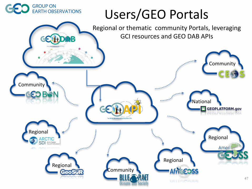
Users/GEO Portals
47
Regional
RegionalRegional
National
Community
Community
Community
Regional
Regional or thematic community Portals, leveraging GCI resources and GEO DAB APIs
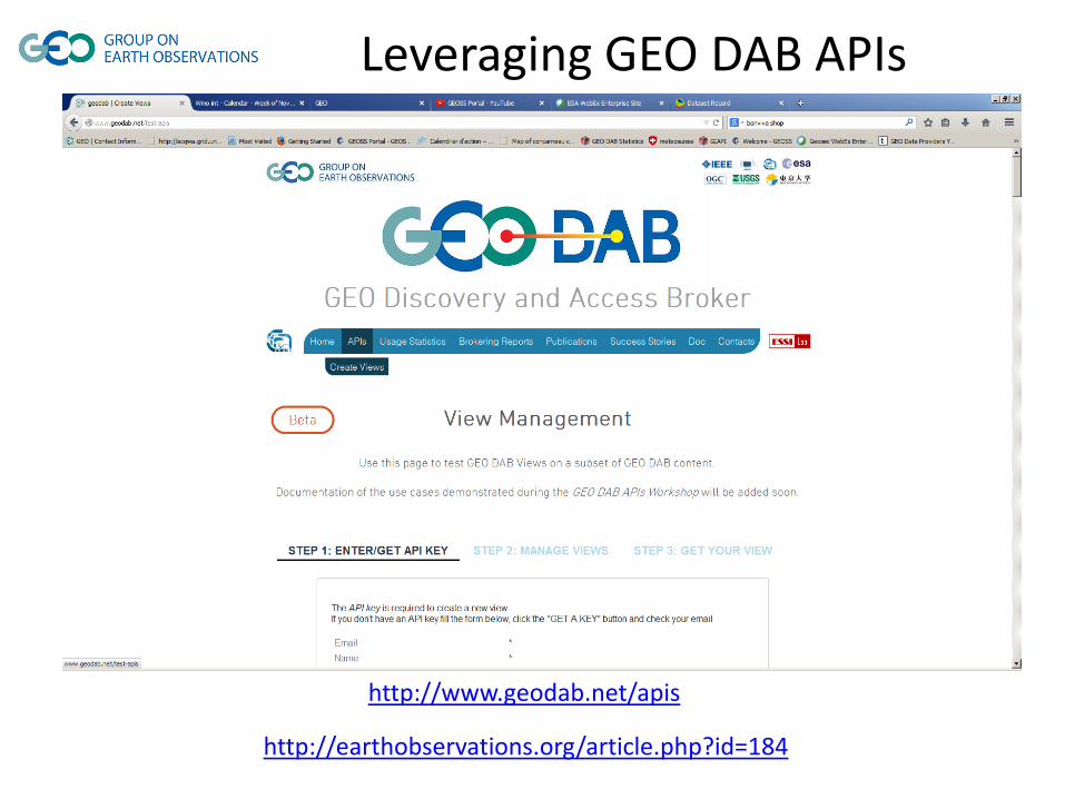
http://www.geodab.net/apis
Leveraging GEO DAB APIs
http://earthobservations.org/article.php?id=184

Source: Geoscience Australia
Australian Data Cube
‘Cubing’ Landsat Images

Source: Geoscience Australia
Data Cube Application
National Flood Risk Information Portal Australia

Transforming our World: The 2030 Plan for Global Action -Article 76: We will promote transparent and accountable scaling-up of appropriate public-private cooperation to exploit the contribution to be made by a wide range of data, including Earth observation and geo-spatial information, while ensuring national ownership in supporting and tracking progress.
SDGs and Earth Observation

Strategic Plan:
“GEO will supply the requisite Earth observations
in support of effective policy responses
for climate change adaptation, mitigation and other impacts
across the SBAs.”
2015 Mexico City Ministerial Declaration:
“Affirm that GEO and its Earth observations and information will support
the implementation of, inter alia:
• the 2030 Global Goals for Sustainable Development,
• the Sendai Framework for Disaster Risk Reduction 2015-2030,
• the United Nations System of Environmental and Economic Accounts,
• the United Nations Framework Convention on Climate Change.”

The GEO Engagement Strategy
• Fundamentally linked to the Mexico City Ministerial Declaration, GEO
Strategic Plan and GEO Work Programme
• Aims at creating the necessary synergies between actions of the
different GEO stakeholders and activities
• Does not attempt to replace existing actions but rather to align them
with relevant policy priorities
• The desired result is to increase the impact and effectiveness of GEO
actions
The mission of GEO can only be achieved through a strong and
coherent engagement with stakeholder communities
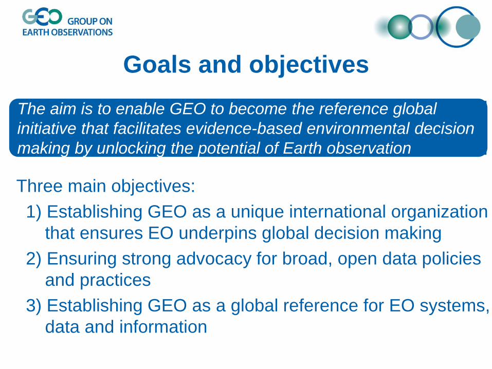
Goals and objectives
Three main objectives:
1) Establishing GEO as a unique international organization
that ensures EO underpins global decision making
2) Ensuring strong advocacy for broad, open data policies
and practices
3) Establishing GEO as a global reference for EO systems,
data and information
The aim is to enable GEO to become the reference global
initiative that facilitates evidence-based environmental decision
making by unlocking the potential of Earth observation

• 2030 Agenda for Sustainable
Development
• Climate Change – Greenhouse
Gas Monitoring
• Disaster Risk Reduction
GEO Engagement Priorities 2017-2019
GEO-XIII, November 2016, St Petersburg

Usefulness of EO information increasingly recognized

Engagement Priorities 2017-2019
2030 AGENDA FOR SUSTAINABLE DEVELOPMENT
- Support to the 2030 Sustainable Development framework enshrined in Mexico
Declaration & GEO Strategic Plan
- Working together with selected GEO activities, actions will focus on
organisations with sound activities related to SDGs and GEO Members/POs
- GEO principals have key role to engage national user stakeholders such as
statistical offices and relevant ministries
- Partnerships to be pursued with UN agencies custodians for SDGs (e.g. FAO,
UNEP, UNESCO, WHO…) as well as with coordination initiatives
- (e.g.: SDSN, UN-GGIM, IAEG-SDGs WGGI, GPSDD, IISD)

GEO Initiative: Earth Observations for the Sustainable Development Goals
(EO4SDGs)
GOAL I: Earth observations and geospatial information contribute in novel and practical ways to support the achievement of the SDGs.
GOAL II: Increase skills and capabilities in uses of Earth observations for SDG activities and their broader benefits.
GOAL III: Broaden interest and awareness of Earth observations support to the SDGs and social, environmental, and economic
benefits.

EO4SDGs: Draft Implementation Plan
Assessment: Most likely Targets and Indicators that Earth obs. can contribute to (directly or indirectly)
Engagement Priorities 2017-2019
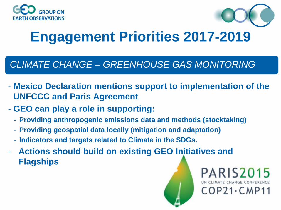
CLIMATE CHANGE – GREENHOUSE GAS MONITORING
- Mexico Declaration mentions support to implementation of the
UNFCCC and Paris Agreement
- GEO can play a role in supporting:
- Providing anthropogenic emissions data and methods (stocktaking)
- Providing geospatial data locally (mitigation and adaptation)
- Indicators and targets related to Climate in the SDGs.
- Actions should build on existing GEO Initiatives and
Flagships

Community Activities
• Access to climate data in GEOSS
• Collaboration between GEO and GFCS
• Copernicus Climate Change Service (C3S) & Copernicus Atmospheric Monitoring
Service (CAMS)
• Land Cover, Water Cycle, Floods, Droughts and others
GEO Initiatives/Flagships
• GEO Carbon and GHG Initiative
• Global Drought Information System
• Climate Change Impact Observation on Africa´s Coastal Zones
• Information Service for Cold Regions
Climate in the GEO Work Programme

COP-23 Side Event
• UNFCCC IPC (Sep 2016) endorsed GEO having independent eligibility
to apply for Side Events and Exhibits at future UNFCCC sessions
• ExCom Action 39.9: Secretariat to work with key partners (e.g. UNFCCC,
IPCC, CEOS, GCOS, ICOS, etc.) to design a Side-Event at COP-23
• Content to be defined with partners Task Force
• Possible topics include:
o Carbon and GHG observations to support the
implementation of the Paris Agreement
o Help for countries in their national reporting
o Role of (satellite) observations in the refinement of the
IPCC Guidelines
Informing policy agendas

Engagement Priorities 2017-2019
DISASTER RISK REDUCTION
- Mexico Declaration mentions support to the implementation of
Sendai Framework for DRR (2015-2030)
- Provision of timely EO data critical to the full cycle of disaster
management
- Primary focus should be on developing countries
- Actions should build on existing GEO initiatives
- GEO working closely with UNISDR and participating in the
Global Platform for Disaster Risk Reduction

Societal Benefit Areas (SBAs)
Climate change and its impacts cut across all SBAs
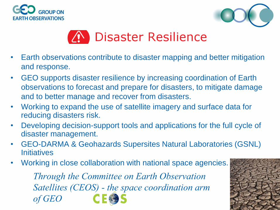
• Earth observations contribute to disaster mapping and better mitigation
and response.
• GEO supports disaster resilience by increasing coordination of Earth
observations to forecast and prepare for disasters, to mitigate damage
and to better manage and recover from disasters.
• Working to expand the use of satellite imagery and surface data for reducing disasters risk.
• Developing decision-support tools and applications for the full cycle of disaster management.
• GEO-DARMA & Geohazards Supersites Natural Laboratories (GSNL) Initiatives
• Working in close collaboration with national space agencies.
Through the Committee on Earth Observation
Satellites (CEOS) - the space coordination arm
of GEO


Thank you !
www.earthobservations.org
www.geoportal.org
@geosec2025
Group on Earth Observations