Embed Size (px)
Citation preview
Macalester InternationalVolume 15 Hybrid Geographies in the EasternMediterranean: Views from the Bosphorus Article 12
Winter 2005
Earthquake Risk, Earthquake Rapid ResponseSystem, and Early Warning System in IstanbulMustafa ErdikBogazici University, Istanbul, Turkey
Follow this and additional works at: http://digitalcommons.macalester.edu/macintl
This Article is brought to you for free and open access by the Institute for Global Citizenship at DigitalCommons@Macalester College. It has beenaccepted for inclusion in Macalester International by an authorized administrator of DigitalCommons@Macalester College. For more information,please contact [email protected].
Recommended CitationErdik, Mustafa (2005) "Earthquake Risk, Earthquake Rapid Response System, and Early Warning System in Istanbul," MacalesterInternational: Vol. 15, Article 12.Available at: http://digitalcommons.macalester.edu/macintl/vol15/iss1/12
Earthquake Risk, Earthquake Rapid Response System, and Early Warning
System in Istanbul
Mustafa Erdik
I. Background
Turkey ranks high among countries suffering loss of life and prop-erty due to earthquakes over many centuries. So far in this century there have been earthquakes in Turkey that caused over 110,000 deaths, about 250,000 hospitalizations, and close to 600,000 destroyed housing units.
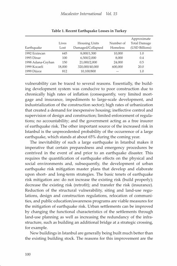
As indicated in Table 1, the series of devastating earthquakes during the last decade has caused housing losses in the hundreds of thou-sands, loss of lives in the tens of thousands, and a financial loss in excess of US $22 billion (about 10% of the average GDP or about 1% annual GDP loss).
Following the losses suffered during the two major earthquakes that struck Turkey in 1999, there has been a broad recognition among Turkey’s governmental, non-governmental, and academic organiza-tions of the need for extensive response planning based on detailed risk analyses of likely seismic hazards in Turkey in general and Istan-bul in particular.
In recent decades, earthquake disaster risks in the urban centers of Turkey have increased, mainly due to very high rates of urbanization, faulty land-use planning and construction, inadequate infrastructure and services, and environmental degradation. Several studies have shown that the vulnerabilities of Turkish building stock are at least an order of magnitude higher than their counterparts in California, which shares a comparable level of earthquake hazard.1 This greater
99
Macalester International Vol. 15
100
Table 1. Recent Earthquake Losses in Turkey
ApproximateLives Housing Units Number of Total Damage
Earthquake Lost Damaged/Collapsed Homeless (USD Billions)
1992 Erzincan 0,00,0645 8,000/1,500 010,000 01.01995 Dinar 0,00,0100 6,500/2,000 00008,000 00.41998 Adana-Ceyhan 0,00,0150 21,000/2,000 024,000 00.51999 Kocaeli 18,000 320,000/40,000 600,000 20.01999 Düzce 0,00,0812 10,100/800 — 01.0
vulnerability can be traced to several reasons. Essentially, the build-ing development system was conducive to poor construction due to chronically high rates of inflation (consequently, very limited mort-gage and insurance, impediments to large-scale development, and industrialization of the construction sector); high rates of urbanization that created a demand for inexpensive housing; ineffective control and supervision of design and construction; limited enforcement of regula-tions; no accountability; and the government acting as a free insurer of earthquake risk. The other important source of the increased risk in Istanbul is the unprecedented probability of the occurrence of a large earthquake, which stands at about 65% during the coming year.
The inevitability of such a large earthquake in Istanbul makes it imperative that certain preparedness and emergency procedures be contrived in the event of and prior to an earthquake disaster. This requires the quantification of earthquake effects on the physical and social environments and, subsequently, the development of urban earthquake risk mitigation master plans that develop and elaborate upon short- and long-term strategies. The basic tenets of earthquake risk mitigation are: do not increase the existing risk (build properly); decrease the existing risk (retrofit); and transfer the risk (insurance). Reduction of the structural vulnerability, siting and land-use regu-lations, design and construction regulations, relocation of communi-ties, and public education/awareness programs are viable measures for the mitigation of earthquake risk. Urban settlements can be improved by changing the functional characteristics of the settlements through land-use planning as well as increasing the redundancy of the infra-structure, such as building an additional bridge at a strategic crossing, for example.
New buildings in Istanbul are generally being built much better than the existing building stock. The reasons for this improvement are the
Mustafa Erdik
101
application of a new (1998) earthquake resistant design code; increased public awareness and demand for earthquake safety; various train-ing and education programs for engineers; better zoning regulations and enforcement by municipalities; and control by private construc-tion supervision firms. New legislation (Revision of Law on Engineer-ing and Architecture, Building Design and Construction Control, and Standard Development Regulations for Municipalities) enacted after the 1999 earthquakes provided help in this regard. For Istanbul the most important and complex issue in mitigating earthquake casualties is the retrofit of existing buildings.
The 1999 Kocaeli earthquake clearly demonstrates that Turkey needs a new emergency management plan that is effective from top down and bottom up. The plan and its provisions need to be created from scratch and practiced frequently. The highly centralized, hierarchical, top-down characteristic of disaster management in Turkey discourages local initiatives and limits community participation. Despite the rigid structure of the system, ad hoc management and a lack of coordination were substantial problems, as witnessed in the first days of the 1999 Kocaeli earthquake. Communication, coordination, and cooperation problems between appointed and elected administrators have, in cer-tain cases, hindered effective Search-and-Rescue and relief operations. Lack of a rapid loss estimation system, lack of disaster scenarios and disaster operation plans, shortage of equipment and materials, and an absence of disaster response training all hindered organized and effec-tive search, rescue, and relief efforts.
Although worldwide it is well known that the potential impact of large earthquakes on urban societies can be reduced by timely and correct action immediately before (Early Warning) and after (Rapid Response) a disastrous earthquake, these concepts and technologies were brought onto the Turkish scene only after the 1999 Kocaeli earth-quake. Earthquake Early Warning in urban and industrial areas allows for clean emergency shutdown of systems susceptible to damage, such as power stations, transportation, computer centers, and telephone systems. The Rapid Response systems, on the other hand, provide reliable information for accurate, effective characterization of the shak-ing and damage for rapid emergency assistance, search, and rescue responses. After a brief quantification of the earthquake risk in Istan-bul, this article will provide a description of the Istanbul Earthquake Rapid Response and Early Warning System.
Macalester International Vol. 15
102
II. Estimated Residential Building Losses and Casualties in Istanbul due to Earthquake
Istanbul faces a significant earthquake hazard and risk as illustrated by the earthquake risk scenario.2
A. Earthquake Hazard
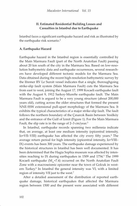
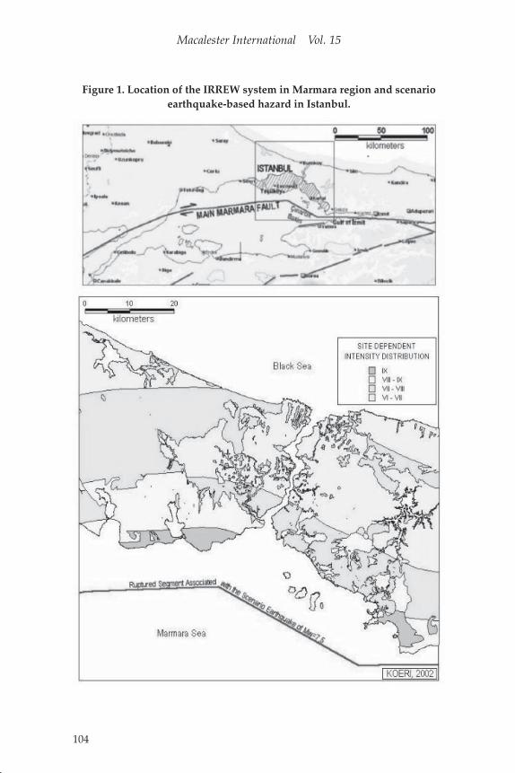
Earthquake hazard in the Istanbul region is essentially controlled by the Main Marmara Fault (part of the North Anatolian Fault) passing about 20 km south of the city in the Marmara Sea. Based on low-reso-lution bathymetric data and earthquake occurrences, several research-ers have developed different tectonic models for the Marmara Sea. Data obtained during the recent high-resolution bathymetric survey by the Ifremer RV Le Suroit vessel indicates that a single, thoroughgoing strike-slip fault system (Main Marmara Fault) cuts the Marmara Sea from east to west, joining the August 17, 1999 Kocaeli earthquake fault with the August 9, 1912 Sarkoy-Murefte earthquake fault. The Main Marmara Fault is argued to be a very young structure (about 200,000 years old), cutting across the older structures that formed the present NNE-SSW extensional pull-apart morphology of the Marmara Sea. It exhibits the typical characteristics of a major strike-slip fault. The fault follows the northern boundary of the Çınarcık Basin between Yesilköy and the entrance of the Gulf of Izmit (Figure 1). For the Main Marmara Fault, the slip rate is in the range of 2–3 cm/year.3
In Istanbul, earthquake records spanning two millennia indicate that, on average, at least one medium intensity (epicentral intensity, Io=VII–VIII) earthquake has affected the city every fifty years.4 The average return period for high intensity (epicentral intensity, Io=VIII–IX) events has been 300 years. The earthquake damage experienced by the historical structures in Istanbul has been well documented. It has been determined that the Hagia Sophia museum was affected by inten-sities reaching to IX during earthquakes in 1509 and 1754.5 The 1999 Kocaeli earthquake (Mw=7.4) occurred on the North Anatolian Fault Zone with a macroseismic epicenter near the town of Golcuk in west-ern Turkey.6 In Istanbul the general intensity was VI, with a limited region of intensity VII just to the west.7
After a detailed assessment of the distribution of reported earth-quake damage, historical earthquakes that affected the Marmara region between 1500 and the present were associated with different

Mustafa Erdik
103
segments of the Main Marmara Fault.8 Assuming lognormal probabil-ity density functions with a typical coefficient variation of 0.5, the conditional probability for the individual rupture of segments located to the immediate south of Istanbul can be determined to be about 42% in the next fifty years. This exceptionally high probability favorably compares with that reported in Parsons and colleagues using stress-transfer techniques.9
B. Scenario Earthquake
The geological and seismological information predicts the appropriate earthquake scenario, which is usually given broad terms involving rup-ture length, location, and magnitude. For “worst case” scenarios, the maximum event size is adopted. The Scenario Earthquake is defined as the largest earthquake expected in a reasonable period of time (gener-ally 500 years). For intrinsically probabilistic applications, the selection of a Scenario Earthquake is based on the disaggregation of the hazard to show which events contribute most to the loss. For Istanbul, almost all these procedures converge to a large earthquake associated with the Main Marmara Fault. On the basis of high conditional probabili-ties associated with certain segments, an Mw=7.5 magnitude strike-slip earthquake associated with the rupturing of four segments in the Mar-mara Sea is selected as the “Credible Worst Case” Scenario Earthquake (Figure 1). The source parameters of the Scenario Earthquake similar to the 1999 Kocaeli earthquake.
C. Geotechnical Conditions
For the description of the geotechnical conditions in Istanbul, in addi-tion to detailed surface geology data, we evaluated approximately 300 borehole investigations, 50 PS velocity logging, and 40 array micro-tremor studies. For determining the soil classes, we adopted the NEHRP (1997) soil classification. This classification has international acceptance in the earthquake engineering profession and facilitates the differentiation of ground motion with respect to different site classes.10 For proper assessment of the seismic risk in urban centers, the poten-tial of the earthquake-induced ground failure hazard—such as lique-faction, landslides, and surface fault rupture—needs to be determined. Ground failure potential is defined as the probability of occurrence, given the susceptibility of the ground and the opportunity exhibited by
Macalester International Vol. 15
104
Figure 1. Location of the IRREW system in Marmara region and scenario earthquake-based hazard in Istanbul.
Mustafa Erdik
105
the severity of the ground motion. Techniques to evaluate the liquefac-tion potential are well established and generally involve the prepara-tion of two types of maps, one showing the liquefaction susceptibility and the other expressing the opportunity for critical levels of shaking. The susceptibility map of liquefaction for Istanbul and vicinity based on the Youd and Perkins (1978) methodology is provided in Erdik and colleagues.11
D. Ground Motion Modeling
Deterministic seismic hazard is computed to understand the spatial distribution of the earthquake ground motion that would result from a given (Scenario) earthquake. The assessment methodology involves the determination of the Scenario Earthquake, identification of proper attenuation relationships, and appropriate site-response quantifica-tion. For this study, the deterministic hazard will be evaluated using median (50-percentile) intensity-based and spectral acceleration-based attenuation relationships.
Regional-specific intensity attenuation relationships developed on the basis of Anatolian earthquakes12 were considered for the quanti-fication of seismic hazard on the basis of MSK intensities. In hazard assessments based on empirical intensity attenuations, the modifica-tion of the ground motion has been traditionally expressed in terms of intensity changes empirically correlated with the ground conditions. Considering that this intensity attenuation has been assessed for aver-age soil conditions in the region, the intensity map is modified to reflect the influence of geological conditions using modification rules similar to Evernden and Thomson.13 The local geology-specific increments vary between –0.4 (Cavusbasi Formation) and 1.1 (Bakirkoy, Gungo-ren, Cukurcesme and Kusdili Alluvium). Site-dependent intensities for the Scenario Earthquake are presented in Figure 1. Using the dam-age definitions of the 1998 European Macroseismic Scale (EMS-1998), a general understanding of damage from exposure to these intensity levels can be gained. For the vulnerability class where the general rein-forced concrete multi-story building stock in Istanbul is located, EMS-1998 provides the following damage definitions:
Intensity VII: A few buildings sustain moderate damageIntensity VIII: Many buildings suffer moderate damage; a few sub-
stantial to heavy damage
Macalester International Vol. 15
106
Intensity IX: Many buildings suffer substantial to heavy damage; a few very heavy damage
(Where “Few” describes less than 20% and “Many” describes between 20% and 60%.)
E. Inventory of Elements at Risk
Buildings, population, lifeline systems, and socioeconomic activities constitute the “elements at risk” in urban areas. Buildings and life-line systems are generally termed built environment. Building inven-tory data is compiled from the Istanbul Metropolitan Municipality and State Statistical Institute, complemented by Turk Telekom analog maps, imagery from helicopter flights, and aerial and satellite imagery. Classification of buildings in Istanbul is essential to ensure a uniform interpretation of data and results. The building inventory uses the three basic categories of Structural Systems, Number of Stories, and Year of Construction. Each category is further subdivided into groups to yield 24 different building classes. The Istanbul metropolitan area was divided into grids as 0.005°×0.005° (approximately 400m × 600m) cells for the aggregation of hazard and physical inventory data. The day- and night-time populations of 28 districts were determined, and then assigned to the geo-cells in order to calculate the human losses due to a major earthquake. The population and building data for Istan-bul were obtained from the State Statistics Institute. For the determi-nation of day population, the Istanbul Transportation Master Plan, prepared by the Municipality of Istanbul Metropolitan in 1997, is being utilized.
F. Earthquake Vulnerabilities
There are two main approaches for generating vulnerability relation-ships. The first approach is based on damage data obtained from field observations after an earthquake or from experiments. The second approach is based on numerical analysis of the structure, either through detailed time-history analysis or through simplified methods. The first approach used in developing vulnerability estimates is called the Expe-rience Data approach. It is based on the fact that certain classes of con-structed facilities tend to share common characteristics and experience similar types of damage in earthquakes. They play an indispensable
Mustafa Erdik
107
role in the fragility curve development study, because only they can be used to calibrate the vulnerability relationships developed analytically. Loss estimates using this approach are more valid when evaluating the risk of large portfolios of facilities than for individual facilities.
The EMS-1998, an updated version of the MSK-81 scale (MSK-1981), differentiates the structural vulnerabilities into six classes (A to F). Reinforced concrete buildings with low levels of earthquake-resistant design are assigned an average vulnerability class of C. Due to defi-ciencies in design, concrete quality, and construction practices, the bulk of the reinforced concrete building stock in Istanbul is in this vulner-ability class. EMS-1998 provides the following definitions of intensity, where “Few” describes less than 20% and “Many” describes between 20% and 60%.
Intensity VI: A few buildings of vulnerability class C sustain D1 damage
Intensity VII: A few buildings of vulnerability class C sustain D2 damage
Intensity VIII: Many buildings of vulnerability class C suffer D2 dam-age, a few D3
Intensity IX: Many buildings of vulnerability class C suffer D3 dam-age, a few D4
Intensity X: Many buildings of vulnerability class C suffer D4 dam-age, a few D5.
The damage to reinforced concrete buildings are classified as:
D1: Negligible to Slight Structural Damage (SD), Slight Non-Struc-tural Damage (N-SD)
D2: Moderate damage (Slight SD, Moderate N-SD)D3: Substantial to heavy damage (Moderate SD, Heavy N-SD)D4: Very heavy damage (Heavy SD, very heavy N-SD)D5: Destruction
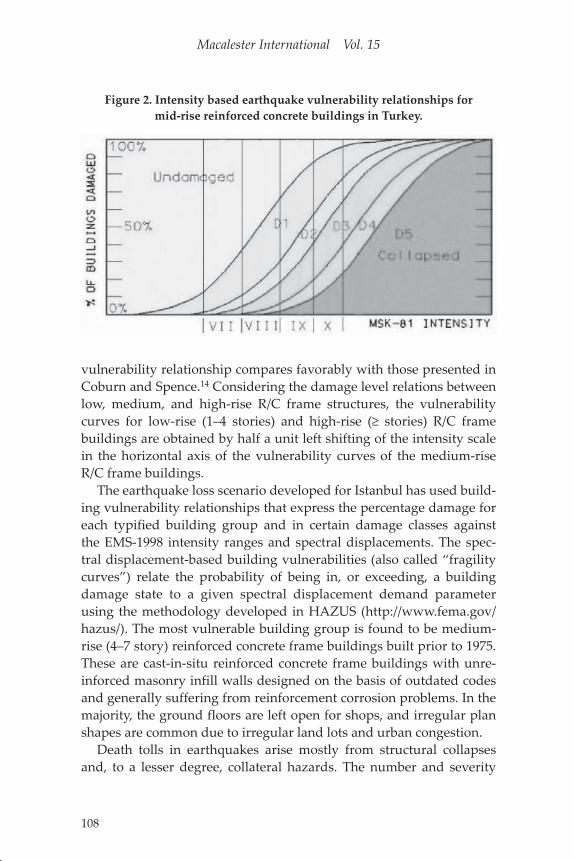
Based on available empirical data as well as compilations from refer-enced works and engineering interpretations, the vulnerability curves for the general mid-rise (4–8 story) R/C frame buildings in Turkey are provided in Figure 2. The horizontal axis indicates the range (uncer-tainty) of MSK intensities and the vertical scale indicates the percent-age loss for the five different damage grades, D1 through D5. This
Macalester International Vol. 15
108
vulnerability relationship compares favorably with those presented in Coburn and Spence.14 Considering the damage level relations between low, medium, and high-rise R/C frame structures, the vulnerability curves for low-rise (1–4 stories) and high-rise (≥ stories) R/C frame buildings are obtained by half a unit left shifting of the intensity scale in the horizontal axis of the vulnerability curves of the medium-rise R/C frame buildings.
The earthquake loss scenario developed for Istanbul has used build-ing vulnerability relationships that express the percentage damage for each typified building group and in certain damage classes against the EMS-1998 intensity ranges and spectral displacements. The spec-tral displacement-based building vulnerabilities (also called “fragility curves”) relate the probability of being in, or exceeding, a building damage state to a given spectral displacement demand parameter using the methodology developed in HAZUS (http://www.fema.gov/hazus/). The most vulnerable building group is found to be medium-rise (4–7 story) reinforced concrete frame buildings built prior to 1975. These are cast-in-situ reinforced concrete frame buildings with unre-inforced masonry infill walls designed on the basis of outdated codes and generally suffering from reinforcement corrosion problems. In the majority, the ground floors are left open for shops, and irregular plan shapes are common due to irregular land lots and urban congestion.
Death tolls in earthquakes arise mostly from structural collapses and, to a lesser degree, collateral hazards. The number and severity
Figure 2. Intensity based earthquake vulnerability relationships for mid-rise reinforced concrete buildings in Turkey.
Mustafa Erdik
109
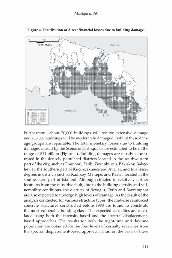
Table 2. Casualty Rates for Reinforced Concrete Structures for Istanbul
Casualty Rates for R/C structures (%)
Injury SeverityLow
DamageMedium Damage
Heavy Damage
Very Heavy Damage
Severity 1 0.050 0.20 1 10–50Severity 2 0.005 0.02 0.50 08–15Severity 3 0 0 0.01 04–10Severity 4 0 0 0.01 04–10
of casualties are strongly related to the extent of both structural and non-structural building damage. In smaller earthquakes, non-struc-tural damages govern the number and type of casualties, whereas in stronger shakings, casualties are highly affected by structural dam-ages, especially by the number of partially or totally collapsed struc-tures. One of the major inputs necessary for earthquake casualty estimation is a correlation between the number and severity of injuries and the damage level of the structures. This, however, is not easily attainable due to the poor quality or lack of information in earthquake casualty data. Casualty for any given structure type, building damage level, and injury severity level can be calculated by the multiplication of Population per Building, Number of Damaged Buildings, and the Casualty Rate. Casualty rates for different building types are estab-lished in HAZUS99 for urban settings in the United States. For other urban settings, appropriate casualty rates need to be developed using empirical earthquake damage and casualty data. The casualty rates for reinforced concrete structures in Turkey are given in Table 2.
The percentages given in the table above are to be multiplied by the number of people in the building at the time of the earthquake. Two different values are given in the column “Very Heavy Damage.” The smaller values are associated with the partial collapse of the building, whereas the larger values are given for total collapse (of the “pancake” type).
G. Physical and Human Losses Due to Earthquake
In order to perform building damage and loss analysis, the building inventory stock database should be provided for each geo-cell. The seismic hazard information in terms of intensities for Intensity-based analysis and spectral accelerations for Spectral Displacement-based analysis should also be aggregated at the center of the geo-cells (400 m
Macalester International Vol. 15
110
by 600 m). To compute the damage probability ratios intensity-based vulnerabilities and/or spectral displacement-based fragility curves for vulnerabilities associated with each building, class type should be specified. Economic losses associated with the general building stock are estimated using the building damage losses and costs for different structural damages of each building group. In order to estimate the number and severity of the casualties, the day and night-time popula-tion for each building type in geo-cells should be provided, together with the casualty rates for each building class and damage grade.
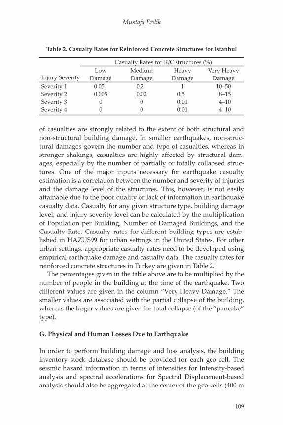
On the basis of the two independent approaches (intensity-based and spectral displacement-based), a total of 35,000 to 40,000 build-ings (about 5% of the total building stock) were estimated damaged beyond repair. Most of the casualties are expected in this damage group, especially in a subset of this group where the collapse will be of the worst pancake form. In pancaked buildings the floors pile up on top of each other, rendering very difficult conditions for search and rescue. Our estimate for pancaked buildings will be in the vicin-ity of 5,000 to 6,000. The expected building damages, calculated by the intensity-based deterministic approach, is provided in Figure 3.
Figure 3. Intensity based distribution of all buildings damaged beyond repair (complete damage).
Mustafa Erdik
111
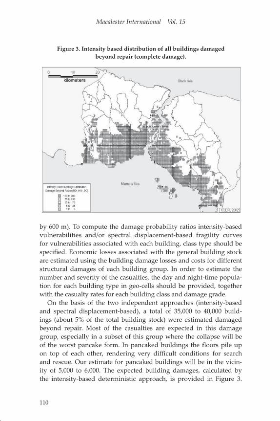
Furthermore, about 70,000 buildings will receive extensive damage and 200,000 buildings will be moderately damaged. Both of these dam-age groups are repairable. The total monetary losses due to building damages caused by the Scenario Earthquake are estimated to be in the range of $11 billion (Figure 4). Building damages are mostly concen-trated in the densely populated districts located in the southwestern part of the city, such as Eminönü, Fatih, Zeytinburnu, Bakirköy, Bahçe-lievler, the southern part of Küçükçekmece and Avcilar, and to a lesser degree, in districts such as Kadiköy, Maltepe, and Kartal, located in the southeastern part of Istanbul. Although situated in relatively farther locations from the causative fault, due to the building density and vul-nerability conditions, the districts of Beyoglu, Eyüp and Bayrampasa are also expected to undergo high levels of damage. As the result of the analysis conducted for various structure types, the mid-rise reinforced concrete structures constructed before 1980 are found to constitute the most vulnerable building class. The expected casualties are calcu-lated using both the intensity-based and the spectral displacement-based approaches. The results for both the night-time and daytime population are obtained for the four levels of casualty severities from the spectral displacement-based approach. Thus, on the basis of these
Figure 4. Distribution of direct financial losses due to building damage.
Macalester International Vol. 15
112
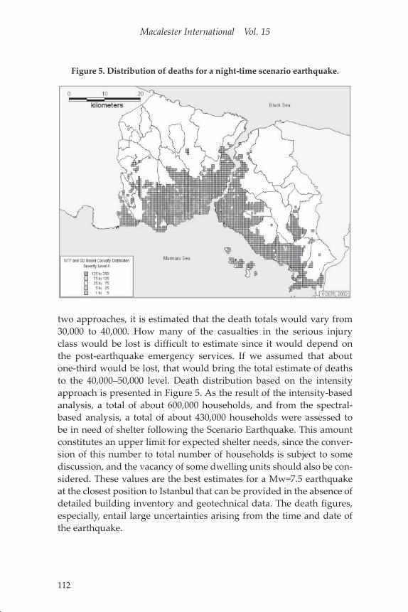
two approaches, it is estimated that the death totals would vary from 30,000 to 40,000. How many of the casualties in the serious injury class would be lost is difficult to estimate since it would depend on the post-earthquake emergency services. If we assumed that about one-third would be lost, that would bring the total estimate of deaths to the 40,000–50,000 level. Death distribution based on the intensity approach is presented in Figure 5. As the result of the intensity-based analysis, a total of about 600,000 households, and from the spectral-based analysis, a total of about 430,000 households were assessed to be in need of shelter following the Scenario Earthquake. This amount constitutes an upper limit for expected shelter needs, since the conver-sion of this number to total number of households is subject to some discussion, and the vacancy of some dwelling units should also be con-sidered. These values are the best estimates for a Mw=7.5 earthquake at the closest position to Istanbul that can be provided in the absence of detailed building inventory and geotechnical data. The death figures, especially, entail large uncertainties arising from the time and date of the earthquake.
Figure 5. Distribution of deaths for a night-time scenario earthquake.
Mustafa Erdik
113
H. Istanbul Earthquake Rapid Response and Early Warning System
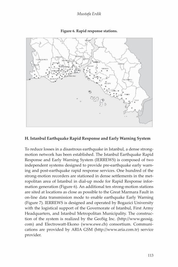
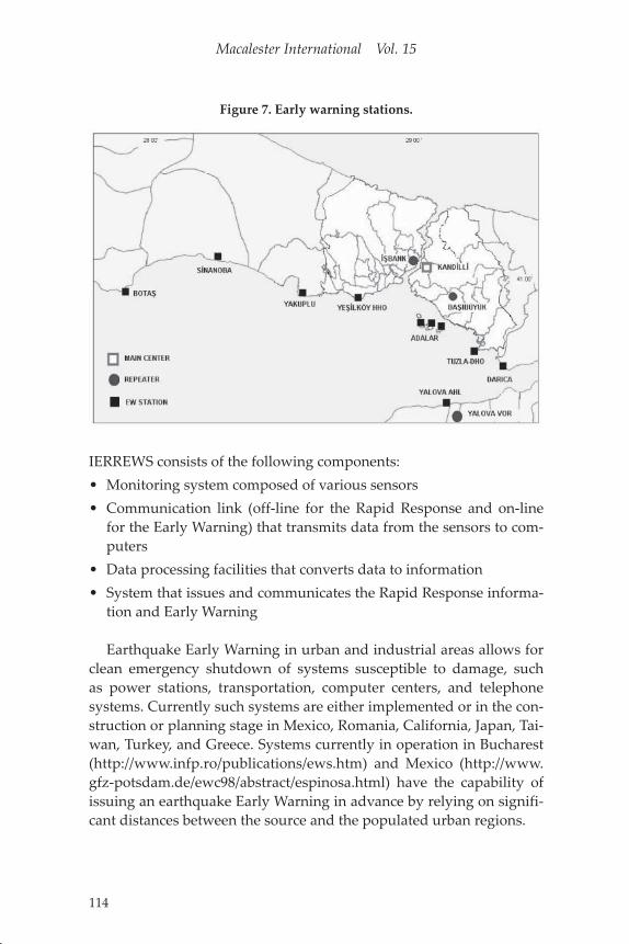
To reduce losses in a disastrous earthquake in Istanbul, a dense strong-motion network has been established. The Istanbul Earthquake Rapid Response and Early Warning System (IERREWS) is composed of two independent systems designed to provide pre-earthquake early warn-ing and post-earthquake rapid response services. One hundred of the strong-motion recorders are stationed in dense settlements in the met-ropolitan area of Istanbul in dial-up mode for Rapid Response infor-mation generation (Figure 6). An additional ten strong-motion stations are sited at locations as close as possible to the Great Marmara Fault in on-line data transmission mode to enable earthquake Early Warning (Figure 7). IERREWS is designed and operated by Bogazici University with the logistical support of the Governorate of Istanbul, First Army Headquarters, and Istanbul Metropolitan Municipality. The construc-tion of the system is realized by the GeoSig Inc. (http://www.geosig.com) and Electrowatt-Ekono (www.ewe.ch) consortium. Communi-cations are provided by ARIA GSM (http://www.aria.com.tr) service provider.
Figure 6. Rapid response stations.
Macalester International Vol. 15
114
IERREWS consists of the following components:• Monitoring system composed of various sensors• Communication link (off-line for the Rapid Response and on-line
for the Early Warning) that transmits data from the sensors to com-puters
• Data processing facilities that converts data to information• System that issues and communicates the Rapid Response informa-
tion and Early Warning
Earthquake Early Warning in urban and industrial areas allows for clean emergency shutdown of systems susceptible to damage, such as power stations, transportation, computer centers, and telephone systems. Currently such systems are either implemented or in the con-struction or planning stage in Mexico, Romania, California, Japan, Tai-wan, Turkey, and Greece. Systems currently in operation in Bucharest (http://www.infp.ro/publications/ews.htm) and Mexico (http://www.gfz-potsdam.de/ewc98/abstract/espinosa.html) have the capability of issuing an earthquake Early Warning in advance by relying on signifi-cant distances between the source and the populated urban regions.
Figure 7. Early warning stations.
Mustafa Erdik
115
I. Rapid Response System
The Rapid Response component of IERREWS has the objective of pro-viding:• Reliable information for accurate, effective characterization of the
shaking and damage by other rapid post-earthquake maps (Shake, Damage, and Casualty maps) for rapid response
• Recorded motion for post-earthquake performance analysis of struc-tures
• Empirical basis for long-term improvements in seismic microzona-tion, seismic provisions of building codes and construction guide-lines
• Seismological data to improve the understanding of earthquake generation at the source and seismic wave propagation
Current examples internationally are the Rapid Response sys-tems implemented in California (USGS, Caltech, and CDMG TriNet ShakeMaps—http://www.trinet.org/shake/, Caltech-USGS Broadcast of Earthquakes (CUBE) System http://www.gps.caltech.edu/~bryant/cube.html, UC Berkeley Seismological Laboratory and USGS Menlo Park (REDI) www.seismo.berkeley.edu/seismo/redi), Taiwan (Earth-quake Rapid Reporting System of CWB http://www.earth.sinica.edu.tw/cdr/IASPEI/data/cwb/rapid.html) and Japan (Real-time Earthquake Assessment Disaster System in Yokohama—READY—http://www.city.yokohama.jp/me/bousai/dppc/handout-e.html).
The Istanbul Earthquake Rapid Response system satisfies the COS-MOS (Consortium of Organizations for Strong-Motion Observation Systems) Urban Strong-Motion Reference Station Guidelines (www.cosmos-eq.org) for the location of instruments, instrument specifi-cations, and housing specifications. The relative instrument spacing is about 2–3 km, which corresponds to about 3 wavelengths in firm ground conditions and more than 10 wavelengths for soft soils for hor-izontally propagating 1 s shear waves. Strong-motion instruments are generally located at grade level in small- and medium-sized buildings, such that the motion recorded corresponds to that on the ground in the surrounding area. Site geology at stations has been characterized in general terms. Certain stations have borehole data. New borehole sur-veys for other stations are being planned. For communication of data from the rapid response stations to the data processing center, and
Macalester International Vol. 15
116
for instrument monitoring, a reliable and redundant GSM commu-nication system (backed up by dedicated landlines and a microwave system) is used, on the basis of a protocol agreement with the ARIA GSM Service provider. In normal times, the Rapid Response stations are being interrogated (for health and instrument monitoring) on a regular basis. Triggered by an earthquake, each station will process the streaming three-channel strong-motion data to yield the spectral accel-erations at specific periods, 12 Hz filtered peak ground acceleration and peak ground velocity, and will send these parameters in the form of SMS messages at every 20 s directly to the main data center through the GSM communication system. The main data processing center is located in the Department of Earthquake Engineering, Kandilli Obser-vatory and Earthquake Research Institute, Bogazici University (KOERI-BU). A secondary center, located in the Seismological Laboratory of the same Institute, serves as a redundant center that can function in case of failure in the main one. Shake, damage, and casualty distribution maps will be automatically generated at the data centers after an earth-quake and communicated to the end users within three minutes. Full-recorded waveforms at each station can be retrieved using GSM and GPRS modems subsequent to an earthquake.
For the generation of Rapid Response information, two method-ologies based on spectral displacements and instrumental intensities are coded into specific computer programs similar to HAZUS (http://www.fema.gov/hazus/). Both of the methodologies essentially rely on the building inventory database, fragility curves, and the methodol-ogy developments in the Istanbul Earthquake Risk Assessment Study conducted by the Department of Earthquake Engineering of Bogazici University.
For the computation of input ground motion parameters, spectral displacements obtained from the SMS messages sent from stations are interpolated to determine the spectral displacement values at the center of each geo-cell, using two-dimensional splines. The earthquake demand at the center of each geo-cell is computed using these spectral displacements. The instrumental intensity at each center of these geo-cells is computed as a function of short-period spectral acceleration. Using the response spectra and the instrumental intensities, building damage and casualties are computed separately by using the spectral displacement-based and intensity-based fragility curves. The compu-tations are conducted at the centers of a 0.01°×0.01° grid system com-prised of geo-cells (1120 m×830 m) size. The building inventories (in 24

Mustafa Erdik
117
groups) for each geo-cell, together with their spectral displacement and intensity-based fragility curves, are incorporated into the software.
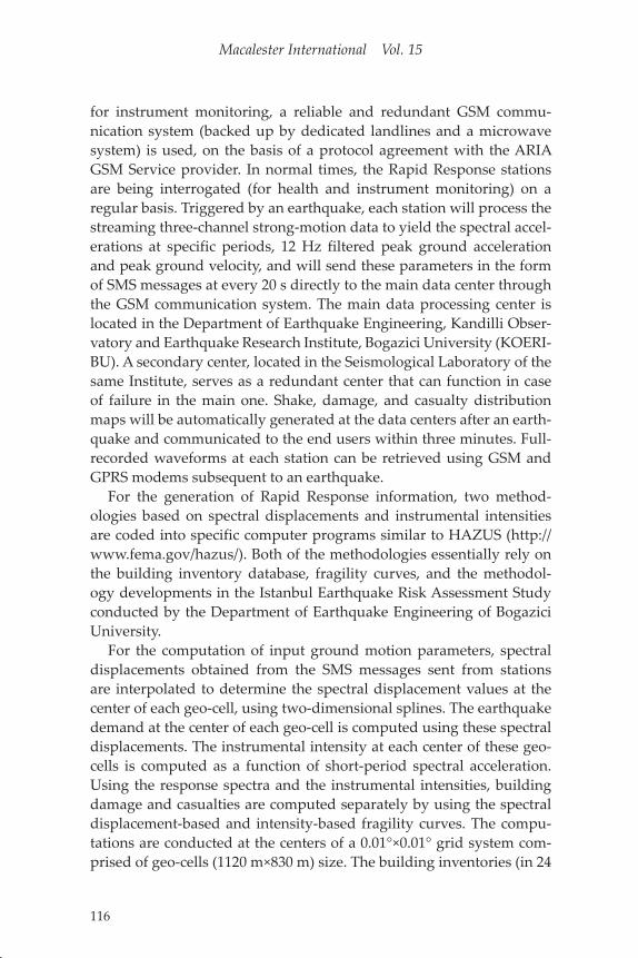
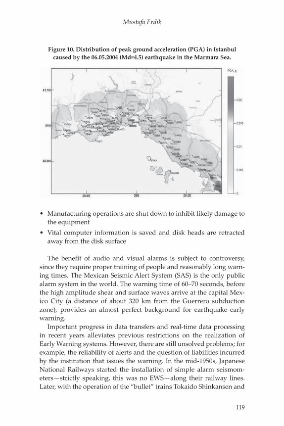
The casualties are estimated on the basis of the number of collapsed buildings and degree of damage. An example of a building damage map that results from randomly simulated strong-motion data is pro-vided in Figure 8. For transmission of the Rapid Response information to the concerned agencies (Istanbul Governorate, Istanbul Municipal-ity, and First Army Headquarters) digital radio modem and GPRS communication systems are used (Figure 9). The Rapid Response sys-tem was successfully tested by the 06.05.2004 (Md=4.5) earthquake in the Marmara Sea. The distribution of Peak Ground Acceleration (PGA) in Istanbul caused by this earthquake is provided in Figure 10. Although this earthquake is recorded by 80% of the stations, needless to say it is not large enough to cause any damage.
J. Early Warning System
Key to earthquake early warning is a continuous communication link between seismic sensors (ideally deployed close to the seismic source) and a central processing facility. If the incoming ground motion data at the processing unit is classified as critical, the system issues a warning
Figure 8. Examples of building damage map that results from a randomly simulated strong motion data.
Macalester International Vol. 15
118
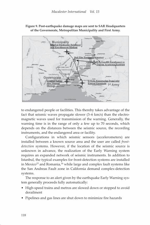
to endangered people or facilities. This thereby takes advantage of the fact that seismic waves propagate slower (3–6 km/s) than the electro-magnetic waves used for transmission of the warning. Generally, the warning time is in the range of only a few up to 70 seconds, which depends on the distances between the seismic source, the recording instruments, and the endangered area or facility.
Configurations in which seismic sensors (accelerometers) are installed between a known source area and the user are called front-detection systems. However, if the location of the seismic source is unknown in advance, the realization of the Early Warning system requires an expanded network of seismic instruments. In addition to Istanbul, the typical examples for front-detection systems are installed in Mexico15 and Romania,16 while large and complex fault systems like the San Andreas Fault zone in California demand complex-detection systems.
The response to an alert given by the earthquake Early Warning sys-tem generally proceeds fully automatically:• High-speed trains and metros are slowed down or stopped to avoid
derailment• Pipelines and gas lines are shut down to minimize fire hazards
Figure 9. Post-earthquake damage maps are sent to SAR Headquarters of the Governorate, Metropolitan Municipality and First Army.
Mustafa Erdik
119
• Manufacturing operations are shut down to inhibit likely damage to the equipment
• Vital computer information is saved and disk heads are retracted away from the disk surface
The benefit of audio and visual alarms is subject to controversy, since they require proper training of people and reasonably long warn-ing times. The Mexican Seismic Alert System (SAS) is the only public alarm system in the world. The warning time of 60–70 seconds, before the high amplitude shear and surface waves arrive at the capital Mex-ico City (a distance of about 320 km from the Guerrero subduction zone), provides an almost perfect background for earthquake early warning.
Important progress in data transfers and real-time data processing in recent years alleviates previous restrictions on the realization of Early Warning systems. However, there are still unsolved problems; for example, the reliability of alerts and the question of liabilities incurred by the institution that issues the warning. In the mid-1950s, Japanese National Railways started the installation of simple alarm seismom-eters—strictly speaking, this was no EWS—along their railway lines. Later, with the operation of the “bullet” trains Tokaido Shinkansen and
Figure 10. Distribution of peak ground acceleration (PGA) in Istanbul caused by the 06.05.2004 (Md=4.5) earthquake in the Marmara Sea.
Macalester International Vol. 15
120
Tohoku Shinkansen, this front alarm system was improved and alarm seismometers were installed every 20 km along the lines. The stations issue a warning whenever a preset level of horizontal ground accelera-tion (40 gal) is exceeded. Trains in the vicinity of the respective alarm stations are automatically slowed down or stopped in order to avoid derailments. The contemporary Japanese Urgent Earthquake Detection and Alarm System (UrEDAS) consists of 30 strong-motion instruments capable of determining the area of sustained damage, using informa-tion about magnitude and hypocenter obtained from P-wave observa-tions (“P-wave alarm”). Ordinary alarm seismometers and UrEDAS are combined into the Japanese “Compact UrEDAS.”
In the Early Warning part of the IERREWS, ten strong-motion sta-tions are located as close as possible to the Great Marmara Fault in “on-line” mode. Continuous telemetry of data between these stations and the main data center is realized with a digital spread spectrum radio modem system involving repeater stations selected in the region (Figure 7). Considering the complexity of fault rupture and the short fault distances involved, a simple and robust Early Warning algorithm, based on the exceeding of specified threshold time domain amplitude levels, is implemented. The band-pass filtered accelerations and the cumulative absolute velocity (CAV-time integral of the absolute accel-eration) are compared with specified threshold levels. When any accel-eration or CAV (on any channel) in a given station exceeds specific selectable threshold values it is considered a vote. Whenever we have two or three (selectable) station votes within a selectable time inter-val, after the first vote, the first alarm is declared. The early warning information (consisting of three alarm levels) will be communicated to the appropriate servo shutdown systems of the recipient facilities, which will automatically decide proper action based on the alarm level. Depending on the location of the earthquake (initiation of fault rupture) and the recipient facility, the alarm time can be as high as about 8 s.
IV. Structural Health Monitoring
Instrumentation of the critical structures with earthquake strong-ground-motion recorders monitor the vibrations (i.e., the structural response) during an earthquake. Comparison of these recordings with those taken before the earthquake can yield variations in structural response, with implications for structural damage and reduction of
Mustafa Erdik
121
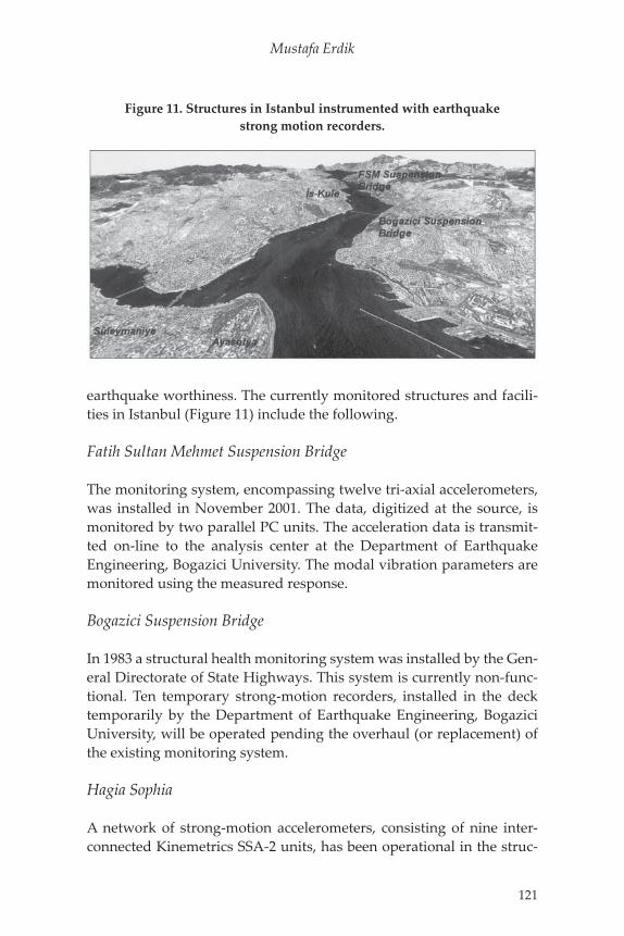
earthquake worthiness. The currently monitored structures and facili-ties in Istanbul (Figure 11) include the following.
Fatih Sultan Mehmet Suspension Bridge
The monitoring system, encompassing twelve tri-axial accelerometers, was installed in November 2001. The data, digitized at the source, is monitored by two parallel PC units. The acceleration data is transmit-ted on-line to the analysis center at the Department of Earthquake Engineering, Bogazici University. The modal vibration parameters are monitored using the measured response.
Bogazici Suspension Bridge
In 1983 a structural health monitoring system was installed by the Gen-eral Directorate of State Highways. This system is currently non-func-tional. Ten temporary strong-motion recorders, installed in the deck temporarily by the Department of Earthquake Engineering, Bogazici University, will be operated pending the overhaul (or replacement) of the existing monitoring system.
Hagia Sophia
A network of strong-motion accelerometers, consisting of nine inter-connected Kinemetrics SSA-2 units, has been operational in the struc-
Figure 11. Structures in Istanbul instrumented with earthquake strong motion recorders.
Macalester International Vol. 15
122
ture since August 1991 as part of the effort to determine its earthquake worthiness. The instruments cover three levels. One instrument is at the ground level; four are located at the cornice level next to the spring-ing points of the four main arches; and four are at the dome base level on the crowns of the main arches.
Suleymaniye
An accelerometer system consisting of eight individual Kinemetrics SSA-2 units operated in the Süleymaniye mosque between 1994 and 1999. The system was replaced by an interconnected array of eight GeoSig recorders in 1999. The positioning of the instruments is simi-lar to the Hagia Sophia array except that there is no instrument at the ground level.
Enron Power Plant
The earthquake monitoring network system for Enron-Trakya Elek-trik Power Plant facilities includes eight on-line strong-ground-motion recorders distributed at critical locations within the industrial facility. The recorders are connected on-line to the main processing center to send nearly real-time data packets.
Is Bank Tower
Earthquake monitoring and alert systems were designed and installed to monitor the structural response and to generate earthquake alarm signals for the building facilities and emergency system. For this pur-pose, four GSR-18 strong-ground-motion stations are utilized. The operational system is similar to that employed for the Enron Power Plant.
V. Conclusions
The effectiveness of using or disregarding earthquake risk mitigation techniques—building rehabilitation, adoption and enforcement of seis-mic provisions in building codes, prudent community growth, and improved disaster response capabilities—are well known and have been demonstrated in Turkish cities and also throughout the world. The focal element of these mitigation activities is a technically sound
Mustafa Erdik
123
state-of-the-art assessment of the various levels of losses. Only by comprehending the consequences of earthquake losses in Istanbul can decisions be made at the governmental level about mitigation priori-ties and optimal approaches.
In order to create an earthquake resilient city and society, earth-quake hazard mitigation strategies, such as rehabilitation of existing vulnerable buildings, development of appropriate zoning ordinances, and enforcement of earthquake building codes, should be enforced. They would serve as a countermeasure against earthquake losses indi-cated in the loss estimation study. In addition, the planning for con-tingency measures—such as identification of alternate transportation routes, emergency response and recovery, identification of emergency shelter locations, availability of medical services, food, water and other essential utilities, and Rapid Response-Early Warning systems—needs to be maximized. �•
Notes1. Erdik et al. 2003.2. http://www.koeri.boun.edu.tr/depremmuh/EXEC_ENG.pdf and Erdik et al. 2003.3. Armijo et al. 1999.4. Ambraseys and Finkel 1991.5. Durukal and Erdik 1994.6. Erdik 2001.7. Gruenthal 1998.8. Erdik et al.. 2004.9. Parsons et al. 2000.10. Erdik et al. 2003.11. Ibid.12. Erdik et al. 1985.13. Evernden and Thomson 1985.14. Coburn and Spence 1992.15. Espinosa Aranda et al. 2003.16. Wenzel et al. 1999.
BibliographyAmbraseys, N. N., and C. F. Finkel. “Long-term Seismicity of Istanbul and of the Mar-mara Sea Region.” Terra Nova 3 (1991): 527–539.Durukal, E., and M. Erdik. “Strong Motion Instrumentation of Aya Sofya and the Analy-sis of Earthquake Response.” Proceedings of the Fifth U. S. National Conference on Earthquake Engineering, Chicago (July 10–14 1994): 343–352.
Macalester International Vol. 15
124
Erdik, M. “Istanbul: Emergency Action Plan.” In Informal Settlements, Environmental Deg-radation and Disaster Vulnerability: The Turkey Case Study, edited by R. Parker, A. Kreimer and M. Munasinghe. World Bank Publication, 1995.―――. “Report on 1999 Kocaeli and Duzce (Turkey) Earthquakes.” In Structural Control for Civil and Infrastructure Engineering, edited by F. Casciati and G. Magonette. World Scientific, 2001.Erdik, M., V. Doyuran, P. Akkas, and P. Gulkan. “Assessment of the Earthquake Hazard in Turkey and Neighboring Regions.” Tectonophysics 117 (1985): 295–344.Erdik, M., N. Aydinoglu, Y. Fahjan, K. Sesetyan, M. Demircioglu, B. Siyahi, E. Durukal, C. Ozbey, Y. Biro, H. Akman, and O.Yuzugullu. “Earthquake Risk Assessment for Istan-bul Metropolitan Area,” Earthquake Engineering and Engineering Vibration 2, no. 1 (June 2003): 1–25.Erdik, M., M. Demircioglu, K. Sesetyan, E. Durukal, and B. Siyahi. “Probabilistic Assess-ment of Earthquake Hazard in Marmara Region.” Soil Dynamics and Earthquake Engineer-ing. September 2004.Espinoza-Aranda, J., and F. H. Rodriquez-Cayeros. “The Seismic Alert System of Mexico City.” In International Handbook of Earthquake and Engineering Seismology, edited by W. H. K. Lee, H. Kanamori, P. C. Jennings, and C. Kisslinger. Academic Press, 2003, pp. 1253–1260.Evernden, J. F., and J. M. Thomson. “Predicting Seismic Intensities.” U. S. Geological Survey Profes. Paper 1360 (1985): 151–202.Gruenthal, G. “European Macroseismic Scale 1998.” Cahiers du Centre Européen de Géody-namique et de Séismologie 15 (1998): 99.HAZUS. “Earthquake Loss Estimation Methodology, Technical Manual, RMS, NIBS and FEMA.” 1999.IDNDR-Radius. http://www.reliefweb.int/ocha_ol/programs/idndr/radius.html.NEHRP. “Recommended Provisions for Seismic Regulations for New Buildings and Other Structures, FEMA-303.” Prepared by the Building Seismic Safety Council for the Federal Emergency Management Agency, Washington, D. C., 1997.Parsons, T., S. Toda, R. S. Stein, A. Barka, and J. H. Dietrich. “Heightened Odds of a Large Earthquake near Istanbul: An Interaction-Based Probability Calculation.” Science, 2000.Wenzel, F., D. Lungu, and O. Novak, eds. “Vrancea Earthquakes: Tectonics, Hazard and Risk Mitigation.” Selected Papers of the First International Workshop on Vrancea Earthquakes, Bucharest, November 1–4, 1997. Dordrecht, Netherlands: Kluwer Aca-demic Publishers, 1998, p. 374.Youd, L., and D. M. Perkins. “Mapping of Liquefaction Induced Ground Failure Poten-tial.” J. GED, ASCE 104, no. 4 (1978): 433–446.