Embed Size (px)
Citation preview


SquirrelPrints
Introduction
Time and Distance
The Trail
Welcome to Calabogie Peaks Resort! We hope during your stay you will findsome time to get out and explore. A great way to discover one of the naturalwonders of our area is to visit Eagle's Nest, a spectacular site with an awesomepanoramic view of the Madawaska wilderness. This guide booklet and map isintended to bring you there. So tie up your hiking boots and get set to guideyourself upon an enjoyable journey!
Walking at a normal and relaxed pace, the return hike to Eagle's Nest will take youaround 2.5 to 3 hours. The trail is 4 kilometres there and then 4 kilometres backfor a total of 8 kms. The initial section of the trail is uphill so please take your timeand go at a pace you are comfortable with. You don't want to get too tired beforearriving at the best part of the hike!
The route to Eagle's Nest uses old logging roads. These roads were formerlyused to harvest hardwood and pine logs from the area. The trail is not used forlogging anymore but there is still occasional motorized use by people on all-terrain-vehicles, motorbikes and 4 wheel drive trucks. Of course, there are alsopeople exploring the area by bicycle and on foot.
Most of the route you will be hiking upon is crown land which is public ownedproperty. Simply keep an ear open for motorized vehicles so you may step off thetrail if needed. Don't be surprised if others on the trail stop to talk with you and askyou how you are doing! It's just a local custom.
Journal / Notes
___________________________________________________
___________________________________________________
___________________________________________________
___________________________________________________
___________________________________________________
___________________________________________________
___________________________________________________
___________________________________________________
___________________________________________________
___________________________________________________
___________________________________________________
___________________________________________________
___________________________________
___________________________________
___________________________________
___________________________________
RaccoonPrints
PorcupinePrints

What to wear and bring
Items to bring along in your backpack
Wear sturdy shoes or hiking boots and dress for the day's anticipated weather. Yourhike is 2.5 to 3 hours in length and the weather could change in that time. Even thoughyou may be warm, it is advised that you wear long pants, a long sleeved shirt and a hat tohelp prevent you from getting mosquito and deer-fly bites. Light coloured clothing worksbest. It’s always good to carry insect repellent with you to use as needed.
Carry a raincoat in your backpack if you feel it may rain. Bring a sweater with you if youfeel it may get cooler or if you are setting out for a hike later in the day. It is alsoimportant that you bring an ample supply of drinking water with you to preventdehydration especially on sunny or humid days. Trail snacks or a trail lunch is a greatidea to keep your energy levels up. Eagle's Nest is a great place to enjoy your packedlunch!
Drinking water (2 bottles per person)Trail lunch or snacks (cereal bars, fruit, juice, cookies, candy bars etc.)Insect repellentHatSunglassesRaincoatSweater or light jacketExtra socksCameraBinocularsThis guideToilet paper or tissueMedications that you may need
NOTE: If you are heading out on a hike after your evening meal,it is a good idea to bring a working flashlight with fresh batteriesIn the event you need it to see on your way back.
PLEASE DO NOT LITTER.
Journal / Notes
___________________________________________________
___________________________________________________
___________________________________________________
___________________________________________________
___________________________________________________
___________________________________________________
___________________________________________________
___________________________________________________
___________________________________________________
___________________________________________________
___________________________________________________
___________________________________________________
___________________________________________________
___________________________________________________
___________________________________________________
___________________________________________________
Beaver Footprints
Hiking Tips
Wildlife
Safety first! Please inform someone in your family or group that you are about to hike outto Eagle’s Nest and give them a rough estimate of your anticipated return time. It is ALSOsuggested that you let a staff member at the Adventure Centre know of your hikingintentions and of your anticipated return time.
Once you are out hiking on the trail, TAKE YOUR TIME. Set your own pace and take iteasy going up any hills. Rest as often as your body tells you to rest. This is an 8 km hikeand you don't want to burn yourself out.
If you set out as a group, keep in mind that the entire group needs to hike at a pace thatcan be maintained by everyone. Sometimes this means that the pace for the entire groupwill be the pace set by the slowest hiker.
On your way watch and listen for birds, animals, insects, reptiles and interesting forestfeatures and plants. You might find interesting feathers. If you are hoping to observewildlife, the quieter you are the better. Generally, if it is drizzling or raining there won't bemany flies to bother you. Muddy spots on the trail are great places to look for animaltracks!
Your chances of seeing birds and small animals are quite good especially if you are quiet.If you don't really desire to see any wildlife just be as loud and noisy as possible!Animals you might see while hiking are the red squirrel, chipmunk, deer mouse, stripedskunk, ruffed grouse, raccoon, porcupine, snowshoe hare, mink, muskrat, beaver, riverotter, red fox, coyote, mink, pine marten, weasel and fisher. Plentiful in this area, themost common large animal that you may see are white-tailed deer. On occasion, amoose has strolled through this area too! Check out some of their footprints in this hikingguide!
Although coyotes, timber wolves, cougars and black bears are wildlife residents of thisarea, your chances of actually seeing them in the forest are extremely rare. Sometimeswe only know these animals are present at all is because of their tracks.
If elusive animals like bears are present, they usually know you are around well beforeyou're even aware of them and will be long gone before you even get a chance to seethem. Most animals are more afraid of humans (for good reason) than we are of them!
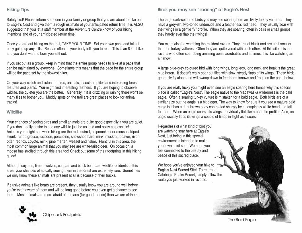
Birds you may see “soaring” at Eagle's Nest
The large dark-coloured birds you may see soaring here are likely turkey vultures. Theyhave a grey-ish, two-toned underside and a featherless red head. They usually soar withtheir wings in a gentle “V” profile. When they are soaring, often in pairs or small groups,they hardly ever flap their wings!
You might also be watching the resident ravens. They are jet black and are a bit smallerthan the turkey vultures. Often they are quite vocal with each other. At this site, it is theravens who often soar doing amazing aerial acrobatics and at times, it is like watching anair show!
A large blue-grey coloured bird with long wings, long legs, long neck and beak is the greatblue heron. It doesn't really soar but flies with slow, steady flaps of its wings. These birdsgenerally fly alone and will swoop down to feed for minnows and frogs on the pond below.
If you are really lucky you might even see an eagle soaring here hence why this specialplace is called “Eagle's Nest”. The eagle native to the Madawaska wilderness is the baldeagle. Often a soaring turkey vulture is mistaken for a bald eagle. Both birds are of asimilar size but the eagle is a bit bigger. The way to know for sure if you see a mature baldeagle is it has a dark brown body contrasted sharply by a completely white head and tailfeathers. When an eagle soars, its wings are virtually flat like a board in profile. Also, aneagle usually flaps its wings a couple of times in flight as it soars.
Regardless of what kind of bird youare watching soar here at Eagle'sNest, just being in this specialenvironment is intended to makeyour own spirit soar. We hope youfeel connected to the beauty andpeace of this sacred place.
We hope you've enjoyed your hike toEagle's Nest Sacred Site! To return toCalabogie Peaks Resort, simply follow theroute you just walked in reverse.
The Bald Eagle
Chipmunk Footprints

12. Question
13. “Windthrows”
E. Entrance to Eagle’s Nest Sacred Site -
From what you've learned so far, what kind of pine is this?
A tree that is blown down and uprooted by the wind is called a windthrow because thewind “throws” it! Here you will notice a few pine trees that have been blown down by thewind. Areas in the woods that are higher or more open in tree cover - like this spot on thetrail - are more susceptible to wind damage. The root area of an uprooted tree becomesan instant garden by creating a place of freshly exposed mineral soil now available to avariety of plants and other trees. Fallen trees become logs that create homes for insectsand small animals as they slowly rot and become earth again. Often the exposed rootarea of a windthrow will become a cozy winter shelter for a hibernating bear!
You have reached your destination! On your way up the last part of the trail, you will seethe “Eagle's Nest Sacred Site” sign. For more insight into the essence of the eagle andthe significance of this site please read the sign.
Enjoy the view! Enjoy your stay! Please be very careful while you are here and do not gettoo close to the edge of the cliff. Watch your children like a hawk and please preventthem from running around. Do not let them get close to the edge either.
This spot is the highlight of our area. Relax and take a break. This is a great place to eatyour lunch or a trail snack. You must bring all your food wrappers, papers, baggies, cans,bottles, etc. home with you. And please, do not throw ANYTHING over the edge as therecould be people exploring upon the rocks below.
CAUTION CLIFF AREA
Your Destination - Eagle's Nest
Your Trail Markers
The first inhabitants of this area were the Algonquin and to some extent the Ojibway.They are known more properly as “Anishnabe” in their own language which means“Original People.” To this day, the Anishnabe still regard the eagle as one of the highest,most revered “manitous.” The word manitou means “spirit.” Any place where the manitouof the eagle exists is considered a place of great power and inspiration by the Anishnabepeople.
The ONLY signs that mark the route to Eagle's Nest are the signs with a symbol of acircle with an eagle’s head divided into four sacred colours of yellow, red, black and white.This symbol appears on your map as a compass. Watch for these signs along the way tomake sure you are following the correct route.
Once you arrive at Eagle's Nest, the route back to the resort is the exact same route butyou will simply be walking it in the reverse direction. On your way to Eagle's Nest try to beobservant of things upon the trail that you can recognize again on your way back. Don'tworry, the four coloured signs mark the route back to the resort as well!
In traditional Anishnabe philosophy a circle represents a journey. Whether the journey ismeasured by the hours of a day, moons of a year or the seasons of a lifetime depend onthe awareness level of the traveler. The circle also represents wholeness and theconnectedness of all things.
For your journey to Eagle's Nest, the markers/signsyou are following are done in the four traditional sacredcolours. Each colour symbolizes a direction and alsoserves as a metaphor for a variety of other things fromphysical elements to spiritual essences that all relateto each other as a whole.
Here is how the Anishnabe people teach thefour sacred colours relating to the life journeyof a person:
YELLOW > East > Spring > ChildRED > South > Summer > YouthBLACK > West > Autumn > AdultWHITE > North > Winter > Elder

Along the Way
START -
A. Trailhead
B. Junction - Go LEFT
1. Red Oak
2. Sugar Maple
A on a four coloured trail marker indicates a trail junction you will see on themap.
A on a marker is a natural feature you can read about in text of this booklet thatfollows.
Let's Go!
Start your hike at the green triangular “Snow School” sign located beside the skilodge. Follow the markers up the hill onto the “Ole K & P” ski run. This will bring you tothe Eagle's Nest trailhead sign.
You are now at the beginning of the forested hiking route to Eagle's Nest. Take a break,look behind you and you will see Calabogie Lake in the distance.
As you continue please note that you will still be walking uphill for a few more minutes.Take it easy. If you like, use the next few numbered nature points as opportunities to rest.
Red oak is a coarse grained deciduous hardwood used in the manufacture of furniture,cabinets, cupboards and hardwood flooring. The acorns it produces are eaten bysquirrels, white-tailed deer and black bears.
This is the kind of maple tree thatproduces sweet sap in the springwhich is boiled to make maple syrup.The first European settlers to TurtleIsland (North America) were shownhow to do this by the Anishnabe, the“Original People.” Yellow birch, a birchtree with shaggy golden-yellow bark,also produces a sweet sap that canbe boiled to make delicious syrup.
LETTER
NUMBER
D. Junction - Go RIGHT
9. Tree Fungus
10. Big Tooth Aspen
11. Eastern White Cedar
You are now on the main old road that will take you directly to Eagle's Nest. Please listenand watch for motorized vehicles that may also be using this trail today. Take note of theappearance of this junction so on your way back you will know where to keep LEFT tobring you back to the resort.
This kind of fungus is called an Artist's Painted Shelf Fungus. Note the red coloured bandon the edge of this fungus. Fungi grow upon trees that have wood that is decaying. Inthe “good old days”, when art supplies were expensive and hard to come by, often afungus was removed from a tree by an artist and its top surface was used like a canvasfor an oil painting.
Aspen is also called poplar around here. The name “big tooth” or “large tooth” comes fromthe pointed edges or teeth, visible on the edges of their leaves. Aspen is a hardwood treebut its wood is actually quite soft. It is one of the favourite trees of the beaver, an animalwith big teeth itself! Beavers not only love to eat the newer bark of aspen trees but mustkeep chewing on larger trees, often cutting them down, to keep up with their long frontincisor teeth which are constantly growing!
Not too long ago it was discovered that some of theoldest living trees in Eastern Canada wereeastern white cedars. Extremely old cedarshave been found growing in places whereconditions seem very unsuitable for lifesuch as cliff faces that are hot, dry and exposedto very harsh weather conditions.
On the face of a cliff, growing conditionsmay be tough but as such these cedarsare generally not disturbed by animalsor humans and so are growing in kindof an inaccessible protected zone.Some eastern cedars that have been foundAre 1200 to 1700 years old and still growing!
Take note of the appearance of this cedar tree andhow well its roots snake around and grow into cracks anchoring the tree to rock. Whenyou get to Eagle's Nest, see if you can observe any cedars growing out of the cliff face.Size is deceiving. Some of the oldest cedars on cliffs are often less than 1 or 2 metrestall!
Sugar Maple Branch
White Cedar Branch
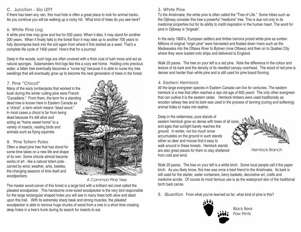
3. White Pine
4. Eastern Hemlock
5. Question
To the Anishnabe, the white pine is often called the “Tree of Life.” Some tribes such asthe Ojibway consider this tree a powerful “medicine” tree. This is due not only to itsmedicinal properties but for its ability to instill inspiration in the human heart. The word forpine in Ojibway is “jingwak”.
In the early 1800's, European settlers and timber barrons prized white pine as lumber.Millions of original “virgin pine” were harvested and floated down rivers such as theMadawaska into the Ottawa River to Bytown (now Ottawa) and then on to Quebec Citywhere they were loaded onto ships and delivered to England.
Walk 20 paces. The tree on your left is a red pine. Note the difference in the colour andtexture of its bark and the density of its needled canopy overhead. The wood of red pine isdenser and harder than white pine and is still used for pine board flooring.
All the large evergreen species in Eastern Canada can live for centuries. The easternhemlock is a tree that often reaches a ripe old age of 600 years! The only other evergreenthat can outlive it is the eastern cedar. Hemlock timbers were used traditionally aswooden railway ties and its bark was used in the process of tanning (curing and softening)animal hides to make into leather.
Deep in the wilderness, pure stands ofeastern hemlock grow so dense with trees of all sizesand ages that sunlight barely reaches theground. In winter, not too much snowaccumulates on the ground in such standseither so deer and moose find it easy towalk around in these forests. Hemlock standsare also great places for them to stay shelteredfrom cold and wind.
Walk 20 paces. The tree on your left is a white birch. Some local people call it the paperbirch. As you likely know, this tree was once a best friend to the Anishnabe. Its bark isstill used for fire starter, water containers, berry baskets, decorative art, crafts andmedicine scrolls. Of course its most famous use is as the waterproof skin of the traditionalbirch bark canoe.
From what you've learned so far, what kind of pine is this?
C. Junction - Go LEFT
6. White Pine Log
7. Pine “Chicot”
8. Pine Totem Poles
If there has been any rain, this mud hole is often a great place to look for animal tracks.As you continue you will be walking up a rocky hill. What kind of trees do you see here?
A white pine tree may grow and live for 500 years. When it dies, it may stand for another200 years. When it finally falls to the forest floor it may take up to another 700 years tofully decompose back into the soil again from where it first started as a seed. That's acomplete life cycle of 1400 years! How's that for a journey!
Deep in the woods, such logs are often covered with a thick coat of lush moss and act asnatural sponges. Salamanders find logs like this a cozy wet home. Holding onto preciouswater, a fallen tree eventually becomes a “nurse log” because it is able to nurse tiny treeseedlings that will eventually grow up to become the next generation of trees in the forest.
Many of the early lumberjacks that worked in thebush during the winter cutting pine were French“Canadiens.” From them, the term for a standingdead tree is known here in Eastern Canada asa “chicot”, a term which means “dead wood.”In most cases a chicot is far from beingdead because it's still alive andacting as “home sweet home” to avariety of insects, nesting birds andanimals such as flying squirrels.
Often a dead pine tree that has stood forsome time takes on a new life and shapeof its own. Some chicots almost becomeworks of art - like a natural totem pole -carved by wind, weather, ants, beetles,the changing seasons of time itself andwoodpeckers.
The master wood-carver of this forest is a large bird with a brilliant red crest called thepileated woodpecker. This handsome crow-sized woodpecker is the very bird responsiblefor the large rectangular shaped holes you will see in many trees both alive and deadupon this trail. With its extremely sharp beak and strong muscles, the pileatedwoodpecker is able to remove huge chunks of wood from a tree in a short time creatingdeep holes in a tree’s trunk during its search for insects to eat.
Hemlock Branch
A Common Pine Tree
Black BearPaw Prints
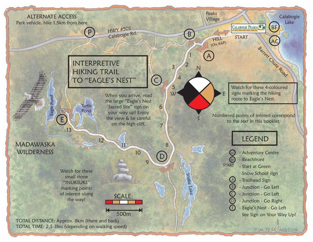
INTERPRETIVE
HIKING TRAIL
TO “EAGLE’S NEST”Watch for these 4-coloured
signs marking the hiking
route to Eagle’s Nest.
SCALE:
500m
Calabogie
Lake
Peaks
Village
TOTAL DISTANCE: Approx. 8km (there and back)
TOTAL TIME: 2.5-3hrs (depending on walking speed)
MADAWASKA
WILDERNESS
Watch for these
small stone
“INUKSUKS”
marking points
of interest along
the way!
ALTERNATE ACCESSPark vehicle, hike 1.5km from here
P
E
D
C
B
A
BF
AC
Turtle
Pond
Eagle
Po
nd
Snake
Lake
Barrett ChuteRoad
START
HWY #508
Calabogie Rd.
When you arrive, read
the large “Eagle’s Nest
Sacred Site” sign on
your way up! Enjoy
the view & be careful
on the high cliff.
13
1211
10
9
8
7
6
5
4
3 2
1
Numbered points of interest correspond
to the text in this booklet.
LEGEND
- Adventure Centre
- Beachfront
- Start at Green
Snow School sign
- Trailhead Sign
- Junction - Go Left
- Junction - Go Left
- Junction - Go Right
- Eagle’s Nest - Go Left
See Sign on Your Way Up!
BF
AC
START
E
D
C
B
A
W E
S
N
HILL
(Ole K&P)