Embed Size (px)
Citation preview
EAST DON TRAIL ENVIRONMENTAL ASSESSMENT
Community Liaison CommitteeMeeting #3July 15, 20136:30 to 8:30 pmFlemingdon Park Library
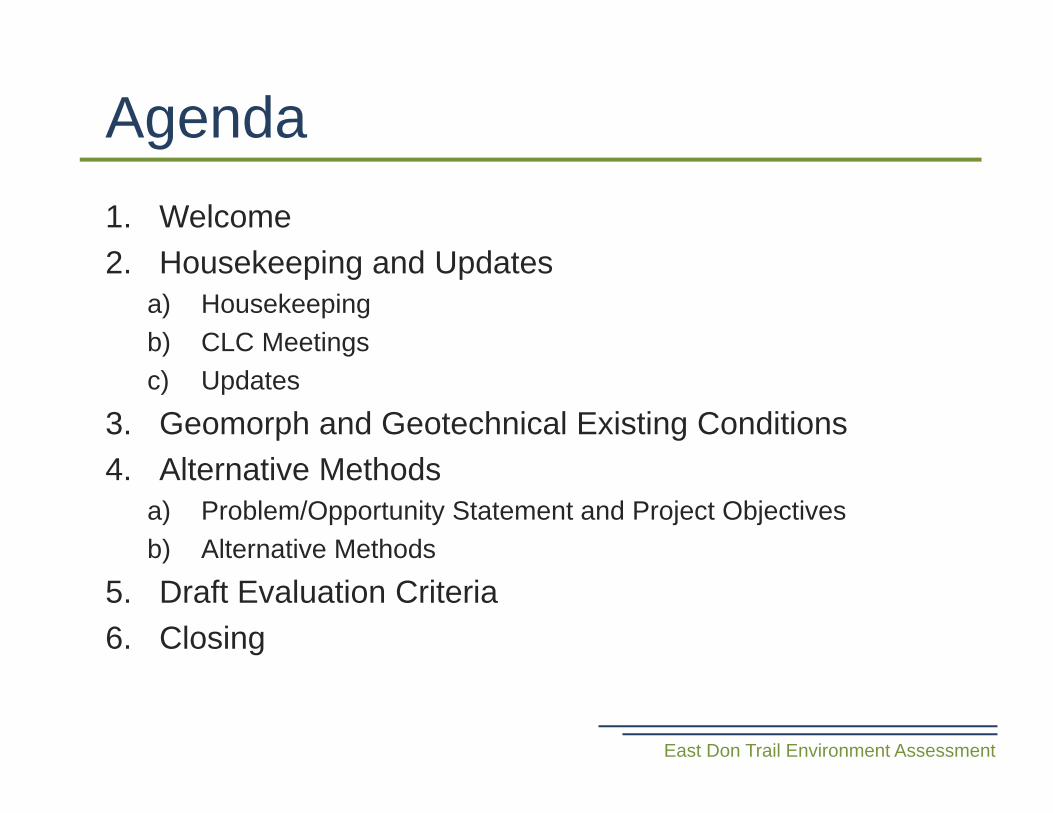
1. Welcome 2. Housekeeping and Updates
a) Housekeepingb) CLC Meetingsc) Updates
3. Geomorph and Geotechnical Existing Conditions4. Alternative Methods
a) Problem/Opportunity Statement and Project Objectivesb) Alternative Methods
5. Draft Evaluation Criteria6. Closing
Agenda
East Don Trail Environment Assessment
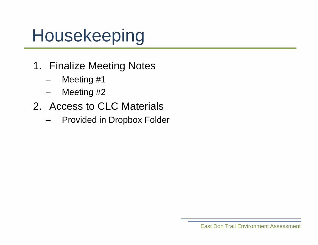
Housekeeping
East Don Trail Environment Assessment
1. Finalize Meeting Notes – Meeting #1 – Meeting #2
2. Access to CLC Materials– Provided in Dropbox Folder
Update: CLC Meetings
East Don Trail Environment Assessment
Meeting Content Date StatusCLC #1 Introduction, issues and
challengesApril 22 Complete
CLC #2 Alternatives to and evaluation
June Complete
CLC #3 Alternative trail alignments, draft criteria
July 15 Today
CLC #4 Evaluate alternative trail alignments
Aug 12 or 14
To be scheduled
CLC #5 Preferred alternative Oct 2013
• Stage 1 Archeological Assessment complete.• Fluvial geomorphic studies complete.• Environmental Baseline Report Draft being completed
for project team and Technical Advisory Committee review and will include:– Physical Environment– Natural/Biological Environment– Cultural Environment– Social-Economic Environment– Technical
Update: Existing Conditions
East Don Trail Environment Assessment
• Alternatives to were presented at CLC Meeting #2 on June 4th .
• CLC was provided an opportunity to provide comments during and after CLC Meeting.
• Revisions included:– Functional Value: Capturing multimodal transportation as a benefit– Additions to Social and Cultural Environment evaluation points, and
addition of Impact to Public Health
• Preferred alternative to: Provide Multi Use Trail Connection• Copy of final alternatives to to will be provided to CLC
Members for their reference via Dropbox.
Update: Alternatives To
East Don Trail Environment Assessment
Geomorph and Geotechnical Existing Conditions
East Don Trail Environment Assessment
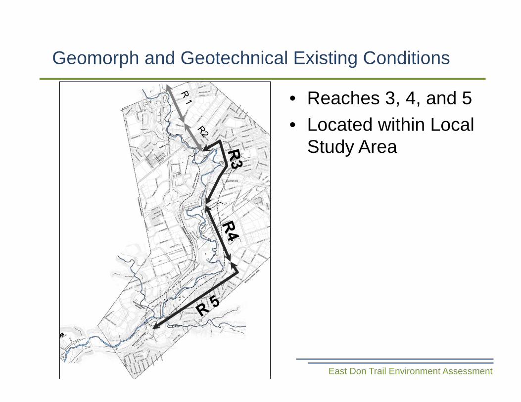
• Reaches 3, 4, and 5• Located within Local
Study Area
Stream Systems Understanding – Reach 3
East Don Trail Environment Assessment
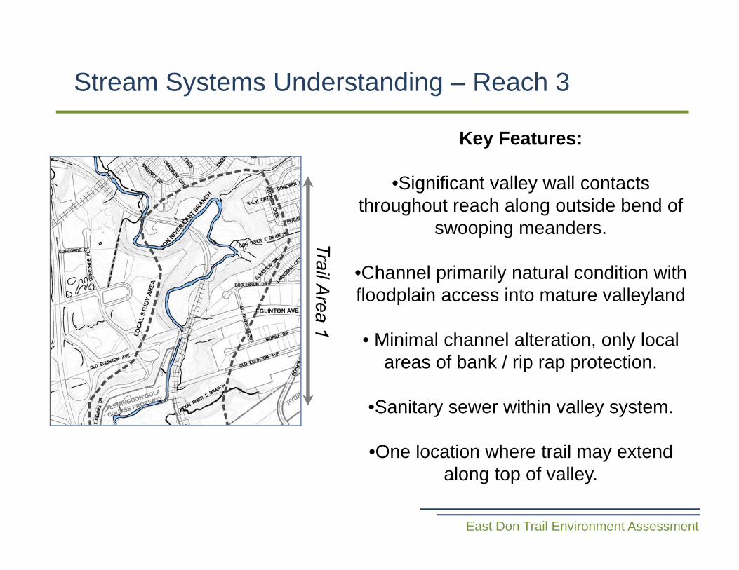
Key Features:
•Significant valley wall contacts throughout reach along outside bend of
swooping meanders.
•Channel primarily natural condition with floodplain access into mature valleyland
• Minimal channel alteration, only local areas of bank / rip rap protection.
•Sanitary sewer within valley system.
•One location where trail may extend along top of valley.
Stream Systems Understanding – Reach 4
East Don Trail Environment Assessment
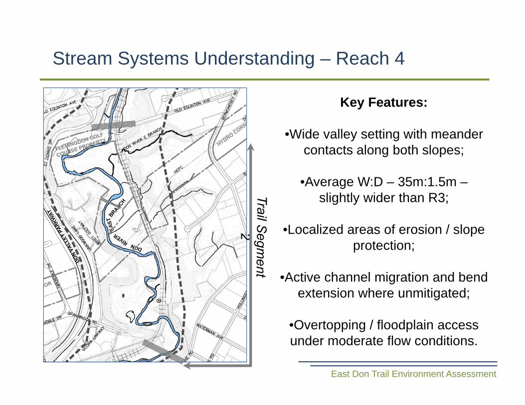
Key Features:
•Wide valley setting with meander contacts along both slopes;
•Average W:D – 35m:1.5m –slightly wider than R3;
•Localized areas of erosion / slope protection;
•Active channel migration and bend extension where unmitigated;
•Overtopping / floodplain access under moderate flow conditions.
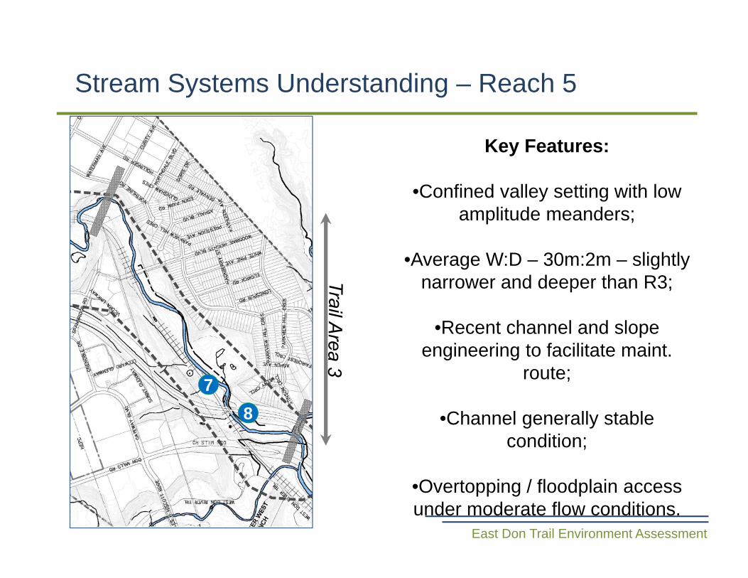
Key Features:
•Confined valley setting with low amplitude meanders;
•Average W:D – 30m:2m – slightly narrower and deeper than R3;
•Recent channel and slope engineering to facilitate maint.
route;
•Channel generally stable condition;
•Overtopping / floodplain access under moderate flow conditions.
Stream Systems Understanding – Reach 5
East Don Trail Environment Assessment
78
Questions?
Geomorph and Geotechnical Existing Conditions
East Don Trail Environment Assessment
Alternative Methods
East Don Trail Environment Assessment
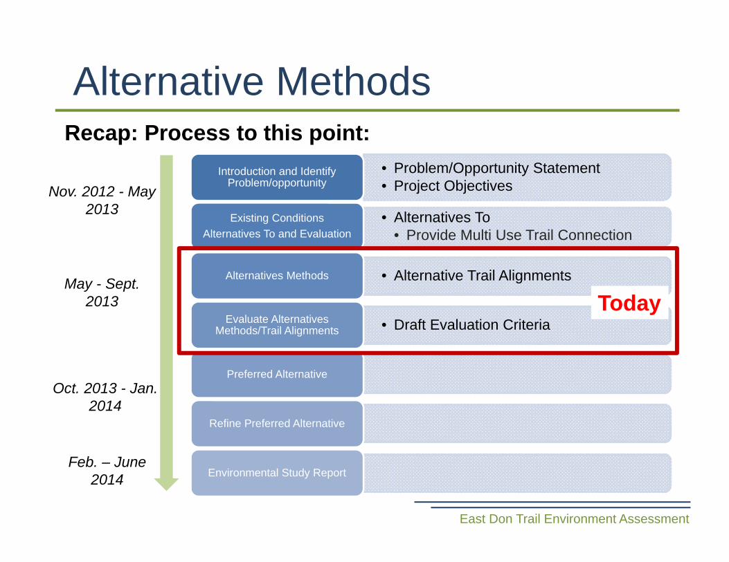
• Problem/Opportunity Statement• Project Objectives
Introduction and Identify Problem/opportunity
• Alternatives To• Provide Multi Use Trail Connection
Existing ConditionsAlternatives To and Evaluation
• Alternative Trail AlignmentsAlternatives Methods
• Draft Evaluation CriteriaEvaluate Alternatives Methods/Trail Alignments
Preferred Alternative
Refine Preferred Alternative
Environmental Study Report
Nov. 2012 - May 2013
May - Sept. 2013
Oct. 2013 - Jan. 2014
Feb. – June 2014
Today
Recap: Process to this point:
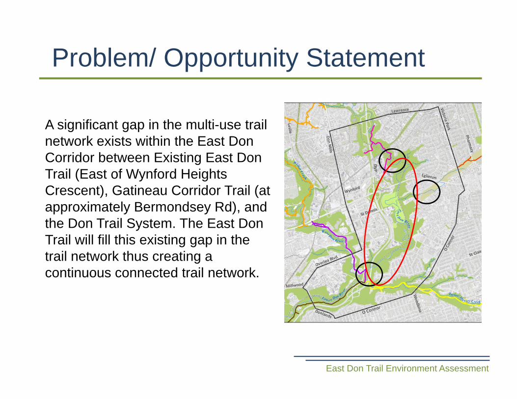
Problem/ Opportunity Statement
East Don Trail Environment Assessment
A significant gap in the multi-use trail network exists within the East Don Corridor between Existing East Don Trail (East of Wynford Heights Crescent), Gatineau Corridor Trail (at approximately Bermondsey Rd), and the Don Trail System. The East Don Trail will fill this existing gap in the trail network thus creating a continuous connected trail network.
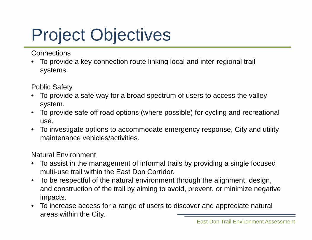
Project Objectives
East Don Trail Environment Assessment
Connections• To provide a key connection route linking local and inter-regional trail
systems.
Public Safety• To provide a safe way for a broad spectrum of users to access the valley
system.• To provide safe off road options (where possible) for cycling and recreational
use.• To investigate options to accommodate emergency response, City and utility
maintenance vehicles/activities.
Natural Environment• To assist in the management of informal trails by providing a single focused
multi-use trail within the East Don Corridor.• To be respectful of the natural environment through the alignment, design,
and construction of the trail by aiming to avoid, prevent, or minimize negative impacts.
• To increase access for a range of users to discover and appreciate natural areas within the City.
Project Objectives
East Don Trail Environment Assessment
Recreation• To create trail and outdoor recreational opportunities for a variety of users.• To provide trail and outdoor recreational opportunities for neighboring
communities.
Transportation• To function as a safe travel route to everyday places and amenities.
Supports Other Initiatives• To coordinate with other planning initiatives in the area allowing for future
integration of the multi-use trail. (e.g. Eglinton Cross-town LRT).
Alternatives To• These are alternatives to the undertaking and are
functionally different ways of approaching and dealing with the problem or opportunity.
• Preferred alternative to: Provide Multi Use Trail Connection
Alternative Methods• These are alternative methods of carrying out the
undertaking and are different ways of doing the same activity.
• For the purpose of this project termed: Alternative Trail Alignments.
Alternatives
East Don Trail Environment Assessment
• Different trail alignment options.• High level
– details will be addressed as part of the refinement of the preferred alignment.
– For example, will determine if we need to cross the river but will not assess bridge length or load capacity.
• Will undergo evaluation to determine the preferred alignment (next CLC meeting).
• Broken down into 3 Areas, these areas have been determined based on infrastructure and property challenges and river reach processes.
Alternative Trail Alignments
East Don Trail Environment Assessment

Areas
East Don Trail Environment Assessment
Alternative Trail Alignments
Area 12 trail alignment options:• Forest Trail A• Forest Trail B
• Road Link A• Road Link B• Road Link C
• River Walk A• River Walk B• River Walk C
• Rail Trail A• Rail Trail B• Rail Trail C
Area 33 trail alignment options:• Access Route A• Access Route B• Access Route C
Area 29 trail alignment options:
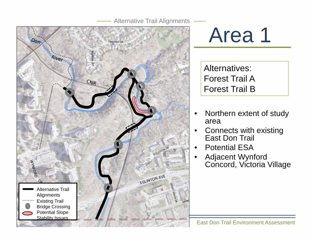
Area 1
East Don Trail Environment Assessment
Alternatives: Forest Trail AForest Trail B
• Northern extent of study area
• Connects with existing East Don Trail
• Potential ESA• Adjacent Wynford
Concord, Victoria Village
Alternative Trail Alignments
Alternative Trail Alignments
Bridge CrossingPotential Slope Stability Issues
Existing Trail
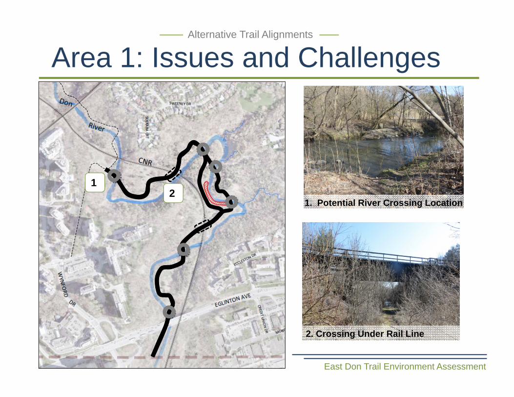
Area 1: Issues and Challenges
East Don Trail Environment Assessment
Alternative Trail Alignments
1. Potential River Crossing Location
2. Crossing Under Rail Line
12
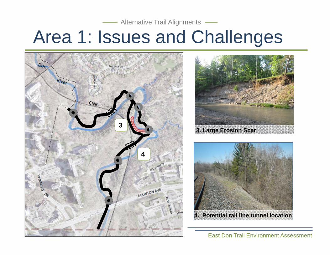
Area 1: Issues and Challenges
East Don Trail Environment Assessment
Alternative Trail Alignments
3
4
3. Large Erosion Scar
4. Potential rail line tunnel location
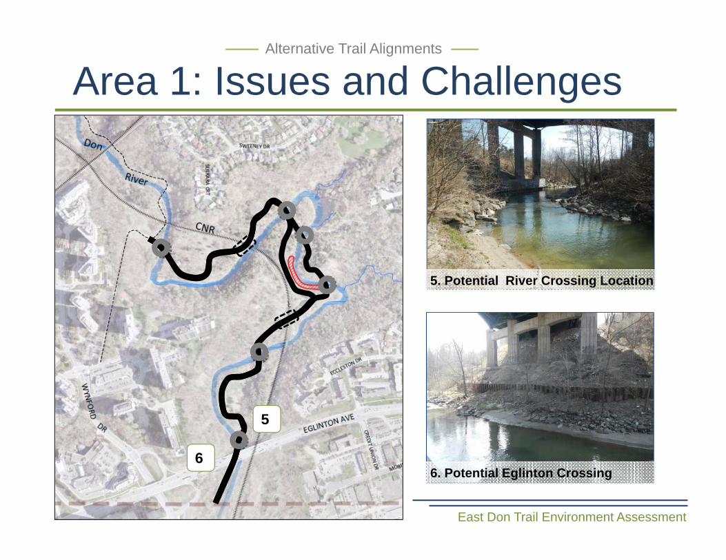
Area 1: Issues and Challenges
East Don Trail Environment Assessment
Alternative Trail Alignments
5
6
5. Potential River Crossing Location
6. Potential Eglinton Crossing
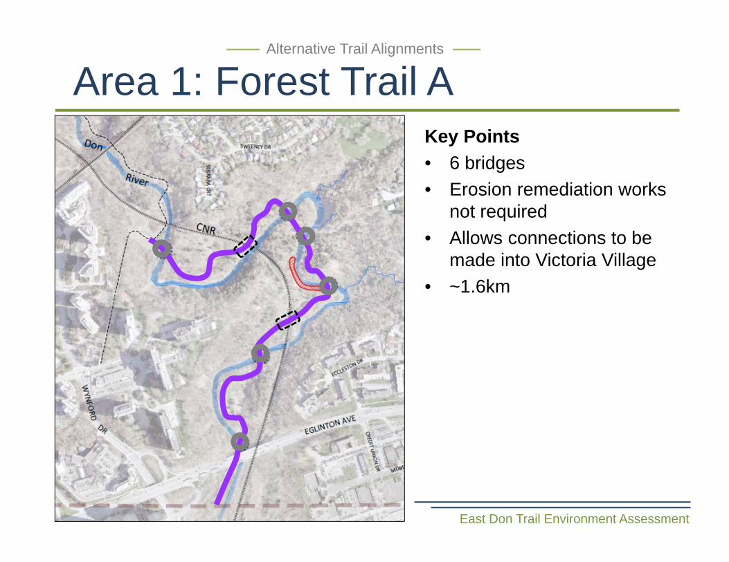
Area 1: Forest Trail A
East Don Trail Environment Assessment
Alternative Trail Alignments
Key Points• 6 bridges• Erosion remediation works
not required • Allows connections to be
made into Victoria Village• ~1.6km
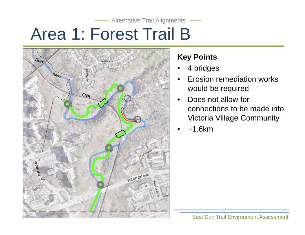
Area 1: Forest Trail B
East Don Trail Environment Assessment
Alternative Trail Alignments
Key Points• 4 bridges• Erosion remediation works
would be required• Does not allow for
connections to be made into Victoria Village Community
• ~1.6km
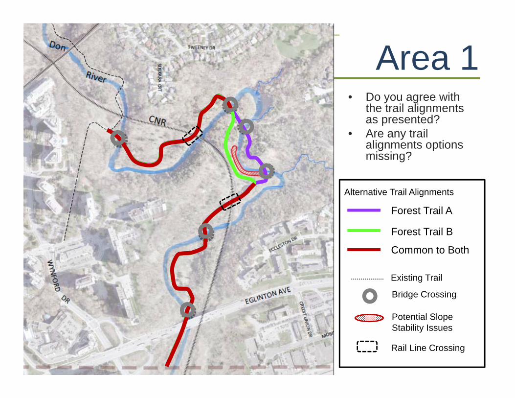
Area 1Alternative Trail Alignments
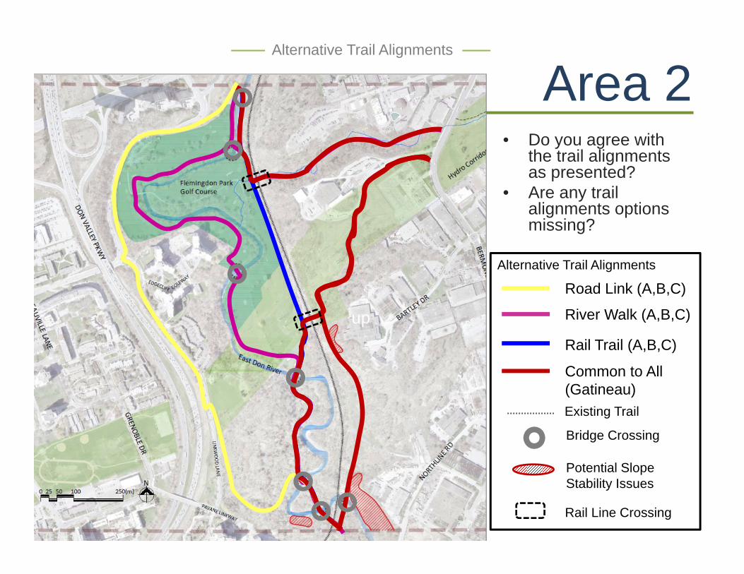
• Do you agree with the trail alignments as presented?
• Are any trail alignments options missing?
Forest Trail A
Forest Trail B
Common to Both
Bridge Crossing
Potential Slope Stability Issues
Existing Trail
Alternative Trail Alignments
Rail Line Crossing
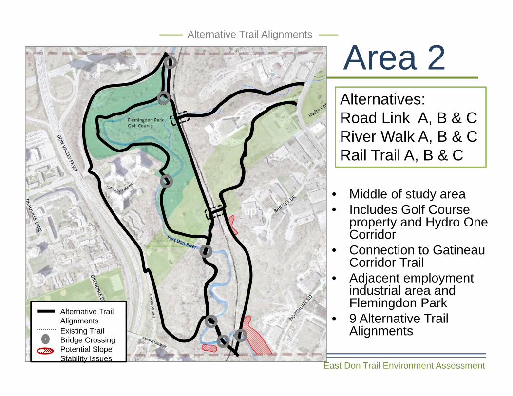
Area 2
East Don Trail Environment Assessment
Alternative Trail Alignments
Alternatives: Road Link A, B & CRiver Walk A, B & CRail Trail A, B & C
• Middle of study area• Includes Golf Course
property and Hydro One Corridor
• Connection to Gatineau Corridor Trail
• Adjacent employment industrial area and Flemingdon Park
• 9 Alternative Trail Alignments
up
Alternative Trail Alignments
Bridge CrossingPotential Slope Stability Issues
Existing Trail
East Don Trail Environment Assessment
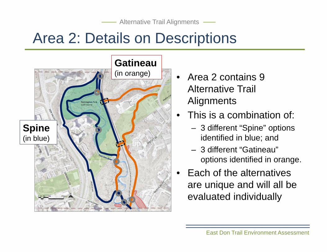
Area 2: Details on Descriptions Alternative Trail Alignments
up
Spine (in blue)
Gatineau(in orange) • Area 2 contains 9
Alternative Trail Alignments
• This is a combination of:– 3 different “Spine” options
identified in blue; and – 3 different “Gatineau”
options identified in orange.
• Each of the alternatives are unique and will all be evaluated individually
up
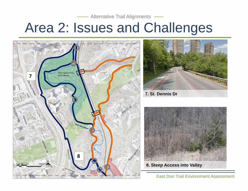
Area 2: Issues and Challenges
East Don Trail Environment Assessment
Alternative Trail Alignments
7
8
7. St. Dennis Dr
8. Steep Access into Valley
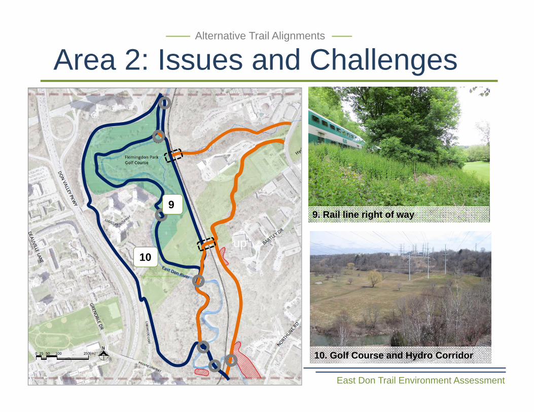
Area 2: Issues and Challenges
East Don Trail Environment Assessment
Alternative Trail Alignments
9. Rail line right of way
10. Golf Course and Hydro Corridor
up
9
10
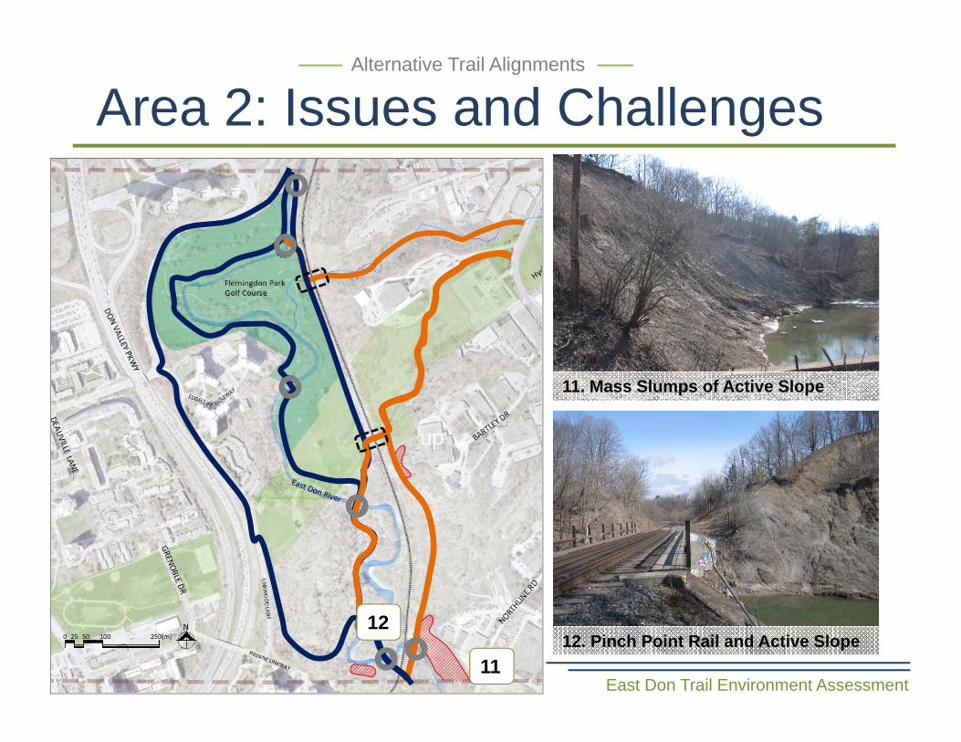
Area 2: Issues and Challenges
East Don Trail Environment Assessment
Alternative Trail Alignments
11. Mass Slumps of Active Slope
12. Pinch Point Rail and Active Slope
up
11
12
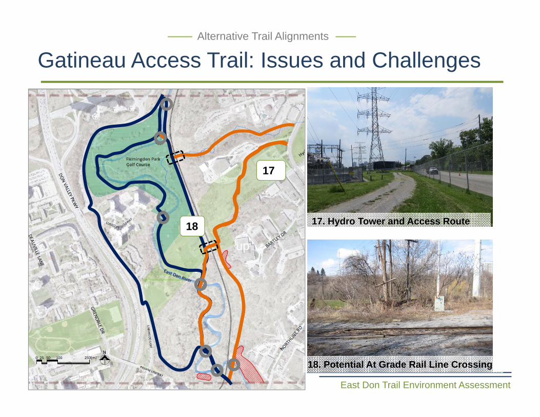
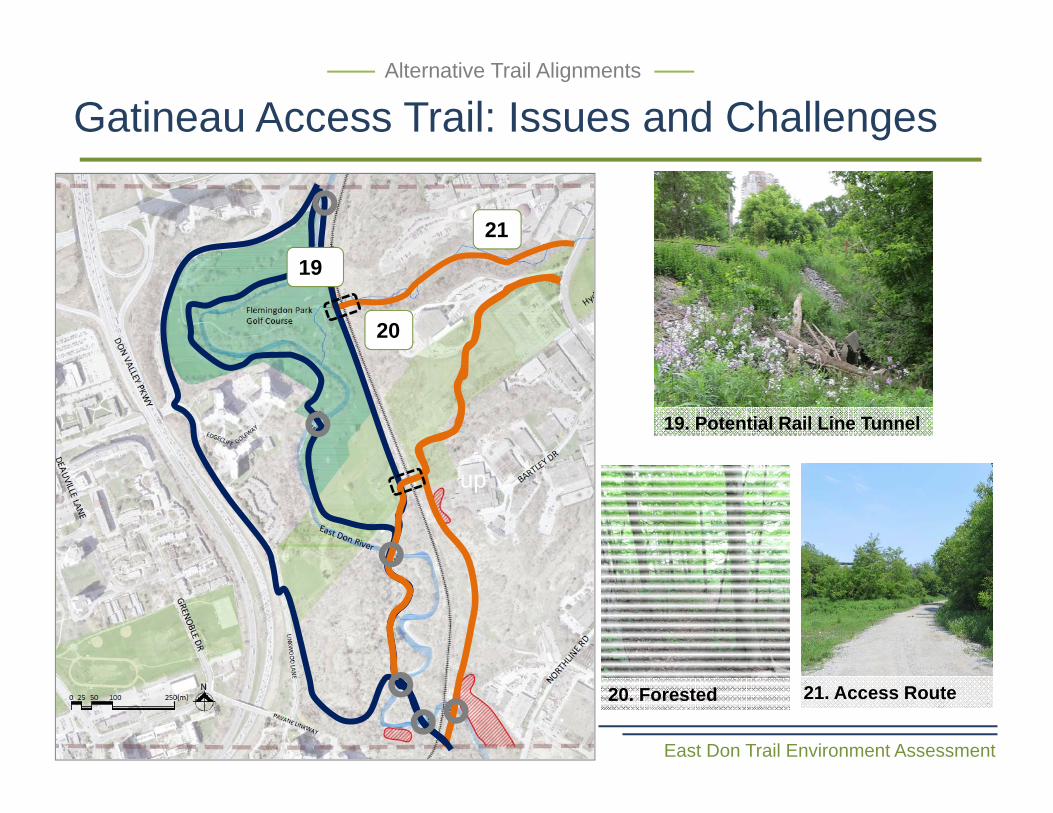
Gatineau Access Trail: Issues and Challenges
East Don Trail Environment Assessment
Alternative Trail Alignments
up
17
18 17. Hydro Tower and Access Route
18. Potential At Grade Rail Line Crossing
East Don Trail Environment Assessment
up
Alternative Trail Alignments
19
20
19. Potential Rail Line Tunnel
21. Access Route20. Forested
21
Gatineau Access Trail: Issues and Challenges
East Don Trail Environment Assessment
up
Road Link A
Road Link B
Common to All
Bridge Crossing
Potential Slope Stability Issues
Existing Trail
Alternative Trail Alignments
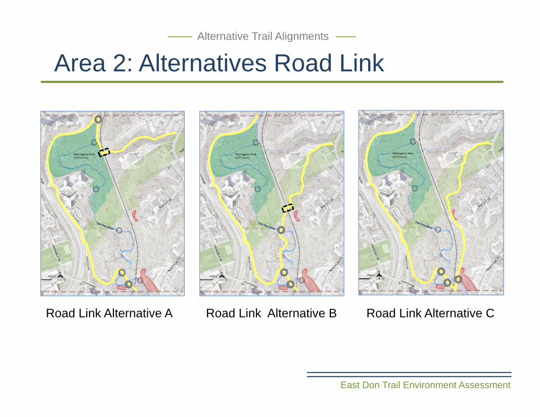
Area 2: Alternatives Road Link A, B & C Alternative Trail Alignments
3 Alternative Trail Alignments
Rail Line Crossing
Road Link C
East Don Trail Environment Assessment
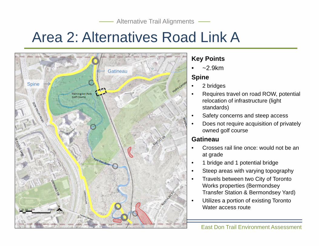
Area 2: Alternatives Road Link AAlternative Trail Alignments
Key Points• ~2.9kmSpine• 2 bridges • Requires travel on road ROW, potential
relocation of infrastructure (light standards)
• Safety concerns and steep access• Does not require acquisition of privately
owned golf courseGatineau • Crosses rail line once: would not be an
at grade• 1 bridge and 1 potential bridge • Steep areas with varying topography• Travels between two City of Toronto
Works properties (BermondseyTransfer Station & Bermondsey Yard)
• Utilizes a portion of existing Toronto Water access route
Gatineau
Spine
East Don Trail Environment Assessment
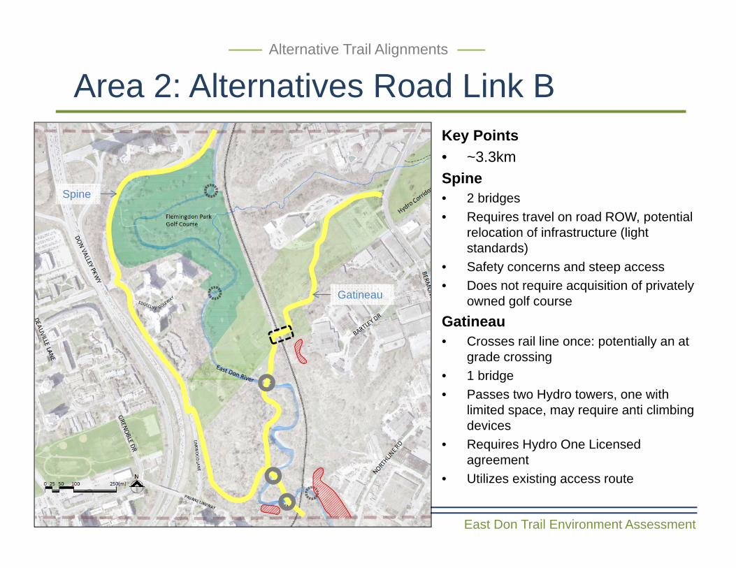
Area 2: Alternatives Road Link B Alternative Trail Alignments
Key Points• ~3.3kmSpine• 2 bridges • Requires travel on road ROW, potential
relocation of infrastructure (light standards)
• Safety concerns and steep access• Does not require acquisition of privately
owned golf courseGatineau • Crosses rail line once: potentially an at
grade crossing• 1 bridge• Passes two Hydro towers, one with
limited space, may require anti climbing devices
• Requires Hydro One Licensed agreement
• Utilizes existing access route
Gatineau
Spine
East Don Trail Environment Assessment
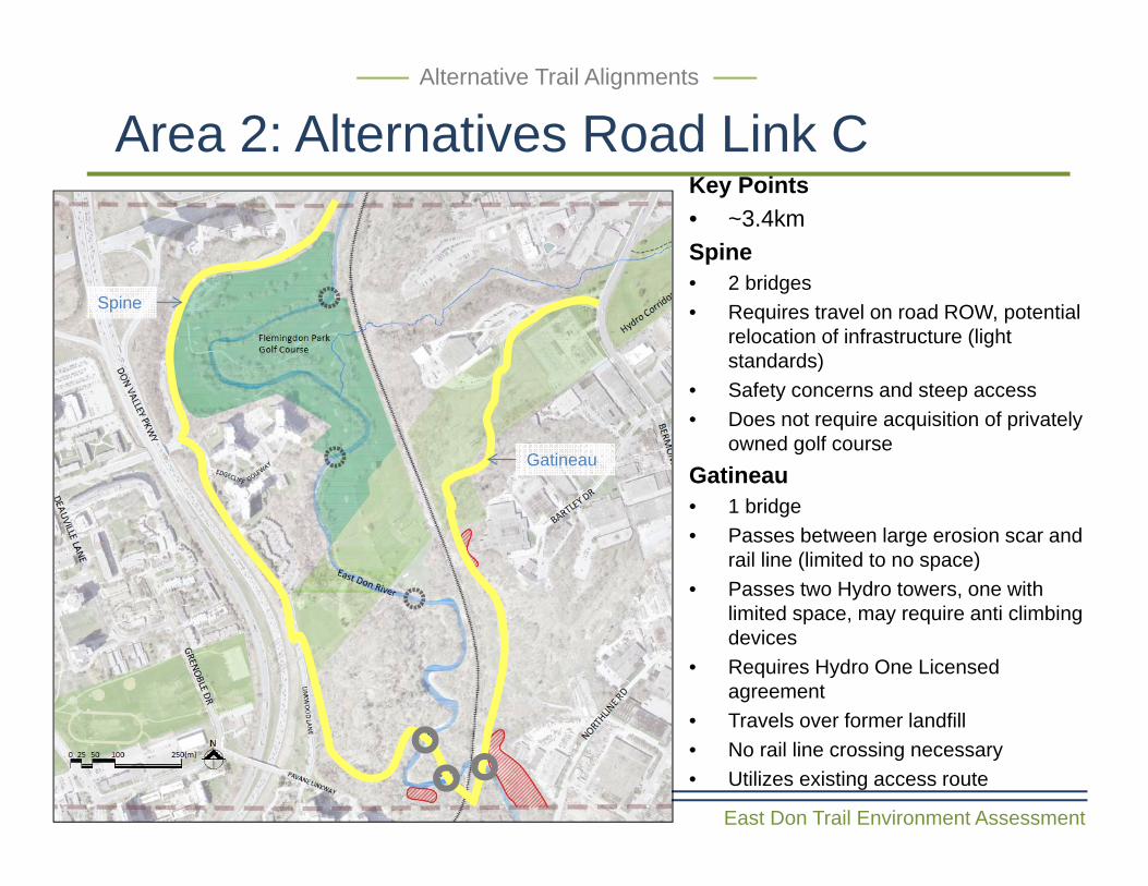
Area 2: Alternatives Road Link C Alternative Trail Alignments
Key Points• ~3.4kmSpine• 2 bridges • Requires travel on road ROW, potential
relocation of infrastructure (light standards)
• Safety concerns and steep access• Does not require acquisition of privately
owned golf courseGatineau • 1 bridge • Passes between large erosion scar and
rail line (limited to no space)• Passes two Hydro towers, one with
limited space, may require anti climbing devices
• Requires Hydro One Licensed agreement
• Travels over former landfill • No rail line crossing necessary• Utilizes existing access route
Gatineau
Spine
East Don Trail Environment Assessment
River Walk A
River Walk B
Common to All
Bridge Crossing
Potential Slope Stability Issues
Existing Trail
Alternative Trail Alignments
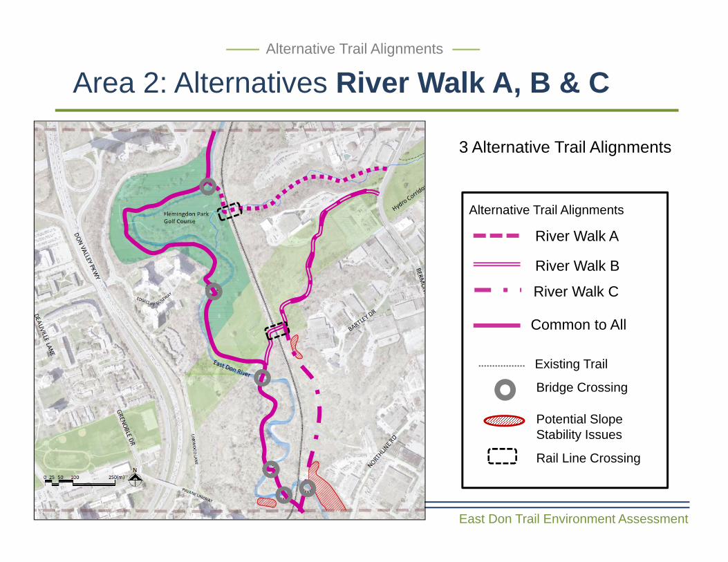
Area 2: Alternatives River Walk A, B & C Alternative Trail Alignments
3 Alternative Trail Alignments
Rail Line Crossing
River Walk C
East Don Trail Environment Assessment
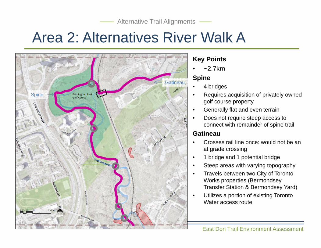
Area 2: Alternatives River Walk AAlternative Trail Alignments
Key Points• ~2.7kmSpine• 4 bridges• Requires acquisition of privately owned
golf course property• Generally flat and even terrain• Does not require steep access to
connect with remainder of spine trailGatineau• Crosses rail line once: would not be an
at grade crossing• 1 bridge and 1 potential bridge • Steep areas with varying topography• Travels between two City of Toronto
Works properties (BermondseyTransfer Station & Bermondsey Yard)
• Utilizes a portion of existing Toronto Water access route
Gatineau
Spine
East Don Trail Environment Assessment
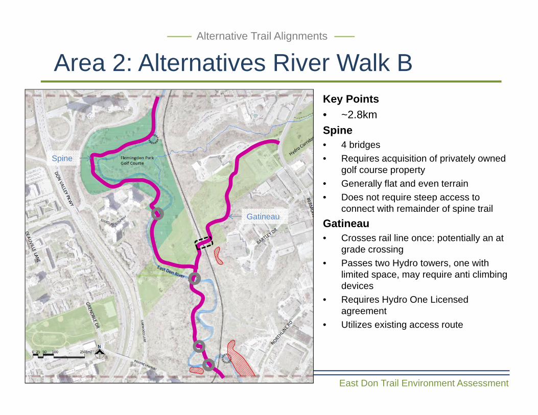
Area 2: Alternatives River Walk B Alternative Trail Alignments
Key Points• ~2.8kmSpine• 4 bridges• Requires acquisition of privately owned
golf course property• Generally flat and even terrain• Does not require steep access to
connect with remainder of spine trailGatineau • Crosses rail line once: potentially an at
grade crossing• Passes two Hydro towers, one with
limited space, may require anti climbing devices
• Requires Hydro One Licensed agreement
• Utilizes existing access route
Gatineau
Spine
East Don Trail Environment Assessment
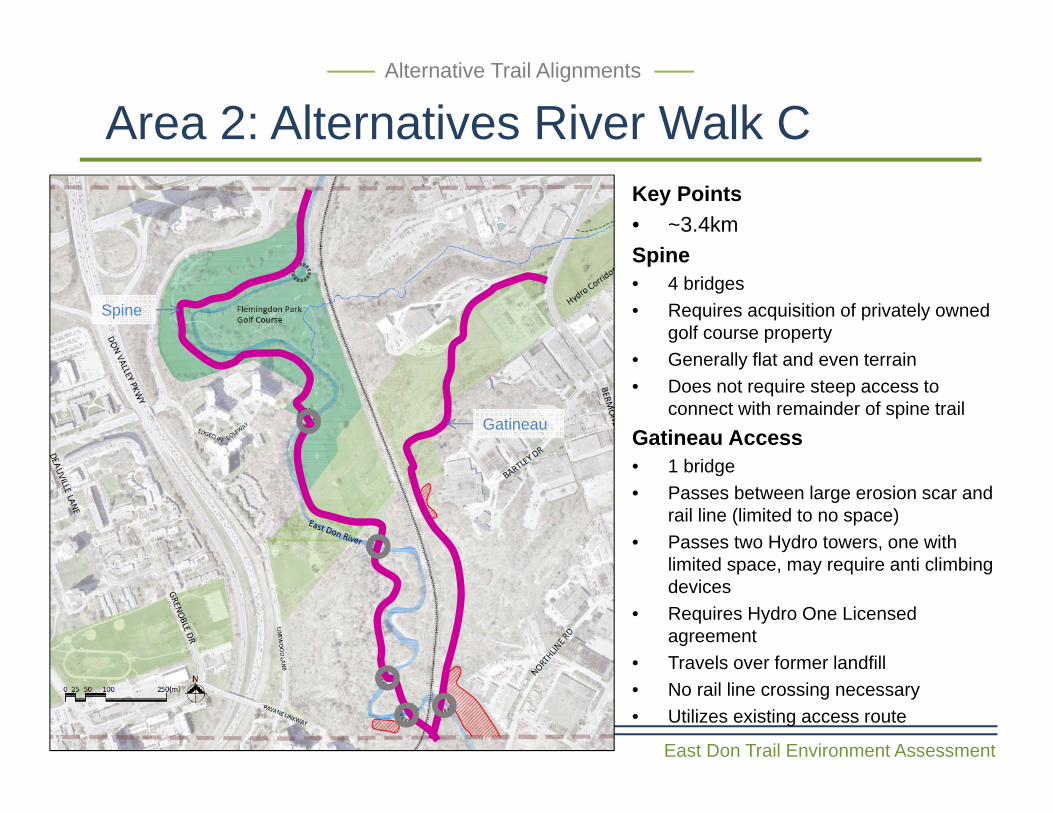
Area 2: Alternatives River Walk C Alternative Trail Alignments
Key Points• ~3.4kmSpine• 4 bridges• Requires acquisition of privately owned
golf course property• Generally flat and even terrain• Does not require steep access to
connect with remainder of spine trailGatineau Access• 1 bridge • Passes between large erosion scar and
rail line (limited to no space)• Passes two Hydro towers, one with
limited space, may require anti climbing devices
• Requires Hydro One Licensed agreement
• Travels over former landfill • No rail line crossing necessary• Utilizes existing access route
Spine
Gatineau
East Don Trail Environment Assessment
Rail Trail A
Rail Trail B
Common to All
Bridge Crossing
Potential Slope Stability Issues
Existing Trail
Alternative Trail Alignments
Area 3: Alternatives Rail Trail A, B & C Alternative Trail Alignments
3 Alternative Trail Alignments
Rail Line Crossing
Rail Trail C
East Don Trail Environment Assessment
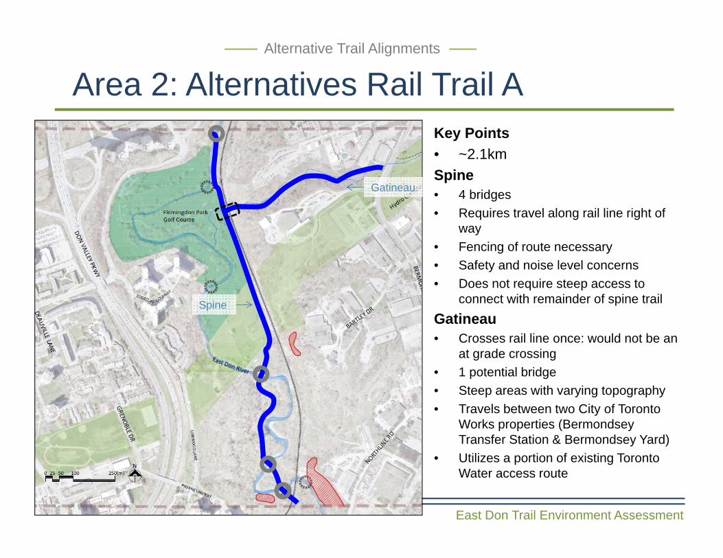
Area 2: Alternatives Rail Trail AAlternative Trail Alignments
Key Points• ~2.1kmSpine• 4 bridges• Requires travel along rail line right of
way• Fencing of route necessary• Safety and noise level concerns• Does not require steep access to
connect with remainder of spine trail Gatineau • Crosses rail line once: would not be an
at grade crossing• 1 potential bridge • Steep areas with varying topography• Travels between two City of Toronto
Works properties (BermondseyTransfer Station & Bermondsey Yard)
• Utilizes a portion of existing Toronto Water access route
Spine
Gatineau
East Don Trail Environment Assessment
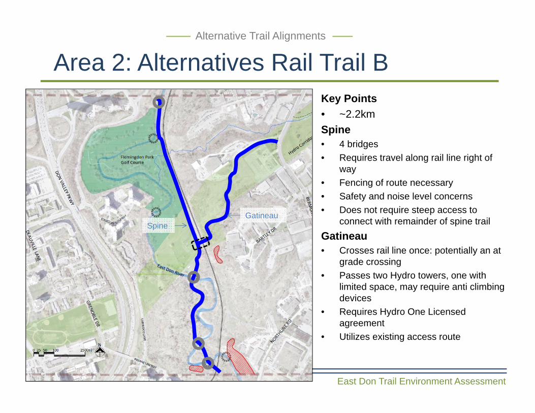
Area 2: Alternatives Rail Trail B Alternative Trail Alignments
Key Points• ~2.2kmSpine• 4 bridges• Requires travel along rail line right of
way• Fencing of route necessary• Safety and noise level concerns• Does not require steep access to
connect with remainder of spine trail Gatineau• Crosses rail line once: potentially an at
grade crossing• Passes two Hydro towers, one with
limited space, may require anti climbing devices
• Requires Hydro One Licensed agreement
• Utilizes existing access route
GatineauSpine
East Don Trail Environment Assessment
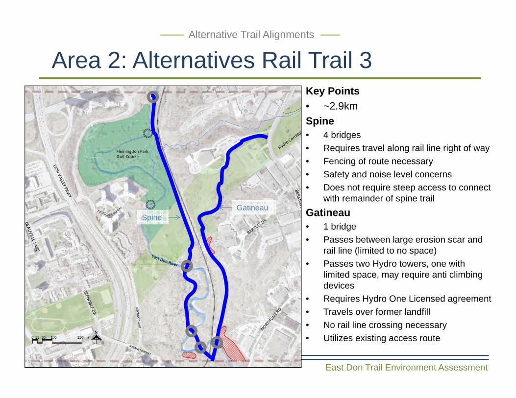
Area 2: Alternatives Rail Trail 3 Alternative Trail Alignments
Key Points• ~2.9kmSpine• 4 bridges• Requires travel along rail line right of way• Fencing of route necessary• Safety and noise level concerns• Does not require steep access to connect
with remainder of spine trail Gatineau • 1 bridge • Passes between large erosion scar and
rail line (limited to no space)• Passes two Hydro towers, one with
limited space, may require anti climbing devices
• Requires Hydro One Licensed agreement• Travels over former landfill • No rail line crossing necessary• Utilizes existing access route
SpineGatineau
East Don Trail Environment Assessment
Area 2: Alternatives Road LinkAlternative Trail Alignments
Road Link Alternative A Road Link Alternative B Road Link Alternative C
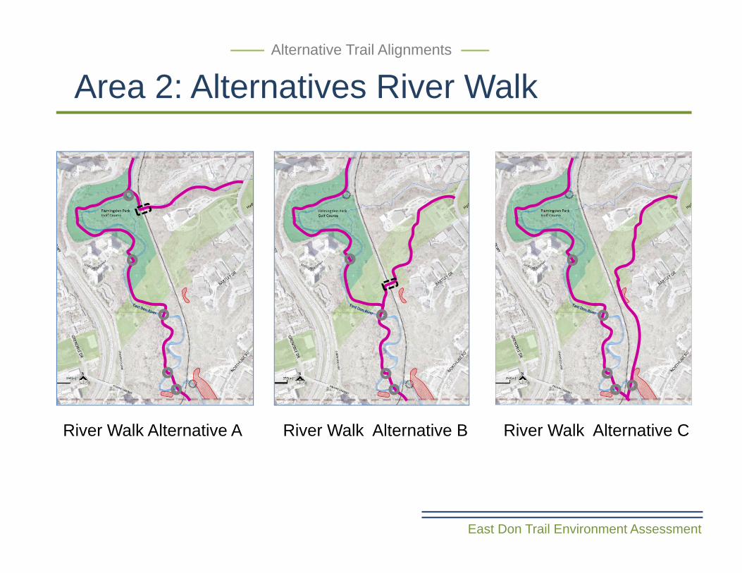
River Walk Alternative B River Walk Alternative C
East Don Trail Environment Assessment
Area 2: Alternatives River WalkAlternative Trail Alignments
River Walk Alternative A
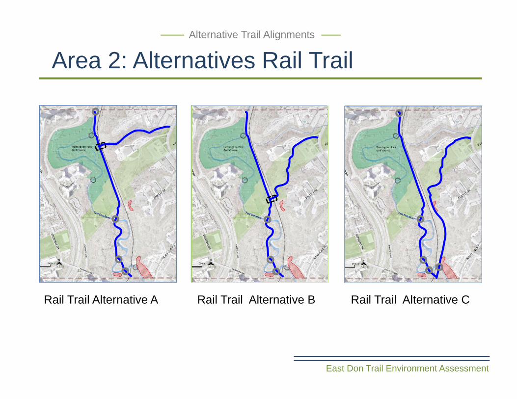
Rail Trail Alternative B Rail Trail Alternative C
East Don Trail Environment Assessment
Area 2: Alternatives Rail TrailAlternative Trail Alignments
Rail Trail Alternative A
Area 2Alternative Trail Alignments
• Do you agree with the trail alignments as presented?
• Are any trail alignments options missing?
River Walk (A,B,C)
Rail Trail (A,B,C)
Common to All (Gatineau)
Bridge Crossing
Potential Slope Stability Issues
Existing Trail
Alternative Trail Alignments
Rail Line Crossing
up
Road Link (A,B,C)
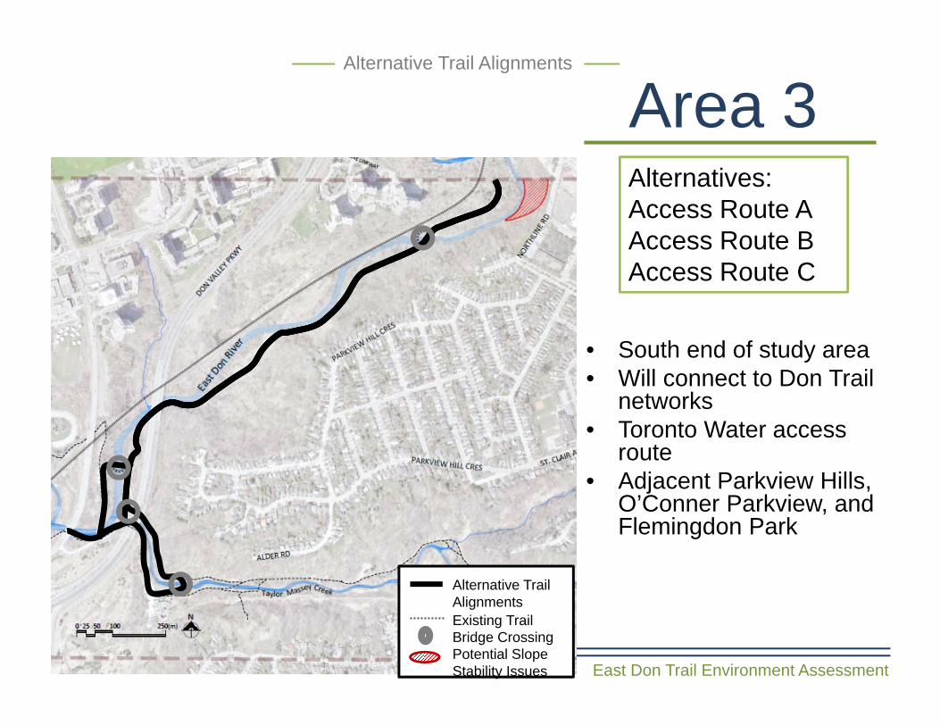
Area 3
East Don Trail Environment Assessment
Alternative Trail Alignments
Alternatives:Access Route AAccess Route BAccess Route C
• South end of study area • Will connect to Don Trail
networks• Toronto Water access
route• Adjacent Parkview Hills,
O’Conner Parkview, and Flemingdon Park
Alternative Trail Alignments
Bridge CrossingPotential Slope Stability Issues
Existing Trail
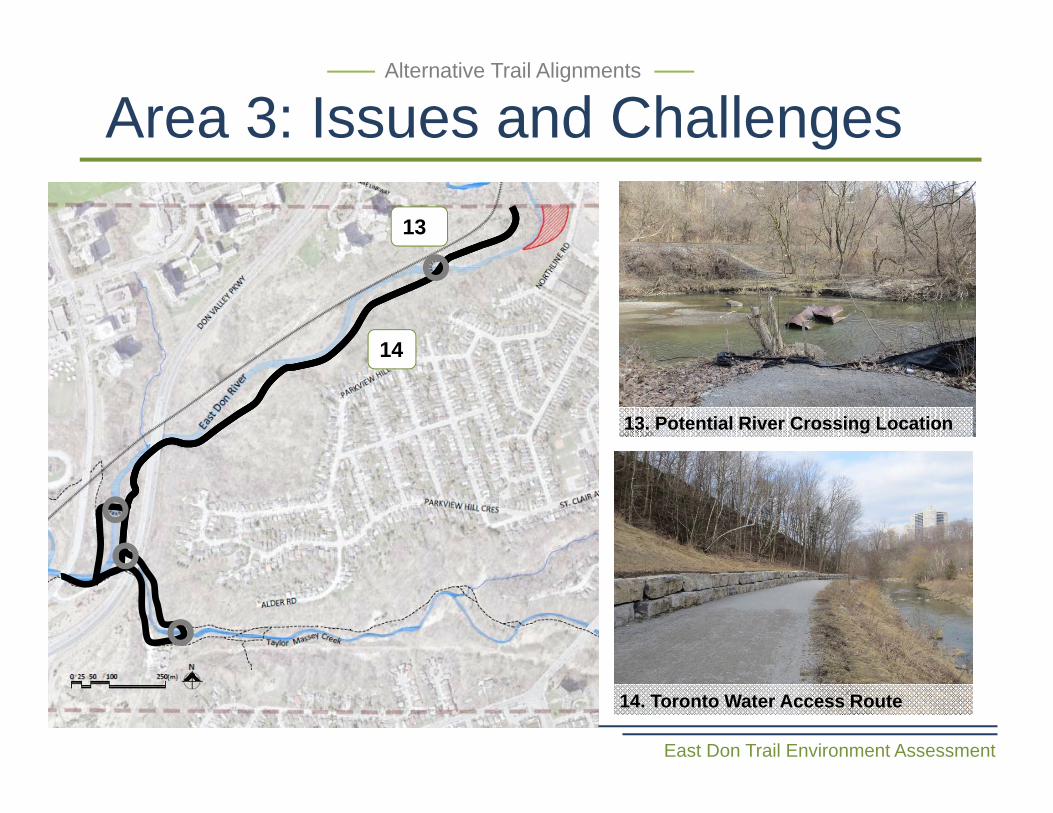
Area 3: Issues and Challenges
East Don Trail Environment Assessment
Alternative Trail Alignments
13
14
13. Potential River Crossing Location
14. Toronto Water Access Route
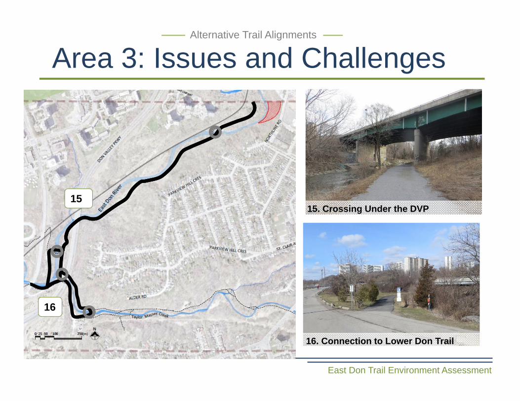
Area 3: Issues and Challenges
East Don Trail Environment Assessment
Alternative Trail Alignments
15. Crossing Under the DVP
16. Connection to Lower Don Trail
15
16
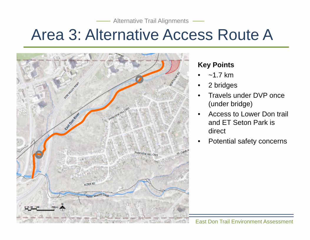
Area 3: Alternative Access Route A
East Don Trail Environment Assessment
Alternative Trail Alignments
Key Points• ~1.7 km• 2 bridges• Travels under DVP once
(under bridge)• Access to Lower Don trail
and ET Seton Park is direct
• Potential safety concerns
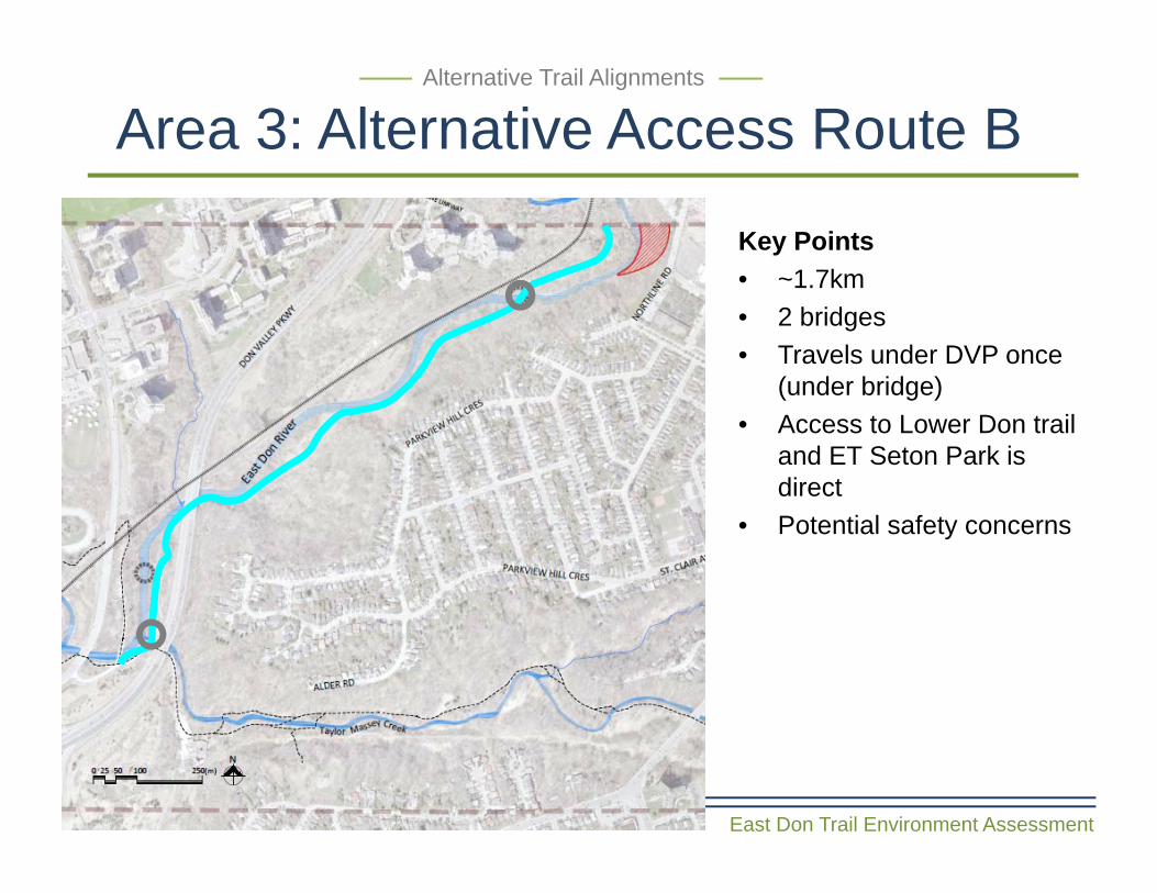
Area 3: Alternative Access Route B
East Don Trail Environment Assessment
Alternative Trail Alignments
Key Points• ~1.7km• 2 bridges• Travels under DVP once
(under bridge)• Access to Lower Don trail
and ET Seton Park is direct
• Potential safety concerns
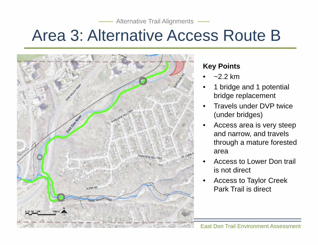
Area 3: Alternative Access Route B
East Don Trail Environment Assessment
Alternative Trail Alignments
Key Points• ~2.2 km• 1 bridge and 1 potential
bridge replacement• Travels under DVP twice
(under bridges)• Access area is very steep
and narrow, and travels through a mature forested area
• Access to Lower Don trail is not direct
• Access to Taylor Creek Park Trail is direct
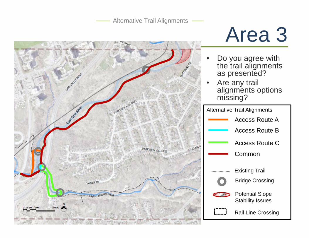
Area 3Alternative Trail Alignments
• Do you agree with the trail alignments as presented?
• Are any trail alignments options missing?
Access Route B
Access Route C
Common
Bridge Crossing
Potential Slope Stability Issues
Existing Trail
Alternative Trail Alignments
Rail Line Crossing
Access Route A
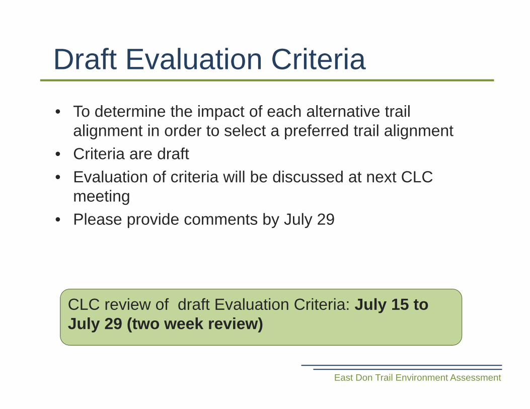
• To determine the impact of each alternative trail alignment in order to select a preferred trail alignment
• Criteria are draft• Evaluation of criteria will be discussed at next CLC
meeting• Please provide comments by July 29
Draft Evaluation Criteria
East Don Trail Environment Assessment
CLC review of draft Evaluation Criteria: July 15 to July 29 (two week review)
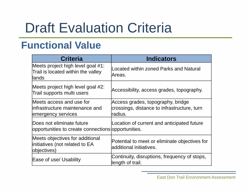
Functional ValueDraft Evaluation Criteria
Criteria IndicatorsMeets project high level goal #1: Trail is located within the valley lands
Located within zoned Parks and Natural Areas.
Meets project high level goal #2: Trail supports multi users Accessibility, access grades, topography.
Meets access and use for infrastructure maintenance and emergency services
Access grades, topography, bridge crossings, distance to infrastructure, turn radius.
Does not eliminate future opportunities to create connections
Location of current and anticipated future opportunities.
Meets objectives for additional initiatives (not related to EA objectives)
Potential to meet or eliminate objectives for additional initiatives.
Ease of use/ Usability Continuity, disruptions, frequency of stops, length of trail.
East Don Trail Environment Assessment
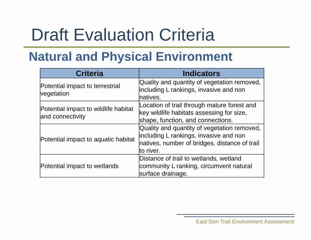
Natural and Physical EnvironmentDraft Evaluation Criteria
East Don Trail Environment Assessment
Criteria IndicatorsPotential impact to terrestrial vegetation
Quality and quantity of vegetation removed, including L rankings, invasive and non natives.
Potential impact to wildlife habitat and connectivity
Location of trail through mature forest and key wildlife habitats assessing for size, shape, function, and connections.
Potential impact to aquatic habitat
Quality and quantity of vegetation removed, including L rankings, invasive and non natives, number of bridges, distance of trail to river.
Potential impact to wetlandsDistance of trail to wetlands, wetland community L ranking, circumvent natural surface drainage.
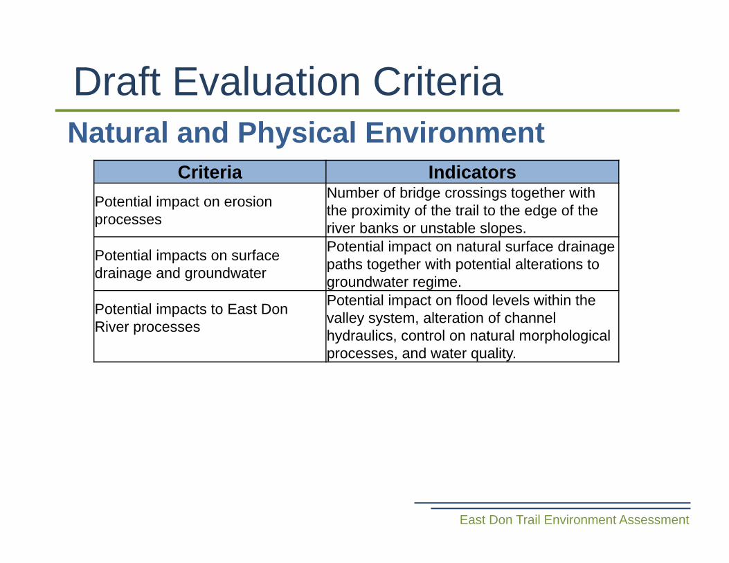
Natural and Physical EnvironmentDraft Evaluation Criteria
East Don Trail Environment Assessment
Criteria IndicatorsPotential impact on erosion processes
Number of bridge crossings together with the proximity of the trail to the edge of the river banks or unstable slopes.
Potential impacts on surface drainage and groundwater
Potential impact on natural surface drainage paths together with potential alterations to groundwater regime.
Potential impacts to East Don River processes
Potential impact on flood levels within the valley system, alteration of channel hydraulics, control on natural morphological processes, and water quality.
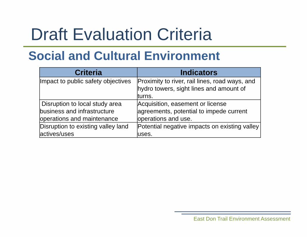
Social and Cultural EnvironmentDraft Evaluation Criteria
East Don Trail Environment Assessment
Criteria IndicatorsImpact to public safety objectives Proximity to river, rail lines, road ways, and
hydro towers, sight lines and amount of turns.
Disruption to local study area business and infrastructure operations and maintenance
Acquisition, easement or license agreements, potential to impede current operations and use.
Disruption to existing valley land actives/uses
Potential negative impacts on existing valley uses.
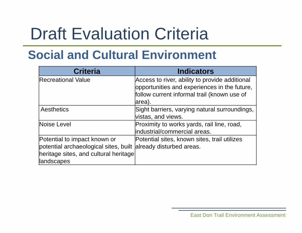
Social and Cultural EnvironmentDraft Evaluation Criteria
East Don Trail Environment Assessment
Criteria IndicatorsRecreational Value Access to river, ability to provide additional
opportunities and experiences in the future, follow current informal trail (known use of area).
Aesthetics Sight barriers, varying natural surroundings, vistas, and views.
Noise Level Proximity to works yards, rail line, road, industrial/commercial areas.
Potential to impact known or potential archaeological sites, built heritage sites, and cultural heritage landscapes
Potential sites, known sites, trail utilizes already disturbed areas.
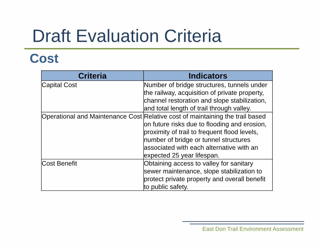
CostDraft Evaluation Criteria
East Don Trail Environment Assessment
Criteria IndicatorsCapital Cost Number of bridge structures, tunnels under
the railway, acquisition of private property, channel restoration and slope stabilization, and total length of trail through valley.
Operational and Maintenance Cost Relative cost of maintaining the trail based on future risks due to flooding and erosion, proximity of trail to frequent flood levels, number of bridge or tunnel structures associated with each alternative with an expected 25 year lifespan.
Cost Benefit Obtaining access to valley for sanitary sewer maintenance, slope stabilization to protect private property and overall benefit to public safety.
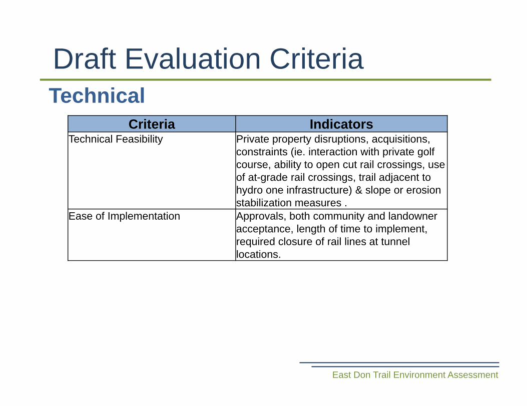
TechnicalDraft Evaluation Criteria
East Don Trail Environment Assessment
Criteria IndicatorsTechnical Feasibility Private property disruptions, acquisitions,
constraints (ie. interaction with private golf course, ability to open cut rail crossings, use of at-grade rail crossings, trail adjacent to hydro one infrastructure) & slope or erosion stabilization measures .
Ease of Implementation Approvals, both community and landowner acceptance, length of time to implement, required closure of rail lines at tunnel locations.
• Evaluate alternative trail alignments • Select preferred alternative• CLC meeting #4 will take place August 12
or 14 – date to be determined
Next Steps
East Don Trail Environment Assessment
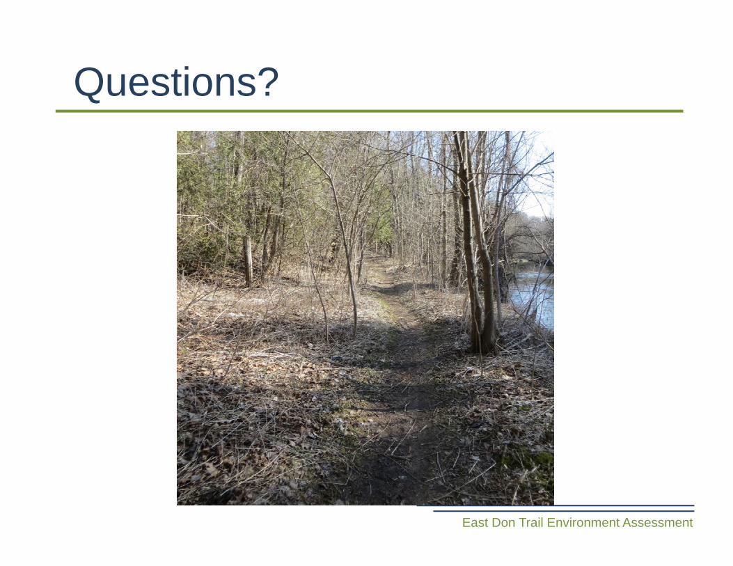
Questions?
East Don Trail Environment Assessment