Embed Size (px)
Citation preview

NSW Roads and Maritime Services
Princes Highway Upgrade - Foxground and Berry Bypass Project
Ecological Monitoring Program 18 September 2014

Document information
Client: NSW Roads and Maritime Services Title: Princes Highway Upgrade - Foxground and Berry Bypass Project Subtitle: Ecological Monitoring Program Document No: 2207005A-ECO-RPT-001 Date: 18 September 2014
Rev Date Details
A 22/05/2014 Draft
B 15/06/2014 Revised Draft
C 23/06/2014 Final Draft
D 26/06/2014 Final Draft
E 17/07/2014 Final
F 18/09/2014 Final
Author, Reviewer and Approver details
Prepared by: Tanya Bangel Date: 18/09/2014 Signature:
Reviewed by: Toby Lambert Date: 18/09/2014 Signature:
Approved by: Alex Cockerill Date: 18/09/2014 Signature:
Distribution
NSW Roads and Maritime Services, Parsons Brinckerhoff file, Parsons Brinckerhoff Library
©Parsons Brinckerhoff Australia Pty Limited 2014
Copyright in the drawings, information and data recorded in this document (the information) is the property of Parsons Brinckerhoff. This document and the information are solely for the use of the authorised recipient and this document may not be used, copied or reproduced in whole or part for any purpose other than that for which it was supplied by Parsons Brinckerhoff. Parsons Brinckerhoff makes no representation, undertakes no duty and accepts no responsibility to any third party who may use or rely upon this document or the information.
Document owner
Parsons Brinckerhoff Australia Pty Limited ABN 80 078 004 798 Level 27 Ernst & Young Centre 680 George Street, Sydney NSW 2000 GPO Box 5394 Sydney NSW 2001 Australia Tel: +61 2 9272 5100 Fax: +61 2 9272 5101 Email: [email protected] www.pbworld.com Certified to ISO 9001, ISO 14001, AS/NZS 4801 A GRI Rating: Sustainability Report 2011
Parsons Brinckerhoff | 2207005A-ECO-RPT-001 RevF iii
NSW Roads and Maritime Services Princes Highway Upgrade - Foxground and Berry Bypass Project - Ecological Monitoring Program
Contents Page number
Glossary v
Abbreviations viii
1. Introduction 1
1.1 Project overview 1
1.2 Objectives 3
1.3 Fulfilment of ecological monitoring requirements 4
2. Mitigation measures 14
2.1 Pre-clearing and clearing process 14
2.2 Connectivity mitigation measures 17
2.3 Nest box management 19
2.4 Weed management 26
2.5 Aquatic and riparian protection 26
3. Ecological monitoring program 28
3.1 Targeted species 28
3.2 Monitoring approach 30
3.3 Consultation with agencies 30
4. Performance criteria 46
4.1 Performance criteria 46
5. Potential contingency measures 50
5.1 Potential contingency measures 50
6. Reporting 52
6.1 Pre-clearing and clearing works 52
6.2 Annual reporting 52
7. Conclusion 53
8. References 54

Parsons Brinckerhoff | 2207005A-ECO-RPT-001 RevF iv
NSW Roads and Maritime Services Princes Highway Upgrade - Foxground and Berry Bypass Project - Ecological Monitoring Program
List of tables Page number
Table 1.1 Ecological monitoring commitments 4 Table 2.1 Dimensions of fauna underpasses 18 Table 3.1 Target species and monitoring value 29 Table 3.2 Pre-clearance surveys, location, timing, frequency and methodology 32 Table 3.3 Ecological monitoring of mitigation measures location, timing, frequency and
methodology 36 Table 4.1 Performance criteria to assess the effectiveness of biodiversity mitigation
measures 46 Table 5.1 Contingency measures 50
List of figures Page number
Figure 1.1 Site location 2 Figure 2.1 Biodiversity mitigation measures and ecological monitoring locations 20
List of appendices Appendix A Targeted species

Parsons Brinckerhoff | 2207005A-ECO-RPT-001 RevF v
NSW Roads and Maritime Services Princes Highway Upgrade - Foxground and Berry Bypass Project - Ecological Monitoring Program
Glossary Biodiversity The biological diversity of life is commonly regarded as being made up of the
following three components:
genetic diversity — the variety of genes (or units of heredity) in any population
species diversity — the variety of species
ecosystem diversity — the variety of communities or ecosystems.
Department of the Environment
(DoE)
Following the 2013 Commonwealth elections the Commonwealth Department of Sustainability, Environment, Water, Population and Communities (SEWPaC) was abolished, is now known as the Commonwealth Department of the Environment.
Broadly, the Department of the Environment designs and implements the Commonwealth’s policies and programmes to aid in the protection and conservation of the environment, water and heritage whilst also promoting climate action.
Department of Primary Industries (DPI)
(Fishing and Aquaculture)
The NSW Department of Primary Industries (Fishing and Aquaculture) are responsible for working with fishing and aquaculture industries, community and other agencies to ensure that fishing and aquaculture develops in a sustainable manner.
Ecological community An assemblage of species occupying a particular area.
Effective mitigation measures
The mitigation measures implemented are successful in reducing negative impacts on biodiversity. Specifically, the mitigation measures implemented aid in retaining the original habitat usage within the study area. Mitigation measures are deemed ineffective if significant (as defined below) changes in habitat usage occur.
Endangered Ecological Community
An ecological community that has been listed under the Threatened Species Conservation Act 1995, Environment Protection and Biodiversity Act 1999 and/or the Fisheries Management Act 1994 as vulnerable, endangered or critically endangered.
Habitat An area or areas occupied, or periodically or occasionally occupied by a species, population or ecological community, including any biotic or abiotic components.
Habitat usage Habitat usage is the way in which an animal utilises the physical, chemical and biological resources within a habitat. Different types of habitat usage include foraging, nesting, refuging and roosting. These usages may be integrated within some areas of a habitat dependent on the requirements of individual specimens. Habitat usage may alter on a seasonal or yearly basis as a result of the specific environmental resources requirements of individual/populations of fauna species within the area.
Locality The area within 10 km of the study area.

Parsons Brinckerhoff | 2207005A-ECO-RPT-001 RevF vi
NSW Roads and Maritime Services Princes Highway Upgrade - Foxground and Berry Bypass Project - Ecological Monitoring Program
Local population The population that occurs within the study area, unless the existence of contiguous or proximal occupied habitat and the movement of individuals or exchange of genetic material across the boundary can be demonstrated (Department of Environment and Climate Change 2007).
Migratory species Species protected as Migratory under the Environment Protection and Biodiversity Conservation Act 1999. Listed migratory species are those listed in the Convention on the Conservation of Migratory Species of Wild Animals (Bonn Convention), China-Australia Migratory Bird Agreement (CAMBA), Japan-Australia Migratory Bird Agreement (JAMBA) and Republic of Korea – Australia Migratory Bird Agreement (RoKAMBA). Listed migratory species also include any native species identified in an international agreement approved by the Minister (Department of the Environment Water Heritage and the Arts 2010). Capitalisation of the term ‘Migratory’ in this report refers to those species listed as Migratory under the Environment Protection and Biodiversity Conservation Act 1999.
Office of Environment and Heritage
Following the 2010 NSW elections the NSW Department of Environment Climate Change and Water (DECCW) was abolished, is now known as the Office of Environment and Heritage, and has been incorporated into the Department of Premier and Cabinet.
Broadly, the Office of Environment and Heritage works towards a healthy environment cared for and enjoyed by the whole NSW community: manages the state’s natural resources, including biodiversity, soils and natural vegetation: manages natural and cultural heritage across the state’s land and waters: acts to minimise the impacts of climate change: promotes sustainable consumption, resource use and waste management: regulates activities to protect the environment: and conducts biodiversity, plant, environmental and cultural heritage research to improve decision making.
Region A bioregion defined in a national system of bioregionalisation. For this study, this is the Sydney Basin Bioregion as defined in the Interim Biogeographic Regionalisation for Australia (Thackway & Cresswell 1995).
Department of the Sustainability, Environment, Water, Populations and the Communities.
(SEWPaC)
The former name of the Department of the Environment.
Significant Important, weighty, or more than ordinary (as defined by the Department of Environment and Climate Change 2007).
Study area The specific area that would be monitored as part of the Project. The study area includes the entire construction footprint and adjacent lands likely to be impacted by the Project.
Threatened biodiversity Threatened species, populations or ecological communities, or their habitats as listed under the Threatened Species Conservation Act 1995 Fisheries Management Act 1994 or the Environment Protection and Biodiversity Conservation Act 1999. Capitalisation of the terms ‘Threatened’ in this report refers to listing under the relevant State and/or Commonwealth legislation.

Parsons Brinckerhoff | 2207005A-ECO-RPT-001 RevF vii
NSW Roads and Maritime Services Princes Highway Upgrade - Foxground and Berry Bypass Project - Ecological Monitoring Program
Threatened species, populations and ecological communities
Species, populations and ecological communities listed as vulnerable, endangered or critically endangered (collectively referred to as Threatened) under the Threatened Species Conservation Act 1995, Fisheries Management Act 1994 or the Environment Protection and Biodiversity Conservation Act 1999.
Viable local population A population that has the capacity to live, develop, and reproduce under normal conditions, unless the contrary can be conclusively demonstrated through analysis of records and references (Department of Environment and Climate Change 2007).
Weeds of National Significance
In 1998, Australian governments endorsed a framework to identify which weed species could be considered (WONS) within an agricultural, forestry and environmental context. Thirty one WONS were identified through this process (Australian Government 2010).

Parsons Brinckerhoff | 2207005A-ECO-RPT-001 RevF viii
NSW Roads and Maritime Services Princes Highway Upgrade - Foxground and Berry Bypass Project - Ecological Monitoring Program
Abbreviations CoA Conditions of Approval
CEMP Construction Environmental Management Plan
EcMP Ecological Monitoring Program
EECs Endangered Ecological Communities
DPI Department of Primary Industries (Fishing and Aquaculture)
CFFMP Construction Flora and Fauna Management Sub-plan
LGA Local Government Area
OEH Office of Environment and Heritage
Roads and Maritime NSW Roads and Maritime Service

Parsons Brinckerhoff | 2207005A-ECO-RPT-001 RevF 1
NSW Roads and Maritime Services Princes Highway Upgrade - Foxground and Berry Bypass Project - Ecological Monitoring Program
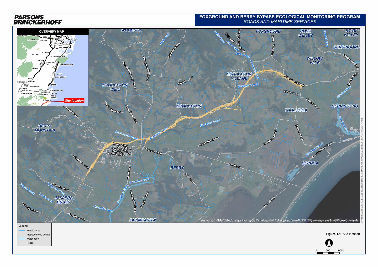
1. Introduction 1.1 Project overview Roads and Maritime Services (Roads and Maritime) is to upgrade 11.6 km of the Princes Highway between Toolijooa Road north of Foxground, to Schofields Lane south of Berry (the Project) (Figure 1.1). The Project is located within the Kiama and Shoalhaven Local Government Areas (LGAs). The resulting upgrade will be a four lane divided highway (two lanes in each direction) with median separation. The Project includes bypasses of Foxground and Berry localities.
The Project is situated within a predominantly rural locality, which is primarily cleared of native vegetation. Some remnant native vegetation exists along creeklines and generally small areas surrounded by cleared paddocks.
Approval for the project was granted on 22 July 2013, under Part 3A of the Environmental Planning and Assessment Act 1979 with Conditions of Approval (CoA). To satisfy the Minister for Planning and Infrastructure’s CoA B9, Roads and Maritime are required to develop and implement an Ecological Monitoring Program (EcMP). The preparation of this EcMP has included consultation with both the Office of Environment and Heritage (OEH) and Department of Primary Industries (Fishing and Aquaculture) (DPI).
This EcMP report has been developed for the Foxground and Berry Bypass Project study area (Figure 1.1) to satisfy the relevant ecological monitoring commitments outlined in the:
Major Project Application MP10 -0240
Conditions of Approval
Princes Highway upgrade – Foxground and Berry bypass – Environmental Assessment (Volumes 1 and 2), specifically, Section 7.3 and Appendix F and G (AECOM 2012)
Princes Highway upgrade – Foxground and Berry bypass – Submissions report, including the revised Statements of Commitments (AECOM 2013).
The EcMP outlines the objectives, goals, mitigation measures, performance criteria, targeted species and a discussion of the adaptive ecological monitoring approach developed for the Project. The ecological monitoring methodology and contingency measures recommended will inform baseline and future ecological monitoring as well as the pre-clearing, during construction and post-clearing surveys. The results of the ecological monitoring will determine the effectiveness of the biodiversity mitigation measures adopted by the Project, highlight modifications and maintenance requirements and/or identify unforseen issues that require additional measures to be implemented, in order to minimise impacts to biodiversity, as part of the CoA for the project.
It should be noted that this EcMP specifically addresses the ecological monitoring requirements for the Project, not any ecological management requirements. The ecological management requirements are covered by the separate Construction Flora and Fauna Management Sub-plan (CFFMP) written by Fulton Hogan and endorsed by Roads and Maritime in 2014. The CFFMP forms part of the Construction Environmental Management Plan (CEMP) for the Project. This EcMP does however refer to the CFFMP where relevant to monitoring requirements, such as in relation to monitoring of mitigation measures outlined in the CFFMP.
Crooked River
Jaspers Creek
Irwins Creek
Brou
ghton
Cree
k
Flying Fox Creek
Irwins Creek Irwins Creek
Broughton Creek
Broughton Creek
Crooked River
Broughton Creek
Broughton Creek
Jaspers Creek
Bundewallah Creek
Snake G
ully
Crooked River
Broughton Creek
Flying Fox Creek
Blue Angle Creek
Beach Road
Moey
an R
oad
Coolangatta Road
Toolijooa
Road
Princess StreetVictoria Street CrookedRiver Road
Queen Street
North StreetTannery Road
Princes Highway
Willowvale Road
Albert Street
O'keeffes Lane
Sharpes Lane
Schofields Lane
Croziers Road
DooleyRoad
Millers Lane
Gerroa Road
Mount Hay Road
Wattamolla Road
Harley Hill Road
Broughton ValeRoad
WoodhillMountain Road
ConnorsCreek
Road
Agars Lane
Wharf
Roa
d
Foxg
roun
dRo
ad
Bundewallah Road
Bong Bong Road
Ridge Lane
Tullo
uch Road
Tindalls Lane
Strongs Road
Baile
ys
Road
ROSEVALLEYROSE
VALLEY
BUNDEWALLAH
GERROA
JASPERSBRUSH
FAR MEADOW
BROUGHTONVILLAGE
WILLOWVALE
BROUGHTONVALE
TOOLIJOOA
BERRY
FOXGROUND
BELLAWONGARAH
WATTAMOLLA
BERRYMOUNTAIN
GERRINGONG
GERRINGONGBROUGHTON
WOODHILL
WOODHILL
Source: Esri, DigitalGlobe, GeoEye, i-cubed, USDA, USGS, AEX, Getmapping, Aerogrid, IGN, IGP, swisstopo, and the GIS User Community
\\APS
YDFIL
03\pro
j\R\Ro
ads_M
aritime
_Serv
ices\2
207005
A_EC
O_MO
NITOR
ING_A
ND_O
FFSE
TS_F
O\10_G
IS\Pro
jects\M
aps\22
07005A
_GIS_
001_A
1.mxd
// Wood
gerS /
/ 19/05
/2014
FOXGROUND AND BERRY BYPASS ECOLOGICAL MONITORING PROGRAMROADS AND MARITIME SERVICES
0 1,000500 m
Figure 1.1 Site location
MOSSVALE
EXETERBURRADOO
SYDNEYGLENBROOK LAPSTONELIVERPOOL
WOODFORD
PICTONDOUGLASPARK
CAMDEN
CAMPBELLTOWN
HELENSBURGH
THE OAKS
BARGO
BULLIWOLLONGONG
DAPTO
BOWRALMITTAGONGWELBY
BERRIMAMINNAMURRAKIAMAJAMBEROO
BERRY
ROBERTSONBUNDANOONWERRIBEACH
PENRITH WESTERNMOTORWAY
WES TLINKM7
HUMEHIG
HWAY
SOUT
HERN
FREE
WAY
LegendWatercourseProposed road designWater bodyRoads °
OVERVIEW MAP
Site location

Parsons Brinckerhoff | 2207005A-ECO-RPT-001 RevF 3
NSW Roads and Maritime Services Princes Highway Upgrade - Foxground and Berry Bypass Project - Ecological Monitoring Program
1.2 Objectives The overriding general objective in developing and implementing the EcMP is to satisfy the Projects ecological monitoring commitments to monitor the effectiveness of the Project’s fauna mitigation measures. The monitoring commitments in the EcMP are guided by a combination of the monitoring that was proposed by Roads and Maritime in the Project Application, Environmental Assessment and Statement of Commitments, combined with addressing CoA B9 of the Project Approval.
The objectives of this EcMP are to:
monitor the effectiveness of the biodiversity mitigation measures as identified in Minister’s conditions of approval B3 and B36(b) which include:
fauna crossings identified in the environmental impact statement of the Princes Highway Upgrade – Foxground to Berry Bypass
exclusion fencing
clearing procedures
replacement of hollows with nest boxes for fauna
collection and assessment of data required to identify significant changes to habitat usage
propose additional contingency measures for circumstances where there are significant changes to habitat usage by targeted fauna that can be directly attributed to the project
the primary objective of the aquatic monitoring aspect of the program would be to detect any impacts on ecological receptors (i.e. receiving aquatic environments) and estimate their geographical scale (i.e. where and how they might be occurring).
The EcMP outlines performance parameters and criteria to assist to assess the effectiveness of the mitigation measures, as required in CoA 9.
Section 1.3 tabulates the ecological monitoring requirements for the Project and identifies where the requirement is addressed, either in the EcMP, CFFMP or elsewhere. This information has been provided to ensure clarity for those responsible for the monitoring and regulation of the impacts of the Project.

Parsons Brinckerhoff | 2207005A-ECO-RPT-001 RevF 4
NSW Roads and Maritime Services Princes Highway Upgrade - Foxground and Berry Bypass Project - Ecological Monitoring Program
1.3 Fulfilment of ecological monitoring requirements Table 1.1 collates the ecological monitoring requirements outlined in the CoAs, revised Statement of Commitments and the Environmental Assessment commitments, management measures and safeguards that are relevant to ecological monitoring for the Project.
Table 1.1 Ecological monitoring commitments
ID Condition Limitations EcMP fulfilment of commitments
Section in EcMP condition is addressed
Minister of Planning and Infrastructure - Conditions of Approval
A1 The proponent shall carry out the project generally in accordance with the: Major Project Application MP10_0240
Princess Highway upgrade – Foxground and Berry bypass – Environmental Assessment (Volumes 1-2), prepared by AECOM Australia Pty Ltd for Roads and Maritime Services and dated November 2012
Princess Highway upgrade – Foxground and Berry bypass – Submissions Report, prepared by AECOM Australia Pty Ltd for Roads and Maritime Services and dated May 2013, including the revised Statement of Commitments contained therein Conditions of Approval
Discussed below
EcMP prepared in accordance with the documents outlined in A1 where applicable
Section 1.1
B9 The proponent shall develop an Ecological Monitoring Program to monitor the effectiveness of the biodiversity mitigation measures implemented as part of the project. The program shall be developed by a suitably qualified and experienced ecologist in consultation with the OEH and DPI (Fishing and Aquaculture) and shall include but not necessarily be limited to
Aspects of the EcMP are likely to be modified if changes in habitat usage are detected
This Ecological Monitoring Program (EcMP) has been developed by a qualified and experienced ecologist and been completed in consultation with OEH and DPI (Fishing and Aquaculture)
This EcMP
(a) An adaptive monitoring program to assess the effectiveness of the mitigation measures identified in conditions B3 and B36 (b) and shall amendment to the measures as necessary. The monitoring program shall nominate performance parameters and criteria against which effectiveness of fauna crossings and exclusion fencing implemented as part of the project
- An adaptive EcMP has been prepared to monitor the effectiveness of the biodiversity mitigation measures in accordance with the conditions and commitments of the project.
Sections 3, 4, 5 and 6

Parsons Brinckerhoff | 2207005A-ECO-RPT-001 RevF 5
NSW Roads and Maritime Services Princes Highway Upgrade - Foxground and Berry Bypass Project - Ecological Monitoring Program
ID Condition Limitations EcMP fulfilment of commitments
Section in EcMP condition is addressed
(b) Mechanisms for developing additional monitoring protocols to assess the effectiveness of any additional mitigation measures implemented to address additional impacts in the case of design amendments or unexpected threatened species finds during construction (where these additional impacts are generally consistent with the biodiversity impacts identified in the Project in the documents listed under Condition A1)
- The EcMP provides monitoring methodologies, performance parameters, potential contingency measures and reporting requirements of the Project
Sections 3, 4, 5 and 6
(c) Monitoring shall be undertaken during construction (for construction-related impacts) and from opening of the project to traffic (for operation/ongoing impacts) until such time as the effectiveness of the mitigation measures can be demonstrated to have been achieved over a minimum of three successive monitoring periods after opening of the project to traffic, unless otherwise agreed by the Director General. The monitoring period may be reduced with the agreement of the Director General in consultation with the OEH and DPI (Fishing and Aquaculture), depending on the outcomes of the monitoring
- Monitoring to be undertaken pre-construction, during construction and post-construction as specified in this condition
Sections 3, 4, 5 and 6
(d) Provision for the assessment of data to identify changes to habitat usage and whether this can be directly attributed to the project
- This EcMP outlines data collection and assessment processes
Sections 3, 4, 5 and 6
(e) Details of contingency measures that would be implemented in the event of changes to habitat usage patterns directly attributable to the construction or operation of the project
- Contingency measures are outlined in this EcMP
Section 5
(f) Provision for annual reporting of monitoring results to the Director General and the OEH and DPI (Fishing and Aquaculture), or as otherwise agreed by those agencies
- Annual reporting of results to the Director General and OEH and DPI (Fishing and Aquaculture) will occur
Section 6
The program shall be submitted to the Director General for approval no later than 6 weeks prior to the commencement of construction that would result in the disturbance of native vegetation (unless otherwise agreed by the Director General)
- This program was submitted to the Director General over 6 weeks prior to commencement of construction resulting in disturbance of native vegetation
Not applicable.
B36 (b) A Construction Flora and Fauna Management Sub-plan (CFFMP) to detail how construction impacts on ecology will be minimised and managed. The sub-plan shall be developed in consultation with the OEH and DPI (Fishing and Aquaculture) and shall include, but not necessarily be limited to
-
A separate CFFMP has been prepared to address and manage the impacts of construction for the Project. The EcMP outlines monitoring requirements for the aspects specified below
Section 2

Parsons Brinckerhoff | 2207005A-ECO-RPT-001 RevF 6
NSW Roads and Maritime Services Princes Highway Upgrade - Foxground and Berry Bypass Project - Ecological Monitoring Program
ID Condition Limitations EcMP fulfilment of commitments
Section in EcMP condition is addressed
Detail of pre-construction surveys undertaken by a suitably qualified and experienced ecologist to verify the construction boundaries/footprint of the project based on detailed design and to confirm the vegetation to be cleared as part of the project (including hollow, threatened flora and fauna species and riparian vegetation)
- Refer to CFFMP for detail. EcMP includes requirement for report and monitoring results as part of overall ecological performance monitoring
Section 2
Updated sensitive area/vegetation maps based on (i) above and previous survey work
- Refer to CFFMP for detail. EcMP includes requirement for report and monitoring results as part of overall ecological performance monitoring
Section 2
Details of general work practices and mitigation measures to be implemented during construction to minimise impacts on native fauna and native vegetation (particularly threatened species and EECs) not proposed to be cleared as part of the project, including, but not necessarily limited to: fencing of sensitive areas, a protocol for the removal and relocation of fauna during clearing, engagement of a suitably qualified and experiences ecologist to identify locations where they would be present to oversee clearing activities and facilitate fauna recues and re-location, clearing timing with consideration to breeding periods, measures for maintaining existing habitat features (such as bush rock and tree branches etc.), seed harvesting and appropriate topsoil management construction worker education, weed management (including controls to prevent the introduction or spread of Phytophthora cinnamomi), erosion and sediment control and progressive re-vegetation
- Refer to CFFMP for detail. EcMP includes requirement for report and monitoring results as part of overall ecological performance monitoring
Section 2
Specific procedures to deal with EEC/threatened species anticipated to be encountered within the project corridor including re-location, translocation and/or management and protection measures
- Refer to CFFMP for detail. EcMP includes requirement for report and monitoring results as part of overall ecological performance monitoring
Section 2
A procedure for dealing with unexpected EEC/threatened species identified during construction including cessation of work and notification of the OEH, determination of appropriate mitigation measures in consultation with the OEH (including relevant re-location measures) and update of ecological monitoring and/or biodiversity offset requirements consistent with conditions B7 and B8
- Refer to CFFMP for detail. EcMP includes requirement for report and monitoring results as part of overall ecological performance monitoring
Section 2
Parsons Brinckerhoff | 2207005A-ECO-RPT-001 RevF 7
NSW Roads and Maritime Services Princes Highway Upgrade - Foxground and Berry Bypass Project - Ecological Monitoring Program
ID Condition Limitations EcMP fulfilment of commitments
Section in EcMP condition is addressed
Revised Statement of Commitments – from within the Submissions Report
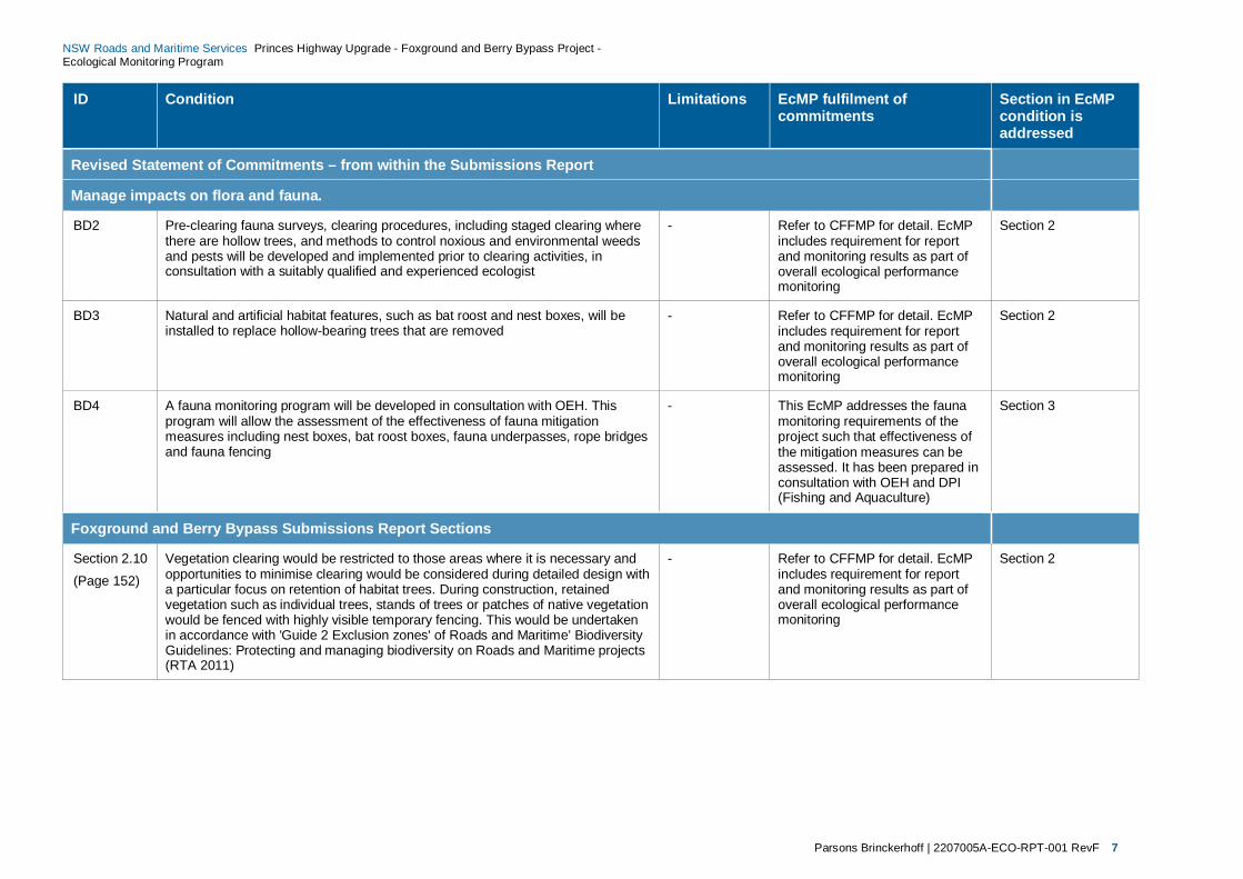
Manage impacts on flora and fauna.
BD2 Pre-clearing fauna surveys, clearing procedures, including staged clearing where there are hollow trees, and methods to control noxious and environmental weeds and pests will be developed and implemented prior to clearing activities, in consultation with a suitably qualified and experienced ecologist
- Refer to CFFMP for detail. EcMP includes requirement for report and monitoring results as part of overall ecological performance monitoring
Section 2
BD3 Natural and artificial habitat features, such as bat roost and nest boxes, will be installed to replace hollow-bearing trees that are removed
- Refer to CFFMP for detail. EcMP includes requirement for report and monitoring results as part of overall ecological performance monitoring
Section 2
BD4 A fauna monitoring program will be developed in consultation with OEH. This program will allow the assessment of the effectiveness of fauna mitigation measures including nest boxes, bat roost boxes, fauna underpasses, rope bridges and fauna fencing
- This EcMP addresses the fauna monitoring requirements of the project such that effectiveness of the mitigation measures can be assessed. It has been prepared in consultation with OEH and DPI (Fishing and Aquaculture)
Section 3
Foxground and Berry Bypass Submissions Report Sections
Section 2.10 (Page 152)
Vegetation clearing would be restricted to those areas where it is necessary and opportunities to minimise clearing would be considered during detailed design with a particular focus on retention of habitat trees. During construction, retained vegetation such as individual trees, stands of trees or patches of native vegetation would be fenced with highly visible temporary fencing. This would be undertaken in accordance with 'Guide 2 Exclusion zones' of Roads and Maritime’ Biodiversity Guidelines: Protecting and managing biodiversity on Roads and Maritime projects (RTA 2011)
- Refer to CFFMP for detail. EcMP includes requirement for report and monitoring results as part of overall ecological performance monitoring
Section 2

Parsons Brinckerhoff | 2207005A-ECO-RPT-001 RevF 8
NSW Roads and Maritime Services Princes Highway Upgrade - Foxground and Berry Bypass Project - Ecological Monitoring Program
ID Condition Limitations EcMP fulfilment of commitments
Section in EcMP condition is addressed
The ancillary areas assessment methodology is detailed in Section 2.7 (pages F22 to F23) of Appendix F - Technical paper: Terrestrial Flora and Fauna to the environmental assessment. The assessment criteria for terrestrial biodiversity aim to identify ancillary areas where there would be:
no substantial vegetation clearing (unless required for project alignment)
low conservation significance for flora and fauna
no removal of EECs, threatened species or threatened fauna habitat (unless required for project alignment)
- Refer to CFFMP for detail. EcMP includes requirement for report and monitoring results as part of overall ecological performance monitoring. Ancillary sites are not expected to require any monitoring as they have been located in areas of low environmental significance, as per the requirements of the EA. Where any ancillary sites are located within the project footprint, and require staged vegetation removal, the monitoring and reporting proposed for all clearing as part of the project would apply. This is addressed in the first row of Table 3.2 in this EcMP
Section 2
In addition no physical disturbance would occur outside the boundaries of the proposed ancillary sites. In accordance with ‘Guide 2 – Exclusion Zones’ (RTA 2011), buffers and temporary fencing would be installed to mark ‘no-go’ areas if ancillary sites are located directly adjacent to EECs or areas of medium-high conservation significance. According to the ancillary facility assessment criteria, the definition of medium-high conservation significance includes:
an area with native vegetation which may be EEC or not
threatened (or migratory) flora or fauna records/occurrences
moderate to good potential habitat for threatened (or migratory) species including intact soil profile, intact structural layers, mature fruiting trees, hollow-bearing trees and fallen woody debris
water source
- Refer to CFFMP for detail. EcMP includes requirement for report and monitoring results as part of overall ecological performance monitoring
Section 2
Further to the safeguards highlighted above, refinements may be made to the design features and construction methods to further minimise vegetation clearing during the detailed design phase of the project
- Refer to CFFMP for detail. EcMP includes requirement for report and monitoring results as part of overall ecological performance monitoring
Section 2

Parsons Brinckerhoff | 2207005A-ECO-RPT-001 RevF 9
NSW Roads and Maritime Services Princes Highway Upgrade - Foxground and Berry Bypass Project - Ecological Monitoring Program
ID Condition Limitations EcMP fulfilment of commitments
Section in EcMP condition is addressed
As detailed above, a vegetation management plan would be prepared to guide revegetation and restoration works. The vegetation management plan would be prepared in consultation with local Landcare groups, the Southern Rivers CMA and affected land owners and would consider the opportunities and constraints surrounding ownership and continuing management of specific parcels of land
- Refer to separate Vegetation Management Plan for the project
Not Applicable
Section 2.10 (Page 154)
Mitigation measures such as fauna fencing, fauna underpasses and rope bridges have been located in areas with the greatest potential for impact based on existing constraints, movement patterns and fauna habitat utilisation (in areas with remnant vegetation). Some of these include
Baseline monitoring limited to spring / summer.
Post-construction monitoring methodology may require modification if any significant changes in habitat usage are detected
This EcMP addresses the fauna monitoring requirements of the project such that effectiveness of the mitigation measures can be assessed.
Section 2 and Section 3
In areas along Broughton Mill Creek identified as potential dispersal habitat for the Green and Golden Bell Frog (Litoria aurea), a frog-proof fence would also be provided to encourage movement of this species beneath the bridge
- EcMP includes requirement for report and monitoring results as part of overall ecological performance monitoring
Section 2 and Section 3
Rope bridges would be provided to facilitate movement of arboreal mammals. Use of barbed wire in the vicinity of rope bridges and associated structures is not recommended due to the potential for gliders to become caught and killed in barbed wire fences
- EcMP includes requirement for report and monitoring results as part of overall ecological performance monitoring
Section 2 and Section 3
Fauna fencing would be provided to avoid or minimise impacts to and improve the safety of native fauna by guiding fauna to crossing points. The current concept design generally includes wire rope safety barriers, except in locations were space is constrained (such as bridges) where concrete barriers would be required. In these locations, Roads and Maritime would use Type F concrete barriers to allow for movement of small mammals, amphibians and reptiles across these areas. Fauna fencing for the project would consist of a 1.8 metre high chain link fence
- EcMP includes requirement for report and monitoring results as part of overall ecological performance monitoring
Section 2 and Section 3

Parsons Brinckerhoff | 2207005A-ECO-RPT-001 RevF 10
NSW Roads and Maritime Services Princes Highway Upgrade - Foxground and Berry Bypass Project - Ecological Monitoring Program
ID Condition Limitations EcMP fulfilment of commitments
Section in EcMP condition is addressed
Farm boundary fencing will be provided in some areas. Roads and Maritime would encourage the use of fauna-friendly fencing design when fencing farm boundaries along the road corridor. The type of fencing used would be subject to agreements with landholders. In open agricultural land between areas of remnant vegetation the potential for small native mammals to occur is limited. Therefore, installing fauna fencing in these areas is not considered to be warranted
- EcMP includes requirement for report and monitoring results as part of overall ecological performance monitoring
Section 2 and Section 3
Monitoring of fauna – vehicle collisions would be undertaken during the operation phase of the Project If road kill becomes an issue during the operational phase of the project additional fencing of these locations would be considered
- This EcMP includes specific road kill monitoring requirements for the Project
Section 2 and Section 3
Section 2.10 (Page 155)
In summary Roads and Maritime Biodiversity Guidelines (Guide 6 Weed management) outlines the requirements for management of terrestrial and aquatic environmental and noxious weeds during construction and suggests best practice methods for weed management during maintenance works. In addition to implementing the management practices recommended in Roads and Maritime’ Biodiversity Guidelines: Protecting and managing biodiversity on Roads and Maritime projects (RTA, 2011), the following mitigation measure would be implemented:
Control drainage that may contain weed seeds or high levels of nutrients.
Use weed-free topsoil in landscaping and re-vegetate disturbed sites with locally indigenous species (local provenance).
Monitor and control weed populations that establish in disturbed areas, with particular attention to eradication of noxious weeds. Weed invasions would be monitored and controlled by a person experienced in weed management.
Incorporate weed management strategies into the vegetation management plan, detailing necessary weed control works, particularly in areas where the weeds may impact on threatened species and/or their habitats.
- The EcMP refers to the Weed Management Strategy in the CFFMP. EcMP includes requirement for report and monitoring results as part of overall ecological performance monitoring
Section 2.4, Section 3 and Section 4
Environment Assessment Report – Biodiversity mitigation and management measures
Pre-construction
General construction impacts on flora and
Conduct a hollow-bearing tree/stag watch survey prior to construction. Undertake stag-watching to identify the number and type of nest boxes required and where to install them. The optimal season for stag-watching is spring; a hollow-bearing tree/stag survey however, can be conducted any time of year
-
EcMP outlines methodology for undertaking hollow bearing tree and stag watching survey within full extent of the project.
Sections 3, 4, 5 and 6
Parsons Brinckerhoff | 2207005A-ECO-RPT-001 RevF 11
NSW Roads and Maritime Services Princes Highway Upgrade - Foxground and Berry Bypass Project - Ecological Monitoring Program
ID Condition Limitations EcMP fulfilment of commitments
Section in EcMP condition is addressed
fauna Install bat roost and nest boxes at a ratio of 1:1 for each hollow removed by the project
- EcMP outlines surveys that would inform the number of bat roosts and nest boxes required to be installed at a 1:1 ratio for each hollow that will be removed. Nest box installation and management also discussed in accordance with Roads and Maritime Biodiversity Guidelines
Sections 3, 4, 5 and 6
Installation of bat roost and nest boxes would take place at least one month prior to the commencement of construction
- EcMP outlines surveys that would inform the number of bat roosts and nest boxes required to be installed at a 1:1 ratio for each hollow that will be removed. Nest box installation and management also discussed in accordance with Roads and Maritime Biodiversity Guidelines
Sections 3, 4, 5 and 6
Install nest boxes in accordance with Roads and Maritime ‘Biodiversity Guidelines: Guide 8 – Nest Boxes’ (RTA 2011)
- EcMP outlines methodology for surveys of bridges and culverts to detect roosting microbats. Refers to the need of a Bat Management Plan if bats are detected during surveys
Sections 3, 4, 5 and 6
Prior to construction, conduct a survey of any bridges or culverts scheduled for removal in order to detect roosting microbats. If detected, prepare and implement a Bat Management Plan
- EcMP outlines methodology for surveys of bridges and culverts to detect roosting microbats. Refers to the need of a Bat Management Plan if bats are detected during surveys
Sections 3, 4, 5 and 6
Construction
Mortality of individuals
Ensure that vegetation clearance complies with Roads and Maritime Biodiversity Guidelines: Guide 4 - Clearing of vegetation and removal of bushrock (RTA, 2011)
- Refer to CFFMP for detail. EcMP includes requirement for report and monitoring results as part of overall ecological performance monitoring
Section 2
Parsons Brinckerhoff | 2207005A-ECO-RPT-001 RevF 12
NSW Roads and Maritime Services Princes Highway Upgrade - Foxground and Berry Bypass Project - Ecological Monitoring Program
ID Condition Limitations EcMP fulfilment of commitments
Section in EcMP condition is addressed
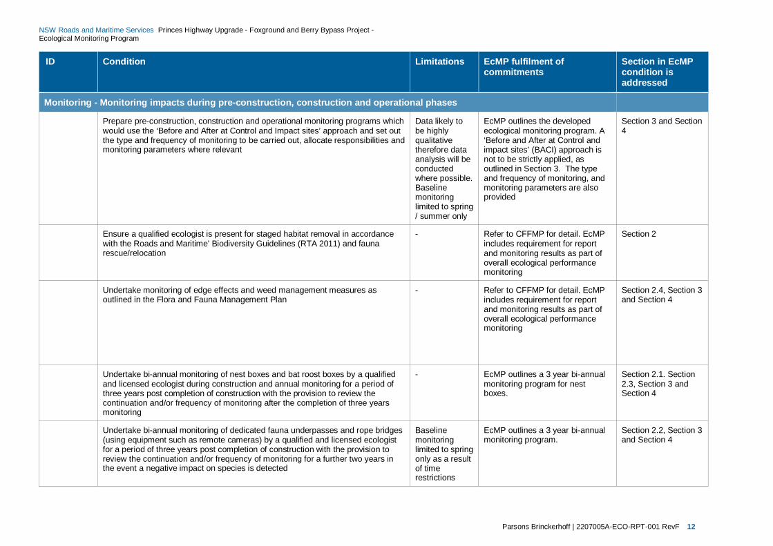
Monitoring - Monitoring impacts during pre-construction, construction and operational phases
Prepare pre-construction, construction and operational monitoring programs which would use the ‘Before and After at Control and Impact sites’ approach and set out the type and frequency of monitoring to be carried out, allocate responsibilities and monitoring parameters where relevant
Data likely to be highly qualitative therefore data analysis will be conducted where possible. Baseline monitoring limited to spring / summer only
EcMP outlines the developed ecological monitoring program. A ‘Before and After at Control and impact sites’ (BACI) approach is not to be strictly applied, as outlined in Section 3. The type and frequency of monitoring, and monitoring parameters are also provided
Section 3 and Section 4
Ensure a qualified ecologist is present for staged habitat removal in accordance with the Roads and Maritime’ Biodiversity Guidelines (RTA 2011) and fauna rescue/relocation
- Refer to CFFMP for detail. EcMP includes requirement for report and monitoring results as part of overall ecological performance monitoring
Section 2
Undertake monitoring of edge effects and weed management measures as outlined in the Flora and Fauna Management Plan
- Refer to CFFMP for detail. EcMP includes requirement for report and monitoring results as part of overall ecological performance monitoring
Section 2.4, Section 3 and Section 4
Undertake bi-annual monitoring of nest boxes and bat roost boxes by a qualified and licensed ecologist during construction and annual monitoring for a period of three years post completion of construction with the provision to review the continuation and/or frequency of monitoring after the completion of three years monitoring
- EcMP outlines a 3 year bi-annual monitoring program for nest boxes.
Section 2.1. Section 2.3, Section 3 and Section 4
Undertake bi-annual monitoring of dedicated fauna underpasses and rope bridges (using equipment such as remote cameras) by a qualified and licensed ecologist for a period of three years post completion of construction with the provision to review the continuation and/or frequency of monitoring for a further two years in the event a negative impact on species is detected
Baseline monitoring limited to spring only as a result of time restrictions
EcMP outlines a 3 year bi-annual monitoring program.
Section 2.2, Section 3 and Section 4
Parsons Brinckerhoff | 2207005A-ECO-RPT-001 RevF 13
NSW Roads and Maritime Services Princes Highway Upgrade - Foxground and Berry Bypass Project - Ecological Monitoring Program
ID Condition Limitations EcMP fulfilment of commitments
Section in EcMP condition is addressed
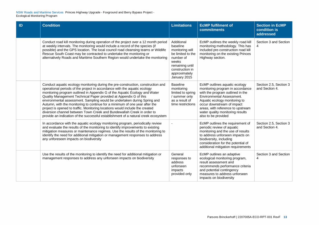
Conduct road kill monitoring during operation of the project over a 12 month period at weekly intervals. The monitoring would include a record of the species (if possible) and the GPS location. The local council road cleansing teams or Wildlife Rescue South Coast may be contracted to undertake the monitoring or alternatively Roads and Maritime Southern Region would undertake the monitoring
Additional baseline monitoring will be limited to the number of weeks remaining until construction in approximately January 2015
EcMP outlines the weekly road kill monitoring methodology. This has included pre-construction road kill monitoring on the existing Princes Highway section.
Section 3 and Section 4
Conduct aquatic ecology monitoring during the pre-construction, construction and operational periods of the project in accordance with the aquatic ecology monitoring program outlined in Appendix G of the Aquatic Ecology and Water Quality Management Technical Paper provided at Appendix G of this environmental assessment. Sampling would be undertaken during Spring and Autumn, with the monitoring to continue for a minimum of one year after the project is opened to traffic. Monitoring locations would include the created diversion channel between Town Creek and Bundewallah Creek in order to provide an indication of the successful establishment of a natural creek ecosystem
Baseline monitoring limited to spring / summer only as a result of time restrictions
EcMP outlines aquatic ecology monitoring program in accordance with the program outlined in the Environmental Assessment. Aquatic ecology monitoring to occur downstream of impact areas, with reference to upstream water quality monitoring results also to be provided
Section 2.5, Section 3 and Section 4.
In accordance with the aquatic ecology monitoring program, periodically review and evaluate the results of the monitoring to identify improvements to existing mitigation measures or maintenance regimes. Use the results of the monitoring to identify the need for additional mitigation or management responses to address any unforeseen impacts on biodiversity
- EcMP outlines the requirement of periodic review of aquatic monitoring and the use of results to address unforseen impacts on biodiversity, including consideration for the potential of additional mitigation requirements
Section 2.5, Section 3 and Section 4.
Use the results of the monitoring to identify the need for additional mitigation or management responses to address any unforseen impacts on biodiversity
General responses to address unforseen impacts provided only
EcMP outlines an adaptive ecological monitoring program, result assessment and recommends performance criteria and potential contingency measures to address unforseen impacts on biodiversity
Section 3 and Section 4
Parsons Brinckerhoff | 2207005A-ECO-RPT-001 RevF 14
NSW Roads and Maritime Services Princes Highway Upgrade - Foxground and Berry Bypass Project - Ecological Monitoring Program
2. Mitigation measures This section summarises the main mitigation measures outlined in the Princes Highway upgrade – Foxground and Berry bypass - Environmental Assessment (AECOM 2012) and Roads and Maritime Biodiversity Guidelines (Roads and Traffic Authority 2011). The mitigation measures focused upon include:
pre-clearing and clearing procedures
connectivity mitigation measures
nest box management
weed management
aquatic and riparian protection.
These mitigation measures nominated for monitoring are discussed below.
The CFFMP provides the specific processes for management of flora and fauna during construction. Refer to the CFFMP for details on the summarised mitigation measures.
This section refers to information obtained from the CFFMP where appropriate for construction activities. Where any inconsistency occurs between the CFFMP and this EcMP, the CCFMP takes precedence. If any adaptive changes are made to the CFFMP, monitoring in this EcMP may need to be amended.
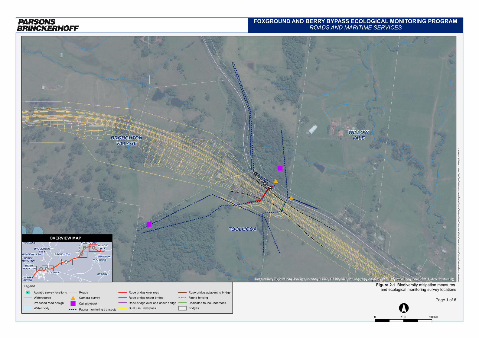
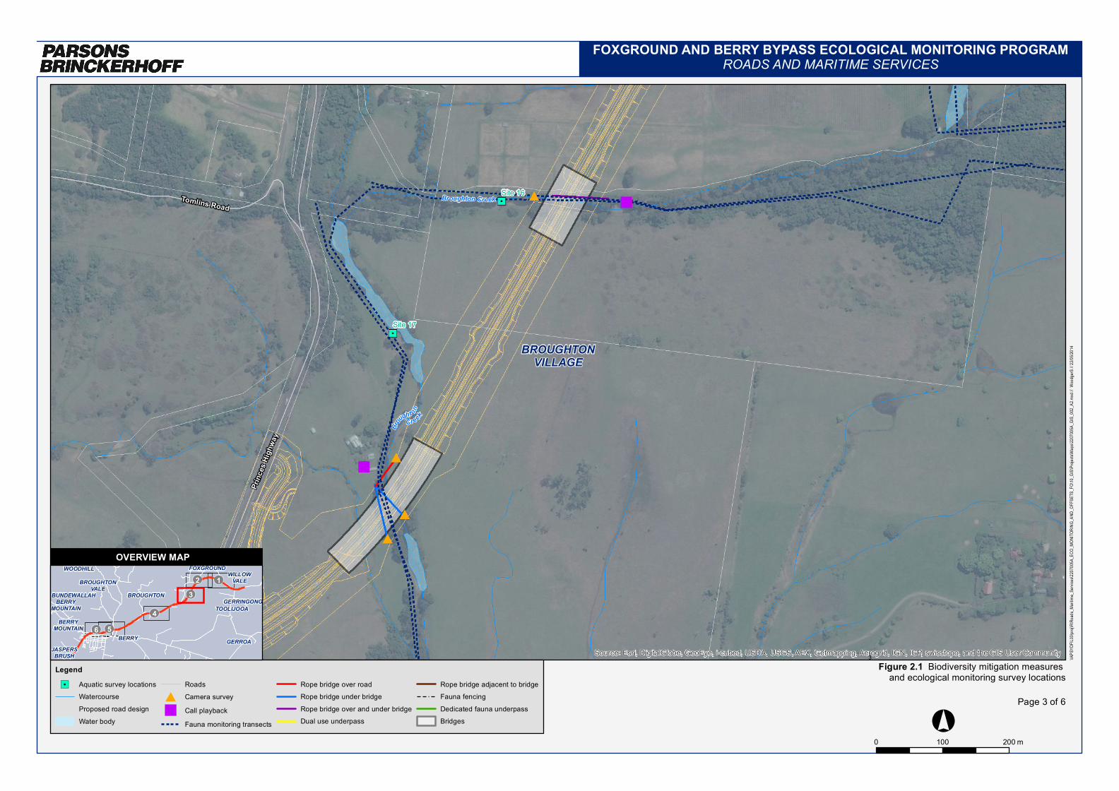
Figure 2.1 shows the current location of proposed mitigation measures and proposed monitoring locations. It should be noted that there are currently some changes being proposed to the mitigation measure locations by Fulton Hogan. If these are approved, the EcMP would need to be updated to reflect any such changes.
2.1 Pre-clearing and clearing process A pre-clearance process and staged habitat removal must be conducted prior to the commencement of any operations that will result in the removal native vegetation or fauna habitat. The pre-clearance process is outlined in the CFFMP and includes:
confirm the location of biodiversity features identified during the environmental assessment process
check for the presence of flora and fauna species and habitat on a site immediately before clearing begins
provide input into identifying appropriate exclusion zones
locate nearby habitat suitable for the release of fauna that may be encountered during the pre-clearing process or habitat removal
inform planning and procedures for the staged habitat removal process
ensure that the location of any threatened flora species, threatened ecological communities and habitat are mapped
identify any additional management measures that may need to be incorporated into the Construction Environmental Management Plan (CEMP).

Parsons Brinckerhoff | 2207005A-ECO-RPT-001 RevF 15
NSW Roads and Maritime Services Princes Highway Upgrade - Foxground and Berry Bypass Project - Ecological Monitoring Program
2.1.1 Pre-clearing surveys
Prior to the commencement of any clearing operations the project team will ensure that all pre – clearance surveys are completed by completing the ‘Pre-clearing / Ground Disturbance Inspection Checklist’ for the Project which is located within the CFFMP (Roads and Maritime Services 2014). This checklist must be signed off prior to clearing.
In summary, prior to clearing the construction boundaries should be delineated, exclusion zones established, habitat trees and other features and weeds identified, targeted surveys conducted and appropriate wildlife rescue organisations notified of clearing operations by a qualified ecologist.
2.1.1.1 Delineation of clearing boundaries
Prior to clearing an ecologist should verify the construction boundaries/footprint of the Project based on the detailed design to identify the proposed clearing boundary and vegetation to be removed by the Project. The delineation survey would confirm the location of hollows, threatened flora and fauna species and vegetation.
Exclusion zones would be established around native vegetation (particularly Endangered Ecological Communities (EECs) and threatened species) not proposed to be cleared by the project.
2.1.1.2 Identification, marking and re-distribution of habitat resources
An initial hollow-bearing tree survey would be conducted to identify the location, number, density and type of hollows present within the entire construction footprint of the Project area. The data collected from this survey would inform the Nest Box Management Plan as discussed in Section 2.3.
Within one week of Stage 1 Clearing (within seven days of under scrubbing and non – habitat tree removal) further surveys would be conducted to locate and mark the habitat trees identified in the initial survey and detect additional habitat resources (e.g. nests, dreys, fissues, termitaria, fallen timber, and dens likely to be inhabited by fauna). The location of additional habitat trees would be recorded using a hand held GPS and all resources would be marked using flagging tape and spray paint to ensure that each tree can be readily identified by machine operators and avoided during Stage 1 Clearing. Details of these habitat features would be passed onto the Environmental Manager.
The habitat resources identified within the habitat resources survey suitable for re-distribution would be relocated into adjacent areas including release sites.
2.1.1.3 Weed site inspection
The project team will undertake a site inspection prior to clearing to identify weed infestations present. The Project ecologist would advise the Project team on the most appropriate weed treatment methodology and timing as best to control the spread or introduction of weeds into new locations (Roads and Maritime Services 2014).
2.1.1.4 Targeted surveys
Green and Golden Bell Frog surveys and management
Potential dispersal habitat for the Green and Golden Bell Frog (GGBF) was previously identified in the Environmental Assessment (AECOM 2012) nearby to the Town Creek diversion. As a result targeted GGBF are required within this area prior to the commencement of any clearing operations. The GGBF survey methodology, location, timing and frequency are provided in Table 3.2.

Parsons Brinckerhoff | 2207005A-ECO-RPT-001 RevF 16
NSW Roads and Maritime Services Princes Highway Upgrade - Foxground and Berry Bypass Project - Ecological Monitoring Program
If GGBFs are detected within the Town Creek diversion area during the pre-clearance surveys further investigations and management measures would be required prior to construction that may include detailed field surveys, preparation of a GGBF Management Plan and monitoring of GGBF during the construction, and post construction phases of the Project.
Microbat surveys and management
Prior to the commencement of clearing operations surveys of all bridges and culverts scheduled for disturbance as part of the project will be conducted to identify sites used by roosting microbats. The microbat survey methodology, location, timing and frequency are provided in Table 3.2.
The preparation of a Bat Management Plan will be required if roosting microbats are detected within bridge and/or culvert structures scheduled for disturbance as part of the project. If bats are detected, the Bat Management Plan will propose management measures and monitoring (i.e. pre-clearing surveys, exclusion during bridge removal, bridge removal outside of maternity season etc.) for the full project duration including pre-construction, construction and operational and post completion phases.
2.1.1.5 Baseline ecological monitoring surveys
Ecological monitoring is required to determine the effectiveness of the ecological mitigation measures implemented by the project. As discussed above these mitigation measures include pre-clearing and clearing procedures, connectivity mitigation measures (including fauna fencing and underpasses) and the installation of nest boxes to compensate for hollows that will be removed by the Project.
The surveys undertaken for the Terrestrial Flora and Fauna Assessment by Biosis (2012) included Elliott trapping, cage trapping, hair tubes, harp traps and a range of other fauna techniques. Threatened species recorded by Biosis were those highly mobile species of bat and bird that would be expected in a highly modified landscape, and included:
Yellow-bellied Sheathtail Bat
Eastern Freetail Bat
Grey-headed Flying Fox
Eastern Bentwing-bat
Eastern False Pipistrelle
Southern Myotis
Greater Broad-nosed Bat
Gang-gang Cockatoo
Powerful Owl.
When developing the monitoring methodology for the EcMP for the Foxground and Berry bypass Project, consideration to the use of a ‘BACI’ (Before and After at Control and Impact sites’) approach was given. This approach requires data to be collected ‘Before’ and ‘After’ at ‘Control’ and ‘Impact’ sites to detect changes in habitat usage against a variable background of environmental changes. It was determined that due to the highly modified nature of the habitats of the locality and to the highly mobile nature of the previously recorded threatened species, that a BACI approach was not warranted for this monitoring project. In addition, the effectiveness of mitigation measures when compared to control sites would be difficult to measure, as the number of replicates and repetition of surveys required to obtain any meaningful statistical patterns is not justified for the level of impact of this project. Off-site ‘Control’ sites are therefore not proposed to be used for this particular project.

Parsons Brinckerhoff | 2207005A-ECO-RPT-001 RevF 17
NSW Roads and Maritime Services Princes Highway Upgrade - Foxground and Berry Bypass Project - Ecological Monitoring Program
The monitoring will still collect habitat and species information before, after and during construction of the new highway and will assess and determine the effectiveness of the mitigation measures that have been implemented, highlight modifications and maintenance requirements and/or identify unforseen issues that require additional measures to be implemented to minimise impacts to biodiversity. The monitoring surveys are described in more detail in Section 3 and Table 3.3.
2.1.2 Clearing procedure
The main objective of a clearing procedure is to minimise the impacts of habitat loss on biodiversity. Specifically, staged clearing procedures aim to allow sufficient time for hollow dependant species to vacate the hollows and naturally relocate minimising the direct impacts on fauna. The Environmental Manager must ensure that all vegetation clearance complies with the Roads and Maritime Biodiversity Guidelines ‘Guide 4: Clearing vegetation and removal of bush rock’ (Roads and Maritime Services 2014).
Following the pre-clearing surveys the removal of habitat features would be cleared as outlined in the CFFMP. This generally includes the removal of non – habitat trees, undergrowth, regrowth, following by removal of habitat trees after a waiting period. Felling of trees would be conducted carefully to avoid injury to wildlife. Once tree has been felled an ecologist should inspect the tree for the emergence of animals. Where detected, fauna should be captured, inspected for injury and relocated within a pre-determine fauna release site. The ‘Fauna Handling and Rescue Procedure’ is provided in the CFFMP (Roads and Maritime Services 2014).
Should injured fauna be captured the animal should be transported to an experienced wildlife carer or veterinarian. Any wildlife carer assisting in the care of injured fauna for the project must hold a license to care for sick and injured native fauna issued by the Office of Environment and Heritage (OEH) under the provisions of the National Parks and Wildlife Act 1974. Wildlife carers must also be able to provide evidence of wildlife carer training and/or extensive experience in the rehabilitation of wildlife. If injured wildlife is able to be released after rehabilitation, it would be conducted in consultation with a project ecologist or RMS environmental management staff to ensure that the release location is suitable with regard to project construction operations.
The unexpected finds procedure is outlined in the CFFMP (Roads and Maritime Services 2014). This procedure would be used if a threatened plant or animal species were unexpectedly observed during the clearing or construction stages of the Project. If unexpected finds do occur during the clearing or construction phases of the Project a review of the EcMP should be conducted to update and modify methodologies appropriately.
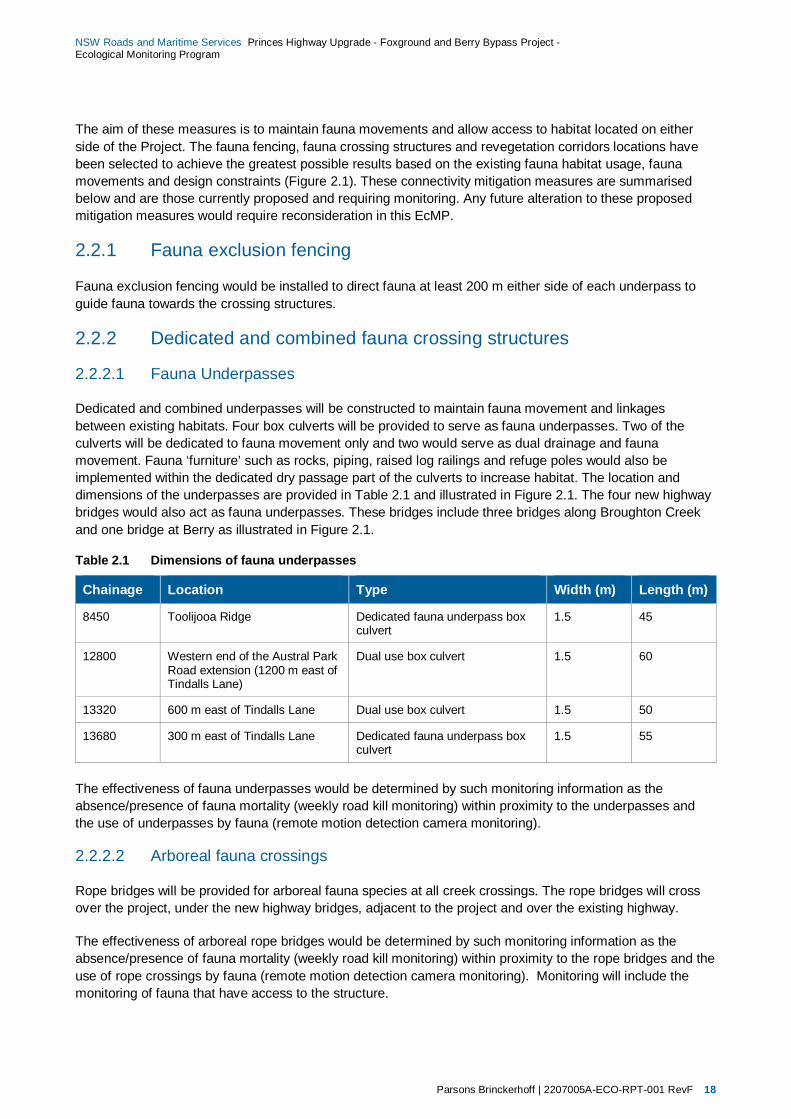
2.2 Connectivity mitigation measures Mitigation measures have been designed and will be implemented as part of the Project to maintain connectivity of fauna habitat. The Project’s connectivity mitigation measures are described in the Environmental Assessment (AECOM 2012) and in the CFFMP (Roads and Maritime Services 2014). The mitigation measures include:
fauna exclusion fencing
dedicated and combined fauna crossing structures, such as culverts and ropes
revegetation corridors.
Parsons Brinckerhoff | 2207005A-ECO-RPT-001 RevF 18
NSW Roads and Maritime Services Princes Highway Upgrade - Foxground and Berry Bypass Project - Ecological Monitoring Program
The aim of these measures is to maintain fauna movements and allow access to habitat located on either side of the Project. The fauna fencing, fauna crossing structures and revegetation corridors locations have been selected to achieve the greatest possible results based on the existing fauna habitat usage, fauna movements and design constraints (Figure 2.1). These connectivity mitigation measures are summarised below and are those currently proposed and requiring monitoring. Any future alteration to these proposed mitigation measures would require reconsideration in this EcMP.
2.2.1 Fauna exclusion fencing
Fauna exclusion fencing would be installed to direct fauna at least 200 m either side of each underpass to guide fauna towards the crossing structures.
2.2.2 Dedicated and combined fauna crossing structures
2.2.2.1 Fauna Underpasses
Dedicated and combined underpasses will be constructed to maintain fauna movement and linkages between existing habitats. Four box culverts will be provided to serve as fauna underpasses. Two of the culverts will be dedicated to fauna movement only and two would serve as dual drainage and fauna movement. Fauna ‘furniture’ such as rocks, piping, raised log railings and refuge poles would also be implemented within the dedicated dry passage part of the culverts to increase habitat. The location and dimensions of the underpasses are provided in Table 2.1 and illustrated in Figure 2.1. The four new highway bridges would also act as fauna underpasses. These bridges include three bridges along Broughton Creek and one bridge at Berry as illustrated in Figure 2.1.
Table 2.1 Dimensions of fauna underpasses
Chainage Location Type Width (m) Length (m)
8450 Toolijooa Ridge Dedicated fauna underpass box culvert
1.5 45
12800 Western end of the Austral Park Road extension (1200 m east of Tindalls Lane)
Dual use box culvert 1.5 60
13320 600 m east of Tindalls Lane Dual use box culvert 1.5 50
13680 300 m east of Tindalls Lane Dedicated fauna underpass box culvert
1.5 55
The effectiveness of fauna underpasses would be determined by such monitoring information as the absence/presence of fauna mortality (weekly road kill monitoring) within proximity to the underpasses and the use of underpasses by fauna (remote motion detection camera monitoring).
2.2.2.2 Arboreal fauna crossings
Rope bridges will be provided for arboreal fauna species at all creek crossings. The rope bridges will cross over the project, under the new highway bridges, adjacent to the project and over the existing highway.
The effectiveness of arboreal rope bridges would be determined by such monitoring information as the absence/presence of fauna mortality (weekly road kill monitoring) within proximity to the rope bridges and the use of rope crossings by fauna (remote motion detection camera monitoring). Monitoring will include the monitoring of fauna that have access to the structure.
Parsons Brinckerhoff | 2207005A-ECO-RPT-001 RevF 19
NSW Roads and Maritime Services Princes Highway Upgrade - Foxground and Berry Bypass Project - Ecological Monitoring Program
2.2.3 Revegetation corridors
Riparian vegetation will be retained under bridges and temporary creek crossings where feasible. Retention of roadside vegetation in the vicinity of rope bridges and fauna underpasses will occur to maintain habitat connectivity. Where vegetation is removed revegetation of these areas would occur as soon as practicable after construction. Revegetation works will also be conducted in existing fauna corridors to enhance habitat connectivity.
The revegetation areas will be monitored to determine ongoing use patterns by fauna via remote motion detection camera, spotlighting, call playback, herpetology searches, tracks, scats and signs searches monitoring.
2.3 Nest box management Nest boxes will be installed to compensate for the loss of hollow bearing trees by providing supplementary fauna habitat. The design and installation of nest boxes will be in accordance with Guide 8 ‘Nest boxes’ of the Roads and Maritime Biodiversity Guidelines (Roads and Traffic Authority 2011) and the mitigation measures as outlined in Table 1.1.
The pre-clearance hollow-bearing tree/stag survey will identify the number and type of nest boxes required to fulfil the above criteria based on the number and size of the hollows that would be removed by the project and the species considered likely to use the existing hollows (Table 3.2). Inspections underneath bridges and culverts along the existing highway are also to be undertaken to determine any use by roosting bat species and whether additional corresponding compensatory habitat for bat species is subsequently required.
Following this a separate Nest Box Management Plan will be prepared outlining the detailed specifications required including dimensions, installation, location placement, baseline and ongoing monitoring, management and maintenance of the nest boxes. This is likely to include installation of bat boxes designed for species such as Southern Myotis, which have been identified as occurring in the locality by OEH. These would be installed in new bridges and culverts, as recommended by OEH.
As outlined in the Roads and Maritime Biodiversity Guidelines: Guide 8: Nest boxes (Roads and Traffic Authority 2011) it is recommended that 70% of the nominated nest boxes be installed up to one month prior to the start of clearing. It should be noted that this 70% target does not include any bat boxes to be installed in the new bridges and culverts, as they could not be installed until construction of these structures. The aim of the initial installation of nest boxes is to supply refuge habitat for hollow dependant fauna that are displaced during the clearing process. The remainder of the nest boxes (such as any bat boxes in new bridges and culverts) would be installed following the final actual abundance and density counts of the hollow-bearing trees cleared as a result of the Project.
Princes Highway
BROUGHTONVILLAGE
WILLOWVALE
TOOLIJOOA
Source: Esri, DigitalGlobe, GeoEye, i-cubed, USDA, USGS, AEX, Getmapping, Aerogrid, IGN, IGP, swisstopo, and the GIS User Community
\\APS
YDFIL
03\pro
j\R\Ro
ads_M
aritime
_Serv
ices\2
207005
A_EC
O_MO
NITOR
ING_A
ND_O
FFSE
TS_F
O\10_G
IS\Pro
jects\M
aps\22
07005A
_GIS_
002_A
2.mxd
// Wood
gerS /
/ 22/05
/2014
FOXGROUND AND BERRY BYPASS ECOLOGICAL MONITORING PROGRAMROADS AND MARITIME SERVICES
Figure 2.1 Biodiversity mitigation measures and ecological monitoring survey locations
Page 1 of 6
Legend"/ Aquatic survey locations
WatercourseProposed road designWater body
Roads# Camera survey" Call playback
Fauna monitoring transects
Rope bridge over roadRope bridge under bridgeRope bridge over and under bridgeDual use underpass
Rope bridge adjacent to bridgeFauna fencingDedicated fauna underpassBridges °
OVERVIEW MAP
BUNDEWALLAH
GERROAJASPERS
BRUSH
WILLOWVALEBROUGHTON
VALE
TOOLIJOOA
BERRY
FOXGROUND
BERRYMOUNTAIN
BERRYMOUNTAIN
GERRINGONGBROUGHTON
WOODHILL
OP1OP2OP3
OP4OP5OP6
1
0 200100 m

Broughton
Creek
Broughton Creek
Princes Highway
Thom
pson
s Roa
d
BROUGHTONVILLAGE
Site 13
Source: Esri, DigitalGlobe, GeoEye, i-cubed, USDA, USGS, AEX, Getmapping, Aerogrid, IGN, IGP, swisstopo, and the GIS User Community
\\APS
YDFIL
03\pro
j\R\Ro
ads_M
aritime
_Serv
ices\2
207005
A_EC
O_MO
NITOR
ING_A
ND_O
FFSE
TS_F
O\10_G
IS\Pro
jects\M
aps\22
07005A
_GIS_
002_A
2.mxd
// Wood
gerS /
/ 22/05
/2014
FOXGROUND AND BERRY BYPASS ECOLOGICAL MONITORING PROGRAMROADS AND MARITIME SERVICES
Figure 2.1 Biodiversity mitigation measures and ecological monitoring survey locations
Page 2 of 6
Legend"/ Aquatic survey locations
WatercourseProposed road designWater body
Roads# Camera survey" Call playback
Fauna monitoring transects
Rope bridge over roadRope bridge under bridgeRope bridge over and under bridgeDual use underpass
Rope bridge adjacent to bridgeFauna fencingDedicated fauna underpassBridges °
OVERVIEW MAP
BUNDEWALLAH
GERROAJASPERS
BRUSH
WILLOWVALEBROUGHTON
VALE
TOOLIJOOA
BERRY
FOXGROUND
BERRYMOUNTAIN
BERRYMOUNTAIN
GERRINGONGBROUGHTON
WOODHILLOP1OP2
OP3
OP4OP5OP6
2
0 200100 m
Bro
ught onCreek
Broughton CreekTomlins Road
Princ
es Hi
ghwa
y
BROUGHTONVILLAGE
Site 16
Site 17
Source: Esri, DigitalGlobe, GeoEye, i-cubed, USDA, USGS, AEX, Getmapping, Aerogrid, IGN, IGP, swisstopo, and the GIS User Community
\\APS
YDFIL
03\pro
j\R\Ro
ads_M
aritime
_Serv
ices\2
207005
A_EC
O_MO
NITOR
ING_A
ND_O
FFSE
TS_F
O\10_G
IS\Pro
jects\M
aps\22
07005A
_GIS_
002_A
2.mxd
// Wood
gerS /
/ 22/05
/2014
FOXGROUND AND BERRY BYPASS ECOLOGICAL MONITORING PROGRAMROADS AND MARITIME SERVICES
Figure 2.1 Biodiversity mitigation measures and ecological monitoring survey locations
Page 3 of 6
Legend"/ Aquatic survey locations
WatercourseProposed road designWater body
Roads# Camera survey" Call playback
Fauna monitoring transects
Rope bridge over roadRope bridge under bridgeRope bridge over and under bridgeDual use underpass
Rope bridge adjacent to bridgeFauna fencingDedicated fauna underpassBridges °
OVERVIEW MAP
BUNDEWALLAH
GERROAJASPERS
BRUSH
WILLOWVALEBROUGHTON
VALE
TOOLIJOOA
BERRY
FOXGROUND
BERRYMOUNTAIN
BERRYMOUNTAIN
GERRINGONGBROUGHTON
WOODHILLOP1OP2
OP3
OP4OP5OP6
3
0 200100 m

BroughtonCreek
BroughtonCreek
Princes Highway
Gemb
rook L
ane
BERRY
BERRY
BROUGHTON
Source: Esri, DigitalGlobe, GeoEye, i-cubed, USDA, USGS, AEX, Getmapping, Aerogrid, IGN, IGP, swisstopo, and the GIS User Community
\\APS
YDFIL
03\pro
j\R\Ro
ads_M
aritime
_Serv
ices\2
207005
A_EC
O_MO
NITOR
ING_A
ND_O
FFSE
TS_F
O\10_G
IS\Pro
jects\M
aps\22
07005A
_GIS_
002_A
2.mxd
// Wood
gerS /
/ 22/05
/2014
FOXGROUND AND BERRY BYPASS ECOLOGICAL MONITORING PROGRAMROADS AND MARITIME SERVICES
Figure 2.1 Biodiversity mitigation measures and ecological monitoring survey locations
Page 4 of 6
Legend"/ Aquatic survey locations
WatercourseProposed road designWater body
Roads# Camera survey" Call playback
Fauna monitoring transects
Rope bridge over roadRope bridge under bridgeRope bridge over and under bridgeDual use underpass
Rope bridge adjacent to bridgeFauna fencingDedicated fauna underpassBridges °
OVERVIEW MAP
BUNDEWALLAH
GERROAJASPERS
BRUSH
WILLOWVALEBROUGHTON
VALE
TOOLIJOOA
BERRY
FOXGROUND
BERRYMOUNTAIN
BERRYMOUNTAIN
GERRINGONGBROUGHTON
WOODHILLOP1OP2
OP3
OP4OP5OP6
4
0 200100 m

BundewallahCreek
BroughtonMill Creek
Broughton
Mill Creek
Connollys Creek
BroughtonCreek
Bundewallah Creek
BroughtonMill Creek
Princes Highway
Albert Street
Alba
ny St
reet
North Street
Alex
andr
a Stre
et
Wood
hill M
ount
ain R
oad
BROUGHTONVALE
BROUGHTON VALE
BERRY
Site 25
Site 27
Source: Esri, DigitalGlobe, GeoEye, i-cubed, USDA, USGS, AEX, Getmapping, Aerogrid, IGN, IGP, swisstopo, and the GIS User Community
\\APS
YDFIL
03\pro
j\R\Ro
ads_M
aritime
_Serv
ices\2
207005
A_EC
O_MO
NITOR
ING_A
ND_O
FFSE
TS_F
O\10_G
IS\Pro
jects\M
aps\22
07005A
_GIS_
002_A
2.mxd
// Wood
gerS /
/ 22/05
/2014
FOXGROUND AND BERRY BYPASS ECOLOGICAL MONITORING PROGRAMROADS AND MARITIME SERVICES
Figure 2.1 Biodiversity mitigation measures and ecological monitoring survey locations
Page 5 of 6
Legend"/ Aquatic survey locations
WatercourseProposed road designWater body
Roads# Camera survey" Call playback
Fauna monitoring transects
Rope bridge over roadRope bridge under bridgeRope bridge over and under bridgeDual use underpass
Rope bridge adjacent to bridgeFauna fencingDedicated fauna underpassBridges °
OVERVIEW MAP
BUNDEWALLAH
GERROAJASPERS
BRUSH
WILLOWVALEBROUGHTON
VALE
TOOLIJOOA
BERRY
FOXGROUND
BERRYMOUNTAIN
BERRYMOUNTAIN
GERRINGONGBROUGHTON
WOODHILLOP1OP2
OP3
OP4OP5OP6
5
0 200100 m

BundewallahCreek
Connollys Creek
Bundewallah Creek
Princ
eAlfr
edSt
reet
Princes Highway
Kangaroo Valley Road
Queen Street
North Street
Alex
andr
a Stre
et
Alba
ny St
reet
Edwa
rd St
reet
Rawl
ings L
ane
BERRY
Site 22
Source: Esri, DigitalGlobe, GeoEye, i-cubed, USDA, USGS, AEX, Getmapping, Aerogrid, IGN, IGP, swisstopo, and the GIS User Community
\\APS
YDFIL
03\pro
j\R\Ro
ads_M
aritime
_Serv
ices\2
207005
A_EC
O_MO
NITOR
ING_A
ND_O
FFSE
TS_F
O\10_G
IS\Pro
jects\M
aps\22
07005A
_GIS_
002_A
2.mxd
// Wood
gerS /
/ 22/05
/2014
FOXGROUND AND BERRY BYPASS ECOLOGICAL MONITORING PROGRAMROADS AND MARITIME SERVICES
Figure 2.1 Biodiversity mitigation measures and ecological monitoring survey locations
Page 6 of 6
Legend"/ Aquatic survey locations
WatercourseProposed road designWater body
Roads# Camera survey" Call playback
Fauna monitoring transects
Rope bridge over roadRope bridge under bridgeRope bridge over and under bridgeDual use underpass
Rope bridge adjacent to bridgeFauna fencingDedicated fauna underpassBridges °
OVERVIEW MAP
BUNDEWALLAH
GERROAJASPERS
BRUSH
WILLOWVALEBROUGHTON
VALE
TOOLIJOOA
BERRY
FOXGROUND
BERRYMOUNTAIN
BERRYMOUNTAIN
GERRINGONGBROUGHTON
WOODHILLOP1OP2
OP3
OP4OP5OP6
6
0 200100 m

Parsons Brinckerhoff | 2207005A-ECO-RPT-001 RevF 26
NSW Roads and Maritime Services Princes Highway Upgrade - Foxground and Berry Bypass Project - Ecological Monitoring Program
2.4 Weed management Weed management of the study area would be conducted in accordance with the Roads and Maritime Biodiversity Guidelines ‘Guide 6 – Weed management’ (Roads and Traffic Authority 2011) and the Weed Management Strategy within the CFFMP (Roads and Maritime Services 2014). These documents provide guidance for the management and control of noxious and environmental weed species during the construction phase of the Project.
The weed mitigation measures that will be implemented as part of the Project include:
Control drainage that may contain weed seeds or high levels of nutrients.
Use weed-free topsoil in landscaping and re-vegetate disturbed sites with locally indigenous species (local provenance).
Monitor and control weed populations that establish in disturbed areas, with particular attention to eradication of noxious weeds. Weed invasions would be monitored and controlled by a person experienced in weed management.
Incorporate weed management strategies into the Vegetation Management Plan, detailing necessary weed control works, particularly in areas where the weeds may impact on threatened species and/or their habitats.
The pre-clearing and construction weed inspections would inform the post-construction Vegetation Management Plan. This plan would outline the weed infestations identified throughout the construction phases and the management actions undertaken or required to be implemented post-construction.
2.5 Aquatic and riparian protection A number of water crossing bridges (bridges and culverts) will be constructed/modified throughout the study area. The mitigation measures proposed to protect aquatic and riparian habitat are outlined in detail in the Project Environmental Assessment (AECOM 2012) to protect the affected waterways. A summary of the aquatic and riparian mitigation measures is provided below:
Consider lopping or relocation of large woody debris in streams as a first priority before removal. Should removal of large woody debris be necessary, consider the introduction of engineered woody debris as compensation within the offset strategy for residual impacts.
Consult with the DPI, Fisheries for input, in relation to matters relevant to Fisheries, where appropriate.
Where feasible use low hollow-core bridges or short lengths of pipe culverts for temporary crossings to maintain fish passage with reference to guidelines for the design and construction of waterway crossings to maintain fish passage.
Manage weeds where identified.
Minimise impacts to water quality during operation of the project through the combination of swales, water quality basins and biofiltration.
Implement erosion and scour protection in the design and construction of bridges and culverts. Manage erosion and sedimentation impacts and conduct surface water quality monitoring during construction of the project to monitor water quality.
Design transverse drainage structures to allow unrestricted passage of most natural flows and allow for changes in the natural flow regime as a result of climate change. This would be achieved by designing bridges and culverts to provide flood immunity from the 100 year flood event and the 50 year flood event respectively.

Parsons Brinckerhoff | 2207005A-ECO-RPT-001 RevF 27
NSW Roads and Maritime Services Princes Highway Upgrade - Foxground and Berry Bypass Project - Ecological Monitoring Program
In areas close to or upstream from sensitive receiving waters, implement additional treatment measures to ensure no net increase in pollutant load from road runoff.
Conduct regular water quality monitoring in accordance with the Foxground and Berry Bypass Water Quality Monitoring Program (GHD, 2014).
Conduct aquatic ecology monitoring during the pre-construction, construction and operational periods.
Periodically review and evaluate the results of the monitoring to identify improvements to existing mitigation measures or maintenance regimes. Use the results of the monitoring to identify the need for additional mitigation or management responses to address any unforeseen impacts on biodiversity.
Ecological monitoring during the pre-construction, construction and post-construction phases of the Project will be undertaken generally in accordance with the aquatic ecological monitoring program outlined in Appendix G of the Foxground and Berry bypass Environment Assessment (AECOM 2012).
The aquatic ecology monitoring will focus on downstream monitoring in association with review of water quality monitoring undertaken separately by Roads and Maritime at both upstream and downstream locations pre-construction, during construction and post-construction.
The results of the aquatic and riparian monitoring will be reviewed to identify or detect changes in aquatic habitat usage. If detected, the monitoring will identify the need for requirements for modifications and maintenance of existing measures and/or additional mitigation measures in response to unforseen impacts on biodiversity. Following these alterations further aquatic and riparian monitoring would be required to assess their effectiveness in reducing impacts on biodiversity.
Parsons Brinckerhoff | 2207005A-ECO-RPT-001 RevF 28
NSW Roads and Maritime Services Princes Highway Upgrade - Foxground and Berry Bypass Project - Ecological Monitoring Program
3. Ecological monitoring program
This EcMP outlines the pre-construction, construction (for construction-related impacts) and post-construction (for operation / ongoing impacts) ecological monitoring surveys that would be conducted to assess the effectiveness of mitigation measures implemented to minimise negative impacts on terrestrial and aquatic biodiversity as a result of the Project.
Ecological monitoring of the mitigation measures implemented as part of the Project will be conducted until such time as the effectiveness of the mitigation measures can be demonstrated to have been achieved over a minimum of a three successive monitoring periods after the road has been opened to traffic. The period of monitoring may be reduced with agreement from the Director General in consultation with OEH and DPI (Fishing and Aquaculture) dependent upon the results of the earlier years of monitoring.
Additional ecological monitoring would also be required if monitoring results detect changes in fauna habitat usage and additional management or control issues (e.g. alterations of connectivity structures, unexpected threatened species finds or amendments to design) are implemented. The additional monitoring would assess the effectiveness of these additional measures until such time as they are demonstrated to be effective. In this circumstance the duration and ecological monitoring methods would be determined in agreement with the Director General and in consultation with OEH and the DPI (Fishing and Aquaculture).
Table 3.2 and Table 3.3 provides the detailed ecological monitoring methodology, timing, frequency, surveys effort and data that will be collected and assessed as part of the Project.
3.1 Targeted species The ecological survey methods described in Table 3.2 and Table 3.3 have been previously outlined by Biosis (2012) to assess the effectiveness of the Project mitigation measures through comparison of animal species composition and abundance during the pre-construction, construction and post-construction phases. Each mitigation measure has been developed to target specific species in accordance with their habitat and movement requirements.
Table 5,1 of the Technical Paper: Terrestrial Flora and Fauna by Biosis (2012) identified the target species to monitor regarding effectiveness of the mitigation measures for terrestrial species. The target species consist of a mix of threatened and non-threatened fauna. While threatened species would use the mitigation measures, due to them being locally/naturally rare they may not be detected by monitoring methods frequently enough to enable detection of habitat use patterns. Presence of species groups (or particular species) that are similar to the threatened species would be indicative that the measures are effective (or otherwise) for maintaining connectivity for target threatened species.
As outlined in the Biosis (2012) assessment, the target species considered to provide a good indication of terrestrial habitat use are outlined below in Table 3.1 below.
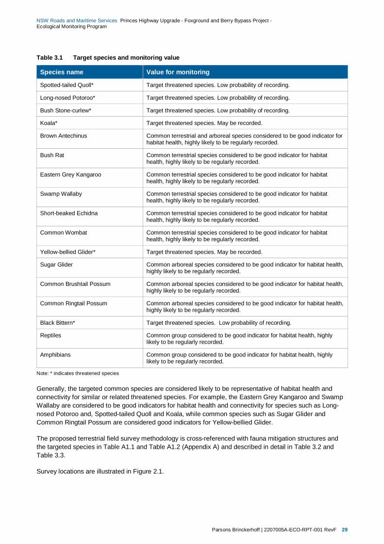
Parsons Brinckerhoff | 2207005A-ECO-RPT-001 RevF 29
NSW Roads and Maritime Services Princes Highway Upgrade - Foxground and Berry Bypass Project - Ecological Monitoring Program
Table 3.1 Target species and monitoring value
Species name Value for monitoring
Spotted-tailed Quoll* Target threatened species. Low probability of recording.
Long-nosed Potoroo* Target threatened species. Low probability of recording.
Bush Stone-curlew* Target threatened species. Low probability of recording.
Koala* Target threatened species. May be recorded.
Brown Antechinus Common terrestrial and arboreal species considered to be good indicator for habitat health, highly likely to be regularly recorded.
Bush Rat Common terrestrial species considered to be good indicator for habitat health, highly likely to be regularly recorded.
Eastern Grey Kangaroo Common terrestrial species considered to be good indicator for habitat health, highly likely to be regularly recorded.
Swamp Wallaby Common terrestrial species considered to be good indicator for habitat health, highly likely to be regularly recorded.
Short-beaked Echidna Common terrestrial species considered to be good indicator for habitat health, highly likely to be regularly recorded.
Common Wombat Common terrestrial species considered to be good indicator for habitat health, highly likely to be regularly recorded.
Yellow-bellied Glider* Target threatened species. May be recorded.
Sugar Glider Common arboreal species considered to be good indicator for habitat health, highly likely to be regularly recorded.
Common Brushtail Possum Common arboreal species considered to be good indicator for habitat health, highly likely to be regularly recorded.
Common Ringtail Possum Common arboreal species considered to be good indicator for habitat health, highly likely to be regularly recorded.
Black Bittern* Target threatened species. Low probability of recording.
Reptiles Common group considered to be good indicator for habitat health, highly likely to be regularly recorded.
Amphibians Common group considered to be good indicator for habitat health, highly likely to be regularly recorded.
Note: * indicates threatened species
Generally, the targeted common species are considered likely to be representative of habitat health and connectivity for similar or related threatened species. For example, the Eastern Grey Kangaroo and Swamp Wallaby are considered to be good indicators for habitat health and connectivity for species such as Long-nosed Potoroo and, Spotted-tailed Quoll and Koala, while common species such as Sugar Glider and Common Ringtail Possum are considered good indicators for Yellow-bellied Glider.
The proposed terrestrial field survey methodology is cross-referenced with fauna mitigation structures and the targeted species in Table A1.1 and Table A1.2 (Appendix A) and described in detail in Table 3.2 and Table 3.3.
Survey locations are illustrated in Figure 2.1.

Parsons Brinckerhoff | 2207005A-ECO-RPT-001 RevF 30
NSW Roads and Maritime Services Princes Highway Upgrade - Foxground and Berry Bypass Project - Ecological Monitoring Program
3.2 Monitoring approach It is well documented that natural systems experience significant natural spatial and temporal variability and to be able to detect environmental impact associated with anthropogenic disturbance, sampling designs must be capable of accounting for and explaining this variability. A logical scientific framework is therefore required to measure any impacts. The design will determine the effectiveness via the detection and quantification of changes in biological assemblages (habitat usage) throughout time. This will be achieved by measuring any interactions between spatial and temporal components of variation against a variable background.
Within each monitoring location, replicate sites are to be established at which a number of ecological factors are to be measured.
Specifically, ecological monitoring will be focused within areas that are likely to be impacted and / or provide habitat or movement pathways for fauna. It is likely that the majority of the ecological monitoring surveys will produce qualitative data that would still allow effective comparisons to be made over time.
The monitoring parameters that would be collected and analysed as part of the EcMP are outlined below in Table 3.2 and Table 3.3.
It is likely that due to the already highly modified nature of the existing and future environment that it would be very difficult to undertake detailed statistical or quantitative analysis of habitat usage. Primarily, data analysis will be qualitative, comparing direct results over time and identifying trends over time until that point when it can be demonstrated against the performance criteria that mitigation measures (including any adaptive measures during the monitoring) have been effective. The focus of the monitoring methodology is on presence / absence of species using the existing and future habitat connections. Continued presence of the species recorded prior to construction of the Project would be considered to equate to a high likelihood of use by these species, based on monitoring of similar structures by Roads and Maritime for previous projects such as those along the Hume Highway and Pacific Highway.
3.3 Consultation with agencies The Foxground and Berry bypass EcMP has been prepared by Parsons Brinckerhoff in consultation with Roads and Maritime representatives and representatives of the OEH and DPI (Fishing and Aquaculture) agencies. Consultation between Roads and Maritime and relevant agency representatives was undertaken to determine the appropriate ecological monitoring required to assess the effectiveness of the mitigation measures implemented by the Project.
Future consultation between Roads and Maritime, the Director General and relevant government agencies will be required during the life of the Project such as for the presentation of annual results or for the modifications of the EcMP as required.
Substantial consultation occurred with both OEH and DPI during the Environment Assessment process for the Project.
This process continued for the preparation of the EcMP. In particular, thanks go to Mr James Dawson (Senior Team Leader, Ecosystems and Threatened Species, Illawarra Region OEH) and Mr Trevor Daly (A/Regional Manager, Aquatic Ecosystems – South, DPI) who provided valuable input during a number of conversations and meetings. Consultations include:
early provision of the proposed methodology for comment to OEH and DPI: 20 March 2013
receipt of comment on early methodology from DPI: 1 April 2014
receipt of comment on early methodology from OEH: 4 April 2014

Parsons Brinckerhoff | 2207005A-ECO-RPT-001 RevF 31
NSW Roads and Maritime Services Princes Highway Upgrade - Foxground and Berry Bypass Project - Ecological Monitoring Program
meeting to discuss review approach with OEH and DPI: 18 June 2014
receipt of final comment on Draft EcMP and methodology from DPI: 9 July 2014
receipt of final comment on Draft EcMP and methodology from OEH: 15 July 2014.
Integration of the results of this consultation, such as increased surveillance of crossings with cameras, additional focus on installation of bat boxes on bridges, and modified aquatic monitoring methodology has occurred.
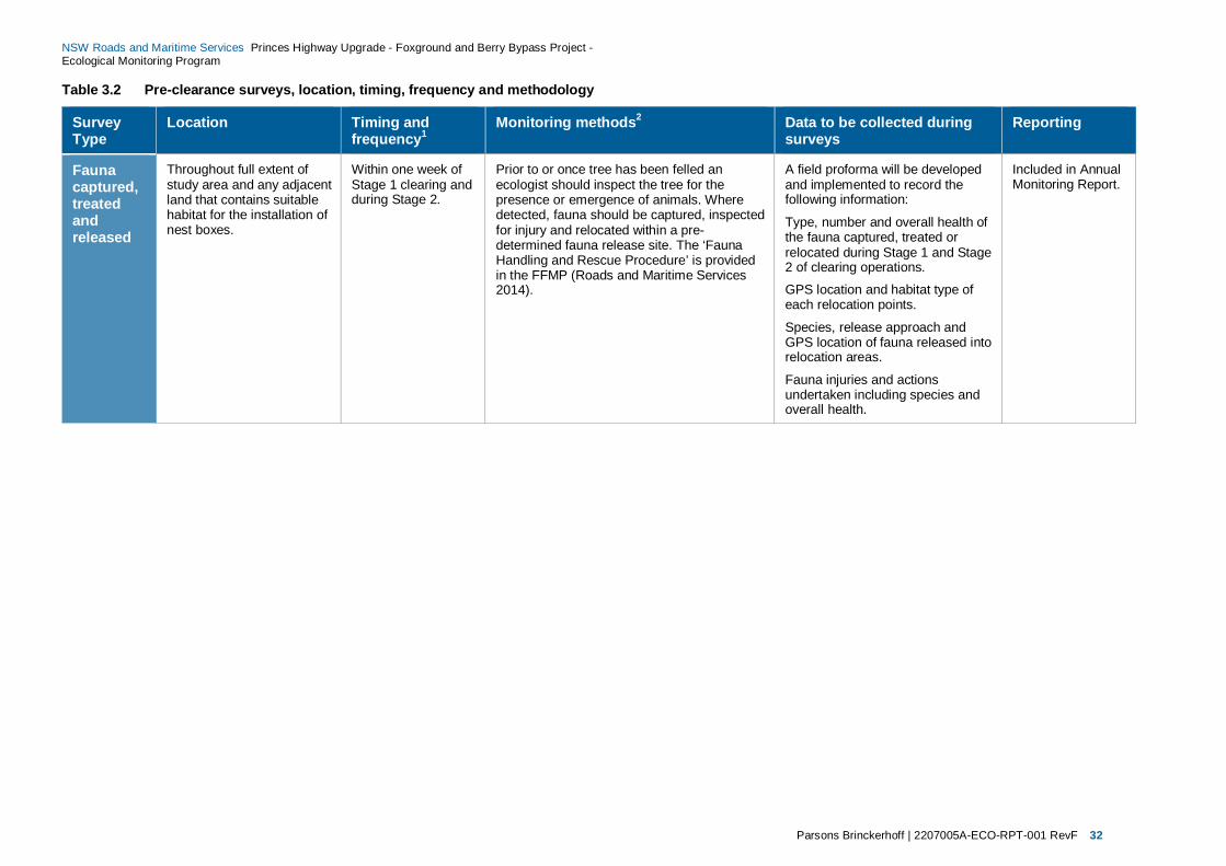
Parsons Brinckerhoff | 2207005A-ECO-RPT-001 RevF 32
NSW Roads and Maritime Services Princes Highway Upgrade - Foxground and Berry Bypass Project - Ecological Monitoring Program
Table 3.2 Pre-clearance surveys, location, timing, frequency and methodology
Survey Type
Location Timing and frequency1
Monitoring methods2 Data to be collected during surveys
Reporting
Fauna captured, treated and released
Throughout full extent of study area and any adjacent land that contains suitable habitat for the installation of nest boxes.
Within one week of Stage 1 clearing and during Stage 2.
Prior to or once tree has been felled an ecologist should inspect the tree for the presence or emergence of animals. Where detected, fauna should be captured, inspected for injury and relocated within a pre-determined fauna release site. The ‘Fauna Handling and Rescue Procedure’ is provided in the FFMP (Roads and Maritime Services 2014).
A field proforma will be developed and implemented to record the following information:
Type, number and overall health of the fauna captured, treated or relocated during Stage 1 and Stage 2 of clearing operations.
GPS location and habitat type of each relocation points.
Species, release approach and GPS location of fauna released into relocation areas.
Fauna injuries and actions undertaken including species and overall health.
Included in Annual Monitoring Report.

Parsons Brinckerhoff | 2207005A-ECO-RPT-001 RevF 33
NSW Roads and Maritime Services Princes Highway Upgrade - Foxground and Berry Bypass Project - Ecological Monitoring Program
Survey Type
Location Timing and frequency1
Monitoring methods2 Data to be collected during surveys
Reporting
Targeted Green and Golden Bell Frog
Where potential habitat has been identified (Town Creek diversion) and at control site at Worrigee Nature Reserve, South Nowra as discussed with OEH.
Any additional areas identified as having potential GGBF habitat that is likely to be impacted upon by the project.
Four nights of survey over at least three visits, each visit separated by at least one week and at least one visit after moderate to heavy rain. To be completed prior to construction.
GGBF targeted surveys are seasonal and so should be conducted between September – March under optimum weather conditions preferably within one week of heavy rainfall (October – February).
Note: Heavy rainfall is > 50 mm in seven days.
GGBF survey and habitat assessment near the Town Creek diversion will be conducted in accordance with Department of the Environments’ Guidelines (Department of the Environment Water Heritage and the Arts 2010) which would include:
checking for GGBF activity at a nearby reference site
daylight survey for basking frogs
dip-netting for tadpoles
initial listening survey on approach for water bodies
call playback survey – two call playback sessions for a minimum of 10 minutes per session for each water body
night-time spotlighting and walkover search of each water body around the entire perimeter searching banks and emergent vegetation (2 h per 200m of water body edge) for the presence of frogs
All GGBF surveys would be undertaken in accordance with the OEH hygiene protocol for the control of disease in frogs. This is to ensure diseases are not spread between different populations.
If GGBFs are detected during the targeted surveys or opportunistically the following data will be collected where possible:
presence of GGBF at reference site
GPS location
number
weather conditions
photograph
other relevant information (e.g. habitat within the area).
If GGBFs are identified notification to OEH will be required prior to construction. RMS and OEH would determine further appropriate actions depending on results.
GGBF Management Plan required if GGBF observed
Results included in Annual Monitoring Report
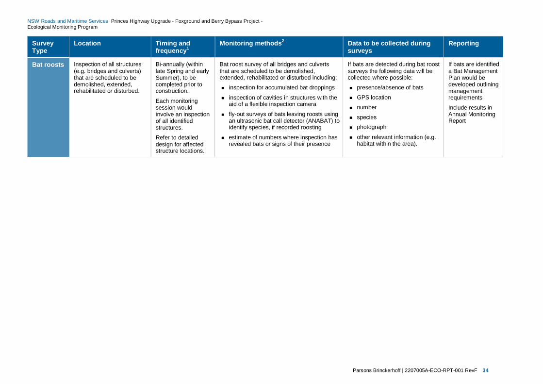
Parsons Brinckerhoff | 2207005A-ECO-RPT-001 RevF 34
NSW Roads and Maritime Services Princes Highway Upgrade - Foxground and Berry Bypass Project - Ecological Monitoring Program
Survey Type
Location Timing and frequency1
Monitoring methods2 Data to be collected during surveys
Reporting
Bat roosts Inspection of all structures (e.g. bridges and culverts) that are scheduled to be demolished, extended, rehabilitated or disturbed.
Bi-annually (within late Spring and early Summer), to be completed prior to construction.
Each monitoring session would involve an inspection of all identified structures.
Refer to detailed design for affected structure locations.
Bat roost survey of all bridges and culverts that are scheduled to be demolished, extended, rehabilitated or disturbed including:
inspection for accumulated bat droppings
inspection of cavities in structures with the aid of a flexible inspection camera
fly-out surveys of bats leaving roosts using an ultrasonic bat call detector (ANABAT) to identify species, if recorded roosting
estimate of numbers where inspection has revealed bats or signs of their presence
If bats are detected during bat roost surveys the following data will be collected where possible:
presence/absence of bats
GPS location
number
species photograph
other relevant information (e.g. habitat within the area).
If bats are identified a Bat Management Plan would be developed outlining management requirements
Include results in Annual Monitoring Report

Parsons Brinckerhoff | 2207005A-ECO-RPT-001 RevF 35
NSW Roads and Maritime Services Princes Highway Upgrade - Foxground and Berry Bypass Project - Ecological Monitoring Program
Survey Type
Location Timing and frequency1
Monitoring methods2 Data to be collected during surveys
Reporting
Habitat resources surveys
Throughout full extent of the study area and any adjacent land that contains suitable habitat for the installation of nest boxes.
Anytime during the year, to be completed prior to construction.
A survey of all mature trees within the construction footprint will be conducted to identify hollow bearing trees. Where hollow-bearing trees are identified a detailed survey of all hollows will be undertaken that would involve recording the information outlined in the ‘Data to be collected during surveys’.
Stag watches would also be conducted of hollow-bearing trees to identify fauna use of hollows identified, for more detail refer to Section 2.3 and Table 3.3. Stag watching would be opportunistic during the undertaking of baseline monitoring – it is not likely to be possible to stag watch every single hollow-bearing trees. The main objective of this activity is to confirm fauna species that might require nest boxes to be installed.
Post-construction abundance and density counts of hollow-bearing trees removed by the project would be conducted to determine the final number and type of hollows removed by the project.
The pre-clearance and post construction tree hollow data will be used to determine the number of nest boxes that are required to be installed. Suitable locations for the installation of nest boxes are to be mapped in areas outside of the construction footprint using a GPS.
A field proforma would be created to record the following tree characteristics:
GPS location, species, height, diameter, number of hollows and overall health of each hollow-bearing tree.
For each hollow identified the position in tree (e.g. trunk, dead branch, spout) and entrance diameter of hollow.
Other information e.g. signs of occupancy
During and on completion of the clearing operations the total number and type of hollows removed will be recorded.
Species and location noted during stag watching would also be recorded.
Detailed specifications, ongoing monitoring and management procedures of nest boxes will be provided in future Nest Box Management Plan.
Include results in Annual Monitoring Report
Note: 1. Additional pre-clearance, construction and/or post-construction monitoring may be required dependent upon the results of the initial pre-clearance surveys. 2. Methodology may be modified dependent upon the results of the initial pre-clearance surveys. All monitoring would be conducted by two qualified and experienced ecologists.

Parsons Brinckerhoff | 2207005A-ECO-RPT-001 RevF 36
NSW Roads and Maritime Services Princes Highway Upgrade - Foxground and Berry Bypass Project - Ecological Monitoring Program
Table 3.3 Ecological monitoring of mitigation measures location, timing, frequency and methodology
Survey Type
Location Timing and frequency1 Monitoring methods2 Data to be collected during monitoring to assess changes in habitat usage
Reporting
Pre-construction baseline Monitoring
Construction Post-construction Monitoring
Pre-construction baseline Monitoring
Construction Post-construction Monitoring
Road kill surveys
Along existing 11.6km stretch of the Princess Highway between Toolijoola Road and O’Keefes Lane in Berry, NSW
No surveys required during construction as road kill is an operational / ongoing impact.
Along upgraded stretch of the Princess Highway between Toolijoola Road and O’Keefes Lane in Berry, NSW
Weekly basis for a period of up to 52 weeks to be completed prior to construction
No surveys required during construction. (see explanation under Monitoring methods)
Weekly basis for a period of up to 52 weeks to commence at the start of the operational phase
Each weekly drive-through road kill survey would involve driving the full length of the project once in each direction, focussing on (but not limited to) a 3 metre width from the road edge. Road kill observed during the drive-through survey will be processed to collect the relevant data.
In circumstances where animals are unable to be positively identified due to destruction of identifying features & safety considerations, an estimate of the size of the animal will be made and it would be assigned to a group such as ‘unidentified small mammal’, ‘unidentified macropod’ ‘unidentified frog’ ‘unidentified small skink’ etc. Samples will be collected for later identification if considered appropriate.
All road kill (containing pouches) will be inspected for the presence of live young. In the circumstance that live young are found they will be referred to the local wildlife care group.
Road kill would be removed outside of the survey area in situations where they cause a safety hazard to vehicles and to avoid counting in subsequent monitoring surveys.
Any live injured wildlife found during the surveys will be referred to the local wildlife care groups.
A field proforma will be created to record the following parameters (where possible):
GPS location
Species
Sex
Presence of any pouch young
Photograph
Other relevant information such as habitat type and condition in proximity to the road kill
Results included in Annual Monitoring Report
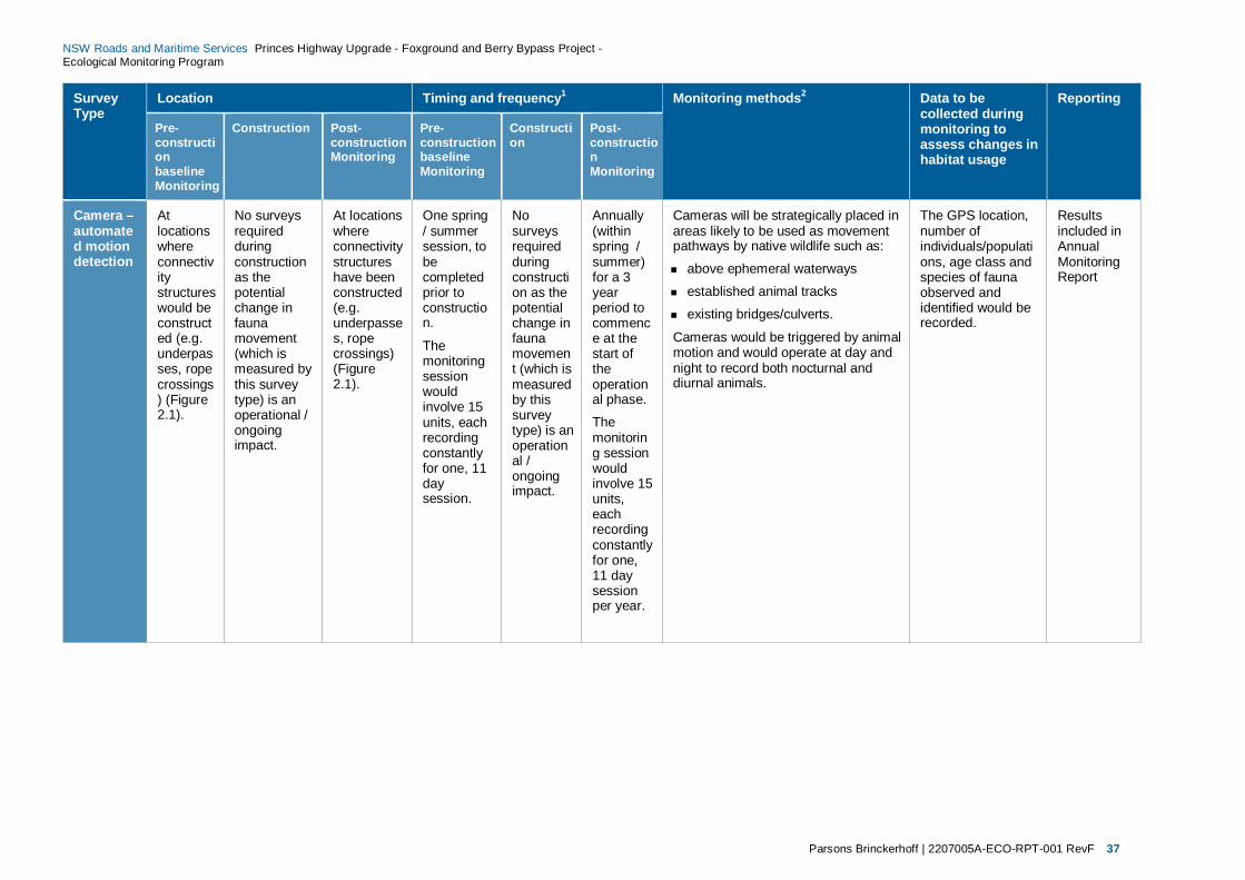
Parsons Brinckerhoff | 2207005A-ECO-RPT-001 RevF 37
NSW Roads and Maritime Services Princes Highway Upgrade - Foxground and Berry Bypass Project - Ecological Monitoring Program
Survey Type
Location Timing and frequency1 Monitoring methods2 Data to be collected during monitoring to assess changes in habitat usage
Reporting
Pre-construction baseline Monitoring
Construction Post-construction Monitoring
Pre-construction baseline Monitoring
Construction
Post-construction Monitoring
Camera – automated motion detection
At locations where connectivity structures would be constructed (e.g. underpasses, rope crossings) (Figure 2.1).
No surveys required during construction as the potential change in fauna movement (which is measured by this survey type) is an operational / ongoing impact.
At locations where connectivity structures have been constructed (e.g. underpasses, rope crossings) (Figure 2.1).
One spring / summer session, to be completed prior to construction.
The monitoring session would involve 15 units, each recording constantly for one, 11 day session.
No surveys required during construction as the potential change in fauna movement (which is measured by this survey type) is an operational / ongoing impact.
Annually (within spring / summer) for a 3 year period to commence at the start of the operational phase.
The monitoring session would involve 15 units, each recording constantly for one, 11 day session per year.
Cameras will be strategically placed in areas likely to be used as movement pathways by native wildlife such as:
above ephemeral waterways
established animal tracks
existing bridges/culverts.
Cameras would be triggered by animal motion and would operate at day and night to record both nocturnal and diurnal animals.
The GPS location, number of individuals/populations, age class and species of fauna observed and identified would be recorded.
Results included in Annual Monitoring Report
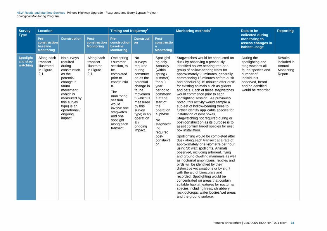
Parsons Brinckerhoff | 2207005A-ECO-RPT-001 RevF 38
NSW Roads and Maritime Services Princes Highway Upgrade - Foxground and Berry Bypass Project - Ecological Monitoring Program
Survey Type
Location Timing and frequency1 Monitoring methods2 Data to be collected during monitoring to assess changes in habitat usage
Reporting
Pre-construction baseline Monitoring
Construction Post-construction Monitoring
Pre-construction baseline Monitoring
Construction
Post-construction Monitoring
Spotlight and stag-watching
Along each transect illustrated in Figure 2.1.
No surveys required during construction. as the potential change in fauna movement (which is measured by this survey type) is an operational / ongoing impact.
Along each transect illustrated in Figure 2.1.
One spring / summer session, to be completed prior to construction.
The monitoring session would involve one stagwatch and one spotlight along each transect.
No surveys required during construction as the potential change in fauna movement (which is measured by this survey type) is an operational / ongoing impact.
Spotlighting only. Annually (within spring / summer) for a 3 year period to commence at the start of the operational phase.
No stagwatching required post-construction.
Stagwatches would be conducted on dusk by observing a previously identified hollow-bearing tree or a group of hollow-bearing trees for approximately 90 minutes, generally commencing 15 minutes before dusk and concluding 15 minutes after dusk for existing animals such as gliders and bats. Each of these stagwatches would commence prior to each spotlighting session. As previously noted, this activity would sample a sub-set of hollow-bearing trees to further identify applicable species for installation of nest boxes. Stagwatching not required during or post-construction as its purpose is to assist confirm target species for nest box installation.
Spotlighting would be completed after dusk along each transect at a rate of approximately one kilometre per hour using 50 watt spotlights. Animals observed, including arboreal, flying and ground-dwelling mammals as well as nocturnal amphibians, reptiles and birds will be identified by their distinctive vocalisations or by sight with the aid of binoculars and recorded. Spotlighting would be concentrated on areas that contain suitable habitat features for nocturnal species including trees, shrubbery, rock outcrops, water bodies/wet areas and the ground surface.
During the spotlighting and stag watches all fauna species and number of individuals observed, heard and/or identified would be recorded
Results included in Annual Monitoring Report
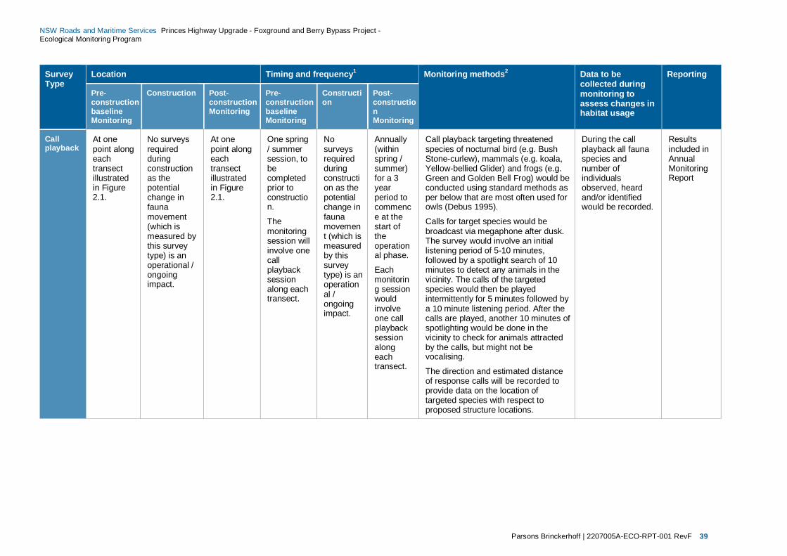
Parsons Brinckerhoff | 2207005A-ECO-RPT-001 RevF 39
NSW Roads and Maritime Services Princes Highway Upgrade - Foxground and Berry Bypass Project - Ecological Monitoring Program
Survey Type
Location Timing and frequency1 Monitoring methods2 Data to be collected during monitoring to assess changes in habitat usage
Reporting
Pre-construction baseline Monitoring
Construction Post-construction Monitoring
Pre-construction baseline Monitoring
Construction
Post-construction Monitoring
Call playback
At one point along each transect illustrated in Figure 2.1.
No surveys required during construction as the potential change in fauna movement (which is measured by this survey type) is an operational / ongoing impact.
At one point along each transect illustrated in Figure 2.1.
One spring / summer session, to be completed prior to construction.
The monitoring session will involve one call playback session along each transect.
No surveys required during construction as the potential change in fauna movement (which is measured by this survey type) is an operational / ongoing impact.
Annually (within spring / summer) for a 3 year period to commence at the start of the operational phase.
Each monitoring session would involve one call playback session along each transect.
Call playback targeting threatened species of nocturnal bird (e.g. Bush Stone-curlew), mammals (e.g. koala, Yellow-bellied Glider) and frogs (e.g. Green and Golden Bell Frog) would be conducted using standard methods as per below that are most often used for owls (Debus 1995).
Calls for target species would be broadcast via megaphone after dusk. The survey would involve an initial listening period of 5-10 minutes, followed by a spotlight search of 10 minutes to detect any animals in the vicinity. The calls of the targeted species would then be played intermittently for 5 minutes followed by a 10 minute listening period. After the calls are played, another 10 minutes of spotlighting would be done in the vicinity to check for animals attracted by the calls, but might not be vocalising.
The direction and estimated distance of response calls will be recorded to provide data on the location of targeted species with respect to proposed structure locations.
During the call playback all fauna species and number of individuals observed, heard and/or identified would be recorded.
Results included in Annual Monitoring Report
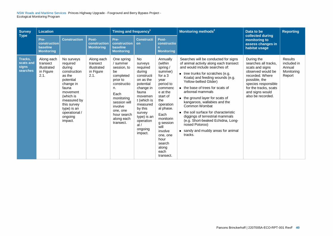
Parsons Brinckerhoff | 2207005A-ECO-RPT-001 RevF 40
NSW Roads and Maritime Services Princes Highway Upgrade - Foxground and Berry Bypass Project - Ecological Monitoring Program
Survey Type
Location Timing and frequency1 Monitoring methods2 Data to be collected during monitoring to assess changes in habitat usage
Reporting
Pre-construction baseline Monitoring
Construction Post-construction Monitoring
Pre-construction baseline Monitoring
Construction
Post-construction Monitoring
Tracks, scats and signs searches
Along each transect illustrated in Figure 2.1.
No surveys required during construction as the potential change in fauna movement (which is measured by this survey type) is an operational / ongoing impact.
Along each transect illustrated in Figure 2.1.
One spring / summer session, to be completed prior to construction.
Each monitoring session will involve one, one hour search along each transect.
No surveys required during construction as the potential change in fauna movement (which is measured by this survey type) is an operational / ongoing impact.
Annually (within spring / summer) for a 3 year period to commence at the start of the operational phase.
Each monitoring session will involve one, one hour search along each transect.
Searches will be conducted for signs of animal activity along each transect and would include searches of:
tree trunks for scratches (e.g. Koala) and feeding wounds (e.g. Yellow-bellied Glider)
the base of trees for scats of arboreal mammals
the ground layer for scats of kangaroos, wallabies and the Common Wombat
the soil surface for characteristic diggings of terrestrial mammals (e.g. Short-beaked Echidna, Long-nosed Potoroo)
sandy and muddy areas for animal tracks.
During the searches all tracks, scats and signs observed would be recorded. Where possible, the species responsible for the tracks, scats and signs would also be recorded.
Results included in Annual Monitoring Report

Parsons Brinckerhoff | 2207005A-ECO-RPT-001 RevF 41
NSW Roads and Maritime Services Princes Highway Upgrade - Foxground and Berry Bypass Project - Ecological Monitoring Program
Survey Type
Location Timing and frequency1 Monitoring methods2 Data to be collected during monitoring to assess changes in habitat usage
Reporting
Pre-construction baseline Monitoring
Construction Post-construction Monitoring
Pre-construction baseline Monitoring
Construction
Post-construction Monitoring
Herpetology searches
Along each transect illustrated in Figure 2.1.
No surveys required during construction as the potential change in fauna movement (which is measured by this survey type) is an operational / ongoing impact.
Along each transect illustrated in Figure 2.1.
One spring / summer session, to be completed prior to construction.
The monitoring session would involve two, 30 minute searches on two separate days along each transect.
No surveys required during construction as the potential change in fauna movement (which is measured by this survey type) is an operational / ongoing impact.
Annually (within spring / summer) for a 3 year period to commence at the start of the operational phase.
Each monitoring session will involve one, one hour search along each of transect.
Herpetofauna (frogs and reptiles) active searches would involve looking for active specimens and eye shine (frogs only) within suitable habitat within the study area. The survey would involve searches for:
active or basking reptiles in sunlit areas
sheltering frogs and reptiles: underneath logs and rocks
in rock crevices
under decorticating bark on trees
amongst leaf litter.
Specimens would be identified visually, by aural recognition of call (frogs only) or collected by hand for identification.
Frogs and reptiles would also be surveyed during spotlighting and call playback events and opportunistically across the study area.
During the herpetology surveys all fauna species observed and identified would be recorded.
Results included in Annual Monitoring Report
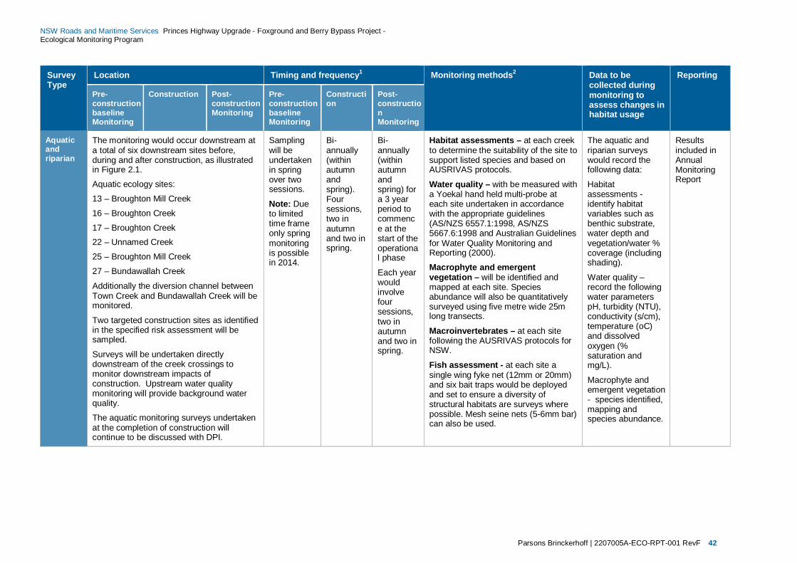
Parsons Brinckerhoff | 2207005A-ECO-RPT-001 RevF 42
NSW Roads and Maritime Services Princes Highway Upgrade - Foxground and Berry Bypass Project - Ecological Monitoring Program
Survey Type
Location Timing and frequency1 Monitoring methods2 Data to be collected during monitoring to assess changes in habitat usage
Reporting
Pre-construction baseline Monitoring
Construction Post-construction Monitoring
Pre-construction baseline Monitoring
Construction
Post-construction Monitoring
Aquatic and riparian
The monitoring would occur downstream at a total of six downstream sites before, during and after construction, as illustrated in Figure 2.1.
Aquatic ecology sites:
13 – Broughton Mill Creek
16 – Broughton Creek
17 – Broughton Creek 22 – Unnamed Creek
25 – Broughton Mill Creek
27 – Bundawallah Creek
Additionally the diversion channel between Town Creek and Bundawallah Creek will be monitored.
Two targeted construction sites as identified in the specified risk assessment will be sampled.
Surveys will be undertaken directly downstream of the creek crossings to monitor downstream impacts of construction. Upstream water quality monitoring will provide background water quality.
The aquatic monitoring surveys undertaken at the completion of construction will continue to be discussed with DPI.
Sampling will be undertaken in spring over two sessions.
Note: Due to limited time frame only spring monitoring is possible in 2014.
Bi-annually (within autumn and spring). Four sessions, two in autumn and two in spring.
Bi-annually (within autumn and spring) for a 3 year period to commence at the start of the operational phase
Each year would involve four sessions, two in autumn and two in spring.
Habitat assessments – at each creek to determine the suitability of the site to support listed species and based on AUSRIVAS protocols.
Water quality – with be measured with a Yoekal hand held multi-probe at each site undertaken in accordance with the appropriate guidelines (AS/NZS 6557.1:1998, AS/NZS 5667.6:1998 and Australian Guidelines for Water Quality Monitoring and Reporting (2000).
Macrophyte and emergent vegetation – will be identified and mapped at each site. Species abundance will also be quantitatively surveyed using five metre wide 25m long transects.
Macroinvertebrates – at each site following the AUSRIVAS protocols for NSW.
Fish assessment - at each site a single wing fyke net (12mm or 20mm) and six bait traps would be deployed and set to ensure a diversity of structural habitats are surveys where possible. Mesh seine nets (5-6mm bar) can also be used.
The aquatic and riparian surveys would record the following data:
Habitat assessments - identify habitat variables such as benthic substrate, water depth and vegetation/water % coverage (including shading).
Water quality – record the following water parameters pH, turbidity (NTU), conductivity (s/cm), temperature (oC) and dissolved oxygen (% saturation and mg/L).
Macrophyte and emergent vegetation - species identified, mapping and species abundance.
Results included in Annual Monitoring Report

Parsons Brinckerhoff | 2207005A-ECO-RPT-001 RevF 43
NSW Roads and Maritime Services Princes Highway Upgrade - Foxground and Berry Bypass Project - Ecological Monitoring Program
Survey Type
Location Timing and frequency1 Monitoring methods2 Data to be collected during monitoring to assess changes in habitat usage
Reporting
Pre-construction baseline Monitoring
Construction Post-construction Monitoring
Pre-construction baseline Monitoring
Construction
Post-construction Monitoring
Macroinvertebrates - would be sampled and identified to family species level and enumerated.
Fish assessment – would be identified to species, enumerated, weighed and measured.
NOTE: Upstream water quality is also to be monitored by Roads and Maritime and will be referred to as necessary.
Nest box monitoring (including any bat boxes under bridge)
No surveys required pre- construction as no nest boxes yet installed.
Monitoring would occur on all nest boxes installed as part of the Project at least once.
Monitoring would occur on all nest boxes installed as part of the Project.
No surveys required pre- construction as no nest boxes yet installed.
Monitoring would occur on all nest boxes installed as part of the Project at least once. 6 monthly monitoring required as a minimum.
As outlined in Nest Box Management Plan. Annually for a 3 year period from the start of the operational phase.
A visual inspection of each nest box would be conducted. Further details would be provided in the Nest Box Management Plan.
On visual inspection of the nest boxes the following data would be collected:
Date of inspection
Weather conditions
Nest box ID
Presence/absence of occupation
If occupied, the species, age (juvenile/adult), number of individuals and whether it is native/feral.
Results included in Annual Monitoring Report
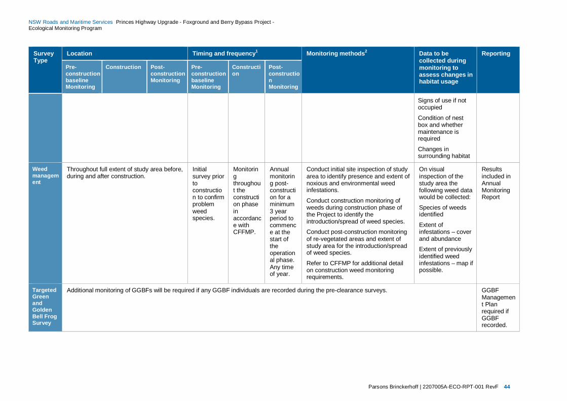
Parsons Brinckerhoff | 2207005A-ECO-RPT-001 RevF 44
NSW Roads and Maritime Services Princes Highway Upgrade - Foxground and Berry Bypass Project - Ecological Monitoring Program
Survey Type
Location Timing and frequency1 Monitoring methods2 Data to be collected during monitoring to assess changes in habitat usage
Reporting
Pre-construction baseline Monitoring
Construction Post-construction Monitoring
Pre-construction baseline Monitoring
Construction
Post-construction Monitoring
Signs of use if not occupied
Condition of nest box and whether maintenance is required
Changes in surrounding habitat
Weed management
Throughout full extent of study area before, during and after construction.
Initial survey prior to construction to confirm problem weed species.
Monitoring throughout the construction phase in accordance with CFFMP.
Annual monitoring post-construction for a minimum 3 year period to commence at the start of the operational phase. Any time of year.
Conduct initial site inspection of study area to identify presence and extent of noxious and environmental weed infestations.
Conduct construction monitoring of weeds during construction phase of the Project to identify the introduction/spread of weed species.
Conduct post-construction monitoring of re-vegetated areas and extent of study area for the introduction/spread of weed species.
Refer to CFFMP for additional detail on construction weed monitoring requirements.
On visual inspection of the study area the following weed data would be collected:
Species of weeds identified
Extent of infestations – cover and abundance
Extent of previously identified weed infestations – map if possible.
Results included in Annual Monitoring Report
Targeted Green and Golden Bell Frog Survey
Additional monitoring of GGBFs will be required if any GGBF individuals are recorded during the pre-clearance surveys. GGBF Management Plan required if GGBF recorded.

Parsons Brinckerhoff | 2207005A-ECO-RPT-001 RevF 45
NSW Roads and Maritime Services Princes Highway Upgrade - Foxground and Berry Bypass Project - Ecological Monitoring Program
Survey Type
Location Timing and frequency1 Monitoring methods2 Data to be collected during monitoring to assess changes in habitat usage
Reporting
Pre-construction baseline Monitoring
Construction Post-construction Monitoring
Pre-construction baseline Monitoring
Construction
Post-construction Monitoring
Bat roosts
Additional monitoring of bats will be required if any individuals are recorded present during pre-clearance inspections structures (e.g. bridges and culverts) likely to be disturbed by the project. Any bat boxes installed under new bridges to be monitored in accordance with nest box monitoring methodology outlined above.
Bat Management Plan required if roosting bats recorded.
Note:
1. Additional post-construction monitoring may be required if previous monitoring results indicate that there are changes in habitat usage as a result of construction. In this case, the biodiversity mitigation measures (e.g. fencing and underpasses) may require modifications and maintenance and/or additional measures will need to be implemented. These modifications and additional will require ecological monitoring to assess the effectiveness of each. Due to time limitations only spring baseline survey is achievable prior to construction in January 2015.
2. Monitoring methodology may be altered dependent upon results of monitoring, as part of an adaptive management approach. All monitoring would be conducted by two qualified and experienced ecologists, or a single ecologist where it is safe to do so. OEH and DPI (Fishing and Aquaculture) would be consulted and the endorsement of these agencies would be received prior to the implementation of any proposed change to the monitoring methods.

Parsons Brinckerhoff | 2207005A-ECO-RPT-001 RevF 46
NSW Roads and Maritime Services Princes Highway Upgrade - Foxground and Berry Bypass Project - Ecological Monitoring Program
4. Performance criteria 4.1 Performance criteria The CoA require the development of performance criteria to assess the effectiveness of biodiversity mitigation measures (including pre-clearing and clearing procedures, fauna connectivity structures and weed management) implemented as a part of the Project.
The performance criteria will also assist identify changes in habitat usage that would indicate the requirement for any modifications and/or maintenance of existing measures and/or identify unforseen issues (such as design amendments or unexpected threatened species finds) that would require additional mitigation measures to be implemented. If modifications to mitigation measures are implemented additional monitoring protocols would be developed to assess their effectiveness in reducing the negative impacts on biodiversity.
A comparison between the nominated performance criteria and results of the ecological monitoring (as outlined in Table 3.2 and Table 3.3) will determine potential changes in habitat usage resulting from the clearing, construction and operational phases of the Project.
The nominated performance criteria that will be used to assess the effectiveness of the mitigation measures implemented are provided in Table 4.1.
Table 4.1 Performance criteria to assess the effectiveness of biodiversity mitigation measures
Mitigation measure
Performance criteria Performance target and timeframe
Responsibility
Implementing pre-clearing and clearing procedures
Low fauna mortality or injury rates resulting from the clearing phase.
Mortality can be demonstrated to have been minimised during the life of the monitoring program.
Roads and Maritime responsible for engaging a qualified and experienced ecologist (with fauna handling skills) to undertake the clearing procedures.
Refer to CFFMP for additional requirements for pre-clearing activities.
Fast processing, treatment and release of fauna.
Fauna released same day of capture.
Accurate data collection or reporting. Discrepancies not noted in recorded data during the life of the monitoring program.
All habitat features identified during surveys. No habitat features unexpectedly observed (except those that could not have been observed for a physical or safety reason) during the life of the monitoring program.
Ecologist present/available during clearing works.
Ecologist present during all clearing works during the life of the monitoring program.
No accidental clearing of threatened biodiversity.
No threatened species impacted that were not previously identified for impact during the life of the monitoring program.
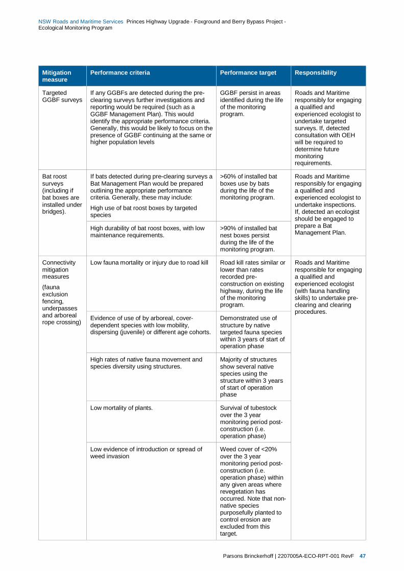
Parsons Brinckerhoff | 2207005A-ECO-RPT-001 RevF 47
NSW Roads and Maritime Services Princes Highway Upgrade - Foxground and Berry Bypass Project - Ecological Monitoring Program
Mitigation measure
Performance criteria Performance target Responsibility
Targeted GGBF surveys
If any GGBFs are detected during the pre-clearing surveys further investigations and reporting would be required (such as a GGBF Management Plan). This would identify the appropriate performance criteria. Generally, this would be likely to focus on the presence of GGBF continuing at the same or higher population levels
GGBF persist in areas identified during the life of the monitoring program.
Roads and Maritime responsibly for engaging a qualified and experienced ecologist to undertake targeted surveys. If, detected consultation with OEH will be required to determine future monitoring requirements.
Bat roost surveys (including if bat boxes are installed under bridges).
If bats detected during pre-clearing surveys a Bat Management Plan would be prepared outlining the appropriate performance criteria. Generally, these may include:
High use of bat roost boxes by targeted species
>60% of installed bat boxes use by bats during the life of the monitoring program.
Roads and Maritime responsibly for engaging a qualified and experienced ecologist to undertake inspections. If, detected an ecologist should be engaged to prepare a Bat Management Plan.
High durability of bat roost boxes, with low maintenance requirements.
>90% of installed bat nest boxes persist during the life of the monitoring program.
Connectivity mitigation measures
(fauna exclusion fencing, underpasses and arboreal rope crossing)
Low fauna mortality or injury due to road kill Road kill rates similar or lower than rates recorded pre-construction on existing highway, during the life of the monitoring program.
Roads and Maritime responsible for engaging a qualified and experienced ecologist (with fauna handling skills) to undertake pre-clearing and clearing procedures.
Evidence of use of by arboreal, cover-dependent species with low mobility, dispersing (juvenile) or different age cohorts.
Demonstrated use of structure by native targeted fauna species within 3 years of start of operation phase
High rates of native fauna movement and species diversity using structures.
Majority of structures show several native species using the structure within 3 years of start of operation phase
Low mortality of plants. Survival of tubestock over the 3 year monitoring period post-construction (i.e. operation phase)
Low evidence of introduction or spread of weed invasion
Weed cover of <20% over the 3 year monitoring period post-construction (i.e. operation phase) within any given areas where revegetation has occurred. Note that non-native species purposefully planted to control erosion are excluded from this target.
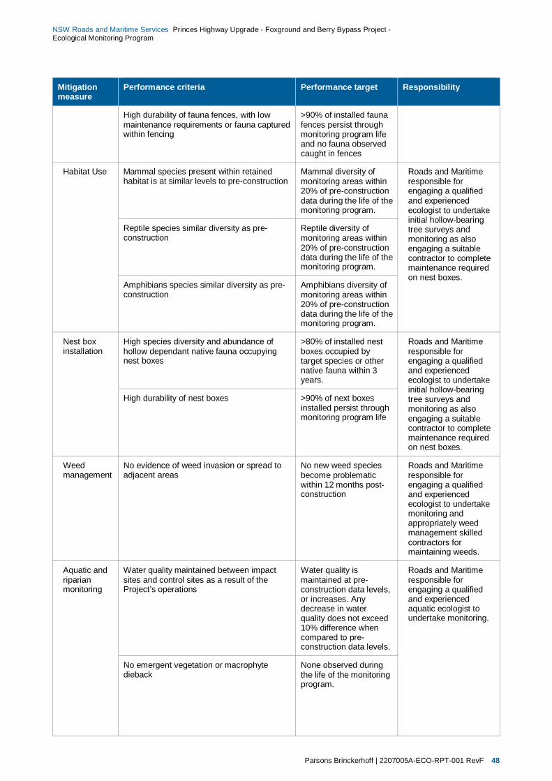
Parsons Brinckerhoff | 2207005A-ECO-RPT-001 RevF 48
NSW Roads and Maritime Services Princes Highway Upgrade - Foxground and Berry Bypass Project - Ecological Monitoring Program
Mitigation measure
Performance criteria Performance target Responsibility
High durability of fauna fences, with low maintenance requirements or fauna captured within fencing
>90% of installed fauna fences persist through monitoring program life and no fauna observed caught in fences
Habitat Use Mammal species present within retained habitat is at similar levels to pre-construction
Mammal diversity of monitoring areas within 20% of pre-construction data during the life of the monitoring program.
Roads and Maritime responsible for engaging a qualified and experienced ecologist to undertake initial hollow-bearing tree surveys and monitoring as also engaging a suitable contractor to complete maintenance required on nest boxes.
Reptile species similar diversity as pre-construction
Reptile diversity of monitoring areas within 20% of pre-construction data during the life of the monitoring program.
Amphibians species similar diversity as pre-construction
Amphibians diversity of monitoring areas within 20% of pre-construction data during the life of the monitoring program.
Nest box installation
High species diversity and abundance of hollow dependant native fauna occupying nest boxes
>80% of installed nest boxes occupied by target species or other native fauna within 3 years.
Roads and Maritime responsible for engaging a qualified and experienced ecologist to undertake initial hollow-bearing tree surveys and monitoring as also engaging a suitable contractor to complete maintenance required on nest boxes.
High durability of nest boxes >90% of next boxes installed persist through monitoring program life
Weed management
No evidence of weed invasion or spread to adjacent areas
No new weed species become problematic within 12 months post-construction
Roads and Maritime responsible for engaging a qualified and experienced ecologist to undertake monitoring and appropriately weed management skilled contractors for maintaining weeds.
Aquatic and riparian monitoring
Water quality maintained between impact sites and control sites as a result of the Project’s operations
Water quality is maintained at pre-construction data levels, or increases. Any decrease in water quality does not exceed 10% difference when compared to pre-construction data levels.
Roads and Maritime responsible for engaging a qualified and experienced aquatic ecologist to undertake monitoring.
No emergent vegetation or macrophyte dieback
None observed during the life of the monitoring program.
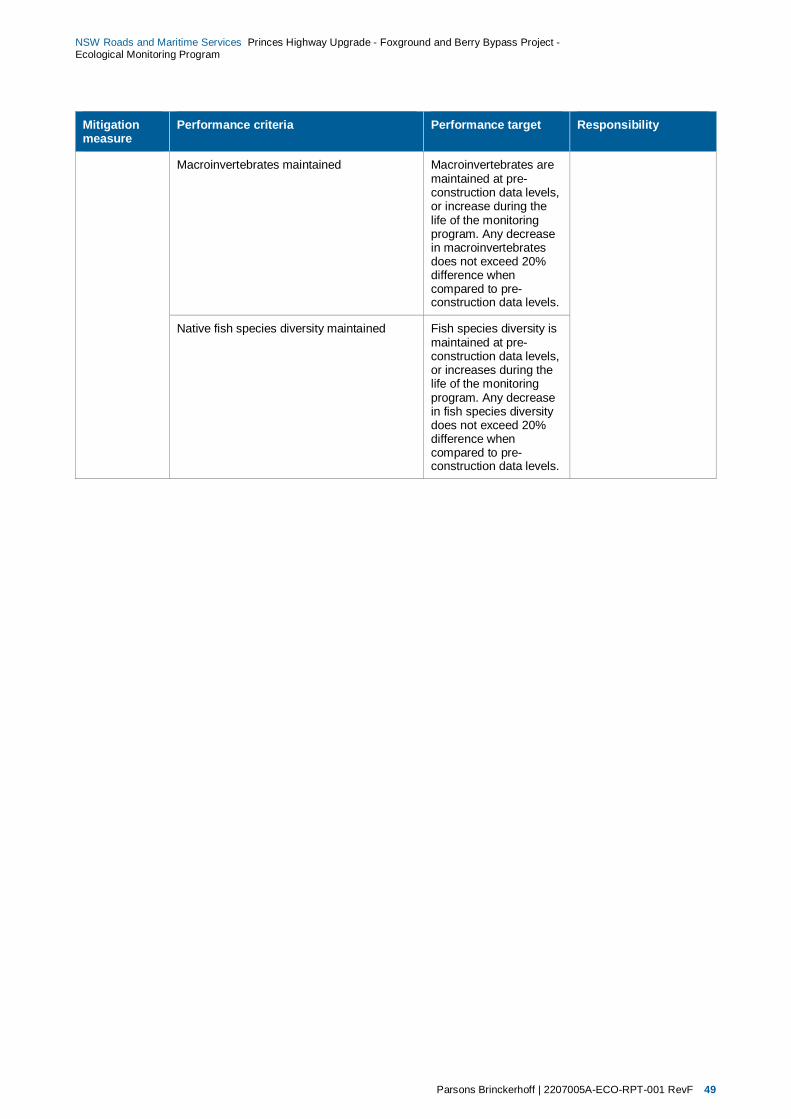
Parsons Brinckerhoff | 2207005A-ECO-RPT-001 RevF 49
NSW Roads and Maritime Services Princes Highway Upgrade - Foxground and Berry Bypass Project - Ecological Monitoring Program
Mitigation measure
Performance criteria Performance target Responsibility
Macroinvertebrates maintained Macroinvertebrates are maintained at pre-construction data levels, or increase during the life of the monitoring program. Any decrease in macroinvertebrates does not exceed 20% difference when compared to pre-construction data levels.
Native fish species diversity maintained Fish species diversity is maintained at pre-construction data levels, or increases during the life of the monitoring program. Any decrease in fish species diversity does not exceed 20% difference when compared to pre-construction data levels.
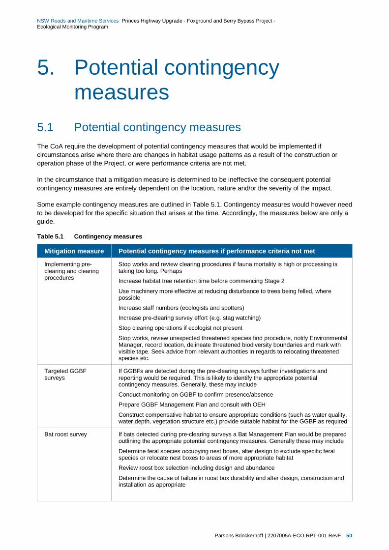
Parsons Brinckerhoff | 2207005A-ECO-RPT-001 RevF 50
NSW Roads and Maritime Services Princes Highway Upgrade - Foxground and Berry Bypass Project - Ecological Monitoring Program
5. Potential contingency measures
5.1 Potential contingency measures The CoA require the development of potential contingency measures that would be implemented if circumstances arise where there are changes in habitat usage patterns as a result of the construction or operation phase of the Project, or were performance criteria are not met.
In the circumstance that a mitigation measure is determined to be ineffective the consequent potential contingency measures are entirely dependent on the location, nature and/or the severity of the impact.
Some example contingency measures are outlined in Table 5.1. Contingency measures would however need to be developed for the specific situation that arises at the time. Accordingly, the measures below are only a guide.
Table 5.1 Contingency measures
Mitigation measure Potential contingency measures if performance criteria not met
Implementing pre-clearing and clearing procedures
Stop works and review clearing procedures if fauna mortality is high or processing is taking too long. Perhaps
Increase habitat tree retention time before commencing Stage 2
Use machinery more effective at reducing disturbance to trees being felled, where possible
Increase staff numbers (ecologists and spotters)
Increase pre-clearing survey effort (e.g. stag watching)
Stop clearing operations if ecologist not present
Stop works, review unexpected threatened species find procedure, notify Environmental Manager, record location, delineate threatened biodiversity boundaries and mark with visible tape. Seek advice from relevant authorities in regards to relocating threatened species etc.
Targeted GGBF surveys
If GGBFs are detected during the pre-clearing surveys further investigations and reporting would be required. This is likely to identify the appropriate potential contingency measures. Generally, these may include
Conduct monitoring on GGBF to confirm presence/absence
Prepare GGBF Management Plan and consult with OEH
Construct compensative habitat to ensure appropriate conditions (such as water quality, water depth, vegetation structure etc.) provide suitable habitat for the GGBF as required
Bat roost survey If bats detected during pre-clearing surveys a Bat Management Plan would be prepared outlining the appropriate potential contingency measures. Generally these may include
Determine feral species occupying nest boxes, alter design to exclude specific feral species or relocate nest boxes to areas of more appropriate habitat
Review roost box selection including design and abundance
Determine the cause of failure in roost box durability and alter design, construction and installation as appropriate

Parsons Brinckerhoff | 2207005A-ECO-RPT-001 RevF 51
NSW Roads and Maritime Services Princes Highway Upgrade - Foxground and Berry Bypass Project - Ecological Monitoring Program
Mitigation measure Potential contingency measures if performance criteria not met
Connectivity mitigation measures
(fauna exclusion fencing, underpasses and arboreal rope crossing)
Review design of connectivity mitigation measures (e.g. location, nature, type, number)
Alter exclusion fencing and rope crossings dependent on species and location of mortalities
Alter underpass ‘fauna furniture’
Alter or add groundcover resources Alter habitat structure near underpasses.
Continue monitoring to observe potential changes in habitat usage as revegetation matures.
If alteration to existing connectivity measures does not decrease mortality rates installation of addition connectivity structures would be considered where reasonable and feasible
Revegetation corridors Install additional/alternative crossing structures Alter habitat structure near underpasses.
Continue monitoring to observe potential changes in habitat usage as revegetation matures
Habitat use Determine causes of habitat use impacts
Address causes of impacts and continue monitoring until use recovers
Nest box installation Determine feral species occupying nest boxes, alter design to exclude specific feral species or relocate nest boxes to areas of more appropriate habitat
Review nest box selection including design and abundance
Determine the cause of failure in nest box durability and alter design, construction and installation as appropriate
Weed management Review weed management and control methods Modify removal techniques, where appropriate
Continue monitoring weed invasions and/or spread
Aquatic and riparian monitoring
Rehabilitate areas affected e.g. erosion control, revegetation and weed control
Undertake weed and pest management where applicable.
Investigate potential pollution sources upstream
Investigate aquatic vegetation dieback and implement measures to restore vegetation
Monitor additional measures implemented to reverse impacts

Parsons Brinckerhoff | 2207005A-ECO-RPT-001 RevF 52
NSW Roads and Maritime Services Princes Highway Upgrade - Foxground and Berry Bypass Project - Ecological Monitoring Program
6. Reporting This section identifies the pre-clearance, clearing and annual reporting that will be completed for the Project. A description of each report is provided below.
6.1 Pre-clearing and clearing works A report will be prepared at the completion of clearing operations which will be provided to the project environmental manager. The report will include the following information:
introduction – background description of the pre-clearing and clearing works
methodology – description of methodology undertaken during the pre-clearance surveys and clearing procedures
results – outline of pre-clearance and clearing results including:
fauna species inventories of displaced, captured, released and mortality of individuals that occur during the pre-clearing and clearing stages
type, number and new location of habitat resources salvaged for relocation
hollow bearing tree register that will be compared against the nest box plan of management to assess the effectiveness of nest boxes installed and their value as offsets for the loss of hollow bearing trees lost as a result of the Project
discussion – detailed description of results and effectiveness of pre-clearance and clearing procedures used
recommendations – suggestions of adaptive responses and contingency measures that may be employed during future monitoring of the site for example frequency, timing or alteration of monitoring methodology.
6.2 Annual reporting Annual reporting will be completed for all monitoring surveys outlined in this EcMP. This report will be provided to the Director General, OEH, DPI (Fishing and Aquaculture), environmental manager and any other relevant persons as otherwise agreed by these agencies. Annual reports will include the following information:
introduction – background description of the monitoring session
methodology – description of methodology undertaken including site location and specific survey site locations
results and discussion – description of monitoring results and comparison of results to performance indicators
review of mitigation measures – the effectiveness of each mitigation measure will be reviewed (where appropriate) at the end of the monitoring period
recommendations – suggestion of adaptive responses and contingency measures potentially required (where appropriate) based on the results of the monitoring session such as the implementation of contingency measures or modification of monitoring timing, frequency or methodology.
Parsons Brinckerhoff | 2207005A-ECO-RPT-001 RevF 53
NSW Roads and Maritime Services Princes Highway Upgrade - Foxground and Berry Bypass Project - Ecological Monitoring Program
7. Conclusion This Ecological Monitoring Program (EcMP) has been prepared for the Roads and Maritime Service (Roads and Maritime) for the Foxground and Berry bypass project. The Project proposes to upgrade 11.6 kilometres of the Princes Highway between Toolijooa Road north of Foxground to Schofields Lane south of Berry (the Project) (Figure 1.1). The EcMP has been prepared to satisfy the relevant ecological monitoring commitments outlined in the:
Major Project Application MP10 -0240
Conditions of approval
Princes Highway upgrade – Foxground and Berry bypass – Environmental Assessment (Volumes 1 and 2), specifically, Section 7.3 and Appendix F and G (AECOM 2012)
Princes Highway upgrade – Foxground and Berry bypass – Submissions report, including the revised statements of commitments (AECOM 2013)
This report outlines the objectives, goals, mitigation measures, performance criteria, targeted species and a discussion of the adaptive ecological monitoring approach developed for the Project. The ecological monitoring methodology and contingency measures recommended will inform baseline and future ecological monitoring as well as the pre-clearing, during construction and post-clearing surveys. The results of the ecological monitoring will determine the effectiveness of the biodiversity mitigation measures adopted by the Project, highlight modifications and maintenance requirements and/or identify unforseen issues that require additional measures to be implemented, in order to minimise impacts to biodiversity, as part of the CoA of the project.
Parsons Brinckerhoff | 2207005A-ECO-RPT-001 RevF 54
NSW Roads and Maritime Services Princes Highway Upgrade - Foxground and Berry Bypass Project - Ecological Monitoring Program
8. References AECOM (2012). Foxground and Berry bypass Princes Highway upgrade: Environmental Assessment Sydney.
AECOM (2013). Foxground and Berry bypass Princess Highway Upgrade: Environmental Assessment - Submissions Report. Sydney.
Debus, S. J. S. (1995). "Surveys of large forest owls in Northern New South Wales: methodology, calling behaviour and owls responses." Corella 19(2): 38-50.
Department of the Environment Water Heritage and the Arts (2010). Survey Guidelines for Australia's Threatened Frogs. Caberra, Department of the Environment Water Heritage and the Arts.
Environmental Protection Agency (Undated). Hygiene protocol for handling amphibians (technical manual). . Brisbane, Ecoaccess environmental licenses and permits.
Roads and Maritime Services (2014). Flora and Fauna Management Sub Plan Toolijooa Road Fill Works stage of Foxground and Berry bypass Sydney.
Roads and Traffic Authority (2011). Biodiveristy Guidelines - Protecting and managing biodiversity on RTA projects, Environment Branch.
Roads and Traffic Authority (2011). Biodiversity Guidelines - Protecting and managing biodiversity on RTA projects. Sydney, RTA - Environment Branch. Revision 0/September 2011.
Underwood, A. J. (1992). "Beyond BACI: the detection of environmental impacts on populations in the real, but variable, world." Journal of Experimental Marine Biology and Ecology 161: 145-178.
Appendix A
Targeted species
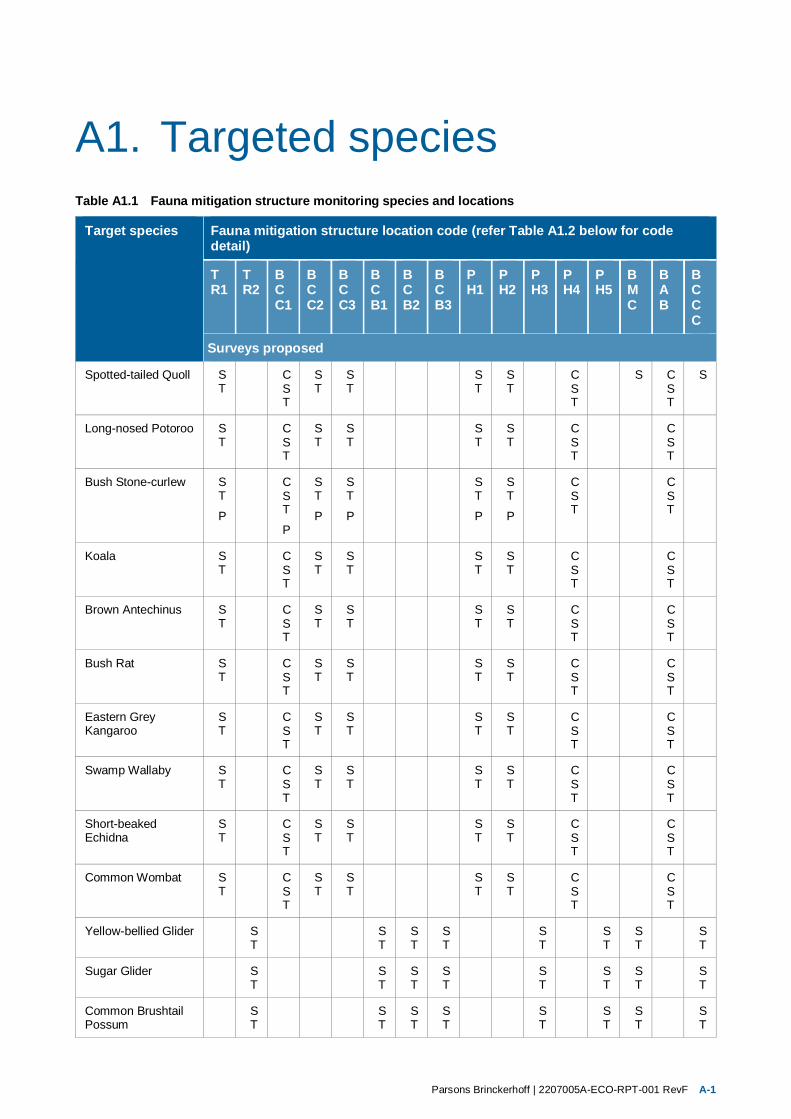
Parsons Brinckerhoff | 2207005A-ECO-RPT-001 RevF A-1
A1. Targeted species Table A1.1 Fauna mitigation structure monitoring species and locations
Target species Fauna mitigation structure location code (refer Table A1.2 below for code detail)
TR1
TR2
BCC1
BCC2
BCC3
BCB1
BCB2
BCB3
PH1
PH2
PH3
PH4
PH5
BMC
BAB
BCCC
Surveys proposed
Spotted-tailed Quoll ST
CST
ST
ST
S T
S T
C ST
S CST
S
Long-nosed Potoroo ST
CST
ST
ST
S T
S T
C ST
CST
Bush Stone-curlew ST
P
CST
P
ST
P
ST
P
ST
P
ST
P
C ST
CST
Koala ST
CST
ST
ST
S T
S T
C ST
CST
Brown Antechinus ST
CST
ST
ST
S T
S T
C ST
CST
Bush Rat ST
CST
ST
ST
S T
S T
C ST
CST
Eastern Grey Kangaroo
ST
CST
ST
ST
S T
S T
C ST
CST
Swamp Wallaby ST
CST
ST
ST
S T
S T
C ST
CST
Short-beaked Echidna
ST
CST
ST
ST
S T
S T
C ST
CST
Common Wombat ST
CST
ST
ST
S T
S T
C ST
CST
Yellow-bellied Glider S T
S T
S T
S T
S T
S T
S T
S T
Sugar Glider S T
S T
S T
S T
S T
S T
S T
S T
Common Brushtail Possum
S T
S T
S T
S T
S T
S T
S T
S T

Parsons Brinckerhoff | 2207005A-ECO-RPT-001 RevF A-2
Target species Fauna mitigation structure location code
TR1
TR2
BCC1
BCC2
BCC3
BCB1
BCB2
BCB3
PH1
PH2
PH3
PH4
PH5
BMC
BAB
BCCC
Surveys proposed
Common Ringtail Possum
S T
S T
S T
S T
S T
S T
S T
S T
Black Bittern CST
Swamp Wallaby CST
CST
CST
CST
CST
Reptiles HS
HS
HS
HS
HS
HS
HS
Amphibians HSP
HSP
HSP
HSP
HSP
HSP
HSP
All terrestrial fauna Roadkill Surveys along entire length of the existing Princes Highway within and adjacent to the project. Surveys will be conducted weekly for a period of 32 weeks and will involve two ecologists. Thereafter these surveys will occur during the post-construction (operational) phase as outlined in Table 3.3.
Aquatic ecology The monitoring would occur at a total of six sites seasonally in spring / summer 2014 and thereafter during construction in Autumn / Spring until 3 years after operation begins. Refer to Table 3.3 for location information.
Survey Methodology Key: C = Camera – automated motion detecting T = Tracks, scats and signs searches S = Spotlighting and stag watching H = Herpetological searches C = Call playback
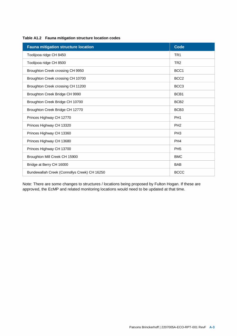
Parsons Brinckerhoff | 2207005A-ECO-RPT-001 RevF A-3
Table A1.2 Fauna mitigation structure location codes
Fauna mitigation structure location Code
Toolijooa ridge CH 8450 TR1
Toolijooa ridge CH 8500 TR2
Broughton Creek crossing CH 9950 BCC1
Broughton Creek crossing CH 10700 BCC2
Broughton Creek crossing CH 11200 BCC3
Broughton Creek Bridge CH 9990 BCB1
Broughton Creek Bridge CH 10700 BCB2
Broughton Creek Bridge CH 12770 BCB3
Princes Highway CH 12770 PH1
Princes Highway CH 13320 PH2
Princes Highway CH 13360 PH3
Princes Highway CH 13680 PH4
Princes Highway CH 13700 PH5
Broughton Mill Creek CH 15900 BMC
Bridge at Berry CH 16000 BAB
Bundewallah Creek (Connollys Creek) CH 16250 BCCC
Note: There are some changes to structures / locations being proposed by Fulton Hogan. If these are approved, the EcMP and related monitoring locations would need to be updated at that time.