Embed Size (px)
Citation preview
Australian Ecosystems Pty Ltd PO Box 424
Patterson Lakes VIC 3197
Tel: (03) 9775 0612
Fax: (03) 9775 0614
www.australianecosystems.com.au
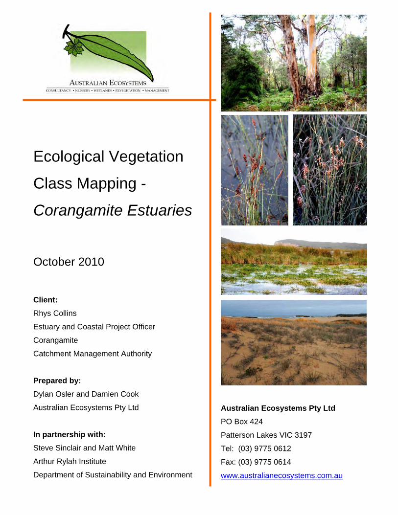
Ecological Vegetation
Class Mapping -
Corangamite Estuaries October 2010 Client: Rhys Collins
Estuary and Coastal Project Officer
Corangamite
Catchment Management Authority
Prepared by: Dylan Osler and Damien Cook
Australian Ecosystems Pty Ltd
In partnership with: Steve Sinclair and Matt White
Arthur Rylah Institute
Department of Sustainability and Environment
Australian Ecosystems
CONTENTS
1.0 INTRODUCTION .................................................................................................. 1
1.1 Project Context ............................................................................................................................... 1
1.2 Project Objectives .......................................................................................................................... 1
1.3 Study Area....................................................................................................................................... 1
2.0 METHODOLOGY ................................................................................................. 3
2.1 Vegetation Mapping ....................................................................................................................... 3
2.2 Vegetation Condition Assessment ............................................................................................... 6
2.3 Limitations of Vegetation Condition Assessment ...................................................................... 7
2.4 GIS Mapping.................................................................................................................................... 8
2.5 Threat Description.......................................................................................................................... 8
2.6 Rare and Threatened Species ....................................................................................................... 9
2.7 General Limitations........................................................................................................................ 9
3.0 ECOLOGICAL VEGETATION CLASSES.......................................................... 10
3.1 Overview of EVC Mapping........................................................................................................... 10
3.2 EVC Descriptions ......................................................................................................................... 12
3.3 Descriptions for Provisional Saltmarsh EVCs .......................................................................... 47
4.0 VEGETATION CONDITION ASSESSMENTS ................................................... 53
4.1 Curdies River ................................................................................................................................ 53 4.1.1 Summary of condition assessments .......................................................................................... 53 4.1.2 Best and poorest condition areas .............................................................................................. 53 4.1.3 Tabulation of threats to remnant vegetation .............................................................................. 55
4.2 Gellibrand River............................................................................................................................ 56 4.2.1 Summary of condition assessments .......................................................................................... 56 4.2.2 Best and poorest condition areas .............................................................................................. 56 4.2.3 Tabulation of threats to remnant vegetation .............................................................................. 57
4.3 Aire River....................................................................................................................................... 60 4.3.1 Summary of condition assessments .......................................................................................... 60 4.3.2 Best and poorest condition areas .............................................................................................. 60 4.3.3 Tabulation of threats to remnant vegetation .............................................................................. 61
4.4 Anglesea River.............................................................................................................................. 62 Ecological Vegetation Class Mapping Corangamite Estuaries, October 2010 Page i
Australian Ecosystems
4.4.1 Summary of condition assessments .......................................................................................... 62
4.5 Painkalac Creek............................................................................................................................ 63 4.5.1 Summary of condition assessments .......................................................................................... 63 4.5.2 Best and poorest condition areas .............................................................................................. 63 4.5.3 Tabulation of threats to remnant vegetation .............................................................................. 64
4.6 Thompson Creek .......................................................................................................................... 65 4.6.1 Summary of condition assessments .......................................................................................... 65 4.6.2 Best and poorest condition areas .............................................................................................. 66 4.6.3 Tabulation of threats to remnant vegetation .............................................................................. 67
5.0 RARE AND THREATENED SPECIES ............................................................... 68
6.0 REFERENCES ................................................................................................... 70
APPENDIX 1: NEW INFORMAL EVC BENCHMARKS CREATED FOR THIS STUDY............ 72
APPENDIX 2: GIS METADATA ................................................................................................. 77
APPENDIX 3: ADDITIONAL PHOTOGRAPHS ......................................................................... 79
Ecological Vegetation Class Mapping Corangamite Estuaries, October 2010 Page ii
Australian Ecosystems
LIST OF FIGURES Figure 1 Extant Ecological Vegetation Classes Curdies River.................................................... 12
Figure 2 Extant Ecological Vegetation Classes Gellibrand River................................................ 13
Figure 3 Extant Ecological Vegetation Classes Aire River.......................................................... 14
Figure 4 Extant Ecological Vegetation Classes Barham River.................................................... 15
Figure 5 Extant Ecological Vegetation Classes Anglesea River ................................................. 16
Figure 6 Extant Ecological Vegetation Classes Painkalac River................................................. 17
Figure 7 Extant Ecological Vegetation Classes Spring River...................................................... 18
Figure 8 Extant Ecological Vegetation Classes Thompsons River ............................................. 19
LIST OF TABLES Table 1 Definition of each estuary reach. The estuaries are listed west to east. .......................... 2
Table 2 Survey dates and field personnel by estuary. The estuaries are listed west to east........ 4
Table 3 The area of each EVC by estuary. The estuaries are listed west to east. The EVCs are
ordered according to their total area in the entire study area. ............................................. 10
Table 4 Habitat Scores by EVC for Curdies River....................................................................... 53
Table 5 Tabulation of threats to remnant vegetation at Curdies River ........................................ 55
Table 6 Habitat Hectare Scores by EVC for Gellibrand River ..................................................... 56
Table 7 Tabulation of threats to remnant vegetation at Gellibrand River .................................... 58
Table 8 Habitat Hectare Scores by EVC for Aire River ............................................................... 60
Table 9 Tabulation of threats to remnant vegetation at Aire River .............................................. 61
Table 10 Habitat Hectare Scores by EVC for Anglesea River .................................................... 62
Table 11 Habitat Hectare Scores by EVC for Painkalac Creek................................................... 63
Table 12 Tabulation of threats to remnant vegetation at Painkalac Creek.................................. 64
Table 13 Habitat Hectare Scores by EVC for Thompson Creek ................................................. 65
Table 14 Tabulation of threats to remnant vegetation at Thompson Creek ................................ 67
Table 15 Rare and threatened species recorded within the study area. Records denoted ‘X’ were
confirmed during the current study, those denoted ‘F’ were retrieved from the FIS, and were
not confirmed during the study. The status of species is taken from Stasjic and Walsh, 2008
(r = rare in Victoria, R = rare in Australia, v = vulnerable in Victoria, V = vulnerable in
Australia, e = endangered in Victoria). ................................................................................ 68
Ecological Vegetation Class Mapping Corangamite Estuaries, October 2010 Page iii
Australian Ecosystems
Ecological Vegetation Class Mapping Corangamite Estuaries, October 2010 Page iv
LIST OF PHOTOGRAPHS Photograph 1 Aquatic Herbland (foreground) Gellibrand Estuary, photographed by D Cook, April
2009 .................................................................................................................................... 20
Photograph 2 Aquatic Sedgeland Gellibrand Estuary, photographed by D Cook, April 2009..... 21
Photograph 3 Brackish Aquatic Herbland supporting Myriophyllum salsugineum (Lake Water-
milfoil), Mimulus repens (Creeping Monkey-flower), Triglochin procerum spp. agg. (Water
Ribbons) and Ruppia polycarpa (Many-fruit Tassel) ........................................................... 23
Photograph 4 Lobelia irrigua (Salt Pratia) ................................................................................... 24
Photograph 5, Brackish Grassland Curdies River, photographed by D Cook, June 2009 .......... 25
Photograph 6 Carex tasmanica Gellibrand Estuary, photographed by D Cook, April 2009 ........ 26
Photograph 7 Brackish Wetland dominated by Schoenoplectus pungens and Rumex bidens,
Gellibrand Estuary, photographed by D Cook, April 2009................................................... 27
Photograph 8 Coast Dune Grassland Curdies River, photographed by D Cook, June 2009...... 28
Photograph 9 Coastal Dune Scrub Curdies River, photographed by D Cook, June 2009 .......... 29
Photograph 10 Boundary of Estuarine Scrub, Estuarine Wetland and Estuarine Flats Grassland
Gellibrand Estuary, photographed by D Cook, April 2009................................................... 31
Photograph 11 Estuarine Scrub Gellibrand Estuary, photographed by D Cook, April 2009 ....... 33
Photograph 12 Estuarine Wetland Gellibrand Estuary, photographed by D Cook, April 2009.... 34
Photograph 13 Estuarine Wetland Curdies River, photographed by D Cook, June 2009........... 35
Photograph 14 Fern Swamp Gellibrand Estuary, photographed by D Cook, April 2009............. 35
Photograph 15 Gahnia Sedgeland- Swamp Scrub Complex Curdies River, photographed by D
Cook, June 2009 ................................................................................................................. 36
Photograph 16 Herb-rich Foothill Forest Curdies River, photographed by D Cook, June 2009.. 38
Photograph 17 Shrubby Riparian Forest Gellibrand Estuary, photographed by D Cook, April
2009 .................................................................................................................................... 40
Photograph 18 Swampy Woodland Curdies River, photographed by D Cook, June 2009 ......... 44
Photograph 19 Tall Marsh Gellibrand Estuary, photographed by D Cook, April 2009 ................ 45
Photograph 20 Wet Verge Sedgeland Gellibrand Estuary, photographed by D Cook, April 2009
............................................................................................................................................ 46
Photograph 21 Carex tasmanica, Curdies River, photographed by D Cook, June 2009 ............ 54
Photograph 22 Vegetation effected by acid sulphate soils Gellibrand Estuary, photographed by
D Cook, April 2009 .............................................................................................................. 59
Photograph 23 Pterostylis tenuissima (Swamp Greenhood)....................................................... 69
Australian Ecosystems
1.0 INTRODUCTION
1.1 Project Context
Australian Ecosystems Pty Ltd, in partnership with the Arthur Rylah Institute (Department of Sustainability and Environment, DSE), was engaged by Corangamite Catchment Management Authority (CCMA) to provide detailed mapping of estuary vegetation at a number of significant waterways within the Corangamite region. The purpose of the study was to provide maps and data for community consultation, population of the Estuary Entrance Management Support System (EEMSS), and for assessing long term change to estuary vegetation. The report that follows describes the Ecological Vegetation Classes (EVCs) supported by the estuaries, and summarises vegetation condition as assessed during autumn 2009. It is intended to complement the EVC and Habitat Condition maps, which are the main product of this project.
1.2 Project Objectives
The project necessitated field surveys to record all native vegetation as EVCs within the defined reach of each of eight estuaries to a height of 2 - 3 metres AHD, and the collection of information on habitat condition using the Habitat Hectare methodology. The project objectives were to: • Provide information for the population of the vegetation (flora) component of the EEMSS; • Gather sufficient information through survey and mapping of estuaries of the region to define
current vegetation communities as a basis for measuring change over time of estuary vegetation;
• Identify the occurrence of rare and threatened species where possible; and • Report on threats to remnant habitat and summarise habitat condition.
1.3 Study Area
Eight estuaries within the CCMA region were surveyed; they being from west to east: • Curdies River (Peterborough), • Gellibrand River (Princeton), • Aire River (Glenaire), • Barham River (Apollo Bay),
Ecological Vegetation Class Mapping Corangamite Estuaries, October 2010 Page 1
Australian Ecosystems
• Painkalac Creek (Aireys Inlet), • Anglesea River (Anglesea), • Spring Creek (Torquay), and • Thompson Creek (Breamlea).
The survey boundaries for each reach are as defined in Table 1.
Table 1 Definition of each estuary reach. The estuaries are listed west to east.
Estuary Defined Estuary Reach
Curdies River Land within the 3.0 metre AHD boundary. Include Curdies River between the mouth upstream through the Inlet to Boggy Creek Road at Curdie Vale. Also include small tributaries along the length of Curdies Inlet Creek that fall within the 3.0 metre limit.
Gellibrand River
Include land within the 2.0 metre AHD boundary. Include the Gellibrand River valley and wetlands from the mouth at Point Ronald upstream to the Great Ocean Road in Lower Gellibrand. Include La trobe Creek (Serpentine Creek) to a distance 100 metres beyond the first minor tributary down each of the west and north east branches.
Aire River
Include land within 1% of the AEP Flood extent, encircled by the Great Ocean Road, Hordern Vale Road and Sand Road. This includes the Aire River from the mouth to the Great Ocean Road Bridge, the Ford and Calder Rivers from their confluence with the Aire upstream to the Great Ocean Road and the entirety of Blind Creek. Include also Lakes Hordern, Calder, Costin and Craven and all drainage channels.
Barham River
Include land within the 3.0 metre AHD boundary. Include the Barham River upstream from the mouth to Barham Valley Road bridge near Kambrook, and small tributaries within this reach near the bridge closest to Apollo Bay. Also include areas of Backwater.
Anglesea River Include land within the 2.5 metre AHD boundary. Include the Anglesea River and surrounding wetlands from the mouth to Coal Mine Road. Include also Blind Creek and wetlands
Painkalac River All land within the 3.0 metre AHD boundary.
Spring Creek All land within the 3.0 metre AHD boundary. Include Spring Creek upstream from the mouth to Duffield’s Road.
Thompson Creek All land within the 3.0 metre AHD boundary.
Curdies River and Gellibrand River are within the Warrnambool Plain Bioregion. Aire River, Barham River, Painkalac Creek, Anglesea River, Spring Creek and Thompson Creek, are within the Otway Plain Bioregion.
Ecological Vegetation Class Mapping Corangamite Estuaries, October 2010 Page 2
Australian Ecosystems
2.0 METHODOLOGY
2.1 Vegetation Mapping
Following Victorian Government protocols (DSE, 2007), ‘native vegetation’ was considered to be any area where at least 25% of the lower-storey vegetation cover is native. Consistent with the approach of most Victorian management agencies (see Commonwealth of Australia and NRE, 1996; Woodgate et al. 1996), EVCs were adopted as the unit of classification for native vegetation. Given EVCs may differ from location to location, descriptions are provided for all EVCs encountered within the study area. Relevant dry-land EVC descriptions may be found in a number of reports (notably Oates and Taranto, 2001; Yugovic et al., 1999). It is important to note that the wetland EVC typology was reviewed between 2006 and 2009, and that the revised typology is followed for all wetlands encountered during this study (DSE, 2006; DSE, 2009). EVC typology is departed from in one area - Coastal Saltmarsh. This is particularly relevant to the Thompson Creek Estuary (Breamlea saltmarsh). The EVC typology currently treats Coastal Saltmarsh (EVC 9) as an aggregate unit (DSE, 2009), implying that it is made up of an un-specified group of smaller units. A recent project (Victorian Saltmarsh Study, 2010) described these distinct units, and recommended their elevation to EVC status. DSE has not yet determined whether those recommendations will be adopted. The EVCs have been used here as provisional units, alongside established EVCs. This decision ensures that the mapping will not become redundant should the new typology be adopted. If rejected, all provisional units would simply revert back to the aggregate unit. For clarity, the provisional units are described separately in the results section. They are: • Coastal Dry Saltmarsh • Coastal Hypersaline Saltmarsh • Coastal Saline Grassland • Coastal Tussock Saltmarsh • Wet Saltmarsh Herbland • Wet Saltmarsh Shrubland
Ecological Vegetation Class Mapping Corangamite Estuaries, October 2010 Page 3
Australian Ecosystems
For a few EVCs (Estuarine Wetland, Swamp Scrub, Brackish Wetland and Wet Verge Sedgeland), a ‘structurally modified’ form of the EVC was recorded. This describes sites that belong to the EVC (given their floristics, soil, inundation regime, etc) but where management has forced the vegetation into a state that looks unlike the EVC. An example is where the shrubs have been cleared from Swamp Scrub, but the understorey remaining is clearly referrable to this EVC (see below for treatment of modified sites that now support a new EVC). The recognition of ‘modified’ sites ensures our data ‘make sense’ to the non-botanist: Regardless of the botanical justification, labelling non-woody vegetation the same as dense ‘Swamp Scrub’ would appear inappropriate to the non-specialist. These ‘structurally modified’ units have no status in the EVC typology. In order to assign vegetation patches to EVCs, the study area was explored extensively on foot, enabling the observed patterns to be reconciled with those visible in aerial photographs (DSE, December 2007, 35cm pixels, GDA94, zone 55). All patches of native vegetation within the study area were assigned an EVC (non native vegetation remains unclassified, but see below). Determinations were made subjectively based on landscape features (soil, apparent flooding and salinity regime, etc.) and the vascular plant species present. Hard-copy aerial photographs were annotated in the field. Representative photographs of many EVCs were taken to form a photographic reference of the region’s estuarine EVCs. Any rare and threatened species were also photographed as a resource to assist in community consultation. Field survey dates, and the botanists who inspected the sites, are as listed in Table 2.
Table 2 Survey dates and field personnel by estuary. The estuaries are listed west to east.
Estuary Survey Dates Field Personnel
Curdies River 9th to 12th June 2009 Damien Cook, Dylan Osler
Gellibrand River 14th to 17th April and 21st to 23rd April 2009 Isabella Amouzandeh, Ana Backstrom, Elaine Bayes, Damien Cook, Dylan Osler
Aire River 1st to 4th June 2009 Ana Backstrom, Dylan Osler, Steve Sinclair (ARI), Geoff Sutter (ARI)
Barham River 15th May 2009 Dylan Osler, Nick Witherow
Anglesea River 16th to 17th May 2009 Matt White (ARI)
Ecological Vegetation Class Mapping Corangamite Estuaries, October 2010 Page 4
Australian Ecosystems
Ecological Vegetation Class Mapping Corangamite Estuaries, October 2010 Page 5
Estuary Survey Dates Field Personnel
Painkalac Creek 19th August 2009, augmented by existing data (Sinclair and White, 2006)
Steve Sinclair (ARI), Heidi Zimmer (ARI)
Spring Creek 19th August 2009 Steve Sinclair (ARI)
Thompson Creek 4th and 17th February 2010 and 23rd January 2010
Steve Sinclair (ARI), Geoff Sutter (ARI), Garreth Kyle (ARI)
In addition to the observed EVCs, a ‘pre-1750 EVC’ was also assigned to each part of the study area. The pre-1750 EVC is a best estimation of which EVC a given site supported prior to European colonisation. Pre-1750 EVCs were assigned even to areas which no longer support native vegetation. In most cases, the current EVC is the same as the pre-1750 EVC, but there are some cases where they differ. Typically, this is in cases where:
• whole-sale hydrological changes or earthworks have altered the conditions of a site, and the site has been re-colonised by native species. This is the case in the Anglesea estuary, where the 1983 wildfires burnt subterranean peats, which were excavated to control the fire. This area has now been recolonised by wetland plants.
• total removal of one layer of vegetation from a site leaves residual vegetation indistinguishable from another EVC (c.f. above). This is the case in the Thompson estuary, where it was speculated that Moonah (Melaleuca lanceolata) trees were removed from near the marsh edges (pre-1750 EVC ‘Estuarine Scrub’), leaving behind low-lying grasslands of Common Tussock grass (Poa labillardierei) (observed EVC ‘Estuarine Flats Grassland’). It could be argued that the determination of Estuarine Flats Grassland is in error, and that the grasslands should have been recognised as degraded ‘Estuarine Scrub’. However, preference was given to assigning the EVC closest to the observed vegetation to avoid errors based on speculation, and to give the ‘benefit of the doubt’ to such sites when assessing condition against a benchmark (see below).
• The original boundaries between two EVCs cannot be distinguished with reliability in areas which retain little or no native vegetation. In these cases the precise pre-1750 EVC is not known in all places. In such cases ‘mosaic’ units were assigned, which represent areas where two or more distinct EVCs occur, and are so patterned that their boundaries cannot be resolved.
Australian Ecosystems
A ‘potential EVC’ was also assigned to all parts of the study area. This reflects the best hope for revegetation, should revegetation be considered appropriate (conceding that revegetation is impractical or undesirable in many places). The potential EVC favours a return to pre-1750 vegetation patterns where possible, unless hydrological or geomorphological changes have made this impossible. Mosaics are used here as described above. Standard DSE EVC mosaic numbers were assigned where available. Consultation with DSE occurred as necessary to create new map unit numbers, to ensure that these become the DSE standard for these units.
2.2 Vegetation Condition Assessment
Vegetation condition was assessed using ‘habitat hectares’, a condition metric used commonly throughout Victoria and endorsed by DSE (Parkes et al. 2003; DSE, 2004). The concept of ‘vegetation condition’ is not clearly defined by DSE, but the following sense is implicit:
• Condition measures the retention or loss of ecological attributes which characterise vegetation in its desired state.
• That state is described by a benchmark against which actual sites are assessed. Habitat hectares has two components: the site score and the landscape context score. The site score relies on a comparison between the observed vegetation and a ‘benchmark’ (available from www.dse.vic.gov.au). The landscape context score assesses the size and connectivity of the vegetation, in relation to other nearby patches of native vegetation. The combination of the site and landscape context scores provides a habitat score, which is taken to be a measure of condition. This can be weighted by the size of the patch in question to give a Habitat Hectares score, which may be used for many purposes (such as calculating offsets according to the ‘Vegetation Framework’; NRE (now DSE) 2002). The condition of all accessible patches of native vegetation was assessed. In many cases, where vegetation zones are arranged as an array of very small, distinct areas, groups of polygons were assessed with a single assessment. Clusters were categorised in the field as belonging to one of several distinct condition classes, and an overall score was estimated for each cluster. This approach was adopted because aspects of the Habitat Hectares site score are scale-dependent, and there is a risk that small areas may be given an inappropriately low score because of their size.
Ecological Vegetation Class Mapping Corangamite Estuaries, October 2010 Page 6
Australian Ecosystems
For many wetlands habitat hectares benchmarks are not available (although they exist for some EVCs relevant to this study). Another index - the index of wetland condition (DSE, 2005a; DSE, 2006) has been created to assess wetland condition. This index answers a different purpose to habitat hectares, and the two systems are not directly comparable. IWC was not used in this project. For wetland EVCs with no benchmarks, information was recorded in the field that is likely to be relevant to an assessment. Members of the project team (DO, SS) met after field work was complete to create informal benchmarks (i.e. not endorsed by DSE), to allow retrospective assessments to be made. This applies to the following EVCs:
• Aquatic Sedgeland • Brackish Aquatic Herbland • Brackish Herbland • Estuarine Reedbed • Fern Swamp • Wet Verge Sedgeland
All informal benchmarks are included as Appendix 1, and have been sent to DSE, with the recommendation that they be adopted as published benchmarks. A brief report detailing habitat condition was prepared for Aire, Gellibrand, Curdies and Painkalac, whereas habitat scores only, are presented for Anglesea and Thompson.
2.3 Limitations of Vegetation Condition Assessment
The condition assessment data collected during this project provide a good overview of vegetation condition in the study area. However, it is important to note several serious limitations of these data, which should restrict how the data are used:
• Habitat hectares performs relatively poorly in wetlands (Parkes et al. 2003). This is due to the fact that wetlands are often structurally simple, and many components of habitat hectares are not applicable; emphasising any errors in the other components. Wetlands are also highly dynamic, such that their conditions can change very rapidly (weeds, litter, life-form covers, etc), making some aspects of the score highly unreliable. Furthermore, wetlands are often dominated by long-lived (essentially immortal) clonal plants, making the idea of recruitment difficult to interpret.
Ecological Vegetation Class Mapping Corangamite Estuaries, October 2010 Page 7
Australian Ecosystems
• Some informal benchmarks, not approved by DSE, were used. • Some of the DSE benchmarks are apparently used rarely, and have not been updated to
match the wetland typology. This means that some benchmarks require lifeforms to be present that are always absent under the new typology, even in the best sites.
• Common scores were used for groups of polygons. In many cases not all member-polygons of the group were inspected in detail.
• Habitat hectares is scale-dependent (notably understorey score). The assessment of very small patches, such as those mapped in complex systems at high resolution, may produce irregular results.
• Efforts were deliberately focused on mapping vegetation type; as vegetation type provides more robust, enduring and useful data.
Given these limitations, the data presented here must NOT be used for Net Gain assessments.
2.4 GIS Mapping
The distribution of native vegetation type (EVC) and condition (habitat hectares) is represented in the final digital map dataset as a series of spatially referenced polygons. All polygons were constructed ‘by hand’ using Arcview 3.2 (ESRI), traced directly from aerial photographs as annotated by the field teams. To permit fluid boundaries on the shapes, a stream digitiser was used with a sensitive screen and stylus (Minnesota Department of Natural Resources 2000, version 1.06; on a Wacom tablet screen). This allowed direct tracing of the shapes on the screen. The complete GIS metadata are included in Appendix 2. The spatial data are resolved sufficiently to be viewed at a scale of 1:2,500.
2.5 Threat Description
The threats which are currently or imminently acting on the vegetation were assessed subjectively in the field, and are tabulated for each estuary (or ‘reach’ within the larger systems), excluding Anglesea River, Barham River and Spring Creek. Adjacent or proximal threats to each estuary beyond the 2.0 – 3.0 metre AHD mapping limit, such as stock access, pressure via recreational use, erosion, barriers to connectivity or invasive weeds were documented for Aire River, Gellibrand River, Painkalac River, Curdies River and Thompson Creek. Inappropriate estuary management has been excluded as an assessed threat. It is assumed to be in need of improvement; given better management is the over-arching driver for this project. Ecological Vegetation Class Mapping Corangamite Estuaries, October 2010 Page 8
Australian Ecosystems
2.6 Rare and Threatened Species
Rare or threatened species are important assets that must be considered when an estuary is managed. The project brief provided a short list of species to be recorded during field surveys. These species (and any other species on DSE’s advisory list (DSE, 2005b)) were recorded opportunistically while mapping vegetation. Locations were recorded on a hand-held GPS and/or marked on an accurate aerial photograph.
2.7 General Limitations
Funding and timing constraints impeded aspects of the study. As the project brief stipulated that surveys be carried out largely during autumn and winter, it is probable that some species may have been overlooked. Several of the target species identified as rare or threatened within the EEMSS were undetectable during this period (e.g. Triglochin minutissima and Triglochin mucronata). The inability to access areas of private land may significantly constrain mapping projects. While every effort was made to access all land within the study area, this limitation must be clearly acknowledged. Areas that could not be accessed but could be seen (for example across a river or fenceline) were assigned an EVC and a condition score to the best of the field botanists’ ability. A few sites were not able to be observed at all, and were not assigned these data. These areas are clearly flagged in the GIS dataset.
Ecological Vegetation Class Mapping Corangamite Estuaries, October 2010 Page 9
Australian Ecosystems
3.0 ECOLOGICAL VEGETATION CLASSES
3.1 Overview of EVC Mapping
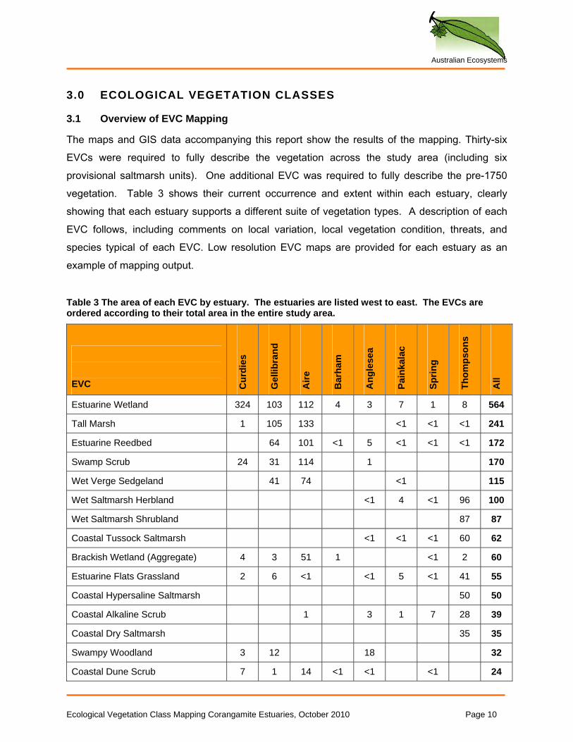
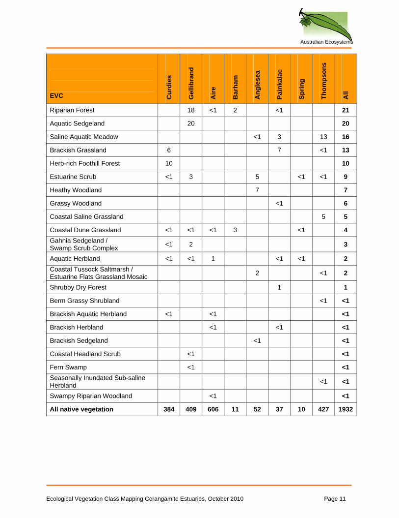
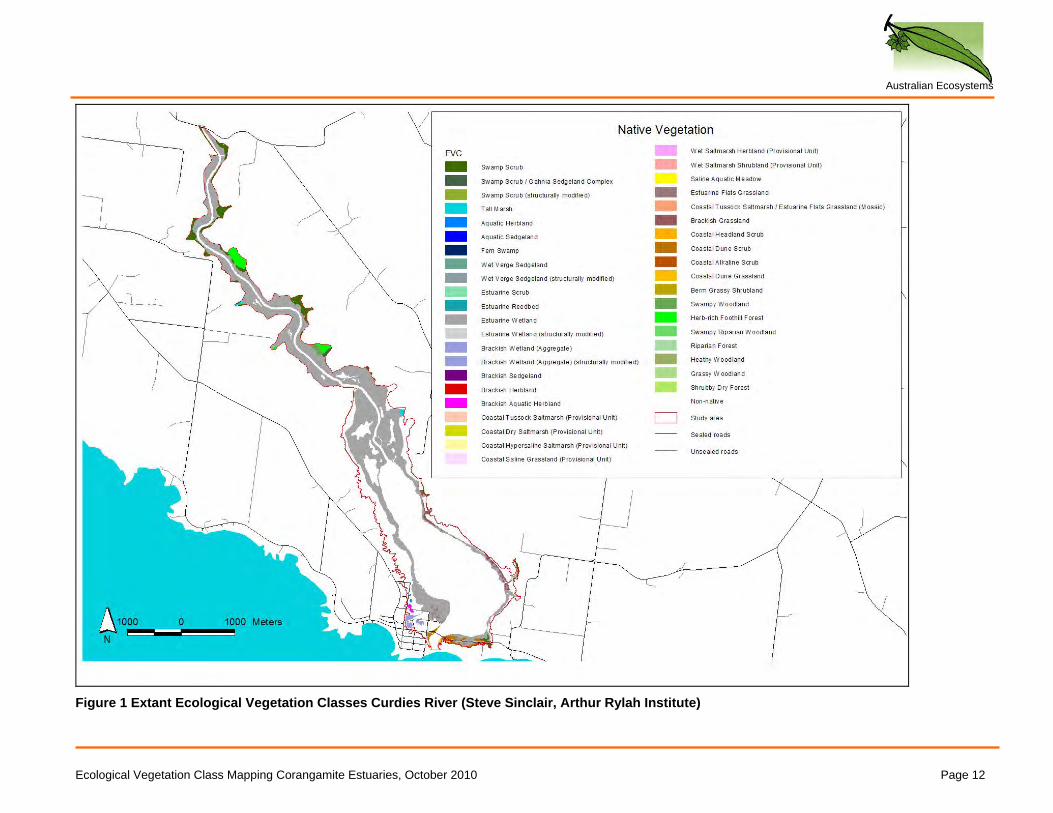
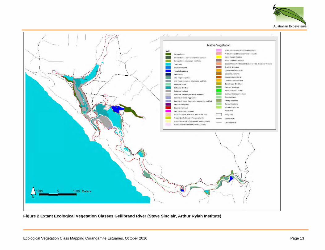
The maps and GIS data accompanying this report show the results of the mapping. Thirty-six EVCs were required to fully describe the vegetation across the study area (including six provisional saltmarsh units). One additional EVC was required to fully describe the pre-1750 vegetation. Table 3 shows their current occurrence and extent within each estuary, clearly showing that each estuary supports a different suite of vegetation types. A description of each EVC follows, including comments on local variation, local vegetation condition, threats, and species typical of each EVC. Low resolution EVC maps are provided for each estuary as an example of mapping output.
Table 3 The area of each EVC by estuary. The estuaries are listed west to east. The EVCs are ordered according to their total area in the entire study area.
EVC C
urdi
es
Gel
libra
nd
Aire
Bar
ham
Ang
lese
a
Pain
kala
c
Sprin
g
Thom
pson
s
All
Estuarine Wetland 324 103 112 4 3 7 1 8 564
Tall Marsh 1 105 133 <1 <1 <1 241
Estuarine Reedbed 64 101 <1 5 <1 <1 <1 172
Swamp Scrub 24 31 114 1 170
Wet Verge Sedgeland 41 74 <1 115
Wet Saltmarsh Herbland <1 4 <1 96 100
Wet Saltmarsh Shrubland 87 87
Coastal Tussock Saltmarsh <1 <1 <1 60 62
Brackish Wetland (Aggregate) 4 3 51 1 <1 2 60
Estuarine Flats Grassland 2 6 <1 <1 5 <1 41 55
Coastal Hypersaline Saltmarsh 50 50
Coastal Alkaline Scrub 1 3 1 7 28 39
Coastal Dry Saltmarsh 35 35
Swampy Woodland 3 12 18 32
Coastal Dune Scrub 7 1 14 <1 <1 <1 24
Ecological Vegetation Class Mapping Corangamite Estuaries, October 2010 Page 10
Australian Ecosystems
Ecological Vegetation Class Mapping Corangamite Estuaries, October 2010 Page 11
EVC C
urdi
es
Gel
libra
nd
Aire
Bar
ham
Ang
lese
a
Pain
kala
c
Sprin
g
Thom
pson
s
All
Riparian Forest 18 <1 2 <1 21
Aquatic Sedgeland 20 20
Saline Aquatic Meadow <1 3 13 16
Brackish Grassland 6 7 <1 13
Herb-rich Foothill Forest 10 10
Estuarine Scrub <1 3 5 <1 <1 9
Heathy Woodland 7 7
Grassy Woodland <1 6
Coastal Saline Grassland 5 5
Coastal Dune Grassland <1 <1 <1 3 <1 4 Gahnia Sedgeland / Swamp Scrub Complex <1 2 3
Aquatic Herbland <1 <1 1 <1 <1 2 Coastal Tussock Saltmarsh / Estuarine Flats Grassland Mosaic 2 <1 2
Shrubby Dry Forest 1 1
Berm Grassy Shrubland <1 <1
Brackish Aquatic Herbland <1 <1 <1
Brackish Herbland <1 <1 <1
Brackish Sedgeland <1 <1
Coastal Headland Scrub <1 <1
Fern Swamp <1 <1 Seasonally Inundated Sub-saline Herbland <1 <1
Swampy Riparian Woodland <1 <1
All native vegetation 384 409 606 11 52 37 10 427 1932
Australian Ecosystems
Figure 1 Extant Ecological Vegetation Classes Curdies River (Steve Sinclair, Arthur Rylah Institute)
Ecological Vegetation Class Mapping Corangamite Estuaries, October 2010 Page 12
Australian Ecosystems
Figure 2 Extant Ecological Vegetation Classes Gellibrand River (Steve Sinclair, Arthur Rylah Institute)
Ecological Vegetation Class Mapping Corangamite Estuaries, October 2010 Page 13
Australian Ecosystems
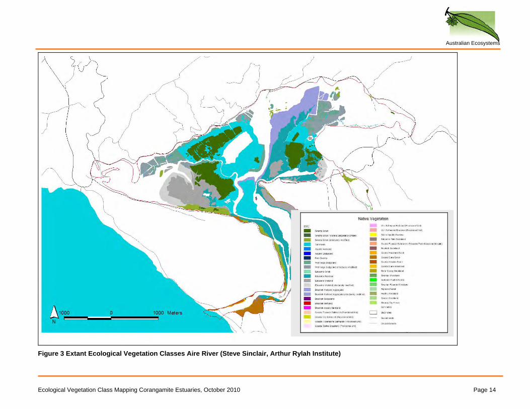
Figure 3 Extant Ecological Vegetation Classes Aire River (Steve Sinclair, Arthur Rylah Institute)
Ecological Vegetation Class Mapping Corangamite Estuaries, October 2010 Page 14
Australian Ecosystems
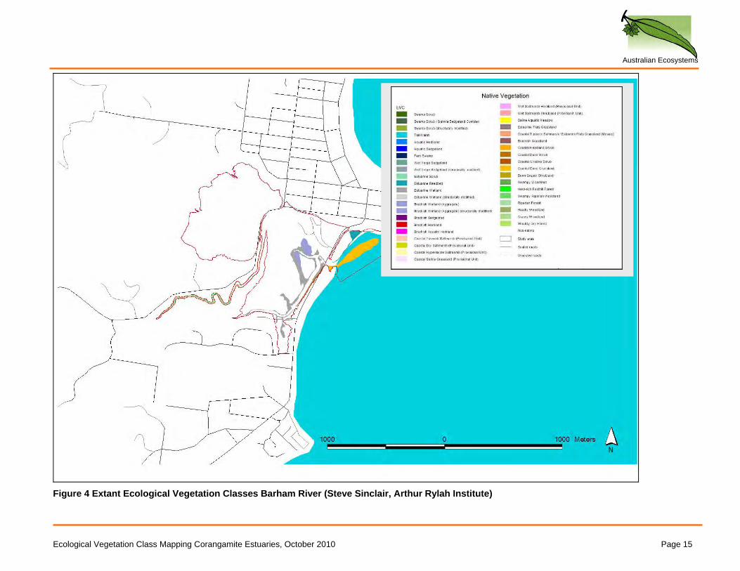
Figure 4 Extant Ecological Vegetation Classes Barham River (Steve Sinclair, Arthur Rylah Institute)
Ecological Vegetation Class Mapping Corangamite Estuaries, October 2010 Page 15
Australian Ecosystems
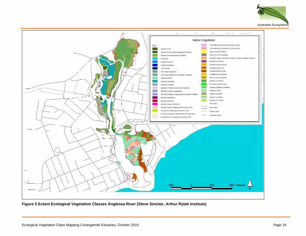
Figure 5 Extant Ecological Vegetation Classes Anglesea River (Steve Sinclair, Arthur Rylah Institute)
Ecological Vegetation Class Mapping Corangamite Estuaries, October 2010 Page 16
Australian Ecosystems
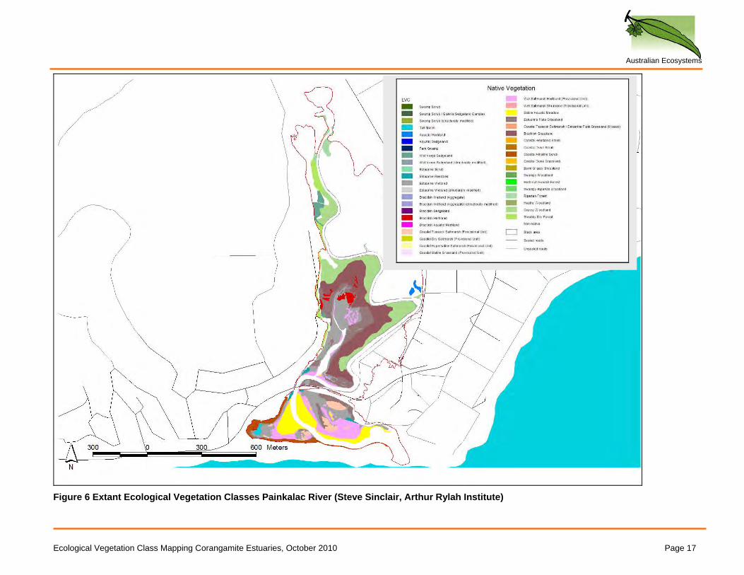
Figure 6 Extant Ecological Vegetation Classes Painkalac River (Steve Sinclair, Arthur Rylah Institute)
Ecological Vegetation Class Mapping Corangamite Estuaries, October 2010 Page 17
Australian Ecosystems
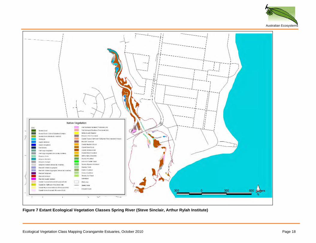
Figure 7 Extant Ecological Vegetation Classes Spring River (Steve Sinclair, Arthur Rylah Institute)
Ecological Vegetation Class Mapping Corangamite Estuaries, October 2010 Page 18
Australian Ecosystems
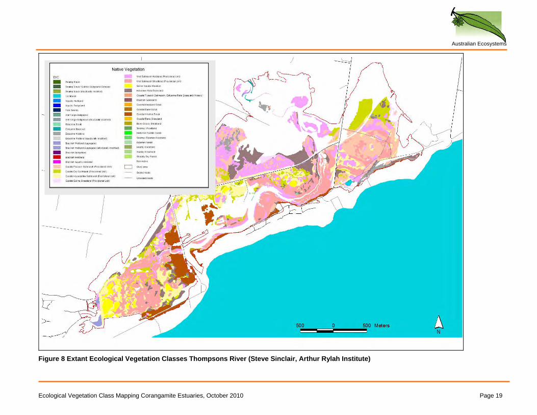
Ecological Vegetation Class Mapping Corangamite Estuaries, October 2010 Page 19
Figure 8 Extant Ecological Vegetation Classes Thompsons River (Steve Sinclair, Arthur Rylah Institute)
Australian Ecosystems
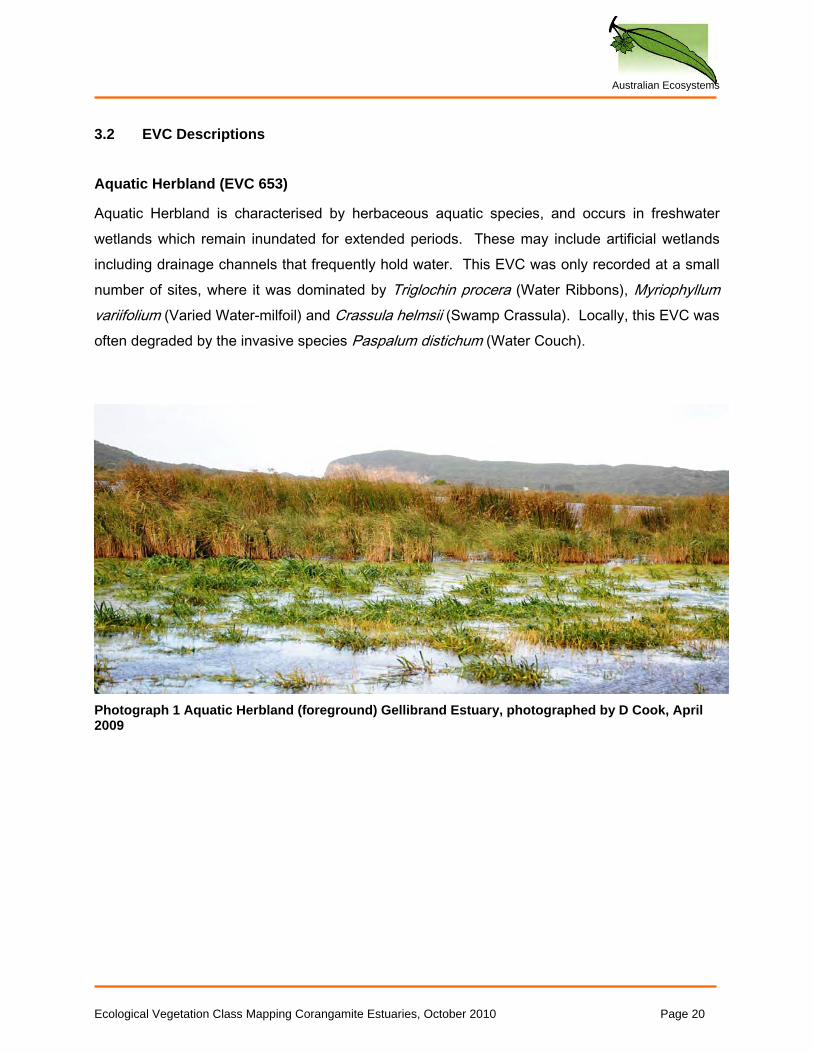
3.2 EVC Descriptions Aquatic Herbland (EVC 653)
Aquatic Herbland is characterised by herbaceous aquatic species, and occurs in freshwater wetlands which remain inundated for extended periods. These may include artificial wetlands including drainage channels that frequently hold water. This EVC was only recorded at a small number of sites, where it was dominated by Triglochin procera (Water Ribbons), Myriophyllum variifolium (Varied Water-milfoil) and Crassula helmsii (Swamp Crassula). Locally, this EVC was often degraded by the invasive species Paspalum distichum (Water Couch).
Photograph 1 Aquatic Herbland (foreground) Gellibrand Estuary, photographed by D Cook, April 2009
Ecological Vegetation Class Mapping Corangamite Estuaries, October 2010 Page 20
Australian Ecosystems
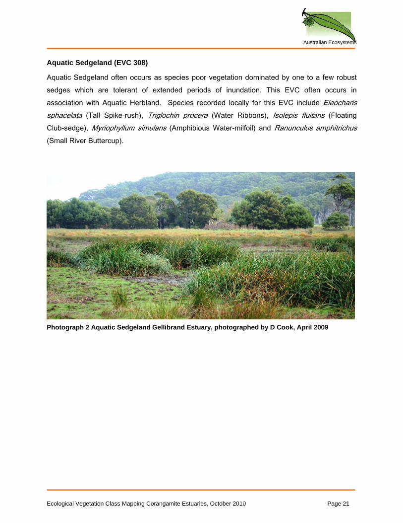
Aquatic Sedgeland (EVC 308)
Aquatic Sedgeland often occurs as species poor vegetation dominated by one to a few robust sedges which are tolerant of extended periods of inundation. This EVC often occurs in association with Aquatic Herbland. Species recorded locally for this EVC include Eleocharis sphacelata (Tall Spike-rush), Triglochin procera (Water Ribbons), Isolepis fluitans (Floating Club-sedge), Myriophyllum simulans (Amphibious Water-milfoil) and Ranunculus amphitrichus (Small River Buttercup).
Photograph 2 Aquatic Sedgeland Gellibrand Estuary, photographed by D Cook, April 2009
Ecological Vegetation Class Mapping Corangamite Estuaries, October 2010 Page 21
Australian Ecosystems
Berm Grassy Shrubland (EVC 311)
Berm Grassy Shrubland grows on low (usually <1m) sand or shell deposits (Oates and Taranto, 2001). These areas are exposed to salt through wind and spray, and occasionally water-logging by high tides, but are never fully inundated by the tide. Locally, the vegetation supports a prominent upper layer of Atriplex cinerea (Coast Saltbush) and Austrostipa stipoides (Coast Spear-grass). Beneath these species, a range of smaller grasses, herbs and sub-shrubs occur, that are a mix of halophytic (salt-tolerant) and glycophytic (non-salt-tolerant) species. This EVC is ecologically closely related to Coastal Dune Grassland, but the latter does not support a shrubby layer. Berm Grassy Shrubland was only mapped in one very small patch near the mouth of the Thompson Creek. No photograph is available for this EVC.
Ecological Vegetation Class Mapping Corangamite Estuaries, October 2010 Page 22
Australian Ecosystems
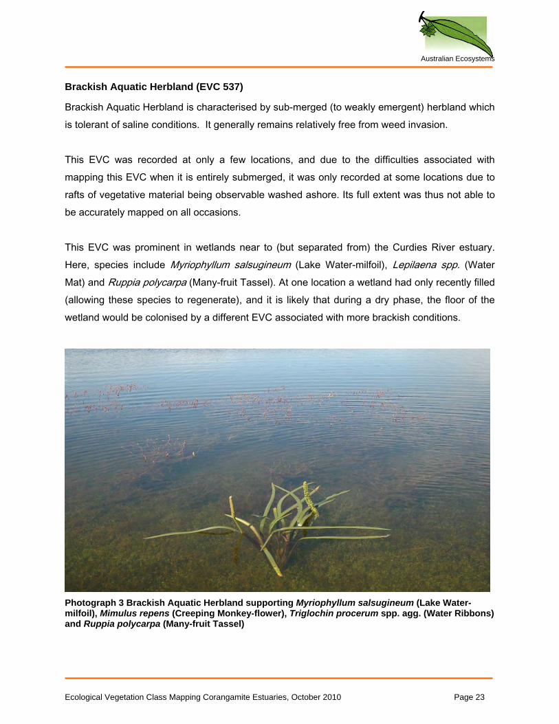
Brackish Aquatic Herbland (EVC 537)
Brackish Aquatic Herbland is characterised by sub-merged (to weakly emergent) herbland which is tolerant of saline conditions. It generally remains relatively free from weed invasion. This EVC was recorded at only a few locations, and due to the difficulties associated with mapping this EVC when it is entirely submerged, it was only recorded at some locations due to rafts of vegetative material being observable washed ashore. Its full extent was thus not able to be accurately mapped on all occasions. This EVC was prominent in wetlands near to (but separated from) the Curdies River estuary. Here, species include Myriophyllum salsugineum (Lake Water-milfoil), Lepilaena spp. (Water Mat) and Ruppia polycarpa (Many-fruit Tassel). At one location a wetland had only recently filled (allowing these species to regenerate), and it is likely that during a dry phase, the floor of the wetland would be colonised by a different EVC associated with more brackish conditions.
Photograph 3 Brackish Aquatic Herbland supporting Myriophyllum salsugineum (Lake Water-milfoil), Mimulus repens (Creeping Monkey-flower), Triglochin procerum spp. agg. (Water Ribbons) and Ruppia polycarpa (Many-fruit Tassel)
Ecological Vegetation Class Mapping Corangamite Estuaries, October 2010 Page 23
Australian Ecosystems
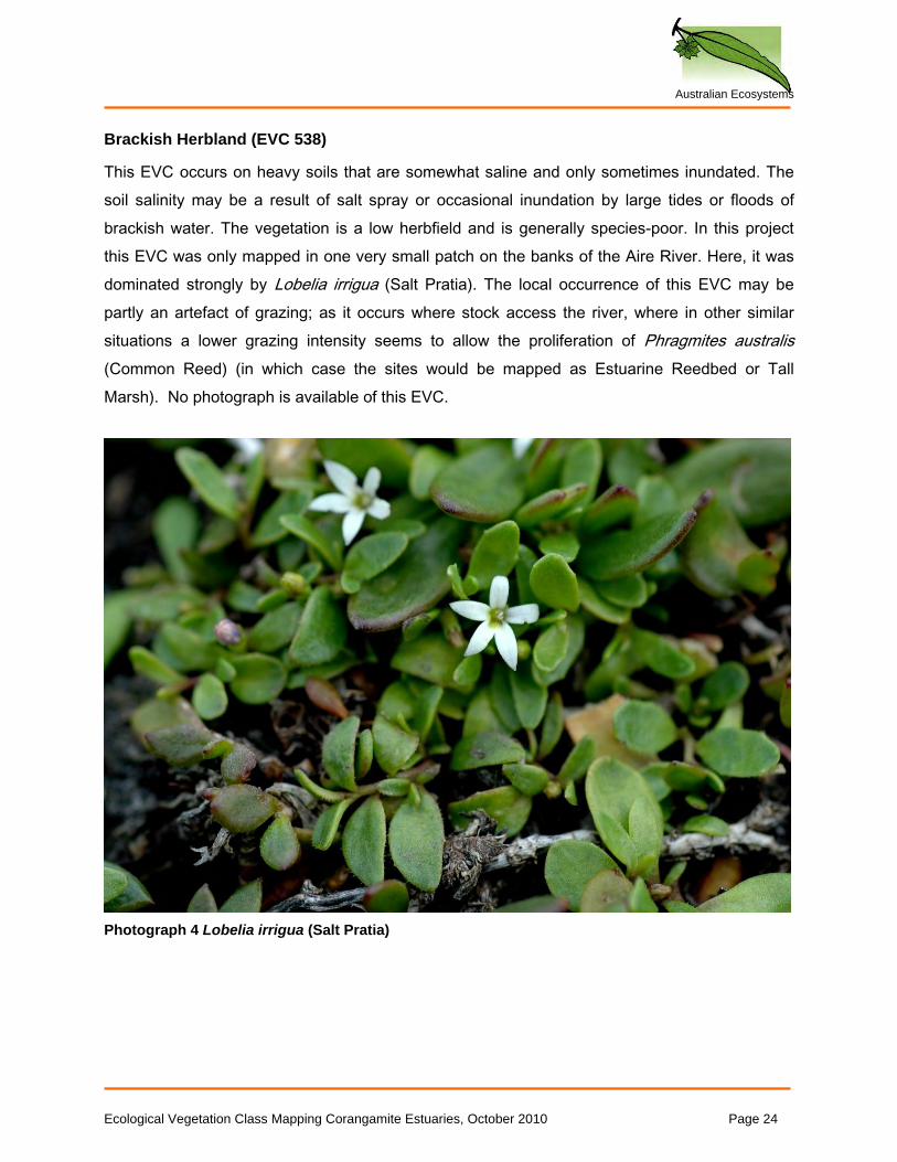
Brackish Herbland (EVC 538)
This EVC occurs on heavy soils that are somewhat saline and only sometimes inundated. The soil salinity may be a result of salt spray or occasional inundation by large tides or floods of brackish water. The vegetation is a low herbfield and is generally species-poor. In this project this EVC was only mapped in one very small patch on the banks of the Aire River. Here, it was dominated strongly by Lobelia irrigua (Salt Pratia). The local occurrence of this EVC may be partly an artefact of grazing; as it occurs where stock access the river, where in other similar situations a lower grazing intensity seems to allow the proliferation of Phragmites australis (Common Reed) (in which case the sites would be mapped as Estuarine Reedbed or Tall Marsh). No photograph is available of this EVC.
Photograph 4 Lobelia irrigua (Salt Pratia)
Ecological Vegetation Class Mapping Corangamite Estuaries, October 2010 Page 24
Australian Ecosystems
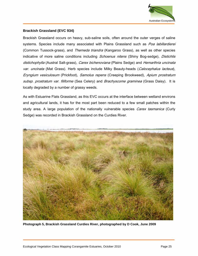
Brackish Grassland (EVC 934)
Brackish Grassland occurs on heavy, sub-saline soils, often around the outer verges of saline systems. Species include many associated with Plains Grassland such as Poa labillardierei (Common Tussock-grass), and Themeda triandra (Kangaroo Grass), as well as other species indicative of more saline conditions including Schoenus nitens (Shiny Bog-sedge), Distichlis distichophylla (Austral Salt-grass), Carex bichenoviana (Plains Sedge) and Hemarthria uncinata var. uncinata (Mat Grass). Herb species include Milky Beauty-heads (Calocephalus lacteus), Eryngium vesiculosum (Prickfoot), Samolus repens (Creeping Brookweed), Apium prostratum subsp. prostratum var. filiforme (Sea Celery) and Brachyscome graminea (Grass Daisy). It is locally degraded by a number of grassy weeds.
As with Estuarine Flats Grassland, as this EVC occurs at the interface between wetland environs and agricultural lands, it has for the most part been reduced to a few small patches within the study area. A large population of the nationally vulnerable species Carex tasmanica (Curly Sedge) was recorded in Brackish Grassland on the Curdies River.
Photograph 5, Brackish Grassland Curdies River, photographed by D Cook, June 2009
Ecological Vegetation Class Mapping Corangamite Estuaries, October 2010 Page 25
Australian Ecosystems
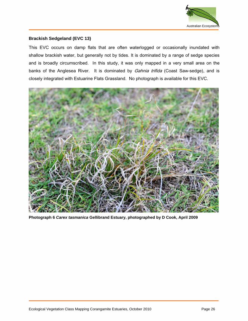
Brackish Sedgeland (EVC 13)
This EVC occurs on damp flats that are often waterlogged or occasionally inundated with shallow brackish water, but generally not by tides. It is dominated by a range of sedge species and is broadly circumscribed. In this study, it was only mapped in a very small area on the banks of the Anglesea River. It is dominated by Gahnia trifida (Coast Saw-sedge), and is closely integrated with Estuarine Flats Grassland. No photograph is available for this EVC.
Photograph 6 Carex tasmanica Gellibrand Estuary, photographed by D Cook, April 2009
Ecological Vegetation Class Mapping Corangamite Estuaries, October 2010 Page 26
Australian Ecosystems
Brackish Wetland (Aggregate) (EVC 656)
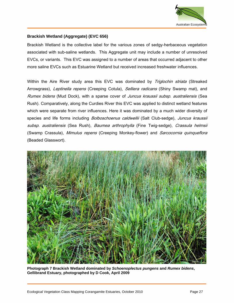
Brackish Wetland is the collective label for the various zones of sedgy-herbaceous vegetation associated with sub-saline wetlands. This Aggregate unit may include a number of unresolved EVCs, or variants. This EVC was assigned to a number of areas that occurred adjacent to other more saline EVCs such as Estuarine Wetland but received increased freshwater influences. Within the Aire River study area this EVC was dominated by Triglochin striata (Streaked Arrowgrass), Leptinella repens (Creeping Cotula), Selliera radicans (Shiny Swamp mat), and Rumex bidens (Mud Dock), with a sparse cover of Juncus kraussii subsp. australiensis (Sea Rush). Comparatively, along the Curdies River this EVC was applied to distinct wetland features which were separate from river influences. Here it was dominated by a much wider diversity of species and life forms including Bolboschoenus caldwellii (Salt Club-sedge), Juncus kraussii subsp. australiensis (Sea Rush), Baumea arthrophylla (Fine Twig-sedge), Crassula helmsii (Swamp Crassula), Mimulus repens (Creeping Monkey-flower) and Sarcocornia quinqueflora (Beaded Glasswort).
Photograph 7 Brackish Wetland dominated by Schoenoplectus pungens and Rumex bidens, Gellibrand Estuary, photographed by D Cook, April 2009
Ecological Vegetation Class Mapping Corangamite Estuaries, October 2010 Page 27
Australian Ecosystems
Coastal Alkaline Scrub (EVC 858)
This EVC occurs in sheltered, near-coastal areas, on soils which contain limestone/calcrete. The overstorey is generally dominated by Melaleuca lanceolata (Moonah), while the mid-storey contains numerous shrub, herb and sedge species, including Pimelea serpyllifolia subsp. serpyllifolia (Thyme Rice-flower). This EVC is closely related to some variants of Estuarine Scrub, which may also be dominated by Moonah. In some areas (notably Anglesea and Spring Creek) these two EVCs occur together, and can be difficult to distinguish. This EVC was mapped at the Curides, Anglesea, Painkalac, Spring and Thompson estuaries. As noted above, it may have been much more extensive in some areas. Once the shrub layer is removed, this EVC can resemble several others. This EVC supported stands of Acacia retinodes var. uncifolia (Coast Wirilda), which is listed as rare in Victoria. It is impacted by weed invasion, including by *Lycium ferocissimum (African Boxthorn) and *Polygala myrtifolia (Parrot Bush). No photograph is available for this EVC. Coastal Dune Grassland (EVC 879)
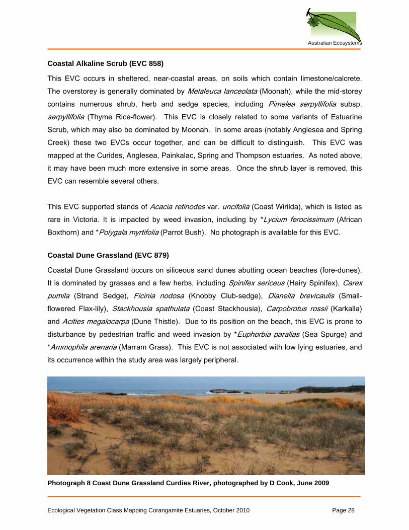
Coastal Dune Grassland occurs on siliceous sand dunes abutting ocean beaches (fore-dunes). It is dominated by grasses and a few herbs, including Spinifex sericeus (Hairy Spinifex), Carex pumila (Strand Sedge), Ficinia nodosa (Knobby Club-sedge), Dianella brevicaulis (Small-flowered Flax-lily), Stackhousia spathulata (Coast Stackhousia), Carpobrotus rossii (Karkalla) and Acities megalocarpa (Dune Thistle). Due to its position on the beach, this EVC is prone to disturbance by pedestrian traffic and weed invasion by *Euphorbia paralias (Sea Spurge) and *Ammophila arenaria (Marram Grass). This EVC is not associated with low lying estuaries, and its occurrence within the study area was largely peripheral.
Photograph 8 Coast Dune Grassland Curdies River, photographed by D Cook, June 2009
Ecological Vegetation Class Mapping Corangamite Estuaries, October 2010 Page 28
Australian Ecosystems
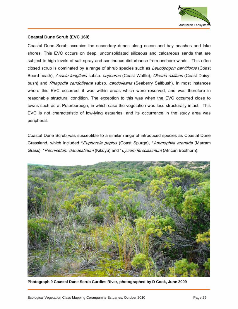
Coastal Dune Scrub (EVC 160)
Coastal Dune Scrub occupies the secondary dunes along ocean and bay beaches and lake shores. This EVC occurs on deep, unconsolidated siliceous and calcareous sands that are subject to high levels of salt spray and continuous disturbance from onshore winds. This often closed scrub is dominated by a range of shrub species such as Leucopogon parviflorus (Coast Beard-heath), Acacia longifolia subsp. sophorae (Coast Wattle), Olearia axillaris (Coast Daisy-bush) and Rhagodia candolleana subsp. candolleana (Seaberry Saltbush). In most instances where this EVC occurred, it was within areas which were reserved, and was therefore in reasonable structural condition. The exception to this was when the EVC occurred close to towns such as at Peterborough, in which case the vegetation was less structurally intact. This EVC is not characteristic of low-lying estuaries, and its occurrence in the study area was peripheral. Coastal Dune Scrub was susceptible to a similar range of introduced species as Coastal Dune Grassland, which included *Euphorbia peplus (Coast Spurge), *Ammophila arenaria (Marram Grass), *Pennisetum clandestinum (Kikuyu) and *Lycium ferocissimum (African Boxthorn).
Photograph 9 Coastal Dune Scrub Curdies River, photographed by D Cook, June 2009
Ecological Vegetation Class Mapping Corangamite Estuaries, October 2010 Page 29
Australian Ecosystems
Coastal Headland Scrub (EVC 161)
Coastal Headland Scrub describes low, shrubby vegetation that is pruned by frequent, strong, salt-laden winds. It usually occurs on exposed cliffs and rocky coastal headlands, and as such, its occurrence in the study area was peripheral. It is locally dominated by Leptospermum continentale (Prickly Tea-tree). No photograph is available for this EVC.
Coastal Saltmarsh (Aggregate) (EVC 9)
As described in the methods section, this unit was avoided in favour of the new, provisional saltmarsh typology described by the Victorian Saltmarsh Study (2010). It was, however, used in the pre-1750 mapping, where the exact pre-settlement arrangement of saltmarsh types could not be ascertained confidently, given the degree of hydrological change that has occurred in some marshes. The units that make up this aggregate unit are described separately.
Ecological Vegetation Class Mapping Corangamite Estuaries, October 2010 Page 30
Australian Ecosystems
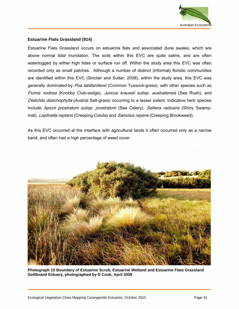
Estuarine Flats Grassland (914)
Estuarine Flats Grassland occurs on estuarine flats and associated dune swales, which are above normal tidal inundation. The soils within this EVC are quite saline, and are often waterlogged by either high tides or surface run off. Within the study area this EVC was often recorded only as small patches. Although a number of distinct (informal) floristic communities are identified within this EVC (Sinclair and Sutter, 2008), within the study area, this EVC was generally dominated by Poa labillardierei (Common Tussock-grass), with other species such as Ficinia nodosa (Knobby Club-sedge), Juncus kraussii subsp. australiensis (Sea Rush), and Distichlis distichophylla (Austral Salt-grass) occurring to a lesser extent. Indicative herb species include Apium prostratum subsp. prostratum (Sea Celery), Selliera radicans (Shiny Swamp-mat), Leptinella reptans (Creeping Cotula) and Samolus repens (Creeping Brookweed). As this EVC occurred at the interface with agricultural lands it often occurred only as a narrow band, and often had a high percentage of weed cover.
Photograph 10 Boundary of Estuarine Scrub, Estuarine Wetland and Estuarine Flats Grassland Gellibrand Estuary, photographed by D Cook, April 2009
Ecological Vegetation Class Mapping Corangamite Estuaries, October 2010 Page 31
Australian Ecosystems
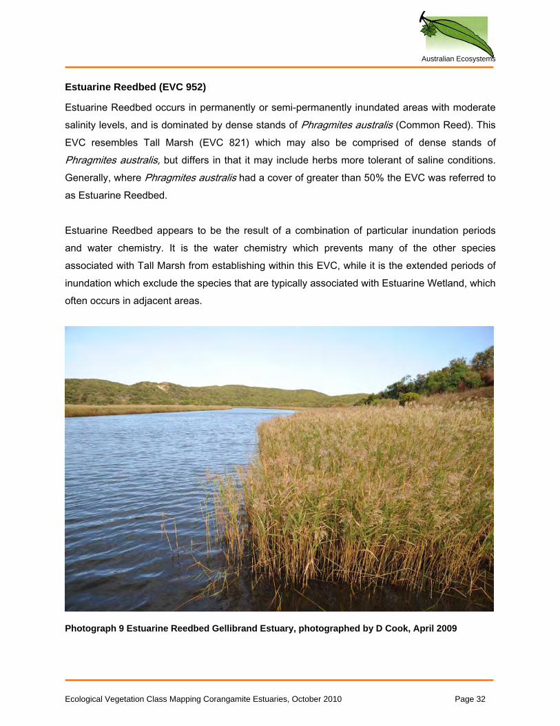
Estuarine Reedbed (EVC 952)
Estuarine Reedbed occurs in permanently or semi-permanently inundated areas with moderate salinity levels, and is dominated by dense stands of Phragmites australis (Common Reed). This EVC resembles Tall Marsh (EVC 821) which may also be comprised of dense stands of Phragmites australis, but differs in that it may include herbs more tolerant of saline conditions. Generally, where Phragmites australis had a cover of greater than 50% the EVC was referred to as Estuarine Reedbed. Estuarine Reedbed appears to be the result of a combination of particular inundation periods and water chemistry. It is the water chemistry which prevents many of the other species associated with Tall Marsh from establishing within this EVC, while it is the extended periods of inundation which exclude the species that are typically associated with Estuarine Wetland, which often occurs in adjacent areas.
Photograph 9 Estuarine Reedbed Gellibrand Estuary, photographed by D Cook, April 2009
Ecological Vegetation Class Mapping Corangamite Estuaries, October 2010 Page 32
Australian Ecosystems
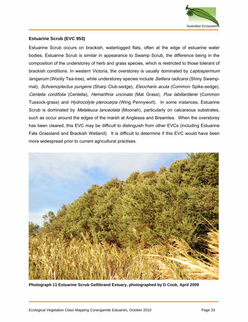
Estuarine Scrub (EVC 953)
Estuarine Scrub occurs on brackish, waterlogged flats, often at the edge of estuarine water bodies. Estuarine Scrub is similar in appearance to Swamp Scrub, the difference being in the composition of the understorey of herb and grass species, which is restricted to those tolerant of brackish conditions. In western Victoria, the overstorey is usually dominated by Leptospermum lanigerum (Woolly Tea-tree), while understorey species include Selliera radicans (Shiny Swamp-mat), Schoenoplectus pungens (Sharp Club-sedge), Eleocharis acuta (Common Spike-sedge), Centella cordifolia (Centella), Hemarthria uncinata (Mat Grass), Poa labillardierei (Common Tussock-grass) and Hydrocotyle pterocarpa (Wing Pennywort). In some instances, Estuarine Scrub is dominated by Melaleuca lanceolata (Moonah), particularly on calcareous substrates, such as occur around the edges of the marsh at Anglesea and Breamlea. When the overstorey has been cleared, this EVC may be difficult to distinguish from other EVCs (including Estuarine Fats Grassland and Brackish Wetland). It is difficult to determine if this EVC would have been more widespread prior to current agricultural practises.
Photograph 11 Estuarine Scrub Gellibrand Estuary, photographed by D Cook, April 2009
Ecological Vegetation Class Mapping Corangamite Estuaries, October 2010 Page 33
Australian Ecosystems
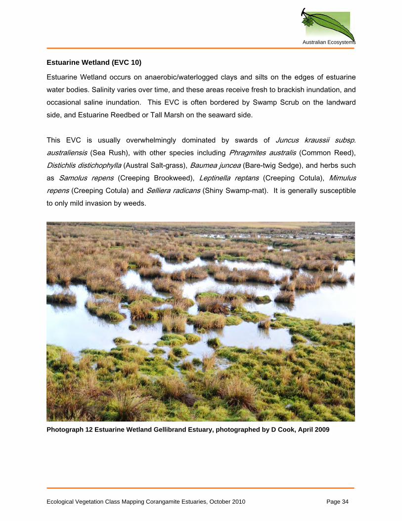
Estuarine Wetland (EVC 10)
Estuarine Wetland occurs on anaerobic/waterlogged clays and silts on the edges of estuarine water bodies. Salinity varies over time, and these areas receive fresh to brackish inundation, and occasional saline inundation. This EVC is often bordered by Swamp Scrub on the landward side, and Estuarine Reedbed or Tall Marsh on the seaward side. This EVC is usually overwhelmingly dominated by swards of Juncus kraussii subsp. australiensis (Sea Rush), with other species including Phragmites australis (Common Reed), Distichlis distichophylla (Austral Salt-grass), Baumea juncea (Bare-twig Sedge), and herbs such as Samolus repens (Creeping Brookweed), Leptinella reptans (Creeping Cotula), Mimulus repens (Creeping Cotula) and Selliera radicans (Shiny Swamp-mat). It is generally susceptible to only mild invasion by weeds.
Photograph 12 Estuarine Wetland Gellibrand Estuary, photographed by D Cook, April 2009
Ecological Vegetation Class Mapping Corangamite Estuaries, October 2010 Page 34
Australian Ecosystems
Photograph 13 Estuarine Wetland Curdies River, photographed by D Cook, June 2009
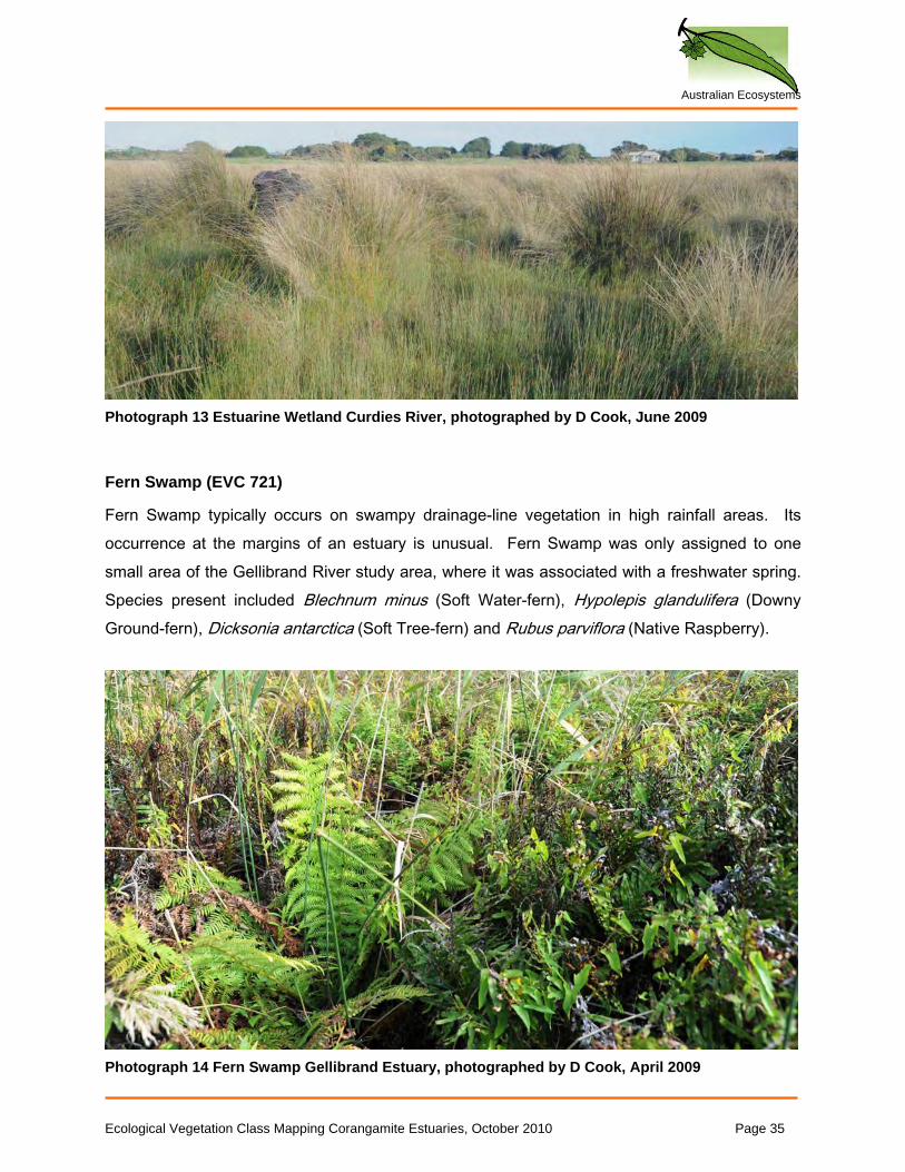
Fern Swamp (EVC 721)
Fern Swamp typically occurs on swampy drainage-line vegetation in high rainfall areas. Its occurrence at the margins of an estuary is unusual. Fern Swamp was only assigned to one small area of the Gellibrand River study area, where it was associated with a freshwater spring. Species present included Blechnum minus (Soft Water-fern), Hypolepis glandulifera (Downy Ground-fern), Dicksonia antarctica (Soft Tree-fern) and Rubus parviflora (Native Raspberry).
Photograph 14 Fern Swamp Gellibrand Estuary, photographed by D Cook, April 2009
Ecological Vegetation Class Mapping Corangamite Estuaries, October 2010 Page 35
Australian Ecosystems
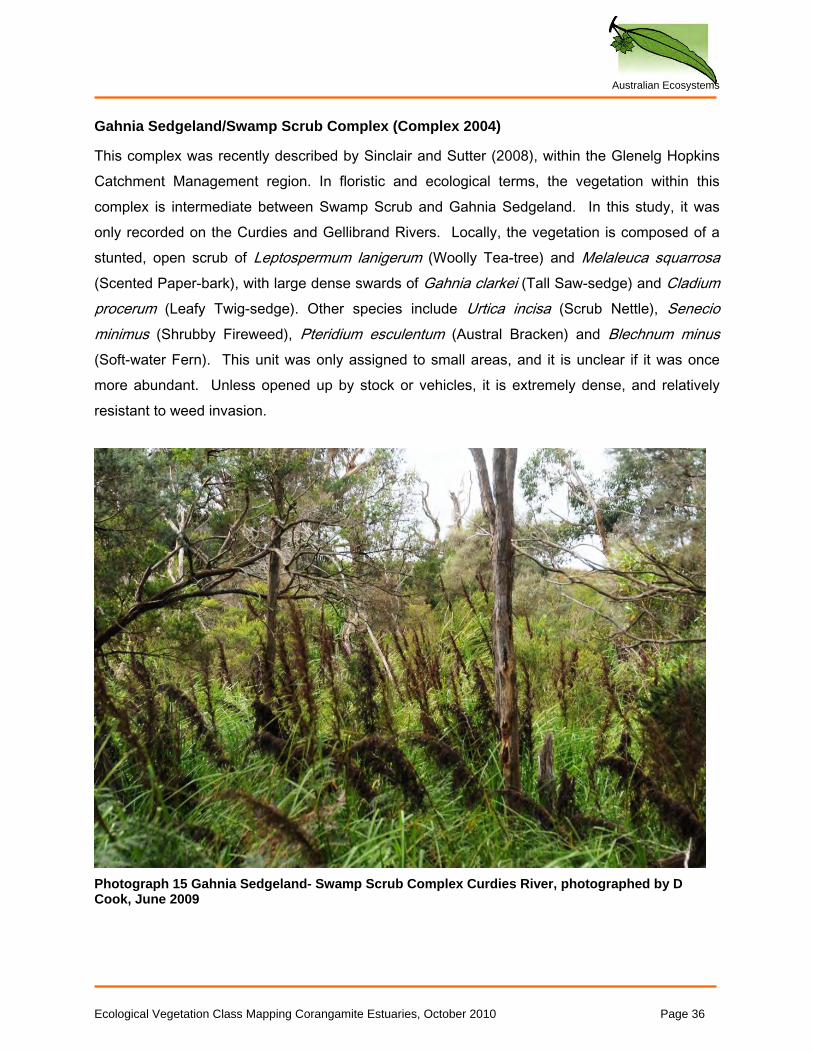
Gahnia Sedgeland/Swamp Scrub Complex (Complex 2004)
This complex was recently described by Sinclair and Sutter (2008), within the Glenelg Hopkins Catchment Management region. In floristic and ecological terms, the vegetation within this complex is intermediate between Swamp Scrub and Gahnia Sedgeland. In this study, it was only recorded on the Curdies and Gellibrand Rivers. Locally, the vegetation is composed of a stunted, open scrub of Leptospermum lanigerum (Woolly Tea-tree) and Melaleuca squarrosa (Scented Paper-bark), with large dense swards of Gahnia clarkei (Tall Saw-sedge) and Cladium procerum (Leafy Twig-sedge). Other species include Urtica incisa (Scrub Nettle), Senecio minimus (Shrubby Fireweed), Pteridium esculentum (Austral Bracken) and Blechnum minus (Soft-water Fern). This unit was only assigned to small areas, and it is unclear if it was once more abundant. Unless opened up by stock or vehicles, it is extremely dense, and relatively resistant to weed invasion.
Photograph 15 Gahnia Sedgeland- Swamp Scrub Complex Curdies River, photographed by D Cook, June 2009
Ecological Vegetation Class Mapping Corangamite Estuaries, October 2010 Page 36
Australian Ecosystems
Grassy Woodland (EVC 175)
Grassy Woodland occurs on moderately fertile sites on undulating terrain throughout southern Victoria. It is a widely circumscribed EVC, but locally it was used to describe only one very small area of highly modified native vegetation in the Painkalac Creek area. It occurs on the edge of the floodplain and the low levee (an unusual position for this EVC). Interpreting the original structure and assigning an EVC to this area was difficult, and the assignment of this EVC is tentative. Observations suggest that this area once supported a woodland of Eucalyptus ovata (Swamp Gum) and Acacia melanoxylon (Blackwood) with an understorey of shrubs including Bursaria spinosa (Sweet Bursaria) and Leptospermum continentale (Prickly Tea-tree), along with Pteridium esculentum (Austral Bracken) and numerous grasses including Poa labillardierei (Common Tussock-grass), Themeda triandra (Kangaroo grass), and several Wallaby-grasses (Austrodanthonia spp.). No photograph is available for this EVC.
Heathy Woodland (EVC 48)
Heathy Woodland occurs on infertile sands. A range of stringy-barked Eucalypts dominate the overstorey, locally including Eucalyptus baxteri (Brown Stringybark) and Eucalyptus obliqua (Messmate Stringybark). The lower storey is extremely diverse, supporting a range of small hard-leaved shrubs (notably peas), Grass-trees and sedges. Grasses are sparse due to the infertility of the soils. This EVC is common throughout southern Victoria. It is not generally associated with estuaries, and its occurrence in the study area is peripheral, being only recorded around the Anglesea estuary. No photograph is available for this EVC.
Ecological Vegetation Class Mapping Corangamite Estuaries, October 2010 Page 37
Australian Ecosystems
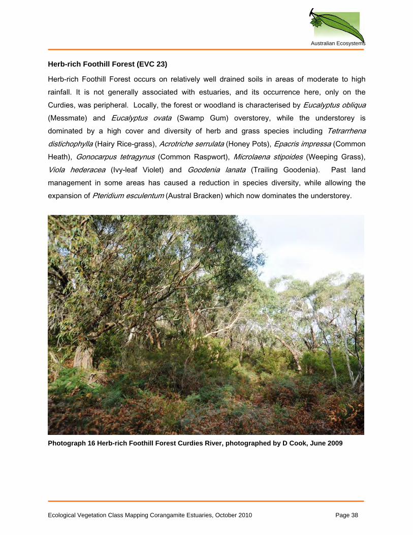
Herb-rich Foothill Forest (EVC 23)
Herb-rich Foothill Forest occurs on relatively well drained soils in areas of moderate to high rainfall. It is not generally associated with estuaries, and its occurrence here, only on the Curdies, was peripheral. Locally, the forest or woodland is characterised by Eucalyptus obliqua (Messmate) and Eucalyptus ovata (Swamp Gum) overstorey, while the understorey is dominated by a high cover and diversity of herb and grass species including Tetrarrhena distichophylla (Hairy Rice-grass), Acrotriche serrulata (Honey Pots), Epacris impressa (Common Heath), Gonocarpus tetragynus (Common Raspwort), Microlaena stipoides (Weeping Grass), Viola hederacea (Ivy-leaf Violet) and Goodenia lanata (Trailing Goodenia). Past land management in some areas has caused a reduction in species diversity, while allowing the expansion of Pteridium esculentum (Austral Bracken) which now dominates the understorey.
Photograph 16 Herb-rich Foothill Forest Curdies River, photographed by D Cook, June 2009
Ecological Vegetation Class Mapping Corangamite Estuaries, October 2010 Page 38
Australian Ecosystems
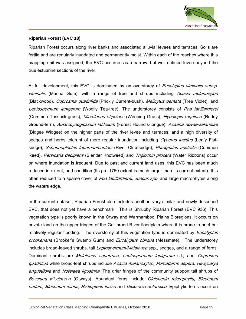
Riparian Forest (EVC 18)
Riparian Forest occurs along river banks and associated alluvial levees and terraces. Soils are fertile and are regularly inundated and permanently moist. Within each of the reaches where this mapping unit was assigned, the EVC occurred as a narrow, but well defined levee beyond the true estuarine sections of the river. At full development, this EVC is dominated by an overstorey of Eucalyptus viminalis subsp. viminalis (Manna Gum), with a range of tree and shrubs including Acacia melanoxylon (Blackwood), Coprosma quadrifida (Prickly Current-bush), Melicytus dentata (Tree Violet), and Leptospermum lanigerum (Woolly Tea-tree). The understorey consists of Poa labillardierei (Common Tussock-grass), Microlaena stipoides (Weeping Grass), Hypolepis rugulosa (Ruddy Ground-fern), Austrocynoglossum latifolium (Forest Hound’s-tongue), Acaena novae-zelandiae (Bidgee Widgee) on the higher parts of the river levee and terraces, and a high diversity of sedges and herbs tolerant of more regular inundation including Cyperus lucidus (Leafy Flat-sedge), Schoenoplectus tabernaemontani (River Club-sedge), Phragmites australis (Common Reed), Persicaria decipiens (Slender Knotweed) and Triglochin procera (Water Ribbons) occur on where inundation is frequent. Due to past and current land uses, this EVC has been much reduced in extent, and condition (Its pre-1750 extent is much larger than its current extent). It is often reduced to a sparse cover of Poa labillardierei, Juncus spp. and large macrophytes along the waters edge. In the current dataset, Riparian Forest also includes another, very similar and newly-described EVC, that does not yet have a benchmark. This is Shrubby Riparian Forest (EVC 936). This vegetation type is poorly known in the Otway and Warrnambool Plains Bioregions. It occurs on private land on the upper fringes of the Gellibrand River floodplain where it is prone to brief but relatively regular flooding. The overstorey of this vegetation type is dominated by Eucalyptus brookeriana (Brooker’s Swamp Gum) and Eucalyptus obliqua (Messmate). The understorey includes broad-leaved shrubs, tall Leptospermum/Melaleuca spp., sedges, and a range of ferns. Dominant shrubs are Melaleuca squarrosa, Leptospermum lanigerum s.l., and Coprosma quadrifida while broad-leaf shrubs include Acacia melanoxylon, Pomaderris aspera, Hedycarya angustifolia and Notelaea ligustrina. The drier fringes of the community support tall shrubs of Bossiaea aff.cinerea (Otways). Abundant ferns include Gleichenia microphylla, Blechnum nudum, Blechnum minus, Histiopteris incisa and Dicksonia antarctica. Epiphytic ferns occur on
Ecological Vegetation Class Mapping Corangamite Estuaries, October 2010 Page 39
Australian Ecosystems
large, old specimens of Acacia melanoxylon, including Asplenium flaccidum and Microsorum diversifolia. Scramblers and ground cover herbs, grasses and sedges include Rubus parviflorus, Tetrarrhena juncea, Gahnia clarkei, Lepidosperma laterale var. majus, Triglochin striatum, Gratiola peruviana, Cyperus lucidus, Carex appressa, Schoenus maschalinus, Hydrocotyle pterocarpa, Stellaria flaccida, Isolepis inundatus, Juncus caespiticius, Viola hederacea and Persicaria strigosa. This vegetation is potentially vulnerable to invasion by creeping/scrambling plants where disturbed but remnants are relatively intact in comparison to many examples of Riparian Forest. Interestingly, there appeared to be intense discussion amongst many of the long term locals with regards to whether trees once occurred along the river levees; this being particularly the case at Gellibrand River. There is some evidence to suggest that Eucalypts did occur, even if only at low densities. Firstly, a large Eucalyptus viminalis subsp. viminalis still exists on the levee, and secondly, an old photograph of the area clearly shows a number of Eucalypts along the river levee. It is likely that this levee was cleared very early on, to allow a horse drawn barge to access the dairy at ‘three bridges’.
Photograph 17 Shrubby Riparian Forest Gellibrand Estuary, photographed by D Cook, April 2009
Ecological Vegetation Class Mapping Corangamite Estuaries, October 2010 Page 40
Australian Ecosystems
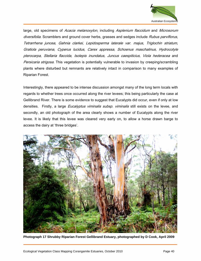
Saline Aquatic Meadow (EVC 842)
Saline Aquatic meadow occurs in shallow, saline pools, associated with the lagoons behind closed river mouths as well as depressions and ‘brine pools’ within Coastal Saltmarsh (EVC 9). These pools may be subject to high levels of evaporation, becoming hyper-saline at times. If the pools become totally dry the exposed vegetation may form a dense, felted mat of bleached plant material. This EVC is generally dominated by Lepilaena preissii (Slender Water-mat) Ruppia maritima (Water Tassel) and charophyte algae. No weeds are known to invade this EVC.
Photograph 17 Saline Aquatic Meadow, Painkalac Creek, photographed by S Sinclair, 2005
Seasonally Inundated Sub-saline Herbland
This unit describes highly unusual vegetation, which occurs only in a few places (Lake Connewarre, Lake Reeve (Gippsland), and in a few other isolated patches (Saltmarsh Study Group, 2010). It is a procumbent shrubland dominated by Wilsonia species, locally Wilsonia backhousei (Narrow-leaf Wilsonia). Closely related to Coastal Saltmarsh and Saline Aquatic Meadow (dry phase), it occurs on hypersaline flats that are often dry, but seasonally inundated by water. In the study area, one very small patch was mapped on the Thompson. No photograph is available for this EVC. Shrubby Dry Forest (EVC 21)
This EVC describes tall woodland or open forest dominated by Eucalyptus tricarpa (Red Ironbark). Its occurrence near the coast is unusual, and the banks of the Painkalac Creek are probably the only place in Victoria where it occurs in association with an estuary. Here, the understorey is dominated by shrubs and grasses, some of which show coastal affinities (such as Rhagodia candolleana (Seaberry Saltbush)). It is susceptible to weed invasion, including by *Chrysanthemoides monilifera subsp. monilifera (Boneseed), although the efforts of local volunteers have kept weed invasion to a minimum. No photograph is available for this EVC.
Ecological Vegetation Class Mapping Corangamite Estuaries, October 2010 Page 41
Australian Ecosystems
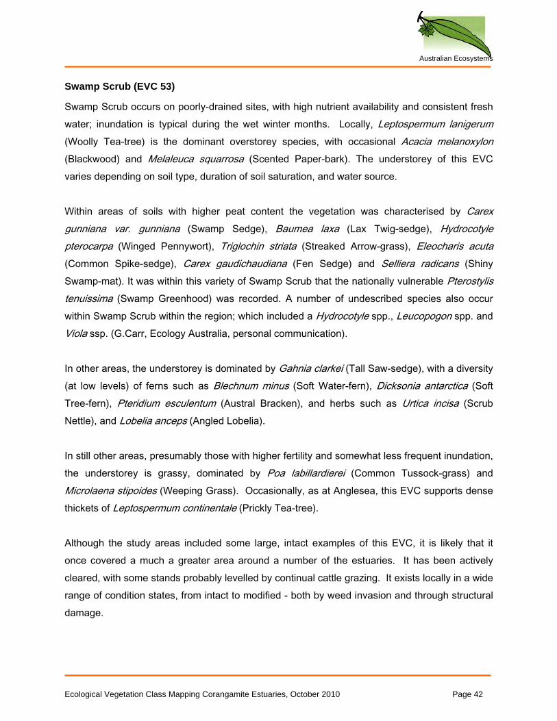
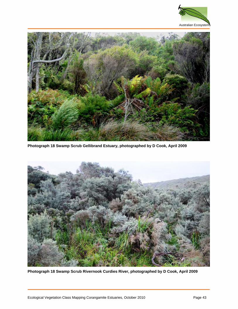
Swamp Scrub (EVC 53)
Swamp Scrub occurs on poorly-drained sites, with high nutrient availability and consistent fresh water; inundation is typical during the wet winter months. Locally, Leptospermum lanigerum (Woolly Tea-tree) is the dominant overstorey species, with occasional Acacia melanoxylon (Blackwood) and Melaleuca squarrosa (Scented Paper-bark). The understorey of this EVC varies depending on soil type, duration of soil saturation, and water source. Within areas of soils with higher peat content the vegetation was characterised by Carex gunniana var. gunniana (Swamp Sedge), Baumea laxa (Lax Twig-sedge), Hydrocotyle pterocarpa (Winged Pennywort), Triglochin striata (Streaked Arrow-grass), Eleocharis acuta (Common Spike-sedge), Carex gaudichaudiana (Fen Sedge) and Selliera radicans (Shiny Swamp-mat). It was within this variety of Swamp Scrub that the nationally vulnerable Pterostylis tenuissima (Swamp Greenhood) was recorded. A number of undescribed species also occur within Swamp Scrub within the region; which included a Hydrocotyle spp., Leucopogon spp. and Viola ssp. (G.Carr, Ecology Australia, personal communication). In other areas, the understorey is dominated by Gahnia clarkei (Tall Saw-sedge), with a diversity (at low levels) of ferns such as Blechnum minus (Soft Water-fern), Dicksonia antarctica (Soft Tree-fern), Pteridium esculentum (Austral Bracken), and herbs such as Urtica incisa (Scrub Nettle), and Lobelia anceps (Angled Lobelia). In still other areas, presumably those with higher fertility and somewhat less frequent inundation, the understorey is grassy, dominated by Poa labillardierei (Common Tussock-grass) and Microlaena stipoides (Weeping Grass). Occasionally, as at Anglesea, this EVC supports dense thickets of Leptospermum continentale (Prickly Tea-tree). Although the study areas included some large, intact examples of this EVC, it is likely that it once covered a much a greater area around a number of the estuaries. It has been actively cleared, with some stands probably levelled by continual cattle grazing. It exists locally in a wide range of condition states, from intact to modified - both by weed invasion and through structural damage.
Ecological Vegetation Class Mapping Corangamite Estuaries, October 2010 Page 42
Australian Ecosystems
Photograph 18 Swamp Scrub Gellibrand Estuary, photographed by D Cook, April 2009
Photograph 18 Swamp Scrub Rivernook Curdies River, photographed by D Cook, April 2009
Ecological Vegetation Class Mapping Corangamite Estuaries, October 2010 Page 43
Australian Ecosystems
Swampy Riparian Woodland (EVC 83)
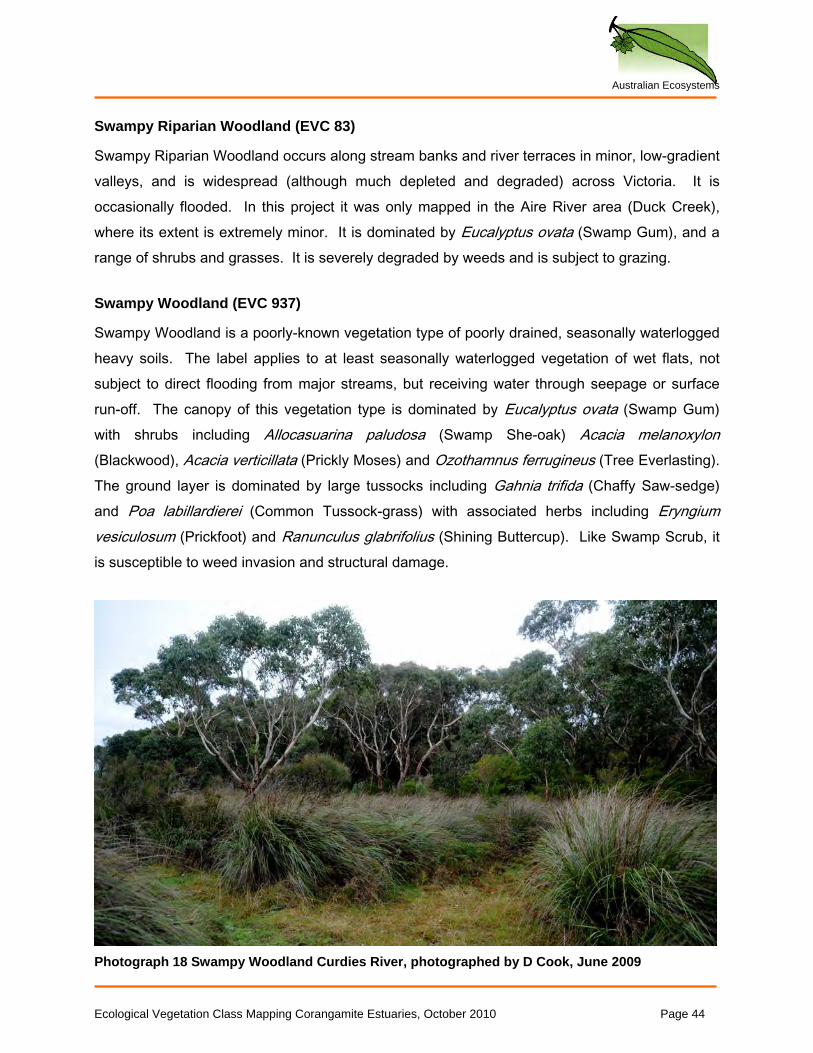
Swampy Riparian Woodland occurs along stream banks and river terraces in minor, low-gradient valleys, and is widespread (although much depleted and degraded) across Victoria. It is occasionally flooded. In this project it was only mapped in the Aire River area (Duck Creek), where its extent is extremely minor. It is dominated by Eucalyptus ovata (Swamp Gum), and a range of shrubs and grasses. It is severely degraded by weeds and is subject to grazing. Swampy Woodland (EVC 937)
Swampy Woodland is a poorly-known vegetation type of poorly drained, seasonally waterlogged heavy soils. The label applies to at least seasonally waterlogged vegetation of wet flats, not subject to direct flooding from major streams, but receiving water through seepage or surface run-off. The canopy of this vegetation type is dominated by Eucalyptus ovata (Swamp Gum) with shrubs including Allocasuarina paludosa (Swamp She-oak) Acacia melanoxylon (Blackwood), Acacia verticillata (Prickly Moses) and Ozothamnus ferrugineus (Tree Everlasting). The ground layer is dominated by large tussocks including Gahnia trifida (Chaffy Saw-sedge) and Poa labillardierei (Common Tussock-grass) with associated herbs including Eryngium vesiculosum (Prickfoot) and Ranunculus glabrifolius (Shining Buttercup). Like Swamp Scrub, it is susceptible to weed invasion and structural damage.
Photograph 18 Swampy Woodland Curdies River, photographed by D Cook, June 2009
Ecological Vegetation Class Mapping Corangamite Estuaries, October 2010 Page 44
Australian Ecosystems
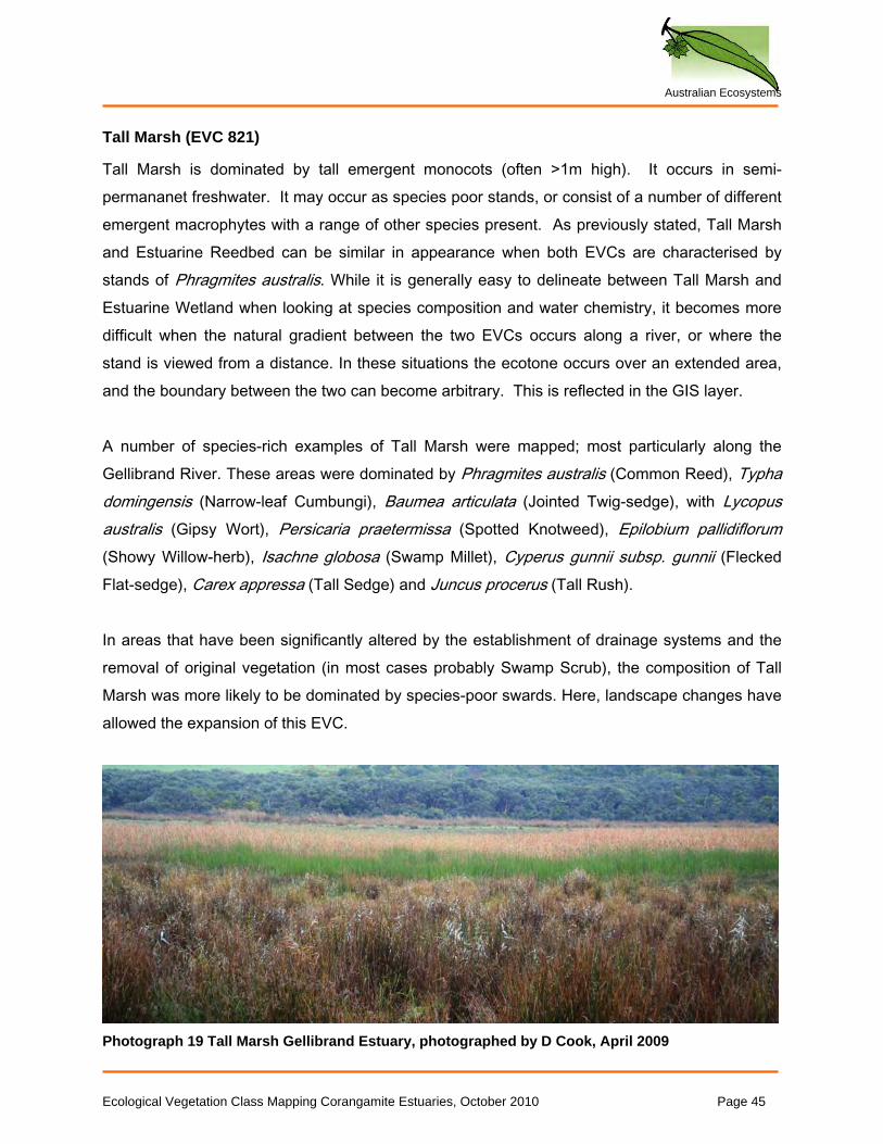
Tall Marsh (EVC 821)
Tall Marsh is dominated by tall emergent monocots (often >1m high). It occurs in semi-permananet freshwater. It may occur as species poor stands, or consist of a number of different emergent macrophytes with a range of other species present. As previously stated, Tall Marsh and Estuarine Reedbed can be similar in appearance when both EVCs are characterised by stands of Phragmites australis. While it is generally easy to delineate between Tall Marsh and Estuarine Wetland when looking at species composition and water chemistry, it becomes more difficult when the natural gradient between the two EVCs occurs along a river, or where the stand is viewed from a distance. In these situations the ecotone occurs over an extended area, and the boundary between the two can become arbitrary. This is reflected in the GIS layer. A number of species-rich examples of Tall Marsh were mapped; most particularly along the Gellibrand River. These areas were dominated by Phragmites australis (Common Reed), Typha domingensis (Narrow-leaf Cumbungi), Baumea articulata (Jointed Twig-sedge), with Lycopus australis (Gipsy Wort), Persicaria praetermissa (Spotted Knotweed), Epilobium pallidiflorum (Showy Willow-herb), Isachne globosa (Swamp Millet), Cyperus gunnii subsp. gunnii (Flecked Flat-sedge), Carex appressa (Tall Sedge) and Juncus procerus (Tall Rush). In areas that have been significantly altered by the establishment of drainage systems and the removal of original vegetation (in most cases probably Swamp Scrub), the composition of Tall Marsh was more likely to be dominated by species-poor swards. Here, landscape changes have allowed the expansion of this EVC.
Photograph 19 Tall Marsh Gellibrand Estuary, photographed by D Cook, April 2009
Ecological Vegetation Class Mapping Corangamite Estuaries, October 2010 Page 45
Australian Ecosystems
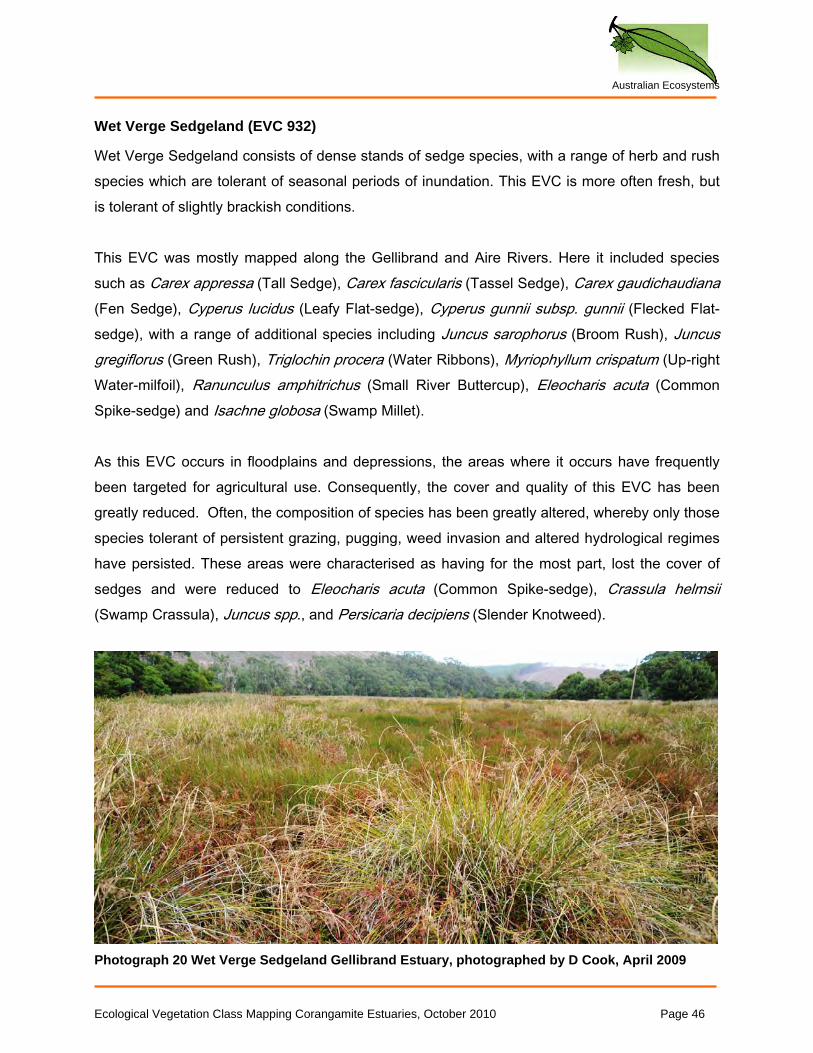
Wet Verge Sedgeland (EVC 932)
Wet Verge Sedgeland consists of dense stands of sedge species, with a range of herb and rush species which are tolerant of seasonal periods of inundation. This EVC is more often fresh, but is tolerant of slightly brackish conditions. This EVC was mostly mapped along the Gellibrand and Aire Rivers. Here it included species such as Carex appressa (Tall Sedge), Carex fascicularis (Tassel Sedge), Carex gaudichaudiana (Fen Sedge), Cyperus lucidus (Leafy Flat-sedge), Cyperus gunnii subsp. gunnii (Flecked Flat-sedge), with a range of additional species including Juncus sarophorus (Broom Rush), Juncus gregiflorus (Green Rush), Triglochin procera (Water Ribbons), Myriophyllum crispatum (Up-right Water-milfoil), Ranunculus amphitrichus (Small River Buttercup), Eleocharis acuta (Common Spike-sedge) and Isachne globosa (Swamp Millet). As this EVC occurs in floodplains and depressions, the areas where it occurs have frequently been targeted for agricultural use. Consequently, the cover and quality of this EVC has been greatly reduced. Often, the composition of species has been greatly altered, whereby only those species tolerant of persistent grazing, pugging, weed invasion and altered hydrological regimes have persisted. These areas were characterised as having for the most part, lost the cover of sedges and were reduced to Eleocharis acuta (Common Spike-sedge), Crassula helmsii (Swamp Crassula), Juncus spp., and Persicaria decipiens (Slender Knotweed).
Photograph 20 Wet Verge Sedgeland Gellibrand Estuary, photographed by D Cook, April 2009
Ecological Vegetation Class Mapping Corangamite Estuaries, October 2010 Page 46
Australian Ecosystems
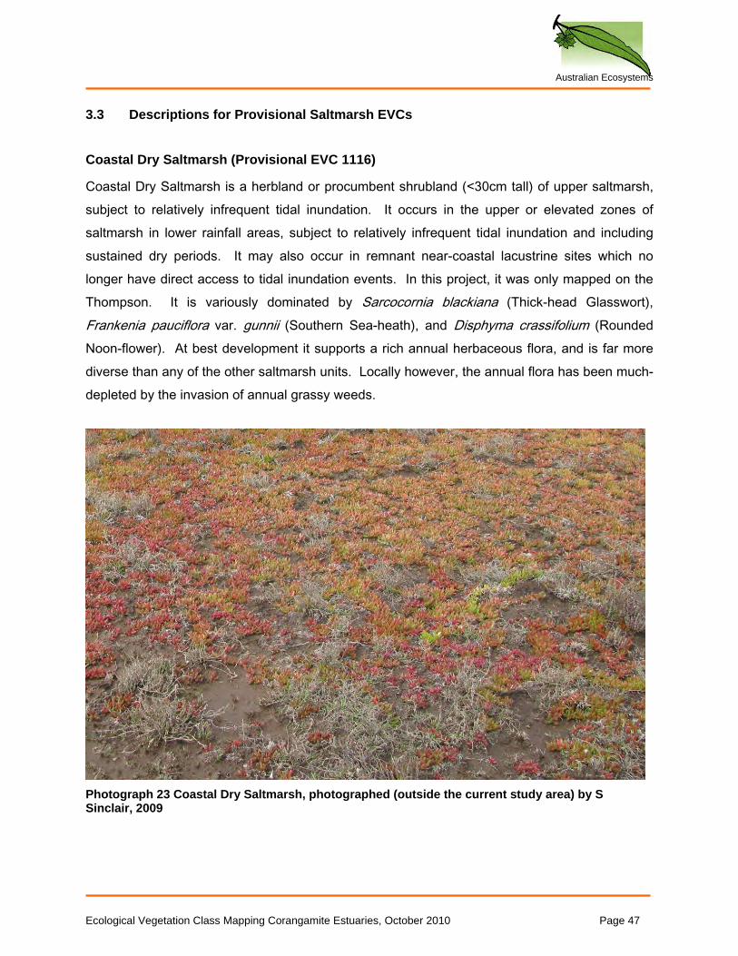
3.3 Descriptions for Provisional Saltmarsh EVCs Coastal Dry Saltmarsh (Provisional EVC 1116)
Coastal Dry Saltmarsh is a herbland or procumbent shrubland (<30cm tall) of upper saltmarsh, subject to relatively infrequent tidal inundation. It occurs in the upper or elevated zones of saltmarsh in lower rainfall areas, subject to relatively infrequent tidal inundation and including sustained dry periods. It may also occur in remnant near-coastal lacustrine sites which no longer have direct access to tidal inundation events. In this project, it was only mapped on the Thompson. It is variously dominated by Sarcocornia blackiana (Thick-head Glasswort), Frankenia pauciflora var. gunnii (Southern Sea-heath), and Disphyma crassifolium (Rounded Noon-flower). At best development it supports a rich annual herbaceous flora, and is far more diverse than any of the other saltmarsh units. Locally however, the annual flora has been much-depleted by the invasion of annual grassy weeds.
Photograph 23 Coastal Dry Saltmarsh, photographed (outside the current study area) by S Sinclair, 2009
Ecological Vegetation Class Mapping Corangamite Estuaries, October 2010 Page 47
Australian Ecosystems
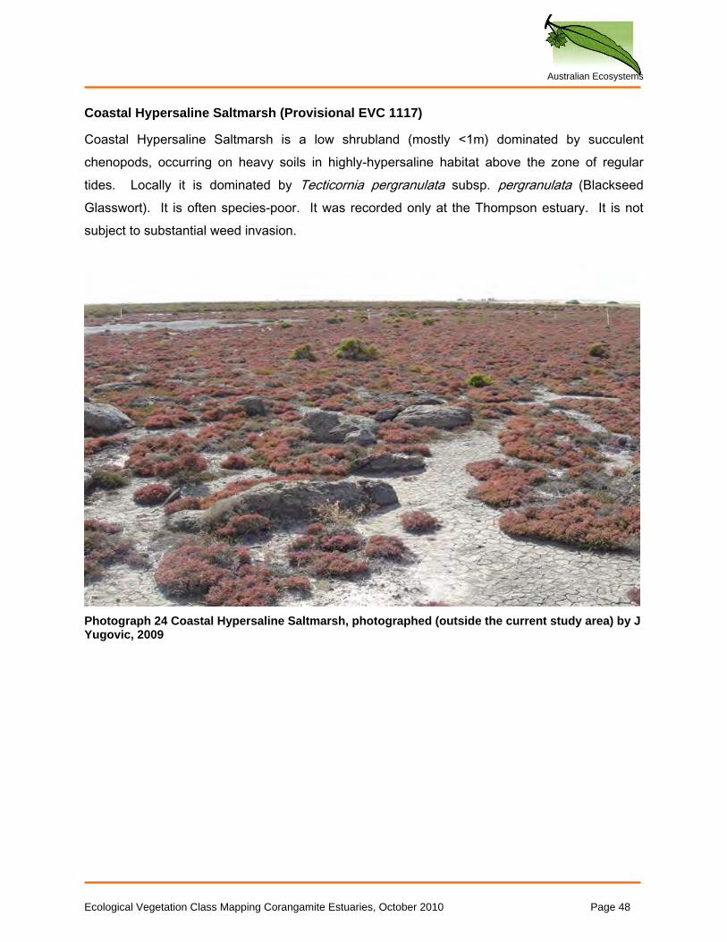
Coastal Hypersaline Saltmarsh (Provisional EVC 1117)
Coastal Hypersaline Saltmarsh is a low shrubland (mostly <1m) dominated by succulent chenopods, occurring on heavy soils in highly-hypersaline habitat above the zone of regular tides. Locally it is dominated by Tecticornia pergranulata subsp. pergranulata (Blackseed Glasswort). It is often species-poor. It was recorded only at the Thompson estuary. It is not subject to substantial weed invasion.
Photograph 24 Coastal Hypersaline Saltmarsh, photographed (outside the current study area) by J Yugovic, 2009
Ecological Vegetation Class Mapping Corangamite Estuaries, October 2010 Page 48
Australian Ecosystems
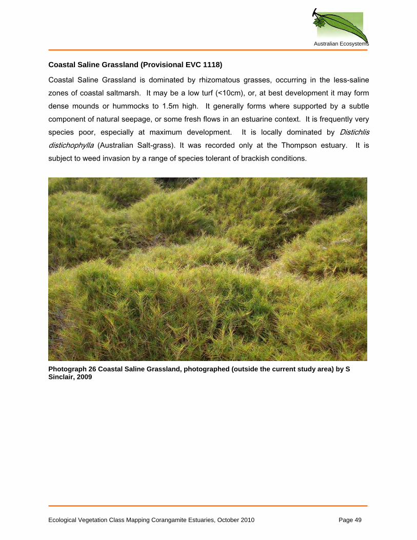
Coastal Saline Grassland (Provisional EVC 1118)
Coastal Saline Grassland is dominated by rhizomatous grasses, occurring in the less-saline zones of coastal saltmarsh. It may be a low turf (<10cm), or, at best development it may form dense mounds or hummocks to 1.5m high. It generally forms where supported by a subtle component of natural seepage, or some fresh flows in an estuarine context. It is frequently very species poor, especially at maximum development. It is locally dominated by Distichlis distichophylla (Australian Salt-grass). It was recorded only at the Thompson estuary. It is subject to weed invasion by a range of species tolerant of brackish conditions.
Photograph 26 Coastal Saline Grassland, photographed (outside the current study area) by S Sinclair, 2009
Ecological Vegetation Class Mapping Corangamite Estuaries, October 2010 Page 49
Australian Ecosystems
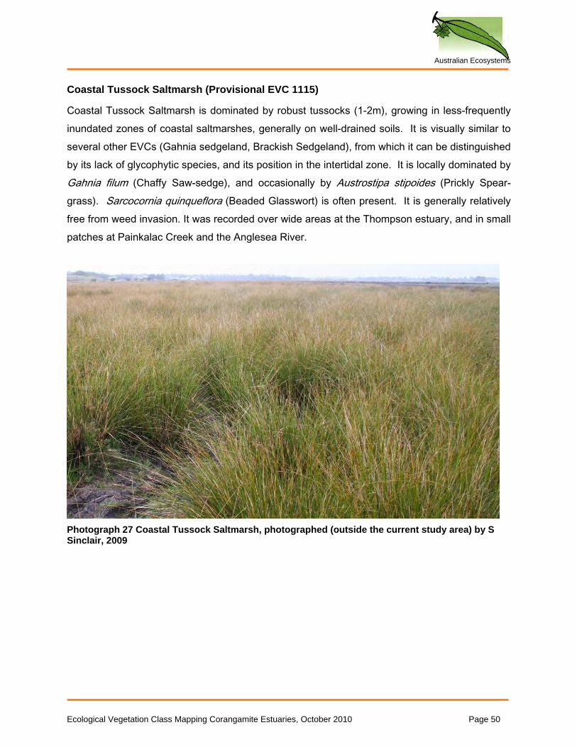
Coastal Tussock Saltmarsh (Provisional EVC 1115)
Coastal Tussock Saltmarsh is dominated by robust tussocks (1-2m), growing in less-frequently inundated zones of coastal saltmarshes, generally on well-drained soils. It is visually similar to several other EVCs (Gahnia sedgeland, Brackish Sedgeland), from which it can be distinguished by its lack of glycophytic species, and its position in the intertidal zone. It is locally dominated by Gahnia filum (Chaffy Saw-sedge), and occasionally by Austrostipa stipoides (Prickly Spear-grass). Sarcocornia quinqueflora (Beaded Glasswort) is often present. It is generally relatively free from weed invasion. It was recorded over wide areas at the Thompson estuary, and in small patches at Painkalac Creek and the Anglesea River.
Photograph 27 Coastal Tussock Saltmarsh, photographed (outside the current study area) by S Sinclair, 2009
Ecological Vegetation Class Mapping Corangamite Estuaries, October 2010 Page 50
Australian Ecosystems
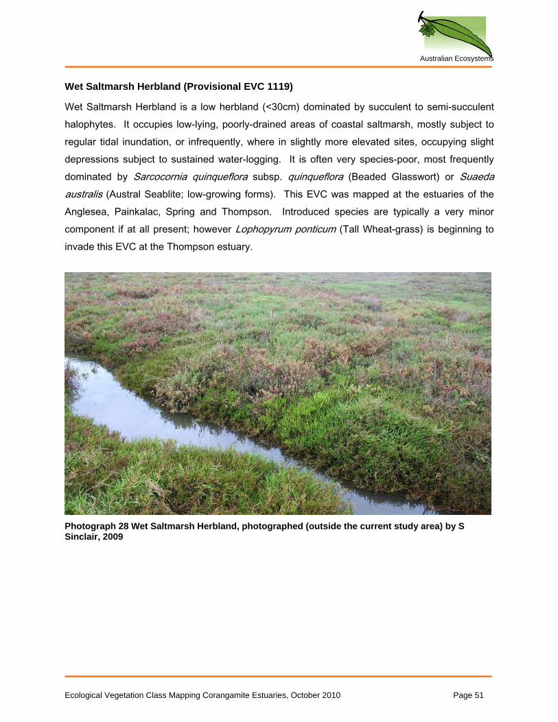
Wet Saltmarsh Herbland (Provisional EVC 1119)
Wet Saltmarsh Herbland is a low herbland (<30cm) dominated by succulent to semi-succulent halophytes. It occupies low-lying, poorly-drained areas of coastal saltmarsh, mostly subject to regular tidal inundation, or infrequently, where in slightly more elevated sites, occupying slight depressions subject to sustained water-logging. It is often very species-poor, most frequently dominated by Sarcocornia quinqueflora subsp. quinqueflora (Beaded Glasswort) or Suaeda australis (Austral Seablite; low-growing forms). This EVC was mapped at the estuaries of the Anglesea, Painkalac, Spring and Thompson. Introduced species are typically a very minor component if at all present; however Lophopyrum ponticum (Tall Wheat-grass) is beginning to invade this EVC at the Thompson estuary.
Photograph 28 Wet Saltmarsh Herbland, photographed (outside the current study area) by S Sinclair, 2009
Ecological Vegetation Class Mapping Corangamite Estuaries, October 2010 Page 51
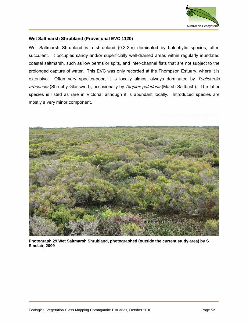
Australian Ecosystems
Wet Saltmarsh Shrubland (Provisional EVC 1120)
Wet Saltmarsh Shrubland is a shrubland (0.3-3m) dominated by halophytic species, often succulent. It occupies sandy and/or superficially well-drained areas within regularly inundated coastal saltmarsh, such as low berms or spits, and inter-channel flats that are not subject to the prolonged capture of water. This EVC was only recorded at the Thompson Estuary, where it is extensive. Often very species-poor, it is locally almost always dominated by Tecticornia arbuscula (Shrubby Glasswort), occasionally by Atriplex paludosa (Marsh Saltbush). The latter species is listed as rare in Victoria; although it is abundant locally. Introduced species are mostly a very minor component.
Photograph 29 Wet Saltmarsh Shrubland, photographed (outside the current study area) by S Sinclair, 2009
Ecological Vegetation Class Mapping Corangamite Estuaries, October 2010 Page 52
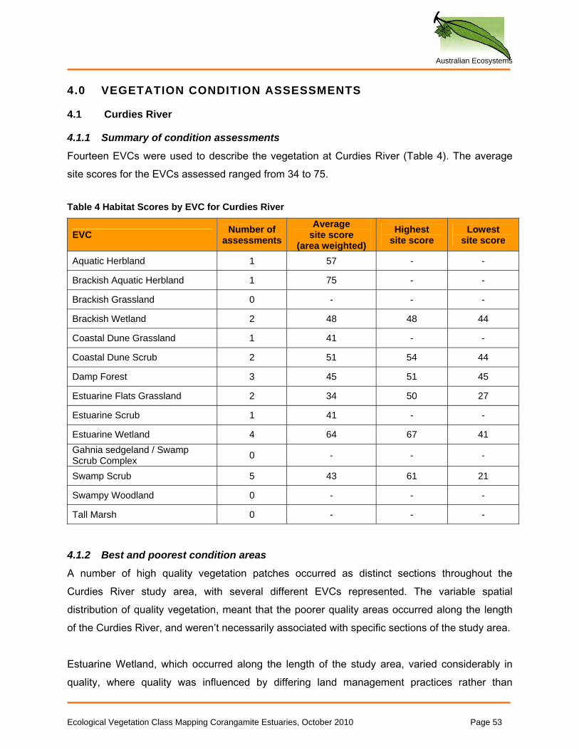
Australian Ecosystems
4.0 VEGETATION CONDITION ASSESSMENTS
4.1 Curdies River
4.1.1 Summary of condition assessments
Fourteen EVCs were used to describe the vegetation at Curdies River (Table 4). The average site scores for the EVCs assessed ranged from 34 to 75. Table 4 Habitat Scores by EVC for Curdies River
EVC Number of assessments
Average site score
(area weighted) Highest
site score Lowest
site score
Aquatic Herbland 1 57 - -
Brackish Aquatic Herbland 1 75 - -
Brackish Grassland 0 - - -
Brackish Wetland 2 48 48 44
Coastal Dune Grassland 1 41 - -
Coastal Dune Scrub 2 51 54 44
Damp Forest 3 45 51 45
Estuarine Flats Grassland 2 34 50 27
Estuarine Scrub 1 41 - -
Estuarine Wetland 4 64 67 41 Gahnia sedgeland / Swamp Scrub Complex 0 - - -
Swamp Scrub 5 43 61 21
Swampy Woodland 0 - - -
Tall Marsh 0 - - -
4.1.2 Best and poorest condition areas
A number of high quality vegetation patches occurred as distinct sections throughout the Curdies River study area, with several different EVCs represented. The variable spatial distribution of quality vegetation, meant that the poorer quality areas occurred along the length of the Curdies River, and weren’t necessarily associated with specific sections of the study area. Estuarine Wetland, which occurred along the length of the study area, varied considerably in quality, where quality was influenced by differing land management practices rather than
Ecological Vegetation Class Mapping Corangamite Estuaries, October 2010 Page 53
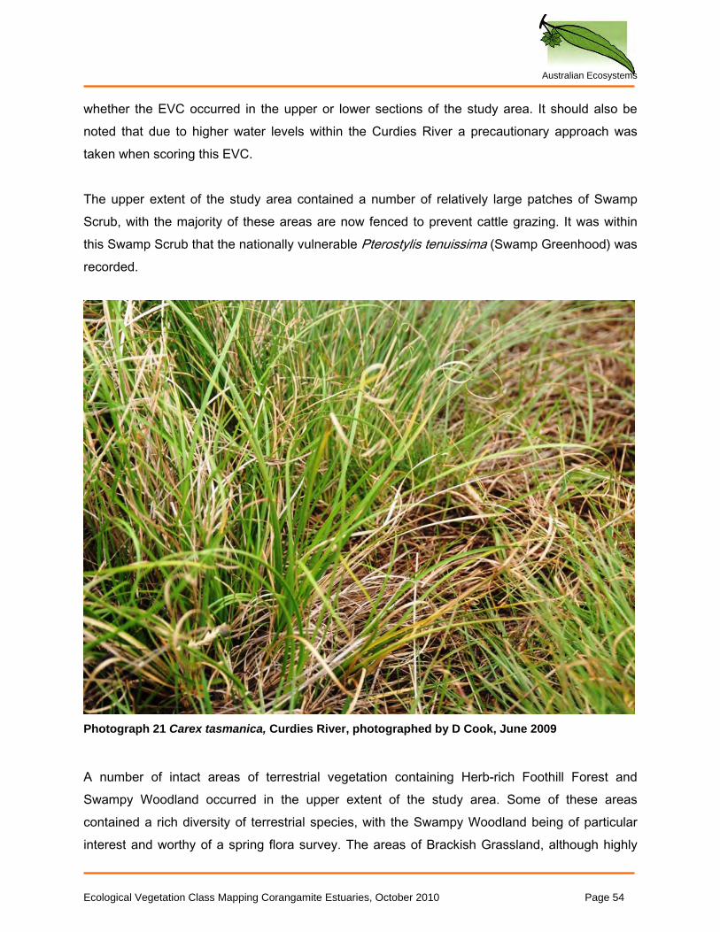
Australian Ecosystems
whether the EVC occurred in the upper or lower sections of the study area. It should also be noted that due to higher water levels within the Curdies River a precautionary approach was taken when scoring this EVC. The upper extent of the study area contained a number of relatively large patches of Swamp Scrub, with the majority of these areas are now fenced to prevent cattle grazing. It was within this Swamp Scrub that the nationally vulnerable Pterostylis tenuissima (Swamp Greenhood) was recorded.
Photograph 21 Carex tasmanica, Curdies River, photographed by D Cook, June 2009
A number of intact areas of terrestrial vegetation containing Herb-rich Foothill Forest and Swampy Woodland occurred in the upper extent of the study area. Some of these areas contained a rich diversity of terrestrial species, with the Swampy Woodland being of particular interest and worthy of a spring flora survey. The areas of Brackish Grassland, although highly
Ecological Vegetation Class Mapping Corangamite Estuaries, October 2010 Page 54
Australian Ecosystems
fragmented and occurring in relatively small patches, were reasonably intact, and contained a large population of the nationally threatened Carex tasmanica (Curly Sedge). The lower section of the study area included parts of Port Campbell National Park which contained intact areas of Coastal Dune Scrub and Coastal Dune Grassland. One of the most significant areas in the lower part of the study area, is that to the north of the Peterborough Boat Ramp. Although mapped as Coastal Saltmarsh, this large area is dominated by Gahnia filum (Chaffy Saw-sedge), and contains very few weeds. There were very few areas dominated by this species recorded in this project.
4.1.3 Tabulation of threats to remnant vegetation
The main threats to the vegetation within the Curdies River study area are those pertaining to the grazing management of freehold lands (see Table 5). Grazing impacts on native vegetation include pugging by cattle, grazing of indigenous vegetation, and the expansion of pasture weeds. These threats are significant contributors to the further fragmentation and degradation of remnant vegetation. It should be noted, that a number of blocks of remnant vegetation had now been fenced to prevent cattle grazing.
Table 5 Tabulation of threats to remnant vegetation at Curdies River
EVC Area Description Current Condition Threat
Estuarine Wetland
Outer margin of Curdies River Intact/Degraded Weed Invasion - *Lophopyrum
ponticum (Tall Wheat-grass)
All EVCs All free hold land Generally intact Grazing - Reduction of indigenous vegetation cover
All EVCs All free hold land Generally intact Grazing - Pugging caused by cattle
All EVCs All free hold land Generally intact Grazing - Expansion of pasture weeds
The highest threat weed recorded along the Curdies River is *Lophopyrum ponticum (Tall Wheat-grass). This species has the potential to displace a large number of species associated within saline and brackish environments, and is likely to have a detrimental effect on the overall health of EVCs associated with these areas. This species was observed scattered along the edge of much of the study area.
Ecological Vegetation Class Mapping Corangamite Estuaries, October 2010 Page 55
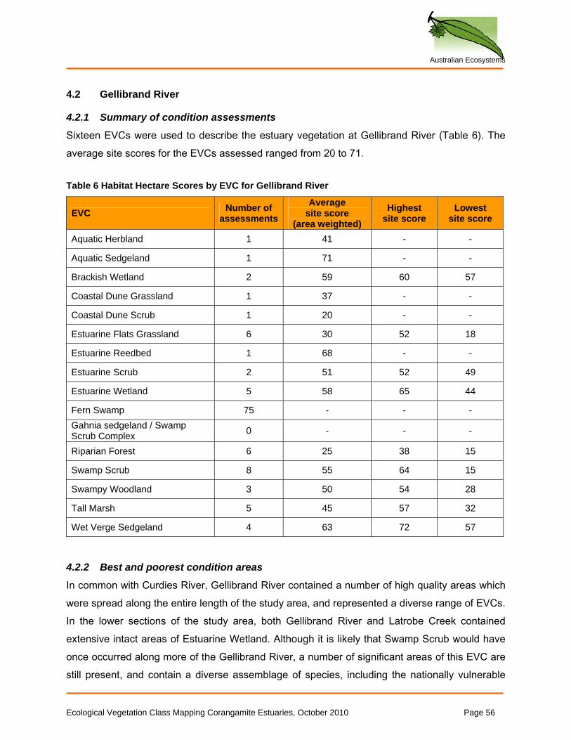
Australian Ecosystems
4.2 Gellibrand River
4.2.1 Summary of condition assessments
Sixteen EVCs were used to describe the estuary vegetation at Gellibrand River (Table 6). The average site scores for the EVCs assessed ranged from 20 to 71. Table 6 Habitat Hectare Scores by EVC for Gellibrand River
EVC Number of assessments
Average site score
(area weighted) Highest
site score Lowest
site score
Aquatic Herbland 1 41 - -
Aquatic Sedgeland 1 71 - -
Brackish Wetland 2 59 60 57
Coastal Dune Grassland 1 37 - -
Coastal Dune Scrub 1 20 - -
Estuarine Flats Grassland 6 30 52 18
Estuarine Reedbed 1 68 - -
Estuarine Scrub 2 51 52 49
Estuarine Wetland 5 58 65 44
Fern Swamp 75 - - - Gahnia sedgeland / Swamp Scrub Complex 0 - - -
Riparian Forest 6 25 38 15
Swamp Scrub 8 55 64 15
Swampy Woodland 3 50 54 28
Tall Marsh 5 45 57 32
Wet Verge Sedgeland 4 63 72 57
4.2.2 Best and poorest condition areas
In common with Curdies River, Gellibrand River contained a number of high quality areas which were spread along the entire length of the study area, and represented a diverse range of EVCs. In the lower sections of the study area, both Gellibrand River and Latrobe Creek contained extensive intact areas of Estuarine Wetland. Although it is likely that Swamp Scrub would have once occurred along more of the Gellibrand River, a number of significant areas of this EVC are still present, and contain a diverse assemblage of species, including the nationally vulnerable Ecological Vegetation Class Mapping Corangamite Estuaries, October 2010 Page 56
Australian Ecosystems
Pterostylis tenuissima (Swamp Greenhood) and Pterostylis lustra (Small Sickle Greenhood). Important stands of these species occurred at both Gellibrand River and Latrobe Creek. A number of other interesting plant species and communities occur on the lower Gellibrand River on the rise where Princetown is situated. This includes a small population of the nationally threatened Carex tasmanica (Curly Sedge) on a roadside and the occurrence of Fern Swamp associated with a spring of fresh ground water. It is very unusual for this EVC to occur almost at sea level, and in such close proximity to a saline environment. A section of the Kangaroobie property on the Gellibrand River flats contains a highly significant area of remnant vegetation that is currently not grazed. This area contained a diverse example of Tall Marsh, with significant Swamp Scrub around the margin which graded into Swampy Woodland (the latter of these, occurring outside of the study area). The area contained a number of species which were not recorded elsewhere within the study area, including Cardamine tenuifolia (Slender Bitter-cress; poorly known in Victoria, Stajsic and Walsh, 2008), Epilobium pallidiflorum (Showy Willow-herb) and Amphibromus neesii (Southern Swamp Wallaby-grass). Other intact remnants of freshwater wetland EVCs occur on the floodplain of the Gellibrand River up-stream of this point. The areas with the least native vegetation correspond to those which are the most productive grazing lands; this included the Gellibrand River flats and levee in the upper sections of the study area, and the upper sections of the Latrobe River. As these areas are more productive farming lands, they have been heavily cleared and drained. Riparian Forest and Wet Verge Sedgeland would have had a wider occurrence in the study area prior to clearing for agriculture. The other poorest areas are those associated with the infrastructure around the Princetown Township (for example, the camping area, roads and car parks).
4.2.3 Tabulation of threats to remnant vegetation
While the threats to remnant vegetation in the Gellibrand River study area are similar to the agricultural threats identified in the other estuaries assessed, Gellibrand appeared to have a particularly high infestation of environmental weeds (see Table 7). While some infestations such as *Tradescantia fluminensis (Wandering Dew) are likely to be difficult to control, there are
Ecological Vegetation Class Mapping Corangamite Estuaries, October 2010 Page 57
Australian Ecosystems
others such as *Juncus acutus (Spiny Rush) and *Salix spp. (Willow), that consist of only a small number of plants, and therefore should be relatively easy to control at this time. Table 7 Tabulation of threats to remnant vegetation at Gellibrand River
EVC Area description Current Condition Threat
Estuarine Scrub Latrobe Creek/Great Ocean Rd
Intact-species rich Weed Invasion - *Coprosma repens (Mirror Bush), *Pennisetum clandestinum (Kikuyu)
Swamp Scrub Latrobe Creek/Great Ocean Rd
Intact-species rich Weed Invasion - *Coprosma repens (Mirror Bush), *Pennisetum clandestinum (Kikuyu)
Pasture Old Coast Road/Kangaroobie Degraded Weed Invasion - *Salix spp. (Willow),
*Juncus acutus (Spiny Rush)
Coastal Dune Grassland
Princetown Beach Car Park Intact-species rich
Weed Invasion - *Ammophila arenaria (Marram Grass), *Euphorbia paralias (Coast Spurge)
Coastal Dune Grassland
Princetown Beach Car Park Intact-species rich Pedestrian Traffic causing erosion
along shoreline
Estuarine Flats Grassland
Port Campbell National Park Degraded Weed Invasion - *Stenotaphrum
secundatum (Buffalo Grass)
Coastal Headland Scrub
Gellibrand River Escarpment Intact-species rich Weed Invasion - *Lycium ferocissimum
(African Box-thorn)
Swamp Scrub Old Coast Road Intact-species rich Weed Invasion - *Rubus spp. agg. fruiticosus (Blackberry), *Zantedeschia aethiopica (Arum Lily)
Gellibrand River (upper)
Down from "Three Bridges" river margins
Moderately Intact Weed Invasion - *Tradescantia flumensis (Wandering Jew)
All EVCs All free hold land Generally intact Grazing - Reduction of indigenous vegetation cover
All EVCs All free hold land Generally intact Grazing - Pugging caused by cattle
All EVCs All free hold land Generally intact Grazing - Expansion of pasture weeds
Ecological Vegetation Class Mapping Corangamite Estuaries, October 2010 Page 58
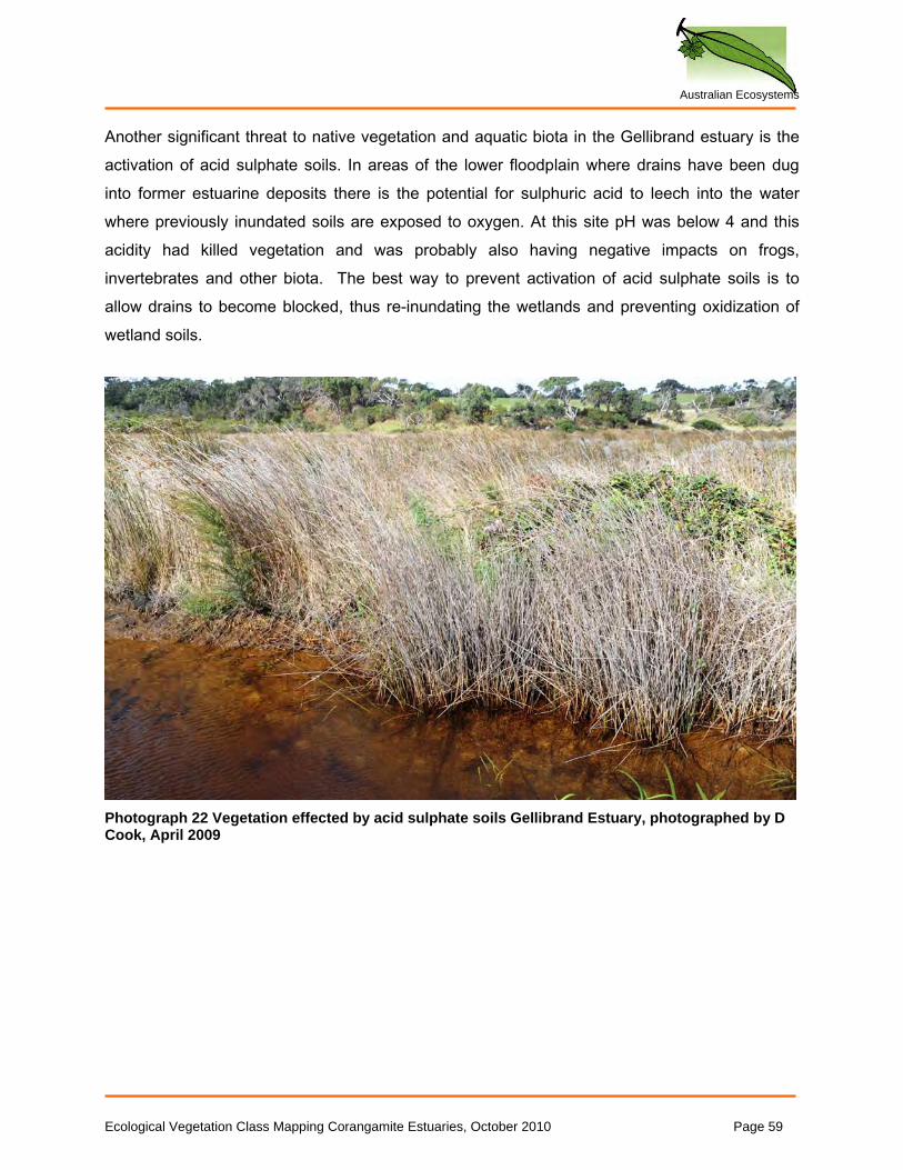
Australian Ecosystems
Another significant threat to native vegetation and aquatic biota in the Gellibrand estuary is the activation of acid sulphate soils. In areas of the lower floodplain where drains have been dug into former estuarine deposits there is the potential for sulphuric acid to leech into the water where previously inundated soils are exposed to oxygen. At this site pH was below 4 and this acidity had killed vegetation and was probably also having negative impacts on frogs, invertebrates and other biota. The best way to prevent activation of acid sulphate soils is to allow drains to become blocked, thus re-inundating the wetlands and preventing oxidization of wetland soils.
Photograph 22 Vegetation effected by acid sulphate soils Gellibrand Estuary, photographed by D Cook, April 2009
Ecological Vegetation Class Mapping Corangamite Estuaries, October 2010 Page 59
Australian Ecosystems
4.3 Aire River
4.3.1 Summary of condition assessments
Fourteen EVCs were used to describe the estuary vegetation at Aire River (Table 8). The average site scores for the EVCs assessed ranged from 20 to 68.
Table 8 Habitat Hectare Scores by EVC for Aire River
EVC Number of assessments
Average site score
(area weighted) Highest
site score Lowest
site score
Aquatic Herbland 1 46 - -
Brackish Aquatic Herbland 1 41 - -
Brackish Herbland 1 68 - -
Brackish Wetland 7 36 42 26
Coastal Dune Grassland 1 45 - -
Coastal Dune Scrub 2 40 42 16
Estuarine Reed Bed 1 68 - -
Estuarine Wetland 9 53 61 53
Riparian Forest 2 20 21 19
Swamp Scrub 16 50 60 6
Swampy Riparian Woodland 2 25 40 23
Tall Marsh 5 56 62 38
Wet Verge Sedgeland 10 40 68 23
4.3.2 Best and poorest condition areas
The Aire River study area comprises three general zones, the lower third of which forms part of the Otway National Park. The largest areas of intact vegetation occur on those lands which are reserved such as Otway National Park, Lake Hordern and Lake Costin, where the primary reason for the intactness of these areas of remnant vegetation is the absence of grazing. The freehold land which forms the middle third of the study area also contained large intact examples of a number of EVCs, particularly Estuarine Wetland, Brackish Wetland, Swamp Scrub and Tall Marsh. For the most part these areas are difficult for stock to access due to the number of narrow but deep channels which have been constructed between the Aire River, Fords River and Calder River. Additionally, high salinity levels have prevented many pasture species from
Ecological Vegetation Class Mapping Corangamite Estuaries, October 2010 Page 60
Australian Ecosystems
establishing. Together these factors appear to have limited continued efforts to manage the areas for agricultural purposes. The upper third of the study area represents the poorest quality native vegetation. Vegetation has largely been cleared for agricultural purposes, and the freehold lands throughout this section of the study area have lower salinity levels that have supported the establishment of general pasture species.
4.3.3 Tabulation of threats to remnant vegetation
The main threats to the vegetation within the Aire River study area pertain to the grazing management of freehold lands (see Table 9). Grazing impacts on native vegetation include pugging by cattle, grazing of indigenous vegetation, and the expansion of pasture weeds. These threats are significant contributors to the further fragmentation and degradation of remnant vegetation.
Table 9 Tabulation of threats to remnant vegetation at Aire River
EVC Area Description Current Condition Threat
All EVCs All freehold land Generally intact Grazing - Reduction of indigenous vegetation cover
All EVCs All freehold land Generally intact Pugging caused by cattle
All EVCs All freehold land Generally intact Expansion of pasture weeds
Estuarine Flats Grassland, Estuarine Wetland
Aire River Camping Ground Generally intact Off track vehicle access
Ecological Vegetation Class Mapping Corangamite Estuaries, October 2010 Page 61
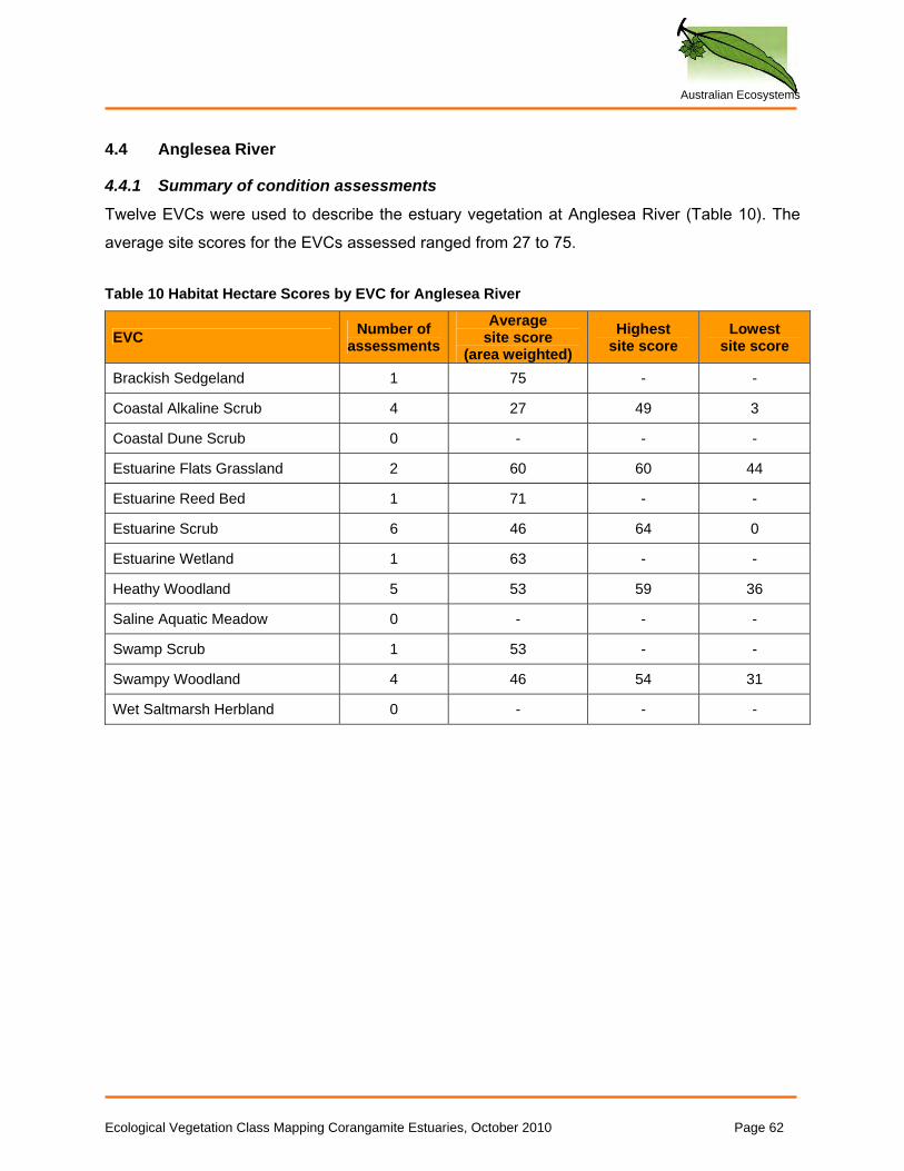
Australian Ecosystems
4.4 Anglesea River
4.4.1 Summary of condition assessments
Twelve EVCs were used to describe the estuary vegetation at Anglesea River (Table 10). The average site scores for the EVCs assessed ranged from 27 to 75. Table 10 Habitat Hectare Scores by EVC for Anglesea River
EVC Number of assessments
Average site score
(area weighted) Highest
site score Lowest
site score
Brackish Sedgeland 1 75 - -
Coastal Alkaline Scrub 4 27 49 3
Coastal Dune Scrub 0 - - -
Estuarine Flats Grassland 2 60 60 44
Estuarine Reed Bed 1 71 - -
Estuarine Scrub 6 46 64 0
Estuarine Wetland 1 63 - -
Heathy Woodland 5 53 59 36
Saline Aquatic Meadow 0 - - -
Swamp Scrub 1 53 - -
Swampy Woodland 4 46 54 31
Wet Saltmarsh Herbland 0 - - -
Ecological Vegetation Class Mapping Corangamite Estuaries, October 2010 Page 62
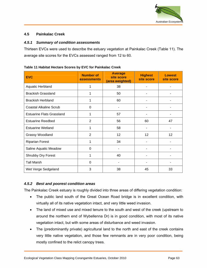
Australian Ecosystems
4.5 Painkalac Creek
4.5.1 Summary of condition assessments
Thirteen EVCs were used to describe the estuary vegetation at Painkalac Creek (Table 11). The average site scores for the EVCs assessed ranged from 12 to 60. Table 11 Habitat Hectare Scores by EVC for Painkalac Creek
EVC Number of assessments
Average site score
(area weighted) Highest
site score Lowest
site score
Aquatic Herbland 1 38 - -
Brackish Grassland 1 50 - -
Brackish Herbland 1 60 - -
Coastal Alkaline Scrub 0 - - -
Estuarine Flats Grassland 1 57 - -
Estuarine Reedbed 2 56 60 47
Estuarine Wetland 1 58 - -
Grassy Woodland 2 12 12 12
Riparian Forest 1 34 - -
Saline Aquatic Meadow 0 - - -
Shrubby Dry Forest 1 40 - -
Tall Marsh 0 - - -
Wet Verge Sedgeland 3 38 45 33
4.5.2 Best and poorest condition areas
The Painkalac Creek estuary is roughly divided into three areas of differing vegetation condition: • The public land south of the Great Ocean Road bridge is in excellent condition, with
virtually all of its native vegetation intact, and very little weed invasion. • The land of mixed use and mixed tenure to the south and west of the creek (upstream to
around the northern end of Wybellenna Dr) is in good condition, with most of its native vegetation intact, but with some areas of disturbance and weed invasion.
• The (predominantly private) agricultural land to the north and east of the creek contains very little native vegetation, and those few remnants are in very poor condition, being mostly confined to the relict canopy trees.
Ecological Vegetation Class Mapping Corangamite Estuaries, October 2010 Page 63
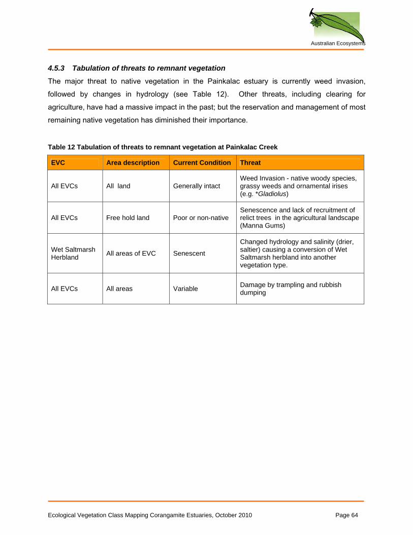
Australian Ecosystems
4.5.3 Tabulation of threats to remnant vegetation
The major threat to native vegetation in the Painkalac estuary is currently weed invasion, followed by changes in hydrology (see Table 12). Other threats, including clearing for agriculture, have had a massive impact in the past; but the reservation and management of most remaining native vegetation has diminished their importance.
Table 12 Tabulation of threats to remnant vegetation at Painkalac Creek
EVC Area description Current Condition Threat
All EVCs All land Generally intact Weed Invasion - native woody species, grassy weeds and ornamental irises (e.g. *Gladiolus)
All EVCs Free hold land Poor or non-native Senescence and lack of recruitment of relict trees in the agricultural landscape (Manna Gums)
Wet Saltmarsh Herbland All areas of EVC Senescent
Changed hydrology and salinity (drier, saltier) causing a conversion of Wet Saltmarsh herbland into another vegetation type.
All EVCs All areas Variable Damage by trampling and rubbish dumping
Ecological Vegetation Class Mapping Corangamite Estuaries, October 2010 Page 64
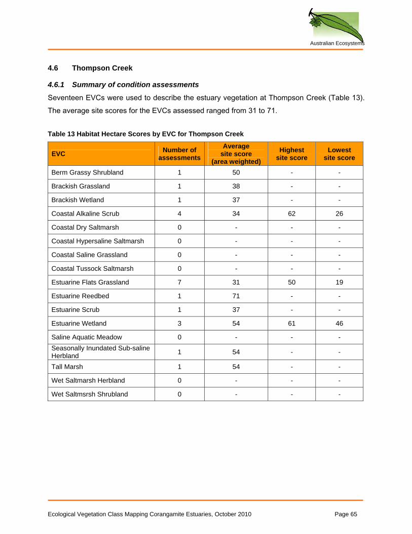
Australian Ecosystems
4.6 Thompson Creek
4.6.1 Summary of condition assessments
Seventeen EVCs were used to describe the estuary vegetation at Thompson Creek (Table 13). The average site scores for the EVCs assessed ranged from 31 to 71. Table 13 Habitat Hectare Scores by EVC for Thompson Creek
EVC Number of assessments
Average site score
(area weighted) Highest
site score Lowest
site score
Berm Grassy Shrubland 1 50 - -
Brackish Grassland 1 38 - -
Brackish Wetland 1 37 - -
Coastal Alkaline Scrub 4 34 62 26
Coastal Dry Saltmarsh 0 - - -
Coastal Hypersaline Saltmarsh 0 - - -
Coastal Saline Grassland 0 - - -
Coastal Tussock Saltmarsh 0 - - -
Estuarine Flats Grassland 7 31 50 19
Estuarine Reedbed 1 71 - -
Estuarine Scrub 1 37 - -
Estuarine Wetland 3 54 61 46
Saline Aquatic Meadow 0 - - - Seasonally Inundated Sub-saline Herbland 1 54 - -
Tall Marsh 1 54 - -
Wet Saltmarsh Herbland 0 - - -
Wet Saltmsrsh Shrubland 0 - - -
Ecological Vegetation Class Mapping Corangamite Estuaries, October 2010 Page 65
Australian Ecosystems
4.6.2 Best and poorest condition areas
The patterns of vegetation condition are complex in the Thompsons estuary, but the following general patterns are observable:
• The saltmarsh in the Karaaf wetland area is mostly in excellent condition. This is the ‘best area’.
• The saltmarsh east of Breamlea Rd is in excellent condition, although its hydrology is presumably more altered than the Karaaf section.
• All riparian areas upstream of Blackgate Road have been largely converted to non-native pasture, and those areas that retain native vegetation are heavily grazed and invaded by weeds. These are the ‘worst areas’.
• The saltmarsh north of Blackgate Road is relatively free from weeds, but has been structurally simplified; presumably as a result of long-term grazing and the pooling of freshwater on the marsh after rains.
• The terrestrial vegetation in the Karaaf wetland area is depleted and degraded by rabbits and weeds
• The saltmarsh vegetation downstream from Blackgate Road and north of the creek has been significantly modified by hydrological changes (channels, dams, levees, fill), but some patches of vegetation remain in excellent condition.
Ecological Vegetation Class Mapping Corangamite Estuaries, October 2010 Page 66
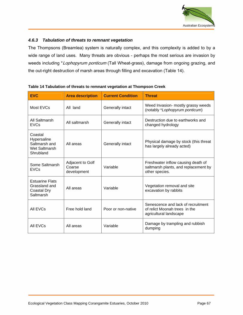
Australian Ecosystems
4.6.3 Tabulation of threats to remnant vegetation
The Thompsons (Breamlea) system is naturally complex, and this complexity is added to by a wide range of land uses. Many threats are obvious - perhaps the most serious are invasion by weeds including *Lophopyrum ponticum (Tall Wheat-grass), damage from ongoing grazing, and the out-right destruction of marsh areas through filling and excavation (Table 14).
Table 14 Tabulation of threats to remnant vegetation at Thompson Creek
EVC Area description Current Condition Threat
Most EVCs All land Generally intact Weed Invasion- mostly grassy weeds (notably *Lophopyrum ponticum)
All Saltmarsh EVCs All saltmarsh Generally intact Destruction due to earthworks and
changed hydrology
Coastal Hypersaline Saltmarsh and Wet Saltmarsh Shrubland
All areas Generally intact Physical damage by stock (this threat has largely already acted)
Some Saltmarsh EVCs
Adjacent to Golf Coarse development
Variable Freshwater inflow causing death of saltmarsh plants, and replacement by other species.
Estuarine Flats Grassland and Coastal Dry Saltmarsh
All areas Variable Vegetation removal and site excavation by rabbits
All EVCs Free hold land Poor or non-native Senescence and lack of recruitment of relict Moonah trees in the agricultural landscape
All EVCs All areas Variable Damage by trampling and rubbish dumping
Ecological Vegetation Class Mapping Corangamite Estuaries, October 2010 Page 67
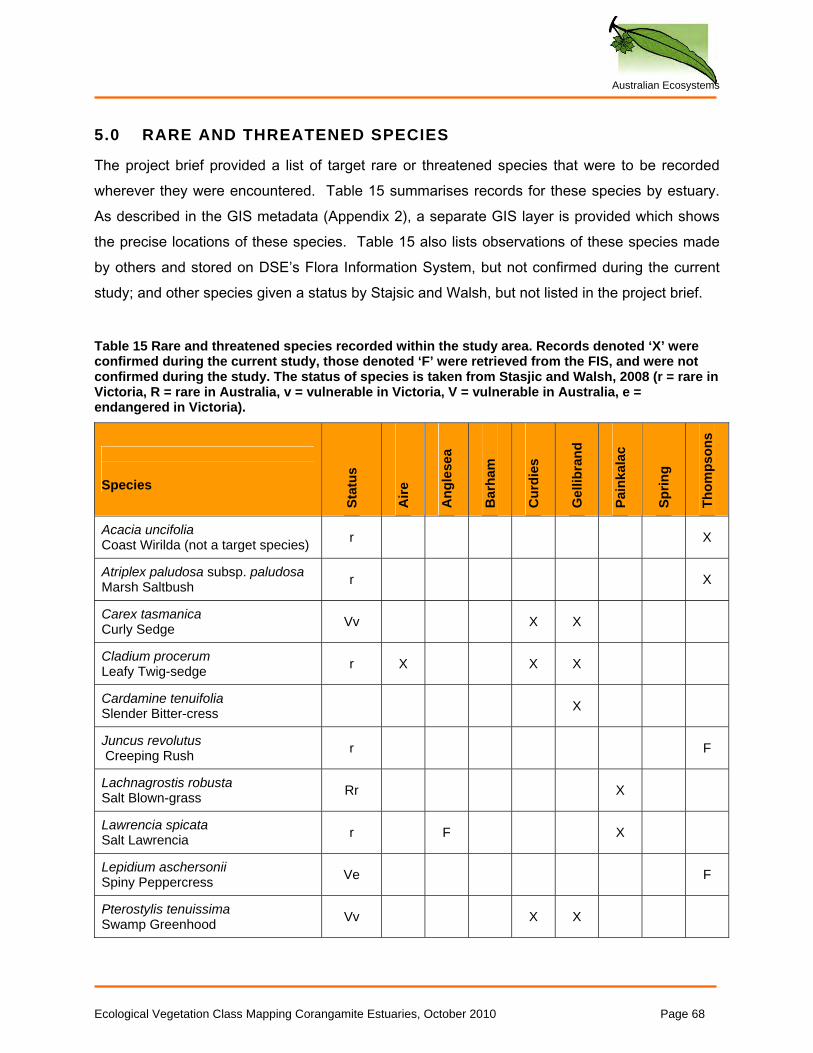
Australian Ecosystems
5.0 RARE AND THREATENED SPECIES
The project brief provided a list of target rare or threatened species that were to be recorded wherever they were encountered. Table 15 summarises records for these species by estuary. As described in the GIS metadata (Appendix 2), a separate GIS layer is provided which shows the precise locations of these species. Table 15 also lists observations of these species made by others and stored on DSE’s Flora Information System, but not confirmed during the current study; and other species given a status by Stajsic and Walsh, but not listed in the project brief.
Table 15 Rare and threatened species recorded within the study area. Records denoted ‘X’ were confirmed during the current study, those denoted ‘F’ were retrieved from the FIS, and were not confirmed during the study. The status of species is taken from Stasjic and Walsh, 2008 (r = rare in Victoria, R = rare in Australia, v = vulnerable in Victoria, V = vulnerable in Australia, e = endangered in Victoria).
Species
Stat
us
Aire
Ang
lese
a
Bar
ham
Cur
dies
Gel
libra
nd
Pain
kala
c
Sprin
g
Thom
pson
s
Acacia uncifolia Coast Wirilda (not a target species) r X
Atriplex paludosa subsp. paludosa Marsh Saltbush r X
Carex tasmanica Curly Sedge Vv X X
Cladium procerum Leafy Twig-sedge r X X X
Cardamine tenuifolia Slender Bitter-cress X
Juncus revolutus Creeping Rush r F
Lachnagrostis robusta Salt Blown-grass Rr X
Lawrencia spicata Salt Lawrencia r F X
Lepidium aschersonii Spiny Peppercress Ve F
Pterostylis tenuissima Swamp Greenhood Vv X X
Ecological Vegetation Class Mapping Corangamite Estuaries, October 2010 Page 68
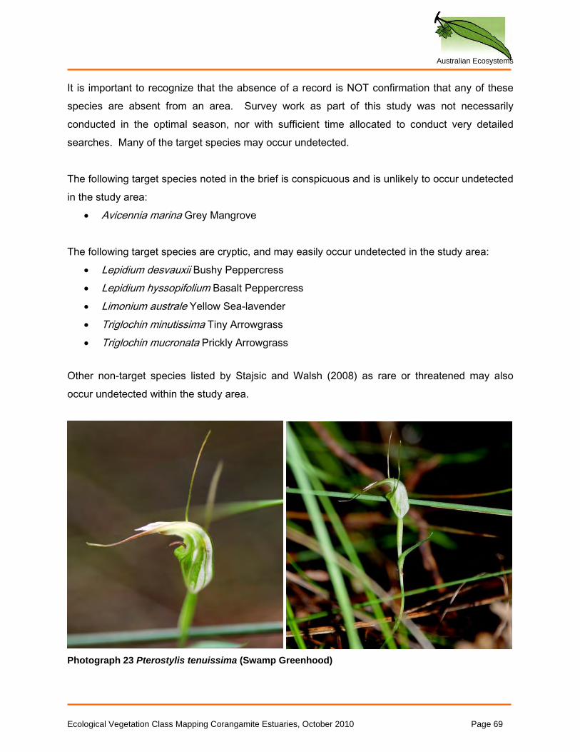
Australian Ecosystems
It is important to recognize that the absence of a record is NOT confirmation that any of these species are absent from an area. Survey work as part of this study was not necessarily conducted in the optimal season, nor with sufficient time allocated to conduct very detailed searches. Many of the target species may occur undetected. The following target species noted in the brief is conspicuous and is unlikely to occur undetected in the study area:
• Avicennia marina Grey Mangrove
The following target species are cryptic, and may easily occur undetected in the study area: • Lepidium desvauxii Bushy Peppercress • Lepidium hyssopifolium Basalt Peppercress • Limonium australe Yellow Sea-lavender • Triglochin minutissima Tiny Arrowgrass • Triglochin mucronata Prickly Arrowgrass
Other non-target species listed by Stajsic and Walsh (2008) as rare or threatened may also occur undetected within the study area.
Photograph 23 Pterostylis tenuissima (Swamp Greenhood)
Ecological Vegetation Class Mapping Corangamite Estuaries, October 2010 Page 69
Australian Ecosystems
6.0 REFERENCES
Commonwealth of Australia and NRE (Natural Resources and Environment), 1996. ‘East Gippsland Regional Forests Agreement Report’ (Appendix G) Barton, ACT.
DSE, 2004. Native Vegetation: sustaining a living landscape, Vegetation Quality Assessment Manual – guidelines for applying the Habitat Hectare scoring method (Version 1.3). Department of Sustainability and Environment, East Melbourne, Victoria.
DSE, 2005a. Index of wetland condition. Conceptual framework and selection of measures. November 2005. Department of Sustainability and Environment, East Melbourne.
DSE, 2005b. Advisory List of Rare or Threatened Plants in Victoria - 2005. Department of Sustainability and Environment, East Melbourne, Victoria.
DSE, 2006. Index of wetland condition. Assessment of wetland vegetation. Update – March 2006. Department of Sustainability and Environment, East Melbourne.
DSE, 2007. Native vegetation, guide for assessment of referred planning permit applications. Department of Sustainability and Environment, East Melbourne.
DSE, 2009. Index of wetland condition. Assessment of wetland vegetation. Update- September 2009. Department of Sustainability and Environment, East Melbourne.
NRE, 2002. Victoria’s native vegetation management – a framework for action. Department of Natural Resources and Environment, Melbourne.
Oates, A. and Taranto M. 2001. Vegetation mapping of the Port Phillip and Westernport region. Authur Rylah Institute for Environmental Research, Heidelberg.
Parkes, D., Newell G. and Cheal, D. 2003. Assessing the quality of native vegetation: the ‘habitat hectares’ approach. Ecological Management and Restoration. 4, 29-38.
Sinclair, S.J. and White, M.D., 2006. Mapping native vegetation in the Painkalac Creek Estuary, Aireys Inlet. Report to the Surf Coast Shire. Arthur Rylah Institute for Environmental Research.
Sinclair, S.J. and Sutter, G.R., 2008. Estuarine wetland vegetation mapping, Glenelg Hopkins CMA. Arthur Rylah Institute Technical Report No. 178.
Stasjic V. and Walsh N. G., 2008. A Census of the Vascular Plants of Victoria, 8th edn. National Herbarium of Victoria, Royal Botanic Gardens, Victoria.
Victorian Saltmarsh Study, 2010. Mangroves and coastal saltmarsh of Victoria: Distribution, condition, threats and management. Authors: Boon, P.I., Allen, T., Brook, J., Carr, G., Frood, D., Hoye, J., Harty, C., Mathews, S., McMahon, A., Rosengren, N., Sinclair, S.,
Ecological Vegetation Class Mapping Corangamite Estuaries, October 2010 Page 70
Australian Ecosystems
White, M. & Yugovic, J. Institute for Sustainability and Innovation, Victoria University, Melbourne.
Walsh N.G. and Entwisle T.J., 1994-9. Flora of Victoria, Volumes 2-4. Inkata Press, Melbourne.
Woodgate, P.W., Peel, B.D., Coram, J.E., Farrell, S.J., Ritman, K.T. and Lewis, A. (1996) Old-growth forest studies in Victoria, Australia; Concepts and principles. Forest Ecology and Management 85, 79–94.
Yugovic, J., Mueck, S., Frood, D., & Todd, J. 1999. Ecological Vegetation Classes of Far South-West Victoria. Department of Natural Resources and Environment: Melbourne, Victoria.
Ecological Vegetation Class Mapping Corangamite Estuaries, October 2010 Page 71
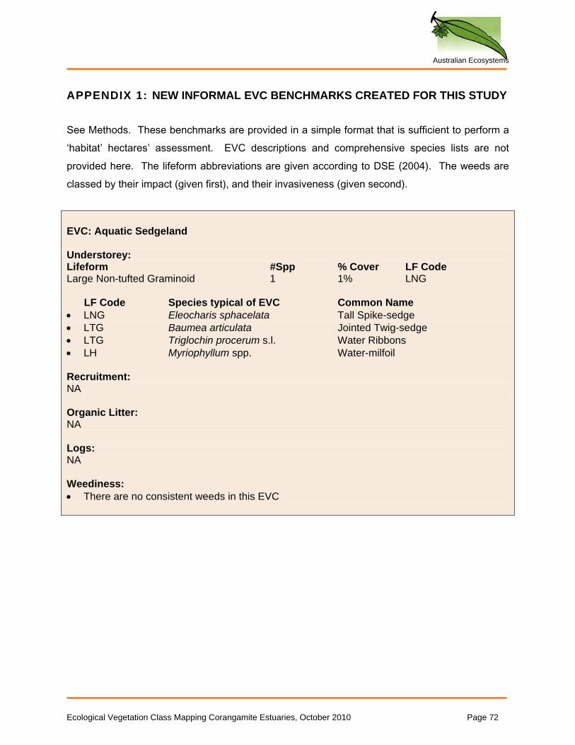
Australian Ecosystems
APPENDIX 1: NEW INFORMAL EVC BENCHMARKS CREATED FOR THIS STUDY See Methods. These benchmarks are provided in a simple format that is sufficient to perform a ‘habitat’ hectares’ assessment. EVC descriptions and comprehensive species lists are not provided here. The lifeform abbreviations are given according to DSE (2004). The weeds are classed by their impact (given first), and their invasiveness (given second). EVC: Aquatic Sedgeland Understorey: Lifeform #Spp % Cover LF Code Large Non-tufted Graminoid 1 1% LNG LF Code Species typical of EVC Common Name • LNG Eleocharis sphacelata Tall Spike-sedge • LTG Baumea articulata Jointed Twig-sedge • LTG Triglochin procerum s.l. Water Ribbons • LH Myriophyllum spp. Water-milfoil Recruitment: NA Organic Litter: NA Logs: NA Weediness: • There are no consistent weeds in this EVC
Ecological Vegetation Class Mapping Corangamite Estuaries, October 2010 Page 72
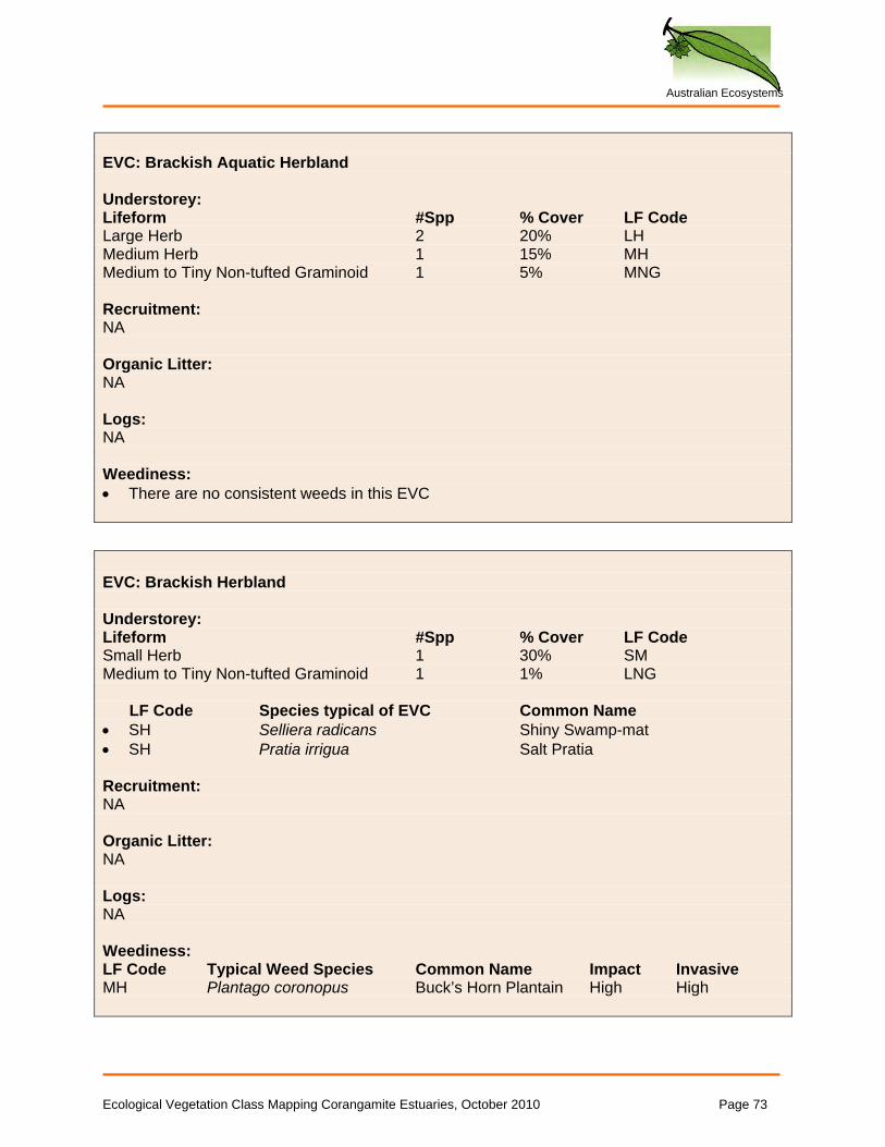
Australian Ecosystems
EVC: Brackish Aquatic Herbland Understorey: Lifeform #Spp % Cover LF Code Large Herb 2 20% LH Medium Herb 1 15% MH Medium to Tiny Non-tufted Graminoid 1 5% MNG Recruitment: NA Organic Litter: NA Logs: NA Weediness: • There are no consistent weeds in this EVC EVC: Brackish Herbland Understorey: Lifeform #Spp % Cover LF Code Small Herb 1 30% SM Medium to Tiny Non-tufted Graminoid 1 1% LNG LF Code Species typical of EVC Common Name • SH Selliera radicans Shiny Swamp-mat • SH Pratia irrigua Salt Pratia Recruitment: NA Organic Litter: NA Logs: NA Weediness: LF Code Typical Weed Species Common Name Impact Invasive MH Plantago coronopus Buck’s Horn Plantain High High
Ecological Vegetation Class Mapping Corangamite Estuaries, October 2010 Page 73
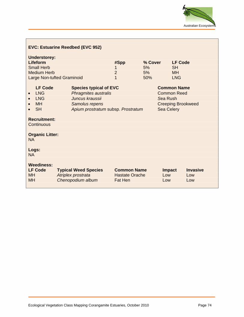
Australian Ecosystems
EVC: Estuarine Reedbed (EVC 952) Understorey: Lifeform #Spp % Cover LF Code Small Herb 1 5% SH Medium Herb 2 5% MH Large Non-tufted Graminoid 1 50% LNG LF Code Species typical of EVC Common Name • LNG Phragmites australis Common Reed • LNG Juncus kraussii Sea Rush • MH Samolus repens Creeping Brookweed • SH Apium prostratum subsp. Prostratum Sea Celery Recruitment: Continuous Organic Litter: NA Logs: NA Weediness: LF Code Typical Weed Species Common Name Impact Invasive MH Atriplex prostrata Hastate Orache Low Low MH Chenopodium album Fat Hen Low Low
Ecological Vegetation Class Mapping Corangamite Estuaries, October 2010 Page 74
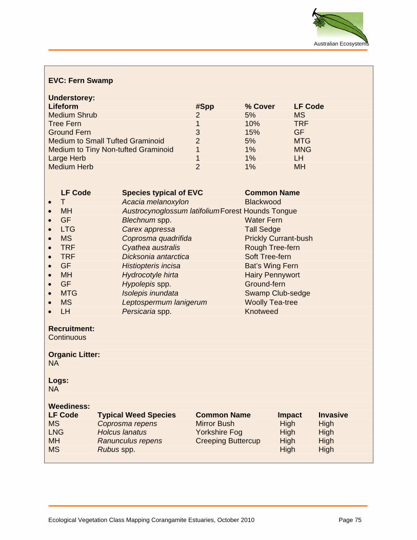
Australian Ecosystems
EVC: Fern Swamp Understorey: Lifeform #Spp % Cover LF Code Medium Shrub 2 5% MS Tree Fern 1 10% TRF Ground Fern 3 15% GF Medium to Small Tufted Graminoid 2 5% MTG Medium to Tiny Non-tufted Graminoid 1 1% MNG Large Herb 1 1% LH Medium Herb 2 1% MH LF Code Species typical of EVC Common Name • T Acacia melanoxylon Blackwood • MH Austrocynoglossum latifolium Forest Hounds Tongue • GF Blechnum spp. Water Fern • LTG Carex appressa Tall Sedge • MS Coprosma quadrifida Prickly Currant-bush • TRF Cyathea australis Rough Tree-fern • TRF Dicksonia antarctica Soft Tree-fern • GF Histiopteris incisa Bat’s Wing Fern • MH Hydrocotyle hirta Hairy Pennywort • GF Hypolepis spp. Ground-fern • MTG Isolepis inundata Swamp Club-sedge • MS Leptospermum lanigerum Woolly Tea-tree • LH Persicaria spp. Knotweed Recruitment: Continuous Organic Litter: NA Logs: NA Weediness: LF Code Typical Weed Species Common Name Impact Invasive MS Coprosma repens Mirror Bush High High LNG Holcus lanatus Yorkshire Fog High High MH Ranunculus repens Creeping Buttercup High High MS Rubus spp. High High
Ecological Vegetation Class Mapping Corangamite Estuaries, October 2010 Page 75
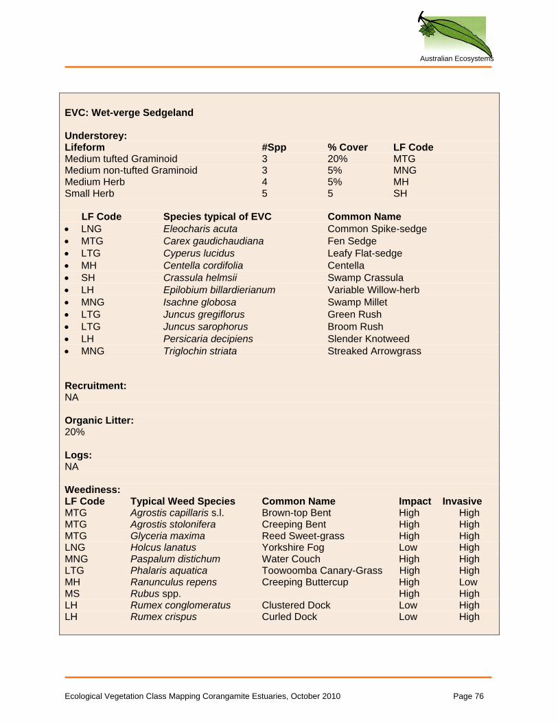
Australian Ecosystems
EVC: Wet-verge Sedgeland Understorey: Lifeform #Spp % Cover LF Code Medium tufted Graminoid 3 20% MTG Medium non-tufted Graminoid 3 5% MNG Medium Herb 4 5% MH Small Herb 5 5 SH LF Code Species typical of EVC Common Name • LNG Eleocharis acuta Common Spike-sedge • MTG Carex gaudichaudiana Fen Sedge • LTG Cyperus lucidus Leafy Flat-sedge • MH Centella cordifolia Centella • SH Crassula helmsii Swamp Crassula • LH Epilobium billardierianum Variable Willow-herb • MNG Isachne globosa Swamp Millet • LTG Juncus gregiflorus Green Rush • LTG Juncus sarophorus Broom Rush • LH Persicaria decipiens Slender Knotweed • MNG Triglochin striata Streaked Arrowgrass Recruitment: NA Organic Litter: 20% Logs: NA Weediness: LF Code Typical Weed Species Common Name Impact Invasive MTG Agrostis capillaris s.l. Brown-top Bent High High MTG Agrostis stolonifera Creeping Bent High High MTG Glyceria maxima Reed Sweet-grass High High LNG Holcus lanatus Yorkshire Fog Low High MNG Paspalum distichum Water Couch High High LTG Phalaris aquatica Toowoomba Canary-Grass High High MH Ranunculus repens Creeping Buttercup High Low MS Rubus spp. High High LH Rumex conglomeratus Clustered Dock Low High LH Rumex crispus Curled Dock Low High
Ecological Vegetation Class Mapping Corangamite Estuaries, October 2010 Page 76

Australian Ecosystems
APPENDIX 2: GIS METADATA
CCMA_v2. ESRI Shapefiles (.shp, .dbf, .sbn, .sbx, .shx) GDA94, zone 54 General: describes the distribution of vegetation by EVC. Fields:
• Estuary (text): name of estuary • Native (text): describes whether the polygon represents native vegetation, according to DSE’s
definition (“Native”, “Not_native”, other values are “unknown” in cases where site access was not granted, or “Water”)
• EVC_curr (number) : The current EVC, using standard DSE typology (see DSE website); with a few exceptions: 999 represents non-native vegetation, and any EVC followed by .9 represents vegetation that is structurally modified to a point where it barely resembles the EVC in question
• EVC_1750 (number): The suggested EVC before colonisation (pre-1750) • EVC_poten (number): The EVC that the site could now support if revegetated, given changes in
hydrology and landform that have taken place • Bench_bio (text): The bioregional benchmark used for condition assessments: EgL= East
Gippsland Lowlands, GipP=Gippsland Plain, OtP= Otway Plain, WaP=Warrnambool Plain, VVP=Victorian Volcanic Plain, new= informal benchmark created for this project (see text for explanation); none= no assessment made
• Lt (number): Habitat Hectares site component: Large tree score (99= not applicable) • Tcc (number): Habitat Hectares site component: Tree canopy score (99= not applicable) • Us (number): Habitat Hectares site component: Understorey score (99= not applicable) • W (number): Habitat Hectares site component: Weed score (99= not applicable) • R (number): Habitat Hectares site component: Recruitment score (99= not applicable) • Ol (number): Habitat Hectares site component: Organic litter score (99= not applicable) • L (number): Habitat Hectares site component: Logs score (99= not applicable) • Site_score (number): Habitat Hectares site score (weighted, maximum 75)
Ecological Vegetation Class Mapping Corangamite Estuaries, October 2010 Page 77

Australian Ecosystems
CCMA_thr_sp
ESRI Shapefiles (.shp, .dbf, .sbn, .sbx, .shx) GDA94, zone 54 General: describes the location of threatened species. Fields:
• Species (text): records scientific name of plant.
Ecological Vegetation Class Mapping Corangamite Estuaries, October 2010 Page 78
Australian Ecosystems
Ecological Vegetation Class Mapping Corangamite Estuaries, October 2010 Page 79
APPENDIX 3: ADDITIONAL PHOTOGRAPHS
Australian Ecosystems
Ecological Vegetation Class Mapping Corangamite Estuaries, October 2010 Page 80
Photoset 1: Curdies River EVCs LIST OF PHOTOGRAPHS Photograph 1, Brackish Grassland Curdies River, photographed by D Cook, June 2009 ...... 81
Photograph 2 Brackish Wetland Curdies River, photographed by D Cook, June 2009 .......... 81
Photograph 3 Coast Dune Grassland Curdies River, photographed by D Cook, June 2009 .. 82
Photograph 4 Coastal Dune Scrub Curdies River, photographed by D Cook, June 2009 ...... 82
Photograph 5 Estuarine Wetland Curdies River, photographed by D Cook, June 2009 ......... 83
Photograph 6 Herb-rich Foothill Forest, photographed by D Cook, June 2009....................... 83
Photograph 7 Swampy Woodland Curdies River, photographed by D Cook, June 2009 ....... 84
Photograph 8 Swamp Scrub Rivernook, photographed by D Cook, June 2009...................... 84
Photograph 9 Sandbar at Curdies River, photographed by D Cook, June 2009..................... 85
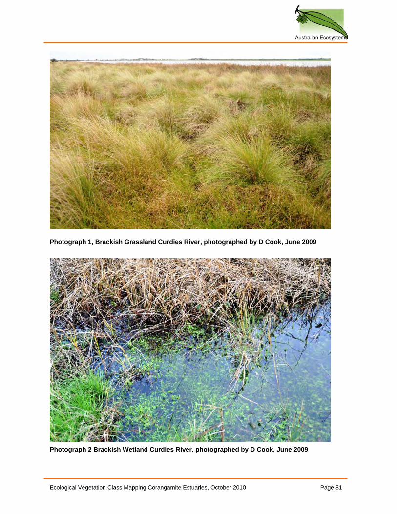
Australian Ecosystems
Ecological Vegetation Class Mapping Corangamite Estuaries, October 2010 Page 81
Photograph 1, Brackish Grassland Curdies River, photographed by D Cook, June 2009
Photograph 2 Brackish Wetland Curdies River, photographed by D Cook, June 2009
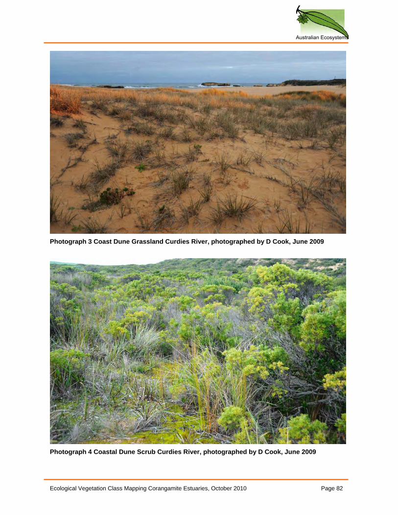
Australian Ecosystems
Ecological Vegetation Class Mapping Corangamite Estuaries, October 2010 Page 82
Photograph 3 Coast Dune Grassland Curdies River, photographed by D Cook, June 2009
Photograph 4 Coastal Dune Scrub Curdies River, photographed by D Cook, June 2009
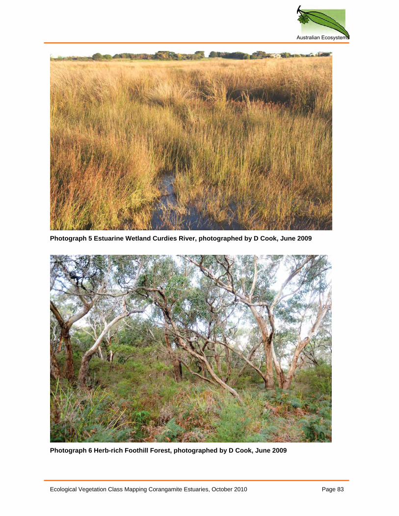
Australian Ecosystems
Ecological Vegetation Class Mapping Corangamite Estuaries, October 2010 Page 83
Photograph 5 Estuarine Wetland Curdies River, photographed by D Cook, June 2009
Photograph 6 Herb-rich Foothill Forest, photographed by D Cook, June 2009
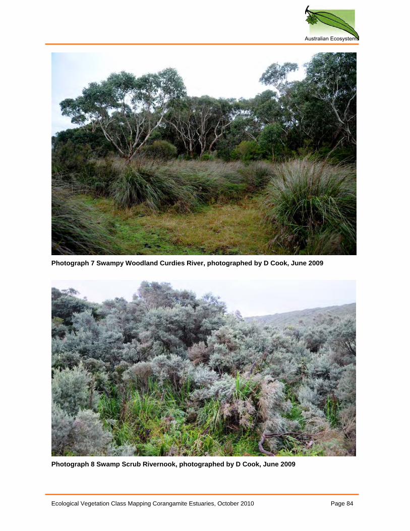
Australian Ecosystems
Ecological Vegetation Class Mapping Corangamite Estuaries, October 2010 Page 84
Photograph 7 Swampy Woodland Curdies River, photographed by D Cook, June 2009
Photograph 8 Swamp Scrub Rivernook, photographed by D Cook, June 2009
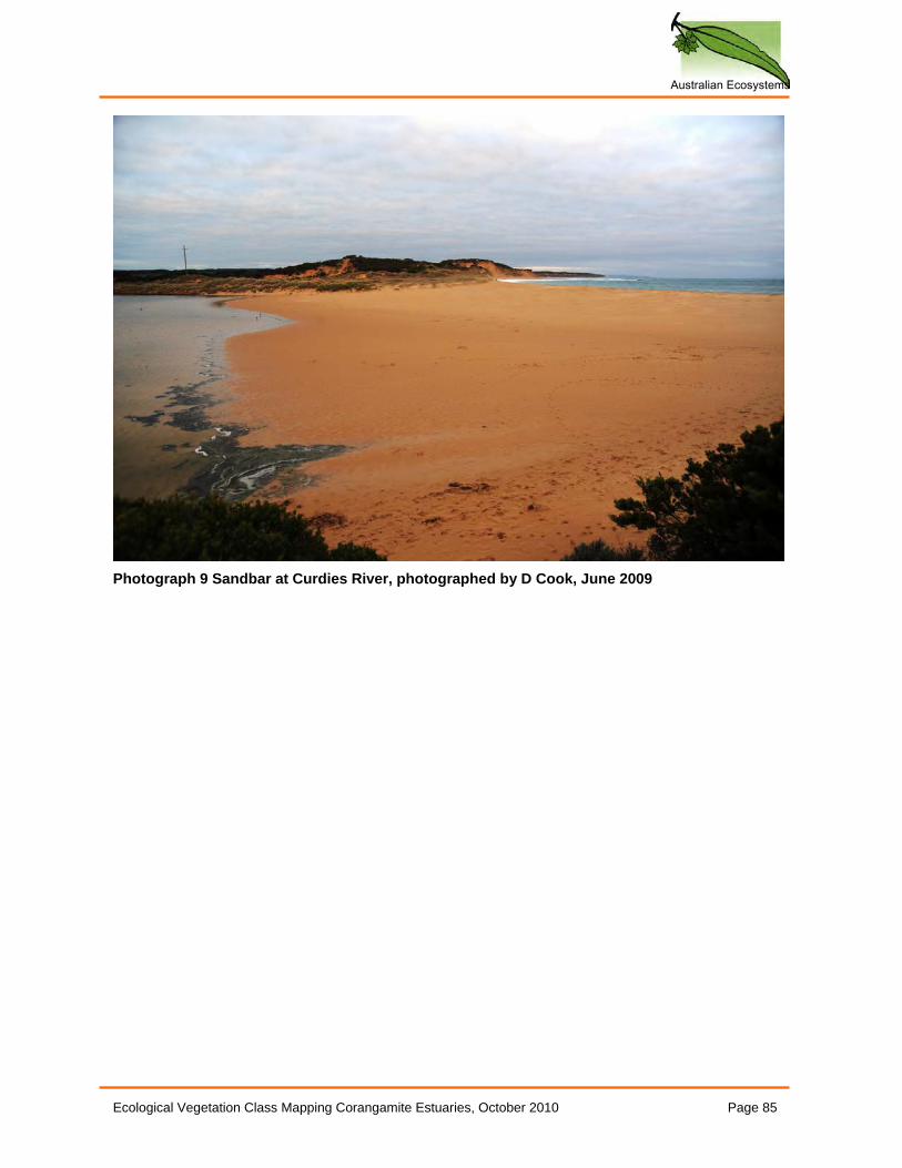
Australian Ecosystems
Ecological Vegetation Class Mapping Corangamite Estuaries, October 2010 Page 85
Photograph 9 Sandbar at Curdies River, photographed by D Cook, June 2009
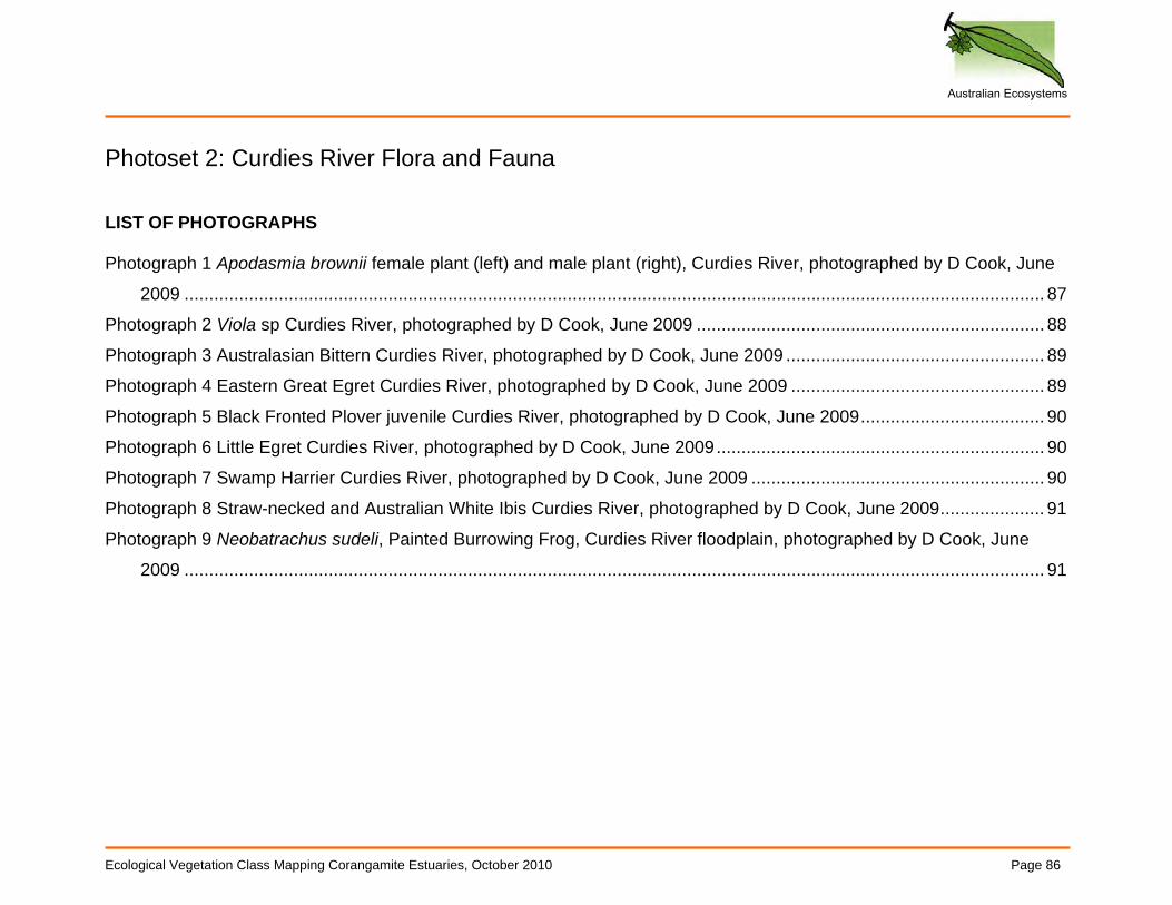
Australian Ecosystems
Ecological Vegetation Class Mapping Corangamite Estuaries, October 2010 Page 86
Photoset 2: Curdies River Flora and Fauna LIST OF PHOTOGRAPHS Photograph 1 Apodasmia brownii female plant (left) and male plant (right), Curdies River, photographed by D Cook, June
2009 ............................................................................................................................................................................. 87
Photograph 2 Viola sp Curdies River, photographed by D Cook, June 2009 ...................................................................... 88
Photograph 3 Australasian Bittern Curdies River, photographed by D Cook, June 2009 .................................................... 89
Photograph 4 Eastern Great Egret Curdies River, photographed by D Cook, June 2009 ................................................... 89
Photograph 5 Black Fronted Plover juvenile Curdies River, photographed by D Cook, June 2009..................................... 90
Photograph 6 Little Egret Curdies River, photographed by D Cook, June 2009.................................................................. 90
Photograph 7 Swamp Harrier Curdies River, photographed by D Cook, June 2009 ........................................................... 90
Photograph 8 Straw-necked and Australian White Ibis Curdies River, photographed by D Cook, June 2009..................... 91
Photograph 9 Neobatrachus sudeli, Painted Burrowing Frog, Curdies River floodplain, photographed by D Cook, June
2009 ............................................................................................................................................................................. 91
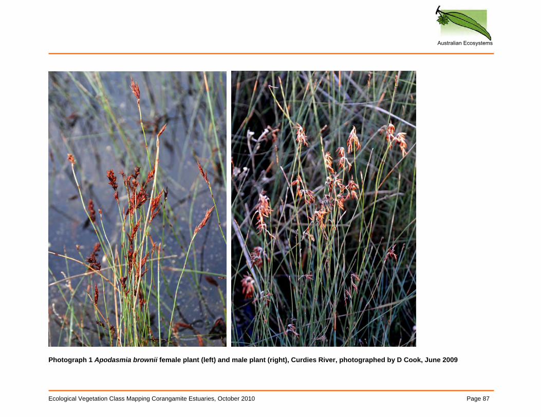
Australian Ecosystems
Ecological Vegetation Class Mapping Corangamite Estuaries, October 2010 Page 87
Photograph 1 Apodasmia brownii female plant (left) and male plant (right), Curdies River, photographed by D Cook, June 2009
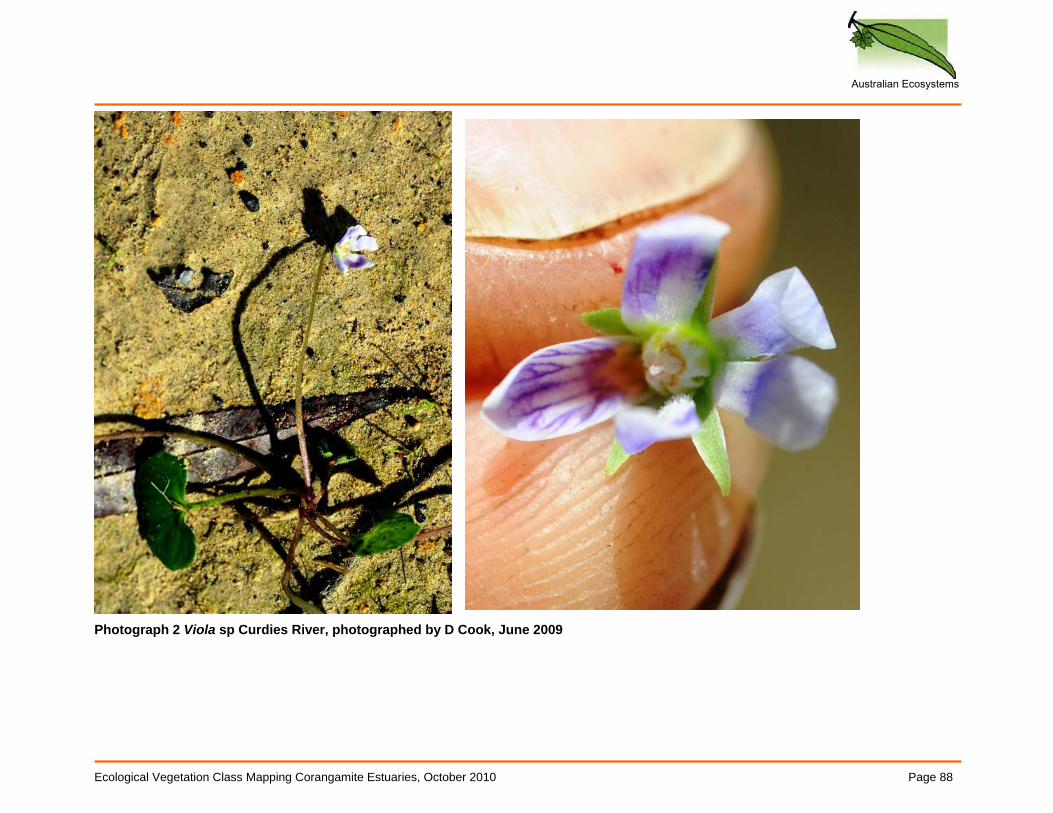
Australian Ecosystems
Ecological Vegetation Class Mapping Corangamite Estuaries, October 2010 Page 88
Photograph 2 Viola sp Curdies River, photographed by D Cook, June 2009
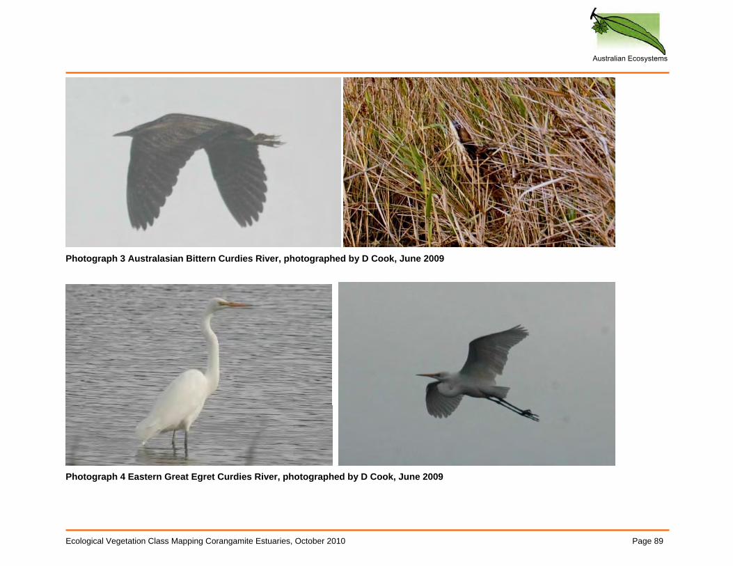
Australian Ecosystems
Ecological Vegetation Class Mapping Corangamite Estuaries, October 2010 Page 89
Photograph 3 Australasian Bittern Curdies River, photographed by D Cook, June 2009
Photograph 4 Eastern Great Egret Curdies River, photographed by D Cook, June 2009
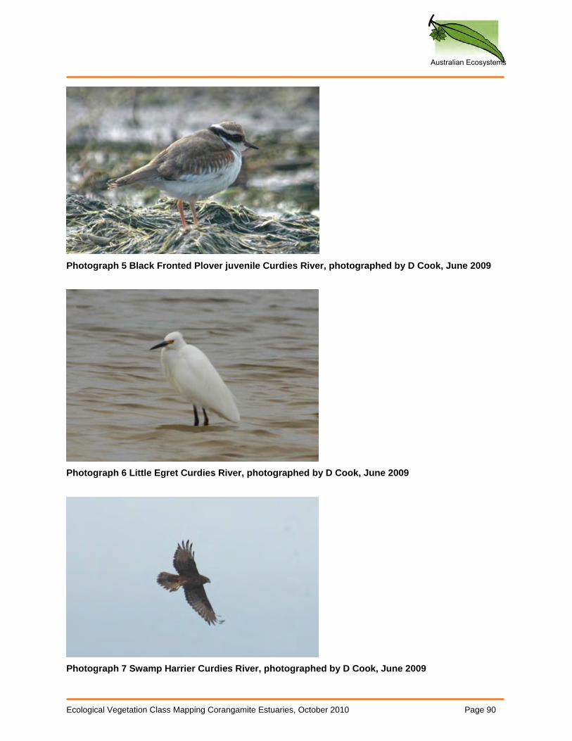
Australian Ecosystems
Ecological Vegetation Class Mapping Corangamite Estuaries, October 2010 Page 90
Photograph 5 Black Fronted Plover juvenile Curdies River, photographed by D Cook, June 2009
Photograph 6 Little Egret Curdies River, photographed by D Cook, June 2009
Photograph 7 Swamp Harrier Curdies River, photographed by D Cook, June 2009
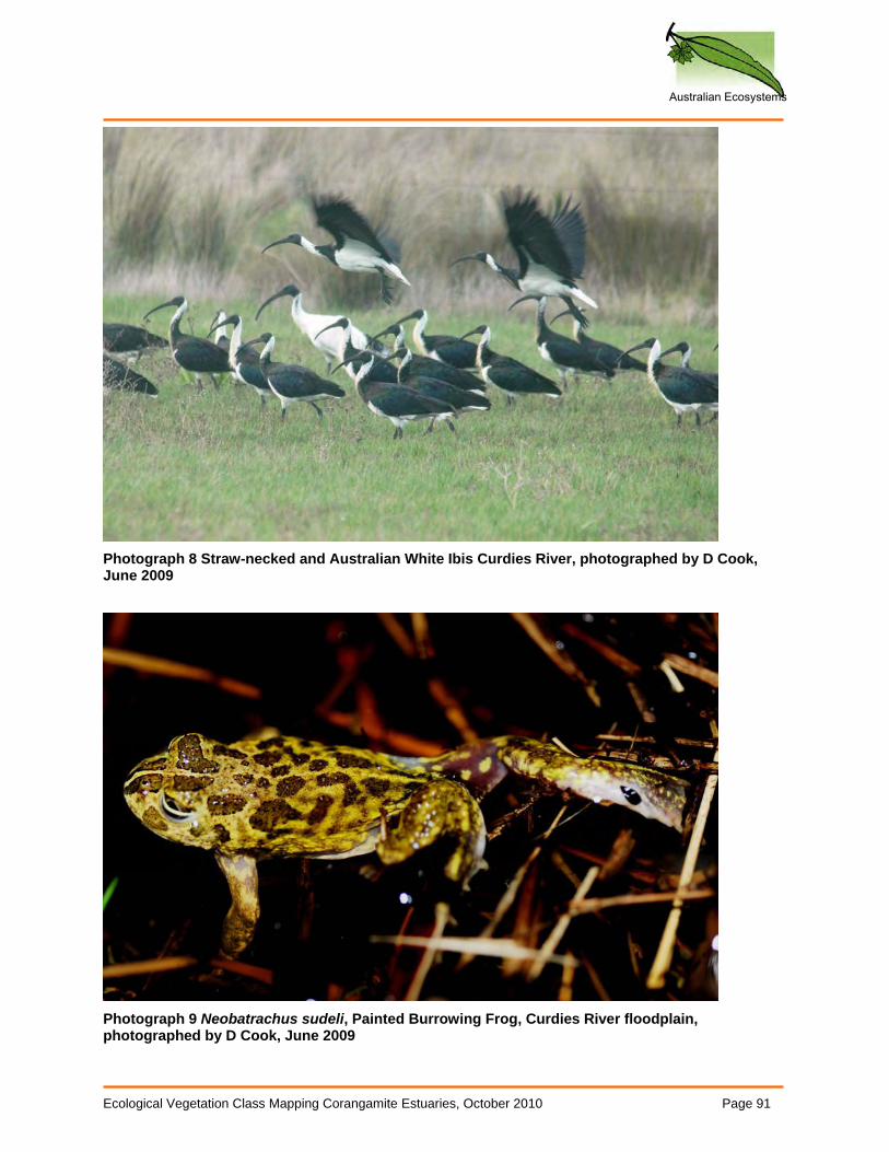
Australian Ecosystems
Ecological Vegetation Class Mapping Corangamite Estuaries, October 2010 Page 91
Photograph 8 Straw-necked and Australian White Ibis Curdies River, photographed by D Cook, June 2009
Photograph 9 Neobatrachus sudeli, Painted Burrowing Frog, Curdies River floodplain, photographed by D Cook, June 2009
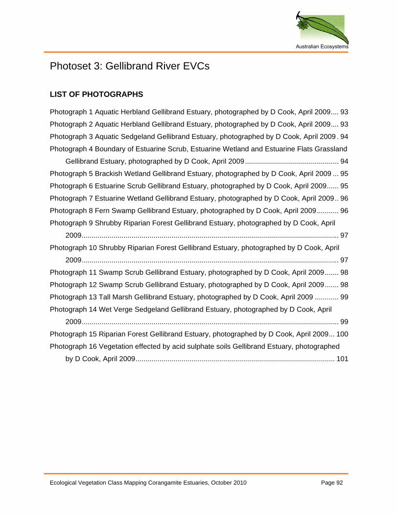
Australian Ecosystems
Ecological Vegetation Class Mapping Corangamite Estuaries, October 2010 Page 92
Photoset 3: Gellibrand River EVCs LIST OF PHOTOGRAPHS Photograph 1 Aquatic Herbland Gellibrand Estuary, photographed by D Cook, April 2009.... 93
Photograph 2 Aquatic Herbland Gellibrand Estuary, photographed by D Cook, April 2009.... 93
Photograph 3 Aquatic Sedgeland Gellibrand Estuary, photographed by D Cook, April 2009 . 94
Photograph 4 Boundary of Estuarine Scrub, Estuarine Wetland and Estuarine Flats Grassland
Gellibrand Estuary, photographed by D Cook, April 2009............................................... 94
Photograph 5 Brackish Wetland Gellibrand Estuary, photographed by D Cook, April 2009 ... 95
Photograph 6 Estuarine Scrub Gellibrand Estuary, photographed by D Cook, April 2009...... 95
Photograph 7 Estuarine Wetland Gellibrand Estuary, photographed by D Cook, April 2009.. 96
Photograph 8 Fern Swamp Gellibrand Estuary, photographed by D Cook, April 2009........... 96
Photograph 9 Shrubby Riparian Forest Gellibrand Estuary, photographed by D Cook, April
2009................................................................................................................................. 97
Photograph 10 Shrubby Riparian Forest Gellibrand Estuary, photographed by D Cook, April
2009................................................................................................................................. 97
Photograph 11 Swamp Scrub Gellibrand Estuary, photographed by D Cook, April 2009....... 98
Photograph 12 Swamp Scrub Gellibrand Estuary, photographed by D Cook, April 2009....... 98
Photograph 13 Tall Marsh Gellibrand Estuary, photographed by D Cook, April 2009 ............ 99
Photograph 14 Wet Verge Sedgeland Gellibrand Estuary, photographed by D Cook, April
2009................................................................................................................................. 99
Photograph 15 Riparian Forest Gellibrand Estuary, photographed by D Cook, April 2009... 100
Photograph 16 Vegetation effected by acid sulphate soils Gellibrand Estuary, photographed
by D Cook, April 2009.................................................................................................... 101
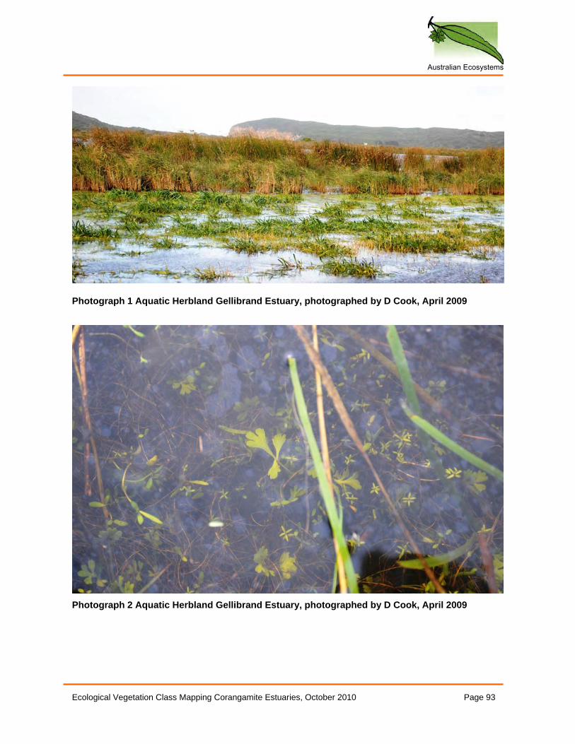
Australian Ecosystems
Ecological Vegetation Class Mapping Corangamite Estuaries, October 2010 Page 93
Photograph 1 Aquatic Herbland Gellibrand Estuary, photographed by D Cook, April 2009
Photograph 2 Aquatic Herbland Gellibrand Estuary, photographed by D Cook, April 2009
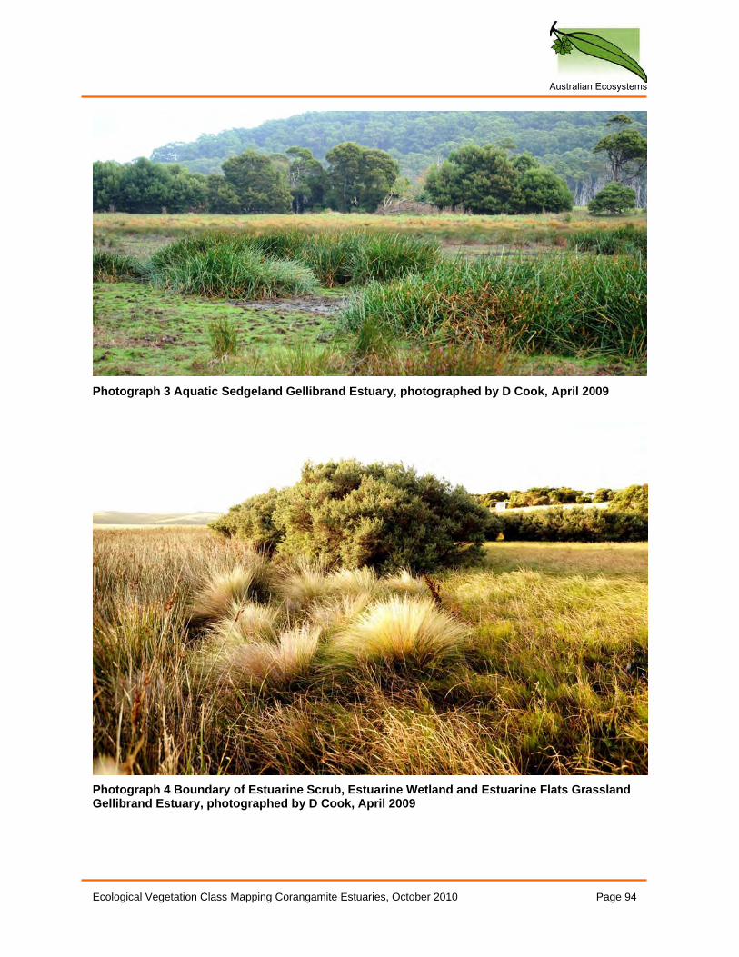
Australian Ecosystems
Ecological Vegetation Class Mapping Corangamite Estuaries, October 2010 Page 94
Photograph 3 Aquatic Sedgeland Gellibrand Estuary, photographed by D Cook, April 2009
Photograph 4 Boundary of Estuarine Scrub, Estuarine Wetland and Estuarine Flats Grassland Gellibrand Estuary, photographed by D Cook, April 2009
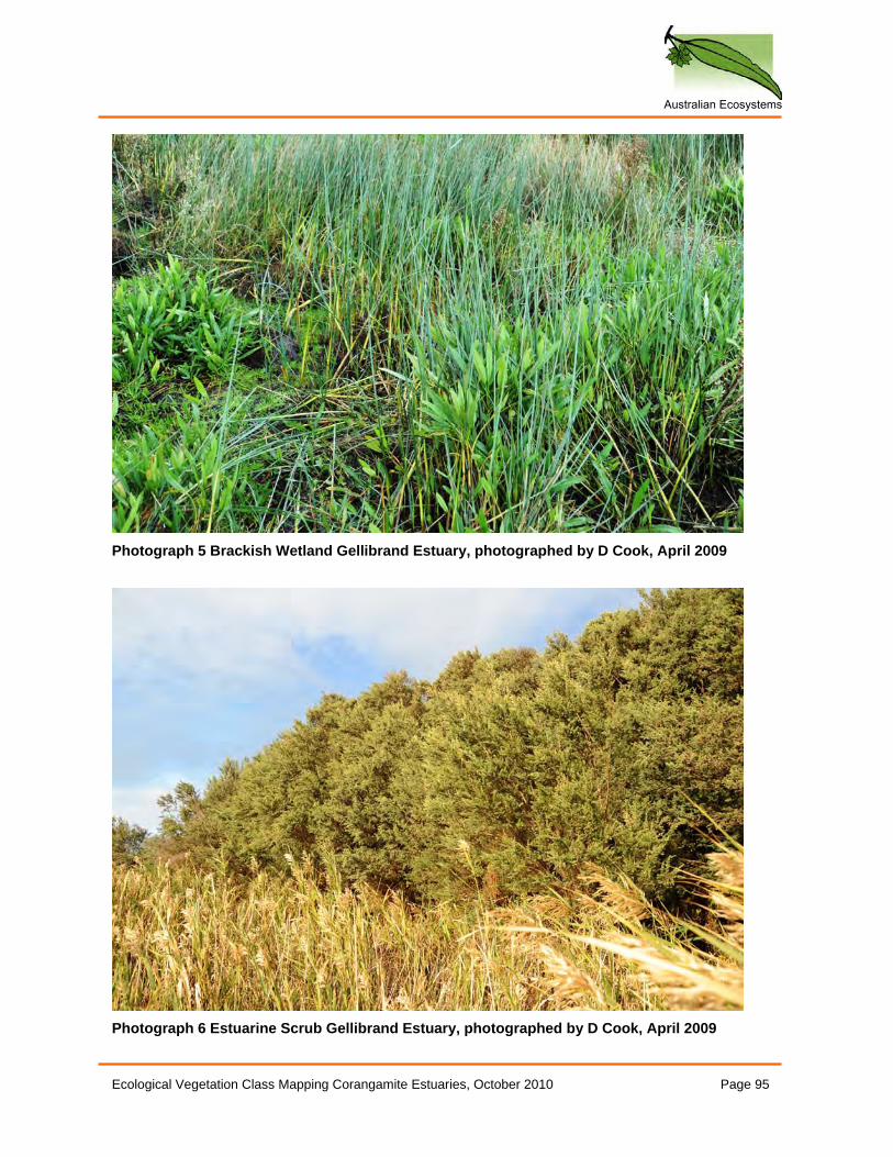
Australian Ecosystems
Ecological Vegetation Class Mapping Corangamite Estuaries, October 2010 Page 95
Photograph 5 Brackish Wetland Gellibrand Estuary, photographed by D Cook, April 2009
Photograph 6 Estuarine Scrub Gellibrand Estuary, photographed by D Cook, April 2009
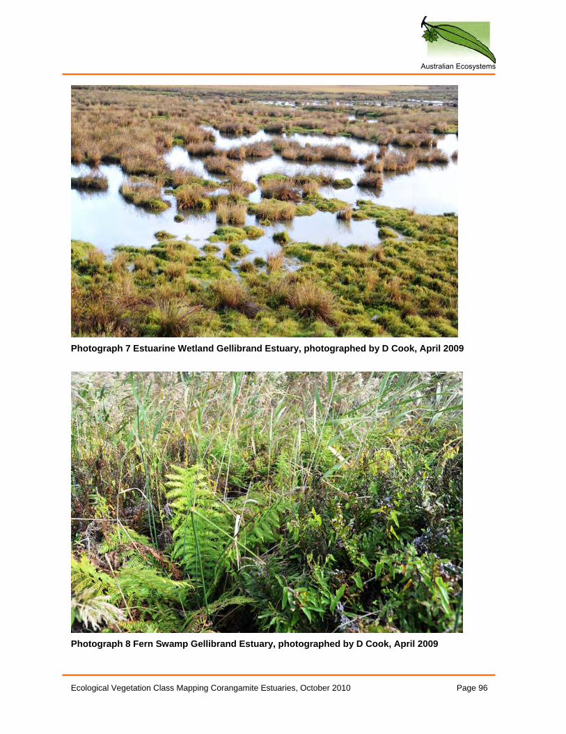
Australian Ecosystems
Ecological Vegetation Class Mapping Corangamite Estuaries, October 2010 Page 96
Photograph 7 Estuarine Wetland Gellibrand Estuary, photographed by D Cook, April 2009
Photograph 8 Fern Swamp Gellibrand Estuary, photographed by D Cook, April 2009
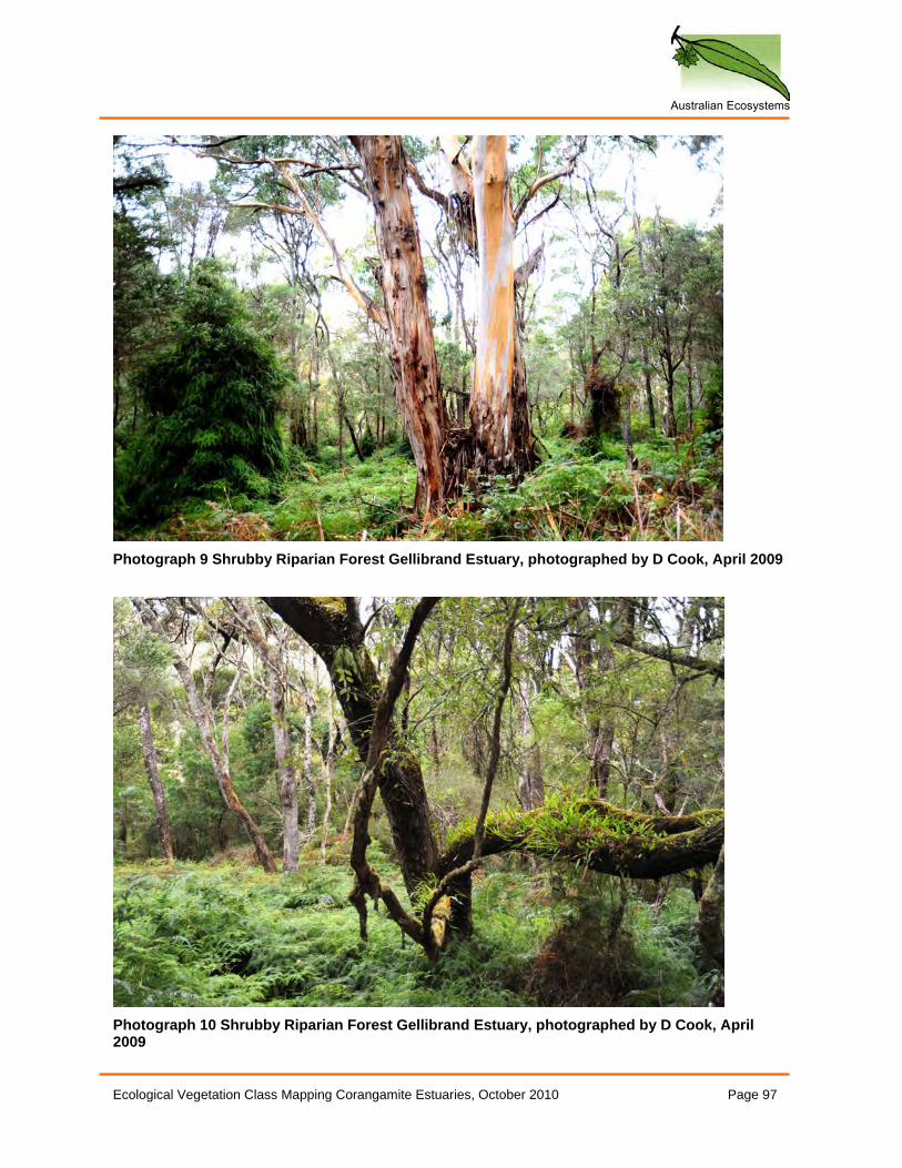
Australian Ecosystems
Ecological Vegetation Class Mapping Corangamite Estuaries, October 2010 Page 97
Photograph 9 Shrubby Riparian Forest Gellibrand Estuary, photographed by D Cook, April 2009
Photograph 10 Shrubby Riparian Forest Gellibrand Estuary, photographed by D Cook, April 2009
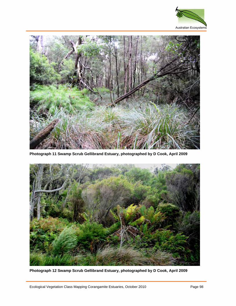
Australian Ecosystems
Ecological Vegetation Class Mapping Corangamite Estuaries, October 2010 Page 98
Photograph 11 Swamp Scrub Gellibrand Estuary, photographed by D Cook, April 2009
Photograph 12 Swamp Scrub Gellibrand Estuary, photographed by D Cook, April 2009
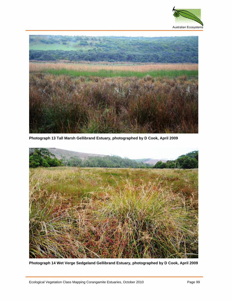
Australian Ecosystems
Ecological Vegetation Class Mapping Corangamite Estuaries, October 2010 Page 99
Photograph 13 Tall Marsh Gellibrand Estuary, photographed by D Cook, April 2009
Photograph 14 Wet Verge Sedgeland Gellibrand Estuary, photographed by D Cook, April 2009
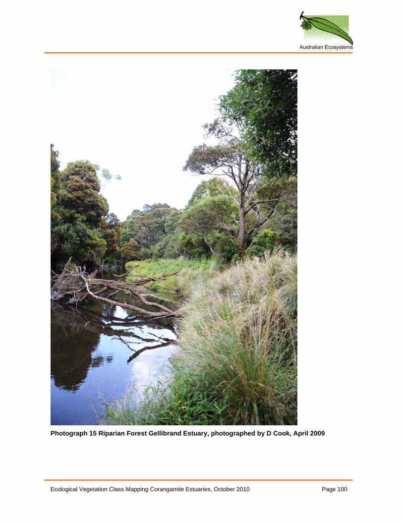
Australian Ecosystems
Ecological Vegetation Class Mapping Corangamite Estuaries, October 2010 Page 100
Photograph 15 Riparian Forest Gellibrand Estuary, photographed by D Cook, April 2009
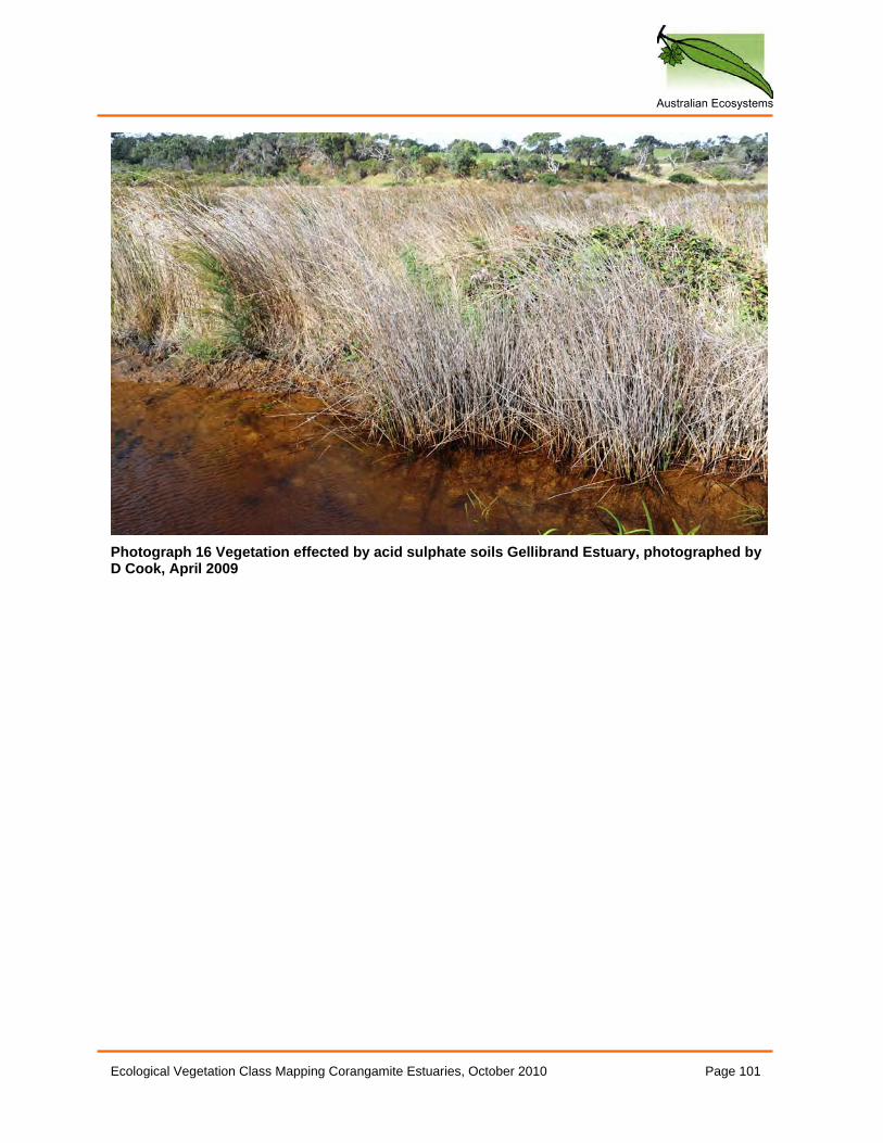
Australian Ecosystems
Ecological Vegetation Class Mapping Corangamite Estuaries, October 2010 Page 101
Photograph 16 Vegetation effected by acid sulphate soils Gellibrand Estuary, photographed by D Cook, April 2009
Australian Ecosystems
Ecological Vegetation Class Mapping Corangamite Estuaries, October 2010 Page 102
Photoset 4: Gellibrand River Flora and Fauna LIST OF PHOTOGRAPHS Photograph 1 Carex tasmanica Gellibrand Estuary, photographed by D Cook, April 2009 ...... 103
Photograph 2 Hypsela tridens, Leptinella reptans and Hydrocotyle sibthorpioides, Gellibrand
Estuary, photographed by D Cook, April 2009 .................................................................. 103
Photograph 3 Juncus acutus Gellibrand Estuary, photographed by D Cook, April 2009 .......... 104
Photograph 4 Pterostylis tenuissima (left) and Cuscuta sp. (right) Gellibrand Estuary,
photographed by D Cook, April 2009 ................................................................................ 105
Photograph 5 Cuscuta sp. Gellibrand Estuary, photographed by D Cook, April 2009 .............. 106
Photograph 6 Dead Eastern Pygmy Perch from fish kill, Gellibrand Estuary, photographed by D
Cook, April 2009................................................................................................................ 106
Photograph 7 Geocrinia victoriana Gellibrand Estuary, photographed by D Cook, April 2009 . 107
Photograph 8 Litoria ewingi Gellibrand Estuary, photographed by D Cook, April 2009 ............ 107
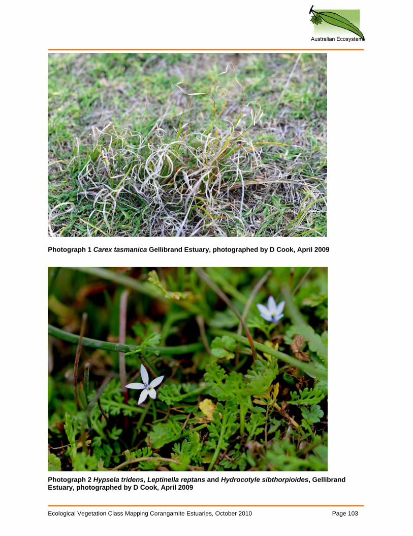
Australian Ecosystems
Ecological Vegetation Class Mapping Corangamite Estuaries, October 2010 Page 103
Photograph 1 Carex tasmanica Gellibrand Estuary, photographed by D Cook, April 2009
Photograph 2 Hypsela tridens, Leptinella reptans and Hydrocotyle sibthorpioides, Gellibrand Estuary, photographed by D Cook, April 2009
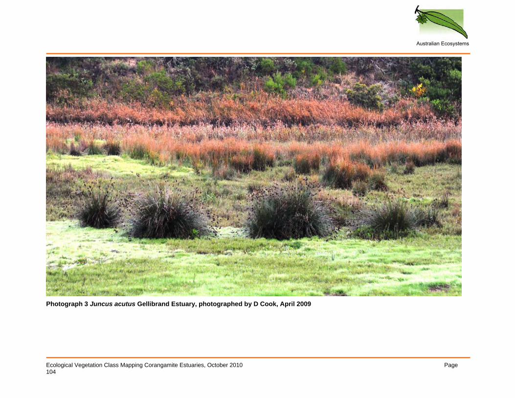
Australian Ecosystems
Ecological Vegetation Class Mapping Corangamite Estuaries, October 2010 Page 104
Photograph 3 Juncus acutus Gellibrand Estuary, photographed by D Cook, April 2009
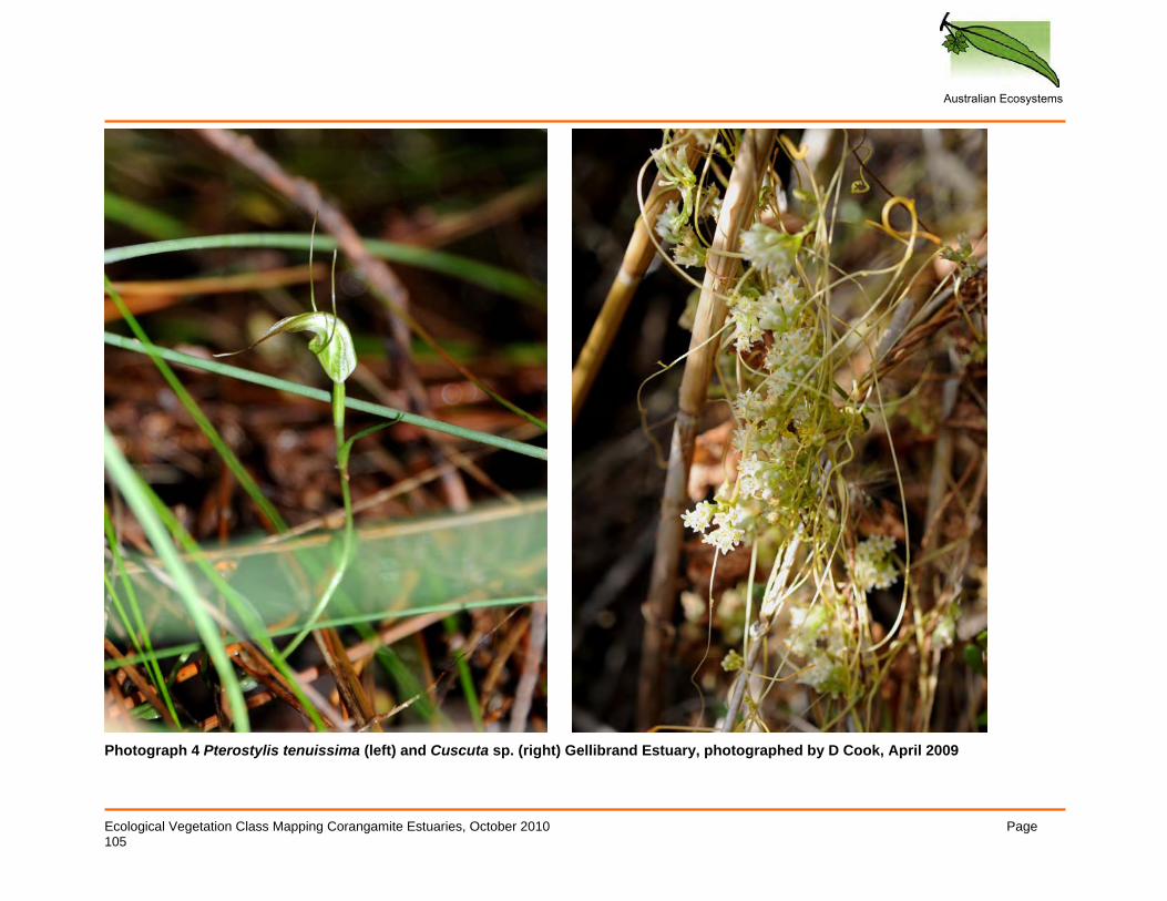
Australian Ecosystems
Ecological Vegetation Class Mapping Corangamite Estuaries, October 2010 Page 105
Photograph 4 Pterostylis tenuissima (left) and Cuscuta sp. (right) Gellibrand Estuary, photographed by D Cook, April 2009
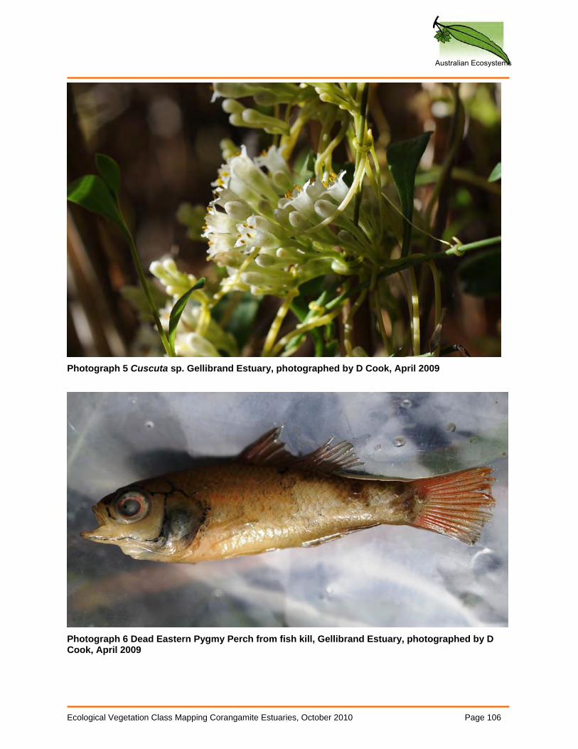
Australian Ecosystems
Ecological Vegetation Class Mapping Corangamite Estuaries, October 2010 Page 106
Photograph 5 Cuscuta sp. Gellibrand Estuary, photographed by D Cook, April 2009
Photograph 6 Dead Eastern Pygmy Perch from fish kill, Gellibrand Estuary, photographed by D Cook, April 2009
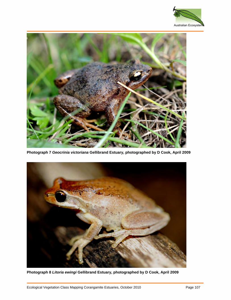
Australian Ecosystems
Ecological Vegetation Class Mapping Corangamite Estuaries, October 2010 Page 107
Photograph 7 Geocrinia victoriana Gellibrand Estuary, photographed by D Cook, April 2009
Photograph 8 Litoria ewingi Gellibrand Estuary, photographed by D Cook, April 2009