Embed Size (px)
Citation preview
A
bRiadtwblldtfcf©
K
1
dtHlT
FI
0d
Landscape and Urban Planning 81 (2007) 328–340
Edge effects of roads on temperature, light, canopy cover, and canopyheight in laurel and pine forests (Tenerife, Canary Islands)
Juan D. Delgado a,∗, Natalia L. Arroyo b, Jose R. Arevalo a, Jose M. Fernandez-Palacios a
a Departamento de Ecologıa, Facultad de Biologıa, E-38206, Universidad de La Laguna, Tenerife, Canary Islands, Spainb Escuela Superior de Ingenierıa Civil e Industrial, Facultad de Matematicas, E-38206, Universidad de La Laguna, Tenerife, Canary Islands, Spain
Received 26 June 2006; received in revised form 17 November 2006; accepted 7 January 2007Available online 8 March 2007
bstract
The estimation of the road edge effect is useful to understand changes induced by the road network on ecosystems. Road networks on islands mayreak ecosystem integrity through microclimate edge effects, which are known to be associated with disturbances to animal and plant communities.oad edge effects have been scarcely studied on oceanic islands. In this paper we studied road edge effects on microclimate and canopy structure
n laurel and pine forests in Tenerife (Canary Islands). We assessed depth of road edge effect for temperature at four vertical layers (soil, litter andir at 5 cm and 1.3 m above ground), light intensity, canopy cover and height, in transects running from narrow (6–7 m width) asphalt roads andust trails to 100 m to the interior of both forests. We used an ANOVA procedure with Helmert difference contrasts to identify the distances alongransects over which edge effects were significant. We detected significant gradients for most parameters but they were consistently narrow bothithin and between forests. In the laurel forest, we detected highly significant gradients for soil temperature, light, and canopy cover and height inoth asphalt and unpaved roads. In the pine forest, we detected a highly significant gradient for soil temperature at asphalt roads, and a significantight gradient for both asphalt and unpaved roads. From the road edge to the forest interior, significant temperature changes persisted for only 3 m,ight variation persisted for 6 m, and canopy cover and height changed significantly within the first 10 m. Asphalt roads and dust trails revealedifferent patterns of variation for temperature between edge and interior. No differences were found between the two types of roads in edge-interiorrends for light or canopy structure. The abruptness of microclimate and canopy gradients was slightly higher in the laurel forest than in the pine
orest, caused by a higher edge contrast in the former. The depth of the road edge effect found in laurel and pine forests was small, but it could haveumulative effects on forest microclimate and forest associated biota at the island scale. Such changes deserve attention by local road managersor planning and design purposes.2007 Elsevier B.V. All rights reserved.
Road
aSctm
eywords: Canary Islands; Canopy height; Canopy cover; Edge; Forest; Light;
. Introduction
Undoubtedly, roads play a key role in urban and suburbanevelopment, facilitate movements of human population overhe land, and connect societies and economies (Havlick, 2002).
owever, at the same time, roads generate many collateral prob-ems for the conservation of ecosystems (Spellerberg, 1998;rombulak and Frissell, 2000; Forman et al., 2002; Song et
∗ Corresponding author. Permanent address: Departamento de Fısica Basica,acultad de Fısica, E-38206, Universidad de La Laguna, Tenerife, Canaryslands, Spain. Tel.: +34 922 318363; fax: +34 922 318311.
E-mail address: [email protected] (J.D. Delgado).
tecatA2se
169-2046/$ – see front matter © 2007 Elsevier B.V. All rights reserved.oi:10.1016/j.landurbplan.2007.01.005
; Temperature; Tenerife
l., 2005) and landscape integrity (Jaarsma and Willems, 2002,errano et al., 2002). Roads create micro and mesoclimatichanges and probably contribute to global macroclimate change,hrough variation of the received sun radiation, wind regimes,
oisture and temperature (Forman et al., 2002). Depending onhe traversed ecosystem, road impacts on microclimate, veg-tation and fauna can vary widely. For example, forest roadsreate linear gaps that remove forest area, divide the ecosystemnd create structural edges where abiotic and biotic condi-ions change more abruptly than in open bushland (Forman and
lexander, 1998; Spellerberg, 1998; Trombulak and Frissell,000). In forested areas, the forest matrix dominates the land-cape, but roads remove or disturb large areas through indirectffects that accumulate and interact at higher scales (Theobald
d Ur
eao(eehfit2dsd
a(2E2amfpwe
bda(wvaI
pattaatt
etoGFgC
sna1
e2m(doo
drrsC
frpltRipaheaprrsnabk
etpggff
2
ost(tL
J.D. Delgado et al. / Landscape an
t al., 1997; Forman, 1998; Heilman et al., 2002; Saunders etl., 2002; Riitters and Wickman, 2003). Disturbances on abi-tic variables can extend variable distances beyond the road gapWilliams-Linera, 1990; Young and Mitchell, 1994; Laurancet al., 1997), and microclimate edge effects have been shown toxtend to the surrounding habitats from only a few meters up toundreds of meters (see examples in Forman et al., 2002). There-ore, the estimation of the road edge effect for abiotic variabless a useful tool to assess the amount of territory that is func-ionally affected by the road network (Forman and Deblinger,000). Concretely, the identification of underlying abiotic gra-ients that percolate the fragmented ecosystem is a necessarytep to understand road influence upon ecosystem structure andynamics (Forman and Alexander, 1998).
Oceanic islands worldwide are being heavily changednd constrained by urbanization and transportation pressuresWhittaker, 1998; Fernandez-Palacios et al., 2004; Song et al.,005). The Canary Islands have the highest road density of all theuropean islands, 6 km km−2 (Martın and Fernandez-Palacios,001). In Tenerife, the road network occupies 3% of the islandrea, but this is a conservative figure based only on paved roadsainly on non-protected territory. The Canarian laurel and pine
orests are traversed by a dense network of corridors includingaved and unpaved roads, fire-breaks and powerline clearings,hich have received little attention as ecological and landscape
lements (Martın and Fernandez-Palacios, 2001).Previous studies have evaluated microclimatic differences
etween laurel forest natural gaps and interior revealing largeifferences in global radiation, photosynthetically active radi-tion (PAR), temperature, wind speed, and relative humidityAschan et al., 1994; Gonzalez-Rodrıguez et al., 2001). No studyas available for the Canarian pine forest. Apparently, no pre-ious work has been devoted to differences between road gapsnd forest interior in both laurel and pine forests in the Canaryslands.
An evaluation of the ecological edge effects of the trans-ortation infrastructure is urgent for the Canarian archipelagond for many other oceanic islands. Roads and associated struc-ures are transforming amounts of territory probably far largerhan expected by local environmental authorities. Local man-gers rely on mostly subjective and partial environmental impactssessments that do not consider road edge effects, the fragmen-ation process implied, and the specific damages to habitats andhe biota (Byron et al., 2000).
Microclimate gradients across road edges influence manycological processes and patterns. Abiotic gradients reachinghe forest interior from the road may transform a large amountf forest into suitable habitat for exotic plants (Fraver, 1994;oosem and Turton, 2000) and animals (Didham et al., 1998).loristic composition changes more or less suddenly along suchradients (e.g. Landenberger and Ostergren, 2002; Hansen andlevenger, 2005).
In the laurel forest, forest destruction by roads and other
tructures causes progressive vegetation degradation, with theew open spaces being concealed by shrubs, bracken fernsnd numerous introduced Mediterranean elements (Hollermann,981). Numerous exotic plants are increasingly colonizing for-Pstf
ban Planning 81 (2007) 328–340 329
st road edges in the Canary Islands (Gonzalez and Gonzalez,001; Arevalo et al., 2005). However, most exotic plants andany sun-loving native ones are apparently limited to narrow
1–5 m) open roadsides. Probably, microclimatic changes pro-uced in the zone of road edge effect are favoring the spreadingf exotics outward the road surface in the Canarian forests andther habitats (Arevalo et al., 2005).
Forest road edges in the Canaries also shelter high plantiversity and an important degree of endemism, especiallyegarding native edge-species and light-demanding ones. At theegional scale, roads would promote native sun-loving elements,ince natural treefall gaps occur at very low frequencies in theanarian laurel forest (Arevalo and Fernandez-Palacios, 1998).
Regarding non-native animals, introduced ship rats use morerequently laurel and pine forest road edges than the forest inte-ior when foraging (Delgado et al., 2001), and are also strong nestredators along and near roads (Delgado et al., 2005). Endemicizards (Gallotia galloti) were more abundant along road edgeshan at the interior of both forests (Delgado et al., in press).oads were thought to play a probable role as corridors through
nhospitable forest matrix for these lizards, changing naturalatterns of abundance, distribution and population genetic vari-tion at the island scale. In some laurel forest patches, theseeliothermic lizards are found only in a narrow stretch of for-st outward the road surface where microclimatic requirementsre met (Delgado et al., in press). If important ecological com-onents (i.e. decomposers, top predators, pollinators) changeelative abundances due to microclimate changes caused byoads, changes in key ecological processes can be expected totart alongside roads (i.e. changes in decomposition rates ofecromass, predator–prey relationships, or plant–animal mutu-lisms) (Giller, 1996; Hansson, 2000). The interpretation of suchiotic disturbances initiated at road gaps would benefit fromnowing the underlying abiotic gradients.
In this paper, we evaluate microclimatic and structural gradi-nts from roads to forest interiors. Along transects perpendicularo roads in both laurel and pine forests, we measured: (a) tem-erature at ground level, leaf-litter level, and two heights aboveround; (b) light intensity; (c) canopy cover and height. Ouroal was to determine if gradients in these variables differedor paved and unpaved roads, and between laurel and pineorests.
. Study area
The field work was conducted on the laurel and pine forestsf Tenerife (Canary Islands, 27–29◦N, 13–18◦W). Laurel forestites are located on the Anaga mountains within the limits ofhe Parque Rural de Anaga, in the Anaga massif, NE Tenerife700–1000 m asl) (Fig. 1). The pine forest sites are included inhe Parque Natural Corona Forestal and Paisaje Protegido Lasagunetas, along the dorsal road between La Esperanza and the
arque Nacional del Teide (∼1000–2000 m). The asphalt roadegments studied have average daily traffic densities (mainlyourism particular cars and buses) of 253–1317 vehicles (laurelorest) and 1536–2460 vehicles (pine forest) (Anon, 2004).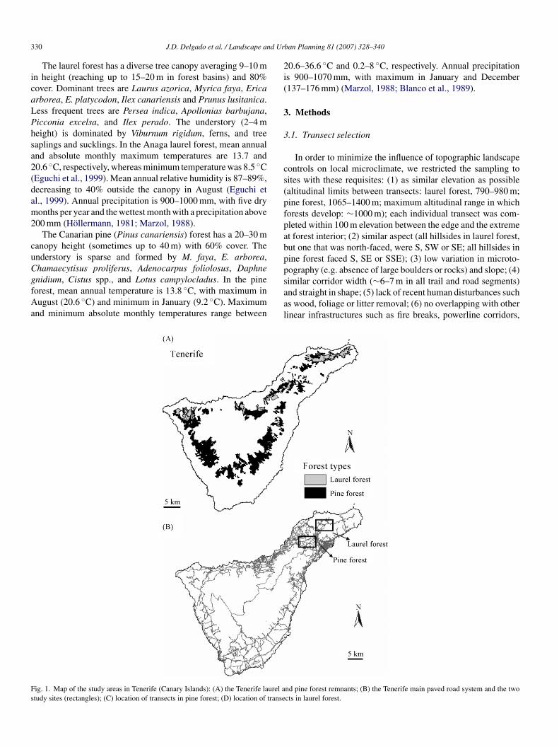
3 d Ur
icaLPhsa2(dam2
cuCgfAa
2i(
3
3
cs(pfpabpp
Fs
30 J.D. Delgado et al. / Landscape an
The laurel forest has a diverse tree canopy averaging 9–10 mn height (reaching up to 15–20 m in forest basins) and 80%over. Dominant trees are Laurus azorica, Myrica faya, Ericarborea, E. platycodon, Ilex canariensis and Prunus lusitanica.ess frequent trees are Persea indica, Apollonias barbujana,icconia excelsa, and Ilex perado. The understory (2–4 meight) is dominated by Viburnum rigidum, ferns, and treeaplings and sucklings. In the Anaga laurel forest, mean annualnd absolute monthly maximum temperatures are 13.7 and0.6 ◦C, respectively, whereas minimum temperature was 8.5 ◦CEguchi et al., 1999). Mean annual relative humidity is 87–89%,ecreasing to 40% outside the canopy in August (Eguchi etl., 1999). Annual precipitation is 900–1000 mm, with five dryonths per year and the wettest month with a precipitation above
00 mm (Hollermann, 1981; Marzol, 1988).The Canarian pine (Pinus canariensis) forest has a 20–30 m
anopy height (sometimes up to 40 m) with 60% cover. Thenderstory is sparse and formed by M. faya, E. arborea,hamaecytisus proliferus, Adenocarpus foliolosus, Daphne
nidium, Cistus spp., and Lotus campylocladus. In the pineorest, mean annual temperature is 13.8 ◦C, with maximum inugust (20.6 ◦C) and minimum in January (9.2 ◦C). Maximumnd minimum absolute monthly temperatures range between
saal
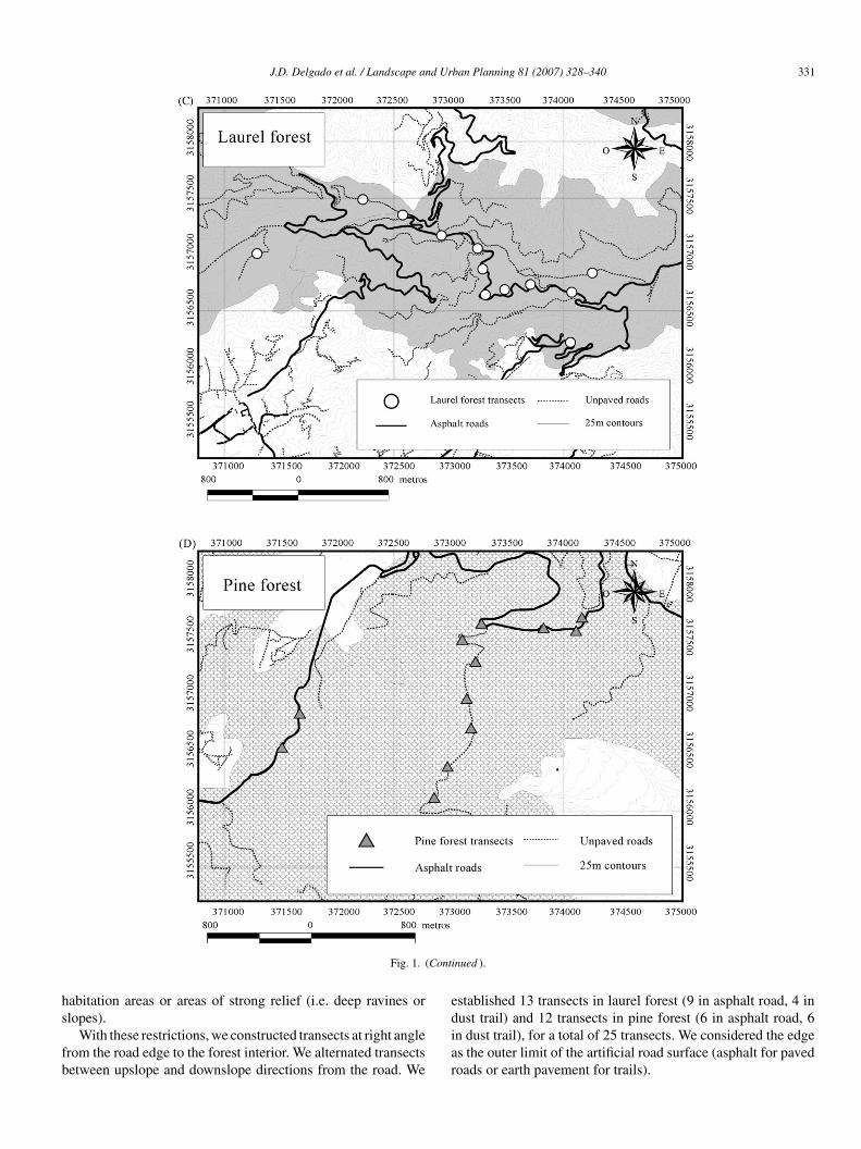
ig. 1. Map of the study areas in Tenerife (Canary Islands): (A) the Tenerife laurel atudy sites (rectangles); (C) location of transects in pine forest; (D) location of transe
ban Planning 81 (2007) 328–340
0.6–36.6 ◦C and 0.2–8 ◦C, respectively. Annual precipitations 900–1070 mm, with maximum in January and December137–176 mm) (Marzol, 1988; Blanco et al., 1989).
. Methods
.1. Transect selection
In order to minimize the influence of topographic landscapeontrols on local microclimate, we restricted the sampling toites with these requisites: (1) as similar elevation as possiblealtitudinal limits between transects: laurel forest, 790–980 m;ine forest, 1065–1400 m; maximum altitudinal range in whichorests develop: ∼1000 m); each individual transect was com-leted within 100 m elevation between the edge and the extremet forest interior; (2) similar aspect (all hillsides in laurel forest,ut one that was north-faced, were S, SW or SE; all hillsides inine forest faced S, SE or SSE); (3) low variation in microto-ography (e.g. absence of large boulders or rocks) and slope; (4)
imilar corridor width (∼6–7 m in all trail and road segments)nd straight in shape; (5) lack of recent human disturbances suchs wood, foliage or litter removal; (6) no overlapping with otherinear infrastructures such as fire breaks, powerline corridors,nd pine forest remnants; (B) the Tenerife main paved road system and the twocts in laurel forest.
J.D. Delgado et al. / Landscape and Urban Planning 81 (2007) 328–340 331
Conti
hs
fb
e
Fig. 1. (
abitation areas or areas of strong relief (i.e. deep ravines or
lopes).With these restrictions, we constructed transects at right anglerom the road edge to the forest interior. We alternated transectsetween upslope and downslope directions from the road. We
diar
nued ).
stablished 13 transects in laurel forest (9 in asphalt road, 4 in
ust trail) and 12 transects in pine forest (6 in asphalt road, 6n dust trail), for a total of 25 transects. We considered the edges the outer limit of the artificial road surface (asphalt for pavedoads or earth pavement for trails).
3 d Ur
l−erwv
aettcflt(
3
tpafaHstpmiAbr
(flrc
dilaaaoadmv
ntv
snmvpatslaoaa1r(pe(e1FCto
psBhbmph2s
3
t(eacmsuupufit
32 J.D. Delgado et al. / Landscape an
We placed ten sampling points along each transect at the fol-owing distances from the edge, in meters: −3 (roadway center),
1 (roadway side), 1, 3, 6, 10, 20, 40, 60 and 100, for all variablesxcepting leaf-litter temperature (negative distances are on theoad surface, positive distances are inside the forest). Leaf-litteras virtually absent within the roadway so the transect for thisariable started within the first meter from the roadway edge.
Laurance et al. (1997) pointed out that, excluding wind, mostbiotic edge effects are commonly produced within 100 m of anydge. Our 100 m-long transects were a compromise between therend to overestimate or underestimate (fail to find a net pattern)he potential edge effects (Laurance, 1991). It was also diffi-ult to find sites with no other overlapping edges or differentorest types further than 100 m from roads. Transects were ateast 100 m apart to study different edges and to minimize spa-ial autocorrelation and pseudoreplication at the landscape scaleHonnay et al., 2002).
.2. Microclimate and canopy data
Abiotic data were taken once at each sampling point on eachransect between March and June 2003 in both forests. Thiseriod comprised a small transition in air temperature at 1.3 mbove ground, with a maximum difference of 2.5 ◦C in bothorests. The overall climate is highly buffered by the trade windsnd the presence of the orographic cloud layer over this period.ence, we assumed that this temporal variation did not change
ubstantially the overall spatial pattern of edge effects. On eachransect, data were collected within 1 h between 1200 and 1500,eriod with maximum values of sun radiation and temperature,inimum relative moisture, and the highest parameter stabil-
ty (Hollermann, 1981; Rosenberg et al., 1983; Marzol, 1988;schan et al., 1994). More than one transect could be completedetween 1200 and 1500 the same day. We avoided working onainy, cloudy or windy days.
Temperature was measured with a digital thermo-coupleHeraeus, Germany; error: ±1 ◦C, precision: ±0.1 ◦C) in theollowing layers: soil (∼5–10 cm depth at interior forest), leafitter, and air at two heights above ground (5 and 130 cm). Weecorded temperature of the surface of asphalt (paved roads) andompacted earth (dust trails).
Sunlight exposure of the understory was estimated with aigital hand lux meter (Delta Ohm Light meter HD8366, Italy;llumination measure: lux; range: 0.1–2 × 10⁻⁵ lx; 1 lx = 1umen m−2) at 1–2 cm above the forest ground. The forest floorctually behaves as a light mosaic due to continuous openingnd movement of the canopy (Canham et al., 1994). Due to this,ny given point selected on the ground receive different amountsf light within brief time lapses. To cope with this punctual vari-tion and the spatial patchiness, 4 readings were haphazardlyistributed on a 6 m-length sub-transect at right angle with theain transect, and at every distance from the edge, and the mean
alue was calculated and used in the analysis.
Due to absence of nearby meteorological stations, we couldot collect continuous light and temperature data near from theransects to check whether the gradients were related to dailyariation or to edge effects. However, some lines of evidence
wcsa
ban Planning 81 (2007) 328–340
upport actual edge-to-interior gradients in microclimate, andot daily oscillations. This is a period of maximal stability inicroclimatic parameters (Hollermann, 1981). Microclimatic
ariables were measured nearly simultaneously by two-threeersons on different distances on each transect. As pointed outbove, all individual transects were completed within 1 h inhe interval 12:00–15:00 local time, and more than one tran-ect could be completed within this period. In addition, inaurel forest, global radiation, illumination and photosyntheticctive radiation (PAR) experience minimum variation through-ut the day near the shaded ground, where thermal extremesre mild (Hollermann, 1981). In July, maximum illuminationt our study area (900–950 m elevation) was found to range15,000–120,000 lx between 12:00 and 15:00 h outside the lau-el forest canopy, but it was only 6000 lx at the forest floorHollermann, 1981). Third, the variation in sunlight and tem-erature in spring-early summer is minimal in the Canaries,specially below the forest canopy at least in the laurel forestHollermann, 1981, 1982), but probably also in the pine for-st. Daily soil temperatures are stable (12.5 ◦C in May) between000 and 2400 h in the laurel forest (Hollermann, 1981, 1982).inally, due to its latitude (28◦ N, ∼500 km north of the Tropic ofancer), the solar midday occurs at 1400 h in the Canaries, and
he change in luminosity between 1200 and 1500 is negligiblen clear days for most of the study period.
We measured canopy height and cover at each samplingoint. Canopy plus upper understory cover was estimated with apherical forest densiometer as percentage (Robert E. Lemmon,artlesville, OK, USA; Lemmon, 1957). The densiometer waseld at 1.5 m height and about 30 cm at right angle from theody and level. We counted the number of grid squares filledore than 75% (or 3/4) with tree reflections and obtained the
ercentage of closure over the total number of squares. Canopyeight was estimated visually by the same person to the nearestm from four sectors of a 5 m radius circle, centered on each
ampling point, and the four measures were averaged.
.3. Data analysis
We used ANOVA with a Helmert procedure to estimatehe depth of the thermal, light and canopy structure gradientsFraver, 1994; Burke and Nol, 1998). Other techniques to delin-ate edge effects have proven to be useful as well (see e.g. Zhengnd Chen, 2000; Harper and Macdonald, 2001). The Helmertontrast compares, for a given variable across all transects, theean value at the edge with the mean value at each succes-
ive distance from the edge. We tested for significant differencesntil the distance beyond which no significant changes appeared,sing the Bonferroni post hoc contrast to correct the critical-level for multiple comparisons. The main advantage leadings to select Helmert contrasts over other methods of mean orrst differences is that it avoids serial correlation and main-
ains the homogeneity of variance between treatments, which
as a requisite for our analysis (Bauer, 1997). In addition, thehance of serial correlation in our ordered data (serial mea-ures along edge-to-interior transects) strongly recommendedmultiple comparison method such as Helmert’s (Bauer, 1997).
d Ur
tpert
ssadp
tn2
4
4
Frd
J.D. Delgado et al. / Landscape an
The edge reference level for the contrast was established athe centre of the roadway (−3 m). The results do not vary forurposes of the Helmert test if the opposite (100 m to the for-st interior) is used. Due to the virtual absence of litter on theoadway, litter temperature was measured only after 1 m fromhe road margin towards the interior forest.
We also examined the effect of road type (dust trail ver-us asphalt road) on the gradients of microclimate and canopy
tructure with ANOVA with type III sum of squares for unbal-nced design. We averaged values for the target variablesescribed above per forest and road type. Before analysis, tem-erature, light and canopy height were log10(x + 1) transformedorh
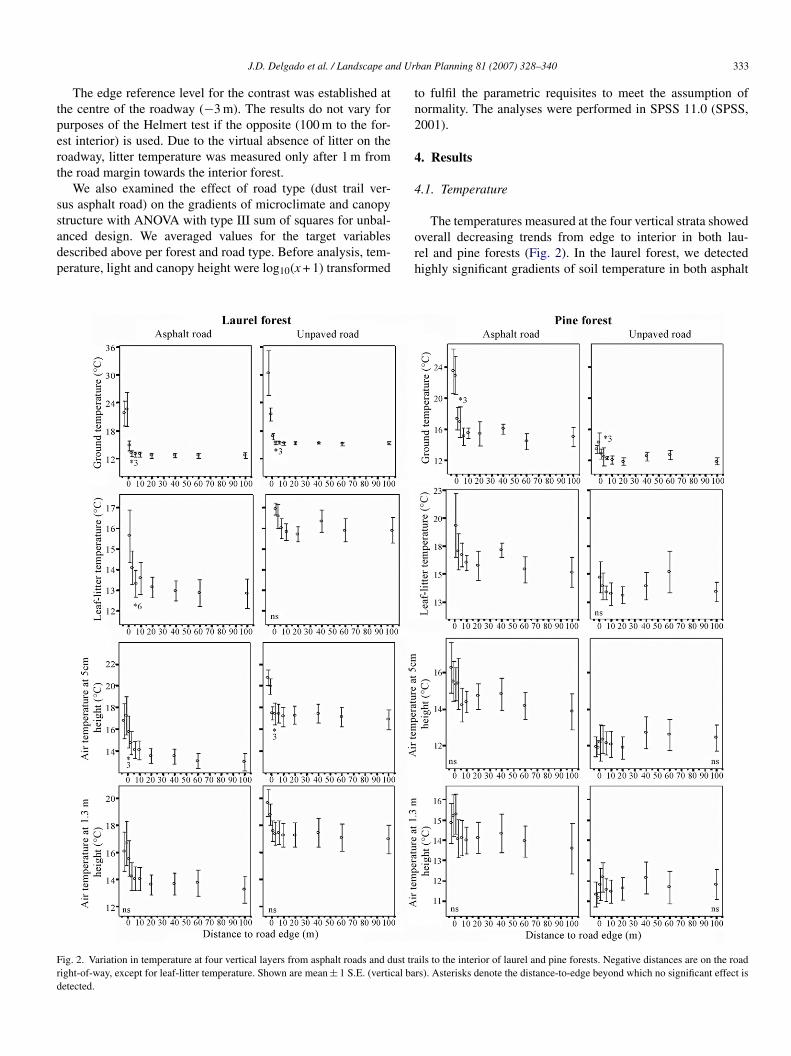
ig. 2. Variation in temperature at four vertical layers from asphalt roads and dust traight-of-way, except for leaf-litter temperature. Shown are mean ± 1 S.E. (vertical baetected.
ban Planning 81 (2007) 328–340 333
o fulfil the parametric requisites to meet the assumption oformality. The analyses were performed in SPSS 11.0 (SPSS,001).
. Results
.1. Temperature
The temperatures measured at the four vertical strata showedverall decreasing trends from edge to interior in both lau-el and pine forests (Fig. 2). In the laurel forest, we detectedighly significant gradients of soil temperature in both asphalt
ils to the interior of laurel and pine forests. Negative distances are on the roadrs). Asterisks denote the distance-to-edge beyond which no significant effect is
334 J.D. Delgado et al. / Landscape and Urban Planning 81 (2007) 328–340
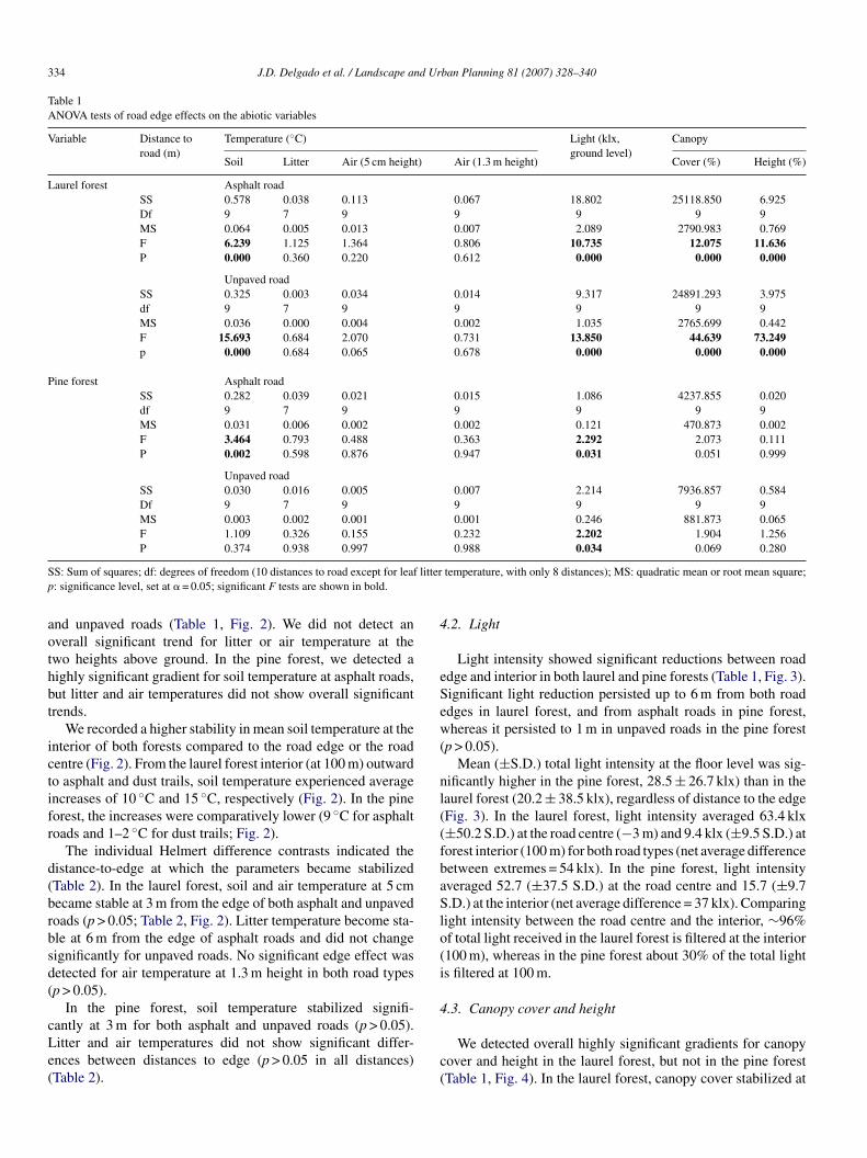
Table 1ANOVA tests of road edge effects on the abiotic variables
Variable Distance toroad (m)
Temperature (◦C) Light (klx,ground level)
Canopy
Soil Litter Air (5 cm height) Air (1.3 m height) Cover (%) Height (%)
Laurel forest Asphalt roadSS 0.578 0.038 0.113 0.067 18.802 25118.850 6.925Df 9 7 9 9 9 9 9MS 0.064 0.005 0.013 0.007 2.089 2790.983 0.769F 6.239 1.125 1.364 0.806 10.735 12.075 11.636P 0.000 0.360 0.220 0.612 0.000 0.000 0.000
Unpaved roadSS 0.325 0.003 0.034 0.014 9.317 24891.293 3.975df 9 7 9 9 9 9 9MS 0.036 0.000 0.004 0.002 1.035 2765.699 0.442F 15.693 0.684 2.070 0.731 13.850 44.639 73.249p 0.000 0.684 0.065 0.678 0.000 0.000 0.000
Pine forest Asphalt roadSS 0.282 0.039 0.021 0.015 1.086 4237.855 0.020df 9 7 9 9 9 9 9MS 0.031 0.006 0.002 0.002 0.121 470.873 0.002F 3.464 0.793 0.488 0.363 2.292 2.073 0.111P 0.002 0.598 0.876 0.947 0.031 0.051 0.999
Unpaved roadSS 0.030 0.016 0.005 0.007 2.214 7936.857 0.584Df 9 7 9 9 9 9 9MS 0.003 0.002 0.001 0.001 0.246 881.873 0.065F 1.109 0.326 0.155 0.232 2.202 1.904 1.256P 0.374 0.938 0.997 0.988 0.034 0.069 0.280
S litterp
aothbt
ictifr
d(brbsd(
cLe(
4
eSew(
nl((fbaSlo(i
4
S: Sum of squares; df: degrees of freedom (10 distances to road except for leaf: significance level, set at � = 0.05; significant F tests are shown in bold.
nd unpaved roads (Table 1, Fig. 2). We did not detect anverall significant trend for litter or air temperature at thewo heights above ground. In the pine forest, we detected aighly significant gradient for soil temperature at asphalt roads,ut litter and air temperatures did not show overall significantrends.
We recorded a higher stability in mean soil temperature at thenterior of both forests compared to the road edge or the roadentre (Fig. 2). From the laurel forest interior (at 100 m) outwardo asphalt and dust trails, soil temperature experienced averagencreases of 10 ◦C and 15 ◦C, respectively (Fig. 2). In the pineorest, the increases were comparatively lower (9 ◦C for asphaltoads and 1–2 ◦C for dust trails; Fig. 2).
The individual Helmert difference contrasts indicated theistance-to-edge at which the parameters became stabilizedTable 2). In the laurel forest, soil and air temperature at 5 cmecame stable at 3 m from the edge of both asphalt and unpavedoads (p > 0.05; Table 2, Fig. 2). Litter temperature become sta-le at 6 m from the edge of asphalt roads and did not changeignificantly for unpaved roads. No significant edge effect wasetected for air temperature at 1.3 m height in both road typesp > 0.05).
In the pine forest, soil temperature stabilized signifi-
antly at 3 m for both asphalt and unpaved roads (p > 0.05).itter and air temperatures did not show significant differ-nces between distances to edge (p > 0.05 in all distances)Table 2).c(
temperature, with only 8 distances); MS: quadratic mean or root mean square;
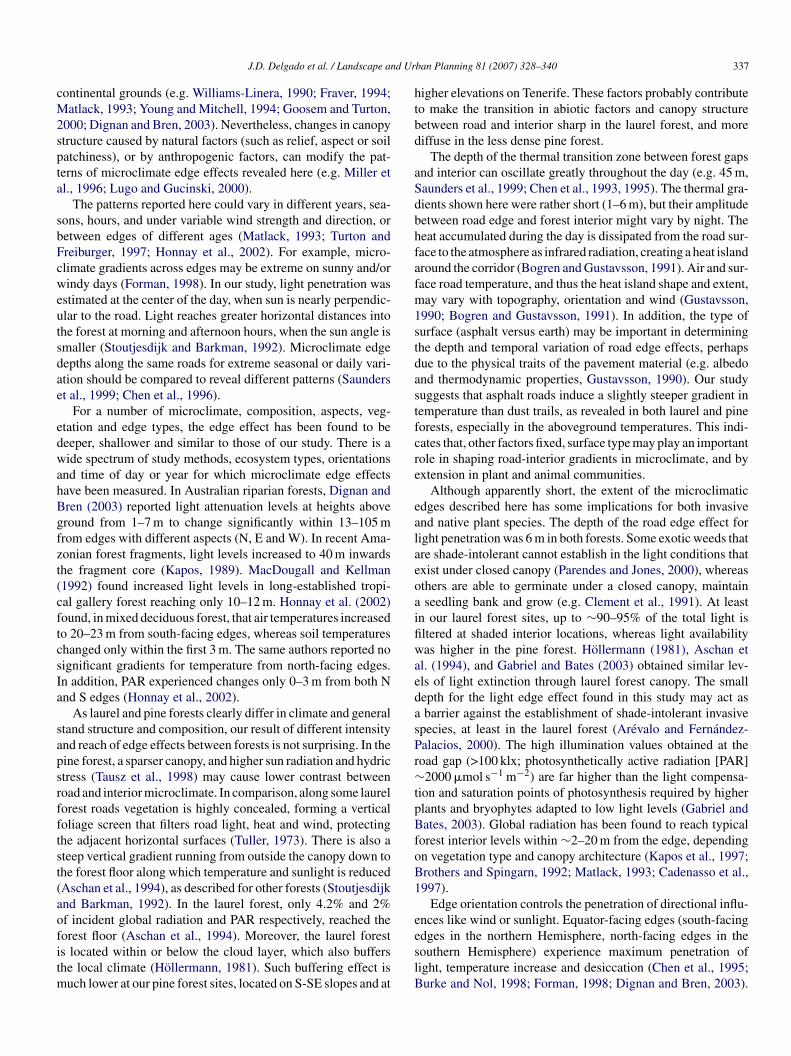
.2. Light
Light intensity showed significant reductions between roaddge and interior in both laurel and pine forests (Table 1, Fig. 3).ignificant light reduction persisted up to 6 m from both roaddges in laurel forest, and from asphalt roads in pine forest,hereas it persisted to 1 m in unpaved roads in the pine forest
p > 0.05).Mean (±S.D.) total light intensity at the floor level was sig-
ificantly higher in the pine forest, 28.5 ± 26.7 klx) than in theaurel forest (20.2 ± 38.5 klx), regardless of distance to the edgeFig. 3). In the laurel forest, light intensity averaged 63.4 klx±50.2 S.D.) at the road centre (−3 m) and 9.4 klx (±9.5 S.D.) atorest interior (100 m) for both road types (net average differenceetween extremes = 54 klx). In the pine forest, light intensityveraged 52.7 (±37.5 S.D.) at the road centre and 15.7 (±9.7.D.) at the interior (net average difference = 37 klx). Comparing
ight intensity between the road centre and the interior, ∼96%f total light received in the laurel forest is filtered at the interior100 m), whereas in the pine forest about 30% of the total lights filtered at 100 m.
.3. Canopy cover and height
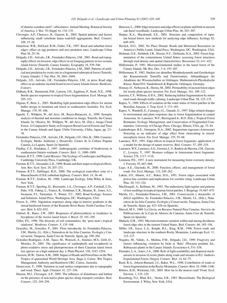
We detected overall highly significant gradients for canopyover and height in the laurel forest, but not in the pine forestTable 1, Fig. 4). In the laurel forest, canopy cover stabilized at

J.D. Delgado et al. / Landscape and Urban Planning 81 (2007) 328–340 335
Fig. 3. Variation in light penetration from asphalt roads and dust trails to the interior of laurel and pine forests. Negative distances are on the road right-of-way.Shown are mean ± 1 S.E. (vertical bars). Asterisks denote the distance-to-edge beyond which no significant effect is detected.
Fig. 4. Variation in canopy cover and height from asphalt roads and dust trails to the interior of laurel and pine forests. Negative distances are on the road right-of-way.Shown are mean ± 1 S.E. (vertical bars). Asterisks denote the distance-to-edge beyond which no significant effect is detected.
336 J.D. Delgado et al. / Landscape and Urban Planning 81 (2007) 328–340
Table 2Results of the Helmert contrasts for the road edge effect
Variable Distance toroad (m)
Temperature (◦C) Light (klx,ground level)
Canopy
Soil Littera Air (5 cm height) Air (1.3 m height) Cover (%) Height (%)
Laurel forest Asphalt road−3 – – – – – –−1 0.000 0.070 0.200 0.000 0.000 0.000
1 0.000 – 0.020 0.000 0.000 0.0003 0.129 0.014 0.134 0.000 0.004 0.0276 0.287 0.392 0.539 0.139
Unpaved road−3 – – – – – –−1 0.000 0.003 0.055 0.000 0.000 0.000
1 0.000 – 0.010 0.000 0.000 0.0003 0.146 0.103 0.804 0.001 0.092 0.0006 0.712 0.045
10 0.293
Pine forest Asphalt road−3 – – – – – –−1 0.001 0.180 0.581 0.040 0.082 0.693
1 0.000 – 0.025 0.0473 0.229 0.081 0.025 0.0176 0.167 0.042
10 0.600
Unpaved road−3 – – – – – –−1 0.181 0.679 0.550 0.003 0.646 0.050
1 0.017 – 0.053 0.096 0.0293 0.425 0.454 0.005 0.3696 0.097
D a chal e road
sider
6Cfcfda
l58
4r
cftappse
rtbi
d(t(tp
5
etpwN
istance to road beyond which no significant variation was detected, shown asevel, set at � = 0.05) for a given variable. Negative numbers are distances on th
a Note that for litter temperature, only distances beyond the road edge are con
m from asphalt roads and at 3 m from unpaved roads (p > 0.05).anopy height stabilized at 6 m from asphalt roads and at 10 m
rom unpaved roads (p > 0.05). In the pine forest, variation inanopy cover stabilized at 10 m from asphalt roads and at 6 mrom unpaved roads (Table 2, Fig. 4). Canopy height did notiffer significantly on asphalt roads (p > 0.05 for all distances),nd stabilized at 3 m from unpaved roads.
The tree canopy was almost twice as high and ∼25%ess dense in the pine forest (height: 17.9 ± 6.4 m; cover:9.2 ± 29%) than in the laurel forest (height: 9.4 ± 5.3 m; cover:3.7 ± 23.1%), regardless of distance to road.
.4. Effect of type of road surface (asphalt versus dust) onoad edge effects
The road type (dust trail versus asphalt road) had a signifi-ant effect in the edge-to-interior gradient in temperature in bothorests (Fig. 2): (a) laurel forest (soil: F = 11.766, p = 0.001; lit-er: F = 37.791, p < 0.001; air at 5 cm: F = 34.405, p < 0.001; airt 1.3 m: F = 35.231, p < 0.001); (b) pine forest (soil: F = 54.654,
< 0.001; litter: F = 8.225, p = 0.005; air at 5 cm: F = 10.485,= 0.002; air at 1.3 m: F = 14.652, p < 0.001). The laurel foresthowed higher average temperature (at the four vertical lay-rs) along unpaved road–interior transects than along asphalt
rtcf
nge from a significant value (bold) to a not significant value of p (significancepavement.
ed.
oad–interior transects (Fig. 2). The opposite was detected forhe pine forest (Fig. 2). The difference in average temperaturesetween both corridor types was higher in the pine forest thann the laurel forest (Fig. 2).
The corridor type had no significant effect on the light gra-ient in the laurel forest (F = 1.113, p = 0.293) or the pine forestF = 0.019, p = 0.891). We detected no significant effect of roadype on the gradient in canopy structure in the laurel forestcover: F = 0.622, p = 0.432; height: F = 0.575, p = 0.450) orhe pine forest (cover: F = 1.352, p = 0.248; height: F = 2.950,= 0.089) (Fig. 4).
. Discussion
We have detected short and abrupt gradients from the roaddge to the interior of the Canarian laurel and pine forests inemperature, light and canopy traits. Overall variation in tem-erature, light and canopy showed a general stabilizing trendithin the first 10 m from road edges in laurel and pine forests.o microclimatic change seemed to persist after 6 m to the inte-
ior of any forest during the study period. Our results suggesthat road edge effects defined by temperature, light, and canopyover and height, may be shallower for our study forest thanor other edge types, including some road systems studied on
d Ur
cM2spta
sbFcweutsdae
edwahBgfzt(cftcsIa
sapsrfftst(aofitm
htbd
aSdbhfafm1stdastfcre
ealaeoaifiwaedasPr∼tpBfoB1
e
J.D. Delgado et al. / Landscape an
ontinental grounds (e.g. Williams-Linera, 1990; Fraver, 1994;atlack, 1993; Young and Mitchell, 1994; Goosem and Turton,
000; Dignan and Bren, 2003). Nevertheless, changes in canopytructure caused by natural factors (such as relief, aspect or soilatchiness), or by anthropogenic factors, can modify the pat-erns of microclimate edge effects revealed here (e.g. Miller etl., 1996; Lugo and Gucinski, 2000).
The patterns reported here could vary in different years, sea-ons, hours, and under variable wind strength and direction, oretween edges of different ages (Matlack, 1993; Turton andreiburger, 1997; Honnay et al., 2002). For example, micro-limate gradients across edges may be extreme on sunny and/orindy days (Forman, 1998). In our study, light penetration was
stimated at the center of the day, when sun is nearly perpendic-lar to the road. Light reaches greater horizontal distances intohe forest at morning and afternoon hours, when the sun angle ismaller (Stoutjesdijk and Barkman, 1992). Microclimate edgeepths along the same roads for extreme seasonal or daily vari-tion should be compared to reveal different patterns (Saunderst al., 1999; Chen et al., 1996).
For a number of microclimate, composition, aspects, veg-tation and edge types, the edge effect has been found to beeeper, shallower and similar to those of our study. There is aide spectrum of study methods, ecosystem types, orientations
nd time of day or year for which microclimate edge effectsave been measured. In Australian riparian forests, Dignan andren (2003) reported light attenuation levels at heights aboveround from 1–7 m to change significantly within 13–105 mrom edges with different aspects (N, E and W). In recent Ama-onian forest fragments, light levels increased to 40 m inwardshe fragment core (Kapos, 1989). MacDougall and Kellman1992) found increased light levels in long-established tropi-al gallery forest reaching only 10–12 m. Honnay et al. (2002)ound, in mixed deciduous forest, that air temperatures increasedo 20–23 m from south-facing edges, whereas soil temperatureshanged only within the first 3 m. The same authors reported noignificant gradients for temperature from north-facing edges.n addition, PAR experienced changes only 0–3 m from both Nnd S edges (Honnay et al., 2002).
As laurel and pine forests clearly differ in climate and generaltand structure and composition, our result of different intensitynd reach of edge effects between forests is not surprising. In theine forest, a sparser canopy, and higher sun radiation and hydrictress (Tausz et al., 1998) may cause lower contrast betweenoad and interior microclimate. In comparison, along some laurelorest roads vegetation is highly concealed, forming a verticaloliage screen that filters road light, heat and wind, protectinghe adjacent horizontal surfaces (Tuller, 1973). There is also ateep vertical gradient running from outside the canopy down tohe forest floor along which temperature and sunlight is reducedAschan et al., 1994), as described for other forests (Stoutjesdijknd Barkman, 1992). In the laurel forest, only 4.2% and 2%f incident global radiation and PAR respectively, reached the
orest floor (Aschan et al., 1994). Moreover, the laurel forests located within or below the cloud layer, which also buffershe local climate (Hollermann, 1981). Such buffering effect isuch lower at our pine forest sites, located on S-SE slopes and at
eslB
ban Planning 81 (2007) 328–340 337
igher elevations on Tenerife. These factors probably contributeo make the transition in abiotic factors and canopy structureetween road and interior sharp in the laurel forest, and moreiffuse in the less dense pine forest.
The depth of the thermal transition zone between forest gapsnd interior can oscillate greatly throughout the day (e.g. 45 m,aunders et al., 1999; Chen et al., 1993, 1995). The thermal gra-ients shown here were rather short (1–6 m), but their amplitudeetween road edge and forest interior might vary by night. Theeat accumulated during the day is dissipated from the road sur-ace to the atmosphere as infrared radiation, creating a heat islandround the corridor (Bogren and Gustavsson, 1991). Air and sur-ace road temperature, and thus the heat island shape and extent,ay vary with topography, orientation and wind (Gustavsson,
990; Bogren and Gustavsson, 1991). In addition, the type ofurface (asphalt versus earth) may be important in determininghe depth and temporal variation of road edge effects, perhapsue to the physical traits of the pavement material (e.g. albedond thermodynamic properties, Gustavsson, 1990). Our studyuggests that asphalt roads induce a slightly steeper gradient inemperature than dust trails, as revealed in both laurel and pineorests, especially in the aboveground temperatures. This indi-ates that, other factors fixed, surface type may play an importantole in shaping road-interior gradients in microclimate, and byxtension in plant and animal communities.
Although apparently short, the extent of the microclimaticdges described here has some implications for both invasivend native plant species. The depth of the road edge effect foright penetration was 6 m in both forests. Some exotic weeds thatre shade-intolerant cannot establish in the light conditions thatxist under closed canopy (Parendes and Jones, 2000), whereasthers are able to germinate under a closed canopy, maintainseedling bank and grow (e.g. Clement et al., 1991). At least
n our laurel forest sites, up to ∼90–95% of the total light isltered at shaded interior locations, whereas light availabilityas higher in the pine forest. Hollermann (1981), Aschan et
l. (1994), and Gabriel and Bates (2003) obtained similar lev-ls of light extinction through laurel forest canopy. The smallepth for the light edge effect found in this study may act asbarrier against the establishment of shade-intolerant invasive
pecies, at least in the laurel forest (Arevalo and Fernandez-alacios, 2000). The high illumination values obtained at theoad gap (>100 klx; photosynthetically active radiation [PAR]2000 �mol s−1 m−2) are far higher than the light compensa-
ion and saturation points of photosynthesis required by higherlants and bryophytes adapted to low light levels (Gabriel andates, 2003). Global radiation has been found to reach typical
orest interior levels within ∼2–20 m from the edge, dependingn vegetation type and canopy architecture (Kapos et al., 1997;rothers and Spingarn, 1992; Matlack, 1993; Cadenasso et al.,997).
Edge orientation controls the penetration of directional influ-nces like wind or sunlight. Equator-facing edges (south-facing
dges in the northern Hemisphere, north-facing edges in theouthern Hemisphere) experience maximum penetration ofight, temperature increase and desiccation (Chen et al., 1995;urke and Nol, 1998; Forman, 1998; Dignan and Bren, 2003).
3 d Ur
Irtt1abcda(
afsrtmrighsTiepdAmei(
Cfadritbsamppep
iwtelrp
A
fmMta
R
A
A
A
A
A
B
B
B
B
B
B
B
B
B
C
C
C
C
38 J.D. Delgado et al. / Landscape an
n spite of selecting mostly south-facing edges, the depth ofoad edge effects shown here at the two forests was consis-ently small, compared to other studies of similar orientations (upo 60–180 m; Forman and Godron, 1986; Young and Mitchell,994; Chen et al., 1995; Brosofske et al., 1997; but see Brothersnd Spingarn, 1992). The edges studied here would experience auffering effect of the subtropical latitude of the Canary Islands,ompared to those of higher latitudes. This hypothesis is coinci-ent with the fact that difference in light intensity between southnd north facing edges increases with distance from the equatorForman and Godron, 1986).
Our study suggests that interior forest conditions similarlyppear after 6–10 m from the road edge in the laurel and the pineorest. Such apparent edge widths may accumulate at the land-cape and regional scales to reduce net forest area and speciesichness (Reed et al., 1996; Findlay and Houlahan, 1997). Withinhis distance from roads, major changes in the biota and com-
unity processes are likely to occur (Watkins et al., 2003). Ifoadsides suffer higher temperatures and light incidence thannterior forest (even with minimal propagation of edge effects),reater fragmentation would lead to increased temperatures andigher light intensities reaching the forest floor at the islandcale. Typical laurel and pine forest roads are about 7 m wide.herefore, the total amount of forest area removed and climat-
cally transformed by a road is 2.7 ha km−1 (0.027 km2) for andge depth of 10 m along both roadsides (an edge depth com-arable to those reported here). A possible consequence of thisepth of road edge is that it accumulates across the island area.mong such probable cumulative impacts are the increase inarginal habitat for sun-loving animal species within the for-
st matrix (e.g. lizards, Delgado et al., in press), predators (e.g.ntroduced rats, Delgado et al., 2001, 2005), and exotic plantsArevalo et al., 2005).
Conversely, rare and threatened bird species (like theanarian-endemic fruit pigeon, Columba bollii), with strict
orest-interior requirements, might suffer from net habitat lossnd road edge effects (Delgado et al., 2005). Fleshy-fruit pro-uction is increased along roadsides in the laurel forest, inelation with a higher productivity through higher light availabil-ty (Luken et al., 1991). Frugivorous pigeons could be attractedo road edges by increased visual signal from fruit displays andy more predictable and accessible fruit resources in time andpace (Nogales et al., 1999; Bach and Kelly, 2004). A generallyssumed effect of attraction to road habitat for birds is increasedortality to car collisions (Clevenger et al., 2003) and enhanced
redation (Bergin et al., 2000). For instance, higher egg and nestredation has been detected for neotropical birds along rural for-st edges (Danielson et al., 1997). However, these issues are stilloorly investigated for the Canarian forest roads.
When creating buffers and managing the landscape surround-ng roads (e.g. exotic weed control, selective cuts, road closure),e should take into account microclimate edge depths, test for its
emporal and spatial variation, and assess its effects on native and
xotic biota and community processes, especially on spatially-imited island grounds. This should aid in the design of betteroad schemes, integrating road management and constructionractices into forest conservation.C
C
ban Planning 81 (2007) 328–340
cknowledgements
We thank Gustavo Morales, Fayna Farina and Cesar Chineaor helping during the field work and Domingo Morales (Depart-ent of Plant Physiology, ULL), Ana Losada and Juana M.ancebo (Department of Botany, ULL). Thanks are also due to
hree anonymous reviewers for improving and commenting onn earlier draft.
eferences
non., 2004. Mapa de Intensidades Medias Diarias de Trafico 2003. Servi-cio Tecnico de Carreteras. Cabildo de Tenerife, Canary Islands, Spain.(Map).
revalo, J.R., Fernandez-Palacios, J.M., 1998. Treefall gap characteristics andregeneration in the laurel forest of Tenerife. J. Veg. Sci. 9, 297–306.
revalo, J.R., Fernandez-Palacios, J.M., 2000. Seed bank analysis of tree speciesin two stands of the Tenerife laurel forest (Canary Islands). For. Ecol. Man-age. 130, 177–185.
revalo, J.R., Delgado, J.D., Otto, R., Naranjo, A., Salas, M., Fernandez-Palacios, J.M., 2005. Exotic species in the roadside plant communitiesthrough an altitudinal gradient in Tenerife and Gran Canaria (CanaryIslands). Perspect. Plant Ecol., Evol. Systematics 7, 185–202.
schan, G., Jimenez, M.S., Morales, D., Losch, R., 1994. Aspectos micro-climaticos de un bosque de laurisilva en Tenerife. Vieraea 23, 125–141.
ach, C.E., Kelly, D., 2004. Effects of forest edges, fruit display size, and fruitcolour on bird seed dispersal in a New Zealand mistletoe, Alepis flavida. N.Z. J. Ecol. 28, 93–103.
auer, P., 1997. A note on multiple testing procedures in dose finding. Biometrics53, 1125–1128.
ergin, T.M., Best, L.B., Freemark, K.E., Koehler, K.J., 2000. Effects oflandscape structure on nest predation in roadsides of a midwestern agroe-cosystem: a multiscale analysis. Landscape Ecol. 15, 131–143.
lanco, A., Castroviejo, M., Fraile, J.L., Gandullo, J.M., Munoz, L.A., Sanchez,O., 1989. Estudio Ecologico Del Pino Canario. ICONA, Madrid, Spain (inSpanish).
ogren, J., Gustavsson, T., 1991. Nocturnal air and road surface temperaturevariations in complex terrain. Int. J. Climatol. 11, 443–455.
rosofske, K.B., Chen, J., Naiman, R.J., Franklin, J.F., 1997. Harvesting effectson microclimatic gradients from small streams to uplands in western Wash-ington. Ecol. Appl. 7, 1188–1200.
rothers, S.T., Spingarn, A., 1992. Forest fragmentation and alien plant invasionof central Indiana old-growth forests. Conserv. Biol. 6, 91–100.
urke, D.M., Nol, E., 1998. Edge and fragment effects on the vegetation ofdeciduous forests in Ontario. Can. Nat. Area J. 18, 45–53.
yron, H.J., Treweek, J.R., Sheate, W.R., Thompson, S., 2000. Road develop-ments in the UK: An analysis of ecological assessment in environmentalimpact statements produced between 1993 and 1997. J. Environ. Plant Man-age. 43, 71–97.
adenasso, M.L., Traynor, M.M., Pickett, S.T.A., 1997. Functional location offorest edges: gradients of multiple physical factors. Can. J. For. Res. 27,774–782.
anham, C.D., Finzi, A.C., Pacala, S.W., Burbank, D.H., 1994. Causes andconsequences of resource heterogeneity in forests: interspecific variation inlight transmission by canopy trees. Can. J. For. Res. 24, 337–349.
hen, J., Franklin, J.F., Lowe, J.S., 1996. Comparison of abiotic and structurallydefined patch patterns in a hypothetical forest landscape. Conserv. Biol. 10,854–862.
hen, J., Franklin, J.F., Spies, T.A., 1993. An empirical model for predictingdiurnal air-temperature gradients from clearcut-forest edge into old-growthDouglas-fir forest. Ecol. Model. 67, 179–198.
hen, J., Franklin, J.F., Spies, T.A., 1995. Growing-season microclimatic gra-dients from clearcut edges into old-growth Douglas-fir forests. Ecol. Appl.5, 74–86.
lement, C., Warren, R., Dreyer, G., Barnes, P., 1991. Photosynthesis, waterrelations and fecundity in the woody vines American and Oriental bittersweet
d Ur
C
D
D
D
D
D
D
E
F
F
F
F
F
F
F
F
G
G
G
G
G
G
H
H
H
H
H
H
H
H
J
K
K
L
L
L
L
L
L
M
M
M
M
M
N
P
R
J.D. Delgado et al. / Landscape an
(Celastrus scandens and C. orbiculatus). Annual Meeting, Botanical Societyof America. J. Bot. 78 (Suppl. 6), 134–135.
levenger, A.P., Chruszcz, B., Gunson, K., 2003. Spatial patterns and factorsinfluencing small vertebrate fauna road-kill aggregations. Biol. Conserv.109, 15–26.
anielson, W.R., DeGraaf, R.M., Fuller, T.K., 1997. Rural and suburban forestedges: effect on egg predators and nest predation rates. Landscape UrbanPlan 38, 25–36.
elgado, J.D., Arevalo, J.R., Fernandez-Palacios, J.M., 2001. Road and topog-raphy effects on invasion: edge effects in rat foraging patterns in two oceanicisland forests (Tenerife, Canary Islands). Ecography 24, 539–546.
elgado, J.D., Arevalo, J.R., Fernandez-Palacios, J.M., 2005. Patterns of artifi-cial nest predation by exotic rats in a fragmented subtropical forest (Tenerife,Canary Islands). J. Nat. Hist. 38, 2661–2669.
elgado, J.D., Arevalo, J.R., Fernandez-Palacios, J.M., in press Road edgeeffect on an endemic lacertid lizard in two Canary Islands forests. Biodivers.Conserv.
idham, R.K., Hammond, P.M., Lawton, J.H., Eggleton, P., Stork, N.E., 1998.Beetle species responses to tropical forest fragmentation. Ecol. Monogr. 68,295–323.
ignan, P., Bren, L., 2003. Modelling light penetration edge effects for streambuffer design in mountain ash forest in southeastern Australia. For. Ecol.Manage. 179, 95–106.
guchi, T., Wildpret, W., del Arco, M., Reyes-Betancort, A., 1999. Synopticanalysis of thermal and moisture conditions in Anaga, Tenerife, the CanaryIslands. In: Ohsawa, M., Wildpret, W., del Arco, M. (Eds.), Anaga CloudForest. A Comparative Study on Evergreen Broad-Leaved Forests and Treesin the Canary Islands and Japan. Chiba University, Chiba, Japan, pp. 23–38.
ernandez-Palacios, J.M., Arevalo, J.R., Delgado, J.D., Otto, R., 2004. Canarias:Ecologıa, Medio Ambiente y Desarrollo. Centro de la Cultura PopularCanaria, La Laguna, Spain (in Spanish).
indlay, C.S., Houlahan, J., 1997. Anthropogenic correlates of biodiversity insoutheastern Ontario wetlands. Conserv. Biol. 11, 1000–1009.
orman, R.T.T., 1998. Land Mosaics: The Ecology of Landscapes and Regions.Cambridge University Press, Cambridge, UK.
orman, R.T.T., Alexander, L.E., 1998. Roads and their major ecological effects.Ann. Rev. Ecol. Syst. 29, 207–231.
orman, R.T.T., Deblinger, R.D., 2000. The ecological road-effect zone of aMassachusetts (USA) suburban highway. Conserv. Biol. 14, 36–46.
orman, R.T.T., Godron, M., 1986. Landscape Ecology. John Wiley & Sons,New York.
orman, R.T.T., Sperling, D., Bissonette, J.A., Clevenger, A.P., Cutshall, C.D.,Dale, V.H., Fahrig, L., France, R., Goldman, C.R., Heanue, K., Jones, A.J.,Swanson, F.J., Turrentine, T., Winter, T.C., 2002. Road Ecology: Scienceand Solutions. Island Press, Washington, DC, Washington, USA.
raver, S., 1994. Vegetation responses along edge-to-interior gradients in themixed hardwood forests of the Roanoke River Basin, North Carolina. Con-serv. Biol. 8, 822–832.
abriel, R., Bates, J.W., 2003. Responses of photosynthesis to irradiance inbryophytes of the Azores laurel forest. J. Bryol. 25, 101–105.
iller, P.S., 1996. The diversity of soil communities, the ‘poor man’s tropicalrainforest’. Biodivers. Conserv. 5, 135–168.
onzalez, M., Gonzalez, F., 2001. Flora introducida. In: Fernandez-Palacios,J.M., Martın, J.L. (Eds.), Naturaleza de las Islas Canarias. Ecologıa y Con-servacion. Turquesa, Santa Cruz de Tenerife, Spain, pp. 199–204.
onzalez-Rodrıguez, A.M., Tausz, M., Wonisch, A., Jimenez, M.S., Grill, D.,Morales, D., 2001. The significance of xanthophylls and tocopherols inphoto-oxidative stress and photoprotection of three Canarian laurel foresttree species on a high radiation day. J. Plant Physiol. 158, 1547–1554.
oosem, M.W., Turton, S.M., 2000. Impact of Roads and Powerlines on the WetTropics of queensland World Heritage Area. Stage ii. Cairns. Wet TropicsManagement Authority and Rainforest CRC, Cairns, Australia.
ustavsson, T., 1990. Variation in road surface temperature due to topographyand wind. Theor. Appl. Climatol. 41, 227–236.
ansen, M.J., Clevenger, A.P., 2005. The influence of disturbance and habitaton the presence of non-native plant species along transport corridors. Biol.Conserv. 125, 249–259.
R
R
ban Planning 81 (2007) 328–340 339
ansson, L., 2000. Edge structures and edge effects on plants and birds in ancientoak-hazel woodlands. Landscape Urban Plan. 46, 203–207.
arper, K.A., Macdonald, S.E., 2001. Structure and composition of ripar-ian boreal forest: new methods for analyzing edge influence. Ecology 82,649–659.
avlick, D.G., 2002. No Place Distant: Roads and Motorized Recreation onAmerica’s Public Lands. Island Press, Washington, DC, Washington, USA.
eilman, G.E., Strittholt, J.R., Slosser, N.C., Dellasala, D.A., 2002. Forest frag-mentation of the conterminous United States: assessing forest intactnessthrough road density and spatial characteristics. Bioscience 52, 411–422.
ollermann, P., 1981. Microenvironmental studies in the laurel forest of theCanary Islands. Mt. Res. Dev. 3–4, 193–207.
ollermann, P., 1982. Studien zur aktuellen Morphodynamik und Geookologieder Kanareninseln Teneriffa und Fuerteventura. Abhandlungen derAkademie der Wissenschaften zu Gottingen. Mathematisch-PhysikalischeKlasse, Band 034, Vandenhoeck & Ruprecht, Gottingen, Germany.
onnay, O., Verheyen, K., Hermy, M., 2002. Permeability of ancient forest edgesfor weedy plant species invasion. For. Ecol. Manage. 161, 109–122.
aarsma, C.F., Willems, G.P.A., 2002. Reducing habitat fragmentation by minorrural roads through traffic calming. Landscape Urban Plan. 58, 125–135.
apos, V., 1989. Effects of isolation on the water status of forest patches in theBrazilian Amazon. J. Trop. Ecol. 5, 173–185.
apos, V., Wandelli, E., Camargo, J.L., Ganade, G., 1997. Edge-related changesin environment and plant responses due to forest fragmentation in centralAmazonia. In: Laurance, W.F., Bierregaard Jr., R.O. (Eds.), Tropical ForestRemnants: Ecology, Management, and Conservation of Fragmented Com-munities. University of Chicago Press, Chicago, Illinois, USA, pp. 33–44.
andenberger, R.E., Ostergren, D.A., 2002. Eupatorium rugosum (Asteraceae)flowering as an indicator of edge effect from clearcutting in mixed-mesophytic forest. For. Ecol. Manage. 155, 55–68.
aurance, W.F., 1991. Edge effects in tropical forest fragments: application ofa model for the design of nature reserves. Biol. Conserv. 57, 205–219.
aurance, W.F., Laurance, S.G., Ferreira, L.V., Rankin-de Merona, J.M., Gascon,C., Lovejoy, T., 1997. Biomass collapse in Amazonian forest fragments.Science 278, 1117–1118.
emmon, P.E., 1957. A new instrument for measuring forest overstory density.J. Forestry 55, 667–668.
ugo, A.E., Gucinski, H., 2000. Function, effects, and management of forestroads. For. Ecol. Manage. 133, 249–262.
uken, J.O., Hinton, A.C., Baker, D.G., 1991. Forest edges associated withpower-line corridors and implications for corridor siting. Landscape UrbanPlan. 20, 315–324.
acDougall, A., Kellman, M., 1992. The understorey light regime and patternsof tree seedlings in tropical riparian forest patches. J. Biogeogr. 19, 667–675.
artın, J.L., Fernandez-Palacios, J.M., 2001. Conservacion y desarrollo: eldifıcil equilibrio. In: Fernandez-Palacios, J.M., Martın, J.L. (Eds.), Natu-raleza de las Islas Canarias. Ecologıa y Conservacion. Turquesa, Santa Cruzde Tenerife, Spain, pp. 423–428 (in Spanish).
arzol, M.V., 1988. La Lluvia, un Recurso Natural Para Canarias. Servicio dePublicaciones de la Caja de Ahorros de Canarias, Santa Cruz de Tenerife,Spain (in Spanish).
atlack, G.R., 1993. Microenvironment variation within and among deciduousforest edge sites in the eastern United States. Biol. Conserv. 66, 185–194.
iller, J.R., Joyce, L.A., Knight, R.L., King, R.M., 1996. Forest roads andlandscape structure in the southern Rocky Mountains. Landscape Ecol. 11,115–127.
ogales, M., Valido, A., Medina, F.M., Delgado, J.D., 1999. Frugivory andfactors influencing visitation by birds at ‘Balo’ (Plocama pendula Ait.,Rubiaceae) plants in the Canary Islands. Ecoscience 6, 531–538.
arendes, L.A., Jones, J.A., 2000. Role of light availability and dispersal mech-anisms in invasion of exotic plants along roads and streams in H.J. AndrewsExperimental Forest, Oregon. Conserv. Biol. 14, 64–75.
eed, R.A., Johson-Barnard, J.J., Baker, W.L., 1996. Contribution of roads to
forest fragmentation in the Rocky Mountains. Conserv. Biol. 10, 1098–1106.iitters, K.H., Wickman, J.D., 2003. How far to the nearest road? Front. Ecol.Environ. 1, 125–129.
osenberg, N.J., Blad, B.L., Verma, S.B., 1983. Microclimate. The BiologicalEnvironment. J. Wiley, New York, USA.
3 d Ur
S
S
S
S
S
S
T
T
T
T
T
W
W
W
Y
40 J.D. Delgado et al. / Landscape an
aunders, S.C., Chen, J., Drummer, T.D., Crow, T.R., 1999. Modeling temper-ature gradients across edges over time in a managed landscape. For. Ecol.Manage. 117, 17–31.
aunders, S.C., Mislivets, M.R., Chen, J., Cleland, D.T., 2002. Effects of roadson landscape structure within nested ecological units of the Northern GreatLakes Region, USA. Biol. Conserv. 103, 209–225.
errano, M., Sanz, L., Puig, J., Pons, J., 2002. Landscape fragmentation causedby the transport network in Navarra (Spain): two-scale analysis and land-scape integration assessment. Landscape Urban Plan. 58, 113–123.
pellerberg, I.F., 1998. Ecological effects of roads and traffic: a literature review.Global Ecol. Biogeogr. 7, 317–333.
ong, I.-J., Hong, S.-K., Kim, H.-O., Byund, B., Gin, Y., 2005. The pattern oflandscape patches and invasion of naturalized plants in developed areas ofurban Seoul. Landscape Urban Plan. 70, 205–219.
toutjesdijk, P.H., Barkman, J.J., 1992. Microclimate, Vegetation and Fauna.Opulus Press, Upssala, Sweden.
ausz, M., Jimenez, M.S., Morales, D., Grill, D., Peters, J., 1998. Element con-
tents and stress-physiological characterization of Pinus Canariensis treesin Mediterranean type forest stands in Tenerife. Chemosphere 36, 1019–1023.heobald, D.M., Miller, J.R., Hobbs, N.T., 1997. Estimating the cumulativeeffects of development on wildlife habitat. Landscape Urban Plan. 39, 25–36.
Z
ban Planning 81 (2007) 328–340
rombulak, S.C., Frissell, C.A., 2000. Review of ecological effects of roads onterrestrial and aquatic communities. Conserv. Biol. 14, 18–30.
uller, S.E., 1973. Effects of vertical vegetation surfaces on the adjacent micro-climate: the role of aspect. Agr. Meteorol. 12, 407–424.
urton, S.M., Freiburger, H.J., 1997. Edge and aspect effects on the microclimateof a small tropical forest remnant on the Atherton tableland, Northeast-ern Australia. In: Laurance, W.F., Bierregard, R.O. (Eds.), Tropical ForestRemnants Ecology, Management, and Conservation of Fragmented Com-munities. Chicago University Press, Chicago, USA, pp. 45–54.
atkins, Z., Chen, J., Pickens, J., Brosofske, K., 2003. Effects of forest roadson understory plants in a managed hardwood landscape. Conserv. Biol. 17,411–419.
hittaker, R.J., 1998. Island Biogeography. Ecology, Evolution and Conserva-tion. Oxford University Press, Oxford, UK.
illiams-Linera, G., 1990. Vegetation structure and environmental conditionsof forest edges in Panama. J. Ecol. 78, 356–373.
oung, A., Mitchell, N., 1994. Microclimate and vegetation edge effects in a
fragmented podocarp-broadleaf forest in New Zealand. Biol. Conserv. 67,63–72.heng, D., Chen, J., 2000. Edge effects in fragmented landscapes: a genericmodel for delineating area of edge influences (D-AEI). Ecol. Model. 132,75–190.