Embed Size (px)
Citation preview
1
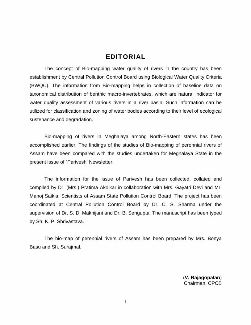
EDITORIALThe concept of Bio-mapping water quality of rivers in the country has been
establishment by Central Pollution Control Board using Biological Water Quality Criteria
(BWQC). The information from Bio-mapping helps in collection of baseline data on
taxonomical distribution of benthic macro-invertebrates, which are natural indicator for
water quality assessment of various rivers in a river basin. Such information can be
utilized for classification and zoning of water bodies according to their level of ecological
sustenance and degradation.
Bio-mapping of rivers in Meghalaya among North-Eastern states has been
accomplished earlier. The findings of the studies of Bio-mapping of perennial rivers of
Assam have been compared with the studies undertaken for Meghalaya State in the
present issue of `Parivesh’ Newsletter.
The information for the issue of Parivesh has been collected, collated and
compiled by Dr. (Mrs.) Pratima Akolkar in collaboration with Mrs. Gayatri Devi and Mr.
Manoj Saikia, Scientists of Assam State Pollution Control Board. The project has been
coordinated at Central Pollution Control Board by Dr. C. S. Sharma under the
supervision of Dr. S. D. Makhijani and Dr. B. Sengupta. The manuscript has been typed
by Sh. K. P. Shrivastava.
The bio-map of perennial rivers of Assam has been prepared by Mrs. Bonya
Basu and Sh. Surajmal.
(V. Rajagopalan) Chairman, CPCB
2
CONTENTS
Page No.
1.0 INTRODUCTION 1
1.1 Rivers Bio-mapping Concept 1
1.2 Rivers Bio-mapping Techniques 2
1.3 Biological Water Quality Criteria 2
2.0 BIO-MAPPING OF THE IMPORTANT PERENNIAL RIVERS OF ASSAM STATE 3
2.1 Surface water resources and their uses 5
2.2 Hydrological status and environmental problems. 8
2.3 Perennial rivers of Assam – Location and morphological features 19
2.4 Bio-monitoring of Perennial Rivers in Assam State 34
3.0 BIOLOGICAL WATER QUALITY ASSESSMENT OF PERENNIAL RIVERS IN ASSAM 46
4.0 COMPARISION OF BIOLOGICAL STATUS OF RIVERS IN MEGHALAYA AND ASSAM STATE 47
1
1.0 INTRODUCTION
1.1 RIVERS BIO-MAPPING CONCEPT
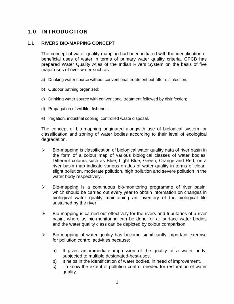
The concept of water quality mapping had been initiated with the identification of beneficial uses of water in terms of primary water quality criteria. CPCB has prepared Water Quality Atlas of the Indian Rivers System on the basis of five major uses of river water such as:
a) Drinking water source without conventional treatment but after disinfection;
b) Outdoor bathing organized;
c) Drinking water source with conventional treatment followed by disinfection;
d) Propagation of wildlife, fisheries;
e) Irrigation, industrial cooling, controlled waste disposal.
The concept of bio-mapping originated alongwith use of biological system for classification and zoning of water bodies according to their level of ecological degradation.
Bio-mapping is classification of biological water quality data of river basin in the form of a colour map of various biological classes of water bodies. Different colours such as Blue, Light Blue, Green, Orange and Red, on a river basin map indicate various grades of water quality in terms of clean, slight pollution, moderate pollution, high pollution and severe pollution in the water body respectively.
Bio-mapping is a continuous bio-monitoring programme of river basin, which should be carried out every year to obtain information on changes in biological water quality maintaining an inventory of the biological life sustained by the river.
Bio-mapping is carried out effectively for the rivers and tributaries of a river basin, where as bio-monitoring can be done for all surface water bodies and the water quality class can be depicted by colour comparison.
Bio-mapping of water quality has become significantly important exercise for pollution control activities because:
a) It gives an immediate impression of the quality of a water body, subjected to multiple designated-best-uses.
b) It helps in the identification of water bodies, in need of improvement.c) To know the extent of pollution control needed for restoration of water
quality.
2
d) To collect the information on long-term cumulative effects of all adverse environmental factors.
e) To maintain and restore the ecological sustainability of the water body in terms of its wholesomeness.
f) Action plans can be prepared by simple colour comparison of the colour maps of water quality drawn for previous years.
g) It may also help in performing the formulation of national pollution control programme.
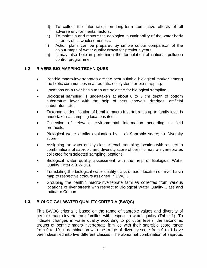
1.2 RIVERS BIO-MAPPING TECHNIQUES
Benthic macro-invertebrates are the best suitable biological marker among the biotic communities in an aquatic ecosystem for bio-mapping.
Locations on a river basin map are selected for biological sampling.
Biological sampling is undertaken at about 0 to 5 cm depth of bottom substratum layer with the help of nets, shovels, dredges, artificial substratum etc.
Taxonomic identification of benthic macro-invertebrates up to family level is undertaken at sampling locations itself.
Collection of relevant environmental information according to field protocols.
Biological water quality evaluation by – a) Saprobic score; b) Diversity score.
Assigning the water quality class to each sampling location with respect to combinations of saprobic and diversity score of benthic macro-invertebrates collected from selected sampling locations.
Biological water quality assessment with the help of Biological Water Quality Criteria (BWQC).
Translating the biological water quality class of each location on river basin map to respective colours assigned in BWQC.
Grouping the benthic macro-invertebrate families collected from various locations of river stretch with respect to Biological Water Quality Class and Indicator Colours.
1.3 BIOLOGICAL WATER QUALITY CRITERIA (BWQC)
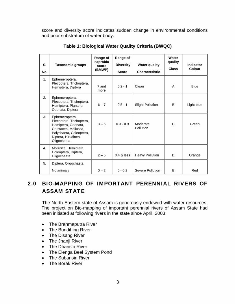
This BWQC criteria is based on the range of saprobic values and diversity of benthic macro-invertebrate families with respect to water quality (Table 1). To indicate changes in water quality according to pollution levels, the taxonomic groups of benthic macro-invertebrate families with their saprobic score range from 0 to 10, in combination with the range of diversity score from 0 to 1 have been classified into five different classes. The abnormal combination of saprobic
3
score and diversity score indicates sudden change in environmental conditions and poor substratum of water body.
Table 1: Biological Water Quality Criteria (BWQC)
S.
No.
Taxonomic groups
Range of saprobic
score (BMWP)
Range of
Diversity
Score
Water quality
Characteristic
Water quality
ClassIndicator Colour
1. Ephemeroptera, Plecoptera, Trichoptera, Hemiptera, Diptera 7 and
more0.2 - 1 Clean A Blue
2. Ephemeroptera, Plecoptera, Trichoptera, Hemiptera, Planaria, Odonata, Diptera
6 – 7 0.5 - 1 Slight Pollution B Light blue
3. Ephemeroptera, Plecoptera, Trichoptera, Hemiptera, Odonata, Crustacea, Mollusca, Polychaeta, Coleoptera, Diptera, Hirudinea, Oligochaeta
3 – 6 0.3 - 0.9 Moderate Pollution
C Green
4. Mollusca, Hemiptera, Coleoptera, Diptera, Oligochaeta 2 – 5 0.4 & less Heavy Pollution D Orange
5. Diptera, Oligochaeta
No animals 0 – 2 0 - 0.2 Severe Pollution E Red
2.0 BIO-MAPPING OF IMPORTANT PERENNIAL RIVERS OF ASSAM STATE
The North-Eastern state of Assam is generously endowed with water resources. The project on Bio-mapping of important perennial rivers of Assam State had been initiated at following rivers in the state since April, 2003:
The Brahmaputra River The Buridihing River The Disang River The Jhanji River The Dhansiri River The Elenga Beel System Pond The Subansiri River The Borak River
4
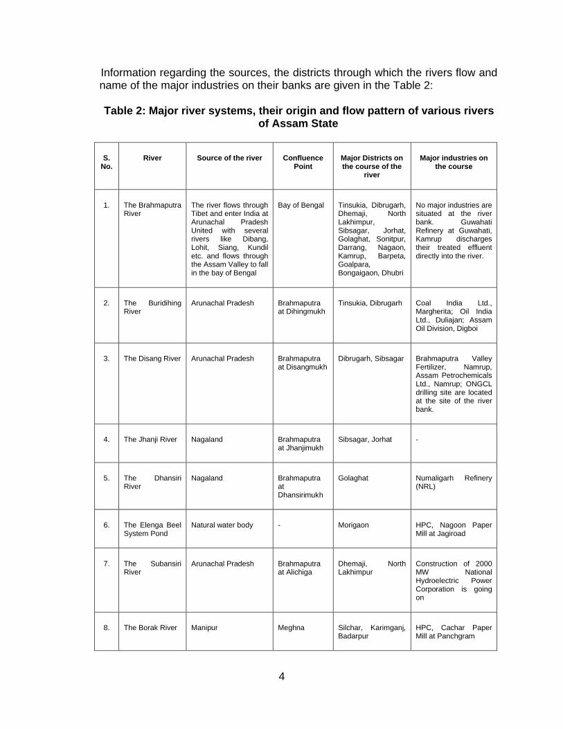
Information regarding the sources, the districts through which the rivers flow and name of the major industries on their banks are given in the Table 2:
Table 2: Major river systems, their origin and flow pattern of various rivers of Assam State
S. No.
River Source of the river Confluence Point
Major Districts on the course of the
river
Major industries on the course
1. The Brahmaputra River
The river flows through Tibet and enter India at Arunachal Pradesh United with several rivers like Dibang, Lohit, Siang, Kundil etc. and flows through the Assam Valley to fall in the bay of Bengal
Bay of Bengal Tinsukia, Dibrugarh, Dhemaji, North Lakhimpur, Sibsagar, Jorhat, Golaghat, Sonitpur, Darrang, Nagaon, Kamrup, Barpeta, Goalpara, Bongaigaon, Dhubri
No major industries are situated at the river bank. Guwahati Refinery at Guwahati, Kamrup discharges their treated effluent directly into the river.
2. The Buridihing River
Arunachal Pradesh Brahmaputra at Dihingmukh
Tinsukia, Dibrugarh Coal India Ltd., Margherita; Oil India Ltd., Duliajan; Assam Oil Division, Digboi
3. The Disang River Arunachal Pradesh Brahmaputra at Disangmukh
Dibrugarh, Sibsagar Brahmaputra Valley Fertilizer, Namrup, Assam Petrochemicals Ltd., Namrup; ONGCL drilling site are located at the site of the river bank.
4. The Jhanji River Nagaland Brahmaputra at Jhanjimukh
Sibsagar, Jorhat -
5. The Dhansiri River
Nagaland Brahmaputra at Dhansirimukh
Golaghat Numaligarh Refinery (NRL)
6. The Elenga Beel System Pond
Natural water body - Morigaon HPC, Nagoon Paper Mill at Jagiroad
7. The Subansiri River
Arunachal Pradesh Brahmaputra at Alichiga
Dhemaji, North Lakhimpur
Construction of 2000 MW National Hydroelectric Power Corporation is going on
8. The Borak River Manipur Meghna Silchar, Karimganj, Badarpur
HPC, Cachar Paper Mill at Panchgram
5
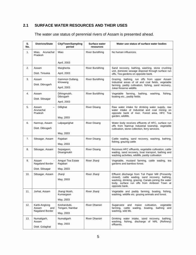
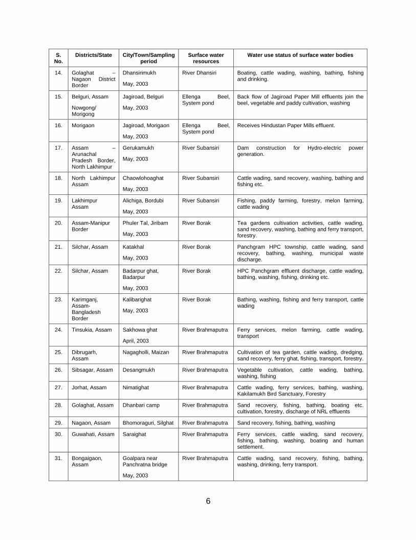
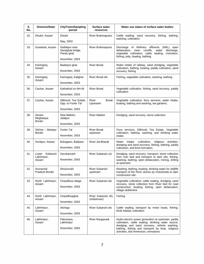
2.1 SURFACE WATER RESOURCES AND THEIR USES
The water use status of perennial rivers of Assam is presented ahead.
S. No.
Districts/State City/Town/Sampling period
Surface water resources
Water use status of surface water bodies
1. Miao, Arunachal Pradesh
Miao
April, 2003
River Buridihing No human influences.
2. Assam
Distt. Tinsukia
Margherita
April, 2003
River Buridihing Sand recovery, bathing, washing, stone crushing unit, domestic sewage disposal through surface run offs, Tea gardens on opposite bank.
3. Assam
Distt. Dibrugarh
Gammon Dullang, Khowang
April, 2003
River Buridihing Grazing, bathing, run offs from upper Assam Industrial areas of oil and coal fields, vegetable farming, paddy cultivation, fishing, sand recovery, Jokai Reserve wildlife.
4. Assam
Distt. Sibsagar
Dihingmukh, Dibrugarh
April, 2003
River Buridihing Vegetable farming, bathing, washing, fishing, boating etc., paddy fields.
5. Assam –Arunachal Pradesh
Dillighat
May, 2003
River Disang Raw water intake for drinking water supply, raw water intake of Industrial and coal mining on opposite bank of river. Forest area, HFC Tea garden, wildlife.
6. Namrup, Assam
Distt. Dibrugarh
Lalpagarighat
May, 2003
River Disang Water body receives effluents of HFC, surface run offs from Namrup Industrial township, vegetable cultivation, stone collection, ferry services.
7. Sibsagar, Assam Rajabari
May, 2003
River Disang Cattle wading, sand recovery, washing, bathing, fishing, grazing cattle
8. Sibsagar, Assam Sepaigaon, Disangmukh
River Disang Receives HFC effluents, vegetable cultivation, cattle wading, sand recovery, boat transport, bathing and washing activities, wildlife, paddy cultivation
9. Assam -Nagaland Border
Distt. Sibsagar
Amguri Tea Estate Rajabari
May, 2003
River Jhanji Vegetable, mustard farming, cattle wading, tea gardens and bamboo forest.
10. Sibsagar, Assam Jhanji
May, 2003
River Jhanji Effluent discharge from Tuli Paper Mill (Presently closed), cattle wading, sand recovery, bathing, washing, drinking, grazing. Canals joining the water body, surface run offs from Amboori Town at opposite bank.
11. Jorhat, Assam Jhangi Mukh, Kumargaon
May, 2003
River Jhanji Vegetable and paddy farming, boating, fishing, washing, wildlife etc. grazing animals and forest.
12. Karbi-Anglong Assam and Nagaland Border
Kesharidubi, Tengani, Nambar
May, 2003
River Dhansiri Sugarcane and maize cultivation, vegetable farming, cattle wading, boating, bathing and washing, wild life.
13. Numaligarh, Assam
Distt. Golaghat
Numaligarh
May, 2003
River Dhansiri Drinking water intake, sand recovery, bathing, washing, fishing, discharge of NRL (Refinery) effluents.
6
S. No.
Districts/State City/Town/Sampling period
Surface water resources
Water use status of surface water bodies
14. Golaghat –Nagaon District Border
Dhansirimukh
May, 2003
River Dhansiri Boating, cattle wading, washing, bathing, fishing and drinking.
15. Belguri, Assam
Nowgong/ Morigong
Jagiroad, Belguri
May, 2003
Ellenga Beel, System pond
Back flow of Jagiroad Paper Mill effluents join the beel, vegetable and paddy cultivation, washing
16. Morigaon Jagiroad, Morigaon
May, 2003
Ellenga Beel, System pond
Receives Hindustan Paper Mills effluent.
17. Assam –Arunachal Pradesh Border, North Lakhimpur
Gerukamukh
May, 2003
River Subansiri Dam construction for Hydro-electric power generation.
18. North Lakhimpur Assam
Chaowlohoaghat
May, 2003
River Subansiri Cattle wading, sand recovery, washing, bathing and fishing etc.
19. Lakhimpur Assam
Alichiga, Bordubi
May, 2003
River Subansiri Fishing, paddy farming, forestry, melon farming, cattle wading
20. Assam-Manipur Border
Phuler Tal, Jiribam
May, 2003
River Borak Tea gardens cultivation activities, cattle wading, sand recovery, washing, bathing and ferry transport, forestry.
21. Silchar, Assam Katakhal
May, 2003
River Borak Panchgram HPC township, cattle wading, sand recovery, bathing, washing, municipal waste discharge.
22. Silchar, Assam Badarpur ghat, Badarpur
May, 2003
River Borak HPC Panchgram effluent discharge, cattle wading, bathing, washing, fishing, drinking etc.
23. Karimganj, Assam-Bangladesh Border
Kalibarighat
May, 2003
River Borak Bathing, washing, fishing and ferry transport, cattle wading
24. Tinsukia, Assam Sakhowa ghat
April, 2003
River Brahmaputra Ferry services, melon farming, cattle wading, transport
25. Dibrugarh, Assam
Nagagholli, Maizan River Brahmaputra Cultivation of tea garden, cattle wading, dredging, sand recovery, ferry ghat, fishing, transport, forestry.
26. Sibsagar, Assam Desangmukh River Brahmaputra Vegetable cultivation, cattle wading, bathing, washing, fishing
27. Jorhat, Assam Nimatighat River Brahmaputra Cattle wading, ferry services, bathing, washing, Kakilamukh Bird Sanctuary, Forestry
28. Golaghat, Assam Dhanbari camp River Brahmaputra Sand recovery, fishing, bathing, boating etc. cultivation, forestry, discharge of NRL effluents
29. Nagaon, Assam Bhomoraguri, Silghat River Brahmaputra Sand recovery, fishing, bathing, washing
30. Guwahati, Assam Saraighat River Brahmaputra Ferry services, cattle wading, sand recovery, fishing, bathing, washing, boating and human settlement.
31. Bongaigaon, Assam
Goalpara near Panchratna bridge
May, 2003
River Brahmaputra Cattle wading, sand recovery, fishing, bathing, washing, drinking, ferry transport.
7
S. No.
Districts/State City/Town/Sampling period
Surface water resources
Water use status of surface water bodies
32. Dhubri, Assam Dhubri
May, 2003
River Brahmaputra Cattle wading, sand recovery, fishing, bathing, washing, cultivation.
33. Guwahati, Assam Sadilapur near Savaighat bridge, Pandu ghat
November, 2003
River Brahmaputra Discharge of Refinery effluents (NRL) open defaecation, town runoffs, water discharge, vegetable cultivation, cattle wading, cremation, fishing, jetty, boating, bathing.
34. Karimganj, Assam
Badarpur ghat
November, 2003
River Borak Water intake of railway, sand dredging, vegetable cultivation, bathing, boating, paddy cultivation, sand recovery, fishing
35. Karimganj, Assam
Karimganj, Kalighat
November, 2003
River Borak d/s Fishing, vegetable cultivation, washing, bathing
36. Cachar, Assam Kathakhal on NH-44
November, 2003
River Borak Vegetable cultivation, fishing, sand recovery, paddy cultivation
37. Cachar, Assam Dilkhush Tea Estate, Opp. to Fooler Tal
November, 2003
River Borak Upstream
Vegetable cultivation, ferry services, water intake, boating, bathing and washing, tea gardens.
38. Assam Meghalaya Border
New-Malidor, Jalalpur
November, 2003
River Malidor Dredging, sand recovery, stone collection.
39. Silchar – Manipur Border
Fooler Tal
November, 2003
River Borak upstream
Ferry services, Dilkhush Tea Estate, Vegetable cultivation, bathing, washing, and drinking water intake.
40. Sonitpur, Assam Bukagaon, Balipara
November, 2003
River Jia-Bharali Water Intake, cultivation, religious activities, dredging and sand recovery, fishing, bathing, paddy cultivation, and brick formation.
41. Lower Subansiri Lakhimpur, Assam
Gerukamukh
November, 2003
River Subansiri u/s Dredging, sand recovery, transport, stone collection from river bed and transport to dam site, fishing, washing, bathing, open defaecation, mining, drilling at upstream.
42. Arunachal Pradesh Border
Dhulumukh
November, 2003
River Subansiri upstream
Washing, bathing, boating, drinking water for wildlife transport of the River stones by motorboats to dam construction site.
43. North Lakhimpur, Assam
Chauldhua village
November, 2003
River Subansiri d/s Vegetable cultivation, cattle wading, dredging, sand recovery, stone collection from River bed for road construction, boating, fishing, open defaecation, village settlement.
44. North Lakhimpur, Assam
Chauldhuaghat
November, 2003
River Subansiri d/s (midstream)
Fishing
45. Lakhimpur, Assam
Alichiga
November, 2003
River Subansiri d/s Cattle wading, transport by motor boats, fishing, birds habitat, cultivation
46. Lakhimpur, Assam
Pahumara, Lakhimpur
November, 2003
River Ranganadi Hydro-electric power generation at upstream, paddy cultivation, cattle wading, drinking water source, dredging and sand recovery, vehicle washing, bathing, fishing and transport by boat, religious activities, idol immersion, cremations.

8
S. No.
Districts/State City/Town/Sampling period
Surface water resources
Water use status of surface water bodies
47. Lakhimpur, Assam
Bogi Nadi, Milanpur
November, 2003
River Boginadi Drinking water, vegetable cultivation, cattle wading, dredging and sand recovery, bathing, washing and fishing, human settlement, paddy cultivation.
48. Assam –Arunachal Pradesh Border
Parbati Nagar, Harmutty Tea Estate Bandardua –Itanagar Border
November, 2003
River Dikrong Cattle wading, dredging, sand recovery, fishing, bathing, boating.
49. Sonitpur, Assam Bhoomuraguri, Tejpur
River Brahmaputra Vegetable, paddy cultivation, bathing, washing, fishing and boating, open defaecation, wildlife.
50. Bongaigaon, Assam
Jogighopa
November, 2003
River Brahmaputra Water Intake of Jogighopa Paper Mill, coal transport by ship and boats, cremation, mustard vegetable cultivation, fishing, open defaecation, paddy field, human settlement.
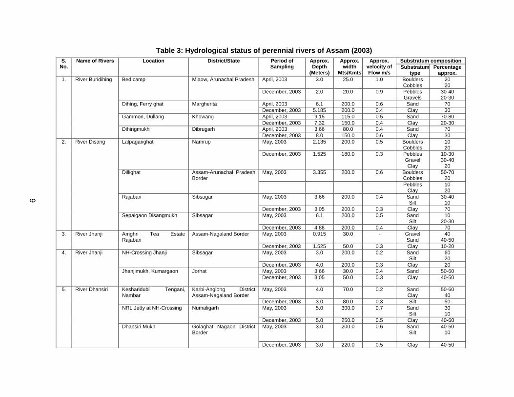
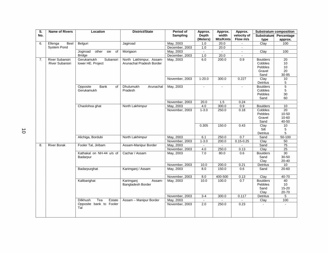
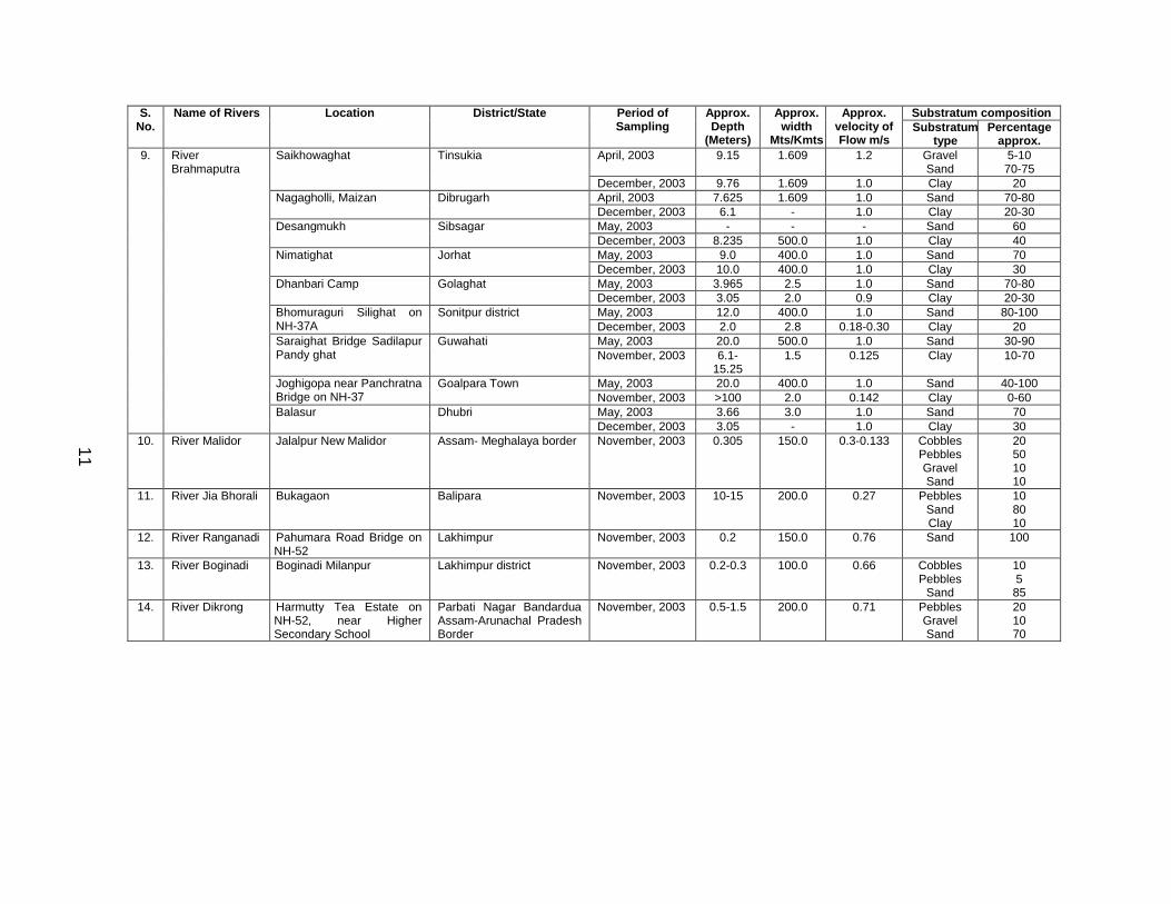
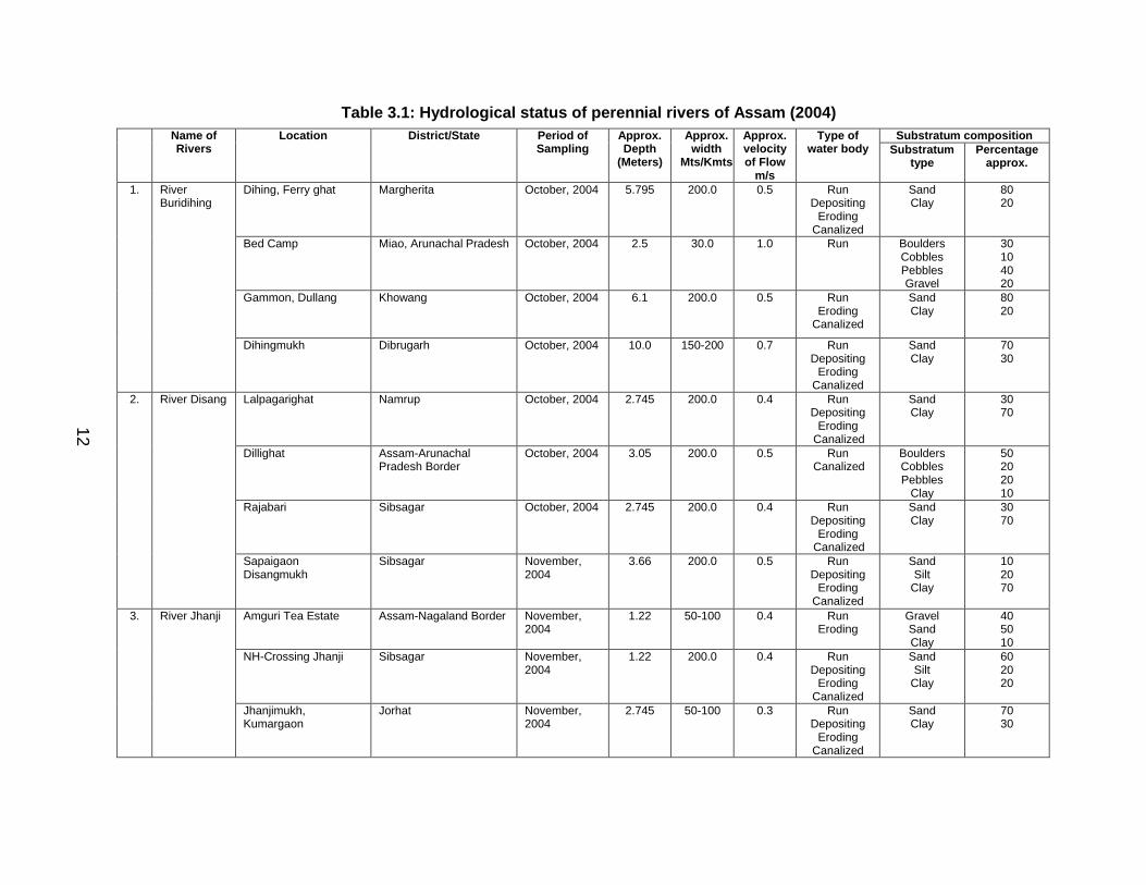
2.2 HYDROLOGICAL STATUS AND ENVIRONMENTAL PROBLEMS
Hydrological status of a water body is an important factor, which determines the status of establishment of biological communities of Benthic macro-invertebrate families. A mature colonization of benthic macro-invertebrate communities in a water body is essential for actual water quality assessment. A number of human activities such as melon farming on River bank, cultivation, brick kilns and brick formation on catchment of river sand dredging, stone collection from river bed for road construction and stone crushers etc. are detrimental activities responsible for habitat destruction in terms of change in flow, depth, self purification capacity of water body and alteration in substratum type, which in turn determine the establishment of fauna and flora in a water body. The tributaries River Brahmaputra viz. River Buridihing, River Disang and River Subansiri possess natural substratum in their upstream reaches in Assam State. Their substratum composed of mainly Boulders, Cobbles, Pebbles and Gravel with comparatively less percentage of sand. The flow of water in these reaches ranges from 0.6 to 1.0 m/s. These habitats are suitable for biological establishments. Other rivers generally have sandy and clay substratum providing poor habitat for proper colonization of biological communities.
9
Table 3: Hydrological status of perennial rivers of Assam (2003)Substratum compositionS.
No.Name of Rivers Location District/State Period of
SamplingApprox. Depth
(Meters)
Approx. width
Mts/Kmts
Approx. velocity of Flow m/s
Substratum type
Percentage approx.
April, 2003 3.0 25.0 1.0 BouldersCobbles
2020
Bed camp Miaow, Arunachal Pradesh
December, 2003 2.0 20.0 0.9 PebblesGravels
30-4020-30
April, 2003 6.1 200.0 0.6 Sand 70Dihing, Ferry ghat MargheritaDecember, 2003 5.185 200.0 0.4 Clay 30April, 2003 9.15 115.0 0.5 Sand 70-80Gammon, Dullang KhowangDecember, 2003 7.32 150.0 0.4 Clay 20-30April, 2003 3.66 80.0 0.4 Sand 70
1. River Buridihing
Dihingmukh DibrugarhDecember, 2003 8.0 150.0 0.6 Clay 30May, 2003 2.135 200.0 0.5 Boulders
Cobbles1020
Lalpagarighat Namrup
December, 2003 1.525 180.0 0.3 PebblesGravelClay
10-3030-40
20May, 2003 3.355 200.0 0.6 Boulders
Cobbles50-70
20Dillighat Assam-Arunachal Pradesh
BorderPebbles
Clay1020
May, 2003 3.66 200.0 0.4 SandSilt
30-4010
Rajabari Sibsagar
December, 2003 3.05 200.0 0.3 Clay 70May, 2003 6.1 200.0 0.5 Sand
Silt10
20-30
2. River Disang
Sepaigaon Disangmukh Sibsagar
December, 2003 4.88 200.0 0.4 Clay 70May, 2003 0.915 30.0 - Gravel
Sand40
40-503. River Jhanji Amghri Tea Estate
RajabariAssam-Nagaland Border
December, 2003 1.525 50.0 0.3 Clay 10-20May, 2003 3.0 200.0 0.2 Sand
Silt6020
NH-Crossing Jhanji Sibsagar
December, 2003 4.0 200.0 0.3 Clay 20May, 2003 3.66 30.0 0.4 Sand 50-60
4. River Jhanji
Jhanjimukh, Kumargaon JorhatDecember, 2003 3.05 50.0 0.3 Clay 40-50
May, 2003 4.0 70.0 0.2 SandClay
50-6040
Kesharidubi Tengani, Nambar
Karbi-Anglong District Assam-Nagaland Border
December, 2003 3.0 80.0 0.3 Silt 50May, 2003 5.0 300.0 0.7 Sand
Silt3010
NRL Jetty at NH-Crossing Numaligarh
December, 2003 5.0 250.0 0.5 Clay 40-60
5. River Dhansiri
Dhansiri Mukh Golaghat Nagaon District Border
May, 2003 3.0 200.0 0.6 SandSilt
40-5010
December, 2003 3.0 220.0 0.5 Clay 40-50
9
10
Substratum compositionS. No.
Name of Rivers Location District/State Period of Sampling
Approx. Depth
(Meters)
Approx. width
Mts/Kmts
Approx. velocity of Flow m/s
Substratum type
Percentage approx.
May, 2003 1.0 20.0 - Clay 100Belguri JagiroadDecember, 2003 1.0 20.0 -May, 2003 - - - Clay 100
6. Ellenga Beel System Pond
Jogiroad other sie of Bridge
MorigaonDecember, 2003 1.0 20.0 -May, 2003 6.0 200.0 0.9 Boulders
CobblesPebblesGravelSand
20101020
30-85
Gerukamukh Subansiri lower HE. Project
North Lakhimpur, Assam-Arunachal Pradesh Border
November, 2003 1-20.0 300.0 0.227 ClayDetritus
105
May, 2003 - - - BouldersCobblesPebbles
Sand
553060
Opposite Bank of Gerukamukh
Dhulumukh Arunachal Pradesh
November, 2003 20.0 1.5 0.24May, 2003 4.0 300.0 0.9 Boulders 10
1-3.0 250.0 0.18 CobblesPebblesGravelSand
2010-5010-6040-50
Chaolohoa ghat North LakhimpurNovember, 2003
0.305 150.0 0.43 ClaySilt
Detritus
1055
May, 2003 6.1 250.0 0.7 Sand 50-100
7. River SubansiriRiver Subansiri
Alichiga, Bordubi North LakhimpurNovember, 2003 1-3.0 200.0 0.15-0.25 Clay 50May, 2003 - - - Sand 75Fooler Tal, Jiribam Assam-Manipur BorderNovember, 2003 4.0 250.0 0.13 Clay 25May, 2003 7.0 80.0 0.6 Boulders
SandClay
3030-5020-40
Kathakal on NH-44 u/s of Badarpur
Cachar / Assam
November, 2003 10.0 200.0 0.21 Detritus 10May, 2003 8.0 150.0 0.6 Sand 20-60Badarpurghat Karimganj / Assam
November, 2003 8.0 400-500 0.13 Clay 40-70May, 2003 10.0 100.0 0.7 Boulders
PebblesSandClay
4010
15-2020-70
Kalibarighat Karimganj Assam-Bangladesh Border
November, 2003 3-4 300.0 0.117 Detritus 5May, 2003 - - - Clay 100
8. River Borak
Dilkhush Tea Estate Opposite bank to Fooler Tal
Assam – Manipur BorderNovember, 2003 2.0 250.0 0.23 - -
10
11
Substratum compositionS. No.
Name of Rivers Location District/State Period of Sampling
Approx. Depth
(Meters)
Approx. width
Mts/Kmts
Approx. velocity of Flow m/s
Substratum type
Percentage approx.
April, 2003 9.15 1.609 1.2 GravelSand
5-1070-75
Saikhowaghat Tinsukia
December, 2003 9.76 1.609 1.0 Clay 20April, 2003 7.625 1.609 1.0 Sand 70-80Nagagholli, Maizan DibrugarhDecember, 2003 6.1 - 1.0 Clay 20-30May, 2003 - - - Sand 60Desangmukh SibsagarDecember, 2003 8.235 500.0 1.0 Clay 40May, 2003 9.0 400.0 1.0 Sand 70Nimatighat JorhatDecember, 2003 10.0 400.0 1.0 Clay 30May, 2003 3.965 2.5 1.0 Sand 70-80Dhanbari Camp GolaghatDecember, 2003 3.05 2.0 0.9 Clay 20-30May, 2003 12.0 400.0 1.0 Sand 80-100Bhomuraguri Silighat on
NH-37ASonitpur district
December, 2003 2.0 2.8 0.18-0.30 Clay 20May, 2003 20.0 500.0 1.0 Sand 30-90Saraighat Bridge Sadilapur
Pandy ghatGuwahati
November, 2003 6.1-15.25
1.5 0.125 Clay 10-70
May, 2003 20.0 400.0 1.0 Sand 40-100Joghigopa near Panchratna Bridge on NH-37
Goalpara TownNovember, 2003 >100 2.0 0.142 Clay 0-60May, 2003 3.66 3.0 1.0 Sand 70
9. River Brahmaputra
Balasur DhubriDecember, 2003 3.05 - 1.0 Clay 30
10. River Malidor Jalalpur New Malidor Assam- Meghalaya border November, 2003 0.305 150.0 0.3-0.133 CobblesPebblesGravelSand
20501010
11. River Jia Bhorali Bukagaon Balipara November, 2003 10-15 200.0 0.27 PebblesSandClay
108010
12. River Ranganadi Pahumara Road Bridge on NH-52
Lakhimpur November, 2003 0.2 150.0 0.76 Sand 100
13. River Boginadi Boginadi Milanpur Lakhimpur district November, 2003 0.2-0.3 100.0 0.66 CobblesPebbles
Sand
10585
14. River Dikrong Harmutty Tea Estate on NH-52, near Higher Secondary School
Parbati Nagar Bandardua Assam-Arunachal Pradesh Border
November, 2003 0.5-1.5 200.0 0.71 PebblesGravelSand
201070
11
12
Table 3.1: Hydrological status of perennial rivers of Assam (2004)Substratum compositionName of
RiversLocation District/State Period of
SamplingApprox. Depth
(Meters)
Approx. width
Mts/Kmts
Approx. velocity of Flow
m/s
Type of water body Substratum
typePercentage
approx.
Dihing, Ferry ghat Margherita October, 2004 5.795 200.0 0.5 Run Depositing
ErodingCanalized
SandClay
8020
Bed Camp Miao, Arunachal Pradesh October, 2004 2.5 30.0 1.0 Run BouldersCobblesPebblesGravel
30104020
Gammon, Dullang Khowang October, 2004 6.1 200.0 0.5 RunEroding
Canalized
SandClay
8020
1. River Buridihing
Dihingmukh Dibrugarh October, 2004 10.0 150-200 0.7 Run Depositing
ErodingCanalized
SandClay
7030
Lalpagarighat Namrup October, 2004 2.745 200.0 0.4 Run Depositing
ErodingCanalized
SandClay
3070
Dillighat Assam-Arunachal Pradesh Border
October, 2004 3.05 200.0 0.5 Run Canalized
BouldersCobblesPebbles
Clay
50202010
Rajabari Sibsagar October, 2004 2.745 200.0 0.4 Run Depositing
ErodingCanalized
SandClay
3070
2. River Disang
Sapaigaon Disangmukh
Sibsagar November, 2004
3.66 200.0 0.5 Run Depositing
ErodingCanalized
SandSilt
Clay
102070
Amguri Tea Estate Assam-Nagaland Border November, 2004
1.22 50-100 0.4 Run Eroding
GravelSandClay
405010
NH-Crossing Jhanji Sibsagar November, 2004
1.22 200.0 0.4 Run Depositing
ErodingCanalized
SandSilt
Clay
602020
3. River Jhanji
Jhanjimukh, Kumargaon
Jorhat November, 2004
2.745 50-100 0.3 Run Depositing
ErodingCanalized
SandClay
7030
12
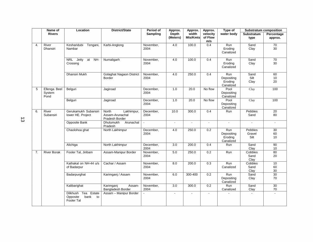
13
Substratum compositionName of Rivers
Location District/State Period of Sampling
Approx. Depth
(Meters)
Approx. width
Mts/Kmts
Approx. velocity of Flow
m/s
Type of water body Substratum
typePercentage
approx.
Kesharidubi Tengani, Nambar
Karbi-Anglong November, 2004
4.0 100.0 0.4 Run Eroding
Canalized
SandClay
7030
NRL Jetty at NH-Crossing
Numaligarh November, 2004
4.0 100.0 0.4 Run Eroding
Canalized
SandClay
7030
4. River Dhansiri
Dhansiri Mukh Golaghat Nagaon District Border
November, 2004
4.0 250.0 0.4 Run Depositing
ErodingCanalized
SandSilt
Clay
601020
Belguri Jagiroad December, 2004
1.0 20.0 No flow Pool DepositingCanalized
Clay 1005 Ellenga Beel System Pond
Belguri Jagiroad December, 2004
1.0 20.0 No flow Pool DepositingCanalized
Clay 100
Gerukamukh Subansiri lower HE. Project
North Lakhimpur, Assam-Arunachal Pradesh Border
December, 2004
10.0 300.0 0.4 Run PebblesSand
2080
Opposite Bank Dhulumukh Arunachal Pradesh
- - - - - - -
Chaolohoa ghat North Lakhimpur December, 2004
4.0 250.0 0.2 Run Depositing
ErodingCanalized
PebblesGravel
Silt
306010
6. River Subansiri
Alichiga North Lakhimpur December, 2004
3.0 200.0 0.4 Run SandClay
9010
Fooler Tal, Jiribam Assam-Manipur Border November, 2004
5.0 250.0 0.2 Run CobblesSandClay
8020
Kathakal on NH-44 u/s of Badarpur
Cachar / Assam November, 2004
8.0 200.0 0.3 Run Canalized
CobblesSandClay
106030
Badarpurghat Karimganj / Assam November, 2004
6.0 300-400 0.2 Run DepositingCanalized
SandClay
3070
Kalibarighat Karimganj Assam-Bangladesh Border
November, 2004
3.0 300.0 0.2 Run Canalized
SandClay
3070
7. River Borak
Dilkhush Tea Estate Opposite bank to Fooler Tal
Assam – Manipur Border - - - - - - -
13
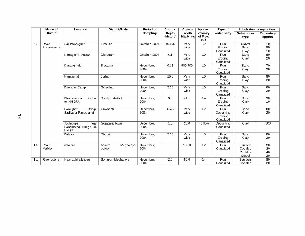
14
Substratum compositionName of Rivers
Location District/State Period of Sampling
Approx. Depth
(Meters)
Approx. width
Mts/Kmts
Approx. velocity of Flow
m/s
Type of water body Substratum
typePercentage
approx.
Saikhowa ghat Tinsukia October, 2004 10.675 Very wide
1.2 Run Eroding
Canalized
GravelSandClay
108010
Nagagholli, Maizan Dibrugarh October, 2004 6.1 Very wide
1.0 Run Eroding
Canalized
SandClay
8020
Desangmukh Sibsagar November, 2004
9.15 500-700 1.0 Run Eroding
Canalized
SandClay
7030
Nimatighat Jorhat November, 2004
15.0 Very wide
1.0 Run Eroding
Canalized
SandClay
8020
Dhanbari Camp Golaghat November, 2004
3.05 Very wide
1.0 Run Eroding
Canalized
SandClay
8020
Bhomuraguri Silighat on NH-37A
Sonitpur district November, 2004
3.0 2 km 0.4 Run Eroding
Canalized
SandClay
9010
Saraighat Bridge Sadilapur Pandu ghat
Guwahati December, 2004
4.575 Very wide
0.2 Run Depositing
ErodingCanalized
SandClay
8020
Joghigopa near Panchratna Bridge on NH-37
Goalpara Town December, 2004
1.0 20.0 No flow DepositingCanalized
Clay 100
9. River Brahmaputra
Balasur Dhubri November, 2004
3.05 Very wide
1.0 Run Eroding
Canalized
SandClay
8020
10. River Malidor
Jalalpur Assam- Meghalaya border
November, 2004
- 100.0 0.2 Run Canalized
BouldersCobblesPebblesGravel
20204020
11. River Lubha Near Lubha bridge Sonapur, Meghalaya November, 2004
2.0 80.0 0.4 Run Canalized
BouldersCobbles
8020
14
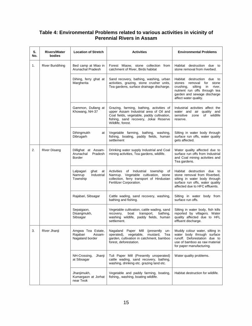
15
Table 4: Environmental Problems related to various activities in vicinity of Perennial Rivers in Assam
S. No.
Rivers/Water bodies
Location of Stretch Activities Environmental Problems
Bed camp at Miao in Arunachal Pradesh
Forest Miaow, stone collection from catchment of River, Birds habitat
Habitat destruction due to stone removal from riverbed.
Dihing, ferry ghat at Margherita
Sand recovery, bathing, washing, urban activities, grazing, stone crusher units, Tea gardens, surface drainage discharge.
Habitat destruction due to stones removal for stone crushing, silting in river, nutrient run offs through tea garden and sewage discharge affect water quality.
Gammon, Dullang at Khowang, NH-37
Grazing, farming, bathing, activities of upper Assam Industrial area of Oil and Coal fields, vegetable, paddy cultivation, fishing, sand recovery, Jokai Reserve Wildlife, forest.
Industrial activities affect the water and air quality and sensitive zone of wildlife reserve.
1. River Buridihing
Dihingmukh at Dibrugarh
Vegetable farming, bathing, washing, fishing, boating, paddy fields, human settlement
Silting in water body through surface run offs, water quality gets affected.
Dillighat at Assam-Arunachal Pradesh Border
Drinking water supply Industrial and Coal mining activities, Tea gardens, wildlife.
Water quality affected due to surface run offs from Industrial and Coal mining activities and Tea gardens.
Lalpagari ghat at Namrup Industrial Township
Activities of Industrial township of Namrup. Vegetable cultivation, stone collection, ferry transport of Hindustan Fertilizer Corporation.
Habitat destruction due to stone removal from Riverbed, silting in water body through surface run offs, water quality affected due to HFC effluents.
Rajabari, Sibsagar Cattle wading, sand recovery, washing, bathing and fishing.
Silting in water body from surface run offs.
2. River Disang
Sepaigaon, Disangmukh, Sibsagar
Vegetable cultivation, cattle wading, sand recovery, boat transport, bathing, washing wildlife, paddy fields, human settlement.
Silting in water body, fish kills reported by villagers. Water quality affected due to HFL effluent discharge.
Amgwa Tea Estate, Rajabari Assam-Nagaland border
Nagaland Paper Mill (presently un-operated), vegetable, mustard, Tea garden, cultivation in catchment, bamboo forest, deforestation.
Muddy colour water, silting in water body through surface runoff. Deforestation due to use of bamboo as raw material for paper manufacturing.
NH-Crossing, Jhanji at Sibsagar
Tuli Paper Mill (Presently unoperated) cattle wading, sand recovery, bathing, washing, drinking etc. grazing land etc.
Water quality problems.
3. River Jhanji
Jhanjimukh, Kumargaon at Jorhat near Teok
Vegetable and paddy farming, boating, fishing,, washing, boating wildlife.
Habitat destruction for wildlife.
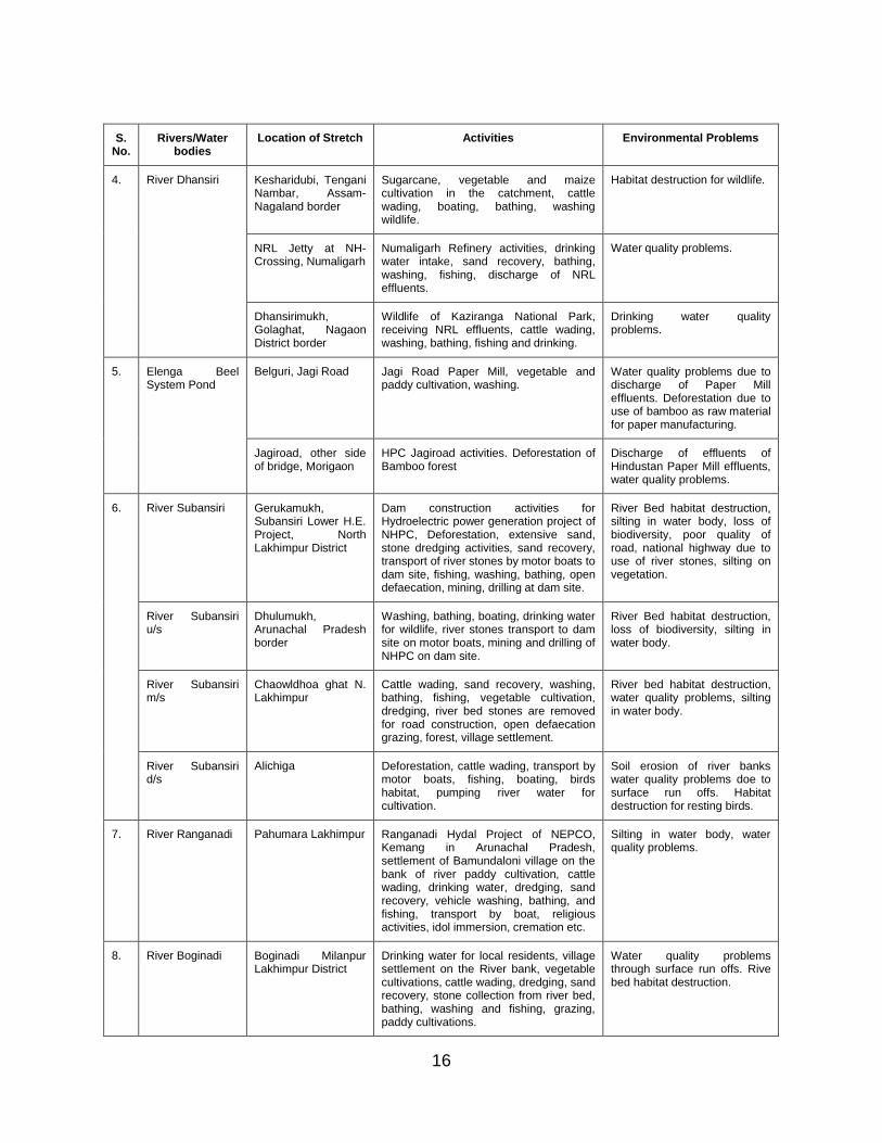
16
S. No.
Rivers/Water bodies
Location of Stretch Activities Environmental Problems
Kesharidubi, Tengani Nambar, Assam-Nagaland border
Sugarcane, vegetable and maize cultivation in the catchment, cattle wading, boating, bathing, washing wildlife.
Habitat destruction for wildlife.
NRL Jetty at NH-Crossing, Numaligarh
Numaligarh Refinery activities, drinking water intake, sand recovery, bathing, washing, fishing, discharge of NRL effluents.
Water quality problems.
4. River Dhansiri
Dhansirimukh, Golaghat, Nagaon District border
Wildlife of Kaziranga National Park, receiving NRL effluents, cattle wading, washing, bathing, fishing and drinking.
Drinking water quality problems.
Belguri, Jagi Road Jagi Road Paper Mill, vegetable and paddy cultivation, washing.
Water quality problems due to discharge of Paper Mill effluents. Deforestation due to use of bamboo as raw material for paper manufacturing.
5. Elenga Beel System Pond
Jagiroad, other side of bridge, Morigaon
HPC Jagiroad activities. Deforestation of Bamboo forest
Discharge of effluents of Hindustan Paper Mill effluents, water quality problems.
River Subansiri Gerukamukh, Subansiri Lower H.E. Project, North Lakhimpur District
Dam construction activities for Hydroelectric power generation project of NHPC, Deforestation, extensive sand, stone dredging activities, sand recovery, transport of river stones by motor boats to dam site, fishing, washing, bathing, open defaecation, mining, drilling at dam site.
River Bed habitat destruction, silting in water body, loss of biodiversity, poor quality of road, national highway due to use of river stones, silting on vegetation.
River Subansiri u/s
Dhulumukh, Arunachal Pradesh border
Washing, bathing, boating, drinking water for wildlife, river stones transport to dam site on motor boats, mining and drilling of NHPC on dam site.
River Bed habitat destruction, loss of biodiversity, silting in water body.
River Subansiri m/s
Chaowldhoa ghat N. Lakhimpur
Cattle wading, sand recovery, washing, bathing, fishing, vegetable cultivation, dredging, river bed stones are removed for road construction, open defaecation grazing, forest, village settlement.
River bed habitat destruction, water quality problems, silting in water body.
6.
River Subansiri d/s
Alichiga Deforestation, cattle wading, transport by motor boats, fishing, boating, birds habitat, pumping river water for cultivation.
Soil erosion of river banks water quality problems doe to surface run offs. Habitat destruction for resting birds.
7. River Ranganadi Pahumara Lakhimpur Ranganadi Hydal Project of NEPCO, Kemang in Arunachal Pradesh, settlement of Bamundaloni village on the bank of river paddy cultivation, cattle wading, drinking water, dredging, sand recovery, vehicle washing, bathing, and fishing, transport by boat, religious activities, idol immersion, cremation etc.
Silting in water body, water quality problems.
8. River Boginadi Boginadi Milanpur Lakhimpur District
Drinking water for local residents, village settlement on the River bank, vegetable cultivations, cattle wading, dredging, sand recovery, stone collection from river bed, bathing, washing and fishing, grazing, paddy cultivations.
Water quality problems through surface run offs. Rive bed habitat destruction.
17
S. No.
Rivers/Water bodies
Location of Stretch Activities Environmental Problems
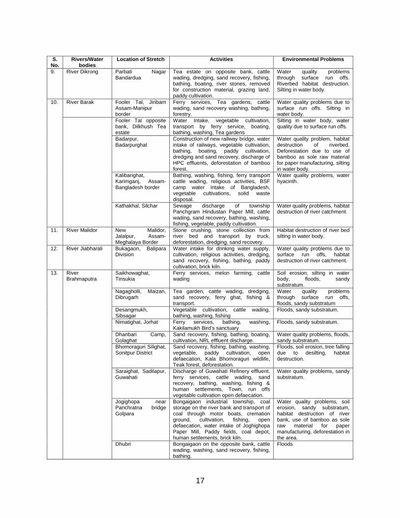
9. River Dikrong Parbati Nagar Bandardua
Tea estate on opposite bank, cattle wading, dredging, sand recovery, fishing, bathing, boating, river stones, removed for construction material, grazing land, paddy cultivation.
Water quality problems through surface run offs. Riverbed habitat destruction. Silting in water body.
River Barak Fooler Tal, Jiribam Assam-Manipur border
Ferry services, Tea gardens, cattle wading, sand recovery washing, bathing, forestry.
Water quality problems due to surface run offs. Silting in water body.
10.
Fooler Tal opposite bank, Dilkhush Tea estate
Water Intake, vegetable cultivation, transport by ferry service, boating, bathing, washing, Tea gardens
Silting in water body, water quality due to surface run offs.
Badarpur, Badarpurghat
Construction of new railway bridge, water intake of railways, vegetable cultivation, bathing, boating, paddy cultivation, dredging and sand recovery, discharge of HPC effluents, deforestation of bamboo forest.
Water quality problem, habitat destruction of riverbed. Deforestation due to use of bamboo as sole raw material for paper manufacturing, silting in water body.
Kalibarighat, Karimganj, Assam-Bangladesh border
Bathing, washing, fishing, ferry transport cattle wading, religious activities, BSF camp water intake of Bangladesh, vegetable cultivations, solid waste disposal.
Water quality problems, water hyacinth.
Kathakhal, Silchar Sewage discharge of township Panchgram Hindustan Paper Mill, cattle wading, sand recovery, bathing, washing, fishing, vegetable, paddy cultivation.
Water quality problems, habitat destruction of river catchment.
11. River Malidor New Malidor, Jalalpur, Assam-Meghalaya Border
Stone crushing, stone collection from river bed and transport by truck, deforestation, dredging, sand recovery.
Habitat destruction of river bed silting in water body.
12. River Jiabharali Bukagaon, Balipara Division
Water intake for drinking water supply, cultivation, religious activities, dredging, sand recovery, fishing, bathing, paddy cultivation, brick kiln.
Water quality problems due to surface run offs, habitat destruction of river catchment.
Saikhowaghat, Tinsukia
Ferry services, melon farming, cattle wading
Soil erosion, silting in water body, floods, sandy substratum.
Nagagholli, Maizan, Dibrugarh
Tea garden, cattle wading, dredging, sand recovery, ferry ghat, fishing & transport.
Water quality problems through surface run offs, floods, sandy substratum
Desangmukh, Sibsagar
Vegetable cultivation, cattle wading, bathing, washing, fishing
Floods, sandy substratum.
Nimatighat, Jorhat Ferry services, bathing, washing, Kakilamukh Bird’s sanctuary
Floods, sandy substratum.
Dhanbari Camp, Golaghat
Sand recovery, fishing, bathing, boating, cultivation, NRL effluent discharge.
Water quality problems, floods, sandy substratum.
Bhomoraguri Silighat, Sonitpur District
Sand recovery, fishing, bathing, washing, vegetable, paddy cultivation, open defaecation, Kala Bhomoraguri wildlife, Teak forest, deforestation.
Floods, soil erosion, tree falling due to desilting, habitat destruction.
Saraighat, Sadilapur, Guwahati
Discharge of Guwahati Refinery effluent, ferry services, cattle wading, sand recovery, bathing, washing, fishing & human settlements, Town, run offs vegetable cultivation open defaecation.
Water quality problems, sandy substratum.
Jogighopa near Panchratna bridge Golpara
Bongaigaon industrial township, coal storage on the river bank and transport of coal through motor boats, cremation ground, cultivation, fishing, open defaecation, water intake of Joghighopa Paper Mill, Paddy fields, coal depot, human settlements, brick kiln.
Water quality problems, soil erosion, sandy substratum, habitat destruction of river bank, use of bamboo as sole raw material for paper manufacturing, deforestation in the area.
13. River Brahmaputra
Dhubri Bongaigaon on the opposite bank, cattle wading, washing, sand recovery, fishing, bathing.
Floods
18
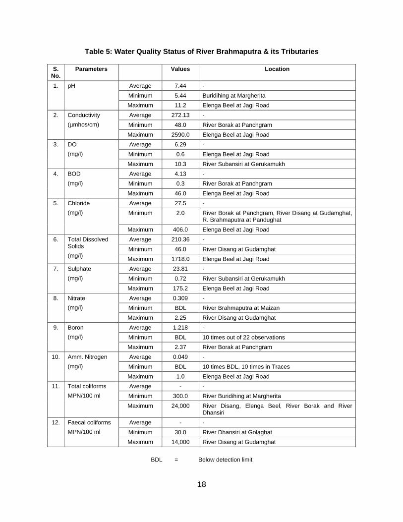
Table 5: Water Quality Status of River Brahmaputra & its Tributaries
S. No.
Parameters Values Location
Average 7.44 -
Minimum 5.44 Buridihing at Margherita
1. pH
Maximum 11.2 Elenga Beel at Jagi Road
Average 272.13 -
Minimum 48.0 River Borak at Panchgram
2. Conductivity
(µmhos/cm)
Maximum 2590.0 Elenga Beel at Jagi Road
Average 6.29 -
Minimum 0.6 Elenga Beel at Jagi Road
3. DO
(mg/l)
Maximum 10.3 River Subansiri at Gerukamukh
Average 4.13 -
Minimum 0.3 River Borak at Panchgram
4. BOD
(mg/l)
Maximum 46.0 Elenga Beel at Jagi Road
Average 27.5 -
Minimum 2.0 River Borak at Panchgram, River Disang at Gudamghat, R. Brahmaputra at Pandughat
5. Chloride
(mg/l)
Maximum 406.0 Elenga Beel at Jagi Road
Average 210.36 -
Minimum 46.0 River Disang at Gudamghat
6. Total Dissolved Solids
(mg/l)Maximum 1718.0 Elenga Beel at Jagi Road
Average 23.81 -
Minimum 0.72 River Subansiri at Gerukamukh
7. Sulphate
(mg/l)
Maximum 175.2 Elenga Beel at Jagi Road
Average 0.309 -
Minimum BDL River Brahmaputra at Maizan
8. Nitrate
(mg/l)
Maximum 2.25 River Disang at Gudamghat
Average 1.218 -
Minimum BDL 10 times out of 22 observations
9. Boron
(mg/l)
Maximum 2.37 River Borak at Panchgram
Average 0.049 -
Minimum BDL 10 times BDL, 10 times in Traces
10. Amm. Nitrogen
(mg/l)
Maximum 1.0 Elenga Beel at Jagi Road
Average - -
Minimum 300.0 River Buridihing at Margherita
11. Total coliforms
MPN/100 ml
Maximum 24,000 River Disang, Elenga Beel, River Borak and River Dhansiri
Average - -
Minimum 30.0 River Dhansiri at Golaghat
12. Faecal coliforms
MPN/100 ml
Maximum 14,000 River Disang at Gudamghat
BDL = Below detection limit
19
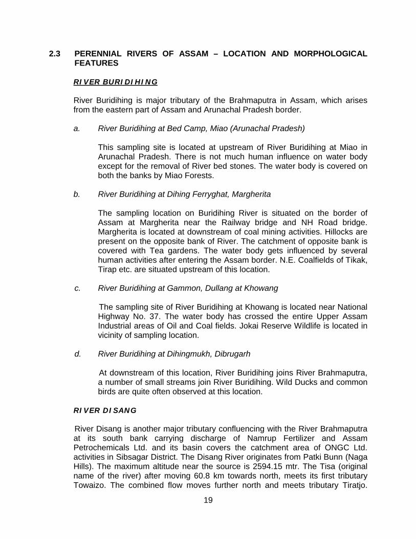
2.3 PERENNIAL RIVERS OF ASSAM – LOCATION AND MORPHOLOGICAL FEATURES
RIVER BURIDIHING
River Buridihing is major tributary of the Brahmaputra in Assam, which arises from the eastern part of Assam and Arunachal Pradesh border.
a. River Buridihing at Bed Camp, Miao (Arunachal Pradesh)
This sampling site is located at upstream of River Buridihing at Miao in Arunachal Pradesh. There is not much human influence on water body except for the removal of River bed stones. The water body is covered on both the banks by Miao Forests.
b. River Buridihing at Dihing Ferryghat, Margherita
The sampling location on Buridihing River is situated on the border of Assam at Margherita near the Railway bridge and NH Road bridge. Margherita is located at downstream of coal mining activities. Hillocks are present on the opposite bank of River. The catchment of opposite bank is covered with Tea gardens. The water body gets influenced by several human activities after entering the Assam border. N.E. Coalfields of Tikak, Tirap etc. are situated upstream of this location.
c. River Buridihing at Gammon, Dullang at Khowang
The sampling site of River Buridihing at Khowang is located near National Highway No. 37. The water body has crossed the entire Upper Assam Industrial areas of Oil and Coal fields. Jokai Reserve Wildlife is located in vicinity of sampling location.
d. River Buridihing at Dihingmukh, Dibrugarh
At downstream of this location, River Buridihing joins River Brahmaputra, a number of small streams join River Buridihing. Wild Ducks and common birds are quite often observed at this location.
RIVER DISANG
River Disang is another major tributary confluencing with the River Brahmaputra at its south bank carrying discharge of Namrup Fertilizer and Assam Petrochemicals Ltd. and its basin covers the catchment area of ONGC Ltd. activities in Sibsagar District. The Disang River originates from Patki Bunn (Naga Hills). The maximum altitude near the source is 2594.15 mtr. The Tisa (original name of the river) after moving 60.8 km towards north, meets its first tributary Towaizo. The combined flow moves further north and meets tributary Tiratjo.
20
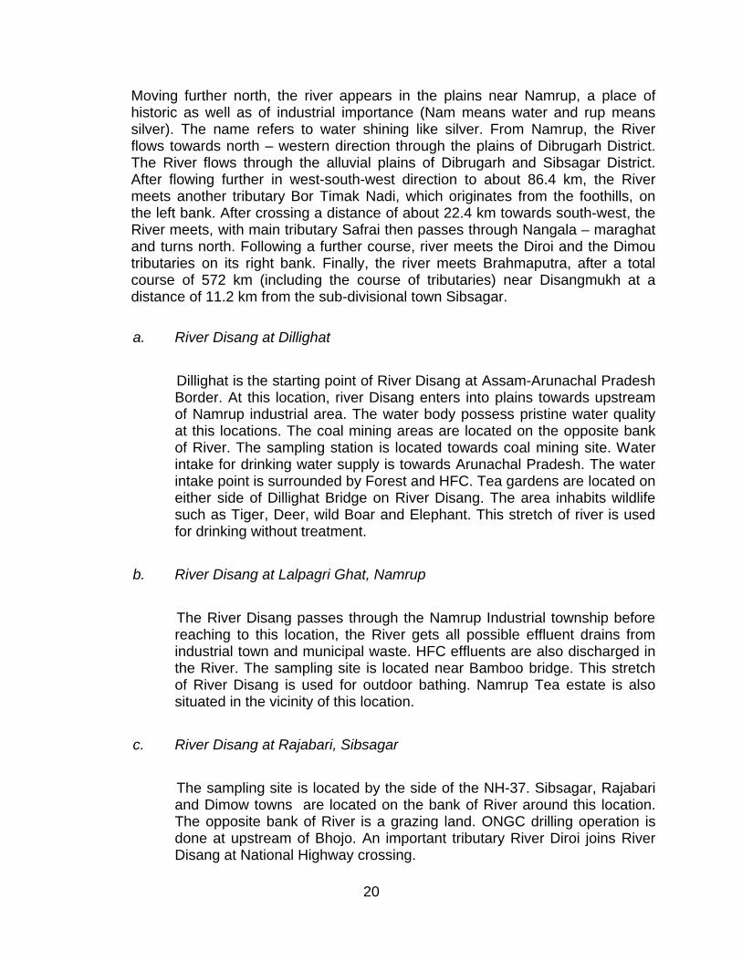
Moving further north, the river appears in the plains near Namrup, a place of historic as well as of industrial importance (Nam means water and rup means silver). The name refers to water shining like silver. From Namrup, the River flows towards north – western direction through the plains of Dibrugarh District. The River flows through the alluvial plains of Dibrugarh and Sibsagar District. After flowing further in west-south-west direction to about 86.4 km, the River meets another tributary Bor Timak Nadi, which originates from the foothills, on the left bank. After crossing a distance of about 22.4 km towards south-west, the River meets, with main tributary Safrai then passes through Nangala – maraghat and turns north. Following a further course, river meets the Diroi and the Dimou tributaries on its right bank. Finally, the river meets Brahmaputra, after a total course of 572 km (including the course of tributaries) near Disangmukh at a distance of 11.2 km from the sub-divisional town Sibsagar.
a. River Disang at Dillighat
Dillighat is the starting point of River Disang at Assam-Arunachal Pradesh Border. At this location, river Disang enters into plains towards upstream of Namrup industrial area. The water body possess pristine water quality at this locations. The coal mining areas are located on the opposite bank of River. The sampling station is located towards coal mining site. Water intake for drinking water supply is towards Arunachal Pradesh. The water intake point is surrounded by Forest and HFC. Tea gardens are located on either side of Dillighat Bridge on River Disang. The area inhabits wildlife such as Tiger, Deer, wild Boar and Elephant. This stretch of river is used for drinking without treatment.
b. River Disang at Lalpagri Ghat, Namrup
The River Disang passes through the Namrup Industrial township before reaching to this location, the River gets all possible effluent drains from industrial town and municipal waste. HFC effluents are also discharged in the River. The sampling site is located near Bamboo bridge. This stretch of River Disang is used for outdoor bathing. Namrup Tea estate is also situated in the vicinity of this location.
c. River Disang at Rajabari, Sibsagar
The sampling site is located by the side of the NH-37. Sibsagar, Rajabari and Dimow towns are located on the bank of River around this location. The opposite bank of River is a grazing land. ONGC drilling operation is done at upstream of Bhojo. An important tributary River Diroi joins River Disang at National Highway crossing.
21
d. River Disang at Disangmukh, Sibsagar
This is the end point of the River before mixing with the Brahmaputra. Tea gardens are located in nearby areas. The sampling stations on River Disang is located at Sapaigaon. Wild ducks, common birds and wild elephants are often observed at this location. Fish kills are often reported by villagers.
RIVER JHANJI
a. River Jhanji
River Jhanji originates from hills of Nagaland and flows through upper Assam. Jhanji river is one of the major south bank tributaries joining at the middle stretch of the River Brahmaputra. Earlier, the river Jhanji used to carry the discharge from the Tuli Paper Mill at Nagaland. River Jhanji arises from Naga hills and enters Assam-Nagaland border at Tuli where the Nagaland Paper Mills is located. Bamboo forests surrounds the Tea garden surrounding the sampling location. Amghri Tea Estate is located on the opposite bank of River towards Nagaland border.
b. River Jhanji at Amguri Tea Estate, Rajabari
At this location River Jhanji enters the border of Assam from Nagaland. Amguri Tea Estate is located on the opposite bank of River towards Nagaland border.
c. River Jhanji at Sibsagar
The sampling site on River Jhanji was selected at NH-37 crossing of Jhanji. Earlier at this location River Jhanji carried the wastewater discharge from Tuli Paper Mills in Nagaland. Now this industry is not operational.
d. River Jhanji at Jhanji Mukh, Jorhat
River Jhanji joins River Brahmaputra at upstream of this location at Kumargaon near Teok. The surrounding land is used for grazing and forest.
RIVER DHANSIRI
A major south bank tributary to the river Brahmaputra flowing through Golaghat District and supposed to carry the discharge from Numaligarh refinery. River Dhansiri rises from Karbi-Anglong District of Assam and Nagaland Border.
22
a. River Dhansiri at Keshardubi
The sampling site on River Dhansiri is located near the bamboo bridge across the River connecting villages of Tengani and Nambar etc. Sampling site at Keshardubi is situated in between Dimapur and Golaghat. The opposite bank of River Dhansiri is closed to Nagaland and North Cachar Hills. Wildlife of Elephant, Tiger and Deer are found in this area.
b. River Dhansiri at NRL Jetty, Numaligarh
The sampling site is near Jetty of Numaligarh Refinery Ltd. (NRL) at NH-Crossing. NRL effluents are discharged here.
c. River Dhansiri at Dhansirimukh
Dhansirimukh is the confluence point to River Brahmaputra. The sampling site on river Dhansiri was selected before confluence at boating ghat near Golaghat and Nagaon District border. Common birds and wild ducks are observed here. Surrounding land is used for grazing. Kaziranga National Park ranges are located towards Nagaon on the riverbank. Sampling site is towards Golaghat bank.
ELLENGA BEEL SYSTEM POND
This is a beel system with low lying lands and becomes a small rivulet in lean season but during rainy season the entire low lying area becomes inundated and takes the shape of a beel. This system receives ETP discharge and wastewater from Nagaon Paper Mill of HPC Ltd. Two drains from the paper mill containing different types of sludge ultimately reach the beel systems and causes siltation problem. The water quality of this beel reach the River Kapili / Kalong as a small stream.
a. Ellenga Beel at Belguri, Jagiroad
The water body is stagnant in the village area. Vegetable and paddy cultivation is done in the vicinity. Water hyacinth growth throughout the surface of water body. Surrounding land is covered by forest Kapili River flows in close vicinity.
b. Ellenga Beel System Pond, Jagiroad, Morigaon
This is a vast ecosystem comprising beel water. The site is nearby the HPC Nagaon Paper Mill outlet. Sampling site was selected on the other side of bridge on Elenga beel system pond towards HPC Jagiroad. Water Hyacinth grows throughout the water body.
23
RIVER SUBANSIRI
This River is one of the major north bank tributaries of Brahmaputra. The River enters into Assam to confluence with the River Brahmaputra after flowing through the hills and forest of Arunachal Pradesh. Dam construction of NHPC is the major activity here. Dam is yet to be constructed. The surrounding of opposite bank is covered by forest. Subansiri is named due to having gold in its sand many years ago.
a. River Subansiri at Gerukamukh
The sampling site on River Subansiri is located at Gerukamukh Subansiri lower Hydro-electric project, near Kendriya Vidyalaya, and between upstream of stone bridge under construction on river and downstream of dam site. NHPC, HE project of 2000 MW is under construction. Earlier the entire area was under Brahmaputra Board. Three months ago the area was inhabited by township, which was taken over by NHPC. Now NHPC township exists alongwith schools and medical centre with 20 beds. Dept. of Forest of Assam Govt. takes care of afforestation activities.
River Subansiri at Gerukamukh
b. River Subansiri at Dhulumukh
Dhulumukh is located in Arunachal Pradesh towards opposite bank of Gerukamukh. Extensive stone harvesting from River bed of Subansiri is carried out transporting through motor boats towards Dam site, where
24
mining and drilling of NHPC Dam site is done. The surrounding land is grazing and forest.
c. River Subansiri at Chauldhoaghat
The sampling site is located near the NH Bridge at Chauldhua village in North Lakhimpur. Thakaraguri village is located on the opposite bank of River Sugansiri. Sampling site was selected in between Road Bridge and Rail Bridge Opp. to J. K. Hotel on National Highway. Arunachal Pradesh hills are located towards Rail Bridge. The backwater of the river is used for various purposes like washing, bathing etc.
River Subansiri at Chauldhoaghat
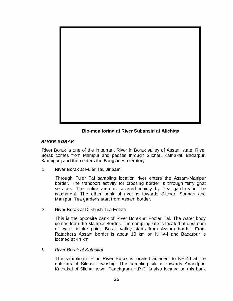
d. River Subansiri at Alichiga, Bordubi
Alichiga is located 90 km downstream from Gerukamukh near Trinayan Mandir at Nutal, Tinali. Morolia village is located on the opposite bank of River Subansiri. The sampling site was selected before confluence of River Subansiri with River Brahmaputra. Lakhimpur town is about 20-25 km from this location. The sampling was carried out on the Subansirimukh bank towards ferry ghat and also at opposite bank towards Morolia village. The forest is covered on the other bank towards Jorhat. River Subansiri joins River Brahmaputra in Majulighat at a distance of about 4 km downstream from this location.
25
Bio-monitoring at River Subansiri at Alichiga
RIVER BORAK
River Borak is one of the important River in Borak valley of Assam state. River Borak comes from Manipur and passes through Silchar, Kathakal, Badarpur, Karimganj and then enters the Bangladesh territory.
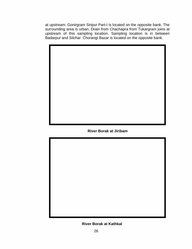
11.. RRiivveerr BBoorraakk aatt FFuulleerr TTaall,, JJiirriibbaamm
Through Fuler Tal sampling location river enters the Assam-Manipur border. The transport activity for crossing border is through ferry ghat services. The entire area is covered mainly by Tea gardens in the catchment. The other bank of river is towards Silchar, Sonbari and Manipur. Tea gardens start from Assam border.
22.. RRiivveerr BBoorraakk aatt DDiillkkhhuusshh TTeeaa EEssttaattee
This is the opposite bank of River Borak at Fooler Tal. The water body comes from the Manipur Border. The sampling site is located at upstream of water intake point. Borak valley starts from Assam border. From Ratachera Assam border is about 10 km on NH-44 and Badarpur is located at 44 km.
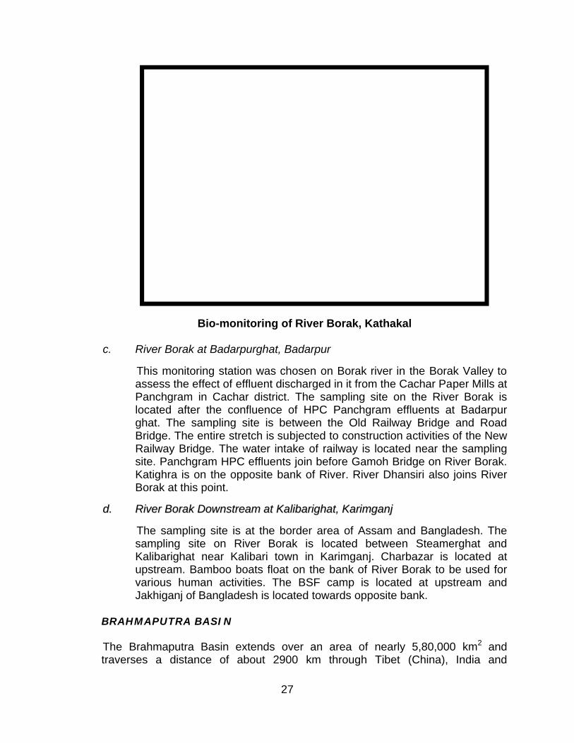
bb.. RRiivveerr BBoorraakk aatt KKaatthhaakkaall
The sampling site on River Borak is located adjacent to NH-44 at the outskirts of Silchar township. The sampling site is towards Anandpur, Kathakal of Silchar town. Panchgram H.P.C. is also located on this bank
26
at upstream. Gonirgram Siripur Part-I is located on the opposite bank. The surrounding area is urban, Drain from Chachapra from Tukargram joins at upstream of this sampling location. Sampling location is in between Badarpur and Silchar. Chorangi Bazar is located on the opposite bank.
River Borak at Jiribam
River Borak at Kathkal
27
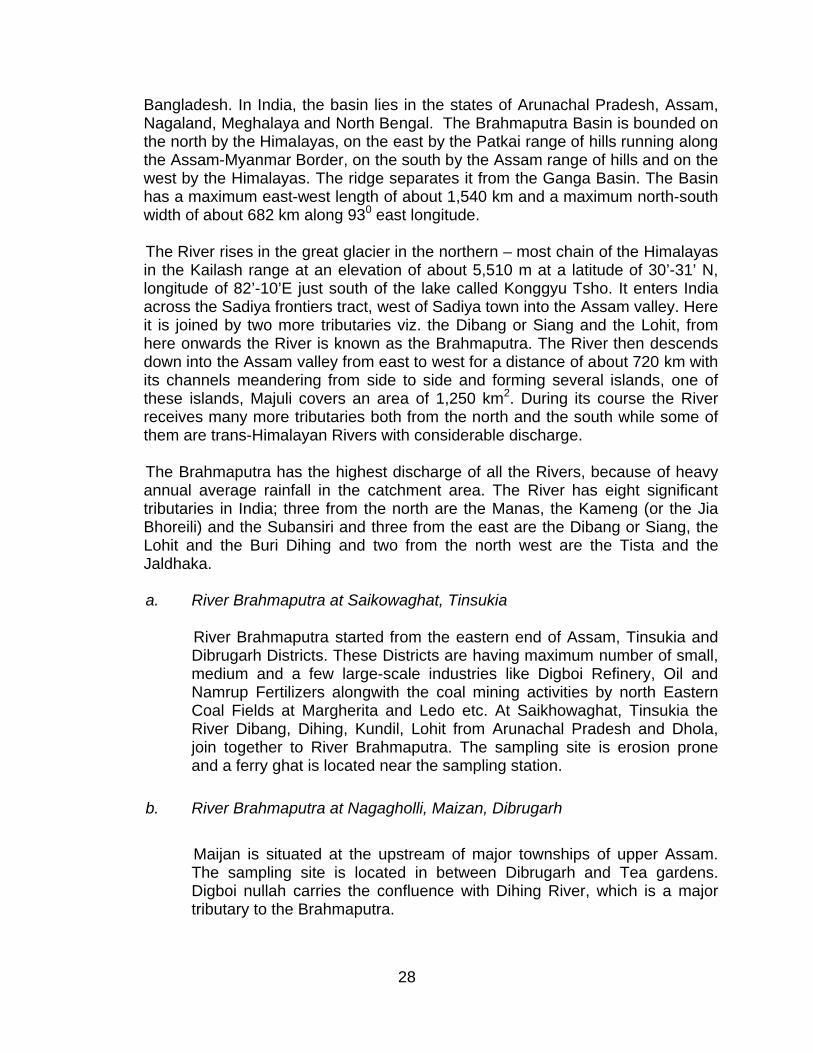
Bio-monitoring of River Borak, Kathakal
c. River Borak at Badarpurghat, Badarpur
This monitoring station was chosen on Borak river in the Borak Valley to assess the effect of effluent discharged in it from the Cachar Paper Mills at Panchgram in Cachar district. The sampling site on the River Borak is located after the confluence of HPC Panchgram effluents at Badarpur ghat. The sampling site is between the Old Railway Bridge and Road Bridge. The entire stretch is subjected to construction activities of the New Railway Bridge. The water intake of railway is located near the sampling site. Panchgram HPC effluents join before Gamoh Bridge on River Borak. Katighra is on the opposite bank of River. River Dhansiri also joins River Borak at this point.
dd.. RRiivveerr BBoorraakk DDoowwnnssttrreeaamm aatt KKaalliibbaarriigghhaatt,, KKaarriimmggaannjj
The sampling site is at the border area of Assam and Bangladesh. The sampling site on River Borak is located between Steamerghat and Kalibarighat near Kalibari town in Karimganj. Charbazar is located at upstream. Bamboo boats float on the bank of River Borak to be used for various human activities. The BSF camp is located at upstream and Jakhiganj of Bangladesh is located towards opposite bank.
BRAHMAPUTRA BASIN
The Brahmaputra Basin extends over an area of nearly 5,80,000 km2 and traverses a distance of about 2900 km through Tibet (China), India and
28
Bangladesh. In India, the basin lies in the states of Arunachal Pradesh, Assam, Nagaland, Meghalaya and North Bengal. The Brahmaputra Basin is bounded on the north by the Himalayas, on the east by the Patkai range of hills running along the Assam-Myanmar Border, on the south by the Assam range of hills and on the west by the Himalayas. The ridge separates it from the Ganga Basin. The Basin has a maximum east-west length of about 1,540 km and a maximum north-south width of about 682 km along 930 east longitude.
The River rises in the great glacier in the northern – most chain of the Himalayas in the Kailash range at an elevation of about 5,510 m at a latitude of 30’-31’ N, longitude of 82’-10’E just south of the lake called Konggyu Tsho. It enters India across the Sadiya frontiers tract, west of Sadiya town into the Assam valley. Here it is joined by two more tributaries viz. the Dibang or Siang and the Lohit, from here onwards the River is known as the Brahmaputra. The River then descends down into the Assam valley from east to west for a distance of about 720 km with its channels meandering from side to side and forming several islands, one of these islands, Majuli covers an area of 1,250 km2. During its course the River receives many more tributaries both from the north and the south while some of them are trans-Himalayan Rivers with considerable discharge.
The Brahmaputra has the highest discharge of all the Rivers, because of heavy annual average rainfall in the catchment area. The River has eight significant tributaries in India; three from the north are the Manas, the Kameng (or the Jia Bhoreili) and the Subansiri and three from the east are the Dibang or Siang, the Lohit and the Buri Dihing and two from the north west are the Tista and the Jaldhaka.
a. River Brahmaputra at Saikowaghat, Tinsukia
River Brahmaputra started from the eastern end of Assam, Tinsukia and Dibrugarh Districts. These Districts are having maximum number of small, medium and a few large-scale industries like Digboi Refinery, Oil and Namrup Fertilizers alongwith the coal mining activities by north Eastern Coal Fields at Margherita and Ledo etc. At Saikhowaghat, Tinsukia the River Dibang, Dihing, Kundil, Lohit from Arunachal Pradesh and Dhola, join together to River Brahmaputra. The sampling site is erosion prone and a ferry ghat is located near the sampling station.
b. River Brahmaputra at Nagagholli, Maizan, Dibrugarh
Maijan is situated at the upstream of major townships of upper Assam. The sampling site is located in between Dibrugarh and Tea gardens. Digboi nullah carries the confluence with Dihing River, which is a major tributary to the Brahmaputra.
29
c. River Brahmaputra at Disangmukh, Sibsagar
The major activity that has direct bearing on the environment is the drilling of crude oil in Sibsagar district by ONGC Ltd. The ONGC Ltd has four major Oil fields at Gelaki, Lakwa, Demalgaon and Rudrasagar, which are continuously kept under vigilance by PCBA (Board). The sampling site is situated at about 16 km from the Sibsagar township.
d. River Brahmaputra at Nimatighat, Jorhat
The sampling site on River Brahmaputra is located at Nimatighat of Jorhat town. Majuli is located on the opposite bank of River at Lakhimpur. Kakilamukh Bird Sanctuary is located at this point. Wild elephants are also found in the sanctuary.
e. River Brahmaputra at Dhanbari Camp, Golaghat
At this location a major tributary River Dhansiri joins on the south bank of River Brahmaputra. River Dhansiri mostly cover the District of Golaghat and supposed to carry the wastewater from Numaligarh Refinery and contribute water quality to River Brahmaputra. Kaziranga ranges are located on the bank of River Brahmaputra.
f. River Brahmaputra at Bhomuraguri, Silighat
Bhomuraguri is located in between Silighat and Nagaon in Sonitpur District. The sampling location on River Brahmaputra is situated at a distance of 6 km from Tejpur town on NH-37A, which joins NH-37 at Kaliabar to NH-52 at Mission Chariali, crossing the River after Brahmaputra Road Bridge. Before construction of the Road Bridge on River, it was a ferry ghat with human settlement on the bank. The ferry and motor boats were used to transport people from one place to other through River. Ari fishes (Mystus Singhala) are collected from River Brahmaputra and sold here. The forest department of Assam also maintained the Teak forest. River Buridihing, Disang, Dikrong, Jhanji, Subansiri, Dhansiri and other tributaries join River Brahmaputra at upstream of this location. Further, ahead River goes downstream to Bangladesh. Tejpur is located on the opposite bank of sampling site.
g. River Brahmaputra at Saraighat, Guwahati
Saraighat Bridge connects both the north & south bank of River Brahmaputra near Sadilapur at Guwahati. The sampling site is located at Pandughat before the Road Bridge. The Refinery effluents are discharged at upstream of this location. The Refinery is located at Noonmati. This is the downstream of Central Guwahati.
30
River Brahmaputra at Guwahati
Bio-monitoring of River Brahmaputra at Bhomuraguri
31
h. River Brahmaputra at Joghigopa
Situated at the downstream of Assam, Jogighopa is about 20 km from Bongaigaon, Industrial Township of Assam. Golpara is the nearest town to this location. Joghigopa is situated across the Panchratna Bridge also known as Naranarayan Setu on River Brahmaputra on NH-37. This town is located at a distance of 168 km from Guwahati. The sampling site is located near water intake point of Jogighopa Paper Mill in District Bongaigaon. Central Govt.’s Archaeological Department has developed historic site on the hill side. The entire catchment of River Brahmaputra at this location is used for coal storage, transport from Garo Hills of Meghalaya state. 2.8 km long rail cum Road Bridge is also present parallel to NH-37. Bamboo boats are used for various human activities on the bank. Pine tree shrubs have been planted on the bank. Beetle nut and Palm trees are common at this place. A big wetland has been formed from the flood water of Brahmaputra, which extends parallel to NH-37. After Guwahati, a number of tributaries like Manas, Puthimari, Pagladia, and Beki etc. join the Brahmaputra before Jogighopa.
River Brahmaputra at Joghigopa
i. River Brahmaputra at Dhubri
This is situated further downstream of Assam. Dhubri is the last monitoring station on River Brahmaputra before entering the territory of Bangladesh. After crossing the Dhubri District, the River takes its way to the Bangladesh. A match factory existed earlier at this location. Bongaigaon is located on the opposite bank of River.
32
j. River Jia-Barali at Bukagaon
River Jia-Barali before entering the Assam border, known as River Kameng in Arunachal Pradesh. Sampling locations on River Jia-Barali at Bukagaon is about 345 km from Jonai and 16 km from Jamuguri of Balipara Division on NH-52. The sampling site is located on River Jia-Barali near Road Bridge of NH-52. Department of Irrigation is located on the opposite bank at Towbhanga village. The sampling site is in between Rail Bridge and Road Bridge on River Jia-Barali. River Jia-Barali originates from the hills of Arunachal Pradesh and joins to River Brahmaputra. Fishing competition is held every year among N-E-States for maximum fish catch. The maximum weight reported for fish catch is 17 kg.
Bio-monitoring of River Jia-Barali
RIVER MALIDOR, NEW MALIDOR, JALALPUR
River Malidor passes through Meghalaya State and Karbi Anglong Tea Estate of Assam at Assam-Meghalaya border. River goes downstream to Bangladesh. The sampling location is situated near New Malidor, Jalalpur at Jaintia Hill Border Road. Sonapur is 48 km and Shillong is 145 km from this location. The sampling site on River Malidor was selected on NH-44 near Shiv Temple. Kalain is at 18km from this location. Beetle nut plantation is common vegetation. Badarpur is 44 km and Umkiang is located at 3 km distance. Tea cultivation is done on hills near Kalain. White Rhododendrons are planted all along the forest. Borak valley starts from the Assam border at this location.

33
RIVER RANGANADI AT PAHUMARA, LAKHIMPUR
River Ranganadi is an important tributary of River Subansiri. Ranganadi originates from Arunachal Pradesh and joins River Subansiri at Pabori Reserve Forest, about 10-20 km from sampling site. Hydro-electric power generation is the major activity of Ranganadi Hydel Project of NEPCO Kameng in Arunachal Pradesh. The sampling site on Ranganadi is located near Road Bridge of NH-52, and 6 km from North Lakhimpur at Pahumara village. Bamundoloni village is situated on the opposite bank of River. Railway Bridge is parallel to Road Bridge on River Ranganadi. Egrets are observed quite often at this location.
River Ranganadi at Lakhimpur
RIVER BOGINADI AT MILANPUR, LAKHIMPUR
Boginadi comes from hills of Arunachal Pradesh and joins to River Subansiri at downstream at a distance of 3-4 km at Ghaggerghat. The sampling site is located at 16 km from Lakhimpur district on a bypass from NH-52 near Namghar. The opposite bank of River Boginadi is inhabited by Lalpari village. Ratanpur nullah from Hills join River Boginadi about 300-500 mtrs upstream from sampling site.
RIVER DIKRONG AT BANDARDUA
River Dikrong is a tributary of River Brahmaputra. River Dikrong arises from Arunachal Pradesh and joins River Brahmaputra at Majuli in Assam. The River Dikrong passes through border of Bandardua in Assam and Arunachal Pradesh. Itanagar is 25 km from NH-52 crossing. The sampling site on River Dikrong was selected at Harmutty Tea Estate near Higher Secondary School, Parbati Nagar, Bandardua. Harmutty Tea Estate is located towards the opposite bank of River Dikrong.

34
River Boginadi
Bio-monitoring of River Boginadi
2.4 BIO-MONITORING OF PERENNIAL RIVERS IN ASSAM STATE
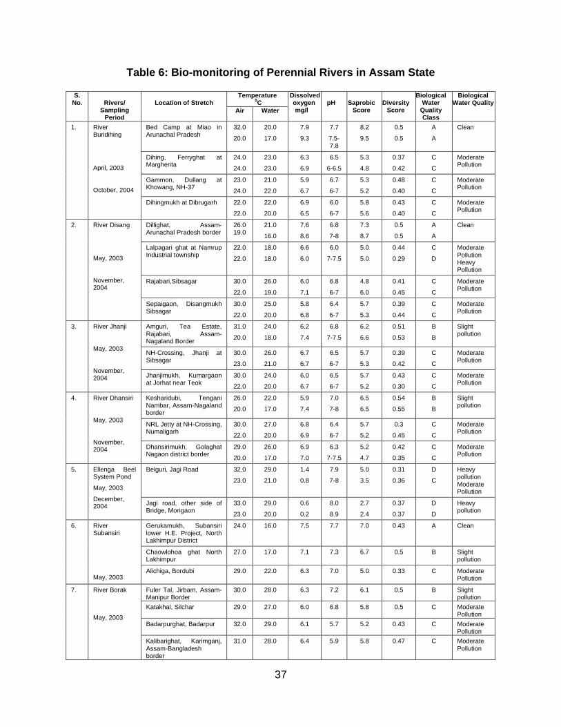
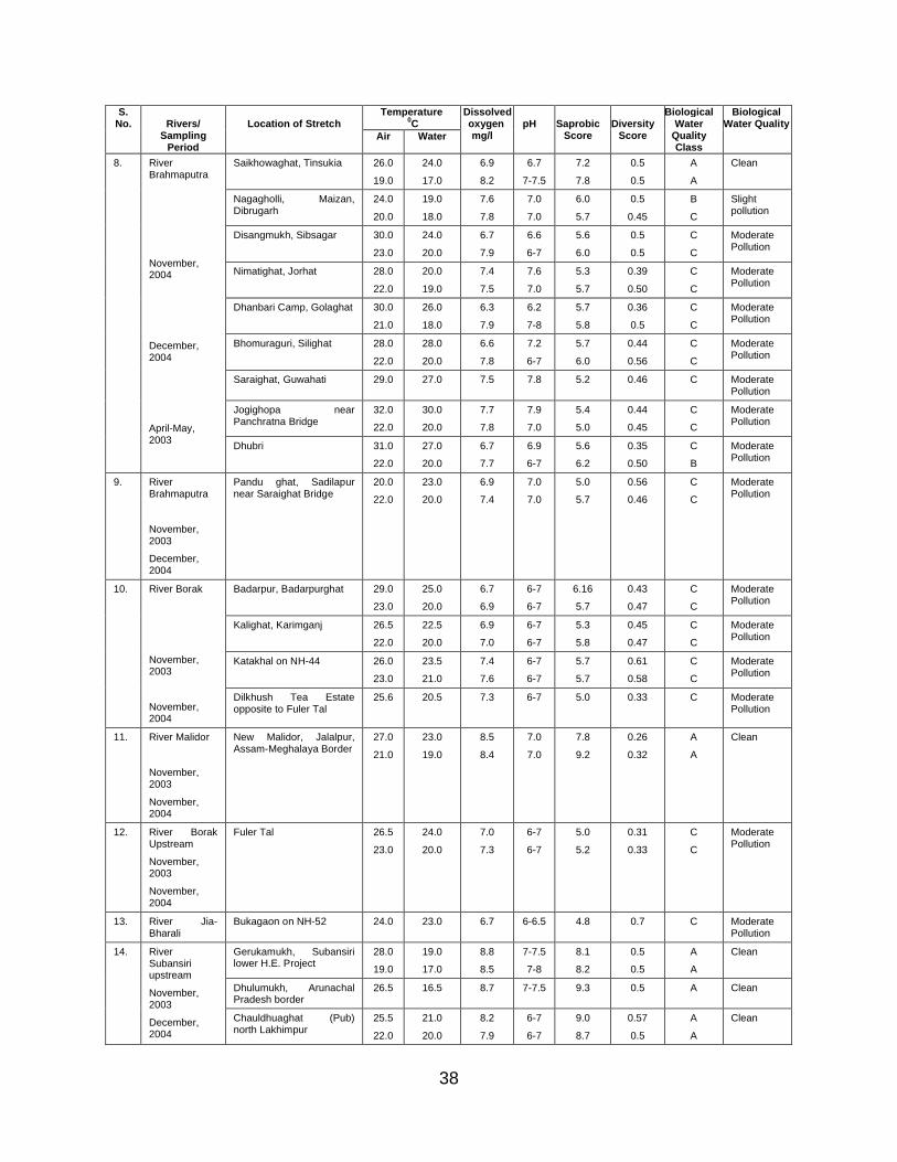
The bio-assessment of Perennial Rivers in Assam State was undertaken using Biological Water Quality Criteria (BWQC) using Saprobic Score and Diversity Score of water quality (Table 6).
35
Fig
1 :
Bio
-Ma
pp
ing
of
So
me
Im
po
rta
nt
Pe
ren
nia
l R
ive
rs o
f A
ss
am (
Ye
ar
20
03)

36
Fig
2 :
Bio
-Ma
pp
ing
of
So
me
Im
po
rta
nt
Pe
ren
nia
l R
ive
rs o
f A
ss
am (
Ye
ar
20
04)
37
Table 6: Bio-monitoring of Perennial Rivers in Assam State
Temperature0C
S. No. Rivers/
Sampling Period
Location of StretchAir Water
Dissolved oxygenmg/l
pH SaprobicScore
DiversityScore
Biological Water
QualityClass
Biological Water Quality
Bed Camp at Miao in Arunachal Pradesh
32.0
20.0
20.0
17.0
7.9
9.3
7.7
7.5-7.8
8.2
9.5
0.5
0.5
A
A
Clean
Dihing, Ferryghat at Margherita
24.0
24.0
23.0
23.0
6.3
6.9
6.5
6-6.5
5.3
4.8
0.37
0.42
C
C
Moderate Pollution
Gammon, Dullang at Khowang, NH-37
23.0
24.0
21.0
22.0
5.9
6.7
6.7
6-7
5.3
5.2
0.48
0.40
C
C
Moderate Pollution
1. River Buridihing
April, 2003
October, 2004
Dihingmukh at Dibrugarh 22.0
22.0
22.0
20.0
6.9
6.5
6.0
6-7
5.8
5.6
0.43
0.40
C
C
Moderate Pollution
Dillighat, Assam-Arunachal Pradesh border
26.019.0
21.0
16.0
7.6
8.6
6.8
7-8
7.3
8.7
0.5
0.5
A
A
Clean
Lalpagari ghat at Namrup Industrial township
22.0
22.0
18.0
18.0
6.6
6.0
6.0
7-7.5
5.0
5.0
0.44
0.29
C
D
Moderate Pollution Heavy Pollution
Rajabari,Sibsagar 30.0
22.0
26.0
19.0
6.0
7.1
6.8
6-7
4.8
6.0
0.41
0.45
C
C
Moderate Pollution
2. River Disang
May, 2003
November, 2004
Sepaigaon, Disangmukh Sibsagar
30.0
22.0
25.0
20.0
5.8
6.8
6.4
6-7
5.7
5.3
0.39
0.44
C
C
Moderate Pollution
Amguri, Tea Estate, Rajabari, Assam-Nagaland Border
31.0
20.0
24.0
18.0
6.2
7.4
6.8
7-7.5
6.2
6.6
0.51
0.53
B
B
Slight pollution
NH-Crossing, Jhanji at Sibsagar
30.0
23.0
26.0
21.0
6.7
6.7
6.5
6-7
5.7
5.3
0.39
0.42
C
C
Moderate Pollution
3. River Jhanji
May, 2003
November, 2004 Jhanjimukh, Kumargaon
at Jorhat near Teok30.0
22.0
24.0
20.0
6.0
6.7
6.5
6-7
5.7
5.2
0.43
0.30
C
C
Moderate Pollution
Kesharidubi, Tengani Nambar, Assam-Nagaland border
26.0
20.0
22.0
17.0
5.9
7.4
7.0
7-8
6.5
6.5
0.54
0.55
B
B
Slight pollution
NRL Jetty at NH-Crossing, Numaligarh
30.0
22.0
27.0
20.0
6.8
6.9
6.4
6-7
5.7
5.2
0.3
0.45
C
C
Moderate Pollution
4. River Dhansiri
May, 2003
November, 2004 Dhansirimukh, Golaghat
Nagaon district border29.0
20.0
26.0
17.0
6.9
7.0
6.3
7-7.5
5.2
4.7
0.42
0.35
C
C
Moderate Pollution
Belguri, Jagi Road 32.0
23.0
29.0
21.0
1.4
0.8
7.9
7-8
5.0
3.5
0.31
0.36
D
C
Heavy pollution Moderate Pollution
5. Ellenga Beel System Pond
May, 2003
December, 2004 Jagi road, other side of
Bridge, Morigaon33.0
23.0
29.0
20.0
0.6
0.2
8.0
8.9
2.7
2.4
0.37
0.37
D
D
Heavy pollution
Gerukamukh, Subansiri lower H.E. Project, North Lakhimpur District
24.0 16.0 7.5 7.7 7.0 0.43 A Clean
Chaowlohoa ghat North Lakhimpur
27.0 17.0 7.1 7.3 6.7 0.5 B Slight pollution
6. River Subansiri
May, 2003Alichiga, Bordubi 29.0 22.0 6.3 7.0 5.0 0.33 C Moderate
Pollution
Fuler Tal, Jirbam, Assam-Manipur Border
30.0 28.0 6.3 7.2 6.1 0.5 B Slight pollution
Katakhal, Silchar 29.0 27.0 6.0 6.8 5.8 0.5 C Moderate Pollution
Badarpurghat, Badarpur 32.0 29.0 6.1 5.7 5.2 0.43 C Moderate Pollution
7. River Borak
May, 2003
Kalibarighat, Karimganj, Assam-Bangladesh border
31.0 28.0 6.4 5.9 5.8 0.47 C Moderate Pollution
38
Temperature0C
S. No. Rivers/
Sampling Period
Location of StretchAir Water
Dissolved oxygenmg/l
pH SaprobicScore
DiversityScore
Biological Water
QualityClass
Biological Water Quality
Saikhowaghat, Tinsukia 26.0
19.0
24.0
17.0
6.9
8.2
6.7
7-7.5
7.2
7.8
0.5
0.5
A
A
Clean
Nagagholli, Maizan, Dibrugarh
24.0
20.0
19.0
18.0
7.6
7.8
7.0
7.0
6.0
5.7
0.5
0.45
B
C
Slight pollution
Disangmukh, Sibsagar 30.0
23.0
24.0
20.0
6.7
7.9
6.6
6-7
5.6
6.0
0.5
0.5
C
C
Moderate Pollution
8.
Nimatighat, Jorhat 28.0
22.0
20.0
19.0
7.4
7.5
7.6
7.0
5.3
5.7
0.39
0.50
C
C
Moderate Pollution
Dhanbari Camp, Golaghat 30.0
21.0
26.0
18.0
6.3
7.9
6.2
7-8
5.7
5.8
0.36
0.5
C
C
Moderate Pollution
Bhomuraguri, Silighat 28.0
22.0
28.0
20.0
6.6
7.8
7.2
6-7
5.7
6.0
0.44
0.56
C
C
Moderate Pollution
Saraighat, Guwahati 29.0 27.0 7.5 7.8 5.2 0.46 C Moderate Pollution
Jogighopa near Panchratna Bridge
32.0
22.0
30.0
20.0
7.7
7.8
7.9
7.0
5.4
5.0
0.44
0.45
C
C
Moderate Pollution
River Brahmaputra
November, 2004
December, 2004
April-May, 2003
Dhubri 31.0
22.0
27.0
20.0
6.7
7.7
6.9
6-7
5.6
6.2
0.35
0.50
C
B
Moderate Pollution
9. River Brahmaputra
November, 2003
December, 2004
Pandu ghat, Sadilapur near Saraighat Bridge
20.0
22.0
23.0
20.0
6.9
7.4
7.0
7.0
5.0
5.7
0.56
0.46
C
C
Moderate Pollution
Badarpur, Badarpurghat 29.0
23.0
25.0
20.0
6.7
6.9
6-7
6-7
6.16
5.7
0.43
0.47
C
C
Moderate Pollution
Kalighat, Karimganj 26.5
22.0
22.5
20.0
6.9
7.0
6-7
6-7
5.3
5.8
0.45
0.47
C
C
Moderate Pollution
Katakhal on NH-44 26.0
23.0
23.5
21.0
7.4
7.6
6-7
6-7
5.7
5.7
0.61
0.58
C
C
Moderate Pollution
10. River Borak
November, 2003
November, 2004
Dilkhush Tea Estate opposite to Fuler Tal
25.6 20.5 7.3 6-7 5.0 0.33 C Moderate Pollution
11. River Malidor
November, 2003
November, 2004
New Malidor, Jalalpur, Assam-Meghalaya Border
27.0
21.0
23.0
19.0
8.5
8.4
7.0
7.0
7.8
9.2
0.26
0.32
A
A
Clean
12. River Borak Upstream
November, 2003
November, 2004
Fuler Tal 26.5
23.0
24.0
20.0
7.0
7.3
6-7
6-7
5.0
5.2
0.31
0.33
C
C
Moderate Pollution
13. River Jia-Bharali
Bukagaon on NH-52 24.0 23.0 6.7 6-6.5 4.8 0.7 C Moderate Pollution
Gerukamukh, Subansiri lower H.E. Project
28.0
19.0
19.0
17.0
8.8
8.5
7-7.5
7-8
8.1
8.2
0.5
0.5
A
A
Clean
Dhulumukh, Arunachal Pradesh border
26.5 16.5 8.7 7-7.5 9.3 0.5 A Clean
14. River Subansiri upstream
November, 2003
December, 2004
Chauldhuaghat (Pub) north Lakhimpur
25.5
22.0
21.0
20.0
8.2
7.9
6-7
6-7
9.0
8.7
0.57
0.5
A
A
Clean
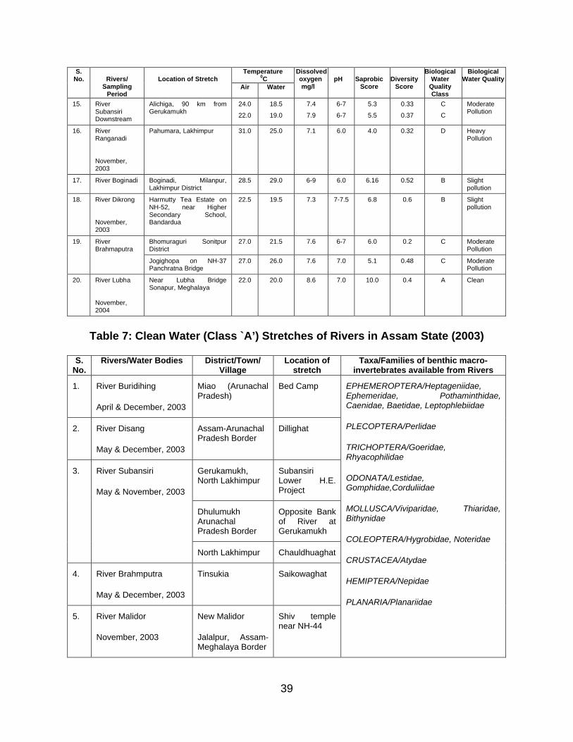
39
Temperature0C
S. No. Rivers/
Sampling Period
Location of StretchAir Water
Dissolved oxygenmg/l
pH SaprobicScore
DiversityScore
Biological Water
QualityClass
Biological Water Quality
15. River Subansiri Downstream
Alichiga, 90 km from Gerukamukh
24.0
22.0
18.5
19.0
7.4
7.9
6-7
6-7
5.3
5.5
0.33
0.37
C
C
Moderate Pollution
16. River Ranganadi
November, 2003
Pahumara, Lakhimpur 31.0 25.0 7.1 6.0 4.0 0.32 D Heavy Pollution
17. River Boginadi Boginadi, Milanpur, Lakhimpur District
28.5 29.0 6-9 6.0 6.16 0.52 B Slight pollution
18. River Dikrong
November, 2003
Harmutty Tea Estate on NH-52, near Higher Secondary School, Bandardua
22.5 19.5 7.3 7-7.5 6.8 0.6 B Slight pollution
Bhomuraguri Sonitpur District
27.0 21.5 7.6 6-7 6.0 0.2 C Moderate Pollution
19. River Brahmaputra
Jogighopa on NH-37 Panchratna Bridge
27.0 26.0 7.6 7.0 5.1 0.48 C Moderate Pollution
20. River Lubha
November, 2004
Near Lubha Bridge Sonapur, Meghalaya
22.0 20.0 8.6 7.0 10.0 0.4 A Clean
Table 7: Clean Water (Class `A’) Stretches of Rivers in Assam State (2003)
S.No.
Rivers/Water Bodies District/Town/ Village
Location of stretch
Taxa/Families of benthic macro-invertebrates available from Rivers
1. River Buridihing
April & December, 2003
Miao (Arunachal Pradesh)
Bed Camp
2. River Disang
May & December, 2003
Assam-Arunachal Pradesh Border
Dillighat
Gerukamukh, North Lakhimpur
Subansiri Lower H.E. Project
Dhulumukh Arunachal Pradesh Border
Opposite Bank of River at Gerukamukh
3. River Subansiri
May & November, 2003
North Lakhimpur Chauldhuaghat
4. River Brahmputra
May & December, 2003
Tinsukia Saikowaghat
5. River Malidor
November, 2003
New Malidor
Jalalpur, Assam-Meghalaya Border
Shiv temple near NH-44
EPHEMEROPTERA/Heptageniidae, Ephemeridae, Pothaminthidae, Caenidae, Baetidae, Leptophlebiidae
PLECOPTERA/Perlidae
TRICHOPTERA/Goeridae, Rhyacophilidae
ODONATA/Lestidae, Gomphidae,Corduliidae
MOLLUSCA/Viviparidae, Thiaridae, Bithynidae
COLEOPTERA/Hygrobidae, Noteridae
CRUSTACEA/Atydae
HEMIPTERA/Nepidae
PLANARIA/Planariidae
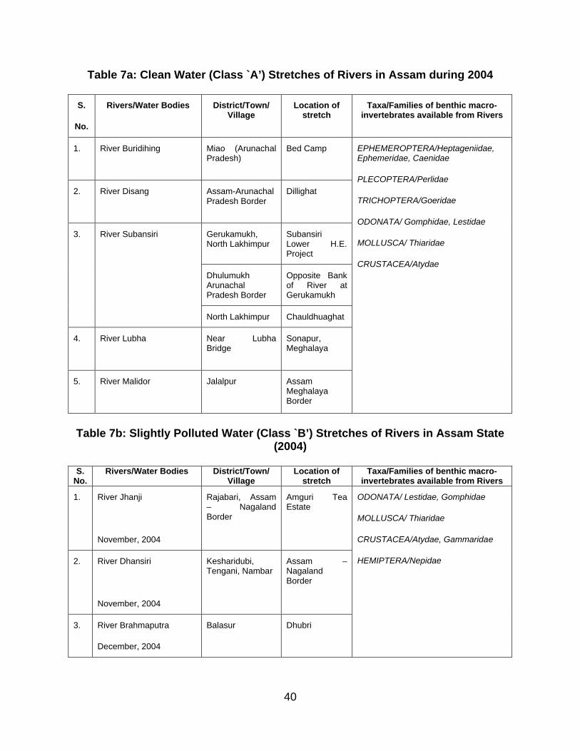
40
Table 7a: Clean Water (Class `A’) Stretches of Rivers in Assam during 2004
S.
No.
Rivers/Water Bodies District/Town/ Village
Location of stretch
Taxa/Families of benthic macro-invertebrates available from Rivers
1. River Buridihing Miao (Arunachal Pradesh)
Bed Camp
2. River Disang Assam-Arunachal Pradesh Border
Dillighat
Gerukamukh, North Lakhimpur
Subansiri Lower H.E. Project
Dhulumukh Arunachal Pradesh Border
Opposite Bank of River at Gerukamukh
3. River Subansiri
North Lakhimpur Chauldhuaghat
4. River Lubha Near Lubha Bridge
Sonapur, Meghalaya
5. River Malidor Jalalpur Assam Meghalaya Border
EPHEMEROPTERA/Heptageniidae, Ephemeridae, Caenidae
PLECOPTERA/Perlidae
TRICHOPTERA/Goeridae
ODONATA/ Gomphidae, Lestidae
MOLLUSCA/ Thiaridae
CRUSTACEA/Atydae
Table 7b: Slightly Polluted Water (Class `B’) Stretches of Rivers in Assam State (2004)
S.No.
Rivers/Water Bodies District/Town/ Village
Location of stretch
Taxa/Families of benthic macro-invertebrates available from Rivers
1. River Jhanji
November, 2004
Rajabari, Assam – Nagaland Border
Amguri Tea Estate
2. River Dhansiri
November, 2004
Kesharidubi, Tengani, Nambar
Assam –Nagaland Border
3. River Brahmaputra
December, 2004
Balasur Dhubri
ODONATA/ Lestidae, Gomphidae
MOLLUSCA/ Thiaridae
CRUSTACEA/Atydae, Gammaridae
HEMIPTERA/Nepidae
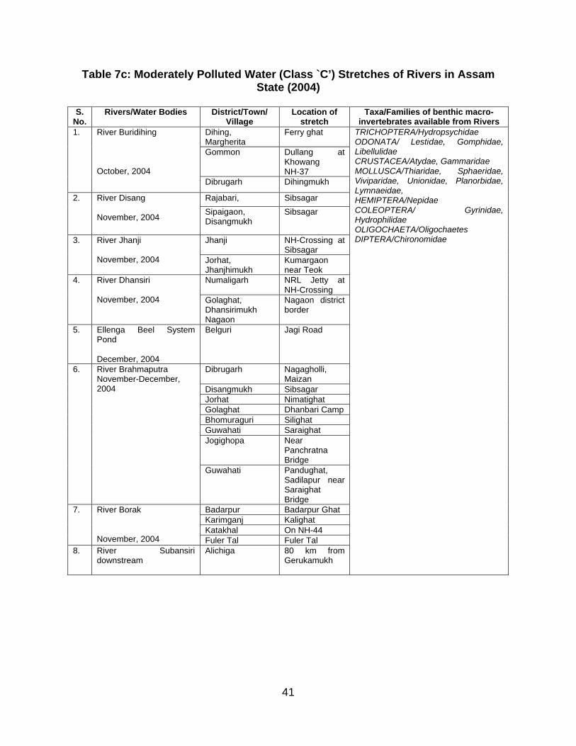
41
Table 7c: Moderately Polluted Water (Class `C’) Stretches of Rivers in Assam State (2004)
S.No.
Rivers/Water Bodies District/Town/ Village
Location of stretch
Taxa/Families of benthic macro-invertebrates available from Rivers
Dihing, Margherita
Ferry ghat
Gommon Dullang at Khowang NH-37
1. River Buridihing
October, 2004Dibrugarh Dihingmukh
Rajabari, Sibsagar2. River Disang
November, 2004Sipaigaon, Disangmukh
Sibsagar
Jhanji NH-Crossing at Sibsagar
3. River Jhanji
November, 2004 Jorhat, Jhanjhimukh
Kumargaon near Teok
Numaligarh NRL Jetty at NH-Crossing
4. River Dhansiri
November, 2004 Golaghat, Dhansirimukh Nagaon
Nagaon district border
5. Ellenga Beel System Pond
December, 2004
Belguri Jagi Road
Dibrugarh Nagagholli, Maizan
Disangmukh SibsagarJorhat NimatighatGolaghat Dhanbari CampBhomuraguri SilighatGuwahati SaraighatJogighopa Near
Panchratna Bridge
6. River BrahmaputraNovember-December, 2004
Guwahati Pandughat, Sadilapur near Saraighat Bridge
Badarpur Badarpur GhatKarimganj KalighatKatakhal On NH-44
7. River Borak
November, 2004 Fuler Tal Fuler Tal8. River Subansiri
downstreamAlichiga 80 km from
Gerukamukh
TRICHOPTERA/HydropsychidaeODONATA/ Lestidae, Gomphidae, LibellulidaeCRUSTACEA/Atydae, GammaridaeMOLLUSCA/Thiaridae, Sphaeridae, Viviparidae, Unionidae, Planorbidae, Lymnaeidae, HEMIPTERA/NepidaeCOLEOPTERA/ Gyrinidae, HydrophilidaeOLIGOCHAETA/OligochaetesDIPTERA/Chironomidae
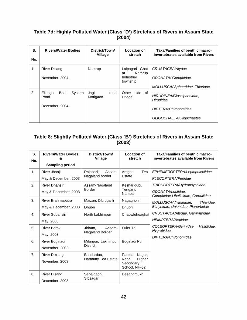
42
Table 7d: Highly Polluted Water (Class `D’) Stretches of Rivers in Assam State (2004)
S.
No.
Rivers/Water Bodies District/Town/ Village
Location of stretch
Taxa/Families of benthic macro-invertebrates available from Rivers
1. River Disang
November, 2004
Namrup Lalpagari Ghat at Namrup Industrial township
2. Ellenga Beel System Pond
December, 2004
Jagi road, Morigaon
Other side of Bridge
CRUSTACEA/Atydae
ODONATA/ Gomphidae
MOLLUSCA/ Sphaeridae, Thiaridae
HIRUDINEA/Glossiphonidae, Hirudidae
DIPTERA/Chironomidae
OLIGOCHAETA/Oligochaetes
Table 8: Slightly Polluted Water (Class `B’) Stretches of Rivers in Assam State (2003)
S.
No.
Rivers/Water Bodies &
Sampling period
District/Town/ Village
Location of stretch
Taxa/Families of benthic macro-invertebrates available from Rivers
1. River Jhanji
May & December, 2003
Rajabari, Assam-Nagaland border
Amghri Tea Estate
2. River Dhansiri
May & December, 2003
Assam-Nagaland Border
Kesharidubi, Tengani, Nambar
Maizan, Dibrugarh Nagagholli3. River Brahmaputra
May & December, 2003 Dhubri Dhubri
4. River Subansiri
May, 2003
North Lakhimpur Chaowlohoaghat
5. River Borak
May, 2003
Jirbam, Assam-Nagaland Border
Fuler Tal
6. River Boginadi
November, 2003
Milanpur, Lakhimpur District
Boginadi Pul
7. River Dikrong
November, 2003
Bandardua, Harmutty Tea Estate
Parbati Nagar, Near Higher Secondary School, NH-52
8. River Disang
December, 2003
Sepaigaon, Sibsagar
Desangmukh
EPHEMEROPTERA/Leptophlebiidae
PLECOPTERA/Perlidae
TRICHOPTERA/Hydropsychidae
ODONATA/Lestidae, Gomphidae,Libellulidae, Corduliidae
MOLLUSCA/Viviparidae, Thiaridae, Bithynidae, Unionidae, Planorbidae
CRUSTACEA/Atydae, Gammaridae
HEMIPTERA/Nepidae
COLEOPTERA/Gyrinidae, Haliplidae, Hygrobidae
DIPTERA/Chironomidae
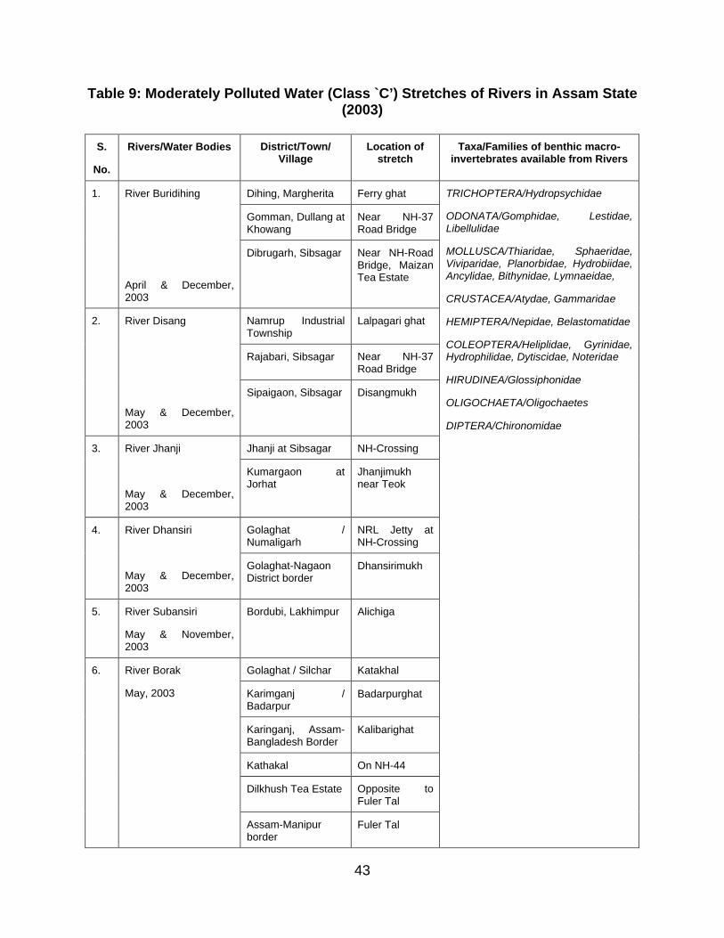
43
Table 9: Moderately Polluted Water (Class `C’) Stretches of Rivers in Assam State (2003)
S.
No.
Rivers/Water Bodies District/Town/ Village
Location of stretch
Taxa/Families of benthic macro-invertebrates available from Rivers
Dihing, Margherita Ferry ghat
Gomman, Dullang at Khowang
Near NH-37 Road Bridge
1. River Buridihing
April & December, 2003
Dibrugarh, Sibsagar Near NH-Road Bridge, Maizan Tea Estate
Namrup Industrial Township
Lalpagari ghat
Rajabari, Sibsagar Near NH-37 Road Bridge
2. River Disang
May & December, 2003
Sipaigaon, Sibsagar Disangmukh
Jhanji at Sibsagar NH-Crossing3. River Jhanji
May & December, 2003
Kumargaon at Jorhat
Jhanjimukh near Teok
Golaghat / Numaligarh
NRL Jetty at NH-Crossing
4. River Dhansiri
May & December, 2003
Golaghat-Nagaon District border
Dhansirimukh
5. River Subansiri
May & November, 2003
Bordubi, Lakhimpur Alichiga
Golaghat / Silchar Katakhal
Karimganj / Badarpur
Badarpurghat
Karinganj, Assam-Bangladesh Border
Kalibarighat
Kathakal On NH-44
Dilkhush Tea Estate Opposite to Fuler Tal
6. River Borak
May, 2003
Assam-Manipur border
Fuler Tal
TRICHOPTERA/Hydropsychidae
ODONATA/Gomphidae, Lestidae, Libellulidae
MOLLUSCA/Thiaridae, Sphaeridae, Viviparidae, Planorbidae, Hydrobiidae, Ancylidae, Bithynidae, Lymnaeidae,
CRUSTACEA/Atydae, Gammaridae
HEMIPTERA/Nepidae, Belastomatidae
COLEOPTERA/Heliplidae, Gyrinidae, Hydrophilidae, Dytiscidae, Noteridae
HIRUDINEA/Glossiphonidae
OLIGOCHAETA/Oligochaetes
DIPTERA/Chironomidae
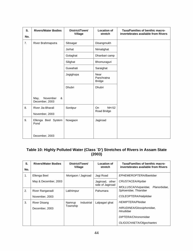
44
S.
No.
Rivers/Water Bodies District/Town/ Village
Location of stretch
Taxa/Families of benthic macro-invertebrates available from Rivers
Sibsagar Disangmukh
Jorhat Nimatighat
Golaghat Dhanbari camp
Silighat Bhomuraguri
Guwahati Saraighat
Jogighopa Near Panchratna Bridge
7. River Brahmaputra
May, November & December, 2003
Dhubri Dhubri
8. River Jia-Bharali
November, 2003
Sonitpur On NH-52 Road Bridge
9. Ellenga Beel System Pond
December, 2003
Nowgaon Jagiroad
Table 10: Highly Polluted Water (Class `D’) Stretches of Rivers in Assam State (2003)
S.
No.
Rivers/Water Bodies District/Town/ Village
Location of stretch
Taxa/Families of benthic macro-invertebrates available from Rivers
Jagi Road1. Ellenga Beel
May & December, 2003
Morigaon / Jagiroad
Jagiroad, other side of Jagiroad
2. River Ranganadi
November, 2003
Lakhimpur Pahumara
3. River Disang
December, 2003
Namrup Industrial Township
Lalpagari ghat
EPHEMEROPTERA/Baetidae
CRUSTACEA/Atydae
MOLLUSCA/Viviparidae, Planorbidae, Sphoeridae, Thiaridae
COLEOPTERA/Haliplidae
HEMIPTERA/Pleidae
HIRUDINEA/Glossiphonidae, Hirudidae
DIPTERA/Chironomidae
OLIGOCHAETA/Oligochaetes
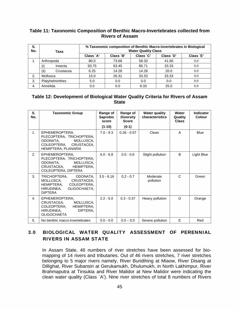
45
Table 11: Taxonomic Composition of Benthic Macro-Invertebrates collected from Rivers of Assam
% Taxonomic composition of Benthic Macro-invertebrates in Biological Water Quality Class
S. No. Taxa
Class `A’ Class `B’ Class `C’ Class `D’ Class `E’
Arthropoda 80.0 73.68 58.33 41.66 0.0
(i) Insecta 93.75 63.45 85.71 33.33 0.0
1.
(ii) Crustacea 6.25 14.28 14.28 20.0 0.0
2. Mollusca 15.0 26.31 33.33 33.33 0.0
3. Platyhelminthes 5.0 0.0 0.0 0.0 0.0
4. Annelida 0.0 0.0 8.33 25.0 0.0
Table 12: Development of Biological Water Quality Criteria for Rivers of Assam State
S. No.
Taxonomic Group Range of Saprobic
score
(1-10)
Range of Diversity
Score
(0-1)
Water quality characteristics
Water Quality Class
Indicator Colour
1. EPHEMEROPTERA, PLECOPTERA, TRICHOPTERA, ODONATA, MOLLUSCA, COLEOPTERA, CRUSTACEA, HEMIPTERA, PLANARIA
7.0 - 9.3 0.26 - 0.57 Clean A Blue
2. EPHEMEROPTERA, PLECOPTERA, TRICHOPTERA, ODONATA, MOLLUSCA, CRUSTACEA, HEMIPTERA, COLEOPTERA, DIPTERA
6.0 - 6.8 0.5 - 0.6 Slight pollution B Light Blue
3. TRICHOPTERA, ODONATA, MOLLUSCA, CRUSTACEA, HEMIPTERA, COLEOPTERA, HIRUDINEA, OLIGOCHAETA, DIPTERA
3.5 - 6.16 0.2 - 0.7 Moderate pollution
C Green
4. EPHEMEROPTERA, CRUSTACEA, MOLLUSCA, COLEOPTERA, HEMIPTERA, HIRUDINEA, DIPTERA, OLIGOCHAETA
2.2 - 5.0 0.3 - 0.37 Heavy pollution D Orange
5. No benthic macro-invertebrates 0.0 - 0.0 0.0 – 0.0 Severe pollution E Red
3.0 BIOLOGICAL WATER QUALITY ASSESSMENT OF PERENNIAL RIVERS IN ASSAM STATE
In Assam State, 46 numbers of river stretches have been assessed for bio-mapping of 14 rivers and tributaries. Out of 46 rivers stretches, 7 river stretches belonging to 5 major rivers namely, River Buridihing at Miaow, River Disang at Dillighat, River Subansiri at Gerukamukh, Dhulumukh, in North Lakhimpur, River Brahmaputra at Tinsukia and River Malidor at New Malidor were indicating the clean water quality (Class `A’). Nine river stretches of total 8 numbers of Rivers
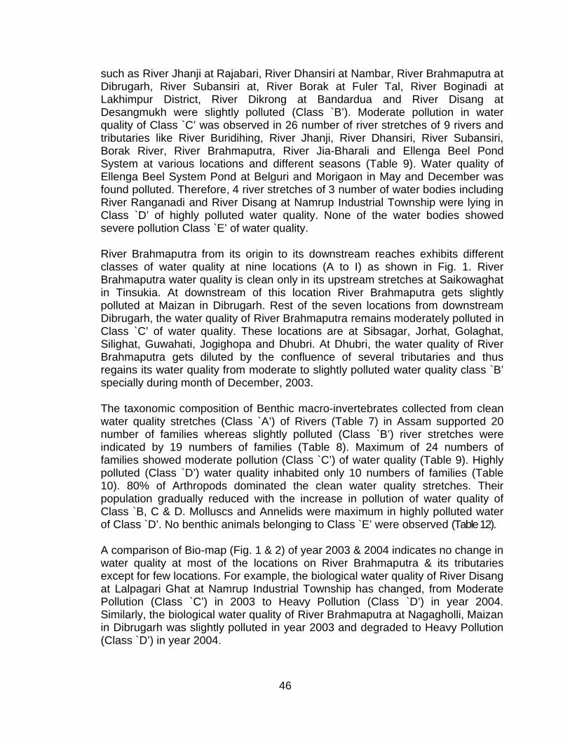
46
such as River Jhanji at Rajabari, River Dhansiri at Nambar, River Brahmaputra at Dibrugarh, River Subansiri at, River Borak at Fuler Tal, River Boginadi at Lakhimpur District, River Dikrong at Bandardua and River Disang at Desangmukh were slightly polluted (Class `B’). Moderate pollution in water quality of Class `C’ was observed in 26 number of river stretches of 9 rivers and tributaries like River Buridihing, River Jhanji, River Dhansiri, River Subansiri, Borak River, River Brahmaputra, River Jia-Bharali and Ellenga Beel Pond System at various locations and different seasons (Table 9). Water quality of Ellenga Beel System Pond at Belguri and Morigaon in May and December was found polluted. Therefore, 4 river stretches of 3 number of water bodies including River Ranganadi and River Disang at Namrup Industrial Township were lying in Class `D’ of highly polluted water quality. None of the water bodies showed severe pollution Class `E’ of water quality.
River Brahmaputra from its origin to its downstream reaches exhibits different classes of water quality at nine locations (A to I) as shown in Fig. 1. River Brahmaputra water quality is clean only in its upstream stretches at Saikowaghat in Tinsukia. At downstream of this location River Brahmaputra gets slightly polluted at Maizan in Dibrugarh. Rest of the seven locations from downstream Dibrugarh, the water quality of River Brahmaputra remains moderately polluted in Class `C’ of water quality. These locations are at Sibsagar, Jorhat, Golaghat, Silighat, Guwahati, Jogighopa and Dhubri. At Dhubri, the water quality of River Brahmaputra gets diluted by the confluence of several tributaries and thus regains its water quality from moderate to slightly polluted water quality class `B’ specially during month of December, 2003.
The taxonomic composition of Benthic macro-invertebrates collected from clean water quality stretches (Class `A’) of Rivers (Table 7) in Assam supported 20 number of families whereas slightly polluted (Class `B’) river stretches were indicated by 19 numbers of families (Table 8). Maximum of 24 numbers of families showed moderate pollution (Class `C’) of water quality (Table 9). Highly polluted (Class `D’) water quality inhabited only 10 numbers of families (Table 10). 80% of Arthropods dominated the clean water quality stretches. Their population gradually reduced with the increase in pollution of water quality of Class `B, C & D. Molluscs and Annelids were maximum in highly polluted water of Class `D’. No benthic animals belonging to Class `E’ were observed (Table 12).
A comparison of Bio-map (Fig. 1 & 2) of year 2003 & 2004 indicates no change in water quality at most of the locations on River Brahmaputra & its tributaries except for few locations. For example, the biological water quality of River Disang at Lalpagari Ghat at Namrup Industrial Township has changed, from Moderate Pollution (Class `C’) in 2003 to Heavy Pollution (Class `D’) in year 2004. Similarly, the biological water quality of River Brahmaputra at Nagagholli, Maizan in Dibrugarh was slightly polluted in year 2003 and degraded to Heavy Pollution (Class `D’) in year 2004.
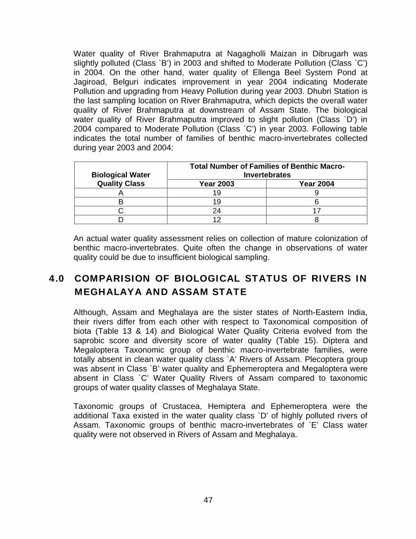
47
Water quality of River Brahmaputra at Nagagholli Maizan in Dibrugarh was slightly polluted (Class `B’) in 2003 and shifted to Moderate Pollution (Class `C’) in 2004. On the other hand, water quality of Ellenga Beel System Pond at Jagiroad, Belguri indicates improvement in year 2004 indicating Moderate Pollution and upgrading from Heavy Pollution during year 2003. Dhubri Station is the last sampling location on River Brahmaputra, which depicts the overall water quality of River Brahmaputra at downstream of Assam State. The biological water quality of River Brahmaputra improved to slight pollution (Class `D’) in 2004 compared to Moderate Pollution (Class `C’) in year 2003. Following table indicates the total number of families of benthic macro-invertebrates collected during year 2003 and 2004:
Total Number of Families of Benthic Macro-InvertebratesBiological Water
Quality Class Year 2003 Year 2004A 19 9B 19 6C 24 17D 12 8
An actual water quality assessment relies on collection of mature colonization of benthic macro-invertebrates. Quite often the change in observations of water quality could be due to insufficient biological sampling.
4.0 COMPARISION OF BIOLOGICAL STATUS OF RIVERS IN MEGHALAYA AND ASSAM STATE
Although, Assam and Meghalaya are the sister states of North-Eastern India, their rivers differ from each other with respect to Taxonomical composition of biota (Table 13 & 14) and Biological Water Quality Criteria evolved from the saprobic score and diversity score of water quality (Table 15). Diptera and Megaloptera Taxonomic group of benthic macro-invertebrate families, were totally absent in clean water quality class `A’ Rivers of Assam. Plecoptera group was absent in Class `B’ water quality and Ephemeroptera and Megaloptera were absent in Class `C’ Water Quality Rivers of Assam compared to taxonomic groups of water quality classes of Meghalaya State.
Taxonomic groups of Crustacea, Hemiptera and Ephemeroptera were the additional Taxa existed in the water quality class `D’ of highly polluted rivers of Assam. Taxonomic groups of benthic macro-invertebrates of `E’ Class water quality were not observed in Rivers of Assam and Meghalaya.
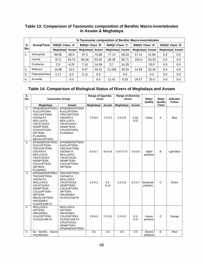
48
Table 13: Comparison of Taxonomic composition of Benthic Macro-invertebrates in Assam & Meghalaya
% Taxonomic composition of Benthic Macro-invertebrates
BWQC Class `A’ BWQC Class `B’ BWQC Class `C’ BWQC Class `D’ BWQC Class `E’S. No.
Group/Taxa
Meghalaya Assam Meghalaya Assam Meghalaya Assam Meghalaya Assam Meghalaya Assam
Arthropoda 86.95 80.0 87.5 73.68 77.14 58.33 57.14 41.66 0.0 0.0
Insecta 97.5 93.75 89.28 63.45 96.29 85.71 100.0 33.33 0.0 0.0
1.
Crustacea 2.5 6.25 7.15 14.28 3.7 14.28 - 20.0 0.0 0.0
2. Mollusca 10.86 15.0 9.37 26.31 11.428 33.33 14.28 33.33 0.0 0.0
3. Platyhelminthes 2.17 5.0 3.12 0.0 - 0.0 - 0.0 0.0 0.0
4. Annelida - 0.0 - 0.0 11.42 8.33 28.57 25.0 0.0 0.0
Table 14: Comparison of Biological Status of Rivers of Meghalaya and Assam
Taxonomic GroupRange of Saprobic
scoreRange of Diversity
ScoreS.
No.
Meghalaya Assam Meghalaya Assam Meghalaya Assam
Waterquality
Water Quality Class
Indicator Colour
1. EPHEMEROPTERAPLECOPTERATRICHOPTERAODONATAMOLLUSCACRUSTACEAHEMIPTERACOLEOPTERADIPTERAPLANARIAMEGALOPTERA
EPHEMEROPTERAPLECOPTERATRICHOPTERAODONATAMOLLUSCACRUSTACEAHEMIPTERACOLEOPTERAPLANARIA--
7.0-8.6 7.0-9.3 0.2-0.8 0.26-0.57
Clean A Blue
2. EPHEMEROPTERAPLECOPTERATRICHOPTERAODONATAMOLLUSCACRUSTACEAHEMIPTERACOLEOPTERADIPTERAPLANARIA
EPHEMEROPTERAPLECOPTERATRICHOPTERAODONATAMOLLUSCACRUSTACEAHEMIPTERACOLEOPTERADIPTERA-
6.0-6.7 6.0-6.8 0.47-0.72 0.5-0.6 Slight pollution
B Light Blue
3. EPHEMEROPTERATRICHOPTERAODONATAMOLLUSCACRUSTACEAHEMIPTERACOLEOPTERADIPTERAMEGALOPTERAHIRUDINEAOLIGOCHAETA
TRICHOPTERAODONATAMOLLUSCACRUSTACEAHEMIPTERACOLEOPTERADIPTERAHIRUDINEAOLIGOCHAETA--
3.4-6.2 4.2-6.16
0.2-0.8 0.2-0.7 Moderate pollution
C Green
4. MOLLUSCADIPTERAHIRUDINEACOLEOPTERAOLIGOCHAETA---
MOLLUSCADIPTERAHIRUDINEACOLEOPTERAOLIGOCHAETACRUSTACEAHEMIPTERAEPHEMEROPTERA
2.6-6.0 2.2-5.0 0.2-0.3 0.3-0.37
Heavy pollution
D Orange
5. No benthic macro-invertebrates
0.0 0.0 0.0 0.0 Severe pollution
E Red
49
______________________________________________________________________________
Published By : Dr. B. Sengupta, Member Secretary, Central Pollution Control Board, Delhi – 32
Printing Supervision & Layout : P.K. Mahendru and Mrs. Anamika Sagar Composing and Laser Type Setting : Mohd. JavedWeb Version : U.A. Ansari and Mrs. Shashi Goel
Fax : 91-11-2230 7079, 4948, 1932 EPABX : 22305792, 22302073, 22302856 TELEX : 031-66440 PCON IN
e-mail : [email protected]; Website : www.cpcb.nic.inPrinted at : National Institute of Science Communication and Information Resources,
CSIR, Dr. K.S. Krishnan Marg, New Delhi – 110 012