Embed Size (px)
Citation preview

Record 2014/20 | GeoCat 76784
EDM Height Traversing Levelling Survey ReportMajuro, Marshall Islands, June 2012
A.R.Hill, A. Lal
APPLYING GEOSCIENCE TO AUSTRALIA’S MOST IMPORTANT CHALLENGES www.ga.gov.au


EDM Height Traversing Levelling Survey Report Majuro, Marshall Islands, June 2012
GEOSCIENCE AUSTRALIA RECORD 2014/20
A.R.Hill1, A. Lal2
1. National Geospatial Reference Systems, Geospatial and Earth Monitoring Division, Geoscience Australia GPO Box 378
Canberra ACT 2601 2. Secretariat of the Pacific Community (SPC)

Department of Industry Minister for Industry: The Hon Ian Macfarlane MP Parliamentary Secretary: The Hon Bob Baldwin MP Secretary: Ms Glenys Beauchamp PSM
Geoscience Australia Chief Executive Officer: Dr Chris Pigram This paper is published with the permission of the CEO, Geoscience Australia
© Commonwealth of Australia (Geoscience Australia) 2014
With the exception of the Commonwealth Coat of Arms and where otherwise noted, all material in this publication is provided under a Creative Commons Attribution 3.0 Australia Licence. (http://www.creativecommons.org/licenses/by/3.0/au/deed.en)
Geoscience Australia has tried to make the information in this product as accurate as possible. However, it does not guarantee that the information is totally accurate or complete. Therefore, you should not solely rely on this information when making a commercial decision.
Geoscience Australia is committed to providing web accessible content wherever possible. If you are having difficulties with accessing this document please email [email protected].
ISSN 2201-702X (PDF)
ISBN 978-1-925124-09-5 (PDF)
GeoCat 76784
Bibliographic reference: Hill, A. R. & Lal, A., 2014, EDM Height Traversing Levelling Survey Report: Majuro, Marshall Is. June 2012. Record 2014/20. Geoscience Australia, Canberra. http://dx.doi.org/10.11636/Record.2014.020

EDM Height Traversing Levelling Survey Report: Majuro, Marshall Is. June 2012 iii
Contents
1 Introduction ............................................................................................................................................ 1
2 The Survey ............................................................................................................................................ 2 2.1 Bench Mark Locality Diagram .......................................................................................................... 3 2.2 The Marshall Islands Datum ............................................................................................................ 3 2.3 Equipment ........................................................................................................................................ 4 2.4 Method ............................................................................................................................................. 4 2.5 Survey Support ................................................................................................................................ 4 2.6 Issues ............................................................................................................................................... 5
3 Comparisons ......................................................................................................................................... 6 3.1 Comparisons between 2012 and 2010 EDM Surveys. .................................................................... 6 3.2 Combined Comparisons 1993 to 2012 ............................................................................................ 7 3.3 Time Series of Bench Mark Movement ............................................................................................ 8
4 Deep Bench Mark Locality Diagrams ..................................................................................................12 5 Permanent Holding Mark Locality Diagrams .......................................................................................18
6 MAJUBM and MAJU Reference Mark Locality Diagrams ...................................................................27
7 References ..........................................................................................................................................31

iv EDM Height Traversing Levelling Survey Report: Majuro, Marshall Is. June 2012
EDM Height Traversing Levelling Survey Report: Majuro, Marshall Is. June 2012 1
1 Introduction
This report outlines the high precision level survey completed between the Sea Level Fine Resolution Acoustic Measuring Equipment (SEAFRAME) tide gauge and continuous Global Navigation Satellite System (CGNSS) station in Majuro, Marshall Islands from 12-18 June 2012.
Personnel involved in the survey were Anna Hill, Project Officer, Geoscience Australia and Andrick Lal, Surveyor, Secretariat of the Pacific Community (SPC)
The Electronic Distance Measurement (EDM) height traversing levelling technique was employed to observe differences in height between the deep bench mark arrays in Majuro, which runs approximately 4 km from the tide gauge sensor to the Continuous Global Navigation Satellite System (CGNSS) antenna. Previous levelling surveys using this technique have been conducted along the route in 2006, 2007, 2009 and 2010.
In addition, precise differential levelling surveys were performed along the deep bench mark (BM) array from 1993 to 2006 by the National Tidal Centre Australia (NTCA). This report contains a comparison between the 2012 and 2010 EDM height traversing results as well as a combined comparison since the first levelling survey in 1993.

2 EDM Height Traversing Levelling Survey Report: Majuro, Marshall Is. June 2012
2 The Survey
The EDM height traversing levelling survey was carried out between the SEAFRAME tide gauge sensor, continuous GNSS station and the deep driven bench marks:
MAJUBM – GPS Benchmark
MAR 13 - Project plaque at tide gauge
MAR 14 - SEAFRAME sensor benchmark
MAR 3 - Deep Driven BM
MAR 15 - Deep Driven BM
MAR 50 - Deep Driven BM
MAR 51 - Deep Driven BM
MAR 52 - Deep Driven BM
MAR 100 - Deep Driven BM
MAR 107 - Deep Driven BM
All the deep bench marks were located and found in good order and undisturbed, including MAR3 which is located within a shop out the front of Robert Reimers Hotel. Also included in the survey were permanent holding marks MAR25, MAR31, MAR36, MAR40, MAR44, MAR54 and temporary holding marks MAR101, MAR102, MAR104, MAR105, MAR106, MAR108, MAR109, MAR110, MAR112, MAR113, MAR114.
The EDM height traversing levelling technique was performed to the Class L2A specifications (ICSM, Standards and Practices for Control Surveys). After reduction an internal precision of 1mm√K or better was achieved (zero order); well within the specifications of the project which is 2√K where K is the distance in kilometres. A table of results and comparisons and the 2012 reduced levels are detailed later in this report.

EDM Height Traversing Levelling Survey Report: Majuro, Marshall Is. June 2012 3
2.1 Bench Mark Locality Diagram
2.2 The Marshall Islands Datum The adopted reference point for this survey is MAR3. Reduction of the data was calculated holding MAR3 fixed at 1.60834 metres.
The height of MAR3 was derived by:
1993 - Adopting the MSL height of USCG BM 4; RL = 1.91414m MSL (Nov 68 – May 69)
1994 – Adopting the height of MAR3 as derived in the 1993 survey.
Initially, MAR2 was the reference point for the surveys, but this was found to be destroyed during the 2006 survey. In order to keep all the reduced levels consistent in reference to a unique benchmark, the RL of MAR3 as determined in the 1993 survey is adopted as the datum for all the surveys.

4 EDM Height Traversing Levelling Survey Report: Majuro, Marshall Is. June 2012
2.3 Equipment • Leica total station model TM30 (Serial No: 361441)
• Leica precision prisms GPH1P (2).
• Leica rigid tripod.
• Stainless steel target poles supported by Leica telescopic bi-poles (2).
• Shortened stainless steel target pole for the SEAFRAME sensor BM connection.
• Leica cast iron change plates (2).
• Kestral 4000 pocket weather tracker
2.4 Method The “Leap-Frog” EDM height traversing technique was employed for the Majuro tide gauge levelling survey. This technique involves setting up a total station (TCA1800L) midway between two target/reflectors (on reflector rods with struts). The targets remain at a particular change point for the back-sight and fore-sight observations. The instrument measures slope distances (±1mm) and vertical angle (1”) to derive height differences (between the instrument’s trunnion axis and the reflectors). In support of the slope distance observations, the ambient temperature, pressure and humidity are recorded (Kestral 4000 pocket weather tracker) and input into the instrument to apply the first velocity correction to the observed distances (Rüeger & Brunner, 1982). Four rounds of observations are taken to the back-sight and fore-sight targets from each instrument setup. All levelling runs started and finished with the same reflector and reflector rod, i.e. an even number of setups when the two reflector rod configuration was used. This eliminates any reflector rod zero error. This technique can also be performed using a single set-up / single rod configuration which is particularly useful when levelling between bench marks which are close together e.g. between the CGNSS RMs.
Reduction of the digital data was computed by the Geoscience Australia levelling program “leveling1.exe”. This program computes the height difference between the two reflectors.
2.5 Survey Support The survey team very much appreciated the assistance from Meteorological Office, Survey Department and Marshall Islands National Telecommunications Authority (NTA). Personnel consulted during the visit were:
Mr. Lee Jacklick – Meteorological Office
Mr. Reginald White – Meteorological Office
Mr. Steven R – Meteorological Office
Mr. Melvin Aliven – NTA
Mr Wase Hackney – Survey Department
Both departments have a keen interest in the SPSLCMP and are always supportive with any associated project matters.

EDM Height Traversing Levelling Survey Report: Majuro, Marshall Is. June 2012 5
2.6 Issues As mentioned in the 2010 report, MAR3 is now inside a building located on the street outside the Robert Reimers Hotel. In the last visit, permission for occupying the benchmark was obtained from the then owner Mr. Rodrigeuz Reimers, (email: [email protected]) to occupy the site. During this visit however, it appears there are new owners of the building and it is now used as a supermarket. The room where MAR3 is located is now a store room. The Project should probably develop a plan to shift the datum reference point to another site as it seems it will become more and more difficult to access this mark in the coming years.
Access to the deep benchmark, MAR15, is also restricted as it is in the Mobile Depot compound; therefore approval to survey the benchmark is necessary from the security gate at the depot.
Another concern is that the CGPS monument and the three RM’s inside the NTA facility at Rita are collocated with several TV satellite dishes and care must be taken during the reference mark monitoring survey to ensure clear line of sight. Contact NTA personal for access into the compound and other survey related matters.
6 EDM Height Traversing Levelling Survey Report: Majuro, Marshall Is. June 2012
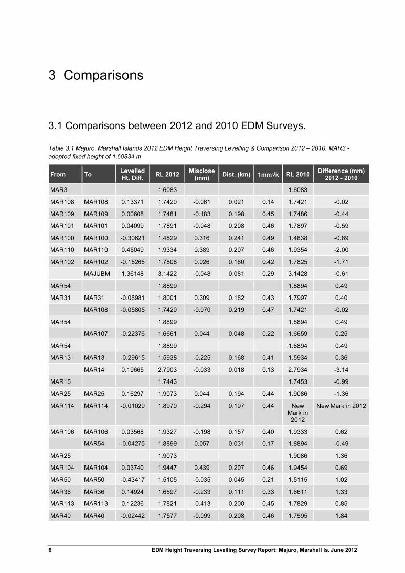
3 Comparisons
3.1 Comparisons between 2012 and 2010 EDM Surveys.
Table 3.1 Majuro, Marshall Islands 2012 EDM Height Traversing Levelling & Comparison 2012 – 2010. MAR3 - adopted fixed height of 1.60834 m
From To Levelled Ht. Diff. RL 2012 Misclose
(mm) Dist. (km) 1mm√k RL 2010 Difference (mm) 2012 - 2010
MAR3 1.6083 1.6083
MAR108 MAR108 0.13371 1.7420 -0.061 0.021 0.14 1.7421 -0.02
MAR109 MAR109 0.00608 1.7481 -0.183 0.198 0.45 1.7486 -0.44
MAR101 MAR101 0.04099 1.7891 -0.048 0.208 0.46 1.7897 -0.59
MAR100 MAR100 -0.30621 1.4829 0.316 0.241 0.49 1.4838 -0.89
MAR110 MAR110 0.45049 1.9334 0.389 0.207 0.46 1.9354 -2.00
MAR102 MAR102 -0.15265 1.7808 0.026 0.180 0.42 1.7825 -1.71
MAJUBM 1.36148 3.1422 -0.048 0.081 0.29 3.1428 -0.61
MAR54 1.8899 1.8894 0.49
MAR31 MAR31 -0.08981 1.8001 0.309 0.182 0.43 1.7997 0.40
MAR108 -0.05805 1.7420 -0.070 0.219 0.47 1.7421 -0.02
MAR54 1.8899 1.8894 0.49
MAR107 -0.22376 1.6661 0.044 0.048 0.22 1.6659 0.25
MAR54 1.8899 1.8894 0.49
MAR13 MAR13 -0.29615 1.5938 -0.225 0.168 0.41 1.5934 0.36
MAR14 0.19665 2.7903 -0.033 0.018 0.13 2.7934 -3.14
MAR15 1.7443 1.7453 -0.99
MAR25 MAR25 0.16297 1.9073 0.044 0.194 0.44 1.9086 -1.36
MAR114 MAR114 -0.01029 1.8970 -0.294 0.197 0.44 New Mark in 2012
New Mark in 2012
MAR106 MAR106 0.03568 1.9327 -0.198 0.157 0.40 1.9333 0.62
MAR54 -0.04275 1.8899 0.057 0.031 0.17 1.8894 -0.49
MAR25 1.9073 1.9086 1.36
MAR104 MAR104 0.03740 1.9447 0.439 0.207 0.46 1.9454 0.69
MAR50 MAR50 -0.43417 1.5105 -0.035 0.045 0.21 1.5115 1.02
MAR36 MAR36 0.14924 1.6597 -0.233 0.111 0.33 1.6611 1.33
MAR113 MAR113 0.12236 1.7821 -0.413 0.200 0.45 1.7829 0.85
MAR40 MAR40 -0.02442 1.7577 -0.099 0.208 0.46 1.7595 1.84
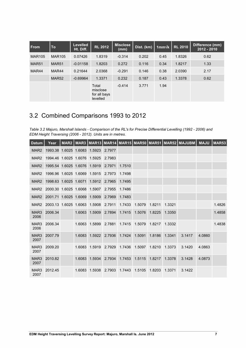
EDM Height Traversing Levelling Survey Report: Majuro, Marshall Is. June 2012 7
From To Levelled Ht. Diff. RL 2012 Misclose
(mm) Dist. (km) 1mm√k RL 2010 Difference (mm) 2012 - 2010
MAR105 MAR105 0.07426 1.8319 -0.314 0.202 0.45 1.8326 0.62
MAR51 MAR51 -0.01158 1.8203 0.272 0.116 0.34 1.8217 1.33
MAR44 MAR44 0.21644 2.0368 -0.291 0.146 0.38 2.0390 2.17
MAR52 -0.69964 1.3371 0.232 0.187 0.43 1.3378 0.62
Total misclose for all bays levelled
-0.414 3.771 1.94
3.2 Combined Comparisons 1993 to 2012
Table 3.2 Majuro, Marshall Islands - Comparison of the RL's for Precise Differential Levelling (1992 - 2006) and EDM Height Traversing (2006 - 2012). Units are in metres.
Datum Year MAR2 MAR3 MAR13 MAR14 MAR15 MAR50 MAR51 MAR52 MAJUBM MAJU MAR53
MAR2 1993.38 1.6025 1.6083 1.5923 2.7977
MAR2 1994.46 1.6025 1.6076 1.5925 2.7983
MAR2 1995.54 1.6025 1.6076 1.5919 2.7971 1.7510
MAR2 1996.96 1.6025 1.6069 1.5915 2.7973 1.7498
MAR2 1998.63 1.6025 1.6071 1.5912 2.7965 1.7495
MAR2 2000.30 1.6025 1.6068 1.5907 2.7955 1.7486
MAR2 2001.71 1.6025 1.6069 1.5909 2.7969 1.7483
MAR2 2003.13 1.6025 1.6063 1.5908 2.7911 1.7433 1.5079 1.8211 1.3321 1.4826
MAR3 2006
2006.34 1.6063 1.5909 2.7894 1.7415 1.5076 1.8225 1.3350 1.4858
MAR3 2006
2006.34 1.6063 1.5899 2.7881 1.7415 1.5079 1.8217 1.3332 1.4838
MAR3 2007
2007.79 1.6083 1.5922 2.7936 1.7424 1.5091 1.8186 1.3341 3.1417 4.0860
MAR3 2007
2009.20 1.6083 1.5919 2.7929 1.7436 1.5097 1.8210 1.3373 3.1420 4.0863
MAR3 2007
2010.82 1.6083 1.5934 2.7934 1.7453 1.5115 1.8217 1.3378 3.1428 4.0873
MAR3 2007
2012.45 1.6083 1.5938 2.7903 1.7443 1.5105 1.8203 1.3371 3.1422

8 EDM Height Traversing Levelling Survey Report: Majuro, Marshall Is. June 2012
3.3 Time Series of Bench Mark Movement Precise Differential Levelling: 1993 - 2006 EDM Height Traversing: 2006 onwards
The purpose of this survey is in twofold: firstly, to provide accurate changes in land height to be used in computations of absolute sea level rise and secondly to provide accurate assessments of relative sea level changes due to localised deformation.
• There appears to be a few movements occurring:
• A possible drop in the reference point (MAR3) of ~1 mm over 3 years.
• A possible rise in the holding marks (e.g. MAR50-52) of ~4 mm over 3 years.
• A knock to the tide gauge (MAR14) could have occurred in 2003 and another smaller knock between the 2010 and 2012 surveys ~-3 mm.
• An incorrect point could have been observed at MAR15 in 2003.
• According to a localised analysis of MAJU and its RM’s, it appears that the GPS site is quite stable.
MAR3
-10
-8
-6
-4
-2
0
2
4
1990 1995 2000 2005 2010 2015
Year of Levelling Survey
Rela
tive
Mov
emen
t of B
ench
Mar
k (m
m)
Datum MAR2 (1993) Datum MAR3 (2006) Datum MAR3 (1993)

EDM Height Traversing Levelling Survey Report: Majuro, Marshall Is. June 2012 9
MAR13
-10
-8
-6
-4
-2
0
2
4
1990 1995 2000 2005 2010 2015
Year of Levelling Survey
Relat
ive M
ovem
ent o
f Ben
ch M
ark
(mm
)
Datum MAR2 (1993) Datum MAR3 (2006) Datum MAR3 (1993)
MAR14
-10
-8
-6
-4
-2
0
2
4
1990 1995 2000 2005 2010 2015
Year of Levelling Survey
Rela
tive
Mov
emen
t of B
ench
Mar
k (m
m)
Datum MAR2 (1993) Datum MAR3 (2006) Datum MAR3 (1993)

10 EDM Height Traversing Levelling Survey Report: Majuro, Marshall Is. June 2012
MAR15
-10
-8
-6
-4
-2
0
2
4
1990 1995 2000 2005 2010 2015
Year of Levelling Survey
Rela
tive
Mov
emen
t of B
ench
Mar
k (m
m)
Datum MAR2 (1993) Datum MAR3 (2006) Datum MAR3 (1993)
MAR50
-10
-8
-6
-4
-2
0
2
4
1990 1995 2000 2005 2010 2015
Year of Levelling Survey
Rela
tive
Mov
emen
t of B
ench
Mar
k (m
m)
Datum MAR2 (1993) Datum MAR3 (2006) Datum MAR3 (1993)

EDM Height Traversing Levelling Survey Report: Majuro, Marshall Is. June 2012 11
MAR51
-10
-8
-6
-4
-2
0
2
4
1990 1995 2000 2005 2010 2015
Year of Levelling Survey
Rela
tive
Mov
emen
t of B
ench
Mar
k (m
m)
Datum MAR2 (1993) Datum MAR3 (2006) Datum MAR3 (1993)
MAR52
-10
-8
-6
-4
-2
0
2
4
1990 1995 2000 2005 2010 2015
Year of Levelling Survey
Rela
tive
Mov
emen
t of B
ench
Mar
k (m
m)
Datum MAR2 (1993) Datum MAR3 (2006) Datum MAR3 (1993)

12 EDM Height Traversing Levelling Survey Report: Majuro, Marshall Is. June 2012
4 Deep Bench Mark Locality Diagrams

EDM Height Traversing Levelling Survey Report: Majuro, Marshall Is. June 2012 13
14 EDM Height Traversing Levelling Survey Report: Majuro, Marshall Is. June 2012

EDM Height Traversing Levelling Survey Report: Majuro, Marshall Is. June 2012 15

16 EDM Height Traversing Levelling Survey Report: Majuro, Marshall Is. June 2012

EDM Height Traversing Levelling Survey Report: Majuro, Marshall Is. June 2012 17

18 EDM Height Traversing Levelling Survey Report: Majuro, Marshall Is. June 2012
5 Permanent Holding Mark Locality Diagrams

EDM Height Traversing Levelling Survey Report: Majuro, Marshall Is. June 2012 19

20 EDM Height Traversing Levelling Survey Report: Majuro, Marshall Is. June 2012

EDM Height Traversing Levelling Survey Report: Majuro, Marshall Is. June 2012 21

22 EDM Height Traversing Levelling Survey Report: Majuro, Marshall Is. June 2012

EDM Height Traversing Levelling Survey Report: Majuro, Marshall Is. June 2012 23

24 EDM Height Traversing Levelling Survey Report: Majuro, Marshall Is. June 2012

EDM Height Traversing Levelling Survey Report: Majuro, Marshall Is. June 2012 25

26 EDM Height Traversing Levelling Survey Report: Majuro, Marshall Is. June 2012

EDM Height Traversing Levelling Survey Report: Majuro, Marshall Is. June 2012 27
6 MAJUBM and MAJU Reference Mark Locality Diagrams

28 EDM Height Traversing Levelling Survey Report: Majuro, Marshall Is. June 2012

EDM Height Traversing Levelling Survey Report: Majuro, Marshall Is. June 2012 29

30 EDM Height Traversing Levelling Survey Report: Majuro, Marshall Is. June 2012

EDM Height Traversing Levelling Survey Report: Majuro, Marshall Is. June 2012 31
7 References
Rüeger, J.M. & Brunner, F.K. 1982, ‘EDM Height Traversing versus Geodetic Levelling’, The Canadian Surveyor, vol. 36, no. 1, pp. 69-87.
Inter-Government Committee on Surveying and Mapping (ICSM) 2002, Standards and Practices for Control Surveys, SP1, Ver. 1.5, May 2002.