Embed Size (px)
Citation preview
1
Effect of Ionospheric Scintillations on GNSS – A White Paper
SBAS Ionospheric Working Group
November 2010 Table of Contents: 1 Introduction................................................................................................................. 2 2 Scintillation Phenomenon ........................................................................................... 2
2.1 Worldwide Characteristics.................................................................................. 2 2.2 Scintillation Activity........................................................................................... 4 2.3 Equatorial and Low Latitude Scintillations ........................................................ 5 2.4 High Latitude Scintillation.................................................................................. 8 2.5 Scintillation Effects at Mid latitudes during Intense Magnetic Storms ............ 10 2.6 Scintillation Models .......................................................................................... 11
3 Effects of Scintillation on GPS and SBAS Systems................................................. 13 3.1 Effect on User Receivers .................................................................................. 13 3.2 Effect on Reference Stations............................................................................. 14 3.3 Effect on Satellite Datalinks ............................................................................. 15 3.4 Characterizing Effects....................................................................................... 16 3.5 Effect on SBAS Availability Using a Service Volume Model (SVM)............. 16
4 Mitigation Techniques .............................................................................................. 18 5 Conclusions and further work................................................................................... 19
2
1 Introduction The ionosphere is a highly variable and complex physical system. It is produced by ionizing radiation from the sun and controlled by chemical interactions and transport by diffusion and neutral wind. Generally, the region between 250 and 400 km, known as the F-region of the ionosphere, contains the greatest concentration of free electrons. At times, the F-region of the ionosphere becomes disturbed, and small-scale irregularities develop. When sufficiently intense, these irregularities scatter radio waves and generate rapid fluctuations (or scintillation) in the amplitude and phase of radio signals. Amplitude scintillation, or short-term fading, can be so severe that signal levels drop below a GPS receiver’s lock threshold, requiring the receiver to attempt reacquisition of the satellite signal. Phase scintillation, characterized by rapid carrier-phase changes, can produce cycle slips and sometimes challenge a receiver’s ability to hold lock on a signal. The impacts of scintillation are not be mitigated by the same dual-frequency technique that is effective at mitigating the ionospheric delay. For these reasons, ionospheric scintillation is one of the most significant threats for Global Navigation Satellite Systems (GNSS) operating in the near equatorial and polar latitudes. Scintillation activity is most severe and frequent in and around the equatorial regions, particularly in the hours just after sunset. In high latitude regions, scintillation is frequent but less severe in magnitude than that of the equatorial regions. Scintillation is rarely experienced in the mid-latitude regions. However, it can limit dual-frequency GNSS operation during very intense magnetic storm periods when the geophysical environment is temporarily altered and high latitude phenomena are extended into the mid-latitudes. To determine the impact of scintillation on GNSS systems, it is important to clearly understand the location, magnitude and frequency of occurrence of scintillation effects. This paper describes scintillation and illustrates its potential effects on GNSS. It presents information on the benefits and weaknesses of current measurement techniques and models of scintillation activity. It discusses the effects of scintillation on the ability of reference station and avionic receivers to obtain range measurements and data from GNSS satellites and the geostationary satellites that broadcast the Space Based Augmentation Systems (SBAS) message to users. The paper further estimates the impact of scintillation on SBAS availability and continuity requirements. The paper concludes with recommendations for possible mitigation techniques.
2 Scintillation Phenomenon
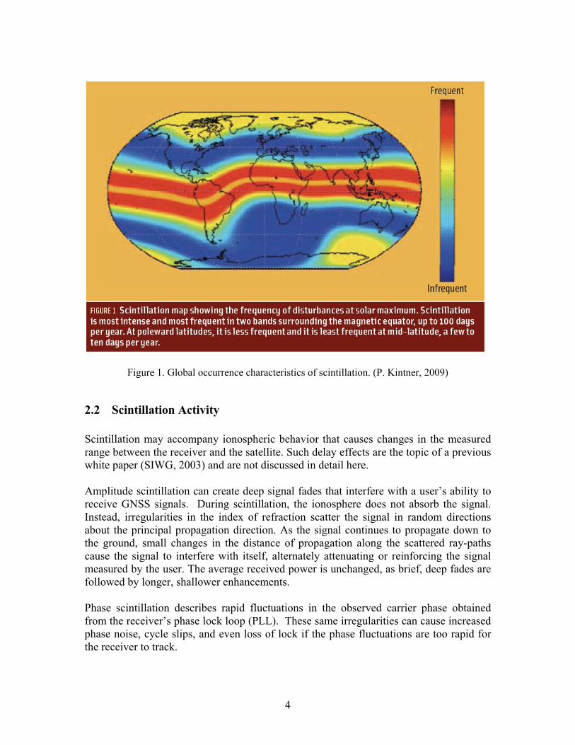
2.1 Worldwide Characteristics Fortunately, many of the important characteristics of scintillation are already well known (Aarons, 1982, 1993, 1995 and Basu et al., 1988). These studies have shown that scintillation activity varies with operating frequency, geographic location, local time, season, magnetic activity, and the 11-year solar cycle. Figure 1 shows a map indicating
3
how scintillation activity varies with geographic location. The Earth’s magnetic field has a major influence of the occurrence of scintillation and regions of the globe with similar scintillation characteristics are aligned with the magnetic poles and associated magnetic equator. The regions located approximately 15° North and South of the magnetic equator (shown in red), are referred to as the equatorial anomaly. These regions experience the most significant activity including deep signal fades that can cause a GNSS receiver to briefly lose track of one or more satellite signals. Less intense fades are experienced near the magnetic equator (shown as a narrow yellow band in between the two red bands) and also in regions immediately to the North and South of the anomaly regions. Scintillation is more intense in the anomaly regions than at the magnetic equator because of a special situation that occurs in the equatorial ionosphere. The combination of electric and magnetic fields about the Earth cause free electrons to be lifted vertically and then diffuse northward and southward. This action reduces the ionization directly over the magnetic equator and increases the ionization over the anomaly regions. The word ‘anomaly’ signifies that although the sun shines above the equator, the ionization attains its maximum density away from the equator. Low-latitude scintillation is seasonally dependent and is limited to local nighttime hours. The high-latitude region can also encounter significant signal fades. Here scintillation may also accompany the more familiar ionospheric effect of the Aurora Borealis (or Aurora Australis near the southern magnetic pole), and also localized regions of enhanced ionization referred to as polar patches. The occurrence of scintillation at auroral latitudes is strongly dependent on geomagnetic activity levels, but can occur in all seasons and is not limited to local nighttime hours. In the mid-latitude regions, scintillation activity is rare, occurring only in response to extreme levels of ionospheric storms (Doherty et al., 2000, 2004; Basu, Su. et al., 2005). During these periods, the active aurora expands both poleward and equatorward, exposing the mid-latitude region to scintillation activity. In all regions, increased solar activity amplifies scintillation frequency and intensity. Scintillation effects are also a function of operating frequency, with lower signal frequencies experiencing more significant scintillation effects.
4
Figure 1. Global occurrence characteristics of scintillation. (P. Kintner, 2009)
2.2 Scintillation Activity Scintillation may accompany ionospheric behavior that causes changes in the measured range between the receiver and the satellite. Such delay effects are the topic of a previous white paper (SIWG, 2003) and are not discussed in detail here. Amplitude scintillation can create deep signal fades that interfere with a user’s ability to receive GNSS signals. During scintillation, the ionosphere does not absorb the signal. Instead, irregularities in the index of refraction scatter the signal in random directions about the principal propagation direction. As the signal continues to propagate down to the ground, small changes in the distance of propagation along the scattered ray-paths cause the signal to interfere with itself, alternately attenuating or reinforcing the signal measured by the user. The average received power is unchanged, as brief, deep fades are followed by longer, shallower enhancements. Phase scintillation describes rapid fluctuations in the observed carrier phase obtained from the receiver’s phase lock loop (PLL). These same irregularities can cause increased phase noise, cycle slips, and even loss of lock if the phase fluctuations are too rapid for the receiver to track.
5
The behavior of each type of observed scintillation and their relationship to each other varies by region and will be described in greater detail in the following sections.
2.3 Equatorial and Low Latitude Scintillations
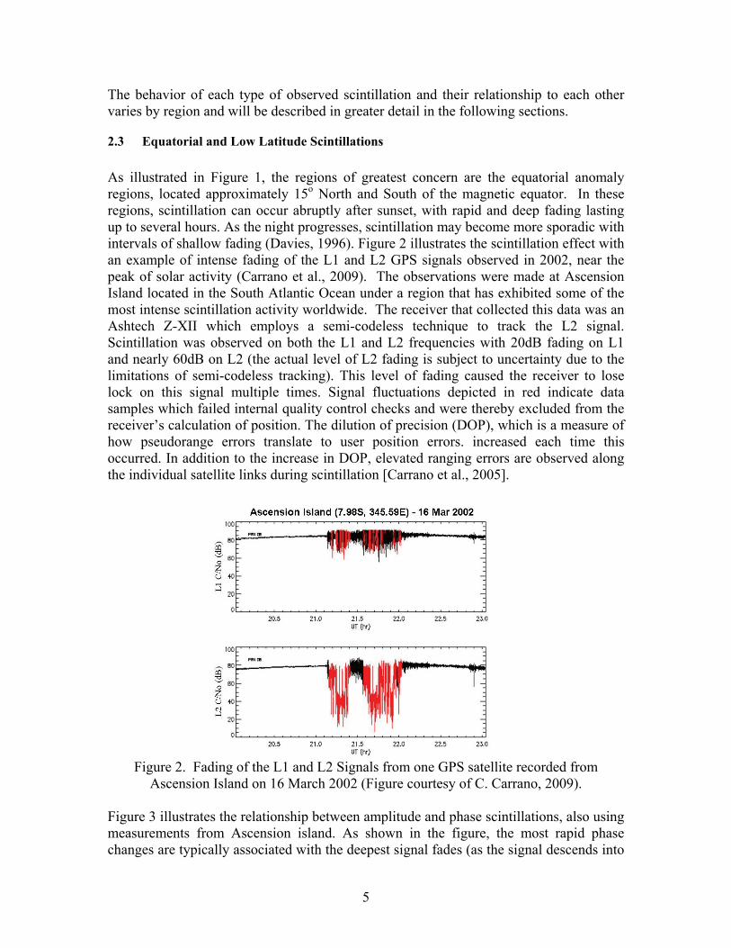
As illustrated in Figure 1, the regions of greatest concern are the equatorial anomaly regions, located approximately 15o North and South of the magnetic equator. In these regions, scintillation can occur abruptly after sunset, with rapid and deep fading lasting up to several hours. As the night progresses, scintillation may become more sporadic with intervals of shallow fading (Davies, 1996). Figure 2 illustrates the scintillation effect with an example of intense fading of the L1 and L2 GPS signals observed in 2002, near the peak of solar activity (Carrano et al., 2009). The observations were made at Ascension Island located in the South Atlantic Ocean under a region that has exhibited some of the most intense scintillation activity worldwide. The receiver that collected this data was an Ashtech Z-XII which employs a semi-codeless technique to track the L2 signal. Scintillation was observed on both the L1 and L2 frequencies with 20dB fading on L1 and nearly 60dB on L2 (the actual level of L2 fading is subject to uncertainty due to the limitations of semi-codeless tracking). This level of fading caused the receiver to lose lock on this signal multiple times. Signal fluctuations depicted in red indicate data samples which failed internal quality control checks and were thereby excluded from the receiver’s calculation of position. The dilution of precision (DOP), which is a measure of how pseudorange errors translate to user position errors. increased each time this occurred. In addition to the increase in DOP, elevated ranging errors are observed along the individual satellite links during scintillation [Carrano et al., 2005].
Figure 2. Fading of the L1 and L2 Signals from one GPS satellite recorded from
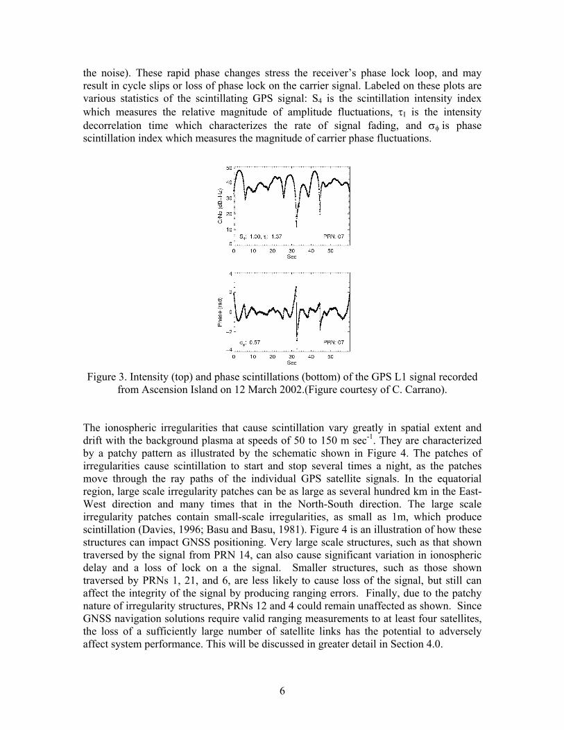
Ascension Island on 16 March 2002 (Figure courtesy of C. Carrano, 2009). Figure 3 illustrates the relationship between amplitude and phase scintillations, also using measurements from Ascension island. As shown in the figure, the most rapid phase changes are typically associated with the deepest signal fades (as the signal descends into
6
the noise). These rapid phase changes stress the receiver’s phase lock loop, and may result in cycle slips or loss of phase lock on the carrier signal. Labeled on these plots are various statistics of the scintillating GPS signal: S4 is the scintillation intensity index which measures the relative magnitude of amplitude fluctuations, I is the intensity decorrelation time which characterizes the rate of signal fading, and is phase scintillation index which measures the magnitude of carrier phase fluctuations.
Figure 3. Intensity (top) and phase scintillations (bottom) of the GPS L1 signal recorded
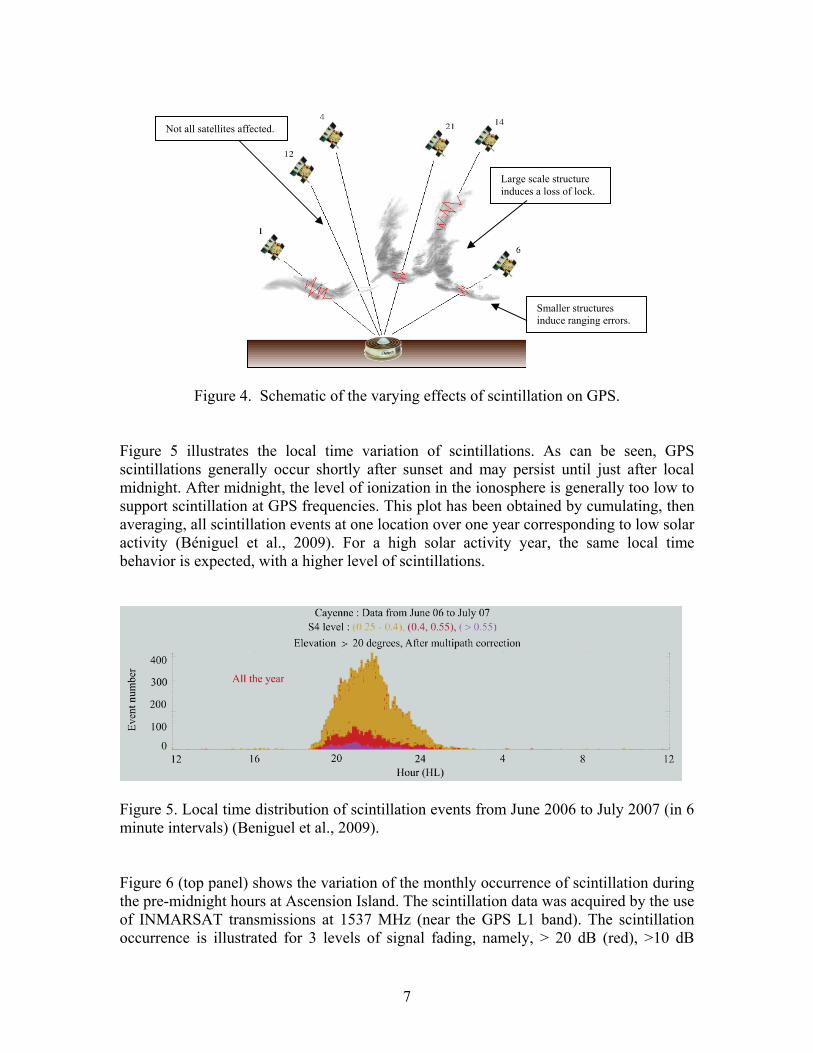
from Ascension Island on 12 March 2002.(Figure courtesy of C. Carrano). The ionospheric irregularities that cause scintillation vary greatly in spatial extent and drift with the background plasma at speeds of 50 to 150 m sec-1. They are characterized by a patchy pattern as illustrated by the schematic shown in Figure 4. The patches of irregularities cause scintillation to start and stop several times a night, as the patches move through the ray paths of the individual GPS satellite signals. In the equatorial region, large scale irregularity patches can be as large as several hundred km in the East-West direction and many times that in the North-South direction. The large scale irregularity patches contain small-scale irregularities, as small as 1m, which produce scintillation (Davies, 1996; Basu and Basu, 1981). Figure 4 is an illustration of how these structures can impact GNSS positioning. Very large scale structures, such as that shown traversed by the signal from PRN 14, can also cause significant variation in ionospheric delay and a loss of lock on a the signal. Smaller structures, such as those shown traversed by PRNs 1, 21, and 6, are less likely to cause loss of the signal, but still can affect the integrity of the signal by producing ranging errors. Finally, due to the patchy nature of irregularity structures, PRNs 12 and 4 could remain unaffected as shown. Since GNSS navigation solutions require valid ranging measurements to at least four satellites, the loss of a sufficiently large number of satellite links has the potential to adversely affect system performance. This will be discussed in greater detail in Section 4.0.
7
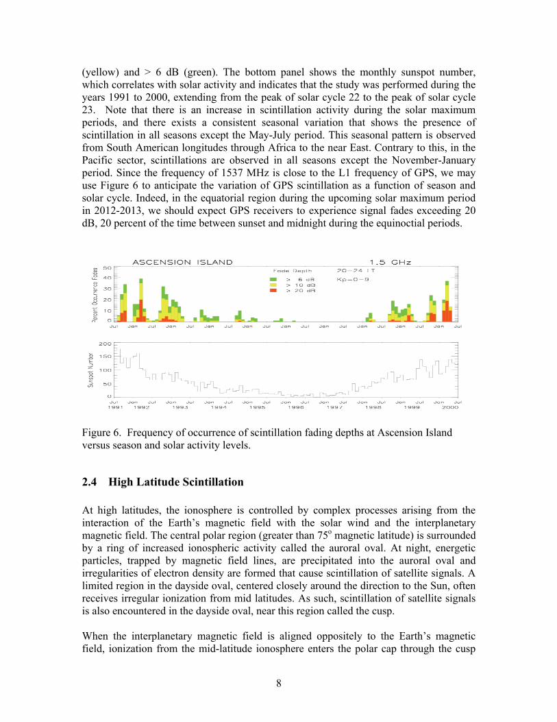
Figure 4. Schematic of the varying effects of scintillation on GPS. Figure 5 illustrates the local time variation of scintillations. As can be seen, GPS scintillations generally occur shortly after sunset and may persist until just after local midnight. After midnight, the level of ionization in the ionosphere is generally too low to support scintillation at GPS frequencies. This plot has been obtained by cumulating, then averaging, all scintillation events at one location over one year corresponding to low solar activity (Béniguel et al., 2009). For a high solar activity year, the same local time behavior is expected, with a higher level of scintillations.
Figure 5. Local time distribution of scintillation events from June 2006 to July 2007 (in 6 minute intervals) (Beniguel et al., 2009). Figure 6 (top panel) shows the variation of the monthly occurrence of scintillation during the pre-midnight hours at Ascension Island. The scintillation data was acquired by the use of INMARSAT transmissions at 1537 MHz (near the GPS L1 band). The scintillation occurrence is illustrated for 3 levels of signal fading, namely, > 20 dB (red), >10 dB
Large scale structure induces a loss of lock.
Smaller structures induce ranging errors.
Not all satellites affected.
8
(yellow) and > 6 dB (green). The bottom panel shows the monthly sunspot number, which correlates with solar activity and indicates that the study was performed during the years 1991 to 2000, extending from the peak of solar cycle 22 to the peak of solar cycle 23. Note that there is an increase in scintillation activity during the solar maximum periods, and there exists a consistent seasonal variation that shows the presence of scintillation in all seasons except the May-July period. This seasonal pattern is observed from South American longitudes through Africa to the near East. Contrary to this, in the Pacific sector, scintillations are observed in all seasons except the November-January period. Since the frequency of 1537 MHz is close to the L1 frequency of GPS, we may use Figure 6 to anticipate the variation of GPS scintillation as a function of season and solar cycle. Indeed, in the equatorial region during the upcoming solar maximum period in 2012-2013, we should expect GPS receivers to experience signal fades exceeding 20 dB, 20 percent of the time between sunset and midnight during the equinoctial periods.
Figure 6. Frequency of occurrence of scintillation fading depths at Ascension Island versus season and solar activity levels.
2.4 High Latitude Scintillation At high latitudes, the ionosphere is controlled by complex processes arising from the interaction of the Earth’s magnetic field with the solar wind and the interplanetary magnetic field. The central polar region (greater than 75o magnetic latitude) is surrounded by a ring of increased ionospheric activity called the auroral oval. At night, energetic particles, trapped by magnetic field lines, are precipitated into the auroral oval and irregularities of electron density are formed that cause scintillation of satellite signals. A limited region in the dayside oval, centered closely around the direction to the Sun, often receives irregular ionization from mid latitudes. As such, scintillation of satellite signals is also encountered in the dayside oval, near this region called the cusp. When the interplanetary magnetic field is aligned oppositely to the Earth’s magnetic field, ionization from the mid-latitude ionosphere enters the polar cap through the cusp
9
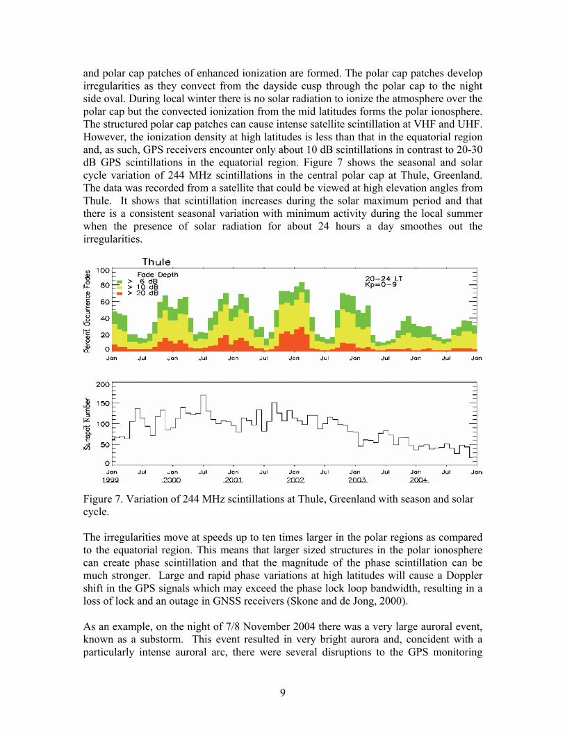
and polar cap patches of enhanced ionization are formed. The polar cap patches develop irregularities as they convect from the dayside cusp through the polar cap to the night side oval. During local winter there is no solar radiation to ionize the atmosphere over the polar cap but the convected ionization from the mid latitudes forms the polar ionosphere. The structured polar cap patches can cause intense satellite scintillation at VHF and UHF. However, the ionization density at high latitudes is less than that in the equatorial region and, as such, GPS receivers encounter only about 10 dB scintillations in contrast to 20-30 dB GPS scintillations in the equatorial region. Figure 7 shows the seasonal and solar cycle variation of 244 MHz scintillations in the central polar cap at Thule, Greenland. The data was recorded from a satellite that could be viewed at high elevation angles from Thule. It shows that scintillation increases during the solar maximum period and that there is a consistent seasonal variation with minimum activity during the local summer when the presence of solar radiation for about 24 hours a day smoothes out the irregularities.
Figure 7. Variation of 244 MHz scintillations at Thule, Greenland with season and solar cycle. The irregularities move at speeds up to ten times larger in the polar regions as compared to the equatorial region. This means that larger sized structures in the polar ionosphere can create phase scintillation and that the magnitude of the phase scintillation can be much stronger. Large and rapid phase variations at high latitudes will cause a Doppler shift in the GPS signals which may exceed the phase lock loop bandwidth, resulting in a loss of lock and an outage in GNSS receivers (Skone and de Jong, 2000). As an example, on the night of 7/8 November 2004 there was a very large auroral event, known as a substorm. This event resulted in very bright aurora and, concident with a particularly intense auroral arc, there were several disruptions to the GPS monitoring
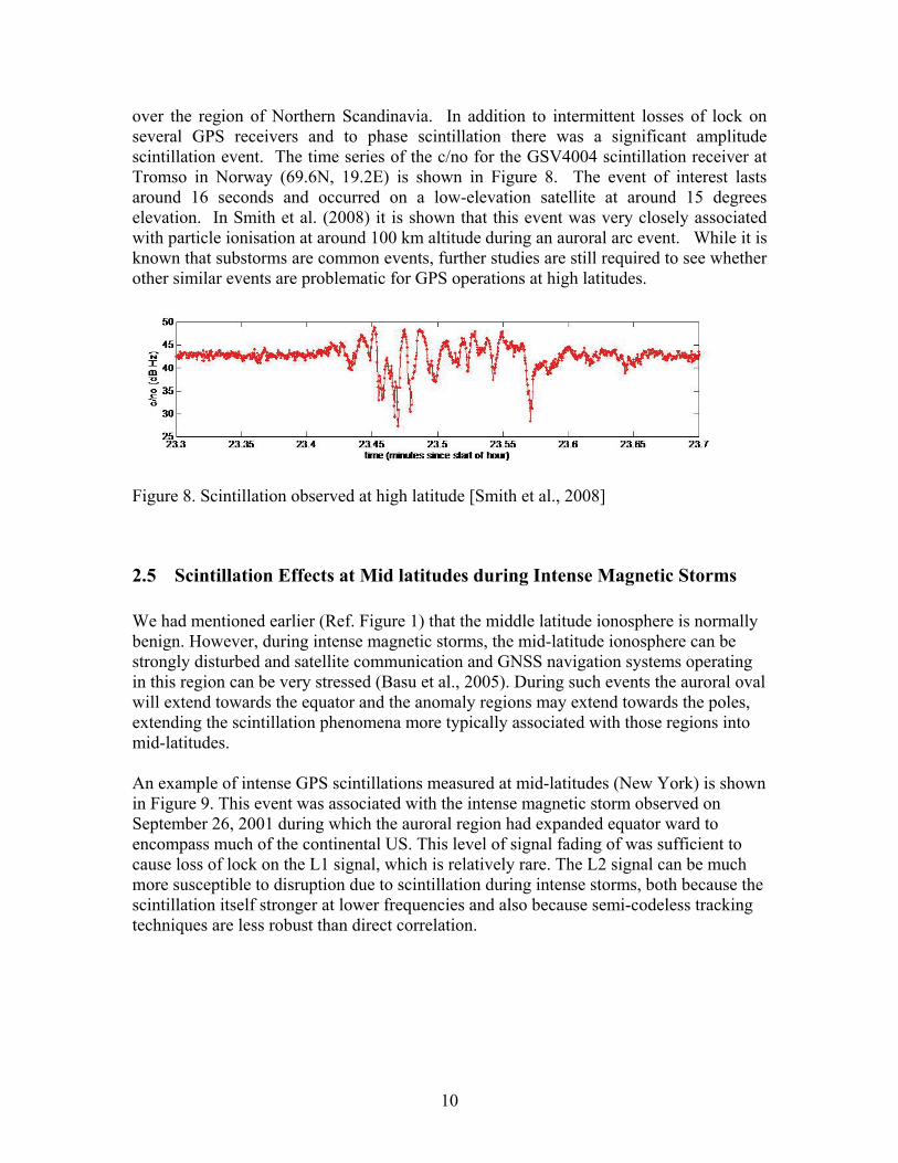
10
over the region of Northern Scandinavia. In addition to intermittent losses of lock on several GPS receivers and to phase scintillation there was a significant amplitude scintillation event. The time series of the c/no for the GSV4004 scintillation receiver at Tromso in Norway (69.6N, 19.2E) is shown in Figure 8. The event of interest lasts around 16 seconds and occurred on a low-elevation satellite at around 15 degrees elevation. In Smith et al. (2008) it is shown that this event was very closely associated with particle ionisation at around 100 km altitude during an auroral arc event. While it is known that substorms are common events, further studies are still required to see whether other similar events are problematic for GPS operations at high latitudes.
Figure 8. Scintillation observed at high latitude [Smith et al., 2008]
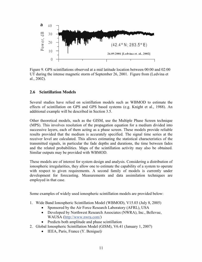
2.5 Scintillation Effects at Mid latitudes during Intense Magnetic Storms We had mentioned earlier (Ref. Figure 1) that the middle latitude ionosphere is normally benign. However, during intense magnetic storms, the mid-latitude ionosphere can be strongly disturbed and satellite communication and GNSS navigation systems operating in this region can be very stressed (Basu et al., 2005). During such events the auroral oval will extend towards the equator and the anomaly regions may extend towards the poles, extending the scintillation phenomena more typically associated with those regions into mid-latitudes. An example of intense GPS scintillations measured at mid-latitudes (New York) is shown in Figure 9. This event was associated with the intense magnetic storm observed on September 26, 2001 during which the auroral region had expanded equator ward to encompass much of the continental US. This level of signal fading of was sufficient to cause loss of lock on the L1 signal, which is relatively rare. The L2 signal can be much more susceptible to disruption due to scintillation during intense storms, both because the scintillation itself stronger at lower frequencies and also because semi-codeless tracking techniques are less robust than direct correlation.
11
Figure 9. GPS scintillations observed at a mid latitude location between 00:00 and 02:00 UT during the intense magnetic storm of September 26, 2001. Figure from (Ledvina et al., 2002).
2.6 Scintillation Models Several studies have relied on scintillation models such as WBMOD to estimate the effects of scintillation on GPS and GPS based systems (e.g. Knight et al., 1988). An additional example will be described in Section 3.5. Other theoretical models, such as the GISM, use the Multiple Phase Screen technique (MPS). This involves resolution of the propagation equation for a medium divided into successive layers, each of them acting as a phase screen. These models provide reliable results provided that the medium is accurately specified. The signal time series at the receiver level are calculated. This allows estimating the statistical characteristics of the transmitted signals, in particular the fade depths and durations, the time between fades and the related probabilities. Maps of the scintillation activity may also be obtained. Similar outputs may be provided with WBMOD. These models are of interest for system design and analysis. Considering a distribution of ionospheric irregularities, they allow one to estimate the capability of a system to operate with respect to given requirements. A second family of models is currently under development for forecasting. Measurements and data assimilation techniques are employed in that case. Some examples of widely used ionospheric scintillation models are provided below: 1. Wide Band Ionospheric Scintillation Model (WBMOD), V15.03 (July 8, 2005)
Sponsored by the Air Force Research Laboratory (AFRL), USA Developed by Northwest Research Associates (NWRA), Inc., Bellevue,
WAUSA (http://www.nwra.com/) Predicts both amplitude and phase scintillation
2. Global Ionospheric Scintillation Model (GISM), V6.41 (January 1, 2007) IEEA, Paris, France (Y. Beniguel)
12
Can be found on the ITU-R website (http://www.itu.int/oth/R0A04000019/en ) Predicts both amplitude and phase scintillation
3. IONSCINT-G, AFRL, USA (K. Groves) Predicts only amplitude scintillation
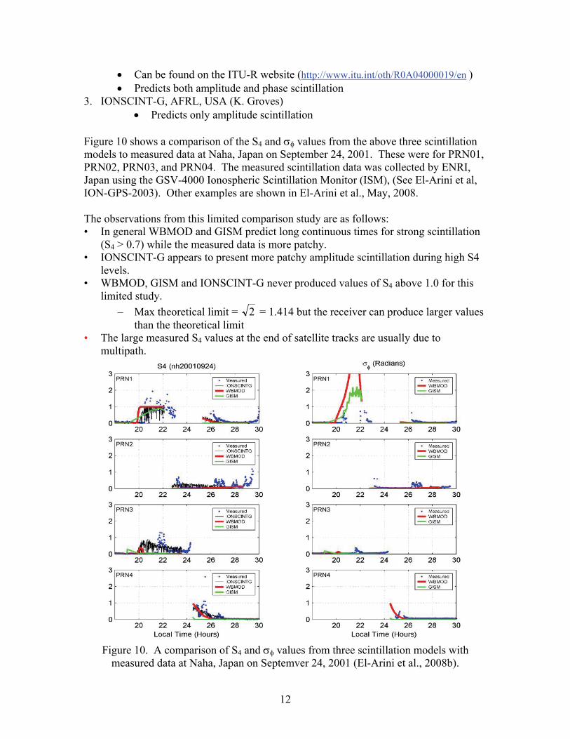
Figure 10 shows a comparison of the S4 and values from the above three scintillation models to measured data at Naha, Japan on September 24, 2001. These were for PRN01, PRN02, PRN03, and PRN04. The measured scintillation data was collected by ENRI, Japan using the GSV-4000 Ionospheric Scintillation Monitor (ISM), (See El-Arini et al, ION-GPS-2003). Other examples are shown in El-Arini et al., May, 2008. The observations from this limited comparison study are as follows: • In general WBMOD and GISM predict long continuous times for strong scintillation
(S4 > 0.7) while the measured data is more patchy. • IONSCINT-G appears to present more patchy amplitude scintillation during high S4
levels. • WBMOD, GISM and IONSCINT-G never produced values of S4 above 1.0 for this
limited study.
– Max theoretical limit = 2 = 1.414 but the receiver can produce larger values than the theoretical limit
• The large measured S4 values at the end of satellite tracks are usually due to multipath.
Figure 10. A comparison of S4 and values from three scintillation models with
measured data at Naha, Japan on Septemver 24, 2001 (El-Arini et al., 2008b).
13
3 Effects of Scintillation on GPS and SBAS Systems Ionospheric scintillation affects users of GNSS in three important ways: it can degrade the quantity and quality of the user measurements; it can degrade the quantity and quality of reference station measurements; and, in the case of Satellite Based Augmentation Systems, it can disrupt the communication from the SBAS geostationary satellite (GEO) to the user receiver. As already discussed, scintillation can briefly prevent signals from being received, disrupt continuous tracking of these signals, or worsen the quality of the measurements by increasing noise and/or causing rapid phase variations. Further, it can interfere with the reception of data from the satellites, potentially leading to loss of use of the signals for extended periods. The net effect is that the system and the user may have fewer measurements, and those that remain may have larger errors. The influence of these effects depends upon the severity of the scintillation, how many components are affected, and how many remain. In this section, we will further describe the three ways GNSS is affected.
3.1 Effect on User Receivers Ionospheric scintillation can lead to loss of the GPS signals or increased noise on the remaining ones. Typically, the fade of the signal is for much less than one second (Seo et al., 2009a), but it may take several seconds afterwards before the receiver resumes tracking and using the signal in its position estimate (Seo et al., 2008). Outages also affect the receiver’s ability to smooth the range measurements to reduce noise. Using the carrier phase measurements to smooth the code substantially reduces noise introduced. When this smoothing is interrupted due to loss of lock caused by scintillation, or is performed with scintillating carrier phase measurements, the range measurement error due to local multipath and thermal noise could be from 3 to 10 times larger (Seo et al., 2008). Additionally, scintillation adds high frequency fluctuations to the phase measurements further hampering noise reduction. Most often scintillation will only affect one or two satellites causing occasional outages and some increase in noise. If many well-distributed signals are available to the user, then the loss of one or two will not significantly affect the user’s overall performance and operations can continue. If the user has poor satellite coverage at the outset, then even modest scintillation levels may cause an interruption to their operation. When scintillation is very strong, then many satellites could be affected significantly. Even if the user has excellent satellite coverage, severe scintillation could interrupt service. Severe amplitude scintillation is rarely encountered outside of equatorial regions, although phase effects can be sufficiently severe at high latitudes to cause wide-spread losses of lock. Equatorial scintillation typically covers regions from tens to hundreds of kilometers wide over a period of minutes to tens of minutes. All users in this region may experience similar, but not necessarily identical, performance effects, since the geometry of their
14
satellites will be essentially the same and they will experience similar levels of scintillation. If the combination is such that it causes a user to experience interruptions in service, then other nearby users will also likely be experiencing similar problems. Polar scintillation is less likely to create amplitude fades sufficient to cause signal loss, however the phase fluctuations may become large enough that the receiver may not be able to maintain continuous lock on the satellite. Such effects may be correlated over hundreds of kilometers
3.2 Effect on Reference Stations The SBAS and GBAS reference stations consist of redundant GPS receivers at precisely surveyed locations. SBAS receivers need to track two frequencies in order to separate out ionospheric effects from other error sources. Currently these receivers use the GPS L1 C/A signal and apply semi-codeless techniques to track the L2 P(Y) signal. Semi codeless tracking is not as robust as either L1 C/A or future L5 tracking. The L2 tracking loops require a much narrower bandwidth and are heavily aided with scaled-phase information from the L1 C/A tracking loops. The net effect is that L2 tracking is much more vulnerable to phase scintillation than L1 C/A, although, because of the very narrow bandwidth, L2 tracking may be less susceptible to amplitude scintillation. (Amplitude fades have a Nakagami distribution, and, thus, on the average, fades are accompanied by enhanced amplitude, and there is no average loss of C/N0.) Because weaker phase scintillation is more common than stronger amplitude scintillation, the L2 signal will be lost more often than L1. The SBAS reference stations must have both L1 and L2 measurements in order to generate the corrections and confidence levels that are broadcast. Severe scintillation affecting a reference station could effectively prevent several, or even all, of its measurements from contributing to the overall generation of corrections and confidences. Access to the civil L5 signal will reduce this vulnerability. The codes are fully available, the signal structure design is more robust, and the broadcast power is increased (Hegarty and Chatre, 2008). L5 capable receivers will suffer fewer outages than the current L2 semi-codeless, however strong amplitude scintillation will still cause disruptions. Strong phase scintillation may as well. SBASs have many reference stations spaced hundreds of kilometers apart. The systems are typically designed to have redundancy in the number of stations. Ideally, the network is distributed so that the loss of any one reference station will not have a significant impact on the performance of the whole system. The reality is that geographical limitations and practical considerations often result in some reference stations whose absences worsen performance in the region near to the station. Generally, reference stations near the edge of the coverage area are more critical for nearby users. If scintillation only affects a few satellites at a single reference station, the net impact on user performance will likely be small and regional. However, if multiple reference stations are affected by scintillation simultaneously, there could be significant and widespread impact. Therefore, it is important to understand the likelihood of scintillation affecting wide-spread regions. Fortunately, the historical data investigated so far indicates that the station separations are larger than the correlation length of equatorial.
15
3.3 Effect on Satellite Datalinks The satellites not only provide ranging information, but also data. When scintillation causes the loss of a signal it also can cause the loss or corruption of the data bits. The GPS satellites broadcast ephemeris data that describe the location of the satellite and the state of its clock. This information is required to determine the user location and is broadcast every 30 seconds. The ephemeris data package spans 18 seconds and the data rate is 50 bits per second. The contents of the ephemeris message are nominally updated every two hours. The data includes parity bits to detect corrupted messages. In order to start using a satellite for aviation applications, the user has to receive two complete uncorrupted ephemeris messages and ensure that they are identical. If scintillation prevents the successful decoding of these messages, then new satellites cannot be used. Satellites that change their information (as indicated in GBAS or SBAS data) also cannot be used with augmentation systems when scintillation prevents successful decoding. Inability to obtain the ephemeris data can prevent the use of a satellite for a minute or longer. The satellite will be held out until scintillation is reduced sufficiently to decode two 18 second data blocks successfully. This requires the fades to either be sufficiently shallow or short (much less than 20 msec) so as not to corrupt the bits. Alternatively, the fades would need to be more than about 18 seconds apart to allow continuous reception of the messages. If the satellite has been in use since before the aircraft encountered the scintillation environment, the user can continue to hold onto the old ephemeris information as long as it is not indicated as changed by the GBAS or SBAS messages. An aviation user must also declare a GPS satellite as unusable if too many bits in a short time are corrupted. This would happen if 5 successive words (three seconds) are corrupted. Recovery from this condition can be as quick as 0.6 seconds as the satellite can be reincorporated on the next uncorrupted word or at may take as long as 30 seconds if the ephemeris information needs to be re-verified. Deep fades that lead to this situation will also create much signal loss and noise increase. Each GPS satellite broadcasts its own ephemeris information, so the loss of data on an individual satellite affects only that satellite. A greater concern is the SBAS data transmission on the geostationary satellite (GEO). This data stream contains required information for all satellites in view including required integrity information. If its data is corrupted, all signals may be affected and loss of positioning becomes much more likely. The GEO data format is different from GPS. Its messages are broadcast at 250 bits per second, and each message length is 1 second. Unlike GPS L1 C/A, the GEO employs forward error correction which spreads information across multiple bits making the message more robust to bit error. The signal also contains very strong parity to detect errors. The SBAS message design makes it robust to occasional lost messages. The loss of a single message has little effect on performance. However, the loss of several messages starts to degrade performance and the greater the number lost, the greater the
16
impact. Each individual message can also affect multiple satellites further increasing the impact. Deep fades lasting tens of milliseconds can lead to lost SBAS messages. If these fades are many tens of seconds apart then the impact may not be too large provided the user did not start with marginal performance. If the significant fades are less than roughly 10 seconds apart on the GEO, the performance will be significantly affected. SBASs are designed to mitigate such effects by having redundant GEOs. Provided severe scintillation only affects one GEO, the user can use an unaffected one. However, if the effects of scintillation are widespread in the sky and all GEOs are affected (and likely many GPS satellites), performance will be limited.
3.4 Characterizing Effects The influence of scintillation on performance at a given time and location depends upon many factors. The two most important are the undisturbed performance of the system (how much margin it has) and the severity of the scintillation (how badly the signals are affected). In characterizing scintillation, there are several important parameters. The most critical parameters describing scintillation are: depth of the fading (does it get close to or below signal tracking threshold), duration of the fade (how long will it remain below the signal tracking threshold), time between deep fades, and area affected (either size of region of the sky and number of satellites affected for the user, or geographic area and number of reference stations affected for the system). High elevation satellites with strong received power (C/N0 values in excess of 50 dB-Hz) would normally not be lost during most fades. This is also true for SBAS satellites that are located directly above the equatorial region. In order to understand the implication of scintillation on SBAS performance we will need to describe the above parameters in relationship to geographic regions where scintillation occurs and how often it occurs at different severity levels. Certain knowledge already exists such as areas and times (time of day, season, solar cycle) where more severe scintillation is expected. However, there is still a need for more extensive and detailed GPS scintillation measurements
3.5 Effect on SBAS Availability Using a Service Volume Model (SVM). El-Arini et al, 2008 examined the effect of scintillation on SBAS availability for L1/L5 dual-frequency user receivers as well as on L1 and L5 single-frequency user receivers in the Western hemisphere using MITRE’s SBAS Service Volume Models. An example of this study is shown in this section for non-precision approach (NPA) phase of flights. Other examples for Localizer Performance with Vertical guidance (LPV) are given in El-Arini et al., December 2008. The assumptions used in this example are as follows: • 24 GPS Martinez constellation (see Appendix B, RTCA/DO-229D, 2006),
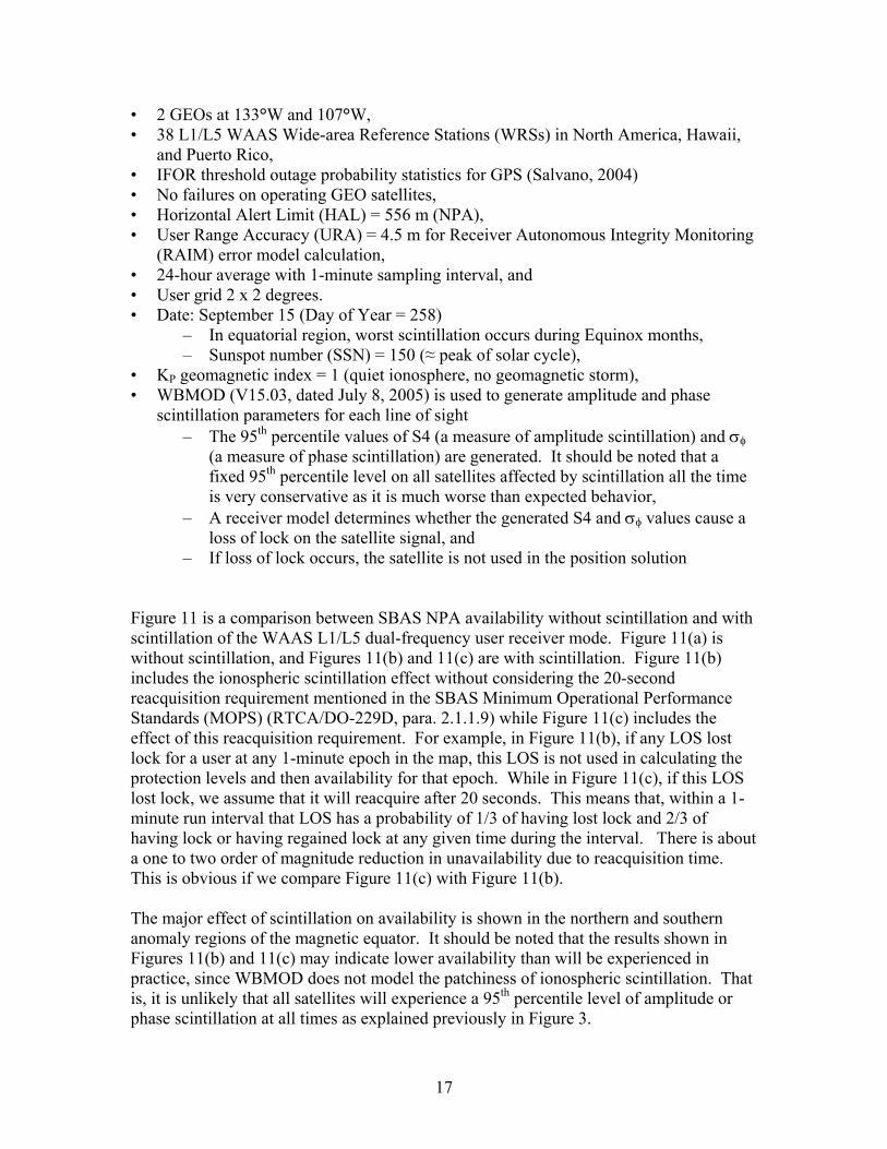
17
• 2 GEOs at 133°W and 107°W, • 38 L1/L5 WAAS Wide-area Reference Stations (WRSs) in North America, Hawaii,
and Puerto Rico, • IFOR threshold outage probability statistics for GPS (Salvano, 2004) • No failures on operating GEO satellites, • Horizontal Alert Limit (HAL) = 556 m (NPA), • User Range Accuracy (URA) = 4.5 m for Receiver Autonomous Integrity Monitoring
(RAIM) error model calculation, • 24-hour average with 1-minute sampling interval, and • User grid 2 x 2 degrees. • Date: September 15 (Day of Year = 258)
– In equatorial region, worst scintillation occurs during Equinox months, – Sunspot number (SSN) = 150 (≈ peak of solar cycle),
• KP geomagnetic index = 1 (quiet ionosphere, no geomagnetic storm), • WBMOD (V15.03, dated July 8, 2005) is used to generate amplitude and phase
scintillation parameters for each line of sight – The 95th percentile values of S4 (a measure of amplitude scintillation) and
(a measure of phase scintillation) are generated. It should be noted that a fixed 95th percentile level on all satellites affected by scintillation all the time is very conservative as it is much worse than expected behavior,
– A receiver model determines whether the generated S4 and values cause a loss of lock on the satellite signal, and
– If loss of lock occurs, the satellite is not used in the position solution Figure 11 is a comparison between SBAS NPA availability without scintillation and with scintillation of the WAAS L1/L5 dual-frequency user receiver mode. Figure 11(a) is without scintillation, and Figures 11(b) and 11(c) are with scintillation. Figure 11(b) includes the ionospheric scintillation effect without considering the 20-second reacquisition requirement mentioned in the SBAS Minimum Operational Performance Standards (MOPS) (RTCA/DO-229D, para. 2.1.1.9) while Figure 11(c) includes the effect of this reacquisition requirement. For example, in Figure 11(b), if any LOS lost lock for a user at any 1-minute epoch in the map, this LOS is not used in calculating the protection levels and then availability for that epoch. While in Figure 11(c), if this LOS lost lock, we assume that it will reacquire after 20 seconds. This means that, within a 1-minute run interval that LOS has a probability of 1/3 of having lost lock and 2/3 of having lock or having regained lock at any given time during the interval. There is about a one to two order of magnitude reduction in unavailability due to reacquisition time. This is obvious if we compare Figure 11(c) with Figure 11(b). The major effect of scintillation on availability is shown in the northern and southern anomaly regions of the magnetic equator. It should be noted that the results shown in Figures 11(b) and 11(c) may indicate lower availability than will be experienced in practice, since WBMOD does not model the patchiness of ionospheric scintillation. That is, it is unlikely that all satellites will experience a 95th percentile level of amplitude or phase scintillation at all times as explained previously in Figure 3.
18
Figure 11: WAAS NPA availability with scintillation in the Western Hemisphere for L1/L5 dual-frequency user receiver mode (El-Arini et al, December 2008)
4 Mitigation Techniques There are several actions that SBAS service providers can take to lessen the impact of scintillation. Increasing the margin of performance is chief among them. The more satellites a user has before the onset of scintillations, the more likely he will retain performance during a scintillation event. In addition, having more satellites means that a user can tolerate more noise on their measurements. Therefore, incorporating as many satellites as possible is an effective means of mitigation. GNSS constellations in addition to GPS are being developed. Including their signals into the user position solution would extend the sky coverage and improve the performance under scintillation conditions. The current SBAS MOPS allows the receiver 20 seconds after the loss of a signal to track it and reintroduce the measurement back into the position solution. For deep fades that last less than a few tenths of a second, signals should be reintroduced back into the position solution within a few seconds or less. Provided there are enough satellites at the outset, it has been shown that a receiver that can reincorporate the satellite within 1 to 2 seconds after each deep fade may be able to maintain availability even during severe scintillation events (Seo et al., 2009b). High rate L1 data was collected from Ascension Island during March of 2001. This data was analyzed to investigate the effects of scintillation on possible L1/L5 use in the future (Seo et al., 2008, Seo et al., 2009a, Seo et al., 2009b). It was found that despite the presence of severe amplitude scintillation that affected 7 of 8 satellites over the same time-span, good performance could be maintained provided the receiver was able to recover quickly from each fade and reintroduce the satellite into its position solution
19
within 1 to 2 seconds. Even though the median time between fades was 5 seconds, it would still be possible to avoid having more than two satellites lost simultaneously. Because the underlying geometry during this event was strong, it was tolerant to the increase in noise and frequent loss of individual satellites.
5 Conclusions and further work Ionospheric scintillations are by now a well known phenomenon in the GPS user community. In equatorial regions (between +/- 30 degrees of the geomagnetic equator) ionospheric scintillations are a daily feature during solar maximum years. In auroral regions, ionospheric scintillations are not strongly linked to time of the day. In the mid-latitude regions, scintillations tend to be linked to ionospheric disturbances where strong TEC gradients can be observed (ionospheric storms, strong traveling ionospheric disturbances, solar eclipse, etc.). In general, scintillations can lead to cycle slips and loss-of-lock in GNSS receivers. For the first generation SBAS-systems using reference stations based on semi-codeless tracking of L2, the concern is that signals of observed GPS SVs are affected by scintillations. Especially reference stations in equatorial regions can experience loss-of-lock of the L2 signal. Once reference receivers are able to use non-encrypted signals on both frequencies, this problem will be reduced; however it will not completely disappear. The user (= airborne) receiver is more robust than the reference station receiver, however if the GEO-link is affected by scintillations, the SBAS functionality can be interrupted. While the global climatic models of ionospheric scintillations can be considered satisfactory for predicting (on a statistical basis) the occurrence and intensity of scintillations, the validation of these models is suffering from the fact that at very intense levels of scintillation, even specially designed scintillation receivers are losing lock. Also, the development of models which can predict reliably the size of scintillation cells (regions of equal scintillation intensity) which allows establishing joint probabilities of losing more than one satellite simultaneously, is still ongoing. Other ongoing work is the development of forecasting tools which will allow issuing warnings ahead of time, when a certain region will be affected by scintillations exceeding a certain threshold. This will allow to plan for “ionospheric outages” in a similar way as weather forecast is currently used for suspension of operation of airports when thunderstorms are approaching. The SBAS-IONO group is planning to issue an expanded version of this white paper which will provide more background and physical insight into the scintillation phenomena.
20
References Aarons, J., “Global Morphology of Ionospheric Scintillations”, Proceedings of the IEEE, Vol. 70, No. 4, April 1982. Aarons, J., “The Longitudinal Morphology of Equatorial F-Layer Irregularities Relevant to their Occurrence”, Space Science Reviews, Vol. 63, 1993, pp. 209 – 43. Aarons, J., “Fading of GPS Transmissions Due to Ionospheric Irregularities”, Center for Space Physics, Boston University, Report to the FAA WAAS Program Office, April 1995. Basu, S., “CEDAR Lecture”, NSF CEDAR Workshop, Longmont, Colorado, 15 June 2003. Basu, Sa., and Basu, Su. (1981): “Equatorial scintillation – A Review”, J. Atmos. Terr. Phys., 43, p. 473. Basu, S., K.M. Groves, Su. Basu, and P.J. Sultan, Jour. Atm. Solar Terr. Phys., 64, 1754, 2002 Basu, S., E. MacKenzie, and S. Basu, “Ionospheric Constraints on VHF/UHF Communications Links during Solar Maximum and Minimum Periods”, Radio Science, Vol. 23, No. 3, May–June 1988, pp.363–78. Basu, Su. et al., Geophys. Res. Lett., 32, L12S06, 2005. Béniguel Y., J-P Adam, N. Jakowski, T. Noack, V. Wilken, J-J Valette, M. Cueto, A. Bourdillon, P. Lassudrie-Duchesne, B. Arbesser-Rastburg, 2009, “Analysis of scintillation recorded during the PRIS measurement campaign”, Radio Sci., 44, doi 1029/2008RS004090 Carrano, C., C. Bridgwood, and K. Groves, “Impacts on Ionospheric Scintillation on GPS Positioning Accuracy”, Proc. AMS Sixth Symposium on Space Weather, Phoenix, AZ, Jan. 2009. Carrano, C. S., K. Groves and J. Griffin, “Empirical Characterization and Modeling of GPS Positioning Errors Due to Ionospheric Scintillation”, Proceedings of the Ionospheric Effects Symposium, Alexandria, VA, May 3-5, 2005. Davies, K., “Ionospheric Radio”, IEEE Electromagnetic Waves Series 31, Peter Peregrinus Ltd., 1990. Doherty, P.H., S.H. Delay, C.E. Valladares, and J.A. Klobuchar, Proc. ION GPS, Sept. 2000.
21
Doherty, P., A.J. Coster, and W. Murtagh, GPS Solutions, 8, 267, 2004. El-Arini, M. B., R. S. Conker, S. D. Ericson, K. W. Bean, F. Niles, K. Matsunaga and K. Hoshinoo, “Analysis of the Effects of Ionospheric Scintillation on GPS L2 in Japan,” Proc. ION-GPS-2003. El-Arini, M. B., J. P. Fernow, T. Hsiao, C. Hegarty, M. Tran, D. Hashemi, M. McLaughlin, and P. Yen, “Modeling the Effect of Ionospheric Scintillation on SBAS Availability in the Western Hemisphere,” Report number MP080294, The MITRE Corporation, McLean, VA, U.S.A., December 2008. El-Arini, M. B., R. Conker, R. Lejeune, Y. Beniguel, J-P Adam, and K. Groves, “Comparing Measured Scintillation Parameters at Naha, Japan with Calculated Values from the Latest Versions of WBMOD, IONSCINT-G and GISM,” SBAS-IONO-Meeting-14, MITRE, McLean, VA, U.S.A., May 2008. Groves, K.M. et al., Proc ION GPS, Sept. 2000. Hegarty, C. J. and Chatre E., “Evolution of the Global Navigation Satellite System (GNSS),” Proceedings of the IEEE Vol. 96, Issue 12, Dec. 2008. Knight, M.F., A. Finn, and M.A. Cervera, “Ionospheric effects on Global Positioning Receivers” , Res. Rep. DSTO-RR-0121, Def. Sci and Technol. Org., Salisbury, South Aust., Australia, 1998. Ledvina, B.M., Makela, J.J., Kintner, P.M. “First observations of intense GPS L1 amplitude scintillations at midlatitude”, Geophys. Res. Lett. 29, N14, doi:10.1029/2002GL014770, 2002. Rino, C.L., Radio Sci., 14, 1135, 1979. Seo, J., Walter, T., Chiou, T.Y., Blanch, J., Enge, P., “Evaluation of Deep Signal Fading Effects Due to Ionospheric Scintillation on GPS Aviation Receivers,” Proc. 21st International Technical Meeting of the Satellite Division of The Institute of Navigation (ION GNSS 2008), Savannah, GA, September 2008, pp. 2397-2404. Seo, J., T. Walter, T.-Y. Chiou, and P. Enge, “Characteristics of deep GPS signal fading due to ionospheric scintillation for aviation receiver design,” Radio Science, 44, July, 2009a. Seo, J., Walter, T., Enge, P., “Availability Benefit of Future Dual Frequency GPS Avionics under Strong Ionospheric Scintillation,” Proc. 22nd International Technical Meeting of The Satellite Division of the Institute of Navigation (ION GNSS 2009), Savannah, GA, September 2009b, pp. 1216-1224.
22
Skone, S. and M. de Jong, Earth Planets Space, 52, 1067, 2000.
Smith, AM; Mitchell, CN; Watson, RJ; Meggs RW; Kintner PM; Kauristie K; Honary F,
“GPS scintillation in the high arctic associated with an auroral arc”, Space Weather – The
Int’l Journal of Research & Applications, 6 (3): Art. No. S03D01, 2008 Thomas, R.M., M.A. Cervera, K. Eftaxiadis, S.L. Manurung, S. Saroso, Effendy, A.G. Ramli, W. Salwa Hassan, H. Rahman, M.N. Daliman, K.M. Groves, and Y. Wang, “A regional GPS receiver network for monitoring equatorial scintillation and total electron content” , Radio Science, Vol. 36, No. 6, pp 1545-1557, Nov-Dec 2001. Valladares C. E., R. Sheehan, J. Villalobos, Radio Science., 39, RS1S23, 2004. Van Dierendonck, A.J., J.A. Klobuchar, and Q. Hua, “Ionospheric scintillation monitoring using commercial single frequency C/A/ code receivers”, Proc. of the Institute of Navigation, GPS93, pp. 1333-1324, Inst. of Navig., Alexandria, VA., 1993 Van Dierendonck, A.J., Q. Hua, P. Fenton, and J. Klobuchar, “Commercial ionospheric scintillation monitoring receiver development and test results”, Proceedings of the 52nd Annual Meeting of the Institute of Navigation, pp. 573-582, Inst. Of Navig., Alexandria, VA., 1996.