Embed Size (px)
Citation preview
60 MARCH-APRIL 2012
Barapukuria is the first and only coal mine in Bangladesh. Itdeals with the groundwater monitoring and mine floodingwith its practical applications to recognize the mining relatedgeo-environmental hazards associated with the GondwanaBarapukuria coal basin of northwest Bangladesh. A summaryand problems regarding the present research emphasizing onthe general geologic understanding, hydrogeological,geotechnical, and tectonic setting of the study area have beenfocused and specially ground movement and water inrush/inflow hazards into the mine. Water inrush in the minegenerates adverse impacts on the exploration andunderground multi-slice longwall mining in the Barapukuriacoal deposits. It is also shown that current coal miningoperations under a mega-aquifer in NW Bangladesh, andpresents a case study of underground mining in Barapukuriaand water inflow enhancements that result from these coalextraction operations.
Introduction
Coal mine of Barapukuria basin in Dinajpur district,Bangladesh, enters into the coal mining era for thefrist time. Geographically the study area lies between
latitudes 25°31/N to 25°35/N and longitude 88°57/E to 88°59/E,included in the survey of Bangladesh topographic sheet No.78C/14. The coalfield was discovered by the Geological Surveyof Bangladesh (GSB) in 1984-85 and 1986-87 field season in thedrill hole GDH-38, which encountered coal seams at a depth of159 m. The coal reserve found in the Barapukuria is 303 milliontonnes (Wardell Armstrong, 1991). In addition to that about 86million tonnes is considered as inferred reserve. Studiessuggest that coal mining is technically as well as economicallyfeasible and concluded in favour of underground mining. Onthe basis of consultant opinion, the Government of Bangladeshdecided to establish an underground coal mine at Barapukuria.In 1994, the Bangladesh government signed a contract with theChinese contractor CMC (China National Machinery Importand Export Corporation) for the development of Barapukuria
coal mine at a production rate of 1 million tonne per year in 25years mine life by underground mining method. At present, thecoal mine is facing enormous difficulties to meet the target.
Structure of the Barapukuria basin
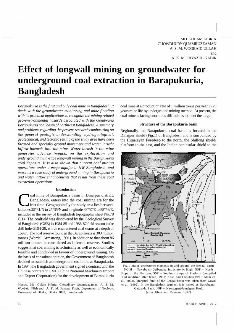
Regionally, the Barapukuria coal basin is located in theDinajpur shield (Fig.1) of Bangladesh and is surrounded bythe Himalayan Foredeep to the north, the Shillong shield/platform to the east, and the Indian peninsular shield to the
Effect of longwall mining on groundwater forunderground coal extraction in Barapukuria,Bangladesh
MD. GOLAM KIBRIACHOWDHURY QUAMRUZZAMAN
A. S. M. WOOBAID ULLAHand
A. K. M. FAYAZUL KABIR
Messrs. Md. Golam Kibria, Chowdhury Quamruzzaman, A. S. M.Woobaid Ullah and A. K. M. Fayazul Kabir, Department of Geology,University of Dhaka, Dhaka 1000, Bangladesh
Fig.1 Major geotectonic elements in and around the Bengal basinNGIH = Nawabganj-Gaibandha Intracratonic High, NSP = North
Slope of the Platform, SSP = Southern Slope of Platform (compiledand modified after Khan, 1991; Khan and Chouhan,1996; Alam et
al., 2003). Marginal fault of the Bengal basin was taken from Gowdet al. (1992). In the Bangladesh segment it is named as Nawabganj-
Gaibanda Fault. NJF = Nawabganj-Jamalganj Fault(after Khan and Rahman, 1992)
61JOURNAL OF MINES, METALS & FUELS
IP / DG / M-MA / F/ 18.5.12
west (Khan, 1991; Khan and Chouhan, 1996; Alam et al.,2003). Structurally, the Barapukuria basin is a long, narrow,and shallow permo-carboniferous intracratonic rift basin. Thebasin trends approximately N-S for over 5 km, ranges from 2to 3 km wide, and is over 550 m deep. Steeply dipping normalfaults bound tilted half-graben occurs below a prominentunconformity, covered by an unstructured pleistocenethrough tertiary clastic sequence, (Fig.2). The northern,western, and southern boundaries of the basin are alsotruncated by several small-scale normal boundary faults.Major basin-bounding faults are part of a zone of crustalweakness. The faults and igneous dyke decrease thecohesion and friction angle and reduce the shear strengththrough fault plane and filling materials. The overall structuresof the Barapukuria basin imply a tectonically active highlydisturbed zone (Wardell Armstrong, 1991; Bakr et al., 1996;Islam and Islam, 2005). The Barapukuria half-graben basin isassumed to be related to tectonic origin. The basin area isvery close (about 200 km) to the convergence boundary ofthe Indian and Eurasian plates. As a consequence, the farfield tectonic stress field is highly significant to the structureof this basin. A 5 km long eastern boundary fault of theBarapukuria basin is the best structural evidence for recenttectonic activity. In a gross sense, for the Barapukuria-type
half-graben basin, displacement is greatest at the center ofthe fault and decreases to zero at the fault tips. Thedisplacement of an initially horizontal surface that intersectsthe fault is greatest at the fault itself and decreases withdistance away from the fault. This produces footwall upliftand hanging-wall subsidence, the later which creates thesedimentary basin (Gibson et al., 1989; Contreras et al., 1997).It is apparent that the basin geometry is affected by faultpropagation and displacement is accumulated on theboundary fault.
Geology and hydrogeology of the basin
Geologically, this basin area is a plain land covered withrecent alluvium and pleistocene barind clay residuum. Thegeologic succession of this basin has been established onthe basis of borehole data (Guha, 1978). The sedimentaryrocks of Gondwana Group, Dupi Tila formation, barind clayresiduum and alluvium of the permian, pliocene, pleistoceneand recent ages respectively were encountered in theboreholes which lie on the pre-cambrian basement complex.A large gap in sedimentary record is present in betweenGondwana Group and Dupi Tila formation, which is mostprobably happened due to the erosional or non-depositionalphase exist during triassic to pliocene age (Khan andRahman, 1992).
The principal constraints to the design of the BCMP relateto the great thickness (average 36 m) of seam V1, whichcontains some 90% of the reserves, and the presence ofmassive Gondwana sandstones and unconsolidated DupiTila formation. The later formation represents a major aquiferover the whole mine area with many thousands of squarekilometers aerial extent. It is at least 100 meters in thicknessreaching185m in the southern part of the mine area and isoverlain by barind clay residuum. The Dupi Tila formation andGondwana sandstone are in hydraulic continuity with the coalseamV1 and represents a major potential hazard to the minefrom water inflow.
Methods of study
Different types of meteorological data are important forinterpreting groundwater level fluctuation and water leveldrawdown. Mainly rainfalls, temperature, humidity of the areawere interpreted. Interpretation of data shows the mine areasclimatic change and how does it affect the groundwater level.The collected meteorological data are from 2000 to 2010 fromregional meteorological sub-division office, Dinajpur. Thecollected hydrogeological data are groundwater levels in dryand rainy seasons, hydrogeologic units and theircharacteristics, amount of mine inflow etc. For determiningthe groundwater level condition it is necessary to monitordifferent monitoring well data which are situated in the minearea. The water levels are monitored from 23 boreholes (now2 test boreholes were sealed) in the Barapukuria coal mine
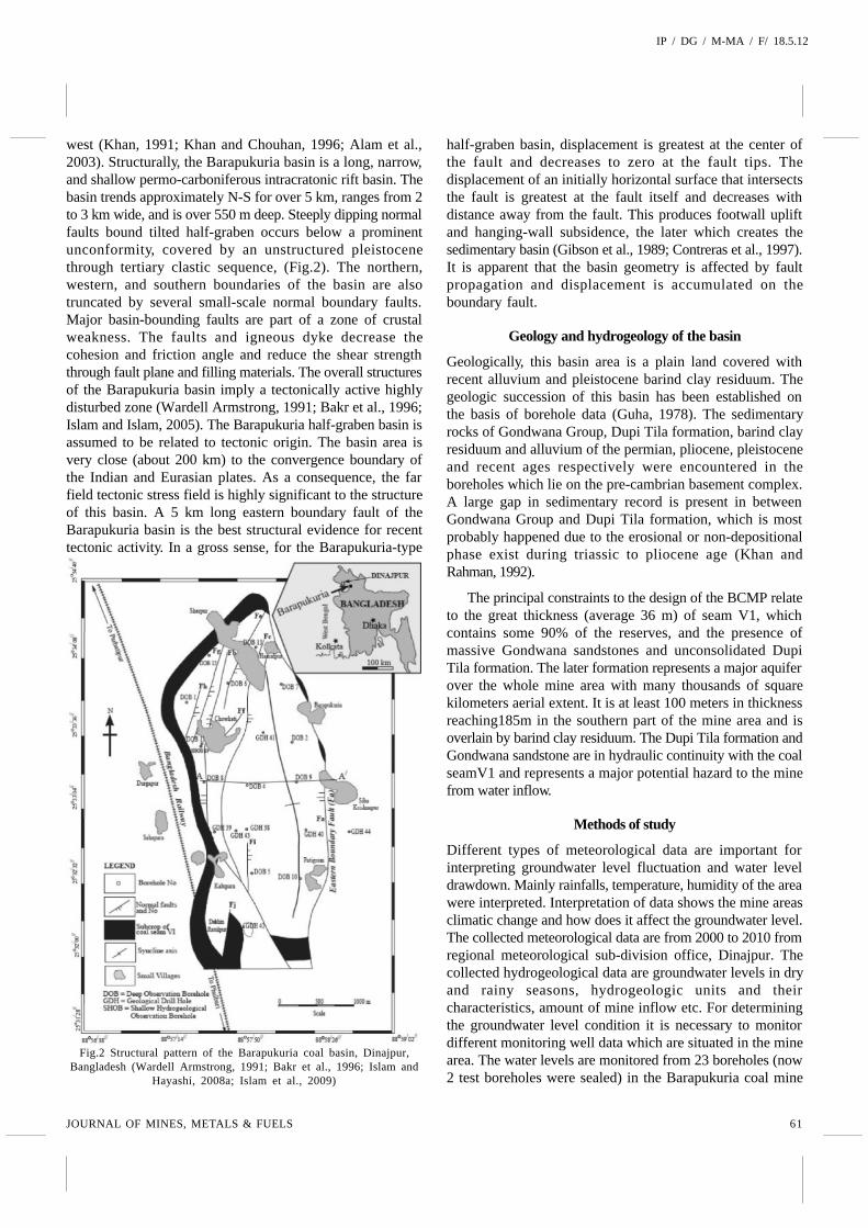
Fig.2 Structural pattern of the Barapukuria coal basin, Dinajpur,Bangladesh (Wardell Armstrong, 1991; Bakr et al., 1996; Islam and
Hayashi, 2008a; Islam et al., 2009)
62 MARCH-APRIL 2012
area. These boreholes were installed by W.A. Company in1991 for the study of hydrogeological characteristics, waterlevel fluctuation and hydraulic relationships between aquifers.Barapukuria coal mining company collected monitoring welldata daily basis. For graphical presentation daily data areconverted to monthly basis from 2004 to 2010. Geotechnicaldata were collected from the existing underground minedocumentation center to evaluate Barapukuria undergroundcoal mine areas recent groundwater and other geotechnicalproblems. At the time of feasibility study for undergroundmine a detail geotechnical investigation was done by WardellArmstrong (1991) and China National Machinery Import andExport Corporation (CMC), 1994, which is used as the mainsource for the present study. More than 20 boreholes wereused to know the geotechnical properties of the rock typesof Barapukuria area. The collected data includes shearstrength properties of rocks (cohesion and angle of friction),moisture and saturated unit weight of rocks, consolidationtest etc. The geotechnical data were collected from fourformations viz. the Madhupur clay formation, Upper Dupi Tilaformation, Lower Dupi Tila formation and Gondwanaformation.
Dupi Tila water level fluctuations and recharge
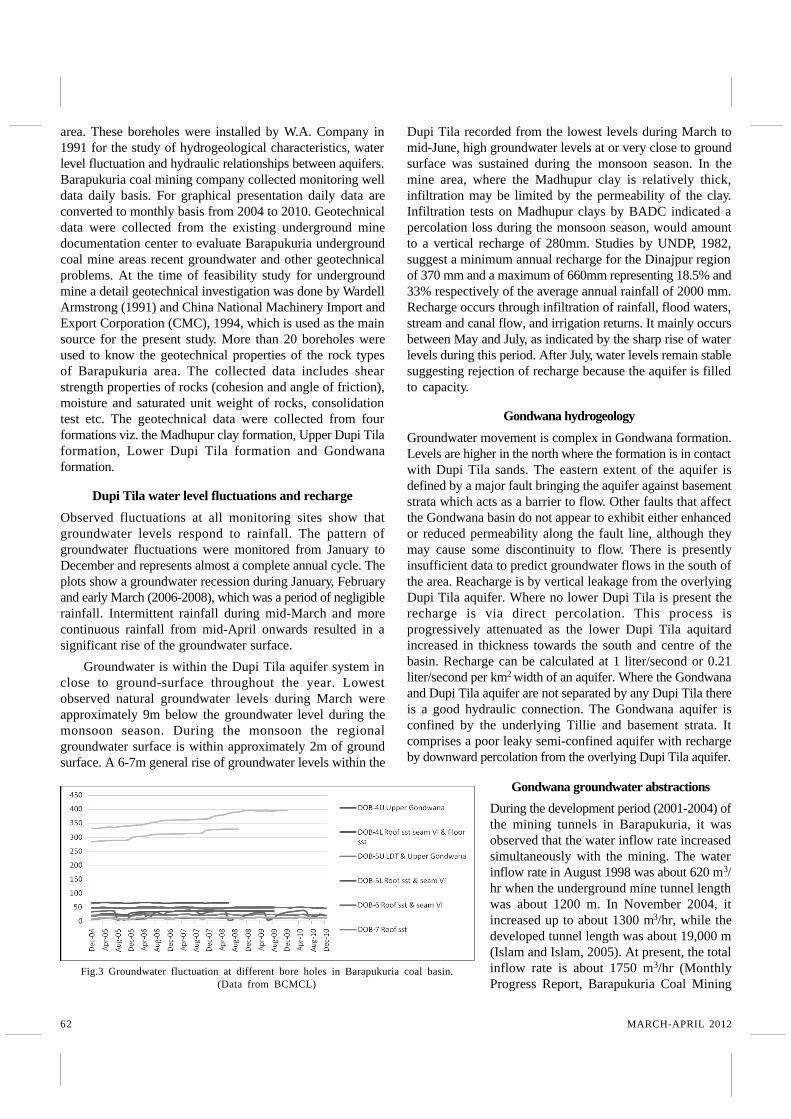
Observed fluctuations at all monitoring sites show thatgroundwater levels respond to rainfall. The pattern ofgroundwater fluctuations were monitored from January toDecember and represents almost a complete annual cycle. Theplots show a groundwater recession during January, Februaryand early March (2006-2008), which was a period of negligiblerainfall. Intermittent rainfall during mid-March and morecontinuous rainfall from mid-April onwards resulted in asignificant rise of the groundwater surface.
Groundwater is within the Dupi Tila aquifer system inclose to ground-surface throughout the year. Lowestobserved natural groundwater levels during March wereapproximately 9m below the groundwater level during themonsoon season. During the monsoon the regionalgroundwater surface is within approximately 2m of groundsurface. A 6-7m general rise of groundwater levels within the
Dupi Tila recorded from the lowest levels during March tomid-June, high groundwater levels at or very close to groundsurface was sustained during the monsoon season. In themine area, where the Madhupur clay is relatively thick,infiltration may be limited by the permeability of the clay.Infiltration tests on Madhupur clays by BADC indicated apercolation loss during the monsoon season, would amountto a vertical recharge of 280mm. Studies by UNDP, 1982,suggest a minimum annual recharge for the Dinajpur regionof 370 mm and a maximum of 660mm representing 18.5% and33% respectively of the average annual rainfall of 2000 mm.Recharge occurs through infiltration of rainfall, flood waters,stream and canal flow, and irrigation returns. It mainly occursbetween May and July, as indicated by the sharp rise of waterlevels during this period. After July, water levels remain stablesuggesting rejection of recharge because the aquifer is filledto capacity.
Gondwana hydrogeology
Groundwater movement is complex in Gondwana formation.Levels are higher in the north where the formation is in contactwith Dupi Tila sands. The eastern extent of the aquifer isdefined by a major fault bringing the aquifer against basementstrata which acts as a barrier to flow. Other faults that affectthe Gondwana basin do not appear to exhibit either enhancedor reduced permeability along the fault line, although theymay cause some discontinuity to flow. There is presentlyinsufficient data to predict groundwater flows in the south ofthe area. Reacharge is by vertical leakage from the overlyingDupi Tila aquifer. Where no lower Dupi Tila is present therecharge is via direct percolation. This process isprogressively attenuated as the lower Dupi Tila aquitardincreased in thickness towards the south and centre of thebasin. Recharge can be calculated at 1 liter/second or 0.21liter/second per km2 width of an aquifer. Where the Gondwanaand Dupi Tila aquifer are not separated by any Dupi Tila thereis a good hydraulic connection. The Gondwana aquifer isconfined by the underlying Tillie and basement strata. Itcomprises a poor leaky semi-confined aquifer with rechargeby downward percolation from the overlying Dupi Tila aquifer.
Fig.3 Groundwater fluctuation at different bore holes in Barapukuria coal basin.(Data from BCMCL)
Gondwana groundwater abstractions
During the development period (2001-2004) ofthe mining tunnels in Barapukuria, it wasobserved that the water inflow rate increasedsimultaneously with the mining. The waterinflow rate in August 1998 was about 620 m3/hr when the underground mine tunnel lengthwas about 1200 m. In November 2004, itincreased up to about 1300 m3/hr, while thedeveloped tunnel length was about 19,000 m(Islam and Islam, 2005). At present, the totalinflow rate is about 1750 m3/hr (MonthlyProgress Report, Barapukuria Coal Mining
63JOURNAL OF MINES, METALS & FUELS
IP / DG / M-MA / F/ 18.5.12
Co. Ltd, December 2010). Initially water inrush was predictedby the geologist and mine planer presumably 500 m3/hr. Butover the time with high production rate of coal, roof cavingpropagate the fracture to the direct roof and indirect roof andthat may be reached up to lower Dupi Tila and upper DupiTila which may cause of the water inrush volume allmosttriple. At present mine authority discharging nearly 1500m3/hr. This trends indicates that there is a direct relationshipbetween the opening of the underground mine face and theinflow rate of water from the Dupi Tila formation through coalseams into the excavated mine face. A detail groundwatermodelling should be carried out for avoiding such incidencein the underground mine.
Overall geological and hydrogelogical environment
In the Barapukuria basin, although seam VI is fairly flat-lying and extensive, the main problem is that the entirebasin is affected by numerous faults and fractures. Asdescribed above, the basin is an intracratonic half-grabenbasin that is crossed by normal faults. The coal bearingpermian Barapukuria formation of the Gondwana Groupforms a plunging syncline that subcropsbelow the plio-pleistocene Dupi Tilaformation, which is the water-bearingformation overlying the mineable coalseam. Two major extensional faults (Fig 2),Fa and Fb, are major controlling factorsfor water seepage into the mine (WardellArmstrong, 1991). The Dupi Tila depositscomprised poorly consolidated tounconsolidated sands with highpermeability ranging from 4.81 mD to 558mD. Permeability within the Gondwana isconsiderably less (3.67 mD to 75 mD) thanthat of the overlying Dupi Tila aquifer.The upper coal seams have permeabilitybetween 9.8 mD and 137.8 mD becausethese seams are comparatively soft and,to a varying extent, are in hydrauliccontinuity with the upper Dupi Tilaaquifer. Seam VI has permeability in therange from 13 mD to 119 mD (Wardell Armstrong, 1991;Islam and Hayashi, 2008a).Wardell Armstrong MiningConsultants of the United Kingdom and China NationalMachinery Import and Export Corporation (CMC) carriedout pump-tests to estimate the hydraulic conductivity ofthe Dupi Tila aquifer and the Gondwana aquifer,respectively. In the Dupi Tila aquifer, the estimated resultsrange from 160-260 m/d for the entire thickness of about110 m (borehole DOB#5). Estimated hydraulic conductivityfor the Gondwana aquifer is 31 m/d for the entire thicknessof about 100 m. The permeability value of the lower DupiTila aquiclude is about 0.15 mD (Wardell Armstrong, 1991)and (CMC 1994).
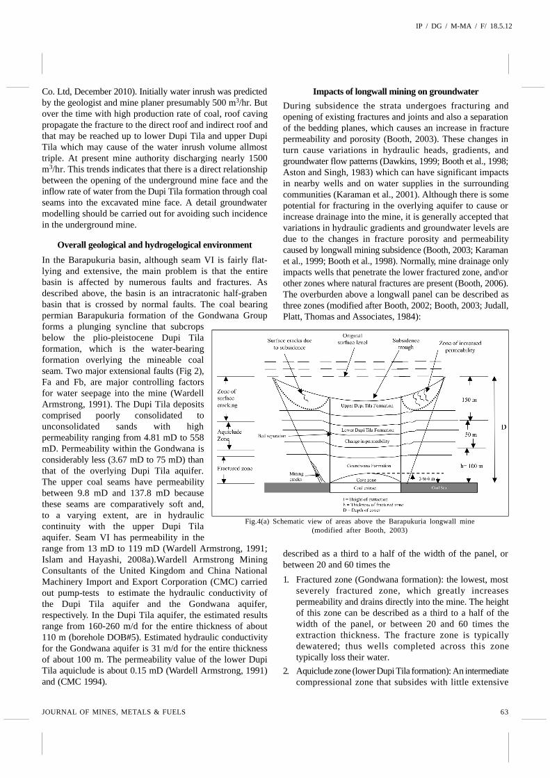
Impacts of longwall mining on groundwater
During subsidence the strata undergoes fracturing andopening of existing fractures and joints and also a separationof the bedding planes, which causes an increase in fracturepermeability and porosity (Booth, 2003). These changes inturn cause variations in hydraulic heads, gradients, andgroundwater flow patterns (Dawkins, 1999; Booth et al., 1998;Aston and Singh, 1983) which can have significant impactsin nearby wells and on water supplies in the surroundingcommunities (Karaman et al., 2001). Although there is somepotential for fracturing in the overlying aquifer to cause orincrease drainage into the mine, it is generally accepted thatvariations in hydraulic gradients and groundwater levels aredue to the changes in fracture porosity and permeabilitycaused by longwall mining subsidence (Booth, 2003; Karamanet al., 1999; Booth et al., 1998). Normally, mine drainage onlyimpacts wells that penetrate the lower fractured zone, and\orother zones where natural fractures are present (Booth, 2006).The overburden above a longwall panel can be described asthree zones (modified after Booth, 2002; Booth, 2003; Judall,Platt, Thomas and Associates, 1984):
described as a third to a half of the width of the panel, orbetween 20 and 60 times the
1. Fractured zone (Gondwana formation): the lowest, mostseverely fractured zone, which greatly increasespermeability and drains directly into the mine. The heightof this zone can be described as a third to a half of thewidth of the panel, or between 20 and 60 times theextraction thickness. The fracture zone is typicallydewatered; thus wells completed across this zonetypically loss their water.
2. Aquiclude zone (lower Dupi Tila formation): An intermediatecompressional zone that subsides with little extensive
Fig.4(a) Schematic view of areas above the Barapukuria longwall mine(modified after Booth, 2003)
64 MARCH-APRIL 2012
fracturing. It typically forms in a shale interval and maintainsoverall lower permeability and confining characteristicsbetween the mine and the shallow aquifer system.
3. Surface zone (upper Dupi Tila formation): It is theuppermost zone and consists of shallow strata subject toextensional stress and fracturing. Aquifers are affected byin situ fracturing but not necessarily by drainage into themine from which they are hydraulically separated by theaquiclude zone. Fracturing and dilation of joints andbedding planes in the subsidence areas causes anincrease in aquifer void volume and porosity. This in turnincreases the aquifer permeability and storage coefficient(Dawkins, 1999), which creates a drop in water level and alocal potentio-metric depression (Booth, 2006; Karaman etal., 1999). Groundwater levels can begin to fall even beforea longwall panel passes under a well, as drawdown istransmitted through the aquifer ahead of the longwall(Dawkins, 1999). Groundwater typically flows along theinduced hydraulic gradient towards the depression overthe subsiding zone (Fig.4) due to any or all of thefollowing (Booth, 2003; Hill and Price, 1983):? Direct drainage to the mine, if the well bottom is within
the lower fractured zone.? Increases in fracture porosity in strata, which causes
large head drops in confined bedrock aquifers becauseof their low storativity and low fracture porosity.
? Increases in fracture permeability, causing decreasesin hydraulic gradient from the site. Groundwater levelsin wells may rise and groundwater discharges in mineincrease.
? Draining of upper level aquifers through fracturedaquitards down to lower levels.
? Drawdown expands outwards from the primarypotentio-metric flow.
Impacts on hydraulic properties
During longwall mining, rock mass deformation and water/gas
flow processes interact dynamically. Flow is controlled by thepermeability of the porous medium, which remains a highlynon-linear function of mining induced stress and resultingfractures (Adhikary and Guo, 2005). Therefore, any predictivemethods to determine hydraulic behaviour requires thecapability to accurately determine mining induced rock massdeformation, fractures and resulting changes in fluid flowparameters (Wook, 2005).
ConclusionA variety of studies have documented the environmentalimpacts of longwall coal mining, including serious effects onaquifers, land subsidence, and the hydraulic properties of themined strata. These studies also show that the impacts oflongwall mining arise not only due to the drainage ofgroundwater into mined panels but also from changes in theoverburden stress regime. Such groundwater hazards presenta risk to mine safety that is a common concern of both mineoperators and researchers. It is of vital importance to studymining-induced strata failure and the hydraulic parameters ofthese strata in order to predict and prevent water inflow incoal mines (Hill and Price, 1983; Booth, 1986; Zhang andShen, 2004).
In the Barapukuria coal basin, six coal seams have beendiscovered, among which only seam VI (about 36 m thick) hasbeen considered for mining. If the coal thickness was around3-10 m, single-slice to double-slice mining methods arepromising. Single to double-slice mining is not economicallybeneficial due to high thickness of coal in Barapukuria. Thus,the China National Machinery Import and Export Corporation(CMC) planned to use the multi-slice longwall mining method.For its operation, CMC divided seam VI into 16 panels with 6slices. Seam VI is blocked out into a panel averaging nearly120 m in width, 550 m to 900 m in length, and about 3.5 m inheight, by excavating passageways around its perimeter. Theultimate height of the fracture zones would be about 22 m forthe panel thickness of 3.5 m. The first-slice coal productioncommenced in 2005 and is continuing with different hazardousenvironments such as high temperature, humidity, large-caving on the roof, and huge water inflow from the roof.
The coal-bearing Gondwana Group in the Barapukuriabasin, as well as the other basins in Bangladesh, is locatedunder a “mega-aquifer” which is named the DupiTilaformation. It is a prolific groundwater reservoir extending overlarger areas of Bangladesh. Numerous high-angle normalfaults, X-shaped joints, and fractures characterize the basins.During a seismic survey carried out by Wardell ArmstrongMining Consultants of the United Kingdom, about 37 faultswere detected. At the time of tunnel development (2001-2004),numerous faults with 1-3 m throw were observed.
Fracture intensity within the rock strata of the GondwanaGroup ranged from 7-10 per meter, whereas joints ranged from1-3 per meter. Thus, the coal-bearing Gondwana Group isconnected directly or indirectly with the overlying water-
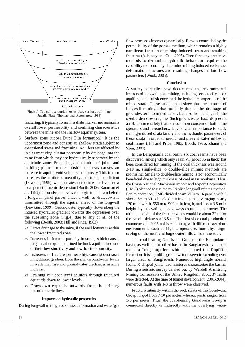
Fig.4(b) Typical overburden zones above a longwall mine(Judall, Platt, Thomas and Associates, 1984)
65JOURNAL OF MINES, METALS & FUELS
IP / DG / M-MA / F/ 18.5.12
bearing Dupi Tila mega-aquifer by diverse joints, faults, andfractures (Islam and Islam, 2005; Islam and Hayashi, 2008a).In addition, there is an open window that is located at thenorthern extremity of the present mine plan. Thehydrogeological conditions in the Barapukuria coal mine arevery complex. The most serious issue affecting the safeoperation of the coal mine is water inflow from theunconsolidated upper Dupi Tila (UDT) aquifer. Flooding ofthe mine from breaches in the upper Dupi Tila aquiferoccurred frequently in different time during the minedevelopment and production time.
Faults and fractures in the Barapukuria basin have createda groundwater flow network between the water bearing DupiTila aquifer and coal-bearing Gondwana rocks (WardellArmstrong, 1991). Wardell Armstrong Mining Consultants ofthe United Kingdom investigated the hydraulic gradient andthe general direction of groundwater inflow in the Barapukuriaarea. A moderate hydrodynamic balance appears to existbetween the upper Dupi Tila aquifer and the underlyingGondwana units, with an almost flat hydraulic gradient(0.0004–0.0006). Average transmissivity, specific yield,storage coefficient, and velocities were 1200 m2/day, 25% to30%, 0.0004, and 0.02 m/day, respectively (Wardell Armstrong,1991; Islam and Hayashi, 2008). The main lineaments (faultsand shear zones) and dikes overlie the Archaean basement inthe study area. Fb is absent within the Dupi Tila formation,and the general direction of groundwater is NE-SW. If Fb waswithin the Dupi Tila formation it could act as an importantconduit, rather than as a barrier to groundwater flow.Conveniently, Fb is located within the Gondwana formation,where the general direction of groundwater is NW-SE, W-E,and SW-NE. The hydraulic gradient and the general directionof groundwater flow are almost at right angles with the trendof Fb in the mining regions. Therefore, Fb could act as abarrier to groundwater flow, i.e., the effect on the aquifer.
Another important geological feature in the Barapukuriacoal deposits is an igneous intrusion (dike) that trends NE-SW. Studies have shown that not only faults, but also dikes,can play important roles in groundwater flow.
Dikes can be either barriers or conductors for groundwaterflow if they consist of fine-grained rock. The effect of dikesdepends on their trends in relation to the hydraulic gradientand the density of the fracture systems in the dikes.Transverse dikes act both as groundwater barriers and asconductors (Babiker and Gudmundsson, 2004). In case of theigneous dike in the Barapukuria basin, it was observed duringthe mining development that the dike acts as a barrier ratherthan a conductor for groundwater flow. A very small amountof water flows through some fracture systems of the dike;however, it was insignificant (Islam et al., 2009).
Despite these geological and hydrogeologicalcomplexities, a multi-slice longwall mining plan has beenconsidered for a 34 year mine lifetime, with a target production
of 1 million tonnes per year. If the mine is successfullyoperated, about 10% of the total coal reserve (about 37 milliontonnes) (Islam and Hayashi, 2008a) will be extracted. At thispoint, our basic question is whether it is possible toaccomplish longwall mining accurately in the Barapukuriabasin considering its geological and hydrogeologicalcharacteristics. The primary purpose of this study is to focuson hydrogeological complexities that might be encounteredin an overlying aquifer during multi-slice mining excavation.Under natural conditions, groundwater is introduced into coalseams by infiltration at the sub-crop with Dupi Tila sands andby vertical movement through the surrounding Gondwanahost rocks.
Drainage of mining excavation sites located within theseseams will cause a redistribution of stress patterns andreadjustment of the natural groundwater flow patterns. Ingeneral, a lowering of the groundwater potential at theexcavation site will lead to the following important changes:
? A higher rate of infiltration from the Dupi Tila into theseam excavation.
? A lower groundwater potential within coal seams relativeto surrounding lithologies that will cause increasedconvergence of groundwater towards the seams.
? Groundwater within the coal seams will converge on thearea of excavation and will cause increased movementtoward the main cavities including lateral flow along thecoal seams.Longwall mining is sometimes considered to be
destructive or environmentally unsafe because it causes theland above the mined-out panel to sink. At present, large-scaleland subsidence has occurred at Kalupara village, south-southeast of the Barapukuria mine, due to extraction of a 3 mhigh section of mining panel 1101. It is to be mentioned thatsome of the Kalupara village is located just above the 1101mining panel, from where coal extraction had already beencompleted by 2006. The 1101 mining panel is about 900 mlength. At present, the 1103 mining panel, which is paralleland just east of the 1101 panel, is under consideration forextraction. If in the future multi-slice (about 18 m thick) coalis extracted, an equal heights of land subsidence can beexpected to occur and cause of new fracture in the Gondwanaformation which increase permeability increasing water inflowlevel in the underground mine face.
References1. Adhikary, D. P. and Guo, H. (2005): A Coupled
Cosserat Two-Phase Double Porosity Flow ModelCSIRO Exploration and Mining, Australia, TheModelling and Simulation Society of Australia andNew Zealand.
2. Alam, M., Alam, M. M., Curray, J., Chowdhury, R. M.L. R. and Gani, M. R. (2003): “An overview of thesedimentary geology of the Bengal Basin in relation
66 MARCH-APRIL 2012
to the regional tectonic framework and basin-fillhistory.” Sediment. Geol. 155: 179-208.
3. Aston and Singh (1983): A reappraisal ofinvestigations into strata permeability changesassociated with longwall mining, International MineWater Association.
4. Bakr, M. A., Rahman, Q. M. A., Islam, M. M., Islam, M.K., Uddin, M. N., Resan, S.A., Haider, M. J., Islam, M.S., Ali, M. W., Choudhury, M. E. A., Mannan, K. M.and Anam, A. N. M. H. (1996): “Geology and CoalDeposits of Barapukuria Basin, Dinajpur District,Bangladesh,” Records of Geological Survey ofBangladesh. 8, pt 1.
5. Babiker, M., and Gudmundsson, A. (2004): “Theeffects of dykes and faults on groundwater flow in anarid land: the Red Sea Hills, Sudan.” Journal ofHydrology 297, 256–273.
6. Booth, C. J. (1986): “Strata-movement concepts and thehydrogeological impact of underground coal mining.”Ground Water 24, 507-515.
7. Booth, C. J. (2003): “Groundwater as an environmentalconstraint of longwall coal mining,” RMZ Materialsand Geoenvironment, 50 (1): 49-52.
8. Booth, C. J. (2006): “Groundwater as an environmentalconstraint of longwall coal mining.” EnvironmentalGeology, 49: 796-803.
9. Booth, C. J., Spande, E. D., Pattee, C. T., Miller, J. D.and Bertsch, L. P. (1998): “Positive and negativeimpacts of longwall mine subsidence on a sandstoneaquifer.” Environmental Geology, 34: 223-233.
10. Contreras, J., Scholz, C. H. and King, G. C. P. (1997):“A general model of rift basin evolution: constraintsof first order stratigraphic observations.” J. Geophys.Res. 102: 7673-7690.
11. China National Machinery Import and ExportCorporation (CMC) (1994.):A SupplementaryHydrogeological Feasibility Study of Barapukuria CoalBasin, Dinajpur, Bangladesh (Unpubl).
12. Dawkins, A. P. (1999): Assessment, management andrehabilitation of surface water losses due to longwallcoal mining subsidence, Minerals Council of Australia,24th Annual Environmental Workshop, Townsville,Queensland, 1999.
13. Gibson, J. R., CoWalsh, J. J. and Watterson, J. (1989):“Modeling of bed contours and cross-sectionsadjacent to planar normal faults.” J. of Struct. Geol.11: 317-328.
14. Guha, D. K. (1978): Tectonic Framework and oil andgas prospect of Bangladesh. Proc., of 4th AnnualConference, Bangladesh Geological Society, Dhaka. p
65-78.15. Hill, J. G. and Price, D. R. (1983): “The impact of deep
mining on an overlying aquifer in WesternPennsylvania,” GWRM Winter: 138-144.
16. Islam, M. R. and Hayashi, D. (2008a): “Geology andcoal bed methane resource potential of the GondwanaBarapukuria Coal Basin, Dinajpur, Bangladesh.” Int. J.of Coal Geol. 75: 127-143.
17. Islam, M. R. and Islam, M. S. (2005): “Water InrushHazard in Barapukuria Coal Mine, Bangladesh.”Bangladesh J. of Geol. 24, 1-17.
18. Islam, M. R., Hayashi, D., and Kamruzzaman, A. B. M.(2009): “Finite Element Modeling of StressDistributions and Problems for Multi-slice LongwallMining in Bangladesh, with special reference to theBarapukuria Coal Mine.” International Journal ofCoal Geology, 78, 91-109p.
19. Judall, Platt, Thomas and Associates (1984): Waterquality aspects of the environmental assessment ofunderground coal mining: A review, Ed. Department ofEnvironment and Planning, Sydney.
20. Karaman, A., Akhiev, S. S. and Carpenter, P. J. (1999):“A new method of analysis of water-level response toa moving boundary of a longwall mine,” WaterResources Research, 35(4): 1001-1010.
21. Karaman, A., Carpenter P. J. and Booth, C. J. (2001):“Type curve analysis of water level changes inducedby a longwall mine,” Environmental Geology 40: 897-901.
22. Khan, A. A. and Chouhan, R. K. S. (1996): “The crustaldynamics and the tectonic trends in the Bengal Basin.”J. Geodynamics 22: 267-286.
23. Khan, F. H. (1991): Geology of Bangladesh, pp 33-40,Willey Eastern Limited, 4835/24 Ansari Road,Daryaganj, New Delhi 110002, India.
24. Khan, A. A. and Rahman, T. (1992): “An Analysis ofGravity Field and Tectonic Evaluation of theNorthwestern Part of Bangladesh.” Tectonophysicsv206, p. 351-364.
25. Armstrong, Wardell (1991): Techno-EconomicFeasibility Study of Barapukuria Coal Project (unpubl.),Dinajpur, Bangladesh.
26. Wook, L. J. (2005): 2D Development of a numericalmodel of rock failure mechanisms associated with theimpact of lateral displacement, masters Thesis,University of Wollongong, 2005.
27. Zhang, J. and Shen, B. (2004): “Coal mining underaquifers in China: a case study.” InternationalJournal of Rock Mechanics & Mining Sciences 41,629-639p.


![Seismic Monitoring Strategies for Deep Longwall Coal … · Seismic Monitoring Strategies for Deep Longwall Coal ... [2016]. Seismic monitoring strategies for deep longwall coal](https://img.pdfslide.net/doc/110x75/5b40c06e7f8b9a2f138d8854/seismic-monitoring-strategies-for-deep-longwall-coal-seismic-monitoring-strategies.jpg)