Embed Size (px)
Citation preview
EfficientPlantationStrategiesforUrbanVillagesinNewDelhi
Bishwajit Banerjee
Architect
Plural Design Consultants Pvt. Ltd
G‐98, Kalkaji, New Delhi
E‐mail – [email protected]
Abstract
The present paper entitled “Efficient Plantation Strategies for Urban Villages in New Delhi” is an
attempt to analyze and finding solutions to the problem of scant green spaces in the Urban Villages
in New Delhi. The paper is divided into four sections, Case Study, Analysis, Inferences and the
proposed solution.
Hypothesis –
These urban villages face a scarcity of land to develop green spaces or any further development.
Redeveloping and relocating these people is not an option. Hydroponics, a known soil‐less
cultivation method, with a little bit of modification in terms of application, can be an elegant
solution to a number of problems related to such localities. It can also answer the problems of Urban
Heat Island effect and ugly urbanisation.
Key Words
Urban Villages, Slums, Agglomeration, Hydroponics
Methodology
The present study has a case study and a solution. Accordingly, the use is made of primary &
secondary data. The secondary data is collected through various reports, journals, internet & books.
To supplement the secondary data, some primary data has been used, which is collected through
interviews, personal visits & self observation.
The present study is more dependent on secondary data. Primary data is not used to a large extent
due to the reliability of the data.
2
“.....To be effective Urban Planning has to precede Development”
New Delhi itself will be the third largest agglomeration by 2015 after Mumbai and Tokyo. If its
satellite towns are taken into consideration (National Capital Territory, NCR), it is the second largest
agglomeration with a combined population of 22.5 million residents according to Demographia. The
capital city, the city of villages, New Delhi, has spruced up on agricultural lands acquired from the
neighbouring villages. In Indian context, a village comprises of the settlement area (where the
villagers reside) locally known as ‘Abadi‐deh’ and the farmlands and pasture fields surrounding
them, locally known as Khet‐Khalihan. The concept of “Lal‐Dora” is described as ‐
“The land earmarked for village abadi & the agricultural lands of the villages were duly demarcated
in the land settlement of 1908‐09 & the abadi site was circumscribed in the village map in red ink.
That is how it came to be known as ‘Lal‐Dora’. The land falling within Lal Dora is not assessed to land
revenue. Those falling outside the village abadi (Lal Dora) are meant for purpose connected with
agriculture and are subject to land revenue.” (Srivastava, 2007)
In the development process, under the land acquisition schemes for the New Delhi Project, the
villagers were given a meagre compensation for their high valued lands. The village was included in
the urban periphery and as compensation to their misery their land was exempted from most of the
development Control regulations (DCR) meant for urban settlements. On the contrary the
neighbouring areas that developed on the farmlands and pasture fields were properly planned
under the DCR, blessed with wide well lit streets, beautiful bungalows & shopping complexes laced
with all the modern amenities. All such facilities, led to substantial rise in property prices in the
National capital territory of Delhi, both in terms of rentals & ownership in these region. In the past
decade, post millennia, migration in New Delhi has increased, because of immense job opportunities
in the capital as well as the satellite townships of Gurgaon and Noida. The villagers being deprived of
their principal, if not the sole means of sustenance‐agriculture & animal husbandry started
constructing multi storey buildings on their small properties, to benefit from the influx in the
migration, by leasing rooms in such buildings. The present situation is explained by the Expert
committee on Lal Dora as‐
“It has been observed by the MCD (Municipal Corporation of Delhi) that people undertaking
construction in urban villages do not come forward for getting their building plans sanctioned. But
the fact is that if a villager, who volunteers to seek sanction of his building plan, is not entertained by
the building department of MCD on the ground of his inability to establish his ownership of the plot
to the satisfaction of MCD. (Srivastava, 2007) This is despite the well known ground reality that the
entire old Abadi bears a single Khasra number & the ownership of individual plots is generally not
available(or updated) by the revenue authorities. The exercise to get a certificate is time consuming
& allegedly expensive.” (Srivastava, 2007)
On the other hand despite making huge profits, not enough was invested in providing basic
amenities in these areas by the authorities. It was not, as if, the government at that time did it
intentionally to make the people suffer, but, they were bound by the land acquisition policies of that
3
time. In this chaotic situation the villages turned into concrete jungles at the passage of time.
Whatever green is left, remains in the disputed properties, which is still untouched by development.
There are some spaces, in interior locations, of such villages, left to be used as recreational parks for
the localities. Instead of catering to the recreational needs of the locals, these lands have become
garbage dumping ground & home for stray dogs and pigs. But even if one develops these patches,
most other places would still be deprived of it. The picture of the serene village has been replaced
with water logged streets, unending stench & streets filled with filth. According to a study titled “A
situational analysis of the young child in India”, 52% of Delhi lives in slums. The logic points towards
complete redevelopment. Start from ground zero. But on moral grounds that would be unfair
towards the existing population living in such villages. At this point, the question is that, are we
really standing at a crossroads? Are we indeed left with only two options either to live in the existing
slums or razing many aspirations to the ground? Samuel Johnson aptly said ‐
“ Sir, if you wish to have a just notion of the magnitude of this city you must not be satisfied with
seeing its great streets and squares, but must survey the innumerable little lanes and courts”.
The Ingredients of a City
According to CIAM (International Congress of Modern Architects), there are four basic elements of
Urban Biology.
1. Sun –The climate and meteorological factors
2. Space – The relation between man and surroundings.
3. Vegetation – The green spaces
4. Steel and Concrete – The built form (Arthur B.Galleon, 2011)
These elements dictate the living Standards in a city and serves as a basis to understand the
behaviour and activities of the locality in concern. These elements can be divided into further
categories.
1. Sun – Sun symbolises the climate & meteorological factors. It can be divided into
temperature, cloud cover & wind conditions.
2. Space – Space is the surrounding envelope. It can be categorized under
a. Location
b. Locality Size
c. Density of the Built environment –
i. Land coverage
ii. Distance between buildings
iii. Average height of the building
d. Land Use Pattern –
e. Urban Geometry
3. Vegetation – The existing green and open recreational space are identified in these
categories
a. Proximity to green spaces
b. Typology
4. Steel & Concrete – to understand the built form the system this element can be categorized
under
4
a. Built form
b. Structural strength
c. Amenities provided to sustain the built form
Apart from these parameters Social and Economic structure has to be understood as well.
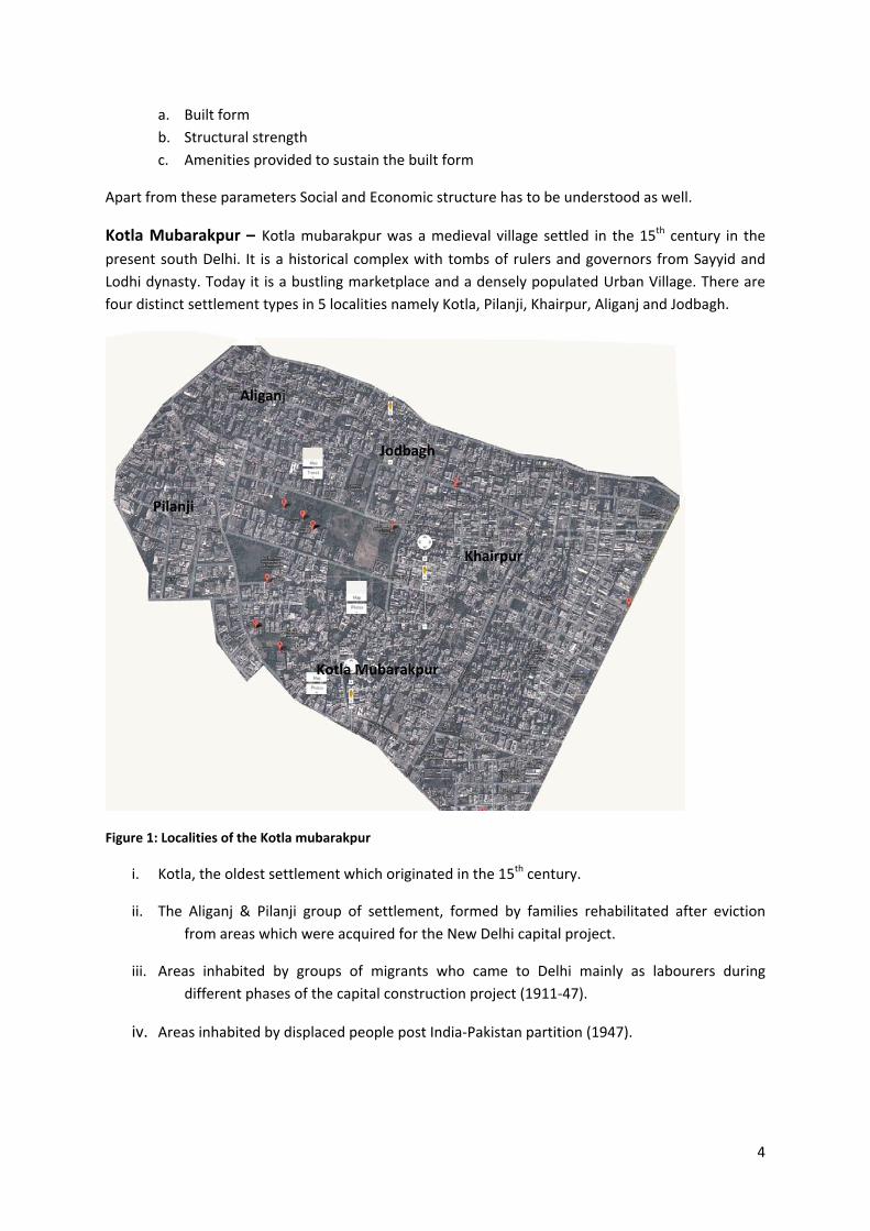
Kotla Mubarakpur – Kotla mubarakpur was a medieval village settled in the 15th century in the
present south Delhi. It is a historical complex with tombs of rulers and governors from Sayyid and
Lodhi dynasty. Today it is a bustling marketplace and a densely populated Urban Village. There are
four distinct settlement types in 5 localities namely Kotla, Pilanji, Khairpur, Aliganj and Jodbagh.
Figure 1: Localities of the Kotla mubarakpur
i. Kotla, the oldest settlement which originated in the 15th century.
ii. The Aliganj & Pilanji group of settlement, formed by families rehabilitated after eviction
from areas which were acquired for the New Delhi capital project.
iii. Areas inhabited by groups of migrants who came to Delhi mainly as labourers during
different phases of the capital construction project (1911‐47).
iv. Areas inhabited by displaced people post India‐Pakistan partition (1947).
Kotla Mubarakpur
Khairpur
Jodbagh
Aliganj
Pilanji
5
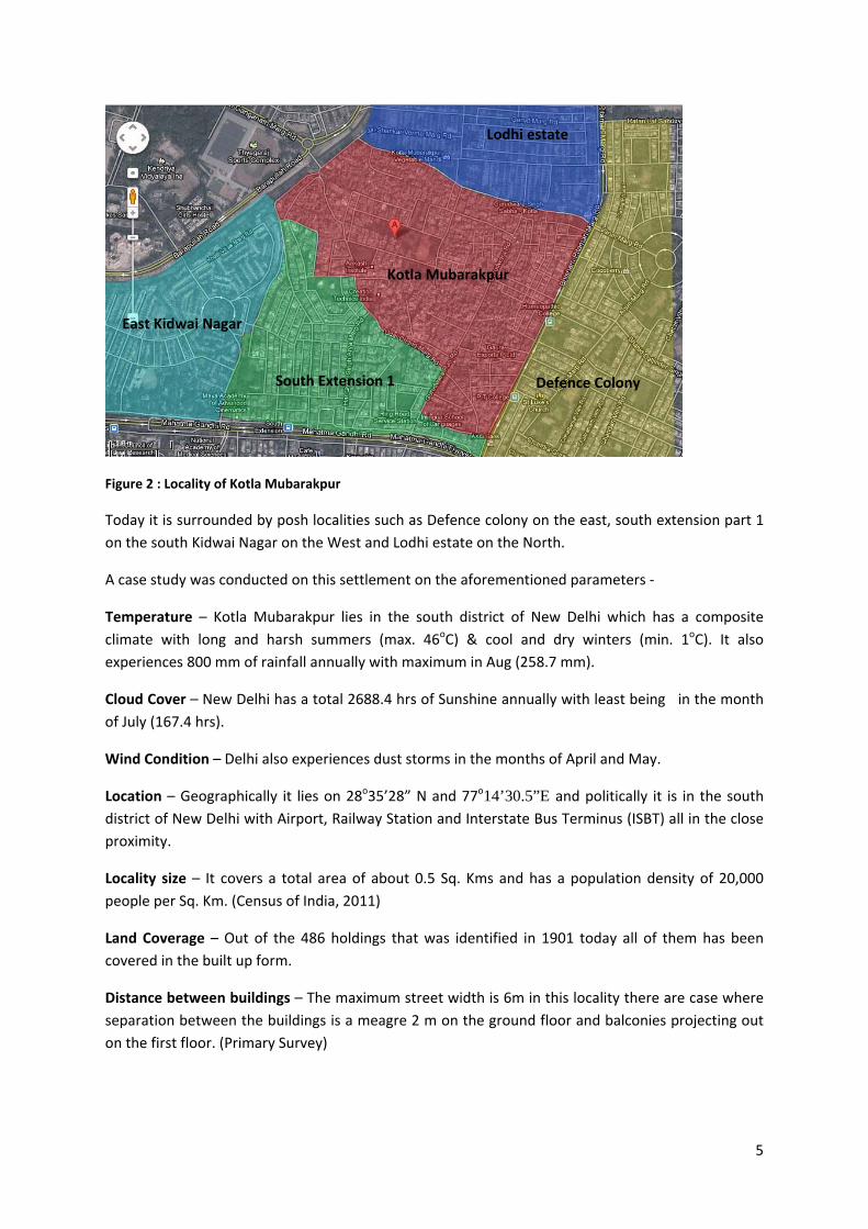
Figure 2 : Locality of Kotla Mubarakpur
Today it is surrounded by posh localities such as Defence colony on the east, south extension part 1
on the south Kidwai Nagar on the West and Lodhi estate on the North.
A case study was conducted on this settlement on the aforementioned parameters ‐
Temperature – Kotla Mubarakpur lies in the south district of New Delhi which has a composite
climate with long and harsh summers (max. 46oC) & cool and dry winters (min. 1oC). It also
experiences 800 mm of rainfall annually with maximum in Aug (258.7 mm).
Cloud Cover – New Delhi has a total 2688.4 hrs of Sunshine annually with least being in the month
of July (167.4 hrs).
Wind Condition – Delhi also experiences dust storms in the months of April and May.
Location – Geographically it lies on 28o35’28” N and 77o14’30.5”E and politically it is in the south
district of New Delhi with Airport, Railway Station and Interstate Bus Terminus (ISBT) all in the close
proximity.
Locality size – It covers a total area of about 0.5 Sq. Kms and has a population density of 20,000
people per Sq. Km. (Census of India, 2011)
Land Coverage – Out of the 486 holdings that was identified in 1901 today all of them has been
covered in the built up form.
Distance between buildings – The maximum street width is 6m in this locality there are case where
separation between the buildings is a meagre 2 m on the ground floor and balconies projecting out
on the first floor. (Primary Survey)
Kotla Mubarakpur
South Extension 1 Defence Colony
Lodhi estate
East Kidwai Nagar
6
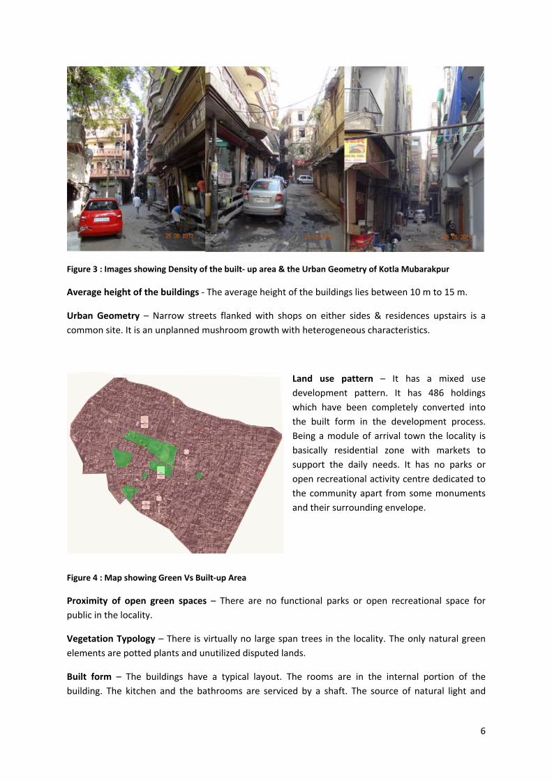
Figure 3 : Images showing Density of the built‐ up area & the Urban Geometry of Kotla Mubarakpur
Average height of the buildings ‐ The average height of the buildings lies between 10 m to 15 m.
Urban Geometry – Narrow streets flanked with shops on either sides & residences upstairs is a
common site. It is an unplanned mushroom growth with heterogeneous characteristics.
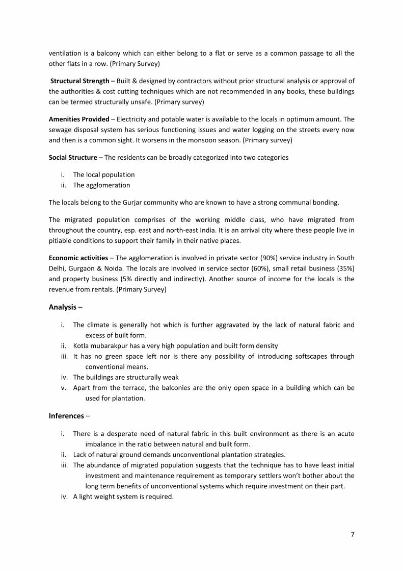
Land use pattern – It has a mixed use
development pattern. It has 486 holdings
which have been completely converted into
the built form in the development process.
Being a module of arrival town the locality is
basically residential zone with markets to
support the daily needs. It has no parks or
open recreational activity centre dedicated to
the community apart from some monuments
and their surrounding envelope.
Figure 4 : Map showing Green Vs Built‐up Area
Proximity of open green spaces – There are no functional parks or open recreational space for
public in the locality.
Vegetation Typology – There is virtually no large span trees in the locality. The only natural green
elements are potted plants and unutilized disputed lands.
Built form – The buildings have a typical layout. The rooms are in the internal portion of the
building. The kitchen and the bathrooms are serviced by a shaft. The source of natural light and
7
ventilation is a balcony which can either belong to a flat or serve as a common passage to all the
other flats in a row. (Primary Survey)
Structural Strength – Built & designed by contractors without prior structural analysis or approval of
the authorities & cost cutting techniques which are not recommended in any books, these buildings
can be termed structurally unsafe. (Primary survey)
Amenities Provided – Electricity and potable water is available to the locals in optimum amount. The
sewage disposal system has serious functioning issues and water logging on the streets every now
and then is a common sight. It worsens in the monsoon season. (Primary survey)
Social Structure – The residents can be broadly categorized into two categories
i. The local population
ii. The agglomeration
The locals belong to the Gurjar community who are known to have a strong communal bonding.
The migrated population comprises of the working middle class, who have migrated from
throughout the country, esp. east and north‐east India. It is an arrival city where these people live in
pitiable conditions to support their family in their native places.
Economic activities – The agglomeration is involved in private sector (90%) service industry in South
Delhi, Gurgaon & Noida. The locals are involved in service sector (60%), small retail business (35%)
and property business (5% directly and indirectly). Another source of income for the locals is the
revenue from rentals. (Primary Survey)
Analysis –
i. The climate is generally hot which is further aggravated by the lack of natural fabric and
excess of built form.
ii. Kotla mubarakpur has a very high population and built form density
iii. It has no green space left nor is there any possibility of introducing softscapes through
conventional means.
iv. The buildings are structurally weak
v. Apart from the terrace, the balconies are the only open space in a building which can be
used for plantation.
Inferences –
i. There is a desperate need of natural fabric in this built environment as there is an acute
imbalance in the ratio between natural and built form.
ii. Lack of natural ground demands unconventional plantation strategies.
iii. The abundance of migrated population suggests that the technique has to have least initial
investment and maintenance requirement as temporary settlers won’t bother about the
long term benefits of unconventional systems which require investment on their part.
iv. A light weight system is required.
8
Hydroponics –
It is a renowned method of growing plants in absence of soil. In this system the nutrient solution,
rather than the media in which the plants are growing, always supplies most of the plant nutrient
requirements. One of the first experiments was done by Woodward in England in 1699. By the mid
19th century, Sachs and Knop had developed their own method of growing plants without soil. In the
late 1930’s Dr. W.F. Gericks first coined the term ’Hydroponics’.
There are various techniques of Hydroponics that is being used in commercial greenhouses,
vegetable production around the world. The prominent technique being –
i. Liquid (Non‐Aggregate) Hydroponics system
ii. Nutrient Film Technique
iii. Aggregate Hydroponics system
iv. Bag Culture
v. Rockwool Culture
vi. Bubbleponics
vii. Ebb & Flow or Flood and Drain sub irrigation
viii. Deep water culture etc.’ (G.Thyagrajan, 2007) (Unknown, 2011)
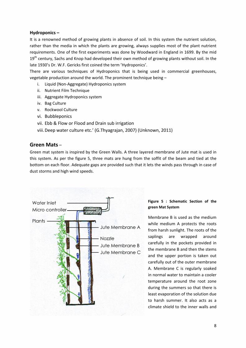
Green Mats – Green mat system is inspired by the Green Walls. A three layered membrane of Jute mat is used in
this system. As per the figure 5, three mats are hung from the soffit of the beam and tied at the
bottom on each floor. Adequate gaps are provided such that it lets the winds pass through in case of
dust storms and high wind speeds.
Figure 5 : Schematic Section of the
green Mat System
Membrane B is used as the medium
while medium A protects the roots
from harsh sunlight. The roots of the
saplings are wrapped around
carefully in the pockets provided in
the membrane B and then the stems
and the upper portion is taken out
carefully out of the outer membrane
A. Membrane C is regularly soaked
in normal water to maintain a cooler
temperature around the root zone
during the summers so that there is
least evaporation of the solution due
to harsh summer. It also acts as a
climate shield to the inner walls and
9
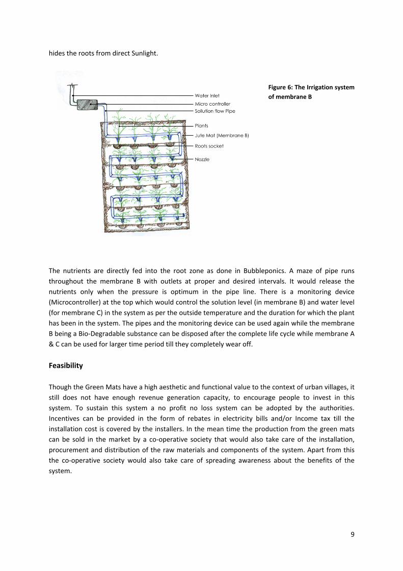
hides the roots from direct Sunlight.
Figure 6: The Irrigation system
of membrane B
The nutrients are directly fed into the root zone as done in Bubbleponics. A maze of pipe runs
throughout the membrane B with outlets at proper and desired intervals. It would release the
nutrients only when the pressure is optimum in the pipe line. There is a monitoring device
(Microcontroller) at the top which would control the solution level (in membrane B) and water level
(for membrane C) in the system as per the outside temperature and the duration for which the plant
has been in the system. The pipes and the monitoring device can be used again while the membrane
B being a Bio‐Degradable substance can be disposed after the complete life cycle while membrane A
& C can be used for larger time period till they completely wear off.
Feasibility
Though the Green Mats have a high aesthetic and functional value to the context of urban villages, it
still does not have enough revenue generation capacity, to encourage people to invest in this
system. To sustain this system a no profit no loss system can be adopted by the authorities.
Incentives can be provided in the form of rebates in electricity bills and/or Income tax till the
installation cost is covered by the installers. In the mean time the production from the green mats
can be sold in the market by a co‐operative society that would also take care of the installation,
procurement and distribution of the raw materials and components of the system. Apart from this
the co‐operative society would also take care of spreading awareness about the benefits of the
system.
10
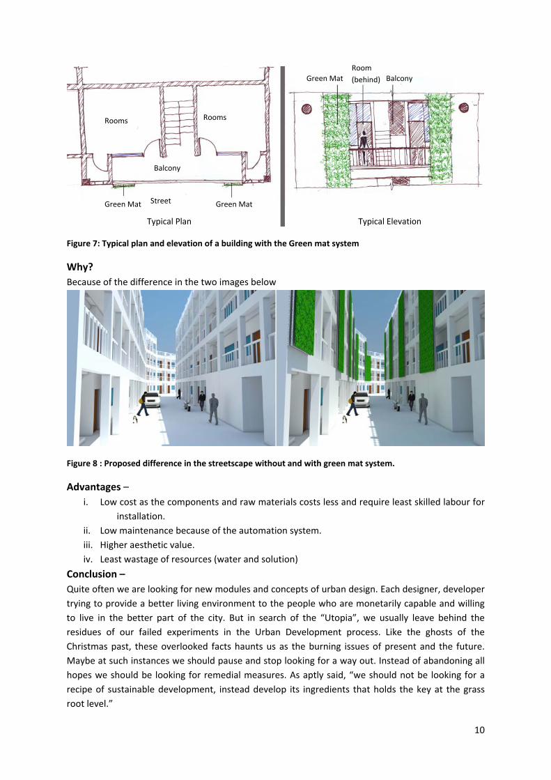
Figure 7: Typical plan and elevation of a building with the Green mat system
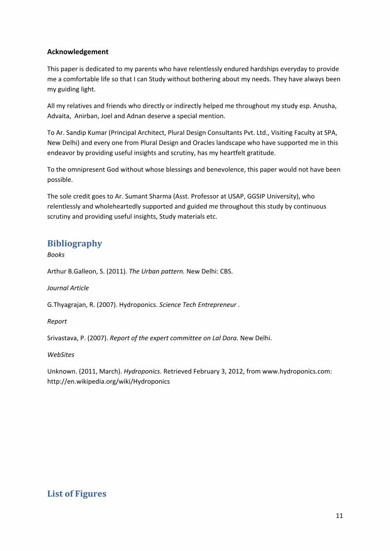
Why?
Because of the difference in the two images below
Figure 8 : Proposed difference in the streetscape without and with green mat system.
Advantages –
i. Low cost as the components and raw materials costs less and require least skilled labour for
installation.
ii. Low maintenance because of the automation system.
iii. Higher aesthetic value.
iv. Least wastage of resources (water and solution)
Conclusion –
Quite often we are looking for new modules and concepts of urban design. Each designer, developer
trying to provide a better living environment to the people who are monetarily capable and willing
to live in the better part of the city. But in search of the “Utopia”, we usually leave behind the
residues of our failed experiments in the Urban Development process. Like the ghosts of the
Christmas past, these overlooked facts haunts us as the burning issues of present and the future.
Maybe at such instances we should pause and stop looking for a way out. Instead of abandoning all
hopes we should be looking for remedial measures. As aptly said, “we should not be looking for a
recipe of sustainable development, instead develop its ingredients that holds the key at the grass
root level.”
Typical Plan Typical Elevation
Rooms Rooms
Balcony
Street Green Mat Green Mat
Green Mat
Room
(behind) Balcony
11
Acknowledgement
This paper is dedicated to my parents who have relentlessly endured hardships everyday to provide
me a comfortable life so that I can Study without bothering about my needs. They have always been
my guiding light.
All my relatives and friends who directly or indirectly helped me throughout my study esp. Anusha,
Advaita, Anirban, Joel and Adnan deserve a special mention.
To Ar. Sandip Kumar (Principal Architect, Plural Design Consultants Pvt. Ltd., Visiting Faculty at SPA,
New Delhi) and every one from Plural Design and Oracles landscape who have supported me in this
endeavor by providing useful insights and scrutiny, has my heartfelt gratitude.
To the omnipresent God without whose blessings and benevolence, this paper would not have been
possible.
The sole credit goes to Ar. Sumant Sharma (Asst. Professor at USAP, GGSIP University), who
relentlessly and wholeheartedly supported and guided me throughout this study by continuous
scrutiny and providing useful insights, Study materials etc.
BibliographyBooks
Arthur B.Galleon, S. (2011). The Urban pattern. New Delhi: CBS.
Journal Article
G.Thyagrajan, R. (2007). Hydroponics. Science Tech Entrepreneur .
Report
Srivastava, P. (2007). Report of the expert committee on Lal Dora. New Delhi.
WebSites
Unknown. (2011, March). Hydroponics. Retrieved February 3, 2012, from www.hydroponics.com:
http://en.wikipedia.org/wiki/Hydroponics
ListofFigures
12
Figure 1: Localities of the Kotla mubarakpur .......................................................................................... 4
Figure 2 : Locality of Kotla Mubarakpur .................................................................................................. 5
Figure 3 : Images showing Density of the built‐ up area & the Urban Geometry of Kotla Mubarakpur 6
Figure 4 : Map showing Green Vs Built‐up Area ................................................................................... 6
Figure 5 : Schematic Section of the green Mat System .......................................................................... 8
Figure 6: The Irrigation system of membrane B ..................................................................................... 9
Figure 7: Typical plan and elevation of a building with the Green mat system ................................... 10
Figure 8 : Proposed difference in the streetscape with and without green mat system. .................... 10