Embed Size (px)
Citation preview

EG2234: Earth Observation
Interactions - LandDr Mark Cresswell
Topics
Land surfaces Temperature and radiance Proxy air temperature Albedo NDVI Fires and volcanoes
Land Surfaces
Remote sensing provides a proxy for the nature of land surfaces
We are interested in land cover rather than land use
Different materials (land cover classes) absorb and reflect electromagnetic radiation differently
We can infer land surface conditions from remotely sensed images

Temperature and Radiance
Infrared radiation is the key A region of the electromagnetic spectrum sandwiched
between the red visible and microwave portions of the spectrum
IR radiation is invisible to Humans 3 – 14µm is TIR (0.7 – 1.3µm is NIR, 1.3 – 3µm is MIR, 10.5 - 12.5µm is TIR)
Quantity of IR is related to radiance Radiance intensity is related to temperature

Temperature and Radiance
Detection of infrared energy is performed by the radiometer
Measurement is the result of a current effect due to the direct interaction of photons with electrons present in the detector
Operation of the detector requires that incident photons liberate charge-carrier electrons

Temperature and Radiance
Different materials in nature absorb and emit thermal energy differently
Differences are due to thermal capacity and ability to conduct as well as environmental parameters
Water often has a high thermal capacity compared with bare soil – so both materials are easily distinguished from one another

TIR image

Raw MeteosatRadiance image
Proxy Air Temperature
LST (land surface temperature) may be converted to a proxy air temperature by means of a solar correction algorithm
Knowing the position of the Sun at the time an image is acquired allows the LST to be transformed into a proxy for air temperature (approx 1m above the ground)
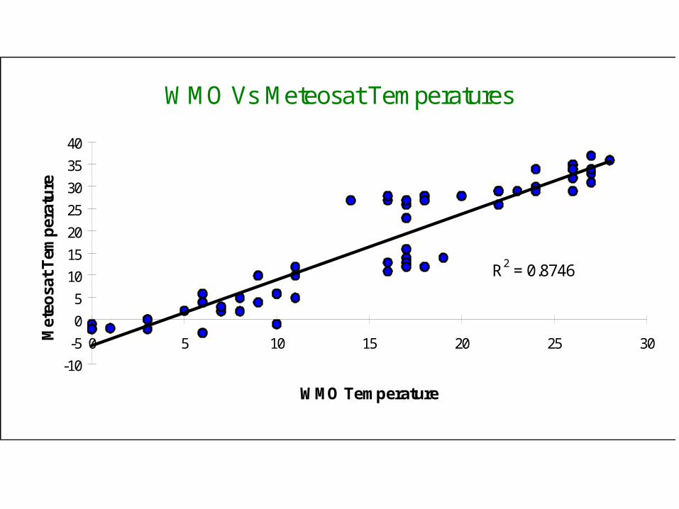
WMO Vs Meteosat Temperatures
R2 = 0.8746
-10
-5
0
5
10
15
20
25
30
35
40
0 5 10 15 20 25 30
WMO Temperature
Met
eosa
t T
emp
erat
ure
N = 58
Temperatures in Celsius
95% Confidence Level

WMO Vs Meteosat Temperatures
-5
0
5
10
15
20
25
30
35
40
Time
Tem
pera
ture
(cel
siu
s)
WMO METEOSAT

WMO Vs Corrected Meteosat Temperatures
-5
0
5
10
15
20
25
30
Time
Tem
pera
ture
(ce
lsiu
s)
WMO
CORRECTED

Albedo
Albedo is simply the ratio of incoming radiation to reflected outgoing radiation expressed as %
100in
outA

Albedo
Materials such as clouds and fresh snow have a HIGH albedo (they reflect much of the incident solar radiation back to space)
Forests and soil have a low albedo (they absorb much of the incident radiation)
We can classify materials according to their albedo

Table 1 - Typical Albedo values for natural surfaces
Surface or Object Albedo (%) Fresh snow 75 – 95 Clouds (Thick) 60 – 90 Cloud (Thin) 30 – 50 Ice 30 - 40 Sand 15 – 45 Grassy Field 10 – 30 Water 10 Forest 3 – 10 Earth/Atmosphere 30 Moon 7

VISIBLE
•Albedo•Weather Fcst.

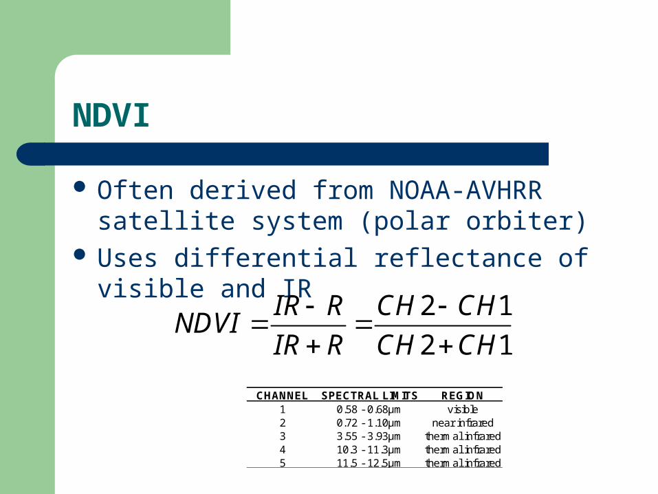
NDVI
Normalised Difference Vegetation Index NDVI provides a good assessment of
photosynthesising vegetation – but caution must be exercised with this type of index as other factors can affect the NDVI other than leaf reflectance: Viewing angle, Soil background, Atmospheric degradation and Leaf orientation
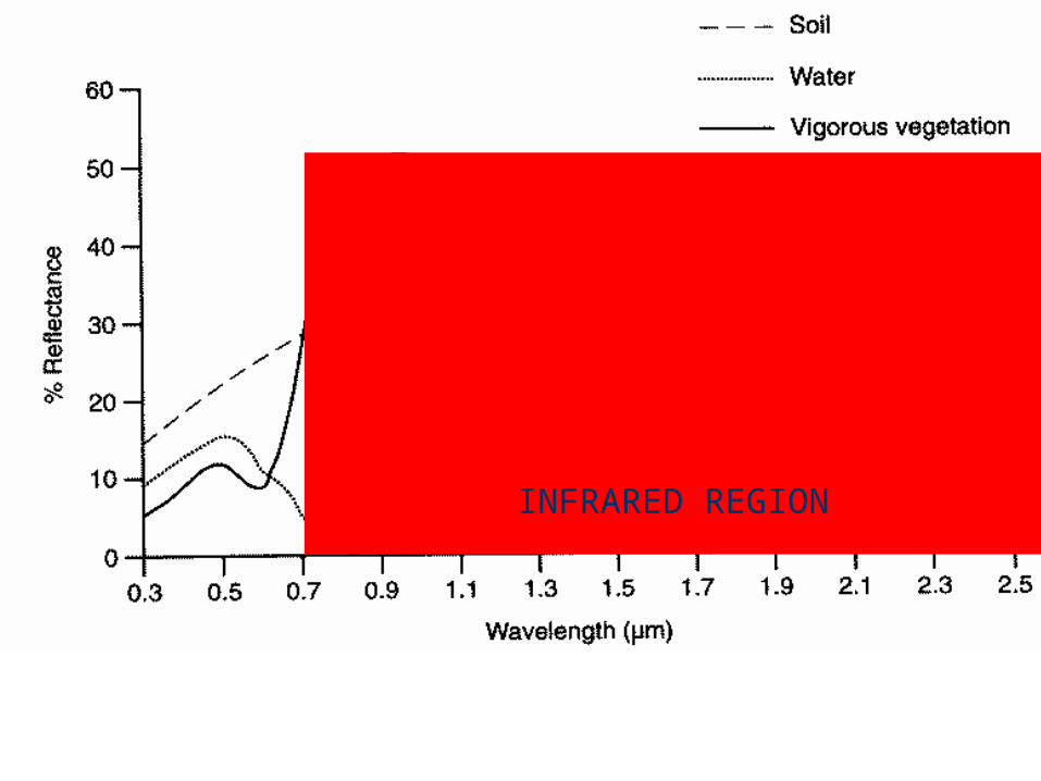
INFRARED REGION

NDVI
Often derived from NOAA-AVHRR satellite system (polar orbiter)
Uses differential reflectance of visible and IR
2 1
2 1
IR R CH CHNDVI
IR R CH CH
CHANNEL SPECTRAL LIMITS REGION
1 0.58 - 0.68µm visible2 0.72 - 1.10µm near infrared3 3.55 - 3.93µm thermal infrared4 10.3 - 11.3µm thermal infrared5 11.5 - 12.5µm thermal infrared

NDVI
NDVI
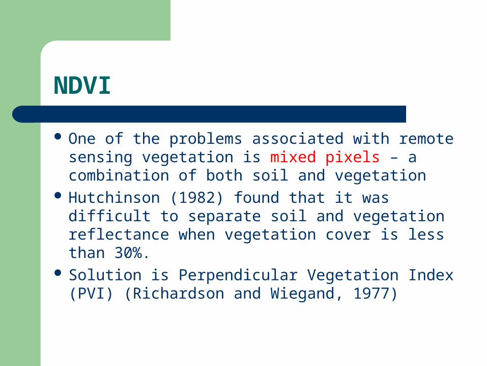
One of the problems associated with remote sensing vegetation is mixed pixels – a combination of both soil and vegetation
Hutchinson (1982) found that it was difficult to separate soil and vegetation reflectance when vegetation cover is less than 30%.
Solution is Perpendicular Vegetation Index (PVI) (Richardson and Wiegand, 1977)

PVI (perpendicular vegetation index):
R E D R E FLE C TA N C E
NE
AR
IN
FR
AR
ED
RE
FL
EC
TAN
CE
AB
C
W
X Y
soil b righ tness lineB = dark wet soils
C = dry soils
X = pure vegetation pixel
Y = mixed pixel
Fires and Volcanoes
Because of their thermal anomaly, fires and active volcanoes can be identified from space
Acquisition of thermal infrared images allows fires to be detected automatically
Time-series of images can show a trend in temperature beneath and surrounding a volcano that might allow a prediction of eruption to be made
Volcanoes
The moderate resolution imaging spectroradiometer (MODIS) instrument on board the NASA EOS platform, Terra gives global coverage every 1-2 days at 250, 500 and 1000 metre resolutions
Spectral data measured at 4µm and 12µm System examines scenes for high temperature
volcanic thermal anomalies
Volcanoes
Once identified, details such as location, emitted spectral radiance and other parameters are transferred via the internet to the Hawaii Institute of Geophysics and Planetology
Algorithms appear to be robust at detecting both permanent and sporadically active volcanic systems. See Wright et al. 2002

Forest Fires
A fire detection and management system should have the following aims:
• A measure of the geographical limits of the fire-front• An estimate of fire intensity• Monitoring of burnt area to look for latent fires• Mapping of burnt areas to aid restoration
(Barducci et al. 2002)

Borneo Fires (Sep 18th 2005)NASA Earth Observatory, 2005