Embed Size (px)
Citation preview
Eldorado National Forest Rock Creek Development Project
Initial Study/ Mitigated Negative Declaration
March 2010
State of California Department of Parks and Recreation
Off-Highway Motor Vehicle Recreation Division
Eldorado National Forest Rock Creek Water Development
Initial Study/ Mitigated Negative Declaration
March 2010
Prepared for:
State of California Department of Parks and Recreation
Off-Highway Motor Vehicle Recreation Division
Prepared by:
TRA Environmental Sciences, Inc. 545 Middlefield Road, Suite 200
Menlo Park, CA 94025 (650) 327-0429
(650) 327-4027 Fax www.traenviro.com
Mitigated Negative Declaration Page i
Eldorado National Forest – Rock Creek Trail Development Project Initial Study/Mitigated Negative Declaration – March 2010
California Department of Parks & Recreation, Off-Highway Motor Vehicle Recreation Division
MITIGATED NEGATIVE DECLARATION
PROJECT: Rock Creek Trail Development
LEAD AGENCY: California Department of Parks and Recreation (CDPR), Off-Highway Motor Vehicle Recreation (OHMVR) Division
AVAILABILITY OF DOCUMENTS: The Initial Study for this Mitigated Negative Declaration is available for review at:
• Eldorado National Forest 7600 Wentworth Springs Road Georgetown, CA 95634 Contact – Jon Jue, Resource Officer, Georgetown Ranger District Phone - (530) 333-5550
• CDPR, OHMVR Division 1725 23rd Street, Suite 200 Sacramento, CA 95816
Contact – Dan Canfield Phone – (916) 324-1574
PROJECT DESCRIPTION:
The Eldorado National Forest is proposing install approximately 8.9 miles of new trail, 0.5 miles of trail reconstruction, 3 new bridges, and 3 new prefabricated restrooms at the Rock Creek Trail System in the Georgetown Ranger District. The trail inventory and monitoring for the Rock Creek Trail System revealed that certain trail segments are in poor condition. Therefore, reroutes are proposed on thirteen segments. Three new bridges are proposed at the lower Rock Creek crossing, Canyon Creek crossing, and on Ballarat Trail. Two prefabricated vault toilets are proposed at the Mace Mill Staging Area, and one is proposed at the Bald Mountain Staging Area.
FINDINGS
The OHMVR Division, having reviewed the Initial Study for the proposed project, finds that:
1. The proposed project will improve the existing Rock Creek Recreation Area by improving the trail system and facilities in the Rock Creek Trail System.
2. With the implementation of mitigation measures, the project will not exceed significance thresholds for the environmental effects identified in the Initial Study Checklist.
3. A Mitigated Negative Declaration will be filed as the appropriate CEQA document of the project.
BASIS OF FINDINGS
Based on the environmental evaluation presented herein, the project will not cause significant adverse effects related to aesthetics, agricultural resources, air quality, biological resources,
Mitigated Negative Declaration Page ii
Eldorado National Forest – Rock Creek Trail Development Project Initial Study/Mitigated Negative Declaration – March 2010
California Department of Parks & Recreation, Off-Highway Motor Vehicle Recreation Division
cultural resources, geology/soils, hazards/hazardous materials, hydrology/water quality, land use/planning, mineral resources, noise, population/housing, public services, recreation, transportation/traffic, and utilities/service systems. In addition, substantial adverse effects on humans, either direct or indirect, will not occur. The project does not affect any important examples of the major periods of California prehistory or history. Nor will the project substantially reduce the habitat of a fish or wildlife species, cause a fish or wildlife population to drop below self-sustaining levels, threaten to eliminate a plant or animal community, or substantially reduce the number or restrict the range of a rare or endangered plant or animal. The project does not have impacts that are individually limited, but cumulatively considerable.
A copy of the Initial Study is attached. Questions or comments regarding this Initial Study/ Negative Declaration should be submitted in writing to:
Contact – Dan Canfield CDPR, OHMVR Division 1725 23rd Street, Suite 200 Sacramento, CA 95816
Pursuant to Section 21082.1 of the California Environmental Quality Act, CDPR has independently reviewed and analyzed the Initial Study and Mitigated Negative Declaration for the proposed project and finds these documents reflect the independent judgment of CDPR.
Table of Contents Page iii
Eldorado National Forest – Rock Creek Trail Development Project Initial Study/Mitigated Negative Declaration – March 2010
California Department of Parks & Recreation, Off-Highway Motor Vehicle Recreation Division
TABLE of CONTENTS
CHAPTER 1 INTRODUCTION .....................................................................................................1
1.1 Introduction and Regulatory Guidance ...............................................................................1
1.2 Lead Agency Contact Information.......................................................................................2
1.3 Purpose and Document Organization.................................................................................2
1.4 Required Permits and Approvals ........................................................................................2
CHAPTER 2 PROPOSED PROJECT...........................................................................................3
2.1 Project Location and Site Description .................................................................................3
2.2 Project Objectives ...............................................................................................................3
2.3 Project Description..............................................................................................................3
2.3.1 Trail Construction .....................................................................................................3
2.3.2 Work Proposed for Each Trail ..................................................................................4
2.3.3 Bridges .....................................................................................................................7
2.3.4 Prefabricated Vault Toilet Restrooms ......................................................................8
2.3.5 BMPs Incorporated Into the Project .........................................................................8
2.3.6 Construction Times and Duration...........................................................................11
CHAPTER 3 ENVIRONMENTAL CHECKLIST AND RESPONSES...........................................20
3.1 Aesthetics .........................................................................................................................23
3.2 Agriculture and Forest Resources ....................................................................................25
3.3 Air Quality .........................................................................................................................27
3.4 Biological Resources ........................................................................................................29
3.5 Cultural Resources ...........................................................................................................41
3.6 Geology and Soils.............................................................................................................43
3.7 Greenhouse Gas Emissions .............................................................................................47
3.8 Hazards and Hazardous Materials....................................................................................49
3.9 Hydrology and Water Quality ............................................................................................52
Table of Contents Page iv
Eldorado National Forest – Rock Creek Trail Development Project Initial Study/Mitigated Negative Declaration – March 2010
California Department of Parks & Recreation, Off-Highway Motor Vehicle Recreation Division
3.10 Land Use and Planning...................................................................................................55
3.11 Mineral Resources ..........................................................................................................56
3.12 Noise...............................................................................................................................57
3.13 Population and Housing..................................................................................................60
3.14 Public Services ...............................................................................................................61
3.15 Recreation.......................................................................................................................63
3.16 Transportation/Traffic......................................................................................................64
3.17 Utilities and Service Systems..........................................................................................66
3.18 Mandatory Findings of Significance ................................................................................68
CHAPTER 4 REFERENCES ......................................................................................................70
CHAPTER 5 REPORT PREPARATION.....................................................................................73
Tables
Table 1: Rock Creek Trail Improvement Summary.......................................................................5
Figures
Figure 1 – Regional Location ......................................................................................................12
Figure 2 – Project Site Map; 1 of 5 .............................................................................................13
Figure 3 – Project Site Map; 2 of 5 .............................................................................................14
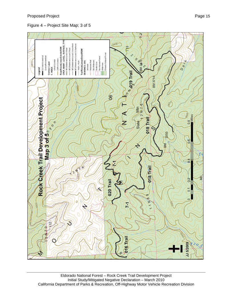
Figure 4 – Project Site Map; 3 of 5 .............................................................................................15
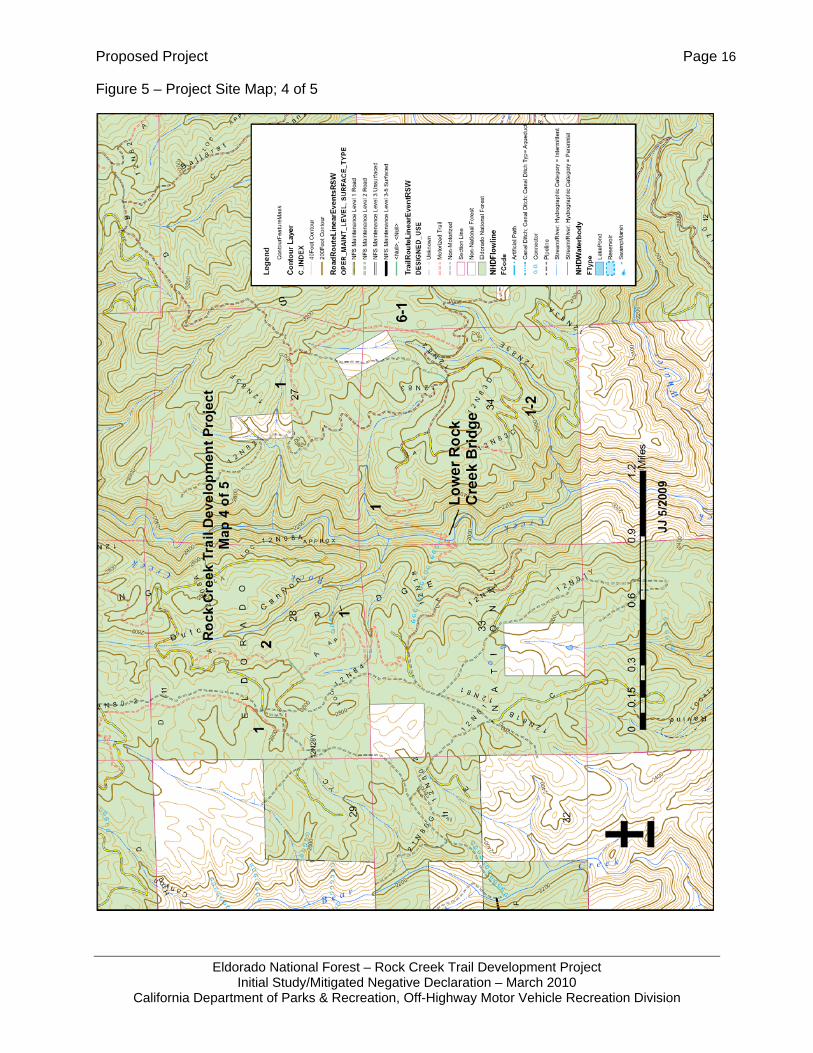
Figure 5 – Project Site Map; 4 of 5 .............................................................................................16
Figure 6 – Project Site Map; 5 of 5 .............................................................................................17
Figure 7 – Photos of Existing Facilities .......................................................................................18
Introduction Page 1
Eldorado National Forest – Rock Creek Trail Development Project Initial Study/Mitigated Negative Declaration – March 2010
California Department of Parks & Recreation, Off-Highway Motor Vehicle Recreation Division
CHAPTER 1 INTRODUCTION
1.1 INTRODUCTION AND REGULATORY GUIDANCE
This Initial Study/Mitigated Negative Declaration (IS/MND) has been prepared by the Off-Highway Motor Vehicle Recreation (OHMVR) Division of the California Department of Parks and Recreation (CDPR). This IS evaluates the potential environmental effects of the Rock Creek Trail Development project in the Rock Creek Recreation Area of the Eldorado National Forest (Figure 1). The Eldorado National Forest is located in El Dorado County, California.
This project would involve:
1. Trail reroutes and reconstruction
2. Installation of three bridges
3. Installation of three prefabricated vault toilets
4. Installation of signs
The project has had previous environmental reviews including a 1997 Revised Draft Environmental Impact Statement, 1999 Final Environmental Impact Statement, 1999 Record of Decision, 2006 Final Supplemental Environmental Impact Statement, 2006 Record of Decision, 2004 Environmental Assessment, and 2009 Decision Memo.
The California Environmental Quality Act (CEQA; Public Resources Code § 21000 et seq.) and the CEQA Guidelines (14 CCR §15000 et seq.) establish the OHMVR Division as the lead agency. The lead agency is defined in CEQA Guidelines section 15367 as “the public agency which has the principal responsibility for carrying out or approving a project.” The lead agency decides whether an Environmental Impact Report (EIR) or ND is required for the project and is responsible for preparing the appropriate environmental review document.
According to CEQA Guidelines Section 15070, a public agency shall prepare a proposed ND or a Mitigated ND when:
1. The IS shows that there is no substantial evidence, in light of the whole record before the agency, that the project may have a significant effect on the environment, or,
2. The IS identifies potentially significant effects, but:
- Revisions in the project plans made before a proposed Mitigated ND and IS are released for public review would avoid the effects or mitigate the effects to a point where clearly no significant effects would occur, and
- There is no substantial evidence, in light of the whole record before the agency, that the project as revised may have a significant effect on the environment.
This IS has been prepared by the OHMVR Division of CDPR in accordance with CEQA and the CEQA Guidelines.
Introduction Page 2
Eldorado National Forest – Rock Creek Trail Development Project Initial Study/Mitigated Negative Declaration – March 2010
California Department of Parks & Recreation, Off-Highway Motor Vehicle Recreation Division
1.2 LEAD AGENCY CONTACT INFORMATION
The lead agency for the proposed project is the OHMVR Division of CDPR, the agency that would be approving and carrying out the project. The contact person for the lead agency regarding the project and questions or comments regarding this Initial Study/Mitigated Negative Declaration should be submitted to:
Contact: Dan Canfield, CDPR, OHMVR Division Address: 1725 23rd Street, Suite 200, Sacramento CA 95816 Phone: (916) 324-1574
1.3 PURPOSE AND DOCUMENT ORGANIZATION
The purpose of this document is to evaluate the potential environmental effects of the Rock Creek Trail Development project.
This document is organized as follows:
• Chapter 1 - Introduction
This chapter provides an introduction to the project and describes the purpose and organization of this document.
• Chapter 2 – Proposed Project
This chapter describes the project location, project area, and site description, objectives, characteristics and related projects.
• Chapter 3 - Environmental Checklist and Responses
This chapter contains the Environmental (IS) Checklist that identifies the significance of potential environmental impacts (by environmental issue) and provides a brief discussion of each impact resulting from implementation of the proposed project. This chapter also contains the Mandatory Findings of Significance.
• Chapter 4 - References
This chapter identifies the references and sources used in the preparation of this IS/MND.
• Chapter 5 - Report Preparation
This chapter provides a list of those involved in the preparation of this document.
1.4 REQUIRED PERMITS AND APPROVALS
No other permits or approvals are required for this project.
Proposed Project Page 3
Eldorado National Forest – Rock Creek Trail Development Project Initial Study/Mitigated Negative Declaration – March 2010
California Department of Parks & Recreation, Off-Highway Motor Vehicle Recreation Division
CHAPTER 2 PROPOSED PROJECT
2.1 PROJECT LOCATION AND SITE DESCRIPTION
CDPR proposes to perform trail reroutes and reconstruction and install bridges and prefabricated vault toilets at the Rock Creek Trail System in the Georgetown Ranger District of El Dorado National Forest, El Dorado, County, California (Figure 1). The Rock Creek area encompasses approximately 23,600 acres of public lands centered about five miles southeast of Georgetown, California.
2.2 PROJECT OBJECTIVES
Trail monitoring on the Rock Creek Trail System has revealed that certain trail segments are in poor condition and contribute to soil erosion, which adversely affects water quality. The trails are in poor condition due to steep trail grades or are in close proximity to streams. The objective of the project is to improve water quality and reduce effects on riparian areas. Vault toilets are needed as the portable toilets the Eldorado National Forest had been using were being vandalized and the portable toilet provider has since refused additional service until the vandals are apprehended.
The project also addresses California Vehicle Code (CVC) requirements to limit combined off-highway vehicle (OHV) and highway legal traffic to road segments no longer than three miles in length (CVC § 38026). One trail will be widened to accommodate all-terrain vehicle. This change in trail use was evaluated previously in the Rock Creek Recreational Trails Environmental Impact Statement documents (USDA 1997 and 1999a) and approved in the Record of Decision (USDA 1999b).
2.3 PROJECT DESCRIPTION
2.3.1 TRAIL CONSTRUCTION
The project involves 8.9 miles of trail construction and a total of 0.5 miles of trail reconstruction involving 11 trail segments. Trail construction involves clearing, excavation, tread hardening, installation of retaining walls, and switchbacks. Trail reconstruction would occur on one trail. These activities are described below:
Clearing. The clearing involves the removal and disposal of trees, logs, limbs, branches, shrubs, herbaceous plants and other vegetation within the clearing limits. The cleared material will not be placed in concentrated piles. The cleared material (all logs, limbs, lopped tops, shrubs, grubbed stumps and roots) will be placed below the trailway and outside of the clearing limits, unless the sideslope above the trail is less than 10 percent or the log is placed uphill in such a way that it will not move into the clearing limits. Clearing and grubbing debris will not be placed in water courses, snow ponds, lakes, meadows, or in locations where it could impede the flows to, through, or from drainage structures.
Excavation. Excavation work includes digging, embankment, and backfill construction required to shape and finish the trailbed, ditches, backslopes, fill slopes, drainage dips, trail passing sections, and turnouts. It also includes excavation and embankment work required to construct shallow stream fords and gully crossings, talus and rubble rock sections, and climbing turns.
Tread Hardening. Tread hardening involves installing concrete blocks or crushed rock to provide a firm surface to protect the native soil on the trail tread. A geo-fabric would be laid
Proposed Project Page 4
Eldorado National Forest – Rock Creek Trail Development Project Initial Study/Mitigated Negative Declaration – March 2010
California Department of Parks & Recreation, Off-Highway Motor Vehicle Recreation Division
down in advance of installing concrete block or crushed rock in order to stabilize the hardening material and prevent wet soil from percolating through the hardened surface. Tread hardening could occur at major culverts or at bridge approaches. It could also occur where steep trail segments are necessary to avoid rock outcrops or other obstacles that may not have been observed during the original trail layout.
Retaining Walls. Retaining wall construction involves gathering native rock from the surrounding area to build the retaining wall. If there is a shortage of available native rock, pressure treated lumber may be used to construct the retaining wall. Retaining walls are often needed where fill material for the trail tread needs to be contained in order to take a trail a certain direction, such as for the approach to a bridge, a trail with steep side slopes, or along a switchback in a trail.
Switchbacks. Switchback construction involves excavating or backfilling the trail so there is a quick change in direction of the trail. It is used when the trail must gain or lose elevation in order to reach a certain destination. It is very common for switchbacks to require retaining walls as mentioned above. It is very important that the radius of turn of a switchback be of sufficient distance to allow the most limiting vehicle, which in this case is a motorcycle or ATV, to accomplish the turn at a reasonable speed.
Trail Reconstruction. Trail reconstruction for this project involves widening a segment of the 11E17 Trail to make it a sufficient width to meet the U.S. Forest Service (USFS) standards for a more difficult rated ATV route. The widening of a trail first starts with clearing vegetation and debris to specified clearing limits. After the clearing has been accomplished, the trail tread would be excavated to create a trail width of 4.5 to 5.2 feet. The trail would be compacted using equipment or vehicles traveling back and forth on the reconstructed trail tread.
Signing. Directional and/or safety signing would be installed to direct users to appropriate trails.
Blasting. Blasting could occur on an as needed basis for those trails with outcroppings that are not visible from the surface. All outcrops that are visible from the surface can be dealt with by rock drill or mini excavator. It should be noted that blasting requires a permit through the County and due to homeland security issues, blasting permits often require an extended waiting period. To avoid having to acquire a blasting permit, contractors have more commonly been utilizing non-explosive techniques such as expansion compounds and boulder blaster machines instead.
Equipment. Each trail segment would require the use of one mini-excavator (36 inches wide) and possibly an ATV to transport personnel and equipment to the work site. It is estimated that trails could be built at a rate of 400 feet per day. With 8.9 miles of trail and 0.5 mile of trail reconstruction, the project would required approximately 124 days of excavator use to construct the trails.
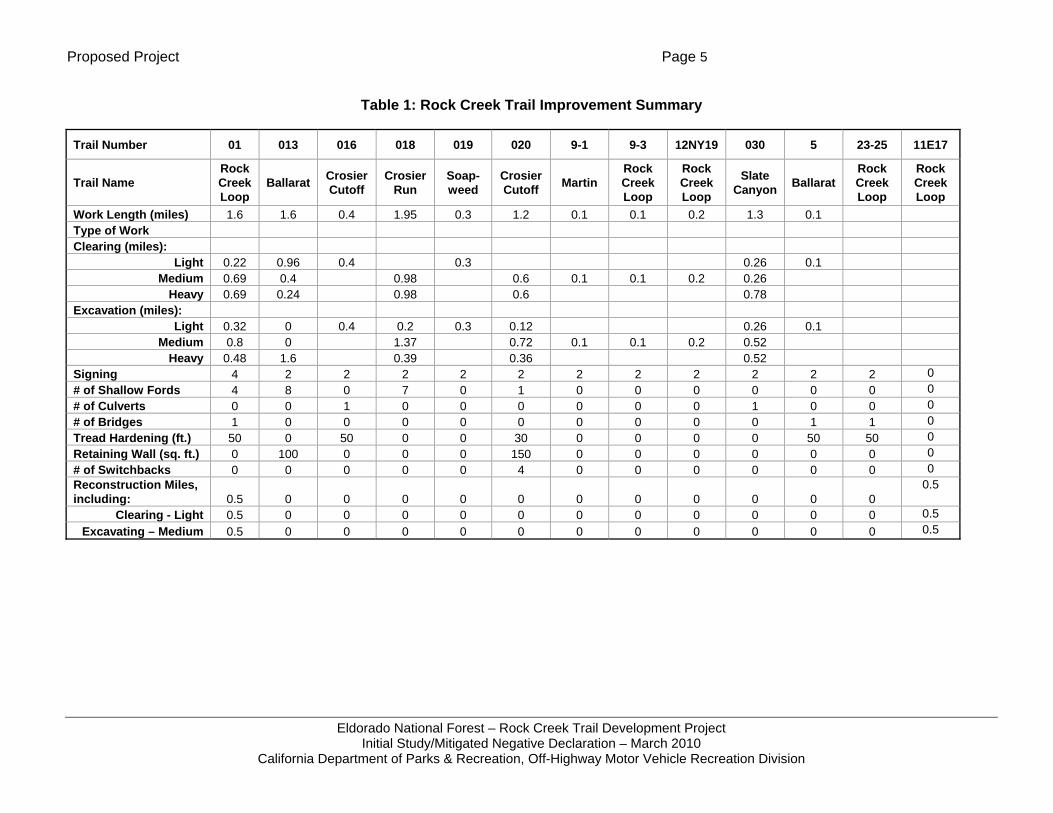
2.3.2 WORK PROPOSED FOR EACH TRAIL
A description of the construction proposed for each trail is summarized in Table 1: Rock Creek Trail Improvement Summary. A text description of the trails and proposed work follows the table.
Proposed Project Page 5
Eldorado National Forest – Rock Creek Trail Development Project Initial Study/Mitigated Negative Declaration – March 2010
California Department of Parks & Recreation, Off-Highway Motor Vehicle Recreation Division
Table 1: Rock Creek Trail Improvement Summary
Trail Number 01 013 016 018 019 020 9-1 9-3 12NY19 030 5 23-25 11E17
Trail Name Rock Creek Loop
Ballarat Crosier Cutoff
Crosier Run
Soap-weed
Crosier Cutoff Martin
Rock Creek Loop
Rock Creek Loop
Slate Canyon Ballarat
Rock Creek Loop
Rock Creek Loop
Work Length (miles) 1.6 1.6 0.4 1.95 0.3 1.2 0.1 0.1 0.2 1.3 0.1 Type of Work Clearing (miles):
Light 0.22 0.96 0.4 0.3 0.26 0.1 Medium 0.69 0.4 0.98 0.6 0.1 0.1 0.2 0.26
Heavy 0.69 0.24 0.98 0.6 0.78 Excavation (miles):
Light 0.32 0 0.4 0.2 0.3 0.12 0.26 0.1 Medium 0.8 0 1.37 0.72 0.1 0.1 0.2 0.52
Heavy 0.48 1.6 0.39 0.36 0.52 Signing 4 2 2 2 2 2 2 2 2 2 2 2 0 # of Shallow Fords 4 8 0 7 0 1 0 0 0 0 0 0 0 # of Culverts 0 0 1 0 0 0 0 0 0 1 0 0 0 # of Bridges 1 0 0 0 0 0 0 0 0 0 1 1 0 Tread Hardening (ft.) 50 0 50 0 0 30 0 0 0 0 50 50 0 Retaining Wall (sq. ft.) 0 100 0 0 0 150 0 0 0 0 0 0 0 # of Switchbacks 0 0 0 0 0 4 0 0 0 0 0 0 0 Reconstruction Miles, including: 0.5 0 0 0 0 0 0 0 0 0 0 0
0.5
Clearing - Light 0.5 0 0 0 0 0 0 0 0 0 0 0 0.5 Excavating – Medium 0.5 0 0 0 0 0 0 0 0 0 0 0 0.5
Proposed Project Page 6
Eldorado National Forest – Rock Creek Trail Development Project Initial Study/Mitigated Negative Declaration – March 2010
California Department of Parks & Recreation, Off-Highway Motor Vehicle Recreation Division
A summary of the specific actions for improvements proposed on each trail is provided below:
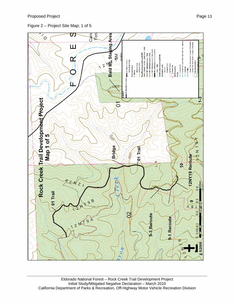
01 Trail (Figure 2) – The 1.6 miles new construction segment of the 01 Trail would replace a section of the 9-3 Trail (also known as the 1 Trail) that is very steep and showing soil erosion and requires frequent maintenance to keep drainage structures functioning. This new construction would also allow riders to have a trail riding opportunity for over 1 mile rather than riding on segments of the 12N79 and 12N79A Roads allowing OHV riders to remain on trail rather than on street-legal roads. A bridge is also proposed for crossing Canyon Creek on this trail; see Chapter 2.3.3 below.
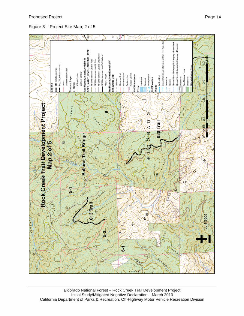
013 Trail (Figure 3) – The purpose of this trail it to take the trail users off of the 12N82C Road that connects to the 23-8 Trail and to provide them with more of a trail experience.
016 Trail (Figure 4) – The purpose of this trail is to improve the stream crossing and to replace a trail that trespasses onto private land. The existing trail travels up the drainage for approximately 100 feet and makes 3 separate stream channel crossings. The new trail would install a culvert for the stream crossing and enter and exit the riparian area more directly, so there would be less disturbance in the riparian area.
018 Trail (Figure 4) – This trail would provide trail users with a new opportunity to ride on the southern portion of Slate Mountain. Currently, there are no trails on the south side of Slate Mountain. People often ride OHVs on the native surface county road to travel in this area. The trail will provide motorcycle riders the opportunity to travel on the trail instead of a road.
019 Trail (Figure 4) - This trail would provide a trail opportunity, where currently there is just the native surfaced county road. It would provide a trail linkage that crosses the county road from the Soapweed Creek.
020 Trail (Figure 4) – This trail would replace a steep, rocky trail that was developed by motorcycles that descend down from Slate Mountain. The new trail would be designed and constructed with less steep trail gradients, switchbacks and rolling grades to provide for trail drainage. There should be less maintenance required by designing and constructing the trails with these features.
9-1 Trail (Figure 2) – This trail realignment (new construction) would correct the existing poor drainage at the site. The existing trail is located on a ridge line and over time the trail surface has become lower than the surrounding ground level. This makes it difficult to construct and maintain drainage structures on the trail. The new location will be located on the side of the ridge and constructed with grade reversals to provide natural drainage and eliminate the need for machine or hand placed dips.
9-3 Trail (Figure 2) – This trail realignment would solve a similar problem with poor drainage and subsequent soil erosion as described for the 9-1 Trail.
12N19Y (Figure 2) – This new trail would solve a similar drainage problem and resulting soil erosion as described for the 9-1 trail.
030 Trail (Figure 3) – This new trail solves the need for combined use designation (also known as mixed use in the national forest), where highway vehicles and OHVs may use the same road. The California Vehicle Code provides for combined use for contiguous segments of road that
Proposed Project Page 7
Eldorado National Forest – Rock Creek Trail Development Project Initial Study/Mitigated Negative Declaration – March 2010
California Department of Parks & Recreation, Off-Highway Motor Vehicle Recreation Division
are 3 miles or less. The Rock Creek Road is currently a rough, native surface road, which keeps highway vehicle speeds down. There are plans in place to chipseal Rock Creek Road in the near future. The Rock Creek Road provides an important linkage between trails in the northern portion of the Rock Creek area to those in the southern portion. The new trail would provide a single track route between portions of Rock Creek Road so that the combined use segments of the Rock Creek Road would remain three miles or less. This would allow OHV riders to continue to ride from the northern portion of the Rock Creek area to trails in the southern portion.
5 Trail (Figure 3) (otherwise referred to as the 9-8 Trail in the Rock Creek EIS) – This portion of the project involves constructing a bridge to replace a shallow ford that is hardened with concrete blocks. Once the bridge is constructed, the trail traffic will be out of the intermittent stream, which can flow a substantial amount of water in the wet season. The effects on water quality, namely sedimentation, should reduce substantially since the ford and the trail approaches to the crossing would be restored once the bridge is put into service. See Chapter 2.3.3 below; for additional information.
23-25 (also 01) Trail, Lower Rock Creek Bridge (Figure 5) – The construction of this bridge would eliminate trail traffic from needing to ford Rock Creek in order to travel from Darling Ridge to Slate Mountain. Since vehicles would no longer be traveling in the stream channel, there would be less potential for fuel spills and lubricants entering Rock Creek if a vehicle were to become disabled trying to cross Rock Creek. It is common to have less skilled riders fall while traveling through this stream crossing. Installation of the bridge would also result in less potential for sediment from the stream channel and banks to be churned up during vehicle travel. The bridge would improve water quality and aquatic habitat in Rock Creek over the present conditions using the low water ford. See Chapter 2.3.3 below for additional information.
11E17 Trail (Figure 6) – The 11E17 Trail was designated as an ATV route, but its existing condition has sections in the 0.5 mile length that are not wide enough for ATVs to use and still keep all four tires on the trail tread. Continued use by ATVs results in vehicles traveling on the fill slope or cut bank and causing the trail tread to narrow even more. The reconstruction would widen the trail tread to 4.5 to 5.2 feet to accommodate ATV traffic and also install some turnouts to allow vehicles or other trail users such as equestrians to pass.
2.3.3 BRIDGES
As mentioned above under their respective trail headings, three bridges are proposed to be installed by this project.
The first is a bridge for the lower Rock Creek crossing along the 23-25 Trail (also known as the 1 Trail) (Figure 5). Currently, motorcycles cross the creek through a low water ford. The bridge would be a metal superstructure approximately 5 to 6 feet wide and 70 to 80 feet long. Footings for the bridge would require clearing an area roughly 20 feet by 20 feet (one footing on each side of the creek). Vegetation in the area to be cleared consists of shrubs and trees less than 6-inches in size and 1-2 trees that are greater than 6-inches in diameter.
The second bridge is proposed for crossing Canyon Creek on the 01 Trail (Figure 2). This bridge would be a metal superstructure, approximately 5 to 6 feet wide and 35 feet long. Footings for the bridge would require clearing an area roughly 12 feet by 12 feet (one footing on each side of the creek). All vegetation to be cleared in the area of the footing is less than six inches in diameter.
Proposed Project Page 8
Eldorado National Forest – Rock Creek Trail Development Project Initial Study/Mitigated Negative Declaration – March 2010
California Department of Parks & Recreation, Off-Highway Motor Vehicle Recreation Division
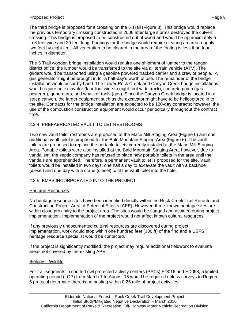
The third bridge is proposed for a crossing on the 5 Trail (Figure 3). This bridge would replace the previous temporary crossing constructed in 2006 after large storms destroyed the culvert crossing. This bridge is proposed to be constructed out of wood and would be approximately 5 to 6 feet wide and 20 feet long. Footings for the bridge would require clearing an area roughly two feet by eight feet. All vegetation to be cleared in the area of the footing is less than four inches in diameter.
The 5 Trail wooden bridge installation would require one shipment of lumber to the ranger district office; the lumber would be transferred to the site via all terrain vehicle (ATV). The girders would be transported using a gasoline powered tracked carrier and a crew of people. A gas generator might be brought in for a half-day’s worth of use. The remainder of the bridge installation would occur by hand. The Lower Rock Creek and Canyon Creek bridge installations would require an excavator (four-foot wide to eight-foot wide track), concrete pump (gas powered), generators, and whacker tools (gas). Since the Canyon Creek bridge is located in a steep canyon, the larger equipment such as the excavator might have to be helicoptored in to the site. Contracts for the bridge installation are expected to be 120-day contracts; however, the use of the combustion construction equipment would occur periodically throughout the contract time.
2.3.4 PREFABRICATED VAULT TOILET RESTROOMS
Two new vault toilet restrooms are proposed at the Mace Mill Staging Area (Figure 6) and one additional vault toilet is proposed for the Bald Mountain Staging Area (Figure 6). The vault toilets are proposed to replace the portable toilets currently installed at the Mace Mill Staging Area. Portable toilets were also installed at the Bald Mountain Staging Area, however, due to vandalism, the septic company has refused to place new portable toilets in the area until the vandals are apprehended. Therefore, a permanent vault toilet is proposed for the site. Vault toilets would be installed in two days: one half a day to excavate the vault with a backhoe (diesel) and one day with a crane (diesel) to fit the vault toilet into the hole.
2.3.5 BMPS INCORPORATED INTO THE PROJECT
Heritage Resources
No heritage resource sites have been identified directly within the Rock Creek Trail Reroute and Construction Project Area of Potential Effects (APE). However, three known heritage sites are within close proximity to the project area. The sites would be flagged and avoided during project implementation. Implementation of the project would not affect known cultural resources.
If any previously undocumented cultural resources are discovered during project implementation, work would stop within one hundred feet (100 ft) of the find and a USFS heritage resource specialist would be contacted.
If the project is significantly modified, the project may require additional fieldwork to evaluate areas not covered by the existing APE.
Biology – Wildlife
For trail segments in spotted owl protected activity centers (PACs) ED016 and ED098, a limited operating period (LOP) from March 1 to August 15 would be required unless surveys to Region 5 protocol determine there is no nesting within 0.25 mile of project activities.

Proposed Project Page 9
Eldorado National Forest – Rock Creek Trail Development Project Initial Study/Mitigated Negative Declaration – March 2010
California Department of Parks & Recreation, Off-Highway Motor Vehicle Recreation Division
Aquatic Wildlife
A wet weather construction restriction (per BMP 2-3 of the Water Quality Management for Forest System Lands in California, Best Management Practices, (USDA, 2000)) shall be implemented to avoid potential impacts to amphibians including the California red-legged frog when they are more likely to be moving across land.
Noxious Weeds
All off road construction equipment moved into the project area must be free of soil, seeds, vegetative matter or other debris that may contain seeds in order to prevent the spread of noxious weeds in the project area. Off-road equipment must be kept out of sites infected with noxious weeds. Where it is not possible to keep off road construction equipment out of sites with noxious weeds, the off-road equipment must be cleaned so that it is free of soil, seeds, vegetative matter, and other debris prior to being moved from infested sites to uninfested sites and prior to being transported to the project site.
Weed-free straw shall be used for erosion control. If any revegetation of sites is required, native seeds approved by the Forest Botanist shall be used.
Hydrology and Soils
The following measures contained in the Water Quality Management for Forest System Lands in California, Best Management Practices (USDA 2000), have been incorporated into the project:
2-1 General Guidelines for Location and Design of Road (Trails)
2-2 Erosion Control Plan
2-3 Timing of Construction Activities
2-4 Stabilization of Road (Trail) Slope Surfaces and Spoil Disposal Areas
2-5 Road (Trail) Slope Stabilization Construction Practices
2-6 Dispersion of Subsurface Drainage from Cut and Fill Slopes
2-7 Control of Road (Trail) Drainage
2-8 Constraints Related to Pioneer Road (Trail) Construction
2-9 Time Erosion Control Measures on Incomplete Road (Trail) and Stream Crossing Projects
2-12 Servicing and Refueling of Equipment
2-13 Control of Construction and Maintenance Activities Adjacent to Stream Maintenance Zones
2-14 Controlling In-Channel Excavation
2-17 Bridge and Culvert Installation
2-22 Maintenance of Roads (Trail)

Proposed Project Page 10
Eldorado National Forest – Rock Creek Trail Development Project Initial Study/Mitigated Negative Declaration – March 2010
California Department of Parks & Recreation, Off-Highway Motor Vehicle Recreation Division
2-23 Road (Trail) Surface Treatment to Prevent Loss of Materials
2-24 Traffic Control during Wet Periods
4-9 Protection of Water Quality Within Developed and Dispersed Recreation Areas
Trail Construction Techniques
• Rolling dips may be constructed with the trail machine on selected trails at intervals ranging from 50 to 300 feet depending on the trail grade and whether the trail alignment provides for adequate drainage. The outlets of rolling dips will have slash and woody debris placed to provide some filtering effect and ground cover. Where it is feasible, rolling dips would be constructed with outlets that collect and trap sediment from the tread surface. The trapped sediment would be reclaimed for use on the trail treads during maintenance activities.
• Breaks or changes in the trail grade would be built to provide for a means to drain water off the trails. The USFS would strive to use this method where the terrain allows.
• The new trail reroutes would be designed for a maximum grade of 15 percent where possible. If a grade of over 15 percent is necessary for an extended distance of over 50 feet, the trail surface will be hardened with compacted aggregate base (gravel with finer material) or an equivalent material to prevent erosion.
• Construction activities would stop before there is off-site runoff from the construction site or when the soil moisture becomes too high for construction activities. An estimated 2 to 3 days of drying time (depending on the amount of precipitation) would be needed prior to resuming trail construction activities.
• Trail construction activities would be completed during dry periods between storms.
• Cut slopes and fills created along the trails would have cover placed on them after construction activities are completed. Local vegetation and duff from clearing activities is suitable for this purpose. If sufficient ground cover material is not available from the local area, weed free straw would be used for ground cover.
• The newly constructed trails would be closed to all uses during the wet/rainy season.
• The trail reroutes would be built using Region 5 Trail Design Standards (USDA 1996).
Blasting
The USFS requires that all employees who work with, monitor work, or inspect work involving explosives or blasting agents must be trained to recognize unsafe work practices and to ensure the safety of the public, government employees, property, and natural resources. All work would comply with federal, state, and local laws in accordance with USFS Manual 6745 and the "Guide for Using, Storing, and Transporting Explosives and Blasting Materials" (sec. 62.06 in the USFS Health and Safety Code Handbook.
Proposed Project Page 11
Eldorado National Forest – Rock Creek Trail Development Project Initial Study/Mitigated Negative Declaration – March 2010
California Department of Parks & Recreation, Off-Highway Motor Vehicle Recreation Division
2.3.6 CONSTRUCTION TIMES AND DURATION
Contracts for trail construction are usually for 90 days depending on how they are packaged (2-3 trails versus 1 per package), but the contract time could be as long as 120 days. Contracts for the Lower Rock Creek and Canyon Creek bridges will probably be for 120 days. The bridge for the 5 Trail is much smaller and can be built by hand and would likely require a shorter contract time. Overall project construction (trails, bridges, and toilets) is expected to occur over two seasons generally between the months of April and October. Construction may be allowed to occur in other months (March, November, December) provided that the soil moisture conditions remain optimal. Excavators can typically construct 400 to 500 feet of trail per day (8 hours). Vault toilet installation would occur over a period of two days; one day to excavate the vault with a backhoe and one day to locate the prefabricated toilet in the vault. Construction would occur between the hours of 7:00 a.m. and 8:00 p.m.

Proposed Project Page 12
Eldorado National Forest – Rock Creek Trail Development Project Initial Study/Mitigated Negative Declaration – March 2010
California Department of Parks & Recreation, Off-Highway Motor Vehicle Recreation Division
Figure 1 – Regional Location
Project Area
Proposed Project Page 13
Eldorado National Forest – Rock Creek Trail Development Project Initial Study/Mitigated Negative Declaration – March 2010
California Department of Parks & Recreation, Off-Highway Motor Vehicle Recreation Division
Figure 2 – Project Site Map; 1 of 5
Proposed Project Page 14
Eldorado National Forest – Rock Creek Trail Development Project Initial Study/Mitigated Negative Declaration – March 2010
California Department of Parks & Recreation, Off-Highway Motor Vehicle Recreation Division
Figure 3 – Project Site Map; 2 of 5
Proposed Project Page 15
Eldorado National Forest – Rock Creek Trail Development Project Initial Study/Mitigated Negative Declaration – March 2010
California Department of Parks & Recreation, Off-Highway Motor Vehicle Recreation Division
Figure 4 – Project Site Map; 3 of 5
Proposed Project Page 16
Eldorado National Forest – Rock Creek Trail Development Project Initial Study/Mitigated Negative Declaration – March 2010
California Department of Parks & Recreation, Off-Highway Motor Vehicle Recreation Division
Figure 5 – Project Site Map; 4 of 5

Proposed Project Page 17
Eldorado National Forest – Rock Creek Trail Development Project Initial Study/Mitigated Negative Declaration – March 2010
California Department of Parks & Recreation, Off-Highway Motor Vehicle Recreation Division
Figure 6 – Project Site Map; 5 of 5
Proposed Project Page 18
Eldorado National Forest – Rock Creek Trail Development Project Initial Study/Mitigated Negative Declaration – March 2010
California Department of Parks & Recreation, Off-Highway Motor Vehicle Recreation Division
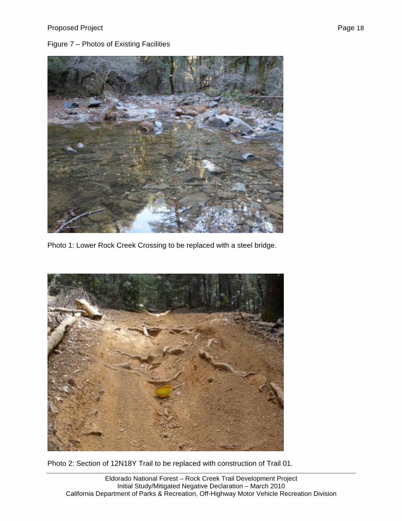
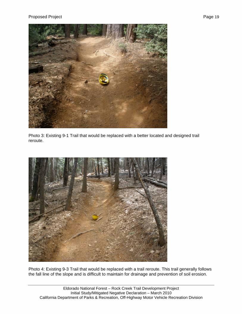
Figure 7 – Photos of Existing Facilities
Photo 1: Lower Rock Creek Crossing to be replaced with a steel bridge.
Photo 2: Section of 12N18Y Trail to be replaced with construction of Trail 01.
Proposed Project Page 19
Eldorado National Forest – Rock Creek Trail Development Project Initial Study/Mitigated Negative Declaration – March 2010
California Department of Parks & Recreation, Off-Highway Motor Vehicle Recreation Division
Photo 3: Existing 9-1 Trail that would be replaced with a better located and designed trail reroute.
Photo 4: Existing 9-3 Trail that would be replaced with a trail reroute. This trail generally follows the fall line of the slope and is difficult to maintain for drainage and prevention of soil erosion.

Environmental Checklist and Responses Page 20
Eldorado National Forest – Rock Creek Trail Development Project Initial Study/Mitigated Negative Declaration – March 2010
California Department of Parks & Recreation, Off-Highway Motor Vehicle Recreation Division
CHAPTER 3 ENVIRONMENTAL CHECKLIST AND RESPONSES
PROJECT INFORMATION
1. Project Title: Rock Creek Trail Development
2. Lead Agency Name & Address: CDPR, OHMVR Division 1725 23rd Street, Suite 200 Sacramento, CA 95816
3. Contact Person & Phone Number:
4. Project Location: Eldorado National Forest, Rock Creek Recreation Area
5. Project Sponsor Name & Address: U.S. Forest Service Eldorado National Forest, Georgetown Ranger District
7600 Wentworth Springs Road Georgetown, CA 95634
Contact – Jon Jue, Resource Officer Phone - (530) 333-5550 6. General Plan Designation: National Forest
7. Zoning: Recreation
8. Description of Project: See Chapter 2 Project Description
9. Surrounding Land Uses & Setting: Refer to Chapter 3 of this document (Section 3.9, Land Use and Planning)
10. Approval Required from Other Public Agencies: None
Environmental Checklist and Responses Page 21
Eldorado National Forest – Rock Creek Trail Development Project Initial Study/Mitigated Negative Declaration – March 2010
California Department of Parks & Recreation, Off-Highway Motor Vehicle Recreation Division
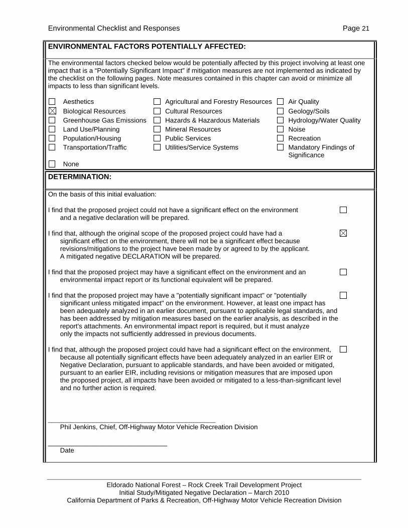
ENVIRONMENTAL FACTORS POTENTIALLY AFFECTED:
The environmental factors checked below would be potentially affected by this project involving at least one impact that is a “Potentially Significant Impact” if mitigation measures are not implemented as indicated by the checklist on the following pages. Note measures contained in this chapter can avoid or minimize all impacts to less than significant levels.
Aesthetics Agricultural and Forestry Resources Air Quality Biological Resources Cultural Resources Geology/Soils Greenhouse Gas Emissions Hazards & Hazardous Materials Hydrology/Water Quality Land Use/Planning Mineral Resources Noise Population/Housing Public Services Recreation Transportation/Traffic Utilities/Service Systems Mandatory Findings of
Significance None
DETERMINATION:
On the basis of this initial evaluation:
I find that the proposed project could not have a significant effect on the environment and a negative declaration will be prepared.
I find that, although the original scope of the proposed project could have had a significant effect on the environment, there will not be a significant effect because revisions/mitigations to the project have been made by or agreed to by the applicant. A mitigated negative DECLARATION will be prepared.
I find that the proposed project may have a significant effect on the environment and an environmental impact report or its functional equivalent will be prepared.
I find that the proposed project may have a "potentially significant impact" or "potentially significant unless mitigated impact" on the environment. However, at least one impact has been adequately analyzed in an earlier document, pursuant to applicable legal standards, and has been addressed by mitigation measures based on the earlier analysis, as described in the report's attachments. An environmental impact report is required, but it must analyze only the impacts not sufficiently addressed in previous documents.
I find that, although the proposed project could have had a significant effect on the environment, because all potentially significant effects have been adequately analyzed in an earlier EIR or Negative Declaration, pursuant to applicable standards, and have been avoided or mitigated, pursuant to an earlier EIR, including revisions or mitigation measures that are imposed upon the proposed project, all impacts have been avoided or mitigated to a less-than-significant level and no further action is required.
_____________________________________________ Phil Jenkins, Chief, Off-Highway Motor Vehicle Recreation Division
________________________________ Date
Environmental Checklist and Responses Page 22
Eldorado National Forest – Rock Creek Trail Development Project Initial Study/Mitigated Negative Declaration – March 2010
California Department of Parks & Recreation, Off-Highway Motor Vehicle Recreation Division
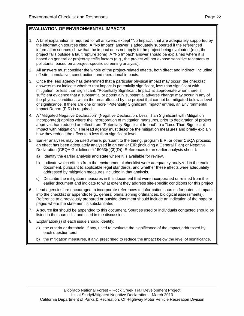
EVALUATION OF ENVIRONMENTAL IMPACTS
1. A brief explanation is required for all answers, except "No Impact", that are adequately supported by the information sources cited. A "No Impact" answer is adequately supported if the referenced information sources show that the impact does not apply to the project being evaluated (e.g., the project falls outside a fault rupture zone). A "No Impact" answer should be explained where it is based on general or project-specific factors (e.g., the project will not expose sensitive receptors to pollutants, based on a project-specific screening analysis).
2. All answers must consider the whole of the project-related effects, both direct and indirect, including off-site, cumulative, construction, and operational impacts.
3. Once the lead agency has determined that a particular physical impact may occur, the checklist answers must indicate whether that impact is potentially significant, less than significant with mitigation, or less than significant. "Potentially Significant Impact" is appropriate when there is sufficient evidence that a substantial or potentially substantial adverse change may occur in any of the physical conditions within the area affected by the project that cannot be mitigated below a level of significance. If there are one or more "Potentially Significant Impact" entries, an Environmental Impact Report (EIR) is required.
4. A "Mitigated Negative Declaration" (Negative Declaration: Less Than Significant with Mitigation Incorporated) applies where the incorporation of mitigation measures, prior to declaration of project approval, has reduced an effect from "Potentially Significant Impact" to a "Less Than Significant Impact with Mitigation." The lead agency must describe the mitigation measures and briefly explain how they reduce the effect to a less than significant level.
5. Earlier analyses may be used where, pursuant to the tiering, program EIR, or other CEQA process, an effect has been adequately analyzed in an earlier EIR (including a General Plan) or Negative Declaration (CEQA Guidelines § 15063(c)(3)(D)). References to an earlier analysis should: a) Identify the earlier analysis and state where it is available for review. b) Indicate which effects from the environmental checklist were adequately analyzed in the earlier
document, pursuant to applicable legal standards, and whether these effects were adequately addressed by mitigation measures included in that analysis.
c) Describe the mitigation measures in this document that were incorporated or refined from the earlier document and indicate to what extent they address site-specific conditions for this project.
6. Lead agencies are encouraged to incorporate references to information sources for potential impacts into the checklist or appendix (e.g., general plans, zoning ordinances, biological assessments). Reference to a previously prepared or outside document should include an indication of the page or pages where the statement is substantiated.
7. A source list should be appended to this document. Sources used or individuals contacted should be listed in the source list and cited in the discussion.
8. Explanation(s) of each issue should identify: a) the criteria or threshold, if any, used to evaluate the significance of the impact addressed by
each question and b) the mitigation measures, if any, prescribed to reduce the impact below the level of significance.
Environmental Checklist and Responses Page 23
Eldorado National Forest – Rock Creek Trail Development Project Initial Study/Mitigated Negative Declaration – March 2010
California Department of Parks & Recreation, Off-Highway Motor Vehicle Recreation Division
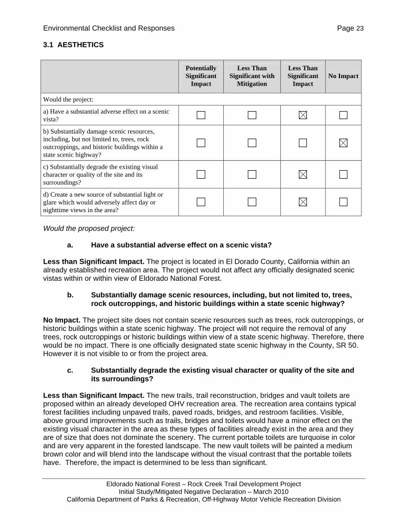
3.1 AESTHETICS
Would the proposed project:
a. Have a substantial adverse effect on a scenic vista?
Less than Significant Impact. The project is located in El Dorado County, California within an already established recreation area. The project would not affect any officially designated scenic vistas within or within view of Eldorado National Forest.
b. Substantially damage scenic resources, including, but not limited to, trees, rock outcroppings, and historic buildings within a state scenic highway?
No Impact. The project site does not contain scenic resources such as trees, rock outcroppings, or historic buildings within a state scenic highway. The project will not require the removal of any trees, rock outcroppings or historic buildings within view of a state scenic highway. Therefore, there would be no impact. There is one officially designated state scenic highway in the County, SR 50. However it is not visible to or from the project area.
c. Substantially degrade the existing visual character or quality of the site and its surroundings?
Less than Significant Impact. The new trails, trail reconstruction, bridges and vault toilets are proposed within an already developed OHV recreation area. The recreation area contains typical forest facilities including unpaved trails, paved roads, bridges, and restroom facilities. Visible, above ground improvements such as trails, bridges and toilets would have a minor effect on the existing visual character in the area as these types of facilities already exist in the area and they are of size that does not dominate the scenery. The current portable toilets are turquoise in color and are very apparent in the forested landscape. The new vault toilets will be painted a medium brown color and will blend into the landscape without the visual contrast that the portable toilets have. Therefore, the impact is determined to be less than significant.
Potentially Significant
Impact
Less Than Significant with
Mitigation
Less Than Significant
Impact No Impact
Would the project:
a) Have a substantial adverse effect on a scenic vista?
b) Substantially damage scenic resources, including, but not limited to, trees, rock outcroppings, and historic buildings within a state scenic highway?
c) Substantially degrade the existing visual character or quality of the site and its surroundings?
d) Create a new source of substantial light or glare which would adversely affect day or nighttime views in the area?

Environmental Checklist and Responses Page 24
Eldorado National Forest – Rock Creek Trail Development Project Initial Study/Mitigated Negative Declaration – March 2010
California Department of Parks & Recreation, Off-Highway Motor Vehicle Recreation Division
d. Create a new source of substantial light or glare which would adversely affect day or nighttime views in the area?
No Impact. The project would not create a new source of substantial light or glare affecting day or nighttime views in the area as no exterior lighting is proposed for any of the facilities.
Environmental Checklist and Responses Page 25
Eldorado National Forest – Rock Creek Trail Development Project Initial Study/Mitigated Negative Declaration – March 2010
California Department of Parks & Recreation, Off-Highway Motor Vehicle Recreation Division
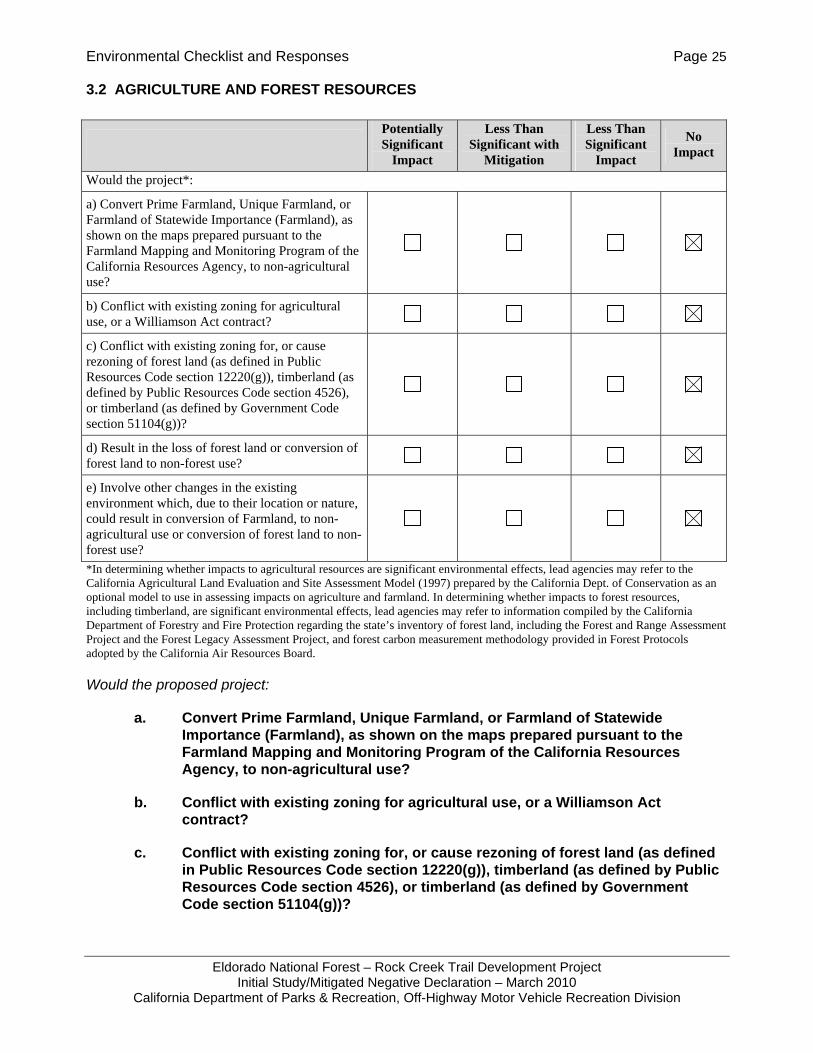
3.2 AGRICULTURE AND FOREST RESOURCES
*In determining whether impacts to agricultural resources are significant environmental effects, lead agencies may refer to the California Agricultural Land Evaluation and Site Assessment Model (1997) prepared by the California Dept. of Conservation as an optional model to use in assessing impacts on agriculture and farmland. In determining whether impacts to forest resources, including timberland, are significant environmental effects, lead agencies may refer to information compiled by the California Department of Forestry and Fire Protection regarding the state’s inventory of forest land, including the Forest and Range Assessment Project and the Forest Legacy Assessment Project, and forest carbon measurement methodology provided in Forest Protocols adopted by the California Air Resources Board.
Would the proposed project:
a. Convert Prime Farmland, Unique Farmland, or Farmland of Statewide Importance (Farmland), as shown on the maps prepared pursuant to the Farmland Mapping and Monitoring Program of the California Resources Agency, to non-agricultural use?
b. Conflict with existing zoning for agricultural use, or a Williamson Act contract?
c. Conflict with existing zoning for, or cause rezoning of forest land (as defined in Public Resources Code section 12220(g)), timberland (as defined by Public Resources Code section 4526), or timberland (as defined by Government Code section 51104(g))?
Potentially Significant
Impact
Less Than Significant with
Mitigation
Less Than Significant
Impact
No Impact
Would the project*:
a) Convert Prime Farmland, Unique Farmland, or Farmland of Statewide Importance (Farmland), as shown on the maps prepared pursuant to the Farmland Mapping and Monitoring Program of the California Resources Agency, to non-agricultural use?
b) Conflict with existing zoning for agricultural use, or a Williamson Act contract?
c) Conflict with existing zoning for, or cause rezoning of forest land (as defined in Public Resources Code section 12220(g)), timberland (as defined by Public Resources Code section 4526), or timberland (as defined by Government Code section 51104(g))?
d) Result in the loss of forest land or conversion of forest land to non-forest use?
e) Involve other changes in the existing environment which, due to their location or nature, could result in conversion of Farmland, to non-agricultural use or conversion of forest land to non-forest use?

Environmental Checklist and Responses Page 26
Eldorado National Forest – Rock Creek Trail Development Project Initial Study/Mitigated Negative Declaration – March 2010
California Department of Parks & Recreation, Off-Highway Motor Vehicle Recreation Division
d. Result in the loss of forest land or conversion of forest land to non-forest use?
e. Involve other changes in the existing environment which, due to their location or nature, could result in conversion of Farmland, to non-agricultural use or conversion of forest land to non-forest use?
No Impact. (Responses a-e) The project area is located within an existing OHV recreation area within a national forest. No farmland exists on the proposed project site. The entire project site is considered timberland; however, the project does not conflict with the timberland zoning. Trail use is considered a forest use; therefore, there would be no loss of forest land or conversion of forest land to non forest use. The project would not cause the rezoning of forest or timberland.

Environmental Checklist and Responses Page 27
Eldorado National Forest – Rock Creek Trail Development Project Initial Study/Mitigated Negative Declaration – March 2010
California Department of Parks & Recreation, Off-Highway Motor Vehicle Recreation Division
3.3 AIR QUALITY
Would the proposed project:
a. Conflict with or obstruct implementation of the applicable air quality plan?
Less than Significant Impact. The project would result in temporary emissions during construction. However, the proposed project would not contribute to urban growth or introduce new sources of air pollutants into the air basin. The applicable air quality plan in effect for El Dorado County is the Sacramento Regional 8-hour Ozone Attainment and Reasonable Further Progress Plan (Sacramento Metropolitan Air Quality Management District 2008). The project would not obstruct or conflict with implementation of this plan.
b. Violate any air quality standard or contribute substantially to an existing or projected air quality violation?
Less than Significant Impact. The project would result in temporary emissions for the duration of construction. However, the project does not involve new land uses and would not contribute to urban growth or introduce new permanent sources of air emissions into the air basin.
c. Result in a cumulatively considerable net increase of any criteria pollutant for which the project region is non-attainment under an applicable federal or state ambient air quality standard (including releasing emissions which exceed quantitative thresholds for ozone precursors)?
Less than Significant Impact. The County is a State non-attainment area for PM10 (particulate matter) and ozone. The County is either unclassified or in attainment for all National Ambient Air Quality Standards and other State Standards.
Potentially Significant
Impact
Less Than Significant with
Mitigation
Less Than Significant
Impact
No Impact
Would the project:
a) Conflict with or obstruct implementation of the applicable air quality plan?
b) Violate any air quality standard or contribute substantially to an existing or projected air quality violation?
c) Result in a cumulatively considerable net increase of any criteria pollutant for which the project region is non-attainment under an applicable federal or state ambient air quality standard (including releasing emissions which exceed quantitative thresholds for ozone precursors)?
d) Expose sensitive receptors to substantial pollutant concentrations?
e) Create objectionable odors affecting a substantial number of people?
Environmental Checklist and Responses Page 28
Eldorado National Forest – Rock Creek Trail Development Project Initial Study/Mitigated Negative Declaration – March 2010
California Department of Parks & Recreation, Off-Highway Motor Vehicle Recreation Division
The project does not involve new land uses and would not contribute to urban growth or introduce new sources of air emissions into the air basin. Exhaust from construction vehicles and grading would result in temporary air pollutant emissions. The screening threshold for combustion activities during construction is 337 gallons average daily fuel use per quarter (El Dorado County APCD 2002). Bobcat-type excavators have a tank capacity of 14 gallons (USDA 1996). Assuming a worst case scenario that construction would occur on all 11 trail segments simultaneously (11 bobcats in use each day) and consume an average of 1 tank of diesel per day; the daily fuel usage of 154 gallons falls well below the threshold. The temporary nature of the impacts does not result in a cumulatively considerable net increase in PM10 or ozone precursors.
d. Expose sensitive receptors to substantial pollutant concentrations?
Less than Significant Impact. The closest sensitive receptors to the Rock Creek Area would be visitors staying in the area campgrounds or residences on private property, which occurs interspersed within the Forest. There are no other sensitive receptors within one-quarter mile of any trail construction proposed (J. Jue., pers. comm., 2009). Temporary emissions from construction vehicles and dust would occur during the construction period. Proper trail construction occurs while soils contain an optimal moisture content and not during dry conditions when soils are prone to wind erosion or excessive dust. In addition, the project does not occur in an area with known naturally occurring asbestos therefore there would be no impact to people or workers from naturally occurring asbestos.
e. Create objectionable odors affecting a substantial number of people?
Less than Significant Impact. The activities associated with the construction and reconstruction of trails and installation of bridges and vault toilets in the Rock Creek Trails Area would not result in the creation of objectionable odors affecting a substantial number of people. Portable toilets already exist or previously existed at the proposed vault toilet sites. Therefore, the impact is considered less than significant.
Environmental Checklist and Responses Page 29
Eldorado National Forest – Rock Creek Trail Development Project Initial Study/Mitigated Negative Declaration – March 2010
California Department of Parks & Recreation, Off-Highway Motor Vehicle Recreation Division
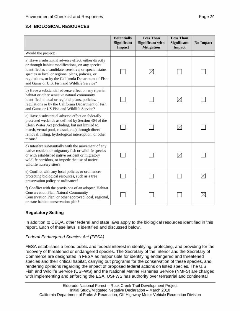
3.4 BIOLOGICAL RESOURCES
Regulatory Setting
In addition to CEQA, other federal and state laws apply to the biological resources identified in this report. Each of these laws is identified and discussed below.
Federal Endangered Species Act (FESA)
FESA establishes a broad public and federal interest in identifying, protecting, and providing for the recovery of threatened or endangered species. The Secretary of the Interior and the Secretary of Commerce are designated in FESA as responsible for identifying endangered and threatened species and their critical habitat, carrying out programs for the conservation of these species, and rendering opinions regarding the impact of proposed federal actions on listed species. The U.S. Fish and Wildlife Service (USFWS) and the National Marine Fisheries Service (NMFS) are charged with implementing and enforcing the ESA. USFWS has authority over terrestrial and continental
Potentially Significant
Impact
Less Than Significant with
Mitigation
Less Than Significant
Impact No Impact
Would the project:
a) Have a substantial adverse effect, either directly or through habitat modifications, on any species identified as a candidate, sensitive, or special status species in local or regional plans, policies, or regulations, or by the California Department of Fish and Game or U.S. Fish and Wildlife Service?
b) Have a substantial adverse effect on any riparian habitat or other sensitive natural community identified in local or regional plans, policies, regulations or by the California Department of Fish and Game or US Fish and Wildlife Service?
c) Have a substantial adverse effect on federally protected wetlands as defined by Section 404 of the Clean Water Act (including, but not limited to, marsh, vernal pool, coastal, etc.) through direct removal, filling, hydrological interruption, or other means?
d) Interfere substantially with the movement of any native resident or migratory fish or wildlife species or with established native resident or migratory wildlife corridors, or impede the use of native wildlife nursery sites?
e) Conflict with any local policies or ordinances protecting biological resources, such as a tree preservation policy or ordinance?
f) Conflict with the provisions of an adopted Habitat Conservation Plan, Natural Community Conservation Plan, or other approved local, regional, or state habitat conservation plan?
Environmental Checklist and Responses Page 30
Eldorado National Forest – Rock Creek Trail Development Project Initial Study/Mitigated Negative Declaration – March 2010
California Department of Parks & Recreation, Off-Highway Motor Vehicle Recreation Division
aquatic species, and NMFS has authority to over species that spend all or part of their life cycle at sea, such as salmonids.
Section 9 of FESA prohibits the unlawful “take” of any listed fish or wildlife species. Take, as defined by FESA, means “to harass, harm, pursue, hunt, shoot, wound, kill, trap, capture, or collect, or to attempt to engage in any such action.” The USFWS’s regulations define harm to mean “an act which actually kills or injures wildlife.” Such an act “may include “significant habitat modification or degradation where it actually kills or injures wildlife by significantly impairing essential behavioral patterns, including breeding, feeding or sheltering” (50 CFR § 17.3). Take can be permitted under FESA under sections 7 and 10. Section 7 provides a process for take permits for federal projects or projects subject to a federal permit.
The Migratory Bird Treaty Act of 1918 (MBTA)
Under the MBTA, it is unlawful to “pursue, hunt, take, capture or kill; attempt to take, capture or kill; possess, offer to or sell, barter, purchase, deliver or cause to be shipped, exported, imported, transported, carried or received any migratory bird, part, nest, egg or product, manufactured or not.” In short, under the MBTA it is illegal to disturb a nest that is in active use, since this could result in killing a bird or destroying an egg. The USFWS oversees implementation of the MBTA.
The Clean Water Act of 1972 (Section 404)
The United States does not have a federal, comprehensive law protecting wetlands. However, through the regulation of activities in “waters of the United States,” the Clean Water Act is the main federal law used to protect wetlands. Section 404 of the Clean Water Act regulates the discharge of dredged or fill material into “waters of the United States,” which includes traditional navigable waters, interstate waters, certain tributaries of any of these waters, and wetlands that meet these criteria or that are adjacent to any of these waters. In 1987, the USACE published a manual for the delineation of wetlands that are regulated by Section 404 and generally defined wetlands as requiring the following three characteristics: hydrology, hydric soils, and hydrophytes (plants adapted to living in saturated soils).
The USACE also regulates activities in waters of the United States under the federal Rivers and Harbors Act. Section 10 of the Rivers and Harbors Act requires permits for any work or structures in navigable waters of the United States, including wetlands within or adjacent to these waters. Both dredging and filling are regulated activities under the Act. Navigable waters are defined as those waters that are subject to the ebb and flow of the tide, or that are presently have been, or may be used for transport of interstate or foreign commerce.
USFWS Wetland Definition
In 1979 the USFWS adopted the wetland classification developed by Cowardin et al. In this classification system, wetlands are defined as lands that are transitional between terrestrial and aquatic systems where the water table is usually at or near the surface or the land is covered by shallow water, and that have one or more of the following attributes:
At least periodically, the land supports predominantly hydrophytes; the substrate is predominantly undrained hydric soil; and, the substrate is non-soil and is saturated with water or covered by shallow water at some time during the growing season of each year.
Environmental Checklist and Responses Page 31
Eldorado National Forest – Rock Creek Trail Development Project Initial Study/Mitigated Negative Declaration – March 2010
California Department of Parks & Recreation, Off-Highway Motor Vehicle Recreation Division
This differs slightly from the USACE definition. The USACE definition requires all three wetlands attributes (hydrology, hydrophytes, and hydric soils) to be present, where the USFWS definition does not.
California Endangered Species Act (CESA)
Provisions of CESA protect state-listed threatened and endangered species. The Fish and Game Commission is charged with establishing a list of endangered and threatened species. The California Department of Fish and Game (CDFG) regulates activities that may result in “take” of individuals (i.e., “hunt, pursue, catch, capture, or kill, or attempt to hunt, pursue, catch, capture, or kill”). Habitat degradation or modification is not expressly included in the definition of “take” under the California Fish and Game Code, but CDFG has interpreted “take” to include the killing of a member of a species which is the proximate result of habitat modification.
Fish and Game Code Section 1602
Section 1602 requires an entity to notify CDFG of any proposed activity that may substantially divert or obstruct the natural flow of, or substantially change or use any material from the bed, channel, or bank of, any river, stream, or lake, or deposit or dispose of debris, waste, or other material containing pavement where it may pass into any stream, river, or lake. CDFG uses the USFWS definition of wetlands when regulating these activities. Although 1602 permits are generally not applicable to federal projects on federal land, its provisions can provide a reference for determining the significance of impacts.
Fish and Game Code Section 3503 and 3503.5
Pursuant to Fish and Game Code section 3503, it is unlawful to “take, possess, or needlessly destroy the nest or eggs of any bird, except as otherwise provided by this code or any regulation made pursuant thereto.” Section 3503.5 provides similar protection specifically to raptors and their nests. CDFG typically recommends surveys for nesting birds that could potentially be directly (actual removal of trees/vegetation) or indirectly (noise disturbance) impacted by project-related activities. Disturbance during the breeding season could result in the incidental loss of fertile eggs or nestlings, or otherwise lead to nest abandonment. Disturbance that causes nest abandonment and/or loss of reproductive effort is considered “taking” by the CDFG.
Fish and Game Code Section 4150
Pursuant to Fish and Game Code section 4150, “[a]ll mammals occurring naturally in California which are not game mammals, fully protected mammals, or fur-bearing mammals, are nongame mammals. Nongame mammals or parts thereof may not be taken or possessed except as provided in this code or in accordance with regulations adopted by the commission.”
Environmental Setting
The Rock Creek Recreation Area consists of mostly motorcycle trails with some ATV, bicycle, and hiking trails.
Aquatic Habitat – Rock Creek was surveyed for fish and their habitat several times between 1973 and 1993 (USDA 1999). All age classes of both rainbow trout and brown trout were observed throughout the stream. Sacramento suckers were observed in the lower portion of the stream in moderate to high numbers during the 1989-1990 survey.
Environmental Checklist and Responses Page 32
Eldorado National Forest – Rock Creek Trail Development Project Initial Study/Mitigated Negative Declaration – March 2010
California Department of Parks & Recreation, Off-Highway Motor Vehicle Recreation Division
Trout have been observed in all of the named tributaries. However, trout densities in the tributaries are lower than in the mainstem, with Canyon Creek having the highest density of the tributary streams. Generally, trout populations in the Rock Creek tributary streams are probably limited by low summer flows, low availability of spawning gravel, and low proportion of pools of sufficient depth (USDA 1999).
A survey for amphibians and western pond turtles was conducted along approximately 6 miles of Rock Creek upstream of the lower Rock Creek crossing (Trail 23-25) in 1994. Pacific chorus frog tadpoles were the only amphibians seen. Sixteen western aquatic garter snakes were also seen throughout the surveyed reach. A bullfrog was observed in the upper portion of Rock Creek above the Rock Creek Road Crossing in 1991. One adult California red-legged frog (CRLF) was observed in 2009 in the headwaters of Little Silver Creek. A population exists as well in the Bear Creek watershed, where one sub-adult and many adults were observed.
A western pond turtle had been sighted in 2002 along Rock Creek Road (Section 3) and was released into Rock Creek. Another was sighted in 1996 in Rock Creek just downstream from the confluence with Harricks Ravine Creek and One Eye Trail (Section 4). One was sighted in 1991 on Whaler Creek just upstream from Rock Creek Road (Section 24). There have been a few sightings of western pond turtles at Raccoon Ponds (T12N, R11E, Section 33), which drain into an unnamed tributary of Rock Creek. These ponds are more than 1,000 feet from Fools Gold 2010-2012 route. Western pond turtles have also been sighted in Bear Creek and Traverse Creek, both more than 1.25 miles from the nearest Enduro route.
No foothill yellow-legged frog sightings have been confirmed in the Rock Creek area.
Vegetation – The Rock Creek Area contains a variety of vegetation communities that support an extremely diverse flora. Management activities (including timber harvest, mining and recreation) and documented catastrophic fires dating back to the late 1800s have affected more than 90 percent of the area. These events have left a mosaic of plant communities that can be generally described as coniferous forest, montane hardwood, chaparral fields, and riparian habitats.
The diversity of vegetation within the Rock Creek Recreation Area is in large part due to soil type and development. Soils in the area are derived from schist, slate, intrusive igneous, and rarely, gabbro or other ultramafic (high magnesium, low calcium) parent material. These soils types are classified as maymen and mariposa soil series and associations. Maymen soils are thin and low in available plant nutrients, typically supporting live oak, chaparral and forb/grass communities. Mariposa soils are from a fine-loamy, mixed, mesic family, are well-drained, and generally support mixed coniferous forest and shrub vegetation with ponderosa pine, sugar pine, manzanita and poison oak dominating. Four special-status1 plant species were identified as having potential to
1 “Special-status species” generally refers to “special animals” and “special plants” that CDFG tracks via its California Natural Diversity Database, regardless of the species’ legal or protection status. CDFG considers the taxa on this list to be those of greatest conservation need. The species on this list generally fall into one or more of the following categories: • Officially listed or proposed for listing under the State and/or Federal Endangered Species Acts. • State or federal candidate for possible listing. • Taxa which meet the criteria for listing, even if not currently included on any list, as described in CEQA Guidelines section 15380. • Taxa designated by CDFG as a Species of Special Concern (SSC). • Taxa that are biologically rare, very restricted in distribution, declining throughout their range, or have a critical, vulnerable stage in
their life cycle that warrants monitoring. • Populations in California that may be on the periphery of a taxon’s range, but are threatened with extirpation in California. • Taxa closely associated with a habitat that is declining in California at an alarming rate (e.g., wetlands, riparian, old growth forests,
desert aquatic systems, native grasslands, vernal pools, etc.). • Taxa designated as a special status, sensitive, or declining species by other state or federal agencies or non-governmental
organizations.

Environmental Checklist and Responses Page 33
Eldorado National Forest – Rock Creek Trail Development Project Initial Study/Mitigated Negative Declaration – March 2010
California Department of Parks & Recreation, Off-Highway Motor Vehicle Recreation Division
occur within the Rock Creek Recreation Area: Pleasant Valley mariposa lily (Calochortus clavatus var. avius), El Dorado manzanita (Arctostaphylos nissenana; USDA 2003d), Red Hills soaproot (Chlorogalum grandiflorum), and Parry’s horkelia (Horkelia parryi). Pleasant Valley mariposa lily and El Dorado manzanita are USFS Region 5 sensitive species, Federal species of special concern, and California Native Plant Society (CNPS) 1B.2 listed plants (CDFG 2009). Parry’s horkelia is a CNPS 1B.2 and a USFS Region 5 sensitive species and Red Hills soaproot is a CNPS 1B.2 species. CNPS 1B.2 species are defined as “fairly endangered in California” (CNPS 2009).
Pleasant Valley mariposa lily occurs on lower montane coniferous forests with Josephine silt loam and volcanic-derived soils. The Pleasant Valley mariposa is found in naturally occurring openings and slopes and ridges with southerly aspects with rocky/cobbly soil (USDA 2004c). Within the Rock Creek Recreation Area, Pleasant Valley mariposa lily habitat is found primarily along the ridge tops where most of the trails are found. Although plant surveys found potential habitat for the Pleasant Valley mariposa lily within the project area, no individual plants were found in the vicinity of construction re-route paths (USDA 1999).
El Dorado manzanita grows in almost pure colonies on hard, shallow shale soils often associated with closed-cone conifer forests. Eight known populations of the El Dorado manzanita occur within El Dorado County, five of which occur within the Eldorado National Forest Georgetown Ranger District (Walker and Taylor 2003). These five occurrences are on Poho Ridge, Cock Robin Point, Slab Creek Ridge, Buckeye Point, and Slate Mountain (Walker and Taylor 2003).
The following table shows documented sensitive plant occurrences within the vicinity of the routes where the project would occur:
Special-status Plant Trail Comments/location Arctostaphylos nissenana East end 018 Trail Approx. 0.15 mile (~750 ft) to south, south of Mosquito
Rd Arctostaphylos nissenana West end 019 Trail Approx. one-third mile to the southwest, two-thirds mile
to S, south of Mosquito Rd
Horkelia parryi 019 and east end of 018 Approx. 0.6 mile to south, south of Mosquito Rd
Horkelia parryi 013 Trail On 11E31, approx. 500 ft southeast of the 013 Trail; T12N R11E Sec 26 NE¼ of SE¼
Horkelia parryi 23-25 Ranges from approx. two-thirds to three-quarters mile from Lower Rock Creek Bridge from southwest to south to southeast to east
Taxus brevifolia1 030 Trail On Rock Creek Rd (12N70) immediately south of 030 Trail, addressed in ARRA Slate Creek road project
1 Pacific yew is a watchlist plant species on the Eldorado National Forest and should be considered a special-status plant in CEQA documents although it does not have status with CDFG or CNPS. Known high priority weeds include: the Rush skeletonweed infestation located south of 030 Trail, at 12N70 road near bridge over Slate Creek and the Scotch broom infestation located on the 11E17 Trail at the junction of 11E17 (east end) at Rock Creek Road.
Red Hills soaproot is known to occur in cismontane woodland, chapparal, and lower montane coniferous forests, frequently, though not exclusively, on serpentine or gabbro soils. Red Hills soaproot is often found in historically disturbed areas. In the vicinity of Eldorado National Forest, the species is known to occur in open sites with little to no leaf litter or duff, such as in transmission
Environmental Checklist and Responses Page 34
Eldorado National Forest – Rock Creek Trail Development Project Initial Study/Mitigated Negative Declaration – March 2010
California Department of Parks & Recreation, Off-Highway Motor Vehicle Recreation Division
line corridors and forest openings (S. Durham, pers. comm., 2009). No surveys were conducted to determine the presence of Red hills soaproot or Red Hills soaproot habitat within the project area.
Parry’s horkelia occurs in chaparral and cismontane woodlands, especially on Ione formation soils, between 264 and 3,420 feet (CNPS 2009). Parry’s horkelia is known to occur in the Rock Creek Recreation area, but not above 3,500 or 3,600 feet (S. Durham, pers. comm., 2009).
Wildlife – A number of special-status wildlife species are known to occur or have potential to occur within the Rock Creek Recreation Area. The following special-status species were identified as having suitable habitat within the proposed project area: valley elderberry longhorn beetle (Desmocerus californicus dimorphus), northwestern pond turtle (Clemmys marmorata marmorata), California red-legged frog (Rana draytonii), foothill yellow-legged frog (Rana boylei), California spotted owl (Strix occidentalis occidentalis), northern goshawk (Acciptor gentilis), Pacific fisher (Martes pennanti), pallid bat (Antrozous pallidus), silver-haired bat (Lasionycteris noctivagans), Yuma myotis (Myotis yumanensis), Townsend’s big eared bat (Corynorhinus townsendii), western red bat (Lasiurus blossevilli), greater western mastiff (Eumops perotis californicus), long-eared myotis (Myotis evotis), and fringed myotis (Myotis thysanodes
Valley elderberry longhorn beetles are currently listed as federally threatened despite a 2006 USFWS five-year status review recommendation to delist (USFWS 2009). Potential habitat for the valley elderberry longhorn beetle is thought to occur in the south and western portions of the Rock Creek Recreation Area (USDA 1999). Valley elderberry longhorn beetles are completely dependent upon their host plant, elderberry (Sambucus spp.; USFWS 1999). Elderberry bushes (Sambucus Mexicana) with one or more stems measuring one inch or greater at ground level are considered suitable habitat. These plants occur within Rock Creek Special Interest Area (Foster and Taylor 1996) which overlaps with Rock Creek Recreation Area.
Within the Rock Creek Recreation Area, suitable habitat exists for both California red-legged frog and foothill yellow-legged frog. California red-legged frog is federally threatened, a California species of special concern, and USFS sensitive species. Red-legged frog habitat consists of low gradient streams (< 2 percent grade), including ponds and calm backwaters within streams below 5,000 feet elevation. Breeding habitat generally requires water depth greater than 20 inches and persistence of water through the tadpole rearing season (at least through July). California red-legged frogs are known to travel long distances over land (>1.2 miles; Fellers and Kleeman 2007), particularly during winter and spring. A wet weather restriction on construction activities per BMP 2-3 of the Water Quality Management for Forest System Lands in California, Best Management Practices, (USDA, 2000) as listed in Section 2.3.5 Best Management Practices would be implemented to avoid the frog during the wet season when they are most likely to travel over land.
Foothill yellow-legged frog is a CDFG species of special concern and USFS sensitive species (CDFG 2009). Foothill yellow-legged frog habitat consists of perennial and intermittent streams with persistent pools below 6,000 feet elevation. The foothill yellow-legged frog is highly aquatic and is primarily restricted to riverine and directly adjacent riparian habitat. The closest known observation of foothill yellow-legged frog occurred in the Rubicon River approximately 2.5 miles east of the project area.
Surveys performed in 1994 and 1995 in Rock Creek found no evidence of California red-legged frog or foothill yellow-legged frog presence (USDA 1999; Fellars and Freel 1996 as cited in USDA 2003b; USDA 2002 as cited in USDA 2003b). In 2003, approximately 5 miles of potential breeding habitat for California red-legged frog (stream reaches with less than a 2% gradient) was identified in the Rock Creek watershed using GIS. Field staff visited many of these reaches and no detections of California red-legged frogs were made at the time. More recently, in 2009, crews from
Environmental Checklist and Responses Page 35
Eldorado National Forest – Rock Creek Trail Development Project Initial Study/Mitigated Negative Declaration – March 2010
California Department of Parks & Recreation, Off-Highway Motor Vehicle Recreation Division
the USFS and U. S. Geological Survey found a red-legged frog on Little Silver Creek within the Rock Creek Management Area and a sub-adult California red-legged frog on a tributary of Bear Creek, and many adults also in Bear Creek, about 2.5 kilometers southwest of the first red-legged frog in 2009 (J. Williams pers. comm. 2010).
Northwestern pond turtles, a CDFG species of special concern (CDFG 2009), have potential to occur in perennial streams throughout the Rock Creek Recreation Area. Suitable aquatic habitat generally requires slow or slack water with basking and refugia habitat. Basking habitat includes rocks, logs, or exposed banks, and refugia habitat includes logs, rocks, undercut banks, submerged vegetation, or a muddy bottom (Holland 1994). Northwestern pond turtles travel into upland areas to reach suitable nesting or over-wintering habitat. Over-wintering habitat consists of a soil, duff, or litter burrow well hidden within or under dense vegetation (Holland 1994). Nesting habitat is a usually located on an unshaded, south- or west-facing slope less than 25 degrees with soils that have a high silt/clay fraction (Holland 1994; Jennings et al. 1994). Northwestern pond turtles have been known to travel up to 500 meters (over ¼ mile) upslope for overwintering. Timing of overwintering and nesting varies by site and by season.
Minimal surveys have been conducted to determine the presence or distribution of northwestern pond turtles within the project area. Although potential habitat exists within the Rock Creek Area, the suitability of that habitat is assumed to be low due to dense forest canopy and therefore little available basking habitat. The nearest observation of a northwestern pond turtle is in the southeastern portion of the project area along Rock Creek Road (USDA 2003b). See above for other sightings.
California spotted owl is a CDFG species of special concern, a USFS sensitive species, and a USFWS bird of conservation concern. California spotted owls are known to occur and nest within the Rock Creek Trail Recreation Area (USDA 1999), as evidenced by the presence of 11 spotted owl protected activity centers (PACs; C. Funari, pers. comm., 2010). A Spotted owl Protected Activity Center (PAC) is a management area approximately 300 acres in size surrounding the actual activity center site (nest site or pair roost site). Generally, no forest treatments (thinning, fuel reduction, vegetation management) or new trails are allowed within the PACs. The spotted owl PAC #ELD0191 overlaps with the proposed project area on the 013 Trail. Since the trail is within one-quarter mile of the designated activity center within the PAC, a limited operation period (LOPs) shall be enforced on this trail as described by the best management practices (BMPs) for construction activities that are listed in Section 2.3.5.
Northern goshawk is a CDFG state species of special concern and a USFS Region 5 sensitive species (CDFG 2009). Northern goshawk habitat consists of mature, dense, conifer forests. Nesting habitat includes overstory trees greater than 24” diameter at breast height (dbh) with a canopy closure greater than 60% on gentle north- to east-facing slopes (USDA 2003b). Northern goshawk habitat is known to occur within the Rock Creek Trail Recreation Area, evidenced by the presence of three PACs (C. Funari, pers. comm., 2010). PACs for northern goshawk are 200 acres in size. However, project activities do not occur within any of these northern goshawk PACs (C. Funari, pers. comm., 2010) nor are any within a quarter mile of an activity center.
The Pacific fisher is a candidate species for federal and state listing, a CDFG species of special concern, and a USFS Region 5 sensitive species (CDFG 2009). Fisher habitat occurs in intermediate- to large-tree stages of coniferous forest and deciduous riparian habitats with a high percent of canopy closure. Fishers den in a variety of protected cavities, brush piles, logs, or under upturned trees. Hollow logs, trees, and snags are especially important. Females give birth and raise their young between February and May (Ahlborn no date). Survey efforts to confirm fisher presence in Eldorado National Forest have returned negative results (USDA 2003b). The potential
Environmental Checklist and Responses Page 36
Eldorado National Forest – Rock Creek Trail Development Project Initial Study/Mitigated Negative Declaration – March 2010
California Department of Parks & Recreation, Off-Highway Motor Vehicle Recreation Division
for Pacific fisher presence is low considering the majority of the Rock Creek project area provides low quality habitat due to higher road densities, past vegetative disturbance, and proximity to residences (USDA 2003b).
As listed above, eight sensitive bat species have potential to occur within the project area. Townsend’s big-eared bats and western red bats are CDFG species of special concern, USFS sensitive, and Western Bat Working Group (WBWG) high-priority species. Pallid bats are a CDFG species of concern, a USFS Region 5 sensitive species, and a WBWG high-priority species (CDFG 2009). The silver-haired bat is a WBWG is medium priority species and Yuma myotis is a WBWG low-medium priority species. Western mastiff bat is a CDFG species of concern and a WBWG high priority species. Long-eared myotis is a WBWG medium priority species, and fringed myotis is a WBWG high priority species.
Townsend’s big eared bats require caves, mines, tunnels, and buildings for roosting. Western red bats roost in trees, often in edge habitat adjacent to streams, fields, or urban areas. Pallid bats are known to roost in buildings, caves, or rock crevices. Silver-haired bats typically roost in small tree hollows, beneath exfoliating bark, in wood piles, and in cliff faces. Yuma myotis and fringed myotis roost in buildings, caves, rock crevices, or under bridges. Long-eared myotis roost in buildings, crevices, spaces under bark, and snags. Western mastiff bats primarily roost in crevices in vertical cliffs, usually granite or consolidated sandstone, and in broken terrain with exposed rock faces.
All of the above-mentioned bat species have potential to create maternity roosts within the project area. The nursery season for these bat species, when a maternity roost has potential to be present, varies by species but generally occurs between March and September.
Discussion
Would the proposed project:
a. Have a substantial adverse effect, either directly or through habitat modifications, on any species identified as a candidate, sensitive, or special status species in local or regional plans, policies, or regulations, or by the California Department of Fish and Game or U.S. Fish and Wildlife Service?
Less than Significant with Mitigation. Based upon surveys done prior to 2009, habitat, and known occurrences, foothill yellow-legged frogs are presumed absent from the project area. The species would not be affected by the project. Because the areas of suitable Pacific fisher habitat would not be directly impacted or reduced by the proposed project, the potential for adverse impacts to fishers is considered less than significant (USDA 1999). The following special-status species, however, have some potential to occur within the Rock Creek Recreation Area and also have life histories that create a potential for overlapping with construction activities.
Pleasant Valley mariposa lily – Although plant surveys found potential habitat for the Pleasant Valley mariposa lily within the project area, no individual plants were found in the vicinity of construction re-route paths (USDA 1999; USDA 2003c). No direct impacts to this species are anticipated, and therefore the potential impact is considered less than significant.
El Dorado manzanita – Although proposed project site surveys conducted in July and August of 2003 found potential habitat for El Dorado manzanita at trail 9-16 (which is in the Rock Creek Recreation Area, but the 9-16 trail is not part of this project), but no plants were found at this site. It is unknown if the El Dorado manzanita occurs at the project construction sites, and take of an El
Environmental Checklist and Responses Page 37
Eldorado National Forest – Rock Creek Trail Development Project Initial Study/Mitigated Negative Declaration – March 2010
California Department of Parks & Recreation, Off-Highway Motor Vehicle Recreation Division
Dorado manzanita plant would be considered a significant impact. Implementation of Mitigation Measure BIO-1 would reduce this potential impact to a less than significant level.
Red Hills soaproot and Parry’s horkelia – No surveys have been conducted to determine the presence of Red Hills soaproot or Parry’s horkelia or their habitat for this specific project, but potentially suitable habitat is known to be present throughout the Rock Creek Recreation Area and therefore has potential to occur in or near the proposed project area (S. Durham, pers. comm., 2009). Surveys for Parry’s horkelia have been performed for several other projects in the Rock Creek Recreation Area and occurrences are documented. As CNPS 1B.2 plants, take of an individual Red Hills soaproot or Parry’s horkelia would be considered a significant impact. Implementation of Mitigation Measure BIO-1 would reduce this potential impact to a less than significant level.
Valley elderberry longhorn beetle – The direct loss of Valley elderberry longhorn beetle habitat would be a significant impact (USFWS 1999). Valley elderberry longhorn beetle habitat comprises any elderberry bush with one or more stems measuring 1.0 inch in diameter or greater at ground level that occurs at or below 3,000 feet in elevation (USFWS 1999). Clear guidelines have been set forth for the avoidance, minimization, and mitigation of impacts to the valley elderberry longhorn beetle by the USFWS (1999). These measures are briefly summarized in Mitigation Measure BIO-2 below. Implementation of Mitigation Measure BIO-2 would reduce this potential impact to a less than significant level.
Northwestern pond turtle - Trail construction activities have the potential to cause the direct loss of hibernating turtles, turtle nests, or turtles traveling between hibernation and aquatic habitat. The loss of an individual turtle or its nest would be considered a significant impact. Implementation of Mitigation Measure BIO-3 will ensure any potential impact is less than significant. Indirect impacts could occur due to reduced water quality from instream or near stream construction activities. These indirect impacts would be less than significant with implementation of Hydrology and Soils BMPs outlined in Section 2.3.5.
California spotted owl and northern goshawk – Mature trees are known to provide nesting habitat for migratory birds, especially raptors. Mature trees in older growth forests, characterized by multi-storied forests with greater than 60 to 70% canopy coverage, are the preferred habitat of California spotted owls and northern goshawks. The breeding season for these bird species is between February 15 and August 31. Although northern goshawks occur within the forest, the project activities are outside all existing northern goshawk PACs and are not expected to affect the species. No nesting habitat will be taken as a result of the Proposed Project. However, noise and ground vibration from the construction of trail reroutes has the potential to cause California spotted owls to abandon a nest. Because all nesting raptors are protected pursuant to Fish and Game Code Section 3503 and 3503.5, such impacts to nesting raptors would be considered significant. The BMP described in section 2.3.5, including an LOP as necessary, would be applied to those trail re-route sections that are within a quarter mile of owl or goshawk designated activity centers or active nest sites. This BMP would reduce any impacts to less than significant levels.
Bats – Little is known regarding the presence, distribution, and abundance of bats in Eldorado National Forest and therefore, for the purpose of this analysis, presence is assumed. Direct and/or permanent impacts to a maternity roost are considered a significant impact. Indirect and/or temporary impacts caused by construction noise are generally not considered significant, particularly in the Rock Creek Recreation Area as noise disturbance from OHV traffic is part of the existing setting. To avoid direct, significant impacts to maternity roosts, Mitigation Measure BIO-4 would be implemented for any project activities that would alter or remove potential maternity
Environmental Checklist and Responses Page 38
Eldorado National Forest – Rock Creek Trail Development Project Initial Study/Mitigated Negative Declaration – March 2010
California Department of Parks & Recreation, Off-Highway Motor Vehicle Recreation Division
roosting habitat (i.e., trees, bridges, or rock faces). Implementation of Mitigation Measure BIO-4 would reduce the potential impact to a less than significant level. California red-legged frog – One adult California red-legged frog (CRLF) was observed in 2009 in the headwaters of Little Silver Creek. A population exists as well in the Bear Creek watershed, where one sub-adult and many adults were observed. There is potential for California red-legged frog (CRLF), a Federally Threatened and California Species of Special Concern to occur at the site due to the site’s proximity to documented occurrences within the Rock Creek area. Therefore, Mitigation Measure BIO-5 is proposed. Implementation of Mitigation Measure BIO-5 would reduce the potential impact to less than significant. In addition, a wet weather restriction on construction (per BMP 2-3 of the Water Quality Management for Forest System Lands in California, Best Management Practices, (USDA, 2000as stated in Section 2.3.5 Best Management Practices would avoid potential impacts to the frog when they are most likely to be moving across land.
Mitigation Measure BIO-1: All trail construction segments will be surveyed for the presence of El Dorado manzanita, Red Hills soaproot and Parry’s horkelia during its bloom and fruiting period by a qualified botanist. If presence is determined, all efforts will be taken to avoid direct impacts. Impact avoidance includes modifying trail alignments to avoid direct impacts to plants and marking and fencing plants to avoid indirect impacts. All fenced plants will be provided a 50-foot buffer. If direct impacts are unavoidable to Parry's horkelia, a Forest Service botanist will be consulted to develop a proper mitigation strategy.
If direct impact to Red Hills soaproot is unavoidable, all efforts to successfully transplant all potentially impacted individuals to a suitable habitat will be made. In addition, on-site restoration, if possible, will replace impacted plants with suitable nursery plants at a replacement ratio of 5:1. If on-site restoration is not suitable, off-site restoration will substitute. All transplanting and restoration activities will occur under the supervision of a qualified botanist and in consultation with a CDFG botanist and Forest Service Botanist if on National Forest Service land. Transplant and restoration plans will, among other variables, consider soils, disturbance, sun exposure, and post-treatment weed control.
Mitigation Measure BIO-2: Pre-construction surveys performed by a qualified biologist for suitable habitat or beetle presence are required. All elderberry bushes with one or more stems of one-inch diameter or greater at ground level will be identified. Avoidance and minimization measures include fencing, flagging, educational signage, construction crew training, and the provision of a 100-foot buffer. Mitigation requires transplanting all elderberry bushes which meet the habitat requirements into a “conservation area.” Each elderberry bush that is destroyed or transplanted must be replaced. Replacement ratios vary between 1:1 and 8:1 (USFWS 1999). All avoidance, minimization, and mitigation measures must be overseen by a qualified biologist and strictly adhere to protocols set forth in the Conservation Guidelines for the Valley Elderberry Longhorn Beetle (USFWS 1999). Mitigation Measure BIO-3: All trail re-route sections will be assessed to determine proximity to perennial stream habitat. If a perennial stream is found to be within 1640 feet of a trail construction site, a qualified biologist will visit the site to determine the suitability of the aquatic habitat to support northwestern pond turtles. Suitable habitat will be assessed primarily by the quality of available refugia and basking habitat. If the perennial stream segment is identified as having the necessary basking and refugia habitat by a qualified biologist, follow up surveys will be required to determine presence/absence of northwestern pond turtles. Surveys must include a minimum of three days of on-the-ground surveys of the adjacent aquatic habitat. To detect the presence of adults or sub-adults, surveys must be conducted between May and August and be spaced by a minimum of 7 days.
Environmental Checklist and Responses Page 39
Eldorado National Forest – Rock Creek Trail Development Project Initial Study/Mitigated Negative Declaration – March 2010
California Department of Parks & Recreation, Off-Highway Motor Vehicle Recreation Division
If the site contains no evidence of turtle presence, no further mitigation is required. If turtles are found to be present then all construction areas within 1640 feet of that habitat must be surveyed to identify all potential upland nesting sites and over-wintering sites. Rathbun et al. (1992, as cited in Jennings et al. 1994) suggested that a 1,640-foot (500 m) buffer was necessary to protect western pond turtle nests due to the lack of information regarding nesting habits under various upland conditions. All potential upland nesting and over-wintering sites, and the corridors between these sites and aquatic habitat, will be marked and construction activities will be avoided in these areas between September 1st and May 1st, when all nests or over-wintering locations are likely to have been abandoned. Between May 1st and July 31st, a qualified biological monitor will survey the construction site daily, prior to the commencement of construction activities. The biologist will inspect all potential nesting habitat for recent nesting activity. Any identified new nests will be marked with fencing and signage and avoided until the nest hatches the following spring. Construction crews will be trained by a qualified biologist to identify northwestern pond turtles and to stop all activities and contact a qualified biologist if a turtle is found moving within or through a construction site. Construction activities must cease until the biological monitor confirms the turtle has moved out of the construction area or has protected the turtle’s over-wintering or nesting site with the appropriate fencing and signage.
Mitigation Measure BIO-4: If suitable maternity roosting habitat (i.e., trees, bridges, or rock faces) will be removed or altered during the breeding season (generally March through September) the following measures must be taken:
• A qualified biologist must survey the potential habitat (i.e., tree, bridge, rock face) to determine the presence or absence of a maternity roost.
• If a maternity roost is found to be present, the removal and/or alteration of the roost structure will be postponed until all individuals have vacated the roost.
Mitigation Measure BIO-5: Pending the outcome of a revised Biological Opinion by the USFWS, certain project sites may not warrant the following mitigation. However, for all other sites not exempted by the Biological Opinion the following shall apply:
For any work within 300-feet of a stream/riparian corridor (defined as within 300-feet from any water course) with standing or flowing water:
• Work within the stream/riparian corridor (defined as areas within 300-feet of any water course with standing or flowing water) shall be limited to the period between June 15 and October 15.
• A worker education program (an informational meeting) shall be conducted prior to the start of all construction activities for all contractors/personnel that will be working at the site. A qualified biologist trained in the identification of CRLF shall inform the workers of CRLF protection status, identification, life history, avoidance measures, and reporting procedures (who to contact) if any CRLF are found on-site. A record of attendance shall be kept by the Forest.
• Pre-construction surveys for CRLF shall be conducted within 48 hours of project implementation by a qualified biologist trained in the identification of CRLF. If any CRLF are found, no work will be conducted within 300 feet of the find until a qualified Forest Service biologist is contacted and determines how to proceed.
• Workers shall check the site at the start of each day (a morning site check, prior to the start of construction activities). If any amphibians are found, all work within 300 feet of the find will stop and a qualified Forest Service biologist shall be contacted for identification and on how to proceed.
Environmental Checklist and Responses Page 40
Eldorado National Forest – Rock Creek Trail Development Project Initial Study/Mitigated Negative Declaration – March 2010
California Department of Parks & Recreation, Off-Highway Motor Vehicle Recreation Division
• The survey methods and results shall be noted in a report or memo and submitted to the OHMVR Division within one week of the survey.
• At the end of each work day, all holes and trenches at any site within 300 feet of a CRLF find shall be covered or backfilled to avoid trapping animals overnight.
b. Have a substantial adverse effect on any riparian habitat or other sensitive natural community identified in local or regional plans, policies, regulations or by the California Department of Fish and Game or U.S. Fish and Wildlife Service?
c. Have a substantial adverse effect on federally protected wetlands as defined by Section 404 of the Clean Water Act (including, but not limited to, marsh, vernal pool, coastal, etc.) through direct removal, filling, hydrological interruption, or other means?
Less than Significant Impact. (Responses b-c). Construction would occur near and within riparian corridors and streams to install the proposed bridges. Installation of the bridge facilities does not represent a substantial adverse effect as the bridges would eliminate vehicles entering the stream areas and reduce the opportunity for OHVs to stall and leak oil or gas into the waterways. No significant amount of riparian vegetation would be removed to accommodate the bridge installations. Therefore, the impact would be less than significant.
d. Interfere substantially with the movement of any native resident or migratory fish or wildlife species or with established native resident or migratory wildlife corridors, or impede the use of native wildlife nursery sites?
Less than Significant Impact. The construction of project facilities would not prevent the movement of any migratory fish or other wildlife species. Because the sites and general area are already used by park visitors, OHVs, and automobile traffic, construction activity is very unlikely to interfere with the current use of adjacent creeks as breeding, foraging, or rearing habitat. See a., above, for a discussion on avoiding and minimizing impacts to breeding and over-wintering special-status species.
e. Conflict with any local policies or ordinances protecting biological resources, such as a tree preservation policy or ordinance?
No Impact. Local policies do not apply to this project as it occurs on federal (USFS) land. Therefore, there would be no impact.
f. Conflict with the provisions of an adopted Habitat Conservation Plan, Natural Community Conservation Plan, or other approved local, regional, or state habitat conservation plan?
No Impact. There are no Habitat Conservation Plans or Natural Community Conservation Plans in effect in the project area.
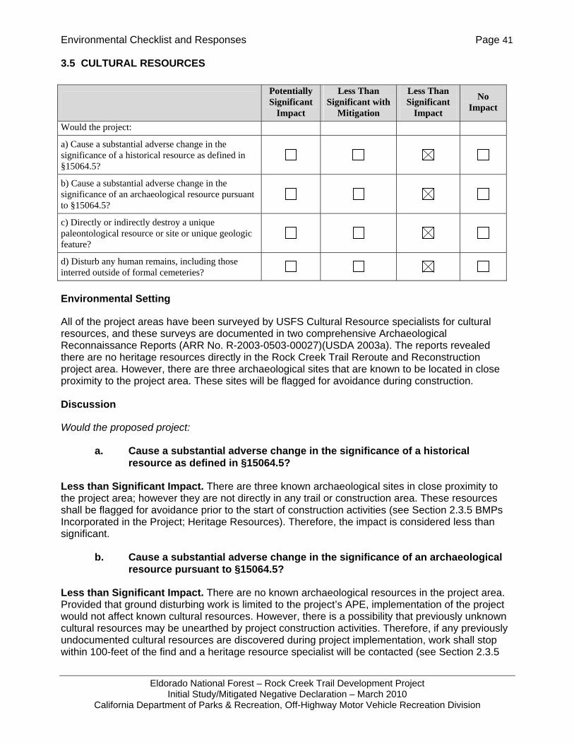
Environmental Checklist and Responses Page 41
Eldorado National Forest – Rock Creek Trail Development Project Initial Study/Mitigated Negative Declaration – March 2010
California Department of Parks & Recreation, Off-Highway Motor Vehicle Recreation Division
3.5 CULTURAL RESOURCES
Environmental Setting
All of the project areas have been surveyed by USFS Cultural Resource specialists for cultural resources, and these surveys are documented in two comprehensive Archaeological Reconnaissance Reports (ARR No. R-2003-0503-00027)(USDA 2003a). The reports revealed there are no heritage resources directly in the Rock Creek Trail Reroute and Reconstruction project area. However, there are three archaeological sites that are known to be located in close proximity to the project area. These sites will be flagged for avoidance during construction.
Discussion
Would the proposed project:
a. Cause a substantial adverse change in the significance of a historical resource as defined in §15064.5?
Less than Significant Impact. There are three known archaeological sites in close proximity to the project area; however they are not directly in any trail or construction area. These resources shall be flagged for avoidance prior to the start of construction activities (see Section 2.3.5 BMPs Incorporated in the Project; Heritage Resources). Therefore, the impact is considered less than significant.
b. Cause a substantial adverse change in the significance of an archaeological resource pursuant to §15064.5?
Less than Significant Impact. There are no known archaeological resources in the project area. Provided that ground disturbing work is limited to the project’s APE, implementation of the project would not affect known cultural resources. However, there is a possibility that previously unknown cultural resources may be unearthed by project construction activities. Therefore, if any previously undocumented cultural resources are discovered during project implementation, work shall stop within 100-feet of the find and a heritage resource specialist will be contacted (see Section 2.3.5
Potentially Significant
Impact
Less Than Significant with
Mitigation
Less Than Significant
Impact
No Impact
Would the project:
a) Cause a substantial adverse change in the significance of a historical resource as defined in §15064.5?
b) Cause a substantial adverse change in the significance of an archaeological resource pursuant to §15064.5?
c) Directly or indirectly destroy a unique paleontological resource or site or unique geologic feature?
d) Disturb any human remains, including those interred outside of formal cemeteries?
Environmental Checklist and Responses Page 42
Eldorado National Forest – Rock Creek Trail Development Project Initial Study/Mitigated Negative Declaration – March 2010
California Department of Parks & Recreation, Off-Highway Motor Vehicle Recreation Division
BMPs Incorporated in the Project; Heritage Resources). With implementation of these standard BMPs, the potential for adverse impacts to archaeological resources is less than significant.
c. Directly or indirectly destroy a unique paleontological resource or site or unique geologic feature?
Less than Significant Impact. There has been no documentation of significant paleontological resources or geological features in the project area by Forest cultural resource specialists. However, there is a chance that construction activities could uncover previously undiscovered buried paleontological resources. Therefore, if any previously undocumented paleontological resources are discovered during project implementation, work shall stop within 100-feet of the find and a heritage resource specialist will be contacted (see Section 2.3.5 BMPs Incorporated into the Project; Heritage resources). Therefore, the impact is considered less than significant.
d. Disturb any human remains, including those interred outside of formal cemeteries?
Less than Significant Impact. The archaeological surveys of the area did not reveal any known cultural resources in the project site, including human remains and any interred outside of formal cemeteries. However, there is a chance that construction activities could uncover previously undiscovered buried human remains. Therefore, if any previously undocumented human remains are encountered during project implementation, work shall stop within 100-feet of the find and a Forest heritage resource specialist and County coroner shall be contacted (see Section 2.3.5 BMPs Incorporated into the Project; Heritage Resources).
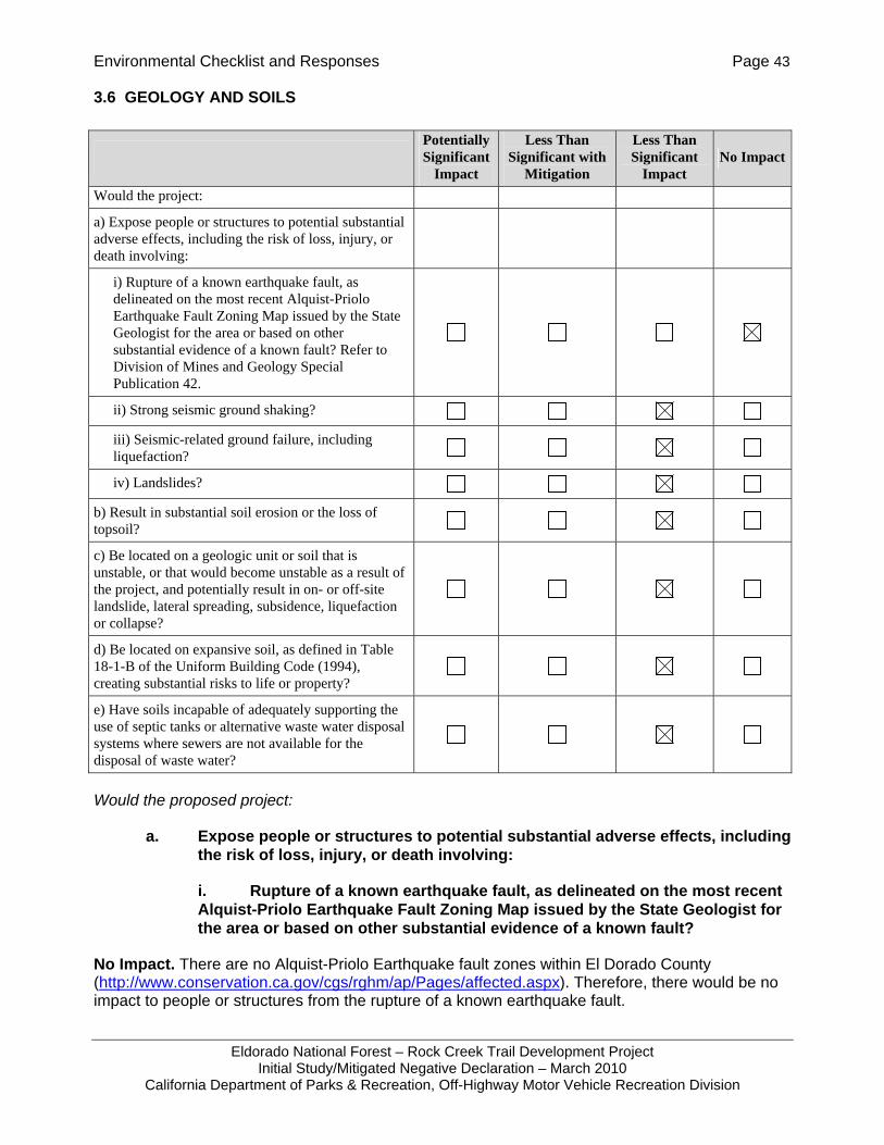
Environmental Checklist and Responses Page 43
Eldorado National Forest – Rock Creek Trail Development Project Initial Study/Mitigated Negative Declaration – March 2010
California Department of Parks & Recreation, Off-Highway Motor Vehicle Recreation Division
3.6 GEOLOGY AND SOILS
Would the proposed project:
a. Expose people or structures to potential substantial adverse effects, including the risk of loss, injury, or death involving:
i. Rupture of a known earthquake fault, as delineated on the most recent Alquist-Priolo Earthquake Fault Zoning Map issued by the State Geologist for the area or based on other substantial evidence of a known fault?
No Impact. There are no Alquist-Priolo Earthquake fault zones within El Dorado County (http://www.conservation.ca.gov/cgs/rghm/ap/Pages/affected.aspx). Therefore, there would be no impact to people or structures from the rupture of a known earthquake fault.
Potentially Significant
Impact
Less Than Significant with
Mitigation
Less Than Significant
Impact No Impact
Would the project:
a) Expose people or structures to potential substantial adverse effects, including the risk of loss, injury, or death involving:
i) Rupture of a known earthquake fault, as delineated on the most recent Alquist-Priolo Earthquake Fault Zoning Map issued by the State Geologist for the area or based on other substantial evidence of a known fault? Refer to Division of Mines and Geology Special Publication 42.
ii) Strong seismic ground shaking?
iii) Seismic-related ground failure, including liquefaction?
iv) Landslides?
b) Result in substantial soil erosion or the loss of topsoil?
c) Be located on a geologic unit or soil that is unstable, or that would become unstable as a result of the project, and potentially result in on- or off-site landslide, lateral spreading, subsidence, liquefaction or collapse?
d) Be located on expansive soil, as defined in Table 18-1-B of the Uniform Building Code (1994), creating substantial risks to life or property?
e) Have soils incapable of adequately supporting the use of septic tanks or alternative waste water disposal systems where sewers are not available for the disposal of waste water?
Environmental Checklist and Responses Page 44
Eldorado National Forest – Rock Creek Trail Development Project Initial Study/Mitigated Negative Declaration – March 2010
California Department of Parks & Recreation, Off-Highway Motor Vehicle Recreation Division
ii. Strong seismic ground shaking?
Less than Significant Impact. The project site is located in El Dorado County. “Based on historical seismic activity and fault and seismic hazards mapping, El Dorado County is considered to have relatively low potential for seismic activity” (EDAW 2003). The facilities proposed are largely trails. Bridges would be designed to current Uniform and California Building Code requirements, which would resist collapse or damage during a seismic event. Therefore, the impact is determined to be less than significant.
iii. Seismic-related ground failure, including liquefaction?
Less than Significant Impact. “No portion of El Dorado County is located in a Seismic Hazard Zone (i.e., regulatory zones that encompass areas prone to liquefaction and earthquake-induced landslides) based on the Seismic Hazards Mapping Program administered by CGS [California Geological Survey]. Therefore, El Dorado County is not considered to be at risk from liquefaction hazards” (EDAW 2003). The impact is considered less than significant.
iv. Landslides?
Less than Significant Impact. The topography at the project site varies. “Historical mapping efforts indicate that landslides can be expected to occur in the western third of the county along the Foothills Fault Zone because of the planes of weakness associated with faulting in the area, and on the eastern slope of the Sierra Nevada, west of Emerald Bay” (EDAW 2003). However, because the improvements proposed are recreational trails and related recreational facilities and not meant for human habitation or occupation, the impact is considered less than significant.
b. Result in substantial soil erosion or the loss of topsoil?
Less than Significant Impact. Many trail segments are being constructed to replace existing trail segments that are contributing to soil erosion due to steep slopes and poor design. BMPs are in place to protect disturbed areas from substantial erosion or loss of topsoil. These BMPs are from the USFS’s Water Quality Management for Forest System Lands in California, Best Management Practices, which have been incorporated into the project, include:
• 2-1 General Guidelines for Location and Design of Road (Trails)
• 2-2 Erosion Control Plan
• 2-3 Timing of Construction Activities
• 2-4 Stabilization of Road (Trail) Slope Surfaces and Spoil Disposal Areas
• 2-5 Road (Trail) Slope Stabilization Construction Practices
• 2-6 Dispersion of Subsurface Drainage from Cut and Fill Slopes
• 2-7 Control of Road (Trail) Drainage
• 2-8 Constraints Related to Pioneer Road (Trail) Construction
Environmental Checklist and Responses Page 45
Eldorado National Forest – Rock Creek Trail Development Project Initial Study/Mitigated Negative Declaration – March 2010
California Department of Parks & Recreation, Off-Highway Motor Vehicle Recreation Division
• 2-9 Time Erosion Control Measures on Incomplete Road (Trail) and Stream Crossing Projects
• 2-12 Servicing and Refueling of Equipment
• 2-13 Control of Construction and Maintenance Activities Adjacent to Stream Maintenance Zones
• 2-14 Controlling In-Channel Excavation
• 2-17 Bridge and Culvert Installation
• 2-22 Maintenance of Roads (Trail)
• 2-23 Road (Trail) Surface Treatment to Prevent Loss of Materials
• 2-24 Traffic Control during Wet Periods
• 4-9 Protection of Water Quality Within Developed and Dispersed Recreation Areas
In addition, the project also includes (see Section 2.3.5 BMPs Incorporated Into the Project; Hydrology and Soils):
• Rolling dips may be constructed with the trail machine on selected trails at intervals ranging from 50 to 300 feet depending on the trail grade and whether the trail alignment provides for adequate drainage. The outlets of rolling dips will have slash and woody debris placed to provide some filtering effect and ground cover. Where it is feasible, rolling dips would be constructed with outlets that collect and trap sediment from the tread surface. The trapped sediment would be reclaimed for use on the trail treads during maintenance activities.
• Breaks or changes in the trail grade would be built to provide for a means to drain water off the trails. The USFS would strive to use this method where the terrain allows.
• The new trail reroutes would be designed for a maximum grade of 15 percent where possible. If a grade of over 15 percent is necessary for an extended distance of over 50 feet, the trail surface will be hardened with compacted aggregate base (gravel with finer material) or an equivalent material to prevent erosion.
• Construction activities would stop before there is off-site runoff from the construction site or when the soil moisture becomes too high for construction activities. An estimated 2 to 3 days of drying time (depending on the amount of precipitation) would be needed prior to resuming trail construction activities.
• Trail construction activities would be completed during dry periods between storms.
• Cut slopes and fills created along the trails would have cover placed on them after construction activities are completed. Local vegetation and duff from clearing activities is suitable for this purpose. If sufficient ground cover material is not available from the local area, weed free straw would be used for ground cover.
Environmental Checklist and Responses Page 46
Eldorado National Forest – Rock Creek Trail Development Project Initial Study/Mitigated Negative Declaration – March 2010
California Department of Parks & Recreation, Off-Highway Motor Vehicle Recreation Division
• The newly constructed trails would be closed to all uses during the wet/rainy season.
• The trail reroutes would be built using Region 5 Trail Design Standards.
Many of the trails are being re-built to address existing erosion problems. By re-siting and rebuilding the trails with proper drainage control features, the project would have an overall benefit of reducing erosion. Therefore, the impact is considered less than significant.
c. Be located on a geologic unit or soil that is unstable, or that would become unstable as a result of the project, and potentially result in on- or off-site landslide, lateral spreading, subsidence, liquefaction or collapse?
Less then Significant Impact. The built features of the project including bridges and vault toilets have been sited and designed to avoid or minimize the impact from on-or off-site lateral spreading, subsidence, liquefaction, and collapse. Therefore, the risk from unstable soils or geologic unit is considered less than significant.
d. Be located on expansive soil, as defined in Table 18-1-B of the Uniform Building Code (1994), creating substantial risks to life or property?
Less than Significant Impact. The project is the construction or reconstruction of trails and installation of bridges and vault toilets, the construction of which would not occur in expansive soils (J. Jue, pers. comm., 2009). The bridges are being reviewed by geotechnical specialists and shall be designed according to the latest engineering codes appropriate for the area. Therefore the project would not result in significant impacts.
e. Have soils incapable of adequately supporting the use of septic tanks or alternative wastewater disposal systems where sewers are not available for the disposal of wastewater?
Less than Significant Impact. The soils at the vault toilet sites are located on stable soils that are not erosive or steep and have been determined to be able to adequately support the proposed installation of vault toilets at the Mace Mill and Bald Mountain sites (J. Jue, pers. comm., 2009). These sites are adjacent to existing OHV staging areas.
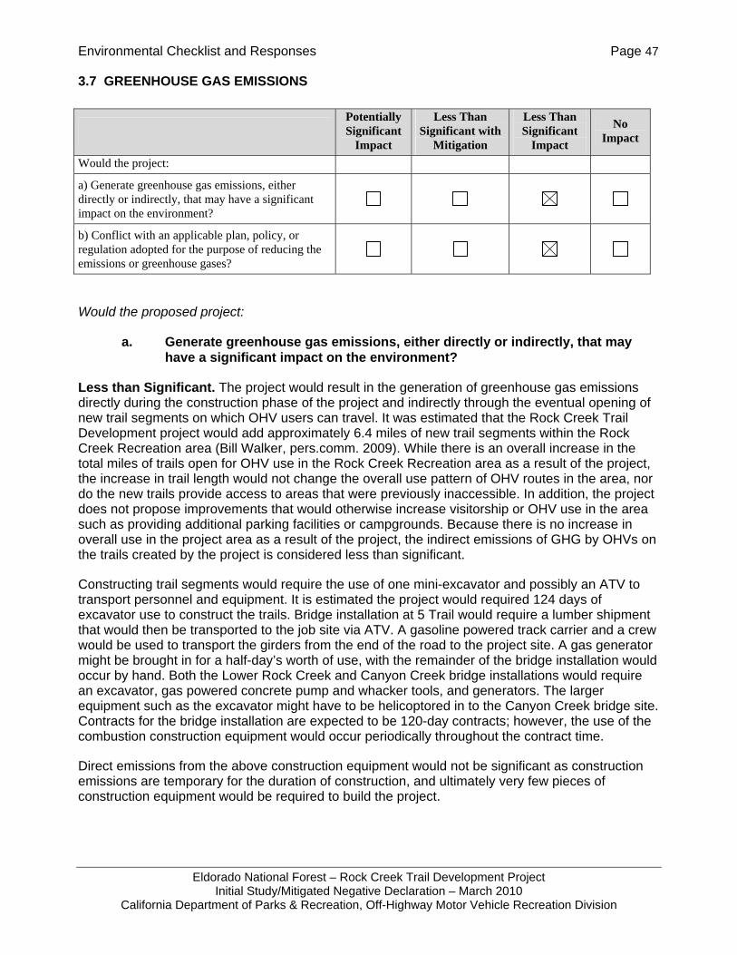
Environmental Checklist and Responses Page 47
Eldorado National Forest – Rock Creek Trail Development Project Initial Study/Mitigated Negative Declaration – March 2010
California Department of Parks & Recreation, Off-Highway Motor Vehicle Recreation Division
3.7 GREENHOUSE GAS EMISSIONS
Would the proposed project:
a. Generate greenhouse gas emissions, either directly or indirectly, that may have a significant impact on the environment?
Less than Significant. The project would result in the generation of greenhouse gas emissions directly during the construction phase of the project and indirectly through the eventual opening of new trail segments on which OHV users can travel. It was estimated that the Rock Creek Trail Development project would add approximately 6.4 miles of new trail segments within the Rock Creek Recreation area (Bill Walker, pers.comm. 2009). While there is an overall increase in the total miles of trails open for OHV use in the Rock Creek Recreation area as a result of the project, the increase in trail length would not change the overall use pattern of OHV routes in the area, nor do the new trails provide access to areas that were previously inaccessible. In addition, the project does not propose improvements that would otherwise increase visitorship or OHV use in the area such as providing additional parking facilities or campgrounds. Because there is no increase in overall use in the project area as a result of the project, the indirect emissions of GHG by OHVs on the trails created by the project is considered less than significant.
Constructing trail segments would require the use of one mini-excavator and possibly an ATV to transport personnel and equipment. It is estimated the project would required 124 days of excavator use to construct the trails. Bridge installation at 5 Trail would require a lumber shipment that would then be transported to the job site via ATV. A gasoline powered track carrier and a crew would be used to transport the girders from the end of the road to the project site. A gas generator might be brought in for a half-day’s worth of use, with the remainder of the bridge installation would occur by hand. Both the Lower Rock Creek and Canyon Creek bridge installations would require an excavator, gas powered concrete pump and whacker tools, and generators. The larger equipment such as the excavator might have to be helicoptored in to the Canyon Creek bridge site. Contracts for the bridge installation are expected to be 120-day contracts; however, the use of the combustion construction equipment would occur periodically throughout the contract time.
Direct emissions from the above construction equipment would not be significant as construction emissions are temporary for the duration of construction, and ultimately very few pieces of construction equipment would be required to build the project.
Potentially Significant
Impact
Less Than Significant with
Mitigation
Less Than Significant
Impact
No Impact
Would the project:
a) Generate greenhouse gas emissions, either directly or indirectly, that may have a significant impact on the environment?
b) Conflict with an applicable plan, policy, or regulation adopted for the purpose of reducing the emissions or greenhouse gases?
Environmental Checklist and Responses Page 48
Eldorado National Forest – Rock Creek Trail Development Project Initial Study/Mitigated Negative Declaration – March 2010
California Department of Parks & Recreation, Off-Highway Motor Vehicle Recreation Division
b. Conflict with an applicable plan, policy or regulation adopted for the purpose of reducing the emissions of greenhouse gases?
Less than Significant. The Air Resources Board’s Scoping Plan (developed per AB 32) is currently in effect to regulate the emission of greenhouse gases. The Scoping Plan (2008) was developed to reduce California’s emissions of greenhouse gases to 1990 levels by the year 2020. The scoping plan has a range of GHG reduction actions, which include direct regulations, alternative compliance mechanisms, monetary and non-monetary incentives, voluntary actions, market-based mechanisms such as a cap-and-trade system, and an AB 32 cost of implementation fee regulation to fund the program. The project would not conflict with any direct regulations, alternative compliance mechanisms, monetary and non-monetary incentives, voluntary actions or market-based mechanisms, or fee regulation.

Environmental Checklist and Responses Page 49
Eldorado National Forest – Rock Creek Trail Development Project Initial Study/Mitigated Negative Declaration – March 2010
California Department of Parks & Recreation, Off-Highway Motor Vehicle Recreation Division
3.8 HAZARDS AND HAZARDOUS MATERIALS
Would the proposed project:
a. Create a significant hazard to the public or the environment through the routine transport, use, or disposal of hazardous materials?
Less than Significant Impact. The project proposes to construct trails and install bridges and vault toilets. These actions do not involve the routine transport, use, or disposal of hazardous materials. A small amount of hazardous materials (fuels and oils) would be used during construction as part of the operation of various construction equipment. However, this would not
Potentially Significant
Impact
Less Than Significant with
Mitigation
Less Than Significant
Impact
No Impact
Would the project:
a) Create a significant hazard to the public or the environment through the routine transport, use, or disposal of hazardous materials?
b) Create a significant hazard to the public or the environment through reasonably foreseeable upset and accident conditions involving the release of hazardous materials into the environment?
c) Emit hazardous emissions or handle hazardous or acutely hazardous materials, substances, or waste within one-quarter mile of an existing or proposed school?
d) Be located on a site which is included on a list of hazardous materials sites compiled pursuant to Government Code Section 65962.5 and, as a result, would it create a significant hazard to the public or the environment?
e) For a project located within an airport land use plan or, where such a plan has not been adopted, within two miles of a public airport or public use airport, would the project result in a safety hazard for people residing or working in the project area?
f) For a project within the vicinity of a private airstrip, would the project result in a safety hazard for people residing or working in the project area?
g) Impair implementation of or physically interfere with an adopted emergency response plan or emergency evacuation plan?
h) Expose people or structures to a significant risk of loss, injury or death involving wildland fires, including where wildlands are adjacent to urbanized areas or where residences are intermixed with wildlands?

Environmental Checklist and Responses Page 50
Eldorado National Forest – Rock Creek Trail Development Project Initial Study/Mitigated Negative Declaration – March 2010
California Department of Parks & Recreation, Off-Highway Motor Vehicle Recreation Division
create a significant hazard to the public through routine transport, use, or disposal of hazardous materials because of the small amount of fuels and oils involved.
b. Create a significant hazard to the public or the environment through reasonably foreseeable upset and accident conditions involving the release of hazardous materials into the environment?
Less than Significant Impact. The project is the construction of trails, bridges, and prefabricated vault toilets. No hazardous materials are involved with their use or operation. A small amount of hazardous materials (fuels and oils) would be used during construction as part of construction equipment operation, but such standard use is unlikely to release significant quantities of these materials into the environment. Therefore the project does not pose a significant hazard involving the release of hazardous materials to the public in the event of upset or accident conditions.
c. Emit hazardous emissions or handle hazardous or acutely hazardous materials, substances, or hazardous waste within one-quarter mile of an existing or proposed school?
No Impact. There are no schools within one-quarter mile of the project site as it is located within a national forest. The project does not involve the emission or handling of hazardous or acutely hazardous materials, substances or hazardous waste near a school. Temporary emissions of construction exhaust are evaluated in Air Quality, Section 3.3.
d. Be located on a site which is included on a list of hazardous materials sites compiled pursuant to Government Code Section 65962.5 and, as a result, would it create a significant hazard to the public or the environment?
No Impact. No hazardous material site is known to occur on or in the vicinity of the project site. The project site is on national forest land and is not on the Department of Toxic Substance Control’s Hazardous Waste and Substance Site List (Cortese List; Department of Toxic Substances 2008).
e. For a project located within an airport land use plan or, where such a plan has not been adopted, within two miles of a public airport or public use airport, would the project result in a safety hazard for people residing or working in the project area?
No Impact. The nearest airport is located one mile northwest of Georgetown, about one mile outside the Forest boundary. The project is the construction of trails, bridges and the installation of vault toilets. These would have no effect on the safety of those working or residing in the project area.
f. For a project within the vicinity of a private airstrip, would the project result in a safety hazard for people residing or working in the project area?
No Impact. The nearest airport is located one mile northwest of Georgetown, about one mile outside the Forest boundary. The project is the construction of trails, bridges and the installation of vault toilets. These would have no effect on the safety of those working or residing in the project area.
g. Impair implementation of or physically interfere with an adopted emergency response plan or emergency evacuation plan?
Environmental Checklist and Responses Page 51
Eldorado National Forest – Rock Creek Trail Development Project Initial Study/Mitigated Negative Declaration – March 2010
California Department of Parks & Recreation, Off-Highway Motor Vehicle Recreation Division
No Impact. The proposed facilities would not impair implementation of or physically interfere with an adopted emergency response plan or emergency evacuation plan. Installation of the new trails, bridges, and vault toilets at an existing recreation area would also not physically interfere with an adopted emergency response plan or emergency evacuation plan.
h. Expose people or structures to a significant risk of loss, injury or death involving wild land fires, including where wild lands are adjacent to urbanized areas or where residences are intermixed with wild lands?
Less than Significant. The project is located within the urban/wildland interface, and the project area is mapped as a “moderate” to “very high” fire hazard area (http://frap.cdf.ca.gov/webdata/maps/colusa/fhszs_map.6.pdf). The project, however, would not expose people or structures to a significant risk of loss, injury, or death involving wildland fires, including where wildlands are adjacent to urbanized areas or where residences are intermixed with wildlands. The project is rerouting and reconstructing trails and installing new trail bridges and vault toilets within an established recreation area. No increase in the number of recreationists is proposed or facilitated by the project.
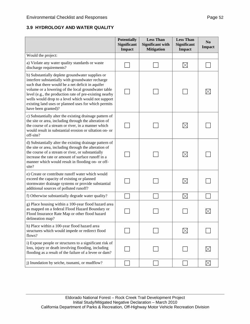
Environmental Checklist and Responses Page 52
Eldorado National Forest – Rock Creek Trail Development Project Initial Study/Mitigated Negative Declaration – March 2010
California Department of Parks & Recreation, Off-Highway Motor Vehicle Recreation Division
3.9 HYDROLOGY AND WATER QUALITY
Potentially Significant
Impact
Less Than Significant with
Mitigation
Less Than Significant
Impact
No Impact
Would the project:
a) Violate any water quality standards or waste discharge requirements?
b) Substantially deplete groundwater supplies or interfere substantially with groundwater recharge such that there would be a net deficit in aquifer volume or a lowering of the local groundwater table level (e.g., the production rate of pre-existing nearby wells would drop to a level which would not support existing land uses or planned uses for which permits have been granted)?
c) Substantially alter the existing drainage pattern of the site or area, including through the alteration of the course of a stream or river, in a manner which would result in substantial erosion or siltation on- or off-site?
d) Substantially alter the existing drainage pattern of the site or area, including through the alteration of the course of a stream or river, or substantially increase the rate or amount of surface runoff in a manner which would result in flooding on- or off-site?
e) Create or contribute runoff water which would exceed the capacity of existing or planned stormwater drainage systems or provide substantial additional sources of polluted runoff?
f) Otherwise substantially degrade water quality?
g) Place housing within a 100-year flood hazard area as mapped on a federal Flood Hazard Boundary or Flood Insurance Rate Map or other flood hazard delineation map?
h) Place within a 100-year flood hazard area structures which would impede or redirect flood flows?
i) Expose people or structures to a significant risk of loss, injury or death involving flooding, including flooding as a result of the failure of a levee or dam?
j) Inundation by seiche, tsunami, or mudflow?
Environmental Checklist and Responses Page 53
Eldorado National Forest – Rock Creek Trail Development Project Initial Study/Mitigated Negative Declaration – March 2010
California Department of Parks & Recreation, Off-Highway Motor Vehicle Recreation Division
Would the proposed project:
a. Violate any water quality standards or waste discharge requirements?
Less than Significant Impact. The project would not violate any water quality standards or waste discharge requirements. The project is not subject to the requirements of a waste discharge permit. A major project objective is to improve water quality and reduce effects on riparian areas, and installation of vault toilets would further protect water quality. Implementation of the proposed project would not violate any discharge requirements.
b. Substantially deplete groundwater supplies or interfere substantially with groundwater recharge such that there would be a net deficit in aquifer volume or a lowering of the local groundwater table level (e.g., the production rate of pre-existing nearby wells would drop to a level which would not support existing land uses or planned uses for which permits have been granted)?
No Impact. The project does not involve the use of ground water either through construction or operation of the proposed facilities. The project also does not involve installation of impervious surfaces that would interfere with groundwater recharge resulting in a net deficit in aquifer volume. The project would have no impact on groundwater.
c. Substantially alter the existing drainage pattern of the site or area, including through the alteration of the course of a stream or river, in a manner which would result in substantial erosion or siltation on- or off-site?
Less than Significant Impact. The existing drainage pattern of the area would not be altered significantly from the existing drainage pattern on site. Trail construction would involve disturbance of about 8.8 miles of trails. The only in-stream improvements proposed by the project include bridge installations. Implementation of BMPs (see Section 2.3.5 BMPs Incorporated into the Project, Hydrology and Soils and Trail Construction Techniques) would prevent off-site transport of sediment disturbed during construction. Therefore, the impact is considered less than significant.
d. Substantially alter the existing drainage pattern of the site or area, including through the alteration of the course of a stream or river, or substantially increase the rate or amount of surface runoff in a manner which would result in flooding on- or off-site?
Less than Significant Impact. The project does not involve altering the course of a stream or river or improvements that would increase the rate or amount of surface runoff. Therefore, the impact is considered less than significant.
e. Create or contribute runoff water which would exceed the capacity of existing or planned storm water drainage systems or provide substantial additional sources of polluted runoff?
Less than Significant Impact. The project would not add significant impervious surfaces in the area. The trail itself can be regarded as a very small impervious surface. With the designed trail features as changes in trail gradient to facilitate the drainage of water from the trail, rolling dips and sediment catchment basins, additional polluted runoff would be reduced to less than significant impact. There are no constructed stormwater drainage systems in the project area, and none are proposed. BMPs would be in place to protect water quality during construction. Therefore, the impact is considered less than significant.
Environmental Checklist and Responses Page 54
Eldorado National Forest – Rock Creek Trail Development Project Initial Study/Mitigated Negative Declaration – March 2010
California Department of Parks & Recreation, Off-Highway Motor Vehicle Recreation Division
f. Otherwise substantially degrade water quality?
Less than Significant Impact. A major project objective is to improve water quality, and the project components, including BMPs incorporated into the project, would achieve this objective. These activities would not otherwise substantially degrade water quality.
g. Place housing within a 100-year flood hazard area as mapped on a federal Flood Hazard Boundary or Flood Insurance Rate Map or other flood hazard delineation map?
No Impact. The project does not involve construction of residential structures within flood hazard areas.
h. Place within a 100-year flood hazard area structures which would impede or redirect flood flows?
Less than Significant Impact. The project area is identified as Flood Hazard Area D according to FEMA Flood Mapping “Areas with possible but undetermined flood hazards”(FEMA 2008). Flood Hazard Area D is defined as, “No flood hazard analysis has been conducted. Flood insurance rates are commensurate with the uncertainty of the flood risk.” The project is the construction of trails, bridges, and vault toilets. None of these facilities would impede or redirect flood flows, and the project does not occur in populated areas or otherwise expose people or structures to flood hazards. The project impacts would be less than significant.
i. Expose people or structures to a significant risk of loss, injury or death involving flooding, including flooding as a result of the failure of a levee or dam?
No Impact. The project does not occur in the downstream area of a levee or dam. Therefore there would be no impact as a result of a levee or dam failure.
j. Result in inundation by seiche, tsunami, or mudflow?
No Impact. The project is located in a national forest. No oceans are nearby to produce a tsunami. No closed bodies of water are nearby to produce a seiche. The project area is also not known as being susceptible to mudflow.
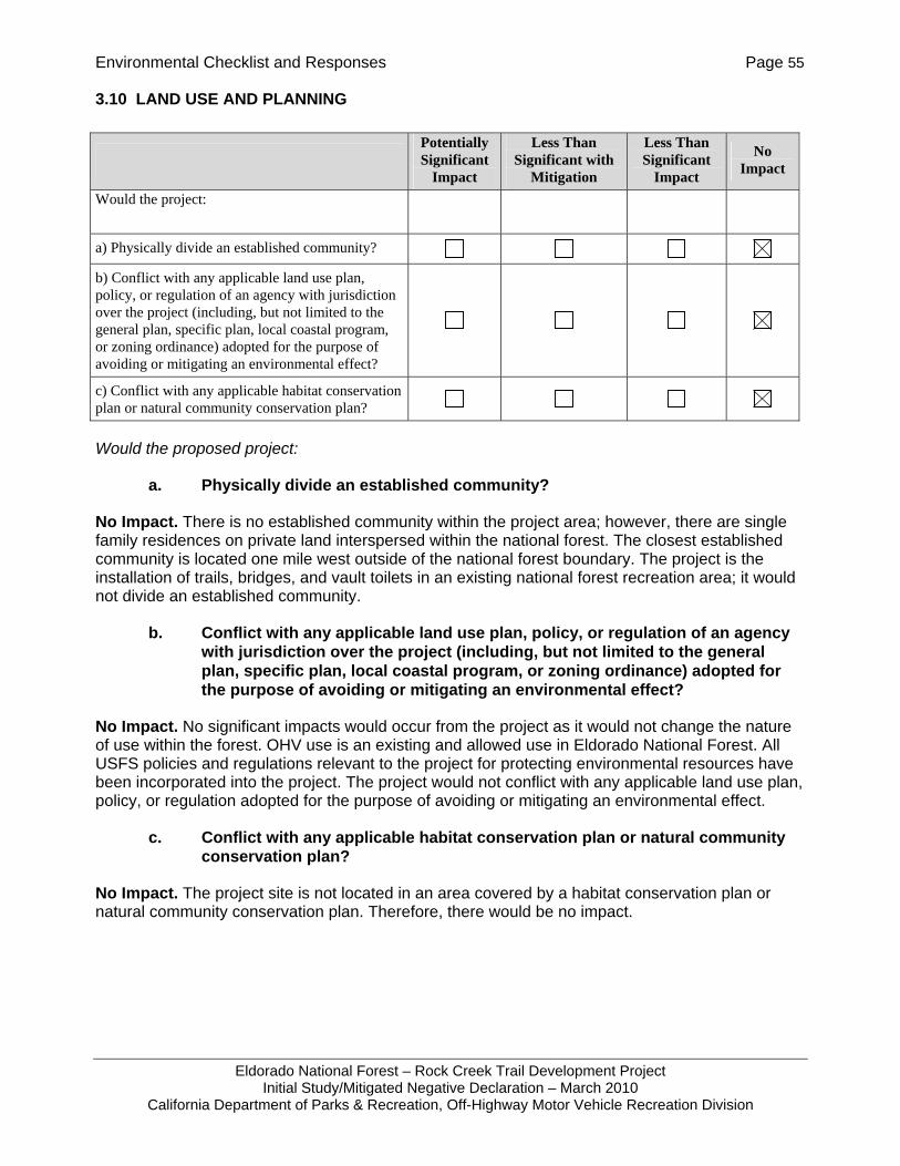
Environmental Checklist and Responses Page 55
Eldorado National Forest – Rock Creek Trail Development Project Initial Study/Mitigated Negative Declaration – March 2010
California Department of Parks & Recreation, Off-Highway Motor Vehicle Recreation Division
3.10 LAND USE AND PLANNING
Would the proposed project:
a. Physically divide an established community?
No Impact. There is no established community within the project area; however, there are single family residences on private land interspersed within the national forest. The closest established community is located one mile west outside of the national forest boundary. The project is the installation of trails, bridges, and vault toilets in an existing national forest recreation area; it would not divide an established community.
b. Conflict with any applicable land use plan, policy, or regulation of an agency with jurisdiction over the project (including, but not limited to the general plan, specific plan, local coastal program, or zoning ordinance) adopted for the purpose of avoiding or mitigating an environmental effect?
No Impact. No significant impacts would occur from the project as it would not change the nature of use within the forest. OHV use is an existing and allowed use in Eldorado National Forest. All USFS policies and regulations relevant to the project for protecting environmental resources have been incorporated into the project. The project would not conflict with any applicable land use plan, policy, or regulation adopted for the purpose of avoiding or mitigating an environmental effect.
c. Conflict with any applicable habitat conservation plan or natural community conservation plan?
No Impact. The project site is not located in an area covered by a habitat conservation plan or natural community conservation plan. Therefore, there would be no impact.
Potentially Significant
Impact
Less Than Significant with
Mitigation
Less Than Significant
Impact
No Impact
Would the project:
a) Physically divide an established community?
b) Conflict with any applicable land use plan, policy, or regulation of an agency with jurisdiction over the project (including, but not limited to the general plan, specific plan, local coastal program, or zoning ordinance) adopted for the purpose of avoiding or mitigating an environmental effect?
c) Conflict with any applicable habitat conservation plan or natural community conservation plan?
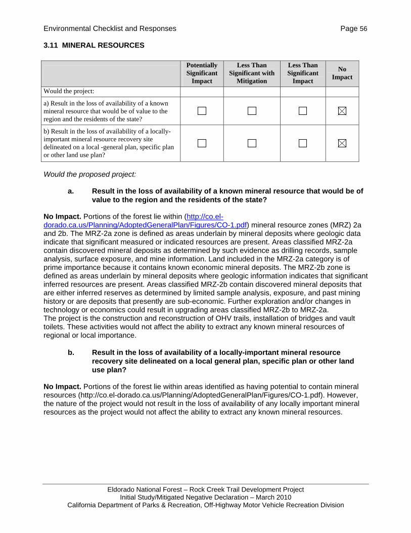
Environmental Checklist and Responses Page 56
Eldorado National Forest – Rock Creek Trail Development Project Initial Study/Mitigated Negative Declaration – March 2010
California Department of Parks & Recreation, Off-Highway Motor Vehicle Recreation Division
3.11 MINERAL RESOURCES
Would the proposed project:
a. Result in the loss of availability of a known mineral resource that would be of value to the region and the residents of the state?
No Impact. Portions of the forest lie within (http://co.el-dorado.ca.us/Planning/AdoptedGeneralPlan/Figures/CO-1.pdf) mineral resource zones (MRZ) 2a and 2b. The MRZ-2a zone is defined as areas underlain by mineral deposits where geologic data indicate that significant measured or indicated resources are present. Areas classified MRZ-2a contain discovered mineral deposits as determined by such evidence as drilling records, sample analysis, surface exposure, and mine information. Land included in the MRZ-2a category is of prime importance because it contains known economic mineral deposits. The MRZ-2b zone is defined as areas underlain by mineral deposits where geologic information indicates that significant inferred resources are present. Areas classified MRZ-2b contain discovered mineral deposits that are either inferred reserves as determined by limited sample analysis, exposure, and past mining history or are deposits that presently are sub-economic. Further exploration and/or changes in technology or economics could result in upgrading areas classified MRZ-2b to MRZ-2a. The project is the construction and reconstruction of OHV trails, installation of bridges and vault toilets. These activities would not affect the ability to extract any known mineral resources of regional or local importance.
b. Result in the loss of availability of a locally-important mineral resource recovery site delineated on a local general plan, specific plan or other land use plan?
No Impact. Portions of the forest lie within areas identified as having potential to contain mineral resources (http://co.el-dorado.ca.us/Planning/AdoptedGeneralPlan/Figures/CO-1.pdf). However, the nature of the project would not result in the loss of availability of any locally important mineral resources as the project would not affect the ability to extract any known mineral resources.
Potentially Significant
Impact
Less Than Significant with
Mitigation
Less Than Significant
Impact
No Impact
Would the project:
a) Result in the loss of availability of a known mineral resource that would be of value to the region and the residents of the state?
b) Result in the loss of availability of a locally-important mineral resource recovery site delineated on a local -general plan, specific plan or other land use plan?
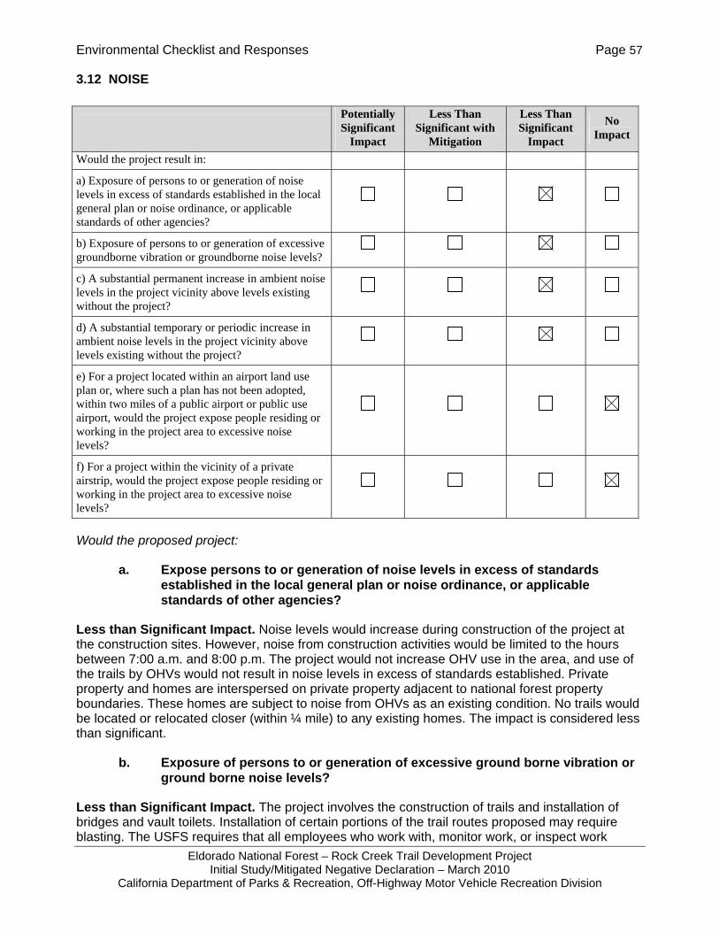
Environmental Checklist and Responses Page 57
Eldorado National Forest – Rock Creek Trail Development Project Initial Study/Mitigated Negative Declaration – March 2010
California Department of Parks & Recreation, Off-Highway Motor Vehicle Recreation Division
3.12 NOISE
Would the proposed project:
a. Expose persons to or generation of noise levels in excess of standards established in the local general plan or noise ordinance, or applicable standards of other agencies?
Less than Significant Impact. Noise levels would increase during construction of the project at the construction sites. However, noise from construction activities would be limited to the hours between 7:00 a.m. and 8:00 p.m. The project would not increase OHV use in the area, and use of the trails by OHVs would not result in noise levels in excess of standards established. Private property and homes are interspersed on private property adjacent to national forest property boundaries. These homes are subject to noise from OHVs as an existing condition. No trails would be located or relocated closer (within ¼ mile) to any existing homes. The impact is considered less than significant.
b. Exposure of persons to or generation of excessive ground borne vibration or ground borne noise levels?
Less than Significant Impact. The project involves the construction of trails and installation of bridges and vault toilets. Installation of certain portions of the trail routes proposed may require blasting. The USFS requires that all employees who work with, monitor work, or inspect work
Potentially Significant
Impact
Less Than Significant with
Mitigation
Less Than Significant
Impact
No Impact
Would the project result in:
a) Exposure of persons to or generation of noise levels in excess of standards established in the local general plan or noise ordinance, or applicable standards of other agencies?
b) Exposure of persons to or generation of excessive groundborne vibration or groundborne noise levels?
c) A substantial permanent increase in ambient noise levels in the project vicinity above levels existing without the project?
d) A substantial temporary or periodic increase in ambient noise levels in the project vicinity above levels existing without the project?
e) For a project located within an airport land use plan or, where such a plan has not been adopted, within two miles of a public airport or public use airport, would the project expose people residing or working in the project area to excessive noise levels?
f) For a project within the vicinity of a private airstrip, would the project expose people residing or working in the project area to excessive noise levels?
Environmental Checklist and Responses Page 58
Eldorado National Forest – Rock Creek Trail Development Project Initial Study/Mitigated Negative Declaration – March 2010
California Department of Parks & Recreation, Off-Highway Motor Vehicle Recreation Division
involving explosives or blasting agents must be trained to recognize unsafe work practices and to ensure the safety of the public, government employees, property, and natural resources. All work would comply with federal, state, and local laws in accordance with USFS Manual 6745 and the "Guide for Using, Storing, and Transporting Explosives and Blasting Materials" (sec. 62.06 in the USFS Health and Safety Code Handbook) as stated the BMPs in Section 2,3,5. As stated above, there are no residences within 0.25 mile of any project activities; therefore, the exposure of persons or generation of groundbourne vibration from blasting activities would be less than significant.
c. A substantial permanent increase in ambient noise levels in the project vicinity above levels existing without the project?
Less than Significant Impact. The land use proposed is an existing land use at the Rock Creek Trails Area. Off-road use has been allowed in the Forest for many years and is an existing condition. As stated above, there are private property owners interspersed with national forest areas; however, these private property owners are already exposed to OHV use within the national forest and this would not change significantly as a result of the project. The project does not place new trail or relocated segments within ¼ mile of existing homes. Therefore, the impact is considered less than significant.
d. A substantial temporary or periodic increase in ambient noise levels in the project vicinity above levels existing without the project?
Less than Significant Impact. The project would not create a substantial temporary or periodic increase in ambient noise levels. As mentioned above, construction of the project would result in a temporary increase in noise levels from activities such as grading and felling trees. These are common construction/demolition activities that do not rise to a level of significance if performed during the normal construction hours stated above. Blasting, if performed for the project, requires a permit from the County and would be a minimum of 0.25 mile from any existing home site. The purpose of blasting is to break rock and would result in noise similar to that of a gunshot and a shock wave. If there is no intervening terrain between the blast site and a home (the nearest home is 0.25 mile from proposed trails), then it is possible that the blast shock wave could cause windows to rattle but otherwise remain intact. However, it is anticipated that if blasting were to occur for the project, it would be infrequent and would occur only during daytime hours; therefore, the impact is considered less than significant.
e. For a project located within an airport land use plan or, where such a plan has not been adopted, within two miles of a public airport or public use airport, would the project expose people residing or working in the project area to excessive noise levels?
No Impact. The nearest airport to the project site is the Georgetown Airport, located about one mile outside the national forest boundary. The project is not located within the 60 dBA CNEL zone of the airport and does not involve a change in recreational or other human use of the area, and project construction or operation would not affect or result in exposure to excessive noise levels from an airport.

Environmental Checklist and Responses Page 59
Eldorado National Forest – Rock Creek Trail Development Project Initial Study/Mitigated Negative Declaration – March 2010
California Department of Parks & Recreation, Off-Highway Motor Vehicle Recreation Division
f. For a project within the vicinity of a private airstrip, would the project expose people residing or working in the project area to excessive noise levels?
No Impact. The proposed project is not within the vicinity of a private airstrip. There are no private airstrips within the national forest boundaries and the project would not attract people to the site that would be exposed to noise from a private air strip.

Environmental Checklist and Responses Page 60
Eldorado National Forest – Rock Creek Trail Development Project Initial Study/Mitigated Negative Declaration – March 2010
California Department of Parks & Recreation, Off-Highway Motor Vehicle Recreation Division
3.13 POPULATION AND HOUSING
Would the proposed project:
a. Induce substantial population growth in an area, either directly (for example, by proposing new homes and businesses) or indirectly (for example, through extension of roads or other infrastructure)?
No Impact. The project would not induce population growth in the nearby community of Georgetown or its environs. The project is within a national forest, and no permanent population or housing would be generated as a result of the project. The project would not add any new permanent residents to the area. Therefore, there would be no impact. There would not be any extension of roads. Although the trails are considered infrastructure, they would not indirectly support growth of the population through new homes or businesses.
b. Displace substantial numbers of existing housing, necessitating the construction of replacement housing elsewhere?
No Impact. The project would not displace existing housing or campsites at the national forest, as there are none at the project site. Therefore, there would be no impacts from displacement.
c. Displace substantial numbers of people, necessitating the construction of replacement housing elsewhere?
No Impact. The project would not displace any people with the construction of trails and bridges and installation of vault toilets. These actions do not affect any existing housing or campsites. Therefore there would be no displacement of people requiring the construction of replacement housing elsewhere.
Potentially Significant
Impact
Less Than Significant with
Mitigation
Less Than Significant
Impact No Impact
Would the project:
a) Induce substantial population growth in an area, either directly (for example, by proposing new homes and businesses) or indirectly (for example, through extension of roads or other infrastructure)?
b) Displace substantial numbers of existing housing, necessitating the construction of replacement housing elsewhere?
c) Displace substantial numbers of people, necessitating the construction of replacement housing elsewhere?

Environmental Checklist and Responses Page 61
Eldorado National Forest – Rock Creek Trail Development Project Initial Study/Mitigated Negative Declaration – March 2010
California Department of Parks & Recreation, Off-Highway Motor Vehicle Recreation Division
3.14 PUBLIC SERVICES
Would the proposed project:
a. Would the project result in substantial adverse physical impacts associated with the provision of new or physically altered governmental facilities, need for new or physically altered governmental facilities, the construction of which could cause significant environmental impacts, in order to maintain acceptable service ratios, response times or other performance objectives for any of the public services:
1. Fire protection?
No Impact. The construction of new trails and bridges and installation of vault toilets would not increase the need for fire protection services or create an adverse impact on fire protection services as it is a construction project for an existing land use within a national forest.
2. Police protection?
No Impact. The project does not increase the need for police protection services or create an adverse impact on police protection services, as the improvements serve existing land uses at a national forest.
3. Schools?
No Impact. The project would not result in increased number of students served by local schools, as it is an existing land use and does not involve the construction of new housing. These activities would not bring in new residents requiring the construction of additional schools.
Potentially Significant
Impact
Less Than Significant with
Mitigation
Less Than Significant
Impact
No Impact
a) Would the project result in substantial adverse physical impacts associated with the provision of new or physically altered governmental facilities, need for new or physically altered governmental facilities, the construction of which could cause significant environmental impacts, in order to maintain acceptable service ratios, response times or other performance objectives for any of the public services:
i) Fire protection?
ii) Police protection?
iii) Schools?
iv) Parks?
v) Other public facilities?

Environmental Checklist and Responses Page 62
Eldorado National Forest – Rock Creek Trail Development Project Initial Study/Mitigated Negative Declaration – March 2010
California Department of Parks & Recreation, Off-Highway Motor Vehicle Recreation Division
4. Parks?
No Impact. The project would not result in an increased number of residents or visitors in the area using community parks. The increase in OHV trail miles in the Georgetown ranger District (6.4 miles) from 126 miles to 133 miles would not be significant enough to create a measureable increase in use at the forest. In addition, other trail user facilities are not being expanded, such as camground sites, parking capacity, or additional traveled road lanes. Therefore, it is not expected that the project would result in increased visitorship to the national forest.
5. Other public facilities?
No Impact. No other public facilities would be affected by the project.
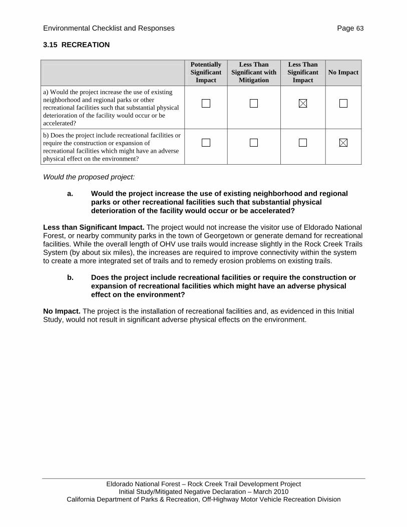
Environmental Checklist and Responses Page 63
Eldorado National Forest – Rock Creek Trail Development Project Initial Study/Mitigated Negative Declaration – March 2010
California Department of Parks & Recreation, Off-Highway Motor Vehicle Recreation Division
3.15 RECREATION
Would the proposed project:
a. Would the project increase the use of existing neighborhood and regional parks or other recreational facilities such that substantial physical deterioration of the facility would occur or be accelerated?
Less than Significant Impact. The project would not increase the visitor use of Eldorado National Forest, or nearby community parks in the town of Georgetown or generate demand for recreational facilities. While the overall length of OHV use trails would increase slightly in the Rock Creek Trails System (by about six miles), the increases are required to improve connectivity within the system to create a more integrated set of trails and to remedy erosion problems on existing trails.
b. Does the project include recreational facilities or require the construction or expansion of recreational facilities which might have an adverse physical effect on the environment?
No Impact. The project is the installation of recreational facilities and, as evidenced in this Initial Study, would not result in significant adverse physical effects on the environment.
Potentially Significant
Impact
Less Than Significant with
Mitigation
Less Than Significant
Impact No Impact
a) Would the project increase the use of existing neighborhood and regional parks or other recreational facilities such that substantial physical deterioration of the facility would occur or be accelerated?
b) Does the project include recreational facilities or require the construction or expansion of recreational facilities which might have an adverse physical effect on the environment?

Environmental Checklist and Responses Page 64
Eldorado National Forest – Rock Creek Trail Development Project Initial Study/Mitigated Negative Declaration – March 2010
California Department of Parks & Recreation, Off-Highway Motor Vehicle Recreation Division
3.16 TRANSPORTATION/TRAFFIC
Would the proposed project:
a. Conflict with an applicable plan, ordinance or policy establishing measures of effectiveness for the performance of the circulation system, taking into account all modes of transportation including mass transit and non-motorized travel and relevant components of the circulation system, including but not limited to intersections, streets, highways and freeways, pedestrian and bicycle paths and mass transit?
No Impact. The project does not conflict with an applicable plan, ordinance or policy establishing measures of effectiveness for the performance of the circulation, including mass transit and non-motorized travel and relevant components of the circulation system. The project actually reduces user conflicts by reducing the need for shared use roadways by providing OHV riders separate but parallel routes to regular automobile roadways. Therefore, there would be no impact.
Potentially Significant
Impact
Less Than Significant with
Mitigation
Less Than Significant
Impact
No Impact
Would the project:
a) Conflict with an applicable plan, ordinance or policy establishing measures of effectiveness for the performance of the circulation system, taking into account all modes of transportation including mass transit and non-motorized travel and relevant components of the circulation system, including but not limited to intersections, streets, highways and freeways, pedestrian and bicycle paths and mass transit?
b) Conflict with an applicable congestion management program, including, but not limited to level of service standards and travel demand measures, or other standards established by the county congestion management agency for designated roads or highways?
c) Result in a change in air traffic patterns, including either an increase in traffic levels or a change in location that results in substantial safety risks?
d) Substantially increase hazards due to a design feature (e.g., sharp curves or dangerous intersections) or incompatible uses (e.g., farm equipment)?
e) Result in inadequate emergency access?
f) Conflict with adopted policies, plans, or programs regarding public transit, bicycle, or pedestrian facilities, or otherwise decrease the performance or safety of such facilities?

Environmental Checklist and Responses Page 65
Eldorado National Forest – Rock Creek Trail Development Project Initial Study/Mitigated Negative Declaration – March 2010
California Department of Parks & Recreation, Off-Highway Motor Vehicle Recreation Division
b. Conflict with an applicable congestion management program, including, but not limited to a level of service standards and travel demand measures, or other standards established by the county congestion management agency for designated roads or highways?
No Impact. The project does not propose to increase use by providing more campgrounds or parking within the Georgetown Ranger District. The project also does not propose widening roadways to provide for additional lanes of traffic, thereby increasing capacity. Therefore, the project would not affect local roads or highways or conflict with an applicable congestion management program including level of service standards, travel demand management measures, or other standards.
c. Result in a change in air traffic patterns, including either an increase in traffic levels or a change in location that results in substantial safety risks?
No Impact. The proposed trail improvements would not affect air traffic patterns. The improvements would have no effect on trail visitorship and therefore would not affect traffic levels. The vault toilets and bridges proposed are a maximum of one-story in height and would not affect air traffic patterns. The improvements are located outside the 65dB and 60dB noise contours for the Georgetown airport.
d. Substantially increase hazards due to a design feature (e.g., sharp curves or dangerous intersections) or incompatible uses (e.g., farm equipment)?
No Impact. The proposed improvements are meant to reduce hazards due to existing design features such as dangerous intersections and incompatible uses. Trail segments are proposed to eliminate the need for intersections serving both regular motor vehicles and OHVs. This separation of incompatible uses increases safety for both motor vehicles and OHVs. The proposed project does not involve any changes in roadway design features and would not affect the amount or nature of use on roads or highways. The project would not cause any hazardous traffic or transportation conditions.
e. Result in inadequate emergency access?
No Impact. The proposed project would not result in inadequate emergency access. The project would actually increase access within the Rock Creek Trail System area thereby increasing emergency access within the area. However, by adding trail mileage to the trail system, visitors could also become more dispersed throughout the recreation area. The project does not prevent adequate emergency access to the area.
f. Conflict with adopted policies, plans, or programs regarding public transit, bicycle, or pedestrian facilities, or otherwise decrease the performance or safety of such facilities supporting alternative transportation (e.g., bus turnouts, bicycle racks)?
No Impact. The proposed project would not conflict with adopted polices, plans, or programs regarding public transit, bicycle or pedestrian facilities, or otherwise decrease the performance or safety of such facilities supporting alternative transportation. The project would have no effect on such facilities. The project is located within a National Forest and involves the construction of new trails, reconstruction of a trail, installation of vault toilets, and bridges.

Environmental Checklist and Responses Page 66
Eldorado National Forest – Rock Creek Trail Development Project Initial Study/Mitigated Negative Declaration – March 2010
California Department of Parks & Recreation, Off-Highway Motor Vehicle Recreation Division
3.17 UTILITIES AND SERVICE SYSTEMS
Would the proposed project:
a. Exceed wastewater treatment requirements of the applicable Regional Water Quality Control Board?
Less than Significant Impact. There are no water uses proposed that would result in an exceedance of waste water treatment requirements. The project is the construction of trail facilities including new trails, bridges, and vault toilets. The vault toilets would not be connected to the municipal waste water system. They would be serviced by an outside contractor. No other uses or activities are proposed at the site that would result in wastewater that would exceed treatment requirements.
Potentially Significant
Impact
Less Than Significant with
Mitigation
Less Than Significant
Impact
No Impact
Would the project:
a) Exceed wastewater treatment requirements of the applicable Regional Water Quality Control Board?
b) Require or result in the construction of new water or wastewater treatment facilities or expansion of existing facilities, the construction of which could cause significant environmental effects?
c) Require or result in the construction of new storm water drainage facilities or expansion of existing facilities, the construction of which could cause significant environmental effects?
d) Have sufficient water supplies available to serve the project from existing entitlements and resources, or are new or expanded entitlements needed?
e) Result in a determination by the wastewater treatment provider which serves or may serve the project that it has adequate capacity to serve the project’s projected demand in addition to the provider’s existing commitments?
f) Be served by a landfill with sufficient permitted capacity to accommodate the project's solid waste disposal needs?
g) Comply with federal, state, and local statutes and regulations related to solid waste?
Environmental Checklist and Responses Page 67
Eldorado National Forest – Rock Creek Trail Development Project Initial Study/Mitigated Negative Declaration – March 2010
California Department of Parks & Recreation, Off-Highway Motor Vehicle Recreation Division
b. Require or result in the construction of new water or wastewater treatment facilities or expansion of existing facilities, the construction of which could cause significant environmental effects?
Less than Significant Impact. The project would not require construction of new or expanded water or wastewater treatment facilities. The facilities proposed are unpaved trails, bridges, and vault toilets which do not require water service. In addition, visitor use numbers are not expected to change significantly from existing visitation. Therefore, the impact is considered less than significant.
c. Require or result in the construction of new storm water drainage facilities or expansion of existing facilities, the construction of which could cause significant environmental effects?
No Impact. This project would install new OHV trails, bridges, and vault toilets within a national forest and would not require the construction of new or expansion of existing stormwater facilities. Therefore, the project would not cause environmental effects due to expansion or construction of storm water drainage facilities.
d. Have sufficient water supplies available to serve the project from existing entitlements and resources, or are new or expanded entitlements needed?
No Impact. No new water supplies or entitlements would be needed as the project proposes to build new segments of OHV trails, bridges, and vault toilets. The vault toilets do not require the provision of water to operate. There would be no expansion of existing water use associated with this project.
e. Result in a determination by the wastewater treatment provider which serves or may serve the project that it has adequate capacity to serve the project’s projected demand in addition to the provider’s existing commitments?
Less than Significant Impact. The project does not involve construction of expanded facilities that would add quantities of wastewater to be treated. Sewage collected by the vault toilets would be collected at regular intervals from an outside service provider. The vault toilets are replacing portable toilet facilities at the two sites and do not facilitate increased visitorship and thus would not increase the amount of waste requiring disposal or treatment.
f. Be served by a landfill with sufficient permitted capacity to accommodate the project’s solid waste disposal needs?
No Impact. The project is the construction of new OHV trail segments, bridges, and vault toilets, which are not expected to alter visitorship to the national forest. In addition, no structures are proposed to be demolished by the project that would require disposal at an off-site waste disposal facility; therefore, there would be no impact.
g. Comply with federal, state, and local statutes and regulations related to solid waste?
No Impact. The project is the construction of new OHV trail segments, bridges, and vault toilets, which are not expected to alter visitorship to the national forest. In addition, no structures are proposed to be demolished by the project that would require disposal at an off-site waste disposal facility; therefore, the impact is considered less than significant.
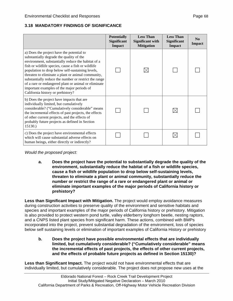
Environmental Checklist and Responses Page 68
Eldorado National Forest – Rock Creek Trail Development Project Initial Study/Mitigated Negative Declaration – March 2010
California Department of Parks & Recreation, Off-Highway Motor Vehicle Recreation Division
3.18 MANDATORY FINDINGS OF SIGNIFICANCE
Would the proposed project:
a. Does the project have the potential to substantially degrade the quality of the environment, substantially reduce the habitat of a fish or wildlife species, cause a fish or wildlife population to drop below self-sustaining levels, threaten to eliminate a plant or animal community, substantially reduce the number or restrict the range of a rare or endangered plant or animal or eliminate important examples of the major periods of California history or prehistory?
Less than Significant Impact with Mitigation. The project would employ avoidance measures during construction activities to preserve quality of the environment and sensitive habitats and species and important examples of the major periods of California history or prehistory. Mitigation is also provided to protect western pond turtle, valley elderberry longhorn beetle, nesting raptors, and a CNPS listed plant species from significant harm. These actions, combined with BMPs incorporated into the project, prevent substantial degradation of the environment, loss of species below self sustaining levels or elimination of important examples of California History or prehistory
b. Does the project have possible environmental effects that are individually limited, but cumulatively considerable? (“Cumulatively considerable” means the incremental effects of past projects, the effects of other current projects, and the effects of probable future projects as defined in Section 15130)?
Less than Significant Impact. The project would not have environmental effects that are individually limited, but cumulatively considerable. The project does not propose new uses at the
Potentially Significant
Impact
Less Than Significant with
Mitigation
Less Than Significant
Impact
No Impact
a) Does the project have the potential to substantially degrade the quality of the environment, substantially reduce the habitat of a fish or wildlife species, cause a fish or wildlife population to drop below self-sustaining levels, threaten to eliminate a plant or animal community, substantially reduce the number or restrict the range of a rare or endangered plant or animal or eliminate important examples of the major periods of California history or prehistory?
b) Does the project have impacts that are individually limited, but cumulatively considerable? (“Cumulatively considerable” means the incremental effects of past projects, the effects of other current projects, and the effects of probably future projects as defined in Section 15130.)
c) Does the project have environmental effects which will cause substantial adverse effects on human beings, either directly or indirectly?

Environmental Checklist and Responses Page 69
Eldorado National Forest – Rock Creek Trail Development Project Initial Study/Mitigated Negative Declaration – March 2010
California Department of Parks & Recreation, Off-Highway Motor Vehicle Recreation Division
project site and all impacts to disturbed habitats would be minimized. Impacts related to climate change are not anticipated as the facilities are not expanding or resulting in increased visitation at the Rock Creek Recreation Area. The project does not propose new housing or new permanent sources of air pollutant emissions. The project does not result in cumulative impacts when considered alone or in combination.
c. Does the project have environmental effects which will cause substantial adverse effects on human beings, either directly or indirectly?
Less than Significant Impact. The project would not have environmental effects that would cause substantial adverse effects on humans, either directly or indirectly. The project is the construction of trails, installation of bridges, and vault toilets within an OHV use area of Eldorado National Forest. No substantial adverse effects, either direct or indirect were identified in this Initial Study.

References Page 70
Eldorado National Forest – Rock Creek Trail Development Project Initial Study/Mitigated Negative Declaration – March 2010
California Department of Parks & Recreation, Off-Highway Motor Vehicle Recreation Division
CHAPTER 4 REFERENCES
Ahlborn, G. No date. Fisher. California Wildlife Habitat Relationships System. California Department of Fish and Game. California Interagency Wildlife Task Group. Accessed November 23, 2009. http://www.dfg.ca.gov/biogeodata/cwhr/cawildlife.aspx.
California Department of Fish and Game (CDFG). 2009. Special Animals. Biogeographic Data Branch, California Natural Diversity Database. Accessed November 23, 2009. http://www.dfg.ca.gov/biogeodata/cnddb/pdfs/SPAnimals.pdf.
California Department of Motor Vehicles. 2010. 2010 Vehicle Code General Provisions and Divisions 1-18.
California Department of Toxic Substances Control. Cortese List: Envirostor Database. http://www.envirostor.dtsc.ca.gov/public/ Last accessed: August 2008.
California Native Plant Society (CNPS). 2009. Inventory of Rare and Endangered Plants (online edition, v7-09d). California Native Plant Society. Sacramento, CA. Accessed on Thu, Nov. 19, 2009 from http://www.cnps.org/inventory.
California Natural Diversity Database. Biogeographic Data Branch. California Department of Fish and Game. November 30th, 2008.
EDAW. 2003. El Dorado County General Plan Draft Environmental Impact Report. May.
El Dorado County Air Pollution Control District. 2002. Guide to Air Quality Assessment. February. http://www.edcgov.us/emd/apcd/guide_airquality.htm
El Dorado County Planning Department. 2004. 2004 El Dorado County General Plan. Placerville, CA. July.
Federal Emergency Management Agency [FEMA]. National Flood Insurance Program. Flood Insurance Rate Map, El Dorado County, California and Incorporated Areas. Map Number 06017CIND0A, Effective Date September 26, 2008.
Fellers, Gary M. and Patrick M. Kleeman. California Red-Legged Frog (Rana draytonii) Movement and Habitat Use: Implications for Conservation. Journal of Herpetology. 41:2, 276-286.
Foster, M. and M. Taylor. 1996. Plant list compiled by M. Foster and M. Taylor from records of M.
Baad, G.L. Stebbins, D. Smith and Eldorado Chapter of the California Native Plant Society. Holland, Dan C. 1994. The western pond turtle: Habitat and history. Wildlife Diversity Program,
Oregon Department of Fish and Wildlife. Prepared for US Department of Energy. Project number 92-068.
Jennings, Mark R., Marc P. Hayes, and Metro Washington Park Zoon Research Section. 1994. Amphibian and Reptile Species of Special Concern in California. Final Report submitted to California Department of Fish and Game. Contract Number 8023
Parker, Charis. 2003. Biological Evaluation and Assessment for the Rock Creek Trails Re-route Project. Eldorado National Forest, Georgetown Ranger Station.
References Page 71
Eldorado National Forest – Rock Creek Trail Development Project Initial Study/Mitigated Negative Declaration – March 2010
California Department of Parks & Recreation, Off-Highway Motor Vehicle Recreation Division
Polite, C and J. Pratt. August 2005. Northern goshawk. California Wildlife Habitat Relationships System. California Department of Fish and Game. California Interagency Wildlife Task Group. Accessed November 23, 2009. http://www.dfg.ca.gov/biogeodata/cwhr/cawildlife.aspx.
Rathbun, G. B., M.R. Jennings, T.G. Murphey, N. R. Siepel. 1993. Status and Ecology of Sensitive Aquatic Vertebrates in Lower San Simeon and Pico Creek, San Luis Obispo County, California. Final Report under Cooperative Agreement 14-16-0009-91-1909. Publication Number PB93-230779, National Technical Review Service, Springfield, VA.
Sacramento Metropolitan Air Quality Management District. 2008. Sacramento Regional 8-hour Ozone Attainment and Reasonable Further Progress Plan. December. http://www.arb.ca.gov/planning/sip/planarea/sacsip/sacplanozone2009.pdf; last accessed December 2009.
U.S. Department of Agriculture. USFS – Engineering Staff. 1996. Standard Specifications for Construction and Maintenance of Trails. September.
U.S. Department of Agriculture. USFS. 1996. Mechanized Trail Equipment. Technology and Development Program. San Dimas Technology and Development Center. San Dimas. September.
U.S. Department of Agriculture. USFS. Pacific Southwest Region. Eldorado National Forest. 1997. Rock Creek Recreational Trails Revised Draft Environmental Impact Statement. October.
U.S. Department of Agriculture. USFS. Pacific Southwest Region. Eldorado National Forest. 1999. Rock Creek Recreational Trails Final Environmental Impact Statement: Minor Changes to the Revised Draft EIS and Public Comments. April.
U.S. Department of Agriculture. USFS. Pacific Southwest Region. Eldorado National Forest. 1999. Rock Creek Recreational Trails Record of Decision. April
U.S Department of Agriculture. USFS. 2000. Water Quality Management for National Forest System Lands in California – Best Management Practices. Pacific Southwest Region, Vallejo, CA.
U.S. Department of Agriculture. USFS. 2003a. Forest Project No. 5303-7, Archaeological Reconnaissance Report No. R-2003-0503-00027. Rock Creek Trail Reroute and Construction, Eldorado National Forest, Georgetown Ranger District.
U.S. Department of Agriculture. USFS. 2003b. Eldorado National Forest. Biological Evaluation and Assessment for the Rock Creek Trails Reroute Project. Eldorado National Forest, Georgetown Ranger District.
U.S. Department of Agriculture. USFS. 2003c. Pacific Southwest Region. Georgetown Ranger District. Sensitive Plants Biological Evaluation and Noxious Weed Assessment for the Rock Creek Trail Reroutes and Reconstruction. August 27, 2003.
U.S. Department of Agriculture. USFS. 2004a. Pacific Southwest Region. Georgetown Ranger District. Riparian Conservation Objectives Analysis and Cumulative Watershed Effects Summary – Eldorado National Forest, Rock Creek Trail Reroutes and Reconstruction. March.
References Page 72
Eldorado National Forest – Rock Creek Trail Development Project Initial Study/Mitigated Negative Declaration – March 2010
California Department of Parks & Recreation, Off-Highway Motor Vehicle Recreation Division
U.S. Department of Agriculture. USFS. 2004b. Pacific Southwest Region. Eldorado National Forest. Georgetown Ranger District. Environmental Assessment for Rock Creek Trail Reroutes and Reconstruction. R5-MB-000. March.
U.S. Department of Agriculture. USFS. 2004c. Field Guide to the Sensitive Plants and Noxious Weeds of Eldorado National Forest. R5-TP-016. Pacific Southwest Region.
U.S. Department of Agriculture. USFS. 2004d. Sierra Nevada National Forest Amendment Supplemental Environmental Impact Statement, Appendix A: Management Direction. Pacific Southwest Region. Accessed November 25, 2009. http://www.fs.fed.us/r5/snfpa/final-seis/rod/appendix-a/standards-guidelines/pac.html.
U.S. Department of Agriculture. USFS. Pacific Southwest Region. Eldorado National Forest. 2006. Final Rock Creek Recreational Trails Supplemental Environmental Impact Statement. October.
U.S. Department of Agriculture. USFS. Pacific Southwest Region. Eldorado National Forest. 2006. Rock Creek Recreational Trails Supplemental Environmental Impact Statement Record of Decision. October.
U.S. Fish and Wildlife Service. 2009. Species Account, Valley Elderberry Longhorn Beetle. Sacramento Fish and Wildlife Office. Accessed November 25, 2009. http://www.fws.gov/sacramento/es/animal_spp_acct/velb.pdf.
U.S. Fish and Wildlife Service. 1999. Conservation Guidelines for the Valley Elderberry Longhorn Beetle. Sacramento Fish and Wildlife Office. Accessed November 25, 2009. http://www.fws.gov/sacramento/es/documents/velb_conservation.pdf.
Walker, Annie and Mike Taylor. August 27, 2003. Sensitive Plants Biological Evaluation and Noxious Weed Risk Assessment for the Rock Creek Trail Reroutes and Reconstruction. Eldorado National Forest, Georgetown Ranger District.
Personal Communications Eldorado National Forest Georgetown Ranger District Placerville, CA 95667 Ramiro Villalvazo, Forest Supervisor (530) 622-5061 Susan Durham, District Botanist Claudia Funari, District Wildlife Biologist Jon Jue, Resource Officer Bill Walker, Forest Trails Manager Jann Williams, Fisheries Biologist

Report Preparation Page 73
Eldorado National Forest – Rock Creek Trail Development Project Initial Study/Mitigated Negative Declaration – March 2010
California Department of Parks & Recreation, Off-Highway Motor Vehicle Recreation Division
CHAPTER 5 REPORT PREPARATION
TRA Environmental Sciences, Inc. Paula Hartman – Program Manager Christina Lau – Project Manager Rebecca Sloan – Associate Sandy Ho – Associate 545 Middlefield Road, Suite 200 Menlo Park, CA 94025 650-327-0429
![rock creek brochure - Iowapublications.iowa.gov/4691/1/rockcreek[1].pdf · Rock Creek Lake GIS Mapping: Rock Creek Lake is at risk. The centerpiece of Rock Creek State Park in Jasper](https://img.pdfslide.net/doc/110x75/5fae47d95225ec13303c7d16/rock-creek-brochure-1pdf-rock-creek-lake-gis-mapping-rock-creek-lake-is-at.jpg)