Embed Size (px)
Citation preview
Recognition and ManageMent of
EndangErEd Ecological
communitiEs in the South eaSt
coRneR of n.S.w.
a report by Jackie Miles for the eurobodalla and
far South coast Local Management teams of the
Southern Rivers catchment Management authority.
Recognition & ManageMent of EndangErEd Ecological communitiEs in the South eaSt coRneR of n.S.w.
Cover pictures | A dry Rainforest | B Bega or candelo dry grass forest | C River-flat eucalypt forest | D Brogo wet Vine forest
B
dc
a
Bega Valley Shire Council
E
F
g
Recognition & ManageMent of EndangErEd Ecological communitiEs in the South eaSt coRneR of n.S.w.
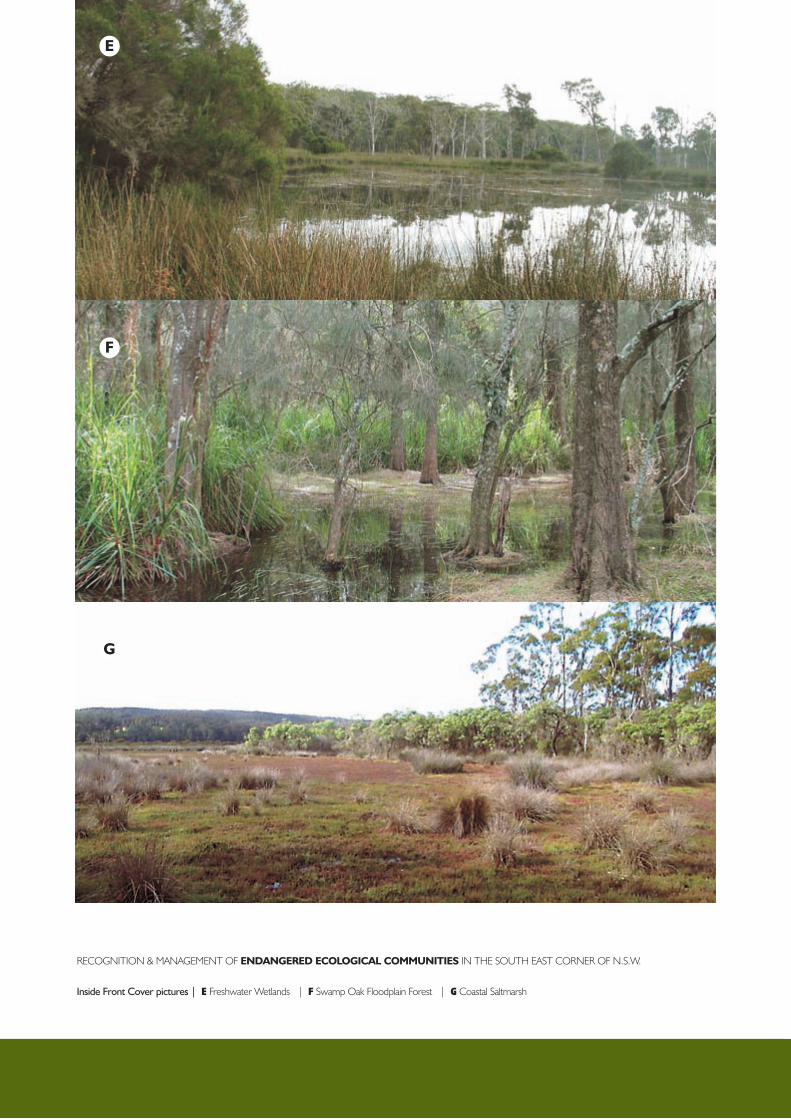
Inside Front Cover pictures | E freshwater wetlands | F Swamp oak floodplain forest | G coastal Saltmarsh
H
i
J
Recognition & ManageMent of EndangErEd Ecological communitiEs in the South eaSt coRneR of n.S.w.
Inside Back Cover pictures | E Bangalay Sand forest | F themeda grassland on Seacliffs and headlands | G Littoral Rainforest
RECOGNITION AND MANAGEMENT OF
ENDANGERED ECOLOGICAL
COMMUNITIES IN THE SOUTH EAST
CORNER OF N.S.W.
A report by Jackie Miles for the Eurobodalla and
Far South Coast Local Management Teams of the
Southern Rivers Catchment Management Authority.

ISBN: 1 74137 295 X
Funded by: Natural Heritage Trust Program jointly funded by the Australian and New South Wales Government.
Drafting: NSW Department of Conservation and Environment, Parks Services Division, Merimbula.
Author: Jackie Miles, Hawkshead Road, Brogo NSW 2550. Email: [email protected]
Contact: Southern Rivers Catchment Management Authority, Suite 2, Bega Centre, 106 Auckland Street, PO Box 118, Bega NSW 2550. Phone 02 6491 8200.
October 2006 © Copyright Southern Rivers Catchment Management Authority.
ii RECOGNITION AND MANAGEMENT OF ENDANGERED ECOLOGICAL COMMUNITIES IN THE SOUTH EAST CORNER OF N.S.W.

ForewordThis booklet has been produced through the passion, dedication and determination of the community as expressed through the members of the Far South Coast Local Management Team. Southern Rivers Catchment Management Authority pays tribute to them and to the author Jackie Miles whose widely based and extremely practical knowledge and experience has made this important tool possible.
Pam Green – Chairperson, Southern Rivers CMA
AimsThis booklet aims to:
• assist private land managers, land management agencies and authorities to identify the eleven EECs
• improve understanding of the basic ecological processes that sustain the EECs, particularly those found most commonly on privately owned land,
• encourage management of EECs in a way that minimises threatening processes and maintains their structural and ecological integrity for future generations.
PrefaceThe second edition of this report provides a technical reference for identification and management of eleven Endangered Ecological Communities (EECs) found on the south coast of New South Wales and its hinterland (in Bega Valley and Eurobodalla Local Government Areas). It updates the earlier guidelines prepared for only four of these communities (Miles, 2005). Additional EECs may be listed for this region in the future, and two communities currently listed separately are likely to be lumped into a single EEC, but this document covers all those relevant to the two LGAs as at September 2006.
It is intended for use by staff of land management agencies, landholders who enter into management contracts with those agencies and other interested landholders. It describes each EEC and discusses issues relevant to the sustainable management of these communities. It is not the Recovery Plan for these communities.
The report was funded by the Southern Rivers Catchment Management Authority through the Natural Heritage Trust Program jointly funded by the Australian and New South Wales Governments. NSW Department of Conservation and Environment, Parks Services Division, Merimbula managed the drafting of the report. The report author is Jackie Miles. Other project partners include the Far South Coast Local Management Teams.
Correspondence relating to this report may be sent to Justin Gouvernet, Southern Rivers CMAPhone: 02 6491 8200 – Email: [email protected]
iii RECOGNITION AND MANAGEMENT OF ENDANGERED ECOLOGICAL COMMUNITIES IN THE SOUTH EAST CORNER OF N.S.W.

ContentsPreface ..................................................................................................................................................... iii
Aims ......................................................................................................................................................... iii
Introduction .............................................................................................................................................. 1
Identification Guidelines ............................................................................................................................ 3
Bega and Candelo Dry Grass Forests ........................................................................................ 3
Brogo Wet Vine Forest and Dry Rainforest ................................................................................ 6
Floodplain Wetland Communities ............................................................................................. 8
Coastal Saltmarsh ................................................................................................................... 11
Littoral Rainforest .................................................................................................................... 13
Themeda Grassland on Seacliffs and Coastal Headlands ............................................................ 15
Bangalay Sand Forest .............................................................................................................. 16
Incentives and support for conservation on private land ............................................................................. 17
Legal implications of having an Endangered Ecological Community remnant ............................................... 17
Planning to conserve EEC remnants .......................................................................................................... 18
Summary of management recommendations ............................................................................................. 21
Appendix 1: Diagnostic Species Lists ...................................................................................................... 22
Bega and Candelo Dry Grass Forests ................................................................................................ 22
Brogo Wet Vine Forest and Dry Rainforest ........................................................................................ 26
River-flat Eucalypt Forest ................................................................................................................. 30
Swamp Oak Floodplain Forest .......................................................................................................... 34
Freshwater Wetlands on Coastal Floodplains ..................................................................................... 37
Coastal Saltmarsh ........................................................................................................................... 39
Littoral Rainforest ............................................................................................................................ 40
Themeda Grassland on Seaclkiffs and Coasyal Headlands .................................................................. 42
Bangalay Sand Forest ...................................................................................................................... 44
Appendix 2: Assessing Conservation Significance .................................................................................... 47
Appendix 3: Some Remnant Vegetation Problems and Possible Responses ............................................. 48
Tree Dieback .................................................................................................................................. 48
Lack of Tree Regeneration ................................................................................................................ 49
Lack of Shrub or Small Tree Layer ..................................................................................................... 50
Excessive Tree or Shrub Vegetation ................................................................................................... 50
Weedy or Low Diversity Groundcover ................................................................................................ 51
Weed Invasion ................................................................................................................................ 52
Erosion ........................................................................................................................................... 53
iv RECOGNITION AND MANAGEMENT OF ENDANGERED ECOLOGICAL COMMUNITIES IN THE SOUTH EAST CORNER OF N.S.W.

Appendix 4: Monitoring your EEC ......................................................................................................... 54
Appendix 5: Conducting Prescribed Burns ............................................................................................. 5 6
Appendix 6: Useful Local Contacts and Websites ................................................................................... 57
Appendix 7: More Reading .................................................................................................................... 58
v RECOGNITION AND MANAGEMENT OF ENDANGERED ECOLOGICAL COMMUNITIES IN THE SOUTH EAST CORNER OF N.S.W.
IntroductionThis report discusses four plant communities restricted to the South East Corner Bioregion of New South Wales (the coastal strip between Batemans Bay and the Victorian border) and another eight communities which are more widely distributed in New South Wales, all of which are listed as Endangered Ecological Communities (EECs) under the NSW Threatened Species Conservation Act 1995. Some of these communities (the first four, plus Littoral Rainforest) have also been nominated for listing as nationally threatened under the Commonwealth Environment Protection and Biodiversity Conservation Act 1999, but at the time of writing the necessary assessment to list these communities had not been completed. If the first two communities listed below do achieve listing under the EPBC Act it is likely to be as a single community, Lowland Grassy Woodlands and Derived Grasslands of the South East Corner Bioregion. At the time of writing a Preliminary Determination had been made under the TSC Act to list Lowland Grassy Woodlands of the South East Corner Bioregion, and delete the earlier listing of Bega and Candelo Dry Grass Forests (that is, to combine what were formerly considered two separate communities under a single name). Up to date information on listings under both the TSC Act and the EPBC Act can be obtained from the relevant websites. Website addresses are provided in Appendix 6.
Four communities located primarily in dry rainshadow valleys of the coast on more fertile soils derived from igneous or volcanic rock types were originally described by Keith & Bedward (1999) for the Eden Comprehensive Regional Assessment (an area roughly equivalent to Bega Valley Local Government Area (LGA). Surveys in Eurobodalla LGA, undertaken for the Southern Comprehensive Regional Assessment (SCRA) and subsequently, have shown that very similar vegetation occurs there, where all three of the forest red gum dominated communities have been included under the name Coastal Forest Red Gum Shrub/Grass Forest (Forest Ecosystem 54 in EcoGIS, 2001). These communities are apparently restricted to the South East Corner bioregion, though there are similar communities which are also listed as EECs to the north and south of the region, in the Illawarra and East Gippsland. The four communities are:
• Bega Dry Grass Forest and Candelo Dry Grass Forest (which are likely to be combined as Lowland Grassy Woodland)
• Brogo Wet Vine Forest
• Dry Rainforest of the South East Forests
Another three communities of coastal river floodplains are listed for the entire NSW coastline (NSW North Coast, Sydney Basin and South East Corner bioregions). They are:
• River-flat Eucalypt Forest on Coastal Floodplains
• Swamp Oak Floodplain Forest
• Freshwater Wetlands on Coastal Floodplains
These seven communities originally occurred largely in the areas now developed for agriculture, where they have been cleared or much modified by farming activities. They are very poorly represented in conservation reserves such as National Parks and there are few or no unmodified examples to show what they might have been like prior to European settlement. They have been listed as endangered because of the extent to which they have been cleared or altered by human activities, their poor conservation status and the continuing threats from further clearing, grazing, weed invasion, lack of management and inappropriate fire regimes. Listing of these communities as endangered is an acknowledgement that they could cease to exist as functioning ecological communities unless the processes threatening them are controlled.
Another four communities are found along the coastline, but often in areas which have been less developed for agriculture. With more people moving to coastal non-urban areas they are coming under increasing pressure for residential development and recreational use. They are somewhat better represented in conservation reserves, but not necessarily secure there from deterioration in extent or condition caused by various threats such as recreational pressure, inappropriate fire regimes and weed invasion. These communities are:
• Coastal Saltmarsh• Littoral Rainforest• Themeda Grassland on Seacliffs and Coastal Headlands• Bangalay Sand Forest
The first three are listed for the entire NSW coastline, and Bangalay Sand Forest only in the Sydney Basin and South East Corner Bioregions.
1 RECOGNITION AND MANAGEMENT OF ENDANGERED ECOLOGICAL COMMUNITIES IN THE SOUTH EAST CORNER OF N.S.W.
Another two communities occur nearby to the west or north of Bega Valley or Eurobodalla Local Government Areas, but are either not present within them or present only in small areas close to LGA boundaries and so are not discussed in any detail in this booklet. They are:
• Montane Peatlands and Swamps• Swamp Sclerophyll Forest on Coastal Floodplains
Montane Peatlands and Swamps of the New England Tableland, NSW North Coast, Sydney Basin, South East Corner, South Eastern Highlands and Australian Alps Bioregions may occur along the western edges of Bega Valley and Eurobodalla LGAs, in the watershed area which includes the headwaters of both coastal and inland rivers. Most of these rivers start life in treeless wet depressions surrounded by forest. Build-up of decaying plant material over many centuries has filled them with spongy peat soils, which perform a valuable function in absorbing water and releasing it slowly into rivers. Plant communities in these wetlands fall into two groupings, shrubby and grassy, though the two forms often occur together. Shrubby forms often consist of a dense stand of waterlogging-tolerant shrubs above a dense and diverse layer of grasses, herbs and sedges, some of which are unique to this community in the region, while others are shared with coastal wetlands. Grassy montane wetlands often consist of a short grassy sward with semi-aquatic herbs. Pools and short sections of flowing stream may include some truly aquatic plants, but large expanses of open water are seldom present. Large hummocks of sphagnum moss can occur in seepage areas. In the northern part of the region this EEC tends to occur at elevations of about 1000 metres, but in the far south where there is a less well defined escarpment, it may occur down to about 500 metres. Many of its occurrences are included within the large National Parks which cover much of the escarpment, but some examples occur on private property. Grazing by domestic livestock and feral animals (particularly pigs and deer), alterations to local hydrology potentially caused by the presence of such animals, erosion and weed invasion are the most pressing threats to this community. This community was described as Subalpine Bog (Map Unit 59) in the Eden CRA and as FE123 and FE126, Montane Wet Heath/Bog and Montane Wet Sedgeland in the Southern CRA surveys.
Swamp Sclerophyll Forest on Coastal Floodplains is described in the Final Determination to list it as an EEC as occurring in the NSW North Coast, Sydney Basin and South East Corner bioregions, but its presence in the South East Corner bioregion is questionable. The distinguishing feature of this EEC is the dominance of the tree canopy by swamp mahogany (Eucalyptus robusta). This species is quite similar in appearance to bangalay or southern mahogany (E. botryoides), a common coastal species, and it appears that records of swamp mahogany in the Moruya area may in fact be misidentifications of bangalay. Swamp mahogany does not appear to occur south of about Ulladulla, so the EEC Swamp Sclerophyll Forest is not discussed any further here. It tends to be associated with drainage depressions on sandy soils close to the coast, and is fairly common in the Jervis Bay hinterland.
One of the aims of this booklet is to assist with identification of the EECs, particularly those most likely to occur on private property. However, remnants of some of the ECCs may vary greatly in their appearance and species composition because of differences between sites in ecological factors and past and current management, so expert advice may be needed. It may be necessary to look at more than just the particular site. Information from surrounding areas, particularly less altered parts of the landscape such as nearby roadsides, may be useful in determining whether particular remnants belong to one of the EECs. The appearance of the Lowland Grassy Woodland EECs (Bega and Candelo Dry Grass Forest) and the relative abundance of weeds and natives can vary greatly with the season and this will also need to be taken into account. Most ecological communities intergrade with adjacent communities rather than having a sharp boundary, and determining the cut-off point between an EEC and the adjacent vegetation types may be difficult.
The question of the extent to which the community can be altered and still be defined as a remnant of the EEC is not thoroughly addressed in the Final Determinations made by the NSW Scientific Committee. In the Determination of Box-Gum Woodland, an EEC of the NSW Tablelands and Slopes which is similar to the Lowland Grassy Woodland EECs, it is stated that “disturbed remnants are still considered to form part of the community, including remnants where the vegetation, either understorey or overstorey or both, would, under appropriate management, respond to assisted natural regeneration, such as where the natural soil and associated seed bank are still at least partially intact”. This implies that the remnant need not have all its tree and understorey layers intact to belong to the EEC. The same principle is assumed to apply to the EECs covered by this document, since there are few or no examples, at least of the communities most affected by agriculture, which are not disturbed. This principle suggests that a site with only relict native trees above an understorey composed largely of introduced pasture grasses or weeds does not belong to the EEC, since it is very unlikely in this case that the soil seed bank would be even partially intact.
The information on structure and indicator species and guidelines on condition assessment in this booklet should assist with judgements on whether a particular remnant has enough integrity to be regarded as belonging to one of the EECs, but for a final decision on site quality, expert opinion may be necessary.
2 RECOGNITION AND MANAGEMENT OF ENDANGERED ECOLOGICAL COMMUNITIES IN THE SOUTH EAST CORNER OF N.S.W.
Identification guidelinesThe first four EECs fall into two groups: Lowland Grassy Woodlands (Candelo and Bega Dry Grass Forests), which were formerly widespread in the farming areas of the South East Corner bioregion; and Brogo Wet Vine Forest and Dry Rainforest which tend to occur together on steep sites within or around the margins of the farming areas.
Bega and Candelo Dry Grass Forests / Lowland Grassy WoodlandBefore European occupation Bega and Candelo Dry Grass Forests occupied much of the lower parts of the landscape on rolling hills of the coastal river valleys. They are mostly found on soils derived from granite and granodiorite, or sometimes on soils derived from metamorphosed sediments among or adjacent to granite areas. Bega Dry Grass Forest may also occur on the more fertile volcanic soils derived from syenite, gabbro, monzonite or basalt, for example, at Tanja and Goalen Head in Bega Valley Shire or at Bingie and Congo in Eurobodalla.
Candelo Dry Grass Forest tends to occur in the drier or colder parts of these areas, where the climate is more similar to that of the nearby Monaro tableland. This is reflected in a greater proportion of plants typical of tablelands grasslands or grassy woodlands occurring in this community. Apart from this difference Bega and Candelo Dry Grass Forests can be difficult to tell apart, particularly as past grazing or cultivation can remove many of the plants which help to distinguish Candelo Dry Grass Forest. They are discussed here as a single entity, and it is likely that they will eventually be listed as a single EEC. In the meantime separate indicator species lists for each EEC have been retained and are provided in Appendix 1.
While the term “forest” was originally used to describe both communities, it is not really known whether they were originally forests or woodlands. In woodlands trees are more sparsely distributed than they are in a forest, with non-overlapping crowns. Both EECs are likely to have had a similar structure, probably with widely spaced trees and an open grassy understorey, with patches of shrubs and smaller trees such as wattles. Prior to European occupation this was probably influenced by Aboriginal land management practices such as burning and digging to extract edible tubers. Native fauna such as bandicoots, potoroos, rat-kangaroos and wallabies may have had an influence on the original forest structure by selective grazing and digging. After European settlement these influences were replaced by clearing, cultivation, rabbits, grazing by livestock and different fire regimes.
Due to past and current management differences between sites any one or more of the canopy, small tree, shrub or groundcover layers could be absent or substantially altered. For example, a small tree and shrub layer could be entirely absent on a site with a long grazing history, trees could be absent as a result of clearing but a grassy groundcover in good condition might still be present, or native trees may be present but the shrub or groundcover layers might be partially replaced with exotic species. If both shrub and groundcover layers are absent or substantially replaced with exotic species then the EEC may not be regarded as being present.
Both communities carry a high proportion of their species diversity in the grasses and herbs of the groundcover layer. Many more indicator species are likely to be found in spring (for herbs) or summer (for grasses) than in the cooler part of the year, when species diversity may appear to be quite low. More species will also be detectable in a wet season than during dry conditions. For these reasons more than one survey may be required to determine what plants are present at a site and so determine whether the site quality is sufficient to say that it belongs to one of these EECs.
Structure and principal speciesStructure will vary between remnants but typically there is a tree layer dominated by forest red gum or rough-barked apple, with white stringybark and coast grey box occurring less frequently. Candelo Dry Grass Forest may also include yellow box, snow gum or broad-leaved peppermint and occasionally Maiden's or blue gum. There may or may not be a small tree layer including black or hickory wattle and occasionally black sheoak, or a shrub layer including blackthorn, various dogwoods (Cassinia and Ozothamnus species) and Jacksonia scoparia.
A grassy groundcover may include any of kangaroo grass, poa tussocks, weeping grass and paddock lovegrass (the latter two likely to be more common on sites with a heavier grazing history) and various herbs including Dichondra repens, Hydrocotyle laxiflora, Desmodium varians, Hypericum gramineum, Glycine clandestina, Glycine tabacina and mulga or rock fern, Cheilanthes sieberi. On sites with a less intensive grazing history there may be additional grasses, and herbs Zornia dyctiocarpa, Desmodium brachypodum, Bulbine glauca and native bluebells, Wahlenbergia species. Samples of Candelo Dry Grass Forest in less disturbed condition may include a much wider range of grass and herb species than Bega Dry
3 RECOGNITION AND MANAGEMENT OF ENDANGERED ECOLOGICAL COMMUNITIES IN THE SOUTH EAST CORNER OF N.S.W.
Grass Forest, many of them also typical of the natural grasslands or grassy woodlands of the Monaro and south-west slopes. Examples of such species are the grasses native sorghum, tall windmill grass, corkscrew grass and bamboo grass, the daisies Chrysocephalum apiculatum, C. semipapposum and Calotis lappulacea, the peas Desmodium brachypodum, Lespedeza juncea and Cullen microcephalum and other herbs or small sub-shrubs Pimelea glauca, Pimelea curviflora, and Velleia paradoxa. Some remnants may consist of nothing more than this grassy groundcover, but these would need to be in quite good condition to be regarded as belonging to either EEC. Typical locations for such secondary grassland remnants are on sites with very little grazing history but where trees have been removed, such as cemeteries and some roadsides.
Location and position in the landscapeBega Dry Grass Forest is most likely to occur on undulating terrain around the edges of the Bega River valley between Wolumla and Brogo, from Brogo to a little north of Cobargo and west to the Wandella valley, and on a few coastal patches of higher fertility soils such as at Tanja and Goalen Head. There is then a gap in its distribution because of a lack of suitable soils until it appears again on basalt north of Tuross Lake and on granite around Moruya. The community appears to also occur in the Belowra valley west of Narooma and the Buckenbowra area west of Batemans Bay, where relict forest red gum and rough-barked apple trees occur. However the grazing history of these areas and lack of ungrazed areas such as road verges means that there are no areas where the original understorey can be seen.
As the principal tree species, forest red gum and rough-barked apple, are both absent from the Towamba Valley west of Eden, grassy remnant vegetation in this area is likely to be derived from some other vegetation community, though it can be similar to Bega Dry Grass Forest in appearance.
Candelo Dry Grass Forest is most likely to occur on undulating terrain in the central part of the Bega River valley, between about Bemboka, Tantawangalo and Bega. The presence of yellow box or snow gum and a number of typical Monaro grass and herb species in some remnants in the Rocky Hall area of the Towamba valley suggests that it also carries this EEC. The Araluen area has some small areas of remnant Candelo Dry Grass Forest particularly in the larger Neringla valley south of Araluen.
Within the areas outlined above these two EECs would formerly have occurred in a mosaic with other vegetation types. They tend to occupy less steep parts of the landscape and slopes with a more exposed northerly or westerly aspect. In gullies and on river banks they are often replaced by Bega Wet Shrub Forest (described in the Southern CRA as FE48 and FE49, two very similar riparian eucalypt communities). On steeper slopes another EEC, Brogo Wet Vine Forest, may occur, or one of the valley margin communities such as Escarpment Dry Grass Forest. The latter is still common and in better condition than the communities listed as EECs because it occurs on steeper sites which have been less modified by farming. It is found around the edges of the Towamba and Bega valleys but is uncommon in Eurobodalla LGA. The principal distinguishing feature apart from location is its dominance by Maiden’s or blue gum and the absence of forest red gum. Additional indicator species for this community are the tree broad-leaved hickory (Acacia falciformis), the shrub austral indigo (Indigofera australis) and the herbs fireweed groundsel (Senecio linearifolius) and yellow everlasting daisy (Bracteantha bracteata). This community may intergrade with Bega or Candelo Dry Grass Forest or Brogo Wet Vine Forest in areas close to valley margins.
In Eurobodalla an additional community has been described which could be confused with Bega or Candelo Dry Grass Forest. This is Southern Escarpment Herb/Grass Dry Forest – Angophora floribunda/E. tereticornis (FE 50 in the Southern CRA classification), an open forest containing many of the species typical of Bega Dry Grass Forest. It has the same dominant tree species, rough-barked apple, forest red gum and white stringybark, with black wattle and hickory wattle in the understorey. However it differs in usually having little or no kangaroo grass and often having a high cover of the small shrub, prickly beard-heath (Leucopogon juniperinus). The groundcover layer is frequently sparse, rather than the near-continuous grass cover typical of Bega or Candelo Dry Grass Forest, but there is likely to be substantial overlap in species composition with Bega Dry Grass Forest. Typical locations are on poor gravelly soils derived from granite but located close to steep dissected country on sandstones or shale, such as along the Tuross River at Tinpot. This community also occurs in Bega Valley LGA to a limited extent, for example around the margins of Wadbilliga National Park near the Brogo Dam.
4 RECOGNITION AND MANAGEMENT OF ENDANGERED ECOLOGICAL COMMUNITIES IN THE SOUTH EAST CORNER OF N.S.W.
Fauna associated with Dry Grass Forest remnantsAs these communities are fragmented and generally embedded within a farming landscape that does not provide suitable habitat for most native fauna, they are likely to be used mostly by the more mobile species of native fauna such as birds and bats. There are a number of bird species which favour the agricultural areas over the denser forests of the surrounding ranges. Some of these are common open country specialists such as magpies and galahs. There are also many less common woodland species, some resident such as the jacky winter, yellow-rumped and buff-rumped thornbills and some migratory visitors to the region such as the scarlet robin, dollar bird, white-throated gerygone, pallid and Horsfield’s bronze cuckoos and dusky woodswallow. Two bird species which are listed as threatened under the NSW Threatened Species Conservation Act occur in the region. The diamond firetail is a small seed-eating finch which occurs in open country of the Bega and Towamba valleys, with very occasional sightings in the Moruya area. The barking owl is found in both the farming areas and surrounding drier forests. It is less common than any of the other five owl species of the region. Both are listed as threatened because of loss of woodland habitat within their main area of distribution west of the Great Dividing Range.
Insectivorous bats are another fauna group which is common, though often overlooked, in the farming areas. Many species are likely to be present. They mostly shelter in hollows or cracks in live or dead trees, though occasionally in buildings or other man-made structures such as bridges. A survey in northern Victoria found that even around isolated paddock trees there were similar levels of bat activity to those found in large blocks of forest.
Where there are connecting strips of vegetation linking farming lands to the surrounding forests such as riverine corridors other mammal species may occur within Bega and Candelo Dry Grass Forest remnants, such as the echidna, common brushtail and ringtail possums, sugar glider, wombat, swamp wallaby, red-necked wallaby and eastern grey kangaroo. Long-nosed bandicoots occur in some areas close to the valley margins. The koala, listed as threatened in New South Wales, was recorded as being common in the farming areas of the Bega Valley in the early years of European settlement but it suffered a population crash at the start of the twentieth century and is now confined to small fragmented populations in the surrounding forests. Attempts are being made to restore primary koala habitat on private lands, especially those adjacent to known koala populations, in line with the Recovery Plan for this species.
Some native fauna may be regarded as a nuisance by landholders because they compete with livestock for grass, or burrow in banks and damage fences. However, much of the wildlife of the farming areas makes an important contribution to farming. Consumption of damaging insects is an obvious case where birds, bats and some mammals such as echidnas and sugar gliders perform a vital, and free, service. Fauna also performs important ecosystem functions to keep remnant native vegetation viable such as pollination of flowers and dispersal of seeds. All native fauna is protected under the National Parks and Wildlife Act 1974, although permits may be issued for the destruction of some species under certain circumstances.
A problem species of native fauna which can occur in Bega and Candelo Dry Grass Forest remnants is the noisy miner (not to be confused with the introduced Indian or common myna, which is primarily a bird of urban areas, although progressively invading towns and rural areas of the South Coast). The noisy miner is an aggressive territorial species which drives most other birds out of its territory. The result is reduced consumption of damaging insects on the eucalypts, which can aggravate dieback in already stressed trees in the farming areas. The noisy miner prefers open park-like woodland with a grassy understorey, and also appears to prefer to live along edges. Fragmentation and understorey removal have probably contributed to its present-day impact on remnant trees. Strangely, although very common in parts of the Bega Valley it appears to be absent from the Moruya area.
Threatened plant species associated with Dry Grass Forest remnantsTo date only two threatened plant species (listed under the NSW Threatened Species Conservation Act and/or the Commonwealth EPBC Act) have been found in the farming areas of Bega Valley or Eurobodalla LGAs.
Austral toadflax (Thesium australe) is a small herb in the same family as the native cherry tree and sandalwoods (Santalaceae). It is a root parasite on grasses, particularly kangaroo grass, and favours sites with moist soils. In Bega Valley Shire it is presently known from only two sites near Bemboka, but being inconspicuous it is very likely to remain undetected and it could be more widespread. In Eurobodalla it occurs on a number of grassy coastal headlands which although now in Eurobodalla National Park, were formerly farmed. It is a widely distributed species but rare throughout its distribution because of habitat loss to farming.
Tangled bedstraw (Galium australe) has been listed as endangered in NSW though it is not uncommon in Victoria. In NSW it is known from a number of small and widely scattered populations in the Jervis Bay area, Eurobodalla and in the Towamba Valley. Another very inconspicuous herb, it could be more common than current records indicate.
5 RECOGNITION AND MANAGEMENT OF ENDANGERED ECOLOGICAL COMMUNITIES IN THE SOUTH EAST CORNER OF N.S.W.
Brogo Wet Vine Forest and Dry RainforestThese two EECs tend to occur together on steep slopes around the margins of the coastal valleys, most commonly on slopes with an exposed north-easterly to north-westerly aspect, and often with large granite outcrops. Dry Rainforest is most often embedded within stands of Brogo Wet Vine Forest, usually where a large boulder provides a protected perch for a Port Jackson fig to become established. Dry Rainforest consists typically of these figs, or more rarely of other rainforest tree species such as sweet pittosporum or native rambutan, and the species which grow in their shade. Patches of Dry Rainforest may also occur in gully heads with a northerly aspect.
These communities occupy this part of the landscape for two reasons. Firstly, some of the principal species such as figs and pittosporum are frost tender when young, so a warm northerly aspect and elevated position with some residual overnight warmth offered by large rock outcrops provides them with suitable conditions for seedlings to become established. Secondly, many of the component species are sensitive to fire, at least when young, and the presence of large rock outcrops reduces the amount of surface fuel available to carry a fire. This allows species which would normally be regarded as typical of fire-protected gully sites to become common on dry exposed slopes.
There may be some difficulty in distinguishing Dry Rainforest from Brogo Wet Vine Forest, as the former often occurs as small patches scattered through the latter. Areas where there is a more or less continuous canopy of fig foliage should be regarded as being Dry Rainforest. As both are listed as EECs it is not crucial to make a distinction between them and they are covered here as a single unit. Both these communities would have formerly been distributed as small, naturally fragmented patches because of their rather specific site requirements. Clearing for farming has affected them, but probably not to the same extent as it has affected the two Dry Grass Forest types.
Structure and principal speciesStructure of Brogo Wet Vine Forest will vary between remnants depending on degree of disturbance but typically there is a tree layer dominated by forest red gum or rough-barked apple and possibly including white stringybark and coast grey box. In Dry Rainforest these species may occur as emergents above a dense, low canopy of Port Jackson fig or sweet pittosporum. Dry Rainforest does not vary as much in structure from site to site. The dense canopy of non-eucalypt species is a constant feature and the main variation is in the species diversity of the understorey and the degree of weed invasion, both influenced by livestock access. Stock will camp in the shade provided by the figs and this can result in almost complete elimination of any native understorey, and its replacement by various agricultural weeds.
The small tree layer may include kurrajong, sweet pittosporum, hickory wattle, Port Jackson fig, smooth rambutan and very occasionally stinging tree or muttonwood. In disturbed sites black wattle may be common. The shrub layer may include tree violet, coffee bush, blackthorn and various dogwoods, principally Cassinia trinerva. In Dry Rainforest the dense tree canopy tends to prevent a shrub layer developing but scattered shrubs may include tree violet, mock-olive and the uncommon species Deeringia amaranthoides and Abutilon oxycarpum.
In Brogo Wet Vine Forest there is a grassy groundcover including weeping grass, basket grass, poa tussocks and paddock lovegrass, but usually not kangaroo grass. A very distinctive grass which is almost exclusively associated with Brogo Wet Vine Forest in this area is hillside burr-grass, a tall clumping grass producing spikes of black burrs which cling tenaciously to clothing. Various herbs occur including Dichondra repens, Hydrocotyle laxiflora, Desmodium brachypodum, Stellaria flaccida, Glycine clandestina, and ferns Cheilanthes sieberi and Pellaea falcata. A prominent feature of Brogo Wet Vine Forest is the presence of numerous vines such as Celastrus australis, Stephania japonica and Sarcopetalum harveyanum.
The groundcover in Dry Rainforest is sparse because of the deep shade under the tree canopy, but generally includes small ferns Pellaea falcata, Asplenium flabellifolium and occasionally Doodia aspera. The most common herbs are Dichondra repens, Stellaria flaccida, Sigesbeckia orientalis and stinging nettle. Grasses are very uncommon and generally only the shade-tolerant basket grass is found under the canopy. Around the edges weeping grass and the wallaby grass Notodanthonia longifolia may occur, particularly around rock outcrops. Vines often festoon the fig canopy. Common species are Celastrus australis, Marsdenia rostrata, Stephania japonica, Sarcopetalum harveyanum, Clematis glycinoides, Eustrephus latifolius, Geitonoplesium cymosum and Sicyos australis. Epiphytic plants such as rock orchids, rock felt fern and hare’s foot fern may grow on the fig trunks and branches or on rocks.
A completely different community sometimes referred to as Dry Rainforest is found in gullies from the coastal strip to the lower escarpment ranges. It is dominated by the tree grey myrtle (Backhousia myrtifolia), and often carries few other species. This type of rainforest is quite common north from Bega and is not covered by the Dry Rainforest of the South East Forests EEC listing.
A more complete species list with scientific names of all species is provided in Appendix 1.
6 RECOGNITION AND MANAGEMENT OF ENDANGERED ECOLOGICAL COMMUNITIES IN THE SOUTH EAST CORNER OF N.S.W.
Location and position in the landscapeIn the Bega Valley LGA both these EECs are most likely to occur on steep north-facing slopes around the edges of the Bega valley between Myrtle Mountain, Tantawangalo and Brogo, from Brogo to Cobargo and on a few hills within the valley such as the Meringola Peak area. There are some stands which are similar in appearance on the southern edge of the Towamba Valley at Rocky Hall and Pericoe, but they lack the forest red gum and angophora, so may not fall within the definition of Brogo Wet Vine Forest. Some red gum dominated remnants around Moruya and Coila Lake in Eurobodalla LGA include figs around rock outcrops, although they occur on less steep sites and so tend to be more affected by clearing and grazing. There are also small stands of similar vegetation at the upper end of the Araluen valley and around Tilba Tilba.
Port Jackson fig may be found on rock outcrops in other parts of the region, such as at the foot of rhyolite outcrops around the Lochiel, Nethercote and Yowaka areas and below cliffs and in exposed gully heads in the rugged Wadbilliga and South East Forests National Parks. In these situations it rarely has many of the associated species listed in the Final Determination of Dry Rainforest of the South East Forests and would probably not be regarded as being the EEC. Port Jackson fig is occasionally present in sheltered south to east-facing gullies with more typical local rainforest trees such as lillypilly and sassafras and in gullies close to the sea. In the latter two situations it would be regarded as being Warm Temperate or Littoral Rainforest, not Dry Rainforest.
Within the areas outlined above Brogo Wet Vine Forest and Dry Rainforest would formerly have occurred in a mosaic with other vegetation types. They may be replaced by Bega Wet Shrub Forest on more sheltered slopes and in gullies and by Bega or Candelo Dry Grass Forest on nearby less steep slopes. Brogo Wet Vine Forest is most difficult to distinguish from Escarpment Dry Grass Forest which can have a similar understorey composition but tends to occur on aspects other than northerly and to be dominated by Maiden’s gum rather than forest red gum.
Fauna associated with Brogo Wet Vine Forest and Dry RainforestThe abundant crops of soft fruits provided by the Port Jackson figs and some of the associated vines provide a valuable resource for some birds such as Lewin’s honeyeater and satin bowerbird. Fruit pigeons more typical of northern coastal areas such as the topknot pigeon visit the region seasonally to feed on fig and other rainforest fruits. Resident fruit pigeons which have increased in numbers in recent years are the brown cuckoo-dove and white-headed pigeon.
The little red and grey-headed flying fox probably also make use of this food resource. Both are summer visitors to the region, and the grey-headed flying fox is listed as threatened in NSW. Another mammal commonly found in association with these EECs is the common ringtail possum, which favours the dense fig canopy as a safe nest-building site.
A problem native bird species which can occur in Brogo Wet Vine Forest is the bell miner, or bellbird. Like the closely related noisy miner, this aggressive territorial bird drives most other birds out of its territory, reducing consumption of damaging insects from the eucalypt tree canopy. This can give rise to defoliation of the eucalypts, which may eventually die if the pressure is not relieved by the bell miners moving on to a new territory, allowing other birds to move back in and reduce insect levels. However, in the long term the loss of eucalypts from Brogo Wet Vine Forest remnants may not be a significant problem, since it would tend to result in their conversion to Dry Rainforest, as long as figs or other rainforest trees are present.
Threatened plant species in Brogo Wet Vine Forest and Dry RainforestNo listed threatened species of plants have been found in either of these EECs to date. However a number of regionally rare plants and plants at their southern limit of distribution in the region are found in association with these two communities. Examples are Port Jackson fig, stinging tree, hillside burr-grass and the shrub Deeringia amaranthoides.
7 RECOGNITION AND MANAGEMENT OF ENDANGERED ECOLOGICAL COMMUNITIES IN THE SOUTH EAST CORNER OF N.S.W.
Floodplain Wetland CommunitiesThe three EECs found on coastal floodplains would formerly have occurred together in a mosaic pattern governed by duration and frequency of flooding. Freshwater Wetlands occupied the areas most frequently or permanently wet, Swamp Oak Floodplain Forests the areas flooded less deeply or for shorter periods and River-flat Eucalypt Forests the higher levee banks or floodplain edges. These highly fertile parts of the landscape were among the first cleared for farming and few remnants of any of these communities can be found in good condition today. Remnants are highly weed-prone because of their moist and relatively fertile soils. They are listed as endangered throughout the NSW coastline.
Freshwater WetlandsFreshwater Wetlands on Coastal Floodplains of the NSW North Coast, Sydney Basin and South East Corner Bioregions refers to a generally herbaceous wetland vegetation type which includes few or no trees or shrubs. It includes a range of different species assemblages depending on the depth and degree of permanence of the swamp. Typical freshwater wetland types on the south coast include areas of more or less permanent standing water like Waldron’s Swamp, which are dominated by tall emergent sedges such as Cladium procerum, Eleocharis sphacelata and Typha orientalis, and more ephemeral shallow wetlands which tend to be grassy, with mat-forming grasses such as water couch (Paspalum distichum) and Pseudoraphis paradoxa, and herbs such as the water milfoils (Myriophyllum spp) and Crassula helmsii, which may grow either in water or prostrate on mud at the water’s edge. The permanent swamps are more likely to be in good condition than ephemeral swamps, since grazing and trampling by livestock is often limited to the edges, and they are less prone to invasion by non-aquatic weed species, which can get a foothold in ephemeral swamps during dry periods.
It can sometimes be difficult to determine whether water bodies on floodplains are naturally occurring wetlands or farm dams. In some cases natural swamps may have been enhanced by addition of an artificial wall so that they hold more water. Aquatic plants generally colonise artificially constructed dams in time, blurring the distinction between natural and artificial wetlands.
Natural freshwater wetlands can occur in other locations besides floodplains. They may occur in the upper parts of river systems and in dune swales (depressions behind coastal sand dunes). Such wetlands are not all covered by this EEC listing though in some cases a wetland behind a dune may also be part of the floodplain of a river, where dunes occur at the river mouth. Identification of this EEC may therefore occasionally be problematic. In the vegetation classification of the Eden region this EEC coincides with those parts of the community Floodplain Wetland (Map Unit 60 in Keith and Bedward 1999) which are not dominated by trees or shrubs, and in the Southern CRA classification it is equivalent to unit 189, Coastal Alluvial Valley Floor Wetlands.
Swamp Oak Floodplain ForestSwamp Oak Floodplain Forest of the NSW North Coast, Sydney Basin and South East Corner Bioregions is a closed forest or scrub community generally dominated by the tree swamp oak (Casuarina glauca), growing on wet flats, often where there is a saline influence. It may include a substantial proportion of swamp paperbark (Malaleuca ericifolia), or even be dominated by this species in some locations. Swamp oak does not occur south of Bermagui, and its ecological role is taken over by swamp paperbark south of this point. The Final Determination of the Scientific Committee states that these southern stands are included in the EEC despite the absence of the species which gives the community its name.
The understorey will vary depending on the degree of salinity. At the more saline extreme this EEC grades into Coastal Saltmarsh, with many typical saltmarsh species in the understorey, such as sea rush, the sedge Baumea juncea and succulent herbs Selliera radicans, Apium prostratum and Suaeda australis. The only shrub or small tree component in such situations is likely to be swamp paperbark or pointed boobialla. In areas with a more freshwater influence there is likely to be some shrub understorey including species not particularly tolerant of salinity such as tree violet, prickly currant-bush and saplings of rainforest species such as muttonwood. The groundcover layer is more likely to include freshwater sedges such as Gahnia clarkei, Cyperus species and Carex species, and herbs with less salt tolerance such as Centella asiatica and Viola banksii.
In the southern CRA, this community was identified as FE24 or FE25, with the former including more swamp paperbark. In the Eden CRA Estuarine Wetland Scrub (Map Unit 63) covers more saline stands and Floodplain Wetland (Map Unit 60) includes some swamp paperbark stands in freshwater situations.
8 RECOGNITION AND MANAGEMENT OF ENDANGERED ECOLOGICAL COMMUNITIES IN THE SOUTH EAST CORNER OF N.S.W.

This EEC is quite widespread along the coastal strip and on the floodplains of larger rivers such as the Moruya and Tuross Rivers. Typical situations include the margins of coastal lakes and lower parts of small creeks draining into them, the upper edge of saltmarsh or mangrove communities on tidal estuaries and depressions at the lower end of the larger rivers and some smaller creeks. Remnants are still common in undeveloped pockets within the greater Batemans Bay area and around the edges of coastal villages such as Congo and Potato Point. Swamp paperbark dominated stands occur on southern floodplains such as those of the Murrah and Bega Rivers.
Remnants on the larger floodplains, which are largely in private ownership, have been substantially degraded by past clearing (although both swamp oak and swamp paperbark resprout readily from root suckers following clearing) and livestock impacts, and by deliberate draining or filling of some wet areas. Remnants around towns are less likely to have been affected by agricultural use, but are highly likely to be weedy, with fertile soils and reliable soil moisture levels making them very susceptible to weed invasion.
River-flat Eucalypt ForestRiver-flat Eucalypt Forest on Coastal Floodplains of the NSW North Coast, Sydney Basin and South East Corner Bioregions is a community dominated by eucalypts other than swamp mahogany (E. robusta). Typical dominant species mentioned in the Final Determination for this EEC which occur on the south coast are forest red gum, rough-barked apple, river peppermint, bangalay or southern mahogany and blue box. Swamp gum is most likely to occur in the far south of the region. Additional species which might occur, but because they are more common in other communities are not diagnostic, are woollybutt, apple-topped box, white stringybark, ribbon or manna gum and, north of Batemans Bay, cabbage gum. River oak or swamp oak may be present but should not be dominant, since this is a eucalypt dominated community. The understorey may include mesophyll (soft-leaved) shrubs such as tree violet, coffee bush and mintbush, riparian scrub species such as sallee wattle and rainforest trees such as grey myrtle, lillypilly and cabbage palm, above a groundcover of mixed grasses, ferns and herbs. On river flats adjacent to tidal sections of rivers, where occasional flooding with brackish water may occur, this rich understorey may be replaced by a few salt-tolerant species of rushes and herbs.
The communities described for Eurobodalla LGA which most resemble the description of this EEC are FE48 and 49, two virtually identical riparian communities dominated by river peppermint and rough-barked apple, and some instances of FE27, which is more closely coastal in its distribution and tends to be dominated by bangalay. In Bega Valley LGA the closest equivalent community is Bega Wet Shrub Forest (Map Unit 19), but there may be small occurrences of Floodplain Wetland (Map Unit 60) which are dominated by swamp gum which would fall into this EEC. Floodplain eucalypt forest remnants dominated by forest red gum have been so thoroughly cleared in Bega Valley LGA that it is not surprising that they were not detected or described in the Eden CRA. In Eurobodalla they have not been explicitly described but seem to have been included within FE27. Such remnants are most visible around the northern rim of the Moruya floodplain and in a few locations near Batemans Bay. Remnants dominated by rough-barked apple, river peppermint and blue box are more common around the inland edges of floodplains, where they may persist in a narrow strip, also running up the floors of tributary gullies and on adjacent lower sheltered slopes, and even on low ridges near the larger rivers. Stands not actually located on floodplains would not be covered by the EEC definition, despite having a more or less identical species composition in many cases.
A floodplain is defined in the Final Determination of this EEC as a flat landform feature which goes under water during some floods, though this may occur as infrequently as once per century. Stands of the relevant forest types on slopes would definitely not qualify as the EEC because they are not on a flat, but the status of stands in smaller gullies which are tributaries of a larger floodplain is more equivocal. A case could be made for either including or excluding them from the EEC, where the gully floor is flat, with the case for inclusion being strongest where flooding on the larger floodplain downstream from the gully might back up into the gully.
This EEC is only stated in the Final Determination to have definitely occurred on the Moruya, Bega and Towamba River floodplains on the far south coast, but “many smaller floodplains and river flats also contain examples of the community” (NSW Scientific Committee, 2004), so it can be expected to occur as small remnants on numerous other sites.
9 RECOGNITION AND MANAGEMENT OF ENDANGERED ECOLOGICAL COMMUNITIES IN THE SOUTH EAST CORNER OF N.S.W.

Fauna associated with Floodplain CommunitiesThe loss of many wetlands throughout New South Wales has resulted in several species of waterbirds being listed as threatened, as are some frogs, such as the once common Green and Gold Bell-frog, which would have bred largely on coastal floodplains. Many other bird and frog species are likely to have been greatly reduced in numbers and contracted in their range. However, some bird species more tolerant of disturbance have persisted or even thrived, such as the wood duck, a grazing species which has benefited from the proliferation of pasture and small farm dams.
Three small, drab brown birds which feed and nest in reed beds and are summer migrants to the area seem to manage to find most remnant stands of reeds, despite their current fragmentation. These are the clamorous reed-warbler, little grassbird and golden-headed cisticola, whose presence is usually detected only by their penetrating calls coming from thickets of tall reeds and sedges. These birds inhabit no other vegetation type and their habitat is largely found on private property in the region.
Threatened plant species in Floodplain CommunitiesSeveral listed threatened species of plants have been found in freshwater wetlands of the region. The waterwheel plant (Aldrovanda vesiculosa) has been recorded in a wetland near Moruya, although its main distribution is in northern Australia. Tall knotweed (Persicaria elatior) has been found on a small floodplain in Bega Valley LGA and in four floodplain locations within Eurobodalla LGA. Yellow loosestrife (Lysimachia vulgaris) is known from only a few records in NSW, one of them on the Bega River floodplain, and square raspwort (Haloragis exalata ssp exalata) occurs both on floodplains and around the edges of coastal lakes in both Bega Valley and Eurobodalla LGAs.
10 RECOGNITION AND MANAGEMENT OF ENDANGERED ECOLOGICAL COMMUNITIES IN THE SOUTH EAST CORNER OF N.S.W.
Coastal SaltmarshCoastal Saltmarshes can be very extensive on broad saline flats in some parts of southern Australia, but on the NSW south coast they tend to occupy only a narrow strip on flatter parts of coastal lake and estuary margins, and in depressions on the lowest parts of floodplains, though they are occasionally more extensive in an infrequently flooded backwater or at the landward end of lakes.
While saltmarsh is generally thought of as being vegetation which is subject to tidal influences, most of the component species are also found in non-tidal saline situations, such as around the edges of the intermittently opening coastal lakes. The NSW Scientific Committee’s Final Determination specifically states that such occurrences are included within the definition of the EEC. It also states that communities with similar species composition on coastal headlands above the reach of the tides are excluded from the definition.
Saltmarsh often forms part of a zonal sequence of wetland communities, being found above mangroves (in tidal estuaries) and below swamp oak forest or swamp paperbark scrub. The mangroves are subject to twice-daily tidal inundation, while the slightly higher saltmarsh is inundated only on peak high tides, and the swamp oak or swamp paperbark even less frequently. Mangroves are not listed as an EEC, although they do have legal protection under the Fisheries Management Act. Swamp Oak Floodplain Forest is listed as an EEC. The Scientific Committee’s final determination of the Swamp Oak Floodplain Forest community states that reedlands with only scattered trees of swamp oak or swamp paperbark are included in the definition of this EEC. Difficulty in allocating vegetation to one or other estuarine community can arise where the communities merge. The mud underneath the most seaward mangrove stands is usually bare, but at the interface of mangrove and saltmarsh it is possible to have a mangrove canopy above a saltmarsh understorey. The density of the mangrove canopy would then presumably dictate which community is said to be present. The Scientific Committee’s Final Determination for Coastal Saltmarsh states that “occasional scattered mature Avicennia marina trees occur through saltmarsh at some sites, and Avicennia (and less frequently Aegiceras corniculatum) seedlings may occur throughout saltmarsh.” As mangrove seedlings have been invading many local saltmarsh areas in recent years the density and age of such mangrove occurrences within some saltmarsh is increasing, and at some point, if and when the mangrove canopy closes, saltmarsh will give way to mangroves on these sites. The upper end of the saltmarsh often grades into swamp oak forest, with many saltmarsh species being typical understorey components of the more saline variant of swamp oak forest.
While saltmarsh occurrences are frequently narrow and linear, they nevertheless often have an internal zonation. The most frequently inundated areas tend to be dominated by the low-growing perennial herb samphire or glasswort (Sarcocornia quinqueflora), or rarely by the threatened species Wilsonia backhousei or Wilsonia rotundifolia. This part of the saltmarsh may carry large areas of bare mud where hypersaline conditions prevent the survival of any plants. The shrub Sclerostegia arbuscula is characteristic of this part of the saltmarsh in southern Australia, but has its northern limit of distribution at Jervis Bay and is generally uncommon on the south coast. A number of salt tolerant herbs may also occur, but are seldom dominant: Samolus repens, Selliera radicans, Limonium australe, Spergularia species B, Apium prostratum, Leptinella longipes, Mimulus repens, Atriplex australasica and Chenopodium glaucum. Above this zone there is frequently a strip of taller, dense vegetation dominated by sea rush (Juncus kraussii), sometimes with other tussocky plants such as Gahnia filum, Baumea juncea or Isolepis nodosa, coastal speargrass (Austrostipa stipoides) or common reed (Phragmites australis), the latter occurring particularly where there is freshwater seepage. The grasses salt-couch (Sporobolus virginicus) and couch (Cynodon dactylon) usually occupy only the upper part of the marsh. Austral seablite (Suaeda australis) frequently occurs along the shores of intermittently open coastal lakes, often where there is a build up of seagrass debris. A more complete indicator species list is provided in Appendix 1.
Occurrences of Coastal Saltmarsh may be quite fluid over time. As water level varies in intermittently closed lakes, saltmarsh may be completely immersed for lengthy periods and emerge more or less intact when the water level recedes. Newly deposited sediment can be colonised by saltmarsh or other littoral communities over time. Swamp oak forest or scrub on coastal lake margins may occasionally burn in droughts, killing the trees and causing the vegetation to become sedge-dominated, and hence more like saltmarsh, until trees can recolonise the area. Tree death is also caused by extended periods of high water level. Such changes may accelerate in the future as a result of sea level change and increased drought frequency associated with global warming.
As Coastal Saltmarsh is a distinctive community with an almost unique species composition, the Southern and Eden CRA each described it as a distinct entity, community 185 in the Southern CRA and Map Unit 64 in the Eden CRA.
11 RECOGNITION AND MANAGEMENT OF ENDANGERED ECOLOGICAL COMMUNITIES IN THE SOUTH EAST CORNER OF N.S.W.

The Scientific Committee lists numerous threats to saltmarsh, including in-filling, disruption to tidal flushing, water-borne pollution such as oil and chemical spills, nutrient enrichment from catchment runoff, weed invasion, damage by domestic and feral animals, human disturbance, altered fire regimes and climate change. The most obvious immediate threat to saltmarsh on the south coast is vehicle damage. Saltmarsh seems irresistible to some off-road drivers and if not fenced is frequently covered in tracks. Because of the harsh growing conditions in saline soils recovery can be very slow. Where saltmarsh abuts grazing land and is not fenced out it can be subject to grazing and trampling, and may then be invaded by a few salt-tolerant weeds such as *Aster subulatus, *Plantago coronopus and *Atriplex patula. Closer to urban areas weed invasion of saltmarsh can be substantial, but this is not generally true of south coast saltmarsh, although sharp rush (*Juncus acutus) represents a growing threat to this community, most obviously in the Clyde River estuary and at Moruya. Saltmarsh is unlikely to develop infestations of most weeds unless there is some prior disturbance, such as by vehicles or livestock. Sharp rush is a more pervasive threat, as seed production is profuse and seed appears to be distributed by floods and tidal water movement.
Invasion of saltmarsh by mangroves is a process that has been recorded in numerous sites throughout NSW in recent years. While some mangrove stands consist of widely spaced old trees, extremely high numbers of mangrove seedlings or saplings can be found in some areas, both in the mangrove zone and in saltmarsh. Various theories have been advanced, but climate change with consequent slight sea level rise seems the most likely explanation. Since the ground on the landward side of saltmarsh sometimes rises relatively steeply in coastal lakes and estuaries, saltmarsh may be gradually squeezed out in many locations, being unable to migrate landwards.
Fauna associated with Coastal SaltmarshSaltmarsh often appears devoid of animal life, but it can provide an important high tide roosting area for wading birds which feed on mudflats at low tides and may be patrolled by larger waterbirds such as herons, ibis and spoonbills, in search of small fish marooned in pools when the tide recedes. Waders which may use saltmarsh in the local area include the conspicuous eastern curlew, whimbrel and bar-tailed godwit, and smaller species such as sharp-tailed sandpiper and red-necked stint. Species of wading birds listed as threatened which occur in the region and may use saltmarsh as foraging or roosting habitat are the pied oystercatcher and sanderling.
Saltmarshes are also vital components of the estuarine food chain. A film of algae growing over the mud surface is harvested by crabs. The planktonic larvae of crabs are released to drift in the water by the female crabs when the saltmarsh is covered by spring tides and are a vital source of food for young fish and other marine life. Other invertebrate fauna such as insects, spiders, worms and small shellfish also contribute to the estuarine food chain and hence to the maintenance of our lake and ocean fisheries. The impact of reduction in the extent of saltmarsh is likely to include reduced availability of high tide roosting areas for wading birds, and probable impacts on this invertebrate fauna, which may have flow-on effects on birds and fish.
Threatened plant species in Coastal SaltmarshThree listed threatened species of plants occur in saltmarsh communities in Bega Valley and Eurobodalla LGAs. Two prostrate mat-forming herbs (Wilsonia backhousei and W. rotundifolia) can be locally abundant on a small proportion of estuaries and lakes such as Wapengo Lake, the Bermagui estuary and Coila Lake and Australian saltgrass (Distichlis distichophylla) is recorded from a few sites including Wonboyn Lake and Nangudga Lake.
12 RECOGNITION AND MANAGEMENT OF ENDANGERED ECOLOGICAL COMMUNITIES IN THE SOUTH EAST CORNER OF N.S.W.
Littoral RainforestThe main defining feature of Littoral Rainforest distinguishing it from other types of rainforest in the region is that it occurs within the influence of the sea, or a large coastal water body such as a lake or estuary. The Scientific Committee’s Final Determination states that “most stands….occur within 2 km of the sea, but may occasionally be found further inland, but within reach of maritime influence.” Features which proximity to the sea provides are input of nutrients contained in salt spray and deposited on leaves and soils, protection from extremes of temperature and humidity and probably most significantly, protection from fires. Sites with the greatest fire protection such as islands and sandspits backed by a coastal lake most often carry stands of Littoral Rainforest. Other situations in which Littoral Rainforest might occur are coastal headlands and boulder berms, the seaward ends of floodplains and in gully mouths around the shores of coastal lakes.
The structure of Littoral Rainforest varies with its age and degree of exposure to strong salt-laden winds. Mature stands in sheltered situations can be as tall and dense as any other type of rainforest, while those in exposed sites such as coastal headlands and the mouths of gullies running into the sea may consist of low, wind-sheared thickets. Young stands developing beneath the canopy of another coastal vegetation community may also be low in stature and patchy in cover. Species composition is also influenced by the same factors. In sheltered sites and mature stands in the northern part of the region the species diversity may be quite high, though often lacking some of the ferns, vines and epiphytes found in other rainforest communities. In more exposed sites and young stands only one or two tree species may be present and the groundcover may include several species more typical of non-rainforest communities.
Littoral Rainforest is listed as an EEC for the whole of the NSW coastline. The floristic definition of Littoral Rainforest is most definitive in the north of the state, where a number of species which are largely confined to it occur, such as tuckeroo (Cupaniopsis anacardioides). South from the Illawarra there are no species which are confined to Littoral Rainforest, although a number of tree species are found more commonly in this community than in other rainforest types, such as red olive plum and cheese tree. However, on the South Coast there are no species which can definitely be said to be diagnostic of this community, or to distinguish it reliably from other rainforest communities. Rather it is the combination of species, and more importantly, the location, which suggests that a rainforest stand is littoral or otherwise. South from Tuross Heads, which is the southern limit of distribution for both red olive plum and cheese tree, the distinction between littoral and other rainforest types becomes more difficult, since the number of component species is even smaller. An unusual Littoral Rainforest community at Bunga Head in Mimosa Rocks National Park includes small-leaved fig, which is very close to its southern limit of distribution on this site. In the southern part of the region littoral rainforest stands are likely to be dominated by one or two tree species, usually either lillypilly, sweet pittosporum, Port Jackson fig or muttonwood. Vines are common and include many of the species recorded in other rainforest types, as well as some such as wombat berry and scrambling lily which are more typical of eucalypt forests. Ferns are a less common and diverse component of the understorey than they are in rainforest types growing on moister sites. In this, Littoral Rainforest is similar to Dry Rainforest.
A more complete indicator species list with scientific names is provided in Appendix 1.
The discussion above suggests that it is likely to be difficult in some situations to determine whether a rainforest stand is Littoral Rainforest, or some other type such as Warm Temperate or Dry Rainforest. The key factor appears to be whether it is the influence of the sea which appears to be governing the presence of rainforest on that site.
Problems of definition may also occur where a young rainforest stand is developing in the absence of fire under another vegetation type, often under the EECs Bangalay Sand Forest or Swamp Oak Floodplain Forest, or in coastal dune or headland banksia scrub. In these cases the tree canopy may consist of sclerophyll species such as eucalypts, banksias or casuarina, with a sub-canopy layer of rainforest trees. If this rainforest sub-canopy layer is still open and patchy then the EEC Littoral Rainforest would probably not be defined as being present, though with continued fire exclusion it is likely to develop in time. The Final Determination for this EEC states that it is “generally a closed forest, (composed of) predominantly rainforest species. While the canopy is dominated by rainforest species, scattered emergent individuals of sclerophyll species such as Angophora costata, Banksia integrifolia, Eucalyptus botryoides and E. tereticornis occur in many stands.” This implies that only relatively advanced regrowth with an open canopy of non-rainforest species would fall within the EEC definition. However, the Final Determination also states that “some stands may be regrowth or in the process of regenerating”, so the cut-off point between what developmental stage is and is not covered by the definition is unclear.
13 RECOGNITION AND MANAGEMENT OF ENDANGERED ECOLOGICAL COMMUNITIES IN THE SOUTH EAST CORNER OF N.S.W.

Littoral Rainforest is also protected in NSW under State Environmental Protection Policy (SEPP) 26, but only those stands which have been mapped under this SEPP are covered by this protection. The Scientific Committee points out that such mapping is not exhaustive and stands of the Littoral Rainforest ecological community occur at locations not mapped under SEPP 26. On the far south coast very few stands are mapped under SEPP 26. The small size of most southern Littoral Rainforest stands makes them difficult to detect on air photos and hence to map.
Littoral Rainforest was not identified as a distinct community in the Southern CRA survey, but was included within Subtropical Rainforest, indicating that the two communities share many species. In the southern part of the region most examples of Littoral Rainforest would appear identical to Warm Temperate Rainforest stands unless they included coastal elements such as banksias. However, in the Eden CRA the Bunga Head rainforest stands were described it as a distinct entity, Map Unit 5.
Occurrences of Littoral Rainforest may be quite fluid over time. In the absence of fire stands can develop under other vegetation types over a period of a few decades, and they may be eliminated in the course of a single fire event. Mature rainforest stands are not very flammable, but by their nature many littoral stands include sclerophyll elements and may abut sclerophyll forest or scrub with highly flammable plants such as bracken and grasses prominent in the groundcover. Although many of the common component tree species are capable of resprouting after fire, mature littoral rainforest cannot develop under a regime of even occasional fires. Complete fire exclusion is necessary for full development of this community.
Threats to Littoral Rainforest listed by the NSW Scientific Committee include clearing, loss of canopy integrity from salt or wind damage as a result of clearing on the margins, grazing by domestic or feral animals, visitor disturbance and particularly collection of ferns and orchids, trampling and demand for greater recreational access, vehicle impacts, rubbish and garden waste dumping, introduction of pathogens such as cinnamon fungus (Phythophthora cinnamomi), fragmentation leading to loss of genetic exchange and loss of fauna species which may be important for pollination or seed dispersal. The most obvious and pervasive threats on the south coast are too frequent fire and weed invasion, although there are localised instances of high visitor pressure where stands are located close to or within towns or near popular camping areas. Fire and weeds can interact, as weed infestations tend to be concentrated around the edges of rainforest stands where more light is available, and so, if flammable, may carry fire into the rainforest. Lantana is the worst weed in this respect.
The problem of fragmentation of remaining stands can be addressed to some extent by encouraging regeneration of littoral rainforest, both the creation of new stands by colonisation of sclerophyll communities in the absence of fire, and the gradual enlargement of existing stands by fire exclusion from the margins. Rainforest trees are very capable of spreading into suitable areas, as most species have seed contained in fleshy fruits which are consumed and dispersed by birds or flying foxes.
Threatened plant species in Littoral RainforestNo listed threatened plants have been recorded in Littoral Rainforest in Bega Valley and Eurobodalla LGAs. However, several species (black plum, red olive plum, cheese tree, Port Jackson fig, small-leaved fig and pointed boobialla) reach their southern limit of distribution within the region and stands containing the more regionally uncommon of these species are therefore of regional significance.
14 RECOGNITION AND MANAGEMENT OF ENDANGERED ECOLOGICAL COMMUNITIES IN THE SOUTH EAST CORNER OF N.S.W.
Themeda Grassland on Seacliffs and Coastal HeadlandsThemeda Grassland on Seacliffs and Coastal Headlands in the NSW North Coast, Sydney Basin and South East Corner Bioregions is a grassy community generally dominated by kangaroo grass (Themeda australis) sparsely distributed on headlands with clay-rich soils throughout the NSW coastline. An indicator species list is provided in Appendix 1. On the far south coast this EEC is best developed on basalt headlands, such as at Bingie Bingie Point, Jemisons Point and Mullimburra Point in Eurobodalla National Park, and also occurs to a limited extent on Goalen Head in Mimosa Rocks National Park, on similar soils derived from gabbro. It may occur on other substrates besides basalt-derived clay soils, but is replaced by shrub-dominated heaths on sandstone headlands (such as occur south of Eden and north of Ulladulla) and by forest or headland scrub on metamorphosed siltstones throughout the coastal strip.
Headland grasslands are often continuous with forest red gum dominated grassy woodlands, which have been largely cleared for farming, such as at Bingie Bingie, Coila Lake and Goalen Head. The headland grasslands were also widely used for agricultural production, both grazing and occasionally cropping, up until quite recently. This has almost certainly resulted in some loss of species richness. More recently there has been pressure for residential development, although most grassland remnants are now in national parks, with some small areas in Council reserves. Higher recreational pressure resulting from an increased population can cause problems even in parks and reserves, usually in the form of vehicle use on headlands, where this is not restricted. Even increased foot traffic can result in weed introductions along paths.
An additional threat to headland grassland communities discussed by the NSW Scientific Committee is invasion by shrubs, both exotic species such as bitou bush and natives such as coast wattle, coast banksia and she-oaks from adjacent forest, dune or headland scrub. Grassy headlands may be backed by forest or swamps and frequently have a fringe of headland scrub on the steeper seaward cliff faces, with grassland being restricted to the most exposed parts of the top of the headland. It is likely that the original grassy headlands were kept in their open, grassy state by Aboriginal burning practices, since in the absence of active management they tend to become shrubby quite rapidly. Misguided planting efforts by community groups can accelerate this process. Lack of active management may see these headland grasslands gradually revert to scrub, as in fact many have partially done already. The fact that they were formerly more open is suggested by the continuing presence on a few sites of a rare and threatened species, austral toadflax (Thesium australe), which only occurs in kangaroo grass grasslands or grassy woodlands.
This community, because of its very restricted distribution in the region, was not detected or described in either the Eden or the Southern CRA surveys. Until the discovery of austral toadflax on some headlands it was easy to assume that they were artificial grasslands created by clearing and grazing. The Final Determination of the Scientific Committee states that stands can be very small, and some south coast stands consist of only a narrow fringe on the area that was too steep to plough, between steep cliffs clothed in scrub and the pasture of kikuyu or other introduced grasses behind them.
Threatened plant species on Coastal Grassy HeadlandsAustral toadflax has been mentioned above. It has been found on Jemison’s Point and Mullimburra Point in Eurobodalla National Park. Another species listed as endangered in NSW, the small herb tangled bedstraw (Galium australe) has also been recorded on Jemison’s Point.
15 RECOGNITION AND MANAGEMENT OF ENDANGERED ECOLOGICAL COMMUNITIES IN THE SOUTH EAST CORNER OF N.S.W.
Bangalay Sand ForestBangalay Sand Forest of the NSW Sydney Basin and South East Corner Bioregions is found growing on sand close to the sea, usually old dune systems immediately behind beaches or on sand barriers at the mouths of coastal lakes. Stands may occur at other locations around coastal lake margins and on top of sea cliffs, where there are deep deposits of sand present, such as at Burrewarra Point near Guerilla Bay and south of Bermagui. The most extensive area of this community on the NSW coast south of Nowra occurs on the large sand sheet between the Moruya and Tomaga River mouths. There are small pockets scattered in many other locations. North of Guerilla Bay the coastline is more rugged with few areas of suitable habitat, while south from Moruya many of the small occurrences of this community are protected within Eurobodalla, Biamanga and Mimosa Rocks National Parks.
Bangalay is almost always the dominant tree species, though blackbutt also commonly occurs. Rarely other species may be dominant, such as silvertop ash at Burrewarra Point, ribbon gum at the western end of Wallaga Lake and on Twofold Bay south of Eden, and white stringybark or rough-barked apple in the far south of the region, though as none of these trees are mentioned in the list of typical species provided in the Final Determination for this community, there is some doubt as to whether such stands would be covered by the EEC definition. There is often a subcanopy layer of the smaller trees saw banksia, coastal banksia, black she-oak and tree broom heath and shrubs such as Sydney golden wattle or coast wattle and coffee bush. The groundcover may include burrawangs and is typically dominated by bracken, blady grass, kangaroo grass and mat-rush. In long unburnt stands a littoral rainforest understorey may gradually develop. Species which indicate that this process has begun are sweet pittosporum and rough-fruited pittosporum, mock olives and blueberry ash. More advanced stands may include lillypilly and muttonwood. A more complete indicator species list with scientific names is provided in Appendix 1.
The main threat to this community is residential development, which has already eliminated many of the small stands in the region. Most of the coastal towns and villages located adjacent to beaches would have displaced this community, generally leaving very little trace of its past occurrence. Threats to remaining stands include over-frequent burning, which can eliminate shrubs and discourage tree regeneration, simplifying the understorey and causing bracken to become more dominant. Stands near towns or popular camping areas are also subjected to recreational use and rubbish dumping, including garden waste, some of which may become established as new weed populations. Bitou bush is one of the most invasive weeds in this community, and while control efforts have been substantial in both Bega Valley and Eurobodalla LGAs, areas which have been infested with this weed for any length of time are very hard to restore to their original condition. Removal of bitou bush tends to be followed by invasion by other weed species. Bridal creeper is also frequent in this community. Other weeds can invade from nearby gardens, spread by birds, wind or dumping, especially into areas where soil moisture levels are high.
This community was described as Dune Dry Shrub Forest (Map Unit 36) in the Eden CRA and as FE28, Coastal Sands Bangalay-Old Man Banksia Forest in the Southern CRA surveys, with another very similar community FE29 (Northern Coastal Sands Shrub/ Fern Forest) occurring usually slightly inland of FE28. Apart from being dominated by blackbutt rather than bangalay, FE29 is very similar to FE28, but it is not mentioned in the Final Determination as one of the communities covered by the EEC definition. It is not clear whether this is an oversight or a deliberate omission, as blackbutt is listed among the indicator species in the Final Determination.
Fauna associated with Bangalay Sand ForestNectar provided by flowering banksias growing in this EEC and the closely associated Dune Scrub is a very valuable resource for migrating honeyeaters which pass through the coastal strip in huge numbers in autumn and spring on their annual north-south migration. One species of honeyeater, the little wattlebird is found almost solely in these two vegetation communities where it is resident throughout the year.
Threatened fauna species which may also use this nectar resource include the migratory swift parrot, which is a sporadic winter visitor to the region breeding in Tasmania in summer, and resident possums and gliders such as the eastern pygmy-possum and yellow-bellied glider. The little red and grey-headed flying fox probably also make use of this food resource. Both are summer visitors to the region, and the grey-headed flying fox is listed as threatened in NSW. Two threatened ground-dwelling mammals, the southern brown bandicoot and long-nosed potoroo, may occur in some areas, though unlikely to occur close to towns where predation by dogs and cats would be most intense. These two species dig in sandy soils for insects and truffles, the underground fruiting bodies of fungi associated with the roots of forest trees and shrubs, leaving characteristic conical or teacup-shaped holes.
16 RECOGNITION AND MANAGEMENT OF ENDANGERED ECOLOGICAL COMMUNITIES IN THE SOUTH EAST CORNER OF N.S.W.
RECOGNITION AND MANAGEMENT OF ENDANGERED ECOLOGICAL COMMUNITIES IN THE SOUTH EAST CORNER OF N.S.W.
Incentives and support for conservation on private landAlthough there is no legal requirement to manage EEC remnants for conservation it is highly desirable that at least some landholders do so. Almost all examples of the first seven communities discussed occur on private land, or on small public reserves such as roadsides, recreation or other Council reserves and Travelling Stock Reserves. Their continued existence therefore relies heavily on the goodwill of the people who own or manage these areas.
Because of this, a range of financial incentives has been provided from both State and Federal government funds to enable private landholders to manage existing remnants for conservation and to enable the restoration of degraded remnants. Funding is generally made available following negotiation of a contractual agreement or a Property Vegetation Plan. Several organisations broker such agreements in the region, including:
• Bega Valley and Eurobodalla Shire Councils
• Southern Rivers Catchment Management Authority
• Far South Coast Landcare Association
• Department of Environment and Conservation (formerly National Parks and Wildlife Service)
These programs and incentives are coordinated through the Southern Rivers Catchment Management Authority. They generally involve provision of some level of management advice and assistance with fencing to control livestock access, and may include help with weed and feral animal control, erosion control and revegetation if this is considered necessary. Where an agreement or contract has been signed, it may describe specific management approaches to be undertaken which should be broadly consistent with those described in this document. Where there is an inconsistency, signed agreements take precedence over the recommendations of these guidelines.
More information about private land conservation incentives is available from the various agencies listed above. Contact details are given in Appendix 6.
Joining a Landcare group will put you in touch with other people in your area who are also thinking about the issues involved in managing their land and may provide the opportunity to exchange ideas and experiences. Your local Landcare Coordinator (listed in Appendix 6) can put you in touch with the nearest group. If there isn’t a group in your area, consider forming one.
Legal Implications of having an Endangered Ecological Community remnantMany remnants of the first seven EECs discussed above occur on properties which are still being actively farmed, as well as on rural residential blocks. The Native Vegetation Act 2003 relates to all vegetation including EECs and requires approval to clear native vegetation unless the activity is exempt, such as clearing regrowth that is not protected under the Act, or the activity is a Routine Agricultural Management Activity (RAMA) as listed under the Act. More advice on RAMAs and other exemptions can be obtained from Southern Rivers CMA or www.nativevegetation.nsw.gov.au
Application to clear any native vegetation is made to the Southern Rivers CMA who will undertake assessment and negotiate a legally binding Property Vegetation Plan. The assessment would take into account whether the vegetation is part of an EEC or not. Activities that do not involve clearing or are exempt from the NV Act may require approval from your local Council.
Under the TSC Act there is no legal requirement to start managing remnant vegetation which belongs to an EEC for conservation, but some management activities within EECs may require permission from the Department of Environment and Conservation. An example would be planting exotic plants or inappropriate natives that would degrade the community.
17

RECOGNITION AND MANAGEMENT OF ENDANGERED ECOLOGICAL COMMUNITIES IN THE SOUTH EAST CORNER OF N.S.W.RECOGNITION AND MANAGEMENT OF ENDANGERED ECOLOGICAL COMMUNITIES IN THE SOUTH EAST CORNER OF N.S.W. 18
Planning to conserve EEC remnantsIdentifying what you haveThe starting point to managing your remnant for conservation is identifying what you have. The guidelines in this booklet may have helped you to recognise your remnant as being one of the EECs. If you are still unsure, or if you would like to have more detailed knowledge of what is present, you might need to get a professional assessment. To do this contact one of the agencies listed in Appendix 6.
Assessing conservation significanceIf your vegetation is identified as being one of the EECs then it is automatically considered to be of at least moderate conservation significance. Whether it is of high conservation significance will depend on its condition and other factors such as its size and position relative to other remnants and whether it has individual species which are listed as threatened or are regionally rare.
How do you tell if your remnant is in good condition? Consider its past management. Has it been heavily and consistently grazed for many years? Such a management history is likely to have removed a good proportion of the native species and created ideal conditions for weed invasion. An absence of young trees, wattles or shrubs suggests such a history. However, natural ecosystems can be remarkably resilient and the removal of grazing pressure can make quite a difference in a period of a year or two. Heavy grazing is not necessarily damaging if the land has lengthy ungrazed periods in which native plants can recover and produce seed. Grazing pressure can vary within a remnant too. Stock tend to camp on high points or under trees and these areas can become compacted, highly nutrient enriched and weedy, but nearby areas may be much less affected. Slopes with an exposed northerly or westerly aspect are often in the best condition because they provide less feed to tempt stock and the dry shallow soils are less likely to support weeds. Sheltered slopes and drainage lines are likely to be more modified. Permanent wetlands are less likely to become degraded than shallow or ephemeral wetlands which are more susceptible to grazing and trampling damage.
The following questions may help you to consider the conservation significance of your remnant vegetation. They apply largely to grassy and floodplain forest and dry rainforest remnants, since these are the EECs most commonly found on private property.
• Is it one of the EECs?
• Is it in good condition (trees healthy if present, structurally diverse, high number of native species and few weeds)?
• Is it a good size (more than 5 hectares), compact in shape, part of a bigger remnant that extends onto neighbouring properties?
• Is it connected to other remnants or to the forests around the edges of the farming areas by other bush patches or a tree-lined creek?
• Does it have features that would make it useful for a range of wildlife such as a dam, natural wetland or creek, large old trees and dead trees with hollows, rocky outcrops to shelter reptiles, leaf litter and woody debris and a shrub layer to provide cover for small birds?
• Have you detected any threatened species on the site or species which are regionally uncommon? (Regionally uncommon plant species are highlighted in the indicator species tables in Appendix 1.)
For a more detailed discussion of factors contributing to conservation significance, see Appendix 2.
Assessing threatsYou will next need to consider what factors are present which have a negative impact on your remnant’s condition, and the severity of that impact. Following are some potential threats:

RECOGNITION AND MANAGEMENT OF ENDANGERED ECOLOGICAL COMMUNITIES IN THE SOUTH EAST CORNER OF N.S.W.RECOGNITION AND MANAGEMENT OF ENDANGERED ECOLOGICAL COMMUNITIES IN THE SOUTH EAST CORNER OF N.S.W.19
• Livestock grazing pressure, which can lead to loss of native groundcover and shrub species, weed invasion, lack of tree regeneration, trampling and pugging of wet soils and erosion. Not all grazing will have such drastic consequences; the level of impact will depend on how often and how heavily the area is grazed and the amount of spelling it is given to recover. Some grazing may even be beneficial in grassy EECs.
• Impacts of feral animals. Rabbits, goats, pigs or deer may represent a threat to remnant vegetation. Rabbits may selectively remove the most palatable herbs and grasses and suppress tree and shrub regeneration. Goats and deer damage trees and shrubs and can cause erosion by creating tracks in steep or wet areas. Pigs do considerable damage to grassy vegetation by digging and turning over the sod. They may selectively target native lilies and orchids which have tasty tubers. They may also consume eggs and young of ground-nesting birds. Introduced carnivores such as foxes, cats and feral dogs are a threat to native wildlife.
• Impacts of native animals. Localised heavy grazing pressure by kangaroos or wallabies can sometimes suppress more palatable plant species and protection may need to be provided to particular plants. Wombats can contribute to erosion by digging in gully heads or stream banks. Noisy miners and bell miners can contribute to poor tree health (see Appendix 3).
• Development proposals. The level of threat will vary with the nature of the proposal and the intensity of the proposed use.
• Weeds. Some introduced species are inevitable in remnant vegetation within and around the edges of farming areas. Some species are more significant than others. Some are listed as noxious (under the Noxious Weeds Act 1993), meaning you have a legal responsibility to control them; many are not listed but have the potential to seriously compromise conservation values and some are only minor components of the vegetation.
• Isolation. If your stand is isolated from other areas of similar vegetation it will be more vulnerable to other threatening processes and probably of less value to fauna. It will be less likely that all the ecosystem processes needed to keep it healthy are functioning adequately.
• Erosion. New instances of erosion can threaten remnant vegetation but old stabilised gullies are not necessarily a threat as their banks can provide protected niches where native vegetation can persist away from livestock grazing pressure.
• Excessive tree or shrub regeneration. While some tree regeneration and shrub presence is desirable, in the absence of grazing or other management such as burning, it may come up very thickly. This can reduce groundcover grass and herb diversity and potentially cause the loss of some regionally uncommon species which prefer open, unshaded conditions. This applies to Bega and Candelo Dry Grass Forest EECs and also to Themeda Grassland on Coastal Headlands.
• Mistletoe. Heavy infestations of mistletoe may kill the odd tree, although usually taking many years to do so. On the plus side, mistletoe is native, it provides sheltered nest sites for birds, it provides nectar for honeyeaters (one of the few plants away from the banksia belt of the immediate coastal strip to reliably do so), its leaves are eaten by possums and many insects and its fruits by birds, and it helps to form the tree hollows which are needed as shelter by many animals.
• Lack of management. Dry Rainforest, Brogo Wet Vine Forest and the floodplain EECs can probably get by with little intervention by humans other than weed and feral animal control, but grassy EECs appear to need more active management. If they are not either grazed, slashed or burnt periodically they may become overgrown with dense stands of shrubs, wattles or young eucalypts, or some of the dominant grasses may thicken up to the point where the native herbs and smaller grasses are smothered. The dominant grasses themselves may eventually lose vigour and give way to weeds. This applies to Bega and Candelo Dry Grass Forests and to Themeda Headland Grasslands.
Devising a plan of managementHaving reviewed what you have, its condition and conservation significance and the threats it faces, you may now wish to do something about changing your management to improve matters. On the other hand you may be reasonably satisfied with the way things are and see no need for change. Either way, a plan will help you to formulate your ideas about what management is needed to either improve things or maintain the status quo, and how and when it should be done.
Under the Native Vegetation Act 2003 there is public funding available to assist landholders to protect and restore native vegetation on private property, with these funds administered by local Catchment Management Authorities. If a landholder is successful in obtaining incentive funds they will need to sign a contract in the form of a Property Vegetation Plan or an alternative contractual agreement that ensures the protection of the vegetation.

RECOGNITION AND MANAGEMENT OF ENDANGERED ECOLOGICAL COMMUNITIES IN THE SOUTH EAST CORNER OF N.S.W. 20 RECOGNITION AND MANAGEMENT OF ENDANGERED ECOLOGICAL COMMUNITIES IN THE SOUTH EAST CORNER OF N.S.W.
Even if you have no intention of applying for native vegetation incentive funding or undertaking any developments requiring consent from government, you may still find that a written plan will:
• clarify problems
• help you to establish what type of assistance you might need and where to get it
• help you to assess your options for actions and set priorities
• remind you in the future of what your starting point was and what you were intending to achieve
• help you assess whether you have achieved it or not.
Actions which you might want to consider including in your plan are:
• weed and feral animal control
• fencing to control stock access to your EEC, or to exclude stock altogether from some remnants
• experimenting with different grazing timing and intensity in your grassy remnant and observing the effects on the vegetation, particularly the native grasses and herbs and the weeds
• undertaking controlled burns in Bega or Candelo Dry Grass Forest remnants at different times of year and monitoring the outcomes (the other EECs discussed in this document are either too moist to burn, or sensitive to fire and should not be burnt, or are generally in public ownership)
• encouraging tree and shrub regeneration around your remnant to increase its size or connect it to another remnant nearby
• planting to link remnants
• thinning areas of excessively dense tree or shrub regeneration
• planting appropriate local species to enhance the species diversity in stands where past management has reduced this
• planting alternative shade and shelter belts for your livestock
• providing nest boxes for fauna to use in remnants which lack large trees with hollows.
Summary of management recommendationsFencing and grazingFence your remnant so that stock access can be controlled. Stock should be excluded entirely from Brogo Wet Vine Forest and Dry Rainforest remnants as they are usually on land which is too steep for grazing. Stock camping under figs will destroy the understorey and encourage weed invasion. Floodplain communities will also benefit from complete stock exclusion, since the wet soils make them very susceptible to trampling damage which is usually followed by weed invasion. Bega and Candelo Dry Grass Forest remnants can be grazed occasionally and this may actually be beneficial for reducing grass cover, encouraging herb growth and keeping tree and shrub regeneration from becoming too thick. However, if you have noxious weeds which could be carried into the remnant by stock, then it would be preferable to exclude stock altogether or admit them only at times when none of these weeds are producing seed. Avoid native plant flowering and seeding times (spring and summer) when grazing. Short periods of intense grazing are preferable to leaving stock in for long periods.
FireIf you have Bega or Candelo Dry Grass Forest remnants try burning them and monitor the results. If there seems to be an increase in native herbs or grasses or a decrease in weeds, then you might like to burn occasionally. Burn different parts of the remnant in rotation if it is a large area, rather than the whole area in any one season. Rake fuel away from the base of old trees prior to lighting up and extinguish tree bases during the fire so as not to undermine old trees and hasten their death. Early spring burning is probably preferable for control of annual weeds but some experimentation with timing might be interesting. Do not burn if soil moisture is very low, or dry conditions are predicted for the coming season, as grass recovery will be too slow and erosion may occur or weeds become established while the ground is bare. Do not burn Brogo Wet Vine Forest or Dry Rainforest remnants and protect them from fires in adjacent areas. Burning may be impossible due to high moisture levels in floodplain EECs and counter-productive in Bangalay Sand Forest remnants as it encourages the formation of a dense, highly flammable bracken understorey. Occasional fire is desirable in Themeda Headland Grasslands. See Appendix 5 for prescribed burning procedures.
WeedsBecome familiar with the local weeds and keep woody weeds and noxious weeds controlled at all times. It is far easier to control weeds if a close watch is kept and weeds are removed when they first appear and before they set seed. Waiting until infestations build up is a recipe for a long, costly and probably ultimately losing battle. Keep vehicles and machinery out of remnants as much as possible and if you must take them in, ensure they are washed first to remove soil and weed seed. Do not put newly bought stock into remnant areas in case they are carrying weed seeds. Do not plant potential environmental weeds in your garden, from which they may spread into the remnant, nor dump garden waste beyond the confines of the garden, on your own or public land.
Development pressurePlan new developments or construction in areas where exotic vegetation is dominant and away from EEC remnant vegetation. Obtain flora and fauna impact assessment before proceeding too far with your plans.
ErosionControl stock access to creeks and wet areas by fencing, and keep an eye on minor drainage lines for development of small head cuts. If erosion begins fence these areas temporarily or permanently. Drainage lines may restore themselves given a little time, but if not they are a good location for revegetation projects, using appropriate local native plants. Obtain advice on erosion control methods from the Southern Rivers Catchment Management Authority.
Fauna habitatRetain features of the habitat that are likely to be important for native animals such as dead trees, large trees especially those with hollows, fallen timber and rock outcrops, and clumps of native shrubs. Control feral animals.
RehabilitationDo not plant anything into an EEC remnant without seeking specialist advice. It is usually preferable to wait for natural regeneration to occur after removing stock, as well as being cheaper and less work. However, if after a few years there is still no tree or shrub regeneration occurring or your groundcover diversity has not improved then you may wish to plant seedlings or direct seed into your remnant. You will need a permit from the Department of Conservation and Environment to do this unless you are doing it as part of a contract with one of the land management agencies. You must use appropriate local native species, from locally collected seed. Seek specialist assistance (see Appendix 6).
21 RECOGNITION AND MANAGEMENT OF ENDANGERED ECOLOGICAL COMMUNITIES IN THE SOUTH EAST CORNER OF N.S.W.
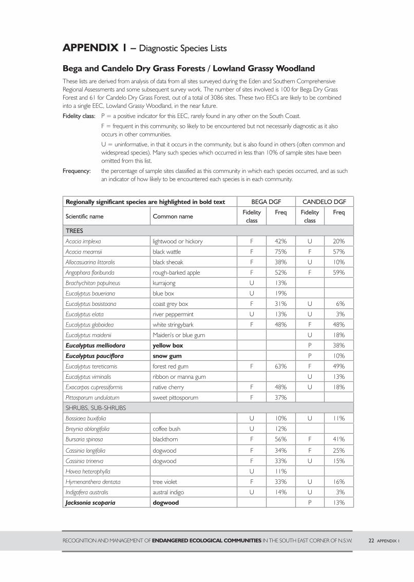
APPENDIX 1 – Diagnostic Species Lists
Bega and Candelo Dry Grass Forests / Lowland Grassy WoodlandThese lists are derived from analysis of data from all sites surveyed during the Eden and Southern Comprehensive Regional Assessments and some subsequent survey work. The number of sites involved is 100 for Bega Dry Grass Forest and 61 for Candelo Dry Grass Forest, out of a total of 3086 sites. These two EECs are likely to be combined into a single EEC, Lowland Grassy Woodland, in the near future.
Fidelity class: P = a positive indicator for this EEC, rarely found in any other on the South Coast.
F = frequent in this community, so likely to be encountered but not necessarily diagnostic as it also occurs in other communities.
U = uninformative, in that it occurs in the community, but is also found in others (often common and widespread species). Many such species which occurred in less than 10% of sample sites have been omitted from this list.
Frequency: the percentage of sample sites classified as this community in which each species occurred, and as such an indicator of how likely to be encountered each species is in each community.
Regionally significant species are highlighted in bold text BEGA DGF CANDELO DGF
Scientific name Common nameFidelity
classFreq Fidelity
classFreq
TREES
Acacia implexa lightwood or hickory F 42% U 20%
Acacia mearnsii black wattle F 75% F 57%
Allocasuarina littoralis black sheoak F 38% U 10%
Angophora floribunda rough-barked apple F 52% F 59%
Brachychiton populneus kurrajong U 13%
Eucalyptus baueriana blue box U 19%
Eucalyptus bosistoana coast grey box F 31% U 6%
Eucalyptus elata river peppermint U 13% U 3%
Eucalyptus globoidea white stringybark F 48% F 48%
Eucalyptus maidenii Maiden’s or blue gum U 18%
Eucalyptus melliodora yellow box P 38%
Eucalyptus pauciflora snow gum P 10%
Eucalyptus tereticornis forest red gum F 63% F 49%
Eucalyptus viminalis ribbon or manna gum U 13%
Exocarpos cupressiformis native cherry F 48% U 18%
Pittosporum undulatum sweet pittosporum F 37%
SHRUBS, SUB-SHRUBS
Bossiaea buxifolia U 10% U 11%
Breynia oblongifolia coffee bush U 12%
Bursaria spinosa blackthorn F 56% F 41%
Cassinia longifolia dogwood F 34% F 25%
Cassinia trinerva dogwood F 33% U 15%
Hovea heterophylla U 11%
Hymenanthera dentata tree violet F 33% U 16%
Indigofera australis austral indigo U 14% U 3%
Jacksonia scoparia dogwood P 13%
22 APPENDIX 1RECOGNITION AND MANAGEMENT OF ENDANGERED ECOLOGICAL COMMUNITIES IN THE SOUTH EAST CORNER OF N.S.W.
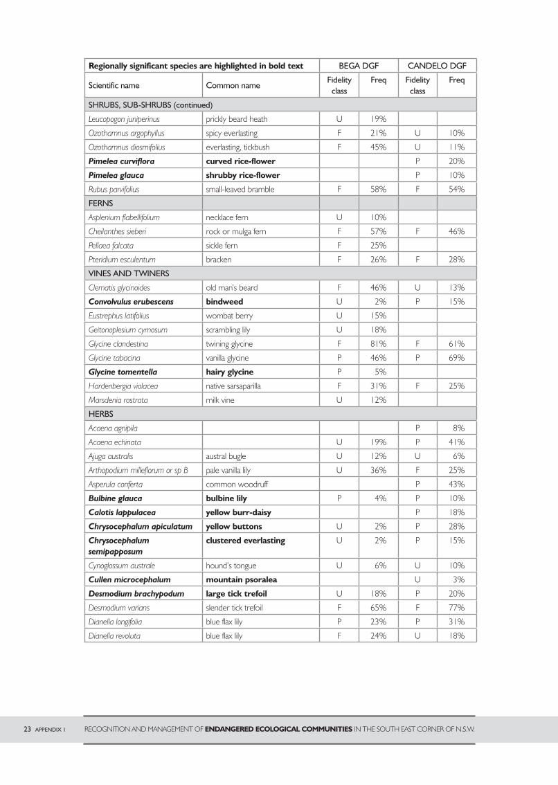
23 APPENDIX 1 RECOGNITION AND MANAGEMENT OF ENDANGERED ECOLOGICAL COMMUNITIES IN THE SOUTH EAST CORNER OF N.S.W.
Regionally significant species are highlighted in bold text BEGA DGF CANDELO DGF
Scientific name Common nameFidelity
classFreq Fidelity
classFreq
SHRUBS, SUB-SHRUBS (continued)
Leucopogon juniperinus prickly beard heath U 19%
Ozothamnus argophyllus spicy everlasting F 21% U 10%
Ozothamnus diosmifolius everlasting, tickbush F 45% U 11%
Pimelea curviflora curved rice-flower P 20%
Pimelea glauca shrubby rice-flower P 10%
Rubus parvifolius small-leaved bramble F 58% F 54%
FERNS
Asplenium flabellifolium necklace fern U 10%
Cheilanthes sieberi rock or mulga fern F 57% F 46%
Pellaea falcata sickle fern F 25%
Pteridium esculentum bracken F 26% F 28%
VINES AND TWINERS
Clematis glycinoides old man’s beard F 46% U 13%
Convolvulus erubescens bindweed U 2% P 15%
Eustrephus latifolius wombat berry U 15%
Geitonoplesium cymosum scrambling lily U 18%
Glycine clandestina twining glycine F 81% F 61%
Glycine tabacina vanilla glycine P 46% P 69%
Glycine tomentella hairy glycine P 5%
Hardenbergia violacea native sarsaparilla F 31% F 25%
Marsdenia rostrata milk vine U 12%
HERBS
Acaena agnipila P 8%
Acaena echinata U 19% P 41%
Ajuga australis austral bugle U 12% U 6%
Arthopodium milleflorum or sp B pale vanilla lily U 36% F 25%
Asperula conferta common woodruff P 43%
Bulbine glauca bulbine lily P 4% P 10%
Calotis lappulacea yellow burr-daisy P 18%
Chrysocephalum apiculatum yellow buttons U 2% P 28%
Chrysocephalum
semipapposum
clustered everlasting U 2% P 15%
Cynoglossum australe hound’s tongue U 6% U 10%
Cullen microcephalum mountain psoralea U 3%
Desmodium brachypodum large tick trefoil U 18% P 20%
Desmodium varians slender tick trefoil F 65% F 77%
Dianella longifolia blue flax lily P 23% P 31%
Dianella revoluta blue flax lily F 24% U 18%
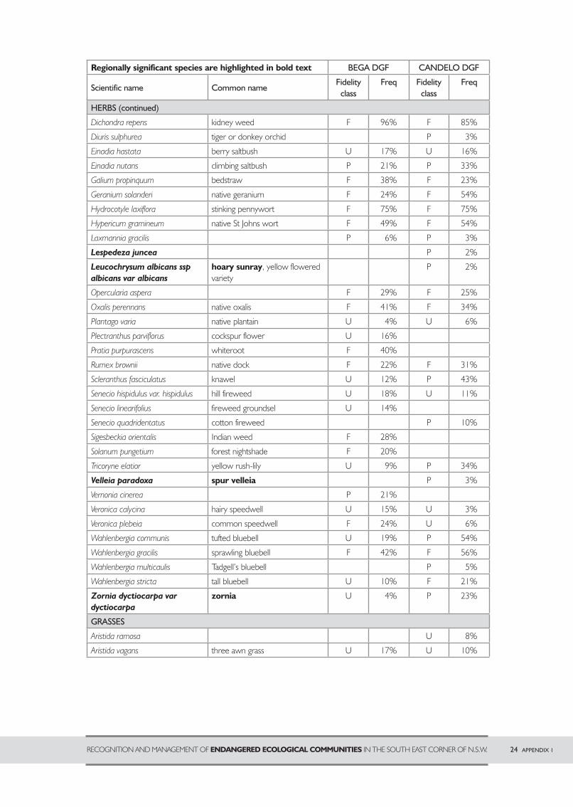
24 APPENDIX 1RECOGNITION AND MANAGEMENT OF ENDANGERED ECOLOGICAL COMMUNITIES IN THE SOUTH EAST CORNER OF N.S.W.
Regionally significant species are highlighted in bold text BEGA DGF CANDELO DGF
Scientific name Common nameFidelity
classFreq Fidelity
classFreq
HERBS (continued)
Dichondra repens kidney weed F 96% F 85%
Diuris sulphurea tiger or donkey orchid P 3%
Einadia hastata berry saltbush U 17% U 16%
Einadia nutans climbing saltbush P 21% P 33%
Galium propinquum bedstraw F 38% F 23%
Geranium solanderi native geranium F 24% F 54%
Hydrocotyle laxiflora stinking pennywort F 75% F 75%
Hypericum gramineum native St Johns wort F 49% F 54%
Laxmannia gracilis P 6% P 3%
Lespedeza juncea P 2%
Leucochrysum albicans ssp
albicans var albicans
hoary sunray, yellow flowered variety
P 2%
Opercularia aspera F 29% F 25%
Oxalis perennans native oxalis F 41% F 34%
Plantago varia native plantain U 4% U 6%
Plectranthus parviflorus cockspur flower U 16%
Pratia purpurascens whiteroot F 40%
Rumex brownii native dock F 22% F 31%
Scleranthus fasciculatus knawel U 12% P 43%
Senecio hispidulus var. hispidulus hill fireweed U 18% U 11%
Senecio linearifolius fireweed groundsel U 14%
Senecio quadridentatus cotton fireweed P 10%
Sigesbeckia orientalis Indian weed F 28%
Solanum pungetium forest nightshade F 20%
Tricoryne elatior yellow rush-lily U 9% P 34%
Velleia paradoxa spur velleia P 3%
Vernonia cinerea P 21%
Veronica calycina hairy speedwell U 15% U 3%
Veronica plebeia common speedwell F 24% U 6%
Wahlenbergia communis tufted bluebell U 19% P 54%
Wahlenbergia gracilis sprawling bluebell F 42% F 56%
Wahlenbergia multicaulis Tadgell’s bluebell P 5%
Wahlenbergia stricta tall bluebell U 10% F 21%
Zornia dyctiocarpa var
dyctiocarpa
zornia U 4% P 23%
GRASSES
Aristida ramosa U 8%
Aristida vagans three awn grass U 17% U 10%
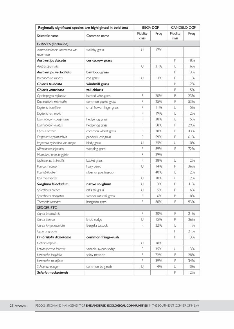
25 APPENDIX 1 RECOGNITION AND MANAGEMENT OF ENDANGERED ECOLOGICAL COMMUNITIES IN THE SOUTH EAST CORNER OF N.S.W.
Regionally significant species are highlighted in bold text BEGA DGF CANDELO DGF
Scientific name Common nameFidelity
classFreq Fidelity
classFreq
GRASSES (continued)
Austrodanthonia racemosa var. racemosa
wallaby grass U 17%
Austrostipa falcata corkscrew grass P 8%
Austrostipa rudis U 31% U 16%
Austrostipa verticillata bamboo grass P 3%
Bothriochloa macra red grass U 4% P 11%
Chloris truncata windmill grass P 2%
Chloris ventricosa tall chloris P 5%
Cymbopogon refractus barbed wire grass P 20% P 23%
Dichelachne micrantha common plume grass F 25% F 53%
Digitaria parviflora small flower finger grass P 11% U 5%
Digitaria ramularis P 19% U 2%
Echinopogon caespitosus hedgehog grass P 38% U 5%
Echinopogon ovatus hedgehog grass F 58% F 29%
Elymus scaber common wheat grass F 28% F 43%
Eragrostis leptostachya paddock lovegrass P 59% P 61%
Imperata cylindrica var. major blady grass U 25% U 10%
Microlaena stipoides weeping grass F 89% F 72%
Notodanthonia longifolia F 29%
Oplismenus imbecillis basket grass F 28% U 2%
Panicum effusum hairy panic U 14% P 36%
Poa labillardieri silver or poa tussock F 40% U 2%
Poa meionectes U 10% U 2%
Sorghum leiocladum native sorghum U 3% P 41%
Sporobolus creber rat’s tail grass U 5% P 16%
Sporobolus elongatus slender rat’s tail grass P 6% P 8%
Themeda triandra kangaroo grass F 80% F 93%
SEDGES ETC
Carex breviculmis F 20% F 21%
Carex inversa knob sedge U 15% P 36%
Carex longebrachiata Bergalia tussock F 22% U 11%
Cyperus gracilis P 21%
Fimbristylis dichotoma common fringe-rush P 3%
Gahnia aspera U 18%
Lepidosperma laterale variable sword-sedge F 35% U 13%
Lomandra longifolia spiny matrush F 72% F 28%
Lomandra multiflora F 39% F 34%
Schoenus apogon common bog-rush U 4% U 10%
Scleria mackaviensis P 2%
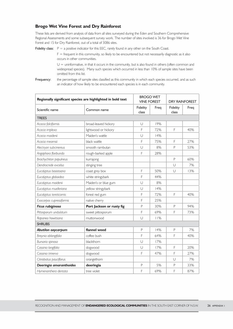
26 APPENDIX 1RECOGNITION AND MANAGEMENT OF ENDANGERED ECOLOGICAL COMMUNITIES IN THE SOUTH EAST CORNER OF N.S.W.
Brogo Wet Vine Forest and Dry RainforestThese lists are derived from analysis of data from all sites surveyed during the Eden and Southern Comprehensive Regional Assessments and some subsequent survey work. The number of sites involved is 36 for Brogo Wet Vine Forest and 15 for Dry Rainforest, out of a total of 3086 sites.
Fidelity class: P = a positive indicator for this EEC, rarely found in any other on the South Coast.
F = frequent in this community, so likely to be encountered but not necessarily diagnostic as it also occurs in other communities.
U = uninformative, in that it occurs in the community, but is also found in others (often common and widespread species). Many such species which occurred in less than 10% of sample sites have been omitted from this list.
Frequency: the percentage of sample sites classified as this community in which each species occurred, and as such an indicator of how likely to be encountered each species is in each community.
Regionally significant species are highlighted in bold textBROGO WET VINE FOREST DRY RAINFOREST
Scientific name Common nameFidelity
classFreq Fidelity
classFreq
TREES
Acacia falciformis broad-leaved hickory U 19%
Acacia implexa lightwood or hickory F 72% F 40%
Acacia maidenii Maiden’s wattle U 14%
Acacia mearnsii black wattle F 75% F 27%
Alectryon subcinereus smooth rambutan U 8% P 53%
Angophora floribunda rough-barked apple F 28%
Brachychiton populneus kurrajong P 60%
Dendrocnide excelsa stinging tree U 7%
Eucalyptus bosistoana coast grey box F 50% U 13%
Eucalyptus globoidea white stringybark F 44%
Eucalyptus maidenii Maiden’s or blue gum U 8%
Eucalyptus muelleriana yellow stringybark U 14%
Eucalyptus tereticornis forest red gum F 72% F 40%
Exocarpos cupressiformis native cherry F 25%
Ficus rubiginosa Port Jackson or rusty fig P 30% P 94%
Pittosporum undulatum sweet pittosporum F 69% F 73%
Rapanea howittiana muttonwood U 11%
SHRUBS
Abutilon oxycarpum flannel weed P 14% P 7%
Breynia oblongifolia coffee bush F 64% F 40%
Bursaria spinosa blackthorn U 17%
Cassinia longifolia dogwood U 17% F 20%
Cassinia trinerva dogwood F 47% F 27%
Citriobatus pauciflorus orangethorn U 7%
Deeringia amaranthoides deeringia P 5% P 33%
Hymenanthera dentata tree violet F 69% F 87%
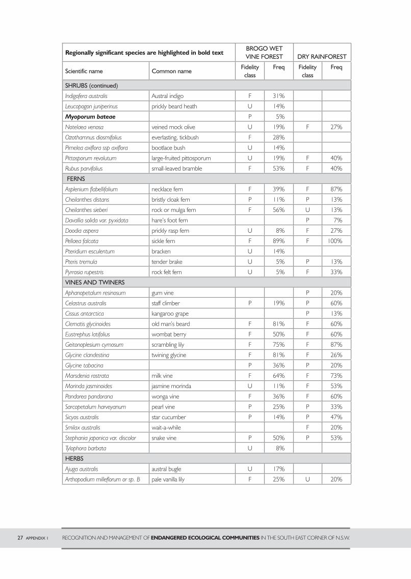
27 APPENDIX 1 RECOGNITION AND MANAGEMENT OF ENDANGERED ECOLOGICAL COMMUNITIES IN THE SOUTH EAST CORNER OF N.S.W.
Regionally significant species are highlighted in bold textBROGO WET VINE FOREST DRY RAINFOREST
Scientific name Common nameFidelity
classFreq Fidelity
classFreq
SHRUBS (continued)
Indigofera australis Austral indigo F 31%
Leucopogon juniperinus prickly beard heath U 14%
Myoporum bateae P 5%
Notelaea venosa veined mock olive U 19% F 27%
Ozothamnus diosmifolius everlasting, tickbush F 28%
Pimelea axiflora ssp axiflora bootlace bush U 14%
Pittosporum revolutum large-fruited pittosporum U 19% F 40%
Rubus parvifolius small-leaved bramble F 53% F 40%
FERNS
Asplenium flabellifolium necklace fern F 39% F 87%
Cheilanthes distans bristly cloak fern P 11% P 13%
Cheilanthes sieberi rock or mulga fern F 56% U 13%
Davallia solida var. pyxidata hare’s foot fern P 7%
Doodia aspera prickly rasp fern U 8% F 27%
Pellaea falcata sickle fern F 89% F 100%
Pteridium esculentum bracken U 14%
Pteris tremula tender brake U 5% P 13%
Pyrrosia rupestris rock felt fern U 5% F 33%
VINES AND TWINERS
Aphanopetalum resinosum gum vine P 20%
Celastrus australis staff climber P 19% P 60%
Cissus antarctica kangaroo grape P 13%
Clematis glycinoides old man’s beard F 81% F 60%
Eustrephus latifolius wombat berry F 50% F 60%
Geitonoplesium cymosum scrambling lily F 75% F 87%
Glycine clandestina twining glycine F 81% F 26%
Glycine tabacina P 36% P 20%
Marsdenia rostrata milk vine F 64% F 73%
Morinda jasminoides jasmine morinda U 11% F 53%
Pandorea pandorana wonga vine F 36% F 60%
Sarcopetalum harveyanum pearl vine P 25% P 33%
Sicyos australis star cucumber P 14% P 47%
Smilax australis wait-a-while F 20%
Stephania japonica var. discolor snake vine P 50% P 53%
Tylophora barbata U 8%
HERBS
Ajuga australis austral bugle U 17%
Arthopodium milleflorum or sp. B pale vanilla lily F 25% U 20%
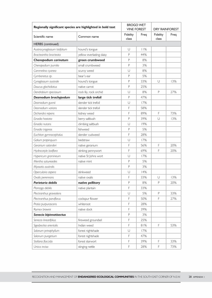
28 APPENDIX 1RECOGNITION AND MANAGEMENT OF ENDANGERED ECOLOGICAL COMMUNITIES IN THE SOUTH EAST CORNER OF N.S.W.
Regionally significant species are highlighted in bold textBROGO WET VINE FOREST DRY RAINFOREST
Scientific name Common nameFidelity
classFreq Fidelity
classFreq
HERBS (continued)
Austrocynoglossum latifolium hound’s tongue U 11%
Bracteantha bracteata yellow everlasting daisy P 44%
Chenopodium carinatum green crumbweed P 8%
Chenopodium pumilio small crumbweed P 3%
Commelina cyanea scurvy weed U 8%
Cymbonotus sp. bear’s ear P 5%
Cynoglossum australe hound’s tongue P 33% U 13%
Daucus glochidiatus native carrot P 25%
Dendrobium speciosum rock lily, rock orchid U 8% P 27%
Desmodium brachypodum large tick trefoil P 47%
Desmodium gunnii slender tick trefoil U 17%
Desmodium varians slender tick trefoil F 58%
Dichondra repens kidney weed F 89% F 73%
Einadia hastata berry saltbush P 39% U 13%
Einadia nutans climbing saltbush U 19%
Einadia trigonos fishweed P 5%
Euchiton gymnocephalus slender cudweed F 28%
Galium propinquum bedstraw U 17%
Geranium solanderi native geranium F 56% F 20%
Hydrocotyle laxiflora stinking pennywort F 69% F 20%
Hypericum gramineum native St Johns wort U 17%
Mentha satureoides native mint P 5%
Myosotis australis P 3%
Opercularia aspera stinkweed U 14%
Oxalis perennans native oxalis F 33% U 13%
Parietaria debilis native pellitory P 8% P 20%
Plantago debilis native plantain F 33%
Plectranthus graveolens U 5% P 33%
Plectranthus parviflorus cockspur flower F 50% F 27%
Pratia purpurascens whiteroot F 28%
Rumex brownii native dock F 39%
Senecio bipinnatisectus P 3%
Senecio linearifolius fireweed groundsel F 25%
Sigesbeckia orientalis Indian weed F 81% F 53%
Solanum prinophyllum forest nightshade U 17%
Solanum pungetium forest nightshade F 47%
Stellaria flaccida forest starwort F 39% F 33%
Urtica incisa stinging nettle F 28% F 73%
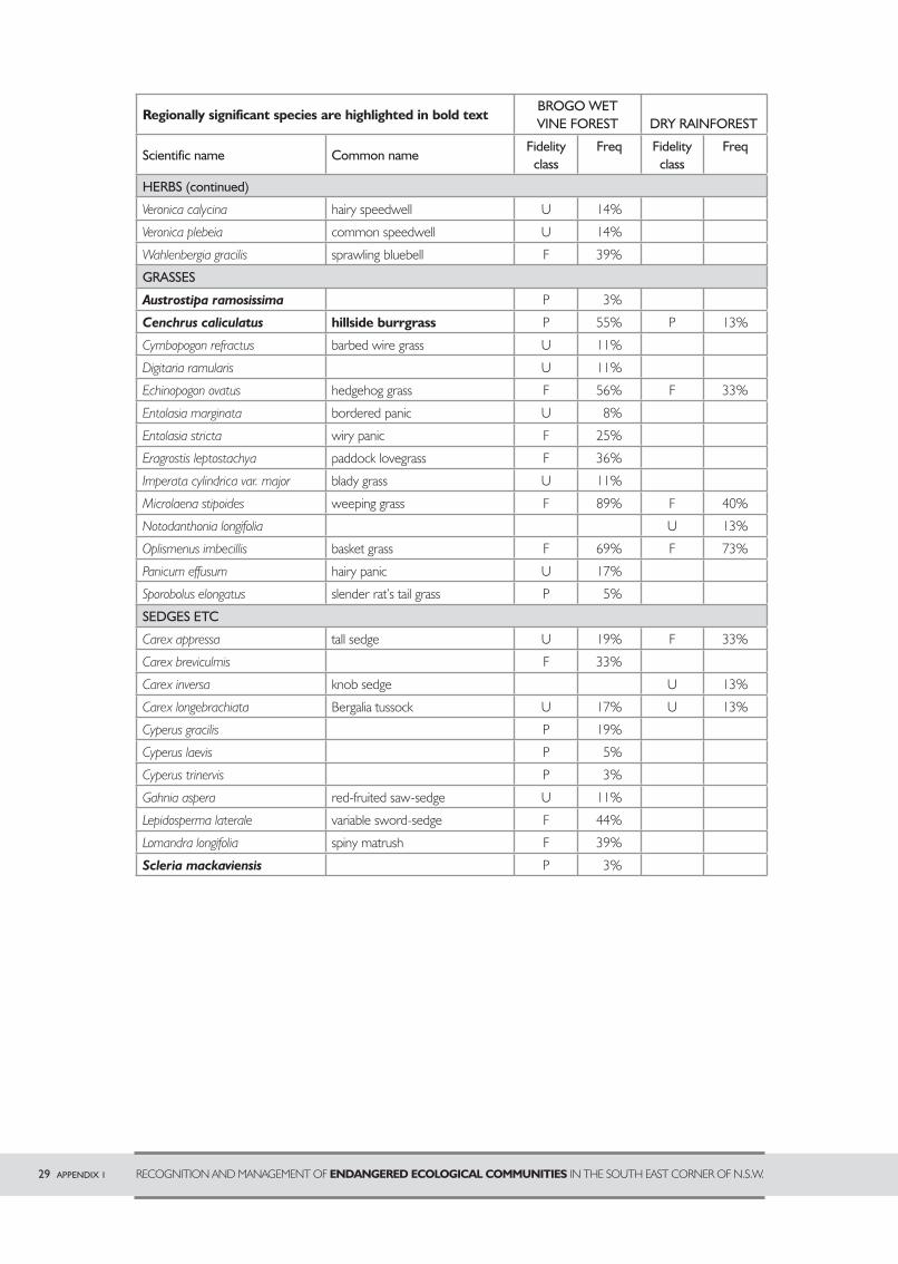
29 APPENDIX 1 RECOGNITION AND MANAGEMENT OF ENDANGERED ECOLOGICAL COMMUNITIES IN THE SOUTH EAST CORNER OF N.S.W.
Regionally significant species are highlighted in bold textBROGO WET VINE FOREST DRY RAINFOREST
Scientific name Common nameFidelity
classFreq Fidelity
classFreq
HERBS (continued)
Veronica calycina hairy speedwell U 14%
Veronica plebeia common speedwell U 14%
Wahlenbergia gracilis sprawling bluebell F 39%
GRASSES
Austrostipa ramosissima P 3%
Cenchrus caliculatus hillside burrgrass P 55% P 13%
Cymbopogon refractus barbed wire grass U 11%
Digitaria ramularis U 11%
Echinopogon ovatus hedgehog grass F 56% F 33%
Entolasia marginata bordered panic U 8%
Entolasia stricta wiry panic F 25%
Eragrostis leptostachya paddock lovegrass F 36%
Imperata cylindrica var. major blady grass U 11%
Microlaena stipoides weeping grass F 89% F 40%
Notodanthonia longifolia U 13%
Oplismenus imbecillis basket grass F 69% F 73%
Panicum effusum hairy panic U 17%
Sporobolus elongatus slender rat’s tail grass P 5%
SEDGES ETC
Carex appressa tall sedge U 19% F 33%
Carex breviculmis F 33%
Carex inversa knob sedge U 13%
Carex longebrachiata Bergalia tussock U 17% U 13%
Cyperus gracilis P 19%
Cyperus laevis P 5%
Cyperus trinervis P 3%
Gahnia aspera red-fruited saw-sedge U 11%
Lepidosperma laterale variable sword-sedge F 44%
Lomandra longifolia spiny matrush F 39%
Scleria mackaviensis P 3%
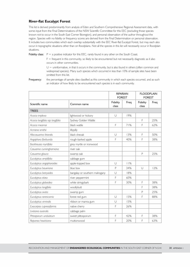
RECOGNITION AND MANAGEMENT OF ENDANGERED ECOLOGICAL COMMUNITIES IN THE SOUTH EAST CORNER OF N.S.W. 30 APPENDIX 1
River-flat Eucalypt ForestThis list is derived predominantly from analysis of Eden and Southern Comprehensive Regional Assessment data, with some input from the Final Determinations of the NSW Scientific Committee for this EEC (excluding those species known not to occur in the South East Corner Bioregion), and personal observation of the author throughout the region. Species with no fidelity or frequency scores are derived from the Final Determination or personal observation. It includes two communities which each overlap substantially with the EEC River-flat Eucalypt Forest, but may each also occur in topographic situations other than on floodplains. Not all the species in this list will necessarily occur in floodplain situations.
Fidelity class: P = a positive indicator for this EEC, rarely found in any other on the South Coast.
F = frequent in this community, so likely to be encountered but not necessarily diagnostic as it also occurs in other communities.
U = uninformative, in that it occurs in the community, but is also found in others (often common and widespread species). Many such species which occurred in less than 10% of sample sites have been omitted from this list.
Frequency: the percentage of sample sites classified as this community in which each species occurred, and as such an indicator of how likely to be encountered each species is in each community.
RIPARIAN FOREST
FLOODPLAINFOREST
Scientific name Common nameFidelity
classFreq Fidelity
classFreq
TREES
Acacia implexa lightwood or hickory U 19%
Acacia longifolia ssp longifolia Sydney Golden Wattle F 25%
Acacia mearnsii black wattle F 71% F 62%
Acmena smithii lillypilly
Allocasuarina littoralis black sheoak U 13% F 50%
Angophora floribunda rough-barked apple F 40% F 38%
Backhousia myrtifolia grey myrtle or ironwood
Casuarina cunninghamiana river oak
Casuarina glauca swamp oak P 25%
Eucalyptus amplifolia cabbage gum
Eucalyptus angophoroides apple-topped box U 11%
Eucalyptus baueriana blue box P 34% U 12%
Eucalyptus botryoides bangalay or southern mahogany U 18%
Eucalyptus elata river peppermint F 60%
Eucalyptus globoidea white stringybark F 30% F 38%
Eucalyptus longifolia woollybutt F 38%
Eucalyptus ovata swamp gum P 25%
Eucalyptus tereticornis forest red gum U 15% F 88%
Eucalyptus viminalis ribbon or manna gum U 15%
Exocarpos cupressiformis native cherry F 26%
Livistona australis cabbage palm
Pittosporum undulatum sweet pittosporum F 42% F 38%
Rapanea howittiana muttonwood F 20% F 63%
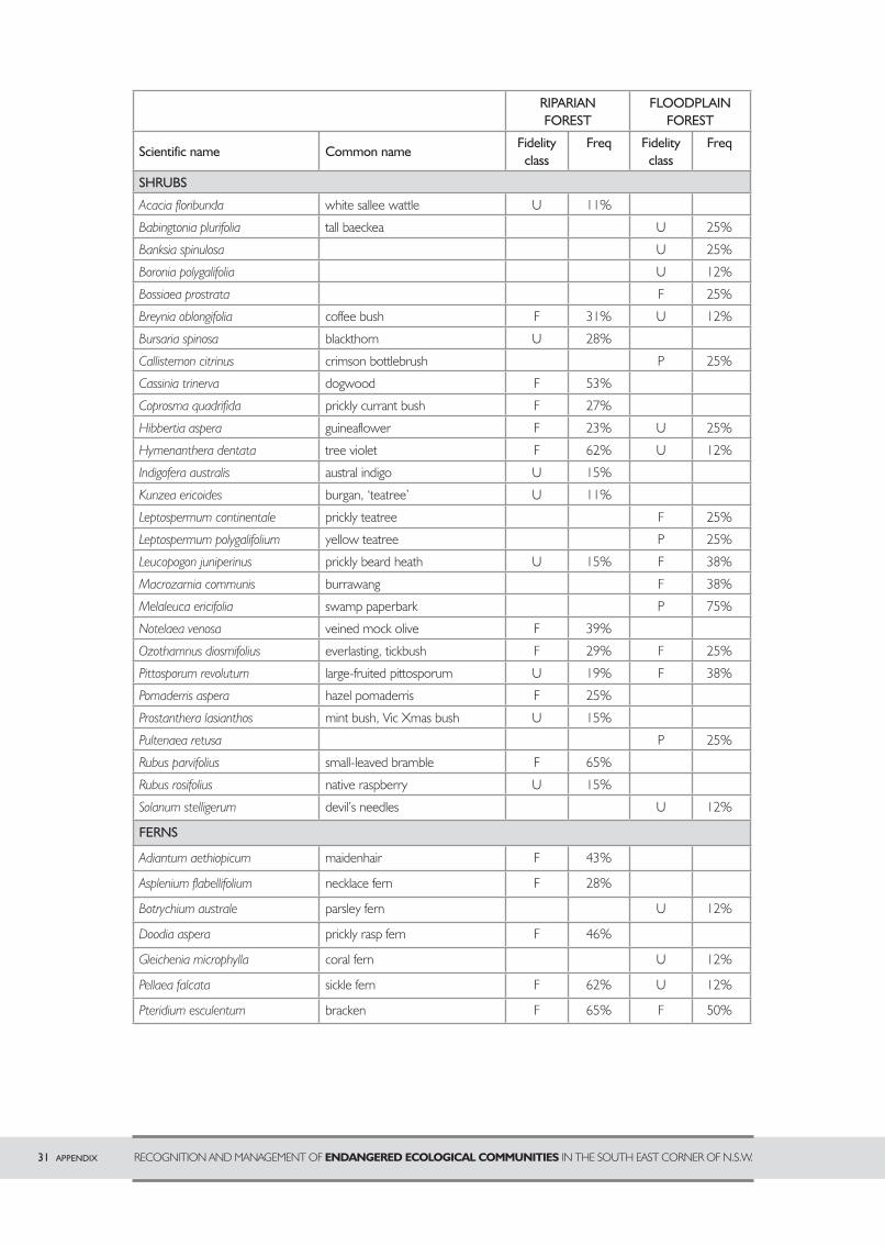
31 APPENDIX RECOGNITION AND MANAGEMENT OF ENDANGERED ECOLOGICAL COMMUNITIES IN THE SOUTH EAST CORNER OF N.S.W.
RIPARIAN FOREST
FLOODPLAINFOREST
Scientific name Common nameFidelity
classFreq Fidelity
classFreq
SHRUBS
Acacia floribunda white sallee wattle U 11%
Babingtonia plurifolia tall baeckea U 25%
Banksia spinulosa U 25%
Boronia polygalifolia U 12%
Bossiaea prostrata F 25%
Breynia oblongifolia coffee bush F 31% U 12%
Bursaria spinosa blackthorn U 28%
Callistemon citrinus crimson bottlebrush P 25%
Cassinia trinerva dogwood F 53%
Coprosma quadrifida prickly currant bush F 27%
Hibbertia aspera guineaflower F 23% U 25%
Hymenanthera dentata tree violet F 62% U 12%
Indigofera australis austral indigo U 15%
Kunzea ericoides burgan, ‘teatree’ U 11%
Leptospermum continentale prickly teatree F 25%
Leptospermum polygalifolium yellow teatree P 25%
Leucopogon juniperinus prickly beard heath U 15% F 38%
Macrozamia communis burrawang F 38%
Melaleuca ericifolia swamp paperbark P 75%
Notelaea venosa veined mock olive F 39%
Ozothamnus diosmifolius everlasting, tickbush F 29% F 25%
Pittosporum revolutum large-fruited pittosporum U 19% F 38%
Pomaderris aspera hazel pomaderris F 25%
Prostanthera lasianthos mint bush, Vic Xmas bush U 15%
Pultenaea retusa I P 25%
Rubus parvifolius small-leaved bramble F 65%
Rubus rosifolius native raspberry U 15%
Solanum stelligerum devil’s needles U 12%
FERNS
Adiantum aethiopicum maidenhair F 43%
Asplenium flabellifolium necklace fern F 28%
Botrychium australe parsley fern U 12%
Doodia aspera prickly rasp fern F 46%
Gleichenia microphylla coral fern U 12%
Pellaea falcata sickle fern F 62% U 12%
Pteridium esculentum bracken F 65% F 50%
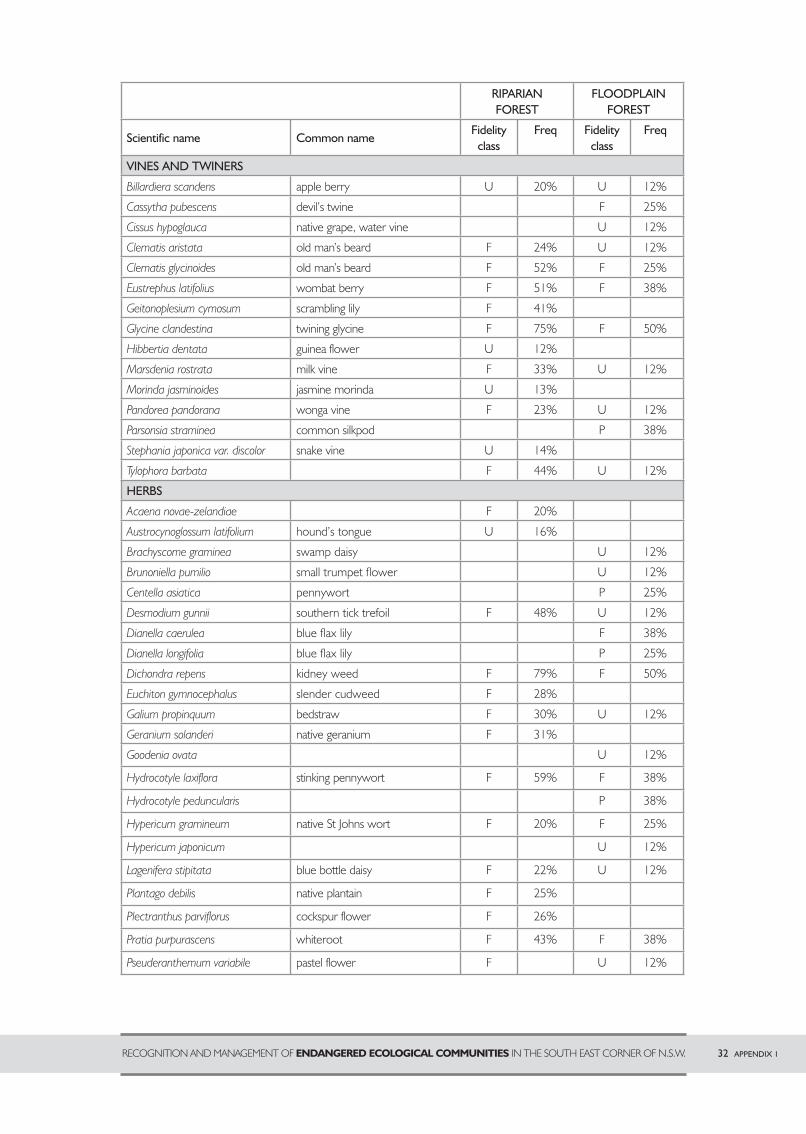
RECOGNITION AND MANAGEMENT OF ENDANGERED ECOLOGICAL COMMUNITIES IN THE SOUTH EAST CORNER OF N.S.W. 32 APPENDIX 1
RIPARIAN FOREST
FLOODPLAINFOREST
Scientific name Common nameFidelity
classFreq Fidelity
classFreq
VINES AND TWINERS
Billardiera scandens apple berry U 20% U 12%
Cassytha pubescens devil’s twine F 25%
Cissus hypoglauca native grape, water vine U 12%
Clematis aristata old man’s beard F 24% U 12%
Clematis glycinoides old man’s beard F 52% F 25%
Eustrephus latifolius wombat berry F 51% F 38%
Geitonoplesium cymosum scrambling lily F 41%
Glycine clandestina twining glycine F 75% F 50%
Hibbertia dentata guinea flower U 12%
Marsdenia rostrata milk vine F 33% U 12%
Morinda jasminoides jasmine morinda U 13%
Pandorea pandorana wonga vine F 23% U 12%
Parsonsia straminea common silkpod P 38%
Stephania japonica var. discolor snake vine U 14%
Tylophora barbata b F 44% U 12%
HERBS
Acaena novae-zelandiae F 20%
Austrocynoglossum latifolium hound’s tongue U 16%
Brachyscome graminea swamp daisy U 12%
Brunoniella pumilio small trumpet fl ower U 12%
Centella asiatica pennywort P 25%
Desmodium gunnii southern tick trefoil F 48% U 12%
Dianella caerulea blue fl ax lily F 38%
Dianella longifolia blue fl ax lily P 25%
Dichondra repens kidney weed F 79% F 50%
Euchiton gymnocephalus slender cudweed F 28%
Galium propinquum bedstraw F 30% U 12%
Geranium solanderi native geranium F 31%
Goodenia ovata U 12%
Hydrocotyle laxiflora stinking pennywort F 59% F 38%
Hydrocotyle peduncularis P 38%
Hypericum gramineum native St Johns wort F 20% F 25%
Hypericum japonicum U 12%
Lagenifera stipitata blue bottle daisy F 22% U 12%
Plantago debilis native plantain F 25%
Plectranthus parviflorus cockspur flower F 26%
Pratia purpurascens whiteroot F 43% F 38%
Pseuderanthemum variabile pastel flower F U 12%
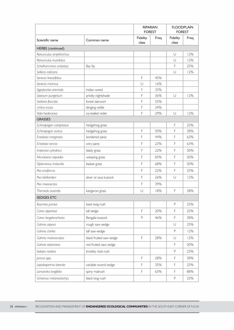
33 APPENDIX 1 RECOGNITION AND MANAGEMENT OF ENDANGERED ECOLOGICAL COMMUNITIES IN THE SOUTH EAST CORNER OF N.S.W.
RIPARIAN FOREST
FLOODPLAINFOREST
Scientific name Common nameFidelity
classFreq Fidelity
classFreq
HERBS (continued)
Ranunculus amphitrichus U 12%
Ranunculus inundatus U 12%
Schelhammera undulata lilac lily F 25%
Selliera radicans U 12%
Senecio linearifolius F 45%
Senecio minimus y U 16%
Sigesbeckia orientalis Indian weed F 33%
Solanum pungetium prickly nightshade F 36% U 12%
Stellaria flaccida forest starwort F 55%
Urtica incisa stinging nettle F 24%
Viola hederacea ivy-leafed violet F 29% U 12%
GRASSES
Echinopogon caespitosus hedgehog grass F 25%
Echinopogon ovatus hedgehog grass F 50% F 38%
Entolasia marginata bordered panic F 44% F 63%
Entolasia stricta wiry panic F 23% F 63%
Imperata cylindrica blady grass F 22% F 50%
Microlaena stipoides weeping grass F 83% F 50%
Oplismenus imbecillis basket grass F 68% F 50%
Poa ensiformis F 22% F 25%
Poa labillardieri silver or poa tussock F 26% U 12%
Poa meionectes F 39%
Themeda australis kangaroo grass U 18% F 38%
SEDGES ETC
Baumea juncea bare twig-rush P 25%
Carex appressa tall sedge F 20% F 25%
Carex longebrachiata Bergalia tussock P 46% F 38%
Gahnia aspera rough saw-sedge U 25%
Gahnia clarkei tall saw-sedge P 12%
Gahnia melanocarpa black fruited saw-sedge F 28% U 12%
Gahnia sieberiana red fruited saw-sedge F 50%
Isolepis nodosa knobby club-rush P 25%
Juncus spp. F 28% F 38%
Lepidosperma laterale variable sword-sedge F 35% F 25%
Lomandra longifolia spiny matrush F 63% F 88%
Schoenus melanostachys black bog-rush P 25%
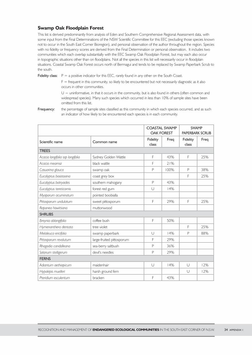
RECOGNITION AND MANAGEMENT OF ENDANGERED ECOLOGICAL COMMUNITIES IN THE SOUTH EAST CORNER OF N.S.W. 34 APPENDIX 1
Swamp Oak Floodplain ForestThis list is derived predominantly from analysis of Eden and Southern Comprehensive Regional Assessment data, with some input from the Final Determinations of the NSW Scientific Committee for this EEC (excluding those species known not to occur in the South East Corner Bioregion), and personal observation of the author throughout the region. Species with no fidelity or frequency scores are derived from the Final Determination or personal observation. It includes two communities which each overlap substantially with the EEC Swamp Oak Floodplain Forest, but may each also occur in topographic situations other than on floodplains. Not all the species in this list will necessarily occur in floodplain situations. Coastal Swamp Oak Forest occurs north of Bermagui and tends to be replaced by Swamp Paperbark Scrub to the south.
Fidelity class: P = a positive indicator for this EEC, rarely found in any other on the South Coast.
F = frequent in this community, so likely to be encountered but not necessarily diagnostic as it also occurs in other communities.
U = uninformative, in that it occurs in the community, but is also found in others (often common and widespread species). Many such species which occurred in less than 10% of sample sites have been omitted from this list.
Frequency: the percentage of sample sites classified as this community in which each species occurred, and as such an indicator of how likely to be encountered each species is in each community.
COASTAL SWAMP OAK FOREST
SWAMPPAPERBARK SCRUB
Scientific name Common nameFidelity
classFreq Fidelity
classFreq
TREES
Acacia longifolia ssp longifolia Sydney Golden Wattle F 43% F 25%
Acacia mearnsii black wattle F 21%
Casuarina glauca swamp oak P 100% P 38%
Eucalyptus bosistoana coast grey box F 25%
Eucalyptus botryoides southern mahogany P 43%
Eucalyptus tereticornis forest red gum U 14%
Myoporum acuminatum pointed boobialla
Pittosporum undulatum sweet pittosporum F 29% F 25%
Rapanea howittiana muttonwood
SHRUBS
Breynia oblongifolia coffee bush F 50%
Hymenanthera dentata tree violet F 25%
Melaleuca ericifolia swamp paperbark U 14% P 88%
Pittosporum revolutum large-fruited pittosporum F 29%
Rhagodia candolleana sea-berry saltbush P 36%
Solanum stelligerum devil’s needles P 29%
FERNS
Adiantum aethiopicum maidenhair U 14% U 12%
Hypolepis muelleri harsh ground fern U 12%
Pteridium esculentum bracken F 43%
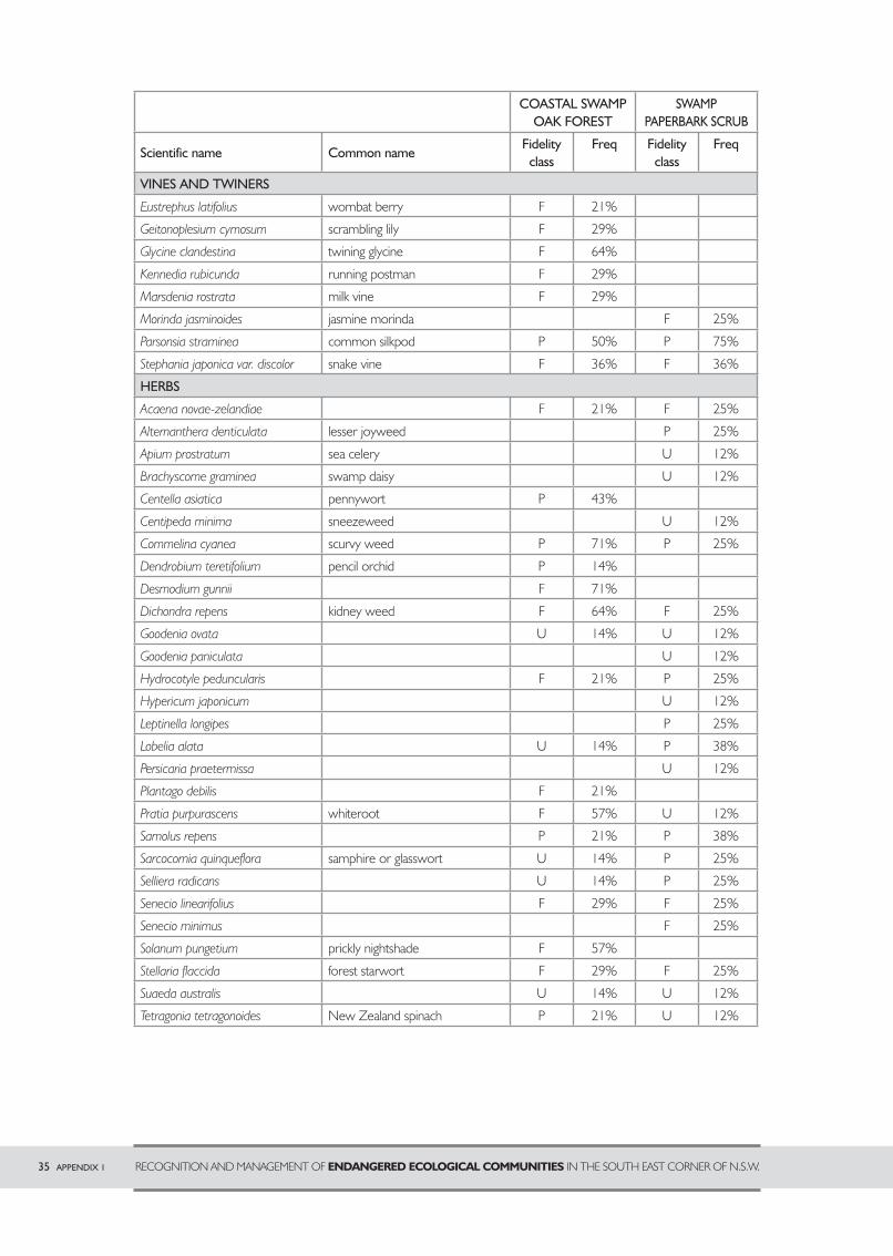
35 APPENDIX 1 RECOGNITION AND MANAGEMENT OF ENDANGERED ECOLOGICAL COMMUNITIES IN THE SOUTH EAST CORNER OF N.S.W.
COASTAL SWAMP OAK FOREST
SWAMPPAPERBARK SCRUB
Scientific name Common nameFidelity
classFreq Fidelity
classFreq
VINES AND TWINERS
Eustrephus latifolius wombat berry F 21%
Geitonoplesium cymosum scrambling lily F 29%
Glycine clandestina twining glycine F 64%
Kennedia rubicunda running postman F 29%
Marsdenia rostrata milk vine F 29%
Morinda jasminoides jasmine morinda F 25%
Parsonsia straminea common silkpod P 50% P 75%
Stephania japonica var. discolor snake vine F 36% F 36%
HERBS
Acaena novae-zelandiae F 21% F 25%
Alternanthera denticulata lesser joyweed P 25%
Apium prostratum sea celery U 12%
Brachyscome graminea swamp daisy U 12%
Centella asiatica pennywort P 43%
Centipeda minima sneezeweed U 12%
Commelina cyanea scurvy weed P 71% P 25%
Dendrobium teretifolium pencil orchid P 14%
Desmodium gunnii F 71%
Dichondra repens kidney weed F 64% F 25%
Goodenia ovata U 14% U 12%
Goodenia paniculata U 12%
Hydrocotyle peduncularis F 21% P 25%
Hypericum japonicum U 12%
Leptinella longipes P 25%
Lobelia alata U 14% P 38%
Persicaria praetermissa U 12%
Plantago debilis F 21%
Pratia purpurascens whiteroot F 57% U 12%
Samolus repens P 21% P 38%
Sarcocornia quinqueflora samphire or glasswort U 14% P 25%
Selliera radicans samphire or glasswort U 14% P 25%
Senecio linearifolius samphire or glasswort F 29% F 25%
Senecio minimus samphire or glasswort F 25%
Solanum pungetium prickly nightshade F 57%
Stellaria flaccida forest starwort F 29% F 25%
Suaeda australis U 14% U 12%
Tetragonia tetragonoides New Zealand spinach P 21% U 12%
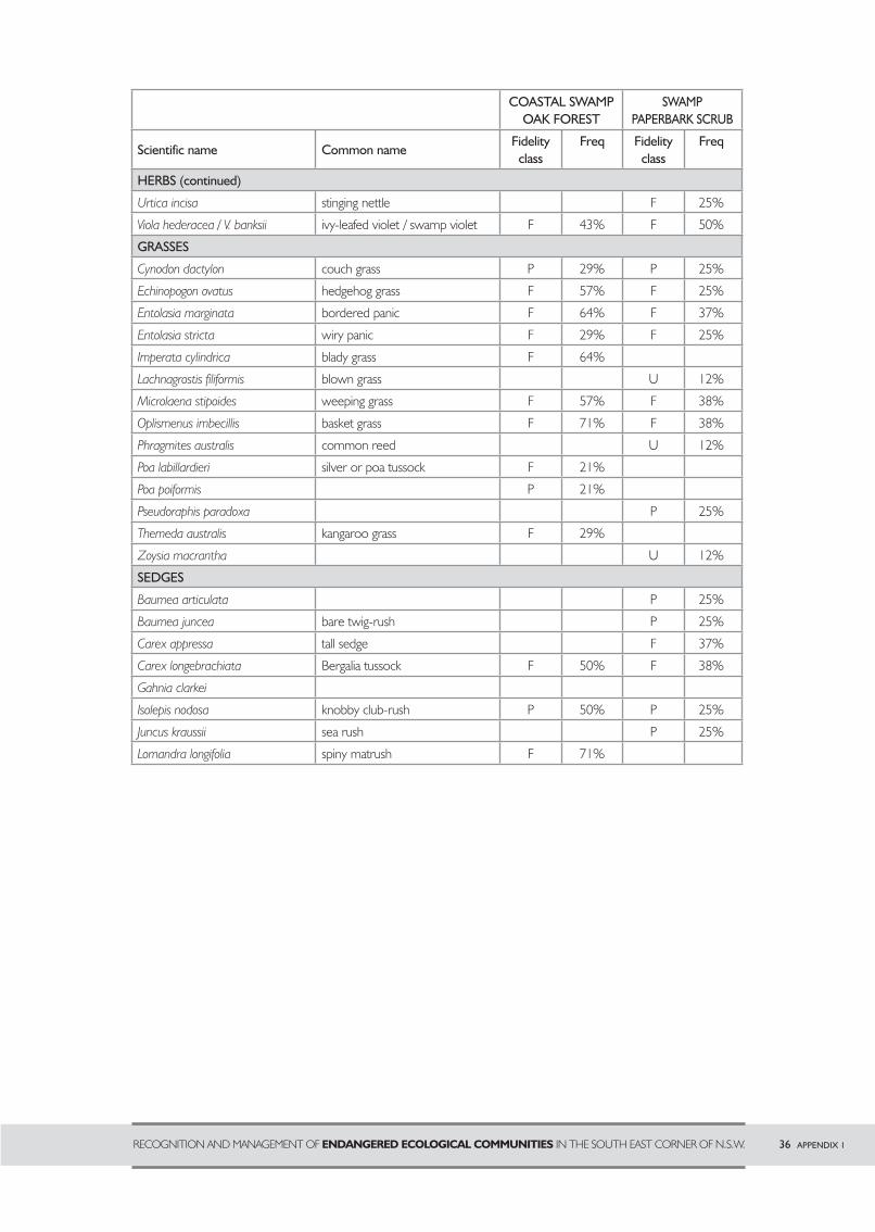
RECOGNITION AND MANAGEMENT OF ENDANGERED ECOLOGICAL COMMUNITIES IN THE SOUTH EAST CORNER OF N.S.W. 36 APPENDIX 1
COASTAL SWAMP OAK FOREST
SWAMPPAPERBARK SCRUB
Scientific name Common nameFidelity
classFreq Fidelity
classFreq
HERBS (continued)
Urtica incisa stinging nettle F 25%
Viola hederacea / V. banksii ivy-leafed violet / swamp violet F 43% F 50%
GRASSES
Cynodon dactylon couch grass P 29% P 25%
Echinopogon ovatus hedgehog grass F 57% F 25%
Entolasia marginata bordered panic F 64% F 37%
Entolasia stricta wiry panic F 29% F 25%
Imperata cylindrica blady grass F 64%
Lachnagrostis filiformis blown grass U 12%
Microlaena stipoides weeping grass F 57% F 38%
Oplismenus imbecillis basket grass F 71% F 38%
Phragmites australis common reed U 12%
Poa labillardieri silver or poa tussock F 21%
Poa poiformis P 21%
Pseudoraphis paradoxa P 25%
Themeda australis kangaroo grass F 29%
Zoysia macrantha U 12%
SEDGES
Baumea articulata P 25%
Baumea juncea bare twig-rush P 25%
Carex appressa tall sedge F 37%
Carex longebrachiata Bergalia tussock F 50% F 38%
Gahnia clarkei
Isolepis nodosa knobby club-rush P 50% P 25%
Juncus kraussii sea rush P 25%
Lomandra longifolia spiny matrush F 71%
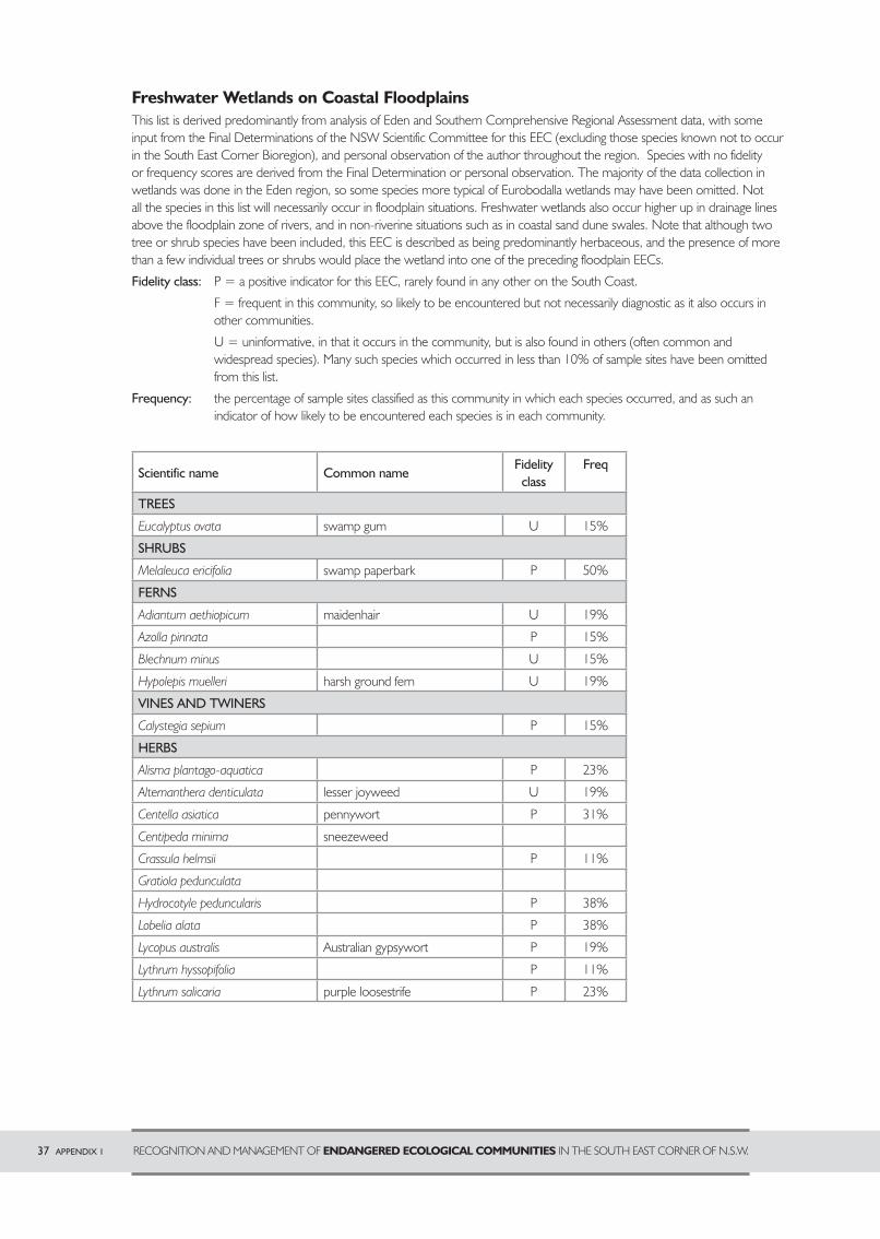
37 APPENDIX 1 RECOGNITION AND MANAGEMENT OF ENDANGERED ECOLOGICAL COMMUNITIES IN THE SOUTH EAST CORNER OF N.S.W.
Freshwater Wetlands on Coastal FloodplainsThis list is derived predominantly from analysis of Eden and Southern Comprehensive Regional Assessment data, with some input from the Final Determinations of the NSW Scientific Committee for this EEC (excluding those species known not to occur in the South East Corner Bioregion), and personal observation of the author throughout the region. Species with no fidelity or frequency scores are derived from the Final Determination or personal observation. The majority of the data collection in wetlands was done in the Eden region, so some species more typical of Eurobodalla wetlands may have been omitted. Not all the species in this list will necessarily occur in floodplain situations. Freshwater wetlands also occur higher up in drainage lines above the floodplain zone of rivers, and in non-riverine situations such as in coastal sand dune swales. Note that although two tree or shrub species have been included, this EEC is described as being predominantly herbaceous, and the presence of more than a few individual trees or shrubs would place the wetland into one of the preceding floodplain EECs.
Fidelity class: P = a positive indicator for this EEC, rarely found in any other on the South Coast.
F = frequent in this community, so likely to be encountered but not necessarily diagnostic as it also occurs in other communities.
U = uninformative, in that it occurs in the community, but is also found in others (often common and widespread species). Many such species which occurred in less than 10% of sample sites have been omitted from this list.
Frequency: the percentage of sample sites classified as this community in which each species occurred, and as such an indicator of how likely to be encountered each species is in each community.
Scientific name Common nameFidelity
classFreq
TREES
Eucalyptus ovata swamp gum U 15%
SHRUBS
Melaleuca ericifolia swamp paperbark P 50%
FERNS
Adiantum aethiopicum maidenhair U 19%
Azolla pinnata P 15%
Blechnum minus U 15%
Hypolepis muelleri harsh ground fern U 19%
VINES AND TWINERS
Calystegia sepium P 15%
HERBS
Alisma plantago-aquatica P 23%
Alternanthera denticulata lesser joyweed U 19%
Centella asiatica pennywort P 31%
Centipeda minima sneezeweed
Crassula helmsii P 11%
Gratiola pedunculata
Hydrocotyle peduncularis P 38%
Lobelia alata P 38%
Lycopus australis Australian gypsywort P 19%
Lythrum hyssopifolia P 11%
Lythrum salicaria purple loosestrife P 23%
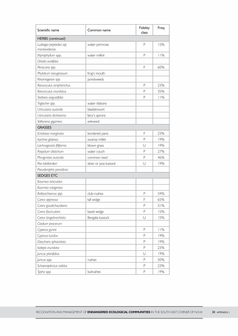
Scientific name Common nameFidelity
classFreq
HERBS (continued)
Ludwigia peploides ssp montevidensis
water primrose P 15%
Myriophyllum spp. water milfoil P 11%
Ottelia ovalifolia swamp gum
Persicaria spp. swamp gum F 60%
Phylidrum lanuginosum frog’s mouth
Potamogeton spp. pondweeds
Ranunculus amphitrichus swamp gum P 23%
Ranunculus inundatus swamp gum P 35%
Stellaria angustifolia swamp gum P 11%
Triglochin spp. water ribbons
Utricularia australis bladderwort
Utricularia dichotoma fairy’s aprons
Vallisneria gigantea eelweed
GRASSES
Entolasia marginata bordered panic F 23%
Isachne globosa swamp millet P 19%
Lachnagrostis filiformis blown grass U 19%
Paspalum distichum water couch P 27%
Phragmites australis common reed P 46%
Poa labillardieri silver or poa tussock U 19%
Pseudoraphis paradoxa swamp paperbark
SEDGES ETC
Baumea articulata maidenhair
Baumea rubiginosa
Bolboschoenus spp. club-rushes P 34%
Carex appressa tall sedge F 65%
Carex gaudichaudiana P 31%
Carex fascicularis tassel sedge P 15%
Carex longebrachiata Bergalia tussock U 15%
Cladium procerum pennywort
Cyperus gunnii sneezeweed P 11%
Cyperus lucidus P 19%
Eleocharis sphacelata P 19%
Isolepis inundata P 23%
Juncus planifolius U 19%
Juncus spp rushes P 50%
Schoenoplectus validus P 23%
Typha spp bulrushes P 19%
RECOGNITION AND MANAGEMENT OF ENDANGERED ECOLOGICAL COMMUNITIES IN THE SOUTH EAST CORNER OF N.S.W. 38 APPENDIX 1
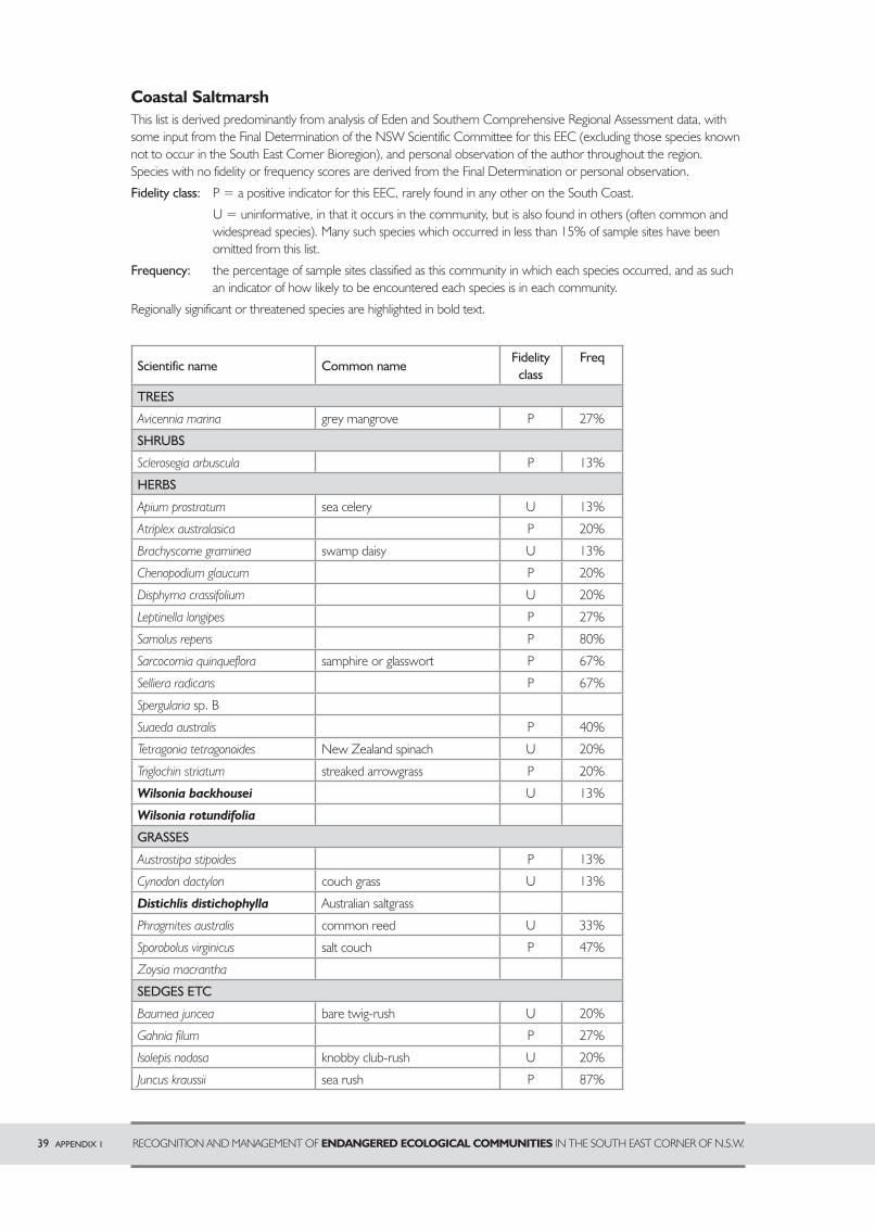
Coastal SaltmarshThis list is derived predominantly from analysis of Eden and Southern Comprehensive Regional Assessment data, with some input from the Final Determination of the NSW Scientific Committee for this EEC (excluding those species known not to occur in the South East Corner Bioregion), and personal observation of the author throughout the region. Species with no fidelity or frequency scores are derived from the Final Determination or personal observation.
Fidelity class: P = a positive indicator for this EEC, rarely found in any other on the South Coast.
U = uninformative, in that it occurs in the community, but is also found in others (often common and widespread species). Many such species which occurred in less than 15% of sample sites have been omitted from this list.
Frequency: the percentage of sample sites classified as this community in which each species occurred, and as such an indicator of how likely to be encountered each species is in each community.
Regionally significant or threatened species are highlighted in bold text.
Scientific name Common nameFidelity
classFreq
TREES
Avicennia marina grey mangrove P 27%
SHRUBS
Sclerosegia arbuscula grey mangrove P 13%
HERBS
Apium prostratum sea celery U 13%
Atriplex australasica lesser joyweed P 20%
Brachyscome graminea swamp daisy U 13%
Chenopodium glaucum sneezeweed P 20%
Disphyma crassifolium U 20%
Leptinella longipes P 27%
Samolus repens samphire or glasswort P 80%
Sarcocornia quinqueflora samphire or glasswort P 67%
Selliera radicans Australian gypsywort P 67%
Spergularia sp. B New Zealand spinach
Suaeda australis streaked arrowgrass P 40%
Tetragonia tetragonoides New Zealand spinach U 20%
Triglochin striatum streaked arrowgrass P 20%
Wilsonia backhousei sea celery U 13%
Wilsonia rotundifolia sea celery
GRASSES
Austrostipa stipoides streaked arrowgrass P 13%
Cynodon dactylon couch grass U 13%
Distichlis distichophylla Australian saltgrass
Phragmites australis common reed U 33%
Sporobolus virginicus salt couch P 47%
Zoysia macrantha salt couch
SEDGES ETC
Baumea juncea bare twig-rush U 20%
Gahnia filum salt couch P 27%
Isolepis nodosa knobby club-rush U 20%
Juncus kraussii sea rush P 87%
39 APPENDIX 1 RECOGNITION AND MANAGEMENT OF ENDANGERED ECOLOGICAL COMMUNITIES IN THE SOUTH EAST CORNER OF N.S.W.
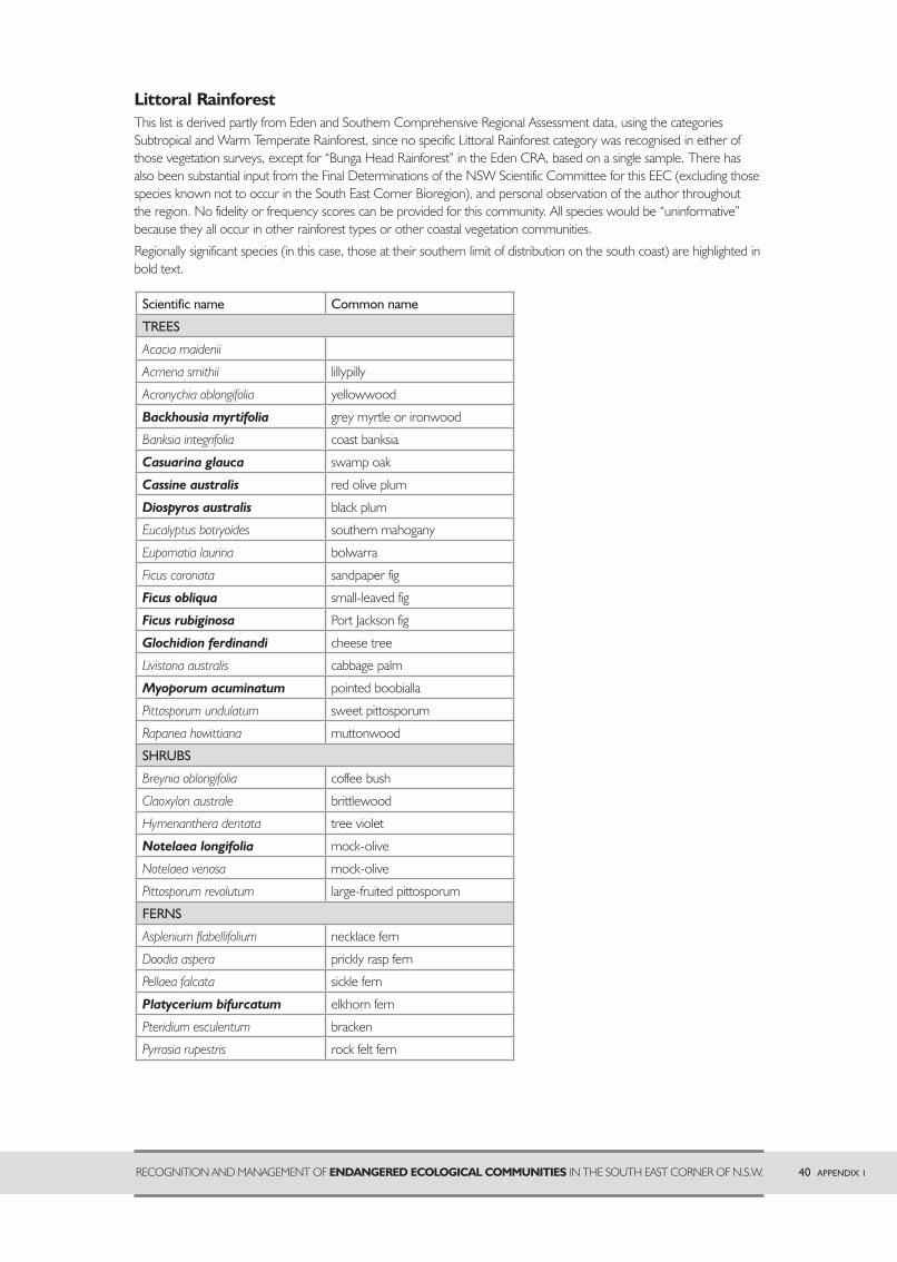
Littoral RainforestThis list is derived partly from Eden and Southern Comprehensive Regional Assessment data, using the categories Subtropical and Warm Temperate Rainforest, since no specific Littoral Rainforest category was recognised in either of those vegetation surveys, except for “Bunga Head Rainforest” in the Eden CRA, based on a single sample. There has also been substantial input from the Final Determinations of the NSW Scientific Committee for this EEC (excluding those species known not to occur in the South East Corner Bioregion), and personal observation of the author throughout the region. No fidelity or frequency scores can be provided for this community. All species would be “uninformative” because they all occur in other rainforest types or other coastal vegetation communities.
Regionally significant species (in this case, those at their southern limit of distribution on the south coast) are highlighted in bold text.
Scientific name Common name
TREES
Acacia maidenii
Acmena smithii lillypilly
Acronychia oblongifolia yellowwood
Backhousia myrtifolia grey myrtle or ironwood
Banksia integrifolia coast banksia
Casuarina glauca swamp oak
Cassine australis red olive plum
Diospyros australis black plum
Eucalyptus botryoides southern mahogany
Eupomatia laurina bolwarra
Ficus coronata sandpaper fig
Ficus obliqua small-leaved fig
Ficus rubiginosa Port Jackson fig
Glochidion ferdinandi cheese tree
Livistona australis cabbage palm
Myoporum acuminatum pointed boobialla
Pittosporum undulatum sweet pittosporum
Rapanea howittiana muttonwood
SHRUBS
Breynia oblongifolia coffee bush
Claoxylon australe brittlewood
Hymenanthera dentata tree violet
Notelaea longifolia mock-olive
Notelaea venosa mock-olive
Pittosporum revolutum large-fruited pittosporum
FERNS
Asplenium flabellifolium necklace fern
Doodia aspera prickly rasp fern
Pellaea falcata sickle fern
Platycerium bifurcatum elkhorn fern
Pteridium esculentum bracken
Pyrrosia rupestris rock felt fern
RECOGNITION AND MANAGEMENT OF ENDANGERED ECOLOGICAL COMMUNITIES IN THE SOUTH EAST CORNER OF N.S.W. 40 APPENDIX 1

Scientific name Common name
VINES AND TWINERS
Aphanopetalum resinosum gum vine
Celastrus australis staff climber
Cissus antarctica kangaroo grape
Cissus hypoglauca native grape, water vine
Eustrephus latifolius wombat berry
Geitonoplesium cymosum scrambling lily
Marsdenia rostrata milk vine
Morinda jasminoides jasmine morinda
Parsonsia straminea common silkpod
Sarcopetalum harveyanum pearl vine
Stephania japonica snake vine
HERBS
Commelina cyanea scurvy weed
Dianella caerulea blue flax lily
Dichondra repens kidney weed
Pseuderanthemum variabile pastel flower
Solanum pungetium prickly nightshade
Viola hederacea / V. banksii ivy-leafed violet / swamp violet
GRASSES
Oplismenus imbecillis basket grass
SEDGES ETC
Carex appressa tall sedge
Carex longebrachiata Bergalia tussock
Gahnia aspera rough saw-sedge
Gahnia melanocarpa black fruited saw-sedge
Lepidosperma concavum variable sword-sedge
Lepidosperma laterale variable sword-sedge
41 APPENDIX 1 RECOGNITION AND MANAGEMENT OF ENDANGERED ECOLOGICAL COMMUNITIES IN THE SOUTH EAST CORNER OF N.S.W.
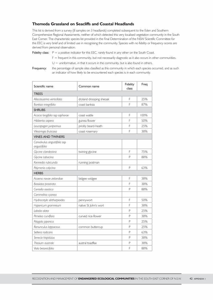
Themeda Grassland on Seacliffs and Coastal HeadlandsThis list is derived from a survey (8 samples on 3 headlands) completed subsequent to the Eden and Southern Comprehensive Regional Assessments, neither of which detected this very localised vegetation community in the South East Corner. The characteristic species list provided in the Final Determination of the NSW Scientific Committee for this EEC is very brief and of limited use in recognising the community. Species with no fidelity or frequency scores are derived from personal observation.
Fidelity class: P = a positive indicator for this EEC, rarely found in any other on the South Coast.
F = frequent in this community, but not necessarily diagnostic as it also occurs in other communities.
U = uninformative, in that it occurs in the community, but is also found in others.
Frequency: the percentage of sample sites classified as this community in which each species occurred, and as such an indicator of how likely to be encountered each species is in each community.
Scientific name Common nameFidelity
classFreq
TREES
Allocasuarina verticillata dryland drooping sheoak F 25%
Banksia integrifolia coast banksia F 87%
SHRUBS
Acacia longifolia ssp sophorae coast wattle F 100%
Hibbertia aspera guinea flower F 50%
Leucopogon juniperinus prickly beard-heath F 25%
Westringia fruticosa coast rosemary F 38%
VINES AND TWINERS
Convolvulus angustifolia ssp angustifolia
couch grass
Glycine clandestina twining glycine F 75%
Glycine tabacina Australian saltgrass P 88%
Kennedia rubicunda running postman
Polymeria calycina salt couch P 63%
HERBS
Acaena novae-zelandiae bidgee-widgee F 38%
Bossiaea prostrata bare twig-rush F 38%
Centella asiatica bare twig-rush P 88%
Commelina cyanea bare twig-rush
Hydrocotyle sibthorpioides pennywort F 50%
Hypericum gramineum native St John’s wort F 38%
Lobelia alata bare twig-rush P 25%
Pimelea curviflora curved rice-flower P 38%
Polygala japonica bare twig-rush P 25%
Ranunculus lappaceus common buttercup P 25%
Selliera radicans bare twig-rush P 63%
Senecio hispidulus bare twig-rush P 38%
Thesium australe austral toadflax P 38%
Viola betonicifolia bare twig-rush F 88%
RECOGNITION AND MANAGEMENT OF ENDANGERED ECOLOGICAL COMMUNITIES IN THE SOUTH EAST CORNER OF N.S.W. 42 APPENDIX 1
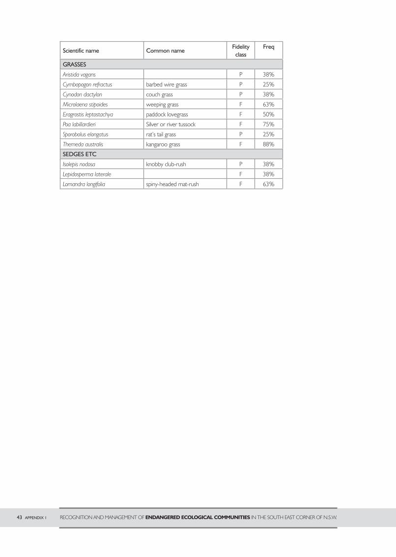
Scientific name Common nameFidelity
classFreq
GRASSES
Aristida vagans P 38%
Cymbopogon refractus barbed wire grass P 25%
Cynodon dactylon couch grass P 38%
Microlaena stipoides weeping grass F 63%
Eragrostis leptostachya paddock lovegrass ezeweed F 50%
Poa labillardieri Silver or river tussock F 75%
Sporobolus elongatus rat’s tail grass P 25%
Themeda australis kangaroo grass F 88%
SEDGES ETC
Isolepis nodosa knobby club-rush P 38%
Lepidosperma laterale bare twig-rush F 38%
Lomandra longifolia spiny-headed mat-rush F 63%
43 APPENDIX 1 RECOGNITION AND MANAGEMENT OF ENDANGERED ECOLOGICAL COMMUNITIES IN THE SOUTH EAST CORNER OF N.S.W.
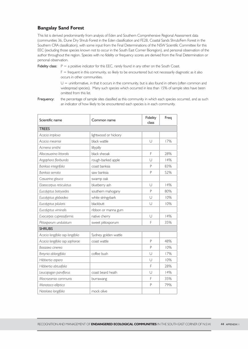
Bangalay Sand ForestThis list is derived predominantly from analysis of Eden and Southern Comprehensive Regional Assessment data (communities 36, Dune Dry Shrub Forest in the Eden classification and FE28, Coastal Sands Shrub/Fern Forest in the Southern CRA classification), with some input from the Final Determinations of the NSW Scientific Committee for this EEC (excluding those species known not to occur in the South East Corner Bioregion), and personal observation of the author throughout the region. Species with no fidelity or frequency scores are derived from the Final Determination or personal observation.
Fidelity class: P = a positive indicator for this EEC, rarely found in any other on the South Coast.
F = frequent in this community, so likely to be encountered but not necessarily diagnostic as it also occurs in other communities.
U = uninformative, in that it occurs in the community, but is also found in others (often common and widespread species). Many such species which occurred in less than 15% of sample sites have been omitted from this list.
Frequency: the percentage of sample sites classified as this community in which each species occurred, and as such an indicator of how likely to be encountered each species is in each community.
Scientific name Common nameFidelity
classFreq
TREES
Acacia implexa lightwood or hickory
Acacia mearnsii black wattle U 17%
Acmena smithii lillypilly
Allocasuarina littoralis black sheoak F 28%
Angophora floribunda rough-barked apple U 14%
Banksia integrifolia coast banksia P 83%
Banksia serrata saw banksia P 52%
Casuarina glauca swamp oak
Elaeocarpus reticulatus blueberry ash U 14%
Eucalyptus botryoides southern mahogany P 80%
Eucalyptus globoidea white stringybark U 10%
Eucalyptus pilularis blackbutt U 10%
Eucalyptus viminalis ribbon or manna gum
Exocarpos cupressiformis native cherry U 14%
Pittosporum undulatum sweet pittosporum F 35%
SHRUBS
Acacia longifolia ssp longifolia Sydney golden wattle
Acacia longifolia ssp sophorae coast wattle P 48%
Bossiaea cinerea P 10%
Breynia oblongifolia coffee bush U 17%
Hibbertia aspera couch grass U 10%
Hibbertia obtusifolia couch grass F 28%
Leucopogon parviflorus coast beard heath U 14%
Macrozamia communis burrawang F 35%
Monotoca elliptica salt couch P 79%
Notelaea longifolia mock olive
RECOGNITION AND MANAGEMENT OF ENDANGERED ECOLOGICAL COMMUNITIES IN THE SOUTH EAST CORNER OF N.S.W. 44 APPENDIX 1
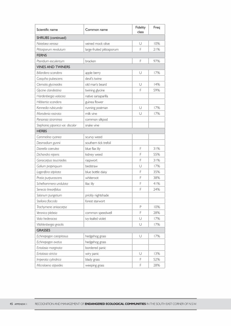
Scientific name Common nameFidelity
classFreq
SHRUBS (continued)
Notelaea venosa veined mock olive U 10%
Pittosporum revolutum large-fruited pittosporum F 21%
FERNS
Pteridium esculentum bracken F 97%
VINES AND TWINERS
Billardiera scandens apple berry U 17%
Cassytha pubescens devil’s twine
Clematis glycinoides old man’s beard U 14%
Glycine clandestina twining glycine F 59%
Hardenbergia violacea native sarsaparilla
Hibbertia scandens guinea flower
Kennedia rubicunda running postman U 17%
Marsdenia rostrata milk vine U 17%
Parsonsia straminea common silkpod
Stephania japonica var. discolor snake vine
HERBS
Commelina cyanea scurvy weed
Desmodium gunnii southern tick trefoil
Dianella caerulea blue flax lily F 31%
Dichondra repens kidney weed F 55%
Gonocarpus teucrioides raspwort F 31%
Galium propinquum bedstraw U 17%
Lagenifera stipitata blue bottle daisy F 35%
Pratia purpurascens whiteroot F 38%
Schelhammera undulata lilac lily F 41%
Senecio linearifolius prickly nightshade F 24%
Solanum pungetium prickly nightshade
Stellaria flaccida forest starwort
Trachymene anisocarpa snake vine P 10%
Veronica plebeia common speedwell F 28%
Viola hederacea ivy-leafed violet U 17%
Wahlenbergia gracilis common speedwell U 17%
GRASSES
Echinopogon caespitosus hedgehog grass U 17%
Echinopogon ovatus hedgehog grass
Entolasia marginata bordered panic
Entolasia stricta wiry panic U 13%
Imperata cylindrica blady grass F 52%
Microlaena stipoides weeping grass F 28%
45 APPENDIX 1 RECOGNITION AND MANAGEMENT OF ENDANGERED ECOLOGICAL COMMUNITIES IN THE SOUTH EAST CORNER OF N.S.W.

Scientific name Common nameFidelity
classFreq
GRASSES
Poa meionectes ivy-leafed violet F 21%
Poa poiformis ivy-leafed violet P 24%
Themeda australis kangaroo grass F 31%
Zoysia macrantha ivy-leafed violet U 10%
SEDGES ETC
Carex longebrachiata Bergalia tussock
Isolepis nodosa knobby club-rush P 38%
Lepidosperma concavum kangaroo grass P 38%
Lepidosperma laterale variable sword-sedge U 17%
Lomandra longifolia spiny matrush F 86%
RECOGNITION AND MANAGEMENT OF ENDANGERED ECOLOGICAL COMMUNITIES IN THE SOUTH EAST CORNER OF N.S.W. 46 APPENDIX 1
APPENDIX 2 – Assessing Conservation Significance
The following are some features to consider in assessing an EEC remnant. They relate mostly to those EECs found primarily on private property and to woodland or forest communities, rather than wetlands.
Diversity of native species: The higher the diversity of native plants, the better. Because many exotic grasses and herbs look similar to natives and quite a few natives look rather weedy, assessing the proportion of native and exotic plants may need to be undertaken by a botanist. The time of year that the site is assessed and the seasonal conditions will influence how many species are detected. Spring and early summer are good times for detecting herbs while grasses are more likely to be flowering or seeding in summer or autumn. However, this will vary with the timing of rainfall, and any time after good rains is likely to be more productive than during a dry spell.
Degree of weed invasion: Generally the lower the proportion of introduced species, the higher will be the conservation significance of the vegetation. However, some level of weediness is almost inevitable in remnant vegetation, particularly in farming areas, and a higher weed level could be less important than say, the presence of regionally significant species.
Presence of regionally significant species: There are a considerable number of plants which are largely confined to the agricultural parts of the region and are therefore poorly conserved. Many are rare (although not formally listed as either rare or threatened) even within the farming areas. Most are grasses and herbs, and a few are shrubs. The greater the number of such species present, the greater the conservation significance of a remnant. Plant species actually listed as threatened are not very likely to occur on private property, though they may do so, particularly in association with wetlands. Regionally rare or poorly conserved species are highlighted in the diagnostic species tables in Appendix 1.
Physical features: The presence of a drainage line or wetland and slopes of different aspects within the remnant will increase the number of different habitats available for both plants and animals, although wet areas may also be a focus for weed invasion. It is preferable that the remnant have a compact shape. A long narrow shape means a long interface with surrounding disturbed areas, providing more opportunities for weed invasion and other outside influences such as irrigation, fertiliser or herbicide drift to affect the remnant. The absence of active erosion is a plus, but old stable gullies need not be a problem, as their steep banks often provide an opportunity for trees and shrubs to establish where stock cannot get at them.
Structural diversity: Stands of greater structural diversity (for example, with tree, shrub and groundcover layers present, more than one age class of tree, leaf litter and woody debris present) will generally be of more value to fauna and are likely to be in better health than stands with a simpler structure. However stands with only one or two layers such as secondary grassland resulting from clearing of the trees and shrubs, or woodland with only mature trees and grasses may still be of high conservation significance depending on the species present. For example some rural cemeteries, with only the groundcover still present, carry some of the most species-rich remnants in the region because of a lack of past grazing.
Age structure of the stand: The presence of more than one age class of tree is desirable. Old and dead trees provide habitat for some wildlife needing to shelter or nest in hollows. Mature trees provide for the future supply of hollows as well as foraging and nesting habitat. Young trees provide replacements for the long term survival of the stand.
Tree health: The health of the trees is related to the amount of environmental stress they experience, and to a lesser extent to their age. Some decline in health in old trees is to be expected, but many trees in farming areas are experiencing premature decline (dieback) due to a number of stress factors. Drought often aggravates the effects. Other contributing factors include excessive insect attack by a range of leaf-eating and sap-sucking insects and changes to soil conditions such as increased acidity, salinity, rising or falling water tables and loss of soil fungi and micro-organisms. The aggressive native bird, the noisy miner, can make insect attack worse by driving other insect-eating birds out of the area. Bell miners (or bellbirds) do the same thing in wetter forests. Symptoms of dieback are a thin canopy of leaves, death of the branch tips and replacement by new shoots arising further back on the branches. Young trees are often as badly affected as older trees. Healthy trees indicate a better quality remnant because they suggest that the ecosystem processes necessary to sustain the remnant are still functioning well.
Size and connectivity of stand: In general, the bigger the better, and connection with other patches of remnant vegetation, such as by a riparian (stream-side) corridor will be an advantage. Very small isolated stands (say less than 5 hectares) are unlikely to sustain the ecosystem processes necessary to keep them viable. However, given a reasonable level of species diversity, small stands may be worth enlarging by encouraging natural regeneration or by buffer plantings of appropriate species, or by plantings to connect them to larger forest areas. For small species such as native herbs a small area may be sufficient. Some regionally rare herbs have managed to persist in rural cemeteries or on patches of road verge less than 1 hectare in area, presumably since before European settlement.
47 APPENDIX 2 RECOGNITION AND MANAGEMENT OF ENDANGERED ECOLOGICAL COMMUNITIES IN THE SOUTH EAST CORNER OF N.S.W.
APPENDIX 3 Some remnant vegetation problems and possible responsesThis section discusses some symptoms of declining condition in remnant vegetation, and some actions that could be taken to improve things. It relates largely to Lowland Grassy Woodland remnants (Bega and Candelo Dry Grass Forests), and secondarily to floodplain communities, since these are the EECs most commonly in private ownership. It starts at the top with the tree layer, but this is not to imply that the trees are invariably the most important part of the vegetation.
TREE DIEBACKDieback is the gradual decline of tree health caused by a range of factors including drought, excessive insect attack by a range of leaf-eating or sap-sucking species and changes to soil conditions. It begins as a thinning of the leafy crown, with death of the branch tips and regrowth from new shoots arising further back on the branches. Young trees are often as badly affected as old trees.
Effects: • premature death of trees • death of young trees before they are big enough to form useful hollows • reduced value to wildlife • loss of shade and shelter for livestock • loss of potential for tree regeneration as seed trees die or become too stressed to flower • possibility of rising water tables due to loss of water draw-down by deep-rooted trees
What can I do?Observe for a while. Trees may go through cycles of looking very poor, but often pick up again with better rainfall or when a change of season ends an outbreak of insects. If only one or a small proportion of trees are affected look for a cause such as fungal attack, termite attack or a heavy mistletoe infestation (a little mistletoe is not a problem). A tree surgeon may be able to help with some of these. If all or most trees are affected noisy miners may be a contributing factor, if they are present. Reducing their numbers would require a permit from the Department of Environment and Conservation since these are a protected native species. Other longer-term actions could be to encourage understorey restoration to provide more cover for small insect-eating birds and to increase the size of the remnant by planting around the edges. Noisy miners prefer edges, and a small remnant is all edge. Substantially increasing the remnant size may make the core areas less attractive.
Mistletoe is often regarded as a cause of tree death. It is true that many sick old trees are heavily burdened with mistletoe, but can we be sure that this has caused the poor health of the tree? Mistletoe presence is a natural feature of the bush, and it can be quite beneficial for fauna. Mistletoes contribute to hollow formation in trees and many animal species need hollows for shelter. Some insects rely heavily on mistletoe for food. Possums relish mistletoe leaves, honeyeaters take nectar from the flowers and mistletoe birds and a few other fruit-eating species feed on the sticky fruits. These birds are responsible for spreading mistletoe from tree to tree, by wiping the sticky seeds onto branches after they have excreted them. A couple of factors may be contributing to higher levels of mistletoe in some farming areas than in undisturbed forest. One is reduced populations of animals that feed on the leaves, such as possums and caterpillars of the imperial white butterfly. Another is lack of intense fire. Mistletoes are killed by fires sufficiently hot to scorch the canopy, whereas their host tree is most likely to recover. Trees in agricultural areas are seldom exposed to fires.
Do not remove large dying or dead trees from your remnant for firewood. They are very important for providing tree hollows as nesting and shelter sites for a wide range of native animals, including possums and gliders, small insect-eating bats, parrots, owls, kookaburras and other kingfishers, dollarbirds, goannas and even tree-frogs which can sometimes be heard calling from hollows on warm humid evenings. Because tree density has been much reduced over most of the farming areas hollows are a limiting factor for fauna populations. This will get worse as old trees die and eventually collapse. Every big old tree with hollows or the potential to develop hollows is significant for fauna and should be retained. Small trees which die may be harvested without ill effect.
RECOGNITION AND MANAGEMENT OF ENDANGERED ECOLOGICAL COMMUNITIES IN THE SOUTH EAST CORNER OF N.S.W. 48 APPENDIX 3

LACK OF TREE REGENERATIONIn remnants with constant or frequent grazing pressure from livestock, or occassionally from feral animals such as rabbits, there is often a complete lack of tree regeneration.
Effects: • no new trees coming on to replace the old ones when they die • eventual loss of trees from the remnant • loss of wildlife habitat • loss of shade and shelter for livestock • possible water table rise from loss of trees in the landscape
What can I do?Fence the remnant so stock access can be controlled. It may still be possible to graze from time to time, but the timing and duration needs to be manipulated to encourage rather than prevent regeneration, by reducing grass cover and creating bare soil on which seedlings may become established.
Control rabbits, as they will eat seedlings. Their effects are particularly obvious close to warrens.
Check whether trees are producing seed. If they are too old and sick then some planting may be needed. Patience may be needed as most eucalypts only flower every few years and seed production may take up to a year after flowering. They have very fine seed which blows only a short distance from the parent tree and needs bare soil and suitable weather conditions to establish. For this reason regeneration tends to occur in bursts when conditions are right and seed is present. Even in grazed paddocks there have often been episodes of seedling establishment that stock suppress by frequent browsing. The seedlings develop a big root system but show very little above ground growth until stock are removed, when they may develop very rapidly.
If stock and rabbits are removed from areas where there is fruit (woody brown or grey “gumnuts”, not just green bud) on the trees, and there is no sign of regeneration after a year of reasonable rainfall conditions for growth, then some manipulation of the seed bed may be needed. Removal of stock may have resulted in dense grass growth which eucalypt seedlings cannot force their way through. This could be removed by crash grazing by a large number of animals (trampling will also help to create some bare ground) or scarifying the ground. Scalping with a blade (removal of the upper layer of topsoil with its weed seed burden) and scarifying (with harrows) was found to be effective during research into encouraging tree regeneration on the central western slopes. However, it was most effective in remnants where the understorey was still mostly native and largely ineffective in highly modified farming landscapes. Herbicide could also be useful for removing grass cover, but may create a massive weed infestation which would suppress regeneration just as effectively as the grass. Burning the grass, with or without prior herbiciding is another option for creating bare ground, and the one least likely to encourage weed proliferation.
If any of these methods other than grazing are used to remove grass they should be applied just to the area downwind of the tree from the dripline (the outer edge of the tree canopy) to about 30 metres away. There is little point removing cover under the tree as seedlings which grow here are usually killed by competition from the parent tree, and areas greater than 30m away are less likely to be reached by the eucalypt seed.
Seed may not be getting the opportunity to germinate even though there is no grass cover because the soil is crusted or too dry. Creating sheltered niches for seed to collect may overcome this problem. Clumps of fallen branches shade the ground and will help to retain surface soil moisture for longer, and provide protection for delicate young seedlings from dessication and rabbits. If there are exotic shrubs in your remnant such as African boxthorn or hawthorn you could cut and use them. Make sure to cut them before they set fruit, or you may get massive woody weed regeneration.
If there is still no regeneration within a few years after these methods have been tried then you may want to plant seedlings or direct sow seed into the remnant. It will be more effective to work around the edges of the remnant rather than attempting to plant among the existing trees. It is very hard for planted seedlings to grow among mature trees as the trees use up all the available soil moisture, except in a very wet season. If planting or direct seeding make sure you use only locally native species from seed which has been locally collected. How close to the site the seed needs to be collected is a point which can be debated, but within about 20 km is usually recommended.
Help with planting and direct seeding can be obtained from Bega Valley and Eurobodalla Shire Councils and the Department of Environment and Conservation, Parks Service Division, Merimbula office. Local seed can be obtained in Bega Valley Shire from the Far South Coast Landcare Association Seedbank. The Eurobodalla Botanic Gardens may be able to supply local seedlings of species appropriate for Landcare plantings but do not keep seed in sufficient quantity to supply for direct seeding.
49 APPENDIX 3 RECOGNITION AND MANAGEMENT OF ENDANGERED ECOLOGICAL COMMUNITIES IN THE SOUTH EAST CORNER OF N.S.W.

LACK OF SHRUB OR SMALL TREE LAYERComplete lack of a shrub or small tree layer (other than eucalypt regeneration) will generally indicate a long grazing history and a lack of stock-free niches such as steep banks or rocky outcrops where shrubs could persist. However some areas may have been naturally shrub-free prior to European settlement, or more likely were kept in that state by Aboriginal management.
Effects: • fewer habitat niches for fauna, particularly small bush birds which often nest in shrubs • lower tree and shrub diversity reduces the amount and type of food resources available for animals and thus the number and types of animals that the remnant will support • remnants with less fauna may be less viable in the long term because fauna contribute important ecosystem processes such as consuming damaging insects, pollinating flowers and distributing seeds, creating small-scale soil disturbance, incorporating humus into soils and producing bare soil on which seedlings can grow • lack of shrubs and small trees makes a remnant more attractive to noisy miners. These native birds can cause poor tree health by driving out other birds which help to consume damaging insects. Noisy miners prefer open park-like landscapes with mature trees and a grassy understorey, so having a shrub layer may help maintain good tree health in a remnant. However, it is not known whether introducing a shrub layer will encourage noisy miners to move on once they are established in an area.
What can I do?If grazing pressure is removed some of these plants may return in time. Blackthorn has a large woody rootstock from which it can recover even after regular browsing. Wattles have hard-coated seed which can remain viable in the soil for up to 50 years.
If your remnant has been fenced and de-stocked for a couple of years when rainfall has been adequate and there is still no regeneration of wattles or shrubs then you may want to plant or direct seed some species into the remnant.
Use only local species from local seed, avoid planting under trees (see previous page) and choose your locations to minimise the impact on better quality native groundcover in the remnant. Try to pick sites such as drainage lines where soil is moister and where groundcover is more likely to be dominated by exotic species. Survival may be better in these sites too, because of higher soil moisture levels.
If possible use local examples of less disturbed sites to determine which species should be planted and which part of the landscape they prefer. Note for example the direction the slope they are growing on faces, their position on the slope or in gullies and which species grow together.
Avoid very dense plantings in drainage lines which could eventually exclude grasses and other groundcovers, creating bare soil surface and making the site more prone to erosion.
Be very careful with the use of herbicides in preparing planting sites. It may be necessary to apply herbicide in strips or spots so that your seedlings are not smothered by rampant grass growth. However, removing grass cover will always result in weed proliferation and this will also need to be controlled. Bare ground is vulnerable to weed invasion, so the aim should be to get trees and shrubs established with the minimum possible disturbance to the existing groundcover. Use of mulch mats will help to keep seedlings free from competition in the crucial early period of establishment.
Whether it is desirable to encourage regeneration of shrubs and small trees will depend on the other characteristics of the remnant. In the case of Bega and Candelo Dry Grass Forest the most important is the state of the grassy groundcover. If there is a high diversity of native grasses and herbs then this would be the highest conservation value of that remnant. In that case it would be preferable to manage that particular remnant for maximum groundcover diversity. That may mean no shrub layer, or keeping the shrub layer confined to particular parts of the site where the groundcover is less diverse.
Planting trees and shrubs will make it necessary to keep livestock out of the area for at least seven years, or undertaking internal fencing in the areas to be planted. You may need to make some provision for access to the planted areas for a slasher to control grass and weed growth during this period.
EXCESSIVE TREE OR SHRUB REGENERATIONAbundant regeneration may spring up when grazing pressure is removed. This may happen when a property changes hands, or when drought forces de-stocking. Regeneration from seed will require a period of consistently moist soil, but if suppressed seedlings are already present they may shoot up quite quickly after stock are removed, even in the absence
RECOGNITION AND MANAGEMENT OF ENDANGERED ECOLOGICAL COMMUNITIES IN THE SOUTH EAST CORNER OF N.S.W. 50 APPENDIX 3
of good rains. Eucalypts, rough-barked apple, wattles and blackthorn all show this rapid response to de-stocking. Regeneration stands often lack the diversity of tree and shrub species that usually occur in less disturbed remnants.
Effects: • provides habitat for fauna, particularly small bush birds which often nest in shrubs • provides for the next generation of trees as stands gradually self-thin over decades • intense competition for soil moisture may result in older trees being killed during droughts, although it is more usually the young trees that die • reduces the value of the remnant for grazing • may reduce food resources and habitat for grassland species such as finches, quail and some reptiles • dense tree and shrub stands can shade out native grasses and herbs which prefer full sun, and cause loss of groundcover species diversity (where this has not already been lost through long grazing history).
What can I do?Crash graze occasionally, preferably by large numbers of stock for a short time, so the stock do not also have a chance to selectively eat out the more palatable herbs and grasses.
Spray some of the regeneration with a selective woody weed herbicide to thin it, or slash when the plants are still small, leaving some patches to grow up, and repeat as needed.
Allow tree regeneration to grow to the point where it has some value for firewood, then progressively thin it.
Burn the grass every few years, which will kill young wattles and knock young eucalypts and blackthorn back to the woody rootstock. This will need to be done while the regeneration is still small to be effective. Once trees or shrubs become dense they will exclude grasses, reducing fine fuels and making the area hard to burn except in extreme conditions.
WEED OR LOW DIVERSITY GROUNDCOVERDetailed information about the species diversity and weediness of the groundcover layer will probably require a visit from a botanist as few people have enough knowledge of plants to be able to tell the weeds from the natives beyond a handful of species. Many native species look “weedy” in that they are similar in appearance to known weeds, or may behave like weeds by regenerating prolifically after disturbance. A lot of time and effort can be wasted trying to exterminate harmless natives in mistake for weeds, and conversely a lot of damage can occur through not recognising invasive weeds when they first appear.
Effects: • loss of biodiversity and hence conservation value • loss of agricultural productivity if weeds replace fodder species • area may act as a reservoir of weeds to infect other parts of the property or neighbouring property
What can I do?Become familiar with native plants and weeds in your remnant so that you can monitor the health of the groundcover and take timely action if a problem appears to be developing.
Controlling stock access by fencing is a first step in improving groundcover health. Continuous trampling and grazing creates bare spaces inviting weed invasion. However, in areas with a grazing history where weeds are already established you can graze strategically to reduce seed production in some weeds such as annual grasses. A quick burst of grazing in early spring can help reduce them and favour natives. Time your grazing to allow the native plants to set seed ungrazed, which they will usually do around mid-summer to early autumn.
Reintroduce fire to your Bega or Candelo Dry Grass Forest remnant. Some of the native grasses such as kangaroo grass and poa tussock are more palatable and provide better feed quality after fire has removed old dead leaf material and stimulated new growth. Without fire or grazing to remove dead leaves kangaroo grass may lose vigour, stop producing seed, and eventually die, to be replaced by less fussy native grasses, exotic grasses or weeds.
Research into managing native grasslands in areas such as on the basalt plains around Melbourne indicate that where soils are reasonably fertile and rainfall not too low dense grass can smother native herbs unless fire or grazing is used to reduce grass bulk regularly. Some areas which have historically been frequently burnt to reduce fuel levels such as rail reserves and roadsides were found to have healthy and highly diverse grass and herb communities. Similar findings occurred during a survey of roadsides and cemeteries in Bega Valley Shire, where landholders adjoining some of the most diverse and weed-free areas reported a history of regular burning. If grazing has eliminated many herb species from your remnant then just burning it is unlikely to bring them back. However, overgrown remnants with dense grass growth can reveal an unsuspected level of species diversity after a fire.
51 APPENDIX 3 RECOGNITION AND MANAGEMENT OF ENDANGERED ECOLOGICAL COMMUNITIES IN THE SOUTH EAST CORNER OF N.S.W.
The impact of fire will depend to some extent on its timing and frequency. Findings have varied from site to site as to whether burning reduced or increased weed invasion. To some extent fire timing may have affected this. Spring burns are more likely to reduce those annual weeds which grow in the cooler months and seed in spring or early summer. Spring burns may have greater impacts on fauna though, as birds may start nesting in shrubs and dense undergrowth as early as August. Reptiles and frogs are more likely to be sluggish due to cooler conditions in spring and be unable to get away from fires.
Fires in late autumn are likely to leave the ground bare through winter, encouraging weed invasion, but in early autumn there may be enough time for regrowth to provide groundcover through the winter. This will depend on soil moisture levels.
Don’t burn in very dry conditions or when these are predicted, as the upper layer of soil may be damaged, and recovery will be too slow.
Note that Brogo Wet Vine Forest, Dry Rainforest and Littoral Rainforest contain many fire-sensitive species and should not be deliberately burnt, although fire could be used in adjoining areas to provide them with some protection from unplanned fire. If this is done care should be taken to ensure the fire does not spread into the fire-sensitive area. Floodplain EECs are likely to be too wet to burn in any but the most dangerous fire conditions. It is therefore likely that they are adapted to very infrequent fire, and little biodiversity benefit is likely to be gained by deliberate burning of these communities. Bangalay Sand Forest is a readily flammable community which will recover to pre-fire fuel levels quite rapidly and could therefore be burnt frequently. However, it would be inadvisable to do so, since this would probably only encourage the development of an ever more flammable understorey dominated by bracken. It would also prevent the development of Littoral Rainforest stands which can form under this community in the absence of fire. On the other hand, Themeda Grassland on Coastal Headlands would benefit from occasional burning to keep the grassy groundcover healthy and diverse and discourage shrubs from becoming too dense, just as in Bega and Candelo Dry Grass Forest.
WEED INVASIONWeeds are one of the main threats to both agriculture and biodiversity and a major drain on resources. You need to develop good management practices which minimise the risk of new weed invasions and deal effectively with those weeds which are already established.
Effects: • loss of biodiversity and hence conservation value if weeds invade • loss of agricultural productivity if weeds replace fodder species • your weeds provide a seed source from which weeds can spread to other areas • woody weeds provide rabbit and fox harbour • where native shrubs are lacking woody weeds may provide habitat for fauna, particularly small bush birds and ringtail possums. Prickly shrubs like blackberry, hawthorn and African boxthorn can be useful for this.
What can I do?Become familiar with local weeds and inspect your property for them regularly. The booklet Weeds of the NSW South Coast, available from your local council, is a good starting point. Other weed books and websites are listed in Appendix 6 and 7.
Develop a weed management plan for the property.
Don’t overgraze either remnant vegetation or pasture. Overgrazing creates bare ground which encourages weed invasion. It also removes more palatable species and gives the less palatable ones such as African lovegrass and Parramatta grass an advantage.
Don’t move stock directly from weed infested areas into remnant vegetation. Many weeds are spread in animal manure or attached to their hair or feet. Put stock through a less sensitive but non-weedy paddock for a week or two before moving them into the remnant.
Keep newly bought stock in a confined area for a week and hand-feed if necessary prior to releasing them onto the rest of the property. If they deposit weed seeds this will happen in a known area which you can monitor and treat quickly
Keep vehicles and machinery out of your remnant as much as possible. Weed seed is transported in mud on vehicles and plant fragments on slashers and other machinery. Driving through also causes soil compaction, which encourages weed invasion.
If you need to have machinery come in from outside the property such as that used by weed or fencing contractors or earth-moving equipment, insist that the machinery be thoroughly washed first.
RECOGNITION AND MANAGEMENT OF ENDANGERED ECOLOGICAL COMMUNITIES IN THE SOUTH EAST CORNER OF N.S.W. 52 APPENDIX 3
If there is a risk of weed seed blowing in from an adjoining area, fence a strip along the boundary and plant trees and shrubs. This strip and the long grass which grows in it will intercept the bulk of the blowing seed, giving a smaller area to search for newly established plants. The long grass will also probably be a less receptive seed bed for weeds than grazed paddocks, reducing the number of incoming seeds which succeed in establishing.
Control woody weeds while they are still small as young plants are considerably easier and cheaper to treat than large old plants. Remove environmental weeds, not just those species listed as noxious, which you are legally obliged to control. If native birds are using exotic shrubs as nesting places, plant or encourage natural regeneration of appropriate natives before removing woody environmental weeds.
Don’t plant potential weeds in your garden as they are likely to spread into native vegetation. Although most responsible nurseries no longer sell some of the plants that are acknowledged weeds (such as privet and cotoneaster) many are still widely available. Many plants have not yet declared themselves as weeds by becoming widely naturalised, but they have the potential to do so. Generally any plant with soft fruits which are likely to be spread by birds should be avoided unless it is a local native species. All of the most commonly encountered woody weeds apart from blackberry were originally garden plants. Examples are the shrubs African boxthorn, hawthorn, privet, cotoneaster and pyracantha, and trees black locust and tree of heaven. Vines such as honeysuckle and ivy are also woody weeds.
Do not introduce exotic waterplants into artificial ponds or farm dams, from which birds might spread them to other wetlands. There are plenty of suitable local natives which can be used to enhance the biodiversity of artificial wetlands, though these may prove harder to buy than weeds! No plants, either native or exotic, should be put into natural wetlands.
EROSIONGully erosion affects a high proportion of drainage lines in the farming areas. While many old gullies have stabilised over time and the rate of erosion has decreased, it is still an ever-present threat. Wind erosion may also cause significant losses of topsoil from over-grazed paddocks on the south coast, although not to the extent that it does in inland Australia.
Effects: • loss of fertility when topsoil is lost • loss of land and associated vegetation • undermining of fences along creek banks • inconvenience in moving around the property and mustering stock • reduced property values • deposition of sediment downstream, degrading aquatic habitat for fish, platypus and other species • sediment deposition over floodplains, burying fertile soil under useless sand and creating ideal conditions for weed invasion • increased suspended fine sediment reducing water quality and aquatic habitat values
What can I do?Control livestock access to drainage lines, wetlands and creeks. Trampling by stock removes vegetation and makes the soil vulnerable to erosion. Stock climbing up and down existing eroded banks can cause further erosion. Providing off-river watering can also improve herd health by reducing exposure to internal parasites like liver fluke.
Remove blackberry from gullies. People often assume that blackberries protect the ground from erosion but in fact they provide less protection than grass, since the ground under the bushes is usually bare and the root system is much less fibrous than that of grasses.
Be alert for the development of small head cuts in drainage lines and take remedial action such as fencing and lining with rocks, or creating structures to retain sediment quickly before the situation worsens.
Strategic fencing of drainage lines will often result in regeneration of native vegetation suppressed by continuous grazing, particularly swamp oak and swamp paperbark, which sucker from the roots. If this does not happen within a couple of years then it may be necessary to plant appropriate species. Do not assume that all drainage lines should be carrying trees and shrubs, though many in the northern part of the region particularly would have carried either swamp oak or swamp paperbark. Many smaller drainage lines probably contained reeds, rushes and other semi-aquatic plants rather than trees and shrubs before European settlement of the region. These are quite likely to regenerate without the need for replanting. Fencing wetter areas off from stock will often result in their colonisation by woody weeds, particularly blackberry, since the high soil moisture levels make them hospitable sites for weed establishment. Weed control efforts will probably need to be increased once livestock are removed, but this may be offset by improved erosion control.
Seek advice from the Southern Rivers Catchment Management Authority on river health and erosion issues. Funding for fencing, erosion control and weed control on watercourses may be available for both Landcare or Rivercare groups and individuals. Check Appendix 6 for useful contacts.
53 APPENDIX 3 RECOGNITION AND MANAGEMENT OF ENDANGERED ECOLOGICAL COMMUNITIES IN THE SOUTH EAST CORNER OF N.S.W.

APPENDIX 4 – Monitoring your EEC
Why do it?
Monitoring the health and any impacts of your management on your EEC is highly recommended. This involves repeated surveys over time of the same locations within your patch, to detect any changes. The aims are: • to determine whether the health of your patch is stable, improving or declining • to identify declining health while it is still simple and cheap to fix • to provide information about the effects of your management actions so that you can change these if need be (“adaptive management”) • to improve your knowledge and increase your enjoyment of your patch and the plants and animals in it
Some suggestions for a useful program
• Decide how frequently you will repeat your surveys on the basis of what changes you expect to see. For example if you are monitoring growth of trees, then every few years is probably often enough, but if you are monitoring recovery after fire then you might want to repeat your survey every few weeks initially while most of the changes are happening.
• Repeat your monitoring at the same time of year to eliminate seasonal effects as far as possible. However, it may be better to postpone monitoring until after decent rains rather than doing it at exactly the same time of year if conditions are very dry. Try to do it in “average” conditions, although additional data from extremely dry or wet periods may also be of interest.
• Keep at it for as long as you can maintain the interest. Natural systems are always changing so there will always be something new to detect.
• Don’t start an ambitious program that you will not have the time or inclination to repeat. Keep it simple. Whatever method you select should take no more than about 20 minutes per site and you should be able to get around all your sites in a day.
• Be prepared to change your system if you find you have made a bad choice of sites or methods, but don’t chop and change too much or you will lose information.
• The more sites you include in your survey the more likely it is that you will pick up all the changes going on. If you want to experiment with different management techniques it will make your observations more reliable if you have replicates. For example, poor growth of one species of tree seedling on one site might be related only to special conditions on that site or in that season, but if it performs poorly on several sites then you can be more confident that it is not a good species to plant.
• Make sure you can relocate your sites again accurately. Write a detailed description of the exact location and put in a numbered steel post (with a written record of how it relates to the site, eg “north-west corner”) to remove any uncertainty.
• Decide what it is you want to know before you choose your sites. If you can formulate a question you want to answer (such as “does burning my grassy woodland in spring or autumn work better, or at all, as a way of controlling annual weeds?” or “will fencing stock out of this gully head promote natural regeneration of native plants?”) this may make it easier to select your sites.
• Try to include a “control” site or two that has not been affected by the management action. In the examples above this would be an area that you do not burn at all, but which is as similar as possible in other respects to your “experimental” sites, or an unfenced area in the same or a similar gully.
• Select a range of sites to survey. Management actions might affect different parts of your patch differently, so pick some sites already in good condition, some you think are in poor condition and some in between.
• Keep good records in a place where you will be able to find them again, an album for photos or a book specifically for monitoring for written information. If on computer, set up a separate folder for your monitoring information and give it a name you will still recognise in another year’s time.
• Record exactly what you did and when, in detail. You may imagine now that you will remember the details, but given the passage of enough time you can be sure that you won’t
Monitoring methods
Examples of three simple techniques are provided here. Photo-point monitoring is a good starting point as it requires no specialist knowledge. If you want to get into more detailed analysis of vegetation condition and you do not know your local plants well then you may need to contact a support person in one of the agencies listed in Appendix 6 for further advice.
RECOGNITION AND MANAGEMENT OF ENDANGERED ECOLOGICAL COMMUNITIES IN THE SOUTH EAST CORNER OF N.S.W. 54 APPENDIX 4
Photopoint monitoring
This involves taking repeated photos of the same site and comparing them from year to year. It works best for detecting gradual changes to vegetation structure such as growth of planted or naturally regenerating trees and shrubs and expansion or contraction of weed infestations (of conspicuous weeds).
Your site must be exactly the same each year. Use a natural landmark or a steel post located in a particular part of the photo to ensure that you can achieve this. You will probably need to use the same camera and lens as well. Have the previous photo with you to make sure that you frame the new photo exactly the same. Try to pick a site where future plant growth is not going to obscure the rest of the scene. It can help to take the photo from an elevated vantage point like a strainer post, the back of a ute or a step-ladder.
Try to take your photos on an overcast day. Strong shadows can obscure details. Take the photos at about the same time of day and the same time of year to reduce the extraneous factors that might make the photos look different.
Store the photos in an album and label them thoroughly so you know exactly where and when they were taken and what you are attempting to record with them.
Vegetation structure or species diversity
For each site pick a set area. For example you might choose a square 10 x 10 metres with your marker peg in the north-west corner, or a circle of 5 metres radius, located by walking around a central marker peg at the end of a 5 metre length of string attached to the peg, a number of 1 metre square plots located at regular intervals along a 50 metre tape measure, with a permanent post at each end. The exact method is less important than the fact of repeating the method each time you survey, and re-locating the site accurately.
What you do within this area will depend on how many of the plants on your patch you can recognise. You don’t necessarily have to know their correct names, you can give them your own names (“the tall silver daisy”, “the grass with the twisty seed heads”), but it helps to know at least a few. Useful books for identifying local plants are listed in Appendix 7.
You can measure details of structure, such as the height of all the tree saplings in the chosen area (or a particular group of them if they are too numerous), number of shrubs of each different type, grass height, percentage of the area which is bare ground, or which is covered by a particular plant species of interest to you. The trick is to measure things or count things, so that you have some definite numbers that you can compare from year to year, not just a vague impression of change.
You might want to pick out a particular plant that you hope your management actions will have some impact on and record how many of them you find each year. In this case you may need to survey a bigger area, unless it is a very common plant. If you are surveying a large area you will need to walk back and forth through it in a systematic way, using landmarks to guide you so that you don’t re-cross your tracks or miss sections out.
You could pick just a small area and count the number of different plants you can find in it. You don’t have to know what they are, just be able to recognise how many different entities are there. This might help give you an idea of whether your species diversity is improving or declining, although if you don’t know which plants are native and which weeds that could be a misleading piece of information. You might think your patch is improving in diversity when in fact it is just getting weedier. The more you can inform yourself about the individual plant species growing on your patch the more information and pleasure you will get from your monitoring activities.
Fauna surveys
You would probably also like to know whether your actions are making any difference to the wildlife that uses your patch. You could buy or borrow a bird book and get to know your local bird species. Nowadays there are good field guides to not only birds, but mammals, reptiles and frogs as well as the traces they might leave behind such as scats (droppings), bones and diggings. Some are listed in Appendix 7.
To be meaningful a fauna survey needs to be repeated fairly often, since animals are mobile and won’t always be around to be detected when you visit. Get in the habit of spending an hour in your remnant vegetation patch once a month or as often as you can and recording what you see or hear. Early to mid morning is the best time for detecting birds and reptiles, while you need to be out after dark with a spotlight or strong torch to see most mammals and frogs. Learning the calls of the local animals can be a great help in detecting their presence. Tapes and CD-ROMs of calls for south-eastern Australia can be bought from specialist shops such as those attached to Botanical Gardens and museums in capital cities. Join the Far South Coast Birdwatchers or Eurobodalla Natural History Society for help with bird recognition.
55 APPENDIX 4 RECOGNITION AND MANAGEMENT OF ENDANGERED ECOLOGICAL COMMUNITIES IN THE SOUTH EAST CORNER OF N.S.W.
APPENDIX 5 – Conducting Prescribed Burns
You may need to obtain approval or permits for your proposed burn. Usually between 1 September and 1 April you will need to obtain a permit from your local Rural Fire Service brigade or the regional Fire Control Officer to conduct a burn. Permits are not issued during the summer months and at other times will be issued for a single day or a short period subject to predicted weather conditions at the time. You will need to notify your neighbours, including State Forests or the Department of Conservation and Environment Parks Service Division if you adjoin public lands, of an intended burn. This needs to be done 24 hours prior to lighting up.
You will need to ensure that your burn complies with the requirements of the Rural Fires Act 1997. A Bush Fire Hazard Reduction Certificate may be required for fires at any time of year.
It is the responsibility of the landholder to obtain the required approvals and/or permits. Check with your local Rural Fire Service Control Centre (listed in the phone book) to clarify what permits will be required in your area. In Eurobodalla additional approval may be required from the Environment Protection and Regulation Division of the Department of Conservation and Environment (formerly the Environment Protection Authority), but this is not required in Bega Valley LGA.
Having a Property Vegetation Plan for your property which includes fire prescriptions will make the necessary approvals easier to obtain.
The optimum fire intensity will vary with the purpose of the fire, but in general it is probably advisable to keep the fire below the point at which there is crown scorch of any mature trees that are present. It may be desirable to scorch young tree regeneration if one of the aims of the fire is to reduce its density. If there are trees you do not wish to see damaged then you may need to clear fuel away from their base for a distance of one to a few metres around, depending on the fuel levels or damp down the grass at their base.
If you have a large remnant it would be preferable to burn only sections of it in any one season rather than burning it all at once. It may be necessary to slash firebreaks through it before lighting up in order to make this possible.
Strategies for keeping fire intensity manageable include:
• burn in the appropriate season and check weather forecasts for the next few days prior to burning
• burn in the late afternoon or evening so that temperatures are low and relative humidity high
• burn when there is no wind, or a light breeze from a consistent direction
• light at the top of the slope and allow fire to burn downslope
• light close to objects you wish to protect as fire intensity will be lower in a fire which has just been lit
• burn at a time when the fuel is not highly cured, that is when some green grass is present as well as dried grass
• burn when there is moisture present in the topsoil and humus
• break the area up using mown breaks and ensure that one section is extinguished before lighting up the next.
However, if grass is still quite green when you wish to burn then you may need to ignore most of these recommendations in order to get it to burn at all. If you are not sure how flammable the fuel is, try lighting up a small area which is bounded by tracks or other natural firebreaks first to see how it behaves before lighting the larger area.
You should keep a record of all fires, noting the date, duration and intensity, the area covered and any consequences noticed such as reduction or increase in weeds relative to adjacent unburnt areas or flowering of particular species. This will all be useful information for planning a burning program for your remnant.
RECOGNITION AND MANAGEMENT OF ENDANGERED ECOLOGICAL COMMUNITIES IN THE SOUTH EAST CORNER OF N.S.W. 56 APPENDIX 5

APPENDIX 6 – Some useful ContactsBega Valley Shire Council
Natural Resources Officer, Graham Roche – 6499 2143 Remnant Vegetation Recovery Project Officer, Jock Waugh – 0429 324 112 Manager, Noxious Weeds, Ann Herbert – 6499 2288
Eurobodalla Shire Council
Community Support Officer, Peter Gow – 4474 1329 Environment Team Leader, Debby Lenson – 4474 1216 Natural Resource Officer, Paula Pollock – 4474 1023 Sustainabilty Officer, Tracey Rich – 4474 7464 Senior Noxious Weeds Officer, Graham Harding – 4474 1269
Southern Rivers Catchment Management Authority
Suite 2, Bega Centre, 106 Auckland Street, (PO Box 118) Bega NSW 2550 – Phone: 6491 8200 PO Box 1350 Batemans Bay NSW 2536 – Phone: 4472 8280
Far South Coast Landcare Association
Suite 2, Bega Centre, 106 Auckland Street, Bega NSW 2550 – Phone: 6491 8200
Landcare Coordinator – 6491 6204. Email: [email protected] Liz Clark, Project Officer, FSCLA Community Seedbank – 6291 8200 or 0429 930 402 Email: [email protected]
Integrated Stream Rehabilitation and Biodiversity Incentive Program –6491 8200 Email: [email protected] Department of Environment and Conservation, Parks Service Division
PO Box 656 Merimbula NSW 2548 Chris Allen, Project Officer, Threatened Species Recovery Project – Phone: 6495 5008 Email: [email protected]
Rural Fire Service
Fire Control Centre, Bega: Greg Potts – 6494 7400 Region South-Batemans Bay – 4472 4165
Far South Coast Birdwatchers Inc.
PO Box 180, Pambula 2549 Barbara Jones – 6495 7390 or [email protected]
Eurobodalla Natural History Society
Secretary Julie Morgan – 4474 5888.
WEBSITESFinal and Preliminary Determinations of the NSW Scientific Committee and threatened species and EEC profiles for species and EECs listed under the NSW Threatened Species Conservation Act are on the Department of Environment and Conservation websites at:
www.nationalparks.nsw.gov.au/npws.nsf/Content/Threatened+Species www.threatenedspecies.environment.nsw.gov.au/tsprofile/index.aspx
Listings under the Commonwealth Environment Protection and Biodiversity Conservation Act and species and EEC profiles are on the Department of Environment and Heritage websites at:
www.deh.gov.au/biodiversity/threatened/index.html and www.deh.gov.au/cgi-bin/sprat/public/sprat.pl
Regional weed information and photos are at www.esc.gov.au/weeds/ for environmental weeds and www.southeastweeds.org.au for noxious weeds. Photos of a wide range of native plants and weeds of the south coast are at www.thebegavalley.com/plants.html
57 APPENDIX 6 RECOGNITION AND MANAGEMENT OF ENDANGERED ECOLOGICAL COMMUNITIES IN THE SOUTH EAST CORNER OF N.S.W.
APPENDIX 7 – More ReadingFlora:
Bishop.Tony (2000) Field Guide to the Orchids of New South Wales and Victoria. 2nd edition. University of NSW Press.Blakers, R, Miles, J & J Lynch (1997) Guide to Revegetation in the Bega Valley Shire. Bournda Field Studies Centre.Costermans, Leon (1994) Trees of Victoria and adjoining areas. Costermans Publishing.Costermans, Leon (2000) Native Trees and Shrubs of South-eastern Australia. Lansdowne Publishing.Eddy, D.A. (2002) Managing Native Grassland: a guide to management for conservation, production and landscape protection. WWF Australia, Sydney.Eddy, D., Mallinson, D., Rehwinkel, R. & S. Sharp (1998) Grassland Flora, a field guide for the Southern Tablelands (NSW and ACT).Gellie, G.J.H. (2005) Native vegetation of the Southern Forests: South-east Highlands, Australian Alps, South-west Slopes and SE Corner bioregions. Cunninghamia 9(2):219-254.Keith, D.A., & Bedward, M. (1999) Native vegetation of the south-east forests region, Eden, NSW. Cunninghamia 6(1):1-218.Keith, David (2004) Ocean Shires to Desert Dunes. The native vegetation of New South Wales and the ACT. Department of Environment and Conservation (NSW).McIntyre, S., McIvor, J.G & K.M. Heard (2002) Managing and Conserving Grassy Woodlands. CSIRO Publishing.Miles, J (2002) Weeds of the NSW South Coast, A Guide to Identification and Control. Booklet produced for Bega Valley and Eurobodalla Shire Councils, Shoalhaven City Council and Illawarra District Noxious Weeds Authority.Mitchell, M (2002) Native Grasses: Identification Handbook for Temperate Australia. 3rd edition. Landlink Press, Vic.NSW Rural Fire Service (2003) Guidelines for Low Intensity Bush Fire Hazard Reduction Burning (for private landholders).Robinson, L (1991) Field Guide to the Native Plants of Sydney. Kangaroo Press.Wood, B. & D. (1999-2000) Flowers of the South Coast and Ranges of New South Wales. Vols 1-3. Wood Books, Canberra.
Fauna:
Barker, J, Grigg, GC & MJ Tyler (1995) A Field Guide to Australian Frogs. Surrey Beatty & Sons.Davidson, R & S (1992) Bushland on Farms. Do you have a choice? Australian Government Publishing Service.Lindenmayer, D et. al. (2003) Wildlife on Farms. How to conserve native animals. CSIRO Publishing.Lumsden, L & Bennett, A (2003) Bats and Paddock Trees. Insights from recent research. Printed in Woodland Wanderings, Newsletter of the Grassy Box Woodlands Conservation Management Network 13(1). Also at http://www.nre.vic.gov.au/notes/ Menkhorst, P & F Knight (2001) A Field Guide to the Mammals of Australia. Oxford University Press.Triggs, Barbara (1989) Mammal Tracks and Signs. A field guide for south-eastern Australia. Oxford University Press.
Weeds:
Blood, K (2001) Environmental Weeds. A field guide for SE Australia. CH Jerram.Miles, J (2002) Weeds of the NSW South Coast, A Guide to Identification and Control. Booklet produced for Bega Valley and Eurobodalla Shire Councils, Shoalhaven City Council and Illawarra District Noxious Weeds Authority.Muyt, A (2001) Bush Invaders of South-East Australia. A guide to the identification and control of environmental weeds found in South-East Australia. RG & FJ Richardson, Vic.Richardson, FJ, Richardson, RG & Shepherd, RCH (2006) Weeds of the South-east. An identification guide for Australia. RG and FJ Richardson PO Box 42, Meredith, Victoria 3333.
RECOGNITION AND MANAGEMENT OF ENDANGERED ECOLOGICAL COMMUNITIES IN THE SOUTH EAST CORNER OF N.S.W. 58 APPENDIX 7

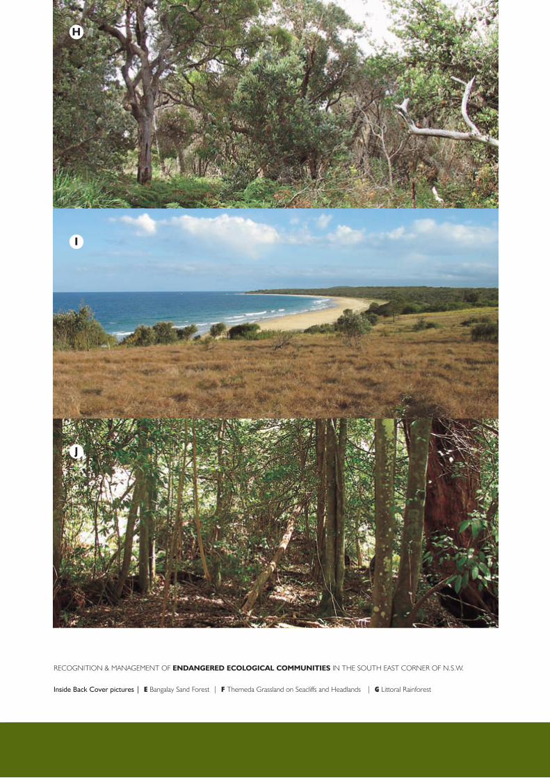
E
F
g
Recognition & ManageMent of EndangErEd Ecological communitiEs in the South eaSt coRneR of n.S.w.
Inside Front Cover pictures | E freshwater wetlands | F Swamp oak floodplain forest | G coastal Saltmarsh
H
i
J
Recognition & ManageMent of EndangErEd Ecological communitiEs in the South eaSt coRneR of n.S.w.
Inside Back Cover pictures | E Bangalay Sand forest | F themeda grassland on Seacliffs and headlands | G Littoral Rainforest

Recognition and ManageMent of
EndangErEd Ecological
communitiEs in the South eaSt
coRneR of n.S.w.
a report by Jackie Miles for the eurobodalla and
far South coast Local Management teams of the
Southern Rivers catchment Management authority.
Recognition & ManageMent of EndangErEd Ecological communitiEs in the South eaSt coRneR of n.S.w.
Cover pictures | A dry Rainforest | B Bega or candelo dry grass forest | C River-flat eucalypt forest | D Brogo wet Vine forest
B
dc
a
Bega Valley Shire Council