Embed Size (px)
Citation preview
Newtown National Nature
Reserve, Isle of Wight
TRAIL
Walking
GRADE
Easy
DISTANCE
4 miles (6.5km),including optionalbird hide visit
TIME
2 hours, plus time inthe bird hides
OS MAP
Landranger 196;Explorer OL29
Contact01983 741020
Facilities
nationaltrust.org.uk/walks
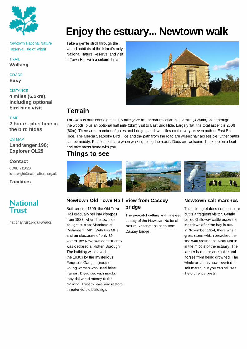
Enjoy the estuary... Newtown walkTake a gentle stroll through thevaried habitats of the Island’s onlyNational Nature Reserve, and visita Town Hall with a colourful past.
TerrainThis walk is built from a gentle 1.5 mile (2.25km) harbour section and 2 mile (3.25km) loop throughthe woods, plus an optional half mile (1km) visit to East Bird Hide. Largely flat, the total ascent is 200ft(60m). There are a number of gates and bridges, and two stiles on the very uneven path to East BirdHide. The Mercia Seabroke Bird Hide and the path from the road are wheelchair accessible. Other pathscan be muddy. Please take care when walking along the roads. Dogs are welcome, but keep on a leadand take mess home with you.
Things to see
Newtown Old Town Hall
Built around 1699, the Old TownHall gradually fell into disrepairfrom 1832, when the town lostits right to elect Members ofParliament (MP). With two MPsand an electorate of only 39voters, the Newtown constituencywas declared a 'Rotten Borough'.The building was saved inthe 1930s by the mysteriousFerguson Gang, a group ofyoung women who used falsenames. Disguised with masksthey delivered money to theNational Trust to save and restorethreatened old buildings.
View from Casseybridge
The peaceful setting and timelessbeauty of the Newtown NationalNature Reserve, as seen fromCassey bridge.
Newtown salt marshes
The little egret does not nest herebut is a frequent visitor. Gentlebelted Galloway cattle graze themeadows after the hay is cut.In November 1954, there was agreat storm which breached thesea wall around the Main Marshin the middle of the estuary. Thefarmer had to rescue cattle andhorses from being drowned. Thewhole area has now reverted tosalt marsh, but you can still seethe old fence posts.
Newtown National Nature
Reserve, Isle of Wight
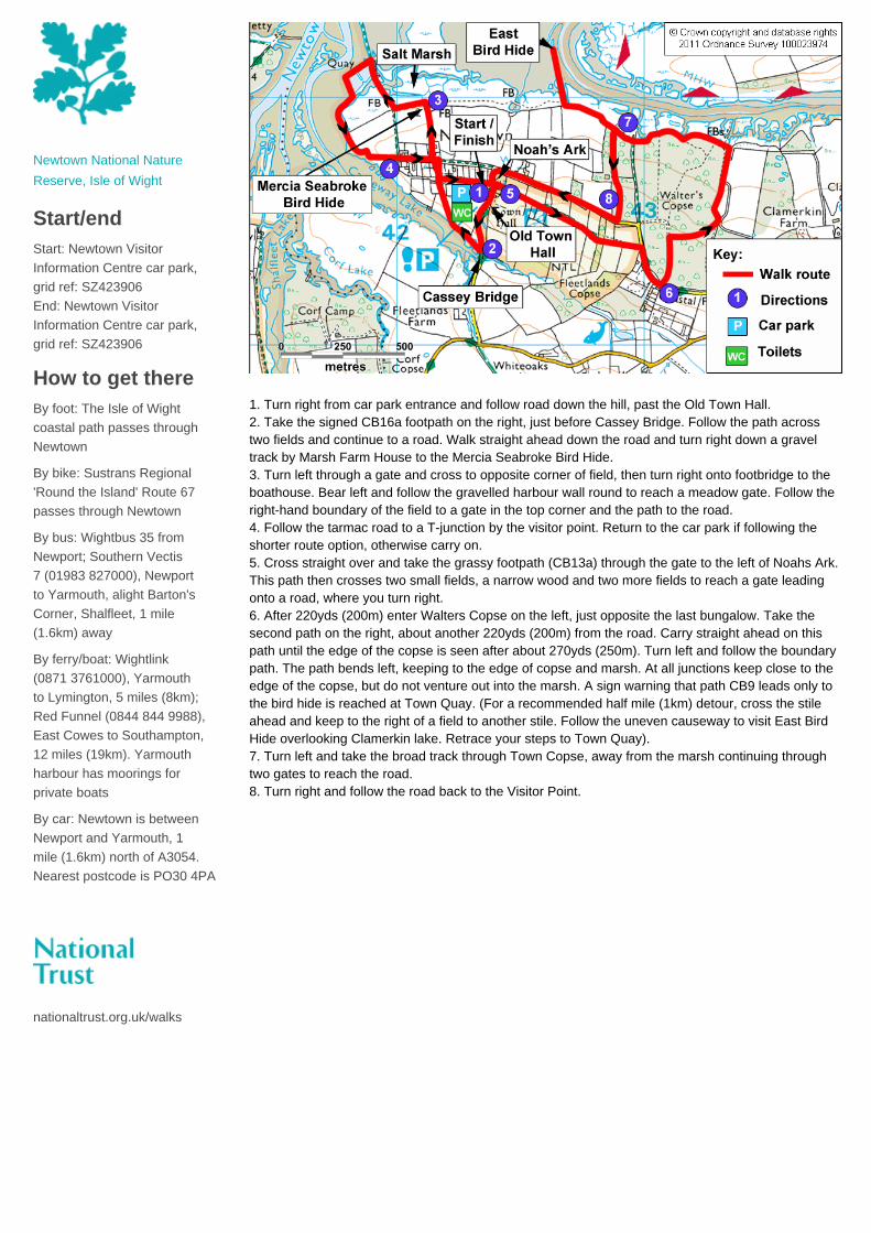
Start/endStart: Newtown VisitorInformation Centre car park,grid ref: SZ423906End: Newtown VisitorInformation Centre car park,grid ref: SZ423906
How to get thereBy foot: The Isle of Wightcoastal path passes throughNewtown
By bike: Sustrans Regional'Round the Island' Route 67passes through Newtown
By bus: Wightbus 35 fromNewport; Southern Vectis 7 (01983 827000), Newportto Yarmouth, alight Barton'sCorner, Shalfleet, 1 mile(1.6km) away
By ferry/boat: Wightlink(0871 3761000), Yarmouthto Lymington, 5 miles (8km);Red Funnel (0844 844 9988),East Cowes to Southampton,12 miles (19km). Yarmouthharbour has moorings forprivate boats
By car: Newtown is betweenNewport and Yarmouth, 1mile (1.6km) north of A3054.Nearest postcode is PO30 4PA
nationaltrust.org.uk/walks
1. Turn right from car park entrance and follow road down the hill, past the Old Town Hall.2. Take the signed CB16a footpath on the right, just before Cassey Bridge. Follow the path acrosstwo fields and continue to a road. Walk straight ahead down the road and turn right down a graveltrack by Marsh Farm House to the Mercia Seabroke Bird Hide.3. Turn left through a gate and cross to opposite corner of field, then turn right onto footbridge to theboathouse. Bear left and follow the gravelled harbour wall round to reach a meadow gate. Follow theright-hand boundary of the field to a gate in the top corner and the path to the road.4. Follow the tarmac road to a T-junction by the visitor point. Return to the car park if following theshorter route option, otherwise carry on.5. Cross straight over and take the grassy footpath (CB13a) through the gate to the left of Noahs Ark.This path then crosses two small fields, a narrow wood and two more fields to reach a gate leadingonto a road, where you turn right.6. After 220yds (200m) enter Walters Copse on the left, just opposite the last bungalow. Take thesecond path on the right, about another 220yds (200m) from the road. Carry straight ahead on thispath until the edge of the copse is seen after about 270yds (250m). Turn left and follow the boundarypath. The path bends left, keeping to the edge of copse and marsh. At all junctions keep close to theedge of the copse, but do not venture out into the marsh. A sign warning that path CB9 leads only tothe bird hide is reached at Town Quay. (For a recommended half mile (1km) detour, cross the stileahead and keep to the right of a field to another stile. Follow the uneven causeway to visit East BirdHide overlooking Clamerkin lake. Retrace your steps to Town Quay).7. Turn left and take the broad track through Town Copse, away from the marsh continuing throughtwo gates to reach the road.8. Turn right and follow the road back to the Visitor Point.