Embed Size (px)
Citation preview
© Crown copyright Met Office
Ensemble applications and integration with deterministic post-processingKen Mylne
Thanks to Caroline Jones, Rob Neal, Piers Buchanan, Andrew Jones,
James Canvin, Andrew Bennett, Stephen Moseley and Jo Robbins.
© Crown copyright Met Office ECMWF Operations Workshop, Nov 2011
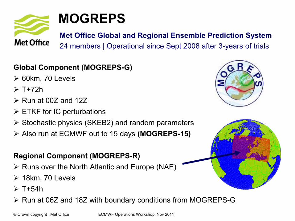
Global Component (MOGREPS-G)
60km, 70 Levels
T+72h
Run at 00Z and 12Z
ETKF for IC perturbations
Stochastic physics (SKEB2) and random parameters
Also run at ECMWF out to 15 days (MOGREPS-15)
Regional Component (MOGREPS-R)
Runs over the North Atlantic and Europe (NAE)
18km, 70 Levels
T+54h
Run at 06Z and 18Z with boundary conditions from MOGREPS-G
MOGREPSMet Office Global and Regional Ensemble Prediction System
24 members | Operational since Sept 2008 after 3-years of trials

© Crown copyright Met Office ECMWF Operations Workshop, Nov 2011
Many web-based productse.g. Prob of Gusts>40kt
• Probabilities,
ensemble mean
and spread also
stored as GRIB2
files for display on
forecaster
workstations
alongside
deterministic
forecasts
• Ensemble members
in GRIB2 for
• Exchange
• TIGGE-LAM
• Product
generation
© Crown copyright Met Office ECMWF Operations Workshop, Nov 2011
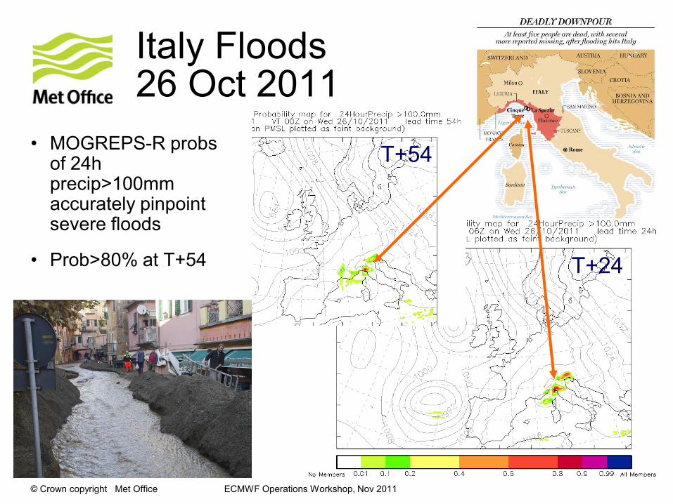
Italy Floods 26 Oct 2011
• MOGREPS-R probs of 24h precip>100mm accurately pinpoint severe floods
• Prob>80% at T+54 T+24
T+54
© Crown copyright Met Office ECMWF Operations Workshop, Nov 2011
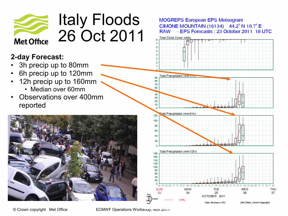
2-day Forecast:• 3h precip up to 80mm• 6h precip up to 120mm• 12h precip up to 160mm
• Median over 60mm
• Observations over 400mm reported
Italy Floods 26 Oct 2011
© Crown copyright Met Office
MOGREPS-WFirst-guess Severe Weather Warnings for NSWWS
Estimating Impact – a Risk tool

© Crown copyright Met Office
The New National Severe Weather Warning Service (NSWWS)
• Alerts/warnings based on likelihood and impact
• Alerts - issued more than 24 hours ahead
• Warnings - issued up to 24 hours ahead
• Regionally varying impact thresholds
• Alerts/warnings presented by shape areas on a map
rather that just by county area
© Crown copyright Met Office ECMWF Operations Workshop, Nov 2011
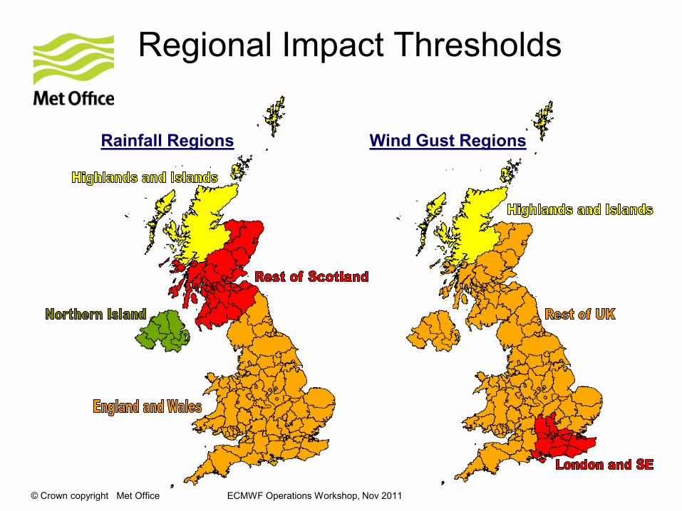
Regional Impact Thresholds
Wind Gust RegionsRainfall Regions
© Crown copyright Met Office ECMWF Operations Workshop, Nov 2011
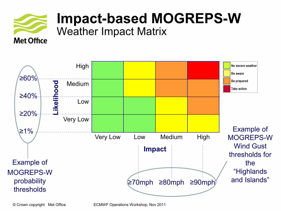
Impact-based MOGREPS-WWeather Impact Matrix
High
Medium
Low
Very Low
Very Low Low Medium High
≥70mph ≥80mph ≥90mph
Example of
MOGREPS-W
Wind Gust
thresholds for
the
“Highlands
and Islands”
≥1%
≥20%
≥40%
≥60%
Example of
MOGREPS-W
probability
thresholds
Impact
Lik
eli
ho
od
© Crown copyright Met Office ECMWF Operations Workshop, Nov 2011
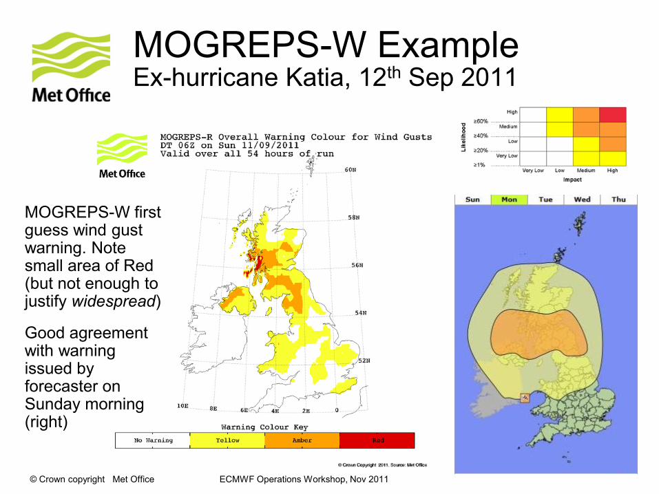
MOGREPS-W ExampleEx-hurricane Katia, 12th Sep 2011
MOGREPS-W first guess wind gust warning. Note small area of Red (but not enough to justify widespread)
Good agreement with warning issued by forecaster on Sunday morning (right)
© Crown copyright Met Office ECMWF Operations Workshop, Nov 2011
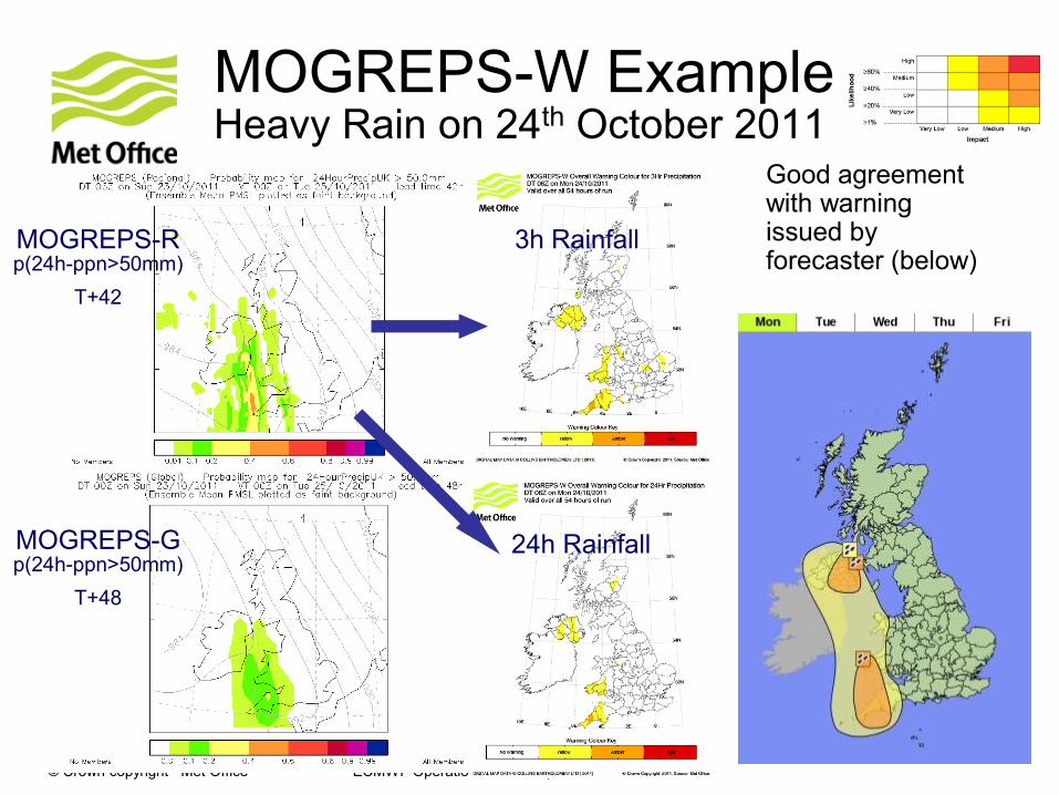
MOGREPS-W ExampleHeavy Rain on 24th October 2011
Good agreement with warning issued by forecaster (below)
3h Rainfall
24h Rainfall
MOGREPS-R p(24h-ppn>50mm)
T+42
MOGREPS-G p(24h-ppn>50mm)
T+48
© Crown copyright Met Office ECMWF Operations Workshop, Nov 2011
Converting Hazard to RiskExample for road vehicle overturning due to strong winds
UHGV T027 Probability
11/5/2008
Raster map – Probability of gust speeds
exceeding the pre-defined UHGV
overturning gust speed threshold
Legend
SplitMwayNet
UHGV_ImpactZS.MEAN
0.000000 - 0.755607
0.755608 - 2.569340
2.569341 - 5.009400
5.009401 - 7.602610
7.602611 - 10.723300
10.723301 - 14.370200
14.370201 - 18.729900
18.729901 - 25.653700
25.653701 - 36.083199
36.083200 - 49.477501
Legend
SplitMwayNet
UHGV_RiskZS.MEAN
0.000000 - 0.100000
0.100001 - 0.200000
0.200001 - 0.300000
0.300001 - 0.400000
0.400001 - 0.500000
0.500001 - 0.600000
0.600001 - 0.700000
0.700001 - 0.800000
0.800001 - 0.900000
0.900001 - 1.000000
Legend
uhgv_prob
Value
High : 1
Low : 0
UHGV T027 Prob x Vuln
11/5/2008
Vector map – Risk (between 0 and 1)
of UHGV overturning per kilometre of route
based on the probability of gusts exceeding the
UHGV overturning gust speed threshold and the
Vulnerability of each route segment
UHGV T027 Risk x
Exposure
11/5/2008
Vector map – Overall Risk of vehicle
overturning along each route determined
using the risk (Prob x Vuln) output and
mulitplying it by the vehiles along the route
on that day and at that time
Wednesday, November 05, 2008
Page 1
Probability, Vulnerability & Exposure = Risk of Vehicles Overturning
OVERALL RISK MAP
© Crown copyright Met Office
Storm surge ensemble
Coupling a surge model to MOGREPS –
In support of coastal flood forecasting by the
Environment Agency

© Crown copyright Met Office ECMWF Operations Workshop, Nov 2011
Storm surge Ensemble –recently extended to 7 days
• Storm surge model coupled to MOGREPS-R and MOGREPS-15
• Probability of surge elevation >1.0m
• Mean and spread of surge elevation
© Crown copyright Met Office ECMWF Operations Workshop, Nov 2011
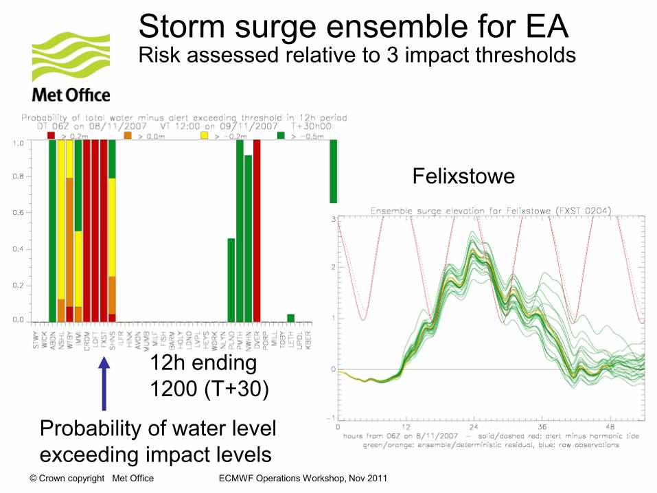
Storm surge ensemble for EARisk assessed relative to 3 impact thresholds
Felixstowe
12h ending
1200 (T+30)
Probability of water level
exceeding impact levels
© Crown copyright Met Office ECMWF Operations Workshop, Nov 2011
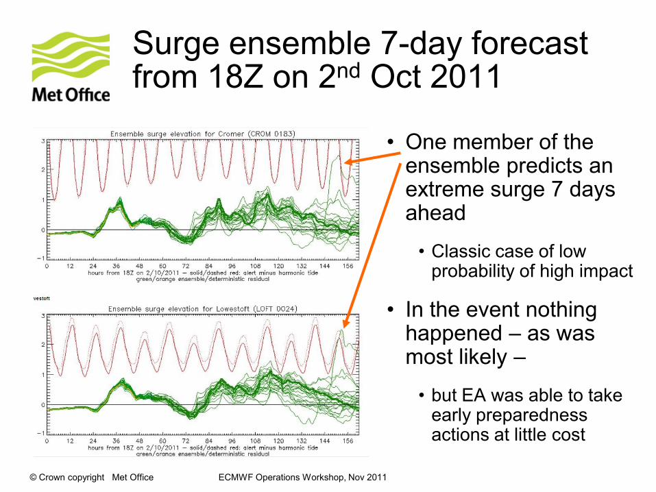
Surge ensemble 7-day forecast from 18Z on 2nd Oct 2011
• One member of the ensemble predicts an extreme surge 7 days ahead
• Classic case of low probability of high impact
• In the event nothing happened – as was most likely –
• but EA was able to take early preparedness actions at little cost
© Crown copyright Met Office ECMWF Operations Workshop, Nov 2011
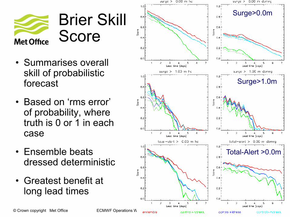
Brier Skill Score
• Summarises overall skill of probabilistic forecast
• Based on „rms error‟ of probability, where truth is 0 or 1 in each case
• Ensemble beats dressed deterministic
• Greatest benefit at long lead times
Surge>0.0m
Surge>1.0m
Total-Alert >0.0m

© Crown copyright Met Office ECMWF Operations Workshop, Nov 2011© Crown copyright Met Office
Uncertainty in Dispersion Modeling
Volcanic Ash, Chemical and Nuclear Accidents
© Crown copyright Met Office ECMWF Operations Workshop, Nov 2011
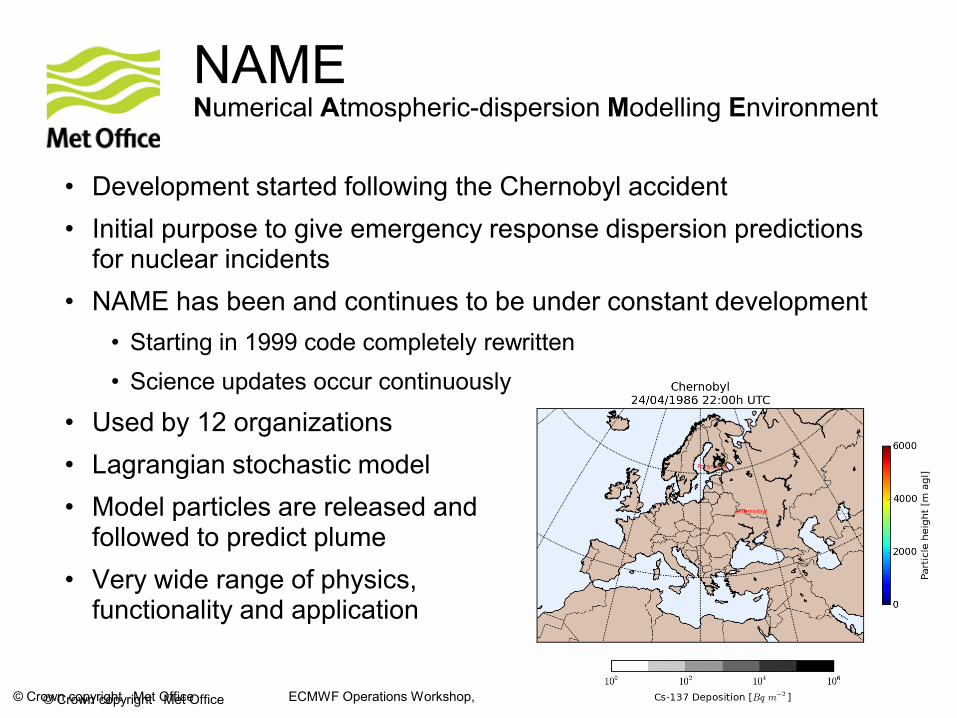
NAMENumerical Atmospheric-dispersion Modelling Environment
• Development started following the Chernobyl accident
• Initial purpose to give emergency response dispersion predictions for nuclear incidents
• NAME has been and continues to be under constant development
• Starting in 1999 code completely rewritten
• Science updates occur continuously
• Used by 12 organizations
• Lagrangian stochastic model
• Model particles are released and followed to predict plume
• Very wide range of physics, functionality and application
© Crown copyright Met Office
© Crown copyright Met Office ECMWF Operations Workshop, Nov 2011
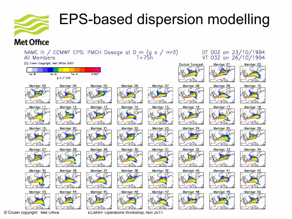
EPS-based dispersion modelling
© Crown copyright Met Office ECMWF Operations Workshop, Nov 2011
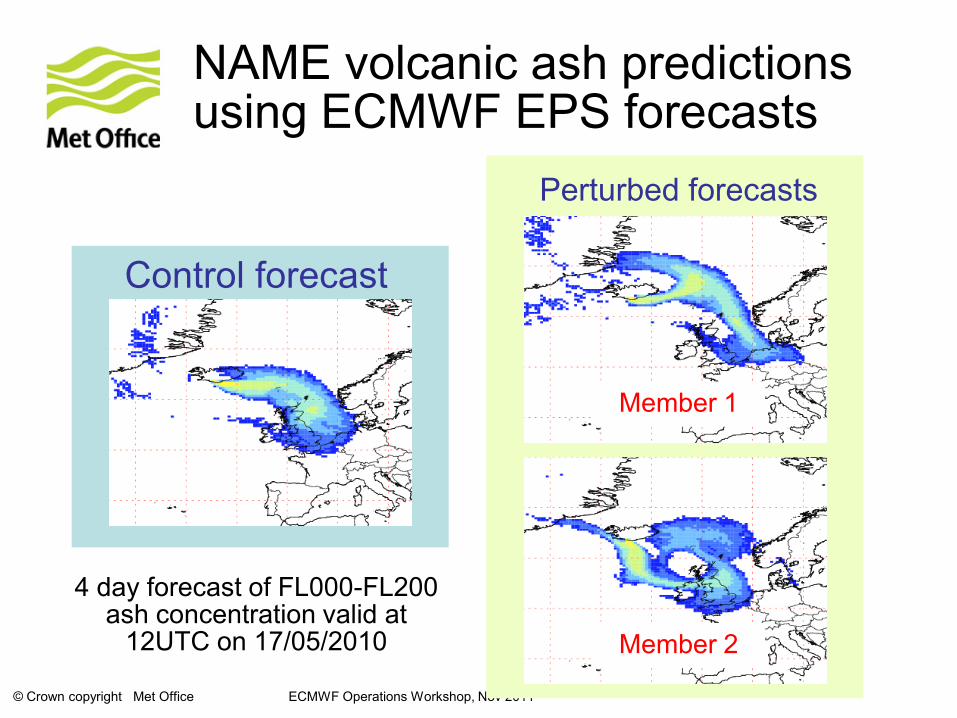
NAME volcanic ash predictions using ECMWF EPS forecasts
Control forecast
Perturbed forecasts
Member 1
Member 2
4 day forecast of FL000-FL200 ash concentration valid at
12UTC on 17/05/2010
© Crown copyright Met Office ECMWF Operations Workshop, Nov 2011
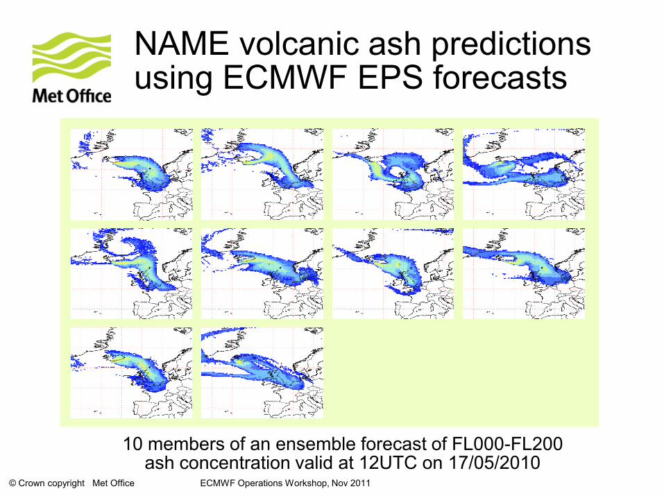
NAME volcanic ash predictions using ECMWF EPS forecasts
10 members of an ensemble forecast of FL000-FL200 ash concentration valid at 12UTC on 17/05/2010
© Crown copyright Met Office ECMWF Operations Workshop, Nov 2011
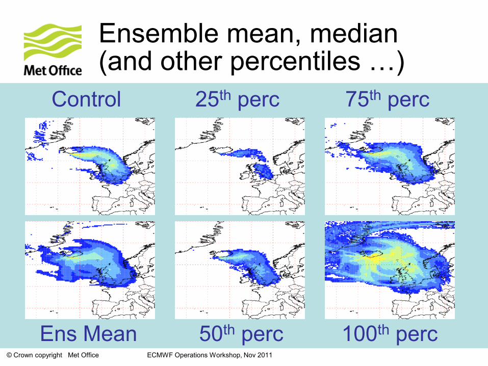
Ensemble mean, median (and other percentiles …)
Control
Ens Mean
25th perc
50th perc 100th perc
75th perc

© Crown copyright Met Office ECMWF Operations Workshop, Nov 2011
NAME volcanic ash predictions using ECMWF EPS forecasts
prob(conc > VA threshold) in FL000-200 at T+72
N.B. meteorological uncertainty only!
© Crown copyright Met Office ECMWF Operations Workshop, Nov 2011
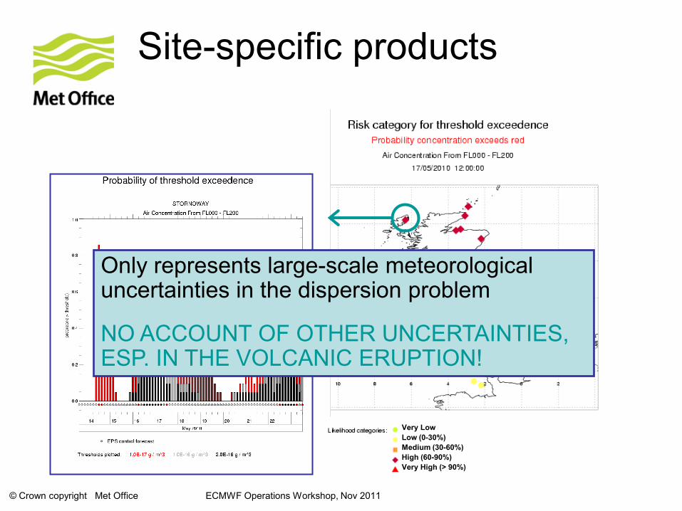
Site-specific products
Very Low
Low (0-30%)
Medium (30-60%)
High (60-90%)
Very High (> 90%)
Only represents large-scale meteorological uncertainties in the dispersion problem
NO ACCOUNT OF OTHER UNCERTAINTIES, ESP. IN THE VOLCANIC ERUPTION!
© Crown copyright Met Office
Use of EPS is a powerful tool to understand the atmospheric forecast uncertainty in long-range dispersion
Full probabilistic prediction also requires:
• Source-term uncertainty
• Model uncertainty
Current research is aiming towards a complete probabilistic prediction
Dispersion Summary
© Crown copyright Met Office
Integrating Post-Processing of Ensemble and Deterministic NWP
© Crown copyright Met Office
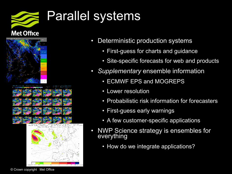
Parallel systems
• Deterministic production systems
• First-guess for charts and guidance
• Site-specific forecasts for web and products
• Supplementary ensemble information
• ECMWF EPS and MOGREPS
• Lower resolution
• Probabilistic risk information for forecasters
• First-guess early warnings
• A few customer-specific applications
• NWP Science strategy is ensembles for everything
• How do we integrate applications?

© Crown copyright Met Office
Site-specific forecasts
© Crown copyright Met Office ECMWF Operations Workshop, Nov 2011
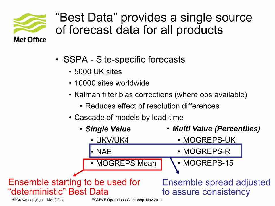
“Best Data” provides a single source of forecast data for all products
• SSPA - Site-specific forecasts
• 5000 UK sites
• 10000 sites worldwide
• Kalman filter bias corrections (where obs available)
• Reduces effect of resolution differences
• Cascade of models by lead-time
• Single Value
• UKV/UK4
• NAE
• MOGREPS Mean
• Multi Value (Percentiles)
• MOGREPS-UK
• MOGREPS-R
• MOGREPS-15
Ensemble starting to be used for “deterministic” Best Data
Ensemble spread adjusted to assure consistency
© Crown copyright Met Office ECMWF Operations Workshop, Nov 2011
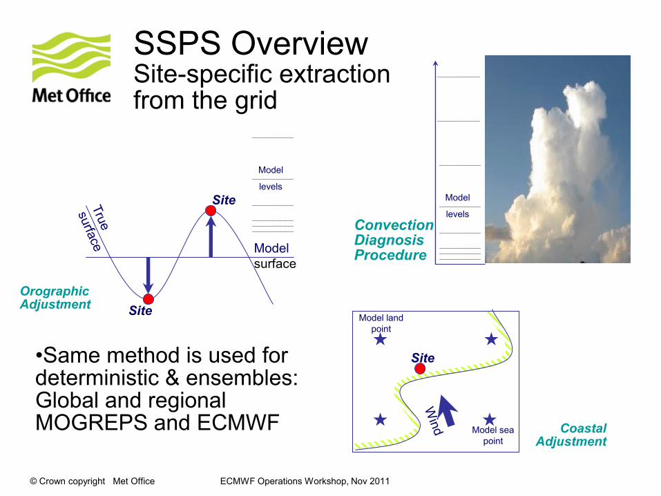
SSPS OverviewSite-specific extraction from the grid
Site
Site
Model
levels
Model
surface
Orographic Adjustment
Model sea
point
Site
Model land
point
Coastal Adjustment
Model
levels
Convection Diagnosis Procedure
•Same method is used for deterministic & ensembles: Global and regionalMOGREPS and ECMWF
© Crown copyright Met Office ECMWF Operations Workshop, Nov 2011
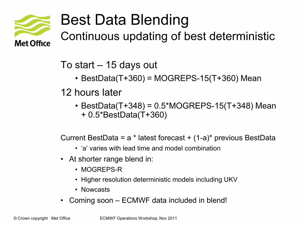
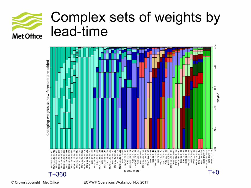
Best Data BlendingContinuous updating of best deterministic
To start – 15 days out
• BestData(T+360) = MOGREPS-15(T+360) Mean
12 hours later
• BestData(T+348) = 0.5*MOGREPS-15(T+348) Mean + 0.5*BestData(T+360)
Current BestData = a * latest forecast + (1-a)* previous BestData
• „a‟ varies with lead time and model combination
• At shorter range blend in:
• MOGREPS-R
• Higher resolution deterministic models including UKV
• Nowcasts
• Coming soon – ECMWF data included in blend!
© Crown copyright Met Office ECMWF Operations Workshop, Nov 2011
Complex sets of weights by lead-time
T+360 T+0
© Crown copyright Met Office ECMWF Operations Workshop, Nov 2011
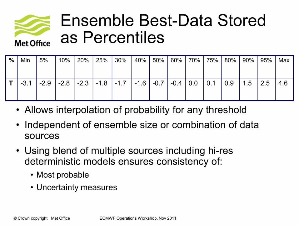
Ensemble Best-Data Stored as Percentiles
• Allows interpolation of probability for any threshold
• Independent of ensemble size or combination of data sources
• Using blend of multiple sources including hi-res deterministic models ensures consistency of:
• Most probable
• Uncertainty measures
% Min 5% 10% 20% 25% 30% 40% 50% 60% 70% 75% 80% 90% 95% Max
T -3.1 -2.9 -2.8 -2.3 -1.8 -1.7 -1.6 -0.7 -0.4 0.0 0.1 0.9 1.5 2.5 4.6
© Crown copyright Met Office ECMWF Operations Workshop, Nov 2011
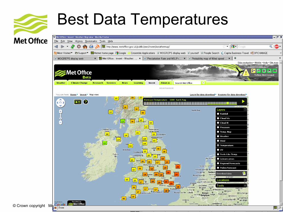
Best Data Temperatures
© Crown copyright Met Office ECMWF Operations Workshop, Nov 2011
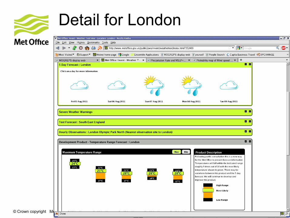
Detail for London
© Crown copyright Met Office
Integrating Gridded DataUK Post-Processing (UKPP)
© Crown copyright Met Office ECMWF Operations Workshop, Nov 2011
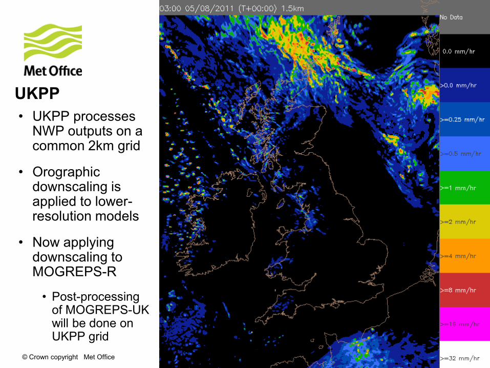
UKPP
• UKPP processes NWP outputs on a common 2km grid
• Orographic downscaling is applied to lower-resolution models
• Now applying downscaling to MOGREPS-R
• Post-processing of MOGREPS-UK will be done on UKPP grid
© Crown copyright Met Office ECMWF Operations Workshop, Nov 2011
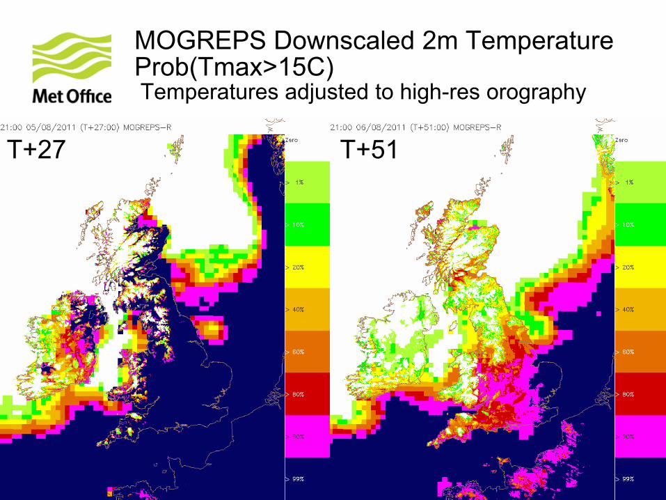
MOGREPS Downscaled 2m TemperatureProb(Tmax>15C)Temperatures adjusted to high-res orography
T+27 T+51

© Crown copyright Met Office ECMWF Operations Workshop, Nov 2011
MOGREPS Downscaled 2m TemperatureProb(Tmax>20C)Temperatures adjusted to high-res orography
T+27 T+51
© Crown copyright Met Office ECMWF Operations Workshop, Nov 2011
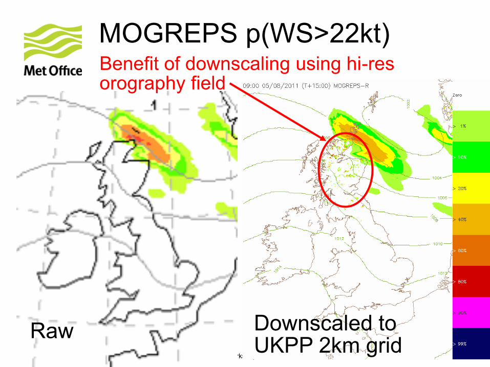
MOGREPS p(WS>22kt)
Raw Downscaled to UKPP 2km grid
Benefit of downscaling using hi-res orography field
© Crown copyright Met Office
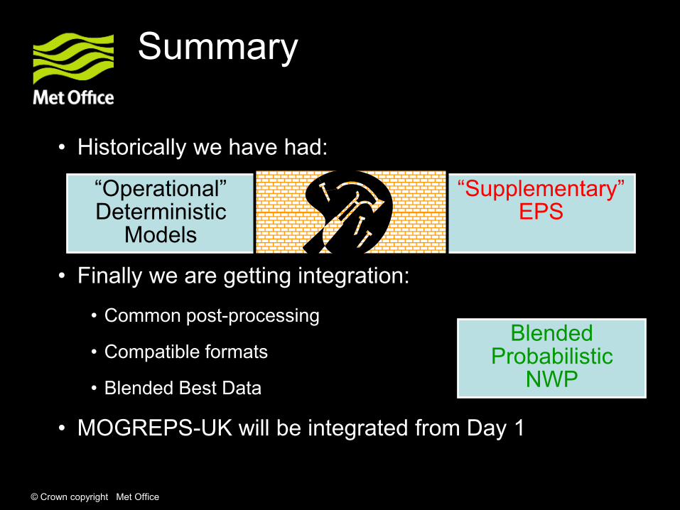
Summary
• Historically we have had:
“Operational” Deterministic
Models
“Supplementary” EPS
Blended Probabilistic
NWP
• Finally we are getting integration:
• Common post-processing
• Compatible formats
• Blended Best Data
• MOGREPS-UK will be integrated from Day 1

© Crown copyright Met Office
Conclusions
• Ensemble forecasts are still widely considered to be a nice to have supplement to the deterministic forecast
• Integrated post-processing provides a consistent picture of the complete forecast
• Coupling of ensembles to a variety of impact models provides effective risk assessment