Embed Size (px)
Citation preview
E-290PEOPLE'S REPUBLIC OF CHINA VOL.3
GUANGXI ZHUANG REGION HIGHWAY PROJECTSHUIRENODUANONANNING HIGHWAY
ENVIRONMENTAL ACTION PLAN( Final Draft)
Guangxi Zhuang Region Communication DepartmentNanning, China
September, 1999
Pub
lic D
iscl
osur
e A
utho
rized
Pub
lic D
iscl
osur
e A
utho
rized
Pub
lic D
iscl
osur
e A
utho
rized
Pub
lic D
iscl
osur
e A
utho
rized

I
PREFACE
Hechi(Shuiren)-Duan-Nanning Highway (called Shuiren-Nanning Highway) is the main section ofChongqing-Zhanjing National Artery Highway, serving as an easy access to the sea ports. It is one ofthe three main sections of "The National Artery Highway Configuration Planning" approved by thestate council. The total length of the proposed main highway is 237.588km, including 140.733km ofexpressway, 97.182km of class-two highway. Five connecting lines with a total length of 25.6km underClass-two are planned at 5 county town sites and a tourist resort. The total estimated cost is 4,117.2million RMB yuan with inclusion of 1.660,billion RMB yuan of the World Bank Loan.
The EIA of Shuiren-Nanning Highway was compiled by Xian Highway University. In November,1998, and it worked out the first edition of EIS. In early December, 1998, the Environmental ProtectionAgency of the MOC held a pre-review meeting on the EIA in Nanning. Based on the new edition ofthe "Project Feasibility Study Report of the Hechi(Shuiren)3DuanONanning Highway" of Dec. 1998,the EIS was completed in January, 1999 (edition for review & approval). In May,1999, the secondedition was finished (revision).In September,1999, the final edition is achieved.
To obtain the environment protection targets put forward in the EIA and to control or mitigate theadverse impacts due to the construction project, the environmental action plan of Shuiren-NanningHighway is compiled on the basis of the project features, the design documents concerned andenvironrnent protection references of highway construction provided by the World Bank.

ContentsPreface
1 PROJECT INTRODUCTION GENERAL ..................................................... (1. )
1.1 General Introduction ....................................................... (1)
1.2 Main Standards in EIA ....................................................... (4)
1.3 Main Conclusions of the EIS ........................................................ (4)
1.4 Environment Managerial Laws and Criteria ...................................................... (5)
1.5 Environmental Management Institutions and Their Responsibilities ........................... (6)
1.6 Composition of Environmental Action Plan ...................................................... (9)
2 ENVIRONMENTAL PROTECTION ACTIONS ................................................ (10)2.1 Management Plan of EP for Project Feasibility Study Phase ............... ..................... (10)2.2 Environmental Protection Actions for Design Phase ............................................. (10)2.3 Environmental Protection Actions for Construction Phase ............. .................... (17)2.4 Environmental Protection Actions for Operation Phase ............... ..................... (18)2.5 Estimated Cost on Environmental Protection ...................................................... (20)
2.6 Environmental Training ....................................................... (21)
3 ENVIRONMENTAL PROTECTION SURVEILLANCE PLAN .................................... (23)
4 ENVIRONMENTAL MONITORING PLAN .................................................... (24)4.1 Objective of Monitoring ........................................................ (24)4.2 Surveillance Institutions ....................................................... (24)4.3 Implementation of Monitoring ....................................................... (24)
4.4 Instruments, Cost and System for Monitoring Report .......................................... (25)
Annex 1: Key Elements of the EAP for Shuiren-Nanning Highway .............................. (27)Annex 2:Environmental Standards ........................................................ (32)
Annex 3: Preventive Schemes Against Soil Erosion of Shuiren-Nanning ........................ (35)
Drawing :Environment and Monitoring spots along the Shuiren-Nanning Highway
ABBREVIATIONS
EIA: environmental impact assessment
EMP: environmental monitoring plan
EP: environmental protection
ETOR: Outline of EIA of Shuiren-Nanning Highway
EPO: Environmental Protection Office
GEAB: Guangxi Regional Expressway Administrative Bureau
GEPB: Guangxi Environmental Protection Bureau
SEPA: State Environmental Protection Administration
GCD: Guangxi Communications DepartmentGCPDI: Guangxi Communications Planning, Survey and Design Institute
MOC: Ministry of Communications
PMO: Project Management office of Guangxi Highway Project Financeal by the World Bank
GAI: Guangxi Archaeological Institute
GALR: Guangxi Communication of Land Acquisition and Resettlement
GCICAB: Guangxi Communications Infrastructure Construction Administration Bureai
GCRD: Guangxi Cultural Relics Division
EMS: Environmental Monitoring Station
WB: The World Bank
1 PROJECT INTRODUCTION
1. lGeneral Introduction
1. The Shuiren-Nanning Highway is one of the important parts of the national trunk-line Chongchen-Zhanjang Highway, one of the three key highways in the "National Trunk Line Configuration Planning"approved by the State Council. Therefore, it is essential to achieve the general planning target in thegeneral highway planning configuration of the state. The proposed project goes from north to south,passing through Hechi, Duan, Mashan, Wuming, and it is destined at Nanning. The study areas arepeopled mainly by minority nationalities. Duan County and Mashan County through which theproposed route will pass are ones of the poorest counties of both Guangxi provincial and country levewhich receive assistance. Although these counties are rich in natural resources, their economy isbackward mainly because of poorer traffic conditions. The construction of the highway will providethese areas with a better infrastructure to help them to get rid of poverty and become rich.
For the geographical location of the alignment, refer to Fig. l -l .
2. The total length of the proposed road is 237.588 km. The whole route is divided into two sectionsfor which three different technical standards will be adopted considering the following factors: thepredicted traffic volume, the level of economical growth of the respective areas, the natural conditions,construction capital and the state planning for the highway configuration. They are:
1) Section from Hechi(Shuiren) to Duan K96+000[1K194+300. The new construction mileage is97.855 km with standards Class-two , including:
Section K96+0007K163+748 with a length of 66.155 km in hilly heavy rolling area; thedesign driving speed is 60 km/h; and section K163+7480K194+300 with a length of 30.70 kmin plain light rolling area; the design driving speed is 80 km/h.
2) Section from Duan to Nanning K194+300E1K335+139. The new construction mileage is 140.733km. Standards for this section will be expressway in plain light rolling areas; design speed is 100 krn/h.
The construction scale, major technical indices and work amount are shown in Table 1-1.
3. Connecting LineThere are 5 connecting lines, which can play a better role of the proposed highway in the economic
are planned at 5 county town sites and a tourist resort. The connecting lines will be built according toclass-two standards. The five lines comprise: Duan County Town line (1.5 km), Mashan County TownLine (4.0km), Dahua County Town Line (16.0km), Wuning County Town Line (3.8km) and YilingyanLine (0.3km).
Fig.1-1 C;eographical Location
2
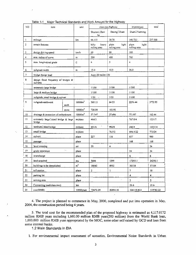
Table 1-1 Major Technical Standards and Work Amount for the Highway
NO. item unit class-two highway expressway total
Shuiren3Daxi DaxinglDuan Duan_Nanningng
I mileage km 66.155 30.70 140.733 237.588
2 tertain features hilly heavy plain light plain lightI____________ rolling area rolling area rolling area
3 design driving speed km/h 60 80 100
4 min. radtus of curve m 200 400 700
5 max. longitudinal grade 0 6 5 4
6 subgrade width m 15.0 15.0 26.0
7 bridge design load Auto-20 trailer-120
8 design flood frequency of bridges &culverts
extremely large bridge 1/100 1/100 1/300
large & medium bridge 1/100 1/100 1/100
subgrade, small bridge & culvert 1/50 . 1/50 1/100
9 subgrade earthwork 10000m' 369.13 64.53 2256.44 3772.95earth
stone lOOOOm3 728.09 103.92
10 drainage & protection of embankment IOOOOm3 57.747 27.496 77.197 162.44
I I extremely largeosized bridge & large m/place 464/3 767.0/4 1231/7bridge__ _ _ _ _ _ _ __ _ _ _ _ _ _ _
12 mediumOsized bridge mi/place 601/6 992/8 260/4 1853/18
13 small bridge m/place 76.5/2 696.5/22 773/24
14 culvert place 227 116 637 980
15 passage place 168 168
16 level crossing set 20 4 24
17 grade separation place 24 24
18 interchange place 6 6
19 land acquired mu 5696 1299 17255.1 24250.1
20 buildings to be demolished m2 18042 8952 30110 57104
21 toll station place 2 1 7 10
22 parking lot place 4 4
23 serving area place _ . 2 2
24 Connecting road(class-two) km 25.6 25.6
25 cost(RMB) 10000yuan 72672.29 20994.10 326110,833 419782.22
4. The project is planned to commence in May, 2000, completed and put into operation in May,2004, the construction period being 4 years.
5. The total cost for the recommended plan of the proposed highway is estimated as 4,117.0172* million RMB yuan including 1,660.00 million RMB yuan(200 million) from the World Bank loan,
1,000.000 million RMB yuan appropriated by the MOC, some other self-raised by GCD and loan fromsome internal banks.
1.2 Main Standards in EIA
1. For environmental impact assessment of acoustics, Environmental Noise Standards in Urban
3
Areas GB 3096-93 is adopted. For schools and hospitals along the route class-one is adopted, and forvillages and residential areas class-four is adopted.
2. For the EIA of ambient air, class-two standards in GB 3095-1996 are adopted. For emission ofatmospheric pollutants, class-two standards are adopted (GB 16290-1996);
3. For water environment, class-three standards are adopted in Surface Water Quality Standards GB3838-88. For emission of domestic sewage, Water Quality Standards of Farm Irrigation GBB5084- 92and class-one standards in Sewage Emission Standards GB 8978-1996 are adopted.
4. Class-2 standards in Soil Environmental Quality Standards GB 16518-1995 and Pb LimitSanitation Standards in Food GB 14935-94 are adopted.
1.3 Main Conclusions of the EIS
1.3.1 Assessment of Existing Environment
(1) The soil and crops along the alignment are fairly good not affected by the Pb.(2) The environmental noise at the schools and villages comply with relevant standards in GB 3096-
93.(3) The water quality in the rivers and reservoirs complies with classOZtwo standards except
Diaojiang River in which COD exceeds classOthree standards.(4) The air along the alignment is quite good meeting classEltwo standards in GB 3095-1996 at all
eight monitoring spots.
1.3.2 Prediction Analysis Conclusion of Impact on Environment
1.3.2.1 Phases of Design and Construction(1) The impact in the construction phase is decrease of farmnland, damage to vegetation and soil
erosion. These impacts could be alleviated by use of rational selection of alignment, plantation of trees,building catch ditches, protection slopes or earth. settlement tanks.
(2) The construction will not have impact on water environment by strengthening management andadopting advanced techniques in bridge construction.
(3) The noise and dust during construction do have some effect on environment. However, the effectcan be mitigated by means of reasonable construction time and location to reduce impact on schoolteaching and other sensitive locations.
(4) No rare plant and animal species occur in the study areas, so there is no impact on them.(5) No important cultural relics have been found along the alignment within the assessment scope.(6) The alignment is in favor of masses and governments along the route.(7) The recommended scheme is superior to the altematives in many respects as environmental
impact, land use, public opinions and urban development. The comparison among the highway to be ornot to be construction shows the superiority of construction for local economy, traffic safety,environmental protection etc.
(8) In construction phase, the existing roads will be affected severely. But this efTect could bemitigated by construction section by section and control of the traffic.
(9) The Hechi-Duan section is mountainous, that is, large excavation can not be avoidable. Adetailed survey has been made to reduce largely the excavation amounts and areas. Also, someplantation design will work in order to minimum the impact on local scenery and soil erosion.
1.3.2.2 Operation Phase(1) The impact on ecosystem in construction phase is resulted from dust and emitted lead by
vehicles. However, the dust has very minor impact on crops due to the fact that there is plenty ofintensive rain that continues long. There is slight lead impact on the route areas.
(2) The runoff from pavement in the early stage of operation has minor impact on the water qualityexcept that it has some impact on the water in Chengjiang River (mainly risky accidents). The sewagefrom tolling stations could be used as manure for farming after disposed of.
(3) The risk of spill of hazardous materials will not be neglected, especially at the section of
4
Chengiiang.(4) In 2024 in operation phase, the standards at 47 places (35 villages, 10 schools and 1 hospital) will
be in excess. Noise preventive measures will be taken at those locations where noise exceeds thestandards.
(5) The exhaust gases will deteriorate the air quality along the highway in operation phase, but theextent will not exceed class-ithvo standards in GB3095-1996.
(6) The traffic safety on connecting lines must be taken into account.(7) The benefit/cost analysis shows that the implementation of the preventive measures will bring
about significant social environmental benefit.
1.4 Environment Managerial Laws and Criteria
(1) Laws*The Environment Protection Law of the P.R.C., December 26,1989;,The Protection and Control Law of Water Pollution of the P.R.C., May, 1996;*The land Management Law of the P.R.C., June 25, 1986;*The protection and Treatment Act of Noise Pollution of the P.R.C., Oct. 26, 1996;The Ambient Pollution Prevention and Protection Law of P.R.C.;Water Pollution Prevention and Protection Law of P.R.C, May ,1996;Antiques Protection Law of P.R.C Nov.29,1982;
Measures for Environmental Protection of Construction Projects by the NEPB, No.(86) 003,March 26, 1986;
,The Water Law of the P.R.C., January 21, 1988;The Conservancy Law of Water and Soil of the P.R.C., June 29, 1991;*River Courses Management Laws of the P.R.C., June 10, 1986;-Design Regulations for EP of Construction Projects No.002(87);-Management Guidelines on Protection of Drinking water sources, No.201(89);-Safety Management Regulations for Chemical Hazardous Goods, February 17, 1987;*Temporary Provisions of Report on Environmental Pollution and Destructive Accidents,September 10, 1987;
* Measures for environmental Protection of Transport Construction Projects by the MOC,No.(90) 17;
*Circular of Strengthening of the Environmental Impact Assessment of Management of theProjects Funded by the Intemational Financial Loan by the NEPB, the NPC, MOF etc.No.(1993) 324, June 21, 1993;
*The world bank operational manual OP/BP/GP4.01: Environmental Assessment, October 1991;The world bank operational manual OD4.20: Indigenous Peoples, September 1991.
(2) Criteria-Quality Standards of Surface Water, GB3838-88;* Standards of Ambient Air Quality, GB3095-1992;Noise Standards at Urban Areas, GB3096-93;Sanitation Standards of Ambient Noise of Industrial Enterprises, January 1,1980;Noise Levels of Construction Site Boundary, GB12523-90;Emission Standards of Asphaltic Pollutants, GB4916-85;
* Ambient Vibration Standards in Urban Areas, GB 10071-88
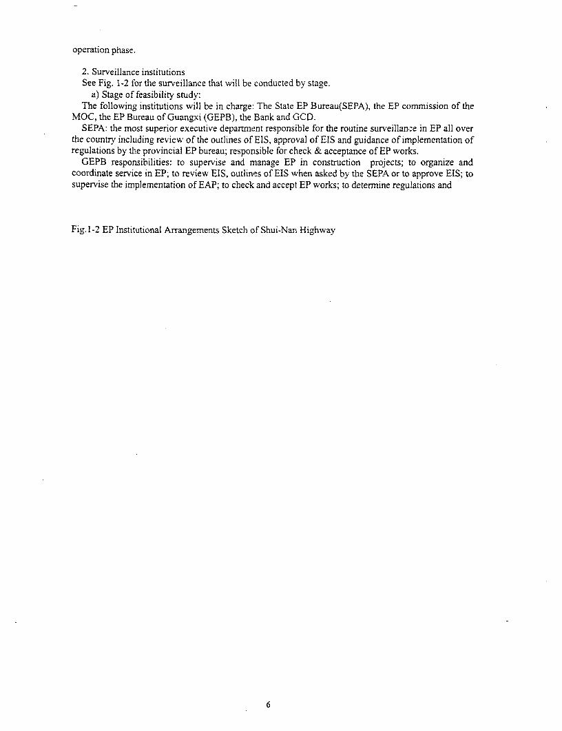
1.5 Environmental Management Institutions and Their ResponsibilitiesThe environmental protection (EP) institutions fall into managerial and monitoring. See Fig. 1-2.
1. Managerial institutionsThe Guangxi Communications Department (GCD) is responsible for the EP management. Its
responsibilities are: to coordinate the EP management between executive departments and employers;instruct employers to implement the managerial measures. The divisions are: The EP department underPMO is responsible for the EP plans and environmental management during the design phase, and isresponsible for the implementation and management of the EAP during the construction phase as well.The Guangxi Expressway Administrastive Bureau (GEAB) is responsible for the EAP during the
5
operation phase.
2. Surveillance institutionsSee Fig. 1-2 for the surveillance that will be conducted by stage.
a) Stage of feasibility study:The following institutions will be in charge: The State EP Bureau(SEPA), the EP commission of the
MOC, the EP Bureau of Guangxi (GEPB), the Bank and GCD.SEPA: the most superior executive department responsible for the routine surveillance in EP all over
the country including review of the outlines of EIS, approval of EIS and guidance of implementation ofregulations by the provincial EP bureau; responsible for check & acceptance of EP works.
GEPB responsibilities: to supervise and manage EP in construction projects; to organize andcoordinate service in EP; to review EIS, outlines of EIS when asked by the SEPA or to approve EIS; tosupervise the implementation of EAP; to check and accept EP works; to determnine regulations and
Fig.1-2 EP Institutional Arrangements Sketch of Shui-Nan Highway
6

Fig. 1-3
7
departments, to be responsible for the construction and acceptance of EP works and surveillance ofoperation service.
d) Operation phase is in charge of by the GEAB and GEPB.e) The environmental monitoring in both construction and operation phases is in the charge of the
provincial environmental monitoring departments and the monitoring stations of the prefectures andcounties concerned.
During the construction phase, the two supervisors from the project agency of the PMO will beresponsible for the supervision of the implementation of EP measures in EAP and tendering documents.
Upon completion of the project, specialized people will be assigned to take responsibilities of EP intheir areas in the following cities and counties: Hechi, Duan, Mashan, Wuming and Nanning. Firebrigades and ambulance corps will be coordinated and controlled by the county governments.
1.6 Composition of Environmental Action Plan* Environmental Management Plan: management activities to prevent or mitigate the adverse
impacts.* Environmental Supervision Plan: supervision activities to ensure synchronous implementation of
mitigative measures together with the project cotistruction.* Environmental Monitoring Plan: monitoring activities to eliminate pollution during both
construction & operation phases.
8
2 ENVIRONMENTAL PROTECTION ACTIONS
2.1 Management Plan of EP for Project Feasibility Study PhaseThe major EP task during the viability study phase is the EIA of the project.
The compilation of the EIA is undertaken by Xi'an Highway university. The EIA panel made thefield reconnaissance survey in detail. An EIA was compiled in January, 1999 as a result and its secondedition was completed in May, 1999, the final edition is achieved in September, 1999.
To implement the EP measures put forward in the EIA and prevent or mitigative the negative impactsof the projects, the Environmental Action Plan has been worked out as a result of consultation withdesigners, resettlement mission, and World Bank Project Agency of Guangxi Conmmunication Division.In September, 1999, the final draft was completed.
2.2 Environmental Protection Actions for Design PhaseThese measures have basically been deterrnined, and should be optimized as necessary in design
phase.
2.2.1 Route Selection(1) The alignment wi]l be selected considering minimizing land acquisition, relocation and
resettlement, and impact of air pollution and noise on enviromnentally.(2) The alignment will avoid cities, towns and other sensitive locations as much as possible.
(3) The alignment will be selected considering reducing cutting mountain to protect the resourceof landscapes.
2.2.2 Social Disruption168 passes (average every 700m) and 24 grade separators will be constructed to facilitate the
crossings of the expressway by local people, animals and vehicles.
2.2.3 Soil Erosion and Land Resources(1)Trees and grasses will be planted in the side slopes and other parts within the occupied slopes.
The slopes in the mountainous areas will be stabilized by various techniques including retaining andprotecting walls in order to avoid flooding of the slopes.
(2) Subgrade drainage system will be installed.(3) 980 culverts will be constructed to retain the irrigation function.
2.2.4 NoiseA combination of measures such as resettlement, installation of noise barriers and afforestation will
be undertaken to mitigate the short and medium tern noise problems. Before the operation of thehighway, 13 villages and 2 schools (I school will be removed because the land is needed by Highway)will be relocated and approximately 3450 m2 noise barriers will be built at sensitive locations.
In Table 2-1 are listed the villages exceeding the standards by more than 3 dB at night in 2014; inTable 2-2, the schools exceeding the standards by more than 3 dB in 2024 in daytime are listed. Basedon the existing conditions of a particular place, the following measures are proposed to take:
(1) It is suggested that in construction the housing in the residential centers within 40 m from theroad center be demolished, considering the fact that the noise level at night in 2006 or 2014 exceeds thestandards by more than 5.0 dB. See Table 2-1. There is much less demolition in mountainous villagesbecause the houses are located sparsely. Besides, the slopes of Shuiren3Duan Secti6n is very steep, so40m of land in width is used for embankment. Therefore, there will not be more removal due to impactof traffic noise.
(2) In the villages where the level exceeds the standards by more than 4.0 dB in 2024, the noisepreventive measures and implementation time will be determined according to the monitoring levelbehind 2014. See Table 2-1.
(3) Noise preventive measures will be taken at the schools where the excess is more than 3dB in2024 in daytime. See Table 2-2.
Table 2-1 Villages Exceeding 3dB in Noise Level and Preventive Measures
9
- - .~~~~~~ ~~ ~~~ predicted levels & excessive amount Leq(dB) measures suggested
E; 200_6 2014 2024 C
Ld Ln Ld Ln Ld Ln
I Hulu 265 30 5 0 0 0 2.6 0 3.3 measures are to beK1(110+35 determined according to
2 Y'angjiadian 280 25 2 0 0.8 0 3.8 0 4.6 monitoring levels afterK147+200 2015
3 Keyang 152 25 I 0 0.8 0 3.8 0 4.6K 1 50+700
4 Xiata 130 25 4 0 4.3 0 7.3 0 8.0 reseittlement is 40m within 5K(166+000 road center; less
5 W,eizou 550 25 2 0 4.31 0 7.3 0 8.0 removement due to someK 168+400 10 households
6 Bale 120 25 I 0 4.3 0 7.3 0 8.0 removement is 40m within 51K 17 l+~800 road center; less
7 Duicheng 185 25 5 0 2.4 0 5.4 0 6.1 removement of some 45K1(173+200 ____households[
8 Bancai ~ 450 25 4 0 4.3 0 7.3 0 8.0K 1 76+200
9 Bayang .310 25 4 0 4.3 0 7.3 0 8.0K 179+300
1 0 Bama 610 25 2 0 4.3 0 7.3 0 8.0 removement is 40m within SK(185+700 road centur; less
I I Bali 495 25 3 0 4.3 0 7.3 0 8.0 removement of 45K186+750 households
1 2 Baicai 34 25 1 0 7.0 2.5 9.5 3.4 10.4K 1 94+400
1 3 Dongpan 350 25 2 0 7.0 2.5 9.5 3.4 10.4K(199+300
14 Bantan 276 40 3 0 2.5 0 5.0 0 59 villagers will plant trees 21(06+750 between
15 Badu 557 50 1 0 0.7 0 3.33 0 T road &village intheK1211+500 ___ __charge of GCICAB.
16 Duili 267 25 1 0 7.0 2.5 9.5 3.4 104 removement is .40m within 51(211+500 road center; less
17 Baxing 278 25 1 0 0.7 2.5 9.5 removement of 8K(213+000 Ihouseholds
18 Jiaochang 329 50 5 0 2.2 0 4.8 0.3 5.7 besides planting trees, 2K(253+80040 1 40 76 7 more measures will be
19 Nalang 201 4 1 0 4. 07 66 1.6 7.5 taken accordin.g to theK(258+800 monitoring after 2015, in
____________ _____ _____ _____ ~~~~~~the charge of GCICAB.20 villages at double-layer wirtdows for 10
connecting the first row houses atlines villages 50m within the
road, some 150 householdsin number.
Table 2-2 Environmental Noise at Schools & HoSpitals and Preventative Measures,~~~ ~predicted levels & excessive amount Leq(dB) measures suggested
IR, 9 ~~2006 2014 2024 F
~~ Ld Ln~~~Ld Ln Ld LT,
I Keli 109 80 1 0 0 1.1 3.3 1.8 4.0 Sm wide plantationIK 146+500
2 Keyang 132 30 1 3.6 7.3 6.6 10.3 7.3 11.0 3m high,200m lang sound 10K(150+700 Ibarrier to be built up
3 Lintang 228 25 2 2.0 7.0 5. 1 9.2 6.2 11.0 2m high, 100 m long sound 10K 159+300 barrier
4 Daxing 653 25 5 7.0 12.0 11.1 14.2 11.2 16.0 2m high & 400 m long sound 10K 164+700 barrier
S Duan clinic bed 25 2 7.0 12.0 10.1 14.2 11.2 16.0 sharing the sound barrier with 10K(164+720 70 Daxing central school
6 Beishe 30 T 7.1 10.8 10.1 13.8 10.8 14.5 3mOtal) enclosing wall 10K(170+800II
7 Jiangcheng 320 50 5 1.0 4.8 3.9 7.8 4.8 8.6 2fm h-igh & 100 m long sound 61(17+650 barrier
8 Gucai 160 5 1.5 2.5 7.3 5.0 8.0 6.1 3mOtall enclosing wall 101(202+500
9 Linjiang 150 40 10 8.6 9.5 11.1 12.0 12.0 12.9 2mDtaIl enclosing wall of 101(216+000 ___........L30Dm long
10
10 Qide 280 80 5 8.7 8.0 11.2 10.5 12.7 11.4 buildingupof2.0rmhigh,300m 8K263+900 long sound barrier
II Yongning 235 230 6 15.5 16.4 17.6 18.4 18.3 10.2 removalK317+100
12 Wanghai 10.0 9.0 12.0 11.4 12.8 12.2 corridor on the second floor to 10WMNNR be closed
N.ote: Weizou Primary School will be resettled in eng. because the land acquired, it is hot made measure of noise prevention here.
2.2.5 Landscape Protection(1) The detail alignment will be determined to minimize spots, volume and areas of cutting limestone
mountains. In the preliminary design, elabration has made and the amount of earth/stone work inrelation to limestone mountains has been reduced by 9%, the areas of side slopes by 8%, and thus thenumber of cutting sites by 7 to 61, compared with those in the feasibility study. Further efforts will bemade in the detail design to further lessen the impacts on the landscape of limestone mountains.
(2) On all of cutting sites, appropriate mitigation measures including the restoration of vegetation willbe taken. All plantable cutting slopes will be covered with turf. Cutting at some low and steep slopeswill be a little expanded so as to turn the slopes gentle for grass plantation. A 50 cm-wide planting belton shoulders at some 10m and higher steep slopes will be designed to allow such grass as Boston Ivyto grow on the slopes. The sections requiring large excavation along the highway and protectingmeasures show in Table 2-3.
(3) Trial sections would be set up in an early stage of construction, where the environmentalmitigation measures against the cutting of limestone mountains addressed in the EA reports will beexamined in order to identify the most effective and practical measures.
2.2.6 Water PollutionSewage treatment facilities will be set up at the service areas and toll stations. Secondary biological
treatment is recommended.
2.2.7 Cultural RelicsCultural relics survey was carried out and no important cultural relics were found out in the working
area of the project.
11
Table 2-3 Statistical data for the sections requiring large excavation along Shuiren-Nanning HighwaySta(fkrotoesL) Average Exposed area Amount of Cutting slope and protecting measures
No. , in) (MI) _excavation
I K96+992-K97+312 320 17.5 11200 154980 The excavation is conducted in layers, for each 1Orn excavation, a new and higher platfomi begins with the cross section o._______ .____________________ ,________ ___________ __________the excavation in the form of a trapezium. 'I'he side slopes for the upper layers and the lower ones are 1:1 and 1:1.0
respectively. The excavated earth/stone will be used to fill the trough for the subgrade. T'he exposed area of the side slope2 K97+440-iK97+540 100 21.6 3456 73224 will be protected by frames of stone plates cemented with mortar, with grasses or climbers between them.
All the excavation at the spur is conducted in layers, for each 10mn excavation, a new and higher platform begins witllthe cross section of the excavation in the form of a trapezium. l'he side slopes for the upper layers and the lower ones are 1:
3 K97+902-K98+030 128 15 3072 54000 and 1:0.75 respectively. 'he excavated earth/stone will be used to build the embankment at both ends of the sectison. Thexposed area of the side slopes will bc protected by franmes of stone plates cemented with mortar, with grasses or climberbetween them.
All the excavation at hills is conducted in layers, for each lOim excavation, a new and higher platform begins with the crossection of the excavation in the form of a trapezium. I'he side slopes for the upper layers and the lower ones are 1: I and 1:0.
4 K98+267-K98+500 233 10 3495 55337 respectively. The excavated earth/stone will be used to fill the gullies for the subgrade at both ends of the section. Ithexposed area of the side slopes will be protected by frames of stonc plates cemented with mortar, wiih grasses or climberbetween them.
5 K99+717-K99+876 159 10 2385 37763 All the excavation is conducted in layers, for each 10m excavation, a new and higher plattorin begins with the croSsection of the excavation in the form of a trapezium. T'he side slopes for the upper layers and the lower ones are i: I ant._____ I:0.75 respectively. The excavated carth/stone will be used to rill the gullies for the subgrade at hoth enis of the section. 'I'h
exposed area of the side slopes will be protected by frames of stone plates cemented with mortar, with grasses or climber6 K105+620-K10S+772 152 10 3048 22809 between them.
All the excavation at the ridge is conduicted in layers, for each l()m excavation, a new andl higher platform hegins witlthe cross section of the excavation in the form of'a trapezium. 'he side slopes for the upper layers and the lower ones are 1I
24372 and 1:0.5 respectively. 'he excavated earth/stone will be hauled to section K107+301)-Ki07+4X8 to build embankment ther.7 K10744t8-K107+604 116 14 3200 24372 The exposed area of the side slopes will be protected by frames of stone plates cemented with mortar, with grasses oclimbers between them,
All the excavation at the hill is conducted in layers, for each 10m excavation, a new and higher platform begins wit lthe cross section of the excavation in the fomi of a trapeziunm. The side slopes for the upper layers and the lower oncs are 1:
8 KI11+020-K112+124 104 10 1560 24700 and 1:0.75 respectively. The excavated earth/stone will he used to build embankment at both ends of it. The exposed areathe side slopes will be protected by frames of stone plates cemented with mortar, with grasses or climbers between them.
rhe excavated side slope is 1:1. The excavated earth/stone wilt he used tc) build cnbankment at both ends of it. I'h9 exposed area of the side slopes will be covered with grasses or climbers, flecause on both sides of the recommendel9 I Kll2+332~Kll2+4l3 | 81 '9 850 16676 alignment are irrigated fields, the scheme is rational.
12
10 K117+070-K117+402 332 1 .5 11852 123504
All the excavation at the ridge is conducted in layers, for each 1Om excavation, a new and higher platform begins wit
I I KKI 17+953-KI 18+060 107 15.3 2892 40797 the cross section of the excavation in the fortm of a trapezium. The side slopes for the upper layers and the lower ones ar1:0.5 and 1:0.3 respectively. The exploded stone is will be used to fill the gullies at both ends of it. The exposed area of th'side slopes will be covered with grasses or climbers.
12 K118+172-K118+421 249 16.5 5752 120502
13 K1184516-K119+118 602 IS 12642 223944
_ .. 'Ihe excavation is conducted in layers, for each 10m excavation, a new and higher platform begins with the cros
14 K1194 566-K119+846 280 12.5 5880 83300 section of the excavation in the form of a trapezium. The side slopes for the upper layers and the lower ones are l:().5 an1:0.3 respectively. The exploded stone will be dumped to the barren troughs except a small amount used to builembankment at both ends of it and Bridge 2. The exposed area will be covered with grasses or climbers.
15 K120+730-K121+096 366 15 7685 136152
16 K122+020-K122+118 98 14 2573 42601 The excavation is conducted in layers, for each 10m excavation, a new and higher platform begins with thc crossection of the excavation in the form of a trapezium. The side slopes for the upper layers and the lower ones are 1:1 an1:0.75 respectively. All the excavated earth/stone will be hauled to Diaojing River Bridge and dumped into trough to huil l
17 K122+188-K122+340 154 17.5 5053 91933 the embankment. All the exposed area of the side slopes will be protected by frames of stone plates cemented with morta______ _ with grasses or climbers between them. Intersecting ditches will be dug at Sm away from the top of each slope to prevent th
18 K122+102-K122+536 104 12.5 2438 38659 slope from scouring
19 K123+286-K123+430 144 17.5 4725 85964
20 K123+646-K123+842 196 12.5 4594 72857
21 K124+080-K124+188 108 11.5 2329 23360
22 K124+696-K124+988 292 17.5 9581 174315
23 K105+120-K120+242 122 1 2516 38146 All the excavation at the ridge is conducted in layers, for each 10m excavation, a new and higher platform begins with the
24 K125+590-K125+906 316 20 20145 229416 cross section of the excavation in the form of a trapezium. The side slopes for the upper layers and the lower ones are 1:1 an(.__ _ 1:0.75 respectively. The excavated earth/stone will be used to fill the gullies for the subgrade at both enis of the section. -Ih(
25 K125+940-K126+080 140 IS 5119 67043 exposed area will be protected by frames of stone plates cemented with mortar, with grasses or climbers between them.Grasses will be planted on the platforms and draining ditches with a cross section of 0.430.4m will be provided. lnterscctin
26 K126+216-K126+442 226 27.5 15149 266390 ditches will be dug at Sm away from the top of each slope to prevent scouring.
27 K126+832-K127+002 170 16 6120 89216
28 K127+114-K127+203 88 15 2970 42141
29 K127+482-K127+596 114 10 2565 31407
13
30 K130+9t2-Ki31+004 92 12.5 3220 32401For all the sections, the excavation is conducted in layers, for each tOm excavation, a new and higher platform begin
with the cross section of the excavation in the form of a trapezium. T'he side slopes for the upper layers and the lower one31 Kt31+036-K131+224 188 12.5 4933 66221 are 1:1 and 1:0.5 respectively. All the excavated earth/stone will be used to build the embankment at both ends of eaclsection. The exposed areas of the slopes will be protected by frames of stone plates cemented with mortar, with grasses o
32 K131+440-K131+670 230 I l 5534 68437 chmbers between them.
33 K131+764-K131+864 too I l 2!18 29755
34 K132+760-1C133+060 300 108925 90150 All the excavation is conducted in layers, for each lOnm excavation, a new and higher platform begins with the cros34_132760K_3_06_30_ . section of the excavation in the form of a trapezium. The side slopes for the upper layers and the lower ones are 1: I and 1:0.35 K133+108-K133+320 212 16 10091 124826 respectively. The excavated earth/stone will be used to build the embankment at both ends of it. T'he exposed area will b. . protected by frames of stone plates cemented with mortar, with grasses or climbers between them.36 K135+150-K135+258 108 10 2295 32454
37 K135+352-K135+450 98 15.5 3228 55045
The side slopes for the upper layers and the lower ones are 1:1 and 1:0.75 respectively. The excavated earth/stone wil38 K137+446-K137+676 230 12.5 8625 85495 be used to build the embankment at both ends of the section. 'I'he exposed area will be protected by franAes oflstone platecemented with mortar, with grasses or climbers between tltem. Intersecting ditches Sm away from the top of thc righto
will be dug to prevent scouring.
All the excavation is conducted in layers. for each tOm excavation, a new and higher platfoirn begins with the cros39 K138+150-K138+264 114 14 2234 38942 section of the excavation in the form of a trapezium. Trhe side slopes for the upper layers and the lower ones are 1:(.5 an1:0.3 respectively. The excavated earth/stone will he used to build the embankment at hoth ends of the section. T he expose i
area will be protected by frames of stone plates cemented with mortar, with grasses or climbers between them.
All the excavation is conducted in layers, for each lOm excavation, a new an(d higher platform begins with the crossection of the excavation in the form of a trapezium. T'he side slopes for the upper layers and the lower ones are 1:1.25 an40 K138+6741-K138+922 248 10 5797 74524 1:1 respectively. The excavated earth/stone will be used to build the embankment at both ends of the section. 'he cxposc larea will be protected by frames of stone plates cemented with mortar, with grasses or clintbers between them. Intersectinditches Sm away from the top of the left slope will be dug to prevent scouring.
41 K139+906-K140+170 264 16.5 11326 103455
42 K142+808-K143+073 265 12.5 8613 74697 Alt the excavation is conducted in layers, for each tOm excavation, a new and higher platform begins with the crossection of the excavation in the form of a trapezium. The side slopes are 1:0.3. The excavated stone will all be used to builthe subgrade at each end of the section. The exposed area will be covered by grasses or climbers.
43 K143+872-KI44+035 163 15 3496 56969
44 KISO+571-KISO+791 220 13.5 6178 67865
14
45 K175+981-K176+610 629 I i 16600 173580
46 K191+962-K192+257 295 18 8750 147840
All the excavation is conducted in layers, for each lOm excavation, a new and higher platform begins with the cros
.47 K198+27;-K198+554 283 13 9198 99264 section of the excavation in the form of a trapezium. The side slopes are 1:0.3. At the pass, thc excavated material is har47 hl98+27l-Kl98+554 283 13 9198 99264 limestone, all of which will all be used to build the subgrade at each end of the section. [Ihe exposed area will be covered b
grasses or climbers.48 K209+060-K209+346 286 13.6 6068 131780
49 K209+555-K209+804 249 16.2 6293 139812
All the excavation is conducted in layers, for each lOm excavation, a new and higher platform begins with the cross sectionof the excavation in the form ofa trapezium and the side slopes of 1:1. The excavated earth/stone will all be used to build th
50 K230+850-K230+984 134 12.4 4813 61300 subgrade at each end ofthe section. T'he exposed area will be protected by frames of stone plates ccmentcd with mortar, withgrasses or climbers between them. Grasses will be planted on the platforms and draining ditches with a cross section of
0.430.4m will be provided.
All the excavation at the ridge is conducted in layers, for each 1lm excavation, a new and higher platform withwidth of 1.5m begins with the cross section oflthe excavation in the form of a trapezium. T-he si(de slopes ror the upper layer
51 K234+165-K234+570 405 12.96 17681 270000 and the lower ones are 1:0.75 and 1:I respectively. T'he exposed area will be protected by frames of stone plates cementcwith mortar, with grasses or climbers between them. Grasses will be planted on the platforms and (Iraining ditchCes withcross section of 0.430.4m will be provided.
52 K240+995-K241+165 170 15.75 5839 161520 All the excavation by the ridge is conducted in layers, for each lOm excavation, a new and higher platlom begin
53 K241+444-K241+570 126 15.4 3567 136830 with the cross section of the excavation in the form of a trapezium. T'he side slopes are taken as 1:1. TI'he excavateearth/stone will be used to build the subgrade at each end of the section. [he exposed area will be protected by frames o
54 K244+489-K244+760 272 13.92 8226 202832 stone plates cemented with mortar, with grasses or climbers between them, intersecting ditches will he dug at Sm away 1ronthe top of each slope to prevent the slope from scouring by water.
55 K258+450-K258+730 282 14.3 11564 183000
56 K270+070-K270+264 194 10.8 10190 62400 The side slopes for the upper layers and the lower ones are 1:1 and 1:0.75 respectively. 'I'he excavated earth/stone wilbe used to build the subgrade at each end of the section. The exposed area will be protected by frames of stone platecemented with mortar, with grasses or climbers between them. intersecting ditches will he dug at Sm away from the top o
57 K271+1 10-K272+030 920 7 29000 17400 the slope on the right to prevent it from scouring by water.
58 K304+753-K304+926 173 13 12180 108400The excavation is conducted in layers, for each lOm excavation, a new and higher platform begins with the cros
59 K306+520-K306+906 386 I1 31820 214320 section of the excavation in the form of a trapezium. The side slopes for the upper layers and the lower ones are 1:0.75 an1:1 respectively. The excavated earth/stone will be hauled to section K306+360-K306+52() and K306+906-K307+130 t
60 K307+453-K307+841 388 14.6 34500 334410 build the embankment. T'he exposed area will be protected by frames of stone plates cemented with mortar, with grasses oclimbers between them.
61 K313+680-K313+840 160 10.4 9500 68300
15
2.3 Environmental Protection Actions for Construction Phase
2.3.1 Ecological Measures and Suggestions
2.3.1.1 Ecological Resources(1) Temporary settlement tanks will be dug at the locations where there is runoff in construction of
subgrade to catch mud and sand. The tank is usually 0.5 m deep, and the size depends on the area ofcatchment. Geotextile will be provided at the outlet where necessary. These places will be rehabilitatedon completion of the work..
(2) Borrow earth will be planned, and it is required that borrow, leveling, rehabilitation andplantation be implemented at the same time. In the plain areas, the borrow pits will be suggested to beused as fishing pools. Before excavation the masses will be consulted about locations of borrow pits.
2.3.1.2 Land Protection(1) Temporary land taking will be to the minimum.
(2) The road will be accepted together with works of plantation, slope protection and drain ditches.(3) When land for temporary use is concerned, the top fermnented soil will be collected for
rehabilitation after the work is completed.(4) No borrow will be allowed to excavate from farmland at will.(5) Workers will be educated to protect animals and no poaching will be allowed.
2.3.1.3 Sewage and WastesWorking wastes and sewage will be under gcod treatment in case of pollution.
2.3.2 Noise(1) In order to reduce the time exposing loud noise, it is suggested that the workers operate
noise3producing machines on shift basis. Besides, the machinery will be maintained properly to keepit in lowest noise level. The workers will wear earplugs and helmets.
(2) When the construction sites are 200mn within the residential areas, no noise producingconstruction activities will be allowed between 22:00 - 6:00.
(3) Interfere with teaching activities will be minimized at the sections of schools by consultationwith schools in order to ensure the suitable time of high noise machinery working.
2.3.3 Air Pollution(1) The storage site and mixing stations will located at least 300 m from residential areas on the
leeward side and haulage roads will be sprayed regularly to reduce dust.(2) The construction sites also will be sprayed regularly, mainly on sunny days, twice a day in the
morning and in the afternoon.
2.3.4 Water Pollution(1) Muddy water caused by mud excavation and material washing pollutes water. Cofferdams and
caissons will be used in bridge construction with the former applying to the construction in the riverwith smaller flow and wider surface and the latter applying to the river larger flow.
(2) Waste water at worker' camp will be properly treated by septic tank, etc. and disposed of(3) Oil leakage from machinery and ships or waste oil will not be discharged into the river. They
should be collected and recycled as appropriate.(4) Asphalt, oil and chemicals will not be stocked at the places close to the water bodies, and they
will be covered with mufflers to avoid them running into the water bodies.
2.3.5 Traffic Management and Safety(1) The proposed alignment goes parallel to the 210 National Highway and crossing it-several times
at Section Honglong - Duan, so it is very important to guide the traffic. It is suggested to construct theroad section after section. Wardens will be posted to guarantee smooth traffic and safety. Detours willbe built at crossings prior to the construction.
(2) Wardens will be posted at crossings, school sections and residential areas to ensure that they aresafe.
17
(3) The working time must be in schedule at some blasting sections. At blasting, no vehicles andpedestrians are allowed to cross. The neighbouring villagers can be subsided for their temporarilyleaving at blasting.
(4) No crossing of pedestrians is allowed when building up bridges.
2.3.6 Cultural RelicsConstruction works will be stopped immnediately if any cultural relics are discovered as a result of
road construction or excavation activities. The local cultural relics authorities will be informed.Excavation will not be resumed unless the authorities approve of it.
2.3.7 Vibration MonitoringWhen vibrationEproducing construction (compaction of piers or operation of vibrating rollers) is
carried out, the impact on neighboring adobe houses will be supervised. Reparative measures will betaken if they are exposed to severe vibration or blasting and likely to suffer from damage.
2.3.8 Visual ResourcesIt is suggested to locate borrow sites at smaller hillsides. In excavation, it is better to cut off the
whole hill head to make use of. If it is impossible to make full use of, it is better to excavate at thebackside. hen hills are used as borrow sites, empty holes can not be left but a slope so as to therestoration of vegetations.
2.4 Environmental Protection Actions for Operation Phase
2.4.1 Zonal Planning on Either Side of the RoadThe prediction of traffic noise reveals that in the long-term of operation (2024) the noise levels
within 100 m of the road are below class 4 of GB 3096- 93 (Standard levels on both sides of arteryroad). Therefore, no villages (within 50m) and schools (within lOOm) or other sensitive locations willbe built.
2.4.2 Traffic Noise(1) No Homing Marks will be posted at the sections near schools.(2) At accesses of road, noiseDmonitoring stations will be installed, and the vehicles with loud noise
will not be allowed to run on the road.(3) Noise barriers or other appropriate noise prevention measures will be taken at locations where
noise exceeds the standard, based on the result of monitoring.(4) With the necessary prevention measures, the excess levels can be controlled below 5dB at
villages; below 2.0 dB at schools in daytime.
2.4.3 Air Pollution(1) Afforestation by planting trees on both sides. The natural conditions along the alignment are
good for growth of trees, it is required that high trees and bushes should be planted where possible oneither side to absorb pollutants and beautify the environment.
(2) The vehicles on the road will be tested ad hoc in emitting pollutants. Those in great excess ofpollutants will not be allowed to run on the road.
2.4.4 Potential Risk of Water Pollution(1) Sewage treatment facilities will be set up at the service centers. The sewage will not be
discharged unless is disposed of properly. For it, secondary biological treatment procedures aresuggested.
(2) Different kinds of leakage and material spill will be avoided to prevent water bodies from beingpolluted.
(3) Public Security Departments will be informed about the transportation of hazardous materials,and they can be transported only with their approval, especially at the section of water protection ofChengjiang River, i.e. K163 - K171.
(4) At section K163 0 K141, five settlement tanks will be dug to catch the runoff from theroadOsides to alleviate the impact on water quality.
(5) In case of foggy weather, the speed of vehicles will be controlled, and no transportation of
18
hazardous materials will be allowed.(6) Driving will not be allowed when drunk, tired, or overtaken.
2.4.5 Aesthetics and Plantation(1) The school and village areas will be treed and sodden to create scenic belts.(2) Highway management areas will also be treed and sodded to make the environment more
beautiful.
2.4.6 Vehicle Management(1) Better vehicle maintenance/management will be enhanced to keep vehicles in good conditions.
Vehicle noise and emission inspection will be strengthened. If a vehicle does not comply with the noiseand/or emission standards, the vehicle will not be allowed to pass until the problem is rectified.Periodical and random exhaust gas emissions inspection will be undertaken.
(2) Public awareness and education will be promoted to familiarize people with the problem of airpollution and noise from vehicles and with related regulations.
2.5 Estimated Cost on Environmental Protection
2.5.1 Nonrecurring Cost on Environmental Protection WorksBased on the measures suggested in this assessment, the nonrecurring cost on the environmental
protection works is listed in Table 2-4. The total cost is 27,999,400 RMB yuan.Table 2-4 Estimated Nonrecurring Cost on Environmental Protection
items contents or estimation methods Cost environmental benefits
10,000
RMB yuan
environmental design and environment monitoring, compilation of 80 to know existing environment, to predict
assessment EIA, design of environment engineering future environment, to prevent pollution, to
beaurify environment, to implement
. _____________preventative measures.
plantation landscape for Highway: 100,000 yuan/ktn; for class- 1693.64 to alleviate atmospheric & acoustic pollution,
protection (including cutting two road: 50,000 yuan/km to restore vegetation, to protect people s
slope vegetation) health, to beautify sceniery, landscape
recovery.
measures to prevent noise building high walls 4.5 to mitigate noise & in schools
I school removal 60.0 to keep norTnal teaching
building sound barriers 53.5 to keep normal teaching
treeing(at noise0exceeding spots) 15.0 to mitigate noise & pollution
demolition of farmhouses 156 to keep normal life
to close the outer corridor at school 2.80
building
double-layer glass windows 150 S
protection measures at toll air conditioning, sound isolating 40 to keep staffOis health
stations
soil conservation settlement tanks: l0,OOOYuan x 38 38 to avoid soil eTosion prevention from soil
erosion and land restoration
Borrow and spoil sites treatment: 2 million 200
Yuan
working dust 1200 daysx600 yuaniday 72 to mitigate air pollution
water treatment facilities one septic tank for all 10 toll stations 20 to protect surface water
water treatment at service water systems at 2 service areas, and 100 control of water quality
and its vegetation vegetation
protection of water sources one oxidizing tank every Skm;3c50,000 25 to protect water sources
yuan
personnel training personnel from; highway construction 76 to improve their abilities in their lines
units, management units, emergency units
and environmental protection units
protection of cultural relics including cost for survey of cultural relics Is to protect cultural relics
19
and excav ation (w%ith no cost for
contingency)
super- ision expenses environment supervision at 12 contract 48 supervision of implementation of EOP items.
sections, 10.000 yuarL'yr. section
wardens for safety 20 persons for 4 years 40.0 to keep smooth traffic and pedestrians safety
total cost for monitoring and 4 x 10.000 yuan for moni toring facilities 40 to monitor environment in construction phase
facilities
emergency accident monitoring expenses to be 10 to reduce accidents of chemical trucks to water
reserved body
total 2799.94
Note: The resettlement cost of Weizou Primary School has list in eng., not be counted here.
2.5.2 Annual Cost on Environmental Protection WorksSee Table 2-5 for detail. The total cost of 20 years operation is 20 yearsxO.54 million = 10.80 million
yuan.Table 2-5 Cost of Annual Operation for Environmental Protection Facilitiesrder items cost (10,000 yuan)
1 annual maintenance cost for environmental protection facilities 5.02 personnel training 1.03 annual monitoring cost 10.04 environmental treatment(from monitoring results) 30.05 EP staff salaries(8000yuan/yr. x 10) 8.0
total 54.0
2.6 Environmental TrainingThe program is intended to train the administrative personnel, technicians and supervisors involved in
environmental protection so that they can acquire the knowledge of environmental protection andensure the fulfillment of the EPAP.
According to their responsibilities, the trainees fall into the following three groups.I. Administrative personnel: they include high-level and middle-level administrative personnel,
who are to be trained to be able to handle issues and emergent situations in environmentalprotection. There are altogether 9 persons, with 3 from the Project Office; 3, from DCG; 2, fromCPSDIG and the Research Institute; 1, from the extemal monitoring agency.
2. Environmental supervisors: They will be trained to have a sound knowledge of environmentalprotection, control of environmental quality, management of expenses and techniques ofenvironmental protection engineering so as to ensure the fulfillment of the EPAP. All thetraining seminars will be held at home. There are altogether 12 persons, with 1 from eachcontracted section.
3. Working staff: There are altogether 18 persons, with 3 from each country; 3, from eachcity/prefecture. They are to be trained to have a sound knowledge of the project and itsenvironmental protection issues so as to cooperate with the other authorities to ensure thefulfillment of the project.
The training is to be carried out both at home and abroad. Those to be trained abroad will learn thenew methods, techniques and management experience from the advanced countries and to introducethem to all the personnel in charge of environmental protection. Those to be trained at home (inNanning City) include administrative personnel and working staff, with the training seminars sponsoredby the Project Office, and lectures given by the senior staff from the World Bank, government officialsand experts.
According to the trainees and training content, the program is divided into the following threestages.
1. The training of environmental supervisors is scheduled in March, 2000, with a period of 7 days;2. The training of high-level administrative personnel abroad is scheduled in March, 2000, with a
period of 21 days;3. The training of working staff at home (including those from each country, city and prefecture) is
scheduled in April, 2000, with a period of 7 days.
20
The training of 9 high-level administrative personnel will cost 450,OOORMByuan, with50,00ORMByuan for each; The training of 18 working staff will cost 270,O)ORMByuan, with15,00ORMByuan for each; The training of 12 envirornmental supervisors will cost 240,OOORMByuan,with 20,OOORMByuan for each; The cost totals 960,OOORMByuan. See Table 8-4.
Table 8-4 Personnel Training PlanPhase kinds number total year cost (RMB
.____ _ ____ ___ I number _ yuan)construction EP person from 3 persons from the 3 2000 450,000
Management constrLIction officeDivision _
environment GCICAB: 2; GCD:3; 6 2000managers other: 1Supervisors and 27 staff from all sections 27 2000 490,000staffemergent case 3 from local traffic 3 2000persons bureaus
operation environment 3 staff from Management 4 2003520 20,000managers Division(internal); 1 from 24
GEAB 1 person/2yr.
total = 43 960,000
:21

3 ENVIRONMENTAL PROTECTION SURVEILLANCE PLAN
Refer to Table 3-1.
Table 3-1 Environmental Protection Surveillance PlanPhase institutions contents of surveillance purpose of surveillance
SEPA i. Review ofOutline of EIA I. To make EIA cover all sides focusing on key
: EPO OF MOC 2.Review of EIA points
- GEPB 3. Review of EAP 2. To put forward all potential & major issues
r< World Bank 3.To make certain that all the mitigative
D GCD measures are implemented
___PMO
c SEPA 1. Review of initial design & EAP 1. To strictly carry out Othree simultaneous
_ EPO of MOC policy O & EAP
o GEPB 2. Examination of use of funds for EP 2. To ensure that it is used properly
GCD 3. Examination of locations of sites of quarries & mixing 3. to ensure that they satisfy requirements of EP
o PMO stations
o EP sections of 4. Examination of control of dust & noise pollution; 4. To mitigate impact on environment &
related determination of construction activity time implement related regulations
counties or 5. Examination of storage of toxic materials &emission of 5. To mitigate impact on environment &
prefectures atmospheric pollutants implement related regulations
6. Examination of discharge and disposal of sewage waste 6. To keep surface water unpolluted
oil at construction camp
7. Restoration of borrow & spoil sites 7. To ensure that scenery & land resources are
not damaged
8.Examination of Othree simultaneousO of EP facilities 8. To guarantee three OsimultaneousO policy
deter mination of completion time
9. Examination of implementation of EP standards 9. To check & accept EP works
10. check up the scenery design and working quality 10. protection of route sources of scenery
GCRD 11. Examination of existence of cultural relics I1. to protect cultural relics
i GEAB 1. Examination of implementation of EAP; I. Implementation of EAP
= Cominunicatio 2. Examination of implementation of monitoring plan; 2. Implementation of monitoring plan
o n Departments 3. Determination of further measures some sensitive 3. Proper protection of environment
cl or cities or locations not identified previously; 4. Proper protection of public health
counties, 4. Examination of weather the environment quality complies S. guarantee of emission standards of sewage
Public Security with requirements at the sensitive locations; 6. getting rid of possible accidents to protect
Departments S. Examination of treatment of sewage at management areas; environment.
6. Prevention of contingent accidents by strengthening 7. add up some measures for protection of
surveillance. In case of accidents, to take timely measures scenery
to get rid of leakage of toxic materials when needed
_ 7. check up the scenery quality
22
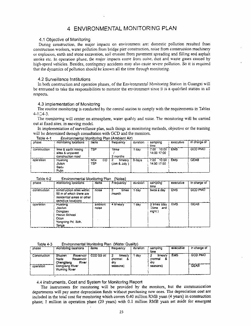
4 ENVIRONMENTAL MONITORING PLAN
4.1 Objective of MonitoringDuring construction, the major impacts on environment are: domestic pollution resulted from
construction workers, water pollution from bridge pier construction, noise from construction machineryor explosion, earth and stone excavation, soil erosion from pavement spreading and filling and asphaltsmoke etc. In operation phase, the major impacts come from noise, dust and waste gases caused byhigh-speed vehicles. Besides, contingency accidents may also cause severe pollution. So it is requiredthat the dynamics of pollution should be known all the time through monitoring.
4.2 Surveillance InstitutionsIn both construction and operation phases, of the Environmental Monitoring Station in Guangxi will
be entrusted to take the responsibilities to monitor the environment since it is a qualified station in allrespects.
4.3 Implementation of MonitoringThe routine monitoring is conducted by the central station to comply with the requirements in Tables
4-1 ]4-3.The monitoring will center on atmosphere, water quality and noise. The monitoring will be carried
out at fixed sites, in moving model.In implementation of surveillance plan, such things as monitoring methods, objective or the training
will be determined through consultation with GCD and the monitors.Table 4-1 Environmental Monitorng Plan (Ambient Air)
I phase monitoring locations items frequency duration sampling executive in charge ofF ______________ ~~~~~~~~ ~~ ~~ ~~time _ _ _ _ _ _
construction lime & earth mixing TSP ltime 1 day 7:00 10:00 EMS GCD PMOsites & unpaved I 14:00 17:00construction road 2 rnonths
operation Hualong NOx CO 2 times/y 5 days 7:00 10:00 EMS GEABJiutun TSP (Jan & July) 14:00 17:00Badu
______ ______ P ulin _ _ _ _ _ _ _ _ _ _ _ _ _ _ _ _ _ _ _ _ _ _ _ _ _ _ _ _ _ _
Table 4-2 Environmental Monitonng Plan (Noise)phase monitoring locations items Frequency duration sampling executive in charge of
______________ _________ ~~~~~~ ~~ ~~tim e _ _ _ _ _ _ _ _ _ _ _
construction construction sites within noise 2 times 1 day twice a day EMS GCD PMO50 m of which there are /monthresidential areas or othersensitive locations
operation Hualong ambient 4 times/y 1 day 2 times (day EMS GEABJioutun noise 3time andDongpan night)Hezuo SchoolOcunYongning Pri. Sch.
____ ____ ___ Tanga _ _ _ _ _ _ _ _ _ _ _ _ _ _ _ _ _ _ _ _ _ _ _ _ _ _ _ _ _ _ _
Table 4-3 Environmental Monitoring Plan (Water Quality)phase monitoring locations items frequency duration sampling executive in charge of
Construction Shuiren Reservoir COD SS oil 2 times/y 1 day 2 times/y EMS GCD PMONada Resenvoir (normal & (normal &Chengjiang River dry dry
operation Dongjiang River seasons) seasons) GEABWuming River
4.4 Instruments, Cost and System for Monitoring ReportThe instruments for monitoring will be provided by the monitors, but the communication
departments will pay some depreciation funds without purchasing new ones. The depreciation cost areincluded in the total cost for monitoring which covers 0.40 million RMB yuan (4 years) in constructionphase; I million in operation phase (20 years) writh 0.1 million RMB yuan set aside for emergent
23
accidents.
An annual monitoring report would be fumished to the Bank by January 31 of each year startingin 2001 during the construction phase and each of the first three years following completion ofconstruction.
The system for reporting is displayed in Fig. 4-1.
24

Fig. 4-1 Procedures of Monitoring Reporting
25
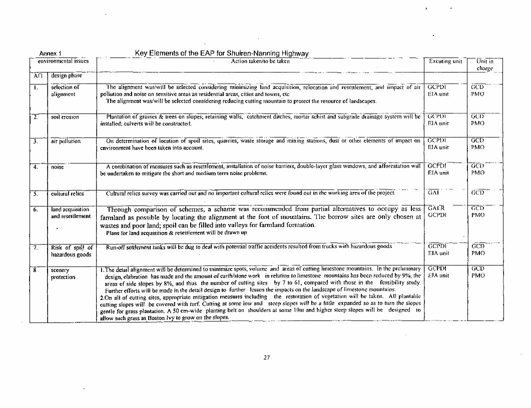
Annex 1 Key Elements of the EAP for Shuiren-Nanning Highwayenvironmental issues Action taken/to be taken Excuting unit Unit in
chargeAO design phase
I7 selection of The alignment was/will be selected considering minimizing land acquisition, relocation and resettlement, and impact of air GCPDI GCDalignment pollution and noise on sensitive areas as residential areas, cities and towns, etc EIA unit PMO
The alignment was/will be selectcd considering reducing cutting mountain to protect the resource of landscapes.
2. soil erosion Plantation of grasses & trees on slopes; retaining walls, catchment ditches, mortar schist and subgrade drainage system will be GCPDI GCDinstalled; culverts will be constructed. EIA unit PMO
3. air pollution On determination of location of spoil sites, quarries, waste storage and mixing stations, dust or other elements of impact on GCPDI GCDenvironment have been taken into account. EIA unit PMO
4. noise A combination of measures such as resettlement, installation of noise barriers, double-layer glass windows, and afforestation will GCPIDI GCDbe undertaken to mitigate the short and medium term noise problems. EIA unit PMO
S. cultural relics Cultural relics survey was carried out and no important cultural relics were found out in the working area of the project. GAI GOt)
6. land acquisition Through comparison of schemes, a schame was recommended from partial alteniatives to occupy as less GALR GCDand resettlement farmland as possible by locating the alignment at the foot of mountains. Tile borrow sites are only chosen at GCPDI PMO
wastes and poor land; spoil can be filled into valleys for farmiland formation.Plans for land acquisition & resettlement will be drawn up
7. Risk of spill of Run-off settlement tanks will be dug to deal with potential traffic accidents resulted from trucks with hazardous goods GCPDI GCDhazardous goods EIA unit PMO
8 scenery I .The detail alignment will be determined to minimize spots, volume and areas of cutting limestone mountains. In the preliminary GCI'DI GCDprotection design, elabration has made and the amount of earth/stone work in relation to limestone mountains has been reduced by 9%, the I.IA unit PMO
areas of side slopes by 8%, and thus the number of cutting sites by 7 to 61, compared with those in the feasibility study.Further efforts will be made in the detail design to further lessen the impacts on the landscape of limestorie mountains.
2.On all of cutting sites, appropriate mitigation measures including the restoration of vegetation will be taken. All plantablecutting slopes will be covered with turf. Cutting at some low and steep slopes will be a little expanded so as to turn the slopesgentle for grass plantation. A 50 cm-wide planting belt on shoulders at some lOm and higher steep slopes will be designed toallow such grass as Boston Ivy to grow on the slopes.
27
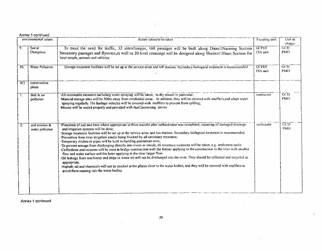
Annex 1 continuedenvironmental issues Action taken/to be taken Excuting unit Unit in
chargc9. Social To meet the need for traffic, 32 interchianges, 168 passages will be built along DuanONanning Sectioi GCPCI C[I)Disruption Necessary passages and flyovers,as well as 20 level crossings will be designed along ShuirenODuani Section for EIA unit PMOlocal people, animals and vehicles.
10. Water Pollution Sewage treatment facilities will be set up at the service areas and toll stations. Secondary biological treatment is recommcnded. GCI'DI GCOIEIA unit PMO
BO constructionphase
I . dust & air -All reasonable measures including water spraying will be taken, in dry season in particular; contractor GCD)pollution 'Material storage sites will be 300m away from residential areas . In addition, they will be covered with mufflers;and adopt water I'MOspraying regularly. The haulage vehicles will be covered with mumers to prevent from spilling;
'Mixers will be sealed properly and provided with dust[lremoving device
2. soil erosion & 'Plantation of sod and trees where appropriate in three months after embankment was completed; repairing of damaged drainaige contractor GCC)water pollution and irrigation systems will be done; PMOSewage treatment facilities will be set up at the service areas and too stations. Secondary biological treatment is recommended.Prevention from river irrigation canals being blocked by all necessary measures;Temporary ditches or pipes will be built in building permanent ones,
-To prevent sewage from discharging directly into rivers or canals, all necessary measures will be taken, e.g. settlement tanks-Cofferdams and caissons will be used in bridge construction with the former applying to the construction in the river with smallerflow and wider surface and the latter applying to the river larger flow.'Oil leakage from machinery and ships or waste oil will not be discharged into the river. They should be collected and recycled asappropriate.
-Asphalt, oil and chemicals will not be stocked at the places close to the watcr bodies, and they will be covered with mufflers toavoid them running into the water bodies.
I _ _ II ___
Annex 1 continued
28
environmental issues Action taken/to be taken Excuting unit Unit incharge
3. noise *To protect workers from being hurt, they will be asked to wear helmets and earplugs and limited in working hours; contractor GCD-No construction activities will be allowed between 22:00116:00 at sites within 200 m there are residential areas; PMO*To keep machinery in low noise by proper maintenance*Interfere with teaching activities will be minimized at the sections of schools by consultation with schools in order to ensure thesuitable time of high noise machinery working.
4. preservation of -Temporary settlement tanks will be dug at the locations where there is runoff in construction of subgrade to catch mud and sand. contractor GCDecological The tank is usually 0.5 m deep, and the size depends on the area of catchment. Geotextile will be provided at the outiet where PMOresources necessary. These places will be rehabilitated on completion of the work.
-Borrow earth will be planned, and it is required that borrow, leveling, rehabilitation and plantation be implemented at the sametime. In the plain areas, the borrow pits will be suggested to be used as fishing pools. Before excavation the masses will beconsulted about locations of borrow pits.
-Temporary land taking will be to the minimum.*The road will be accepted together with works of plantation, slope protection and drain ditches.-When land for temporary use is concerned, the top fermented soil will be collected for rehabilitation aftcr the work is completed.*No borrow will be allowed to excavate from farmiand at will.-Workers will be educated to protect animals and no poaching will be allowed.-Working wastes and sewage will be under good treatment in case of pollution.
5. cultural relics Excavation will be stopped immediately if any cultural relies are found . Excavation will not be resumed until protective contractor GCI)measures have been taken by the relics protection authorizes. PMO
6. construction There will be garbage cans & sanitation facilities. Feces waste, domestic sewage can not be discharged into rivers or other water contractor GCDareas bodies unless disposed of properly PMO
7. haulage *To decrease dust and noise and minimize impact on existing transport, haulage route wi)l be sclected carefully; contractor GCDmanagement To consult transport &security departments for better control of traffic; PMO
To build temporary roads intersecting existing road properly;-To avoid peak hours on existing road by drawing up reasonable transport schedules.
Annex 1 continued
29
environmental issues Action taken/to be taken Excuting unit TJn-t incharge
8. construction *Safety markings will be set up on temporary road regulations suitable for temporary road will be adopted, contractor GCDsafety *Effective safety measures will be taken during construction; during blast people and vehicles will be evacuated for safetyO PMO
sake. The use of explosive will be met with requirements of safety department;-Wardens will be needed on construction sites for safety.
9 scenery -scenery quality can be restored by strict implementation; contractor GCDprotection -borrow sites far from the highway, no steep slopes is formed by borrowing. Study PMO
*Trial sections would be set up in an early stage of construction, where the environmental mitigation measures against the cutting of Institute oflimestone mountains addressed in the EA reports would be examined in order to identify the most effective and practical GCD actormeasures.
10 Vibration When vibrationOproducing construction (compaction of piers or operation of vibrating rollers) is carried out, the impact on I MOMonitoring neighboring adobe houses will be supervised. Reparative measures will be taken if they are exposed to severe vibration or blasting
and likely to suffer from damage.
C Operationphase
1. zonal planing No villages (within 50m) and schools (within I 00m) or other sensitive locations will be built along highway. Local GEABGovenment
2. noise No homing markings will be set up at school sections; llighway CEA13* At accesses of road, noise monitoring stations will be installed, and the vehicles with loud noise will not be allowed to run on Sections of
the road. counties or*Noise barriers or other appropriate noise prevention measures will be taken at locations where noise exceeds the standard, based citieson the result of monitoring.With the necessary prevention measures, the excess levels can be controlled below 5dB at villages; below 2.0 dB at schools indaytime.
Annex_ . continud I
Annex 1 continued
30
environmental issues Action taken/to be taken Excuting unit Unit incharge
3. air pollution *Afforestation by planting trees on both sides. The natural conditions along the alignment are good for growth of trees, it is required Highway GEAI3
that high trees and bushes should be planted where possible on either side to absorb pollutants and beautify the environment. Sections of
*The vehicles on the road will be tested ad hoc in emitting pollutants. Those in great excess of pollutants will not be allowed to run counties or
on the road. cities
4. vehicular Vehicles will be kept in good conditions by examining vehicular exhaust gases; vehicles with low speed and loud noise will not be Hlighway GEAB
management allowed to go on road; Scctions of
*The public will be educated to be aware of noise pollution and informed of relevant regulations. counties orcities securitydepartments
5. risk of spills of *An emergency group will be organized by GEAB & GEPB to deal with the emergency; the group will be responsible also for Ilighway GEAB-
hazardous goods Management of hazardous goods spill on high[lclass highways all over the region. Sections of
* Transport of hazardous goods will have all the three certificates issued by security department; counties or
-Special routes or stop locations will be assigned by security department; cities-In case of spilling of hazardous goods, relevant departments will be informed immediately to take urgent measures. There will be
another monitoring group to deal with similar accidents.
6 water pollution Domestic sewage at toll stations will be disposed of by use of septic tanks, and then used as irrigation water. Garbage will be llighway
treated centrally. Sections ofcounties orcitics
D environment Monitoring will be conducted based on relevant specifications or standards issued by SEPA EMS GEAB
monitoring An annual monitoring report would be furnished to the Bank by January 31 of each year starting in 2001 during the GEPB3
construction phase and each of the first three years following completion of construction.
31
Annex 2Environmental Standard
Environ_ent Standards in EIAEnvironmental Standards NumberNoise Standards at Urban Areas GB3096-93Standards of Ambient Air Quality GB3095- 1996Quality Standards of Surface Water GB3838-88General Discharge Standards of Sewage GB8978- 1996Quality Standards of Irrigation Water GB5084-92Quality Standards of Soil GB15618-1995Sanitation Standards of Lead in Food GB14935-94Noise Sanitation Standards of Industrial Enterprises 1980.1.1Noise Level for Construction Site Boundary GB 12523-90Emission Standards of Asphaltic Pollutants GB4916-85Ambient Vibration Standards of Urban Areas GB 10071-88
Table 2-1 Noise Standards at Urban Areas(GB3096-93)
Equivalent noise level: Leq:dB(A)
class daytime night apply to
0 50 40 very sensitive areas
I 55 45 residential and educational areas
2 60 50 residential, shopping and industrial mixed areas
3 65 55 industrial areas
4 70 55 areas on both sides of artery lines
Table 2-2 Assessment Standards of Ambient Air Quality Unit:mgINm3
pollutants time of exampling concentration limit remark
1 2 3
CO daily average 4.00 4.00 6.00 Class-two in GB3095-1996
hourly average 10.00 10.00 20.00
NOx daily average 0.10 0.10 0.15
hourly average 0.15 0.15 0.30
TSP daily average 0.12 0.30 0.50
Note: Class-one applies to natural preservatives, resorts and some other areas specially needed.
Class-two applies to residential areas, shopping and traflic mixed areas, cultural, industrial and rural areas.
Class-three applies to some special industrial zones.
Table 2-3 Quality Standards of Surface Water(GB3838-88)
class 0 0 0 0 0
item
pH 6.508.5 609
32
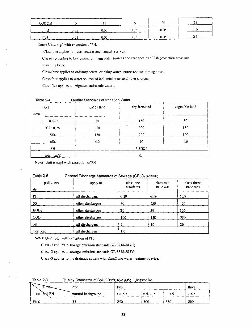
CODCs 15 15 15 20 25
oilss 0.05 0.05 0.05 0.05 1.0
Pbs 0.01 0.05 0.05 0.05 0.1
Notes: Unit: mg/l with exception of PH.
Class-one applies to water sources and natural reserves:
Class-two applies to key central drinking water sources and rare species of fish protection areas and
spawning beds,
Class-three applies to ordinary central drinking water sourcesand swNimming areas:
Class-four applies to water sources of industrial areas and other sources;
Class-five applies to irrigation and scenic waters.
Table 2-4 Quality Standards of Irrigation Water
sort paddy land dry farmland vegetable land
itemBOD5S 80 150 80
CODCrs 200 300 150
SSs 150 200 l00
oilS 5.0 10 1.0
PH 5.508.5
total leadS 0.1
Notes: Unit is mg/I with exception of PH.
Table 2-5 General Discharge Standards of Sewage (GB8978-1996)
pollutants apply to class-one class-two class-three
item standards standards standards
PH all dischargers 609 609 609
SS other dischargers 70 150 400
BOD5 other dischargers 20 30 300
CODcr other dischargers 100 150 500
oil all dischargers 5 10 20
total lead all dischargers 1.0
Notes: Unit: mg/l with exception of PH.
Class -I applies to sewage emission standards GB 3838-88 IIl;
Class -2 applies to sewage emission standards GB 3838-88 IV;
Class -3 applies to the drainage system with classOltwo water treatment device.
Table 2-6 Qua lity Standards of Soil(GB15 18-1995) Unit:mg/kg
c one two three
item <l PH natural background 006.5 6.507.5 0 7.5 06.5
Pb s 35 250 300 350 500
33
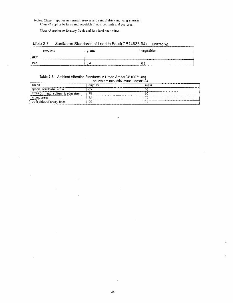
Notes: Class- I applies to natural reserves and central drinking water sources;Class -2 applies to farmland vegetable fields, orchards and pastures.
Class -3 applies to forestry fields and farmland near mines.
Table 2-7 Sanitation Standards of Lead in Food(GB14935-94) Unit:mg/kg
products grains vegetables
item
PbS 0.4 0.2
Table 2-8 Ambient Vibration Standards in IJrban Areas(GB10071-88)equivalent acoustic levels Leq:dB(A)
scope daytime nightspecial residential areas 65 65areas of living, culture & education 70 67mixed areas 75 72
both sides of artery lines 75 72
:34
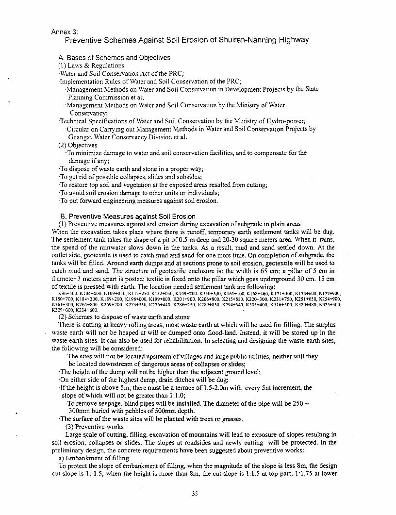
Annex 3:Preventive Schemes Against Soil Erosion of Shuiren-Nanning Highway
A. Bases of Schemes and Objectives(1) Laws & Regulations*Water and Soil Conser-ation Act of the PRC;-Implementation Rules of Water and Soil Conservation of the PRC;
*Management Methods on Water and Soil Conservation in Development Projects by the StatePlanning Commission et al;Management Methods on Water and Soil Conservation by the Ministry of WaterConservancy;
-Technical Specifications of Water and Soil Conservation by the MIinistry of Hydro-power;-Circular on Carrying out Management Methods in WVater and Soil Conservation Projects byGuangxi Water Conservancy Division et al.
(2) Objectives-To minimize damage to water and soil conservation facilities, and to compensate for thedamage if any;
*To dispose of waste earth and stone in a proper way;*To get rid of possible collapses, slides and subsides;*To restore top soil and vegetation at the exposed areas resulted from cutting;*To avoid soil erosion damage to other units or individuals;*To put forward engineering measures against soil erosion.
B. Preventive Measures against Soil Erosion(I) Preventive measures against soil erosion during excavation of subgrade in plain areas
When the excavation takes place where there is runoff, temporary earth settlement tanks will be dug.The settlement tank takes the shape of a pit of 0.5 m deep and 20-30 square meters area. When it rains,the speed of the rainwater slows down in the tanks. As a result, mud and sand settled down. At theoutlet side, geotextile is used to catch mud and sand for one more time. On completion of subgrade, thetanks will be filled. Around earth dumps and at sections prone to soil erosion, geotextile will be used tocatch mud and sand. The structure of geotextile enclosure is: the width is 65 cm; a pillar of 5 cm indiameter 3 meters apart is posted; textile is fixed onto the pillar which goes underground 30 cm. 15 cmof textile is pressed with earth. The location needed settlement tank are following:
K96+500, K104+000, K109+850, K112+250, K132+050, K149+200, K150+530, K165+100, K168+460, K171+300, K174+600, K177+900,KI180+700, K184+200, K189+200, K196+000, K199+000, K201+900, K206+800, K215+650, K220+300, K231+750, K251+650, K254+900,K261+300, K264+800, K269+700, K273+550, K276+440, K286+250, K289+850, K294+540, K303+400, K316+500, K320+480, K325+300,K329+000, K334+600.
(2) Schemes to dispose of waste earth and stoneThere is cutting at heavy rolling areas, most waste earth at which will be used for filling. The surplus
waste earth will not be heaped at will or dumped onto flood-land. Instead, it will be stored up in thewaste earth sites. It can also be used for rehabilitation. In selecting and designing the waste earth sites,the following will be considered:
'The sites will not be located upstream of villages and large public utilities, neither will theybe located downstream of dangerous areas of collapses or slides;
'The height of the dump will not be higher than the adjacent ground level;'On either side of the highest dump, drain ditches will be dug;'If the height is above 5m, there must be a terrace of 1.5-2.Om with every 5m increment, theslope of which will not be greater than 1: 1.0;
'To remove seepage, blind pipes will be installed. The diameter of the pipe will be 250 -300mm buried with pebbles of 500mm depth.
'The surface of the waste sites will be planted with trees or grasses.(3) Preventive worksLarge scale of cutting, filling, excavation of mountains will lead to exposure of slopes resulting in
soil erosion, collapses or slides. The slopes at roadsides and newly cutting will be protected. In thepreliminary design, the concrete requirements have been suggested about preventive Works:
a) Embankment of fillingTo protect the slope of embankment of filling, when the magnitude of the slope is less 8m, the design
cut slope is 1: 1.5; when the height is more than Sm, the cut slope is 1:1.5 at top part, 1:1.75 at lower
35
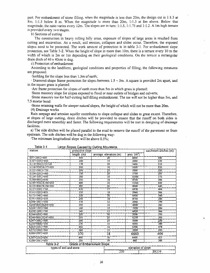
part. For embankment of stone filling, when the magnitude is less than 20m, the design cut is 1:1.3 at8m; 1:1.5 below 8 m. When the magnitude is more than 20m, 1:1.3 at 8m above. Below thatmagnitude, the ratio varies every 12m. The slopes are in turn: 1:1.5, 1:1.75 and 1:1.2. A Im high terraceis provided every two stages.
b) Sections of cuttingThe construction in heavy rolling hilly areas, exposure of slopes of large areas is resulted from
cutting and excavation. As a result, soil erosion, collapses and slides occur. Therefore, the exposedslopes need to be protected. The work amount of protection is in table 3-1. For enmbankment slopeprotection, see Table 3-2. When the height of slope in more than 10m, there is a terrace every 10 m thewidth of which is 2m or Im depending on their geological conditions. On the terrace a rectangulardrain ditch of 40 x 40cm is dug.
c) Protection of embankmentAccording to the landform, geological conditions and properties of filling, the following measures
are proposed:-Sodding for the slope less than 1.5m of earthl;Diamond-shape frame protection for slopes between 1.5 - Sm. A square is provided 2m apart, and
in the square grass is planted.-Arc frame protection for slopes of earth more than 5m in which grass is planted;,Stone masonry slope for slopes exposed to flood or near outlets of bridges and culveits;-Stone masonry toe for half-cutting half-filling embankment. The toe will not be higher than Sm, and
7.5 mortar bond.-Stone retaining walls for steeper natural slopes, the height of which will not be more than 20m.(4) Drainage worksRain seepage and artesian aquifer contributes to slope collapse and slides to great extent. Therefore,
at slopes of large cutting, drain ditches will be provided to ensure that the runoff on both sides isdischarged more smoothly and faster. The followving requirements will be met in designing of drainagefacilities.
a) The side ditches will be placed parallel to the road to remove the runoff of the pavement or fromupstream. The side ditches will be dug in the following way:
-The minimum longitudinal slope will be above 0.5%;
Table 3-1 Large Slopes Caused by Cutting Mountainsstation protective slope catchment ditches (m)
length (m) average elevation (m) area (ri)K97+2000+600 400 20 6000 440K107+2500+450 200 15 3000 230K114+9500115+120 170 20 3400 210K116+9500K117+450 500 S__ _000 520K122+5003+750 200 25 S000 250K124+2500+400 IS0 25 3750 200K134+3000+600 300 _ 35 10500 370K144+4000+650 250 IS -S750 286K145+4503K146+050 600 22 13200 644K155+8000K156+200 400 20 8000 440K157+350C+760 410 17 6970 444K161+5200+850 330 18 5940 366K175+3400+660 320 20 6400 360K191+3000+550 250 18 8750 286K208+3800+550 170 12 2040 194K208+8000K209+050 250 16 4000 282K224+1500+360 160 12 1920 284K238+3600+700 340 13 4420 366K244+65003+900 250 20 5000 290K246+8000K247+050 250 25 6250 300K247+3000+500 200 25 5000 250K250+0800+350 270 is 4050 300K265+2503+700 450 14 6300 478K271+1000+360 - 260 15 3900 290K306+2500+620 370 18 6660 406K307+2500+650 400 16 6400 423K308+3000+650 35019 665 388
Table 3-2 Grade of Embankment Slopetypes of soil and stone elevation of slope
7320 20D30
36
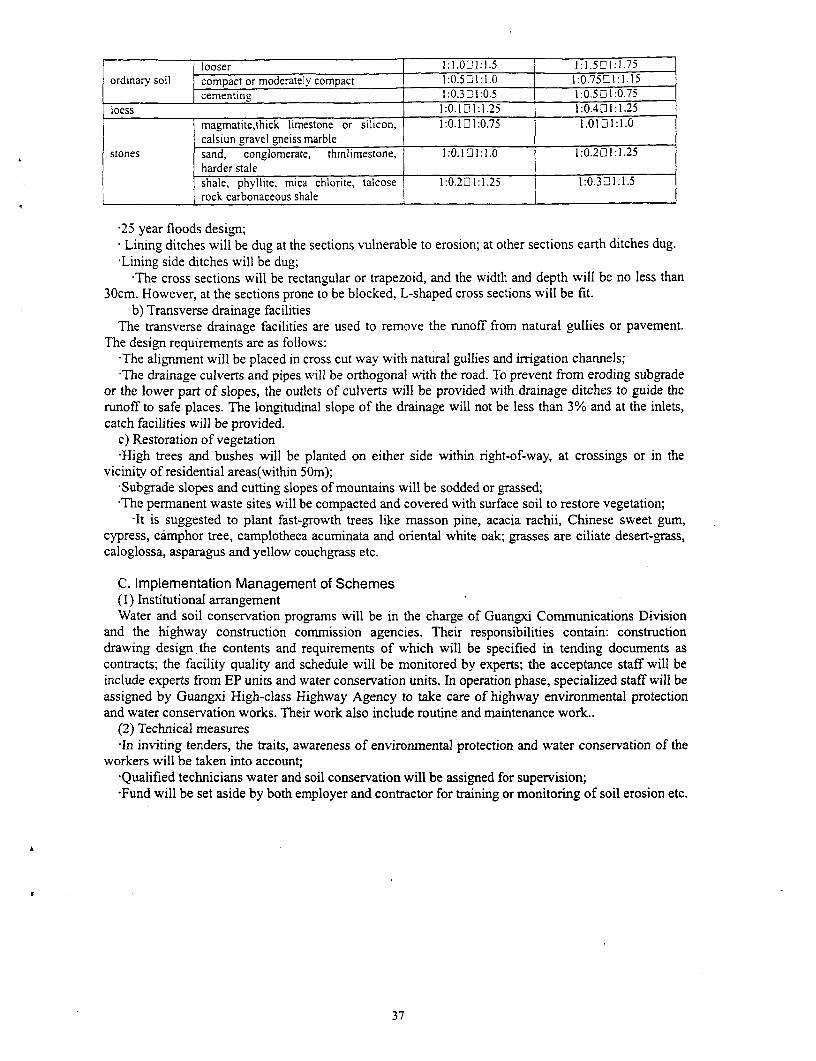
| looser 1:1.021:1.5 1:1.5L1:1.75ordinary soil compact or moderatelv compact 1:0.5 1: 1.0 1:0.75 01:1.15
._ cementing 1:0.321:0.5 1:0.5 21:0.75loess 1:0.101:1.25 1:0.401:1.25
magmatite,thick limestone or silicon, 1:0.1 21:0.75 1.01 01:1.0calsiun gravel gneiss marble
stones sand, conglomerate, thinlimestone, 1:0.1 21:1.0 1:0.201:1.25harder staleshale, phyllite, mica chlorite, talcose 1:0.22 1:1.25 1:0.3 21:1.5rock carbonaceous shale
25 year floods design;* Lining ditches will be dug at the sections vulnerable to erosion; at other sections earth ditches dug.Lining side ditches will be dug;
*The cross sections will be rectangular or trapezoid, and the width and depth will be no less than30cm. However, at the sections prone to be blocked, L-shaped cross sections will be fit.
b) Transverse drainage facilitiesThe transverse drainage facilities are used to remove the runoff from natural gullies or pavement.
The design requirements are as follows:-The alignment will be placed in cross cut way with natural gullies and irrigation channels;The drainage culverts and pipes will be orthogonal with the road. To prevent from eroding subgrade
or the lower part of slopes, the outlets of culverts will be provided with.drainage ditches to guide therunoff to safe places. The longitudinal slope of the drainage will not be less than 3% and at the inlets,catch facilities will be provided.
c) Restoration of vegetation*High trees and bushes will be planted on either side within right-of-way, at crossings or in the
vicinity of residential areas(within 50m);-Subgrade slopes and cutting slopes of mountains will be sodded or grassed;-The permanent waste sites will be compacted and covered with surface soil to restore vegetation;
-It is suggested to plant fast-growth trees like masson pine, acacia rachii, Chinese sweet gum,cypress, camphor tree, camplotheca acuminata and oriental white oak; grasses are ciliate desert-grass,caloglossa, asparagus and yellow couchgrass etc.
C. Implementation Management of Schemes(1) Institutional arrangementWater and soil conservation programs will be in the charge of Guangxi Communications Division
and the highway construction commission agencies. Their responsibilities contain: constructiondrawing design the contents and requirements of which will be specified in tending documents ascontracts; the facility quality and schedule will be monitored by experts; the acceptance staff will beinclude experts from EP units and water conservation units. In operation phase, specialized staff will beassigned by Guangxi High-class Highway Agency to take care of highway environmental protectionand water conservation works. Their work also include routine and maintenance work..
(2) Technical measures-In inviting tenders, the traits, awareness of environmental protection and water conservation of the
workers will be taken into account;-Qualified technicians water and soil conservation will be assigned for supervision;-Fund will be set aside by both employer and contractor for training or monitoring of soil erosion etc.
F -
37