Embed Size (px)
Citation preview

Environmental Assessment
061705 Bryant Pkwy. Extension (S)
ENVIRONMENTAL
ASSESSMENT
APPENDIX I
Public Involvement
Public Meeting Synopsis
Page 1 of 4
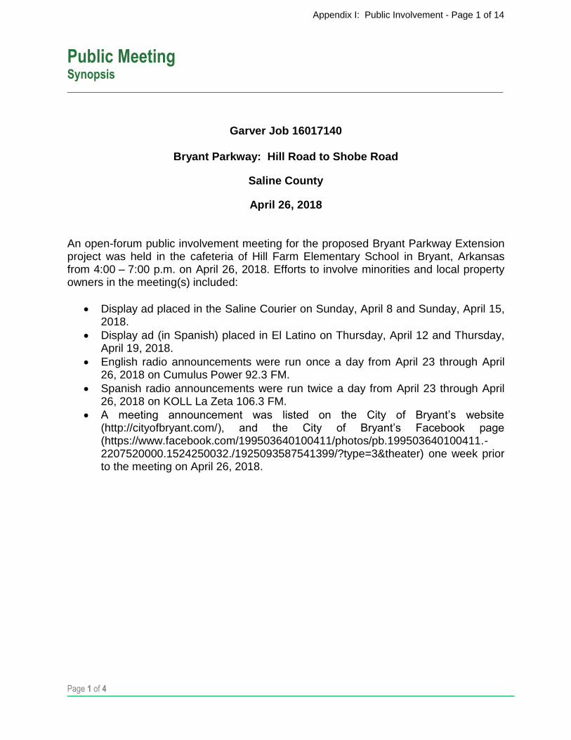
Garver Job 16017140
Bryant Parkway: Hill Road to Shobe Road
Saline County
April 26, 2018
An open-forum public involvement meeting for the proposed Bryant Parkway Extension project was held in the cafeteria of Hill Farm Elementary School in Bryant, Arkansas from 4:00 – 7:00 p.m. on April 26, 2018. Efforts to involve minorities and local property owners in the meeting(s) included:
Display ad placed in the Saline Courier on Sunday, April 8 and Sunday, April 15, 2018.
Display ad (in Spanish) placed in El Latino on Thursday, April 12 and Thursday, April 19, 2018.
English radio announcements were run once a day from April 23 through April 26, 2018 on Cumulus Power 92.3 FM.
Spanish radio announcements were run twice a day from April 23 through April 26, 2018 on KOLL La Zeta 106.3 FM.
A meeting announcement was listed on the City of Bryant’s website (http://cityofbryant.com/), and the City of Bryant’s Facebook page (https://www.facebook.com/199503640100411/photos/pb.199503640100411.-2207520000.1524250032./1925093587541399/?type=3&theater) one week prior to the meeting on April 26, 2018.
Appendix I: Public Involvement - Page 1 of 14

Public Meeting Synopsis
Page 2 of 4
The following information was available for inspection and comment.
Three poster boards (26”x40”) with an aerial background at a scale of 1" = 700', illustrating the entire length of the proposed project. The exhibit showed the five alternatives currently being considered (Alternatives A-E), a preliminary impact matrix of each alternative, the airport property line, and surrounding vicinity. Additionally, drawings were provided showing the typical roadway section (with and without the shared-use path) and the typical bridge section (with shared-use path).
An information sheet also was provided summarizing the project need and study purpose, project study area, project status, purpose of the Public Involvement Meeting, and information regarding comment submittal.
A handout was available for the public to make comments. A copy of the comment sheet is attached to this synopsis. Table 1 describes the results of public participation at the 4-7 p.m. meeting.
Attendance at meeting (Including City and Garver staff) 46
Comments received 9
Garver reviewed all comments received and evaluated their contents. The summary of comments listed below reflects the personal perception or opinion of the person or organization making the statement. The sequencing of the comments is random and is not intended to reflect importance or numerical values. Some of the comments are combined and/or paraphrased to simplify the synopsis process. An analysis of the responses received from the public survey is shown in Table 2.
Feels the proposed Bryant Parkway Extension is necessary. 6
Feels the proposed Bryant Parkway Extension is not necessary. 2
Feels the proposed design will improve the traffic flow through the area. 4
Table 1
Public Participation Total
Table 2
Survey Results Totals
Appendix I: Public Involvement - Page 2 of 14
Public Meeting Synopsis
Page 3 of 4
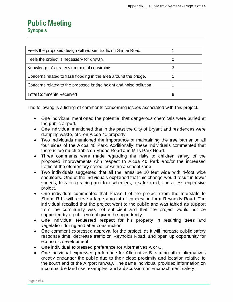
Feels the proposed design will worsen traffic on Shobe Road. 1
Feels the project is necessary for growth. 2
Knowledge of area environmental constraints 3
Concerns related to flash flooding in the area around the bridge. 1
Concerns related to the proposed bridge height and noise pollution. 1
Total Comments Received 9
The following is a listing of comments concerning issues associated with this project.
One individual mentioned the potential that dangerous chemicals were buried at the public airport.
One individual mentioned that in the past the City of Bryant and residences were dumping waste, etc. on Alcoa 40 property.
Two individuals mentioned the importance of maintaining the tree barrier on all four sides of the Alcoa 40 Park. Additionally, these individuals commented that there is too much traffic on Shobe Road and Mills Park Road.
Three comments were made regarding the risks to children safety of the proposed improvements with respect to Alcoa 40 Park and/or the increased traffic at the elementary school or within a school zone.
Two individuals suggested that all the lanes be 10 feet wide with 4-foot wide shoulders. One of the individuals explained that this change would result in lower speeds, less drag racing and four-wheelers, a safer road, and a less expensive project.
One individual commented that Phase I of the project (from the Interstate to Shobe Rd.) will relieve a large amount of congestion form Reynolds Road. The individual recalled that the project went to the public and was tabled as support from the community was not sufficient and that the project would not be supported by a public vote if given the opportunity.
One individual requested respect for his property in retaining trees and vegetation during and after construction.
One comment expressed approval for the project, as it will increase public safety response time, decrease traffic on Reynolds Road, and open up opportunity for economic development.
One individual expressed preference for Alternatives A or C.
One individual expressed preference for Alternative B, stating other alternatives greatly endanger the public due to their close proximity and location relative to the south end of the Airport runway. The same individual provided information on incompatible land use, examples, and a discussion on encroachment safety.
Appendix I: Public Involvement - Page 3 of 14

Public Meeting Synopsis
Page 4 of 4
Attachments:
Small-scale copy of the display board and informational sheet
Blank comment form
Appendix I: Public Involvement - Page 4 of 14

Appendix I: Public Involvement - Page 5 of 14
PUBLIC INVOLVEMENT MEETING
Thursday, April 26, 2018
City of Bryant Bryant Parkway: Hill Rd. to Shobe Rd.
Saline County
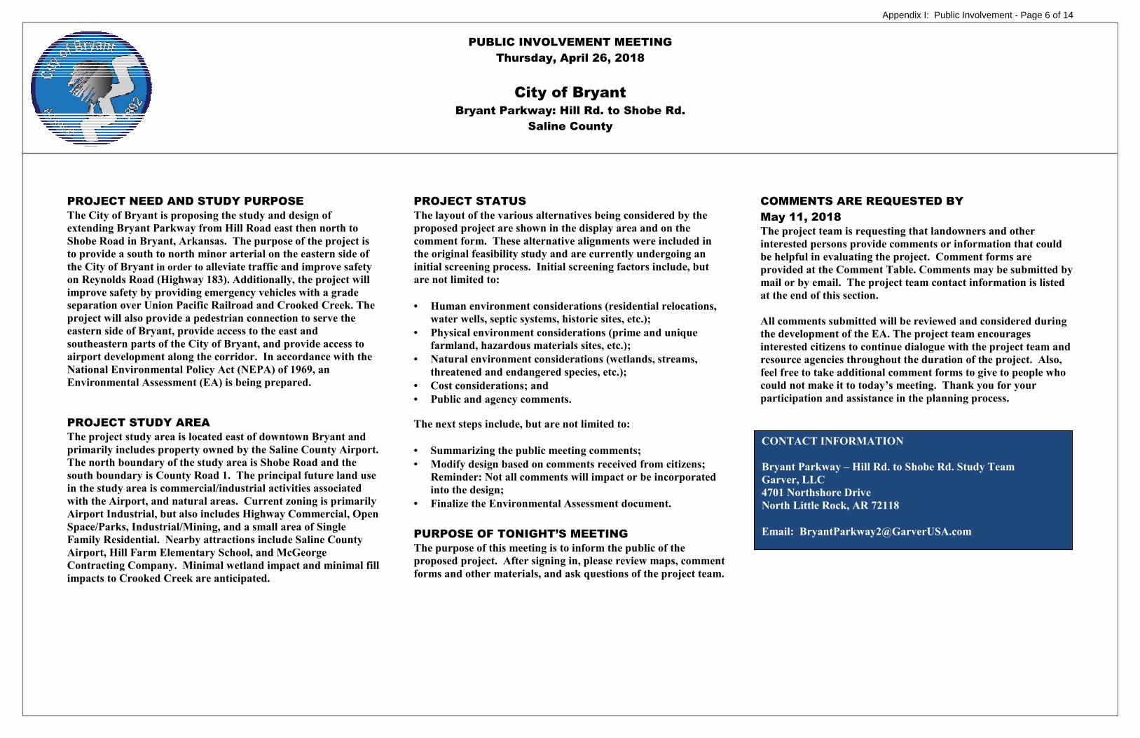
PROJECT NEED AND STUDY PURPOSE
The City of Bryant is proposing the study and design of
extending Bryant Parkway from Hill Road east then north to
Shobe Road in Bryant, Arkansas. The purpose of the project is
to provide a south to north minor arterial on the eastern side of
the City of Bryant in order to alleviate traffic and improve safety
on Reynolds Road (Highway 183). Additionally, the project will
improve safety by providing emergency vehicles with a grade
separation over Union Pacific Railroad and Crooked Creek. The
project will also provide a pedestrian connection to serve the
eastern side of Bryant, provide access to the east and
southeastern parts of the City of Bryant, and provide access to
airport development along the corridor. In accordance with the
National Environmental Policy Act (NEPA) of 1969, an
Environmental Assessment (EA) is being prepared.
PROJECT STUDY AREA
The project study area is located east of downtown Bryant and
primarily includes property owned by the Saline County Airport.
The north boundary of the study area is Shobe Road and the
south boundary is County Road 1. The principal future land use
in the study area is commercial/industrial activities associated
with the Airport, and natural areas. Current zoning is primarily
Airport Industrial, but also includes Highway Commercial, Open
Space/Parks, Industrial/Mining, and a small area of Single
Family Residential. Nearby attractions include Saline County
Airport, Hill Farm Elementary School, and McGeorge
Contracting Company. Minimal wetland impact and minimal fill
impacts to Crooked Creek are anticipated.
PROJECT STATUS
The layout of the various alternatives being considered by the
proposed project are shown in the display area and on the
comment form. These alternative alignments were included in
the original feasibility study and are currently undergoing an
initial screening process. Initial screening factors include, but
are not limited to:
• Human environment considerations (residential relocations,
water wells, septic systems, historic sites, etc.);
• Physical environment considerations (prime and unique
farmland, hazardous materials sites, etc.);
• Natural environment considerations (wetlands, streams,
threatened and endangered species, etc.);
• Cost considerations; and
• Public and agency comments.
The next steps include, but are not limited to:
• Summarizing the public meeting comments;
• Modify design based on comments received from citizens; Reminder: Not all comments will impact or be incorporated
into the design;
• Finalize the Environmental Assessment document.
PURPOSE OF TONIGHT’S MEETING
The purpose of this meeting is to inform the public of the
proposed project. After signing in, please review maps, comment
forms and other materials, and ask questions of the project team.
COMMENTS ARE REQUESTED BY
May 11, 2018
The project team is requesting that landowners and other
interested persons provide comments or information that could
be helpful in evaluating the project. Comment forms are
provided at the Comment Table. Comments may be submitted by
mail or by email. The project team contact information is listed
at the end of this section.
All comments submitted will be reviewed and considered during
the development of the EA. The project team encourages
interested citizens to continue dialogue with the project team and
resource agencies throughout the duration of the project. Also,
feel free to take additional comment forms to give to people who
could not make it to today’s meeting. Thank you for your
participation and assistance in the planning process.
CONTACT INFORMATION
Bryant Parkway – Hill Rd. to Shobe Rd. Study Team
Garver, LLC
4701 Northshore Drive
North Little Rock, AR 72118
Email: [email protected]
Appendix I: Public Involvement - Page 6 of 14

COMMENT FORM Public Involvement Meeting
Thursday, April 26, 2018
Bryant Parkway: Hill Rd. to Shobe Rd. INSTRUCTIONS Please complete this form and submit it to Project Team personnel at this meeting or mail it by May 11, 2018 to:
Bryant Parkway: Hill Rd. to Shobe Rd. Study Team Garver, LLC
4701 Northshore Drive North Little Rock, AR 72118
It is often necessary to contact property owners along potential routes. For this reason, please provide the information below: NAME: __________________________________ ADDRESS: ______________________________ CITY: ___________________________________ STATE: __________ ZIP CODE: __________ PHONE: ________________________________ EMAIL: _________________________________ If you email your comments to the project team at [email protected], please follow the format of this comment form and be sure to include your contact information. Please be thorough in completing this form as these comments will help the project team determine key community concerns and preferences. Thank you. Do you think the proposed Bryant Parkway Extension is necessary? ___ Yes ___ No Please explain: _________________________ ____________________________________________________________________________________________________________________________________________________________
Do you have information on any of the following (if so, please explain on reverse side): ___ Threatened and Endangered Species ___ Hazardous Waste Sites ___ Cave locations ___ Water wells ___ Septic tanks ___ Existing or former landfills ___ Parks or public lands ___ Historical sites ___ Family cemeteries ___ Archaeological sites
Appendix I: Public Involvement - Page 7 of 14

If you have information regarding the roadway alignments mentioned above, please provide here:
____________________________________________________________________________________
____________________________________________________________________________________
____________________________________________________________________________________
____________________________________________________________________________________
____________________________________________________________________________________
____________________________________________________________________________________
____________________________________________________________________________________
____________________________________________________________________________________
Additional Comments (If additional space is needed, please enclose additional pages):
____________________________________________________________________________________
____________________________________________________________________________________
____________________________________________________________________________________
____________________________________________________________________________________
____________________________________________________________________________________
____________________________________________________________________________________
____________________________________________________________________________________
Affix
Postage
Bryant Parkway: Hill Rd. to Shobe Rd. Study Team Garver, LLC 4701 Northshore Drive North Little Rock, AR 72118
FOLD HERE
STAPLE / TAPE HERE
STAPLE / TAPE HERE STAPLE / TAPE HERE FOLD HERE
Appendix I: Public Involvement - Page 8 of 14
Appendix I: Public Involvement - Page 9 of 14
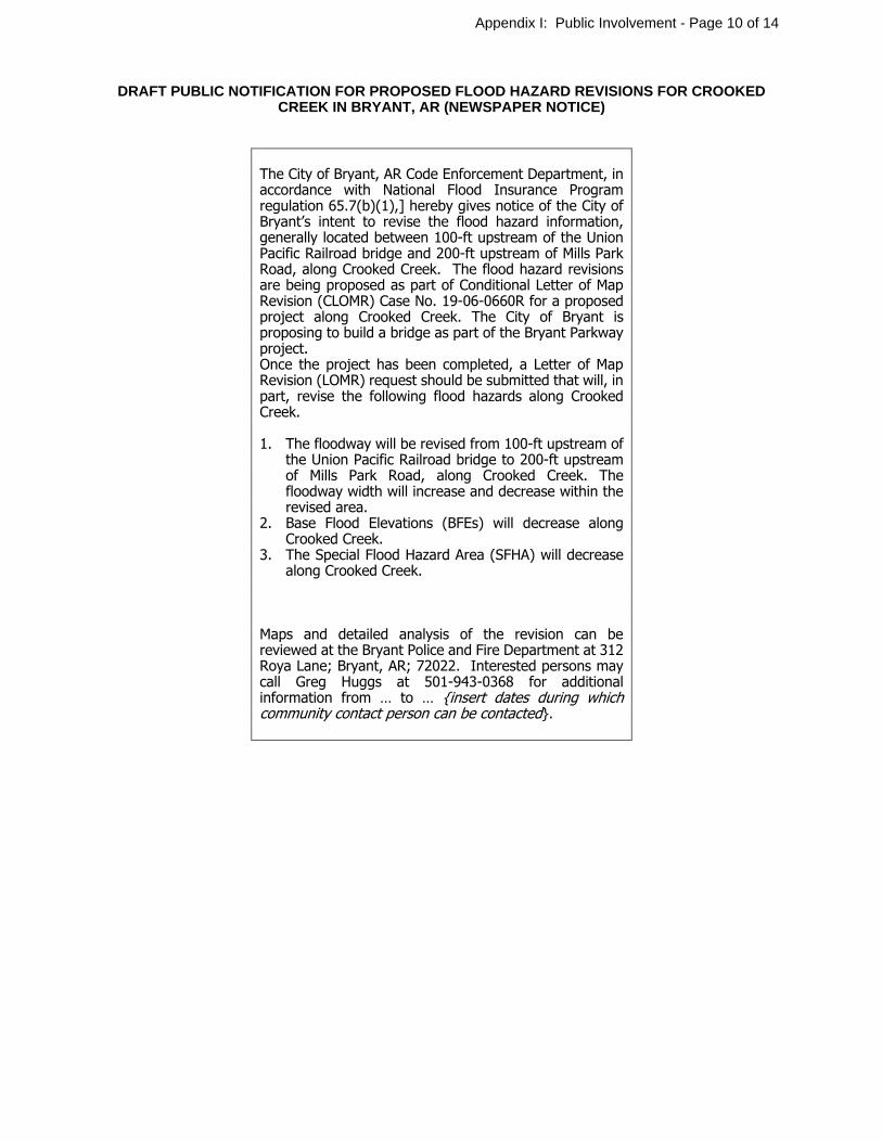
DRAFT PUBLIC NOTIFICATION FOR PROPOSED FLOOD HAZARD REVISIONS FOR CROOKED CREEK IN BRYANT, AR (NEWSPAPER NOTICE)
The City of Bryant, AR Code Enforcement Department, in accordance with National Flood Insurance Program regulation 65.7(b)(1),] hereby gives notice of the City of Bryant’s intent to revise the flood hazard information, generally located between 100-ft upstream of the Union Pacific Railroad bridge and 200-ft upstream of Mills Park Road, along Crooked Creek. The flood hazard revisions are being proposed as part of Conditional Letter of Map Revision (CLOMR) Case No. 19-06-0660R for a proposed project along Crooked Creek. The City of Bryant is proposing to build a bridge as part of the Bryant Parkway project. Once the project has been completed, a Letter of Map Revision (LOMR) request should be submitted that will, in part, revise the following flood hazards along Crooked Creek. 1. The floodway will be revised from 100-ft upstream of
the Union Pacific Railroad bridge to 200-ft upstream of Mills Park Road, along Crooked Creek. The floodway width will increase and decrease within the revised area.
2. Base Flood Elevations (BFEs) will decrease along Crooked Creek.
3. The Special Flood Hazard Area (SFHA) will decrease along Crooked Creek.
Maps and detailed analysis of the revision can be reviewed at the Bryant Police and Fire Department at 312 Roya Lane; Bryant, AR; 72022. Interested persons may call Greg Huggs at 501-943-0368 for additional information from … to … {insert dates during which community contact person can be contacted}.
Appendix I: Public Involvement - Page 10 of 14

Appendix I: Public Involvement - Page 11 of 14
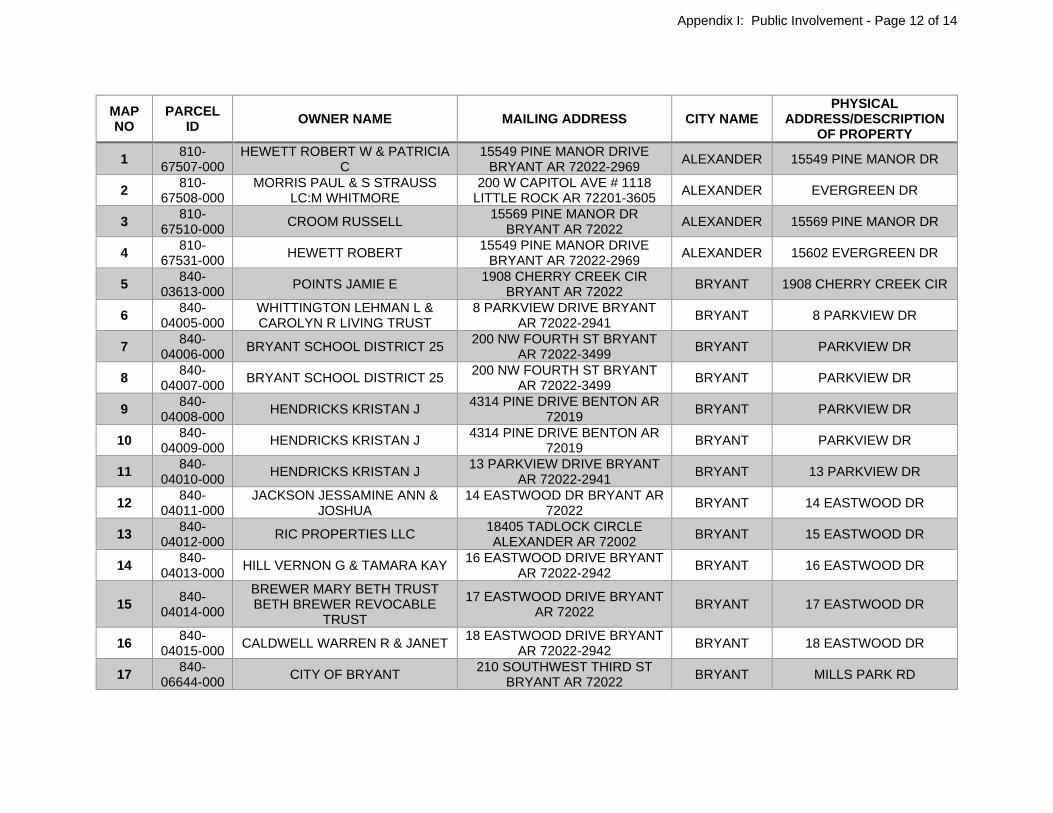
MAP NO
PARCEL ID
OWNER NAME MAILING ADDRESS CITY NAME PHYSICAL
ADDRESS/DESCRIPTION OF PROPERTY
1 810-
67507-000 HEWETT ROBERT W & PATRICIA
C 15549 PINE MANOR DRIVE
BRYANT AR 72022-2969 ALEXANDER 15549 PINE MANOR DR
2 810-
67508-000 MORRIS PAUL & S STRAUSS
LC:M WHITMORE 200 W CAPITOL AVE # 1118
LITTLE ROCK AR 72201-3605 ALEXANDER EVERGREEN DR
3 810-
67510-000 CROOM RUSSELL
15569 PINE MANOR DR BRYANT AR 72022
ALEXANDER 15569 PINE MANOR DR
4 810-
67531-000 HEWETT ROBERT
15549 PINE MANOR DRIVE BRYANT AR 72022-2969
ALEXANDER 15602 EVERGREEN DR
5 840-
03613-000 POINTS JAMIE E
1908 CHERRY CREEK CIR BRYANT AR 72022
BRYANT 1908 CHERRY CREEK CIR
6 840-
04005-000 WHITTINGTON LEHMAN L & CAROLYN R LIVING TRUST
8 PARKVIEW DRIVE BRYANT AR 72022-2941
BRYANT 8 PARKVIEW DR
7 840-
04006-000 BRYANT SCHOOL DISTRICT 25
200 NW FOURTH ST BRYANT AR 72022-3499
BRYANT PARKVIEW DR
8 840-
04007-000 BRYANT SCHOOL DISTRICT 25
200 NW FOURTH ST BRYANT AR 72022-3499
BRYANT PARKVIEW DR
9 840-
04008-000 HENDRICKS KRISTAN J
4314 PINE DRIVE BENTON AR 72019
BRYANT PARKVIEW DR
10 840-
04009-000 HENDRICKS KRISTAN J
4314 PINE DRIVE BENTON AR 72019
BRYANT PARKVIEW DR
11 840-
04010-000 HENDRICKS KRISTAN J
13 PARKVIEW DRIVE BRYANT AR 72022-2941
BRYANT 13 PARKVIEW DR
12 840-
04011-000 JACKSON JESSAMINE ANN &
JOSHUA 14 EASTWOOD DR BRYANT AR
72022 BRYANT 14 EASTWOOD DR
13 840-
04012-000 RIC PROPERTIES LLC
18405 TADLOCK CIRCLE ALEXANDER AR 72002
BRYANT 15 EASTWOOD DR
14 840-
04013-000 HILL VERNON G & TAMARA KAY
16 EASTWOOD DRIVE BRYANT AR 72022-2942
BRYANT 16 EASTWOOD DR
15 840-
04014-000
BREWER MARY BETH TRUST BETH BREWER REVOCABLE
TRUST
17 EASTWOOD DRIVE BRYANT AR 72022
BRYANT 17 EASTWOOD DR
16 840-
04015-000 CALDWELL WARREN R & JANET
18 EASTWOOD DRIVE BRYANT AR 72022-2942
BRYANT 18 EASTWOOD DR
17 840-
06644-000 CITY OF BRYANT
210 SOUTHWEST THIRD ST BRYANT AR 72022
BRYANT MILLS PARK RD
Appendix I: Public Involvement - Page 12 of 14
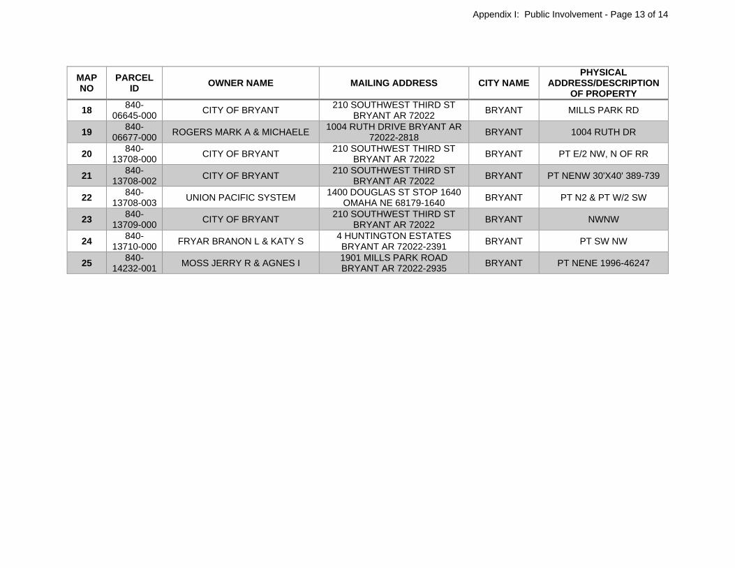
MAP NO
PARCEL ID
OWNER NAME MAILING ADDRESS CITY NAME PHYSICAL
ADDRESS/DESCRIPTION OF PROPERTY
18 840-
06645-000 CITY OF BRYANT
210 SOUTHWEST THIRD ST BRYANT AR 72022
BRYANT MILLS PARK RD
19 840-
06677-000 ROGERS MARK A & MICHAELE
1004 RUTH DRIVE BRYANT AR 72022-2818
BRYANT 1004 RUTH DR
20 840-
13708-000 CITY OF BRYANT
210 SOUTHWEST THIRD ST BRYANT AR 72022
BRYANT PT E/2 NW, N OF RR
21 840-
13708-002 CITY OF BRYANT
210 SOUTHWEST THIRD ST BRYANT AR 72022
BRYANT PT NENW 30'X40' 389-739
22 840-
13708-003 UNION PACIFIC SYSTEM
1400 DOUGLAS ST STOP 1640 OMAHA NE 68179-1640
BRYANT PT N2 & PT W/2 SW
23 840-
13709-000 CITY OF BRYANT
210 SOUTHWEST THIRD ST BRYANT AR 72022
BRYANT NWNW
24 840-
13710-000 FRYAR BRANON L & KATY S
4 HUNTINGTON ESTATES BRYANT AR 72022-2391
BRYANT PT SW NW
25 840-
14232-001 MOSS JERRY R & AGNES I
1901 MILLS PARK ROAD BRYANT AR 72022-2935
BRYANT PT NENE 1996-46247
Appendix I: Public Involvement - Page 13 of 14

Appendix I: Public Involvement - Page 14 of 14