Embed Size (px)
Citation preview
ENVIRONMENTAL ASSESSMENTfor the S.R. 0424, SECTION 390HAZLETON BELTWAY EXTENSIONHazle Township, Luzerne County, Pennsylvania
Prepared by:U.S. Department of TransportationFederal Highway AdministrationandPennsylvania Department of TransportationEngineering District 4-0
U.S. Department of Transportation
Federal Highway Administration
December 2017
ENVIRONMENTAL ASSESSMENT S.R. 0424, SECTION 390 | HAZLETON BELTWAY EXTENSION ii
TABLE OF CONTENTS
I. INTRODUCTION/PROJECT DESCRIPTION .............................................................1
II. PROJECT PURPOSE AND NEEDS ...............................................................................2
1. System Linkages and Transportation Demand ........................................................4
2. Traffic Operations (and Incident Management) ......................................................6
3. Project Need Statement ............................................................................................9
III. ENVIRONMENTAL OVERVIEW ...............................................................................10
IV. ALTERNATIVES CONSIDERED ................................................................................11
V. ENVIRONMENTAL RESOURCES, IMPACTS, AND MITIGATION ....................21
A. Geologic Features: Mining, Acid Rock Drainage, Steep Slopes and Rock
Cuts ............................................................................................................22
B. Surface Waters (Wetlands, Streams, and Floodplains) ..............................26
C. Threatened and Endangered (T&E) Species ..............................................33
D. Indirect Impacts .........................................................................................40
E. Cumulative Impacts ...................................................................................47
VI. PUBLIC COMMENT AND AGENCY COORDINATION ........................................59
VII. PREFERRED ALTERNATIVE .....................................................................................61
ENVIRONMENTAL ASSESSMENT S.R. 0424, SECTION 390 | HAZLETON BELTWAY EXTENSION iii
List of Figures
Figure 1. Project Study Area ............................................................................................................2
Figure 2. Humboldt Industrial Park and Surrounding Communities ...............................................3
Figure 3. Potential Detour Routes for S.R. 0924 and I-81, Incident Management ..........................8
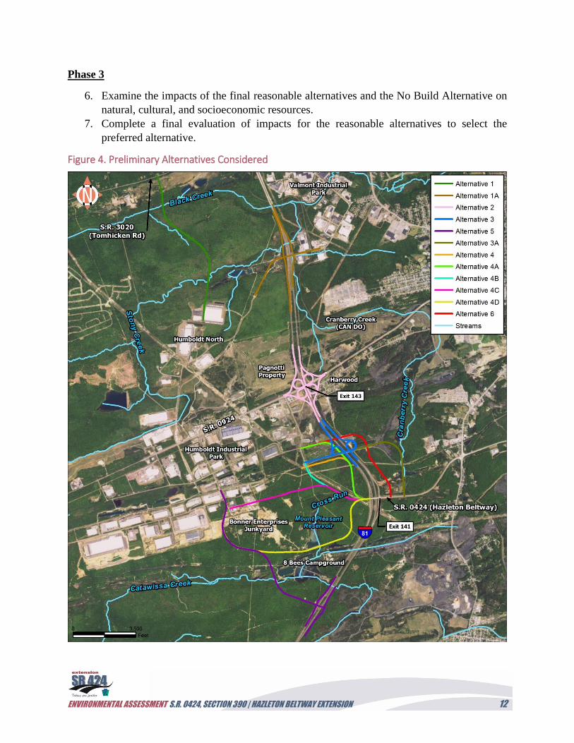
Figure 4. Preliminary Alternatives Considered .............................................................................12
Figure 5. Reasonable Alternatives Studied in Phase 2 ..................................................................14
Figure 6. Reasonable Alternatives Studied in Detail (Alternatives 4, 4A, and 4A Modified) ......19
Figure 7: Geology ..........................................................................................................................23
Figure 8. Mine Openings ...............................................................................................................25
Figure 9. Wetlands and Waterways Identified Adjacent to Proposed Build Alternatives
(Alternatives 4, 4A, and 4A Modified). .............................................................................29
Figure 10. Threatened and Endangered Species ............................................................................39
Figure 11. Indirect Impacts, Area of Influence ..............................................................................42
Figure 12. RSA Map ......................................................................................................................49
Figure 13. Transportation and Development Projects in RSAs .....................................................55
List of Tables
Table 1. Level of Service (LOS) Thresholds. ..................................................................................7
Table 2. Preliminary Alternative Screening Details. .....................................................................16
Table 3. Roadway Design Criteria. ................................................................................................18
Table 4. Preliminary Alternative Development and Evolution. ....................................................20
Table 5. Wetlands Identified within the S.R. 0424, Section 390 “Waters of the U.S. Investigation
Area (Alternatives 4, 4A, and 4A Modified). ....................................................................30
Table 6. Watercourses/Impoundments Identified within the S.R. 0424, Section 390 “Waters of
the U.S.” Investigation Area. .............................................................................................32
Table 7. List of Plant Species and Their Pennsylvania Statuses. ...................................................35
Table 8. Plant Species of Special Concern Identified within the July and August 2008 Plant
Survey Area. ......................................................................................................................36
Table 9. Communities of Special Concern Identified within the July and August 2008 Plant
Survey Area. ......................................................................................................................36
Table 10. Resources’ Current Conditions in the Resource Study Area (RSA). ............................48
Table 11. Summary of Population Trends, 1960 to 2015. .............................................................50
Table 12. Resources’ Current Conditions in the RSAs..................................................................52
Table 13. Projects in the RSAs on Transportation Improvement and Long Range Transportation
Plans. ..................................................................................................................................53
Table 14. Anticipated Cumulative Impacts. ..................................................................................56
Table 15. Public and Agency Coordination Meetings. ..................................................................59
Table 16. Summary of Impacts for Alternatives Selected for Detailed Study (Alternatives 4, 4A,
4A Modified). ....................................................................................................................61
Table 17. Summary of Recommended Mitigation for the Preferred Alternative. .........................64
ENVIRONMENTAL ASSESSMENT S.R. 0424, SECTION 390 | HAZLETON BELTWAY EXTENSION iv
List of Photographs
Photograph 1. Hazleton Beltway (S.R. 0424) bridge over I-81. All proposed build alternatives
would extend from this location northward into HIP ...........................................1
Photograph 2. View along the S.R. 0424 bridge over I-81 to where it terminates at the start of
the proposed Beltway Extension ..........................................................................1
Photograph 3. Access road to Humboldt Station from S.R. 0924 ................................................4
Photograph 4. Tractor-trailer accident along southbound I-81 near the S.R. 0924 exit. The
accident shut down the region for hours (Source: WNEP.com) ...........................5
Photograph 5. Crash article from the Hazleton Standard Speaker ..............................................6
Photograph 6. Traffic backup caused by accident ........................................................................9
Photograph 7. Wetland along a utility ROW within the proposed alignment for Alternatives 4,
4A, and 4A Modified. I-81 is in the background ................................................10
Photograph 8. View of the RDTF along the crest of the Pismire Ridge in the project study area.
Pitch pine, scrub-oak, and lowbush blueberries are typical of this plant
community ..........................................................................................................11
Photograph 9. Bartonia paniculata (screw-stem) ......................................................................34
Photograph 10. Platantherea blephariglottis (white-fringed orchid) ..........................................34
Appendices
Appendix A: Design Plans
Appendix B: Environmental Features/Constraint Mapping; Stormwater Basin Locations
(Alternatives 4A and 4A Modified)
Appendix C: Additional Resources in Project Study Area
Appendix D: Agency Correspondence
Appendix E: Technical Support Data Index
Appendix F: List of Preparers
Appendix G: References
ENVIRONMENTAL ASSESSMENT S.R. 0424, SECTION 390 | HAZLETON BELTWAY EXTENSION v
List of Acronyms
APE Area of Potential Effect
BHA Bat Habitat Assessment
BMP Best Management Practices
BOD Pennsylvania Department of Transportation, Bureau of Design
CAN DO Community Area New Development Organization
CFR Code of Federal Regulations
CWF Cold Water Fisheries
d.b.h. Diameter at breast height
DCNR Department of Conservation and Natural Resources
EB Eastbound
EO Executive Order
EPA Environmental Protection Agency
EPDS Pennsylvania Department of Transportation, Bureau of Design, Environmental
Policy and Development Section
ERDC Engineer Research and Development Center
EV Exceptional Value
E&S Erosion and Sedimentation
FEMA Federal Emergency Management Agency
FHWA Federal Highway Administration
FT Feet
GHA Greater Hazleton Area
HCA Hazleton City Authority
HIP Humboldt Industrial Park (includes the entire campus, including Humboldt
Industrial Park Proper, Humboldt East, Humboldt West, Humboldt North,
Humboldt Northwest, and Humboldt Station
IPCC Intergovernmental Panel on Climate Change
KOZ Keystone Opportunity Zones
LLRP Luzerne County Long Range Plan
LOS Level of Service
mph Miles per hour
MPO Metropolitan Planning Organization
NEPA National Environmental Policy Act
NOAA National Oceanic and Atmospheric Administration
NPDES National Pollutant Discharge Elimination System
NRCS Natural Resources Conservation Service
N&W Navarro & Wright Consulting Engineers, Inc.
PADCNR-PNHP Pennsylvania Department of Conservation and Natural Resources, Bureau of
Forestry - Pennsylvania Natural Heritage Program
PADEP Pennsylvania Department of Environmental Protection
ENVIRONMENTAL ASSESSMENT S.R. 0424, SECTION 390 | HAZLETON BELTWAY EXTENSION vi
PEM Palustrine emergent
PennDOT Pennsylvania Department of Transportation
PFBC Pennsylvania Fish & Boat Commission
PFO Palustrine forested
PGC Pennsylvania Game Commission
PNDI Pennsylvania Natural Diversity Inventory
POW Palustrine Open Water
PPL PPL Corporation (formerly Pennsylvania Power & Light)
PRNA Pismir Ridge Natural Area
PSS Palustrine Scrub-Shrub
RDTF Ridgetop Dwarf-Tree Forest
ROW Right-of-Way
RPW Relatively Permanent Waterway
RSA Resource Study Area
S.R. State Route
TBD To Be Determined
TIP Transportation Improvement Plan
TYP Twelve Year Plan
T&E Threatened and Endangered
TNW Traditionally Navigable Waterway
USACE United States Army Corps of Engineers
USDOT United States Department of Transportation
USFWS United States Fish and Wildlife Service
USGS United States Geological Survey
VMT Vehicle miles of travel
ENVIRONMENTAL ASSESSMENT S.R. 0424, SECTION 390 | HAZLETON BELTWAY EXTENSION 1
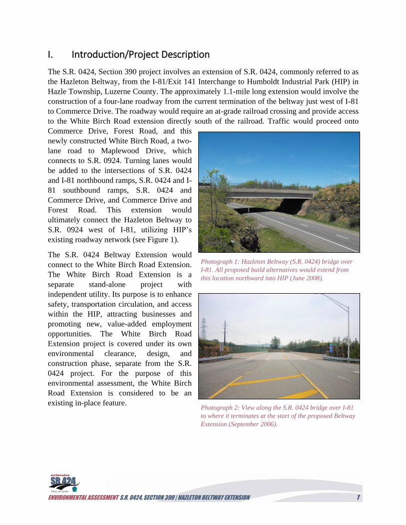
I. Introduction/Project Description
The S.R. 0424, Section 390 project involves an extension of S.R. 0424, commonly referred to as
the Hazleton Beltway, from the I-81/Exit 141 Interchange to Humboldt Industrial Park (HIP) in
Hazle Township, Luzerne County. The approximately 1.1-mile long extension would involve the
construction of a four-lane roadway from the current termination of the beltway just west of I-81
to Commerce Drive. The roadway would require an at-grade railroad crossing and provide access
to the White Birch Road extension directly south of the railroad. Traffic would proceed onto
Commerce Drive, Forest Road, and this
newly constructed White Birch Road, a two-
lane road to Maplewood Drive, which
connects to S.R. 0924. Turning lanes would
be added to the intersections of S.R. 0424
and I-81 northbound ramps, S.R. 0424 and I-
81 southbound ramps, S.R. 0424 and
Commerce Drive, and Commerce Drive and
Forest Road. This extension would
ultimately connect the Hazleton Beltway to
S.R. 0924 west of I-81, utilizing HIP’s
existing roadway network (see Figure 1).
The S.R. 0424 Beltway Extension would
connect to the White Birch Road Extension.
The White Birch Road Extension is a
separate stand-alone project with
independent utility. Its purpose is to enhance
safety, transportation circulation, and access
within the HIP, attracting businesses and
promoting new, value-added employment
opportunities. The White Birch Road
Extension project is covered under its own
environmental clearance, design, and
construction phase, separate from the S.R.
0424 project. For the purpose of this
environmental assessment, the White Birch
Road Extension is considered to be an
existing in-place feature.
Photograph 1: Hazleton Beltway (S.R. 0424) bridge over
I-81. All proposed build alternatives would extend from
this location northward into HIP (June 2008).
Photograph 2: View along the S.R. 0424 bridge over I-81
to where it terminates at the start of the proposed Beltway
Extension (September 2006).
ENVIRONMENTAL ASSESSMENT S.R. 0424, SECTION 390 | HAZLETON BELTWAY EXTENSION 2
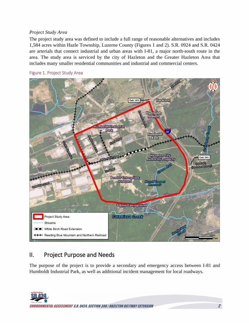
Project Study Area
The project study area was defined to include a full range of reasonable alternatives and includes
1,584 acres within Hazle Township, Luzerne County (Figures 1 and 2). S.R. 0924 and S.R. 0424
are arterials that connect industrial and urban areas with I-81, a major north-south route in the
area. The study area is serviced by the city of Hazleton and the Greater Hazleton Area that
includes many smaller residential communities and industrial and commercial centers.
Figure 1. Project Study Area
II. Project Purpose and Needs
The purpose of the project is to provide a secondary and emergency access between I-81 and
Humboldt Industrial Park, as well as additional incident management for local roadways.
ENVIRONMENTAL ASSESSMENT S.R. 0424, SECTION 390 | HAZLETON BELTWAY EXTENSION 3
The project’s purpose was developed from an analysis of:
1. System linkages and transportation demand of the existing roadway network; and
2. Traffic operations (which includes incident management).
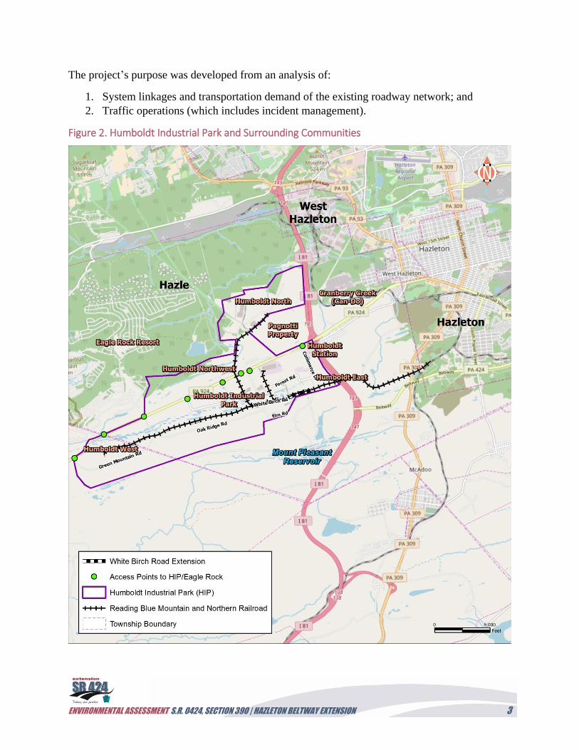
Figure 2. Humboldt Industrial Park and Surrounding Communities
ENVIRONMENTAL ASSESSMENT S.R. 0424, SECTION 390 | HAZLETON BELTWAY EXTENSION 4
1. System Linkages and Transportation Demand
System Linkages
The Greater Hazleton Area (GHA), with a population of approximately 85,000, consists of
several communities located in and around southern Luzerne County, including the City of
Hazleton, West Hazleton Borough, Freeland Borough, Hazle Township, Beaver Meadows
Borough, McAdoo Borough, Sugarloaf Township, Conyngham Borough, and Butler Township.
Within this community resides the HIP, one of Pennsylvania’s largest industrial parks and home
to many businesses and industries that employ a large portion of the GHA work force. In
addition, Eagle Rock Resort, a large gated resort community, is located to the west of HIP.
Neither the HIP nor the resort has been developed to capacity. This community of municipalities
and industrial and residential developments is served by several main transportation corridors in
the existing roadway network, consisting of I-81, S.R. 0424, and S.R. 0924. A roadway network
map of the GHA is provided in Figure 2 and identifies access points for these land uses along
S.R. 0924.
In order to better serve the above community and accommodate regional growth, this project
seeks to increase transportation linkages and connectivity within the roadway network with an
additional access for both HIP users and local vehicular traffic. It would provide a direct
continuous transportation facility through the project study area.
The need for increased system linkage is primarily associated with the existing S.R. 0424
roadway, known as the “Hazleton Beltway,” which connects S.R. 0309 to I-81 at Exit 141. This
two-lane roadway terminates at the I-81/Exit 141 interchange, and a gap currently exists from the
Hazleton Beltway to the HIP. This gap limits access from the GHA to the large industrial,
commercial, and residential areas west of I-81; therefore, there is no secondary access into the
HIP from S.R. 0424 or I-81, and all traffic must proceed along S.R. 0924. The need is
compounded by the fact that S.R. 0924 remains the main access for the expanding Eagle Rock
Resort and HIP businesses in the North and Northwest campuses.
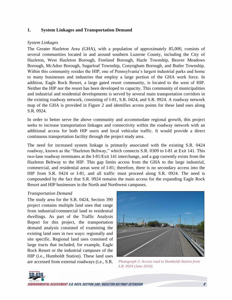
Transportation Demand
The study area for the S.R. 0424, Section 390
project contains multiple land uses that range
from industrial/commercial land to residential
dwellings. As part of the Traffic Analysis
Report for this project, the transportation
demand analysis consisted of examining the
existing land uses in two ways: regionally and
site specific. Regional land uses consisted of
large tracts that included, for example, Eagle
Rock Resort or the industrial campuses of the
HIP (i.e., Humboldt Station). These land uses
are accessed from external roadways (i.e., S.R. Photograph 3: Access road to Humboldt Station from
S.R. 0924 (June 2016).
ENVIRONMENTAL ASSESSMENT S.R. 0424, SECTION 390 | HAZLETON BELTWAY EXTENSION 5
0924) by a limited number of driveways or roadways (see Figure 2). While many of these
regional land uses rely on one access driveway, several of the land uses also contained internal
roadway networks (i.e., HIP) that were further analyzed for their site-specific influence on
transportation demand. This site-specific analysis involved evaluating the traffic volume
expected to be generated by individual tenants. For example, the Amazon distribution center and
Hershey factory located in Humboldt Proper would generate traffic to and from the proposed
Beltway Extension. The transportation demand analysis indicated a need for east-west roadways
(Forest Road and White Birch Road Extension) within HIP to distribute traffic to and from
north-south roadways (Maplewood Drive and Commerce Drive) that would connect S.R. 0424 to
S.R. 0924 (see Figure 1).
One of the largest traffic generators is the HIP, located approximately 1 mile northwest of I-
81/Exit 141. HIP continues to grow and currently consists of over 3,000 acres and 7,000
employees. HIP is located on the border of Hazle Township, Luzerne County; and East Union
Township, Schuylkill County, with the
majority of the Park in Hazle Township
(Figure 2). HIP mostly consists of
manufacturing and warehousing land uses;
however, commercial buildings are beginning
to be introduced in their various campuses
(e.g., Humboldt Station). HIP is primarily
accessed by S.R. 0924 and its interchange with
I-81 at Exit 143. The S.R. 0924 corridor
running through HIP between the
Schuylkill/Luzerne County Line and the I-
81/Exit 143 Interchange experiences large
volumes of traffic during peak hours, with HIP
traffic contributing a significant amount of
these volumes.
Another large traffic generator is Eagle Rock Resort, which is located on the north side of S.R.
0924 and is accessed by its main driveway on S.R. 0924. Eagle Rock Resort is a planned
residential development consisting of 9,800 lots, over 5,000 acres, and contains several public
amenities such as a golf course and ski resort. While 1,000 homes are currently built, 90 percent
of the buildable lots have been sold, and the development is expected to grow well into the
future.
In addition, the Pagnotti Property is forecasted as large traffic generator. This 237-acre future
development is located north of S.R. 0924 and would be accessed by two driveways from S.R.
0924. It is planned to contain high cube warehousing and distribution centers, as well as
subdivisions of commercial development, including restaurants and gas stations.
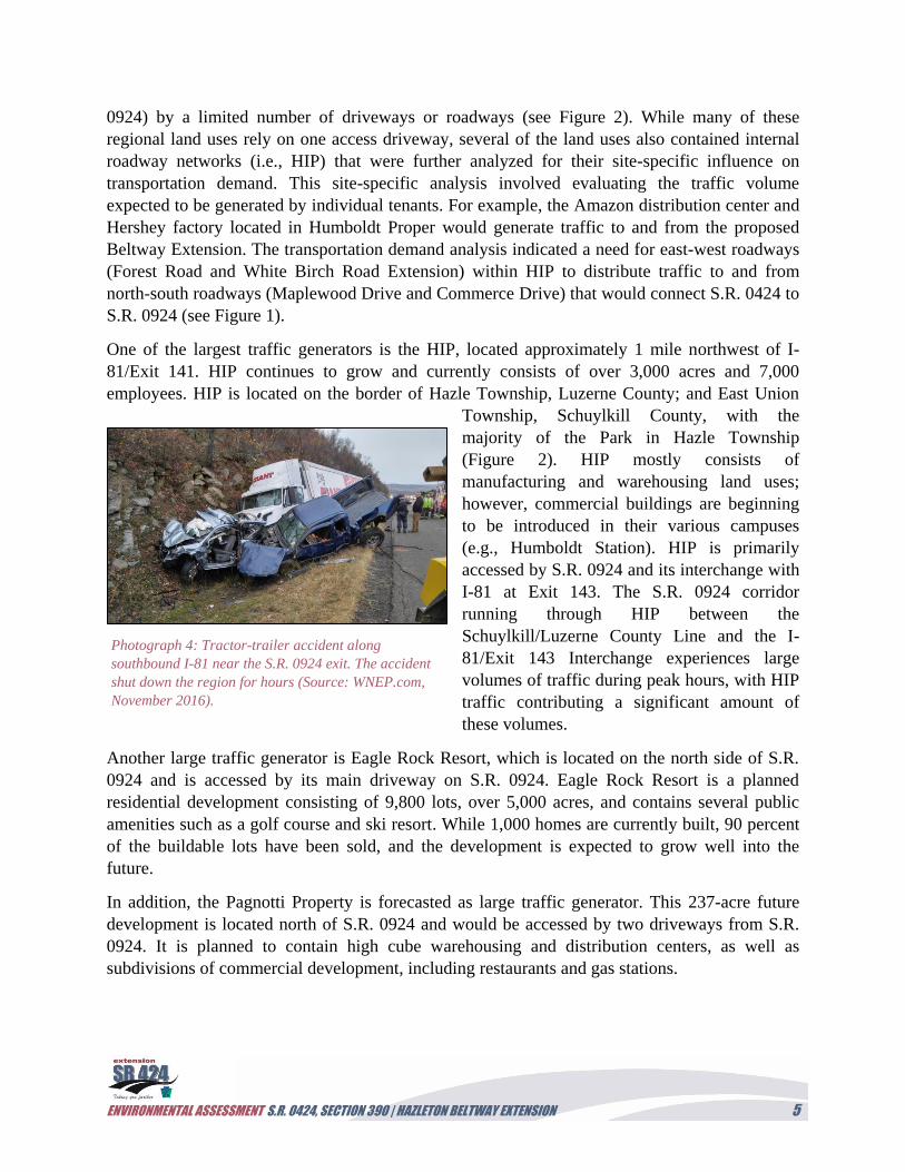
Photograph 4: Tractor-trailer accident along
southbound I-81 near the S.R. 0924 exit. The accident
shut down the region for hours (Source: WNEP.com,
November 2016).
ENVIRONMENTAL ASSESSMENT S.R. 0424, SECTION 390 | HAZLETON BELTWAY EXTENSION 6
2. Traffic Operations (and Incident Management)
A traffic analysis was conducted to determine what effect a secondary access would have on the
roadway network within the GHA study area. For modeling purposes, the analysis assumed the
secondary access would be provided by the S.R. 0424 extension to HIP and the surrounding
roadway network via I-81/Exit 141, but the results of the analysis apply to all solutions that
provide secondary access. Traffic recorders were used to determine the current number of
vehicles at intersections in the field during peak traffic times. These data were coupled with
traffic modeling software to determine the characteristics of the proposed secondary roadway,
including number of lanes and dedicated turning lanes that would be necessary for redistributing
future traffic volumes. The results of this
analysis indicated that the extension would
improve network connectivity by redistributing
traffic from S.R. 0924 to I-81/Exit 141 via the
existing roadway network. It would redistribute
the large volumes of existing traffic to help
regional land uses while facilitating the
transportation demand of site-specific land uses
(e.g., Amazon) within the regional land use
(e.g., HIP) in the project study area. This
information ultimately helped determine the
appropriate traffic volumes to consider when
developing the levels of service (LOS) analysis
of the proposed roadway and connector roads
for the Traffic Analysis Report. It is anticipated
that 9,800 vehicles per day would use the S.R.
0424 extension as a secondary access in the
year 2038.
An analysis of the traffic operations within the Traffic Analysis Report focuses on LOS and
incident management. The study area traffic flows to and from the local and regional roadway
network via I-81 and S.R. 0924. The extension of S.R. 0424 would redistribute and divert some
of this traffic and improve operating conditions. All of the study area intersections currently
operate at acceptable LOS (A through D); however, the LOS start to degrade within the study
area in the build year 2018 without the extension, and would continue to worsen through the
design year 2038 without the extension. LOS can be viewed as a report card, with “A” being the
best and “F” being the worst. The study area intersections that would facilitate the flow of traffic
from an extension of S.R. 0424 consist of S.R. 0424 and I-81 Northbound ramps, S.R. 0424 and
I-81 Southbound ramps, Commerce Drive and White Birch Road, Commerce Drive and Forest
Road, Commerce Drive and S.R. 0924, Maplewood Drive and White Birch Road, Maplewood
Drive and Forest Road, and Maplewood Drive and S.R. 0924.
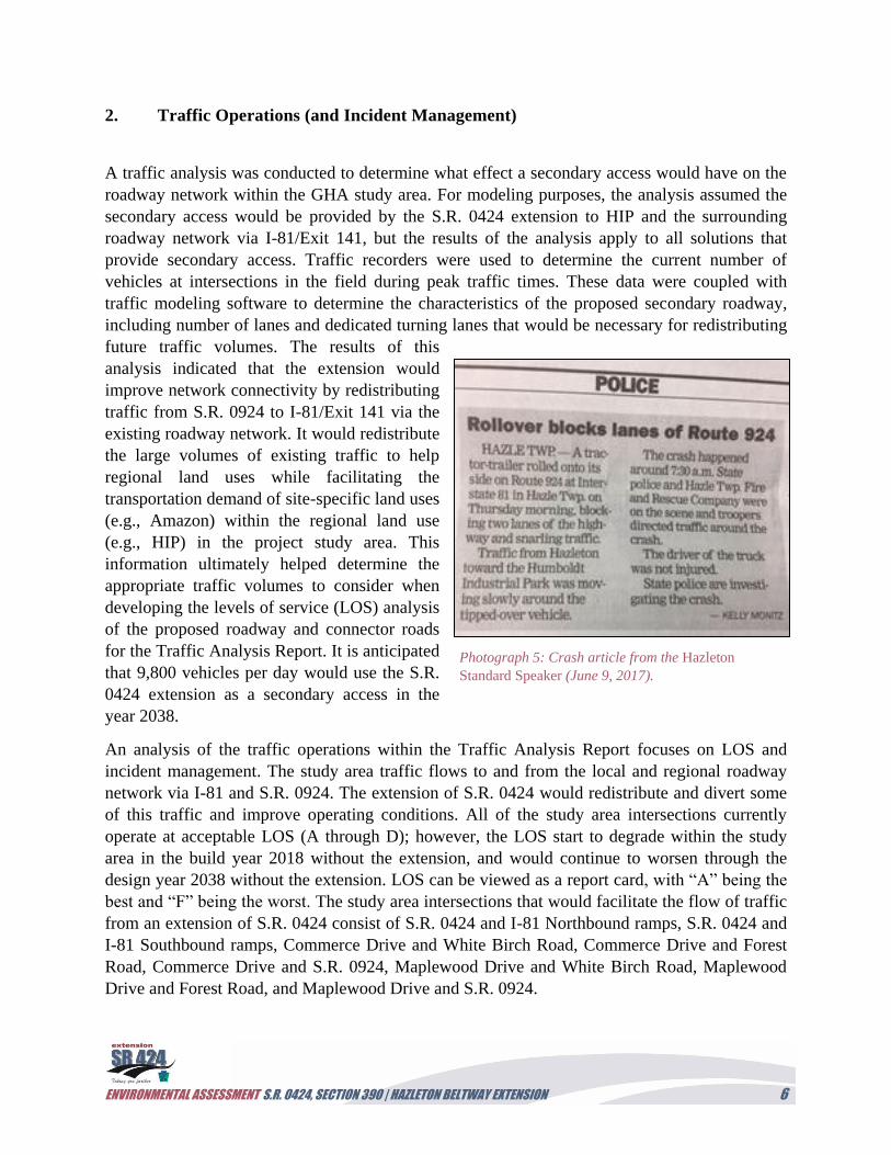
Photograph 5: Crash article from the Hazleton
Standard Speaker (June 9, 2017).
ENVIRONMENTAL ASSESSMENT S.R. 0424, SECTION 390 | HAZLETON BELTWAY EXTENSION 7
The intersections of Maplewood Drive and S.R. 0924, and Commerce Drive and S.R. 0924,
would experience failing LOS (unacceptable progression/gridlock) in 2018 and 2038,
respectively, without secondary access. The S.R. 0424 extension would help mitigate these
failing LOS, and no other intersection in the project study area would experience a drop in LOS.
Therefore, providing secondary access would maintain the operation of the other intersections at
acceptable LOS. The LOS for each intersection in the project study area would range from an
LOS A (4.8 Seconds/Vehicle Control Delay) to an LOS C (30.6 Seconds/Vehicle Control Delay)
with a secondary access.
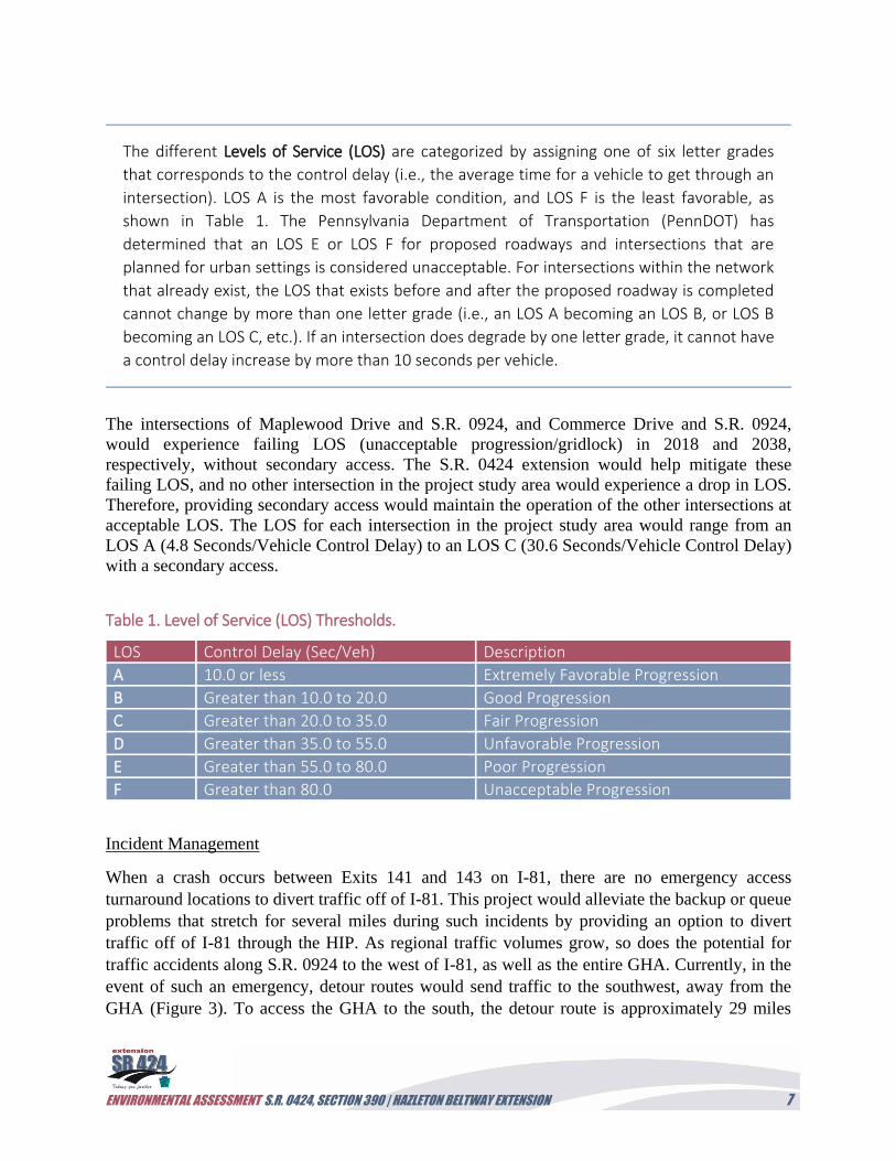
Table 1. Level of Service (LOS) Thresholds.
LOS Control Delay (Sec/Veh) Description
A 10.0 or less Extremely Favorable Progression
B Greater than 10.0 to 20.0 Good Progression
C Greater than 20.0 to 35.0 Fair Progression
D Greater than 35.0 to 55.0 Unfavorable Progression
E Greater than 55.0 to 80.0 Poor Progression
F Greater than 80.0 Unacceptable Progression
Incident Management
When a crash occurs between Exits 141 and 143 on I-81, there are no emergency access
turnaround locations to divert traffic off of I-81. This project would alleviate the backup or queue
problems that stretch for several miles during such incidents by providing an option to divert
traffic off of I-81 through the HIP. As regional traffic volumes grow, so does the potential for
traffic accidents along S.R. 0924 to the west of I-81, as well as the entire GHA. Currently, in the
event of such an emergency, detour routes would send traffic to the southwest, away from the
GHA (Figure 3). To access the GHA to the south, the detour route is approximately 29 miles
The different Levels of Service (LOS) are categorized by assigning one of six letter grades
that corresponds to the control delay (i.e., the average time for a vehicle to get through an
intersection). LOS A is the most favorable condition, and LOS F is the least favorable, as
shown in Table 1. The Pennsylvania Department of Transportation (PennDOT) has
determined that an LOS E or LOS F for proposed roadways and intersections that are
planned for urban settings is considered unacceptable. For intersections within the network
that already exist, the LOS that exists before and after the proposed roadway is completed
cannot change by more than one letter grade (i.e., an LOS A becoming an LOS B, or LOS B
becoming an LOS C, etc.). If an intersection does degrade by one letter grade, it cannot have
a control delay increase by more than 10 seconds per vehicle.
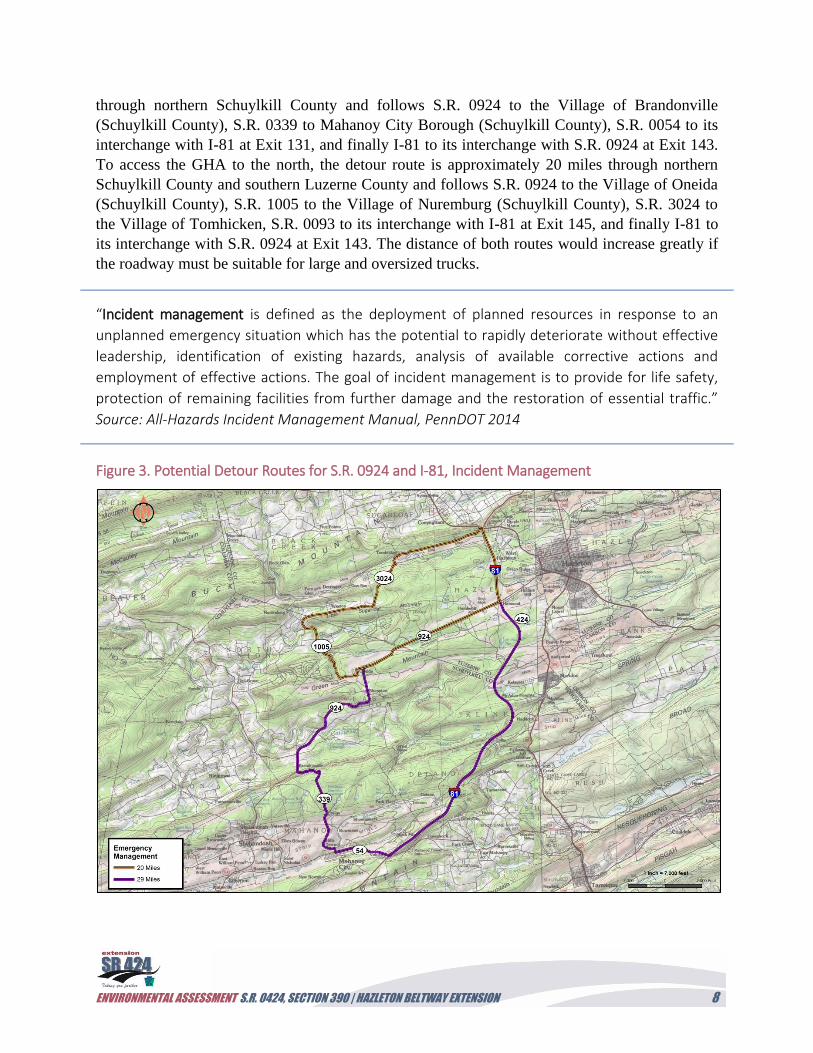
ENVIRONMENTAL ASSESSMENT S.R. 0424, SECTION 390 | HAZLETON BELTWAY EXTENSION 8
through northern Schuylkill County and follows S.R. 0924 to the Village of Brandonville
(Schuylkill County), S.R. 0339 to Mahanoy City Borough (Schuylkill County), S.R. 0054 to its
interchange with I-81 at Exit 131, and finally I-81 to its interchange with S.R. 0924 at Exit 143.
To access the GHA to the north, the detour route is approximately 20 miles through northern
Schuylkill County and southern Luzerne County and follows S.R. 0924 to the Village of Oneida
(Schuylkill County), S.R. 1005 to the Village of Nuremburg (Schuylkill County), S.R. 3024 to
the Village of Tomhicken, S.R. 0093 to its interchange with I-81 at Exit 145, and finally I-81 to
its interchange with S.R. 0924 at Exit 143. The distance of both routes would increase greatly if
the roadway must be suitable for large and oversized trucks.
“Incident management is defined as the deployment of planned resources in response to an
unplanned emergency situation which has the potential to rapidly deteriorate without effective
leadership, identification of existing hazards, analysis of available corrective actions and
employment of effective actions. The goal of incident management is to provide for life safety,
protection of remaining facilities from further damage and the restoration of essential traffic.”
Source: All-Hazards Incident Management Manual, PennDOT 2014
Figure 3. Potential Detour Routes for S.R. 0924 and I-81, Incident Management
ENVIRONMENTAL ASSESSMENT S.R. 0424, SECTION 390 | HAZLETON BELTWAY EXTENSION 9
3. Project Need Statement
As a result of the above analysis, two project needs were identified based on the existing and
projected condition of the transportation network and operations. The project needs are system
linkage/transportation demand and traffic operations.
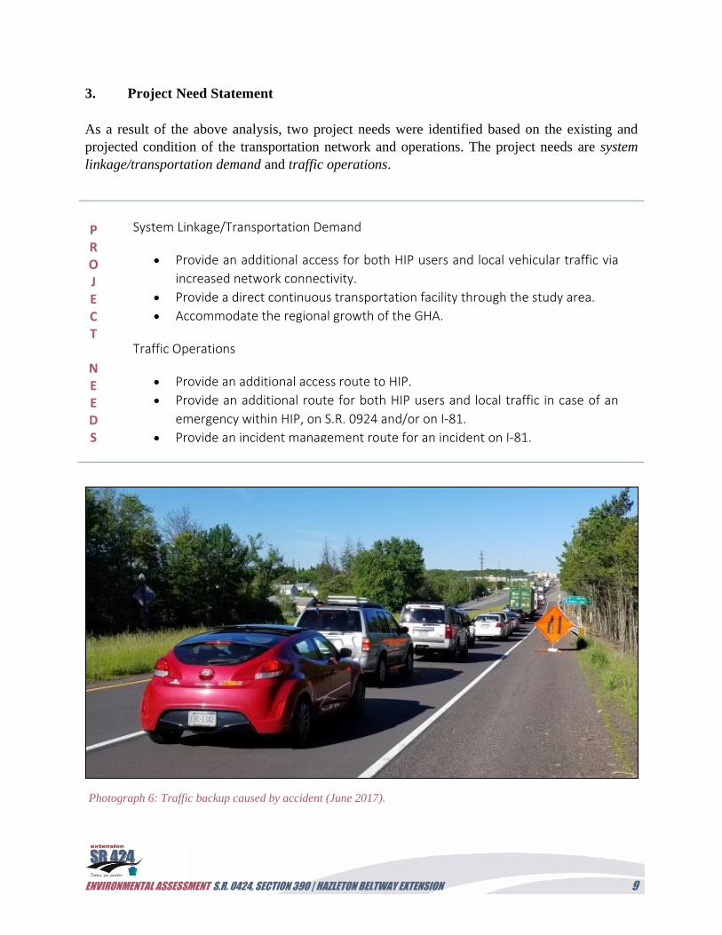
Photograph 6: Traffic backup caused by accident (June 2017).
System Linkage/Transportation Demand
Provide an additional access for both HIP users and local vehicular traffic via
increased network connectivity.
Provide a direct continuous transportation facility through the study area.
Accommodate the regional growth of the GHA.
Traffic Operations
Provide an additional access route to HIP.
Provide an additional route for both HIP users and local traffic in case of an
emergency within HIP, on S.R. 0924 and/or on I-81.
Provide an incident management route for an incident on I-81.
P R O J E C T
N E E D S
ENVIRONMENTAL ASSESSMENT S.R. 0424, SECTION 390 | HAZLETON BELTWAY EXTENSION 10
III. ENVIRONMENTAL OVERVIEW
The project study area features a diversity of natural habitats, including deciduous and mixed
forest, wetlands, and waterways that support threatened and endangered (T&E) species along the
Pismire Ridge, which bisects this area. While many areas were heavily influenced by past mining
practices, large forest tracts remain intact along the ridge and in the southern portion of the study
area. Wetlands and waterways were surveyed within the project study area along 250-foot wide
investigation corridors associated with each alternative considered. In total, 15 wetlands were
identified consisting primarily of palustrine emergent (PEM) wetlands north of the railroad and
along the gas/water right-of-way (ROW), and palustrine forested (PFO) wetlands to the south.
One large wetland mitigation site, created to offset wetland impacts associated with the HIP
development, is located north of the railroad adjacent to I-81.
Several wetlands within the project study area are designated as Exceptional Value (EV)
wetlands, as defined in 25 PA Code, Section 105.17(1)(iv), as they are within a public drinking
water supply area and maintain the quality of the water supply. The Mount Pleasant Reservoir is
an active public water supply reservoir for the Hazleton City Authority (HCA), which provides
water to the City of Hazleton, Pennsylvania, and its population of over 23,000 residents.
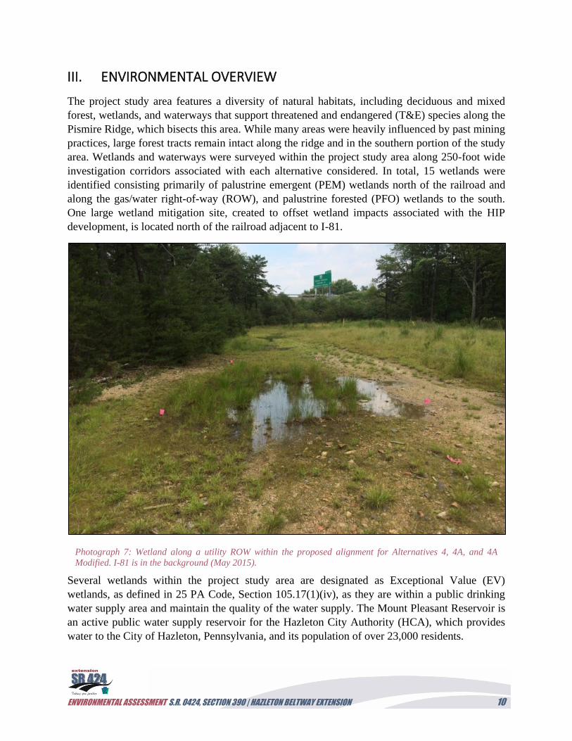
Photograph 7: Wetland along a utility ROW within the proposed alignment for Alternatives 4, 4A, and 4A
Modified. I-81 is in the background (May 2015).
ENVIRONMENTAL ASSESSMENT S.R. 0424, SECTION 390 | HAZLETON BELTWAY EXTENSION 11
The forest and wetlands in the study area also
provide habitat for several T&E species, and
includes a community of special concern, the
Ridgetop Dwarf-Tree Forest (RDTF). The
RDTF is part of the ridgetop acidic barren
complex that represents a group of open-
canopy ridgetops and summits that occur
throughout central and northeastern
Pennsylvania, such as the Pismire Ridge.
IV. Alternatives Considered
Alternatives Development
The process of developing alternatives begins
with a search for alternatives that meet current
engineering design parameters while satisfying the approved project purpose and needs. These
proposed alternatives must also be engineered to minimize their impact on natural, cultural, and
socioeconomic resources in the project study area. Public and resource agency input further
refine the range of alternatives. Finally, the process results in the examination of multiple
proposed alternatives, including the No Build Alternative, to identify reasonable alternatives that
are then further evaluated to ultimately select a preferred alternative. This project followed a
multi-phased approach to screen recommended alternatives for those that met the project purpose
and needs while minimizing impacts to natural, cultural, and socioeconomic resources, and to
ultimately select a preferred alternative.
Screening of Preliminary Alternatives
The alternatives development screening process included the following phases:
Phase 1
1. Review the transportation problems (needs) in the project study area.
2. PennDOT and the project consultant develop alternatives that would potentially address
these problems (needs).
3. Conduct an initial screening of proposed alternatives with local stakeholders (project and
task force teams) and resource agencies.
Phase 2
4. Refine the selection of alternatives with public and resource agencies (reasonable
alternatives).
5. Examine the feasibility of the reasonable alternatives based on the Alternatives Analysis
study.
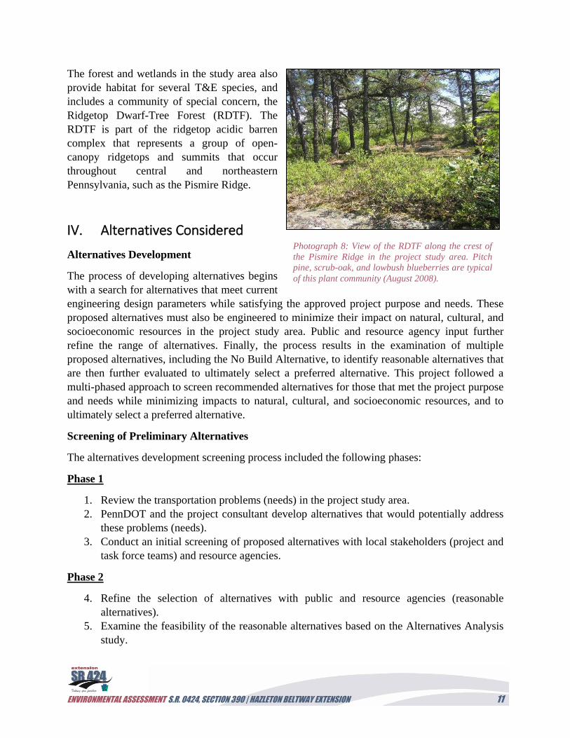
Photograph 8: View of the RDTF along the crest of
the Pismire Ridge in the project study area. Pitch
pine, scrub-oak, and lowbush blueberries are typical
of this plant community (August 2008).
ENVIRONMENTAL ASSESSMENT S.R. 0424, SECTION 390 | HAZLETON BELTWAY EXTENSION 12
Phase 3
6. Examine the impacts of the final reasonable alternatives and the No Build Alternative on
natural, cultural, and socioeconomic resources.
7. Complete a final evaluation of impacts for the reasonable alternatives to select the
preferred alternative.
Figure 4. Preliminary Alternatives Considered
ENVIRONMENTAL ASSESSMENT S.R. 0424, SECTION 390 | HAZLETON BELTWAY EXTENSION 13
Phase 1
During the initial Phase 1 screening, 12 build alternatives and the No Build Alternative were
evaluated to determine whether they met the project purpose and needs for the S.R. 0424,
Section 390 project (Figure 4; Table 2). These alternatives were conceptualized in an effort to
improve system linkages and traffic operations in the region with several alternatives located
north of S.R 0924 and south of the Hazleton Beltway. The initial screening phase was conducted
at a project kickoff meeting held on February 2, 2007. Subsequent meetings were held with the
project task force, which included Community Area New Development Organization (CAN
DO), Humboldt Business Association, Hazleton City Authority (HCA), Greater Hazleton
Chamber of Commerce, Hazle Township, Luzerne County Planning, PennDOT, project
consultants, and resource agencies throughout 2007 (Figure 4). Of the 12 build alternatives
considered, seven (7) were determined to meet the project’s purpose and needs (Alternatives
3A, 4, 4A, 4B, 4C, 4D, and 6). In particular, all of these reasonable alternatives extend from the
existing S.R. 0424 Hazleton Beltway and would provide an additional access for HIP users and
local vehicular traffic, as well as an incident management route for I-81. In addition,
Alternatives 3A, 4D, and 6 were also considered during the Phase 1 screening as they would
completely avoid the HCA watershed, which provides drinking water for local communities
from wells and the Mt. Pleasant Reservoir on their property south of the HIP (Figure 4).
Phase 2
The Phase 2 screening process involved a review of secondary source information, field views of
the project study area, and meetings with the public and task force prior to a project shutdown at
the end of 2009. The project study area for the phase encompassed the seven reasonable
alternatives noted above (Figure 5). The secondary source review and field views were
conducted to document the presence of aquatic resources, T&E species, historic structures and
archaeology, and hazardous waste along these alternative alignments. The public and task force
meetings also helped to further refine the selection of reasonable alternatives for detailed study
by identifying local and regional concerns associated with each alignment. In particular, the
HCA expressed a concern with any alternative that directly impacted their drinking water source
(i.e., wells and reservoirs) in the Mt. Pleasant watershed.
ENVIRONMENTAL ASSESSMENT S.R. 0424, SECTION 390 | HAZLETON BELTWAY EXTENSION 14
Figure 5. Reasonable Alternatives Studied in Phase 2
As a result of the Phase 2 screening, Alternatives 3A and 6 were eliminated due to their
extensive impacts to intact forestland, and the need to build or expand multiple crossings for the
railroad, I-81 and a mine pool. In addition, these alternatives would not provide system linkage
and incident management that is as effective as the alternatives that extend directly from I-81.
Alternatives 4B, 4C, and 4D were also eliminated due to their potential impact to the HCA
watershed, including the drinking water wells and reservoir, EV wetlands that maintain drinking
water quality, and impacts to overhead utilities requiring tower relocations. The project
consultant also noted that the remaining alignments, Alternatives 4 and 4A, could be modified
to maximize their distances from Well #2 of the HCA watershed and limit the potential for
ENVIRONMENTAL ASSESSMENT S.R. 0424, SECTION 390 | HAZLETON BELTWAY EXTENSION 15
drinking water impacts, including completely avoiding EV wetlands and species of special
concern associated with these wetlands These modifications focused on using either a
roundabout, reverse curve, or single curve geometry to bring the southern approach of the
Alternatives 4 and 4A alignments closer to I-81 and still provide a roadway geometry that ties
into S.R. 0424. As a result, Alternatives 4 and 4A were selected for detailed study in Phase 3,
which followed project interruption in 2009 and its restart in 2014.
Phase 3
A project restart kickoff meeting was coordinated with PennDOT, Federal Highway
Administration (FHWA), and the project consultant on April 28, 2014, to summarize the status
of the project and alternatives development, and discuss the reasonable alternatives to carry into
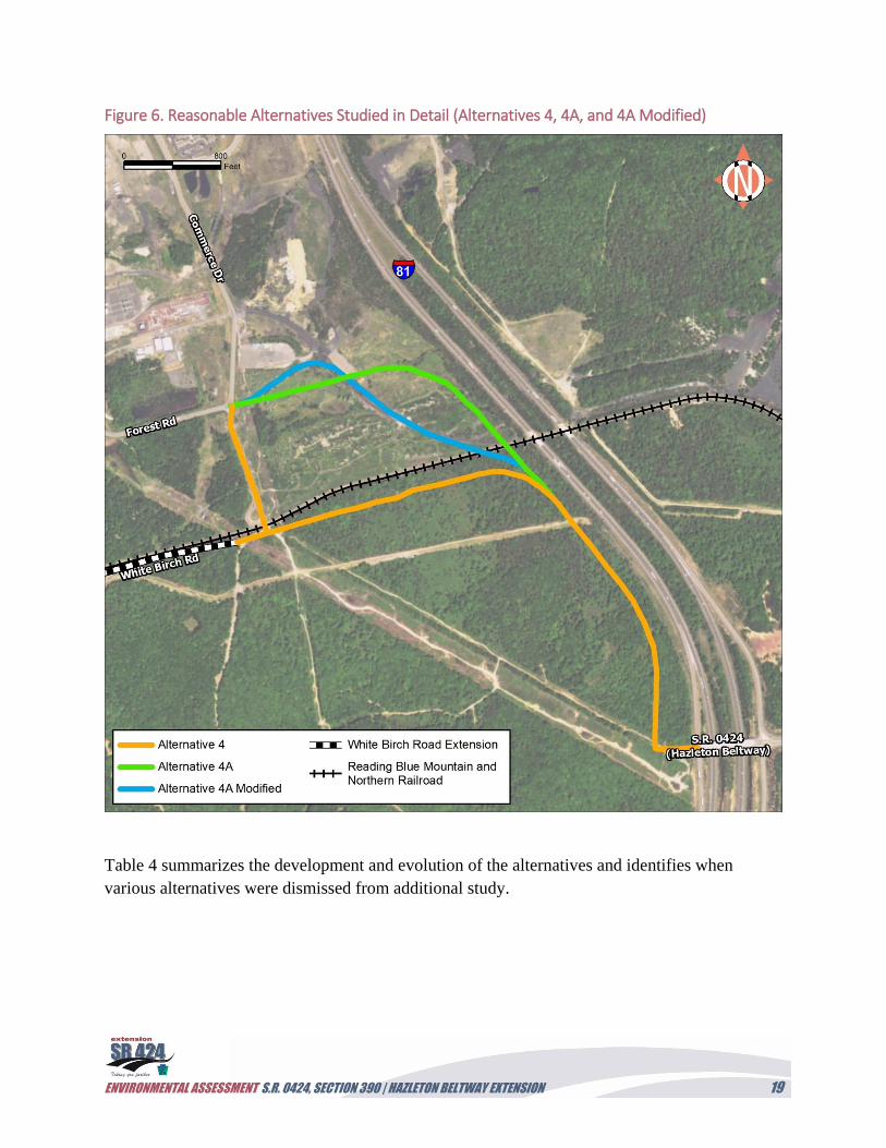
the final environmental study process. In addition to Alternatives 4 and 4A, the project team
(Appendix F) requested that a new alternative, Alternative 4A Modified, be considered for the
list of reasonable alternatives. This alternative follows a similar southern alignment as the other
two, but would follow an abandoned railroad spur north of the existing active railroad to bypass
wetlands that were noted during previous studies. Figure 6 illustrates the final three alternatives
selected for detailed study and identifies where they would tie into the White Birch Road
extension, Commerce Drive, and Forest Road within the HIP.
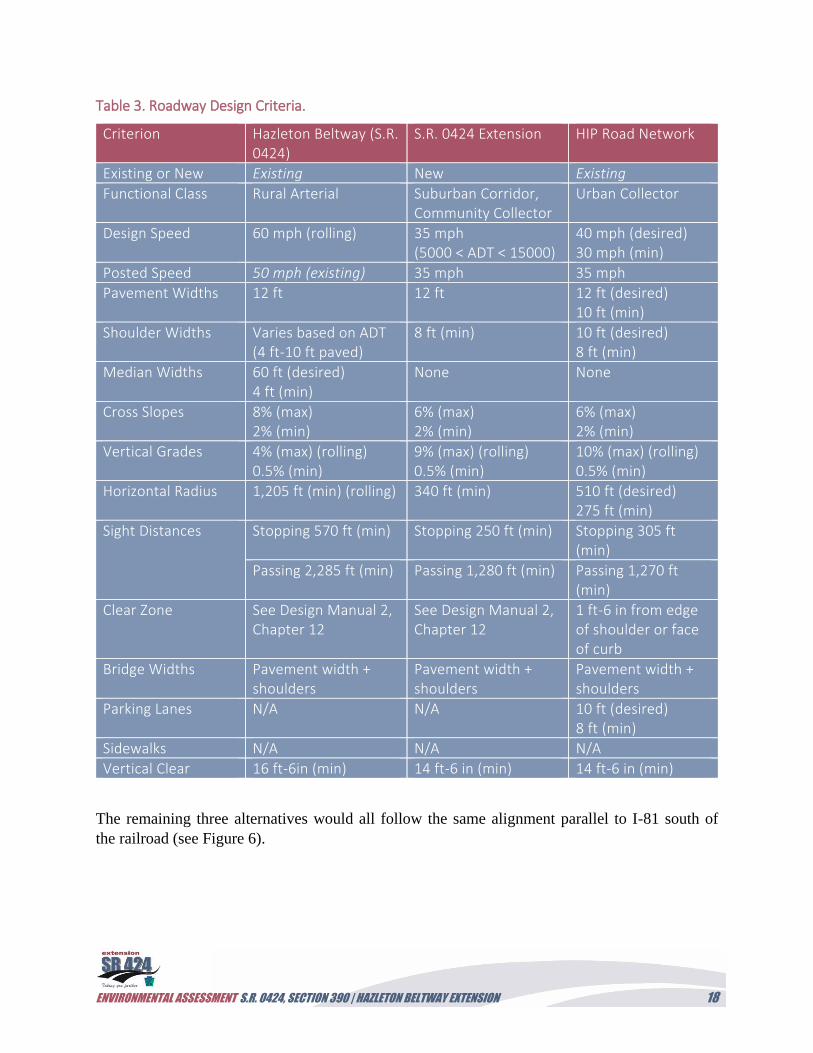
During the April 28 meeting, attendees also agreed that project engineering design parameters
would follow the urban design criteria for these three remaining alternatives. Table 3 provides a
summary of the design criteria to be utilized based on these parameters. The proposed pavement,
shoulder, and median widths presented in Table 3 are also in conformance with Smart
Transportation design guidelines.
ENVIRONMENTAL ASSESSMENT S.R. 0424, SECTION 390 | HAZLETON BELTWAY EXTENSION 16
Table 2. Preliminary Alternative Screening Details.
Alternative Number
Description Meets Project Purpose and Needs (Y/N)
Project Team Comment Advanced for Detailed Study (Y/N)
Alternative 1 This alternative would connect Humboldt North to S.R. 3020 (Tomhicken Road) involving a new two-lane access road (1.7 miles long) with two new structures over Stony and Black creeks. An at-grade railroad crossing and construction of a new intersection at Tomhicken Road would be required.
N No direct access to I-81, or access to HIP proper (primary traffic generator). Would not improve incident management for I-81.
N
Alternative 1A This alternative would connect Humboldt North to a new diamond interchange with I-81 between Exit 143 and Exit 145. It would involve a new two-lane access road (0.7 mile long) with two new structures over Stony Creek. An access road could also connect HIP with Valmont Industrial Park.
N Additional interchange needed on I-81. No direct access to I-81 or access to HIP proper (primary traffic generator). Would not improve incident management for I-81.
N
Alternative 2 This alternative would involve the development of the existing partial cloverleaf interchange at Exit 143 into a full cloverleaf interchange.
N Possible future capital improvements project separate from the S.R. 0924 Corridor Improvements Project. Provides no additional capacity on S.R. 0924.
N
Alternative 3 This alternative would involve a road to connect Humboldt East to a new I-81 interchange between Exit 141 and Exit 143. In addition, this alternative would include the construction of a new two-lane access road (0.6 mile long) and a new partial cloverleaf interchange that would carry I-81 over the new access road.
N Additional interchange needed on I-81, which would be less than 1 mile from Exit 141.
N
Alternative 3A
This alternative would involve the construction of a road north of and parallel to the railroad to connect Humboldt East (Commerce Drive) to S.R. 0424 east of I-81 Exit 141. This alternative would include the construction of a new two-lane access road (1.5 miles long), construction of an at-grade railroad crossing, and the lengthening of the two I-81 bridges over the railroad. A 300+ foot long bridge would be required to cross a mine pool located east of I-81.
Y Would require significant costs for the roadway and not provide a practical detour for incident management along I-81.
N
Alternative 4 This alternative would involve a road to connect Humboldt East (Commerce Drive) to S.R. 0424 and I-81 at Exit 141. This alternative would also include the construction of a new two-lane access road (1.1 miles long), construction of an at-grade railroad crossing, implementation of post-construction stormwater management Best Management Practices (BMPs) to address water quality issues in the HCA watershed (i.e., a controlled drainage system [curbing, inlets, pipes, lined swales, lined detention ponds, etc.]), and a 300-foot buffer between the new road and HCA well #2 with a design speed of 45 mph.
Y Minimizes impact to the HCA watershed, wells, and reservoirs while meeting purpose and needs.
Y
Alternative 4A This alternative would involve a road to connect Humboldt East (Forest Road) to S.R. 0424 and I-81 at Exit 141. This alternative would also include the construction of a new two-lane access road (1.2 miles long), construction of an at-grade railroad crossing, implementation of post-construction stormwater management BMPs to address water quality issues in the HCA watershed (i.e., a controlled drainage system [curbing, inlets, pipes, lined swales, lined detention ponds, etc.]), and a 300-foot buffer between the new road and HCA well #2 with a design speed of 45 mph.
Y Minimizes impact to the HCA watershed, wells, and reservoirs while meeting purpose and needs.
Y
Alternative 4A Modified
This alternative would involve a road to connect Humboldt East (Forest Road) to S.R. 0424 and I -81 at Exit 141. This alternative would also include the construction of a new two-lane access road (1.1 miles long) along an existing haul road, construction of an at-grade railroad crossing, implementation of post-construction stormwater management BMPs to address water quality issues in the HCA watershed (i.e., a controlled drainage system [curbing, inlets, pipes, lined swales, lined detention ponds, etc.]), and a 300-foot buffer between the new road and HCA well #2 with a design speed of 35 mph.
Y Minimizes impact to the HCA watershed, wells, and reservoirs while meeting purpose and needs.
Y
ENVIRONMENTAL ASSESSMENT S.R. 0424, SECTION 390 | HAZLETON BELTWAY EXTENSION 17
Alternative Number
Description Meets Project Purpose and Needs (Y/N)
Project Team Comment Advanced for Detailed Study (Y/N)
Alternative 4B This alternative would involve a road to connect Humboldt East (Commerce Drive) to S.R. 0424 and I -81 at Exit 141. This alternative would also include the construction of a new two-lane access road (0.9 mile long), construction of an at-grade railroad crossing, implementation of post-construction stormwater management BMPs to address water quality issues in the HCA watershed (i.e., a controlled drainage system [curbing, inlets, pipes, lined swales, lined detention ponds, etc.]).
Y Impacts HCA watershed, wells, and wetlands, and transmission lines while meeting all purpose and needs.
N
Alternative 4C This alternative would involve a road to connect Humboldt East (Elm Road) to S.R. 0424 and I -81 at Exit 141. This alternative would also include the construction of a new two-lane access road (1.6 miles long), construction of an at-grade railroad crossing, and implementation of post-construction stormwater management BMPs to address water quality issues in the HCA watershed (i.e., a controlled drainage system [curbing, inlets, pipes, lined swales, lined detention ponds, etc.]).
Y Impacts HCA watershed, wells, wetlands, and large forestland while meeting all purpose and needs.
N
Alternative 4D This alternative would involve the construction of a road through the Bonner family private property and around the Mount Pleasant Reservoirs to its intersection with Maplewood Drive. This alternative would include the construction of a new two-lane access road (2.4 miles long) and implementation of post-construction stormwater management BMPs to address water quality issues for the Bonner family (i.e., a controlled drainage system [curbing, inlets, pipes, lined swales, lined detention ponds, etc.]).
Y Requires significant costs for the roadway with impacts to forestland and residential property while meeting all purpose and needs.
N
Alternative 5 This alternative would involve a road to connect HIP (Maplewood Drive) to a new I-81 Interchange south of Exit 141. This alternative would also include the construction of a new two-lane access road (1.9 miles long), construction of a new structure over Catawissa Creek, and construction of a new I -81 diamond interchange that would carry the new access road over I-81. This would include the removal and replacement of the existing Haul Road bridge.
N Additional interchange needed on I-81. In proximity to junkyard, and impacts 8 Bees Campground, wetlands, and large forestland.
N
Alternative 6 This alternative would involve one at-grade railroad crossing and two new bridges on I-81 to extend Forest Road eastward under I-81 and to its connection with S.R. 0424 on the east side of the I-81/Exit 141 interchange.
Y Requires significant costs for the roadway and new bridges and does not provide a practical detour for incident management along I-81.
N
No Build Alternative
This alternative would involve no additional access roadways or improvements to existing roadways. Y Does not satisfy project purpose and needs. Used as comparison in detailed study.
ENVIRONMENTAL ASSESSMENT S.R. 0424, SECTION 390 | HAZLETON BELTWAY EXTENSION 18
Table 3. Roadway Design Criteria.
Criterion Hazleton Beltway (S.R. 0424)
S.R. 0424 Extension HIP Road Network
Existing or New Existing New Existing
Functional Class Rural Arterial Suburban Corridor, Community Collector
Urban Collector
Design Speed 60 mph (rolling) 35 mph (5000 < ADT < 15000)
40 mph (desired) 30 mph (min)
Posted Speed 50 mph (existing) 35 mph 35 mph
Pavement Widths 12 ft 12 ft 12 ft (desired) 10 ft (min)
Shoulder Widths Varies based on ADT (4 ft-10 ft paved)
8 ft (min) 10 ft (desired) 8 ft (min)
Median Widths 60 ft (desired) 4 ft (min)
None None
Cross Slopes 8% (max) 2% (min)
6% (max) 2% (min)
6% (max) 2% (min)
Vertical Grades 4% (max) (rolling) 0.5% (min)
9% (max) (rolling) 0.5% (min)
10% (max) (rolling) 0.5% (min)
Horizontal Radius 1,205 ft (min) (rolling) 340 ft (min) 510 ft (desired) 275 ft (min)
Sight Distances Stopping 570 ft (min) Stopping 250 ft (min) Stopping 305 ft (min)
Passing 2,285 ft (min) Passing 1,280 ft (min) Passing 1,270 ft (min)
Clear Zone See Design Manual 2, Chapter 12
See Design Manual 2, Chapter 12
1 ft-6 in from edge of shoulder or face of curb
Bridge Widths Pavement width + shoulders
Pavement width + shoulders
Pavement width + shoulders
Parking Lanes N/A N/A 10 ft (desired) 8 ft (min)
Sidewalks N/A N/A N/A
Vertical Clear 16 ft-6in (min) 14 ft-6 in (min) 14 ft-6 in (min)
The remaining three alternatives would all follow the same alignment parallel to I-81 south of
the railroad (see Figure 6).
ENVIRONMENTAL ASSESSMENT S.R. 0424, SECTION 390 | HAZLETON BELTWAY EXTENSION 19
Figure 6. Reasonable Alternatives Studied in Detail (Alternatives 4, 4A, and 4A Modified)
Table 4 summarizes the development and evolution of the alternatives and identifies when
various alternatives were dismissed from additional study.
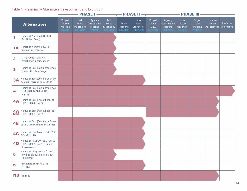
Humboldt North to S.R. 3020 (Tomhicken Road)
AlternativesProject Kickoff
Meeting2/2/2007
Project Team
Meeting2/24/2015
Environ-mental
AssessmentPreferred
Alternative
Project Field View
4/28/2014
Task Force
Meeting #16/21/2007
Task Force
Meeting #212/21/2007
Task Force
Meeting #311/5/2009
Task Force
Meeting #42/5/2015
Public Meeting6/24/2008
Agency Coordination
Meeting8/21/2007
Agency Coordination
Meeting11/19/2014
Humboldt North to new I-81 diamond interchange
I-81/S.R. 0924 (Exit 143) Interchange modifications
Humboldt East (Commerce Drive) to new I-81 interchange
Humboldt East (Commerce Drive) adjacent railroad to S.R. 0424
Humboldt East (Commerce Drive) to I-81/S.R. 0424 (Exit 141) near I-81
Humboldt East (Forest Road) to I-81/S.R. 0424 (Exit 141)
Humboldt East (Forest Road) to I-81/S.R. 0424 (Exit 141)
Humboldt East (Commerce Drive) to I-81/S.R. 0424 (Exit 141) direct
Humboldt (Elm Road) to I-81/ S.R. 0424 (Exit 141)
Humboldt (Maplewood Drive) to I-81/S.R. 0424 (Exit 141) south of reservoirsHumboldt (Maplewood Drive) to new I-81 diamond interchange (Haul Road)
Forest Road under I-81 to S.R. 0424
No Build
1
1A
2
3
3A
4
4A
4AMOD
4B
4C
4D
5
6
NB
Table 4. Preliminary Alternative Development and Evolution.
20
PHASE I PHASE II PHASE III
ENVIRONMENTAL ASSESSMENT S.R. 0424, SECTION 390 | HAZLETON BELTWAY EXTENSION 21
V. Environmental Resources, Impacts, and Mitigation
This section summarizes the impacts to environmental resources and associated mitigation
measures for the No Build Alternative and three build alternatives selected for detailed study by
the project team in coordination with the public, the local task force, and resource agencies
(Figure 6). Each resource discussed in this section was identified within the project study area;
however, several resources were only studied within an investigation corridor that contained the
build alternative alignments. For example, wetlands, waterways, and T&E species habitat were
surveyed in the field within an investigation area that expanded 250 feet on either side of the
three proposed alignment centerlines.
As a result of the three-phased approach, Alternatives 4, 4A, and 4A Modified were selected for
detailed study to determine the environmental, cultural, and socioeconomic impacts of each
alignment.
The Hazleton Beltway Project, as proposed, would not impact the following resources, and
therefore no further discussion of these resources is presented: coastal zones, navigable
waterways, wild and scenic rivers, National Natural Landmarks, wildlife sanctuaries/refuges,
state game lands, public parks, National Historic Landmarks, and community facilities and services.
In addition, several resources were identified within the project study area and would either be
impacted minimally or to the same extent by the three build alternatives. In these cases, the
resources are identified in the paragraph below but are discussed more extensively in Appendix
C, as they would not play a prominent role in the selection of a preferred alternative. The
following resources fall into this category: agricultural, air, noise, waste, cultural resources
(historic structures and archaeology), groundwater, and greenhouse gases (GHG) and climate
change. Further information on these resources can be requested from the list of materials in
the technical file, as identified in Appendix E. In addition, proposed development and local
planning, environmental justice communities, utilities, and displacements also did not play a
prominent role in the alternative selection.
Secondary source and field investigations within the project study area determined that the three
build alignments travel through a landscape affected by strip mining and, more recently, by
commercial and industrial development with a supporting roadway and utility network. As such,
many resources within the alignment study areas were not significantly impacted, and these
impacts do not differ between the three build alternatives studied in detail. They are noted below:
Agricultural Resources - Soils of Statewide Importance (Alvira silt loam [AlB]) are
present along the common southern alignment of the three build alternatives.
Air Quality and Noise - Luzerne County has been designated as “in attainment” for all
regional air pollutants, and the project would not result in any meaningful increases in
ENVIRONMENTAL ASSESSMENT S.R. 0424, SECTION 390 | HAZLETON BELTWAY EXTENSION 22
traffic volumes. There are also no noise-sensitive land uses in the proximity of the build
alignments. Air and noise impacts would be minimal.
GHG and Climate Change – The build alternatives would support the reduction of GHG
emissions and not be significantly impacted by climate change.
Hazardous Waste Sites - Site investigations indicated that a waste site (Waste Site 14)
associated with the PPL Harwood steam electric station property was identified at the
intersection of Forest Road and Commerce Drive. This waste site could be impacted by
any of the three build alternatives and would require testing of any soil removed.
Cultural Resources (Historic Structures and Archaeology) - Neither intact historic
structures nor any significant archaeological resources were identified along the three
build alternatives.
Groundwater Resources (Wells, Water Supply) - The HCA’s groundwater resources,
including wells and reservoir, will not be directly impacted by the build alternatives, and
stormwater management measures will be implemented to indirect limit impacts to the
drinking water supply.
Proposed Development - The proposed S.R. 0424 beltway extension is compatible with
local and regional planning initiatives and has the support of local developers and
municipal and county planners and officials.
Utilities – Utilities in the project study area include underground water lines (HCA),
underground and overhead transmission and distribution lines (PPL Electric Utilities
Corporation), and underground gas lines (UGI Utilities Inc.). Minor relocation of lines or
utility poles will be required.
Environmental Justice and Displacements – No impacts to environmental justice
communities and no residential displacements will occur. The project will provide
additional access and also ease congestion in the greater Hazleton area.
Please refer to Appendix C for background on the studies completed on the above resources.
The following resources were identified as having the potential to be impacted by the build
alternatives and were selected for detailed study.
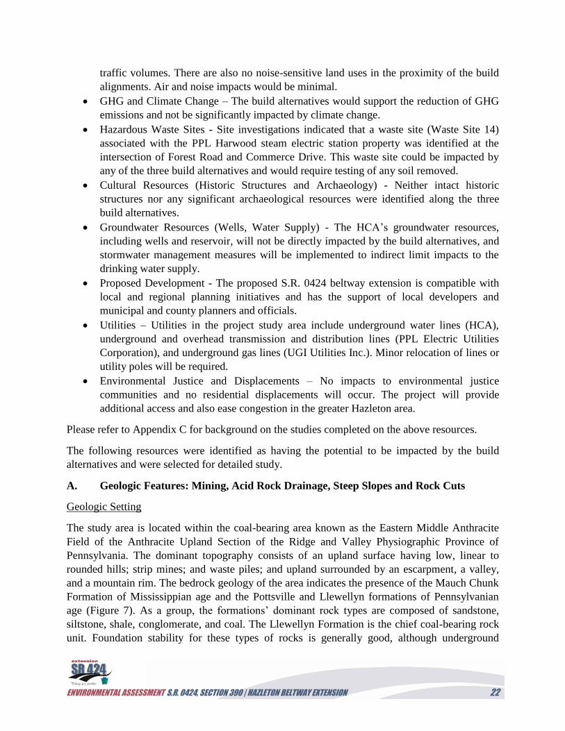
A. Geologic Features: Mining, Acid Rock Drainage, Steep Slopes and Rock Cuts
Geologic Setting
The study area is located within the coal-bearing area known as the Eastern Middle Anthracite
Field of the Anthracite Upland Section of the Ridge and Valley Physiographic Province of
Pennsylvania. The dominant topography consists of an upland surface having low, linear to
rounded hills; strip mines; and waste piles; and upland surrounded by an escarpment, a valley,
and a mountain rim. The bedrock geology of the area indicates the presence of the Mauch Chunk
Formation of Mississippian age and the Pottsville and Llewellyn formations of Pennsylvanian
age (Figure 7). As a group, the formations’ dominant rock types are composed of sandstone,
siltstone, shale, conglomerate, and coal. The Llewellyn Formation is the chief coal-bearing rock
unit. Foundation stability for these types of rocks is generally good, although underground
ENVIRONMENTAL ASSESSMENT S.R. 0424, SECTION 390 | HAZLETON BELTWAY EXTENSION 23
mining activities may give rise to subsidence. Cut slope stability is good, except when
undercutting occurs where resistant beds of sandstone and conglomerate are underlain by more
easily weathered rocks, such as shale. The Pottsville and Llewellyn formations contain acid-
bearing rock; therefore, newly exposed rocks and fill material may require remediation. The
surficial materials throughout the study area are primarily mining waste and stony, glacially
influenced soils weathered from sandstone and conglomerate. The predominant non-mining soils
encountered throughout the area are extremely stony sandy loams on the hilltops and hillsides
and very stony silt loams in the low areas. The only major negative characteristic of the soils
throughout the area is the potential to be corrosive to steel.
Figure 7: Geology
ENVIRONMENTAL ASSESSMENT S.R. 0424, SECTION 390 | HAZLETON BELTWAY EXTENSION 24
Given the study area’s geologic setting and topography, roadway construction could encounter
several constructability issues:
Cut slope and fill slope stability;
Settlement of newly placed embankment fill;
Material suitability issues from the potentially acidic rock units;
Acid rock drainage, which may cause in-situ materials to be unsuitable for on-site usage;
and
Roadway drainage would need to be designed to divert any potential pollutants away
from water resources and areas of public water supplies.
Existing Conditions:
Mining Conditions
Portions of the area surrounding the Humboldt Industrial Park (HIP) and the existing S.R. 0081
and S.R. 0424 Interchange display past surface mining activities, as well as some areas where
deep mining has been performed (Figure 8). Current land use of the mined areas varies from
woodland to industrial and residential areas. A preliminary review of mining features was
completed. Although no mine or subsidence features were mapped within the project study area,
there may be occurrences of subsidence that have not been reported due to going unnoticed, such
as in the non-developed woodlands. Evidence of acid mine drainage was noticed during a
previous field view. These abandoned mine features may cause issues concerning the health and
safety of the public, degrade the quality of the environment, and diminish the use of land and
water resources if disturbed during construction activities associated with the project.
Subsidence is the gradual caving or sinking of land. This is related to the mining activities within
the project study area, but no instances were identified in the project study area.
Acid Rock Drainage
The potential for acid rock drainage problems during roadway construction as a result of rock
cuts or excavations was preliminarily identified given the project setting within the anthracite
coal region and related geologic setting.
Steep Slopes and Rock Cuts
The potential for steep slopes and rock cuts complications during roadway construction was
preliminarily identified given the related geologic setting.
ENVIRONMENTAL ASSESSMENT S.R. 0424, SECTION 390 | HAZLETON BELTWAY EXTENSION 25
Figure 8. Mine Openings
Impacts:
No Build Alternative: The No Build Alternative would have no impact to mining features, nor
would it require special measures to address cut and fill slope stability, embankment fill
settlement, material suitability and acid rock drainage, or roadway drainage.
Build Alternatives: Alternatives 4A and 4A Modified all have the potential for multiple
geological-based issues, including the potential for significant excavation of mining waste.
Alternative 4 would also require cut slopes in excess of 30 feet, requiring rockfall catchment
areas and/or rockfall fencing to provide adequate safety with respect to rock slope stability.
Alternatives 4A and 4A Modified, which extend north of the railroad tracks, have the potential
for stability issues associated with deep mining below their footprints.
Navarro & Wright Consulting Engineers, Inc. (N&W) conducted geotechnical studies associated
with Alternative 4 in January and February 2017. Rock core samples were selected for acid-base
ENVIRONMENTAL ASSESSMENT S.R. 0424, SECTION 390 | HAZLETON BELTWAY EXTENSION 26
accounting testing performed according to the Pennsylvania Department of Environmental
Protection (PADEP) Overburden Sampling and Testing Manual, Contract No. ME86120. Based
on the results of the acid-base accounting, the underlying bedrock does not contain acid-bearing
rock. However, Alternatives 4A and 4A Modified were not fully tested and would still pose a
potential risk for encountering acid-bearing rock that would need to be either encapsulated on-
site, treated on-site, or landfilled.
Environmental Features/Constraint Mapping:
Please refer to the Environmental Constraints Map in Appendix B.
Minimization/Mitigation:
Potential minimization and mitigation would involve the following:
Continued assessment of the potential slope cuts to determine the need for the
implementation of rockfall controls. Based on the geotechnical studies currently being
conducted by N&W, cut slopes are proposed to be 1.5 to 1, and no catchment areas are
anticipated. The existing PPL electric tower located south of the Commerce Drive cul-de-
sac is considered to be a critical section for the Alternative 4 alignment, and an R-6 rip-
rap buttress is proposed to stabilize the load near the top of the proposed cut.
Implementation of acid-bearing rock testing during final design to develop treatment
methods to buffer drainage runoff for Alternatives 4A and 4A Modified. Geotechnical
studies associated with Alternative 4 determined that the underlying bedrock does not
contain acid-bearing rock.
Additional borings along Alternatives 4A and 4A Modified to determine the presence of
subsurface mining north of the railroad tracks.
Balancing earthwork to minimize the amount of waste material generated.
B. Surface Waters (Wetlands, Streams, and Floodplains)
Methodology:
The wetland investigations were conducted in accordance with the U.S. Army Corps of
Engineers (USACE) Wetlands Delineation Manual (Environmental Laboratory 1987), the
Regional Supplement to the Corps of Engineers Wetland Delineation Manual: Eastern
Mountains and Piedmont (USACE Engineer Research and Development Center [ERDC] 2010),
the PADEP Chapter 105 Regulations, and Section 404 of the Federal Clean Water Act. Wetland
habitats were classified according to U.S. Fish and Wildlife Service (USFWS) Classification of
Wetlands and Deepwater Habitats of the United States (Cowardin et al. 1979).
The wetland and watercourse boundaries were delineated from September 27 to 29, 2007;
October 2 to 3, 2007; and on October 25, 2007, in an area identified as the “Waters of the United
States” (“Waters of the U.S.”) investigation area. The “Waters of the U.S.” investigation area
consisted of five distinct alternative route sites:
ENVIRONMENTAL ASSESSMENT S.R. 0424, SECTION 390 | HAZLETON BELTWAY EXTENSION 27
1. Commerce Drive to S.R. 0424 north of Hazleton City Authority (HCA) watershed
(Alternative 4);
2. Forest Road to S.R. 0424 (Alternative 4A);
3. Commerce Drive to S.R. 0424 along power lines (Alternative 4B);
4. Maplewood Drive to S.R. 0424 (Alternative 4C); and
5. Maplewood Drive to S.R. 0424 routed below the reservoirs (Alternative 4D).
A.D. Marble prepared a “Waters of the U.S.” Investigation, Delineation, and Functional
Assessment Report for the S.R. 0424, Section 390, Hazleton Beltway Extension, which was
submitted to the USACE and the PADEP on May 30, 2008. A jurisdictional determination (JD)
was conducted by the Baltimore District of the USACE on November 18, 2009. This JD was
conducted within an “investigation area” defined as the project limits associated only with
Alternatives 4 and 4A. An approved JD letter was provided on February 3, 2010. In May 2015,
A.D. Marble conducted a field investigation in the study area defined by Alternatives 4 and 4A,
as well as the newly added Alternative 4A Modified alignment, to update known wetland
boundaries and include any new wetlands and waterways observed. After the JD expired in 2015,
a JD field view was coordinated by A.D. Marble & Company (A.D. Marble) on July 1, 2015,
along the Alternatives 4, 4A, and 4A Modified project alignments. An approved JD letter was
received on December 15, 2015.
A jurisdictional determination (JD) is an official review or determination by the USACE regarding
whether “waters of the United States” or “navigable waters of the United States” are present.
Existing Conditions:
The “Waters of the U.S.” investigation area limits for each of the three field-investigated
alternative routes included a 500-foot corridor that measured 250 feet to either side of the
centerline. The boundaries for all wetlands and watercourses encountered were delineated within
this “Waters of the U.S.” investigation area.
The wetlands and watercourses identified in the “Waters of the U.S.” investigation area are
located in two separate watersheds, Cranberry Creek (subwatershed of Black Creek) and Cross
Run (subwatershed of Catawissa Creek), which ultimately discharge into the Susquehanna River.
The Susquehanna River is the nearest Traditionally Navigable Waterway (TNW) relative to the
project study area. Much of the project study area consists of lands disturbed through past coal
mining operations. Wetlands and watercourses are associated with headwaters to the Catawissa
Creek and Black Creek watersheds and with remnant strip mining depressions, some of which
are isolated. The headwater areas are expansive, particularly in Cross Creek where surface and
subsurface waters contribute to HCA’s Mt. Pleasant reservoirs and several water supply wells.
Remnant strip mining depressions and disturbed lands are located primarily within the Cranberry
ENVIRONMENTAL ASSESSMENT S.R. 0424, SECTION 390 | HAZLETON BELTWAY EXTENSION 28
Creek watershed where wetland restoration and mitigation projects have also been constructed.
Some of the disturbed area depressions are contained within wetland systems, while others occur
as isolated areas with no apparent surface water connection to other wetlands or watercourses.
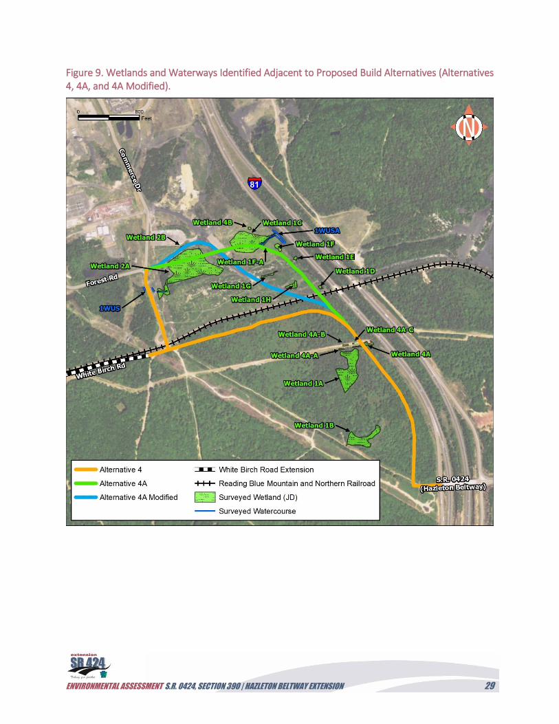
A total of 15 wetland areas and 12 watercourses were initially identified within the “Waters of
the U.S.” investigation area on the west side of I-81. A second field investigation and JD was
conducted in 2015 to assess the presence of wetlands within the 250-foot investigation corridor
associated with the three build alternatives. In total, 16 wetlands were identified and included an
additional five new wetlands (including Wetlands IF-A, 4A, 4A-A to 4A-C, and 4B). These
wetlands are shown on Figure 9. Wetlands identified along the investigation corridors of the
study area included palustrine forested (PFO), palustrine scrub-shrub (PSS), palustrine emergent
(PEM), and palustrine open water (POW) wetlands (see Table 5). A wetland functional analysis
was conducted for each wetland using the Corps Descriptive Method evaluation (USACE 1995).
The results of the functional assessments indicate that the major functions of most of the project
wetlands are groundwater recharge/discharge, floodflow alteration, sediment/toxicant retention,
nutrient removal, production export, and wildlife habitat.
Within the project study area, wetlands in the watershed of the Mount Pleasant Reservoir are
considered Exceptional Value (EV) wetlands as defined in 25 PA Code, Section 105.17(1)(iv), if
they are within a public drinking water supply area and maintain quality of that water supply.
Wetlands 1A and 1B appear to be hydrologically connected and satisfy the EV definition. The
Mount Pleasant Reservoir is an active public water supply reservoir for the HCA. The HCA
provides water to the City of Hazleton, Pennsylvania, with a population over 23,000 residents.
The project study area falls within two main watersheds: the Catawissa Creek watershed and the
Black Creek watershed. Pismire Ridge, which runs east/west near the center of the project study
area, divides the north and south portions of the project study area and provides the drainage
divide for the two watersheds. The watershed of Catawissa Creek drains areas to the south, and
the northern portion of the study area drains into Catawissa Creek and into the watershed of
Black Creek. Both Catawissa Creek and Black Creek are tributaries to the Susquehanna River,
which is the nearest TNW to the project study area.
There are numerous mine pools within the study area that are associated with historic strip-
mining activities, streams, and other bodies of water. The north side of Pismire Ridge has a
history of strip-mining activity. Numerous remnant excavations have become water-filled over
time. These strip-mine pools are scattered in the landscape on the northern flank of Pismire
Ridge.
ENVIRONMENTAL ASSESSMENT S.R. 0424, SECTION 390 | HAZLETON BELTWAY EXTENSION 29
Figure 9. Wetlands and Waterways Identified Adjacent to Proposed Build Alternatives (Alternatives 4, 4A, and 4A Modified).
ENVIRONMENTAL ASSESSMENT S.R. 0424, SECTION 390 | HAZLETON BELTWAY EXTENSION 30
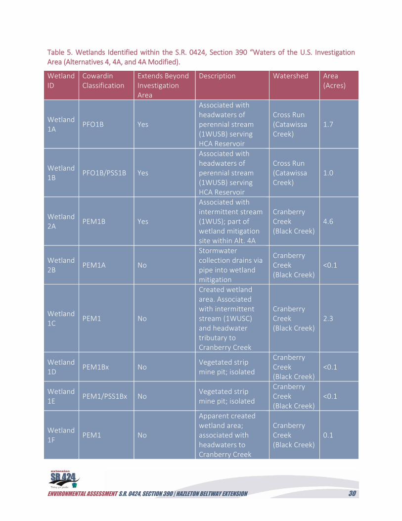
Table 5. Wetlands Identified within the S.R. 0424, Section 390 “Waters of the U.S. Investigation Area (Alternatives 4, 4A, and 4A Modified).
Wetland ID
Cowardin Classification
Extends Beyond Investigation Area
Description Watershed Area (Acres)
Wetland 1A
PFO1B Yes
Associated with headwaters of perennial stream (1WUSB) serving HCA Reservoir
Cross Run (Catawissa Creek)
1.7
Wetland 1B
PFO1B/PSS1B Yes
Associated with headwaters of perennial stream (1WUSB) serving HCA Reservoir
Cross Run (Catawissa Creek)
1.0
Wetland 2A
PEM1B Yes
Associated with intermittent stream (1WUS); part of wetland mitigation site within Alt. 4A
Cranberry Creek (Black Creek)
4.6
Wetland 2B
PEM1A No
Stormwater collection drains via pipe into wetland mitigation
Cranberry Creek (Black Creek)
<0.1
Wetland 1C
PEM1 No
Created wetland area. Associated with intermittent stream (1WUSC) and headwater tributary to Cranberry Creek
Cranberry Creek (Black Creek)
2.3
Wetland 1D
PEM1Bx No Vegetated strip mine pit; isolated
Cranberry Creek (Black Creek)
<0.1
Wetland 1E
PEM1/PSS1Bx No Vegetated strip mine pit; isolated
Cranberry Creek (Black Creek)
<0.1
Wetland 1F
PEM1 No
Apparent created wetland area; associated with headwaters to Cranberry Creek
Cranberry Creek (Black Creek)
0.1
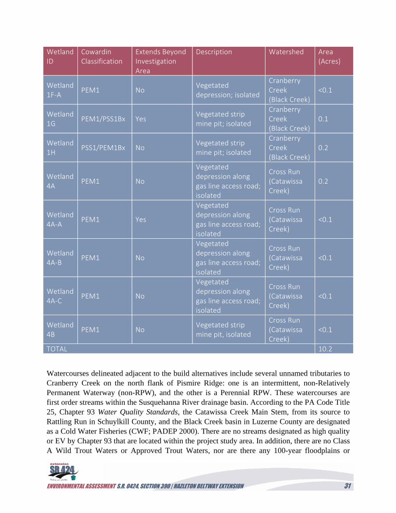
ENVIRONMENTAL ASSESSMENT S.R. 0424, SECTION 390 | HAZLETON BELTWAY EXTENSION 31
Wetland ID
Cowardin Classification
Extends Beyond Investigation Area
Description Watershed Area (Acres)
Wetland 1F-A
PEM1 No Vegetated depression; isolated
Cranberry Creek (Black Creek)
<0.1
Wetland 1G
PEM1/PSS1Bx Yes Vegetated strip mine pit; isolated
Cranberry Creek (Black Creek)
0.1
Wetland 1H
PSS1/PEM1Bx No Vegetated strip mine pit; isolated
Cranberry Creek (Black Creek)
0.2
Wetland 4A
PEM1 No
Vegetated depression along gas line access road; isolated
Cross Run (Catawissa Creek)
0.2
Wetland 4A-A
PEM1 Yes
Vegetated depression along gas line access road; isolated
Cross Run (Catawissa Creek)
<0.1
Wetland 4A-B
PEM1 No
Vegetated depression along gas line access road; isolated
Cross Run (Catawissa Creek)
<0.1
Wetland 4A-C
PEM1 No
Vegetated depression along gas line access road; isolated
Cross Run (Catawissa Creek)
<0.1
Wetland 4B
PEM1 No Vegetated strip mine pit, isolated
Cross Run (Catawissa Creek)
<0.1
TOTAL 10.2
Watercourses delineated adjacent to the build alternatives include several unnamed tributaries to
Cranberry Creek on the north flank of Pismire Ridge: one is an intermittent, non-Relatively
Permanent Waterway (non-RPW), and the other is a Perennial RPW. These watercourses are
first order streams within the Susquehanna River drainage basin. According to the PA Code Title
25, Chapter 93 Water Quality Standards, the Catawissa Creek Main Stem, from its source to
Rattling Run in Schuylkill County, and the Black Creek basin in Luzerne County are designated
as a Cold Water Fisheries (CWF; PADEP 2000). There are no streams designated as high quality
or EV by Chapter 93 that are located within the project study area. In addition, there are no Class
A Wild Trout Waters or Approved Trout Waters, nor are there any 100-year floodplains or
ENVIRONMENTAL ASSESSMENT S.R. 0424, SECTION 390 | HAZLETON BELTWAY EXTENSION 32
regulated floodways within the project study area according to the Pennsylvania Fish and Boat
Commission (PFBC) and FEMA. It should be noted that the Mt. Pleasant Reservoirs, located on
the south side of the project study area, provide potable water to the City of Hazleton and receive
drainage from several of the wetlands noted above.
Table 6. Watercourses/Impoundments Identified within the S.R. 0424, Section 390 “Waters of the U.S.” Investigation Area.
Watercourse ID
Classification Watercourse Length (feet)
Average Width (feet)
Associated Wetland or Watercourse
1WUS Intermittent Non-RPW
367 3 Wetland 2A
1WUSA Perennial RPW
490 4 Wetland 1C and tributary to Cranberry Creek
Impacts:
No Build Alternative: The No Build Alternative would have no wetland, stream, or floodplain
impacts.
Build Alternatives:
Alternative 4 would potentially impact 0.2 acre of PEM wetland (Wetlands 4A and 4A-C)
located along the gas and water lines access corridor within the watershed of HCA’s Mount
Pleasant reservoirs. While located within the reservoirs’ watershed, these wetlands are isolated
and do not meet the classification of EV wetlands, as defined in PA Code, Title 25, Section
105.17(1)(iv), as they do not maintain the quality of the water supply. Alternative 4 is not
anticipated to impact waterways.
Alternative 4A would potentially impact 2.2 acres of PEM wetland (Wetlands 2A, 1C, 1D, 1E,
4A, and 4A-C). The majority of these PEM wetlands are located outside the reservoir watershed
and are either water-filled strip mine depressions or are wetland mitigation sites to offset wetland
impacts from previous projects conducted by CAN DO at the Humboldt Industrial Park (HIP).
Wetlands 4A and 4A-C are located along the gas and water lines access corridor within the
watershed of HCA’s Mount Pleasant reservoirs. While located within the reservoirs’ watershed,
these wetlands are isolated and do not meet the classification of EV wetlands, as defined in 25
Pa. Code, Section 105.17(1)(iv) as they do not maintain the quality of the water supply.
Alternative 4A is anticipated to have approximately 42 linear feet of impacts to perennial
waterways.
Alternative 4A Modified would potentially impact 0.4 acre of PEM wetland (Wetlands 2A, 1G,
1H, 4A, and 4A-C). The majority of these PEM wetlands are located outside the reservoir
watershed and are either water-filled strip mine depressions or are wetland mitigation sites to
offset wetland impacts from previous projects conducted by CAN DO at the HIP. Wetlands 4A
ENVIRONMENTAL ASSESSMENT S.R. 0424, SECTION 390 | HAZLETON BELTWAY EXTENSION 33
and 4A-C are located along the gas and water lines access corridor within the watershed of
HCA’s Mount Pleasant reservoirs. While located within the reservoir’s watershed, these
wetlands are isolated and do not meet the classification of EV wetlands, as defined in 25 Pa.
Code, Section 105.17(1)(iv), as they do not maintain the quality of the water supply. Alternative
4A Modified is not anticipated to impact waterways.
Environmental Features/Constraint Mapping: Please refer to the Environmental Constraints
Map in Appendix B.
Minimization/Mitigation:
The build alternatives have been designed to avoid and minimize wetland and watercourse
impacts. Additional measures, such as steepened slopes and retaining walls, would be considered
during final design for the selected alternative. A compensatory wetland mitigation plan would
be developed as part of the final design phase of the project to replace the impacted wetlands.
Implementation of the mitigation plan would ensure a no-net loss of wetlands as a result of the
project. To ensure that impacts to wetlands would be minimized during construction, orange
protective fencing would be installed around those wetlands to be avoided prior to clearing and
grubbing. As of June 2017, CAN DO provided access to Pit G, a 5.6-acre mitigation site in
construction that can be expanded to provide the compensatory mitigation acreage required for
any of the build alternatives.
C. Threatened and Endangered (T&E) Species
Methodology:
An initial investigation of the project study area revealed the potential for several threatened and
endangered (T&E) plant species and a community of concern. A Pennsylvania Natural Diversity
Inventory (PNDI) electronic inquiry in 2007 indicated two potential conflicts with species of
special concern. The USFWS and the Pennsylvania Department of Conservation and Natural
Resources (DCNR) were consulted for additional information.
DCNR defines a species of special concern as “a classification that is composed of colonies,
groups or single individuals of a plant species that the Department has determined to be a
unique occurrence deserving protection. Among the factors that may be used to classify a
plant population within this category are the existence of unusual geographic locations,
unisexual populations or extraordinarily diverse plant populations.” This classification is not
as serious as threatened and endangered, which is a classification for species that are in
danger of extinction or that may become endangered if critical habitat is not protected.
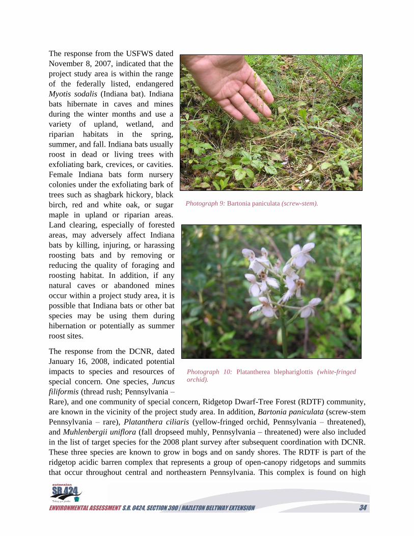
ENVIRONMENTAL ASSESSMENT S.R. 0424, SECTION 390 | HAZLETON BELTWAY EXTENSION 34
The response from the USFWS dated
November 8, 2007, indicated that the
project study area is within the range
of the federally listed, endangered
Myotis sodalis (Indiana bat). Indiana
bats hibernate in caves and mines
during the winter months and use a
variety of upland, wetland, and
riparian habitats in the spring,
summer, and fall. Indiana bats usually
roost in dead or living trees with
exfoliating bark, crevices, or cavities.
Female Indiana bats form nursery
colonies under the exfoliating bark of
trees such as shagbark hickory, black
birch, red and white oak, or sugar
maple in upland or riparian areas.
Land clearing, especially of forested
areas, may adversely affect Indiana
bats by killing, injuring, or harassing
roosting bats and by removing or
reducing the quality of foraging and
roosting habitat. In addition, if any
natural caves or abandoned mines
occur within a project study area, it is
possible that Indiana bats or other bat
species may be using them during
hibernation or potentially as summer
roost sites.
The response from the DCNR, dated
January 16, 2008, indicated potential
impacts to species and resources of
special concern. One species, Juncus
filiformis (thread rush; Pennsylvania –
Rare), and one community of special concern, Ridgetop Dwarf-Tree Forest (RDTF) community,
are known in the vicinity of the project study area. In addition, Bartonia paniculata (screw-stem
Pennsylvania – rare), Platanthera ciliaris (yellow-fringed orchid, Pennsylvania – threatened),
and Muhlenbergii uniflora (fall dropseed muhly, Pennsylvania – threatened) were also included
in the list of target species for the 2008 plant survey after subsequent coordination with DCNR.
These three species are known to grow in bogs and on sandy shores. The RDTF is part of the
ridgetop acidic barren complex that represents a group of open-canopy ridgetops and summits
that occur throughout central and northeastern Pennsylvania. This complex is found on high
Photograph 9: Bartonia paniculata (screw-stem).
Photograph 10: Platantherea blephariglottis (white-fringed
orchid).
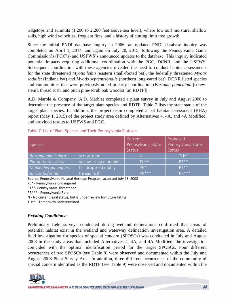
ENVIRONMENTAL ASSESSMENT S.R. 0424, SECTION 390 | HAZLETON BELTWAY EXTENSION 35
ridgetops and summits (1,200 to 2,200 feet above sea level), where low soil moisture, shallow
soils, high wind velocities, frequent fires, and a history of cutting limit tree growth.
Since the initial PNDI database inquiry in 2006, an updated PNDI database inquiry was
completed on April 1, 2014, and again on July 20, 2015, following the Pennsylvania Game
Commission’s (PGC’s) and USFWS’s announced updates to the database. This inquiry indicated
potential impacts requiring additional coordination with the PGC, DCNR, and the USFWS.
Subsequent coordination with these agencies revealed the need to conduct habitat assessments
for the state threatened Myotis leibii (eastern small-footed bat), the federally threatened Myotis
sodalist (Indiana bat) and Myotis septentrionalis (northern long-eared bat). DCNR listed species
and communities that were previously noted in early coordination (Bartonia paniculata [screw-
stem], thread rush, and pitch pine-scrub oak woodlot [an RDTF]).
A.D. Marble & Company (A.D. Marble) completed a plant survey in July and August 2008 to
determine the presence of the target plant species and RDTF. Table 7 lists the state status of the
target plant species. In addition, the project team completed a bat habitat assessment (BHA)
report (May 1, 2015) of the project study area defined by Alternatives 4, 4A, and 4A Modified,
and provided results to USFWS and PGC.
Table 7. List of Plant Species and Their Pennsylvania Statuses.
Species Current Pennsylvania State Status
Proposed Pennsylvania State Status
Bartonia paniculata screw-stem N TU^^
Platanthera ciliaris yellow-fringed orchid TU^^ PT**
Muhlenbergia uniflora fall dropseed muhly PE* PT**
Juncus filiformis thread rush PR*** PR*** Source: Pennsylvania Natural Heritage Program, accessed July 28, 2008 PE* - Pennsylvania Endangered PT**- Pennsylvania Threatened PR*** - Pennsylvania Rare N - No current legal status, but is under review for future listing TU^^ - Tentatively undetermined
Existing Conditions:
Preliminary field surveys conducted during wetland delineations confirmed that areas of
potential habitat exist in the wetland and waterway delineation investigation area. A detailed
field investigation for species of special concern (SPOSCs) was conducted in July and August
2008 in the study areas that included Alternatives 4, 4A, and 4A Modified; the investigation
coincided with the optimal identification period for the target SPOSCs. Four different
occurrences of two SPOSCs (see Table 8) were observed and documented within the July and
August 2008 Plant Survey Area. In addition, three different occurrences of the community of
special concern identified as the RDTF (see Table 9) were observed and documented within the
ENVIRONMENTAL ASSESSMENT S.R. 0424, SECTION 390 | HAZLETON BELTWAY EXTENSION 36
July and August 2008 Plant Survey Area. Thread rush, yellow-fringed orchid, and fall dropseed
muhly were not observed during the course of the survey; however, suitable habitat for these
species is present in some of the wetland areas within the July and August 2008 Plant Survey
Area.
Table 8. Plant Species of Special Concern Identified within the July and August 2008 Plant Survey Area.
Species Current PA State Status
Investigation Area
Bartonia paniculata screw-stem N 4B/4C
Platanthera blephariglottis white-fringed orchid
N 4/4A
N - No current legal status, but is under review for future listing
Table 9. Communities of Special Concern Identified within the July and August 2008 Plant Survey Area.
Plant Community Investigation Area Acreage (acres)
RDTF 1 4/4A 14.9
RDTF 2 4/4A 5.3
RDTF 3 4/4A 1.8
The response from the PFBC dated November 16, 2007, indicated no adverse impacts are
expected from the proposed project and, except for occasional transient species, rare, candidate,
threatened, or endangered species under PFBC jurisdiction are not known to exist in the vicinity
of the project study area.
The project team completed a BHA report (May 1, 2015) of the project study area defined by
Alternatives 4, 4A, and 4A Modified; and provided results to USFWS and PGC. On July 8,
2015, USFWS indicated that potential exists to injure or kill the Indiana bat, as well as the
northern long-eared bat, during the removal of trees and forested areas within the study area. The
agency requires a seasonal restriction on tree cutting. In coordination with the USFWS,
PennDOT has agreed to cut trees and forest areas within the project areas between November 15
and March 31 to avoid killing or injuring these bats. In addition, wherever possible, PennDOT
will retain shagbark hickory trees, dead and dying trees, and large diameter trees (greater than 12
inches diameter at breast height [d.b.h.]) to serve as roost trees for bats. Following the review of
the BHA report, PGC indicated on September 15, 2015, that the project would result in no
impact to the eastern small-footed bat.
The USFWS, in addition to the bat habitat recommendation, provided additional
recommendations to avoid and minimize impacts to migratory birds within the project area
ENVIRONMENTAL ASSESSMENT S.R. 0424, SECTION 390 | HAZLETON BELTWAY EXTENSION 37
(Appendix D: USFWS letter, July 8, 2015). These recommendations include restricting clearing
and maintenance activities (e.g., mowing) to the period between September 1 and March 31
when birds are no longer nesting; this restriction would avoid take of most breeding birds, their
nests, and their young. Minimization of land and vegetation disturbance during design and
construction is recommended to reduce habitat fragmentation, as well as avoid permanent habitat
alterations in areas where birds are highly concentrated. Finally, a habitat restoration plan should
be developed for the proposed project to avoid and minimize negative impacts to birds.
Additional coordination with DCNR occurred in 2015 to address potential impacts to the species
noted above, as well as the RDTF community. Following a review of the study area comprised of
Alternatives 4, 4A, and 4A Modified, DCNR indicated in a letter dated October 2, 2015, that no
impacts are anticipated to noted herbaceous species of concern if wetlands in which they have
been found would be avoided. DCNR recommended conservation measures (voluntary action) to
limit disturbance within the RDTF community to minimize impact, to the fullest extent possible,
to protect the integrity of this significant woodland. DCNR also recommends the cleaning of
construction equipment and vehicles thoroughly before they are brought on-site and to avoid
using seed mixes that include invasive plant species to re-vegetate the area in order to prevent the
spread of invasive plant species.
In an effort to stem the decline in pollinator species, such as bees and butterflies, FHWA
developed best management practices (BMPs) to help transportation agencies identify ways to
integrate pollinator friendly practices. These practices include utilizing pollinator-friendly native
wildflower seed mixes, planting flowering shrubs and trees along roadsides and medians, and
judicious mowing and herbicide use. These BMPs should be utilized, where possible, to reduce
the project’s impact on pollinator species and promote greater diversity of native vegetation
along roadsides.
Under the Natural Resources Assessment and Mitigation Agency Partnering Policy (2007),
PennDOT recognizes the environmental benefit of natural resources and need to protect
ecologically significant resources that are not otherwise protected or regulated by legislation
and/or executive orders. Under this policy, Districts are directed to consider mitigation by
application of the FHWA “reasonable expenditure of public funds” test. Those resources, such as
the RDTF, that may be significant in providing biological diversity and functional intactness of
ecosystems, as well as providing opportunities for public recreation or environmental education.
According to the policy, a natural resource may be considered a “Natural Resource Meriting
Compensation” (NRMC) if it possesses any of the Type A or Type B ecological or social
characteristics, can be documented to be significant or unique, and is likely to be significantly
impacted by the proposed project.
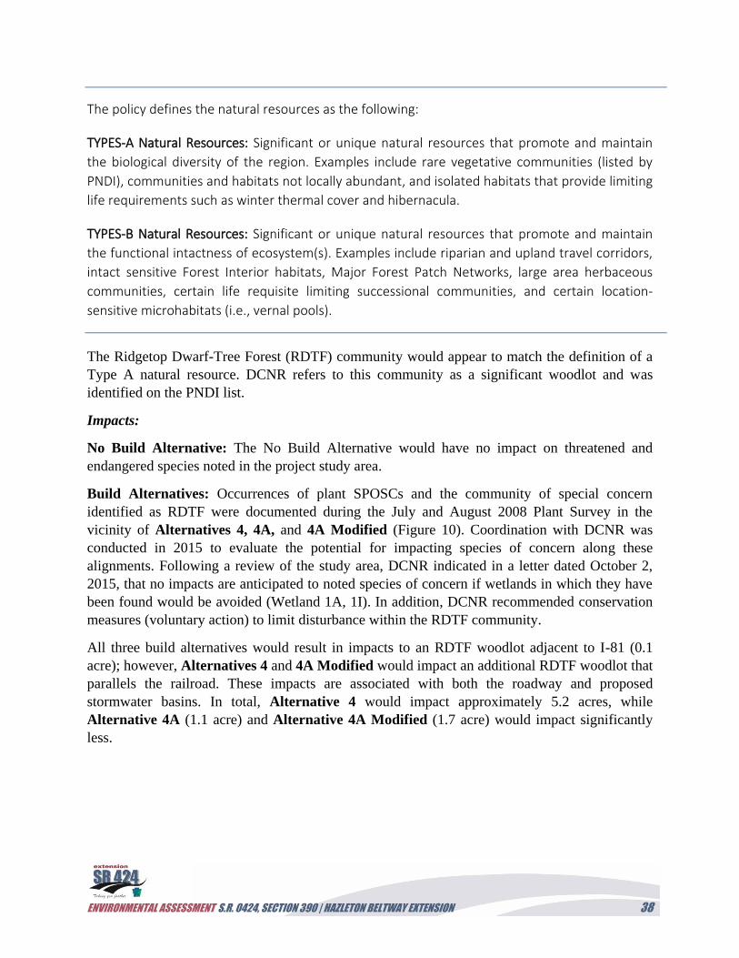
ENVIRONMENTAL ASSESSMENT S.R. 0424, SECTION 390 | HAZLETON BELTWAY EXTENSION 38
The policy defines the natural resources as the following:
TYPES-A Natural Resources: Significant or unique natural resources that promote and maintain
the biological diversity of the region. Examples include rare vegetative communities (listed by
PNDI), communities and habitats not locally abundant, and isolated habitats that provide limiting
life requirements such as winter thermal cover and hibernacula.
TYPES-B Natural Resources: Significant or unique natural resources that promote and maintain
the functional intactness of ecosystem(s). Examples include riparian and upland travel corridors,
intact sensitive Forest Interior habitats, Major Forest Patch Networks, large area herbaceous
communities, certain life requisite limiting successional communities, and certain location-
sensitive microhabitats (i.e., vernal pools).
The Ridgetop Dwarf-Tree Forest (RDTF) community would appear to match the definition of a
Type A natural resource. DCNR refers to this community as a significant woodlot and was
identified on the PNDI list.
Impacts:
No Build Alternative: The No Build Alternative would have no impact on threatened and
endangered species noted in the project study area.
Build Alternatives: Occurrences of plant SPOSCs and the community of special concern
identified as RDTF were documented during the July and August 2008 Plant Survey in the
vicinity of Alternatives 4, 4A, and 4A Modified (Figure 10). Coordination with DCNR was
conducted in 2015 to evaluate the potential for impacting species of concern along these
alignments. Following a review of the study area, DCNR indicated in a letter dated October 2,
2015, that no impacts are anticipated to noted species of concern if wetlands in which they have
been found would be avoided (Wetland 1A, 1I). In addition, DCNR recommended conservation
measures (voluntary action) to limit disturbance within the RDTF community.
All three build alternatives would result in impacts to an RDTF woodlot adjacent to I-81 (0.1
acre); however, Alternatives 4 and 4A Modified would impact an additional RDTF woodlot that
parallels the railroad. These impacts are associated with both the roadway and proposed
stormwater basins. In total, Alternative 4 would impact approximately 5.2 acres, while
Alternative 4A (1.1 acre) and Alternative 4A Modified (1.7 acre) would impact significantly
less.
ENVIRONMENTAL ASSESSMENT S.R. 0424, SECTION 390 | HAZLETON BELTWAY EXTENSION 39
Figure 10. Threatened and Endangered Species
The three build alternatives would require impacts to forestland located within the swarming
range of several bat species. A bat habitat assessment was completed for these alignments that
determined only a few roosting trees were located adjacent to the proposed alignments, and no
hibernacula were identified. The closest known hibernacula are currently identified as Priority 4
sites, with fewer than 50 individuals, and are located over 10 miles away. In addition, the project
would not affect south-facing slopes, which are a preferred habitat for foraging bats.
Coordination with the USFWS and PGC determined that if seasonal restrictions on tree cutting
are observed during construction, the project would not have an effect on bat species, including
ENVIRONMENTAL ASSESSMENT S.R. 0424, SECTION 390 | HAZLETON BELTWAY EXTENSION 40
the Indiana, northern long-eared, and eastern small-footed bats. In addition, proposed future
projects would require consultation with the USFWS; and avoidance, minimization, and
mitigation measures would be required that reduce any significant cumulative impact on these
federally listed species. Therefore, the project would not result in the degradation of bat habitat
or overall health of federally endangered or state threatened bat species.
Environmental Features/Constraint Mapping: Please refer to the Environmental Constraints
Map in Appendix B. Locations for proposed stormwater basins are noted in Appendix A
(Alternative 4) and in Appendix B (Alternatives 4A and 4A Modified).
Minimization/Mitigation:
Agency coordination with the USFWS and DCNR would continue through the final design and
permitting phase of the project. The implementation of conservation measures to avoid impacts
to bat, plant, and tree communities would be followed for the preferred alternative. These
measures would include seasonal restrictions on tree removal, installation of protective fencing
to limit disturbance of wetlands, and minimization of disturbance to the RDTF woodlots. For
example, stormwater basins located within the RDTF will be reduced in size, where possible, to
limit impacts to existing RDTF tracts. Consideration of bioretention areas and subsurface
infiltration beds, including over excavation of basins, can be explored to reduce the size of
proposed stormwater management basins and minimize impacts to the RDTF. In addition,
cleaning of construction equipment and vehicles before entering the construction site and a
restriction on the use of seed mixes with invasive plant species will be followed to prevent the
spread of these invasive species.
D. Indirect Impacts
In addition to the consideration of a project’s direct impacts, the Council on Environmental
Quality (CEQ) regulations require that the indirect impacts of a project be examined (40 CFR §
1508.25 [c]).
The project needs, as described in Section II of the report, help define the limits of the project’s
influence and quantify the indirect impacts on natural, cultural, and socioeconomic resources.
One of the most likely causes of indirect effects is project-related growth; however, even when
this growth is minimal, there remains a potential for indirect effects associated with non-growth-
related indirect effects.
Indirect impacts are defined as, “Effects which are ‘caused’ by the action and are later in time or
farther removed in distance, but are still reasonably foreseeable. Indirect impacts may include
growth inducing effects and other effects related to induced changes in the pattern of land use,
population density or growth rate, and related effects on air and water and other natural
systems, including ecosystems” (40 CFR § 1508.8 [b]).
ENVIRONMENTAL ASSESSMENT S.R. 0424, SECTION 390 | HAZLETON BELTWAY EXTENSION 41
The analyses of the potential for growth-induced effects on land use and related effects on
natural, cultural, and socioeconomic resources were completed for the build alternatives on
geology, surface water quality, and threatened and endangered species. A detailed analysis for
indirect impacts by the three build alternatives on agricultural resources, air quality and noise,
cultural resources, environmental justice communities, proposed developments, and utilities was
not completed as there were no direct, or significant, impacts to these resources. The area is in
attainment for air quality and there are no noise sensitive receptors, cultural resources, or
environmental justice communities present. The project area is already planned for development,
and that development is not dependent upon this project; therefore, additional indirect impacts to
agricultural soils or utilities would not occur due to this project.
The analyses on the noted resources above begins with a review of regional and local planning
initiatives that affect the indirect impact “area of influence,” or AOI, for the beltway extension
project. This AOI extends past the limits of disturbance of the build alternatives and takes into
account any project-related growth that would occur in the future. For this project, the limits of
the AOI extend outside of the project study area and include the entire HIP (Proper), including
Humboldt Station, West campus, and East campus, as the primary goal of this project is to
provide access to and through the HIP roadway network. In addition, the planned
(conceptualized and unfinished) developments at the intersection of I-81 and S.R. 0924 (Pagnotti
Property and CAN DO’s Cranberry Creek) and the Northwest and North HIP campuses north of
S.R. 0924 should be included in the AOI as the project could induce project development of
these areas (Figure 11). Finally, the Eagle Rock Resort is included as it represents one of the
biggest generators of traffic in the region, and its residents would benefit greatly by the improved
system linkage and incident management. No additional properties outside of the project study
area would experience induced growth as a result of the construction of the S.R. 0424 extension.
Meetings with the task force, including a public meeting, were conducted to better understand
the ongoing and proposed development within the AOI.
The regional and local planning initiatives that help to identify the pressure to develop land
within and adjacent to the HIP include the Lackawanna-Luzerne Comprehensive and Long
Range Transportation Plan (LLCLRT; McCormick Taylor 2012) and the Lackawanna-Luzerne
Long Range Transportation Plan Update (McCormick Taylor 2015), which serve as a guide for
the Metropolitan Planning Organization (MPO) to achieve desired regional development in the
two counties. As part of this planning effort, the MPO selected Priority Areas
…intended to provide a density of population sufficient to support new retail uses
and community facilities, and attract employment. Concentrating jobs and
residences in identified Priority Areas would increase transit ridership potential.
As the demand for transit emerges, local transit authorities can offer new routes or
extend existing ones. (McCormick Taylor 2012)
ENVIRONMENTAL ASSESSMENT S.R. 0424, SECTION 390 | HAZLETON BELTWAY EXTENSION 42
Figure 11. Indirect Impacts, Area of Influence
ENVIRONMENTAL ASSESSMENT S.R. 0424, SECTION 390 | HAZLETON BELTWAY EXTENSION 43
Once selected and established, these Priority Areas would help to promote greater access and
interconnectivity efforts for multi-modal forms of transportation. In effect, these areas would
help to promote local and regional development and the expansion of the public transportation
network while fostering more “walkable, bikable, and transit-friendly” areas. In addition, the
LLCLRT identifies infill areas where additional growth can be promoted. The Regional Plan
identifies one priority area, the Humboldt Center, within the AOI, and multiple priority areas
northeastward. These include the Valmont Plaza, Valmont Industrial Park, and Penn State
Hazleton priority areas. The entire project study area falls within designated infill areas. In
addition, the Greater Hazleton Area region, as a whole, is designated as Mixed Density Infill
Areas except for the portion of undeveloped land south of the existing railroad that forms the
HCA’s Mount Pleasant Reservoir watershed (McCormick Taylor 2012:Figure 2.1 Land Use
Plan). It should be noted that the HIP, as well as the three neighboring Priority Areas, are more
specifically designated a Transit Village Priority Area. These areas would involve
“transformations of existing settings that already attract people for education, employment,
shopping, or entertainment” (McCormick Taylor 2012).
Within the HIP, industrial growth has been promoted by the designation of Keystone
Opportunity Zones (KOZs). KOZ areas exist throughout the HIP and specifically adjacent to
Commerce Drive where the build alternatives would tie into the newly constructed White Birch
Road Extension, Commerce Drive, and Forest Road (see Figure C-7 in Appendix C). As of
September 2017, many of these KOZ areas were beginning to be developed or had planned
developments designed. For example, Parcel 105 (31 acres) is currently under development for a
commercial warehouse, while Parcel 103 (46.8 acres) was designed for industrial tenants with
access to rail service.
KOZ areas were established to stimulate economic development within already developed
industrial parks, focusing on light industrial uses such as manufacturing, assembly and
warehouse facilities, or office and commercial structures.
Designated conservation areas occur within the project study area. The Open Space, Greenways,
and Outdoor Recreation Master Plan (2004) identifies the HCA’s Mount Pleasant Reservoir and
drinking water watershed as conservation areas. Additional conservation areas are located east of
I-81 on either side of the existing S.R. 0424 Hazleton Beltway (McCormick Taylor 2012:Figure
2.1 Land Use Plan). According to the Open Space Plan, this area is part of the Pismire Natural
Area and is targeted for recreation and open space. Development is generally discouraged in
these areas, in particular, where incentives for development occur on adjacent properties. The
HCA, as a member of the project task force, was a driving force behind the development of
alternatives that bordered I-81 and the railroad to limit impacts to the wells and reservoirs
utilized for drinking water.
As a result, the initiatives noted above would, theoretically, encourage the development of the
previously mined land above the Reading Blue Mountain and Northern Railroad, while limiting
ENVIRONMENTAL ASSESSMENT S.R. 0424, SECTION 390 | HAZLETON BELTWAY EXTENSION 44
development of the large forest tract associated with the HCA’s drinking watershed. This can be
highlighted in the assessment of vacant land in and adjacent to the project study area. Vacant
land is present in large tracts within the project study area and east of I-81 along the S.R. 0424
Hazleton Beltway. The majority of this land is owned by Bonner Family Enterprises, HCA, and a
private landowner (Louis Beltrami). CAN DO manages the vacant land within the HIP, as well
as large tracts designated for light industrial, commercial, and residential use in the HIP
Northwest, North, and Cranberry Creek campuses north of S.R. 0924. At this time, much of this
previously strip-mined land is used as staging areas for equipment, construction material, or
regenerated forest land. In addition, a large wetland mitigation site was constructed in Humboldt
East (Lot 106) in 2007 to compensate for wetland impacts within the HIP campus.
The vacant land present in the AOI falls into three categories of development opportunities listed
below:
1. Properties with no current development plans. This category features vacant land with no
infrastructure and no current plans for development. This category includes Lot 106, the
Bonner Family Enterprises, and the HCA Mount Pleasant Reservoir property. These large
tracts of land are primarily targeted for conservation to maintain water quality or to
preserve open space and recreation. Lot 106 contains a wetland mitigation site which has
associated easements that further restrict its development. This represents approximately
18 percent, or 1,992 acres, in the AOI.
2. Properties with approved development plans. This category features vacant land with
approved development plans and existing infrastructure to serve development. Vacant
properties in the Humboldt Station complex adjacent to a recently developed hotel and
restaurants meet this criterion. These lands are cleared of vegetative cover and prepared for
development. In addition, Lot 105 has been approved for development and began grading
activities in May 2016. This represents approximately 12 percent, or 1,338 acres, in the AOI.
3. Property with conceptual plans. This category features vacant land with conceptual plans
for development, but internal access roads or infrastructure may be non-existent or
limited. The Pagnotti Property, Cranberry Creek planned development, and Lot 103 in
Humboldt East fall into this category. High cube warehousing and distribution centers, as
well as commercial development, such as restaurants and gas stations, are proposed for
the Pagnotti Property, while Lot 103 and Cranberry Creek have conceptual plans for
development; however, all remain vacant with a regenerating forest cover. In addition,
vacant properties in Humboldt West, Northwest, and North have access to limited
infrastructure, but lack approved plans at this time. This represents approximately 16
percent, or 1,764 acres, in the AOI.
While the majority of land within the AOI falls under either developed or no development plan
categories, approximately 16 percent of the AOI features parcels with at least a conceptual plan for
development and some connection to infrastructure. While it is unlikely that these parcels would be
ENVIRONMENTAL ASSESSMENT S.R. 0424, SECTION 390 | HAZLETON BELTWAY EXTENSION 45
developed in the near future, it should be noted that they all feature land that was either previously
mined or supported the strip-mining industry. Several of these properties, including Cranberry
Creek, the Pagnotti Property, and parcels in Humboldt North and Northwest, were cleared of
vegetation in the recent past in anticipation of development but have since started to regenerate a
vegetative cover. Therefore, if developed, their environmental impact would be minimal.
The remainder of the developable parcels includes property that features approved plans or no
plans for development. Potential indirect impacts to these properties would be minimal. Humboldt
Station and the Lot 105 properties have already been cleared for development or are in the process
of being developed into a warehouse facility. Environmental impacts have already been realized, as
forested and wetland areas were impacted as of May 2016. In addition, Eagle Rock Resort has
approved units for sale, residential development, and an existing roadway network, and areas with
aquatic resources have already been protected as open space outside of these lots. The fact that 90
percent of the buildable lots were sold in the resort, yet only 10 percent of them have been
developed, indicates relatively low pressure for further development. Parcels categorized in the
AOI as having no development plans include the HCA’s watershed, the private properties of the
Bonner and Beltrami families, or open areas protected as part of the HIP development plans, and
are unlikely to be affected by this project. Most of these areas contain streams and wetlands or
drinking water wells and reservoirs that make them unsuitable for further development.
The project’s AOI includes a variety of undeveloped properties in the north and western regions
which have access to infrastructure to support growth (though it is limited in some of these
regions). Properties along S.R. 0924 or directly along existing access roads within the HIP have
access to water, sewer, and electricity; however, large parcels such as the Pagnotti Property and
Cranberry Creek lack internal infrastructure to fully develop these sites. In addition, the demand
for development is relatively low based on the inability of CAN DO to find tenants for parcels
within the HIP still zoned as KOZ and the inability for Lot 103, Cranberry Creek, and Pagnotti
Property concept plans to move forward. Even properties within Humboldt Station, where
infrastructure is present, have not found commercial tenants. As a result, the potential for
project-related growth due to growth pressure is considered to be relatively low.
Impacts:
No Build Alternative: Under the No Build Alternative, developmental pressure on the existing
vacant parcels would remain unchanged, as no additional access roads would be built from S.R.
0424 or I-81 into the HIP. A proposed White Birch Road extension would provide additional
access for Humboldt West and HIP tenants to access Commerce Drive and provide a minor
improvement in travel time to S.R. 0924. As a result, properties zoned as KOZ in these park
campuses may become more favorable to future tenants. The North, Northwest, Pagnotti, and
Cranberry Creek properties would not benefit from the No Build scenario and are unlikely to
experience any accelerated growth, as traffic congestion issues at the S.R. 0924 and I-81
interchange would not be lessened.
Build Alternatives: The construction of the S.R. 0424 beltway extension would provide a new
access into the HIP from the I-81/S.R. 0424 interchange. In any of the Alternatives 4, 4A, or 4A
ENVIRONMENTAL ASSESSMENT S.R. 0424, SECTION 390 | HAZLETON BELTWAY EXTENSION 46
Modified scenarios, traffic congestion related to HIP traffic and incident management would
improve, especially during peak travel periods. In particular, these alternatives would help
mitigate the failing LOS in the build year 2018 through 2038, as analyzed in the Traffic Analysis
Report. In addition, access directly to vacant properties in Humboldt East, Humboldt Station, and
HIP (Proper) should improve with the new connection to Commerce Drive, making these parcels
more desirable to tenants. Eagle Rock Resort residents would also benefit from the increased
system linkage and access to a detour route for incident management along I-81 or S.R. 0924.
However, a closer look at the vacant properties in these campuses suggests that development
pressure would not significantly increase. For example, Lots 103 and 106 are designated as
KOZ, but only until the end of 2017. With the extension unlikely to be built by then, tax benefits
for developing these sites would end. In addition, environmental concerns are present on these
sites that may continue to dissuade tenants, including their location within the PPL-Hardwood
hazardous waste site, the presence of existing wetlands or a wetland mitigation site, and the PPL
Electrical transmission line, which crosses over Lot 103. Finally, the lack of development in the
resort, despite 90 percent sale of buildable lots, suggests that other factors besides the
transportation network are dissuading owners from beginning construction.
All other vacant properties, including the North, Northwest, Pagnotti Property, and Cranberry
Creek sites, as well as undeveloped lots in Eagle Rock Resort, would not gain additional direct
access from the build alternatives. Any benefit they attain from the proposed project would be
related to incident management and the availability of an alternate route through the HIP to the
S.R. 0424 and I-81 interchange. While this should help traffic flow and incident management
along S.R. 0924 and I-81 in the vicinity of the project, it is unlikely to spur the development of
these properties if economic pressures remain constant. These parcels have been available since
the early 2000s and are associated with redevelopment initiatives related to the Humboldt Center
Priority Area, including many assigned as KOZs. Finally, additional vacant land is located within
Priority Areas just north of the project study area at CAN DO’s Valmont Industrial Park, which
further reduces the development pressures in the AOI. As a result, the development of vacant
parcels within the AOI is not dependent upon the construction of the S.R. 0424 Beltway
Extension. Therefore, the indirect impact of the build alternatives would be minimal on geology,
surface water quality, and threatened and endangered species, as the project would not induce
indirect impacts to these resources.
Environmental Features/Constraint Mapping:
Please refer to the Environmental Constraints Map in Appendix B.
Minimization/Mitigation:
No additional mitigation is proposed as part of S.R. 0424 Beltway Extension project for indirect
impacts. Existing local and regional planning, as well as existing environmental protection
efforts, would continue to preserve open spaces and promote land development practices that
reduce impacts on natural and cultural resources in the vicinity of the project study area.
ENVIRONMENTAL ASSESSMENT S.R. 0424, SECTION 390 | HAZLETON BELTWAY EXTENSION 47
E. Cumulative Impacts
In addition to the consideration of a project’s direct impacts, the Council on Environmental Quality
(CEQ) regulations require that the cumulative impacts of a project be examined (40 CFR §
1508.25 [c]). The project needs, as described in Section II, help define the limits of the project’s
influence and quantify the cumulative impacts on natural, cultural, and socioeconomic resources.
A cumulative impact is defined as, “Impact on the environment which results from the
incremental impact of the action when added to other past, present, and reasonably foreseeable
future actions regardless of what agency (Federal or non-federal) or person undertakes such
other actions” (40 CFR § 1508.7).
Documentation of cumulative impacts includes an analysis of potential incremental impacts to
significant environmental features as a result of the proposed S.R. 0424, Section 390 Hazleton
Beltway Extension Project. These incremental impacts can result in individually minor but
collectively significant impacts occurring over a period of time when added to other past,
present, and reasonably foreseeable future actions. Resources that are not significantly impacted
by the project are not a focus of this analysis (e.g., soils of statewide importance).
Methodology:
This cumulative effects analysis begins with the identification of resources that would be directly
and/or indirectly affected by the proposed alternatives (Alternatives 4, 4A, and 4A Modified). A
boundary, or Resource Study Area (RSA), is assigned to each resource along with time frames for
a past and future trend analysis. The time frames affecting these resources are established based on
available information in county comprehensive plans; Long Range Transportation Plans;
PennDOT’s Four & Twelve Year Plans (TYP) and Transportation Improvement Plans (TIP);
resource agency inventories; and from meetings with local stakeholders (i.e., CAN DO). Potential
impacts resulting from these future projects were assessed based on the type of project (e.g.,
resurfacing), previous knowledge of such projects, and professional judgment. The proposed
project’s impacts were then combined with an analysis of past trends and future potential effects to
generate a potential cumulative effect. The current condition of the resource and the likelihood the
resource would recover from the impact determined the significance of the cumulative effect.
Cumulative Effects Study Area Boundaries:
Each resource impacted by the proposed project needs to be evaluated for its cumulative impacts
within an established RSA (PennDOT 2008). The RSA is defined as a “geographic area” within
which the impacts on a particular resource are analyzed. The proposed S.R. 0424, Section 390
Hazleton Beltway Extension Project would have direct/indirect impacts on aquatic resources,
forestland (Pismir Ridge Natural Area, including the Ridgetop Dwarf-Tree Forest community),
and threatened and endangered wildlife (Indiana, northern long-eared, and eastern small-footed
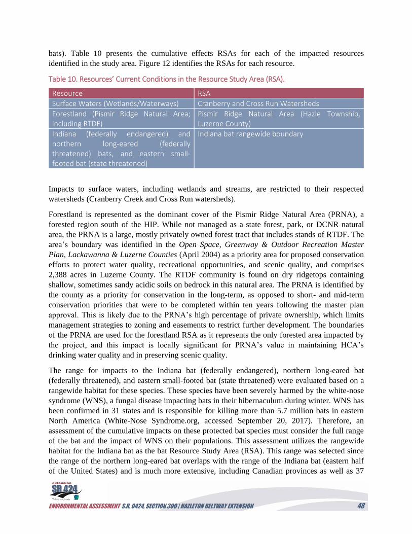
ENVIRONMENTAL ASSESSMENT S.R. 0424, SECTION 390 | HAZLETON BELTWAY EXTENSION 48
bats). Table 10 presents the cumulative effects RSAs for each of the impacted resources
identified in the study area. Figure 12 identifies the RSAs for each resource.
Table 10. Resources’ Current Conditions in the Resource Study Area (RSA).
Resource RSA
Surface Waters (Wetlands/Waterways) Cranberry and Cross Run Watersheds
Forestland (Pismir Ridge Natural Area; including RTDF)
Pismir Ridge Natural Area (Hazle Township, Luzerne County)
Indiana (federally endangered) and northern long-eared (federally threatened) bats, and eastern small-footed bat (state threatened)
Indiana bat rangewide boundary
Impacts to surface waters, including wetlands and streams, are restricted to their respected
watersheds (Cranberry Creek and Cross Run watersheds).
Forestland is represented as the dominant cover of the Pismir Ridge Natural Area (PRNA), a
forested region south of the HIP. While not managed as a state forest, park, or DCNR natural
area, the PRNA is a large, mostly privately owned forest tract that includes stands of RTDF. The
area’s boundary was identified in the Open Space, Greenway & Outdoor Recreation Master
Plan, Lackawanna & Luzerne Counties (April 2004) as a priority area for proposed conservation
efforts to protect water quality, recreational opportunities, and scenic quality, and comprises
2,388 acres in Luzerne County. The RTDF community is found on dry ridgetops containing
shallow, sometimes sandy acidic soils on bedrock in this natural area. The PRNA is identified by
the county as a priority for conservation in the long-term, as opposed to short- and mid-term
conservation priorities that were to be completed within ten years following the master plan
approval. This is likely due to the PRNA’s high percentage of private ownership, which limits
management strategies to zoning and easements to restrict further development. The boundaries
of the PRNA are used for the forestland RSA as it represents the only forested area impacted by
the project, and this impact is locally significant for PRNA’s value in maintaining HCA’s
drinking water quality and in preserving scenic quality.
The range for impacts to the Indiana bat (federally endangered), northern long-eared bat
(federally threatened), and eastern small-footed bat (state threatened) were evaluated based on a
rangewide habitat for these species. These species have been severely harmed by the white-nose
syndrome (WNS), a fungal disease impacting bats in their hibernaculum during winter. WNS has
been confirmed in 31 states and is responsible for killing more than 5.7 million bats in eastern
North America (White-Nose Syndrome.org, accessed September 20, 2017). Therefore, an
assessment of the cumulative impacts on these protected bat species must consider the full range
of the bat and the impact of WNS on their populations. This assessment utilizes the rangewide
habitat for the Indiana bat as the bat Resource Study Area (RSA). This range was selected since
the range of the northern long-eared bat overlaps with the range of the Indiana bat (eastern half
of the United States) and is much more extensive, including Canadian provinces as well as 37
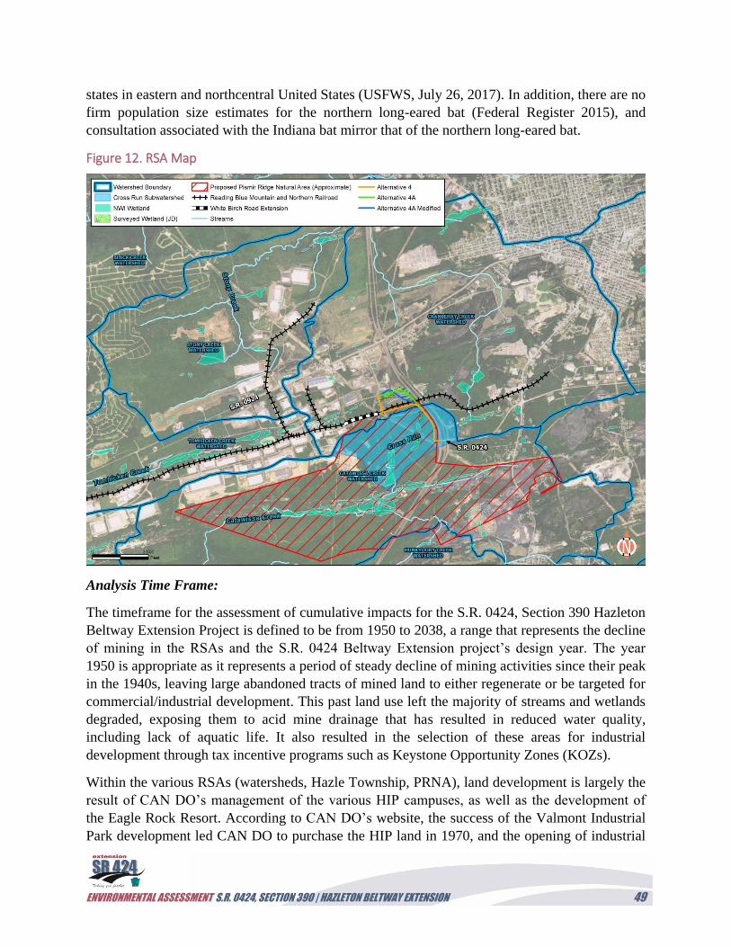
ENVIRONMENTAL ASSESSMENT S.R. 0424, SECTION 390 | HAZLETON BELTWAY EXTENSION 49
states in eastern and northcentral United States (USFWS, July 26, 2017). In addition, there are no
firm population size estimates for the northern long-eared bat (Federal Register 2015), and
consultation associated with the Indiana bat mirror that of the northern long-eared bat.
Figure 12. RSA Map
Analysis Time Frame:
The timeframe for the assessment of cumulative impacts for the S.R. 0424, Section 390 Hazleton
Beltway Extension Project is defined to be from 1950 to 2038, a range that represents the decline
of mining in the RSAs and the S.R. 0424 Beltway Extension project’s design year. The year
1950 is appropriate as it represents a period of steady decline of mining activities since their peak
in the 1940s, leaving large abandoned tracts of mined land to either regenerate or be targeted for
commercial/industrial development. This past land use left the majority of streams and wetlands
degraded, exposing them to acid mine drainage that has resulted in reduced water quality,
including lack of aquatic life. It also resulted in the selection of these areas for industrial
development through tax incentive programs such as Keystone Opportunity Zones (KOZs).
Within the various RSAs (watersheds, Hazle Township, PRNA), land development is largely the
result of CAN DO’s management of the various HIP campuses, as well as the development of
the Eagle Rock Resort. According to CAN DO’s website, the success of the Valmont Industrial
Park development led CAN DO to purchase the HIP land in 1970, and the opening of industrial
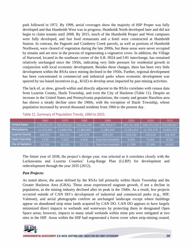
ENVIRONMENTAL ASSESSMENT S.R. 0424, SECTION 390 | HAZLETON BELTWAY EXTENSION 50
park followed in 1972. By 1999, aerial coverages show the majority of HIP Proper was fully
developed and that Humboldt West was in progress; Humboldt North developed later and did not
begin to claim tenants until 2008. By 2015, much of the Humboldt Proper and West campuses
were fully developed, and fast food restaurants and a hotel were constructed at Humboldt
Station. In contrast, the Pagnotti and Cranberry Creek parcels, as well as portions of Humboldt
Northwest, were cleared of vegetation during the late 2000s, but these areas were never occupied
by tenants and are now in the process of regenerating a vegetative cover. In addition, the Village
of Harwood, located in the southeast corner of the S.R. 0924 and I-81 interchange, has remained
relatively unchanged since the 1950s, indicating very little pressure for residential growth in
conjunction with local economic development. Besides these changes, there has been very little
development within the RSAs since mining declined in the 1950s. Further, regional development
has been concentrated in commercial and industrial parks where economic development was
spurred by tax-based incentives (e.g., KOZ) to develop areas impacted by past mining activities.
The lack of, or slow, growth within and directly adjacent to the RSAs correlates with census data
from Luzerne County, Hazle Township, and even the City of Hazleton (Table 11). Despite an
increase in the United States and Pennsylvania populations, the county and greater Hazelton area
has shown a steady decline since the 1960s, with the exception of Hazle Township, whose
population increased by several thousand residents from 1960 to the present day.
Table 11. Summary of Population Trends, 1960 to 2015.
1960 1970 1980 1990 2000 2010 2015
United States 179,323,175 203,302,031 226,542,199 248,709,873 281,421,906 308,745,538 320,090,857
Pennsylvania 11,319,366 11,800,766 11,863,895 11,881,643 12,281,054 12,702,379 12,802,503
Luzerne County 346,972 342,211 343,079 328,149 319,250 320,918 318,449
Hazle Township 7,478 7,619 9,458 Data Not Available 9,000 9,544 9,563
City of Hazleton 32,056 30,426 27,113 Data Not Available 23,399 25,340 24,932
The future year of 2038, the project’s design year, was selected as it correlates closely with the
Lackawanna and Luzerne Counties’ Long-Range Plan (LLRP) for development and
redevelopment through the year 2035 (2012).
Past Projects:
As noted above, the areas defined by the RSAs fall primarily within Hazle Township and the
Greater Hazleton Area (GHA). These areas experienced stagnant growth, if not a decline in
population, as the mining industry declined after its peak in the 1940s. As a result, few projects
occurred outside of CAN DO’s development of industrial and commercial parks (e.g., HIP,
Valmont), and aerial photographs confirm an unchanged landscape except where buildings
appear on abandoned strip mine lands acquired by CAN DO. CAN DO appears to have largely
minimized direct impacts to wetlands and waterways by protecting them in designated Open
Space areas; however, impacts to many small wetlands within mine pits were mitigated at two
sites in the HIP. Areas within the HIP had regenerated a forest cover when strip-mining ceased,
ENVIRONMENTAL ASSESSMENT S.R. 0424, SECTION 390 | HAZLETON BELTWAY EXTENSION 51
but they have since been cleared for redevelopment. Forestland south of the railroad within the
HCA drinking watershed, and more extensively within the planned PRNA, has largely remained
intact except for the land occupied by the active Bonner junkyard.
Current Conditions:
Aquatic resources were identified from an assessment of NWI mapped wetlands within the
watersheds. There are currently 106.5 acres and 38.2 acres of NWI wetland (primarily palustrine
open water [POW] wetlands associated with mine pits) in the Cranberry Creek and Cross Run
watersheds, respectively. In addition, these watersheds contain 36,459.6 linear feet (Cranberry)
and 4,903.6 linear feet (Cross Run) of streams.
Utilizing available GIS layers, the PRNA was identified as being 2,388 acres in size in Luzerne
County, with approximately 1,738.8 acres of forestland. Twenty-three acres of RTDF were
delineated within the investigation corridors of the three reasonable alternative alignments;
however, the exact total acreage of RTDF is difficult to estimate in the PRNA without
conducting a ground survey. An estimate can be developed based on the ridgetop elevations that
correlate with the delineated RTDF within the PRNA. In total, there are 485.3 acreages of
ridgetops that correlate with the expected range for RTDF in the PRNA.
According to the Pennsylvania Game Commission (PGC), there are 18 known Indiana bat
hibernacula in 11 Pennsylvania counties, the largest of which is located at Canoe Creek Mine
(J.D. Hartman Mine) in Blair County (PGC 2010). This hibernaculum supports approximately 90
percent of the Indiana bat population and is located approximately 120 miles from the project
study area. The closest hibernacula to the project study area are the Shickshinny and the Glen
Lyon mine hibernacula, which are located approximately 15 miles from the study area. These
winter hibernacula are protected mines that are listed as Priority 4 sites (i.e., sites that are least
important for recovery and long-term conservation of M. sodalist due to the observed historic
populations of less than 50 bats; USFWS 2007). Studies of the Pennsylvania Indiana bat
population show an increase due in part to gating to reduce human disturbance and predation by
feral cats, owls, and black snakes during swarming periods. However, WNS has recently become
a major threat to cave bat populations (PGC 2010). The 2017 rangewide population for M.
sodalist is 530,705, with 229 hibernacula in 17 states (USFWS, July 5, 2017). Since 2007,
Pennsylvania is one of the largest states experiencing a net loss of Indiana bats, with the
population decreasing from 1,015 (2007) to 23 individuals in 2017 (USFWS, July 5, 2017). In
regards to the northern long-eared bat, population declines are estimated at 99 percent in the
Northeastern United States (USFWS 2016)
Mature forests, which offer habitat for roosting bats in the summer following spring emergence,
are critical for both M. sodalist and M. septentrionalis bat survivorship that were also found to
prefer insect-foraging habitat on gentle to moderate south-facing slopes covered by mixed oak
and northern hardwood forests (PGC 2010). Protected forests in the county consist of the 8,813-
acre Nanticoke tract of the Lackawanna State Forest. In addition, Nescopeck and Ricketts Glen
state parks, comprising 3,550 and 13,050 acres in Luzerne County, respectively, and a portion of
the 4,548 acres of the Lehigh Gorge State Park, all feature large protected forest habitat that
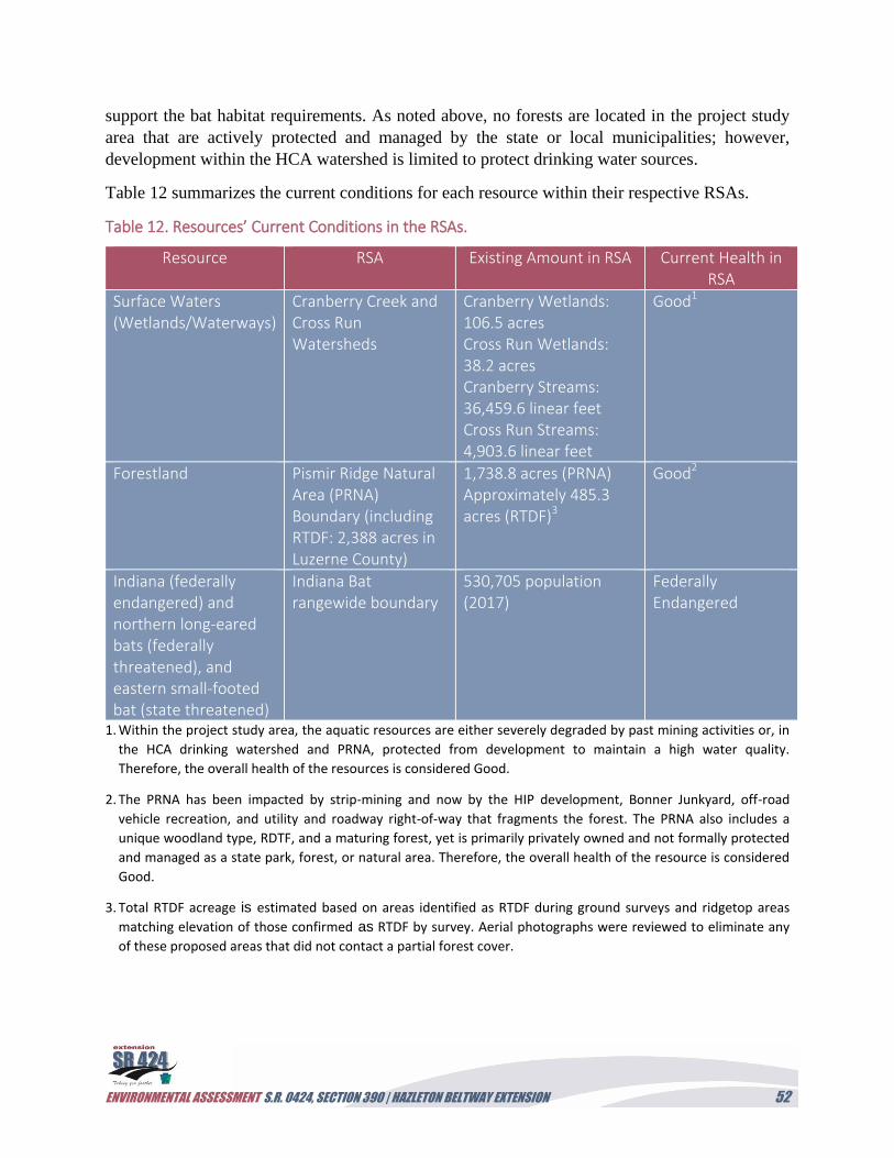
ENVIRONMENTAL ASSESSMENT S.R. 0424, SECTION 390 | HAZLETON BELTWAY EXTENSION 52
support the bat habitat requirements. As noted above, no forests are located in the project study
area that are actively protected and managed by the state or local municipalities; however,
development within the HCA watershed is limited to protect drinking water sources.
Table 12 summarizes the current conditions for each resource within their respective RSAs.
Table 12. Resources’ Current Conditions in the RSAs.
Resource RSA Existing Amount in RSA Current Health in RSA
Surface Waters (Wetlands/Waterways)
Cranberry Creek and Cross Run Watersheds
Cranberry Wetlands: 106.5 acres Cross Run Wetlands: 38.2 acres Cranberry Streams: 36,459.6 linear feet Cross Run Streams: 4,903.6 linear feet
Good1
Forestland Pismir Ridge Natural Area (PRNA) Boundary (including RTDF: 2,388 acres in Luzerne County)
1,738.8 acres (PRNA) Approximately 485.3 acres (RTDF)3
Good2
Indiana (federally endangered) and northern long-eared bats (federally threatened), and eastern small-footed bat (state threatened)
Indiana Bat rangewide boundary
530,705 population (2017)
Federally Endangered
1. Within the project study area, the aquatic resources are either severely degraded by past mining activities or, in
the HCA drinking watershed and PRNA, protected from development to maintain a high water quality.
Therefore, the overall health of the resources is considered Good.
2. The PRNA has been impacted by strip-mining and now by the HIP development, Bonner Junkyard, off-road
vehicle recreation, and utility and roadway right-of-way that fragments the forest. The PRNA also includes a
unique woodland type, RDTF, and a maturing forest, yet is primarily privately owned and not formally protected
and managed as a state park, forest, or natural area. Therefore, the overall health of the resource is considered
Good.
3. Total RTDF acreage is estimated based on areas identified as RTDF during ground surveys and ridgetop areas
matching elevation of those confirmed as RTDF by survey. Aerial photographs were reviewed to eliminate any
of these proposed areas that did not contact a partial forest cover.
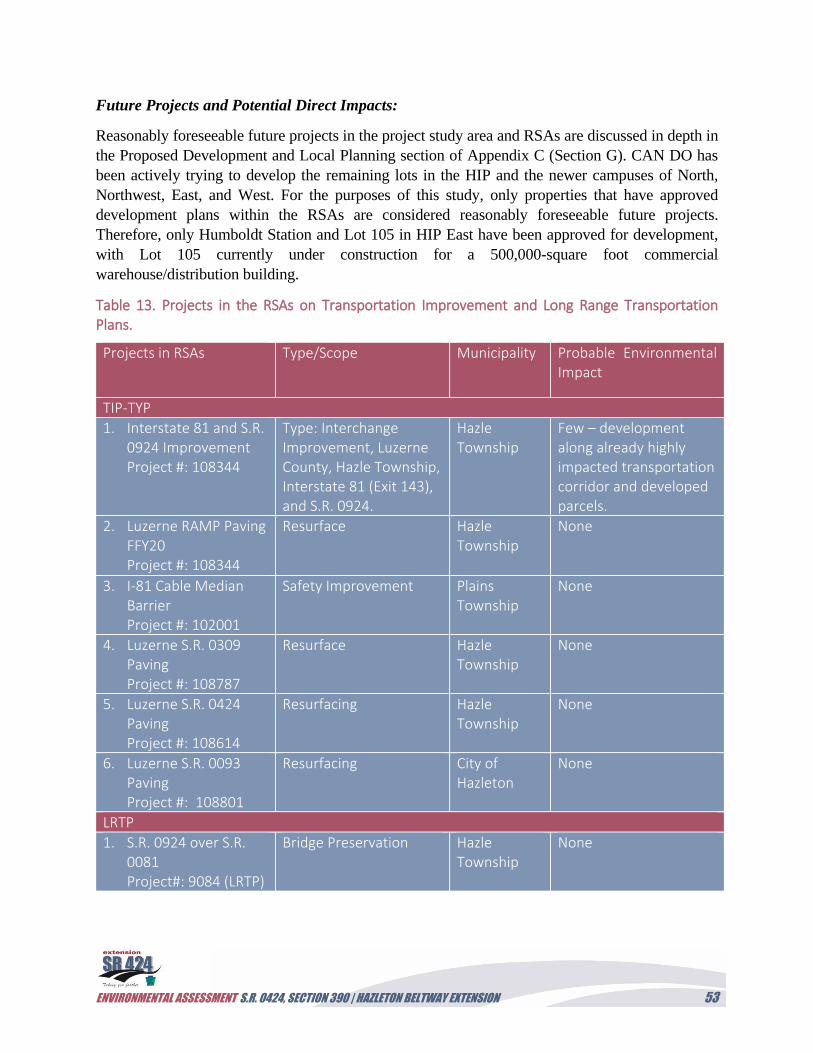
ENVIRONMENTAL ASSESSMENT S.R. 0424, SECTION 390 | HAZLETON BELTWAY EXTENSION 53
Future Projects and Potential Direct Impacts:
Reasonably foreseeable future projects in the project study area and RSAs are discussed in depth in
the Proposed Development and Local Planning section of Appendix C (Section G). CAN DO has
been actively trying to develop the remaining lots in the HIP and the newer campuses of North,
Northwest, East, and West. For the purposes of this study, only properties that have approved
development plans within the RSAs are considered reasonably foreseeable future projects.
Therefore, only Humboldt Station and Lot 105 in HIP East have been approved for development,
with Lot 105 currently under construction for a 500,000-square foot commercial
warehouse/distribution building.
Table 13. Projects in the RSAs on Transportation Improvement and Long Range Transportation Plans.
Projects in RSAs Type/Scope Municipality Probable Environmental Impact
TIP-TYP
1. Interstate 81 and S.R. 0924 Improvement Project #: 108344
Type: Interchange Improvement, Luzerne County, Hazle Township, Interstate 81 (Exit 143), and S.R. 0924.
Hazle Township
Few – development along already highly impacted transportation corridor and developed parcels.
2. Luzerne RAMP Paving FFY20 Project #: 108344
Resurface Hazle Township
None
3. I-81 Cable Median Barrier Project #: 102001
Safety Improvement Plains Township
None
4. Luzerne S.R. 0309 Paving Project #: 108787
Resurface Hazle Township
None
5. Luzerne S.R. 0424 Paving Project #: 108614
Resurfacing Hazle Township
None
6. Luzerne S.R. 0093 Paving Project #: 108801
Resurfacing City of Hazleton
None
LRTP
1. S.R. 0924 over S.R. 0081 Project#: 9084 (LRTP)
Bridge Preservation Hazle Township
None
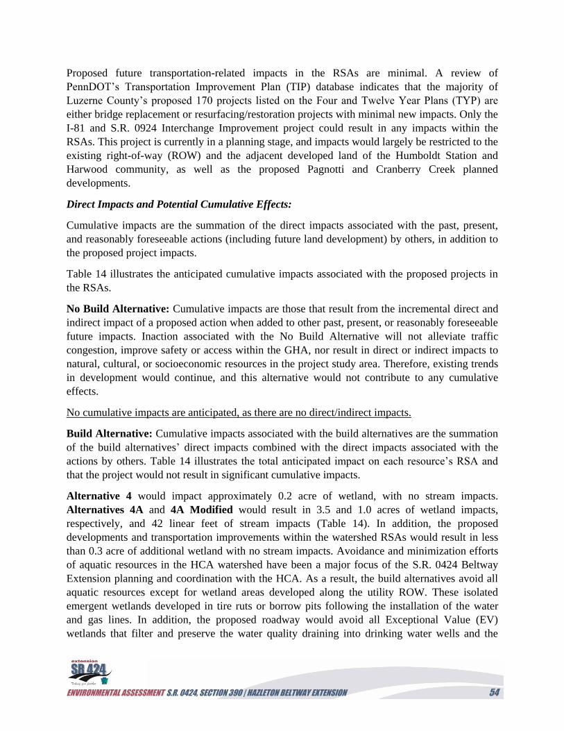
ENVIRONMENTAL ASSESSMENT S.R. 0424, SECTION 390 | HAZLETON BELTWAY EXTENSION 54
Proposed future transportation-related impacts in the RSAs are minimal. A review of
PennDOT’s Transportation Improvement Plan (TIP) database indicates that the majority of
Luzerne County’s proposed 170 projects listed on the Four and Twelve Year Plans (TYP) are
either bridge replacement or resurfacing/restoration projects with minimal new impacts. Only the
I-81 and S.R. 0924 Interchange Improvement project could result in any impacts within the
RSAs. This project is currently in a planning stage, and impacts would largely be restricted to the
existing right-of-way (ROW) and the adjacent developed land of the Humboldt Station and
Harwood community, as well as the proposed Pagnotti and Cranberry Creek planned
developments.
Direct Impacts and Potential Cumulative Effects:
Cumulative impacts are the summation of the direct impacts associated with the past, present,
and reasonably foreseeable actions (including future land development) by others, in addition to
the proposed project impacts.
Table 14 illustrates the anticipated cumulative impacts associated with the proposed projects in
the RSAs.
No Build Alternative: Cumulative impacts are those that result from the incremental direct and
indirect impact of a proposed action when added to other past, present, or reasonably foreseeable
future impacts. Inaction associated with the No Build Alternative will not alleviate traffic
congestion, improve safety or access within the GHA, nor result in direct or indirect impacts to
natural, cultural, or socioeconomic resources in the project study area. Therefore, existing trends
in development would continue, and this alternative would not contribute to any cumulative
effects.
No cumulative impacts are anticipated, as there are no direct/indirect impacts.
Build Alternative: Cumulative impacts associated with the build alternatives are the summation
of the build alternatives’ direct impacts combined with the direct impacts associated with the
actions by others. Table 14 illustrates the total anticipated impact on each resource’s RSA and
that the project would not result in significant cumulative impacts.
Alternative 4 would impact approximately 0.2 acre of wetland, with no stream impacts.
Alternatives 4A and 4A Modified would result in 3.5 and 1.0 acres of wetland impacts,
respectively, and 42 linear feet of stream impacts (Table 14). In addition, the proposed
developments and transportation improvements within the watershed RSAs would result in less
than 0.3 acre of additional wetland with no stream impacts. Avoidance and minimization efforts
of aquatic resources in the HCA watershed have been a major focus of the S.R. 0424 Beltway
Extension planning and coordination with the HCA. As a result, the build alternatives avoid all
aquatic resources except for wetland areas developed along the utility ROW. These isolated
emergent wetlands developed in tire ruts or borrow pits following the installation of the water
and gas lines. In addition, the proposed roadway would avoid all Exceptional Value (EV)
wetlands that filter and preserve the water quality draining into drinking water wells and the
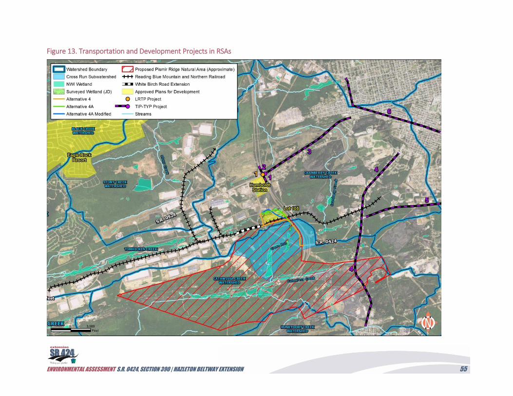
ENVIRONMENTAL ASSESSMENT S.R. 0424, SECTION 390 | HAZLETON BELTWAY EXTENSION 55
Figure 13. Transportation and Development Projects in RSAs
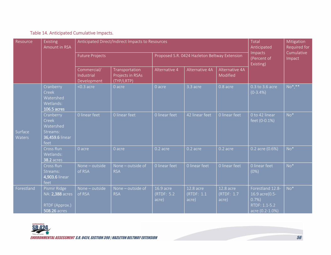
ENVIRONMENTAL ASSESSMENT S.R. 0424, SECTION 390 | HAZLETON BELTWAY EXTENSION 56
Table 14. Anticipated Cumulative Impacts.
Resource Existing Amount in RSA
Anticipated Direct/Indirect Impacts to Resources Total Anticipated Impacts (Percent of Existing)
Mitigation Required for Cumulative Impact
Future Projects Proposed S.R. 0424 Hazleton Beltway Extension
Commercial/ Industrial Development
Transportation Projects in RSAs (TYP/LRTP)
Alternative 4 Alternative 4A Alternative 4A Modified
Surface Waters
Cranberry Creek Watershed Wetlands: 106.5 acres
<0.3 acre 0 acre 0 acre 3.3 acre 0.8 acre 0.3 to 3.6 acre (0-3.4%)
No*,**
Cranberry Creek Watershed Streams: 36,459.6 linear feet
0 linear feet 0 linear feet 0 linear feet 42 linear feet 0 linear feet 0 to 42 linear feet (0-0.1%)
No*
Cross Run Wetlands: 38.2 acres
0 acre 0 acre 0.2 acre 0.2 acre 0.2 acre 0.2 acre (0.6%) No*
Cross Run Streams: 4,903.6 linear feet
None – outside of RSA
None – outside of RSA
0 linear feet 0 linear feet 0 linear feet 0 linear feet (0%)
No*
Forestland Pismir Ridge NA: 2,388 acres RTDF (Approx.) 508.26 acres
None – outside of RSA
None – outside of RSA
16.9 acre (RTDF: 5.2 acre)
12.8 acre (RTDF: 1.1 acre)
12.8 acre (RTDF: 1.7 acre)
Forestland 12.8-16.9 acre(0.5-0.7%) RTDF: 1.1-5.2 acre (0.2-1.0%)
No*
ENVIRONMENTAL ASSESSMENT S.R. 0424, SECTION 390 | HAZLETON BELTWAY EXTENSION 57
Resource Existing Amount in RSA
Anticipated Direct/Indirect Impacts to Resources Total Anticipated Impacts (Percent of Existing)
Mitigation Required for Cumulative Impact
Future Projects Proposed S.R. 0424 Hazleton Beltway Extension
Commercial/ Industrial Development
Transportation Projects in RSAs (TYP/LRTP
Alternative 4 Alternative 4A Alternative 4A Modified
Indiana (federally endangered) and northern long-eared bats (federally threatened), and eastern small-footed bat (state threatened)
530,705 population (Indiana bat, 2017)
No impact anticipated with seasonal restriction on tree removal
No impact anticipated with seasonal restriction on tree removal
No impact anticipated with seasonal restriction on tree removal
No impact anticipated with seasonal restriction on tree removal
No impact anticipated with seasonal restriction on tree removal
No impact No impact to health of bat populations
* Cumulative impacts <1% are considered negligible and would not require mitigation.
** Minimization and avoidance measures would be utilized to further limit impacts. Mitigation of direct impacts would be completed as part of permitting for
unavoidable impacts.
ENVIRONMENTAL ASSESSMENT S.R. 0424, SECTION 390 | HAZLETON BELTWAY EXTENSION 58
Mount Pleasant Reservoir. Finally, a closed drainage system would direct roadway runoff from
this watershed into detention ponds in Cranberry Creek and then into a borrow pit south of
Harwood. This system would reduce traffic-related pollutant loads from affecting HCA’s
watershed. Wetland mitigation has been developed for previous impacts in the HIP and would be
expanded, where possible, to compensate for unavoidable impacts of the build alternatives.
Therefore, as the overall impact to aquatic resources is small (e.g., maximum of 2.2 percent of
wetland and 0.1 percent of stream in the Cranberry Creek Watershed), and efforts are proposed
to offset these direct impacts, the project would not result in cumulative impacts to aquatic
resources in either the Cross Run or Cranberry Creek watersheds.
Forestland (including the RTDF community) within the PRNA would be impacted by the build
alternative alignments. Specifically, a maximum of 16.94 acres of forest would be cleared
(including 5.2 acres of RTDF) as a result of Alternative 4’s construction, with fewer impacts
associated with the other two alternatives (Table 14). The proposed development and
transportation improvements in the region would not impact the forestland RSA, as these
projects are located north of the natural area within the HIP campuses or along existing
transportation corridors. As a result, no additional impacts are anticipated. The proposed
alternative alignments were also moved closer to I-81 to reduce their impact on the HCA
watershed; this decision also reduces the overall fragmentation of the forestland as well as
reduces impacts to the PRNA’s interior. Therefore, as the overall impact to forestland is small
(<0.9%) relative to the entire forested PRNA, the project would not result in significant
cumulative impacts to forestland resources, including RTDF, in the PRNA.
As noted above, the S.R. 0424, Section 390 Hazleton Beltway Extension Project would require
impacts to forestland located within the swarming range of several bat species. These forested
impacts are a maximum of 16.9 acres with no impacts associated with proposed development in
the project study. In fact, projects approved for development in the HIP are located on land
parcels where forest cover has already been removed. Additional approved developments in the
Eagle Rock Resort are for residential homes where development has been slow and not related to
development of the S.R. 0424 extension. In addition, a bat habitat assessment was completed for
these alignments and determined only a few roosting trees were located adjacent to the proposed
alignments. No hibernacula will be impacted by the project, and the project would not affect
south-facing slopes that are a preferred habitat for foraging bats. As a result, the USFWS and
PGC determined that the project will avoid killing or injuring Indiana and northern long-eared
bats if PennDOT agrees to cut trees between November 16 to March 31 and retain any shagbark
hickory trees, dead and dying trees, and large diameter trees (>12 inches d.b.h.). Therefore, the
project would not result in the degradation of bat habitat or overall health of federally
endangered or state threatened bat species. In comparison to the 2017 rangewide population for
M. sodalist (530,705), and similarly to the much larger range of M. septentrionalis bats, this
project would not have a significant impact on bat populations, nor would the project result in a
cumulative impact that further significantly diminishes protected bat species populations in
comparison to the harmful effects of WNS.
ENVIRONMENTAL ASSESSMENT S.R. 0424, SECTION 390 | HAZLETON BELTWAY EXTENSION 59
Minimization/Mitigation:
No additional mitigation is proposed as part of the S.R. 0424, Section 390 Hazleton Beltway
extension project. This project would include mitigation for direct impacts associated with the
construction of the new roadway. Development within the RSAs would likely require adherence
to state and federal rules and regulations and review as part of the environmental permit approval
process, including Section 404-Chapter 105 Joint Permit and National Pollution Discharge
Elimination System (NPDES) Permits reviewed by the PADEP, USACE, and the Luzerne
County Conservation District. These permits require steps to demonstrate the avoidance and
minimization of impacts to water resources, forest impacts, and threatened and endangered
species, and provide compensatory mitigation for unavoidable impacts.
VI. Public Comment and Agency Coordination
The alternatives evaluation meetings conducted with both public and resource agencies are a
critical component of the environmental assessment process. These meetings often reveal new
alternatives that meet the project’s purpose and needs or uncover unintended impacts or
consequences that render a proposed alternative unsuitable for further study. Table 15
summarizes the efforts to engage the local stakeholders (task force), the general public, and
resource agencies during the selection process. These meetings are discussed in Section IV, and
more information can be found in the Project Technical File.
Table 15. Public and Agency Coordination Meetings.
Activity Date Purpose/Outcome
Project Kickoff Meeting
2/2/2007 Alternatives, including the No Build Alternative, were screened for meeting the purpose and needs. Alternatives 1, 1A, and 3 were not considered viable options.
Task Force Meeting #1
6/21/2007 All alternatives, including the No Build Alternative, were presented to the task force. Alternatives 3A and 4D were identified as potentially reducing impacts to the HCA Watershed.
Agency Coordination Meeting
8/21/2007 The agencies reviewed all of the alternatives, including the No Build Alternative. Alternatives 4, 4A, 4B, 4C, and 4D were recommended forward for further study.
Task Force Meeting #2
12/21/2007 The task force reviewed all alternatives, including the No Build Alternative, as well as recommendations provided by the agencies for further study of Alternatives 4, 4A, 4B, 4C, and 4D.
ENVIRONMENTAL ASSESSMENT S.R. 0424, SECTION 390 | HAZLETON BELTWAY EXTENSION 60
Activity Date Purpose/Outcome
Public Meeting 6/24/2008 Alternatives 4, 4A, 4B, 4C, and 4D, as well as the No Build Alternative, were presented to public. The public reviewed Alternatives 3A and 6.
Task Force Meeting #3
11/5/2009 The task force reviewed the results of the value planning session, agency coordination meeting, public involvement, and environmental studies completed to date. Modifications to Alternative 4 were also discussed to minimize the impact to the watershed. Alternatives 4 and 4A were recommended for detailed study.
Project Field View 4/28/2014 During the field view, the project team identified a new alignment (Alternative 4A Modified) along the abandoned railroad alignment in Humboldt East. Alternatives 4, 4A, and 4A Modified were recommended for detailed study.
Agency Coordination Meeting
11/19/2014 As a result of the project restart, Alternatives 4, 4A, and 4A Modified were presented at the agency coordination meeting.
Task Force Meeting #4
2/5/2015 The task force reviewed the results from the Agency Coordination meeting and recommended alternatives for detailed study. Support for Alternative 4 was expressed.
Project Team Meeting
2/24/2015 The traffic study was discussed, and the project team agreed to consider the connection of Alternative 4 to the White Birch Road Extension.
Project Team Meeting
10/1/2015 This meeting was held to discuss the results of the traffic study in conjunction with the detailed environmental study to select the preferred alternative.
Pre-Application Meeting #1
7/14/2016 This meeting was held to discuss erosion and sedimentation control measures, stormwater management, wetland impacts, proposed mitigation, and previous resource agency coordination for the preferred alternative.
Pre-Application Meeting #2
1/19/2017 Permit requirements for the NPDES and Joint permits were discussed with state representatives. Wetland mitigation options were evaluated in the HIP.
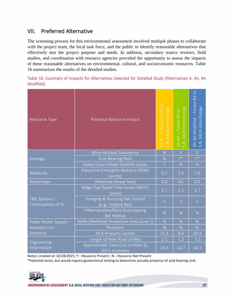
ENVIRONMENTAL ASSESSMENT S.R. 0424, SECTION 390 | HAZLETON BELTWAY EXTENSION 61
VII. Preferred Alternative
The screening process for this environmental assessment involved multiple phases to collaborate
with the project team, the local task force, and the public to identify reasonable alternatives that
effectively met the project purpose and needs. In addition, secondary source reviews, field
studies, and coordination with resource agencies provided the opportunity to assess the impacts
of these reasonable alternatives on environmental, cultural, and socioeconomic resources. Table
16 summarizes the results of the detailed studies.
Table 16. Summary of Impacts for Alternatives Selected for Detailed Study (Alternatives 4, 4A, 4A Modified).
Resource Type Potential Resource Impact
Alt
4 –
Co
mm
erc
e D
r to
S.R
. 04
24
Inte
rch
ange
Alt
4A
– F
ore
st R
d t
o
S.R
. 04
24
Inte
rch
ange
Alt
4A
Mo
dif
ied
– F
ore
st R
d t
o
S.R
. 04
24
Inte
rch
ange
Geology
Mine-Related Subsidence N Y Y
Acid-Bearing Rock N Y* Y*
Steep Slopes/Slope Stability Issues Y N N
Wetlands Palustrine Emergent Wetland (PEM)
(acres) 0.2 3.5 1.0
Waterways Perennial (linear feet) 0.0 42 0.0
T&E Species / Communities of SC
Ridge Top Dwarf-Tree Forest (RDTF) (acres)
3.7 1.1 1.7
Foraging & Roosting Bat Habitat (e.g., Indiana Bat)
Y Y Y
Hibernaculum/Rock Outcropping Bat Habitat
N N N
Public Water Supply – Hazleton City Authority
Wells (Wellhead Protection Area Zone 1) N N N
Reservoir N N N
HCA Property (acres) 15.6 9.6 10.4
Engineering Information
Length of New Road (miles) 1.1 1.2 1.1
Approximate Total Cost (million $) 2015 estimates
14.3 14.7 14.1
Notes: created on 10/28/2015; Y – Resource Present ; N – Resource Not Present *Potential exists, but would require geotechnical testing to determine actually presence of acid-bearing rock.
ENVIRONMENTAL ASSESSMENT S.R. 0424, SECTION 390 | HAZLETON BELTWAY EXTENSION 62
Alternatives 4A and 4A Modified pose concerns with their alignments north of the railroad
where mining activities have transformed the landscape. Both of these alignments are directly
above abandoned subsurface mining activities that could create stability issues associated with
subsidence. In addition, it was noted during the November 2014 agency coordination meeting
that Alternative 4A Modified would be located in the center of an approximately 33-acre lot
where a 500,000-square foot commercial warehouse/distribution building is proposed, creating
potential for additional ROW costs. Alternative 4A would also impact this lot, but would remain
on the eastern side of the property and avoid the warehouse but impact much of the proposed
parking and stormwater management facilities. Since the meeting, grading activities and
infrastructure and building construction have commenced.
A project team meeting was held on February 24, 2015, to discuss the Traffic Analysis Report
which analyzed options for traffic dispersion within HIP, and what, if any, upgrades might be
needed as part of this project within the internal HIP network to ensure acceptable LOS. Three
options were discussed.
Option 1: S.R. 0424 connection at Forest Road without an extension of White Birch Road
to Commerce Drive.
Option 2: S.R. 0424 connection at Forest Road with an extension of White Birch Road to
Commerce Drive (by CAN DO).
Option 3: S.R. 0424 connection at the White Birch Road extension (by CAN DO) and
Commerce Drive intersection.
Options 1 and 2 correlate to scenarios involving Alternative 4A and 4A Modified, while
Option 3 correlates to a scenario involving Alternative 4.
Following the completion of the traffic study, a project status meeting was held on October 1,
2015, to discuss the findings. This traffic study report indicated that the study area cannot sustain
acceptable LOS and capacity in future year (2038) without an extension of S.R. 0424. Based on
the construction of the White Birch Road extension, Options 2 and 3 can both provide the
required capacity and LOS to extend S.R. 0424 through HIP to S.R. 0924. However, Option 2
would not work as well as Option 3 since its direct connection with Forest Road would subject
more traffic to the roadway’s reverse curve horizontal geometry (sharp turns). It would also be
farther away from the large traffic generators on Oak Ridge Road (southwest of White Birch
Road), have an adverse impact to the development of Lot 105 within Humboldt East, and create
another at-grade railroad crossing. Option 3 would better accommodate future traffic while
limiting at-grade railroad crossings. Therefore, the construction of an extension of S.R. 0424
utilizing the Alternative 4 alignment would minimize impacts to resources within the study area
while providing the most effective secondary and emergency access between I-81 and HIP, as
well as additional incident management for local roadways.
ENVIRONMENTAL ASSESSMENT S.R. 0424, SECTION 390 | HAZLETON BELTWAY EXTENSION 63
Preferred Alternative: Alternative 4
Alternative 4 is identified as the Preferred Alternative. The Preferred Alternative would meet the
project purpose and needs identified by FHWA and PennDOT for system linkage, transportation
demand, and traffic operations:
System Linkage and Transportation Demand
The Preferred Alternative would provide access from I-81 and the existing S.R. 0424 Hazleton
Beltway into the HIP, providing a direct connection through the industrial park to S.R. 0924
from Commerce Drive, Forest Road, and the White Birch Road extension. This new access
would help to accommodate regional growth in the Greater Hazleton Area, in particular within
the HIP’s Humboldt Station, Humboldt East campus, and Humboldt West campus, as well as
Humboldt Northwest; Humboldt North; and the Eagle Rock Resort, Cranberry Creek, and
Pagnotti properties adjacent to the I-81 and S.R. 0924 interchange.
Traffic Operations
The Preferred Alternative would provide an additional access to the HIP from I-81 that can serve
as an incident management route for accidents along the I-81 or S.R. 0924 corridors in Hazle
Township. This additional route should also alleviate local traffic concerns during peak hours for
vehicles accessing Eagle Rock Resort and the various commercial and industrial businesses,
including the McCann School of Business & Technology located in the HIP.
In addition to addressing the project purpose and needs, the Preferred Alternative would
minimize impacts to the environmental and cultural resources with minimal impact to
socioeconomic resources. This alternative would avoid or significantly minimize impacts to
surface and groundwater resources, avoiding all jurisdictional wetlands, waterways, and drinking
water wells or reservoirs in the Mount Pleasant watershed. Coordination with DCNR, the
USFWS, and the PGC was undertaken to ensure that there would be no adverse impacts to
protected species and impacts to their habitat would be minimized. The Preferred Alternative
would have minimal impacts to hazardous waste sites and utilities, while requiring no impacts to
environmental justice populations, local communities, or displacement of businesses.
Avoidance and minimization efforts were incorporated into the Preferred Alternative; however,
unavoidable impacts would occur as part of project implementation. Table 17 provides a
summary of the mitigation commitments for the Preferred Alternative. A matrix was prepared for
the project’s Environmental Commitment and Mitigation Tracking System (ECMTS) and is
provided in the Project Technical File. It includes the list of environmental commitment actions
and resolutions for the next three phases of project development: final design, construction, and
post-construction/maintenance.
ENVIRONMENTAL ASSESSMENT S.R. 0424, SECTION 390 | HAZLETON BELTWAY EXTENSION 64
Table 17. Summary of Recommended Mitigation for the Preferred Alternative.
Resource Effect Recommended Mitigation
Regulated Wetlands
0.2 acre of direct impacts to PEM wetlands (isolated wetlands along utility ROW)
● Develop and implement a compensatory
wetland mitigation plan.
● Install orange protective fencing around
wetlands to be avoided prior to clearing and
grubbing activities (fencing locations to be
identified on the project’s E&S Control Plan).
● Prohibit construction equipment from being
refueled in regulated waters.
● Implement an approved E&S Control Plan and
include Best Management erosion and
sedimentation controls.
Threatened & Endangered Species (Plants)
Plant species of
concern and
Woodland
Community of
Concern (RDTF)
● Install orange protective fencing around
wetlands, where plant species were
observed, prior to clearing and grubbing
activities (fencing locations to be identified
on the project’s E&S Control Plan).
● Limit impacts to RDTF where possible.
Threatened & Endangered Species (Plants)
Invasive Species ● Clean construction equipment and vehicles
before entering the construction site and
restrict the use of seed mixes with invasive
plant species to prevent the spread of these
invasive species.
Threatened & Endangered Species (Bats)
Indiana Bat/Northern
Long-Eared Bat
● Develop construction schedule in compliance
with timbering restrictions (cutting only
allowed from November 15 to March 31) and
prepare Special Provision for timbering time
restrictions.
● Retention of any shagbark hickory trees, dead
and dying trees, and large diameter trees
(greater than 12 inches d.b.h.) to serve as
roost trees for bats.
Wildlife Migratory Birds ● Perform maintenance activities and
vegetative clearing between September 1
ENVIRONMENTAL ASSESSMENT S.R. 0424, SECTION 390 | HAZLETON BELTWAY EXTENSION 65
Resource Effect Recommended Mitigation
and March 31 to avoid take of breeding birds,
nests, and their young.
● Develop habitat restoration plan that avoids
and minimizes impact to birds.
● Use only native plant species.
Wildlife Pollinators ● Use pollinator-friendly native wildflower seed
mixes and flowering shrubs and trees along
roadsides and medians, and judicious
mowing and herbicide use when possible to
promote pollinator usage.
Farmland Protection Policy Act – Farmland
Direct impact to Soils
of Statewide
Importance and
Prime Farmland Soils.
● Prepare E&S Control Plan during final design
for PS&E Package to minimize the soil
erosion.
Archaeology No Effect ● NA
Utilities Direct impacts to
existing water lines,
sewer lines, and gas
lines, as well as
overhead electrical
distribution lines.
● Complete additional coordination with utility
companies during final design to coordinate
relocation or reconstruction of impacted
utilities with the design and construction
schedule of the project.
● Complete additional PA One Call prior to
ground disturbance activities.
● Complete subsurface utility engineering to
determine precise utility locations.
Waste Sites Potential impact to
contaminated soils
associated with the
PPL Harwood Site.
● Coordination with the PADEP during
construction if waste material at the former
PPL Harwood Site would be excavated. If
necessary, a Scope of Work Plan would be
prepared and provided to the PADEP for
approval of the proposed management
options (e.g., disposal at an approved
permitted facility or reburial on site).
● Additional soil sampling may be required.
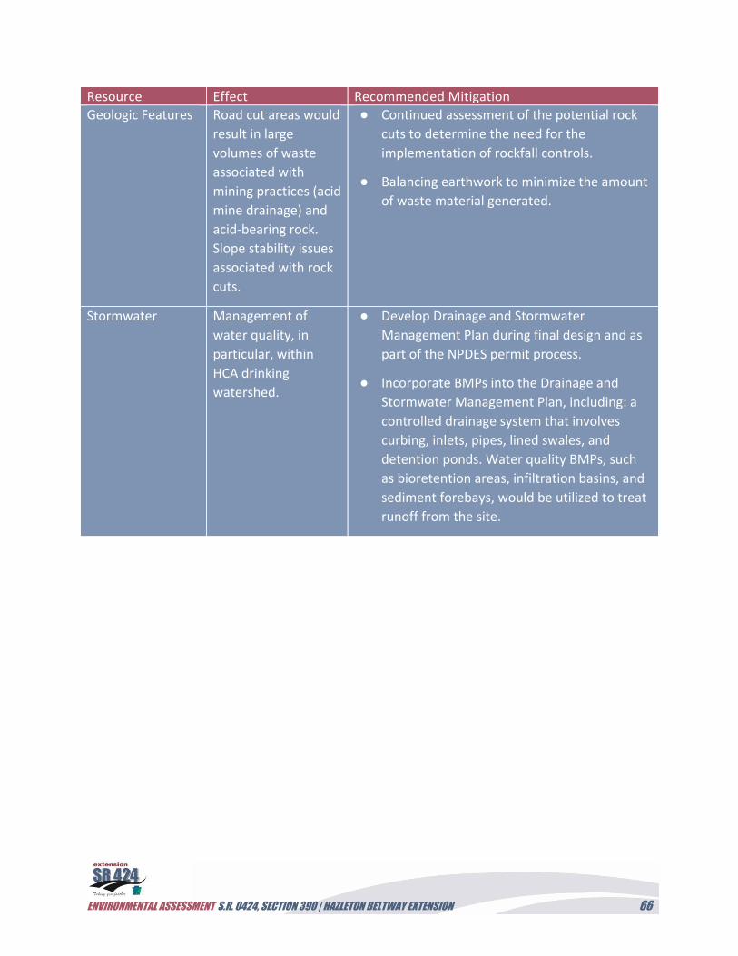
ENVIRONMENTAL ASSESSMENT S.R. 0424, SECTION 390 | HAZLETON BELTWAY EXTENSION 66
Resource Effect Recommended Mitigation
Geologic Features Road cut areas would
result in large
volumes of waste
associated with
mining practices (acid
mine drainage) and
acid-bearing rock.
Slope stability issues
associated with rock
cuts.
● Continued assessment of the potential rock
cuts to determine the need for the
implementation of rockfall controls.
● Balancing earthwork to minimize the amount
of waste material generated.
Stormwater Management of
water quality, in
particular, within
HCA drinking
watershed.
● Develop Drainage and Stormwater
Management Plan during final design and as
part of the NPDES permit process.
● Incorporate BMPs into the Drainage and
Stormwater Management Plan, including: a
controlled drainage system that involves
curbing, inlets, pipes, lined swales, and
detention ponds. Water quality BMPs, such
as bioretention areas, infiltration basins, and
sediment forebays, would be utilized to treat
runoff from the site.