Embed Size (px)
Citation preview
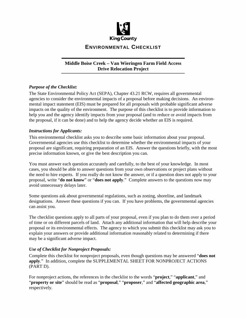
ENVIRONMENTAL CHECKLIST
Middle Boise Creek – Van Wieringen Farm Field Access Drive Relocation Project
Purpose of the Checklist: The State Environmental Policy Act (SEPA), Chapter 43.21 RCW, requires all governmental agencies to consider the environmental impacts of a proposal before making decisions. An environ-mental impact statement (EIS) must be prepared for all proposals with probable significant adverse impacts on the quality of the environment. The purpose of this checklist is to provide information to help you and the agency identify impacts from your proposal (and to reduce or avoid impacts from the proposal, if it can be done) and to help the agency decide whether an EIS is required. Instructions for Applicants: This environmental checklist asks you to describe some basic information about your proposal. Governmental agencies use this checklist to determine whether the environmental impacts of your proposal are significant, requiring preparation of an EIS. Answer the questions briefly, with the most precise information known, or give the best description you can. You must answer each question accurately and carefully, to the best of your knowledge. In most cases, you should be able to answer questions from your own observations or project plans without the need to hire experts. If you really do not know the answer, or if a question does not apply to your proposal, write “do not know” or “does not apply.” Complete answers to the questions now may avoid unnecessary delays later. Some questions ask about governmental regulations, such as zoning, shoreline, and landmark designations. Answer these questions if you can. If you have problems, the governmental agencies can assist you. The checklist questions apply to all parts of your proposal, even if you plan to do them over a period of time or on different parcels of land. Attach any additional information that will help describe your proposal or its environmental effects. The agency to which you submit this checklist may ask you to explain your answers or provide additional information reasonably related to determining if there may be a significant adverse impact. Use of Checklist for Nonproject Proposals: Complete this checklist for nonproject proposals, even though questions may be answered “does not apply.” In addition, complete the SUPPLEMENTAL SHEET FOR NONPROJECT ACTIONS (PART D). For nonproject actions, the references in the checklist to the words “project,” “applicant,” and “property or site” should be read as “proposal,” “proposer,” and “affected geographic area,” respectively.
King County Environmental Checklist Middle Boise Van Wieringen Farm Access Drive Relocation
A. BACKGROUND
1. Name of the proposed project, if applicable:
Middle Boise Creek – Van Wieringen Farm Field Access Drive Relocation Project
2. Name of Applicant:
King County Department of Natural Resources and Parks Water and Land Resources Division
3. Address and phone number of applicant and contact person:
Sarah McCarthy King County Water and Land Resources Division 201 South Jackson Street, Suite 600 Seattle, WA 98104-3855 Phone: 206-477-4766 Fax: 206-296-0192 E-mail: [email protected]
4. Date checklist prepared:
August 2016
5. Agency requesting checklist:
King County Department of Natural Resources and Parks Water and Land Resources Division
6. Proposed timing or schedule (include phasing, if applicable):
The Middle Boise Creek – Van Wieringen Farm Field Access Drive Relocation Project (hereafter referred to as the “Project”) is scheduled to be constructed during the fall of 2016. If weather conditions limit construction activities, the work will be completed in summer/fall 2017.
7. Do you have any plans for future additions, expansion, or further activity related to or connected with this proposal? If yes, explain.
Not at this time, but a future restoration project may be proposed in this area if funding becomes available.
8. List any environmental information you know about that has been prepared, or will be prepared, directly related to this proposal.
King County, Boise Creek Rapid Rural Reconnaissance Report, April 2004. Herrera Environmental Consultants, Inc., Middle Boise Creek Habitat Restoration and Flood Reduction Feasibility Study, February 22, 2011.
1
King County Environmental Checklist Middle Boise Van Wieringen Farm Access Drive Relocation
9. Do you know whether applications are pending for governmental approvals of other proposals directly affecting the property covered by your proposal? If yes, explain.
Not at this time.
10. List any government approvals or permits that will be needed for your proposal, if known.
National Pollution Discharge Elimination System (NPDES) – WA Department of Ecology
Local King County permitting (clearing and grading, critical areas review, shorelines exemption) may be required.
King County Flood Hazard Certification
Compliance with King County Cultural Resources Procedures (AEP LUD 16-1; KCC 20.62.150)
Otherwise, the project is exempt from state and federal permitting (RCW 90.58.030(3)(e); 33CFR 323.4).
11. Give a brief, complete description of your proposal, including the proposed uses and the size of the project and site. There are several questions later in this checklist that ask you to describe certain aspects of your proposal. You do not need to repeat those answers on this page.
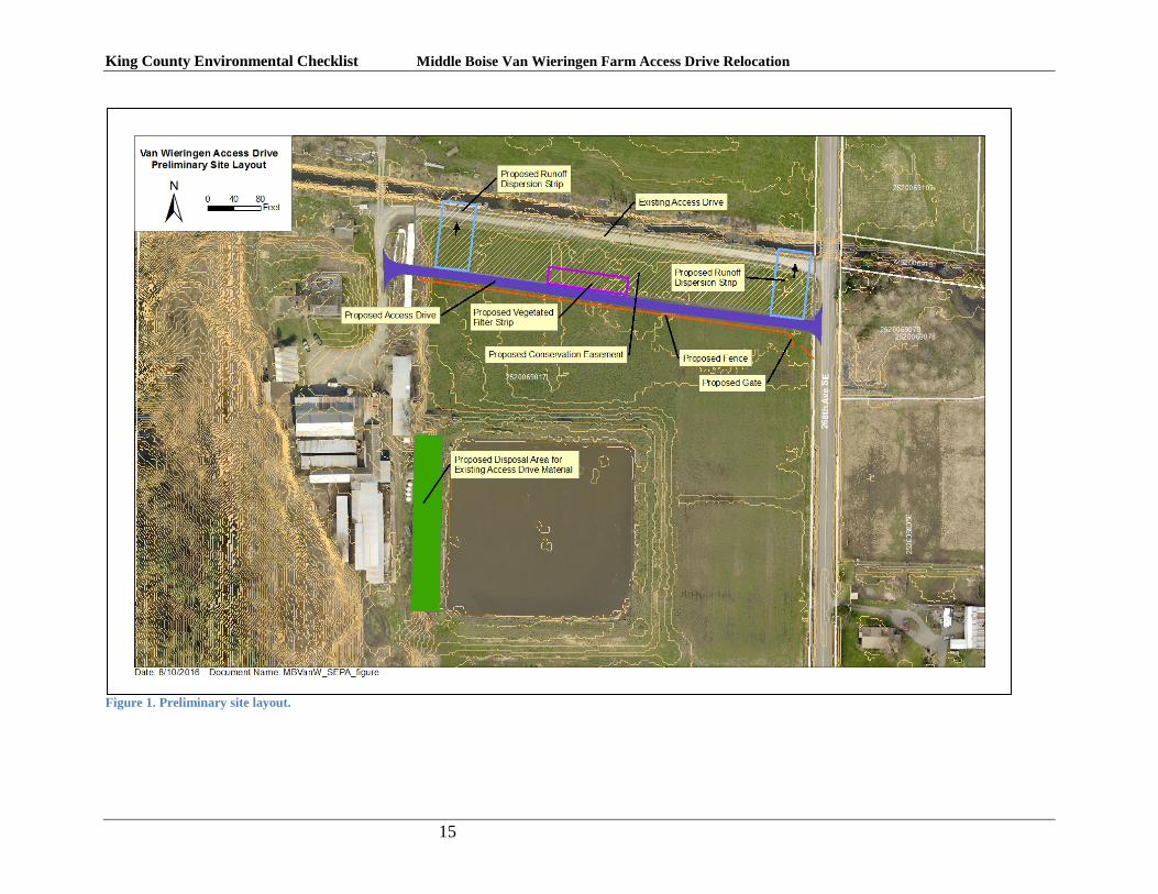
The King County Water and Land Resources Division proposes to relocate a farm field access drive along Boise Creek in the Agricultural Production District on the Enumclaw Plateau. The 660-foot drive runs along the south (left) bank of Boise Creek and is currently eroding into the stream. The drive is used as the primary access to the landowner’s farm field, dairy, and farmhouse. Boise Creek lacks a riparian buffer in this area. The proposed project would remove the existing drive, relocate utilities, build a new paved drive on the south side of the conservation easement, revegetate the riparian zone to comply with stormwater regulations and install a cattle exclusion fence (Figure 1).
12. Location of the proposal. Give sufficient information for a person to understand the precise
location of your proposed project, including a street address, if any, and section, township, and range, if known. If a proposal would occur over a range of area, provide the range or boundaries of the site(s). Provide a legal description, site plan, vicinity plan, and topographic map, if reasonably available. While you should submit any plans required by the agency, you are not required to duplicate maps or detailed plans submitted with any permit applications related to this checklist.
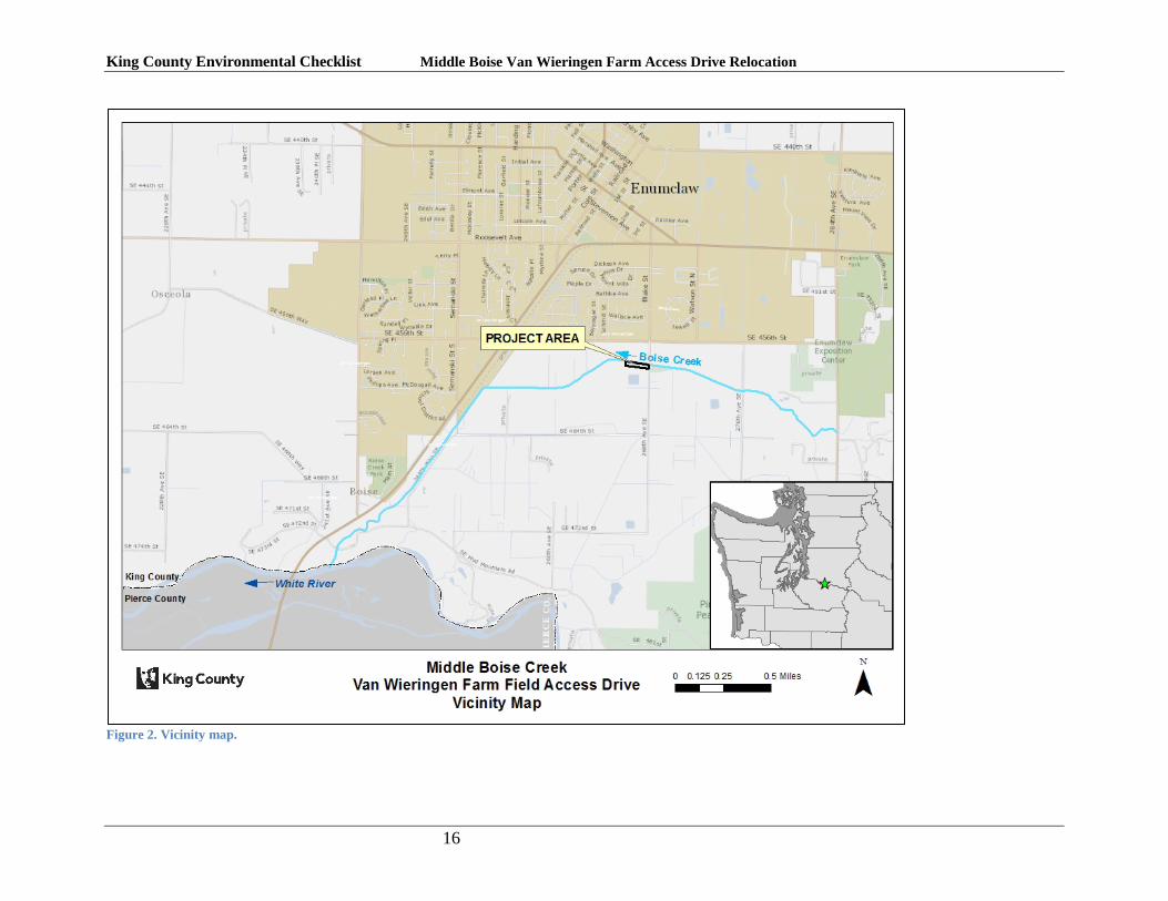
The project is located southeast of the City of Enumclaw within the Enumclaw Agricultural Production District (APD) in unincorporated King County. Boise Creek is a tributary to the White River, which is within Watershed Resource Inventory Area (WRIA) 10. Boise Creek forms the northern boundary of the project site; 268th Avenue SE forms the eastern boundary. The project is located in the SW1/4 of Section 25, Township 20 N, Range 6 East. See Figure 2.
2
King County Environmental Checklist Middle Boise Van Wieringen Farm Access Drive Relocation
B. ENVIRONMENTAL ELEMENTS
1. Earth
a. General description of the site (underline one): flat, rolling, hilly, steep slopes, mountainous, other.
The project site is located on the Enumclaw Plateau along the west flank of the Cascade Mountains. The relatively flat morphology of the Enumclaw Plateau is dominated by Holocene lahar deposits and forms the broad floodplain for Boise Creek.
b. What is the steepest slope on the site (approximate percent slope)?
The site is flat with a maximum slope of about 0.3%.
c. What general types of soils are found on the site (for example, clay, sand, gravel, peat, muck)? If you know the classification of agricultural soils, specify them and note any prime farmland.
Soils primarily include Buckley gravelly silt loam and Sultan silt loam. Alderwood gravelly sandy loam and Beausite gravelly sandy loam are present on a smaller portion of the area. According to the NRCS soil survey, the majority of the site is considered prime farmland. Roughly half of this is contingent on drainage and the landowner has indicated some of the challenges of draining the site for optimum production.
d. Are there surface indications or history of unstable soils in the immediate vicinity? If so, describe.
There is evidence of erosion along the streambank. The bank is vertical and undercut in places, with evidence of slumping.
e. Describe the purpose, type, and approximate quantities of any filling or grading proposed. Indicate the source of fill.
Fill will be placed to construct the proposed drive. Fill will consist of gravel, crushed rock, and asphalt pavement. Materials will be sourced from offsite vendors. The approximate quantity of fill to be placed is 1,200 cubic yards.
The existing drive will be removed and the material used to level an onsite area outside of wetland and floodplain for placement of silage tubes. The quantity of existing drive material (soil and gravel) to be removed will be approximately equivalent to the quantity of fill to be placed for construction of the proposed drive in order to meet local compensatory floodplain storage requirements.
f. Could erosion occur as a result of clearing, construction, or use? If so, generally describe.
Erosion could occur during drive removal; however, Best Management Practices (BMPs) such as silt fence, wattles, and stabilized construction entrances will be used, as necessary, to prevent erosion or sedimentation during construction.
3
King County Environmental Checklist Middle Boise Van Wieringen Farm Access Drive Relocation
g. About what percent of the site will be covered with impervious surfaces after project construction (for example, asphalt or buildings)?
The project will add approximately 10,000 square feet of impervious surface (asphalt drive), which is a 1.2% increase over existing. Approximately 5.7% of the affected parcel will be covered with impervious surfaces (including existing impervious surface and new impervious surface) after project construction.
h. Proposed measures to reduce or control erosion, or other impacts to the earth, if any:
All necessary and appropriate erosion control Best Management Practices (BMPs) will be used during construction to limit sediment runoff from access roads, work areas, and stockpiles during rainstorms. The drive will be paved, and the work area riverward of the new drive will be vegetated with native trees and shrubs or grass.
2. Air
a. What types of emissions to the air would result from the proposal (for example, dust, automobile, odors, industrial wood smoke, greenhouse gases) during construction and when the project is completed? If any, generally describe and give approximate quantities, if known.
Construction activities may generate airborne dust in the work area. The proposed project, once construction is complete, will emit no gasses or other emissions with the potential to negatively affect health or climate. Construction of the proposed project will use various vehicles and pieces of equipment that emit gasses with the potential to affect climate. These gasses include carbon dioxide (CO2), methane and nitrous oxide, as well as others in much smaller amounts. The global warming potential (GWP) of these compounds is measured in “carbon dioxide equivalents”, or CO2e, which converts the GWP of various gasses into their equivalent in CO2. The amount of CO2e that may be emitted as a result of constructing the proposed project has been estimated by computing the amount of fuel to be consumed by equipment used to construct the project, both during construction assuming transit from Seattle, Washington. Fuel consumed is then converted into CO2e emitted using formulae developed by the Energy Information Administration (EIA) of the U.S. Department of Energy. Using these formulae and estimates, construction of the proposed project would result in the discharge of approximately 111 tons of CO2e to the atmosphere.
b. Are there any off-site sources of emissions or odor that may affect your proposal? If so, generally describe.
No off-site emissions will affect this work.
c. Proposed measures to reduce or control emissions or other impacts to the air, if any:
Use of heavy and motorized equipment will be kept to a minimum to conserve fuel and minimize emissions.
4
King County Environmental Checklist Middle Boise Van Wieringen Farm Access Drive Relocation
3. Water
a. Surface:
1) Is there any surface water body on or in the immediate vicinity of the site (including year-round and seasonal streams, saltwater, lakes, ponds, wetlands)? If yes, describe the type and provide names. If appropriate, state what stream or river it flows into.
Yes, the project site is directly adjacent to Boise Creek and within farmed wetlands used for hay. Boise Creek is a tributary to the White River and is a Type S aquatic area that supports anadromous salmonids. The wetlands are depressional wetlands that are degraded as a result of farming practices.
2) Will the project require any work over, in, or adjacent to (within 200 feet) the described waters? If yes, please describe and attach available plans.
Yes, the Project will require grading and planting immediately adjacent to Boise Creek.
3) Estimate the amount of fill and dredge material that could be placed in or removed from surface water or wetlands and indicate the area of the site that would be affected. Indicate the source of fill material.
The approximate quantity of fill to be placed in existing farmed wetlands for construction of the proposed farm field access drive is 1,200 cubic yards. The material will be placed along the alignment of the proposed driveway.
The existing farm field access drive will be removed and the material used to level an onsite area outside of wetland and floodplain for placement of silage tubes. The quantity of existing drive material (soil and gravel) to be removed from floodplain and/or wetlands will be approximately equivalent to the quantity of fill to be placed for construction of the proposed farm field access drive.
4) Will the proposal require surface water withdrawals or diversions? Give general description, purpose, and approximate quantities, if known.
The proposed project will involve no surface water withdrawals or diversions.
5
King County Environmental Checklist Middle Boise Van Wieringen Farm Access Drive Relocation
5) Does the proposal lie within a 100-year floodplain? If so, note location on the site plan.
The project lies within Zone A of the Special Flood Hazard Area identified on the Flood Insurance Rate Panel Map 53033C1505F. No Base Flood Elevations or flood depths are shown, but compliance with floodplain development standards is required.
6) Does the proposal involve any discharges of waste materials to surface waters? If so, describe the type of waste and anticipated volume of discharge.
No waste material will be discharged.
b. Ground:
1) Will ground water be withdrawn, or will water be discharged to ground water? Give general description, purpose, and approximate quantities, if known.
No.
2) Describe waste material that will be discharged into the ground from septic tanks or other sources, if any (for example: domestic sewage; industrial containing the following chemicals…; agricultural; etc.). Describe the general size of the system, the number of such systems, the number of houses to be served (if applicable), or the number of animals or humans the system(s) are expected to serve.
No waste materials will be discharged to ground water.
c. Water Runoff (including storm water):
1) Describe the source of runoff (including storm water) and method of collection and disposal, if any (include quantities, if known). Where will this water flow? Will this water flow into other waters? If so, describe.
Stormwater runoff within the construction area will either infiltrate on the site, or be treated with BMPs if infiltration is not achievable. Runoff from the finished farm field access drive will infiltrate through a vegetated buffer.
2) Could waste materials enter ground or surface waters? If so, generally describe.
No
d. Proposed measures to reduce or control surface, ground, and runoff water impacts, if any:
BMPs will be used to mitigate water runoff.
4. Plants
a. Check or underline types of vegetation found on the site:
Deciduous trees: alder, maple, aspen, other
6
King County Environmental Checklist Middle Boise Van Wieringen Farm Access Drive Relocation
Evergreen trees: fir, cedar, pine, other Shrubs Grass Pasture Crop or grain Wet soil plants: cattail, buttercup, bulrush, skunk cabbage, other Water plants: water lily, eelgrass, milfoil, other Other types of vegetation
The site is predominantly hay field. The stream bank is undercut and being eroded by Boise Creek, and supports a few native willows.
b. What kind and amount of vegetation will be removed or altered
Primarily grass (used for hay).
c. List threatened or endangered species known to be on or near the site.
None present as ascertained through a query of the GIS data provided by the Washington Natural Heritage Program of the Department of Natural Resources and the Washington Department of Fish and Wildlife Priority Habitat and Species database.
d. Proposed landscaping, use of native plants, or other measures to preserve or enhance vegetation on the site, if any:
The riparian zone associated with the project will be extensively planted with native trees and shrubs. Areas designated for future restoration will be stabilized using sterile grass seed.
5. Animals
a. Check or underline any birds or animals that have been observed on or near the site, or are known to be on or near the site:
Birds: hawk, heron, eagle, songbirds, other Mammals: deer, bear, elk, beaver, other Fish: bass, salmon, trout, herring, shellfish, other
Anadromous fish species known to inhabit Boise Creek include Chinook salmon (Oncorhynchus tshawytscha), coho salmon (O. kisutch), and steelhead (O. mykiss).
b. List any threatened or endangered species known to be on or near the site.
• Puget Sound Chinook salmon (threatened) • Puget Sound steelhead (threatened)
c. Is the site part of a migration route? If so, explain.
Anadromous fish species, including salmon and steelhead trout, migrate up Boise Creek to the project site to spawn. Salmon and steelhead fry then out-migrate past the site on their way to salt water. The project site is also located along the Pacific Flyway
7
King County Environmental Checklist Middle Boise Van Wieringen Farm Access Drive Relocation
and may be visited by migrating birds. The North Rainier Elk Herd (White River Unit) traverses this area (WDFW Priority Habitats and Species database).
d. Proposed measures to preserve or enhance wildlife, if any:
This project is designed to reduce bank erosion and plant a portion of the riparian buffer which will provide shade and cover for the stream. Riparian vegetation will provide food and cover for aquatic, avian and terrestrial wildlife species.
6. Energy and Natural Resources
a. What kinds of energy (electric, natural gas, oil, wood stove, solar) will be used to meet the completed project’s energy needs? Describe whether it will be used for heating, manufacturing, etc.
The finished project will require no energy.
b. Would your project affect the potential use of solar energy by adjacent properties? If so, generally describe.
No
c. What kinds of energy conservation features are included in the plans of this proposal? List other proposed measures to reduce or control energy impacts, if any:
N/A
7. Environmental Health
a. Are there any environmental health hazards, including exposure to toxic chemicals, risk of fire and explosion, spill, or hazardous waste that could occur as a result of this proposal? If so, describe.
1) Describe special emergency services that might be required.
N/A
2) Proposed measures to reduce or control environmental health hazards, if any:
N/A
b. Noise:
1) What types of noise exist in the area that may affect your project (for example, traffic, equipment, operation, other)? Normal urban and rural noises are expected. These will have no impact on the activities covered by this document.
8
King County Environmental Checklist Middle Boise Van Wieringen Farm Access Drive Relocation
2) What types and levels of noise would be created by or associated with the project on a short-term or long-term basis (for example, traffic construction, equipment operation, other)? Indicate what hours noise would come from the site.
There will be short-term construction noise from heavy equipment and dump trucks during daylight working hours (7 a.m. to 7 p.m., Monday through Friday) while the project is being constructed. Construction should last less than three weeks. Noise levels in the immediate vicinity of heavy equipment operation may be as high as 90 decibels, but should dissipate rapidly with distance from the equipment. No additional noise will be generated by the finished project.
3) Proposed measures to reduce or control noise impacts, if any:
Construction noise will comply with the provisions of applicable noise ordinances. Equipment operation will be limited to the hours from 7 a.m. to 7 p.m., Monday through Friday. Work on Saturdays, though unlikely, will be limited to the hours from 9 a.m. to 5 p.m.
8. Land and Shoreline Use
a. What is the current use of the site and adjacent properties?
Adjacent properties include residential farms.
b. Has the site been used for agriculture? If so, describe.
Yes. The site is located within the Enumclaw Agricultural Production District and has been farmed since the early 1900’s.
c. Describe any structures on the site.
None
d. Will any structures be demolished? If so, what?
No structures will be demolished.
e. What is the current zoning classification of the site?
Zone A35.
f. What is the current comprehensive plan designation of the site?
Agricultural (Agricultural Production District).
g. If applicable, what is the current shoreline master program designation of the site?
Resource shoreline.
9
King County Environmental Checklist Middle Boise Van Wieringen Farm Access Drive Relocation
h. Has any part of the site been classified as an “environmentally sensitive” area? If so, specify.
Yes. Boise Creek is classified as a King County Type S Aquatic Area. A farmed Category IV wetland is located on site as well.
i. Approximately how many people would reside or work in the completed project?
None.
j. Approximately how many people would the completed project displace?
None.
k. Proposed measures to avoid or reduce displacement impacts, if any:
None.
l. Proposed measures to ensure the proposal is compatible with existing and projected land uses and plans, if any:
None.
9. Housing
a. Approximately how many units would be provided, if any? Indicate whether high-, middle-, or low-income housing.
None
b. Approximately how many units, if any, would be eliminated? Indicate whether high-, middle-, or low-income housing.
None
c. Proposed measures to reduce or control housing impacts, if any:
None.
10. Aesthetics
a. What is the tallest height of any proposed structure(s), not including antennas? What is the principal exterior building material(s) proposed?
The new driveway elevation will approximately match the existing driveway elevation.
b. What views in the immediate vicinity would be altered or obstructed?
None.
10
King County Environmental Checklist Middle Boise Van Wieringen Farm Access Drive Relocation
c. Proposed measures to reduce or control aesthetic impacts, if any:
Native vegetation will be planted on the site to improve both ecological and aesthetic functions.
11. Light and Glare
a. What type of light or glare will the proposal produce? During what time of day would it mainly occur?
None.
b. Could light or glare from the finished project be a safety hazard or interfere with views?
No.
c. What existing off-site sources of light or glare may affect your proposal?
None.
d. Describe proposed measures to reduce or control light and glare impacts, if any.
None.
12. Recreation
a. What designated and informal recreational opportunities are in the immediate vicinity?
There is no recreational use of Boise Creek in the project area, which is private property, or immediate vicinity. The closest public recreational area is Pinnacle Peak Park, which is located approximately one mile south of the project area.
b. Would the proposed project displace any existing recreational uses? If so, describe.
No.
c. Proposed measures to reduce or control impacts on recreation, including recreation opportunities to be provided by the project or applicant, if any:
No recreational impacts are expected to occur as a result of this project.
13. Historical and Cultural Preservation
a. Are there any places or objects listed on, or proposed for, national, state, or local preservation registers known to be on or next to the site? If so, generally describe.
A professional archeologist with expertise in historic and cultural resource identification and preservation reviewed local, state and federal records and data bases for information about the project site. The project is within the boundaries of the Landmark-eligible Benson Farm (888). The Louis Basik Barn (2620) is on an adjacent parcel.
11
King County Environmental Checklist Middle Boise Van Wieringen Farm Access Drive Relocation
b. Generally describe any landmarks or evidence of historical, archaeological, scientific,
or cultural importance known to be on or next to the site.
The project is within the boundaries of the Landmark-eligible Benson Farm (888). The Louis Basik Barn (2620) is on an adjacent parcel. There is a prehistoric site adjacent to (approx. 350m away) the project area. The project is unlikely to have any impacts on either the prehistoric site or adjacent sites (farm/barn) that are listed as landmark-eligible sites.
c. Proposed measures to reduce or control impacts, if any:
An archaeologist will conduct a subsurface survey of the project area before any ground-disturbing activities are undertaken. If no evidence of cultural resources are found during the pre-project survey, an unanticipated discovery plan will be developed and followed if cultural resources are encountered during construction. If cultural resources are found, an archaeologist will then monitor excavation during data collection and project construction. The project area is currently tilled, so intact cultural resources are unlikely to be found in the upper ground layer. If cultural or archaeological resources are uncovered or encountered during project construction, work will cease immediately and appropriate steps necessary to protect those resources will be taken prior to resuming construction. If resources are discovered, the Washington State Department of Archaeology and Historic Preservation, the King County Historic Preservation Program, and any affected tribal groups will be notified immediately, and an on-site inspection will be conducted by a state-certified archaeologist and other qualified resource professionals. A mitigation plan will be prepared prior to construction resuming at the site.
14. Transportation
a. Identify public streets and highways serving the site and describe proposed access to the existing street system. Show on-site plans, if any.
268th Avenue SE, a public road, forms the eastern boundary of the project site.
b. Is the site currently served by public transit? If not, what is the approximate distance to the nearest transit stop?
No. The nearest transit stop is in the City of Enumclaw, approximately one mile to the north of the project site.
c. How many parking spaces would the completed project have? How many would the project eliminate?
None.
12
King County Environmental Checklist Middle Boise Van Wieringen Farm Access Drive Relocation
Will the proposql require any new roads or streets, or improvements to existing roadsor streets, not including driveways? If so, generally describe (indicate whether publicor private).
No.
'tlill the project use (or occur in the immediate vicinity ofl water, rail, or airtransportation? If so, generally describe.
No.
f How many vehicular trips per day would be generated by the completed project? Ifknown, indicate when peak volumes would occur.
The finished project will not generate any extra vehicle trips over existing.
g. Proposed measures to reduce or control transportation impacts, if any:
None.
15. Public Services
a. Would the project result in an increased needfor public services for example: fireprotection, police protection, health care, schools, other)? If so, generally describe.
No.
b. Proposed measures to reduce or control direct impacts on public services, if any:
None.
16. Utilities
a. íJnderline utilities curuently available at the site: electricit.v. natural gas. water,
refuse service, telephone. sanitary sewer, septic svtstem. other.
b. Describe the utilities thøt are proposedfor the project, the utility providing the
service, qnd the general construction activities on the site or in the immediqte vicinitythat might be needed.
Utilities will be relocated during construction.
C. SIGNATURE
The above answers are true and complete to the best of my knowledge. I understand thatthe lead agency is relying on them to make its decision.
Signature:
Title:
d.
e
13
King County Environmental Checklist Middle Boise Van Wieringen Farm Access Drive Relocation
Date Submitted:
t4
King County Environmental Checklist Middle Boise Van Wieringen Farm Access Drive Relocation
Figure 1. Preliminary site layout.
15
King County Environmental Checklist Middle Boise Van Wieringen Farm Access Drive Relocation
Figure 2. Vicinity map.
16
King County Environmental Checklist Middle Boise Van Wieringen Farm Access Drive Relocation
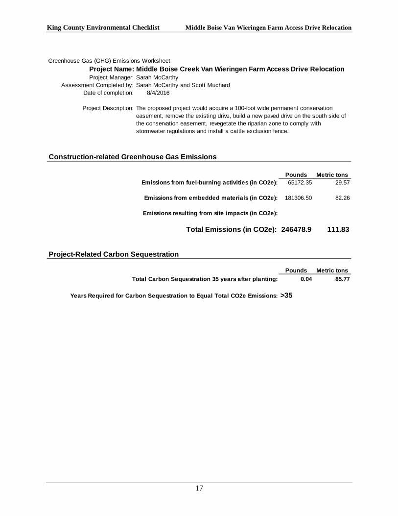
Greenhouse Gas (GHG) Emissions WorksheetProject Name: Middle Boise Creek Van Wieringen Farm Access Drive RelocationProject Manager: Sarah McCarthy
Assessment Completed by: Sarah McCarthy and Scott MuchardDate of completion: 8/4/2016
Project Description:
Construction-related Greenhouse Gas Emissions
Pounds Metric tonsEmissions from fuel-burning activities (in CO2e): 65172.35 29.57
Emissions from embedded materials (in CO2e): 181306.50 82.26
Emissions resulting from site impacts (in CO2e):
Total Emissions (in CO2e): 246478.9 111.83
Project-Related Carbon Sequestration
Pounds Metric tonsTotal Carbon Sequestration 35 years after planting: 0.04 85.77
Years Required for Carbon Sequestration to Equal Total CO2e Emissions: >35
The proposed project would acquire a 100-foot wide permanent conservation easement, remove the existing drive, build a new paved drive on the south side of the conservation easement, revegetate the riparian zone to comply with stormwater regulations and install a cattle exclusion fence.
17