Embed Size (px)
Citation preview
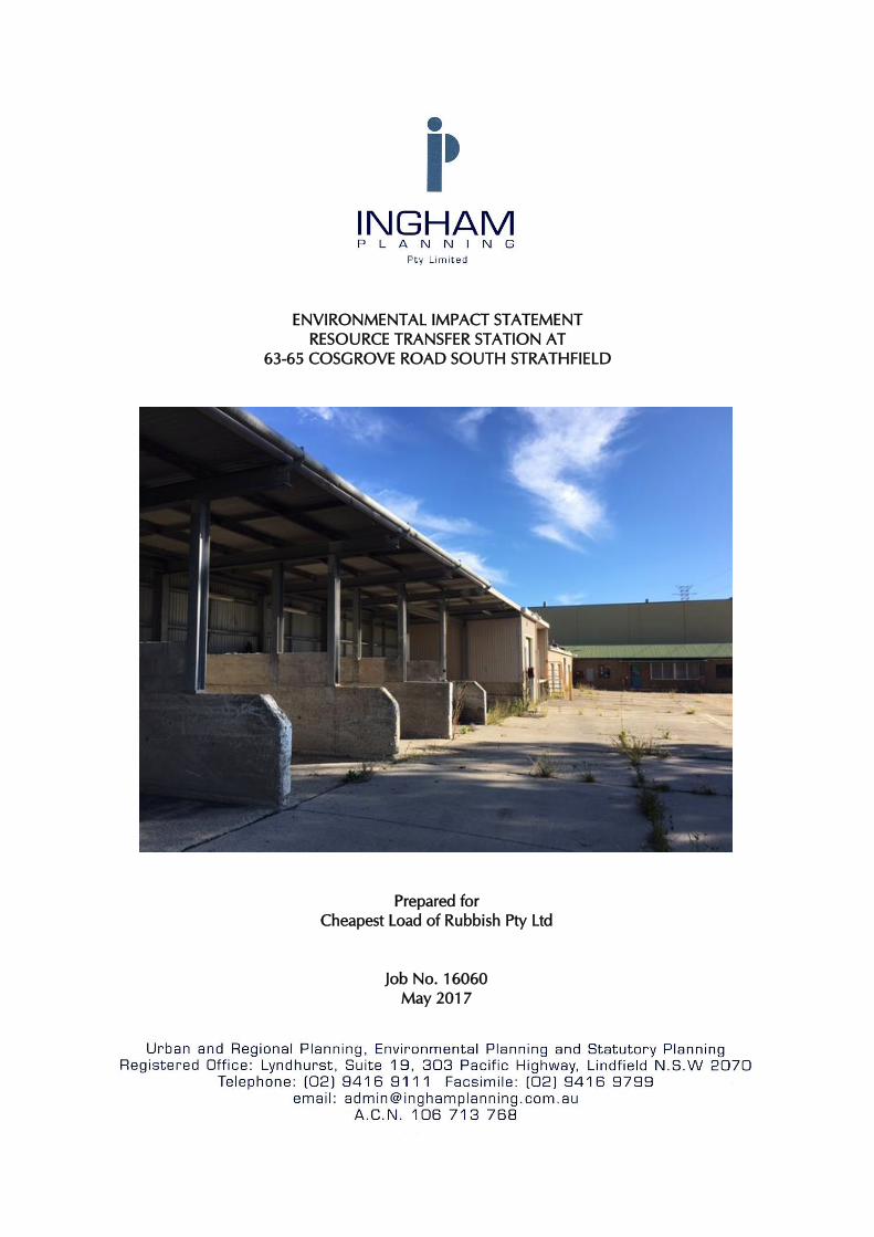
ENVIRONMENTAL IMPACT STATEMENT
RESOURCE TRANSFER STATION AT
63-65 COSGROVE ROAD SOUTH STRATHFIELD
Prepared for
Cheapest Load of Rubbish Pty Ltd
Job No. 16060
May 2017
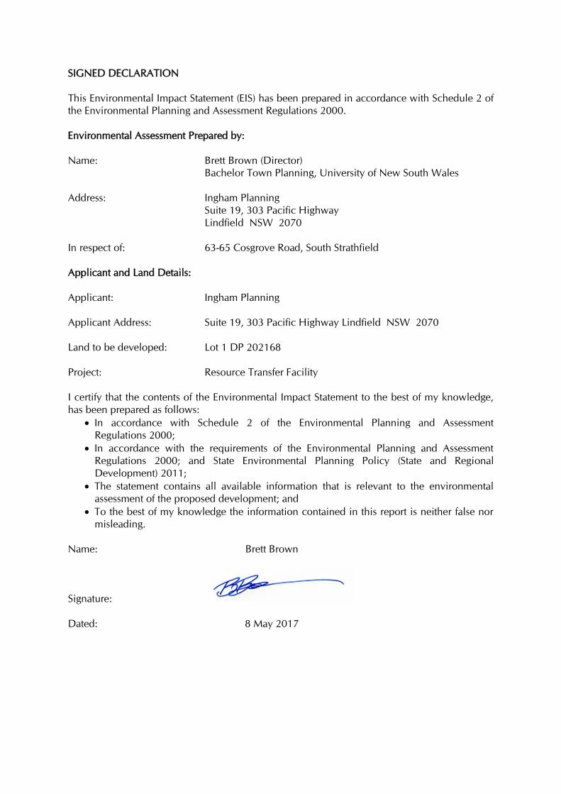
SIGNED DECLARATION
This Environmental Impact Statement (EIS) has been prepared in accordance with Schedule 2 of
the Environmental Planning and Assessment Regulations 2000.
Environmental Assessment Prepared by:
Name:
Brett Brown (Director)
Bachelor Town Planning, University of New South Wales
Address:
Ingham Planning
Suite 19, 303 Pacific Highway
Lindfield NSW 2070
In respect of:
63-65 Cosgrove Road, South Strathfield
Applicant and Land Details:
Applicant: Ingham Planning
Applicant Address:
Suite 19, 303 Pacific Highway Lindfield NSW 2070
Land to be developed: Lot 1 DP 202168
Project: Resource Transfer Facility
I certify that the contents of the Environmental Impact Statement to the best of my knowledge,
has been prepared as follows:
In accordance with Schedule 2 of the Environmental Planning and Assessment
Regulations 2000;
In accordance with the requirements of the Environmental Planning and Assessment
Regulations 2000; and State Environmental Planning Policy (State and Regional
Development) 2011;
The statement contains all available information that is relevant to the environmental
assessment of the proposed development; and
To the best of my knowledge the information contained in this report is neither false nor
misleading.
Name: Brett Brown
Signature:
Dated: 8 May 2017
Ingham Planning Pty Ltd
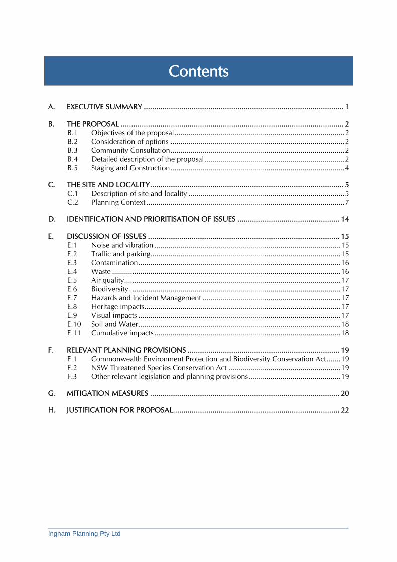
Contents
A. EXECUTIVE SUMMARY ................................................................................................ 1
B. THE PROPOSAL ........................................................................................................... 2 B.1 Objectives of the proposal ..................................................................................... 2 B.2 Consideration of options ....................................................................................... 2 B.3 Community Consultation ....................................................................................... 2 B.4 Detailed description of the proposal ...................................................................... 2 B.5 Staging and Construction ....................................................................................... 4
C. THE SITE AND LOCALITY ............................................................................................. 5 C.1 Description of site and locality .............................................................................. 5 C.2 Planning Context ................................................................................................... 7
D. IDENTIFICATION AND PRIORITISATION OF ISSUES ................................................. 14
E. DISCUSSION OF ISSUES ............................................................................................ 15 E.1 Noise and vibration ............................................................................................. 15 E.2 Traffic and parking ............................................................................................... 15 E.3 Contamination ..................................................................................................... 16 E.4 Waste .................................................................................................................. 16 E.5 Air quality ............................................................................................................ 17 E.6 Biodiversity ......................................................................................................... 17 E.7 Hazards and Incident Management ..................................................................... 17 E.8 Heritage impacts .................................................................................................. 17 E.9 Visual impacts ..................................................................................................... 17 E.10 Soil and Water ..................................................................................................... 18 E.11 Cumulative impacts ............................................................................................. 18
F. RELEVANT PLANNING PROVISIONS ......................................................................... 19 F.1 Commonwealth Environment Protection and Biodiversity Conservation Act ....... 19 F.2 NSW Threatened Species Conservation Act ........................................................ 19 F.3 Other relevant legislation and planning provisions .............................................. 19
G. MITIGATION MEASURES ........................................................................................... 20
H. JUSTIFICATION FOR PROPOSAL................................................................................ 22
Ingham Planning Pty Ltd
APPENDICES
Appendix A Photos of the site
Appendix B Operational Waste Management Plan by Cheapest Load of Rubbish
Appendix C Letter from EI Australia and Phase 1 and 2 Environmental Site Assessment by
Aecomm
Appendix D Noise, Vibration and Air Quality Assessment by Wilkinson Murray
Appendix E Traffic and Parking Impact Assessment by Traffix
Appendix F Construction Waste Management Plan by Moshonis Building Designers and
Engineers
Appendix G Stormwater Management Report and Concept Drainage Plan by C&M
Consulting Engineers
Appendix H Arborist Report by Urban Tree Care
Appendix I Preliminary Hazard Analysis prepared by Ingham Planning
Appendix J Copy of Secretary’s Environmental Assessment Requirements (SEARS)
Appendix K Copy of Strathfield Council PreDA meeting minutes
Ingham Planning Pty Ltd 1
A Executive Summary
A. EXECUTIVE SUMMARY
The subject development application (DA) seeks approval for the construction of a new
resource transfer station at 63-65 Cosgrove Road South Strathfield. The proposal
constitutes designated development as it is listed under Schedule 3 of the Environmental
Planning and Assessment Regulation 2000. In this regard resource transfer stations with
more than 30,000 tonnes annual throughput are designated development. The proposal
seeks consent for 40,000 tonnes.
The DA is ‘integrated development’ as a licence under the Protection of the Environment Operations Act 1997 is required from the Environmental Protection
Authority.
It is noted that in addition to this statement the DA is accompanied by the following
detailed reports:
Photos of the site (see Appendix A);
Operational Waste Management Plan by Cheapest Load of Rubbish (Appendix B);
Letter from EI Australia and Phase 1 and 2 Environmental Site Assessment by
Aecomm (see Appendix C);
Noise, Vibration and Air Quality Assessment by Wilkinson Murray (see Appendix
D);
Traffic and Parking Impact Assessment by Traffix (see Appendix E);
Construction Waste Management Plan by Moshonis Building Designers and
Engineers (Appendix F);
Stormwater Management Report and Concept Drainage Plan by C&M Consulting
Engineers (Appendix G);
Arborist Report by Urban Tree Care (Appendix H);
Preliminary Hazard Analysis prepared by Ingham Planning (Appendix I);
Copy of SEARS (Appendix J);
Copy of Council PreDA comments (Appendix K).
The subject site is located on a busy distributer road within an established industrial
area. The nearest residences are over 350m away and there is intervening industry
operating 24 hours a day 7 days a week. The proposal involves the sorting, processing
and transfer of resources within an indoor environment. In this context, the potential for
impact is limited.
Potential noise will be mitigated to ensure minimal impact on surrounding properties.
All other potential impacts can be suitably mitigated as outlined in this Statement.
The proposal represents an appropriate use in this location.
Ingham Planning Pty Ltd 2
B The Proposal
B. THE PROPOSAL
B.1 Objectives of the proposal
The objectives of the proposal are:
to provide a modern and safe facility to maximise the reuse of waste resources;
to provide a service to the local region, increasing the available options for
collection of waste resources;
to generate opportunities for local employment;
to maximise operational efficiency and sustainability;
to ensure that impacts on surrounding properties and environment is minimised.
B.2 Consideration of options
The proposal has been subject to a detailed locational analysis with the aim of ensuring:
The site is central to the main market of the business operations;
The site is located within an industrial context in order to ensure compatibility with
surrounding land uses;
The site is located on a busy road and away from residential areas to ensure
minimal noise impacts.
B.3 Community Consultation
Given that the site has only one neighbour of any consequence (the industrial unit
development to the north) and is well removed from residential areas, the need for
consultation is minimal. The proponent has had discussions with the closest neighbour
about the proposal.
B.4 Detailed description of the proposal
The proposal seeks to establish a new Resource Transfer Station on the subject site.
Consent is sought for the following:
Physical works
Demolition of all buildings on site however some existing open concrete bays will
be retained and accommodated within the proposed building. The existing concrete
slab that covers the majority of the site will be retained and made good where
necessary. Some existing concrete storage bays will also be retained and reused
(see photo on cover);
Removal of some vegetation;
Minor excavation for the weighbridge and building footings;
Construction of a new concrete and metal industrial building up to a height of 12m.
The Gross Floor Area (GFA) of the building is 1891sqm. The new building will have
Ingham Planning Pty Ltd 3
two roller doors fronting Cosgrove Road which will allow trucks to use a ‘left in/left
out’ movement and pass through the building where waste will be deposited and
loaded. The building will accommodate a range of machinery including a ‘trommel’
which will sort and separate material. The building will also accommodate areas for
sorting and temporary materials storage and an office/amenities;
Construction of a weighbridge and office;
Signage within a signage zone of 37sqm;
Parking for 20 vehicles;
Landscaping of the site;
Provision of infrastructure including water tanks to allow water reuse.
Operational details
Operating Hours
6.00 am to 10.00 pm, 7 days per week.
Staffing The maximum number of staff on site at any one time will be 16.
Operational Management
The business involves the collection of primarily household waste (not food waste) and
small scale commercial waste (minimal demolition material) by a fleet of small trucks.
Expected truck movements are 33 per day. The waste is either disposed of directly to an
approved waste disposal facility or brought to the site and sorted into appropriate
categories for collection and distribution. The waste streams comprise metals, plastics,
masonry and paper/cardboard which is recycled and general waste which is disposed of.
The estimated maximum waste throughput for the subject site is 40,000 tonnes. The
amount in each stream is estimated as follows:
Metals – 4%, plastics – 15%, masonry – 4%, paper/cardboard – 13%, timber – 15%,
general waste – 49%.
As part of the EPA licence requirements an Operational Environmental Management Plan
and an Emergency and Incident Response Plan are required to be prepared. Such
documents ensure that the operation of the business will minimise environmental impacts
and have appropriate measures and procedures in place to deal with unforeseen
circumstances. The Operational Waste Management Plan (WMP) at Appendix B
provides further details about the nature of the operation.
Traffic Management The movement of vehicles arriving to the site will be managed by way of two way
communications between the office and the drivers. This will ensure that there will be no
queuing of vehicles. The trucks that collect the material are generally 6.4M Small Rigid
Vehicles (SRV’s). Larger trucks (including ‘truck and dog’ vehicles up to 19m) may visit
the site to collect sorted material for transfer to other locations.
Ingham Planning Pty Ltd 4
B.5 Staging and Construction
As the proposed construction is basic and not complex, the development will be
constructed in a single stage. A Construction Management Plan (CMP) will be prepared
prior to construction.
Ingham Planning Pty Ltd 5
C The Site and Locality
C. THE SITE AND LOCALITY
C.1 Description of site and locality
Address: 63-65 Cosgrove Road, Strathfield South, 2136
Lot number: 1
Plan number: DP202168
Council Name: STRATHFIELD MUNICIPAL COUNCIL
Parcel Size: 2736sqm
The subject land is approximately 450m south of the Hume Hwy and 1.5km north of
Punchbowl Road (see Figure 1). The site has a frontage to Cosgrove Road of around
100m. The land is roughly triangular in shape with a western boundary adjoining a major
rail freight yard. The northern boundary adjoins similarly zoned industrial land. The site
was previously used as a depot by Roads and Maritime Services (RMS). It contains a
number of buildings and structures associated with that use (see Figures 2 and 3 and
photographs of the site and surrounds provided at Appendix A). The site includes some
existing vegetation as described in the Arborist Report at Appendix H.
As indicated in the Phase 1 and 2 Environmental Site Assessment at Appendix C, the site
has limited contamination and is suitable for ongoing industrial use.
Figure 1 – Location
Ingham Planning Pty Ltd 6
Figure 2 – Aerial photo of site and locality
Figure 3 – Aerial photo of site
Ingham Planning Pty Ltd 7
C.2 Planning Context
C.2.1 Zoning
The site is zoned IN1 General Industrial under Strathfield LEP 2012.
Figure 4 - Zoning
Zone IN1 General Industrial
1 Objectives of zone • To provide a wide range of industrial and warehouse land uses. • To encourage employment opportunities. • To minimise any adverse effect of industry on other land uses. • To support and protect industrial land for industrial uses. • To minimise fragmentation of valuable industrial land, and provide large sites for integrated and large floorplate activities. 2 Permitted without consent Nil 3 Permitted with consent Agricultural produce industries; Animal boarding or training establishments; Boat building and repair facilities; Car parks; Depots; Environmental protection works; Freight transport facilities; Garden centres; General industries; Industrial retail outlets; Industrial training facilities; Kiosks; Landscaping material supplies; Light industries; Neighbourhood shops; Plant nurseries; Recreation areas; Roads; Sex services premises; Signage; Storage premises; Take away food and drink premises; Timber yards; Transport depots; Truck depots; Vehicle body repair workshops; Vehicle repair stations; Veterinary hospitals; Warehouse or distribution centres; Wholesale supplies 4 Prohibited Any development not specified in item 2 or 3 The following relevant definitions are provided in the LEP.
waste or resource management facility means any of the following: (a) a resource recovery facility, (b) a waste disposal facility,

Ingham Planning Pty Ltd 8
(c) a waste or resource transfer station, (d) a building or place that is a combination of any of the things referred to in paragraphs (a)–(c). waste or resource transfer station means a building or place used for the collection and transfer of waste material or resources, including the receipt, sorting, compacting, temporary storage and distribution of waste or resources and the loading or unloading of waste or resources onto or from road or rail transport. Note. Waste or resource transfer stations are a type of waste or resource management facility—see the definition of that term in this Dictionary. resource recovery facility means a building or place used for the recovery of resources from waste, including works or activities such as separating and sorting, processing or treating the waste, composting, temporary storage, transfer or sale of recovered resources, energy generation from gases and water treatment, but not including re-manufacture or disposal of the material by landfill or incineration. Note. Resource recovery facilities are a type of waste or resource management facility—see the definition of that term in this Dictionary. It is considered that ‘waste or resource transfer station’ best describes the proposed use.
However none of the above uses are permitted with or without consent in the IN1 zone.
The proposal is permissible pursuant to SEPP (Infrastructure) 2007 as discussed below.
C.2.2 Planning Controls
SEPP (Infrastructure) 2007
This policy allows certain infrastructure related development even if the LEP prohibits it.
Part 3 Division 23 Waste or resource management facilities provides the following
provisions which are relevant to the proposal. 120 Definitions In this Division: prescribed zone means any of the following land use zones or a land use zone that is equivalent to any of those zones: (a) RU1 Primary Production, (b) RU2 Rural Landscape, (c) IN1 General Industrial, (d) IN3 Heavy Industrial, (e) SP1 Special Activities, (f) SP2 Infrastructure. resource recovery facility means a facility for the recovery of resources from waste, including such works or activities as separating and sorting, processing or treating the waste, composting, temporary storage, transfer or sale of recovered resources, energy generation from waste gases and water treatment, but not including re-manufacture of material or goods or disposal of the material by landfill or incineration. waste disposal facility means a facility for the disposal of waste by landfill, incineration or other means, including associated works or activities such as recycling, resource recovery and other resource management activities, energy generation from waste gases, leachate management, odour control and the winning of extractive material to generate a void for disposal of waste or to cover waste after its disposal.
Ingham Planning Pty Ltd 9
waste or resource management facility means a waste or resource transfer station, a resource recovery facility or a waste disposal facility. waste or resource transfer station means a facility for the collection and transfer of waste material or resources, including the receipt, sorting, compacting, temporary storage and distribution of waste or resources and the loading or unloading of waste or resources onto or from road or rail transport. 121 Development permitted with consent (1) Development for the purpose of waste or resource management facilities, other than development referred to in subclause (2), may be carried out by any person with consent on land in a prescribed zone. (2) Development for the purposes of a waste or resource transfer station may be carried out by any person with consent on: (a) land in a prescribed zone, or (b) land in any of the following land use zones or equivalent land use zones: (i) B5 Business Development, (ii) B6 Enterprise Corridor, (iii) IN2 Light Industrial, (iv) IN4 Working Waterfront, or (c) land on which development for any of the following purposes is permitted with consent under any environmental planning instrument: (i) industry, (ii) business premises or retail premises, (iii) freight transport facilities. (3) Development for the purpose of the recycling of construction and demolition material, or the disposal of virgin excavated natural material (as defined by the Protection of the Environment Operations Act 1997) or clean fill, may be carried out by any person with consent on land on which development for the purpose of industries, extractive industries or mining may be carried out with consent under any environmental planning instrument. Pursuant to the above, the proposal, being a waste transfer station is permissible with consent in the IN1 zone. It is also noted that of the types of waste related uses dealt with
by this Division, a waste transfer station is considered to have the least potential for
impact as it alone is also permitted in the IN2, IN4, B5 or B6 zones.
It is noted that the DA will also be required to be referred to RMS pursuant to Clause 104
and Schedule 3.
State Environmental Planning Policy No 55—Remediation of Land
The Section 149 identifies the land as being subject to a Council Policy on hazard risk.
However as indicated in the report at Appendix C the site “is considered to be suitable for on-going commercial/industrial land use”.
Environmental Planning and Assessment Act and Regulations (the EP&A Act and Regs)
The proposed use is designated development pursuant to the EP&A Act and Regs. In this
regard Schedule 3 of the Regs indicates development that is designated and includes
Clause 32 - Waste management facilities or works. This Clause states:
Ingham Planning Pty Ltd 10
1) Waste management facilities or works that store, treat, purify or dispose of waste or sort, process, recycle, recover, use or reuse material from waste and: (a) that dispose (by landfilling, incinerating, storing, placing or other means) of solid or liquid waste: (i) that includes any substance classified in the Australian Dangerous Goods Code or medical, cytotoxic or quarantine waste, or (ii) that comprises more than 100,000 tonnes of “clean fill” (such as soil, sand, gravel, bricks or other excavated or hard material) in a manner that, in the opinion of the consent authority, is likely to cause significant impacts on drainage or flooding, or (iii) that comprises more than 1,000 tonnes per year of sludge or effluent, or (iv) that comprises more than 200 tonnes per year of other waste material, or (b) that sort, consolidate or temporarily store waste at transfer stations or materials recycling facilities for transfer to another site for final disposal, permanent storage, reprocessing, recycling, use or reuse and: (i) that handle substances classified in the Australian Dangerous Goods Code or medical, cytotoxic or quarantine waste, or (ii) that have an intended handling capacity of more than 10,000 tonnes per year of waste containing food or livestock, agricultural or food processing industries waste or similar substances, or (iii) that have an intended handling capacity of more than 30,000 tonnes per year of waste such as glass, plastic, paper, wood, metal, rubber or building demolition material, or (c) that purify, recover, reprocess or process more than 5,000 tonnes per year of solid or liquid organic materials, or (d) that are located: (i) in or within 100 metres of a natural waterbody, wetland, coastal dune field or environmentally sensitive area, or (ii) in an area of high watertable, highly permeable soils, acid sulphate, sodic or saline soils, or (iii) within a drinking water catchment, or (iv) within a catchment of an estuary where the entrance to the sea is intermittently open, or (v) on a floodplain, or (vi) within 500 metres of a residential zone or 250 metres of a dwelling not associated with the development and, in the opinion of the consent authority, having regard to topography and local meteorological conditions, are likely to significantly affect the amenity of the neighbourhood by reason of noise, visual impacts, air pollution (including odour, smoke, fumes or dust), vermin or traffic. (2) This clause does not apply to: (a) development comprising or involving any use of sludge or effluent if: (i) the dominant purpose is not waste disposal, and (ii) the development is carried out in a location other than one listed in subclause (1) (d), above, or (b) development comprising or involving waste management facilities or works specifically referred to elsewhere in this Schedule, or (c) development for which State Environmental Planning Policy No 52—Farm Dams and Other Works in Land and Water Management Plan Areas requires consent. The proposal is considered to be designated development as it is a waste/resource transfer
station with an intended handling capacity of more than 30,000 tonnes a year (as referred
to in (b) above. The subject site is within 500m of a residential zone (see Figure 1) as
referred to in (d) above, however it is considered that the proposal is unlikely to have a
significant impact on this area as there are intervening industrial uses and buildings.
Ingham Planning Pty Ltd 11
State Environmental Planning Policy No 33—Hazardous and Offensive Development This Policy relates to potentially hazardous or offensive industries. These are defined as
follows:
potentially hazardous industry means a development for the purposes of any industry which, if the development were to operate without employing any measures (including, for example, isolation from existing or likely future development on other land) to reduce or minimise its impact in the locality or on the existing or likely future development on other land, would pose a significant risk in relation to the locality: (a) to human health, life or property, or (b) to the biophysical environment, and includes a hazardous industry and a hazardous storage establishment. potentially offensive industry means a development for the purposes of an industry which, if the development were to operate without employing any measures (including, for example, isolation from existing or likely future development on other land) to reduce or minimise its impact in the locality or on the existing or likely future development on other land, would emit a polluting discharge (including for example, noise) in a manner which would have a significant adverse impact in the locality or on the existing or likely future development on other land, and includes an offensive industry and an offensive storage establishment.
The proposal is not one likely to potentially impact on human health or the biophysical
environment, however impacts such as noise and traffic could potentially be offensive.
To assist in the determination of this issue the Department of Planning has published a
number of guidelines including the Hazardous and Offensive Development Application
Guidelines prepared by the Department of Planning January 2011. This Guideline
advises that:
In deciding if a proposal is ‘potentially offensive industry’ consent authorities need to determine whether, in the absence of safeguards, the proposal would emit a polluting discharge which would cause a significant level of offence. It is recommended the following be considered: Does the proposal require a licence under any pollution control legislation administered by the DECCW or other public authority? If so, the proposal should be considered potentially offensive. If such a pollution control licence or approval is not required, does the proposal cause offence having regard to the sensitivity of the receiving environment? This will in many cases be a matter for judgement. Consent authorities are advised to consult with the DECCW and take into account their views. Whilst the potential for impacts are considered to be minimal, in this case, a licence is
required from the Environment Protection Authority (EPA) and therefore treating the
proposal conservatively, this Policy does apply.
The conclusion that the proposal is potentially offensive but not potentially hazardous is
supported by the above DA Guidelines, as ‘Waste (landfilling/processing)’ is included in
the list of uses in Appendix 3 that could be potentially offensive but this use is not in the
list of uses that could be potentially hazardous.
Notwithstanding the above, the SEAR’s issued by the DP&E (se Appendix J) indicates that
the proposal is a ‘potentially hazardous industry’ and that a ‘Preliminary Hazard Analysis’
Ingham Planning Pty Ltd 12
(PHA) should be undertaken. Whilst we do not agree with this assessment a PHA has
been prepared and is provided at Appendix I.
Pursuant to Clause 13 of the Policy, the consent authority must consider the following
matters in relation to both potentially hazardous and offensive industries:
(a) current circulars or guidelines published by the Department of Planning relating to hazardous or offensive development, and (b) whether any public authority should be consulted concerning any environmental and land use safety requirements with which the development should comply, and (c) in the case of development for the purpose of a potentially hazardous industry—a preliminary hazard analysis prepared by or on behalf of the applicant, and (d) any feasible alternatives to the carrying out of the development and the reasons for choosing the development the subject of the application (including any feasible alternatives for the location of the development and the reasons for choosing the location the subject of the application), and (e) any likely future use of the land surrounding the development.
In relation to a), in addition to the DA Guidelines mentioned above, the SEAR’s refers to
the following:
Hazardous Industry Planning Advisory Paper No. 6 - Guidelines for Hazard Analysis (DoP, 2011) and Multi-Level Risk Assessment (DoP, 2011). These documents only relate to potentially hazardous industry, not potentially offensive
industry.
In relation to b), the EPA is required to be consulted as a licence is required for the type of
use proposed. The nature of the proposal is such that it is not considered necessary to
refer to authorities such as the fire brigade.
In relation to c), a PHA is provided at Appendix I.
In relation to d), the proposed location and alternatives have been discussed in Sections B
and H of the EIS.
In relation to (e, there is nothing to indicate that there will be any change to the
surrounding land uses which are presently used for infrastructure or industry.
Strathfield Local Environmental Plan 2012 Apart from the zoning of the land the other relevant LEP controls are a max height limit of
12m and a max FSR of 1:1. The proposal complies with these requirements having a max
height of 12m and an FSR of 0.69:1.
Strathfield Development Control Plan (DCP)
The relevant development controls for the proposal are discussed below:
10m building setback to Cosgrove Road – the proposal includes some minor
encroachments into this setback. A small corner of the building extends up to 5.5m
from the front boundary as this is the only way the proposed weighbridge area can be
accommodated within the building. However it is only a small area and adds to the
visual relief of the streetfront façade of the building and reduces its overall bulk. This
Ingham Planning Pty Ltd 13
element and the other roller door are treated with different materials to further reduce
the bulk of the building in the streetscape. The other encroachment is the signage
which is sculptural element affixed to the building and also aimed at providing
interest in the building façade. Both of these encroachments are seen as positive
elements on the overall visual presentation of the building. It is also noted that the
northern part of the building is setback further than 10m from the street boundary,
providing an appropriate balance in this regard;
2m landscaped setback to Cosgrove Road – the proposal complies with this
requirement in the northern and southern parts of the frontage however the central
element is only 1m wide as parking and access needs to be accommodated.
However given the overall amount of deep soil area provided within the front
setback, the proposed landscaping is considered appropriate;
1.2m landscaped setback to side boundaries between building line and street -
complies;
Nil setback to side and rear boundaries - complies;
Parking spaces at the rate of 1 per 55sqm of industrial use or 1 per 2 employees
(whichever the greater) – generally complies (see discussion in Section E.2 below).
C.2.3 Strategic Planning Context
A Plan for Growing Sydney
A Plan for Growing Sydney establishes a long-term planning framework to manage
Sydney’s growth in a sustainable manner and strengthen its economic development whilst
enhancing the unique lifestyle, heritage and environment of Sydney.
There are no specific goals or directions of the Plan that apply to the proposal. However
the proposal is consistent with the broader principle of maintaining employment
generating lands.
Towards Our Greater Sydney 2056 and draft District Plans
These documents have been prepared by the new Greater Sydney Commission and are
currently on exhibition. Towards Our Greater Sydney 2056 is a draft amendment to A
Plan for Growing Sydney. It is a high level document and the proposal is not inconsistent
with any of its contents.
The subject land is at the edge of the draft Central District Plan. The proposal is not
inconsistent with any of the contents of this Plan.
Ingham Planning Pty Ltd 14
D Identification and prioritisation of
issues
D. IDENTIFICATION AND PRIORITISATION OF ISSUES
The nature of the proposal is such is that it has limited potential for impact:
It does not deal with hazardous or putrescible waste that has the potential for
adverse impacts;
The transfer process takes place within the proposed building;
The majority of the site is covered with an existing concrete slab which is to be
retained and as such materials can be more easily managed;
The site has limited close neighbours and nearest residences are over 350m away;
The site is located on a busy distributor road and close to the arterial road network.
The main issue relation to the proposal is noise from the tipping of material and
machinery within the building. To allow efficient use and appropriate ventilation, it is
intended to operate the facility with the roller doors open. Therefore there is the potential
for noise to affect surrounding properties. As indicated in the Acoustic Assessment at
Appendix D, the proposal will not have any unreasonable impacts in this regard.
The next most sensitive issue is traffic. However the proposal has been designed to
minimise these impact and as indicated in the Traffic Assessment at Appendix E, the
proposal will not have any unreasonable impacts in this regard.
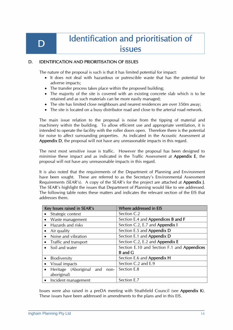
It is also noted that the requirements of the Department of Planning and Environment
have been sought. These are referred to as the Secretary’s Environmental Assessment
Requirements (SEAR’s). A copy of the SEAR’s for the project are attached at Appendix J.
The SEAR’s highlight the issues that Department of Planning would like to see addressed.
The following table notes these matters and indicates the relevant section of the EIS that
addresses them.
Key Issues raised in SEAR’s Where addressed in EIS
Strategic context Section C.2
Waste management Section E.4 and Appendices B and F
Hazards and risks Section C.2, E.7 and Appendix I
Air quality Section E.5 and Appendix D
Noise and vibration Section E.1 and Appendix D
Traffic and transport Section C.2, E.2 and Appendix E
Soil and water Section E.10 and Section F.1 and Appendices
B and G
Biodiversity Section E.6 and Appendix H
Visual impacts Section C.2 and E.9
Heritage (Aboriginal and non-
aboriginal)
Section E.8
Incident management Section E.7
Issues were also raised in a preDA meeting with Strathfield Council (see Appendix K).
These issues have been addressed in amendments to the plans and in this EIS.
Ingham Planning Pty Ltd 15
E Discussion of issues
E. DISCUSSION OF ISSUES
E.1 Noise and vibration
A full Noise and Vibration Assessment has been undertaken and is provided at Appendix
D. The following provides a summary of the conclusions.
Noise The noise impact assessment has been carried out in accordance with the following
guidelines:
• NSW Industrial Noise Policy (INP) (EPA, 2000);
• NSW Road Noise Policy (RNP) (DECCW, 2011);
• Interim Construction Noise Guideline (ICNG) (DECC, 2009);
Consideration has been given to the impact of the proposal on both adjoining industrial
properties and the nearest residential properties in Gregory and McEncroe Streets and
Cave and Rebecca Roads. The assessment concludes that the proposal will be within the
relevant noise criteria and therefore acceptable in relation to noise impacts.
Vibration There are no Australian Standards that address the potential for vibration to cause building
damage. In this instance the more stringent German Standard DIN 4150 – 1999 Structural
vibration: Part 3: Effects of Vibration on Structures, (DIN 4150-3-1999) Part 3 have been
adopted. This assessment concludes:
It should be noted that no significant sources of vibration have been identified for this facility. The most significant vibration source will come from the dumping of loads from the truck onto the ground. This will not cause high enough level to be at risk of causing building damage or impacting on human comfort. A detailed assessment of potential vibration impacts is therefore not considered necessary.
E.2 Traffic and parking
The traffic and parking impacts of the proposal have been addressed in detail in the
assessment at Appendix E. In relation to traffic the report provides the following
comments:
The operational plan for the facility indicates the site will generate a maximum of 33 truck movements per day and up to 32 passenger vehicle movements per day. This volume of traffic, spread over a typical 8 hour work day represents only 8 vehicle movements (in or out) per hour or 1 vehicle every 7-8 minutes. Furthermore, these trips are split between the two directions (with vehicles approaching from the south and departing to the north). This level of traffic generation would have a negligible impact upon the surrounding road network, as it is well within the range of typical traffic fluctuations.

Ingham Planning Pty Ltd 16
Accordingly, the traffic impacts of the development are considered to be negligible, with no external improvements to the network considered to be required as a result of the development.
It is noted that in their letter forming part of the SEAR’s, RMS requested modelling of the
intersections of Cosgrove Road with Liverpool Road and Punchbowl Road. However,
given very limited increase in traffic from the proposal, such analysis is considered to be
unwarranted.
In relation to parking, the nature of the use is such is that it does not easily fit into the
categories provided in Council DCP for different types of uses. The parking rate for
industrial use is 1 space per 55sqm of GFA or 1 space per 2 employees. However the use
does not include manufacturing and has limited processing of materials. Whilst not a
‘warehouse’, like a warehouse the site accommodates material for short periods before
they are relocated elsewhere. Using the warehouse parking rate of 1 space per 300sqm,
the proposal would generate the need for 7 car spaces.
Having regard to the circumstances, the application of the industrial employee rate is
considered to be appropriate. This would generate the need for 8 car spaces. This
number of employees does not include the truck drivers who take the trucks home and
therefore do not create a demand for on-site parking.
Therefore the provision of 20 spaces is considered more than adequate for the proposed
use. It is also noted that there is a bus service on Liverpool Road that provides access to
public transport services.
Parking is discussed in further detail in the Traffic Assessment at Appendix E.
E.3 Contamination
A Phase 1 and 2 Environmental Site Assessment has been undertaken by Aecom on
behalf of the previous owners - RMS. This report (copy at Appendix C) satisfies the
requirements of SEPP 55 and concludes that the “site is suitable for ongoing commercial/industrial use”. This report has been reviewed by EI Australia (see letter at
Appendix C) having regard to the proposed use of the land. The conclusion agrees with
the findings of Aecom and recommendations are provided for the construction process
which can be adopted as conditions of any consent granted.
E.4 Waste
A detailed Operational Waste Management Plan (OWMP) has been prepared and is
provided at Appendix B. The majority of the waste generated by the use itself will simply
be incorporated into the overall waste treatment that occurs within the building. In terms
of general waste, the site will utilise a private contractor for waste service.
In terms of the management of waste that passes through the facility a detailed
Operational Environmental Management Plan (OEMP) will be prepared as required as
part of the EPA licensing process. This will detail how waste on the site will be
sorted/process and redistributed. It will also outline procedures to deal with unexpected
circumstances such as the presence of hazardous or contaminated material and onsite
emergencies.
Ingham Planning Pty Ltd 17
An assessment of Construction Waste Management has been undertaken using Council’s
template. This assessment is provided at Appendix F.
E.5 Air quality
The handling of material will occur within the proposed building and as such the
potential for impacts will be limited. To protect workers and to limit escape via the open
doors of the building, dust suppression including misting will be incorporated. Full
details of such measures will form part of the OEMP. The assessment of impacts on air
quality at Appendix D concludes that subject to appropriate control measures, the
proposal will not pose an unreasonable risk in relation to this issue.
E.6 Biodiversity
There is no habitat of any significance on the subject site. Whilst some trees are required
to be removed, these are not considered to be of any significance and will be replaced by
new planting.
E.7 Hazards and Incident Management
No hazardous waste will be intentionally collected as part of the operation. Therefore
careful review of material on pick up will ensure that the chances of hazardous material
being collected is minimised. If hazardous material is detected when tipping occurs
within the facility, there will be no storage of the material on-site and it will be removed
immediately to an appropriate waste disposal facility. Such procedures will be outlined
in further detail in the OEMP to be prepared as required by the EPA licence.
There will also be procedures in place to deal with accidents within the site eg spillage of
chemicals. Such incidents will be outlined further in the Emergency and Incident
Response Plan to be prepared as part of the EPA license application.
These matters are also discussed in the Preliminary Hazard Analysis at Appendix I.
E.8 Heritage impacts
The subject property does not have any heritage significance. In regard to aboriginal
heritage, the site is not located in an area where there is likely to be any related resources.
In any event, the potential for impact is limited to the excavation to be undertaken (which
is also limited). Conditions of consent can require appropriate measures to be taken if
any artefacts become evident during excavation.
E.9 Visual impacts
The proposed building generally complies with the relevant Council development
controls and changes have been made to the draft plans in response to matters raised by
Council at the preDA meeting. These matters are discussed in further detail in Section
C.2. The building is an industrial form that is compatible with the nature of surrounding
development. Landscaping will be provided within the 10m building setback and this
will further reduce the bulk and scale of the building when viewed from the public
domain.
Ingham Planning Pty Ltd 18
E.10 Soil and Water
The proposal will have minimal potential for impact as only dry, non-putrescible waste is
to be collected. Further, the tipping will occur within the building and the majority of the
site is covered by a concrete slab. In terms of contaminated soil, the proposed minor
excavation will take place as recommended in the Environmental Assessment letter at
Appendix C. There will be no other impacts on soil or ground water as:
There will be no materials kept outside the building that could potentially affect soil
or water. In the case of an incident, appropriate procedures will be in place to
ensure that potential impacts are minimized. Therefore generally only clean runoff
will be collected by the proposed stormwater system. As detailed in the Stormwater
Management Plan at Appendix G, this will include a water tank for reuse of water;
Within the building whilst washing down will generally not be part of the
operational procedures, a trade waste permit will be sought to allow appropriate
runoff to be disposed of via the Sydney Water sewer system.
A Stormwater Management Report and Concept Drainage Plan have been prepared and
are provided at Appendix G.
E.11 Cumulative impacts
The proposal will only add to the existing impacts within this industrial area such as traffic
and noise to a small degree. Therefore the potential for cumulative impacts is minimal.
Ingham Planning Pty Ltd 19
F Relevant planning provisions
F. RELEVANT PLANNING PROVISIONS
F.1 Commonwealth Environment Protection and Biodiversity Conservation Act
There is no significant vegetation on site and as such approval under this Act will not be
required.
F.2 NSW Threatened Species Conservation Act
The subject site does not provide any significant habitat and as such there will be no
adverse impacts.
F.3 Other relevant legislation and planning provisions
The other relevant legislation and planning provisions have been considered above.
Ingham Planning Pty Ltd 20
G Mitigation Measures
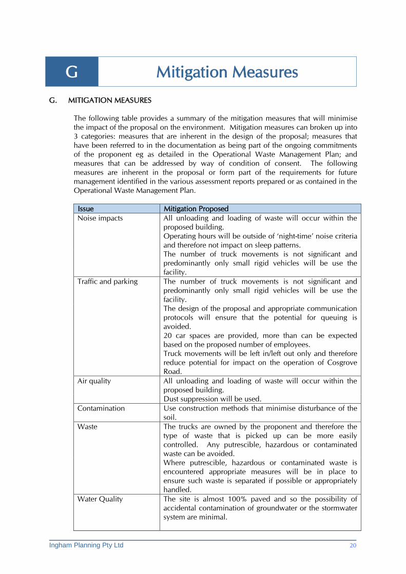
G. MITIGATION MEASURES
The following table provides a summary of the mitigation measures that will minimise
the impact of the proposal on the environment. Mitigation measures can broken up into
3 categories: measures that are inherent in the design of the proposal; measures that
have been referred to in the documentation as being part of the ongoing commitments
of the proponent eg as detailed in the Operational Waste Management Plan; and
measures that can be addressed by way of condition of consent. The following
measures are inherent in the proposal or form part of the requirements for future
management identified in the various assessment reports prepared or as contained in the
Operational Waste Management Plan.
Issue Mitigation Proposed
Noise impacts All unloading and loading of waste will occur within the
proposed building.
Operating hours will be outside of ‘night-time’ noise criteria
and therefore not impact on sleep patterns.
The number of truck movements is not significant and
predominantly only small rigid vehicles will be use the
facility.
Traffic and parking The number of truck movements is not significant and
predominantly only small rigid vehicles will be use the
facility.
The design of the proposal and appropriate communication
protocols will ensure that the potential for queuing is
avoided.
20 car spaces are provided, more than can be expected
based on the proposed number of employees.
Truck movements will be left in/left out only and therefore
reduce potential for impact on the operation of Cosgrove
Road.
Air quality All unloading and loading of waste will occur within the
proposed building.
Dust suppression will be used.
Contamination Use construction methods that minimise disturbance of the
soil.
Waste The trucks are owned by the proponent and therefore the
type of waste that is picked up can be more easily
controlled. Any putrescible, hazardous or contaminated
waste can be avoided.
Where putrescible, hazardous or contaminated waste is
encountered appropriate measures will be in place to
ensure such waste is separated if possible or appropriately
handled.
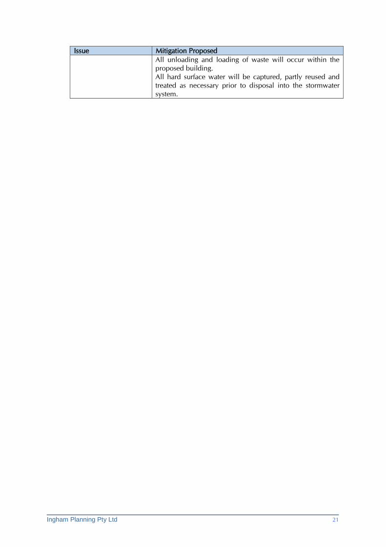
Water Quality The site is almost 100% paved and so the possibility of
accidental contamination of groundwater or the stormwater
system are minimal.
Ingham Planning Pty Ltd 21
Issue Mitigation Proposed
All unloading and loading of waste will occur within the
proposed building.
All hard surface water will be captured, partly reused and
treated as necessary prior to disposal into the stormwater
system.
Ingham Planning Pty Ltd 22
H Justification for proposal
H. JUSTIFICATION FOR PROPOSAL
The primary reason for the proposal is to provide a well located, modern and easily
accessible waste transfer facility to service the region. One of the most important
factors in setting up such a business is to minimise the impacts of the proposal on
nearby properties, especially residential properties. The subject site has been carefully
located, and the development designed, to achieve the best outcome in this regard:
There are minimal adjoining properties – the only direct neighbours are to the
north and these businesses are not orientated toward the site but to the street
frontage. The property across Cosgrove Road is a very large building with no
openings facing the street. To the rear are rail yards. The nearest residential
property is around 350m away with intervening 24 hour industrial uses;
It is located on a busy road which connects two arterial roads. This means that
traffic associated with the development will not be discernible from existing
traffic and that trucks will not have to pass through quiet residential streets to
access markets;
The site is already fully paved and can accommodate a building large enough to
contain all the potentially disturbing processes associated with the use;
More than adequate parking is provide to ensure that on-street parking in the
vicinity of the site is not placed under increased demand.
In view of the above the proposal is considered to be entirely justified and appropriate.
It represents a positive use of the land and as such we request Council’s favourable
consideration.