Embed Size (px)
Citation preview

Environmental Reports & Surveys
Local Authority Search
Regulated Drainage & Water Report Preliminary Ecological Appraisal
Coal Search Certificate Groundsure Screening Report
1 of 10
1 of 10
Regulated Local Authority Search
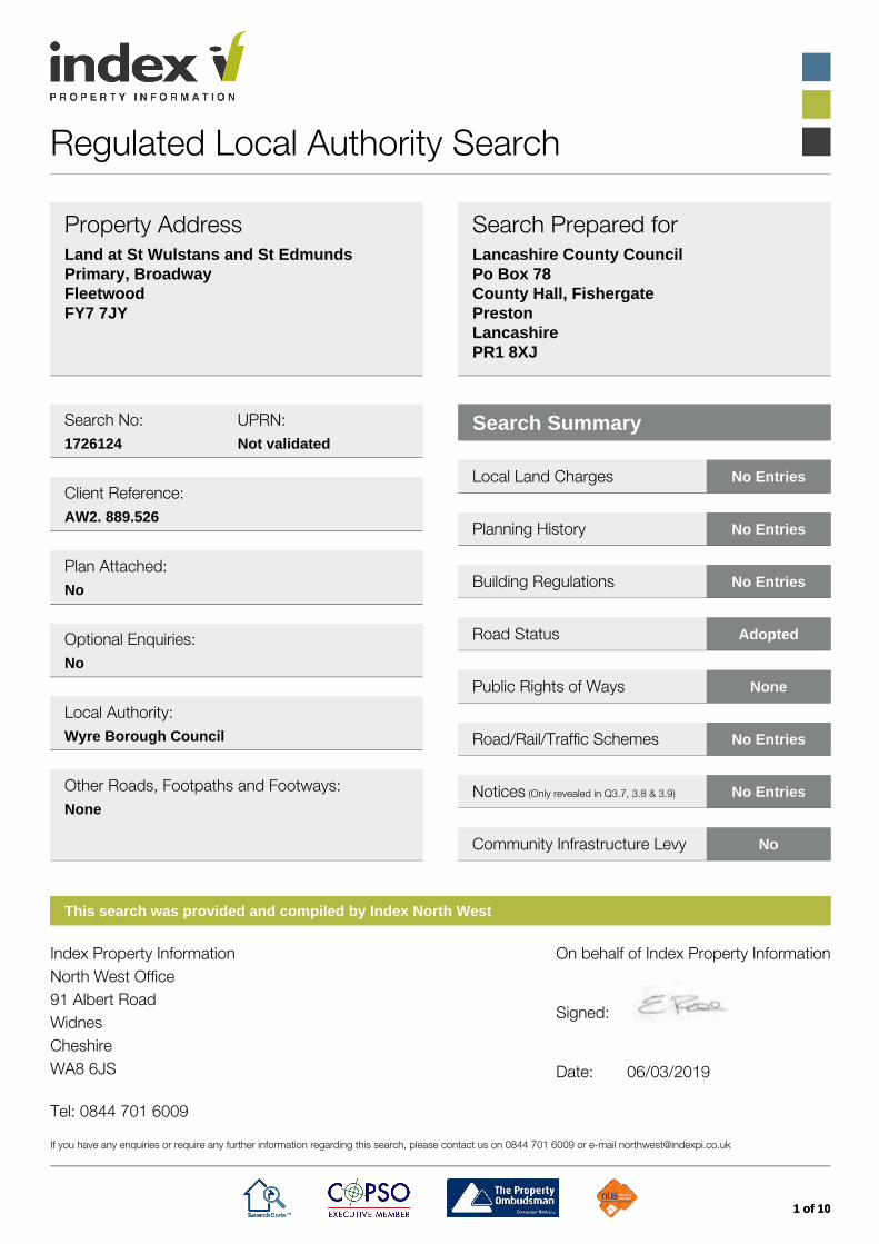
Property AddressLand at St Wulstans and St EdmundsPrimary, BroadwayFleetwoodFY7 7JY
Search Prepared forLancashire County CouncilPo Box 78County Hall, FishergatePrestonLancashirePR1 8XJ
Search No: UPRN:1726124 Not validated
Client Reference:AW2. 889.526
Plan Attached:No
Optional Enquiries:No
Local Authority:Wyre Borough Council
Other Roads, Footpaths and Footways:None
Search Summary
Local Land Charges No Entries
Planning History No Entries
Building Regulations No Entries
Road Status Adopted
Public Rights of Ways None
Road/Rail/Traffic Schemes No Entries
Notices (Only revealed in Q3.7, 3.8 & 3.9) No Entries
Community Infrastructure Levy No
This search was provided and compiled by Index North West
Index Property InformationNorth West Office91 Albert RoadWidnesCheshireWA8 6JS Tel: 0844 701 6009
On behalf of Index Property Information
Signed:
Date: 06/03/2019
If you have any enquiries or require any further information regarding this search, please contact us on 0844 701 6009 or e-mail [email protected]
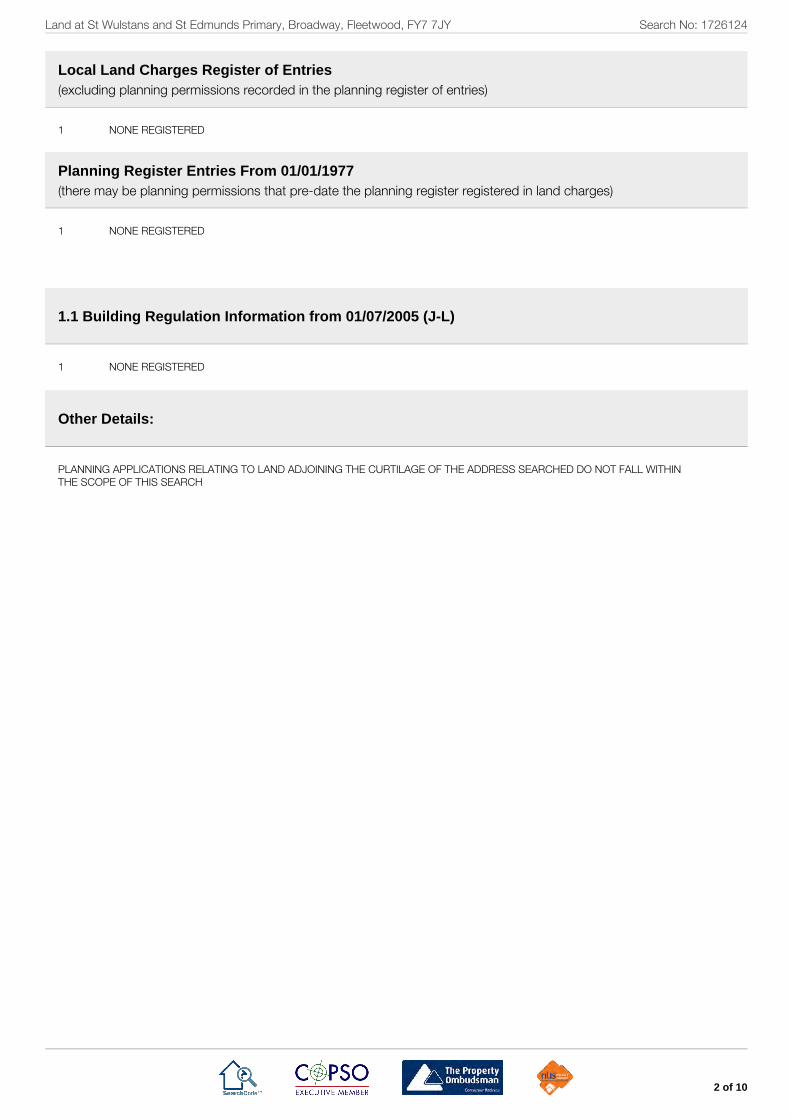
Land at St Wulstans and St Edmunds Primary, Broadway, Fleetwood, FY7 7JY Search No: 1726124
2 of 10
Local Land Charges Register of Entries(excluding planning permissions recorded in the planning register of entries)
1 NONE REGISTERED
Planning Register Entries From 01/01/1977(there may be planning permissions that pre-date the planning register registered in land charges)
1 NONE REGISTERED
1.1 Building Regulation Information from 01/07/2005 (J-L)
1 NONE REGISTERED
Other Details:
PLANNING APPLICATIONS RELATING TO LAND ADJOINING THE CURTILAGE OF THE ADDRESS SEARCHED DO NOT FALL WITHINTHE SCOPE OF THIS SEARCH

Land at St Wulstans and St Edmunds Primary, Broadway, Fleetwood, FY7 7JY Search No: 1726124
3 of 10
1. Planning and Building Regulations
1.1 Planning and building decisions and pending applications
Which of the following relating to the property have been granted, issuedfor refused or (where applicable) are the subject of pending applicationsor agreements?
(a) a planning permission PLEASE REFER TO LOCAL LAND CHARGES/PLANNING ENTRIES
(b) a listed building consent PLEASE REFER TO LOCAL LAND CHARGES/PLANNING ENTRIES
(c) a conservation area consent PLEASE REFER TO LOCAL LAND CHARGES/PLANNING ENTRIES
(d) a certificate of lawfulness of existing use or development PLEASE REFER TO LOCAL LAND CHARGES/PLANNING ENTRIES
(e) a certificate of lawfulness of proposed use or development PLEASE REFER TO LOCAL LAND CHARGES/PLANNING ENTRIES
(f) a certificate of lawfulness of proposed works for listed buildings PLEASE REFER TO LOCAL LAND CHARGES/PLANNING ENTRIES
(g) a heritage partnership agreement PLEASE REFER TO LOCAL LAND CHARGES/PLANNING ENTRIES
(h) a listed building consent order PLEASE REFER TO LOCAL LAND CHARGES/PLANNING ENTRIES
(i) a local listed building consent order PLEASE REFER TO LOCAL LAND CHARGES/PLANNING ENTRIES
(j) building regulation approval PLEASE REFER TO BUILDING REGULATION ENTRIES
(k) a building regulation completion certificate PLEASE REFER TO BUILDING REGULATION ENTRIES
(l) any building regulations certificate or notice issued in respect of workcarried out under a competent person self-certification scheme?
PLEASE REFER TO BUILDING REGULATION ENTRIES
How can copies of the decisions be obtained? PLEASE CONTACT OUR OFFICE FOR GUIDANCE
N.B. If building control for the property is currently administered byan outside body the seller or developer should be asked toprovide evidence of compliance with building regulations.
1.2 Planning designations and proposals
What designations of land use for the property or the area, and whatspecific proposals for the property are contained in any existing orproposed development plan?
WYRE BOROUGH COUNCILLOCAL PLAN 1999- RECREATIONAL OPEN SPACE (TREC14)
ENVIRONMENT AGENCY PLAN: FLOOD MAP FOR PLANNING(RIVERS AND SEA)- FLOOD ZONE 1
N.B. This reply reflects policies or proposals in any existingdevelopment plan and in any formally proposed alteration orreplacement plan, but does not include policies contained inplanning guidance notes or supplementary planningdocuments

Land at St Wulstans and St Edmunds Primary, Broadway, Fleetwood, FY7 7JY Search No: 1726124
4 of 10
2. Roads and Public Rights of Way
2.1 Roadways, footways and footpaths Which of the roads, footways and footpaths named in the application forthis search are:
(a) highways maintainable at public expense BROADWAY - YES
(b) subject to adoption and supported by a bond or bond waiver NONE
(c) to be made up by a local authority who will reclaim the cost from thefrontagers.
NONE
(d) to be adopted by a local authority without reclaiming the cost from thefrontagers.
NONE
N.B. If a road, footpath or footway is not a highway, there may beno right to use it. The Company cannot express an opinionwithout seeing the title plan of the property and requesting thelocal authority to carry out an inspection, whether or not anyexisting or proposed highway directly abuts the boundary ofthe property
2.2 Is any public right of way which abuts on, or crosses the property,shown on a definitive map or revised definitive map?
NO
2.3 Are there any pending applications to record a public right of waythat abuts, or crosses the property, on a definitive map or reviseddefinitive map?
NO
2.4 Are there any legal orders to stop up, divert, alter or create a publicright of way which abuts, or crosses the property not yet implemented orshown on a definitive map?
NO
N.B. A survey of all paths has not been completed and whilst thisdoes not preclude the existence of unrecorded rights of waythe Local Authority is unaware of a claimed rights of wayexisting over the property. Additional public rights of way mayexist other than those shown on the definitive map
2.5 If so, please attach a plan showing the approximate route. NOT APPLICABLE
3. Other Matters
Apart from matters entered on the registers of local land charges,do any of the following matters apply to the property? If so, howcan copies of relevant documents be obtained?
3.1 Land required for public purposes
Is the property included in land required for public purposes? NO
3.2 Land to be acquired for road works
Is the property included in land to be acquired for roadworks? NO
Land at St Wulstans and St Edmunds Primary, Broadway, Fleetwood, FY7 7JY Search No: 1726124
5 of 10
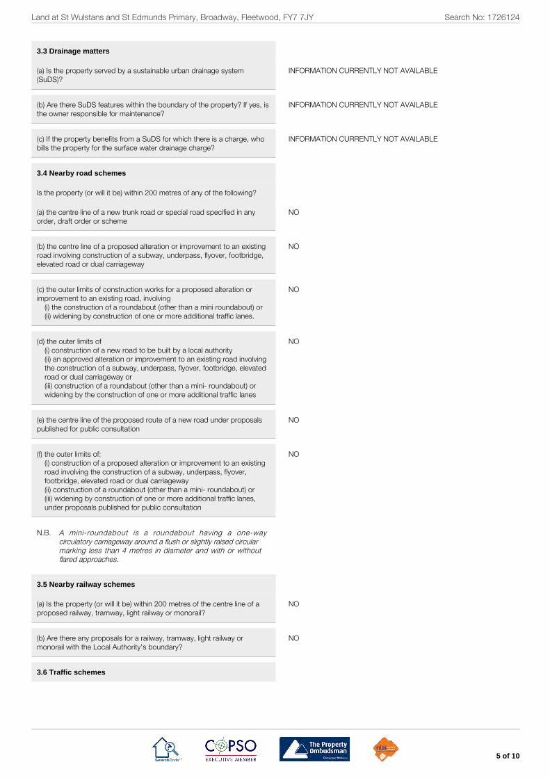
3.3 Drainage matters
(a) Is the property served by a sustainable urban drainage system(SuDS)?
INFORMATION CURRENTLY NOT AVAILABLE
(b) Are there SuDS features within the boundary of the property? If yes, isthe owner responsible for maintenance?
INFORMATION CURRENTLY NOT AVAILABLE
(c) If the property benefits from a SuDS for which there is a charge, whobills the property for the surface water drainage charge?
INFORMATION CURRENTLY NOT AVAILABLE
3.4 Nearby road schemes
Is the property (or will it be) within 200 metres of any of the following?
(a) the centre line of a new trunk road or special road specified in anyorder, draft order or scheme
NO
(b) the centre line of a proposed alteration or improvement to an existingroad involving construction of a subway, underpass, flyover, footbridge,elevated road or dual carriageway
NO
(c) the outer limits of construction works for a proposed alteration orimprovement to an existing road, involving
(i) the construction of a roundabout (other than a mini roundabout) or(ii) widening by construction of one or more additional traffic lanes.
NO
(d) the outer limits of(i) construction of a new road to be built by a local authority(ii) an approved alteration or improvement to an existing road involvingthe construction of a subway, underpass, flyover, footbridge, elevatedroad or dual carriageway or(iii) construction of a roundabout (other than a mini- roundabout) orwidening by the construction of one or more additional traffic lanes
NO
(e) the centre line of the proposed route of a new road under proposalspublished for public consultation
NO
(f) the outer limits of:(i) construction of a proposed alteration or improvement to an existingroad involving the construction of a subway, underpass, flyover,footbridge, elevated road or dual carriageway(ii) construction of a roundabout (other than a mini- roundabout) or(iii) widening by construction of one or more additional traffic lanes,under proposals published for public consultation
NO
N.B. A mini-roundabout is a roundabout having a one-waycirculatory carriageway around a flush or slightly raised circularmarking less than 4 metres in diameter and with or withoutflared approaches.
3.5 Nearby railway schemes
(a) Is the property (or will it be) within 200 metres of the centre line of aproposed railway, tramway, light railway or monorail?
NO
(b) Are there any proposals for a railway, tramway, light railway ormonorail with the Local Authority's boundary?
NO
3.6 Traffic schemes

Land at St Wulstans and St Edmunds Primary, Broadway, Fleetwood, FY7 7JY Search No: 1726124
6 of 10
Has a local authority approved but not yet implemented any of thefollowing for the roads, footways and footpaths which are named inBoxes B and C and are within 200 metres of the boundaries of theproperty?
(a) permanent stopping up or diversion NO
(b) waiting or loading restrictions NO
(c) one way driving NO
(d) prohibition of driving NO
(e) pedestrianisation NO
(f) vehicle width or weight restriction NO
(g) traffic calming works including road humps NO
(h) residents' parking controls NO
(i) minor road widening or improvement NO
(j) pedestrian crossings NO
(k) cycle tracks NO
(l) bridge building NO
N.B. In some circumstances, road closure orders can be obtainedby third parties from magistrate's courts or can be made bythe Secretary of State for Transport, without involving theLocal Authority within which the property is located. Thisenquiry is designed to reveal matters that are yet to beimplemented and could not therefore be ascertained by avisual inspection. Schemes that have been or are currentlybeing implemented will not be referred to in answer to thisenquiry
3.7 Outstanding notices
Do any statutory notices which relate to the following matters subsist inrelation to the property other than those revealed in a response to anyother enquiry in this form?
(a) building works NO
(b) environment NO
(c) health and safety NO
(d) housing NO
(e) highways NO
(f) public health NO
(g) flood and coastal erosion risk management NO
Land at St Wulstans and St Edmunds Primary, Broadway, Fleetwood, FY7 7JY Search No: 1726124
7 of 10
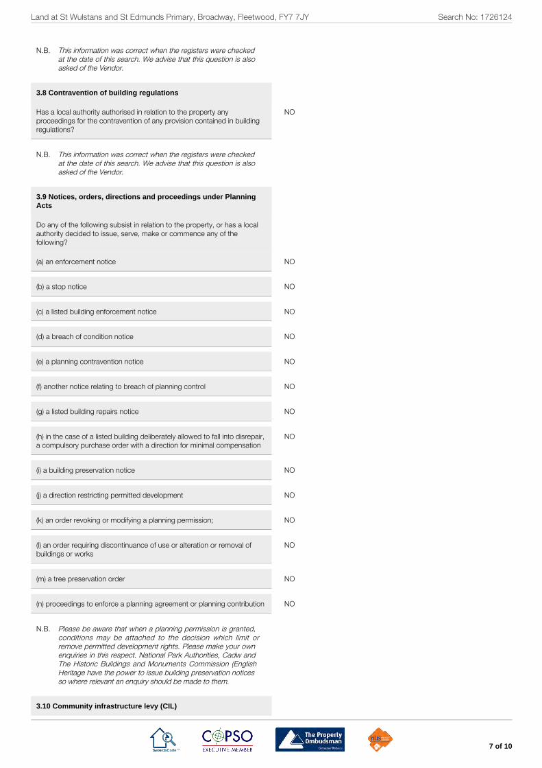
N.B. This information was correct when the registers were checkedat the date of this search. We advise that this question is alsoasked of the Vendor.
3.8 Contravention of building regulations
Has a local authority authorised in relation to the property anyproceedings for the contravention of any provision contained in buildingregulations?
NO
N.B. This information was correct when the registers were checkedat the date of this search. We advise that this question is alsoasked of the Vendor.
3.9 Notices, orders, directions and proceedings under PlanningActs
Do any of the following subsist in relation to the property, or has a localauthority decided to issue, serve, make or commence any of thefollowing?
(a) an enforcement notice NO
(b) a stop notice NO
(c) a listed building enforcement notice NO
(d) a breach of condition notice NO
(e) a planning contravention notice NO
(f) another notice relating to breach of planning control NO
(g) a listed building repairs notice NO
(h) in the case of a listed building deliberately allowed to fall into disrepair,a compulsory purchase order with a direction for minimal compensation
NO
(i) a building preservation notice NO
(j) a direction restricting permitted development NO
(k) an order revoking or modifying a planning permission; NO
(l) an order requiring discontinuance of use or alteration or removal ofbuildings or works
NO
(m) a tree preservation order NO
(n) proceedings to enforce a planning agreement or planning contribution NO
N.B. Please be aware that when a planning permission is granted,conditions may be attached to the decision which limit orremove permitted development rights. Please make your ownenquiries in this respect. National Park Authorities, Cadw andThe Historic Buildings and Monuments Commission (EnglishHeritage have the power to issue building preservation noticesso where relevant an enquiry should be made to them.
3.10 Community infrastructure levy (CIL)
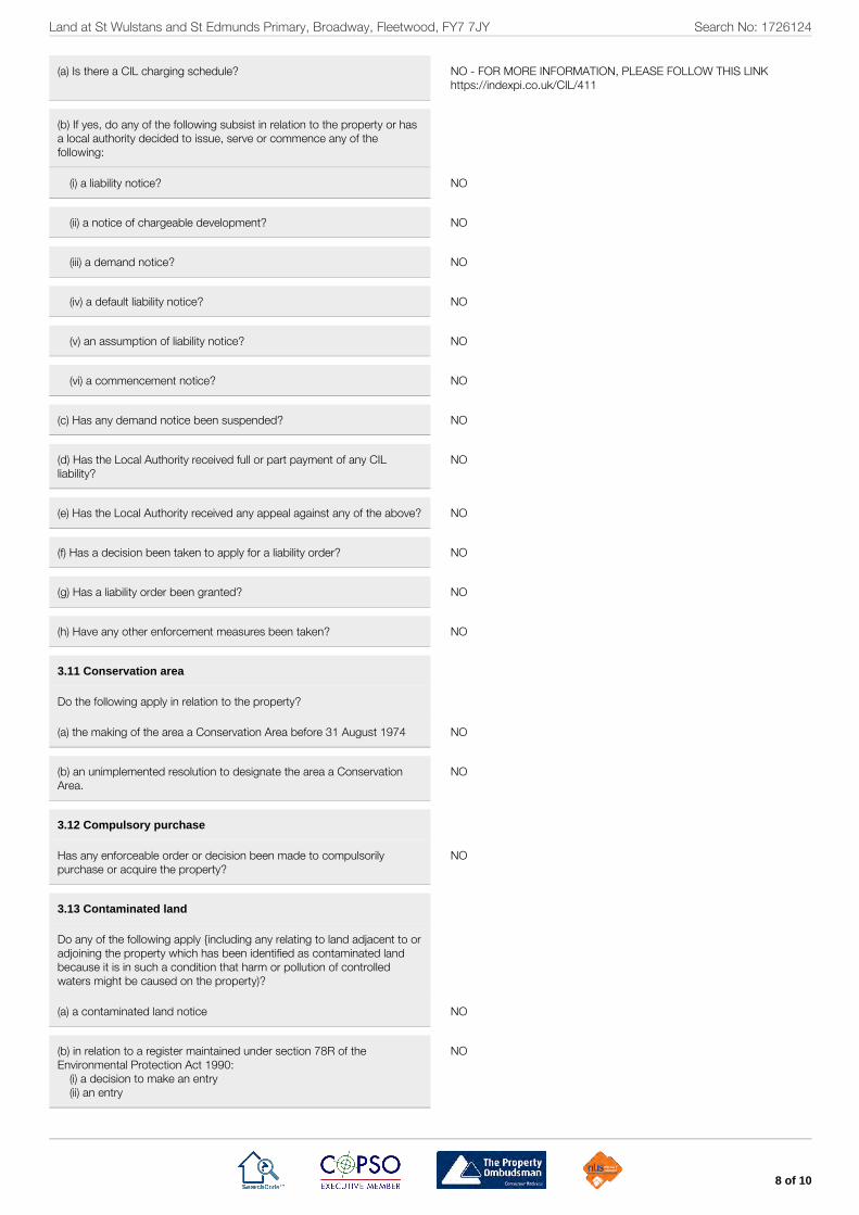
Land at St Wulstans and St Edmunds Primary, Broadway, Fleetwood, FY7 7JY Search No: 1726124
8 of 10
(a) Is there a CIL charging schedule? NO - FOR MORE INFORMATION, PLEASE FOLLOW THIS LINKhttps://indexpi.co.uk/CIL/411
(b) If yes, do any of the following subsist in relation to the property or hasa local authority decided to issue, serve or commence any of thefollowing:
(i) a liability notice? NO
(ii) a notice of chargeable development? NO
(iii) a demand notice? NO
(iv) a default liability notice? NO
(v) an assumption of liability notice? NO
(vi) a commencement notice? NO
(c) Has any demand notice been suspended? NO
(d) Has the Local Authority received full or part payment of any CILliability?
NO
(e) Has the Local Authority received any appeal against any of the above? NO
(f) Has a decision been taken to apply for a liability order? NO
(g) Has a liability order been granted? NO
(h) Have any other enforcement measures been taken? NO
3.11 Conservation area
Do the following apply in relation to the property?
(a) the making of the area a Conservation Area before 31 August 1974 NO
(b) an unimplemented resolution to designate the area a ConservationArea.
NO
3.12 Compulsory purchase
Has any enforceable order or decision been made to compulsorilypurchase or acquire the property?
NO
3.13 Contaminated land
Do any of the following apply {including any relating to land adjacent to oradjoining the property which has been identified as contaminated landbecause it is in such a condition that harm or pollution of controlledwaters might be caused on the property)?
(a) a contaminated land notice NO
(b) in relation to a register maintained under section 78R of theEnvironmental Protection Act 1990:
(i) a decision to make an entry(ii) an entry
NO

Land at St Wulstans and St Edmunds Primary, Broadway, Fleetwood, FY7 7JY Search No: 1726124
9 of 10
(c) consultation with the owner or occupier of the property conductedunder section 78G(3) of the Environmental Protection Act 1990 beforethe service of a remediation notice
NO
N.B. A negative reply does not imply that the property or anyadjoining or adjacent land is free from contamination or fromthe risk of it, and the reply may not disclose steps taken byanother council in whose area adjacent or adjoining land issituated
3.14 Radon gas
Do records indicate that the property is in a 'Radon Affected Area' asidentified by Public Health England or Public Health Wales?
PLEASE REFER TO ENVIRONMENTAL REPORT
N.B. "Radon Affected Area" means a part of the country with a 1%probability or more of present or future homes being above theAction Level. Such areas are designated by the HealthProtection Agency which also advises Government on thenumerical value of the "Radon Act ion Level" ( therecommended maximum radon concentration in the home.Radon concentrations above the Action Level should bereduced below it and become as low as reasonablypracticable}. Radon preventative measures are required fornew buildings in higher risk areas. For new properties thebuilder and/or the owners of properties built after 1988 shouldsay whether protective measures were incorporated in theconstruction of the property. Further information on radon,including an indicative version of the Radon Affected Areasmap, the associated health risks and common questions andanswers is available on the Health Protection Agency {HPA}website {www.hpa.org.uk/radiation/index.htm}. Alternatively,information can be requested from HPA by telephone {0800614529 {24h} or 01235 822622 {D/T} or by writing to RadonStudies, Health Protection Agency, Radiation ProtectionDivision, Chilton, Didcot, Oxon OX11 0RQ. A guide containingfurther information about Radon Affected Areas is availablefree from DEFRA.
3.15 Assets of community value
(a) Has the property been nominated as an asset of community value? NO
If so:(i) Is it listed as an asset of community value? NOT APPLICABLE(ii) Was it excluded and placed on the 'nominated but not listed' list? NOT APPLICABLE(iii) Has the listing expired? NOT APPLICABLE(iv) Is the Local Authority reviewing or proposing to review the listing? NOT APPLICABLE(v) Are there any subsisting appeals against the listing? NOT APPLICABLE
(b) If the property is listed:
(i) Has the Local Authority decided to apply to the Land Registry for anentry or cancellation of a restriction in respect of listed land affectingthe property?
NOT APPLICABLE
(ii) Has the Local Authority received a notice of disposal? NOT APPLICABLE(iii) Has any community interest group requested to be treated as abidder?
NOT APPLICABLE

Land at St Wulstans and St Edmunds Primary, Broadway, Fleetwood, FY7 7JY Search No: 1726124
10 of 10
Information Sources:
WYRE BOROUGH COUNCIL, CIVIC CENTRE, BRECK ROAD, POULTON-LE-FYLDE, LANCASHIRE, FY6 7PUTel: 01253 891000 - Web: https://indexpi.co.uk/_/1Mkg
Planning and Building Regulations
The answer(s) to Q1.1 (A) - (I) were obtained by examining public records
The answer(s) to Q1.1 (J) - (L) were obtained by examining public records
Planning Designations and Proposals
The answer(s) to Q1.2 were obtained by examining public records
Roads
The answer(s) to Q2 (A) - (D) were obtained by examining public records
The answer(s) to Q2.2 were obtained by examining public records
The answer(s) to Q2.3 were obtained by examining public records
The answer(s) to Q2.4 were obtained by examining public records
The answer(s) to Q2.5 were obtained by examining public records
Other Matters
The answer(s) to Q3.1 were obtained by examining public records
The answer(s) to Q3.2 were obtained by examining public records
The answer(s) to Q3.3 were obtained by examining public records
The answer(s) to Q3.4 were obtained by examining public records
The answer(s) to Q3.5 were obtained by examining public records
The answer(s) to Q3.6 were obtained by examining public records
The answer(s) to Q3.7 were obtained by examining public records
The answer(s) to Q3.8 were obtained by examining public records
The answer(s) to Q3.9 were obtained by examining public records
The answer(s) to Q3.10 were obtained by examining public records
The answer(s) to Q3.11 were obtained by examining public records
The answer(s) to Q3.12 were obtained by examining public records
The answer(s) to Q3.13 were obtained by examining public records
The answer(s) to Q3.14 were obtained by examining public records
The answer(s) to Q3.15 were obtained by examining public records
Terms and Conditions
1. Definitions and Interpretation
1.1 In these Conditions the following words shall have the meanings set
opposite them:
“Charges” mean our financial charges for providing the Services,
which will be notified to You when You submit Your Order.
“Client” shall include (i) The individual(s) or business entity of whom
You act on whose behalf You are using the Services (ii) The
individual(s) or business entity who has or are considering acquiring
an interest in or charge over the Property to which the Services relate.
(iii) The individual(s) or business entity who acts in a professional or
advisory capacity for any person using the Services.
“Confirmation of Order” means our written acceptance of the Order.
“Contract” means the legally-binding agreement between Us and You
for the supply by Us of the Services and which incorporates these
Conditions.
“Data Provider” means a third-party provider of data used in a Report
“Intellectual Property Rights” means any intellectual property right,
including, without limitation, copyright, database rights, trademarks,
patents, trade secrets or design rights.
“Invoice” means an invoice in respect of the Services issued by Us to
You.
“Order” means Your request for Us to provide the Services which You
place by communicating or sending it to Us by electronic or other pre-
agreed means.
“Property” means the property address or location of the buildings,
land, fixtures and all chattels for which You require a Report.
“Index” means the party with whom You place an Order for the
Services which may be Index Property Information Limited, Index
Insure Limited or any one or a combination of affiliated businesses.
“Report” means any report/document that You have asked Us to
deliver to You as detailed in the Order.
“Required Information” means all information required to submit an
Order to Us which shall enable Us to provide the Services to You and
which shall be included in the Order.
“Search Code” means the ‘Council of Property Search Organisations’
search code.
“Third Party Report” means any Report that We procure from a third
party on Your behalf for the purpose of providing the Services to You.
“Services” mean the provision of Reports to You.
“Us” or “We” or Our means Index.
“You” or “Your” means the conveyancer and/or the conveyancer’s
firm acting on behalf of the Client.
1.2 Headings used in these Conditions are for convenience only and shall
not affect the interpretation of the main provisions.
2. Your Privacy and Security
2.1 Your personal details and any details identifying the Client are held on
a secure database in accordance with relevant data protection
legislation and those details are used solely for the provision of the
Services. We shall not pass confidential customer information to other
organisations unless You specifically authorise Index to do so.
2.2 Your Order will be retained by Us in an electronic format and will be
available for inspection upon reasonable notice for a period of 6 years
from the date of the Order.
2.3 Index will use personal information which We hold about You and/or
the Client to provide the Services to You, for credit control and market
research purposes and to inform You about Our Services and products
and legal developments and training sessions or events which We
believe may be of interest to You.
2.4 Except in the situations listed above or as required or allowed by other
regulations, We will not pass, disclose, rent or sell Your personal
information or the Client’s personal information (other than any
personal information which is already publicly available and which is
incorporated into Our search products) to any third party without Your
prior consent.
3. The Services
3.1 An Order will be deemed to be an offer to purchase Services from Us
on these Conditions.
3.2 We will not be obliged to accept any Order. No Contract for Services
will come into force until Confirmation of Order has been provided to
You by Us.
3.3 These Conditions alone will apply to (and will form part of) the
Contract. They supersede any previously issued terms and conditions
of supply.
3.4 No terms or conditions endorsed on, delivered with, or contained in
the Client’s purchase Order, Confirmation of Order, specification or
other document will form part of the Contract and in the event of any
conflict these conditions shall prevail.
3.5 No variation of the Conditions or to an Order will be binding unless
expressly agreed in writing and executed by a duly authorised
signatory on behalf of Index.
3.6 Each Order, if accepted by Us, will constitute a separate and severable
Contract.
3.7 Upon receiving and accepting Your Order We shall provide a
Confirmation of Order. Once this is issued We shall commence work
on Your Order.
3.8 Any indication that We may give as to the time in which We will
perform the Services will be a good faith estimate only. We will use all
reasonable endeavours to deliver the Report within the timescale that
We have estimated. Due to variations in availability of the information
You agree that time of delivery of Reports is not of the essence and
that delivery may take place as soon as is reasonably possible after
Confirmation of Order has been provided.
4. Charges
4.1 Unless expressly indicated otherwise, the Charges will include VAT at
the applicable rate.
4.2 Unless indicated otherwise the Charges also include all delivery and
communication costs.
4.3 You shall pay the Invoice in full and in cleared funds within 30 days of
delivery of the Report. Time of payment is of the essence.
4.4 If You fail to make any payment due to Us under these Conditions by
the due date for payment (Due Date), then We shall charge interest at
a rate of 1.75% per month. Such interest shall accrue on a daily basis
from the Due Date until the date of actual payment of the overdue
amount.
4.5 You shall pay all amounts due under these Conditions in full and Index
reserve the right to suspend or discontinue the Service without notice
to You in the event of repeated non-payment of the Services by You.
5. Warranties
5.1 We will:
a) Recommend relevant Reports which may be carried out against the
Property Should You ask Us to;
b) Pass Orders onto the relevant Data Provider;
c) Forward the Report to You electronically or otherwise as You may
request in the Order;
d) Ensure that Reports are accessible by You at www.indexlive.co.uk by
using Your unique login and password;
e) Comply with the Search Code which is regulated by the Property Codes
Compliance Board.
f) We are authorised to provide all the Services contained in this
Agreement.
g) Use our expertise and skill to provide the Services to You and will keep
You updated with any new Third Party Reports and Reports.
5.2 You will provide Us with the Required Information in Your Order. You
warrant that the information supplied by You is complete, correct and
up to date.
5.3 You will notify Us immediately on You becoming aware of any
inaccuracy contained within the Order. If We receive Your notification
before the Confirmation of Order is sent, We will change the Order
accordingly. If We receive Your notification after the Confirmation of
Order is sent, We will attempt to alter the Services to reflect the new

information but You will be responsible for our reasonable costs in
changing the Services. Whether or not it is possible to alter the
Services will depend on the progress of the Services at the time of
notification to Us of the inaccurate information and the nature of the
changes to the information and You acknowledge that it may not be
possible to alter the Services at that time and You will therefore be
required to submit a new Order and you will be responsible for the
abortive costs.
5.4 If ordering online, You will provide an electronic mailing address. If
ordering by other means or if email communication (or electronic
communication) is not available, You shall communicate by first class
post or via a facsimile machine. In all communication You will provide
a return address. In providing this address You agree that
communications between Us and You will be through these means.
6. Cancellation
If You cancel Your Order after We have provided the Confirmation of
Order any refund of monies already paid will be at Our discretion and
You will remain liable to pay any Charges that have been reasonably
incurred by Us.
7. Intellectual Property Rights and Proprietorship
7.1 Any and all Intellectual Property Rights arising from performance of
the Services shall vest in Us and remain our property. We disclaim all
proprietary rights including, without limitation, Intellectual Property
Rights in Third Party Reports.
7.2 You will not acquire, nor will You attempt to register any Intellectual
Property Rights in any Reports whether on Your own behalf or on
behalf of the Client. You further agree not to use the Reports in whole
or part other than as is expressly permitted by these Conditions.
7.3 Title to the Index products and Services which are the subject of Your
Order shall remain the property of Index and shall not pass to You or
any third party until the Charges notified to You have been paid to Us
in full.
8. Limitation of Liability
8.1 We will use Our reasonable endeavours to ensure that the information
contained within any Report is accurate at the date of its publication.
You accept that the information on which any Report is based may be
subject to change from the date of its publication and We will not be
liable for failing to include in or omit from the Report, any information
which becomes available after the date of publication or provision of
the Services.
8.2 We have in place Professional Indemnity Insurance from £5 million in
respect of each and every claim in respect of our work in preparing
collating and providing a Report and providing Third Party Reports as
part of the Services to you.
8.3 Where the value of the Property exceeds the amount set out in clause
8.2 it is Your responsibility to inform Us upon submission of the Order
so that We may arrange additional or alternative insurance cover to
take into account the increased value. If no such notification is
received by Us with the Order, any claim against Us will be limited to
the amount set out in clause 8.2.
8.4 We cannot accept liability for any negligent or incorrect entry in the
registers which We search.
8.5 We shall not accept any responsibility or liability for any inaccuracy or
error in the Report that is based on incomplete or inaccurate
information supplied by You.
8.6 A Report may contain information supplied by a Data Provider. We
may also supply (as intermediary) a Report that has been wholly
created by a Data Provider. These Data Providers are required by their
regulatory bodies to have appropriate Professional Indemnity
Insurance or to be covered by statutory compensation arrangements.
We shall not accept liability for any loss or consequence of the act or
omission of a Data Provider except that We shall, at Your request and
expense, provide reasonable assistance in any claim brought by You
or a Client against a Data Provider concerning the supply by that Data
Provider of an incorrect or incomplete Report and shall, where
possible, assign to You (or a Client at Your direction) at Your cost the
benefit of any warranty, guarantee or indemnity given to Us by such
Data Provider or of which We have the benefit .
8.7 We shall not be liable to You for any loss caused by a failure by You or
Your Client to have in place all necessary means of receiving the
Services the maintenance of internet access, email facilities and
security measures.
8.8 We acknowledge that You may make Reports available to Clients in
the normal course of Your business and agree that where You do so
then any such Client shall have the benefit of enforcing Your rights
under these Conditions as if the Client were a party to the Contract,
including where Reports are placed in a data room or other file sharing
environment as part of a wider transaction.
8.9 Nothing in these Conditions shall limit or exclude Our liability for any
matter in respect of which it would be unlawful for Us to exclude or
restrict liability.
8.10 Subject to clause 8.9:
The Company shall not be liable to You or any third party for any loss
of profits or Contracts (whether direct or indirect) or for any indirect
or consequential loss whether arising from negligence, breach of
Contract or howsoever.
8.11 We will not be liable in Contract, tort, negligence and statutory duty
or otherwise, for any loss or damage whatsoever caused by any act or
omission of a Data Provider or inaccuracies in or omissions from any
responses provided by a Data Provider.
8.12 The information and data used to generate search alerts is derived
from publicly available records and other third-party sources and We
do not warrant the accuracy or completeness of such information or
data. We do not claim that these sources represent an exhaustive or
comprehensive list of all sources that might be consulted.
9. Force Majeure
We will not be liable for any failure to perform the Services due to any
event beyond Our reasonable control. However, if our performance of
the Services is delayed due to any event beyond our reasonable
control, We will notify You promptly.
10. Assignment
You acknowledge that Index may use one or more Data Provider to
fulfil provision of the Services on the terms set out in this Agreement.
Subject to the other terms of this Agreement, Index will remain
responsible for, and liable to You, in respect of the provision of the
Services by such Data Provider.
11. General
11.1 You acknowledge that in instructing Us to provide the Services You do
not do so on the basis of any representation, warranty or provision not
expressly contained within these Conditions.
11.2 If at any time, any one or more of these Conditions are held to be
unenforceable, illegal or otherwise invalid in any respect; such
enforceability, illegality or invalidity shall not affect the remaining
Conditions, which shall remain in full force and effect.
11.3 Any failure by Us to enforce a breach of these Conditions by You will
not be deemed to be a waiver of any subsequent breach of these
Conditions that You may make.
11.4 Nothing in these Conditions shall create or be deemed to create a
partnership or joint venture between Us or You or the relationship of
principal and agent or employer and employee.
11.5 These Conditions will be governed by English law.
12. Independent Dispute Resolution
If You make a complaint and We are unable to resolve it to your
satisfaction, you may refer the complaint to the Property Ombudsman
Scheme (web site: www.tpos.co.uk, email: [email protected]). We
will co-operate fully with the Ombudsman during an investigation and
comply with the Ombudsman’s final decision.

Regulated Search
Important Consumer Information This search has been produced Index Property Information, Head Office is at 1-3 Langham Barns, Langham Lane, Colchester, Essex, CO4 5ZS, Tel: 01206 273 423, E-mail [email protected], which is registered with the Property Codes Compliance Board (PCCB) as a subscriber to the Search Code. The PCCB independently monitors how registered search firms maintain compliance with the Code. The Search Code: provides protection for homebuyers, sellers, estate agents, conveyancers and mortgage lenders who rely on the information included in property
search reports undertaken by subscribers on residential and commercial property within the United Kingdom sets out minimum standards which firms compiling and selling search reports have to meet promotes the best practice and quality standards within the industry for the benefit of consumers and property professionals enables consumers and property professionals to have confidence in firms which subscribe to the code, their products and services. By giving you this information, the search firm is confirming that they keep to the principles of the Code. This provides important protection for you. The Code’s Core Principles Firms which subscribe to the Search Code will:
display the Search Code logo prominently on their search reports
act with integrity and carry out work with due skill, care and diligence
at all times maintain adequate and appropriate insurance to protect consumers
conduct business in an honest, fair and professional manner
handle complaints speedily and fairly
ensure that products and services comply with industry registration rules and standards and relevant laws
monitor their compliance with the Code
Complaints If you have a query or complaint about your search, you should raise it directly with the search firm, and if appropriate ask for any complaint to be considered under their formal internal complaints procedure. If you remain dissatisf ied with the firm’s final response, after your complaint has been formally considered, or if the firm has exceeded the response timescales, you may refer your complaint for consideration under The Property Ombudsman scheme (TPOs). The Ombudsman can award up to £5,000 to you if the Ombudsman finds that you have suffered actual financial loss and/or aggravation, distress or inconvenience as a result of your search provider failing to keep to the Code. Please note that all queries or complaints regarding your search should be directed to your search provider in the first instance, not to TPOs or to the PCCB. TPOs Contact Details: The Property Ombudsman scheme Milford House 43-55 Milford Street Salisbury Wiltshire SP1 2BP Tel: 01722 333306 Fax: 01722 332296 Web site: www.tpos.co.uk Email: [email protected] You can get more information about the PCCB from www.propertycodes.org.uk. PLEASE ASK YOUR SEARCH PROVIDER IF YOU WOULD LIKE A COPY OF THE SEARCH CODE Complaints Procedure If you want to make a complaint, we will: Acknowledge it within 5 working days of receipt. Normally deal with it fully and provide a final response, in writing, within 20 working days of receipt. Keep you informed by letter, telephone or e-mail, as you prefer, if we need more time. Provide a final response, in writing, at the latest within 40 working days of receipt. Liaise, at your request, with anyone acting formally on your behalf. Complaints should be sent to: Nikki Younger, Network Manager, Index Property Information, 1-3 Langham Barns, Langham Lane, Colchester, Essex, CO4 5ZS, Tel: 01206 273 423, E-mail: [email protected]. If you are not satisfied with our final response, or if we exceed the response timescales, you may refer the complaint to The Property Ombudsman scheme (TPOs): Tel: 01722 333306, E-mail: [email protected]. We will co-operate fully with the Ombudsman during an investigation and comply with his final decision.

REGULATED LOCAL SEARCH INDEMNITY BLOCK POLICY LOCAL AUTHORITY ERRORS AND OMISSIONS (RESIDENTIAL AND COMMERCIAL) To the Policyholder/Intermediary A copy of this document must be provided to the insured (including any lender which are insured by the Policy) before conclusion of the insurance contract. If you are a solicitor, you should provide a copy of this document to your client and/or their lender and/or the purchaser’s solicitors for the benefit of their client and/or their lender prior to the conclusion of the insurance contract. We assume that you are authorised by the FCA and PRA or otherwise licensed (where applicable) to provide insurance mediation activities. If you are a broker, you should disclose this document in accordance with the FCA/PRA rules. To the Insured This document provides a summary of the cover provided under the Policy purchased. It does not contain the full terms and conditions of the Policy and you should therefore read this summary in conjunction with the full Policy wording which is available upon request from Property and Land Information Ltd (INDEX) to ensure you are fully aware of the terms and conditions of the cover provided. The Underwriter of this Policy is:-Stewart Title Limited (‘ST’) of 6 Henrietta Street, 3rd Floor, Covent Garden, London WC2E 8PS (‘ST’s address’). The Policyholder is:-Index Property Information, 1-3, Langham Barns, Langham Lane, Langham, Colchester, Essex, CO4 5ZS(‘Index’) (including all franchisees of Index) Summary of insurance and cover provided by this Policy. If you are a Buyer (as defined by the Policy) who has requested or has been provided with a personal local search provided by INDEX (‘the Search’) or if you are a lender to the Buyer or are lending in a remortgage this is an indemnity policy relating to the Search.Cover applies where you suffer a loss covered by the policy and described later in this document because you have relied upon information given in a search carried out by Index but that information is actually incorrect due to an error or omission on the part of the Local Authority providing the information to Index AND you claim arises at a time when Index is no longer a trading entity and so has no Professional indemnity cover to cover your claim. For the avoidance of doubt you cannot make any claim under this policy whilst Index is a trading entity and/or holds any Professional Indemnity Insurance for its or the Local Authority’s errors whether or not that insurance policy meets your claim or not The losses covered by the policy are as follows:-If you are a Buyer cover is for the difference in market value of the Property with and without the adverse entry( this term is as defined in the policy) as at the date of the Search, or any damages or costs you incur in altering or demolishing the property or any part of it because of enforcement action or threat thereof by the local planning authority, and/or any other costs incurred to mitigate the effect of the adverse entry. If you are a Lender the cover is for the Deficit you suffer as a result of the adverse entry. The Maximum Liability is the lesser of the purchase price in the case of a purchase or the mortgage advance in the case of a remortgage scenario, or £2million. Key features or benefits under this Policy. This is an indemnity insurance policy the purpose of which is to protect you so that you are reimbursed with the financial loss referred to herein which you incur. Subject to the terms and conditions of the Policy the cover seeks to put you back in the same position you were in prior to the claim. There is a Maximum Liability which we will pay and this is explained in the Policy. Key Conditions and Exclusions. Key conditions:- ⦁ You must notify us immediately of any adverse entry which comes to your attention and co-operate fully with all reasonable requests by us for information and documentation and shall, at our expense, take any action required by ST to mitigate any loss or potential loss arising as a result of the adverse entry. ⦁ If you knowingly make a claim which is false or fraudulent in any respect the cover provided under this Policy shall become void with immediate effect. ⦁ Any act or omission by you, which in whole or part induces a claim under this Policy, will prejudice your position and could void the Policy. ⦁ You or your advisors should not take any steps to compromise or settle a claim without ST’s prior written consent. ⦁ It is a condition precedent to any liability on ST that the Insured and the Policyholder have observed the conditions and warranties of the Policy. Key exclusions; you are not insured:- ⦁ for any adverse entry known to you or your advisors at the date of cover or where you know the answer given is incorrect or ⦁ For any losses covered by a household buildings insurance policy where, had the question been answered at the date of the search, there would have been no adverse entry. ⦁ For any loss which is insured by any other policy of insurance whether or not that policy meets your claim ⦁ For any claim made whilst Index is a trading entity A full list of Conditions and Exclusions is contained in the Policy. What is the Policy term? There is no fixed term –the Policy continues until you are no longer the owner or when the mortgage is redeemed. Updating the cover.ST can consider requests to increase or extend cover. ST will not however provide advice thereon or recommend how you should proceed. You will need to make your own decisions about how to proceed and we recommend that you seek advice from your advisor and/or the Policyholder. Rights of cancellation. You have a right to cancel the contract within 14 days of its commencement or receipt of the Policy whichever is later. Where performance of the contract has commenced at your request before expiry of the cancellation period we may require you to pay for the cover actually provided in connection with the Policy. The amount will be in proportion to the extent of the cover already provided to you in comparison with the full coverage of the contract. Claims under this Policy. If you wish to notify a claim under this Policy, please contact us in writing immediately you become aware of the claim with as much detail as is available for the attention of the Company Solicitor at ST’s address. What if you have a complaint? If you wish to register a complaint, please contact us by writing to ‘The Company Solicitor’at ST’s address or, if you are not satisfied with the response, to the Financial Ombudsman Service whose current address is in the Policy. The Financial Services Compensation Scheme (FSCS)We are covered by the FSCS. You may be entitled to compensation from the scheme if we cannot meet our obligations. This will depend on the type of business and the circumstances of the claim. Further information about compensation scheme arrangements is available from the FSCS currently contactable at 10th Floor, Beaufort House, 15 St Botolph Street, London EC3A 7QU.
1 of 4
1 of 4
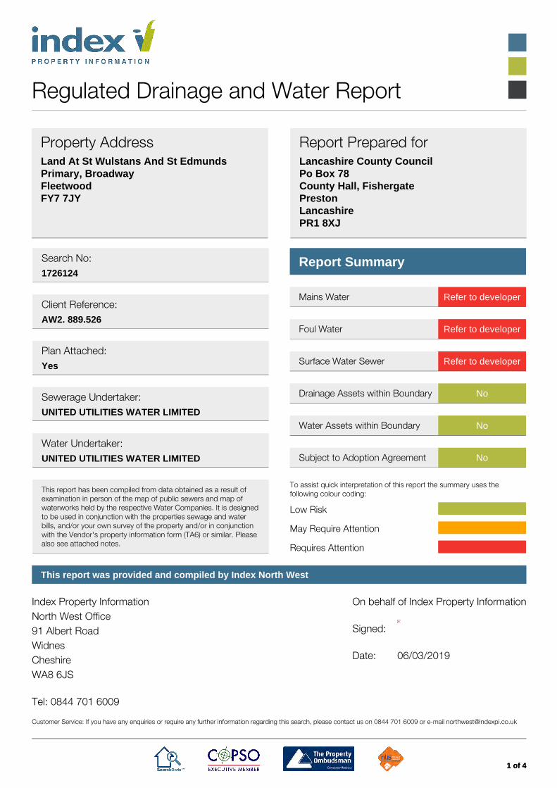
Regulated Drainage and Water Report
Property AddressLand At St Wulstans And St EdmundsPrimary, BroadwayFleetwoodFY7 7JY
Report Prepared forLancashire County CouncilPo Box 78County Hall, FishergatePrestonLancashirePR1 8XJ
Search No:1726124
Client Reference:AW2. 889.526
Plan Attached:Yes
Sewerage Undertaker:UNITED UTILITIES WATER LIMITED
Water Undertaker:UNITED UTILITIES WATER LIMITED
This report has been compiled from data obtained as a result ofexamination in person of the map of public sewers and map ofwaterworks held by the respective Water Companies. It is designedto be used in conjunction with the properties sewage and waterbills, and/or your own survey of the property and/or in conjunctionwith the Vendor's property information form (TA6) or similar. Pleasealso see attached notes.
Report Summary
Mains Water Refer to developer
Foul Water Refer to developer
Surface Water Sewer Refer to developer
Drainage Assets within Boundary No
Water Assets within Boundary No
Subject to Adoption Agreement No
To assist quick interpretation of this report the summary uses thefollowing colour coding:
Low Risk
May Require Attention
Requires Attention
This report was provided and compiled by Index North West
Index Property InformationNorth West Office91 Albert RoadWidnesCheshireWA8 6JS Tel: 0844 701 6009
On behalf of Index Property Information Signed: Date: 06/03/2019
Customer Service: If you have any enquiries or require any further information regarding this search, please contact us on 0844 701 6009 or e-mail [email protected]
Land At St Wulstans And St Edmunds Primary, Broadway, Fleetwood, FY7 7JY Search No: 1726124
2 of 4
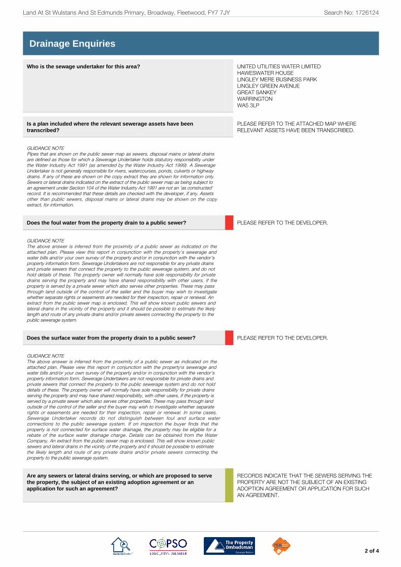
Drainage Enquiries
Who is the sewage undertaker for this area?
UNITED UTILITIES WATER LIMITEDHAWESWATER HOUSELINGLEY MERE BUSINESS PARKLINGLEY GREEN AVENUEGREAT SANKEYWARRINGTONWA5 3LP
Is a plan included where the relevant sewerage assets have beentranscribed? PLEASE REFER TO THE ATTACHED MAP WHERE
RELEVANT ASSETS HAVE BEEN TRANSCRIBED.
GUIDANCE NOTEPipes that are shown on the public sewer map as sewers, disposal mains or lateral drainsare defined as those for which a Sewerage Undertaker holds statutory responsibility underthe Water Industry Act 1991 (as amended by the Water Industry Act 1999). A SewerageUndertaker is not generally responsible for rivers, watercourses, ponds, culverts or highwaydrains. If any of these are shown on the copy extract they are shown for information only.Sewers or lateral drains indicated on the extract of the public sewer map as being subject toan agreement under Section 104 of the Water Industry Act 1991 are not an 'as constructed'record. It is recommended that these details are checked with the developer, if any. Assetsother than public sewers, disposal mains or lateral drains may be shown on the copyextract, for information.
Does the foul water from the property drain to a public sewer? PLEASE REFER TO THE DEVELOPER.
GUIDANCE NOTEThe above answer is inferred from the proximity of a public sewer as indicated on theattached plan. Please view this report in conjunction with the property's sewerage andwater bills and/or your own survey of the property and/or in conjunction with the vendor'sproperty information form. Sewerage Undertakers are not responsible for any private drainsand private sewers that connect the property to the public sewerage system, and do nothold details of these. The property owner will normally have sole responsibility for privatedrains serving the property and may have shared responsibility with other users, if theproperty is served by a private sewer which also serves other properties. These may passthrough land outside of the control of the seller and the buyer may wish to investigatewhether separate rights or easements are needed for their inspection, repair or renewal. Anextract from the public sewer map is enclosed. This will show known public sewers andlateral drains in the vicinity of the property and it should be possible to estimate the likelylength and route of any private drains and/or private sewers connecting the property to thepublic sewerage system.
Does the surface water from the property drain to a public sewer? PLEASE REFER TO THE DEVELOPER.
GUIDANCE NOTEThe above answer is inferred from the proximity of a public sewer as indicated on theattached plan. Please view this report in conjunction with the property\s sewerage andwater bills and/or your own survey of the property and/or in conjunction with the vendor'sproperty information form. Sewerage Undertakers are not responsible for private drains andprivate sewers that connect the property to the public sewerage system and do not holddetails of these. The property owner will normally have sole responsibility for private drainsserving the property and may have shared responsibility, with other users, if the property isserved by a private sewer which also serves other properties. These may pass through landoutside of the control of the seller and the buyer may wish to investigate whether separaterights or easements are needed for their inspection, repair or renewal. In some cases,Sewerage Undertaker records do not distinguish between foul and surface waterconnections to the public sewerage system. If on inspection the buyer finds that theproperty is not connected for surface water drainage, the property may be eligible for arebate of the surface water drainage charge. Details can be obtained from the WaterCompany. An extract from the public sewer map is enclosed. This will show known publicsewers and lateral drains in the vicinity of the property and it should be possible to estimatethe likely length and route of any private drains and/or private sewers connecting theproperty to the public sewerage system.
Are any sewers or lateral drains serving, or which are proposed to servethe property, the subject of an existing adoption agreement or anapplication for such an agreement?
RECORDS INDICATE THAT THE SEWERS SERVING THEPROPERTY ARE NOT THE SUBJECT OF AN EXISTINGADOPTION AGREEMENT OR APPLICATION FOR SUCHAN AGREEMENT.
Land At St Wulstans And St Edmunds Primary, Broadway, Fleetwood, FY7 7JY Search No: 1726124
3 of 4
GUIDANCE NOTEThe above answer is inferred from the proximity of a public sewer as indicated on theattached plan. Please view this report in conjunction with the property's sewerage andwater bills and/or your own survey of the property and/or in conjunction with the vendorsproperty information form. Pipes that are shown on the public sewer map as sewers,disposal mains or lateral drains are defined as those for which a sewerage undertaker holdsstatutory responsibility under the Water Industry Act 1991 (as amended by the WaterIndustry Act 1999).
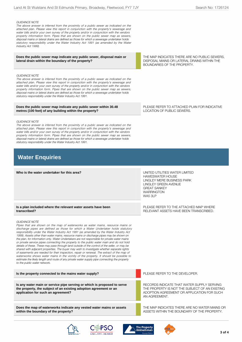
Does the public sewer map indicate any public sewer, disposal main orlateral drain within the boundary of the property?
THE MAP INDICATES THERE ARE NO PUBLIC SEWERS,DISPOSAL MAINS OR LATERAL DRAINS WITHIN THEBOUNDARIES OF THE PROPERTY.
GUIDANCE NOTEThe above answer is inferred from the proximity of a public sewer as indicated on theattached plan. Please view this report in conjunction with the property's sewerage andwater bills and/or your own survey of the property and/or in conjunction with the vendorsproperty information form. Pipes that are shown on the public sewer map as sewers,disposal mains or lateral drains are defined as those for which a sewerage undertaker holdsstatutory responsibility under the Water Industry Act 1991.
Does the public sewer map indicate any public sewer within 30.48metres (100 feet) of any building within the property? PLEASE REFER TO ATTACHED PLAN FOR INDICATIVE
LOCATION OF PUBLIC SEWERS.
GUIDANCE NOTEThe above answer is inferred from the proximity of a public sewer as indicated on theattached plan. Please view this report in conjunction with the property's sewerage andwater bills and/or your own survey of the property and/or in conjunction with the vendorsproperty information form. Pipes that are shown on the public sewer map as sewers,disposal mains or lateral drains are defined as those for which a sewerage undertaker holdsstatutory responsibility under the Water Industry Act 1991.
Water Enquiries
Who is the water undertaker for this area?
UNITED UTILITIES WATER LIMITEDHAWESWATER HOUSELINGLEY MERE BUSINESS PARKLINGLEY GREEN AVENUEGREAT SANKEYWARRINGTONWA5 3LP
Is a plan included where the relevant water assets have beentranscribed? PLEASE REFER TO THE ATTACHED MAP WHERE
RELEVANT ASSETS HAVE BEEN TRANSCRIBED.
GUIDANCE NOTEPipes that are shown on the map of waterworks as water mains, resource mains ordischarge pipes are defined as those for which a Water Undertaker holds statutoryresponsibility under the Water Industry Act 1991 (as amended by the Water Industry Act1999). Assets other than water mains, resource mains or discharge pipes may be shown onthe plan, for information only. Water Undertakers are not responsible for private water mainsor private service pipes connecting the property to the public water main and do not holddetails of these. These may pass through land outside of the control of the seller, or may beshared with adjacent properties. The buyer may wish to investigate whether separate rightsof easements are needed for their inspection, repair or renewal. The extract of the map ofwaterworks shows water mains in the vicinity of the property. It should be possible toestimate the likely length and route of any private water supply pipe connecting the propertyto the public water network.
Is the property connected to the mains water supply? PLEASE REFER TO THE DEVELOPER.
Is any water main or service pipe serving or which is proposed to servethe property, the subject of an existing adoption agreement or anapplication for such an agreement?
RECORDS INDICATE THAT WATER SUPPLY SERVINGTHE PROPERTY IS NOT THE SUBJECT OF AN EXISTINGADOPTION AGREEMENT OR APPLICATION FOR SUCHAN AGREEMENT.
Does the map of waterworks indicate any vested water mains or assetswithin the boundary of the property? THE MAP INDICATES THERE ARE NO WATER MAINS OR
ASSETS WITHIN THE BOUNDARY OF THE PROPERTY.

Land At St Wulstans And St Edmunds Primary, Broadway, Fleetwood, FY7 7JY Search No: 1726124
4 of 4
GUIDANCE NOTEWhere the property is part of a very recent or ongoing development and the water mainsand service pipes are not the subject of an adoption application, buyers should consult withthe developer to confirm that the Water Undertaker will be asked to provide a water supplyto the development or to ascertain the extent of any private water supply system for whichthey will hold maintenance and renewal liabilities.
Billing Matters
What is the current basis for charging for sewerage and water servicesat the property? PLEASE REFER TO THE VENDOR.
GUIDANCE NOTEWater and Sewerage Companies full charges are set out in their charges schemes whichare available from the Company free of charge upon request. The Company may install ameter at the premises where a buyer makes a change of use of the property or where thebuyer uses water for watering the garden, other than by hand (this includes the use ofsprinklers) or automatically replenishing a pond or swimming pool with a capacity greaterthan 10,000 litres.

Wate
r Asset M
ap
LEGEND
WATER MAIN
LARGE TRUNK MAIN
PROPOSED WATER MAIN
ABANDONED MAIN
CONCESSIONARY PIPE
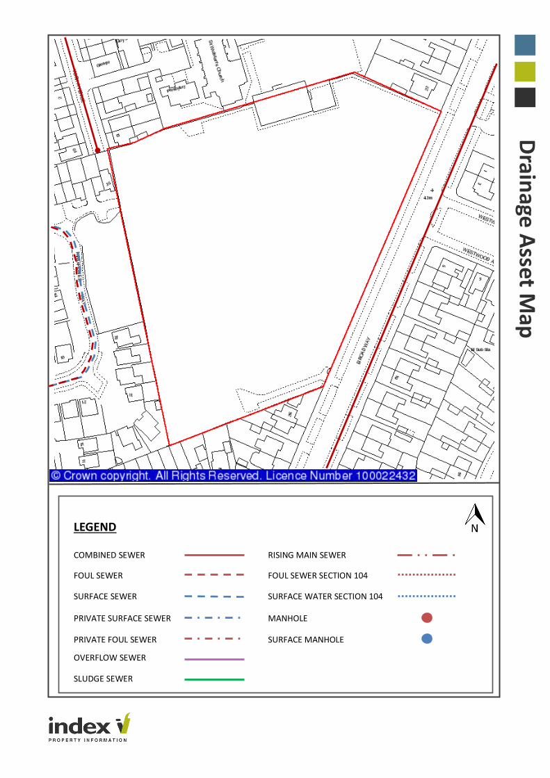
Drain
age A
sset Map
LEGEND
COMBINED SEWER RISING MAIN SEWER
FOUL SEWER FOUL SEWER SECTION 104
SURFACE SEWER SURFACE WATER SECTION 104
PRIVATE SURFACE SEWER MANHOLE
PRIVATE FOUL SEWER SURFACE MANHOLE
OVERFLOW SEWER
SLUDGE SEWER

Terms and Conditions
1. Definitions and Interpretation
1.1 In these Conditions the following words shall have the meanings set
opposite them:
“Charges” mean our financial charges for providing the Services,
which will be notified to You when You submit Your Order.
“Client” shall include (i) The individual(s) or business entity of whom
You act on whose behalf You are using the Services (ii) The
individual(s) or business entity who has or are considering acquiring
an interest in or charge over the Property to which the Services relate.
(iii) The individual(s) or business entity who acts in a professional or
advisory capacity for any person using the Services.
“Confirmation of Order” means our written acceptance of the Order.
“Contract” means the legally-binding agreement between Us and You
for the supply by Us of the Services and which incorporates these
Conditions.
“Data Provider” means a third-party provider of data used in a Report
“Intellectual Property Rights” means any intellectual property right,
including, without limitation, copyright, database rights, trademarks,
patents, trade secrets or design rights.
“Invoice” means an invoice in respect of the Services issued by Us to
You.
“Order” means Your request for Us to provide the Services which You
place by communicating or sending it to Us by electronic or other pre-
agreed means.
“Property” means the property address or location of the buildings,
land, fixtures and all chattels for which You require a Report.
“Index” means the party with whom You place an Order for the
Services which may be Index Property Information Limited, Index
Insure Limited or any one or a combination of affiliated businesses.
“Report” means any report/document that You have asked Us to
deliver to You as detailed in the Order.
“Required Information” means all information required to submit an
Order to Us which shall enable Us to provide the Services to You and
which shall be included in the Order.
“Search Code” means the ‘Council of Property Search Organisations’
search code.
“Third Party Report” means any Report that We procure from a third
party on Your behalf for the purpose of providing the Services to You.
“Services” mean the provision of Reports to You.
“Us” or “We” or Our means Index.
“You” or “Your” means the conveyancer and/or the conveyancer’s
firm acting on behalf of the Client.
1.2 Headings used in these Conditions are for convenience only and shall
not affect the interpretation of the main provisions.
2. Your Privacy and Security
2.1 Your personal details and any details identifying the Client are held on
a secure database in accordance with relevant data protection
legislation and those details are used solely for the provision of the
Services. We shall not pass confidential customer information to other
organisations unless You specifically authorise Index to do so.
2.2 Your Order will be retained by Us in an electronic format and will be
available for inspection upon reasonable notice for a period of 6 years
from the date of the Order.
2.3 Index will use personal information which We hold about You and/or
the Client to provide the Services to You, for credit control and market
research purposes and to inform You about Our Services and products
and legal developments and training sessions or events which We
believe may be of interest to You.
2.4 Except in the situations listed above or as required or allowed by other
regulations, We will not pass, disclose, rent or sell Your personal
information or the Client’s personal information (other than any
personal information which is already publicly available and which is
incorporated into Our search products) to any third party without Your
prior consent.
3. The Services
3.1 An Order will be deemed to be an offer to purchase Services from Us
on these Conditions.
3.2 We will not be obliged to accept any Order. No Contract for Services
will come into force until Confirmation of Order has been provided to
You by Us.
3.3 These Conditions alone will apply to (and will form part of) the
Contract. They supersede any previously issued terms and conditions
of supply.
3.4 No terms or conditions endorsed on, delivered with, or contained in
the Client’s purchase Order, Confirmation of Order, specification or
other document will form part of the Contract and in the event of any
conflict these conditions shall prevail.
3.5 No variation of the Conditions or to an Order will be binding unless
expressly agreed in writing and executed by a duly authorised
signatory on behalf of Index.
3.6 Each Order, if accepted by Us, will constitute a separate and severable
Contract.
3.7 Upon receiving and accepting Your Order We shall provide a
Confirmation of Order. Once this is issued We shall commence work
on Your Order.
3.8 Any indication that We may give as to the time in which We will
perform the Services will be a good faith estimate only. We will use all
reasonable endeavours to deliver the Report within the timescale that
We have estimated. Due to variations in availability of the information
You agree that time of delivery of Reports is not of the essence and
that delivery may take place as soon as is reasonably possible after
Confirmation of Order has been provided.
4. Charges
4.1 Unless expressly indicated otherwise, the Charges will include VAT at
the applicable rate.
4.2 Unless indicated otherwise the Charges also include all delivery and
communication costs.
4.3 You shall pay the Invoice in full and in cleared funds within 30 days of
delivery of the Report. Time of payment is of the essence.
4.4 If You fail to make any payment due to Us under these Conditions by
the due date for payment (Due Date), then We shall charge interest at
a rate of 1.75% per month. Such interest shall accrue on a daily basis
from the Due Date until the date of actual payment of the overdue
amount.
4.5 You shall pay all amounts due under these Conditions in full and Index
reserve the right to suspend or discontinue the Service without notice
to You in the event of repeated non-payment of the Services by You.
5. Warranties
5.1 We will:
a) Recommend relevant Reports which may be carried out against the
Property Should You ask Us to;
b) Pass Orders onto the relevant Data Provider;
c) Forward the Report to You electronically or otherwise as You may
request in the Order;
d) Ensure that Reports are accessible by You at www.indexlive.co.uk by
using Your unique login and password;
e) Comply with the Search Code which is regulated by the Property Codes
Compliance Board.
f) We are authorised to provide all the Services contained in this
Agreement.
g) Use our expertise and skill to provide the Services to You and will keep
You updated with any new Third Party Reports and Reports.
5.2 You will provide Us with the Required Information in Your Order. You
warrant that the information supplied by You is complete, correct and
up to date.
5.3 You will notify Us immediately on You becoming aware of any
inaccuracy contained within the Order. If We receive Your notification
before the Confirmation of Order is sent, We will change the Order
accordingly. If We receive Your notification after the Confirmation of
Order is sent, We will attempt to alter the Services to reflect the new
information but You will be responsible for our reasonable costs in
changing the Services. Whether or not it is possible to alter the
Services will depend on the progress of the Services at the time of
notification to Us of the inaccurate information and the nature of the
changes to the information and You acknowledge that it may not be
possible to alter the Services at that time and You will therefore be
required to submit a new Order and you will be responsible for the
abortive costs.
5.4 If ordering online, You will provide an electronic mailing address. If
ordering by other means or if email communication (or electronic
communication) is not available, You shall communicate by first class
post or via a facsimile machine. In all communication You will provide
a return address. In providing this address You agree that
communications between Us and You will be through these means.
6. Cancellation
If You cancel Your Order after We have provided the Confirmation of
Order any refund of monies already paid will be at Our discretion and
You will remain liable to pay any Charges that have been reasonably
incurred by Us.
7. Intellectual Property Rights and Proprietorship
7.1 Any and all Intellectual Property Rights arising from performance of
the Services shall vest in Us and remain our property. We disclaim all
proprietary rights including, without limitation, Intellectual Property
Rights in Third Party Reports.
7.2 You will not acquire, nor will You attempt to register any Intellectual
Property Rights in any Reports whether on Your own behalf or on
behalf of the Client. You further agree not to use the Reports in whole
or part other than as is expressly permitted by these Conditions.
7.3 Title to the Index products and Services which are the subject of Your
Order shall remain the property of Index and shall not pass to You or
any third party until the Charges notified to You have been paid to Us
in full.
8. Limitation of Liability
8.1 We will use Our reasonable endeavours to ensure that the information
contained within any Report is accurate at the date of its publication.
You accept that the information on which any Report is based may be
subject to change from the date of its publication and We will not be
liable for failing to include in or omit from the Report, any information
which becomes available after the date of publication or provision of
the Services.
8.2 We have in place Professional Indemnity Insurance from £5 million in
respect of each and every claim in respect of our work in preparing
collating and providing a Report and providing Third Party Reports as
part of the Services to you.
8.3 Where the value of the Property exceeds the amount set out in clause
8.2 it is Your responsibility to inform Us upon submission of the Order
so that We may arrange additional or alternative insurance cover to
take into account the increased value. If no such notification is
received by Us with the Order, any claim against Us will be limited to
the amount set out in clause 8.2.
8.4 We cannot accept liability for any negligent or incorrect entry in the
registers which We search.
8.5 We shall not accept any responsibility or liability for any inaccuracy or
error in the Report that is based on incomplete or inaccurate
information supplied by You.
8.6 A Report may contain information supplied by a Data Provider. We
may also supply (as intermediary) a Report that has been wholly
created by a Data Provider. These Data Providers are required by their
regulatory bodies to have appropriate Professional Indemnity
Insurance or to be covered by statutory compensation arrangements.
We shall not accept liability for any loss or consequence of the act or
omission of a Data Provider except that We shall, at Your request and
expense, provide reasonable assistance in any claim brought by You
or a Client against a Data Provider concerning the supply by that Data
Provider of an incorrect or incomplete Report and shall, where
possible, assign to You (or a Client at Your direction) at Your cost the
benefit of any warranty, guarantee or indemnity given to Us by such
Data Provider or of which We have the benefit .
8.7 We shall not be liable to You for any loss caused by a failure by You or
Your Client to have in place all necessary means of receiving the
Services the maintenance of internet access, email facilities and
security measures.
8.8 We acknowledge that You may make Reports available to Clients in
the normal course of Your business and agree that where You do so
then any such Client shall have the benefit of enforcing Your rights
under these Conditions as if the Client were a party to the Contract,
including where Reports are placed in a data room or other file sharing
environment as part of a wider transaction.
8.9 Nothing in these Conditions shall limit or exclude Our liability for any
matter in respect of which it would be unlawful for Us to exclude or
restrict liability.
8.10 Subject to clause 8.9:
The Company shall not be liable to You or any third party for any loss
of profits or Contracts (whether direct or indirect) or for any indirect
or consequential loss whether arising from negligence, breach of
Contract or howsoever.
8.11 We will not be liable in Contract, tort, negligence and statutory duty
or otherwise, for any loss or damage whatsoever caused by any act or
omission of a Data Provider or inaccuracies in or omissions from any
responses provided by a Data Provider.
8.12 The information and data used to generate search alerts is derived
from publicly available records and other third-party sources and We
do not warrant the accuracy or completeness of such information or
data. We do not claim that these sources represent an exhaustive or
comprehensive list of all sources that might be consulted.
9. Force Majeure
We will not be liable for any failure to perform the Services due to any
event beyond Our reasonable control. However, if our performance of
the Services is delayed due to any event beyond our reasonable
control, We will notify You promptly.
10. Assignment
You acknowledge that Index may use one or more Data Provider to
fulfil provision of the Services on the terms set out in this Agreement.
Subject to the other terms of this Agreement, Index will remain
responsible for, and liable to You, in respect of the provision of the
Services by such Data Provider.
11. General
11.1 You acknowledge that in instructing Us to provide the Services You do
not do so on the basis of any representation, warranty or provision not
expressly contained within these Conditions.
11.2 If at any time, any one or more of these Conditions are held to be
unenforceable, illegal or otherwise invalid in any respect; such
enforceability, illegality or invalidity shall not affect the remaining
Conditions, which shall remain in full force and effect.
11.3 Any failure by Us to enforce a breach of these Conditions by You will
not be deemed to be a waiver of any subsequent breach of these
Conditions that You may make.
11.4 Nothing in these Conditions shall create or be deemed to create a
partnership or joint venture between Us or You or the relationship of
principal and agent or employer and employee.
11.5 These Conditions will be governed by English law.
12. Independent Dispute Resolution
If You make a complaint and We are unable to resolve it to your
satisfaction, you may refer the complaint to the Property Ombudsman
Scheme (web site: www.tpos.co.uk, email: [email protected]). We
will co-operate fully with the Ombudsman during an investigation and
comply with the Ombudsman’s final decision.

Regulated Search
Important Consumer Information This search has been produced Index Property Information, Head Office is at 1-3 Langham Barns, Langham Lane, Colchester, Essex, CO4 5ZS, Tel: 01206 273 423, E-mail [email protected], which is registered with the Property Codes Compliance Board (PCCB) as a subscriber to the Search Code. The PCCB independently monitors how registered search firms maintain compliance with the Code. The Search Code: provides protection for homebuyers, sellers, estate agents, conveyancers and mortgage lenders who rely on the information included in property
search reports undertaken by subscribers on residential and commercial property within the United Kingdom sets out minimum standards which firms compiling and selling search reports have to meet promotes the best practice and quality standards within the industry for the benefit of consumers and property professionals enables consumers and property professionals to have confidence in firms which subscribe to the code, their products and services. By giving you this information, the search firm is confirming that they keep to the principles of the Code. This provides important protection for you. The Code’s Core Principles Firms which subscribe to the Search Code will:
display the Search Code logo prominently on their search reports
act with integrity and carry out work with due skill, care and diligence
at all times maintain adequate and appropriate insurance to protect consumers
conduct business in an honest, fair and professional manner
handle complaints speedily and fairly
ensure that products and services comply with industry registration rules and standards and relevant laws
monitor their compliance with the Code
Complaints If you have a query or complaint about your search, you should raise it directly with the search firm, and if appropriate ask for any complaint to be considered under their formal internal complaints procedure. If you remain dissatisf ied with the firm’s final response, after your complaint has been formally considered, or if the firm has exceeded the response timescales, you may refer your complaint for consideration under The Property Ombudsman scheme (TPOs). The Ombudsman can award up to £5,000 to you if the Ombudsman finds that you have suffered actual financial loss and/or aggravation, distress or inconvenience as a result of your search provider failing to keep to the Code. Please note that all queries or complaints regarding your search should be directed to your search provider in the first instance, not to TPOs or to the PCCB. TPOs Contact Details: The Property Ombudsman scheme Milford House 43-55 Milford Street Salisbury Wiltshire SP1 2BP Tel: 01722 333306 Fax: 01722 332296 Web site: www.tpos.co.uk Email: [email protected] You can get more information about the PCCB from www.propertycodes.org.uk. PLEASE ASK YOUR SEARCH PROVIDER IF YOU WOULD LIKE A COPY OF THE SEARCH CODE Complaints Procedure If you want to make a complaint, we will: Acknowledge it within 5 working days of receipt. Normally deal with it fully and provide a final response, in writing, within 20 working days of receipt. Keep you informed by letter, telephone or e-mail, as you prefer, if we need more time. Provide a final response, in writing, at the latest within 40 working days of receipt. Liaise, at your request, with anyone acting formally on your behalf. Complaints should be sent to: Nikki Younger, Network Manager, Index Property Information, 1-3 Langham Barns, Langham Lane, Colchester, Essex, CO4 5ZS, Tel: 01206 273 423, E-mail: [email protected]. If you are not satisfied with our final response, or if we exceed the response timescales, you may refer the complaint to The Property Ombudsman scheme (TPOs): Tel: 01722 333306, E-mail: [email protected]. We will co-operate fully with the Ombudsman during an investigation and comply with his final decision.
Simply Ecology Ltd, Office 7-2-6, Cameron House, White Cross, South Road, Lancaster LA1 4XF
Tel: 01524 874522 - Mob: 07754 538437 - [email protected]
www.simplyecology.co.uk
Land off Broadway, Fleetwood, FY7 7DQ
Preliminary Ecological Appraisal
Simply Ecology Limited
Ref: SE/LCCQ113/01
March 2019
For
Lancashire County Council
P.O. Box 26
County Hall
Preston
PR1 8XB
Land off Broadway, Fleetwood, FY7 7DQ
Simply Ecology Limited – Preliminary Ecological Appraisal – March 2019
CONTENTS PAGE
1.0 INTRODUCTION .................................................................................................................... 1 1.1 Background Information ..................................................................................................... 1 1.2 Aims ................................................................................................................................... 1 1.3 Site Description and Proposed Works ................................................................................. 1
2.0 SURVEY METHODOLOGY ..................................................................................................... 2 2.1 Desk Study ......................................................................................................................... 2 2.2 Extended Phase 1 Survey .................................................................................................... 2 2.3 Invasive Alien Plants ........................................................................................................... 2 2.4 Bat Tree Survey .................................................................................................................. 2 2.5 Personnel ........................................................................................................................... 3 2.6 Timing and Constraints ....................................................................................................... 3
3.0 DESK STUDY RESULTS .......................................................................................................... 4 3.1 Nature Conservation Sites .................................................................................................. 4 3.2 Priority Habitats ................................................................................................................. 4 3.3 Protected/Noteworthy Species ........................................................................................... 5
4.0 PHASE 1 SURVEY RESULTS ................................................................................................... 9 4.1 Habitat Results ................................................................................................................... 9 4.2 Invasive Alien Species ........................................................................................................ 13 4.3 Tree Inspection .................................................................................................................. 13 4.4 Breeding Birds ................................................................................................................... 13
5.0 CONCLUSIONS AND RECOMMENDATIONS ....................................................................... 14 5.2 Statutory Sites .................................................................................................................. 14 5.3 Habitats ............................................................................................................................ 14 5.4 Invasive Species ................................................................................................................ 15 5.5 Protected Species ............................................................................................................. 15
6.0 REFERENCES ........................................................................................................................ 17 APPENDIX B: LOCAL BIOLOGICAL HERITATE SITES ...................................................................... 21
PLANS PAGE
Plan 1: Site Location. ......................................................................................................................... 1
Plan 2: Red line site boundary. ........................................................................................................... 1
Plan 3: Desk study results from LERN detailing the protected conservation sites and species within
2km, as well as invasive species. ........................................................................................................ 8
Plan 4: Phase 1 survey map of the site. ............................................................................................. 12
Land off Broadway, Fleetwood, FY7 7DQ
Simply Ecology Limited – Preliminary Ecological Appraisal – March 2019
Control Sheet
Name Position
Author: Samantha Gray BA GradCIEEM Business Ecologist
Checked and
Approved by: Jason Reynolds MSc MCIEEM Director
Version History
Version Date Modified by Approved by Comment/Reason(s)
1 14/03/19 N/A JR First Issue
Disclaimer
This report has been prepared by Simply Ecology Limited with all reasonable skill, care and
diligence, within the terms of the Contract with the Client. The actions of the surveyor on site and
during the production of the report were undertaken in accordance with the Code of Professional
Conduct for the Chartered Institute of Ecology and Environmental Management.
(www.cieem.org.uk).
This report has been prepared by Simply Ecology Limited for the sole use of the client and in
connection with the development project described – this report cannot be relied upon by any third
party without express written consent by both Simply Ecology Limited and the client.
This is a technical report and does not represent legal advice/ opinion.
This report remains Simply Ecology Limited property and cannot be relied upon until full payment
has been made.
Simply Ecology Limited retain the right to re-publish data obtained and submit those species
records produced during all ecological studies to the local recording centre.
Copyright ©
This report is the copyright of Simply Ecology Limited. Any unauthorised reproduction or usage of
material from this report is prohibited.
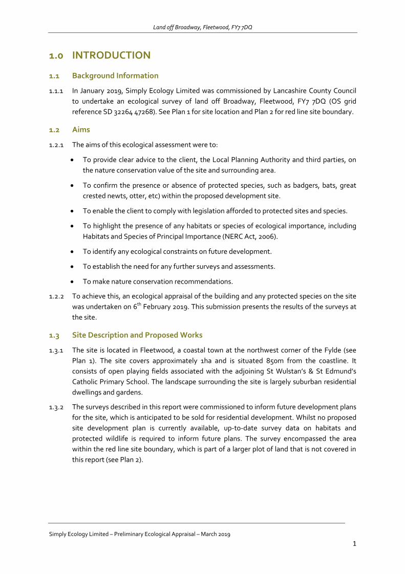
Land off Broadway, Fleetwood, FY7 7DQ
Simply Ecology Limited – Preliminary Ecological Appraisal – March 2019
1
1.0 INTRODUCTION
1.1 Background Information
1.1.1 In January 2019, Simply Ecology Limited was commissioned by Lancashire County Council
to undertake an ecological survey of land off Broadway, Fleetwood, FY7 7DQ (OS grid
reference SD 32264 47268). See Plan 1 for site location and Plan 2 for red line site boundary.
1.2 Aims
1.2.1 The aims of this ecological assessment were to:
To provide clear advice to the client, the Local Planning Authority and third parties, on
the nature conservation value of the site and surrounding area.
To confirm the presence or absence of protected species, such as badgers, bats, great
crested newts, otter, etc) within the proposed development site.
To enable the client to comply with legislation afforded to protected sites and species.
To highlight the presence of any habitats or species of ecological importance, including
Habitats and Species of Principal Importance (NERC Act, 2006).
To identify any ecological constraints on future development.
To establish the need for any further surveys and assessments.
To make nature conservation recommendations.
1.2.2 To achieve this, an ecological appraisal of the building and any protected species on the site
was undertaken on 6th February 2019. This submission presents the results of the surveys at
the site.
1.3 Site Description and Proposed Works
1.3.1 The site is located in Fleetwood, a coastal town at the northwest corner of the Fylde (see
Plan 1). The site covers approximately 1ha and is situated 850m from the coastline. It
consists of open playing fields associated with the adjoining St Wulstan’s & St Edmund’s
Catholic Primary School. The landscape surrounding the site is largely suburban residential
dwellings and gardens.
1.3.2 The surveys described in this report were commissioned to inform future development plans
for the site, which is anticipated to be sold for residential development. Whilst no proposed
site development plan is currently available, up-to-date survey data on habitats and
protected wildlife is required to inform future plans. The survey encompassed the area
within the red line site boundary, which is part of a larger plot of land that is not covered in
this report (see Plan 2).
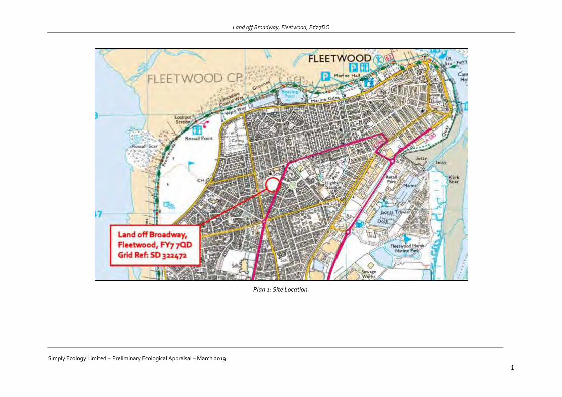
Land off Broadway, Fleetwood, FY7 7DQ
Simply Ecology Limited – Preliminary Ecological Appraisal – March 2019
1
Plan 1: Site Location.

Land off Broadway, Fleetwood, FY7 7DQ
Simply Ecology Limited – Preliminary Ecological Appraisal – March 2019
1
Plan 2: Red line site boundary.
Land off Broadway, Fleetwood, FY7 7DQ
Simply Ecology Limited – Preliminary Ecological Appraisal – March 2019
2
2.0 SURVEY METHODOLOGY
2.1 Desk Study
2.1.1 For the desk study the application site and surrounding 1km was selected to search for any
existing biological information. Consultation with commercially available datasets was
undertaken to identify records of animals or plants within this search area. Lancashire
Ecological Records Network (LERN) supplied the relevant documentation.
2.1.2 In addition, an online search of the Multi Agency Geographical Information Centre
(www.magic.gov.uk) and Natural England’s Nature on the Map
(www.natureonthemap.org.uk) was undertaken to identify the presence of nationally or
internationally important sites receiving statutory protection. This included sites designated
under the Wildlife and Countryside Act 1981 (as amended) and the Conservation of Habitats
and Species Regulations 2010. This covers Sites of Special Scientific Interest (SSSI), Special
Protection Areas (SPA) and Special Areas of Conservation (SAC) all of which have legal
protection.
2.2 Extended Phase 1 Survey
2.2.1 The Phase 1 habitat survey was undertaken by Kevin Heywood BSc (Hons) ACIEEM on 6th
February 2019. The survey followed the Phase 1 habitat survey methodology (JNCC, 2010)
which is a standard technique for recording and mapping habitats. During the Phase 1
survey the presence or potential for presence of protected species was recorded and
assessed.
2.2.2 The survey involved walking the whole site, mapping and describing different habitats (for
example: woodland, grassland, scrub). Evidence of fauna and faunal habitat is also recorded
(for example droppings, tracks, or habitat such as ponds for breeding amphibians). The
methods used for ecological survey are in accordance with those established and generally
accepted methodologies for field survey, as published by the professional body, the
Chartered Institute of Ecology and Environmental Management (CIEEM).
2.3 Invasive Alien Plants
2.3.1 During the Phase 1 habitat survey, observations of invasive alien plants listed under
Schedule 9 of The Wildlife and Countryside Act 1981 (as amended) were made. The search
included species such as Giant Hogweed (Heracleum mantegazzianum), Japanese knotweed
(Fallopia japonica) and Himalayan balsam (Impatiens glandulifera).
2.4 Bat Tree Survey
2.4.1 As part of the inspection, a visual survey of all trees was carried out using 10x42 binoculars.
The survey was undertaken in accordance with the standard methods described in the ‘Bat
Worker’s Manual’ (JNCC 2004) and ‘Bat Surveys – Good Practice Guidelines’ (BCT 2016). The
survey comprised of identifying the following features:
Woodpecker holes with small cracks/crevices
Cracks/crevices, ivy cover and flaking bark
Land off Broadway, Fleetwood, FY7 7DQ
Simply Ecology Limited – Preliminary Ecological Appraisal – March 2019
3
Loose or flaking bark deadwood in canopy or stem low/no ivy cover
Medium to dense ivy cover
Deadwood in canopy or stem
Snagged branches
Hollow stems or limbs
Hole in buttresses/hollow core
2.4.2 The following signs were searched for, as these would indicate bat presence:
Staining around a hole, caused by natural oils in the bats’ fur.
Stains beneath a hole, caused by bat urine.
Scratch marks around a hole, caused by bat claws.
Bat droppings beneath a hole.
Audible squeaking from within a hole, especially on hot days or at dusk.
Insects (especially flies) around a hole.
2.4.3 Once surveyed, each tree was categorised, using Bat Conservation Trust guidelines,
according to its potential to support roosting bats into one of four categories:
1. Confirmed bat roost,
2a. High potential to support bats,
2b. Low/moderate potential to support bats, and
3. Negligible potential to support bats.
2.5 Personnel
2.5.1 All surveys were undertaken by Kevin Heywood BSc (Hons) ACIEEM. Kevin is an Ecologist
with Simply Ecology Ltd. Kevin graduated with a first-class honours degree in Ecology from
Lancaster University in 2015. In addition to this, he has acquired experience since 2012
working as an ecologist in a freelance capacity and since 2015 as a full-time employee for
Simply Ecology Ltd. During this time, he has developed numerous field skills and carried out
a wide range of botanical and protected species surveys. His expertise predominantly lies
with habitat mapping and undertaking protected species surveys including: bats, great
crested newts, badgers, otters and reptiles. Kevin holds a protected species licence for all
British bats.
2.6 Timing and Constraints
2.6.1 The Phase 1 survey was undertaken on 6th February 2019. Whilst this is not the most optimal
time to record flora, typically key indicator species can readily be identified using vegetative
material and using dead plant matter. The timing posed no problems for the protected
species assessment, and no constraints were encountered.

Land off Broadway, Fleetwood, FY7 7DQ
Simply Ecology Limited – Preliminary Ecological Appraisal – March 2019
4
3.0 DESK STUDY RESULTS
3.1 Nature Conservation Sites
3.1.1 The search for conservation sites in the surrounding area included both nationally important
sites, (Sites of Special Scientific Interest) and internationally important sites (Natura 2000
and Ramsar sites). The desk study revealed there were no statutory designated nature
conservation sites on the site. However the Wyre Estuary SSSI, Morecambe Bay Ramsar and
SAC sites were all located within 900m of the development boundary (see Plan 3).
3.1.2 Given the proximity to the aforementioned SSSI, the site lies within surrounding Impact Risk
Zones. The potential for impacts will require further consideration.
3.1.3 A total of six non-statutory Biological Heritage Sites (BHS) were identified within the local
area, although none were present on site. The closest of which is Fleetwood Cemetery,
located northwest, which comprises of species-rich dune grassland. This list of local
Biological Heritage Sites was compiled from the Lancashire Environment Record Network
(LERN). These are summarised in Table 1 and Plan 3, with further information provided in
Appendix B.
Table 1: Local Biological Heritage sites.
Habitat Type Site Name Approximate Locations
Species-rich dune grassland Fleetwood Cemetery 400m northwest
Mosaic of coastal and dune
grassland
Fleetwood Golf Course 550m northwest
Mosaic of grasslands, scrub,
swap and open water
Fleetwood Marsh Industrial
Lands
1000m southeast
Dune and coastal grassland Fleetwood Promenade 1150m west
Network of ditches and
bankings around small
agricultural fields
Rossall School Fields 1810m southeast
Brackish water pool ICI Hillhouse International
Pool
1850m southwest
3.2 Priority Habitats
3.2.1 The desk study also revealed that a number of Priority Habitats were located within the
surrounding 1km of the site. These included Coastal and Sand Dunes; Lowland Heathland;
and Deciduous Woodland. Whilst these are not designated, they do hold NERC (2006)
status. These results are summarised in Table 2 below.
Table 2: Priority Habitats within 1km of the site.
Habitat Type Location Relevant Legislation
Coastal and Sand Dunes Outside of the site,
approximately 550m
northwest
NERC (2006)
Lowland Heathland Outside of the site,
approximately 860m
NERC (2006)
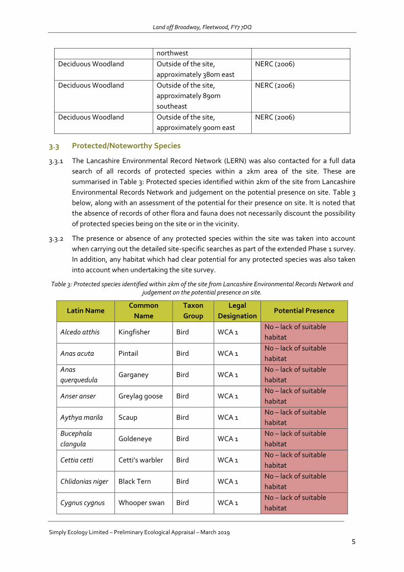
Land off Broadway, Fleetwood, FY7 7DQ
Simply Ecology Limited – Preliminary Ecological Appraisal – March 2019
5
northwest
Deciduous Woodland Outside of the site,
approximately 380m east
NERC (2006)
Deciduous Woodland Outside of the site,
approximately 890m
southeast
NERC (2006)
Deciduous Woodland Outside of the site,
approximately 900m east
NERC (2006)
3.3 Protected/Noteworthy Species
3.3.1 The Lancashire Environmental Record Network (LERN) was also contacted for a full data
search of all records of protected species within a 2km area of the site. These are
summarised in Table 3: Protected species identified within 2km of the site from Lancashire
Environmental Records Network and judgement on the potential presence on site. Table 3
below, along with an assessment of the potential for their presence on site. It is noted that
the absence of records of other flora and fauna does not necessarily discount the possibility
of protected species being on the site or in the vicinity.
3.3.2 The presence or absence of any protected species within the site was taken into account
when carrying out the detailed site-specific searches as part of the extended Phase 1 survey.
In addition, any habitat which had clear potential for any protected species was also taken
into account when undertaking the site survey.
Table 3: Protected species identified within 2km of the site from Lancashire Environmental Records Network and judgement on the potential presence on site.
Latin Name Common
Name
Taxon
Group
Legal
Designation Potential Presence
Alcedo atthis Kingfisher Bird WCA 1 No – lack of suitable
habitat
Anas acuta Pintail Bird WCA 1 No – lack of suitable
habitat
Anas
querquedula Garganey Bird WCA 1
No – lack of suitable
habitat
Anser anser Greylag goose Bird WCA 1 No – lack of suitable
habitat
Aythya marila Scaup Bird WCA 1 No – lack of suitable
habitat
Bucephala
clangula Goldeneye Bird WCA 1
No – lack of suitable
habitat
Cettia cetti Cetti’s warbler Bird WCA 1 No – lack of suitable
habitat
Chlidonias niger Black Tern Bird WCA 1 No – lack of suitable
habitat
Cygnus cygnus Whooper swan Bird WCA 1 No – lack of suitable
habitat

Land off Broadway, Fleetwood, FY7 7DQ
Simply Ecology Limited – Preliminary Ecological Appraisal – March 2019
6
Eremophila
alpestris Shore lark Bird WCA 1
No – lack of suitable
habitat
Falco
columbarius Merlin Bird WCA 1
No – lack of suitable
habitat
Fringilla
montifringilla Brambling Bird WCA 1
No – lack of suitable
habitat
Limosa limosa Black-tailed
godwit Bird WCA 1
No – lack of suitable
habitat
Melanitta nigra Common scoter Bird WCA 1 No – lack of suitable
habitat
Pandion
haliaetus Osprey Bird WCA 1
No – lack of suitable
habitat
Plectrophenax
nivalis Snow bunting Bird WCA 1
No – lack of suitable
habitat
Turdus iliacus Redwing Bird WCA 1
Possible – some
potentially suitable
habitat for foraging
Turdus pilaris Fieldfare Bird WCA 1
Possible – some
potentially suitable
habitat for foraging
Tyto alba Barn owl Bird WCA 1;
WCA 9
No – lack of suitable
habitat
Bufo bufo Common toad Amphibian WCA 5
Possible – some
potentially suitable
habitat
Lissotriton
vulgaris Smooth newt Amphibian WCA 5
No – lack of suitable
habitat
Rana temporaria Common frog Amphibian WCA 5
Possible – some
potentially suitable
habitat
Triturus cristatus Great crested
newt Amphibian
HabsRegs2;
WCA 5
No – lack of suitable
habitat
Zootoca vivipara Common lizard Reptile WCA 5 No – lack of suitable
habitat
Arvicola
amphibius
European water
vole Mammal WCA 5
No – lack of suitable
habitat
Pipistrellus
pipistrellus
Common
pipistrelle Mammal WCA 5
Possible – some
potentially suitable
habitat for foraging
Pipistrellus
pygmaeus
Soprano
pipistrelle Mammal WCA 5
Possible – some
potentially suitable
habitat for foraging
Plecotus auritus Brown long-
eared bat Mammal WCA 5
No – lack of suitable
habitat
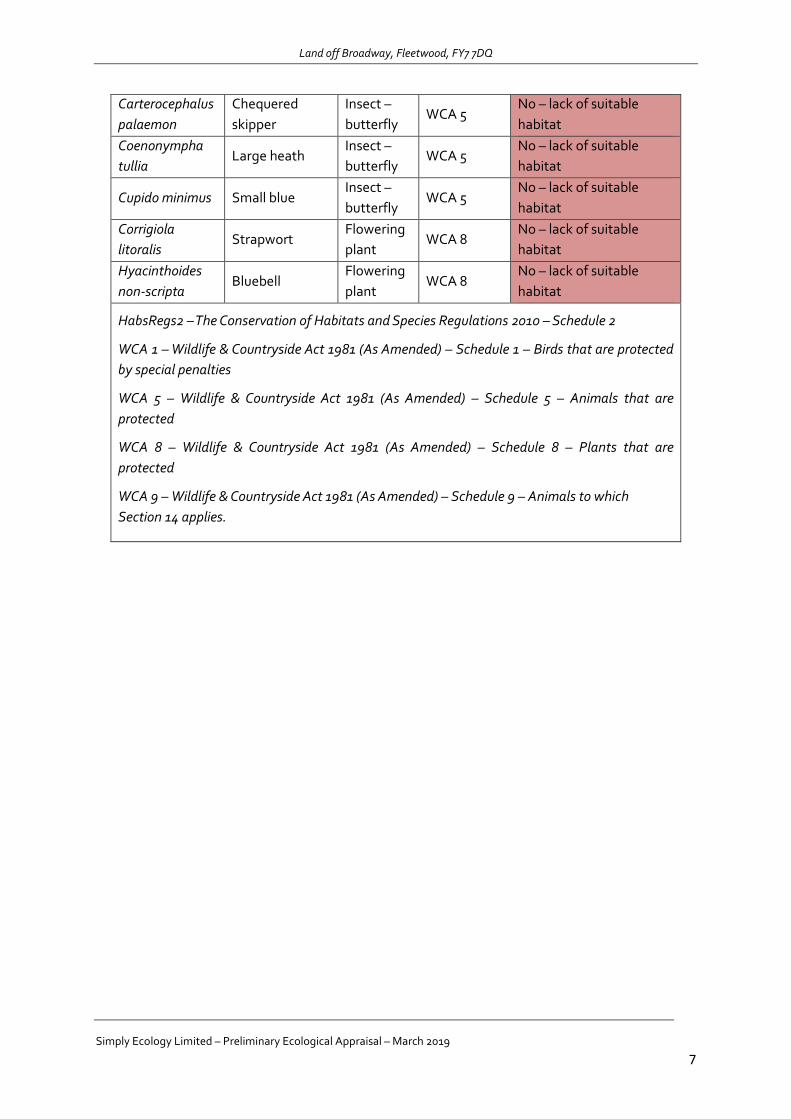
Land off Broadway, Fleetwood, FY7 7DQ
Simply Ecology Limited – Preliminary Ecological Appraisal – March 2019
7
Carterocephalus
palaemon
Chequered
skipper
Insect –
butterfly WCA 5
No – lack of suitable
habitat
Coenonympha
tullia Large heath
Insect –
butterfly WCA 5
No – lack of suitable
habitat
Cupido minimus Small blue Insect –
butterfly WCA 5
No – lack of suitable
habitat
Corrigiola
litoralis Strapwort
Flowering
plant WCA 8
No – lack of suitable
habitat
Hyacinthoides
non-scripta Bluebell
Flowering
plant WCA 8
No – lack of suitable
habitat
HabsRegs2 – The Conservation of Habitats and Species Regulations 2010 – Schedule 2
WCA 1 – Wildlife & Countryside Act 1981 (As Amended) – Schedule 1 – Birds that are protected
by special penalties
WCA 5 – Wildlife & Countryside Act 1981 (As Amended) – Schedule 5 – Animals that are
protected
WCA 8 – Wildlife & Countryside Act 1981 (As Amended) – Schedule 8 – Plants that are
protected
WCA 9 – Wildlife & Countryside Act 1981 (As Amended) – Schedule 9 – Animals to which
Section 14 applies.
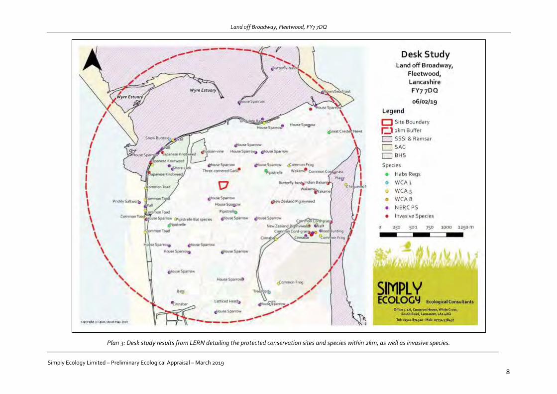
Land off Broadway, Fleetwood, FY7 7DQ
Simply Ecology Limited – Preliminary Ecological Appraisal – March 2019
8
Plan 3: Desk study results from LERN detailing the protected conservation sites and species within 2km, as well as invasive species.
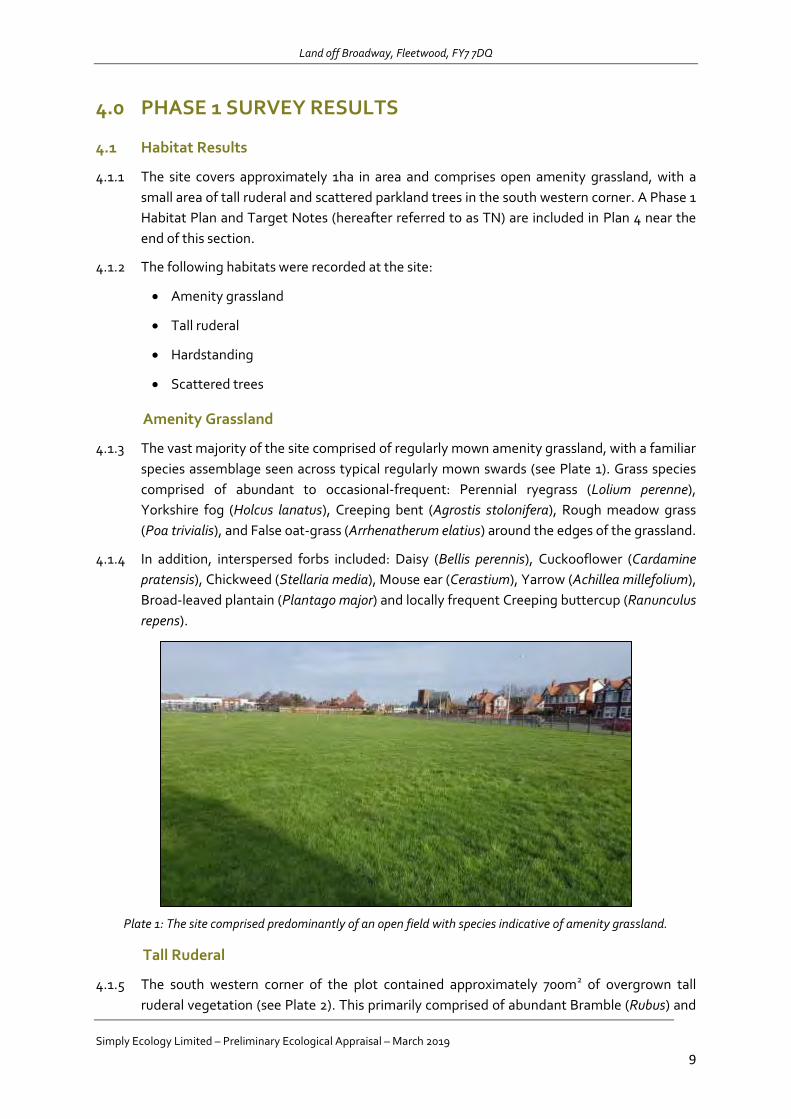
Land off Broadway, Fleetwood, FY7 7DQ
Simply Ecology Limited – Preliminary Ecological Appraisal – March 2019
9
4.0 PHASE 1 SURVEY RESULTS
4.1 Habitat Results
4.1.1 The site covers approximately 1ha in area and comprises open amenity grassland, with a
small area of tall ruderal and scattered parkland trees in the south western corner. A Phase 1
Habitat Plan and Target Notes (hereafter referred to as TN) are included in Plan 4 near the
end of this section.
4.1.2 The following habitats were recorded at the site:
Amenity grassland
Tall ruderal
Hardstanding
Scattered trees
Amenity Grassland
4.1.3 The vast majority of the site comprised of regularly mown amenity grassland, with a familiar
species assemblage seen across typical regularly mown swards (see Plate 1). Grass species
comprised of abundant to occasional-frequent: Perennial ryegrass (Lolium perenne),
Yorkshire fog (Holcus lanatus), Creeping bent (Agrostis stolonifera), Rough meadow grass
(Poa trivialis), and False oat-grass (Arrhenatherum elatius) around the edges of the grassland.
4.1.4 In addition, interspersed forbs included: Daisy (Bellis perennis), Cuckooflower (Cardamine
pratensis), Chickweed (Stellaria media), Mouse ear (Cerastium), Yarrow (Achillea millefolium),
Broad-leaved plantain (Plantago major) and locally frequent Creeping buttercup (Ranunculus
repens).
Plate 1: The site comprised predominantly of an open field with species indicative of amenity grassland.
Tall Ruderal
4.1.5 The south western corner of the plot contained approximately 700m2 of overgrown tall
ruderal vegetation (see Plate 2). This primarily comprised of abundant Bramble (Rubus) and

Land off Broadway, Fleetwood, FY7 7DQ
Simply Ecology Limited – Preliminary Ecological Appraisal – March 2019
10
Greater willowherb (Epilobium hirsutum), with occasional Greater stitchwort (Stellaria
holostea) and Hoary willowherb (Epilobium parviflorum). The invasive species Japanese
knotweed (Fallopia japonica) was also identified within the vegetation (see TN1 below).
4.1.6 Grass species present included frequent False oat-grass, Cocksfoot (Dactylis glomerata),
Common bent (Agrostis capillaris) and locally frequent Canary grass (Phalaris canariensis),
with occasional Perennial ryegrass and Yorkshire fog.
Plate 2: An area of tall ruderal vegetation was present in the south western corner of the site.
Hardstanding
4.1.7 To the south of the survey area was a small path comprising of hardstanding (see Plate 3).
This contained some forbs from the adjacent amenity grassland areas, but overall had little
to zero botanical interest.
Plate 3: The hardstanding path contained a small amount of forbs from the surrounding amenity grassland.

Land off Broadway, Fleetwood, FY7 7DQ
Simply Ecology Limited – Preliminary Ecological Appraisal – March 2019
11
Scattered Trees
4.1.8 A single alder tree (Alnus glutinossa) was present on site (see Plate 4). This was a semi-
mature specimen located within the section of tall ruderal vegetation. No other trees were
present within the site boundary.
Plate 4: A single alder tree was present within the tall ruderal vegetation, along the southern border of the site.

Land off Broadway, Fleetwood, FY7 7DQ
Simply Ecology Limited – Preliminary Ecological Appraisal – March 2019
12
Plan 4: Phase 1 survey map of the site.
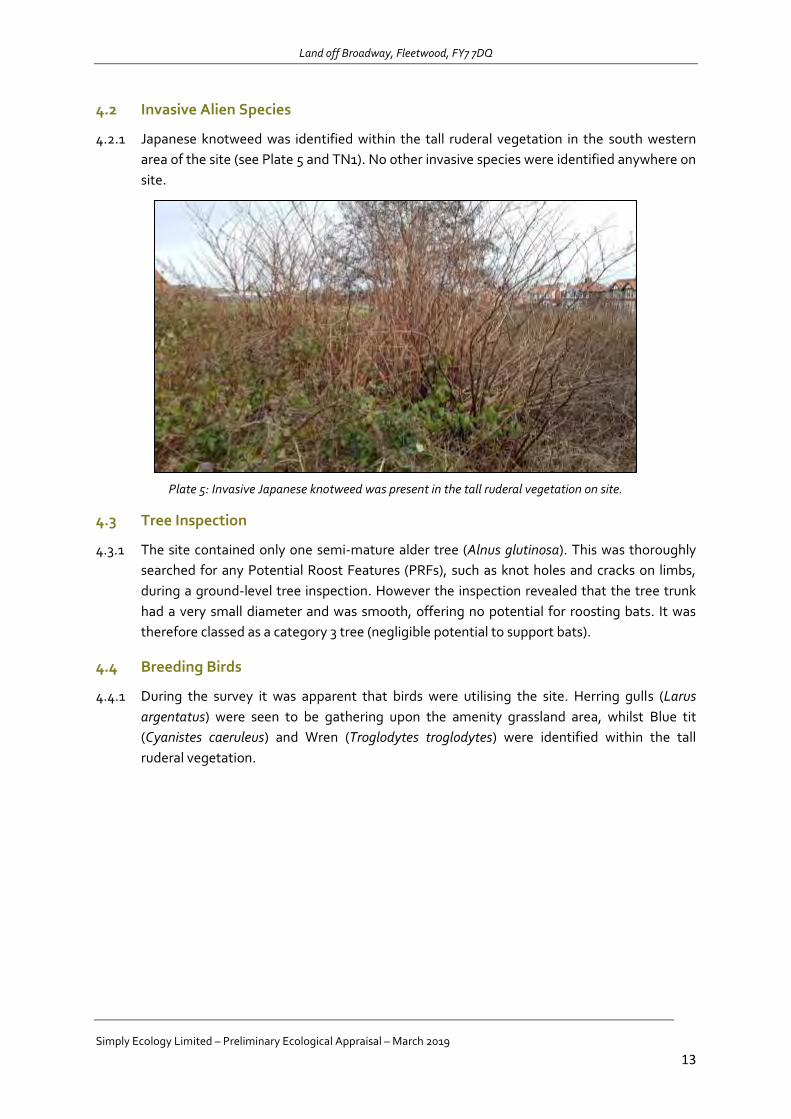
Land off Broadway, Fleetwood, FY7 7DQ
Simply Ecology Limited – Preliminary Ecological Appraisal – March 2019
13
4.2 Invasive Alien Species
4.2.1 Japanese knotweed was identified within the tall ruderal vegetation in the south western
area of the site (see Plate 5 and TN1). No other invasive species were identified anywhere on
site.
Plate 5: Invasive Japanese knotweed was present in the tall ruderal vegetation on site.
4.3 Tree Inspection
4.3.1 The site contained only one semi-mature alder tree (Alnus glutinosa). This was thoroughly
searched for any Potential Roost Features (PRFs), such as knot holes and cracks on limbs,
during a ground-level tree inspection. However the inspection revealed that the tree trunk
had a very small diameter and was smooth, offering no potential for roosting bats. It was
therefore classed as a category 3 tree (negligible potential to support bats).
4.4 Breeding Birds
4.4.1 During the survey it was apparent that birds were utilising the site. Herring gulls (Larus
argentatus) were seen to be gathering upon the amenity grassland area, whilst Blue tit
(Cyanistes caeruleus) and Wren (Troglodytes troglodytes) were identified within the tall
ruderal vegetation.
Land off Broadway, Fleetwood, FY7 7DQ
Simply Ecology Limited – Preliminary Ecological Appraisal – March 2019
14
5.0 CONCLUSIONS AND RECOMMENDATIONS
5.1.1 In January 2019, Simply Ecology Limited was commissioned by Lancashire County Council
to undertake an Extended Phase 1 on land off Broadway, Fleetwood, FY7 7DQ. This was
completed on 6th February 2019.
5.1.2 It is understood that the site is due to be sold for residential development. At the present
time, no proposed plans are available. It is therefore anticipated that any development could
result in the loss of all habitats on site, but no ecological appraisal was possible.
5.2 Statutory Sites
5.2.1 No statutory designated nature conservation sites are located within the site, however the
Wyre Estuary SSSI, Morecambe Bay Ramsar and SAC sites were all located within 900m of
the development boundary. Due to the close proximity to these statutory sites, the
development falls within the Natural England Impact Risk Zone (IRZ).
5.2.2 It is anticipated that the site will be sold for residential development. In line the Natural
England (NE) Impact Risk Zone (IRZ) guidance, any planning application for “Residential
development of 10 units or more.” Will require further Ecological Assessment with regards
to avoiding or mitigating impacts:
It is recommended that an Ecological Appraisal is conducted when a full
development plan has been produced. This will determine any impacts upon the
nearby designated sites, and highlight any opportunities to avoid or mitigate these
impacts. Reason: This is required in order to deliver compliance with the Wildlife and
Countryside Act 1981 (as amended) and The Conservation of Habitats and Species
Regulations 2017.
5.3 Habitats
5.3.1 The site consisted of amenity grassland, with tall ruderal vegetation, hardstanding and a
single tree. The predominant habitat to be affected by any works would be the amenity
grassland. This is a common and widespread habitat type and of low ecological value.
However, the grassland covered approximately 1ha of land, so any impacts would needs to
be addressed through appropriate soft landscaping proposals.
5.3.2 Tall ruderal vegetation located in the south western corner of the site would also be lost.
This was dominated by bramble and constituted slightly greater value habitat. Within this
was also a single semi-mature alder tree. In order to ensure there is continued ecological
value on this site, the following recommendations are provided:
It is recommended that an Ecological Appraisal is conducted when a full
development plan has been produced. The development scheme should aim to
limit impacts upon existing ecological features and to create new habitats on site.
Species should include blackthorn, common hawthorn, elder and holly. Reason: This
will ensure compliance with the Local Authority’s statutory duty to conserve and
enhance biodiversity under The Natural Environment and Rural Communities Act 2006,
Section 15 of The National Planning Policy Framework (2018) and The Local Plan.

Land off Broadway, Fleetwood, FY7 7DQ
Simply Ecology Limited – Preliminary Ecological Appraisal – March 2019
15
5.4 Invasive Species
5.4.1 Invasive Japanese knotweed was identified on the site. This was located within the tall
ruderal vegetation, along the southern boundary. It will be important to remove this invasive
species and ensure it is not inadvertently spread. Therefore:
It is recommended that the Japanese knotweed within the site is clearly marked
with hazard tape and appropriate action to eradicate this pernicious weed is taken
prior to any development. Prior to treatment by specialist contractor, no activities
causing soil disturbance within 7m of the knotweed must occur. Full implementation of
appropriate control and waste management procedures will be necessary. Reason:
Under the Wildlife and Countryside Act 1981 (as amended), it is an offence to plant or
otherwise cause Japanese knotweed to grow in the wild. The treatment of the
Japanese knotweed will also need to take into account the Environmental Permitting
Regulations 2018 and the Environmental Protection Act (Duty Of Care) Regulations
1991 which state that cut knotweed material and soil containing rhizomes must be
disposed of as controlled waste if they are to be removed from their site of origin.
5.5 Protected Species
Bats
5.5.1 A single semi-mature alder tree was located on site in the south western corner. This was
fully examined for potential bat roosting features, however none were identified. Whist no
roosts were present, it is likely that bats may utilise this area of the site for foraging and
commuting purposes. Removal of this vegetation and increased lighting on site could have a
potentially negative impact upon bats. Therefore:
It is recommended that any development can continue without supervision by the
Appointed Ecologist. No Natural England licence is necessary in this instance as no
impact upon any bat roost is predicted. This is due to the lack of any signs of current
or historical use of the tree by bats. Reason: This will deliver compliance with: Section
9 (1 & 4) of The Wildlife & Countryside Act 1981 (as amended), Part 3 (43; 1 & 2) of The
Conservation of Habitats and Species Regulations 2017 and Section 15 of The National
Planning Policy Framework (2018).
It is recommended that a lighting scheme should be adopted at the site which
delivers low wildlife impact and is in accordance with BCT/ILP (2018). Lighting
should seek to avoid creation of light spill onto any boundary vegetation so that bat
flight-lines are maintained. The effects of any lighting provided shall be reduced
through the use of i) directional lighting, ii) lighting on poles of the minimum
permissible height iii)lighting on timers and iv) use of narrow spectrum bulbs to reduce
UV emission. Reason: This will ensure compliance with the Local Authority’s statutory
duty to conserve and enhance biodiversity under The Natural Environment and Rural
Communities Act 2006, Section 15 of The National Planning Policy Framework (2018)
and The Local Plan.

Land off Broadway, Fleetwood, FY7 7DQ
Simply Ecology Limited – Preliminary Ecological Appraisal – March 2019
16
Breeding Birds
5.5.2 Although the site is highly unlikely to support a notable assemblage of birds in a local
context due to its limited extent and nature of the habitats present, it is possible that the
site is used by small numbers of breeding birds. In view of the protection afforded to all
breeding birds, their nests and eggs, development works should proceed as follows:
It is recommended that all site clearance work should be carried out outside of the
bird breeding season (March to August inclusive). Where this is not possible, a
suitably qualified ecologist should carry out a check to confirm the absence of
nesting birds immediately prior to clearance works commencing. If a bird nest in
current use is discovered, then an appropriate buffer zone around the nest should be
created where clearance works can only continue after the nest is vacated. Reason:
This will ensure that no offences are committed under The Wildlife and Countryside Act
1981 (as amended). The bird-nesting season is generally regarded to extend between
March and August inclusive.
Land off Broadway, Fleetwood, FY7 7DQ
Simply Ecology Limited – Preliminary Ecological Appraisal – March 2019
17
6.0 REFERENCES
BAT CONSERVATION TRUST (2016). Bat Surveys – Good Practice Guidelines. Bat Conservation
Trust, London.
BAT CONSERVATION TURST and INSTITUTE OF LIGHTING PROFESSIONALS (2018) Bats and
artificial lighting in the UK. Bats and the Built Environment series Guidance Note 08/18. Institute Of
Lighting Professionals, Rugby.
DEPARTMENT FOR COMMUNITIES AND LOCAL GOVERNMENT (2018) National Planning Policy
Framework. HMSO. London
JOINT NATURE CONSERVATION COMMITTEE Mitchell-Jones, A.J. & McLeish, A.P. [Eds.] (2004)
The Bat Workers Manual (3rd edition). Joint Nature Conservancy Council, Peterborough.
National Planning Policy Framework 2018:
https://assets.publishing.service.gov.uk/government/uploads/system/uploads/attachment_data/file
/728643/Revised_NPPF_2018.pdf
Natural Environment and Rural Communities Act 2006:
http://www.opsi.gov.uk/acts/acts2006/ukpga_20060016_en_1
The Conservation of Habitats and Species Regulations 2017:
https://www.legislation.gov.uk/uksi/2017/1012/pdfs/uksi_20171012_en.pdf
Wildlife and Countryside Act 1981:
http://www.legislation.gov.uk/ukpga/1981/69/contents
Land off Broadway, Fleetwood, FY7 7DQ
Simply Ecology Limited – Preliminary Ecological Appraisal – March 2019
18
APPENDIX A: STATUTORY AND PLANNING CONTEXT A.0.1 The client is advised that many species of British wildlife are legally protected. The
following section provides a brief overview of the protection afforded to species commonly encountered during development. The Recommendations at the end of this report will advise as necessary, but it is also useful for the client to have an understanding of the legal protection as this helps to ensure that the law is complied with.
A.1 Badgers
A.1.1 Badgers are protected under Schedule 6 of the Wildlife and Countryside Act 1981 (as amended) (WCA), and the Protection of Badgers Act 1992. It is illegal to:
Kill, injure, take, possess or cruelly ill-treat a badger or to attempt to do so;
Interfere with a badger sett by damaging or destroying it;
Obstruct access to or any entrance of a badger sett;
Disturb a badger when it is occupying a sett
A.1.2 A badger sett is “any structure or place that displays signs indicating current use by a badger”. Natural England, the Government’s statutory nature conservation body, classifies a sett as active if it has been occupied within the last 12 months.
A.1.3 Operations that might cause disturbance of an active sett entrance can be carried out under licence from Natural England. If any badgers are found during the course of the survey, this will be highlighted in this report.
A.2 Birds
A.2.1 All wild birds are protected against killing or injury under The WCA 1981 (as amended). This protection extends to bird’s nests during the breeding season, which makes it an offence to damage or destroy nests or eggs. Birds that are listed on Schedule 1 of the Act receive additional protection against intentional or reckless disturbance during the breeding season. This makes it an offence to disturb these species at or near to their nesting site.
A.3 European Protected Species (includes bats, otter, hazel dormouse, great crested newts, and others)
A.3.1 The client is advised that all bats and great crested newts are European Protected Species (EPS). These EPS are protected under European legislation that is implemented in England via The Conservation of Habitats and Species Regulations 2010 (Regulation 41). A full list of EPS is provided in Schedule 2 of the Regulations. In addition, these EPS also receive the protection of the Wildlife and Countryside Act 1981 (as amended) in respect of Section 9 (4)(b & c) and (5).
A.3.2 If both national and international legislation are taken together, the legislative protection afforded to these species makes it an offence to:
Intentionally/ deliberately kill, disturb, injure or capture them.
Intentionally or recklessly damage, destroy or obstruct access to any breeding site or
resting place.
Possess or control any live or dead specimen or anything derived from a European
Protected Species.

Land off Broadway, Fleetwood, FY7 7DQ
Simply Ecology Limited – Preliminary Ecological Appraisal – March 2019
19
A.3.3 If an activity is likely to result in any of the above offences, derogation from the legal protection can be issued in the form of a European Protected Species licence issued by Natural England. Licences for development purposes are issued under The Conservation Of Habitats And Species Regulations (2010) and only allow what is permitted within the terms and conditions of the licence. If any EPS are found during the course of the survey, this will be highlighted in this report.
A.4 Protected Mammals and Reptiles (includes water vole, red squirrel, reptiles and others)
A.4.1 All native reptiles and a variety of British mammals also receive protection under The WCA 1981 (as amended). Schedule 5 of The WCA lists animals that are protected. The degree of protection varies. Water voles and red squirrel are examples of species with full protection. The Act makes it an offence to intentionally kill, injure, take, possess, or trade in any wild animal listed in Schedule 5, and prohibits interference with places used for shelter or protection, or intentionally disturbing animals occupying such places.
A.4.2 All native reptiles in the UK are protected. The commoner species such as grass snake, common lizard, slow worm and adder are protected only from unlawful killing and injuring. In practice this may require a reptile protection scheme before implementing a planning permission but no specific licence is required. Sand lizard and smooth snake listed as EPS (see A3.3 above).
A.4.4 If any protected species are found during the course of the survey, this will be highlighted in this report.
A.5 Non-native invasive species
A.5.1 A number of non-native plant species growing wild in the UK are listed on Schedule 9 of the WCA due to their invasive nature and the detrimental impact they can have on native habitats and wildlife. This legislation makes it an offence to plant or otherwise cause to grow in the wild any plant species which is included in Part II of Schedule 9.
A.5.2 This legislation should be considered during site clearance works which could lead to the spread of Schedule 9 listed plant species from the site if plant material is not properly handled and disposed of. Development proposals should also consider the removal of invasive species from areas of site that would otherwise remain unaffected by works in order to avoid the risk of these invasive plants spreading from the site in the future and enhance habitats within the site. This would in turn free up space for wildlife friendly planting, prioritising use of native species within planting schemes where appropriate.
A.6 Planning Considerations
A.6.1 When considering each planning application, the presence of protected species, such as those listed above, is a material consideration which must be fully considered by the Local Authority when granting planning permission. If a licence from Natural England is required, then prior to issuing any planning consent, the local planning authority will need to be satisfied that there is no reason why such a licence would not be issued. Therefore, in reaching the planning decision the local planning authority will need to have regard to the requirements of the Conservation of Habitats and Species Regulations 2010. The three licensing tests given in the Regulations must be considered. In summary, these are that:
1. The development is required for the purpose of:
Preserving public health or public safety;

Land off Broadway, Fleetwood, FY7 7DQ
Simply Ecology Limited – Preliminary Ecological Appraisal – March 2019
20
For other imperative reasons of over-riding public interest, including those of a social or
economic nature and beneficial consequences of primary importance for the
environment;
For preventing serious damage to property.
2. There is no satisfactory alternative.
3. The proposal will not be detrimental to the maintenance of the population of the species
at a favourable conservation status.
A.6.2 All necessary information would need to be provided to the planning authority as part of the planning application in order to address the above tests.
A.6.3 The Natural Environment and Communities Act (NERC Act) 2006 extended the biodiversity duty set out in the Countryside and Rights of Way (CROW) Act to public bodies and statutory undertakers to ensure due regard to the conservation of biodiversity. The Duty is set out in Section 40 of the Act, and states that:
"Every public authority must, in exercising its functions, have regard, so far as is consistent with the proper exercise of those functions, to the purpose of conserving biodiversity"
A.6.4 The Duty applies to all local authorities, community, parish and town councils, police, fire and health authorities and utility companies. Section 41 (S41) of this Act (the ‘England Biodiversity List’) also requires the Secretary of State to publish a list of habitats and species that are of principal importance for the conservation of biodiversity in England. This list is used to guide decision-makers such as public bodies, including local and regional authorities, in implementing their duty under section 40(1) of the Act.
A.6.5 Also, Local Authorities must follow the National Planning Policy Framework (NPPF) which provides guidance on the interpretation of the law in relation to wildlife issues and development. For each development proposal considered by the Local Planning Authority the NPPF states that the authority must aim to conserve and enhance biodiversity. If significant harm resulting from a development cannot be avoided (through locating on an alternative site with less harmful impacts), adequately mitigated, or, as a last resort, compensated for, then planning permission should be refused.
UK Biodiversity Action Plan (UK BAP)
A.6.6 The UK BAP, which was first published in 1994, was the UK government response to the 1992 Convention on Biological Diversity. It sets priorities for nationally important ‘priority species’ and ‘priority habitats’. Each species and habitat action plan has costed actions and targets, and is used to inform the compilation of national lists such as the Section 41 List described above.

Land off Broadway, Fleetwood, FY7 7DQ
Simply Ecology Limited – Preliminary Ecological Appraisal – March 2019
21
APPENDIX B: LOCAL BIOLOGICAL HERITATE SITES
Land off Broadway, Fleetwood, FY7 7DQ
Simply Ecology Limited – Preliminary Ecological Appraisal – March 2019
22
.
Land off Broadway, Fleetwood, FY7 7DQ
Simply Ecology Limited – Preliminary Ecological Appraisal – March 2019
23

Land off Broadway, Fleetwood, FY7 7DQ
Simply Ecology Limited – Preliminary Ecological Appraisal – March 2019
24
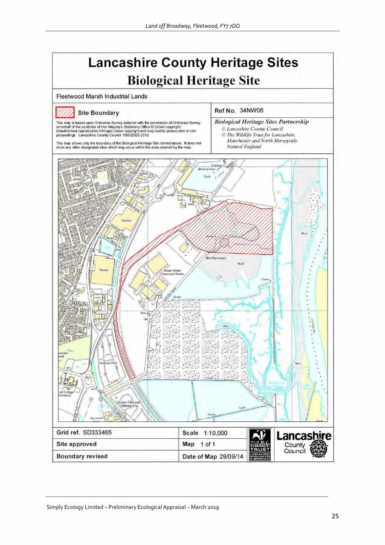
Land off Broadway, Fleetwood, FY7 7DQ
Simply Ecology Limited – Preliminary Ecological Appraisal – March 2019
25

Land off Broadway, Fleetwood, FY7 7DQ
Simply Ecology Limited – Preliminary Ecological Appraisal – March 2019
26
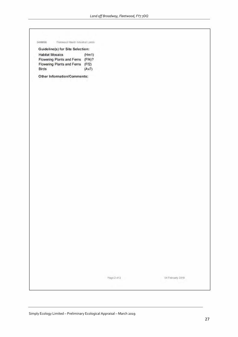
Land off Broadway, Fleetwood, FY7 7DQ
Simply Ecology Limited – Preliminary Ecological Appraisal – March 2019
27
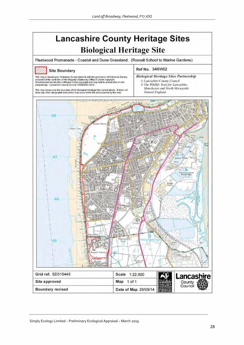
Land off Broadway, Fleetwood, FY7 7DQ
Simply Ecology Limited – Preliminary Ecological Appraisal – March 2019
28
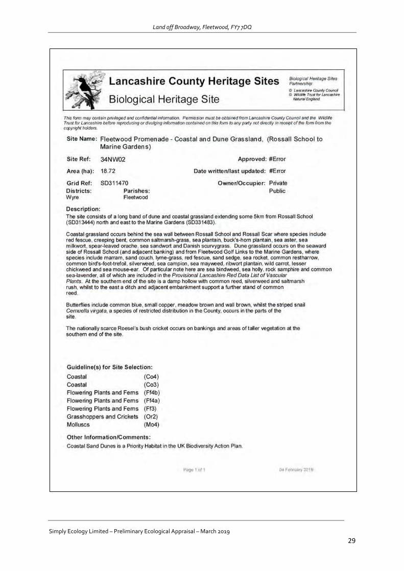
Land off Broadway, Fleetwood, FY7 7DQ
Simply Ecology Limited – Preliminary Ecological Appraisal – March 2019
29
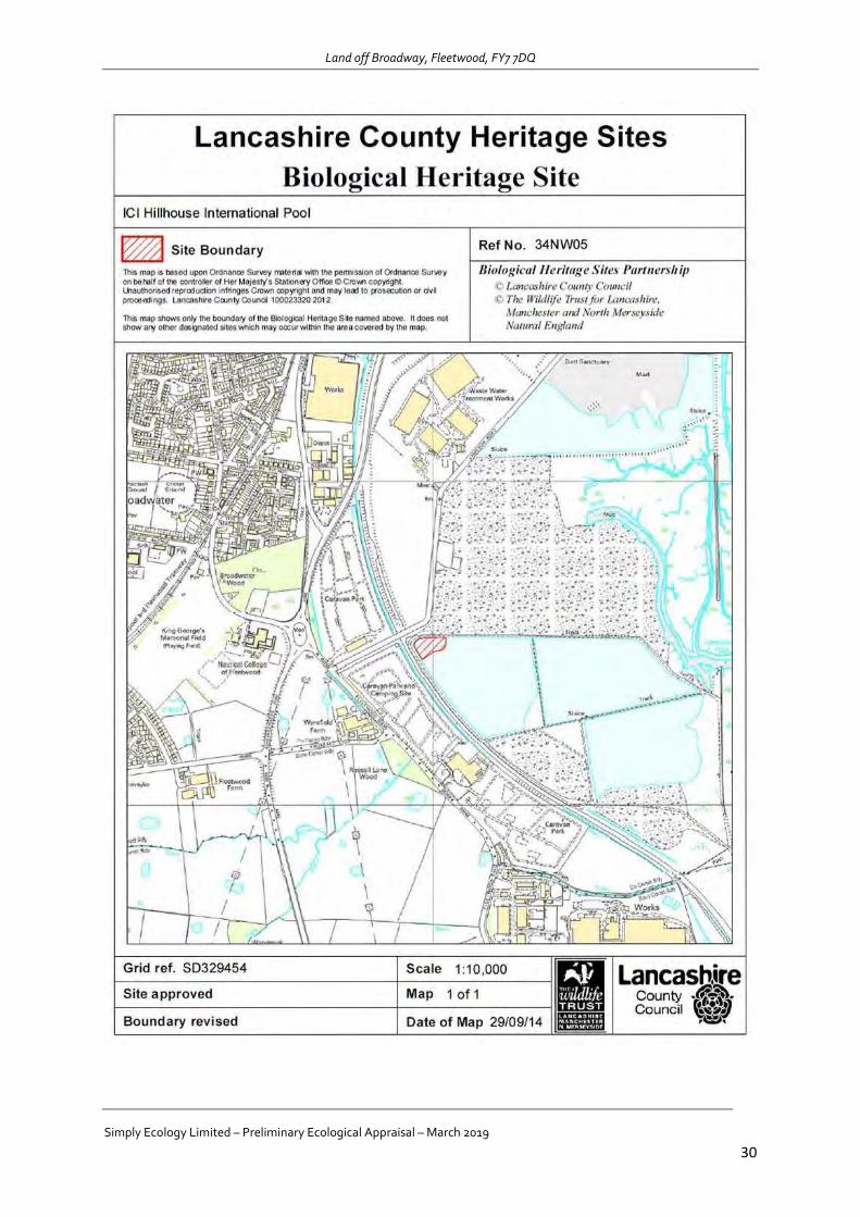
Land off Broadway, Fleetwood, FY7 7DQ
Simply Ecology Limited – Preliminary Ecological Appraisal – March 2019
30
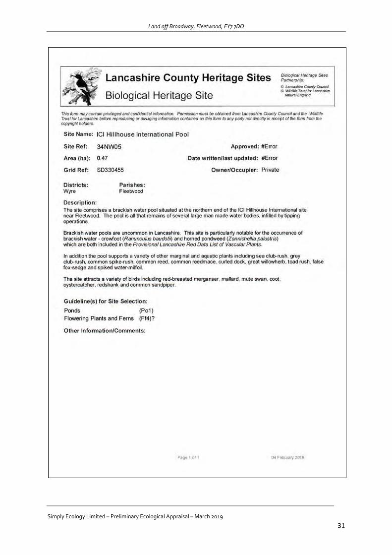
Land off Broadway, Fleetwood, FY7 7DQ
Simply Ecology Limited – Preliminary Ecological Appraisal – March 2019
31
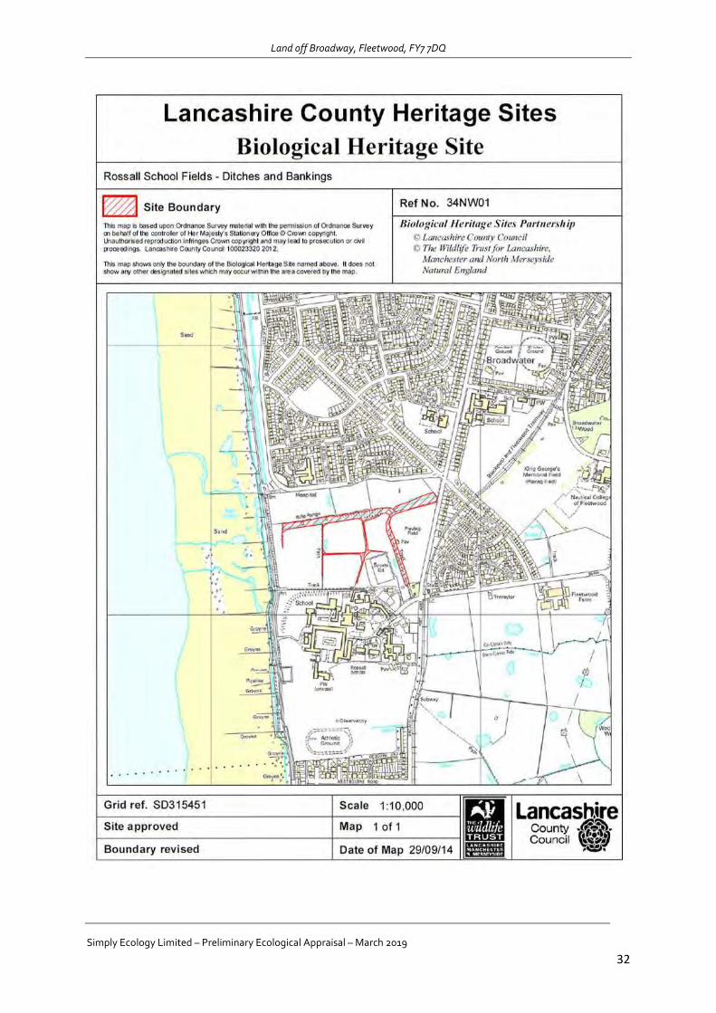
Land off Broadway, Fleetwood, FY7 7DQ
Simply Ecology Limited – Preliminary Ecological Appraisal – March 2019
32
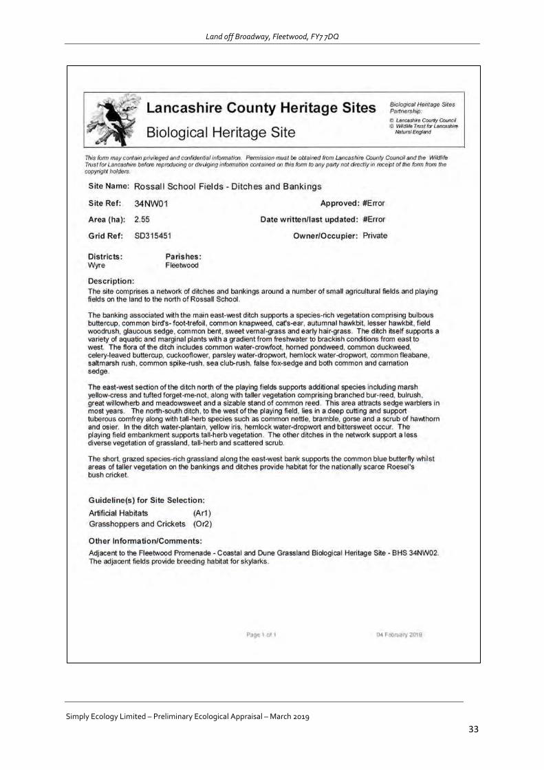
Land off Broadway, Fleetwood, FY7 7DQ
Simply Ecology Limited – Preliminary Ecological Appraisal – March 2019
33

PASSED
Within the scope of this assessment, the Site is not considered to be susceptible to mining-related ground
instability. Any identified mining features are considered unlikely to impact the value or security of the Site for
normal lending purposes and will not impact upon the completion of this transaction.
Professional Opinion:
Report on:
COALREGULATED NO COAL & BRINE SEARCH CERTIFICATE
Search Details:
This Terrafirma No Coal Search Certificate provides an expert certification that the site is not affected by past,
current or future Coal or Cheshire Brine mining hazards. The assessment is based upon official Coal Authority
licensed data, interpreted within Terrafirma’s Geographic Information System (GIS) of abandoned mine plans,
maps, records and archives.
Additional Remarks:
Insurance:
Date:
Client Reference:
Terrafirma Reference:
No Coal Mining
No Cheshire Brine Extraction
Official Coal Authority Licensed Data
This No Coal Search Certificate includes No Coal and Brine Search Insurance, up to a loss in value of £50,000.
Terrafirma’s terms and conditions also provide liability cover of £10 million per report, per claim. Full terms of
both insurance policies can be found on pages 2, 3 and 4.
ST WULSTANS AND ST EDMUNDS PRIMARY, BROADWAY, WYRE BOROUGH COUNCIL, FLEETWOOD, FY77JY
26/02/2019
1726124
TFC20190226145748-433912
PASSEDThis is a summary of the policy and does not contain the full terms and conditions of the cover which can be found in the
policy document. It is important that you read the policy document carefully when you receive it.
Definitions
Coal & Brine Search Insurance means the insurance policy provided by ERGO Versicherung AG, UK Branch (”Insurer”)
which is authorised by Bundesanstalt für Finanzdienstleistungsaufsicht and subject to limited regulation by the Financial
Conduct Authority and Prudential Regulation Authority.
ERGO Versicherung AG, UK Branch is wholly owned by Munich Re, and is rated AA- (Very strong) by Standard &
Poor’s.
“Insurance” means the insurance covering the loss in Market Value of the Property (and all other costs and expenses which
have been agreed) directly attributable to any changes in the Information revealed in a subsequent TerraSearch Coal Report
which was not revealed in the TerraSearch Coal Report (”Report”) attached to this Insurance.
“Market Value” means the value determined by an appointed RICS surveyor, such loss to be calculated at the date of the
subsequent Report.
“Information” means the information in the Report compiled from:
No Coal & Brine Search Insurance Conditions
2018 Terrafirma Mine Searches Ltd | v2.0
1. The Coal Authority’s records in relation to past, present and planned underground and opencast coal-mining
activity, shafts and adits (vertical and horizontal entries to mines), coal-mining geology, coal-mining related
hazards, coal-mining subsidence and mine gas, as recorded in the CON29M (2018) report; and
2. The records of the Cheshire Brine Subsidence Compensation Board (CBSCB) in relation to Cheshire Brine,
as specifically recorded in the CON29M (2006) report or reported in Questions 3 and 4 of the CBSCB Cheshire
Salt Search.
Subject to the terms of the Insurance (full details available on the Terrafirma website), each Report issued for a
single residential dwelling includes Insurance up to maximum of £50,000, effective from the date of issue of the
Report (”Effective Date”) until the property is sold or, in respect on a mortgagee, until the debt secured by the
mortgage is repaid.
The Insurance applies only to the Purchaser, being:
1. the person who asked for the Report (and the mortgagee) in connection with purchase of the Property.
2. the person who purchased the Property (and the mortgagee) if the person selling the Property has asked for
a Report for the benefit of the Purchaser as part of a seller’s pack or if the Property has been purchased by
way of auction.
3. the owner of the Property (and the mortgagee) if the Property is being re-mortgaged or the owner of the
Property who has chosen to obtain a Report.
4. the Purchaser’s estate and beneficiaries, to whom the benefit of the Policy will pass in the event of the
Purchaser’s death during the Period of Insurance.
PASSEDThe Insurance is not applicable:
No Coal & Brine Search Insurance Conditions Continued:
2018 Terrafirma Mine Searches Ltd | v2.0
1. if at the date of the claim, the Purchaser is not the legal or beneficial owner of the Property.
2. if the Property is not a single private home in the United Kingdom which is used only for residential purposes.
3. in relation to loss of a transaction for the sale or for the purchase of the Property nor for any costs incurred in
relation to the loss of such transaction.
4. in respect of structural or other physical damage caused to the Property by subsidence, flooding or otherwise.
5. as a result of any change in Information in response to - future underground coal mining and- future opencast
coal mining.
6. if the Information in any subsequent Report after the Effective Date also appears on the attached Report.
7. to any problem revealed by the first Report after the Effective Date if the Purchaser or their legal representative
knew about the problem on or before the Effective Date.
8. to any change to the CON29M (2018) Search form and/or the Report made after the Effective Date which
affects the Insurer’s responsibility under this Policy, if the Insurer would not have been responsible for the loss
before such change.
9. to any change in the interpretation of Information upon which the Report was produced, provided such
Information remains unchanged.
The Insurer will not be responsible for any loss for which The Coal Authority or the Cheshire Brine Subsidence Compensation
Board may be required to pay by law.
Conditions
1. If the Purchaser receives information about any claim, loss or incident for which the Insurer may be responsible
under this Policy, the Purchaser must contact the Insurer as soon as possible.
2. If there is any claim under this Policy which is also covered by any other insurance, the Insurer will pay no more
than their rateable proportion of the loss and any costs and expenses connected with it.
3. The Purchaser agrees to do and permit to be done all things that the Insurer considers necessary to minimise
loss under the Policy. The Insurer will be responsible for any expense incurred in complying with this Condition.
4. The Purchaser must not make any offer promise or payment or incur any costs or expenses unless the Insurer
has agreed in writing to cover such costs and expenses.
5. If there is a claim under the Insurance, the Insurer has the right to instruct a Surveyor to assess the Market
Value of the Property.
6. Where the Insurer has accepted a claim and there is disagreement over the amount to be paid, the dispute can
be referred to an agreed arbitrator (or in the absence of an agreement an arbitrator appointed by the President
of the Chartered Institute of Arbitrators) in accordance with the law at the time.
ERGO Versicherung AG, UK Branch is wholly owned by Munich Re and is covered by the Financial Services
Compensation Scheme.

PASSEDThis No Coal & Brine Search Certificate has been carried out with reference to official licensed British Geological Survey,
Coal Authority data and Terrafirma’s bespoke GIS, which includes an extenstive collection of abandoned mine plans, maps,
records and archives in our possession.
From this material, we have endeavoured to provide as accurate a report as possible. It should be realised that totally
unrecorded or unindicated surface mineral workings can exist between known past underground mineral workings and
therefore Terrafirma cannot be held responsible for any settlement or subsidence problems as a result of a Site being
affected by unrecorded surface mineral extraction features.
It is a ‘remote’ investigation and reviews only information provided by the client and from the databases of publicly available
information that have been chosen to enable a desk-based environmental assessment of the Site. The Certificate does not
include a Site Investigation, nor does Terrafirma make specific information requests of the regulatory authorities for any
relevant information they may hold.
This report is concerned solely with the Site searched and should be used in connection with adjacent properties as only
relevant known mining features have been mentioned and any known features that could potentially have a direct influence
upon the target Site. Other features which may be present in the general area may have been omitted for clarity.
This report is confidential to the client, the client’s legal advisor and the client’s Mortgage lender, as defined in the
TerraSearch® terms and conditions, and as such may be used by them for conveyancing or related purposes. We have no
liability toward any person or organisation not party to commissioning this report. This report or any part of it is not permitted
to be reproduced, copied, altered or in any other way distributed by any other person or organisation.
Report Limitations
2018 Terrafirma Mine Searches Ltd | v2.0
Terms & Conditions
Report Licensing
This report is provided under the Terrafirma Terms & Conditions (v2.1) for TerraSearch® Report (v2.0), a copy of which is
available on our website at: https://www.terrafirmasearch.co.uk/s/CONDITIONS-OF-CONTRACT-FOR-TERRASEARCH-
REPORTS-v21.pdf. They provide a limit of liability per report of £10 million, backed by Professional Indemnity Insurance;
details available on request.
This report contains Data provided by The Coal Authority. Any and all analysis and interpretation of Coal Authority Data in
this report is made by Terrafirma Mine Searches Ltd and is in no way supported, endorsed or authorised by The Coal
Authority. The use of the data is restricted to the terms and provisions contained in this report. Data reproduced in this report
may be the Copyright of The Coal Authority and permission should be sought from Terrafirma Mine Searches Ltd prior to any
re-use.
© Crown Copyright (2018) Ordnance Survey License Number 0100020315. May contain British Geological Survey
materials © NERC (2018).
Important Consumer Information
This search has been produced by TERRAFIRMA MINE SEARCHES LTD - Address: 2440 The Quadrant, Aztec West Business
Park, Almondsbury, Bristol, BS32 4AQ; Email: [email protected]; Telephone 0330 900 7500 which is registered with
the Property Codes Compliance Board (PCCB) as a subscriber to the Search Code. The PCCB independently monitors how
registered search firms maintain compliance with the Code.

PASSEDThe Search Code:
The Search Code
2018 Terrafirma Mine Searches Ltd | v2.0
Complaints
If you have a query or complaint about your search, you should raise it directly with the search firm, and if appropriate ask for any complaint
to be considered under their formal internal complaints procedure. If you remain dissatisfied with the firm’s initial response, after your
complaint has been formally considered, or if the firm has exceeded the response timescales, you may refer your complaint for consideration
under the The Property Ombudsman scheme (TPOs). The Ombudsman can award up to £5,000 to you if the Ombudsman finds that you
have suffered actual financial loss and/or aggravation, distress or inconvenience as a result of your search provider failing to keep to the Code.
Please note that all queries or complaints regarding your search should be directed to your search provider in the first instance, not to TPOs
or to the PCCB.
If you wish to make a complaint directly to Terrafirma, we will:
provides protection for homebuyers, sellers, estate agents, conveyancers and mortgage lenders who rely on the information included in
property search reports undertaken by subscribers on residential and commercial property within the United Kingdom;
sets out minimum standards which firms compiling and selling search reports have to meet;
promotes the best practice and quality standards within the industry for the benefit of consumers and property professionals;
enables consumers and property professionals to have confidence in firms which subscribe to the code, their products and
services;
By giving you this information, the search firm is confirming that they keep to the principles of the Code. This provides
important protection for you.
The Code’s core principles: Firms which subscribe to the Search Code will:
display the Search Code logo prominently on their search reports;
act with integrity and carry out work with due skills, care and diligence;
at all times maintain adequate and appropriate insurance to protect consumers;
conduct business in an honest, fair and professional manner;
handle complaints speedily and fairly;
ensure that products and services comply with industry registration rules and standards and relevant laws;
monitor their compliance with the Code
CONTACT TERRAFIRMA IF YOU WOULD LIKE A COPY OF THE SEARCH CODE
TPOs Contact Details:
Acknowledge it within 5 working days of receipt;
Normally deal with it fully and provide a final response, in writing, within 20 working days of receipt;
Keep you informed by letter, telephone or e-mail, as you prefer, if we need more time;
Provide a final response, in writing, at the latest within 40 working days of receipt;
Liaise, at your request, with anyone acting formally on your behalf;
Complaints should be sent to: Senior Executive, Terrafirma - Address: 2440 The Quadrant, Aztec West Business Park, Almondsbury,
Bristol, BS32 4AQ; Email: [email protected]; Telephone: 0330 900 7500.
If you are not satisfied with our final response, or if we exceed the response timescales, you may refer the complaint to The Property
Ombudsman scheme (TPOs). We will co-operate fully with the Ombudsman during an investigation and comply with his final decision.
WE TRUST THIS REPORT PROVIDES THE INFORMATION YOU REQUIRE. PLEASE CONTACT US IF YOU HAVE ANY QUERIES
OR IF WE CAN BE OF ANY FURTHER ASSISTANCE.
The Property Ombudsman Scheme, Milford House, 43-55 Milford Street, Salisbury, Wiltshire, SP1 2BP
Tel: 01722 333306, Fax: 01722 332296, Web: www.tpos.co.uk. Email: [email protected]. You can get more information about the PCCB
from www.propertycodes.org.uk or from our website at www.terrafirmasearch.co.uk.

Land at St Wulstans and St Edmunds Primary, Broadway, FY7 7JY
Professional opinion
page 5
Contaminated Land
Low:
Acceptable Risk
page 6
Flood Risk
Moderate-High
Consultant’s guidance and recommendations inside.
Site plan
© Crown copyright and database rights 2019. Ordnance Survey licence 100035207
page 6
Ground Stability
Identified
Radon
Passed
page 7
Energy
Identified
Planning Constraints
Not identified
TransportationNot identified
A full assessment of transportation is available in other
Groundsure searches, including the Groundsure Review.
Contact Groundsure or your search provider for further
details.
Contaminated land liability
Statutory or 3rd party actionIs there a risk of statutory (e.g. Part 2A EPA 1990) or
third party action being taken against the site?
Unlikely
Banking securityIs it likely that the property will represent acceptable
banking security from a contaminated land
perspective?
Yes
Environmental liabilityIs there a risk that the property value may be
impacted due to contaminated land liability issues?
Unlikely
Contact us with any questions at:
08444 159 000
Grid reference: 332270 447300
Reference: Index-5844896
Your reference: 1726124
Date: 27 February 2019

Overview of findings and recommendations
These relate to environmental risks that may have liability implications, affect insurance premiums,
property values and/or a lender's willingness to lend.
We have searched a comprehensive library of information to determine the results within this report. We
only provide maps and data tables when we have identified features within the search radius or we
consider the results to be of note. A list of the other datasets that we have searched is provided for you in
the back of this report.
Contaminated Land
None required. However, whilst Groundsure has not identified a potential contaminant-pathway-receptor
relationship of significant concern at the site, in its current use, we do note that it is to be developed. Planning
policy states that the developer or land owner is responsible for ensuring a site is suitable for its proposed use
by addressing any potential pollution concerns. This means that a Phase 1 Risk Assessment may be required, at
a minimum, particularly if development is for a highly sensitive end use (i.e. residential purposes).
Please contact Groundsure (at [email protected]) in order for us to provide you with a Phase 1
quotation. This quotation would include a discount to reflect the entire cost of the report already undertaken
for the study area. We would advise you contact the Local Planning Authority in the first instance to confirm
whether a Phase 1 Risk Assessment is required.
Flood
Flood risk
The property is assessed to have a flood risk rating of moderate or higher. Key recommended next steps:
consider flood prevention measures that may be useful in the property, such as flood gates and barriers or
modified airbricks
investigate the insurance on offer for the property to ensure any implications on premiums are fully
understood before completion
National Planning Policy Framework (NPPF)
A full flood risk assessment will be required at the site in the event that it will be developed/redeveloped. The
NPPF states that the flood risk assessment should identify and assess the risks of all forms of flooding to and
from the development and demonstrate how these flood risks will be managed so that the development
remains safe throughout its lifetime, taking climate change into account. Those proposing developments
should take advice from the emergency services when producing an evacuation plan for the development as
part of the flood risk assessment.
Land at St Wulstans and St Edmunds
Primary, Broadway, FY7 7JY
Grid reference: 332270 447300
Reference: Index-5844896
Your reference: 1726124
Contact us with any questions at:
08444 159 000
Date: 27 February 20192
Ground stability
The property is assessed to lie within an area that has; a moderate to high potential for natural ground
subsidence, a risk of natural cavities being present, and/or non-natural ground subsidence risks present. Key
recommended next steps:
consider having a structural survey conducted by a Structural Surveyor to determine whether or not the
property is affected. Note that any such structural survey will supersede the Groundsure report
consider conducting a visual check at the property looking out for cracks and other signs of subsidence
consider contacting the relevant Local Authority to ask for records of the property and local area relating
to subsidence
remember that professional advice should be sought before altering the ground in any way at the
property, including by planting trees
Infilled land
The property is assessed to lie within 25m of an area of infilled land. Key recommended next steps:
consider having a structural survey conducted by a Structural Surveyor to determine whether or not the
property is affected. Note that any such structural survey will supersede the Groundsure report
consider conducting a visual check at the property looking out for cracks and other signs of subsidence,
however be aware recent redecoration of the property may mask signs
consider contacting the relevant Local Authority to ask for records of the property and local area relating
to subsidence
remember that professional advice should be sought before altering the ground in any way at the
property, including planting trees
if structural surveys have not considered the potential effects of being built on a site like this, you may
wish to contact the local Building Regulations Officer, Planning Department and if recently constructed, the
site developers
unless information is available confirming that suitable ground engineering techniques have been used to
protect the property, it is recommended that you contact the Local Authority Planning department to
confirm whether protective design measures were used during construction
Other considerations
These are next steps associated with non-environmental search returns on matters of energy and
transport infrastructure, mobile masts, and planning constraints.
Energy
Land at St Wulstans and St Edmunds
Primary, Broadway, FY7 7JY
Grid reference: 332270 447300
Reference: Index-5844896
Your reference: 1726124
Contact us with any questions at:
08444 159 000
Date: 27 February 20193
Oil and gas
Oil and Gas extraction, exploration or development has been identified within 5km of the property. Key
recommended next steps:
consider visiting the operator's website for further information
consider visiting the area in order to more accurately assess the impact this extraction site would have on
the property
Wind
Existing or proposed wind installations have been identified within 5km. Key recommended next steps:
use the details given in the report to find out more about the potential impacts on the property
consider contacting the operating company and the relevant Local Authority for further information
consider visiting the area in order to more accurately assess the impact this wind development would have
on the property
Solar
Existing or proposed solar installations have been identified within 5km of the property. Key recommended
next steps:
use the details given in the report to find out more about the potential impacts on the property by
contacting the operating company and/or Local Authority
consider visiting the area in order to more accurately assess the impact this solar farm would have on the
property
Power stations
One or more Power Stations have been identified within 5km of the property. Key recommended next steps:
consider visiting the power station operator's website for further information. Many power stations have
large amounts of information on their local impacts available on the operator's website
additionally, consider approaching the Air Quality team of the Local Authority which may hold additional
information regarding any air quality impacts in the area
if a nuclear installation has been identified, consider visiting http://www.hse.gov.uk/nuclear/regulated-
sites.htm for further information on the site
Projects
One or more nationally significant energy infrastructure projects has been identified within 5km of the
property. Key recommended next steps:
consider visiting the National Infrastructure Planning website at
https://infrastructure.planninginspectorate.gov.uk/projects/, where further details on nationally
significant infrastructure projects, including environmental impact assessments, can be found
Land at St Wulstans and St Edmunds
Primary, Broadway, FY7 7JY
Grid reference: 332270 447300
Reference: Index-5844896
Your reference: 1726124
Contact us with any questions at:
08444 159 000
Date: 27 February 20194

Consultant's assessment
Environmental searches are designed to ensure that significant hazards and risks associated with this property
are identified and considered alongside the investment in or purchase of a property.
Please see the guidance section on page 2 for further advice.
Contaminated Land
The Contaminated Land assessment has been
completed by a qualified environmental consultant.
Please see page 13 for details of the identified issues.
Past Land Use Low
Waste and Landfill Low
Current and Recent Industrial Low
Current and proposed land use
Current land use
Groundsure has been advised by the client (or their advisers) that the property is currently a plot of
undeveloped open space.
Proposed land use
Groundsure has been advised that the property will be developed for an unspecified end use.
Site land uses
No potentially contaminative land uses have been identified at the study site.
Surrounding area land uses
No potentially contaminative land uses have been identified in proximity to the study site.
Site setting
Potentially vulnerable receptors have been identified including current and future site users, ground workers
during development, residents of adjacent dwellings with gardens, users of the adjacent school and the
underlying Secondary B aquifer.
Conclusion
Groundsure has not identified a potential contaminant-pathway-receptor relationship that may give rise to
significant environmental liability. Please refer to the Contaminated Land assessment methodology contained
within this report.
Land at St Wulstans and St Edmunds
Primary, Broadway, FY7 7JY
Grid reference: 332270 447300
Reference: Index-5844896
Your reference: 1726124
Contact us with any questions at:
08444 159 000
Date: 27 February 20195
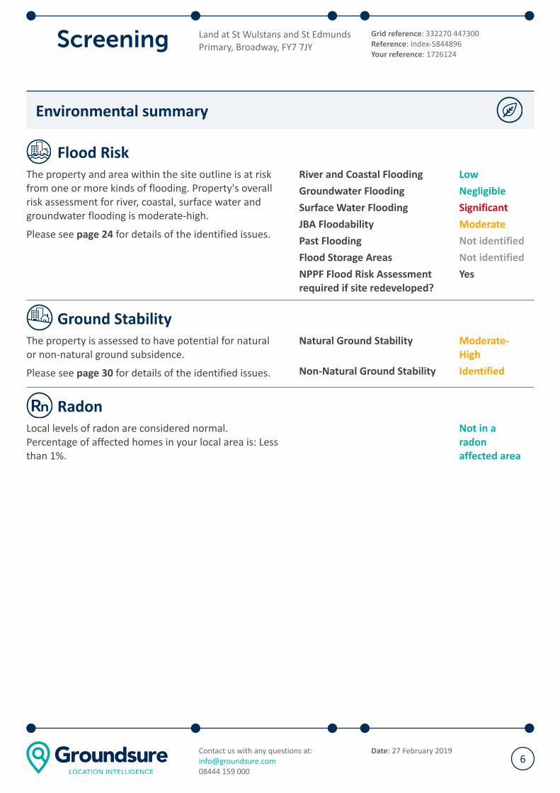
Environmental summary
Flood Risk
The property and area within the site outline is at risk
from one or more kinds of flooding. Property's overall
risk assessment for river, coastal, surface water and
groundwater flooding is moderate-high.
Please see page 24 for details of the identified issues.
River and Coastal Flooding Low
Groundwater Flooding Negligible
Surface Water Flooding Significant
JBA Floodability Moderate
Past Flooding Not identified
Flood Storage Areas Not identified
NPPF Flood Risk Assessment
required if site redeveloped?
Yes
Ground Stability
The property is assessed to have potential for natural
or non-natural ground subsidence.
Please see page 30 for details of the identified issues.
Natural Ground Stability Moderate-
High
Non-Natural Ground Stability Identified
Radon
Local levels of radon are considered normal.
Percentage of affected homes in your local area is: Less
than 1%.
Not in a
radon
affected area
Land at St Wulstans and St Edmunds
Primary, Broadway, FY7 7JY
Grid reference: 332270 447300
Reference: Index-5844896
Your reference: 1726124
Contact us with any questions at:
08444 159 000
Date: 27 February 20196

Energy summary
Oil and Gas
Active or planned wells or extraction areas (such as
fracking sites) have been identified near the property.
Please see the guidance section on page 2 for further
advice. Additionally, see page 33 for details of the
identified issues.
Oil and Gas Areas Identified
Oil and Gas Wells Not identified
Wind and Solar
Our search of existing and planned renewable wind
and solar infrastructure has identified results.
Please see the guidance section on page 2 for further
advice. Additionally, see page 35 for details of the
identified issues.
Wind Identified
Solar Identified
Energy Infrastructure
Our search of major energy transmission or generation
infrastructure and nationally significant infrastructure
projects has identified results.
Please see the guidance section on page 2 for further
advice. Additionally, see page 39 for details of the
identified issues.
Power stations Identified
Energy Infrastructure Not identified
Projects Identified
Land at St Wulstans and St Edmunds
Primary, Broadway, FY7 7JY
Grid reference: 332270 447300
Reference: Index-5844896
Your reference: 1726124
Contact us with any questions at:
08444 159 000
Date: 27 February 20197
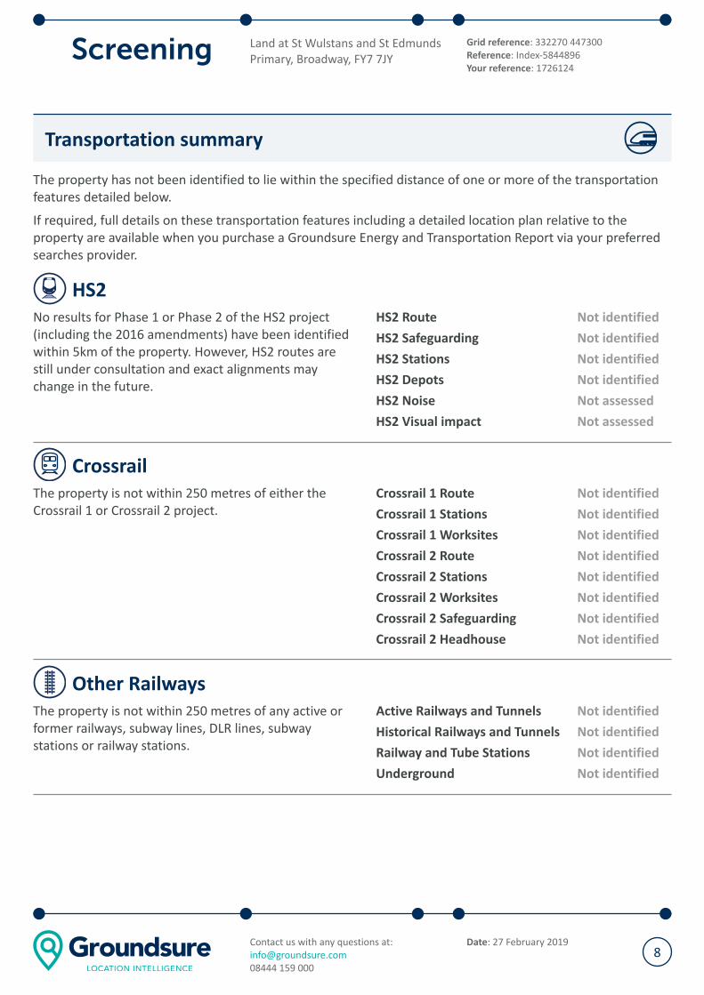
Transportation summary
The property has not been identified to lie within the specified distance of one or more of the transportation
features detailed below.
If required, full details on these transportation features including a detailed location plan relative to the
property are available when you purchase a Groundsure Energy and Transportation Report via your preferred
searches provider.
HS2
No results for Phase 1 or Phase 2 of the HS2 project
(including the 2016 amendments) have been identified
within 5km of the property. However, HS2 routes are
still under consultation and exact alignments may
change in the future.
HS2 Route Not identified
HS2 Safeguarding Not identified
HS2 Stations Not identified
HS2 Depots Not identified
HS2 Noise Not assessed
HS2 Visual impact Not assessed
Crossrail
The property is not within 250 metres of either the
Crossrail 1 or Crossrail 2 project.
Crossrail 1 Route Not identified
Crossrail 1 Stations Not identified
Crossrail 1 Worksites Not identified
Crossrail 2 Route Not identified
Crossrail 2 Stations Not identified
Crossrail 2 Worksites Not identified
Crossrail 2 Safeguarding Not identified
Crossrail 2 Headhouse Not identified
Other Railways
The property is not within 250 metres of any active or
former railways, subway lines, DLR lines, subway
stations or railway stations.
Active Railways and Tunnels Not identified
Historical Railways and Tunnels Not identified
Railway and Tube Stations Not identified
Underground Not identified
Land at St Wulstans and St Edmunds
Primary, Broadway, FY7 7JY
Grid reference: 332270 447300
Reference: Index-5844896
Your reference: 1726124
Contact us with any questions at:
08444 159 000
Date: 27 February 20198
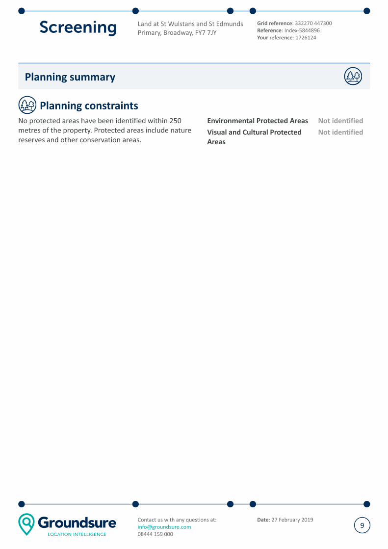
Planning summary
Planning constraints
No protected areas have been identified within 250
metres of the property. Protected areas include nature
reserves and other conservation areas.
Environmental Protected Areas Not identified
Visual and Cultural Protected
Areas
Not identified
Land at St Wulstans and St Edmunds
Primary, Broadway, FY7 7JY
Grid reference: 332270 447300
Reference: Index-5844896
Your reference: 1726124
Contact us with any questions at:
08444 159 000
Date: 27 February 20199

Other environmental considerations
The following additional risks or issues are outside the scope of the opinion provided by this report. However,
further consideration of these may be appropriate for the subject property.
Asbestos
The Control of Asbestos Regulations 2012 require an Asbestos Management Plan to be maintained for all
commercial property constructed prior to 2000 i.e. where asbestos may be contained within the building
fabric. Refurbishment or demolition of site structures may require further Refurbishment and Demolition
Asbestos Surveys.
Site-specific features
This report has considered additional site specific information, where provided by the client, however it has
not included a site inspection. Additional issues may exist at the property that cannot be reasonably identified
by a desk based report like this one. Examples might include operational issues such as those linked to oil
storage, waste management, materials handling and site drainage. Additional surveys and assessments may be
required if these issue are considered to be a concern.
Unexploded ordnance (UXO)
The UK has a history of military activity, including extensive military training sites, bombing during the First
World War and sustained strategic bombing during the Second World War. A legacy of this military activity is
the incidence of UXO across Britain. Construction increases the risk from UXO. If intrusive works are planned
on site, an assessment of the likelihood of UXO risk should be carried out in compliance with the Construction
(Design and Management) Regulations 2015.
Environmental insurance
The ownership or possession of land and property is one of the most valuable assets an individual or
organisation can have. In cases where we are unable to provide a low risk assessment with regards to
contaminated land, environmental insurance should be considered. Environmental insurance can protect
against regulatory and third party action, potential losses and additional costs in dealing with contamination.
Independent, specialist brokers are able to access the entire environmental insurance market, providing
bespoke environmental policies to address risk and transactional issues.
Phase 1 environmental risk assessment
A Phase 1 environmental risk assessment (Contaminated Land) aims to clarify any identified environmental
risks further or could support a planning application. It includes a site inspection, regulatory consultation and
additional details of site context. Our expert analysis provides a detailed breakdown of each potential exposure
pathway and suggested mitigation measures. For further information or to request a quote please e-mail us at
[email protected]. The reports start from £1195+VAT, which includes a discount for current reporting.
Made ground and infilled land
Areas of made ground and infilled land can settle over time and could potentially cause subsidence. If the
property is known to be located on made or infilled ground it would be prudent to contact a RICS accredited
surveyor and/or geotechnical engineer to clarify any structural/subsidence risks and determine if possible
what materials were used during the infilling process.
Land at St Wulstans and St Edmunds
Primary, Broadway, FY7 7JY
Grid reference: 332270 447300
Reference: Index-5844896
Your reference: 1726124
Contact us with any questions at:
08444 159 000
Date: 27 February 201910

Recent aerial photograph
N
Aerial photography supplied by Getmapping PLC. © Copyright Getmapping PLC 2019. All Rights Reserved.
Capture Date: 19/07/2013
Site Area: 2.04ha
Land at St Wulstans and St Edmunds
Primary, Broadway, FY7 7JY
Grid reference: 332270 447300
Reference: Index-5844896
Your reference: 1726124
Contact us with any questions at:
08444 159 000
Date: 27 February 201911
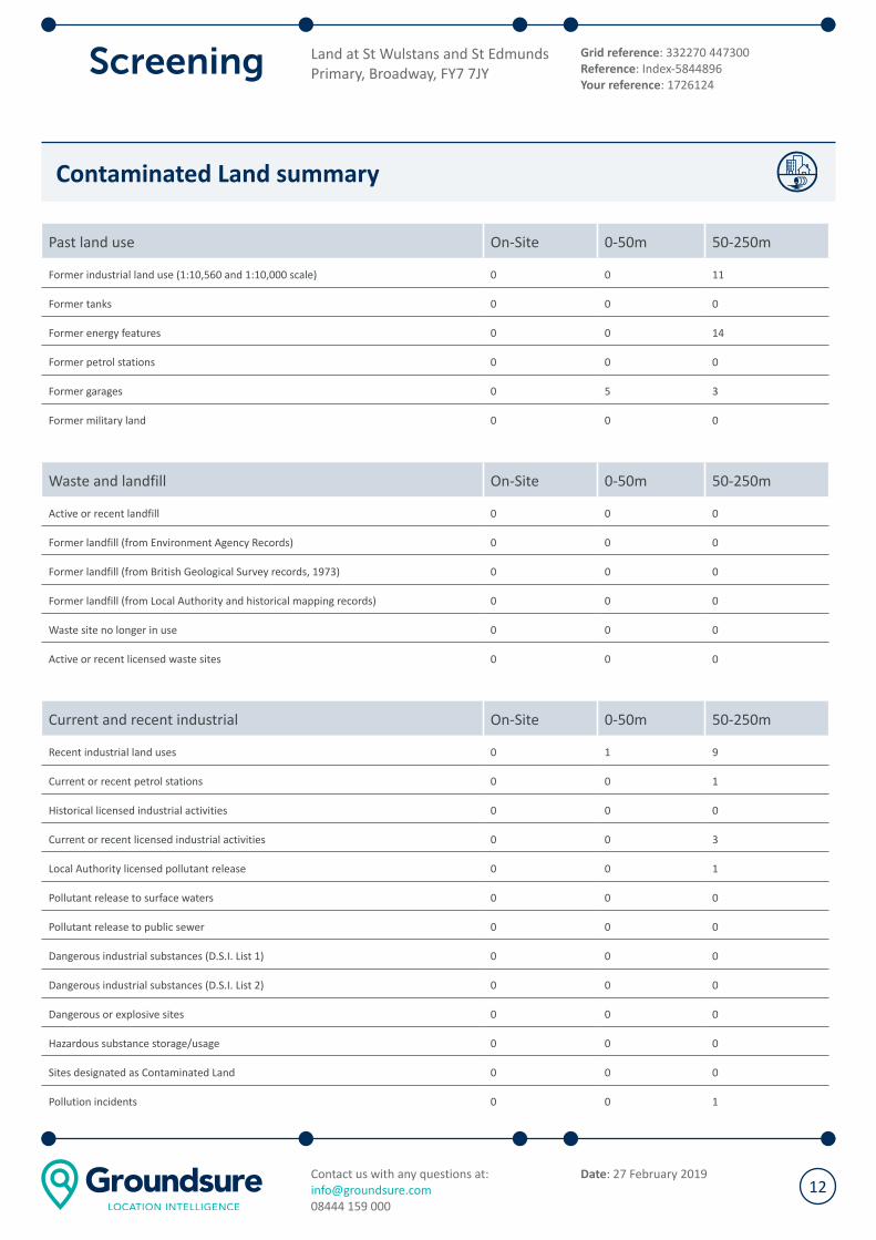
Contaminated Land summary
Past land use On-Site 0-50m 50-250m
Former industrial land use (1:10,560 and 1:10,000 scale) 0 0 11
Former tanks 0 0 0
Former energy features 0 0 14
Former petrol stations 0 0 0
Former garages 0 5 3
Former military land 0 0 0
Waste and landfill On-Site 0-50m 50-250m
Active or recent landfill 0 0 0
Former landfill (from Environment Agency Records) 0 0 0
Former landfill (from British Geological Survey records, 1973) 0 0 0
Former landfill (from Local Authority and historical mapping records) 0 0 0
Waste site no longer in use 0 0 0
Active or recent licensed waste sites 0 0 0
Current and recent industrial On-Site 0-50m 50-250m
Recent industrial land uses 0 1 9
Current or recent petrol stations 0 0 1
Historical licensed industrial activities 0 0 0
Current or recent licensed industrial activities 0 0 3
Local Authority licensed pollutant release 0 0 1
Pollutant release to surface waters 0 0 0
Pollutant release to public sewer 0 0 0
Dangerous industrial substances (D.S.I. List 1) 0 0 0
Dangerous industrial substances (D.S.I. List 2) 0 0 0
Dangerous or explosive sites 0 0 0
Hazardous substance storage/usage 0 0 0
Sites designated as Contaminated Land 0 0 0
Pollution incidents 0 0 1
Land at St Wulstans and St Edmunds
Primary, Broadway, FY7 7JY
Grid reference: 332270 447300
Reference: Index-5844896
Your reference: 1726124
Contact us with any questions at:
08444 159 000
Date: 27 February 201912

Contaminated Land
Past land use
© Crown copyright and database rights 2019. Ordnance Survey licence 100035207
Site Outline
Search buffers in metres (m)
Former industrial land uses
Former energy features
Former garages
Former industrial land use (1:10,560 and 1:10,000 scale)
These historical land uses have been identified from 1:10,560 and 1:10,000 scale Ordnance Survey maps dated
from the mid to late 1800s to recent times. They have the potential to have caused ground contamination.
Please see the Environmental Summary to find out how these could impact the site.
Please see the guidance section on page 2 for further advice.
Distance Direction Use Date
127 m W Rifle Ranges 1910
167 m W Rifle Ranges 1891
196 m W Unspecified Pit 1891
Land at St Wulstans and St Edmunds
Primary, Broadway, FY7 7JY
Grid reference: 332270 447300
Reference: Index-5844896
Your reference: 1726124
Contact us with any questions at:
08444 159 000
Date: 27 February 201913
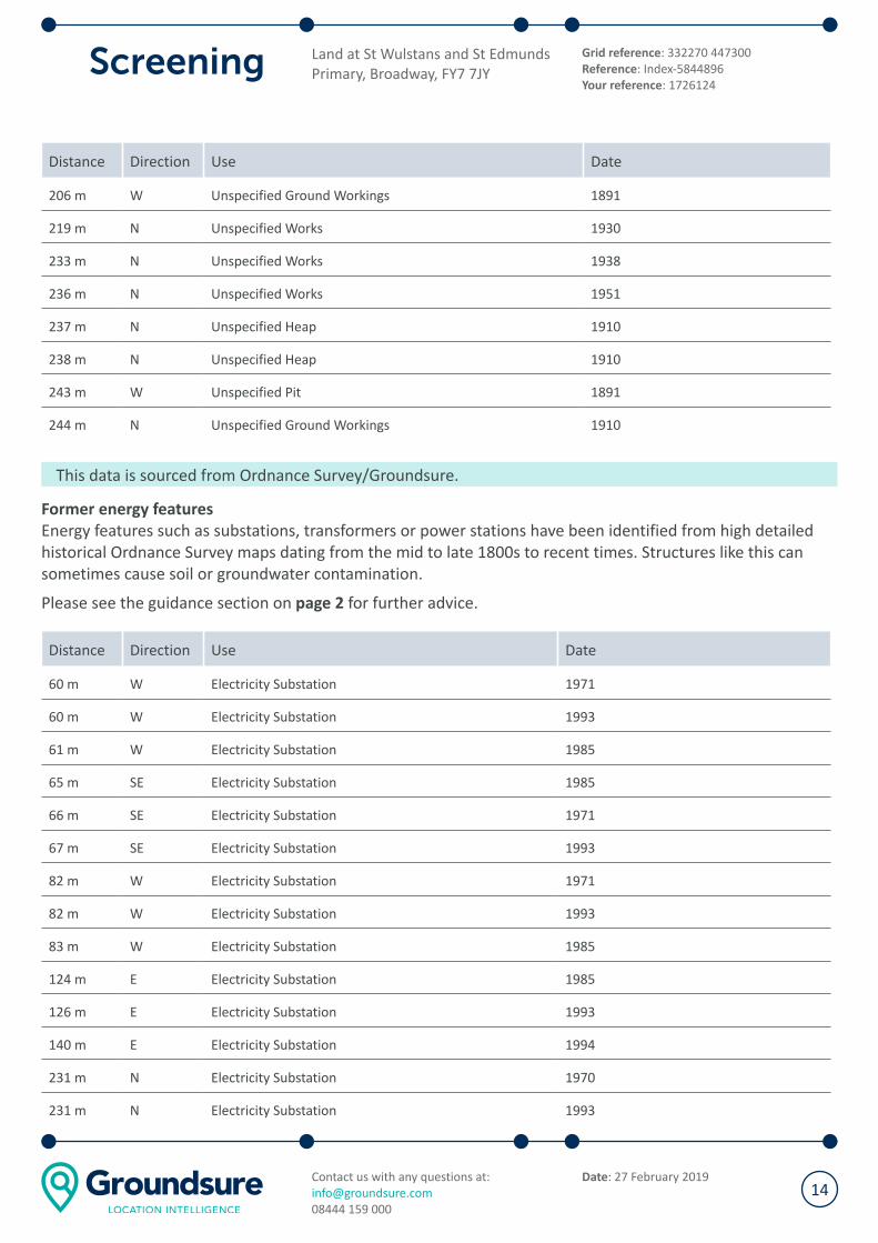
Distance Direction Use Date
206 m W Unspecified Ground Workings 1891
219 m N Unspecified Works 1930
233 m N Unspecified Works 1938
236 m N Unspecified Works 1951
237 m N Unspecified Heap 1910
238 m N Unspecified Heap 1910
243 m W Unspecified Pit 1891
244 m N Unspecified Ground Workings 1910
This data is sourced from Ordnance Survey/Groundsure.
Former energy features
Energy features such as substations, transformers or power stations have been identified from high detailed
historical Ordnance Survey maps dating from the mid to late 1800s to recent times. Structures like this can
sometimes cause soil or groundwater contamination.
Please see the guidance section on page 2 for further advice.
Distance Direction Use Date
60 m W Electricity Substation 1971
60 m W Electricity Substation 1993
61 m W Electricity Substation 1985
65 m SE Electricity Substation 1985
66 m SE Electricity Substation 1971
67 m SE Electricity Substation 1993
82 m W Electricity Substation 1971
82 m W Electricity Substation 1993
83 m W Electricity Substation 1985
124 m E Electricity Substation 1985
126 m E Electricity Substation 1993
140 m E Electricity Substation 1994
231 m N Electricity Substation 1970
231 m N Electricity Substation 1993
Land at St Wulstans and St Edmunds
Primary, Broadway, FY7 7JY
Grid reference: 332270 447300
Reference: Index-5844896
Your reference: 1726124
Contact us with any questions at:
08444 159 000
Date: 27 February 201914
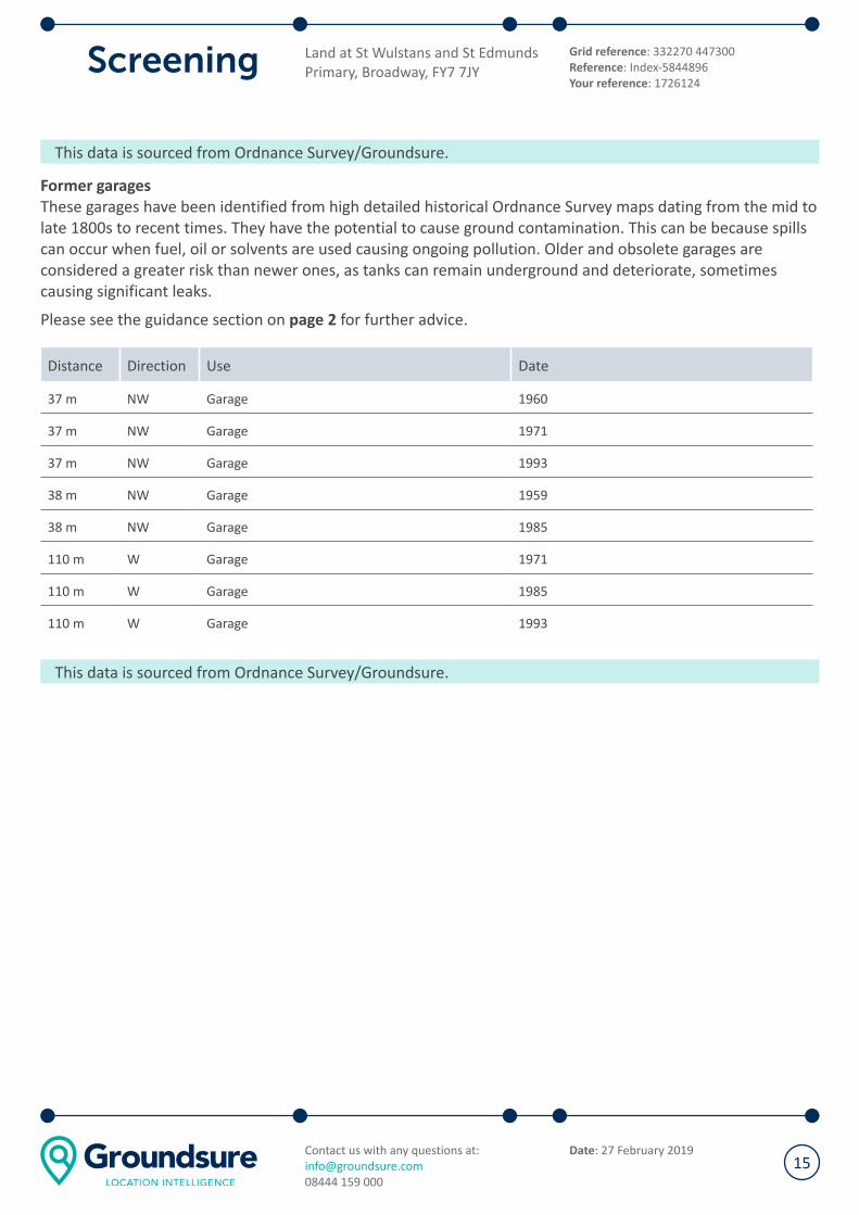
This data is sourced from Ordnance Survey/Groundsure.
Former garages
These garages have been identified from high detailed historical Ordnance Survey maps dating from the mid to
late 1800s to recent times. They have the potential to cause ground contamination. This can be because spills
can occur when fuel, oil or solvents are used causing ongoing pollution. Older and obsolete garages are
considered a greater risk than newer ones, as tanks can remain underground and deteriorate, sometimes
causing significant leaks.
Please see the guidance section on page 2 for further advice.
Distance Direction Use Date
37 m NW Garage 1960
37 m NW Garage 1971
37 m NW Garage 1993
38 m NW Garage 1959
38 m NW Garage 1985
110 m W Garage 1971
110 m W Garage 1985
110 m W Garage 1993
This data is sourced from Ordnance Survey/Groundsure.
Land at St Wulstans and St Edmunds
Primary, Broadway, FY7 7JY
Grid reference: 332270 447300
Reference: Index-5844896
Your reference: 1726124
Contact us with any questions at:
08444 159 000
Date: 27 February 201915
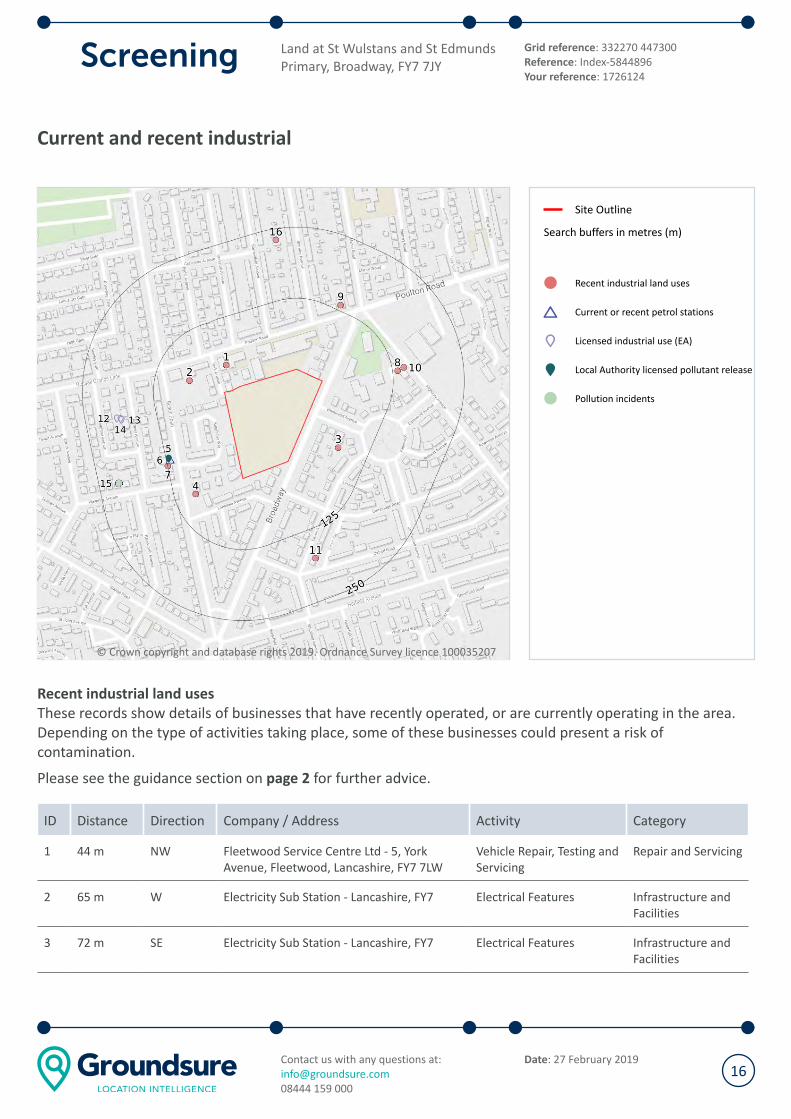
Current and recent industrial
© Crown copyright and database rights 2019. Ordnance Survey licence 100035207
Site Outline
Search buffers in metres (m)
Recent industrial land uses
Current or recent petrol stations
Licensed industrial use (EA)
Local Authority licensed pollutant release
Pollution incidents
Recent industrial land uses
These records show details of businesses that have recently operated, or are currently operating in the area.
Depending on the type of activities taking place, some of these businesses could present a risk of
contamination.
Please see the guidance section on page 2 for further advice.
ID Distance Direction Company / Address Activity Category
1 44 m NW Fleetwood Service Centre Ltd - 5, York
Avenue, Fleetwood, Lancashire, FY7 7LW
Vehicle Repair, Testing and
Servicing
Repair and Servicing
2 65 m W Electricity Sub Station - Lancashire, FY7 Electrical Features Infrastructure and
Facilities
3 72 m SE Electricity Sub Station - Lancashire, FY7 Electrical Features Infrastructure and
Facilities
Land at St Wulstans and St Edmunds
Primary, Broadway, FY7 7JY
Grid reference: 332270 447300
Reference: Index-5844896
Your reference: 1726124
Contact us with any questions at:
08444 159 000
Date: 27 February 201916

ID Distance Direction Company / Address Activity Category
4 87 m W Electricity Sub Station - Lancashire, FY7 Electrical Features Infrastructure and
Facilities
7 125 m W Beach Road Garage Fleetwood Ltd - 59,
Beach Road, Fleetwood, Lancashire, FY7
8PW
Vehicle Repair, Testing and
Servicing
Repair and Servicing
8 134 m E Electricity Sub Station - Lancashire, FY7 Electrical Features Infrastructure and
Facilities
9 135 m NE G Walsh & Son - 290, Poulton Road,
Fleetwood, Lancashire, FY7 7LA
General Construction
Supplies
Industrial Products
10 146 m E Electricity Sub Station - Lancashire, FY7 Electrical Features Infrastructure and
Facilities
11 177 m S R D Automotive - 45, Devon Avenue,
Fleetwood, Lancashire, FY7 7EA
Vehicle Repair, Testing and
Servicing
Repair and Servicing
16 230 m N Electricity Sub Station - Lancashire, FY7 Electrical Features Infrastructure and
Facilities
This data is sourced from Ordnance Survey.
Current or recent petrol stations
Petrol stations and their associated storage tanks are considered a risk for soil and groundwater
contamination. This is because spills can occur when fuel tanks are filled and leaks from these tanks can cause
ongoing pollution. Older and obsolete petrol stations are considered a greater risk than newer ones, as fuel
tanks can remain underground and deteriorate, sometimes causing significant leaks. In some cases, fuels such
as petrol or diesel can spread beneath the surface, meaning that properties can be affected even when they
are some distance away.
Please see the guidance section on page 2 for further advice.
ID Distance Direction Company Address Status
6 121 m W OBSOLETE Beach Road, Fleetwood, Lancashire, FY7
8PW
Obsolete
This data is sourced from Experian Catalist.
Current or recent licensed industrial activities
Major industrial processes (Part A(1) Processes) are regulated under Environmental Permitting Regulations, as
required under the Integrated Pollution Prevention and Control (IPPC) Directive. The release of pollutants
could present a contamination risk if Environment Agency regulations are not adhered to.
Please see the guidance section on page 2 for further advice.
Land at St Wulstans and St Edmunds
Primary, Broadway, FY7 7JY
Grid reference: 332270 447300
Reference: Index-5844896
Your reference: 1726124
Contact us with any questions at:
08444 159 000
Date: 27 February 201917
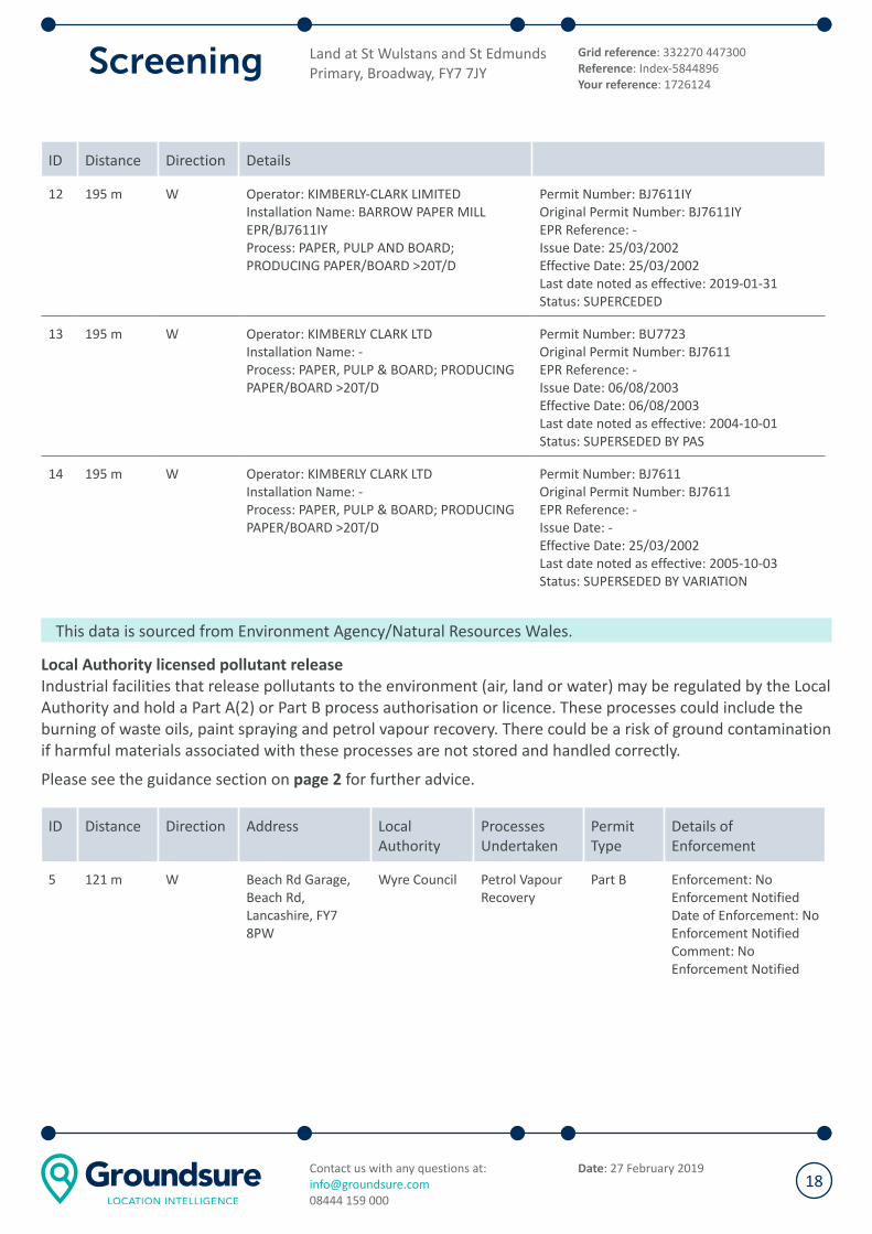
ID Distance Direction Details
12 195 m W Operator: KIMBERLY-CLARK LIMITED
Installation Name: BARROW PAPER MILL
EPR/BJ7611IY
Process: PAPER, PULP AND BOARD;
PRODUCING PAPER/BOARD >20T/D
Permit Number: BJ7611IY
Original Permit Number: BJ7611IY
EPR Reference: -
Issue Date: 25/03/2002
Effective Date: 25/03/2002
Last date noted as effective: 2019-01-31
Status: SUPERCEDED
13 195 m W Operator: KIMBERLY CLARK LTD
Installation Name: -
Process: PAPER, PULP & BOARD; PRODUCING
PAPER/BOARD >20T/D
Permit Number: BU7723
Original Permit Number: BJ7611
EPR Reference: -
Issue Date: 06/08/2003
Effective Date: 06/08/2003
Last date noted as effective: 2004-10-01
Status: SUPERSEDED BY PAS
14 195 m W Operator: KIMBERLY CLARK LTD
Installation Name: -
Process: PAPER, PULP & BOARD; PRODUCING
PAPER/BOARD >20T/D
Permit Number: BJ7611
Original Permit Number: BJ7611
EPR Reference: -
Issue Date: -
Effective Date: 25/03/2002
Last date noted as effective: 2005-10-03
Status: SUPERSEDED BY VARIATION
This data is sourced from Environment Agency/Natural Resources Wales.
Local Authority licensed pollutant release
Industrial facilities that release pollutants to the environment (air, land or water) may be regulated by the Local
Authority and hold a Part A(2) or Part B process authorisation or licence. These processes could include the
burning of waste oils, paint spraying and petrol vapour recovery. There could be a risk of ground contamination
if harmful materials associated with these processes are not stored and handled correctly.
Please see the guidance section on page 2 for further advice.
ID Distance Direction Address Local
Authority
Processes
Undertaken
Permit
Type
Details of
Enforcement
5 121 m W Beach Rd Garage,
Beach Rd,
Lancashire, FY7
8PW
Wyre Council Petrol Vapour
Recovery
Part B Enforcement: No
Enforcement Notified
Date of Enforcement: No
Enforcement Notified
Comment: No
Enforcement Notified
Land at St Wulstans and St Edmunds
Primary, Broadway, FY7 7JY
Grid reference: 332270 447300
Reference: Index-5844896
Your reference: 1726124
Contact us with any questions at:
08444 159 000
Date: 27 February 201918

This data is sourced from the Local Authorities.
Pollution incidents
Environment Agency keep records of all major or significant pollution incidents that are known to have
impacted the land, water or air. The location provided for these records may relate to the location of the
incidents but may sometimes be recorded where the effects of the incident was reported.
Please see the guidance section on page 2 for further advice.
ID Distance Direction Incident
Date
Land Impact Water Impact Pollutant
15 215 m W 29/03/2011 Category 4 (No
Impact)
Category 4 (No
Impact)
Other Atmospheric Pollutant or
Effect
This data is sourced from Environment Agency/Natural Resources Wales.
Land at St Wulstans and St Edmunds
Primary, Broadway, FY7 7JY
Grid reference: 332270 447300
Reference: Index-5844896
Your reference: 1726124
Contact us with any questions at:
08444 159 000
Date: 27 February 201919
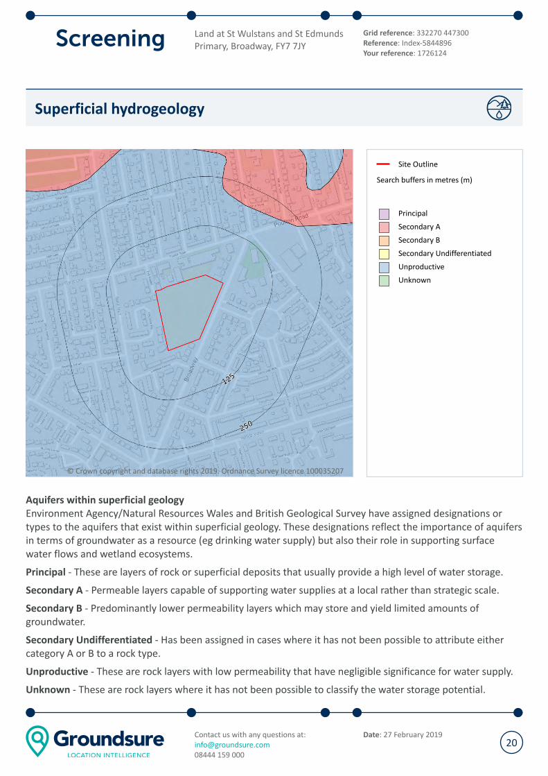
Superficial hydrogeology
© Crown copyright and database rights 2019. Ordnance Survey licence 100035207
Site Outline
Search buffers in metres (m)
Principal
Secondary A
Secondary B
Secondary Undifferentiated
Unproductive
Unknown
Aquifers within superficial geology
Environment Agency/Natural Resources Wales and British Geological Survey have assigned designations or
types to the aquifers that exist within superficial geology. These designations reflect the importance of aquifers
in terms of groundwater as a resource (eg drinking water supply) but also their role in supporting surface
water flows and wetland ecosystems.
Principal - These are layers of rock or superficial deposits that usually provide a high level of water storage.
Secondary A - Permeable layers capable of supporting water supplies at a local rather than strategic scale.
Secondary B - Predominantly lower permeability layers which may store and yield limited amounts of
groundwater.
Secondary Undifferentiated - Has been assigned in cases where it has not been possible to attribute either
category A or B to a rock type.
Unproductive - These are rock layers with low permeability that have negligible significance for water supply.
Unknown - These are rock layers where it has not been possible to classify the water storage potential.
Land at St Wulstans and St Edmunds
Primary, Broadway, FY7 7JY
Grid reference: 332270 447300
Reference: Index-5844896
Your reference: 1726124
Contact us with any questions at:
08444 159 000
Date: 27 February 201920

Distance Direction Designation
0 on site Unproductive
203 m NE Secondary A
This data is sourced from Environment Agency/Natural Resources Wales.
Superficial geology
Superficial deposits are the youngest natural geological deposits formed during the most recent period of
geological time. They rest on older deposits or rocks referred to as bedrock. This information comes from the
BGS 1:50,000 Digital Geological Map of Great Britain, where available.
Description BGS LEX Code Rock Type
TIDAL FLAT DEPOSITS, 1 TFD1-XCZ CLAY AND SILT
This data is sourced from British Geological Survey.
Land at St Wulstans and St Edmunds
Primary, Broadway, FY7 7JY
Grid reference: 332270 447300
Reference: Index-5844896
Your reference: 1726124
Contact us with any questions at:
08444 159 000
Date: 27 February 201921
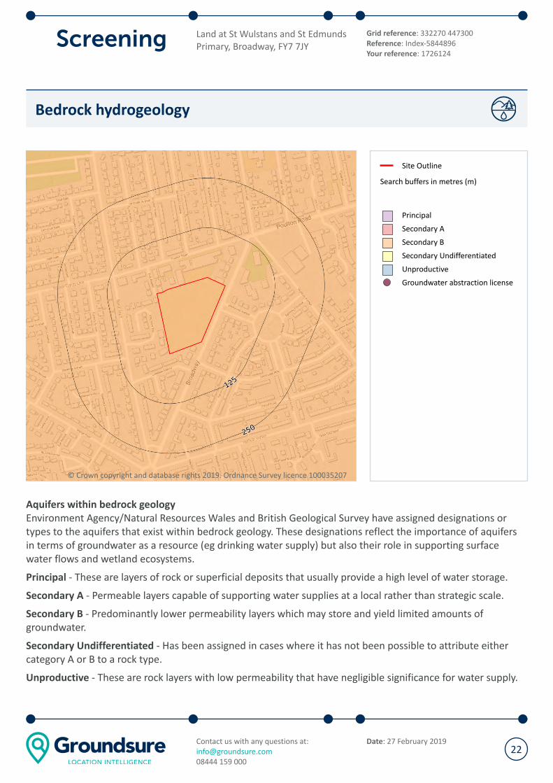
Bedrock hydrogeology
© Crown copyright and database rights 2019. Ordnance Survey licence 100035207
Site Outline
Search buffers in metres (m)
Principal
Secondary A
Secondary B
Secondary Undifferentiated
Unproductive
Groundwater abstraction license
Aquifers within bedrock geology
Environment Agency/Natural Resources Wales and British Geological Survey have assigned designations or
types to the aquifers that exist within bedrock geology. These designations reflect the importance of aquifers
in terms of groundwater as a resource (eg drinking water supply) but also their role in supporting surface
water flows and wetland ecosystems.
Principal - These are layers of rock or superficial deposits that usually provide a high level of water storage.
Secondary A - Permeable layers capable of supporting water supplies at a local rather than strategic scale.
Secondary B - Predominantly lower permeability layers which may store and yield limited amounts of
groundwater.
Secondary Undifferentiated - Has been assigned in cases where it has not been possible to attribute either
category A or B to a rock type.
Unproductive - These are rock layers with low permeability that have negligible significance for water supply.
Land at St Wulstans and St Edmunds
Primary, Broadway, FY7 7JY
Grid reference: 332270 447300
Reference: Index-5844896
Your reference: 1726124
Contact us with any questions at:
08444 159 000
Date: 27 February 201922
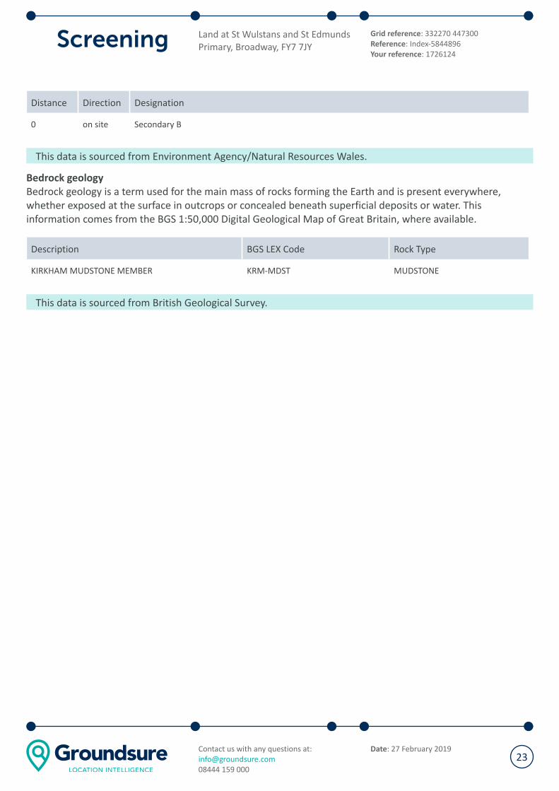
Distance Direction Designation
0 on site Secondary B
This data is sourced from Environment Agency/Natural Resources Wales.
Bedrock geology
Bedrock geology is a term used for the main mass of rocks forming the Earth and is present everywhere,
whether exposed at the surface in outcrops or concealed beneath superficial deposits or water. This
information comes from the BGS 1:50,000 Digital Geological Map of Great Britain, where available.
Description BGS LEX Code Rock Type
KIRKHAM MUDSTONE MEMBER KRM-MDST MUDSTONE
This data is sourced from British Geological Survey.
Land at St Wulstans and St Edmunds
Primary, Broadway, FY7 7JY
Grid reference: 332270 447300
Reference: Index-5844896
Your reference: 1726124
Contact us with any questions at:
08444 159 000
Date: 27 February 201923

Flood
Risk of flooding from rivers and the sea
© Crown copyright and database rights 2019. Ordnance Survey licence 100035207
Site Outline
Search buffers in metres (m)
Environment Agency river and
coastal flooding:
High
Medium
Low
Very Low
Historical Flood Events
Areas Used for Flood Storage
Areas Benefiting from Flood
Defences
Proposed Flood Defence
Scheme
Flood Defences
Risk of flooding from rivers and the sea
The property has a Low chance of flooding in any given year, according to Risk of Flooding from Rivers and Sea
(RoFRaS) data. This could cause problems with insuring the property against flood risk.
RoFRaS assesses flood risk from rivers and the sea in England and Wales, using local data and expertise. It
shows the chance of flooding from rivers or the sea, taking account of flood defences and the condition those
defences are in. The RoFRaS model uses local water level and flood defence data to model flood risk. See
below for explanation of the RoFRaS levels of flood risk.
Please see the guidance section on page 2 for further advice.
Environment Agency RoFRaS risk ratings
Land at St Wulstans and St Edmunds
Primary, Broadway, FY7 7JY
Grid reference: 332270 447300
Reference: Index-5844896
Your reference: 1726124
Contact us with any questions at:
08444 159 000
Date: 27 February 201924
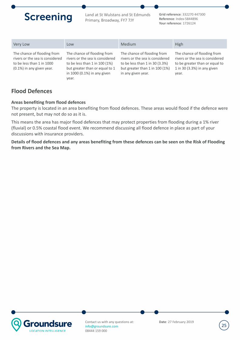
Very Low Low Medium High
The chance of flooding from
rivers or the sea is considered
to be less than 1 in 1000
(0.1%) in any given year.
The chance of flooding from
rivers or the sea is considered
to be less than 1 in 100 (1%)
but greater than or equal to 1
in 1000 (0.1%) in any given
year.
The chance of flooding from
rivers or the sea is considered
to be less than 1 in 30 (3.3%)
but greater than 1 in 100 (1%)
in any given year.
The chance of flooding from
rivers or the sea is considered
to be greater than or equal to
1 in 30 (3.3%) in any given
year.
Flood Defences
Areas benefiting from flood defences
The property is located in an area benefiting from flood defences. These areas would flood if the defence were
not present, but may not do so as it is.
This means the area has major flood defences that may protect properties from flooding during a 1% river
(fluvial) or 0.5% coastal flood event. We recommend discussing all flood defence in place as part of your
discussions with insurance providers.
Details of flood defences and any areas benefiting from these defences can be seen on the Risk of Flooding
from Rivers and the Sea Map.
Land at St Wulstans and St Edmunds
Primary, Broadway, FY7 7JY
Grid reference: 332270 447300
Reference: Index-5844896
Your reference: 1726124
Contact us with any questions at:
08444 159 000
Date: 27 February 201925

Surface water flood risk
© Crown copyright and database rights 2019. Ordnance Survey licence 100035207
Site Outline
Search buffers in metres (m)
JBA Surface Water Flood
Highly significant
Significant
High
Moderate to high
Moderate
Low to moderate
Low
Surface water flood risk
The property is likely to be prone to flooding following extreme rainfall, which could cause problems with
insuring the property against flood risk.
The area in which the property is located has been assessed to be at a Significant risk of surface water
flooding. This area is considered to have a 1 in 75 probability of surface water flooding due to rainfall in a given
year to a depth of between 0.3m to 1m. However, as is the case with probability statistics and predictions, this
information should be used as a guideline only. The area may flood several years in a row, or not at all for many
years.
These risk calculations are based on JBA Risk Management maps.
Land at St Wulstans and St Edmunds
Primary, Broadway, FY7 7JY
Grid reference: 332270 447300
Reference: Index-5844896
Your reference: 1726124
Contact us with any questions at:
08444 159 000
Date: 27 February 201926

JBA Floodability Rating
© Crown copyright and database rights 2019. Ordnance Survey licence 100035207
Site Outline
Search buffers in metres (m)
Black 2
Black 1
Red
Amber
Green
The property has been rated as Amber. Amber indicates a moderate level of flood hazard.
JBA's Floodability rating provides an indication of the likelihood of a property being flooded from river, coastal
and/or surface water flood. It is based on a ground level model that does not contain buildings or
infrastructure. The Floodability information is based on a model and should not be relied upon as fact. It is
only one of the many considerations reviewed as part of a commercial insurance policy.
Other underwriting considerations may include whether the building has been raised, are the contents raised
off the floor, the construction type, business type, whereabouts the flooding impacts the property and the
likelihood of business interruption such as access restrictions due to flood waters. As a property owner,
understanding the risk to your property is valuable and adding flood resilience measures to the property,
where known to be at risk, may help getting insurance or reducing the premium or excess charged by an
insurer.
Land at St Wulstans and St Edmunds
Primary, Broadway, FY7 7JY
Grid reference: 332270 447300
Reference: Index-5844896
Your reference: 1726124
Contact us with any questions at:
08444 159 000
Date: 27 February 201927
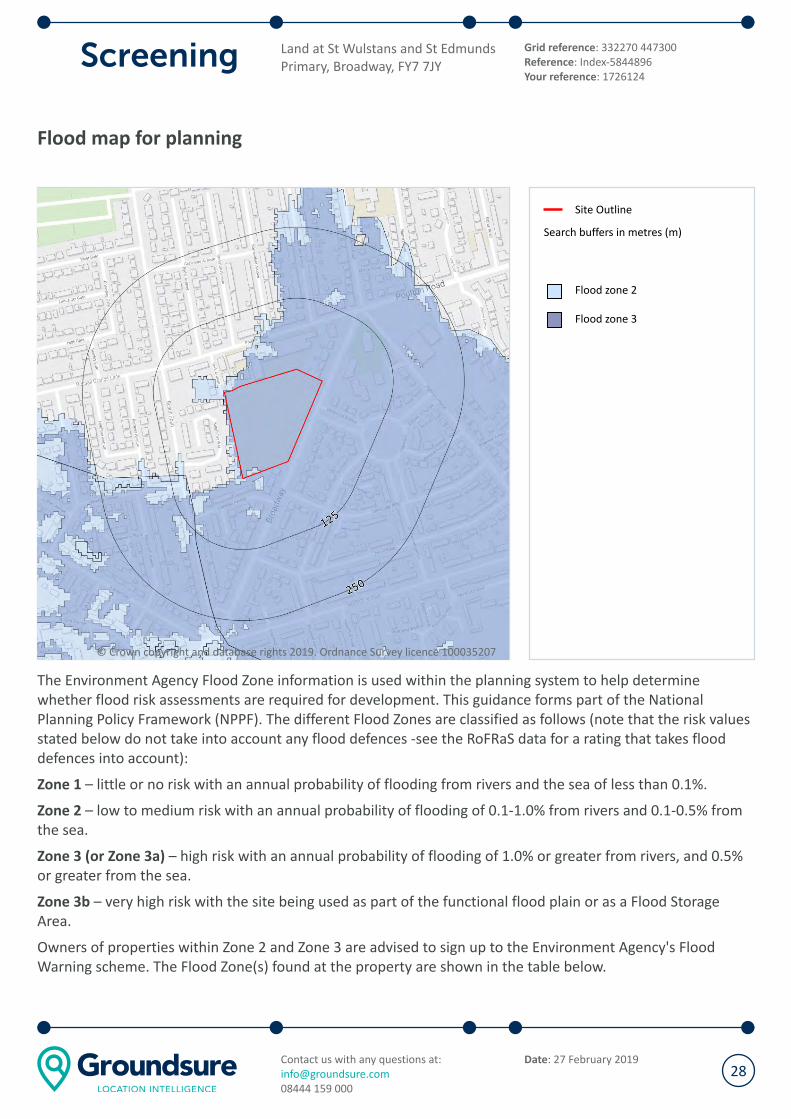
Flood map for planning
© Crown copyright and database rights 2019. Ordnance Survey licence 100035207
Site Outline
Search buffers in metres (m)
Flood zone 2
Flood zone 3
The Environment Agency Flood Zone information is used within the planning system to help determine
whether flood risk assessments are required for development. This guidance forms part of the National
Planning Policy Framework (NPPF). The different Flood Zones are classified as follows (note that the risk values
stated below do not take into account any flood defences -see the RoFRaS data for a rating that takes flood
defences into account):
Zone 1 – little or no risk with an annual probability of flooding from rivers and the sea of less than 0.1%.
Zone 2 – low to medium risk with an annual probability of flooding of 0.1-1.0% from rivers and 0.1-0.5% from
the sea.
Zone 3 (or Zone 3a) – high risk with an annual probability of flooding of 1.0% or greater from rivers, and 0.5%
or greater from the sea.
Zone 3b – very high risk with the site being used as part of the functional flood plain or as a Flood Storage
Area.
Owners of properties within Zone 2 and Zone 3 are advised to sign up to the Environment Agency's Flood
Warning scheme. The Flood Zone(s) found at the property are shown in the table below.
Land at St Wulstans and St Edmunds
Primary, Broadway, FY7 7JY
Grid reference: 332270 447300
Reference: Index-5844896
Your reference: 1726124
Contact us with any questions at:
08444 159 000
Date: 27 February 201928
Distance Direction Description
0 on site Flood zone 2
0 on site Flood zone 3
This data is sourced from the Environment Agency / Natural Resources Wales
Land at St Wulstans and St Edmunds
Primary, Broadway, FY7 7JY
Grid reference: 332270 447300
Reference: Index-5844896
Your reference: 1726124
Contact us with any questions at:
08444 159 000
Date: 27 February 201929

Ground stability
Natural ground subsidence
© Crown copyright and database rights 2019. Ordnance Survey licence 100035207
Site Outline
Search buffers in metres (m)
Moderate - high
Low
Negligible - very low
Natural ground subsidence
The property, or an area within 50m of the property, has a moderate to high potential for natural ground
subsidence. This rating is derived from the British Geological Survey's GeoSure database, and is based upon
the natural qualities of the geology at the site rather than any historical subsidence claims or events.
Additionally, this data does not take into account whether buildings on site have been designed to withstand
any degree of subsidence hazard.
Please see the guidance section on page 2 for further advice.
Surveyors are normally aware of local problem areas in relation to subsidence, however, this data provided by
British Geological Survey (BGS) can highlight areas where a significant potential for natural ground subsidence
exists and whether it may need particular consideration. The term “Subsidence” refers to ground movement
that could cause damage to foundations in domestic or other properties.
Land at St Wulstans and St Edmunds
Primary, Broadway, FY7 7JY
Grid reference: 332270 447300
Reference: Index-5844896
Your reference: 1726124
Contact us with any questions at:
08444 159 000
Date: 27 February 201930
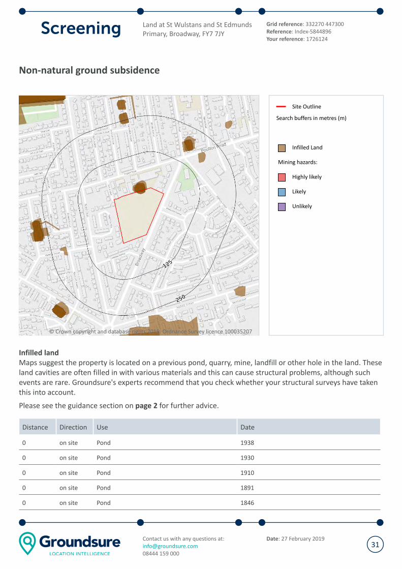
Non-natural ground subsidence
© Crown copyright and database rights 2019. Ordnance Survey licence 100035207
Site Outline
Search buffers in metres (m)
Infilled Land
Mining hazards:
Highly likely
Likely
Unlikely
Infilled land
Maps suggest the property is located on a previous pond, quarry, mine, landfill or other hole in the land. These
land cavities are often filled in with various materials and this can cause structural problems, although such
events are rare. Groundsure's experts recommend that you check whether your structural surveys have taken
this into account.
Please see the guidance section on page 2 for further advice.
Distance Direction Use Date
0 on site Pond 1938
0 on site Pond 1930
0 on site Pond 1910
0 on site Pond 1891
0 on site Pond 1846
Land at St Wulstans and St Edmunds
Primary, Broadway, FY7 7JY
Grid reference: 332270 447300
Reference: Index-5844896
Your reference: 1726124
Contact us with any questions at:
08444 159 000
Date: 27 February 201931
Distance Direction Use Date
0 on site Pond 1910
Groundsure's experts systematically analyse historical maps, which can highlight areas that, over time, may
have been filled with various materials. The materials used are usually safe, although in some cases
contaminative materials may also have been used. Past ground workings have been identified at the site.
These workings may be associated with railway cuttings or other ground engineering but may also indicate
mining activity. Information is taken from features identified on Ordnance Survey historical maps, which do
not indicate the distance or direction that mines extend beneath the surface. For example, features such
as mine shafts only indicate the entrance to a mine. From this, we may infer the potential for underground
features to extend outward from this point. Some features within this database may also relate to non-
mining underground activities e.g. air shafts for underground railways.
Land at St Wulstans and St Edmunds
Primary, Broadway, FY7 7JY
Grid reference: 332270 447300
Reference: Index-5844896
Your reference: 1726124
Contact us with any questions at:
08444 159 000
Date: 27 February 201932
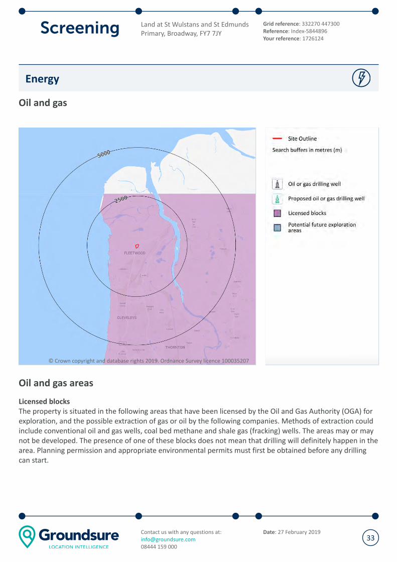
Energy
Oil and gas
© Crown copyright and database rights 2019. Ordnance Survey licence 100035207
Oil and gas areas
Licensed blocks
The property is situated in the following areas that have been licensed by the Oil and Gas Authority (OGA) for
exploration, and the possible extraction of gas or oil by the following companies. Methods of extraction could
include conventional oil and gas wells, coal bed methane and shale gas (fracking) wells. The areas may or may
not be developed. The presence of one of these blocks does not mean that drilling will definitely happen in the
area. Planning permission and appropriate environmental permits must first be obtained before any drilling
can start.
Land at St Wulstans and St Edmunds
Primary, Broadway, FY7 7JY
Grid reference: 332270 447300
Reference: Index-5844896
Your reference: 1726124
Contact us with any questions at:
08444 159 000
Date: 27 February 201933
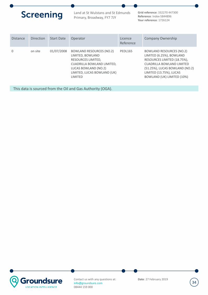
Distance Direction Start Date Operator Licence
Reference
Company Ownership
0 on site 01/07/2008 BOWLAND RESOURCES (NO.2)
LIMITED, BOWLAND
RESOURCES LIMITED,
CUADRILLA BOWLAND LIMITED,
LUCAS BOWLAND (NO.2)
LIMITED, LUCAS BOWLAND (UK)
LIMITED
PEDL165 BOWLAND RESOURCES (NO.2)
LIMITED (6.25%), BOWLAND
RESOURCES LIMITED (18.75%),
CUADRILLA BOWLAND LIMITED
(51.25%), LUCAS BOWLAND (NO.2)
LIMITED (13.75%), LUCAS
BOWLAND (UK) LIMITED (10%)
This data is sourced from the Oil and Gas Authority (OGA).
Land at St Wulstans and St Edmunds
Primary, Broadway, FY7 7JY
Grid reference: 332270 447300
Reference: Index-5844896
Your reference: 1726124
Contact us with any questions at:
08444 159 000
Date: 27 February 201934
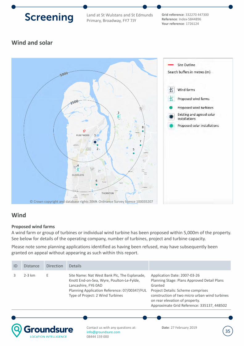
Wind and solar
© Crown copyright and database rights 2019. Ordnance Survey licence 100035207
Wind
Proposed wind farms
A wind farm or group of turbines or individual wind turbine has been proposed within 5,000m of the property.
See below for details of the operating company, number of turbines, project and turbine capacity.
Please note some planning applications identified as having been refused, may have subsequently been
granted on appeal without appearing as such within this report.
ID Distance Direction Details
3 2-3 km E Site Name: Nat West Bank Plc, The Esplanade,
Knott End-on-Sea, Wyre, Poulton-Le-Fylde,
Lancashire, FY6 0AD
Planning Application Reference: 07/00347/FUL
Type of Project: 2 Wind Turbines
Application Date: 2007-03-26
Planning Stage: Plans Approved Detail Plans
Granted
Project Details: Scheme comprises
construction of two micro urban wind turbines
on rear elevation of property.
Approximate Grid Reference: 335137, 448502
Land at St Wulstans and St Edmunds
Primary, Broadway, FY7 7JY
Grid reference: 332270 447300
Reference: Index-5844896
Your reference: 1726124
Contact us with any questions at:
08444 159 000
Date: 27 February 201935

ID Distance Direction Details
4 3-4 km S Site Name: College Farm Rossall Road,
Thornton Cleveleys, Lancashire, FY5 2AT
Planning Application Reference: 13/00129/FUL
Type of Project: 2 Wind Turbines
Application Date: 2013-02-22
Planning Stage: Early Planning Detail Plans
Refused
Project Details: Scheme comprises installation
of two micro scale wind turbines (14.97m to
hub, 5.6m diameter blad).
Approximate Grid Reference: 331745, 444082
This information is derived from planning data supplied by Glenigan, in some cases with further accuracy
applied by Groundsure's experts. This search includes planning applications for wind farms with multiple
turbines within 5,000m of the property. This data is updated on a quarterly basis.
If the existence of a planning application, passed or refused may have a material impact with regard to the
decision to purchase the property, Groundsure recommends independent, thorough enquiries are made
with the Local Authority. If any applications have been identified within this report, Groundsure have
included the planning reference to enable further enquiries to be made.
Proposed wind turbines
Planning applications for individual wind turbines have been proposed within 5,000m of the property. See
below for details of the operating company, number of turbines, project and turbine capacity.
Please note some planning applications identified as having been refused may have subsequently been
granted on appeal without appearing as such within this report.
ID Distance Direction Details
2 1-2 km SE Site Name: Jameson Road, Wyre, Fleetwood,
Lancashire, FY7 8TW
Planning Application Reference: 13/00915/LCC
Type of Project: Wind Turbine
Application Date:
2013-12-23
Planning Stage: Early Planning Detailed Plans
Submitted
Project Details: Scheme comprises
construction of 78m high wind turbine, control
kiosk, improvements to the access road and
realignment of the fence.
Approximate Grid Reference: 333230, 446226
5 4-5 km SE Site Name: Grange Farm Grange Lane,
Stalmine, Poulton-Le-Fylde, Lancashire, FY6
0JQ
Planning Application Reference: 11/00803/FUL
Type of Project: Wind Turbine
Application Date:
2011-11-07
Planning Stage: Plans Approved Detail Plans
Granted
Project Details: Scheme comprises installation
of a wind turbine on a 15m high mast.
Approximate Grid Reference: 336415, 445426
Land at St Wulstans and St Edmunds
Primary, Broadway, FY7 7JY
Grid reference: 332270 447300
Reference: Index-5844896
Your reference: 1726124
Contact us with any questions at:
08444 159 000
Date: 27 February 201936
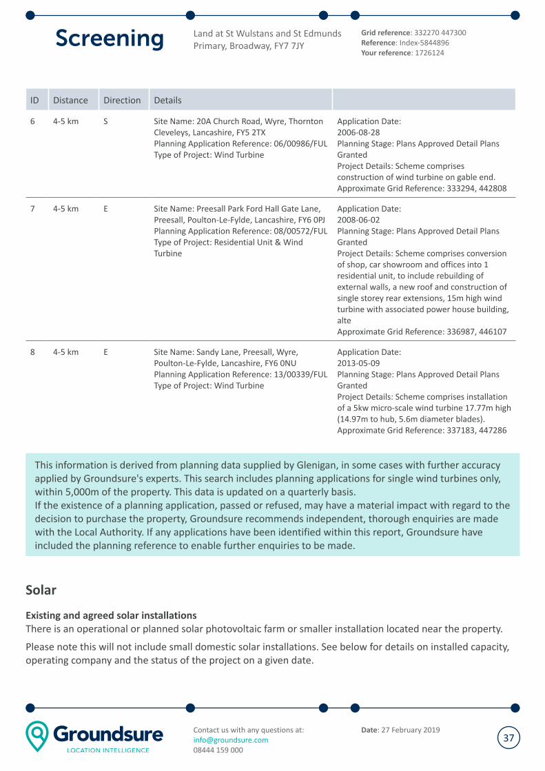
ID Distance Direction Details
6 4-5 km S Site Name: 20A Church Road, Wyre, Thornton
Cleveleys, Lancashire, FY5 2TX
Planning Application Reference: 06/00986/FUL
Type of Project: Wind Turbine
Application Date:
2006-08-28
Planning Stage: Plans Approved Detail Plans
Granted
Project Details: Scheme comprises
construction of wind turbine on gable end.
Approximate Grid Reference: 333294, 442808
7 4-5 km E Site Name: Preesall Park Ford Hall Gate Lane,
Preesall, Poulton-Le-Fylde, Lancashire, FY6 0PJ
Planning Application Reference: 08/00572/FUL
Type of Project: Residential Unit & Wind
Turbine
Application Date:
2008-06-02
Planning Stage: Plans Approved Detail Plans
Granted
Project Details: Scheme comprises conversion
of shop, car showroom and offices into 1
residential unit, to include rebuilding of
external walls, a new roof and construction of
single storey rear extensions, 15m high wind
turbine with associated power house building,
alte
Approximate Grid Reference: 336987, 446107
8 4-5 km E Site Name: Sandy Lane, Preesall, Wyre,
Poulton-Le-Fylde, Lancashire, FY6 0NU
Planning Application Reference: 13/00339/FUL
Type of Project: Wind Turbine
Application Date:
2013-05-09
Planning Stage: Plans Approved Detail Plans
Granted
Project Details: Scheme comprises installation
of a 5kw micro-scale wind turbine 17.77m high
(14.97m to hub, 5.6m diameter blades).
Approximate Grid Reference: 337183, 447286
This information is derived from planning data supplied by Glenigan, in some cases with further accuracy
applied by Groundsure's experts. This search includes planning applications for single wind turbines only,
within 5,000m of the property. This data is updated on a quarterly basis.
If the existence of a planning application, passed or refused, may have a material impact with regard to the
decision to purchase the property, Groundsure recommends independent, thorough enquiries are made
with the Local Authority. If any applications have been identified within this report, Groundsure have
included the planning reference to enable further enquiries to be made.
Solar
Existing and agreed solar installations
There is an operational or planned solar photovoltaic farm or smaller installation located near the property.
Please note this will not include small domestic solar installations. See below for details on installed capacity,
operating company and the status of the project on a given date.
Land at St Wulstans and St Edmunds
Primary, Broadway, FY7 7JY
Grid reference: 332270 447300
Reference: Index-5844896
Your reference: 1726124
Contact us with any questions at:
08444 159 000
Date: 27 February 201937

ID Distance Direction Address Details
1 1-2 km SE Fleetwood Water Treatment
Works, Fleetwood Waste Water
Treatment Works, Jameson
Road, Fleetwood
Contractor: United
Utilities
LPA Name: Lancashire
County Council
Capacity (MW): 1.3
Application Date: 16/07/2014
Pre Consent Status: Operational
Post Consent Status: Operational
Date Commenced: 15/03/2015
The solar installation data is supplied by Department of Energy and Climate Change (DECC) and updated
on a monthly basis.
Land at St Wulstans and St Edmunds
Primary, Broadway, FY7 7JY
Grid reference: 332270 447300
Reference: Index-5844896
Your reference: 1726124
Contact us with any questions at:
08444 159 000
Date: 27 February 201938

Energy infrastructure
© Crown copyright and database rights 2019. Ordnance Survey licence 100035207
Power stations
Power stations
There is an active power station on or near to the property. Power stations can cause air pollution issues and
may not be visually pleasing.
Power generation stations identified by these searches have a capacity of over 1 MW (Million Watt output)
and will be one of the following types: Combined Cycle Gas Turbine (CCGT), Gas/Oil, Coal Gas, Diesel Gas, HP
Oil, Poultry Litter, Coal/Oil, Coal/Gas, Meat and Bone, Pumped Storage Mine Gas, Rapeseed Oil, Straw/Gas
Waste Combined Heat or Power Biomass.
Air pollution issues can be investigated further through the Air Quality team at the Local Authority. If the
existence of any of a power generation station may have a material impact with regard to the decision to
purchase the property, Groundsure recommends making independent enquiries with the operating company
listed.
Land at St Wulstans and St Edmunds
Primary, Broadway, FY7 7JY
Grid reference: 332270 447300
Reference: Index-5844896
Your reference: 1726124
Contact us with any questions at:
08444 159 000
Date: 27 February 201939

ID Distance Direction Company
name
Power station name Type of power
station
Total
capacity
(MW)
Operating
since
1 4-5 km SE Vinnolit
Hillhouse LTD
Hillhouse International
Business Park
Combined Heat
and Power
5 No Details
This data is sourced from the Digest of United Kingdom Energy Statistics (DUKES), a database from the
Department of Energy and Climate Change (DECC).
Large Energy Projects
Large scale energy generation or transmission infrastructure has been proposed on or near to the property.
Plans have been submitted to the Planning Inspectorate (formerly known as the Infrastructure Planning
Commission). See below for details of what is proposed.
Distance Direction Details Summary
894 m SE Operator: Halite Energy
Group Ltd
Site Name: Preesall
Saltfield Underground Gas
Storage
Stage: Decided
Underground gas storage facility to store gas in, extract gas from and
inject gas into, with a total storage capacity up to 900 million standard
cubic metres and working capacity of up to 600 million cubic metres,
both specified at standard temperatures
and pressures, comprising:(i) up to 19 operational caverns formed by
solution mining of the Preesall halite deposit all to be constructed to any
extent downwards below 220 metres below ground surface and to be
confined in the Preesall halite deposit.(ii)
7 multiple wellhead compounds to create the underground salt caverns
and, once operational, to connect the gas manifolds.(iii) Gas Compressor
Compound comprising pig launchers and receivers; slug catchers; above
ground high.
3-4 km SE Operator: Wyre Power Ltd
Site Name: Hillhouse
Enterprise Zone Power
Station
Stage: Pre Application
Up to 900MW Megawatt electrical (MWe) Power Plant primarily using
combined cycle gas turbine (CCGT) technology with optional additional
open cycle gas turbine (OCGT) technology to help address the fluctuating
energy demands of UK power consumption. The p
roject will include a new gas pipeline, Above Ground Installations at St
Michaels on Wyre and Hillhouse, and an electrical cable to Stanah
substation.
Land at St Wulstans and St Edmunds
Primary, Broadway, FY7 7JY
Grid reference: 332270 447300
Reference: Index-5844896
Your reference: 1726124
Contact us with any questions at:
08444 159 000
Date: 27 February 201940

The information for this search is taken from a range of publicly available datasets. If the existence of a
large scale infrastructure project may have a material impact with regard to the decision to purchase the
property, Groundsure recommends making independent, thorough enquiries, starting with the National
Infrastructure Planning website - https://infrastructure.planninginspectorate.gov.uk/projects/.
Land at St Wulstans and St Edmunds
Primary, Broadway, FY7 7JY
Grid reference: 332270 447300
Reference: Index-5844896
Your reference: 1726124
Contact us with any questions at:
08444 159 000
Date: 27 February 201941

Datasets searched but no features were found at this location
In addition to the results detailed in the maps and tables in this report, all of these datasets were also queried
but did not reveal any results relevant to the site or surrounding area.
Contaminated Land
Former tanks
Former petrol stations
Former military land
Former landfill (from British Geological Survey records, 1973)
Former landfill (from Local Authority and historical mapping records)
Waste site no longer in use
Active or recent landfill
Former landfill (from Environment Agency Records)
Active or recent licensed waste sites
Dangerous or explosive sites
Hazardous substance storage/usage
Sites designated as Contaminated Land
Historical licensed industrial activities
Pollutant release to surface waters
Pollutant release to public sewer
Dangerous industrial substances (D.S.I. List 1)
Dangerous industrial substances (D.S.I. List 2)
Bedrock hydrogeology
Groundwater abstraction licences
Source Protection Zones and drinking water abstractions
Source Protection Zones
Source Protection Zones in confined aquifer
Drinking water abstraction licences
Hydrology
Water courses from Ordnance Survey
Surface water abstractions
Flood Risk
Flood storage areas: part of floodplain
Historical flood areas
Flood defences
Proposed flood defences
Groundwater flooding
Ground stability
Natural geological cavities
Coal mining
Non-coal mining
Mining cavities
Radon
Oil and Gas
Oil or gas drilling well
Proposed oil or gas drilling well
Potential future exploration areas
Wind and solar
Wind farms
Proposed solar installations
Energy Infrastructure
Electricity transmission lines and pylons
National Grid energy infrastructure
Nuclear installations
Planning constraints
Sites of Special Scientific Interest
Internationally important wetland sites (Ramsar Sites)
Special Areas of Conservation
Special Protection Areas (for birds)
National Nature Reserves
Local Nature Reserves
Designated Ancient Woodland
Green Belt
World Heritage Sites
Areas of Outstanding Natural Beauty
National Parks
Conservation Areas
Listed Buildings
Certificates of Immunity from Listing
Scheduled Monuments
Registered Parks and Gardens
Land at St Wulstans and St Edmunds
Primary, Broadway, FY7 7JY
Grid reference: 332270 447300
Reference: Index-5844896
Your reference: 1726124
Contact us with any questions at:
08444 159 000
Date: 27 February 201942
Contaminated Land assessment methodology
Environmental risk framework
This report is designed to provide a basic environmental liability risk assessment for the purposes of
transaction due diligence, financing arrangements and similar circumstances. The report comprises a basic risk
assessment within the general principles of the contaminant-pathway-receptor pollutant linkage model and
with due regard for relevant publications issued by the Department of Environment, Food and Rural Affairs
(and predecessor government departments) the British Standards Institute and the European Union.
Explicit opinion is provided with regard to potential liability for the property to be identified as Contaminated
Land in accordance with the meaning set out in Part 2A of the Environmental Protection Act 1990.
Consideration and due regard is also made of associated legislation that may lead to related statutory or third
party environmental liability, including but not limited to the Water Resources Act 1991,the Water Act 2014,
the Contaminated Land Regulations 2006, Environmental Permitting Regulations 2010, the Environmental
Damage (Prevention and Remediation) (England) (Amendment) Regulations 2015 in England and the
Environmental Damage (Prevention and Remediation) (Amendment) (Wales) Regulations 2015 in Wales.
This report does not contain a detailed Conceptual Site Model as required in the National Planning Policy
Framework, however, it may prove highly effective in determining whether such further assessment is
appropriate.
The report is based upon the information contained in subsequent dataset sections. Some datasets have been
generated by and are unique to Groundsure, whilst others are provided by recognised bodies including
Environment Agency/Natural Resources Wales, British Geological Survey, Public Health England, Local
Authorities, etc. Groundsure may also have been provided with further details regarding the site by the client
and / or his advisers. In the absence of such, Groundsure has made a best estimation regarding current and
proposed land use. This report and the risk assessment presented is based purely upon this information.
In undertaking this report Groundsure has not, unless explicitly stated to the contrary, undertaken a site
inspection, site investigation, consulted directly with the Local Authority with specific regard to the subject
property or reviewed existing environmental reports. Whilst every effort is made to consider likely
environmental liabilities on the basis of the information assessed, certain issues may only be readily
discernible from physical site inspection and / or investigation.
Contaminant source - Pathway - Receptor definitions
Contaminant sources include (but are not limited to):
Historical on-site and historical off-site sources (works, factories, oil tanks, landfill sites)
Current on-site and current off-site sources (petrol stations, industrial facilities)
Pathways comprise:
Any mechanisms facilitating 'receptor' exposure to contaminative 'sources'
Receptors include:
Human health i.e. site users or occupiers, adjacent site users or occupiers
Land at St Wulstans and St Edmunds
Primary, Broadway, FY7 7JY
Grid reference: 332270 447300
Reference: Index-5844896
Your reference: 1726124
Contact us with any questions at:
08444 159 000
Date: 27 February 201943
Controlled Waters i.e. groundwater, surface water (rivers and streams etc)
Habitats and biodiversity (in particular nature reserves or other designated sensitive habitats)
Property, buildings and infrastructure
Environmental risk assessment definitions
A risk rating will be provided on the front page of the report depending on the level of environmental liability
that there has been assessed to be at the site. The ratings are defined as follows:
Low: There are unlikely to be significant environmental liabilities associated with the property.
Low to Moderate: There are unlikely to be significant environmental liabilities associated with the property
with regard to the proposed use. However, minor issues may require further consideration and assessment
under certain circumstances e.g. redevelopment.
Moderate: Some potential environmental liabilities are likely to reside with the property as a result of
historical and / or current use. Whilst unlikely to represent an immediate significant issue, if left unchecked this
position may change with time. A prudent purchaser may wish to make further enquiries of the vendor /
undertake limited further due diligence / seek environmental improvements. Redevelopment of the site will
likely require further, more detailed assessment.
Moderate to High: Some potential significant environmental liability issues have been identified at the
property requiring further assessment. Should further information be available it may be possible to re-assess
the risk. In the absence of sufficient further information, further assessment might comprise consultation with
the environmental regulators / review of existing environmental reports / commissioning new environmental
reports / consideration of environmental insurance.
High: Significant potential environmental liabilities have been identified at the property. Further detailed
environmental due diligence will likely be required and may include review of existing environmental reports /
commissioning new environmental reports including site investigations / consideration of environmental
insurance / transaction restructuring.
Is there a risk of statutory (e.g. Part 2A EPA 1990) or third party action being taken against the site?
This response considers the risk of legal liability arising through ownership or occupation and use of the
property through statutory or other third party claims.
Does the property represent Acceptable Banking Security from an environmental risk perspective?
Consideration is given to the suitability of the property as robust financial security for the purposes of secured
lending facilities. An assumption is made here that the subject property is being considered in isolation and
that normal commercial lending loan to value ratios are being considered.
Groundsure may in certain circumstances be able to make a specific lender liability assessment based on a full
view of financial arrangements and hence the commercial context of the environmental risks.
Is there a risk that the property value may be impacted due to environmental liability issues?
This response sets out to advise whether environmental liabilities are likely to materially impact upon a
standard Royal Institution of Chartered Surveyors valuation of the property necessitating further assessment.
Environmental Damage (Prevention and Remediation) Regulations 2015
The Environmental Damage (Prevention and Remediation) (England) (Amendment) Regulations 2015, the
Environmental Damage (Prevention and Remediation) (Amendment) (Wales) Regulations 2015 and the
Environmental Liability (Scotland) Amendment Regulations 2015 came into force on 19th July 2015, and
amend the Environmental Damage (Prevention and Remediation) Regulations 2009, which came into force in
Land at St Wulstans and St Edmunds
Primary, Broadway, FY7 7JY
Grid reference: 332270 447300
Reference: Index-5844896
Your reference: 1726124
Contact us with any questions at:
08444 159 000
Date: 27 February 201944

England on 1st March 2009, in Wales on 6th May 2009 and in Scotland on 24th June 2009. These regulations
implement the European Directive on Environmental Liability (2004/35/EC) and are aimed at ensuring
responsible parties prevent and remedy environmental damage to the following receptors:
Sites of Special Scientific Interest (SSSIs), other protected habitats and protected species
Surface waters
Groundwater
Land, if contamination of the land results in significant risk of adverse effects on human health
The regulations are based on the 'polluter pays' principle and ensures that those responsible for causing
environmental damage are those responsible for paying to prevent and remedy such damage. 'Environmental
Damage' has a specific meaning within the Regulations, and covers only the most serious cases. For damage to
SSSIs, EU protected species and habitats and damage to water, primary remediation, complementary
remediation and compensatory remediation may be required by the enforcing authorities (Environment
Agency/Natural Resources Wales, Scottish Environment Protection Agency (SEPA), Local Authorities, the
Marine Fisheries Agency, Marine Scotland, Welsh Ministers and Natural England/Natural Resources
Wales/Scottish Natural Heritage).
The regulations apply on land in England, Wales and Scotland, 1 nautical mile seaward from the baseline (in
relation to water damage), on the seabed around the UK up to the limits set out in the Continental Shelf Act
1964, and to waters in the Renewable Energy Zone, which extends approximately 200 miles out to sea (in
relation to protected species and natural habitats). These regulations are designed to work in tandem with Part
2A of the Environmental Protection Act, and only apply to environmental damage caused after the Regulations
came into force. Groundsure's assessment of the site is not an assessment of the potential for Environmental
Damage to occur at the site, but is an assessment of the sensitivity of the site in relation to relevant receptors.
Land at St Wulstans and St Edmunds
Primary, Broadway, FY7 7JY
Grid reference: 332270 447300
Reference: Index-5844896
Your reference: 1726124
Contact us with any questions at:
08444 159 000
Date: 27 February 201945

Flood information
The Flood Risk Assessment section is based on datasets covering a variety of different flooding types. No
inspection of the property or of the surrounding area has been undertaken by Groundsure or the data
providers. The modelling of flood hazards is extremely complex and in creating a national dataset certain
assumptions have been made and all such datasets will have limitations. These datasets should be used to give
an indication of relative flood risk rather than a definitive answer. Local actions and minor variations, such as
blocked drains or streams etc. can greatly alter the effect of flooding. A low or negligible modelled flood risk
does not guarantee that flooding will not occur. Nor will a high risk mean that flooding definitely will occur.
Groundsure's overall flood risk assessment takes account of the cumulative risk of river, coastal, surface water
(pluvial), and groundwater flooding and historic flood events.
Risk of flooding from rivers and the sea
This is an assessment of flood risk for England and Wales produced using local data and expertise, provided by
Environment Agency. It shows the chance of flooding from rivers or the sea presented in categories taking
account of flood defences and the condition those defences are in. The model uses local water level and flood
defence data to model flood risk.
Historic flood events
Over 86,000 events are recorded within this database. This data is used to understand where flooding has
occurred in the past and provides details as available. Absence of a historic flood event for an area does not
mean that the area has never flooded, but only that Environment Agency/Natural Resources Wales do not
currently have records of flooding within the area. Equally, a record of a flood footprint in previous years does
not mean that an area will flood again, and this information does not take account of flood management
schemes and improved flood defences.
Surface water flooding
JBA Risk Management surface water flood map identifies areas likely to flood following extreme rainfall events,
i.e. land naturally vulnerable to surface water or “pluvial” flooding. This data set was produced by simulating 1
in 75 year, 1 in 200 year and 1 in 1000 year rainfall events. Modern urban drainage systems are typically built
to cope with rainfall events between 1 in 20 and 1 in 30 years, though older ones may even flood in a 1 in 5
year rainstorm event.
Proposed flood defences
The data includes all Environment Agency/Natural Resources Wales's projects over £100K that will change or
sustain the standards of flood defence in England and Wales over the next 5 years. It also includes the
equivalent schemes for all Local Authority and Internal Drainage Boards.
Flood storage areas
Flood Storage Areas may also act as flood defences. A flood storage area may also be referred to as a balancing
reservoir, storage basin or balancing pond. Its purpose is to attenuate an incoming flood peak to a flow level
that can be accepted by the downstream channel. It may also delay the timing of a flood peak so that its
volume is discharged over a longer time interval. These areas are also referred to as Zone 3b or 'the functional
floodplain' and has a 5% or greater chance of flooding in any given year, or is designed to flood in the event of
an extreme (0.1%) flood or another probability which may be agreed between the Local Planning Authority
and Environment Agency/Natural Resources Wales, including water conveyance routes. Development within
Flood Storage Areas is severely restricted.
Land at St Wulstans and St Edmunds
Primary, Broadway, FY7 7JY
Grid reference: 332270 447300
Reference: Index-5844896
Your reference: 1726124
Contact us with any questions at:
08444 159 000
Date: 27 February 201946
Groundwater flooding
Groundwater flooding is flooding caused by unusually high groundwater levels. It occurs as excess water
emerging at the ground surface or within underground structures such as basements. Groundwater flooding
tends to be more persistent than surface water flooding, in some cases lasting for weeks or months, and it can
result in significant damage to property. This risk assessment is based on a 5m Digital Terrain Model (DTM) and
a 1 in 100 year return period.
Search Code and Groundsure terms and conditions
IMPORTANT CONSUMER PROTECTION INFORMATION
This search has been produced by Groundsure Ltd, Sovereign House, Church Street, Brighton, BN1 1UJ. Tel: 08444 159 000. Email:
[email protected] which is registered with the Property Codes Compliance Board (PCCB) as a subscriber to the Search Code. The
PCCB independently monitors how registered search firms maintain compliance with the Code.
The Search Code
provides protection for homebuyers, sellers, estate agents, conveyancers and mortgage lenders who rely on the information
included in property search reports undertaken by subscribers on residential and commercial property within the United
Kingdom
sets out minimum standards which firms compiling and selling search reports have to meet
promotes the best practice and quality standards within the industry for the benefit of consumers and property professionals
enables consumers and property professionals to have confidence in firms which subscribe to the code, their products and
services
By giving you this information, the search firm is confirming that they keep to the principles of the Code. This provides important
protection for you.
The Code's core principles
Firms which subscribe to the Search Code will:
display the Search Code logo prominently on their search reports
act with integrity and carry out work with due skill, care and diligence
at all times maintain adequate and appropriate insurance to protect consumers
conduct business in an honest, fair and professional manner
handle complaints speedily and fairly
ensure that products and services comply with industry registration rules and standards and relevant laws
monitor their compliance with the Code
Complaints Advice
If you have a query or complaint about your search, you should raise it directly with the search firm, and if appropriate ask for any
complaint to be considered under their formal internal complaints procedure. If you remain dissatisfied with the firm's final
response, after your complaint has been formally considered, or if the firm has exceeded the response timescales, you may refer
your complaint for consideration under The Property Ombudsman scheme (TPOs). The Ombudsman can award up to £5,000 to you if
the Ombudsman finds that you have suffered actual financial loss and/or aggravation, distress or inconvenience as a result of your
search provider failing to keep to the Code.
Please note that all queries or complaints regarding your search should be directed to your search provider in the first instance, not
to TPOs or to the PCCB.
TPO's Contact Details:
The Property Ombudsman scheme, Milford House, 43-55 Milford Street, Salisbury, Wiltshire SP1 2BP. Tel: 01722 333306 Fax: 01722
332296 Email: [email protected] Web: https://www.tpos.co.uk/
You can get more information about the PCCB from https://pccb.org.uk/.
Land at St Wulstans and St Edmunds
Primary, Broadway, FY7 7JY
Grid reference: 332270 447300
Reference: Index-5844896
Your reference: 1726124
Contact us with any questions at:
08444 159 000
Date: 27 February 201947
PLEASE ASK YOUR SEARCH PROVIDER IF YOU WOULD LIKE A COPY OF THE SEARCH CODE
COMPLAINTS PROCEDURE: If you want to make a complaint, we will:
acknowledge it within 5 working days of receipt
normally deal with it fully and provide a final response, in writing, within 20 working days of receipt
keep you informed by letter, telephone or e-mail, as you prefer, if we need more time
provide a final response, in writing, at the latest within 40 working days of receipt
liaise, at your request, with anyone acting formally on your behalf
Complaints should be sent to:
Operations Director, Groundsure Ltd, Sovereign House, Church Street, Brighton, BN1 1UJ. Tel: 08444 159 000. Email:
[email protected] If you are not satisfied with our final response, or if we exceed the response timescales, you may refer the
complaint to The Property Ombudsman scheme (TPOs): Tel: 01722 333306, E-mail: [email protected] We will co-operate fully with
the Ombudsman during an investigation and comply with their final decision.
Groundsure's Terms and Conditions can be viewed online at this link: https://www.groundsure.com/terms-and-conditions-
feb11-2019
Important consumer protection information
All of the advice and reports that Groundsure produces are covered by a comprehensive Remediation Contribution policy to ensure
customers are protected, see https://www.groundsure.com/remediation for full details.
Data providers
Groundsure works with respected data providers to bring you the most relevant and accurate information in your Screening report.
To find out who they are and their areas of expertise see https://www.groundsure.com/sources-reference.
Land at St Wulstans and St Edmunds
Primary, Broadway, FY7 7JY
Grid reference: 332270 447300
Reference: Index-5844896
Your reference: 1726124
Contact us with any questions at:
08444 159 000
Date: 27 February 201948


![xMOE IDOL FEST ggžFJb7Ð.Ð LIVE [Yamakatsu] LIVE LinQ FY7 ...moesami.com/xa-test/wp-content/uploads/2020/01/delisami2020chir… · xMOE IDOL FEST ggžFJb7Ð.Ð LIVE [Yamakatsu]](https://img.pdfslide.net/doc/110x75/5fbfe332aa4593439f29aa1a/xmoe-idol-fest-ggfjb7-live-yamakatsu-live-linq-fy7-xmoe-idol-fest-ggfjb7.jpg)