Embed Size (px)
Citation preview
EPPING FOREST DISTRICT COUNCIL LOCAL PLAN EXAMINATION
STATEMENT OF THE LEE VALLEY REGIONAL PARK AUTHORITY
SUBMITTED IN RESPECT OF MATTER 2
APPENDICES A – AUTHORITY RESPONSE TO LOCAL PLAN CONSULTATIONS
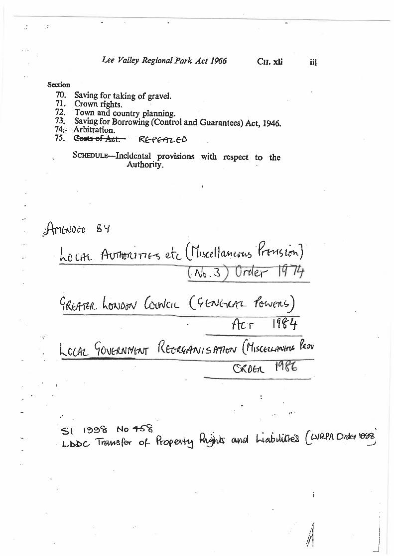
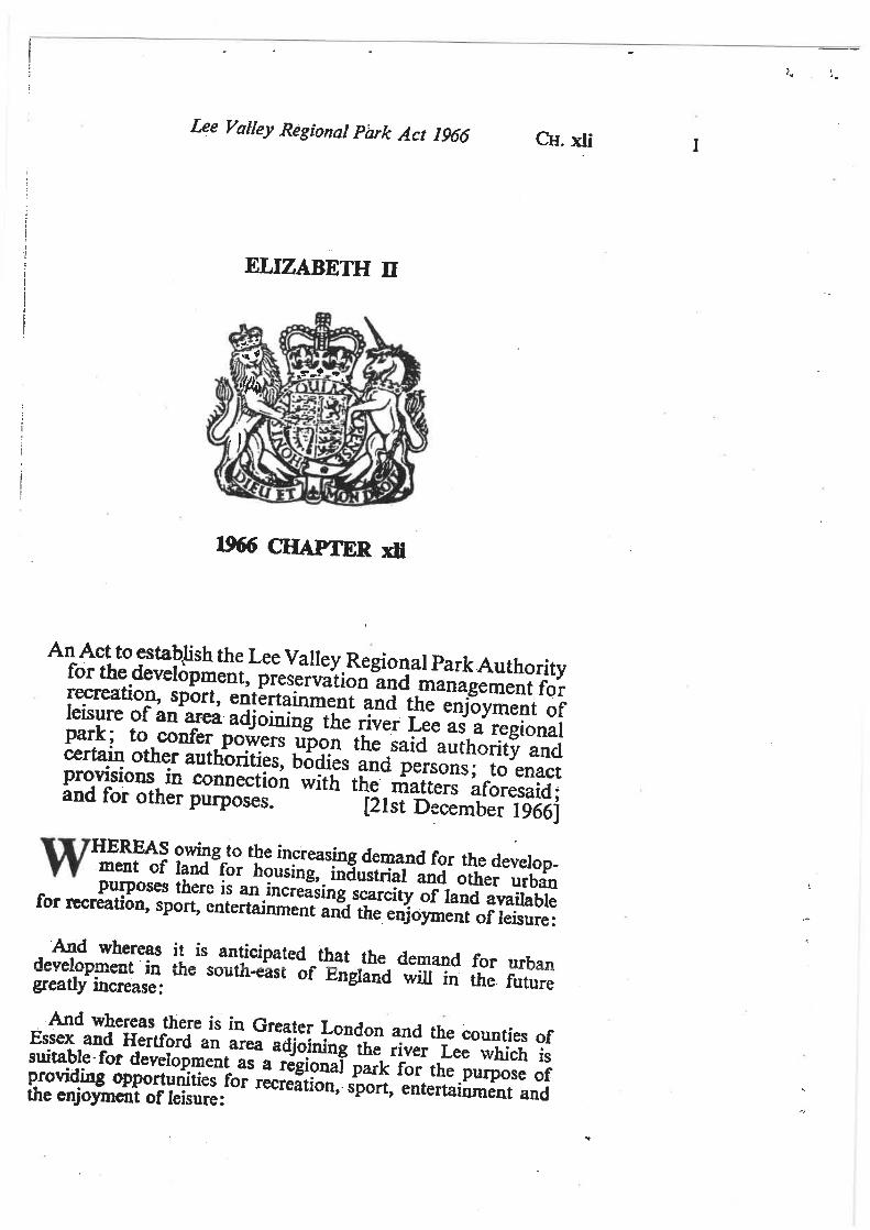
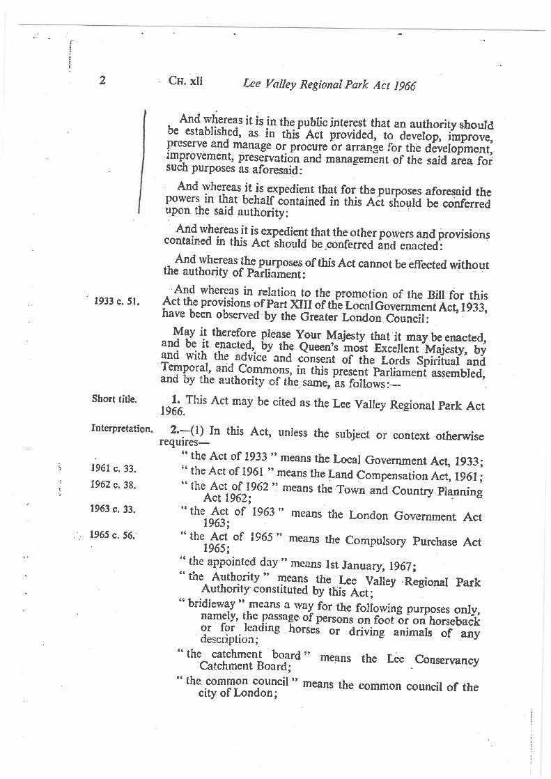
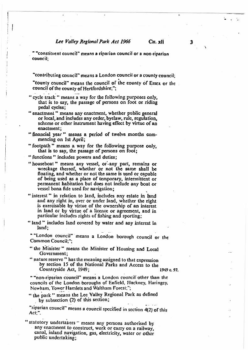
B – EXTRACTS FROM LEE VALLEY REGIONAL PARK ACT 1966
C – RELEVANT PDF AREA PROPOSALS FOR AREAS 5, 6 AND 7
1
Alison Blom-Cooper Email: [email protected] Planning Policy Team Direct Dial: 01992 709885 Epping Forest District Council Civic Offices High Street Epping Essex CM16 4BZ
23rd January 2018
Dear Alison
RE: CONSULTATION ON EPPING FOREST DRAFT LOCAL PLAN REGULATION 19 - LEE VALLEY REGIONAL PARK AUTHORITY COMMENTS
Thank you for consulting the Regional Park Authority on the Draft Local Plan consultation document.
This document was considered by the Authority’s Regeneration and Planning Committee on the 18th January 2018 and this letter represents the Authority’s formal response
Key Draft Local Plan Policies of relevance to the Regional Park
As set out in the strategic context for the draft Local Plan a substantial area of the Regional Park lies within Epping Forest District (3929.52 acres or 39.64%) and as such the Local Plan once adopted will be a major influence on future use of and development within the Park.
Vision and Strategic Policies
Whilst the new vision for the District references the ‘recreational aims’ of the Regional Park, this should be revised to refer to the Authority’s statutory purpose which includes in addition to ‘recreation’, references to both ‘leisure and nature conservation’.
General text included at paragraphs 2.18-2.24 ‘Strategic Policies of the Local Plan,’ provides a helpful context for the Authority but needs revision to include references to the Authority’s adopted vision that the Park is a ‘world class leisure destination’ supported by adopted series of strategic aims as follows: A Park:
that is a high quality and regionally unique visitor destination that delivers a range of high quality opportunities for sport
Appendix A
Paper RP/14/18
2
that delivers a high quality biodiversity resource for the region that helps people improve their well being landscape that embraces the physical, cultural and social heritage of
the area, and that contributes to the environmental sustainability of the region.
This was agreed after extensive public consultation in 2008-10 and these suggested changes should be included in a revised draft plan. SP6 Green Belt and District Open Land The Council’s draft policy to protect the openness of the Green Belt is welcomed. However, the plan should draw a distinction between greenfield greenbelt where protections should be maintained and ‘previously developed land’ which if released for new development could have considerable value in supporting the districts draft employment and housing policies but without adversely impacting on ‘openness’. The Authority has during the local plan process supported the release of sites at Mile and Langley Nurseries which are defined as ‘previously developed’ with lawful use for commercial purposes. These sites lie within the ‘village envelope’ of Waltham Abbey; they lie in a sustainable location for new development. The principle of their development for housing was agreed in pre application advice included in a letter which is attached as an appendix to this letter. They would have to be de-designated from the green belt. It is unclear the logic of not including them in the housing site allocations for this settlement. Accordingly, the Authority requests that these are considered in site allocation for housing. This would have the effect of reducing the extent of land required from other ‘green field’ sites which lie adjacent to this centre in the green belt. The Authority welcomes the deletion of the designation of land in the Regional Park as ‘District Open Land’. Food Production and Glasshouses The Council is proposing a criteria based approach for new or replacement glasshouse and associated packhouse development, policy E3. This policy has been revised since the draft included in the Regulation 18 version to include reference to combined heat and power plants and ancillary low carbon generation. The actual criteria has been revised with the effect that it weakens the level of ‘environmental protection’ given to the Regional Park in the event of large scale glasshouse development. It is suggested that these references are retained in line with the Regulation 18 draft. Gypsies and Travellers The Council is proposing a sequential approach to the allocation of sites for Travellers and Travelling Showpeople as set out in draft Policy SP2 Spatial
Paper RP/14/18
3
Development Strategy 2011-2033 and policy H4 Traveller Site Development. This approach includes the provision of land for Traveller sites as part of the development of new housing sites which address some of the concerns previously raised by the Authority. However the sequential approach looks first at the regularisation of existing sites with temporary permissions or other unauthorised sites, then intensification and extension of existing sites, followed by appropriately located new sites outside the Green Belt, and then new sites in the Green Belt which are appropriately located in terms of healthcare, education, and other services. Provision of sites as part of new residential development is the last stage in the process. The current wording of the policy differs from that included in the Regulation 18 draft with criteria used for assessing the degree of impact of applications shifting from whether the site is located in the Green Belt, an issue of principle, to ‘any impacts on the Green Belt’. This shift runs counter to government advice in government guidance issued in August 2015. The original drafting included in the Regulation 18 plan should be retained. Biodiversity and green infrastructure The proposed changes are broadly in line with the suggestions made by the Authority in response to the Regulation 18 draft plan although it is considered that a specific reference should be made to the Authority’s intentions to support the development of a new replacement building to serve visitors at the Bittern Information Point at Fishers Green as the Authority has commenced feasibility work for a revised scheme. The Lee Valley Biodiversity Action Plan (BAP) 2000 should be referenced as part of the ‘Key Evidence’ listed at para 4.8 of the draft Local Plan and account should also be taken of the revised BAP currently out for consultation and due to be finalised by March 2018. Further minor changes are needed at paragraph 4.11 to ensure adequate, up to date ecological information is supplied as follows: Amendments shown in red and strikethrough –
“In order to understand the impact of development proposals on protected species and habitats and potentially valuable habitat for protected species it may will be necessary to require detailed ecological survey information and an impact assessment to enable the Council to judge the proposal and how effective measures to mitigate or compensate any harm might be. This will depend on the level of existing data available.….”
The Justification text (para 4.14) refers to situations where there is insufficient information provided regarding the ecological status of a site, its management and mitigation. However as biodiversity is a material consideration, sufficient survey work and information should be provided by developers from the outset. The wording at para 4.14 undermines the policy that follows and should be amended.
Paper RP/14/18
4
In terms of the Policy DM1 ‘Habitat Protection and Improving Biodiversity’, there should be a minor amendment to clarify that sub section D about the mitigation hierarchy also applies to local wildlife sites identified under sub sections C. Policy under sub section E requires a minor amendment to wording at the end of the second sentence as follows: “require that monitoring is undertaken…and to make sure ensure that any mitigation, compensation and offsetting is effective in the long term” E4 The Visitor Economy Further detail is required under Policy E4 to support future development and improvements at the Lee Valley White Water Centre (LVWWC). General text under paragraph 3.70 mentions the White Water Centre, which lies just over the border, near Waltham Abbey, and that it could be “a catalyst in the medium to long term to encourage sport and other tourism-related activities in the locality” Policy E4 offers support for high quality visitor accommodation and for upgrading existing visitor attractions, which is helpful in terms of the wider Park area, for example the River Lee Country Park and Lee Valley Park Farms. The Authority is developing the Lee Valley White Water Centre as the major family leisure destination in the south east. Working with our leisure trust, Vibrant Partnerships we will diversify its offer into ‘extreme’ sports. The centre attracts more than 330,000 visits and is the home to British Canoe’s national performance centre for canoe slalom. The intention is that the regional and national event programme will be integral to plans in the foreseeable future. Currently, the centre’s offer reflects two phases of development. The first involved the creation of the centre as an Olympic venue; this operated for under two years until the completion of the second or ‘legacy phase’ in 2013. Both phases of development extended the visitor offer focused entirely on paddle sports. A series of temporary permissions are being used to ‘test’ the market for extending the officer at the site. The Authority with Vibrant Partnerships is looking at plans for a third phase of development to secure the centre’s reputation for extreme sports. Working with its partners the Authority has identified land on adjacent sites for further investment within an ‘opportunity area’ which would extend the existing curtilage to include the showground site; this should be identified in the draft plan and will be used as the basis of a masterplan with Borough of Broxbourne. A draft ITT has already been shared with officers and the work will be underway in March. Vibrant Partnerships working with the Authority is scoping the market to look at new attractions which could include zip wires, wave machine and extended beach area
Paper RP/14/18
5
An additional bullet point could be added to Policy E4 as follows:
Opportunities for the sustainable development of the visitor economy will be supported where they are of a scale, type and appearance appropriate to the locality and provide local economic benefits, through the following measures ….. viii) support for development of high quality leisure facilities and activities in association with the adjoining Lee Valley White Water Centre to create a major family leisure destination within the south east at Waltham Abbey.
It is considered that this ‘opportunity area’ should be included in the draft plan. This will support the Councils initiatives to strengthen the local visitor economy. A plan Appendix D of the proposed opportunity area is included with this letter. Policy relating to ‘Places’ The Authority supports the policy focus on key places within the District particularly the policies which are aimed at revitalising centres adjacent to the Regional Park such as Waltham Abbey, Nazeing, Roydon and Sewardstone. Draft visions and policies which are aimed at revitalising places such as Waltham Abbey District Centre and improving facilities at smaller settlements such as Nazeing and Roydon are to be welcomed. However more detail should be included about the Park and its role in providing opportunities for, and access to, healthy activity, enjoyment of nature, informal outdoor recreation and group events and leisure facilities, e.g. cycling, sailing and angling. Infrastructure improvements such as access into the Park from Waltham Abbey, from Roydon station, or via public transport on Nazeing Road should form part of the infrastructure delivery plan for these areas. More detail should be included about the Regional Park and its relationship to these areas. The Local Plan should promote and help to enhance its role in providing opportunities for, and access to, healthy activity and group events, enjoyment of nature, informal outdoor recreation and leisure facilities, e.g cycling, sailing, and angling for all members of the public. Waltham Abbey Gardens and the town centre itself are an important gateway into the River Lee Country Park, and this has been identified through the Authority’s draft PDF Area 6 Proposals. Support should be included for improved visitor facilities including the Authority’s draft proposals for an improved ‘Bittern information Point’ (BIP) in Fishers Green and related infrastructure within the River Lee Country Park at Fishers Green and the Lee Valley Park Farms, and within the Royal Gunpowder Mills site. The relationship between the Park and the settlements of Nazeing and Roydon should be highlighted. Infrastructure improvements such as access into the Park from Roydon station, or via additional cross valley public
Paper RP/14/18
6
transport provision on Nazeing Road should form part of the infrastructure delivery plan for these areas. Improvements to the Crooked Mile as a key route serving the River Lee Country Park, particularly for cyclists, has long been an ambition of the Authority and requires joint working with Essex County and other stakeholders. This should be promoted through the Local Plan. Reference to the recreational and biodiverse open space assets within the Park at Sewardstone should be also included. This should sit under the section about Waltham Abbey as the Regulation 19 Local Plan no longer includes a separate section for Sewardstone. Infrastructure and Delivery The draft plan is accompanied by a detailed Infrastructure and Delivery plan indicating the level of infrastructure required at key trigger points during the plan period for each settlement. It indicates that sn 106 and at some point a CIL charging schedule will be agreed to fund the infrastructure. Whilst the importance of funding of local infrastructure required to support new development is recognised it is considered that provisions should be included for commuted sums to support continued investment in the Regional Park given that additional population growth in settlements on the edge of the Park will lead to increased visits and further pressures requiring new visitor infrastructure to ‘accommodate’ or re-direct this activity through the Park. The Authority would welcome feedback and further discussion on the comments made above. Yours sincerely
Stephen Wilkinson Head of Planning and Strategic Partnerships Appendices Plan and photographs of Mile and Langley Nursery Pre application advice Proposed Opportunity Area adjacent to Lee Valley White Water Centre
Lee Valley Regional Park Authority Myddelton House, Bulls Cross, Enfield, Middlesex, EN2 9HG Telephone: 01992 717 711 Fax: 01992 719937 www.leevalleypark.org.uk
Sarah King Email: [email protected] Planning Policy Team Direct Dial: 01992 709885 Epping Forest District Council Civic Offices High Street Epping Essex CM16 4BZ
15th December 2016
Dear Sarah
RE: CONSULTATION ON EPPING FOREST DRAFT LOCAL PLAN - LEE VALLEY REGIONAL PARK AUTHORITY COMMENTS
Thank you for consulting the Regional Park Authority on the Draft Local Plan consultation document.
This document is due to be considered by the Authority’s Members at the Upper Lee Valley Regeneration and Planning Committee on the 15 December 2016. The following are officer level comments to meet the consultation deadline of 12 Dec 2016. The Authority’s formal response will be forwarded as soon as possible after the committee.
Key Draft Local Plan Policies of relevance to the Regional Park
As set out in the strategic context for the draft Local Plan a substantial area of the Regional Park lies within Epping Forest District (3929.52 acres or 39.64%) and as such the Local Plan once adopted will be a major influence on future use of and development within the Park.
Vision and Strategic Policies
The Authority welcomes the detail included about the Lee Valley Regional Park, in the draft Local Plan chapter ‘Strategic Context’, and the specific reference to the Park Act identifying its requirements regarding the inclusion of the Authority’s relevant Plan Proposals within local planning strategies and policies. Support for the “recreational aims” of the Regional Park within the draft Vision for the District is also noted. Reference to the Authority’s vision needs updating to that agreed in 2010 as ‘A World Class Leisure Destination’.
The Local Plan does not however include a policy for the Regional Park. The significance of the Regional Park as part of the District’s green infrastructure, its unique offer in serving the leisure, cultural, educational, access to nature and sporting needs of the public requires both recognition and support through policy. As stated in earlier comments at the Issues and Options stage
Lee Valley Regional Park Authority Myddelton House, Bulls Cross, Enfield, Middlesex, EN2 9HG Telephone: 01992 717 711 Fax: 01992 719937 www.leevalleypark.org.uk
the GLA definition of the Park as a Strategic Cultural Area (policy 4.5) in the London Plan is a useful framework and consistent with the Authority’s Vision of the Park as a World Class Visitor Destination. A dedicated policy could provide support for the Authority’s emerging strategic policies and draft proposals and those adopted for Area 5 of the Park Development Framework (PDF) which includes the Sewardstone area and Gunpowder Park. This would be in line with Section 14 of the Lee Valley Regional Park Act 1966. SP5 Green Belt and District Open Land The Authority notes and supports the emphasis placed on protecting the openness of the Green Belt in policy SP5 Green Belt and supports those changes to the greenbelt which are required to reflect the impact of planning decisions since the last green belt review over 20 years ago However there is concern about the appropriateness of other Green Belt amendments and the inclusion of a new policy designation, ‘District Open Land’ (DOL) for several areas currently designated as green belt within the Regional Park. On land south of Waltham Abbey the suggested alteration to the Green Belt boundary and its re-designation as DOL includes removing areas of land that are not proposed for new development. Some of these sites also fall within the Park – Town Mead leisure park and the waterway and land corridor adjoining the Rammey Marsh Flood Relief Channel and Lee Navigation that connects the River Lee Country Park at Highbridge Street with Gunpowder Park to the south. Please refer to the Plan at Appendix C. The justification included in supporting text for this land being re-designated as DOL is undermined by the inclusion of this site and reflects an incorrect ‘test’ being applied from the National Planning Policy Framework (2012) which fails to understand the strategic function of green belts. Further, land within the Park serves a wider than local function, for example, the waterway corridor along the Navigation is an important element of the regions green infrastructure. Land within the Park to the north and south of these areas is designated as Green Belt. Removing these sites from the Green Belt appears unnecessary. The Authority supports the decision not to release land from the green belt to the west of Roydon and endorses the view that land to the west of the settlement is the most sensitive location in landscape terms and that development would be harmful to the setting of the Regional Park. The Authority is concerned however by proposals to amend the Green Belt to the south of Nazeing, just outside the Park boundary, in order to accommodate proposed residential site allocation. A large proportion of the site is identified in the Authority’s adopted Park Plan (2000) as requiring protection from development as it adds a landscape context to the wider
Lee Valley Regional Park Authority Myddelton House, Bulls Cross, Enfield, Middlesex, EN2 9HG Telephone: 01992 717 711 Fax: 01992 719937 www.leevalleypark.org.uk
valley contained by the Regional Park. The Authority has objected to recent planning applications for residential development in this area on the grounds that it would adversely impact on the permanence and openness of the Green Belt and compromise the landscape setting of the Regional Park.
SP6 The Natural Environment, Landscape Character and Green Infrastructure
Additional text and changes are proposed to this section as follows:
Policy DM1 ‘Habitat protection and improving biodiversity’ which seeks to ensure all development deliver net biodiversity gain is supported. The SPA was designated where significant numbers of key species were found. However there are other areas that whilst linked functionally and used as alternative feeding or roosting areas, were not included in the designation boundary. The importance of these areas should be noted and protected by policy so that any impacts on them that may in turn affect the SPA features can be considered appropriately. Amendments to the second bullet are proposed as follows (shown in red font):
DM1 B: Development proposals must protect and enhance natural habitats and areas of biodiversity, and should not negatively impact upon areas of international or national designation or functionally linked land within the district important for the key species.
A direct reference to Local Wildlife Sites and their protection should also be made in policy.
Bullet point F is considered rather vague and should be strengthened as follows. Survey evidence showing the absence of protected species demonstrates that a thorough approach has been followed.
F. Where there are grounds to believe that a Protected Species, PrioritySpecies or Priority Habitat may be affected by proposed development,applicants must provide survey information and site assessment toestablish the extent of potential impact.
District Wide Policies
Employment Policies
Policy E1 Employment Sites supports the redevelopment, renewal or extension of existing premises for employment use before identifying new sites. Land within the Park and the Green Belt at Moss Nursery, Nazeing (ELR-0099) has been identified as an extension to an existing employment site. This appears to be a new employment designation within the Park and within the Green Belt although part of the area shown has an established use providing for vehicle servicing and car spares. The strategic policies included
Lee Valley Regional Park Authority Myddelton House, Bulls Cross, Enfield, Middlesex, EN2 9HG Telephone: 01992 717 711 Fax: 01992 719937 www.leevalleypark.org.uk
in the Park Plan do allow for the redevelopment of sites such as this although the Authority would seek planning obligations to the benefit of the Regional Park if any application is made.
Policy E3 Food Production and Glasshouses
In 2012 the Authority supported the District Council in the commissioning of a report into the glasshouses industry. The report, “The Lea Valley Glasshouse Industry” included two recommendations of relevance to the Regional Park:
“Large scale expansion will require new designations of E13 areas. To reflect traffic issues and the incompatibility of glasshouses and the Regional Park, designations should be considered to the east of Epping” i.e. outside the Park and that “the Council should consider the expansion of existing E13 designations outside the Park boundary”. (Recommendations 2 and 3).
It is unclear how this report has been used in the determination of the new policy which may, in the absence of a robust evidence base be unsound.
E4 The Visitor Economy
Further detail is required under Policy E4 to support future development and improvements at the Lee Valley White Water Centre (LVWWC). General text under paragraph 4.61 mentions the White Water Centre, which lies just over the border, near Waltham Abbey, and that it could be “a catalyst in the medium to long term to encourage sport and other tourism-related activities in the locality”
Policy E4 offers support for high quality visitor accommodation and for upgrading existing visitor attractions, which is helpful in terms of the wider Park area, for example the River Lee Country Park and Lee Valley Park Farms.
The Authority is developing the Lee Valley White Water Centre as the major family leisure destination in the south east. Working with our leisure trust, Vibrant Partnerships we will diversify its offer into ‘extreme’ sports.
The centre attracts more than 330,000 visits and is the home to British Canoe’s national performance centre for canoe slalom. The intention is that the regional and national event programme will be integral to our plans in the foreseeable future.
Currently, the centre’s offer reflects two phases of development. The first involved the creation of the centre as an Olympic venue; this operated for under two years until the completion of the second or ‘legacy phase’ in 2013. Both phases of development extended the visitor offer focused entirely on paddle sports with recent innovations such as the new beach.
The Authority with Vibrant Partnerships is looking at plans for a third phase of development to secure the centre’s reputation for extreme sports. Working
Lee Valley Regional Park Authority Myddelton House, Bulls Cross, Enfield, Middlesex, EN2 9HG Telephone: 01992 717 711 Fax: 01992 719937 www.leevalleypark.org.uk
with its partners the Authority has identified land on adjacent sites for further investment within an ‘opportunity area’ which would extend the existing curtilage to include the showground site; this should be identified in the draft plan and will be used as the basis of a masterplan with Borough of Broxbourne. Vibrant Partnerships working with the Authority is scoping the market to look at new attractions which could include zip wires, wave machine and extended beach area An additional bullet point could be added to Policy E4 as follows:
Opportunities for the sustainable development of the visitor economy will be supported where they are of a scale, type and appearance appropriate to the locality and provide local economic benefits, through the following measures ….. viii) support for development of high quality leisure facilities and activities in association with the adjoining Lee Valley White Water Centre to create a major family leisure destination within the south east at Waltham Abbey.
The Authority was successful in agreeing with the borough of Broxbourne a joint approach which shows the potential for expansion at the centre which extends northwards but also to the east into the District. It is considered that this ‘opportunity area’ should be included in the draft plan. This will support the Councils initiatives to strengthen the local visitor economy. A plan Appendix D of the proposed opportunity area is included with this letter. Traveller Site Development The Authority notes the Council’s sequential approach to the allocation of sites for Travellers and Travelling Showpeople as set out in draft Policy SP2 Spatial Development Strategy 2011-2033 and policy H4 Traveller Site Development and supports the provision of land for Traveller sites as part of the development of new housing sites. However the sequential approach directs decision makers towards the regularisation of temporary and unauthorised sites first, intensification of existing sites and sites within the green belt before turning to new allocations/development sites. For the Regional Park, which within Epping Forest District is mainly green belt land (94.2%), this will place undue pressure on green belt sites within the Park, for example the four temporary Traveller sites at Carthagena. Government guidance states that Traveller sites in the Green Belt, whether temporary or permanent are inappropriate development (“Planning Policy for Traveller Sites” August 2015). This is mentioned in supporting text for draft Policy H4 Traveller Site Development which highlights green belt designation as a consideration when assessing applications for Traveller site development for sites other than those allocated in the Plan.
Lee Valley Regional Park Authority Myddelton House, Bulls Cross, Enfield, Middlesex, EN2 9HG Telephone: 01992 717 711 Fax: 01992 719937 www.leevalleypark.org.uk
It would seem as drafted that the implications of the policy counter adopted Government policy and would be prejudicial to the Authority’s commitment to improve landscape at Carthagena. It could be considered ‘unsound’.
Biodiversity and Green Infrastructure
The Authority supports the Development Management policies for habitat protection and improving biodiversity DM1 and for the Lee Valley SPA DM3. The Park area within Epping Forest District contains a diverse and rich ecology including part of the Lee Valley SPA and Ramsar site, the Cornmill Stream and Old River Lea and Waltham Abbey SSSIs and a number of Local Wildlife sites. It is important that development within or adjoining the Park delivers a net biodiversity gain and that appropriate survey information is included when an application is submitted. Suitable monitoring of any required mitigation, compensation and offsetting must also be effective for it have any purpose.
Policy supporting the extension, maintenance and enhancement of Green Infrastructure in the District, set out as part of policy SP6 ‘The Natural Environment, Landscape Character and Green Infrastructure’ is welcomed. It would be helpful to identify both the Regional Park and Epping Forest as major elements within the District’s green infrastructure as part of this strategic policy.
Reference to The Lea Catchment Nature improvement Area (NIA) should be incorporated into this section of the Local Plan. It is endorsed by the Herts Local Nature Partnership and seeks to establish a joined up and resilient ecological network at a landscape scale throughout the Lea Valley. The 5 key aims of the NIA, as set out below:
To restore, recreate and link characteristic ecological, hydrological andlandscape features to fully integrate the Lea floodplain corridor
To improve the ecological management of designated sites within theLea Valley
To enhance and enlarge key biodiversity sites in the Lea Valley To begin to achieve good ecological status of the River Lea and
tributaries To increase awareness and understanding of the biodiversity of the
Lea Valley and to activate participation in its conservation
This would strengthen Green Infrastructure planning in the District and support Policy SP6: ‘The Natural Environment, landscape Character and Green Infrastructure’.
Policy relating to ‘Places’
Lee Valley Regional Park Authority Myddelton House, Bulls Cross, Enfield, Middlesex, EN2 9HG Telephone: 01992 717 711 Fax: 01992 719937 www.leevalleypark.org.uk
The Authority supports the policy focus on key places within the District particularly the policies which are aimed at revitalising centres adjacent to the Regional Park such as Waltham Abbey, Nazeing, Roydon and Sewardstone.
More detail should be included about the Regional Park and its relationship to these areas. The Local Plan should promote and help to enhance its role in providing opportunities for, and access to, healthy activity and group events, enjoyment of nature, informal outdoor recreation and leisure facilities, e.g cycling, sailing, and angling for all members of the public. Waltham Abbey Gardens and the town centre itself are an important gateway into the River Lee Country Park, and this has been identified through the draft PDF Area 6 Proposals. Support should be included for improved visitor facilities and related infrastructure within the River Lee Country Park at Fishers Green and the Lee Valley Park Farms, and within the Royal Gunpowder Mills site.
The relationship between the Park and the settlements of Nazeing and Roydon should be highlighted. Infrastructure improvements such as access into the Park from Roydon station, or via additional cross valley public transport provision on Nazeing Road should form part of the infrastructure delivery plan for these areas. Improvements to the Crooked Mile as a key route serving the River Lee Country Park, particularly for cyclists, has long been an ambition of the Authority and requires joint working with Essex County and other stakeholders. This should be promoted through the Local Plan.
Reference to the recreational and biodiverse open space assets within the Park at Sewardstone should be included within the vision statement.
Response to call for sites
In January 2016 officers responded to the Council’s ‘call for sites’ with the submission of two sites on the edge of Waltham Abbey, Langley and Mile Nursery, which lie on the Crooked Mile. Whilst both of these lie in the green belt and Regional Park they are occupied by commercial uses. Through its greenbelt review the District Council dismissed the inclusion of both sites.
The comment included in the schedule is as follows:
‘Although this site was available, it was judged that other sites were preferential in terms of the SSM hierarchy and their achievability and if allocated would cumulatively provide the desired quantum of development in this settlement’.
In short, whilst other sites have already been allocated, in the local planning authority’s view these two are not required. However, importantly the current designation of the sites as green belt was not a determining factor in preventing their inclusion for housing and was dismissed as a constraint though your assessment process.
Lee Valley Regional Park Authority Myddelton House, Bulls Cross, Enfield, Middlesex, EN2 9HG Telephone: 01992 717 711 Fax: 01992 719937 www.leevalleypark.org.uk
The Authority would like to retain these two sites in the ‘call’ for consideration by the District Council as it reviews the results of consultation as part of its preparation for the Regulation 19 consultation which will commence in 2017. These sites have the advantage of currently being occupied on short leases and could become available for housing development within the next 2 years; they are deliverable as housing sites. They should be de-designated from the greenbelt and allocated for housing.
Infrastructure and Delivery
The Authority looks forward to working with the Council on the development of the infrastructure delivery plan and in identifying opportunities to secure future improvements to green infrastructure in line with strategic policy SP6, and the detailed Green Infrastructure strategy, and in particular to improve access to the Regional Park for cyclists and pedestrians. Although the Council is in the process of reviewing the potential offered by a Community Infrastructure Levy and has not yet adopted a charging schedule the Authority would wish to see specific reference to the Regional Park in the schedule if and when this is drafted.
The Authority would welcome feedback and further discussion on the comments made above.
Yours sincerely
Stephen Wilkinson Head of Planning and Strategic Partnerships Lee Valley Regional Park Authority
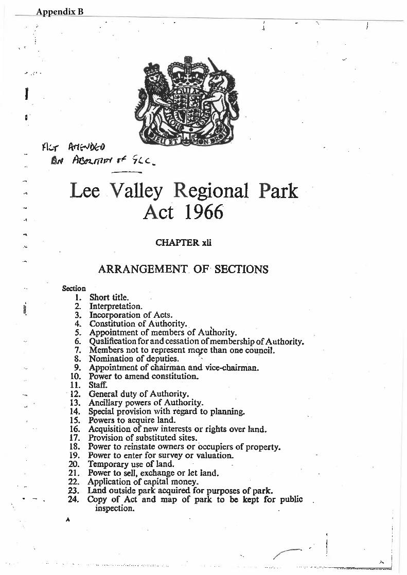
Appendix B
1
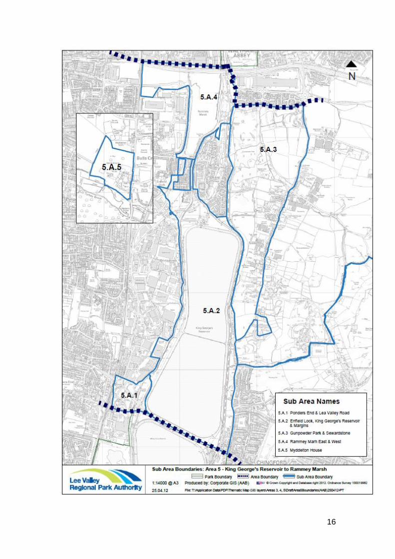
Appendix C Please note text in bold identifies proposals relevant to Epping Forest District Area 5 King George V Reservoir to Rammey Marsh Key resources and special features The open waters of the King George V Reservoir (173ha) anchor the southern part of this area whilst in the north large open green spaces dominate. The King George V Reservoir is an SSSI and although public access is restricted the southern basin is used for sailing and both basins are used by bird watchers. This expanse of water makes the land along the eastern margins of particular importance for public access and recreation especially as a means of providing access into Gunpowder Park and connections through into Epping Forest in the east. Gunpowder Park comprises 90ha and is established as a country park. The site lies on the eastern side of the Regional Park and access from the west is limited. The country park contains a wide range of landscapes, designed to celebrate the sites industrial heritage and to facilitate a range of recreational uses. The landscape also supports a variety of habitats which extend southwards into Sewardstone Marsh and along the eastern side of the reservoir. To the east of Gunpowder Park lies Rammey Marsh a wide expanse of open space which rises gently in the north to meet the M25. The grassland habitat and Small River Lee which divides the East and West Marshes support a wide range of species including rare orchids, water voles and invertebrates. The King George V Reservoir, land adjoining and Rammey Marsh are designated as Sites of Metropolitan Importance for Nature Conservation (SMINC), Gunpowder Park within Epping Forest District is designated a Local Wildlife Site. Both Rammey Marsh and Gunpowder Park are popular for informal recreational and nature conservation activities. Events and sporting activities are also held at Gunpowder Park including regular ‘Fun Runs’ and cyclo-cross. Public access between the sites is however difficult and proposals seek to improve connections across the River Lee Navigation and Rammey Marsh Flood Relief Channel.
2
The River Lee Navigation and towpath provide an attractive connection through to the Enfield Lock Conservation Area, the secluded waterside site at Swan and Pike Pool and at the southern end of Area 5 to the water meadows and grassland habitats associated with the Wrights Flour Mills off Lee Valley Road. The Authority is working with the London Borough of Enfield to enhance existing ecological interest and educational resources on this site and open up the site to the public for recreation and access to nature purposes. Although Myddelton House lies away from the main Parklands it represents an important heritage site with particular interest for visitors in the listed house and gardens. Recent investment in the site following the successful Heritage Lottery Funding bid have enhanced its appeal The eastern side of the valley is dominated by valley sides which rise to Barn Hill at 49m. This ridge shapes the landscape of the Park and provides great views across the whole valley.
Opportunities for visitors
The key to unlocking potential within the northern part of this area lies in improving existing and creating new access links into and between sites such as Gunpowder Park and Rammey Marsh which connect to the River Lee Country Park to the north. The provision of the Lee Valley Pathway on the eastern side of the Park will link together sites behind Sewardstone Road providing direct access from the campsite connecting with Gilwell Lane and other routes into Epping Forest. The waterways are also a key resource for visitors and connections from west to east between the towpath and the Lee Valley Pathway will be strengthened. Gunpowder Park, Rammey Marsh and smaller sites such as Swan and Pike Pool and Ponders End offer the visitor a rich nature and heritage experience, and have the potential to accommodate a range of other active recreational and educational activities. Visitor facilities at Myddelton House have been greatly enhanced over the last few years and there is scope to invest further in this key visitor node. Proposals are focused on opening up more of the site to visitors, showcasing the growing of heritage varieties in the gardens and best practice in sustainable gardening. At the sailing club on the King George V Reservoir there are opportunities to enhance the water sports offer, and on the south western edge of the reservoir consider options for improving public access and recreational use of land adjoining Ponders End.
3
Adopted principles guiding these proposals The Authority’s proposals for each of these areas are designed to address the issues identified above and are based on the Authority’s adopted (July 2010) guiding principles for the future development and management of the Regional Park. These are:
Partnership work – recognising that many of the proposals can only be delivered through the collective efforts of a range of partners, stakeholders and landowners.
Regional Value – assessing the range of benefits that any particular facility or activity within the Park delivers to the people of Essex, Hertfordshire and London.
Multi-function and synergy – developing proposals which can be used to harness competing demands.
Flexibility – the design and management of facilities and open spaces of the park in a way which responds to changing needs and demands
Sustainability – ensuring that new development does not prejudice the lives of future generations.

4
Please leave blank
5
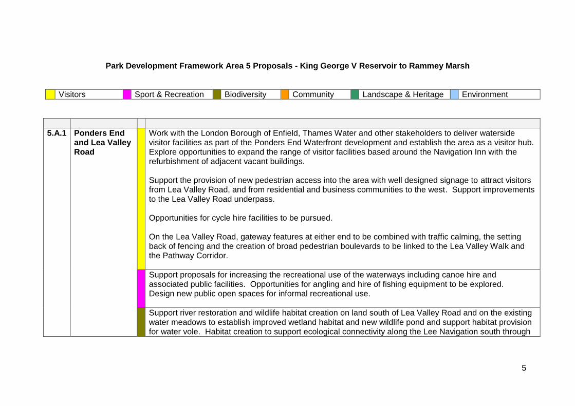
Park Development Framework Area 5 Proposals - King George V Reservoir to Rammey Marsh
Visitors Sport & Recreation Biodiversity Community Landscape & Heritage Environment
5.A.1 Ponders End and Lea Valley Road
Work with the London Borough of Enfield, Thames Water and other stakeholders to deliver waterside visitor facilities as part of the Ponders End Waterfront development and establish the area as a visitor hub. Explore opportunities to expand the range of visitor facilities based around the Navigation Inn with the refurbishment of adjacent vacant buildings. Support the provision of new pedestrian access into the area with well designed signage to attract visitors from Lea Valley Road, and from residential and business communities to the west. Support improvements to the Lea Valley Road underpass. Opportunities for cycle hire facilities to be pursued. On the Lea Valley Road, gateway features at either end to be combined with traffic calming, the setting back of fencing and the creation of broad pedestrian boulevards to be linked to the Lea Valley Walk and the Pathway Corridor.
Support proposals for increasing the recreational use of the waterways including canoe hire and associated public facilities. Opportunities for angling and hire of fishing equipment to be explored. Design new public open spaces for informal recreational use.
Support river restoration and wildlife habitat creation on land south of Lea Valley Road and on the existing water meadows to establish improved wetland habitat and new wildlife pond and support habitat provision for water vole. Habitat creation to support ecological connectivity along the Lee Navigation south through
6
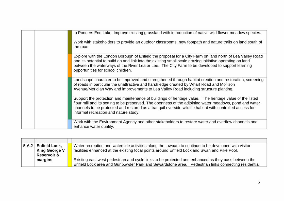
to Ponders End Lake. Improve existing grassland with introduction of native wild flower meadow species. Work with stakeholders to provide an outdoor classrooms, new footpath and nature trails on land south of the road.
Explore with the London Borough of Enfield the proposal for a City Farm on land north of Lea Valley Road and its potential to build on and link into the existing small scale grazing initiative operating on land between the waterways of the River Lea or Lee. The City Farm to be developed to support learning opportunities for school children.
Landscape character to be improved and strengthened through habitat creation and restoration, screening of roads in particular the unattractive and harsh edge created by Wharf Road and Mollison Avenue/Meridian Way and improvements to Lea Valley Road including structure planting. Support the protection and maintenance of buildings of heritage value. The heritage value of the listed flour mill and its setting to be preserved. The openness of the adjoining water meadows, pond and water channels to be protected and restored as a tranquil riverside wildlife habitat with controlled access for informal recreation and nature study.
Work with the Environment Agency and other stakeholders to restore water and overflow channels and enhance water quality.
5.A.2 Enfield Lock, King George V Reservoir & margins
Water recreation and waterside activities along the towpath to continue to be developed with visitor facilities enhanced at the existing focal points around Enfield Lock and Swan and Pike Pool. Existing east west pedestrian and cycle links to be protected and enhanced as they pass between the Enfield Lock area and Gunpowder Park and Sewardstone area. Pedestrian links connecting residential
7
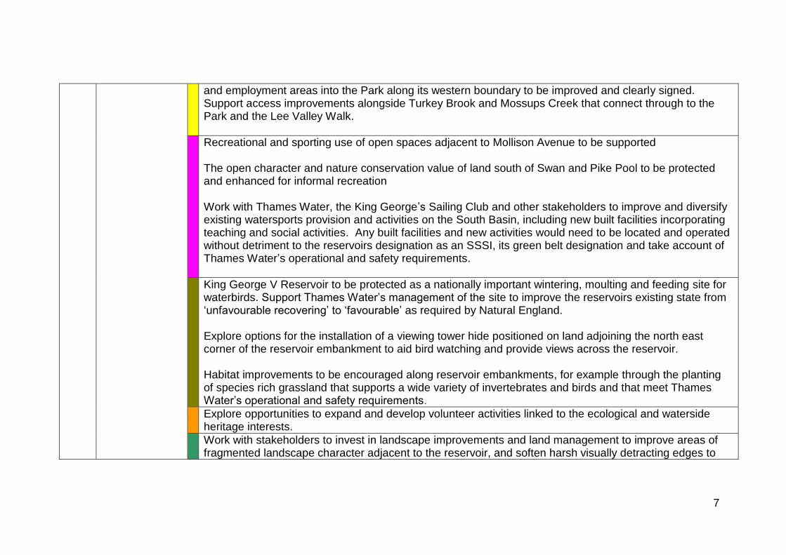
and employment areas into the Park along its western boundary to be improved and clearly signed. Support access improvements alongside Turkey Brook and Mossups Creek that connect through to the Park and the Lee Valley Walk.
Recreational and sporting use of open spaces adjacent to Mollison Avenue to be supported The open character and nature conservation value of land south of Swan and Pike Pool to be protected and enhanced for informal recreation Work with Thames Water, the King George’s Sailing Club and other stakeholders to improve and diversify existing watersports provision and activities on the South Basin, including new built facilities incorporating teaching and social activities. Any built facilities and new activities would need to be located and operated without detriment to the reservoirs designation as an SSSI, its green belt designation and take account of Thames Water’s operational and safety requirements.
King George V Reservoir to be protected as a nationally important wintering, moulting and feeding site for waterbirds. Support Thames Water’s management of the site to improve the reservoirs existing state from ‘unfavourable recovering’ to ‘favourable’ as required by Natural England. Explore options for the installation of a viewing tower hide positioned on land adjoining the north east corner of the reservoir embankment to aid bird watching and provide views across the reservoir. Habitat improvements to be encouraged along reservoir embankments, for example through the planting of species rich grassland that supports a wide variety of invertebrates and birds and that meet Thames Water’s operational and safety requirements.
Explore opportunities to expand and develop volunteer activities linked to the ecological and waterside heritage interests.
Work with stakeholders to invest in landscape improvements and land management to improve areas of fragmented landscape character adjacent to the reservoir, and soften harsh visually detracting edges to
8
the Park adjacent to industrial areas along its western boundary. Open space adjacent to Mollison Avenue to be protected and enhanced to establish both a positive entrance into the Regional Park and a north-south link to the rest of the Park. Waterway heritage features and buildings to be conserved and enhanced as an integral part of continuing environmental and access improvements.
Recognise operational needs of Thames Water to access land for operational and investment purposes. Support ongoing improvements to water quality to enhance ecological conditions and recreational use of the water and waterside open space. Explore with stakeholders the feasibility of using the River Lee Navigation for water transport, alongside its recreational role and taking account of its ecological value.
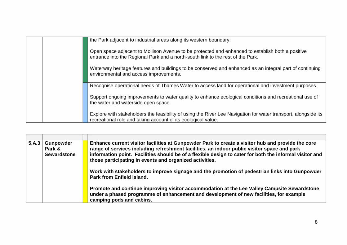
5.A.3 Gunpowder Park & Sewardstone
Enhance current visitor facilities at Gunpowder Park to create a visitor hub and provide the core range of services including refreshment facilities, an indoor public visitor space and park information point. Facilities should be of a flexible design to cater for both the informal visitor and those participating in events and organized activities. Work with stakeholders to improve signage and the promotion of pedestrian links into Gunpowder Park from Enfield Island. Promote and continue improving visitor accommodation at the Lee Valley Campsite Sewardstone under a phased programme of enhancement and development of new facilities, for example camping pods and cabins.
9
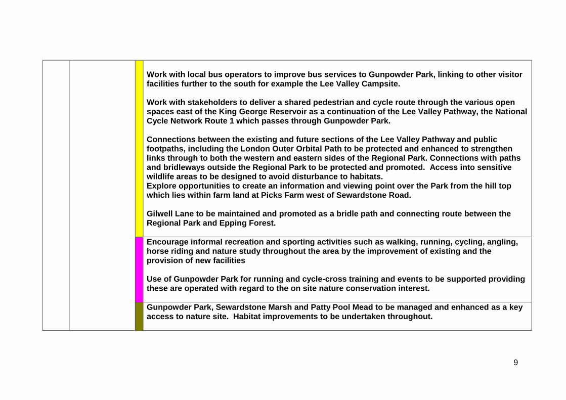
Work with local bus operators to improve bus services to Gunpowder Park, linking to other visitor facilities further to the south for example the Lee Valley Campsite. Work with stakeholders to deliver a shared pedestrian and cycle route through the various open spaces east of the King George Reservoir as a continuation of the Lee Valley Pathway, the National Cycle Network Route 1 which passes through Gunpowder Park. Connections between the existing and future sections of the Lee Valley Pathway and public footpaths, including the London Outer Orbital Path to be protected and enhanced to strengthen links through to both the western and eastern sides of the Regional Park. Connections with paths and bridleways outside the Regional Park to be protected and promoted. Access into sensitive wildlife areas to be designed to avoid disturbance to habitats. Explore opportunities to create an information and viewing point over the Park from the hill top which lies within farm land at Picks Farm west of Sewardstone Road. Gilwell Lane to be maintained and promoted as a bridle path and connecting route between the Regional Park and Epping Forest.
Encourage informal recreation and sporting activities such as walking, running, cycling, angling, horse riding and nature study throughout the area by the improvement of existing and the provision of new facilities Use of Gunpowder Park for running and cycle-cross training and events to be supported providing these are operated with regard to the on site nature conservation interest.
Gunpowder Park, Sewardstone Marsh and Patty Pool Mead to be managed and enhanced as a key access to nature site. Habitat improvements to be undertaken throughout.
10
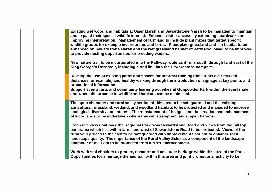
Existing wet woodland habitats at Osier Marsh and Sewardstone Marsh to be managed to maintain and expand their special wildlife interest. Enhance visitor access by extending boardwalks and improving interpretation. Management of farmland to include plant mixes that target specific wildlife groups for example invertebrates and birds. Floodplain grassland and fen habitat to be enhanced on Sewardstone Marsh and the wet grassland habitat of Patty Pool Mead to be improved to provide nesting opportunities for breeding waders. New nature trail to be incorporated into the Pathway route as it runs south through land east of the King George’s Reservoir, including a trail link into the Sewardstone campsite.
Develop the use of existing paths and spaces for informal training (time trials over marked distances for example) and healthy walking through the introduction of signage at key points and promotional information. Support events, arts and community learning activities at Gunpowder Park within the events site and where disturbance to wildlife and habitats can be minimised.
The open character and rural valley setting of this area to be safeguarded and the existing agricultural, grassland, wetland, and woodland habitats to be protected and managed to improve ecological diversity and interest. The reinstatement of hedges and the creation and enhancement of woodlands to be undertaken where this will strengthen landscape character. Extensive views out over the Regional Park from Sewardstone Road and views from the hill top panorama which lies within farm land west of Sewardstone Road to be protected. Views of the rural valley sides to the east to be safeguarded with improvements sought to enhance their landscape quality. The importance of the Rural Valley Sides as a component of the landscape character of the Park to be protected from further encroachment. Work with stakeholders to protect, enhance and celebrate heritage within this area of the Park. Opportunities for a heritage themed trail within this area and joint promotional activity to be
11
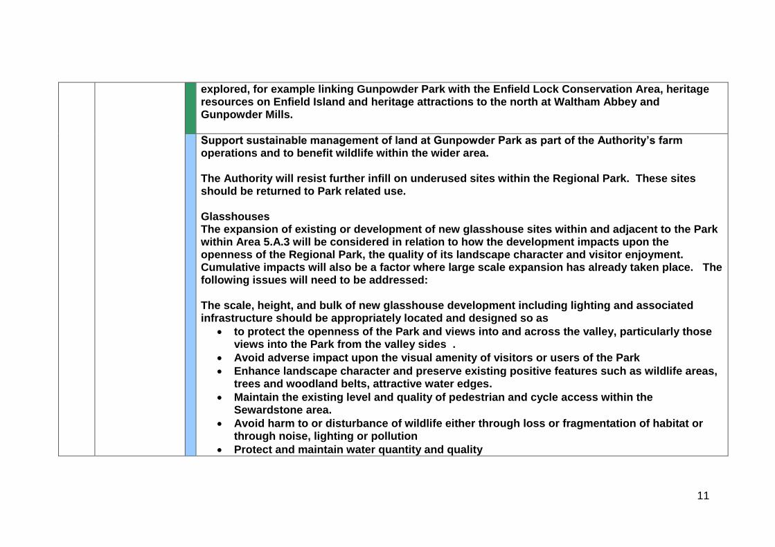
explored, for example linking Gunpowder Park with the Enfield Lock Conservation Area, heritage resources on Enfield Island and heritage attractions to the north at Waltham Abbey and Gunpowder Mills.
Support sustainable management of land at Gunpowder Park as part of the Authority’s farm operations and to benefit wildlife within the wider area. The Authority will resist further infill on underused sites within the Regional Park. These sites should be returned to Park related use. Glasshouses The expansion of existing or development of new glasshouse sites within and adjacent to the Park within Area 5.A.3 will be considered in relation to how the development impacts upon the openness of the Regional Park, the quality of its landscape character and visitor enjoyment. Cumulative impacts will also be a factor where large scale expansion has already taken place. The following issues will need to be addressed: The scale, height, and bulk of new glasshouse development including lighting and associated infrastructure should be appropriately located and designed so as
to protect the openness of the Park and views into and across the valley, particularly those views into the Park from the valley sides .
Avoid adverse impact upon the visual amenity of visitors or users of the Park
Enhance landscape character and preserve existing positive features such as wildlife areas, trees and woodland belts, attractive water edges.
Maintain the existing level and quality of pedestrian and cycle access within the Sewardstone area.
Avoid harm to or disturbance of wildlife either through loss or fragmentation of habitat or through noise, lighting or pollution
Protect and maintain water quantity and quality
12
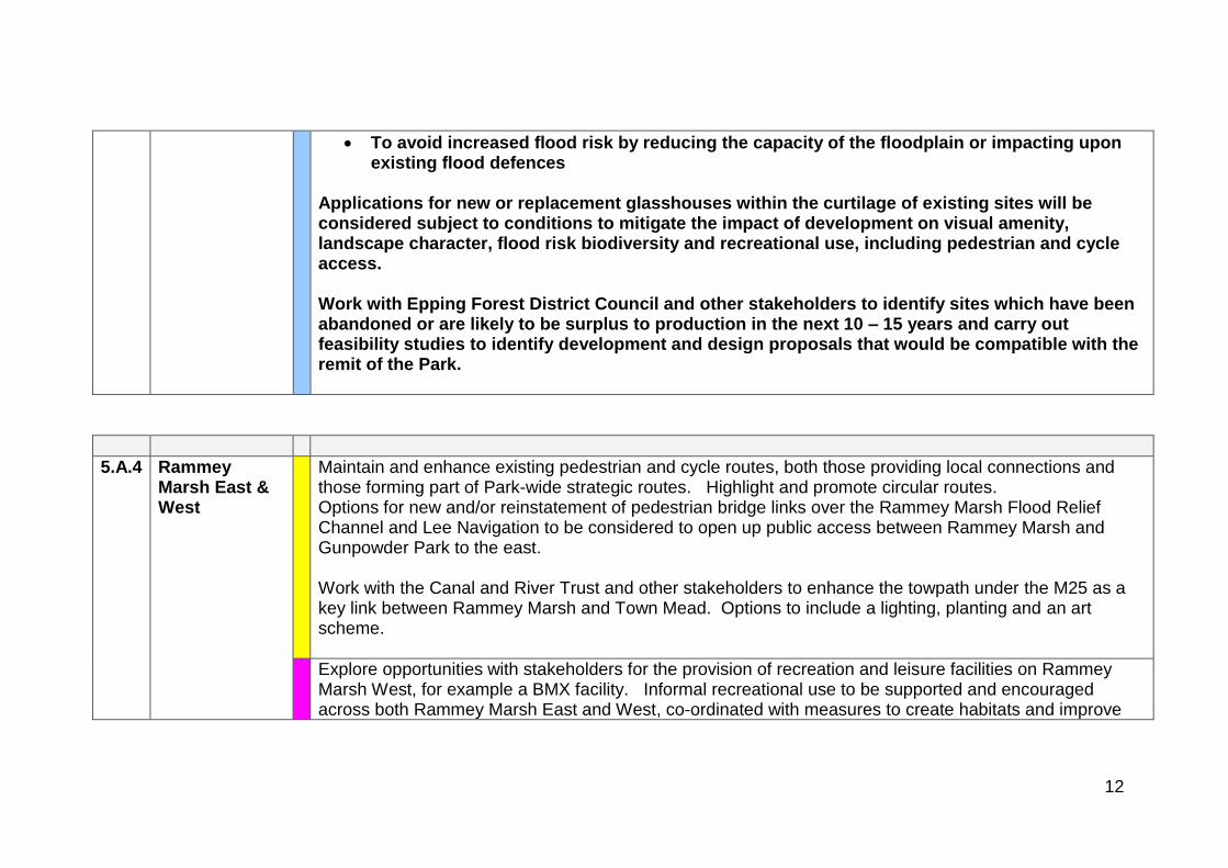
To avoid increased flood risk by reducing the capacity of the floodplain or impacting upon existing flood defences
Applications for new or replacement glasshouses within the curtilage of existing sites will be considered subject to conditions to mitigate the impact of development on visual amenity, landscape character, flood risk biodiversity and recreational use, including pedestrian and cycle access. Work with Epping Forest District Council and other stakeholders to identify sites which have been abandoned or are likely to be surplus to production in the next 10 – 15 years and carry out feasibility studies to identify development and design proposals that would be compatible with the remit of the Park.
5.A.4 Rammey Marsh East & West
Maintain and enhance existing pedestrian and cycle routes, both those providing local connections and those forming part of Park-wide strategic routes. Highlight and promote circular routes. Options for new and/or reinstatement of pedestrian bridge links over the Rammey Marsh Flood Relief Channel and Lee Navigation to be considered to open up public access between Rammey Marsh and Gunpowder Park to the east. Work with the Canal and River Trust and other stakeholders to enhance the towpath under the M25 as a key link between Rammey Marsh and Town Mead. Options to include a lighting, planting and an art scheme.
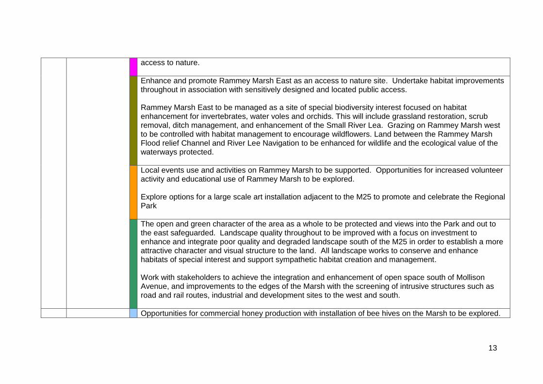
Explore opportunities with stakeholders for the provision of recreation and leisure facilities on Rammey Marsh West, for example a BMX facility. Informal recreational use to be supported and encouraged across both Rammey Marsh East and West, co-ordinated with measures to create habitats and improve
13
access to nature.
Enhance and promote Rammey Marsh East as an access to nature site. Undertake habitat improvements throughout in association with sensitively designed and located public access. Rammey Marsh East to be managed as a site of special biodiversity interest focused on habitat enhancement for invertebrates, water voles and orchids. This will include grassland restoration, scrub removal, ditch management, and enhancement of the Small River Lea. Grazing on Rammey Marsh west to be controlled with habitat management to encourage wildflowers. Land between the Rammey Marsh Flood relief Channel and River Lee Navigation to be enhanced for wildlife and the ecological value of the waterways protected.
Local events use and activities on Rammey Marsh to be supported. Opportunities for increased volunteer activity and educational use of Rammey Marsh to be explored. Explore options for a large scale art installation adjacent to the M25 to promote and celebrate the Regional Park
The open and green character of the area as a whole to be protected and views into the Park and out to the east safeguarded. Landscape quality throughout to be improved with a focus on investment to enhance and integrate poor quality and degraded landscape south of the M25 in order to establish a more attractive character and visual structure to the land. All landscape works to conserve and enhance habitats of special interest and support sympathetic habitat creation and management. Work with stakeholders to achieve the integration and enhancement of open space south of Mollison Avenue, and improvements to the edges of the Marsh with the screening of intrusive structures such as road and rail routes, industrial and development sites to the west and south.
Opportunities for commercial honey production with installation of bee hives on the Marsh to be explored.
14
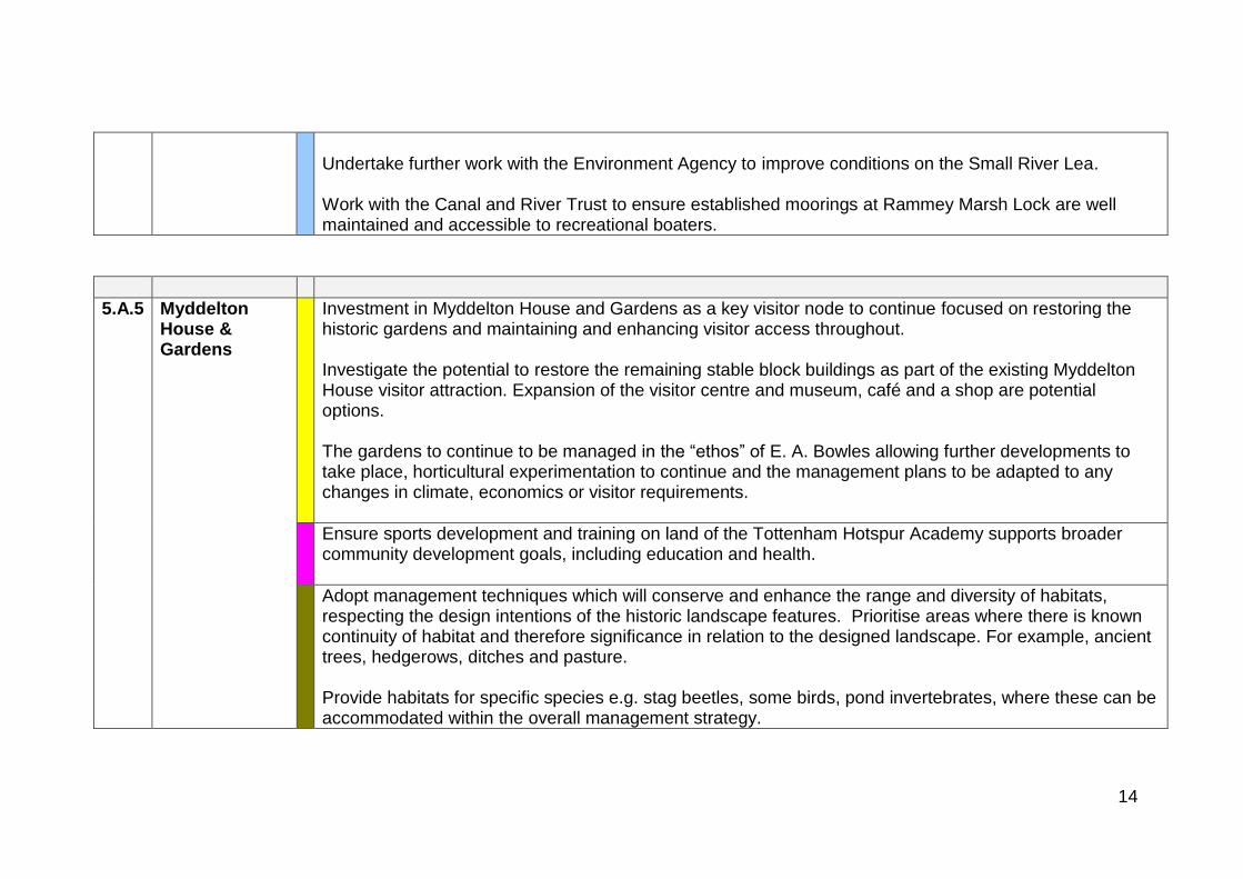
Undertake further work with the Environment Agency to improve conditions on the Small River Lea. Work with the Canal and River Trust to ensure established moorings at Rammey Marsh Lock are well maintained and accessible to recreational boaters.
5.A.5 Myddelton House & Gardens
Investment in Myddelton House and Gardens as a key visitor node to continue focused on restoring the historic gardens and maintaining and enhancing visitor access throughout. Investigate the potential to restore the remaining stable block buildings as part of the existing Myddelton House visitor attraction. Expansion of the visitor centre and museum, café and a shop are potential options. The gardens to continue to be managed in the “ethos” of E. A. Bowles allowing further developments to take place, horticultural experimentation to continue and the management plans to be adapted to any changes in climate, economics or visitor requirements.
Ensure sports development and training on land of the Tottenham Hotspur Academy supports broader community development goals, including education and health.
Adopt management techniques which will conserve and enhance the range and diversity of habitats, respecting the design intentions of the historic landscape features. Prioritise areas where there is known continuity of habitat and therefore significance in relation to the designed landscape. For example, ancient trees, hedgerows, ditches and pasture. Provide habitats for specific species e.g. stag beetles, some birds, pond invertebrates, where these can be accommodated within the overall management strategy.
15
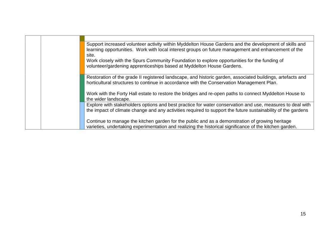
Support increased volunteer activity within Myddelton House Gardens and the development of skills and learning opportunities. Work with local interest groups on future management and enhancement of the site. Work closely with the Spurs Community Foundation to explore opportunities for the funding of volunteer/gardening apprenticeships based at Myddelton House Gardens.
Restoration of the grade II registered landscape, and historic garden, associated buildings, artefacts and horticultural structures to continue in accordance with the Conservation Management Plan. Work with the Forty Hall estate to restore the bridges and re-open paths to connect Myddelton House to the wider landscape.
Explore with stakeholders options and best practice for water conservation and use, measures to deal with the impact of climate change and any activities required to support the future sustainability of the gardens Continue to manage the kitchen garden for the public and as a demonstration of growing heritage varieties, undertaking experimentation and realizing the historical significance of the kitchen garden.
16
1
APPENDIX C Area 6 Proposals River Lee Country Park Draft for Adoption April 2019 Note: Proposals relevant to Epping Forest District Council are shown in bold INTRODUCTION
Context Section
The River Lee Country Park forms the majority of this area, a well-established landscape of 1,000 acres created from restored mineral workings, managed gravel pits, lakes and marshland, with valley sides in the east in agricultural use. It comprises a mosaic of landscapes, and heritage assets extensive paths and cycle routes and places for informal recreation. The southern section is dominated by the LV White Water Centre (LVWWC). Local sporting and recreational facilities are provided on Town Mead.
Lying just north of the M25, the area is defined by the B194 Nazeing New Road to the north, and to the south by the A121 between Waltham Abbey and Waltham Cross. The western boundary is strongly defined by the London to Stansted railway which together with a woodland edge helps contain the urban areas of Cheshunt and Broxbourne whilst also offering public access into the Park via stations at Waltham Cross, Cheshunt and Broxbourne. Unfortunately the railway also creates a physical barrier, restricting entry into the Park to a few pedestrian level-crossings. It is likely that Crossrail 2 proposals will impact upon this area and proposals seek mitigation for any adverse impacts on access and amenity of the Park; for example improved rail access at Broxbourne station and supporting infrastructure. The eastern boundary follows the B194 as it skirts around the foot of the low hills of Holyfield, Galley Hill and Clayton Hill.
The woodland and the rural setting provide a continuity of character. This is an area with a largely consistent character of high quality, where there is a presumption in favour of protection of its features. The impact of new development within and immediately surrounding the area is limited to localised areas, although glasshouses and farm buildings in the north are visible from the valley floor. A more fragmented character is evident to the south, where the Lee Valley White Water Centre and residential development at the Royal Gunpowder Mills site are less well contained. The presence of large pylon lines that converge on the substation at the centre of the area are also intrusive elements in the generally small scale and intricate
2
landscape.
Key Resources and Special Features
The extensive gravel pits, lakes and small meadows set within a well wooded valley floor provide a secluded, semi-enclosed character, more open to the east where rolling hills provide an attractive rural setting. There is a mosaic of water channels, wetlands and marshland within this area and the River Lee Navigation provides a unifying feature, connecting sites and offering access throughout the River Lee Country Park. The views which open out to the east include the wooded hill tops of Galley Hill and Clayton Hill which form an important skyline.
Parts of the area have a significant sense of time depth, with heritage assets forming landmark features and the focus of visitor attractions. For example, the former ordinance sites at the Royal Gunpowder Mills, a Scheduled Monument and Conservation Area, the water mill at Broxbourne Meadows and the Waltham Abbey complex to the south (also designated a Scheduled Monument and Conservation Area) reflect this interest.
The diversity of the wildlife and associated habitats is recognised as a key feature of this area with three Sites of Special Scientific Interest; one at Turnford and Cheshunt Pits which also forms part of the Lee Valley Special Protection Area and Ramsar Site, another formed by the Cornmill Meadows and the third known as the Waltham Abbey SSSI contained within the Royal Gunpowder Mills site. Habitat improvements will be delivered throughout the River Lee Country Park as part of the Nature Improvement Area project.
Opportunities for visitors
There are varied opportunities for visitors in Area 6, based on facilities, the quality of natural resources and heritage interest. Informal recreation and countryside activities predominate with visitor facilities such as paths, cycle routes, wildlife trails, natural play, orienteering course, café, bird hides and information points concentrated within the River Lee Country Park. These facilities, especially at Fishers Green, Cheshunt and the White Water Centre also provide key bases for many outdoor learning sessions taking place within the River Lee Country Park. The Lee Valley Park Farms at Hayes Hill and Holyfield are a key visitor hub particularly popular with families and for educational trips. More active recreation is catered for at the Herts Young Mariners outdoor centre, by the extensive angling sites, and by the Fishers Green Sailing Club. Boat trips, canoeing and rowing are all popular activities on the River Lee Navigation with the Lee Valley Boat Centre at Broxbourne providing hire facilities and support services. Likewise cycle hire is available at Broxbourne Meadows and most of the River Lee Country Park is easily accessible by bike. All these activities and environments provide opportunities for people to improve their
3
physical and mental health and wider well-being.
The Lee Valley White Water Centre, a world class Olympic legacy venue offers a range of water sports and activities from canoeing and kayaking to Hydrospeeding and white water rafting. Situated at the southern most entrance to the River Lee Country Park it also acts as a visitor hub with a café bar and viewing areas accessible to the general Park visitor. Major national and international water sports events are regularly held at the centre. The adjoining open space known as the Showground site also offers scope for open space events and activities.
Visitor accommodation is provided at the YHA London Lee Valley in Cheshunt and proposals seek to replace existing holiday chalets at Broxbourne Meadows with new ‘pod’ style visitor accommodation to expand the variety of accommodation options available.
The historic environs of Waltham Abbey market town, in particular the Abbey Church and Gardens provide a popular southern gateway to the wider park. The Abbey Gardens and Cornmill Meadows/ Tree Park are also a key hub for education activities. The heritage theme continues at the nearby Royal Gunpowder Mills which includes an exhibition about the history of explosives manufacture and a range of themed attractions and seasonal events to celebrate the unique history of the site and its growing wildlife value.
Adopted guiding principles guiding these proposals
The Authority’s proposals for each of these areas are designed to address the issues identified above and are based on the Authority’s adopted (July 2010) guiding principles for the future development and management of the Regional Park. These are:
Partnership work – recognising that many of the proposals can only be delivered through the collective efforts of a range of partners, stakeholders and landowners.
Regional Value – assessing the range of benefits that any particular facility or activity within the Park delivers to the people of Essex, Hertfordshire and London.
Multi-function and synergy – developing proposals which can be used to harness competing demands.
Flexibility – the design and management of facilities and open spaces of the park in a way which responds to changing needs and demands
Sustainability – ensuring that new development does not prejudice the lives of future generations.
4
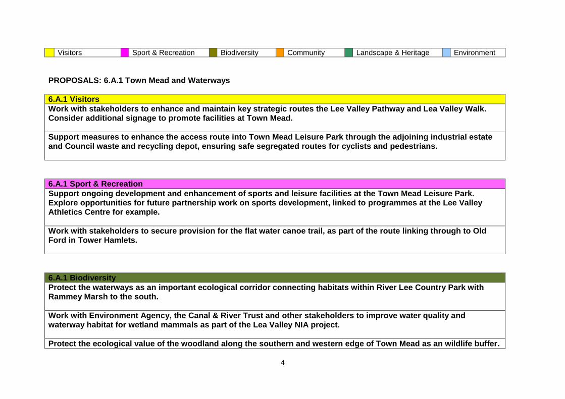
Visitors Sport & Recreation Biodiversity Community Landscape & Heritage Environment
PROPOSALS: 6.A.1 Town Mead and Waterways
6.A.1 Visitors
Work with stakeholders to enhance and maintain key strategic routes the Lee Valley Pathway and Lea Valley Walk. Consider additional signage to promote facilities at Town Mead.
Support measures to enhance the access route into Town Mead Leisure Park through the adjoining industrial estate and Council waste and recycling depot, ensuring safe segregated routes for cyclists and pedestrians.
6.A.1 Sport & Recreation
Support ongoing development and enhancement of sports and leisure facilities at the Town Mead Leisure Park. Explore opportunities for future partnership work on sports development, linked to programmes at the Lee Valley Athletics Centre for example.
Work with stakeholders to secure provision for the flat water canoe trail, as part of the route linking through to Old Ford in Tower Hamlets.
6.A.1 Biodiversity
Protect the waterways as an important ecological corridor connecting habitats within River Lee Country Park with Rammey Marsh to the south.
Work with Environment Agency, the Canal & River Trust and other stakeholders to improve water quality and waterway habitat for wetland mammals as part of the Lea Valley NIA project.
Protect the ecological value of the woodland along the southern and western edge of Town Mead as an wildlife buffer.
5
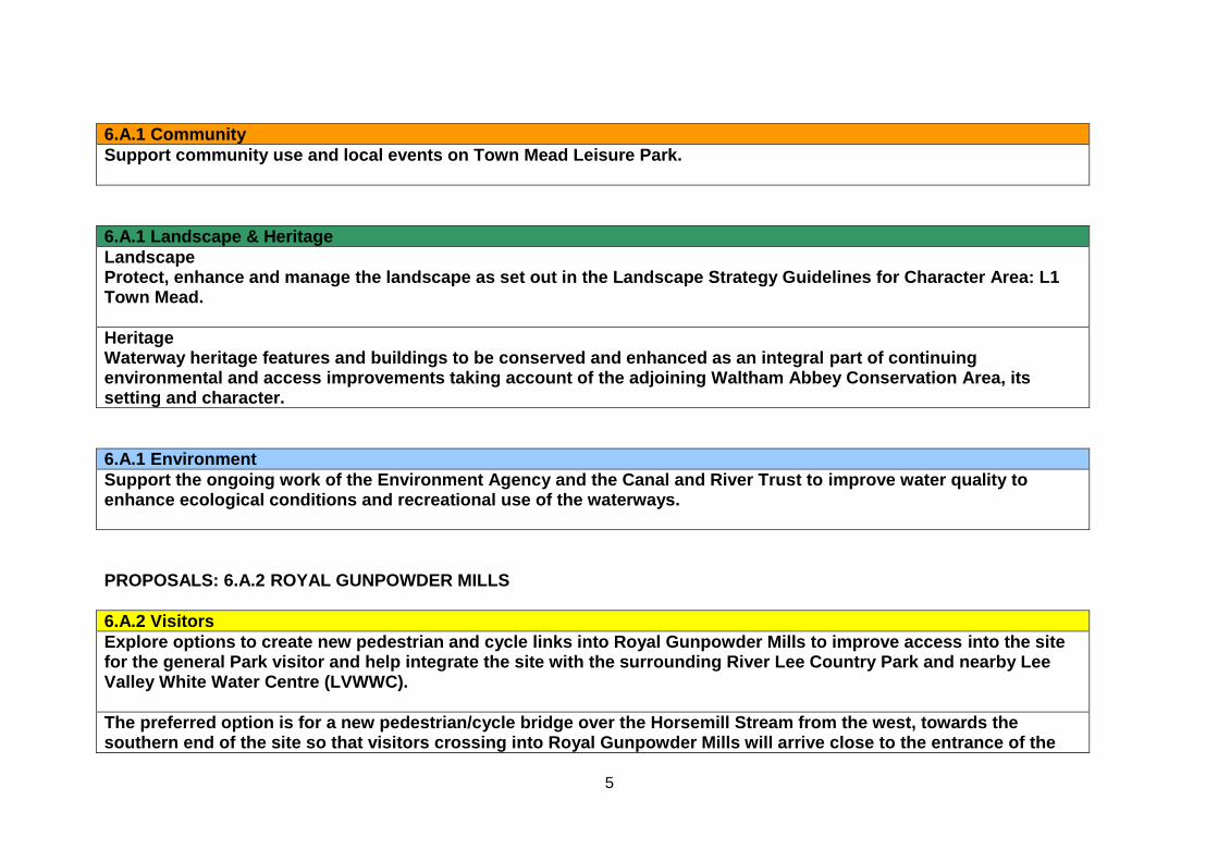
6.A.1 Community
Support community use and local events on Town Mead Leisure Park.
6.A.1 Landscape & Heritage
Landscape Protect, enhance and manage the landscape as set out in the Landscape Strategy Guidelines for Character Area: L1 Town Mead.
Heritage Waterway heritage features and buildings to be conserved and enhanced as an integral part of continuing environmental and access improvements taking account of the adjoining Waltham Abbey Conservation Area, its setting and character.
6.A.1 Environment
Support the ongoing work of the Environment Agency and the Canal and River Trust to improve water quality to enhance ecological conditions and recreational use of the waterways.
PROPOSALS: 6.A.2 ROYAL GUNPOWDER MILLS
6.A.2 Visitors
Explore options to create new pedestrian and cycle links into Royal Gunpowder Mills to improve access into the site for the general Park visitor and help integrate the site with the surrounding River Lee Country Park and nearby Lee Valley White Water Centre (LVWWC).
The preferred option is for a new pedestrian/cycle bridge over the Horsemill Stream from the west, towards the southern end of the site so that visitors crossing into Royal Gunpowder Mills will arrive close to the entrance of the
6
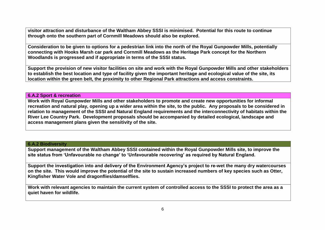
visitor attraction and disturbance of the Waltham Abbey SSSI is minimised. Potential for this route to continue through onto the southern part of Cornmill Meadows should also be explored.
Consideration to be given to options for a pedestrian link into the north of the Royal Gunpowder Mills, potentially connecting with Hooks Marsh car park and Cornmill Meadows as the Heritage Park concept for the Northern Woodlands is progressed and if appropriate in terms of the SSSI status.
Support the provision of new visitor facilities on site and work with the Royal Gunpowder Mills and other stakeholders to establish the best location and type of facility given the important heritage and ecological value of the site, its location within the green belt, the proximity to other Regional Park attractions and access constraints.
6.A.2 Sport & recreation
Work with Royal Gunpowder Mills and other stakeholders to promote and create new opportunities for informal recreation and natural play, opening up a wider area within the site, to the public. Any proposals to be considered in relation to management of the SSSI and Natural England requirements and the interconnectivity of habitats within the River Lee Country Park. Development proposals should be accompanied by detailed ecological, landscape and access management plans given the sensitivity of the site.
6.A.2 Biodiversity
Support management of the Waltham Abbey SSSI contained within the Royal Gunpowder Mills site, to improve the site status from ‘Unfavourable no change’ to ‘Unfavourable recovering’ as required by Natural England.
Support the investigation into and delivery of the Environment Agency’s project to re-wet the many dry watercourses on the site. This would improve the potential of the site to sustain increased numbers of key species such as Otter, Kingfisher Water Vole and dragonflies/damselflies.
Work with relevant agencies to maintain the current system of controlled access to the SSSI to protect the area as a quiet haven for wildlife.
7
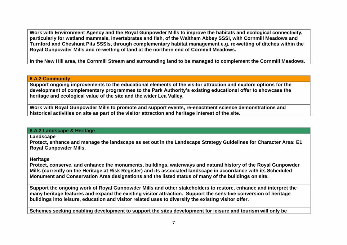
Work with Environment Agency and the Royal Gunpowder Mills to improve the habitats and ecological connectivity, particularly for wetland mammals, invertebrates and fish, of the Waltham Abbey SSSI, with Cornmill Meadows and Turnford and Cheshunt Pits SSSIs, through complementary habitat management e.g. re-wetting of ditches within the Royal Gunpowder Mills and re-wetting of land at the northern end of Cornmill Meadows.
In the New Hill area, the Cornmill Stream and surrounding land to be managed to complement the Cornmill Meadows.
6.A.2 Community
Support ongoing improvements to the educational elements of the visitor attraction and explore options for the development of complementary programmes to the Park Authority’s existing educational offer to showcase the heritage and ecological value of the site and the wider Lea Valley.
Work with Royal Gunpowder Mills to promote and support events, re-enactment science demonstrations and historical activities on site as part of the visitor attraction and heritage interest of the site.
6.A.2 Landscape & Heritage
Landscape Protect, enhance and manage the landscape as set out in the Landscape Strategy Guidelines for Character Area: E1 Royal Gunpowder Mills. Heritage Protect, conserve, and enhance the monuments, buildings, waterways and natural history of the Royal Gunpowder Mills (currently on the Heritage at Risk Register) and its associated landscape in accordance with its Scheduled Monument and Conservation Area designations and the listed status of many of the buildings on site.
Support the ongoing work of Royal Gunpowder Mills and other stakeholders to restore, enhance and interpret the many heritage features and expand the existing visitor attraction. Support the sensitive conversion of heritage buildings into leisure, education and visitor related uses to diversify the existing visitor offer.
Schemes seeking enabling development to support the sites development for leisure and tourism will only be
8
considered where these will have no adverse impact on the SSSI and the openness of the River Lee Country Park and where they form part of a robust business case
6.A.2 Environment
Support the Environment Agency and Royal Gunpowder Mills in implementing measures to resolve contamination issues on site and further improve the general safety of the environment in which many of the artefacts and structures stand in order to enable greater public access.
Work with the Environment Agency and other stakeholders on the project to rewet the ditches and water courses on site. Work with the Environment Agency, and other stakeholders to support development projects which integrate measures, including sustainable drainage systems to mitigate and reduce flood risk within and outside the Park, at the same time as delivering wider sustainability benefits to biodiversity, water quality and recreational activity.
PROPOSALS: 6.A.3 LEE VALLEY WHITE WATER CENTRE – Please note this Proposal covers land that lies within both Broxbourne and Epping Forest District
6.A.3 Visitors
Develop the existing visitor offer at the Lee Valley White Water Centre to create a major visitor destination to complement the Royal Gunpowder Mills and Waltham Abbey Gardens. New investment will diversify the range of activities from ‘paddle into extreme sports. Investment options will also consider the potential for hotel accommodation.
Identify sites for cycle hire for visitors intending to explore the Regional Park
Market the Lee Valley White Water Centre as a primary access into River Lee Country Park.
9
6.A.3 Sport & Recreation
Lee Valley White Water Centre RLCP south. Develop the Lee Valley White Water Centre as a World Class venue for canoeing, kayaking and rafting and as the major family leisure destination within the south east. Its offer will be diversified into ‘extreme’ sports. Major paddle sporting events to continue to be held at this venue.
Existing training sessions, schools and club water sports programmes and activities to be expanded in association with training provided at other venues in particular the Herts Young Mariners Base.
Explore with stakeholders and private developers opportunities for an active leisure zone or adrenaline sports park/hub adjoining and complementary to the Lee Valley White Water Centre. Options could include an aerial ropes course, zip wire, climbing wall, mountain biking, cycle hire, indoor surfing – ‘Flowrider’, and health and fitness facilities.
High quality sustainable design will be sought for new investment proposals to respond to the site’s location in the green belt and, its proximity to protected sites of national and international sites of ecological significance.
Provide signs for and promote the route of the Lee Valley 10km route with set distances identified to enable people to train over timed lengths.
6.A.3 Biodiversity
Management of swales, meadows and trees belts to maintain high ecological values.
6.A.3 Community
Promote and continue to develop the Lee Valley White Water Centre as a major venue for international, national and regional water sports events and competitions.
Expand existing schools, club, and community training and events on site. Provide additional facilities such as an outdoor
10
classroom, provision of shelter/shade and new changing rooms to accommodate this increased event and educational activity. This will support the outdoor learning offer in River Lee Country Park in addition to the onsite outdoor learning programmes
Interpretation to be installed to assist Lee Valley education service outdoor learning programmes which complement the current water sports offer.
Development of volunteer support at the Lee Valley White Water Centre to be expanded.
Explore the feasibility of developing a cycle track for triathlon events; this could be located around the edge of the Showground site but be designed to link to other cycle paths in the River Lee Country Park.
Enhance and promote the Showground site within the River Lee Country Park as a major event site for the Regional Park. Improve infrastructure and services including the provision of permanent toilets, power and sewage points, upgrading of access routes, paths and designated car parking area. Explore options for opening up new areas to the west of the Showground site and the Lee Valley White Water Centre for temporary events. This would require improved access off from Trinity Lane or a new southern access into the River Lee Country Park via the Britannia nursery site.
6.A.3 Landscape & Heritage
Protect, enhance and manage the landscape as set out in the Landscape Strategy Guidelines for Character Area: A4 Kings Weir to Waltham Town Lock.
6.A.3 Environment
Water Ensure development and operational proposals are consistent with the Water Framework Directive objectives and support implementation of the Thames River Basin Management Plan and the actions it identifies to secure improved water and ecological quality.
11
Work with the Environment Agency, and other stakeholders to support development projects which integrate measures, including sustainable drainage systems to mitigate and reduce flood risk within and outside the Park, at the same time as delivering wider sustainability benefits to biodiversity, water quality and recreational activity.
PROPOSALS: 6.A.4 RIVER LEE COUNTRY PARK
6.A.4 Visitors
Work with public transport operators to improve access by public transport to each entrance to the River Lee Country Park.
Explore options to improve the accessibility throughout the River Lee Country Park through sustainable means. Options should allow access for all visitors. These could include a land train or electronic buggies operating on new routes between facilities.
Work with stakeholders to improve access and the quality of the routes for pedestrians and cyclists into the Park
At entrance points to the River Lee Country Park in the north along Paynes Lane, Green Lane and Old Nazeing Road;
from adjoining communities to the south and west and off from key routes such as the Crooked Mile along the eastern boundary;
continue to maintain the Lee Valley Pathway and Lee Valley Walk
Explore options with Essex County Council and Epping Forest District Council to create a pedestrian route/cycle lane provision either on or off road along all or part of Crooked Mile, for example from the roundabout at Abbey View as far as the Cornmill Tree Park and Claygate Lane. Options to include an assessment of the viability and safety of providing a pedestrian crossing from the Park onto Claygate Lane and bridleway to link the Park with the wider Epping area.
A new pedestrian and operational access into the River Lee Country Park off from Eleanor Cross Road via the Britannia Nursery site to be provided as part of the redevelopment of this site together with a small visitor car park.
The Authority will work with the Network Rail/Crossrail 2 team on developing a strategic access and wayfinding strategy to
12
improve visitor access into the Regional Park.
At Trinity Lane consider options for adding directional signage from Theobalds Grove Railway station.
Improve the rail bridge crossing at Turnford Brook and gateway signage both at the entrance and on the main road.
Within the River Lee Country Park visitor facilities are to be enhanced at the existing visitor/activity hubs as follows: 1. South River Lee Country Park and Waltham Abbey Gardens Work with Broxbourne Borough Council and Hertfordshire County Council to improve the quality and accessibility of walking and cycling routes into the Park from Waltham Cross Station with the provision of clear directional signage along main routes and from adjoining residential areas.
Examine the feasibility of a water taxi service with the Canal and River Trust (CR&T) as a means of transporting visitors to and from the area. This could connect with boating facilities to the north at the Lee Valley Boat Centre, Broxbourne.
Waltham Abbey Gardens Promote and manage Waltham Abbey Gardens as a secondary gateway into the River Lee Country Park and the Cornmill Meadows access to nature site. Work with stakeholders to secure additional signage to Cornmill Meadows.
Consider options to develop a River Lee Country Park visitors centre within the Abbey Farmhouse or similar building to provide a combination of visitor and educational facilities, and multifunctional indoor spaces including classroom, events space, toilets, and small catering service.
Cornmill Tree Park Enhance Cornmill Tree Park as a visitor hub focused on woodland crafts and activities including woodland management, bush crafts and forest schools. Explore opportunities for wild camping.
Footpath connections through to the Fishers Green and Hayes Hill Farm hubs to be enhanced. Options for a pedestrian link between the southern part of the Cornmill Meadows and the Royal Gunpowder Mills site to be explored.
13
2. Cheshunt Station and Pindar Visitor Gateway Work with partners to improve access and establish a primary gateway into the Park for all visitors from Windmill Lane and Cheshunt Station by:
promoting Cheshunt Station as the primary public transport point into the River Lee Country Park,
safeguarding and improving the bridge access over the railway for cyclists and pedestrians,
developing synergies between visitor facilities at the YHA London Lee Valley (YHA) and Herts Young Mariners Base (HYMB) to serve all Park visitors, e.g. use of YHA café by general Park visitors, shared/improved car & coach parking, cycle hire or drop off, improved links to Discovery Trail routes from the YHA and HYMB,
improving the entrance into the Park along Windmill Lane and from Pindar car park through signage and environmental enhancements,
3. Fishers Green Visitor Hub Development of a new Bittern Information Point as a multifunctional visitor and educational space, close to Seventy Acres Lake to be constructed on at least two levels to include;
visitor information/arrival and small interpretation area, with the option to include a catering outlet if viable/appropriate,
provision of indoor observation/bird watching areas providing views out over the water and adjacent habitats, and
classroom facilities and a base for volunteers separated from bird watching facilities to avoid disturbance High quality sustainable design will be sought for new investment proposals to respond to the site’s location in the green belt and, its proximity to protected sites of national and international sites of ecological significance.
Implement improvements to the Fishers Green entrance and car park to establish a primary gateway into the River Lee Country Park by:
upgrading the toilets and visitor signage and providing shelter for visiting groups,
reviewing pedestrian routes between the Fishers Green car park and the Lee Valley Park Farms and increasing marketing to encourage use of the Farm café,
working with Essex County, Epping Forest District Council and the Growers Association to improve the quality
14
and safety of the vehicle access into Fishers Green/River Lee Country Park from the Crooked Mile and along Stubbins Hall Lane; with improved signage, clearly demarked pedestrian and cycle routes, landscape treatment and habitat enhancements.
Options for a bus/coach turning and drop off point to be explored in collaboration with local bus/coach service providers and the County Highway department.
4. Lee Valley Park Farms Visitor Hub (Hayes Hill and Holyfield Hall Farms) Develop the Lee Valley Park Farms as an all year round family focused visitor facility to include:
redesigned and enhanced visitor centre with associated retail area and café at entrance to the Farms,
improved path networks, site signage information and seating areas,
improvements to existing and provision of new outdoor themed play facilities,
new purpose built indoor soft play centre with restaurant and toilets,
provision of new outdoor play concept ‘Waterplay’,
the development of a range of visitor accommodation.
provision of covered lunch areas All development at the Lee Valley Park Farms will need to take account of the sensitivity of its Green Belt location and the need for high quality design, improved public transport, pedestrian accessibility, and the protection and enhancement of existing ecological value within the site and the adjoining areas of the River Lee Country Park.
A dedicated Lee Valley Park Rangers base to be established at Holyfield Hall Farm.
5. Broxbourne Gateway and Visitor Hub - River Lee Country Park North Establish a major visitor hub at Broxbourne as a primary gateway into the River Lee Country Park incorporating existing visitor facilities at Broxbourne Riverside, Old Mill and Meadows and the site of the former Leisure Pool. This will be achieved by:
Supporting and retaining the existing provision for cycle hire, boat hire, river cruising, catering and recreational moorings as a core element of the Broxbourne Gateway;
developing synergies with similar facilities elsewhere within the River Lee Country Park and wider Park, e.g. drop off points at the Lee Valley Park Farms and Lee Valley White Water Centre for cycle hire;
15
Exploring options with stakeholders and existing operators to reposition, enhance and enlarge these visitor facilities, to create a more extensive visitor offer potentially in one key waterside location;
Exploring options for replacing existing holiday chalets at Broxbourne Meadows with new ‘pod’ style visitor accommodation;
joint working with Broxbourne Council to update the Leisure Pool Development Brief to include the potential for residential development to enable the wider development and improvement of the site
High quality sustainable design will be sought for new investment proposals to respond to the site’s location in the Green Belt and, its proximity to protected sites of national and international sites of ecological significance.
Improvements to routes and signage into the area for pedestrians and cyclists to include;
Clearer signs and a segregated pedestrian/cycle route from Broxbourne Station, through the station car park, under the road and railway incorporating appropriate safety features
Creation of a new pedestrian crossing on Nazeing New Road, making use of existing traffic island to the east, to provide safe access into the site accessible to all visitors,
A signed route through from adjoining residential areas from Mill Lane via Churchfields and off from Station Road,
The coherence of routes and movement between sites, along the waterways and the rest of the River Lee Country Park to be addressed by clear signs and treatment of path surfaces including the rationalisation and careful positioning of signs for anglers and angling clubs.
Promote access into the River Lee Country Park by public transport in particular via Broxbourne train Station and by bus. Options to establish Broxbourne station as part of the main pedestrian gateway and access point into the area to be explored with stakeholders
Access off from Nazeing New Road to be promoted as the main vehicle access to the area, car parking provision to be assessed and rationalised to ensure it serves the general visitor to the Park and those using leisure facilities.
Clayton Hill Develop the site as an access point in to River Lee Country Park. Work with stakeholders to improve visitor facilities especially where this would also benefit local events use, and recreational activities for example provision of toilets.
16
6.A.4 Sport & Recreation
RLCP South and Waltham Abbey Gardens Work with stakeholders to secure provision for the flat water canoe trail, south from the Lee Valley White Water Centre as part of the route linking through to Old Ford in Tower Hamlets. Explore potential for a portage at or close to Waltham Town Lock with car parking and associated amenities for boaters to be available at the Lee Valley White Water Centre.
Enhance informal recreational facilities at the Waltham Abbey Gardens.
Herts Young Mariners Base Support outdoor adventure activities and water based sports and training courses at the Herts Young Mariners Base. Explore further opportunities to develop synergies between the water sports, training and development programmes that are offered at sites and facilities within the River Lee Country Park, for example the Lee Valley White Water Centre.
Work with Herts Young Mariners Base and the Environment Agency to review and potentially increase use of the Herts Young Mariners canoe trail, (currently only available 6 times a year) taking account of angling use and fish spawning areas. Explore options to extend Lee Valley Flat Water Canoe Trail north to Herts Young Mariners Base from Lee Valley White Water Centre.
Pindar Natural Play hub Develop and promote the River Lee Country Park south of Pindar car park as a hub for natural play and informal recreation. Future improvements to include new toilets, catering outlet, information point and improvements to the existing parking. Existing pedestrian and cycle routes through from Cheshunt Station to be maintained and enhanced.
Lee Valley Park Farms Play New outdoor themed play including an outdoor waterplay facility to be developed at Lee Valley Park Farms as an integral part of expanding and improving the sites family friendly visitor attractions. A new purpose built soft play centre to be developed within the existing envelop of the Farm site with classroom provision included.
Nazeing Marsh, the old Chimes Nursery site and Rushymead Work with EFDC, landowners and other stakeholders to bring this area of the Park into a recreational or leisure use in
17
accordance with the Park’s remit.
Undertake further works at Rushymead to open up the site and create a quiet waterside area for informal recreation.
Angling Protect, manage and continue to improve the fisheries within the RLCP as regional leisure and sporting venues for a diverse range of specimen coarse angling. Invest in current angling infrastructure throughout RLCP. Establish buffer zones to create seclusion around swims on the Old River Lea to the west and south of Holyfield Lake (as hatched on plan).
Sailing, Boating and Rowing Holyfield Lake to be managed and promoted for sailing. Improvement of and investment in existing sailing and boating facilities will be supported. The existing refuge area to be protected and maintained. The Authority’s long term aim is to develop this lake as a Centre for Sailing Excellence with sufficient infrastructure including, secure parking and a replacement lakeside building. In advance of the delivery of the long term aim studies should consider the impacts of this proposal on: - green belt designation - ecological interests, including the adjacent SSSI/SPA and whether an EIA is needed; - the range and type of sailing and water activities which can be accommodated, and - flood risk. This proposal should be read in conjunction with Proposal 7.A.2
Work with stakeholders and operators to support and maintain the waterways for rowing and recreational boating. Explore opportunities to improve facilities at the Lee Valley Boat Centre.
6.A.4 Biodiversity
Fauna and Flora Protect, enhance and manage the mosaic of open water, scrapes, meadows, floodplain grassland and farmland
18
habitats within the River Lee Country Park to improve its ecological value and species diversity.
Turnford and Cheshunt Pits SSSI Protect Turnford and Cheshunt Pits SSSI (part of the Lee Valley Special Protection Area 2000) as an internationally important wetland with priority given to the key habitats, species (Bittern, Shoveler and Gadwall), open water, reedbed and wetland scrape. Management to maintain the ‘favourable’ status of the site as required by Natural England and with reference to the Lee Valley SPA Site Improvement Plan. Future management of the site to be focused on the maintenance and enhancement of these key habitats with particular importance placed on the on-going reedbed management, creation and enhancement, retaining the early successional habitat of Hall Marsh Scrape, encouraging the growth of aquatic and marginal vegetation around the lake edges and continued restoration of the grassland areas.
Cornmill Stream and Old River Lea (Cornmill Meadows) SSSI Protect Cornmill Stream and Old River Lea (Cornmill Meadows) SSSI as a freshwater habitat with one of the most diverse invertebrate faunas in Essex. Manage the site to maintain ‘favourable’ status as required by Natural England.
Maintain the mosaic of wetland habitats targeting protection of key species. Explore opportunities to increase the extent of wetland habitat into the northern section of the site in partnership with Environment Agency and Natural England. Maintain and manage areas of shallow flood for the benefit of designated SPA species (wintering Shoveler).
Maintain the internal wildlife refuges on site allowing open public access to the perimeter of the site.
Waltham Abbey SSSI Work with EA and Royal Gunpowder Mills to improve the ecological connectivity, particularly for wetland mammals and dragonflies/damselflies, of the Waltham Abbey SSSI with Cornmill Meadows and Turnford and Cheshunt Pits SSSIs, through complementary habitat management e.g. re-wetting of ditches within Royal Gunpowder Mills and re-wetting of land at the northern end of Cornmill Meadows.
Habitat improvements to be delivered throughout the RLCP and at key sites as part of the NIA project as follows:
Grassland habitat – scrub removal from a number of grasslands within and adjacent to the Turnford and Cheshunt SSSI.
19
Gravel pits - Selective tree removal and opening up of gravel pits within Lea Valley SPA and expansion of key features such as reedbeds and existing emergent vegetation
Waterway and ditch enhancements for wetland mammals such as Otter and Water Vole including tree management and removal, in-channel management of vegetation, and where possible reprofiling of areas along ditches to create deeper pools to retain water throughout the year.
Improvement of wet meadows at the Goosefield for breeding waders including the installation of sluices to better control water levels and reconfiguration of scrapes.
Rotational restoration of Norman’s Pond complex for Great Crested Newts breeding
Woodland coppice management north of the sub station to improve habitat for Nightingales,
Improvements and new viewing area at end of the Orchid boardwalk trail
Management of invasive species across sites with the aim of eradication where possible, otherwise aiming to control numbers to minimise impact on natural features
Work with Natural England to agree the continued management of Higher Level Stewardship areas at Cornmill Meadows, Silvermeade and the Farm and aim to enter the River Lee Country Park into a new Countryside Stewardship scheme.
Management of non-designated waterbodies to take account of their role in supporting the wider SPA
Establish Britannia Meadows and Lake as an ecological buffer to complement the adjoining SSSI, Lee Valley SPA and Ramsar areas. Manage grassland/meadow around lake and to the north and improve lake edges for invertebrates and mammals to create feeding habitat for Barn Owls and other predatory birds.
Protect refuge area on southern part of Holyfield Lake
Access to Nature Fishers Green Access to Nature Hub Development of a new Bittern Information Point close to Seventy Acres Lake to provide indoor observation areas, interactive facilities, and classroom. Development at this ecologically sensitive location would be a collaborative process with key stakeholders and would require Natural England permissions. It would need to take account of its location within the Green Belt and floodplain and be of a scale and design appropriate to the open character,
20
ecological value and landscape quality of the Park.
Explore opportunities to create a series of nature discovery areas or spectacles within adjoining sites including construction of a ‘mock’ Badgers sett for people to walk inside, creation of an artificial otters holt to provide an ‘Otters Eye View’ and a ‘see inside a kingfisher bank’ with remote cameras. New GPS and ‘App’ based wildlife trails to be promoted within the River Lee Country Park.
Explore opportunities at Turnford and Cheshunt Pits SSSI to enhance access to nature, engage and educate visitors providing this has no negative impact on the site’s designation.
Protect access to nature sites at Holyfield Hall Farm and Cornmill Meadows. Management of the Lee Valley Park Farms to incorporate measures that improve biodiversity and encourage wildlife in accordance with the ten-year Higher Level Stewardship Agreement (commenced 2013) and the Cornmill Meadows Management Plan.
Protect the existing habitat at Silvermeade as a stronghold for the Water Vole and a key access to nature site for viewing this species. Undertake ditch improvements and other conservation measures to enhance and maintain suitable habitat, in accordance with the ten-year Higher Level Stewardship Agreement.
Work with relevant agencies to ensure that access to nature areas that are more sensitive, for example Sites of Special Scientific Interest (SSSI’s), are managed to minimise damage and disturbance, and to improve the status of these areas.
6.A.4 Community
Work with stakeholders and interest groups to support and encourage development of volunteer activity and programmes throughout River Lee Country Park
Waltham Abbey Gardens Work with stakeholders to continue to develop, promote and deliver a range of Park and community led events and arts activities within Waltham Abbey Gardens, in particular those that draw upon and promote the heritage/historical and ecological value of the area e.g. ‘King Harold’s Day’ and ‘Wild about Wetlands’. Event planning and delivery should take full account of the need to conserve and protect the heritage value of the site.
21
Provision of a dedicated Lee Valley Park education centre within the Abbey Farmhouse or similar building to include secure outdoor space for long term environmental educational installations and high quality interpretation room.
Continue to develop provision of environmental and heritage education programmes in line with the National Curriculum utilising the Cornmill Meadows orienteering course and Abbey Gardens. Renew the Abbey Gardens pond dipping platforms.
Lee Valley Park Farms Develop a show programme to be delivered at the Lee Valley Park Farms as part of the visitor experience. A new show amphitheatre to be created within the old barn at Hayes Hill Farm to be utilised by both farm and education teams.
Continue to develop facilities to support educational visits explaining the farming operation and business at Holyfield Hall Farm, for example in relation to commercial dairy and arable farming. Install interactive exhibits (such as flour grinding exhibits, traditional dairy mock up, etc.) Explore options to provide for classroom space within the Lee Valley Park Farms to assist in the delivery of educational and environmental programmes.
Investigate bus transport opportunities to Fishers Green/ Lee Valley Park farms to aid access by educational groups.
Fishers Green Development of the new Bittern Information Point at Fishers Green to include classroom provision and an interactive interpretation space for educational, volunteer and events use. Classroom space to be designed to accommodate 40 people, separate from bird watching areas to avoid disturbance.
Outdoor shelter to be provided close to the Fishers Green car park for large school, volunteer and other visiting groups. The shelter should achieve a high quality of sustainable design taking account of the character of the area and opportunities to create a feature within the landscape. Options to provide further shelters for school and other groups to be explored at Holyfield Hall Farm along the Old River Lee and down the Navigation in key education areas.
Broxbourne Gateway Explore options for new flexible classroom space and toilet provision as part of the enhancement of the Broxbourne Gateway
22
and Visitor hub. Support local events and educational activities at Broxbourne Old Mill and Meadows.
General River Lee Country Park Maintain the orienteering course within the River Lee Country Park and consider provision of outdoor shelters at Pindar natural play visitor hub to support orienteering events and environmental education activities from Cheshunt out into the River Lee Country Park.
Support use of Turnershill Marsh south of Cheshunt Station for smaller community events and orienteering.
Support local events at Clayton Hill.
6.A.4 Landscape & Heritage
Landscape Protect, enhance and manage the landscape as set out in the Landscape Strategy Guidelines for Character Areas:
- A4 Kings Weir to Waltham Town Lock - G3 Clayton Hill – Holyfield Hall - I1 Arboretum - K1 Waltham Abbey Gardens
Views of the Abbey Church at Waltham Abbey, and of Broxbourne Parish Church and the New River in the north of the RLCP to be protected and long distance views across the rural landscape and to the rural valley sides to be retained.
At key sites: Invest in landscape improvements at key entrances to the Park to maintain and enhance access into the Park including Broxbourne Meadows and Riverside, Cheshunt Station and Pindar car park, Fishers Green/Lee Valley Park Farms, Cornmill Tree Park, Waltham Abbey Gardens and Highbridge Street. Improve the quality of access routes into the Park from the north along Paynes Lane, Green Lane and Old Nazeing Road.
Heritage
23
Work with stakeholders to conserve, promote and celebrate heritage features, artefacts and buildings within the River Lee Country Park. Explore opportunities for heritage themed trails based on industrial, wartime, the glasshouse and gravel industries. Develop physical and promotional links to and with existing heritage sites at Royal Gunpowder Mills and at sites within Area 5 such as at Gunpowder Park and Enfield Lock Conservation Area.
Waltham Abbey Gardens Work with stakeholders to protect, preserve, restore, and interpret the many elements of heritage interest at Waltham Abbey Gardens to establish the site as a major heritage attraction taking account of its Conservation Area designation and setting. Link the various aspects of the heritage offer at the Abbey Gardens site with the important heritage sites within Waltham Abbey including the Royal Gunpowder Mills and continue to engage and work with the local community partnerships on heritage related projects and enhancements.
Broxbourne Old Mill and Meadows Enhance, refurbish and maintain Broxbourne Mill and its setting and improve interpretation on site.
6.A.4 Environment
Glasshouses The expansion of existing or development of new glasshouse sites within and adjacent to the River Lee Country Park Area 6.A.4 will be considered in relation to how the development impacts upon the openness of the Regional Park, the quality of its landscape character and visitor enjoyment. Cumulative impacts will also be a factor where large scale expansion has already taken place. The following issues will need to be addressed: The scale, height, and bulk of new glasshouse development including lighting and associated infrastructure should be appropriately located and designed so as
to protect the openness of the Park and views into and across the River Lee Country Park.
Avoid adverse impact upon the visual amenity of visitors or users of the Park
Enhance landscape character and preserve existing positive features such as wildlife areas, trees and woodland belts, attractive water edges.
Maintain the existing level and quality of pedestrian and cycle access within the River Lee Country Park.
Avoid harm to or disturbance of wildlife either through loss or fragmentation of habitat or through noise, lighting or pollution
24
Protect and maintain water quantity and quality
To avoid increased flood risk by reducing the capacity of the floodplain or impacting upon existing flood defences
Applications for new or replacement glasshouses within the curtilage of existing sites will be considered subject to conditions to mitigate the impact of development on visual amenity, landscape character, flood risk, biodiversity and recreational use, including pedestrian and cycle access. Where development is proposed on land outside the ownership of the Authority it will seek planning obligations in line with the above proposal to mitigate adverse impacts.
Lee Valley Park Farms Continue to develop the commercial dairy and arable farm at Holyfield Hall Farm; agricultural use to contribute positively to the open landscape character, biodiversity and educational experience of the Park.
Continue to manage the Farm in line with the ten-year Higher Level Stewardship agreement (HLS) commenced in November 2012.
Water Work with Thames Water, the Environment Agency and relevant stakeholders to meet Water Framework Directive objectives and ensure proposals support the implementation of the Thames River Basin Management Plan and its identified actions to secure improved water and ecological quality. Work with the Environment Agency, and other stakeholders to support development projects which integrate measures including sustainable drainage systems, to mitigate and reduce flood risk within and outside the Park, at the same time as delivering wider sustainability benefits to biodiversity, water quality and recreational activity. Work with the EA and the C&R Trust to encourage greater use of the waterways for recreational boating and angling.
Four Tracking & Crossrail 2 Support ongoing investment in the Greater Anglia service and Network Rail infrastructure and work with Network Rail/Crossrail 2 team, the local and county authorities to develop a strategy for retaining crossing points and access into the Park for all
25
visitors and to enable operational management, without large areas of parkland being lost to new bridge landings, new roads or related infrastructure.
The Authority will work closely with Crossrail 2 including environmental specialists to mitigate any adverse impacts on the amenity of the Park as a result of Crossrail 2 proposals; for example improved rail access at Cheshunt station and supporting infrastructure. These proposals may not be resolved within the timescale of these Area proposals.
Energy North London Reinforcement Project includes improvements to the electricity network from Waltham Cross Sub-station at Fishers Green through to Hackney. The Authority has agreed a scheme of mitigation for these works where they impact upon the Park including monies for NIA improvement schemes.
Contaminated Land Undertake appropriate mitigation for impacts and risks associated with contaminated land within the Authority’s ownership, in accordance with the Authority’s Contaminated Land Policy (2011). Land will be evaluated on the basis of the ‘suitable for use’ approach where land will be made suitable for any new use as planning permission is given for that use. Remediation will be carried out to a level that prevents unacceptable risks to human health or the environment in relation to the current use or future use of the land for which planning permission is being sought. Encourage other landowners to remediate contaminated land in accordance with the Authority’s Policy.
Regularly (at least annually) review available information relating to contaminated land and where necessary and in accordance with the Authority’s Contaminated Land Policy, update current information by carrying out further site investigations.
PROPOSALS: 6.A.4.1 WHARF ROAD INSET
6.A.4.1 Visitors
Create a new pedestrian spine parallel with the Broxbourne Ditch corridor to provide a different pedestrian environment and relieve pressure on the Navigation towpath.
26
Extend the existing path network by providing further new tracks and paths to form extra links and circuits including an additional path along the southern edge of Silvermeade Wildlife site.
Upgrade Wharf Road as an entrance and gateway point into the RLCP. Work with Broxbourne Council, Hertfordshire County and Network Rail to sign the Regional Park from the High Road and improve the environmental quality of the route along residential roads and Wharf Road into the Park at this point. Assess existing entrance signage and ensure appropriate site signage is provided that promotes both the RLCP and safe crossing of the railway.
Maintain and enhance the small car park and provide an illustrated information board along with additional signage for information, interpretation and orientation throughout the area.
6.A.4.1 Sport & recreation
Protect and maintain the area as a tranquil space for informal recreation, walking and cycling forming part of the wider River Lee Country Park. Work with Broxbourne Council and landowners to increase the amount of space available for informal recreation, particularly in the southern half of the site.
Improve and extend the existing network of tracks and paths to create circular routes with links through to adjoining areas of the River Lee Country Park for walkers and cyclists.
6.A.4.1 Biodiversity
Extend the ecological qualities of Silvermeade to the north eastern part of the site and along the Broxbourne Ditch to encourage species such as Water Vole. Areas in the north west to be managed as grassland and scrub grassland matrix. To the south areas of species rich grassland to be planted and managed as meadows.
This will be achieved through the following initiatives:
Investigate provision of new scrapes, shallow pools and marsh habitat creation to the north and south of Nut Tree Nursery to extend existing habitats in Silvermeade and provide visually accessible habitats adjacent to new paths. Arisings to be disposed of in selected locations on site to avoid any reduction in flood plain capacity. Contamination
27
surveys and Phase 1 and Phase 2 Ecological surveys are also required.
Along Broxbourne Ditch removal of selected trees and pollarding of ditchside willows to reduce excessive shading; removal of litter; desilting and possible easing of bank gradients in limited numbers of selected locations to create habitat suitable for Water Vole.
Introduction of a scrub control programme for areas south-west of Silvermeade, and north of Wharf Road, to conserve potentially interesting grassland and reedbed habitat.
Removal and control of Great Willowherb in the north west of the site and Himalayan Balsam in the north east.
Undertake cyclical management of hedgerows on Wharf Road and on the Navigation, removal of inappropriate species and localised gapping up.
Introduce meadow management on land west of Silvermeade and investigate feasibility of using cattle for grazing.
Promote the site as an access to nature area with opportunities to view species such as the Water Vole.
6.A.4.1 Community
No text
6.A.4.1 Landscape & Heritage
Landscape Protect, enhance and manage the landscape as set out in the Landscape Strategy Guidelines for Character Area: A4 Kings Weir to Waltham Town Lock Extend the positive landscape character of surrounding areas to the south and north into the site and strengthen existing landscape features including the Broxbourne ditch and the river edge.
Plant locally native wet woodland to extend and consolidate existing scattered tree clumps to provide enhanced screening to visually intrusive uses. Species should be mainly willow, alder and birch with some oak, with a focus on the creation of alder carr.
Thin and remove existing vegetation to improve inter-visibility of areas such as the Navigation and to remove the legacy of chalet plot development. The focus will be on the removal of inappropriate species (mainly surviving garden species from previous chalet development) and poor quality trees.
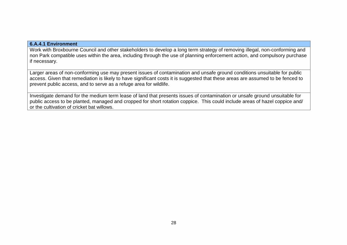
28
6.A.4.1 Environment
Work with Broxbourne Council and other stakeholders to develop a long term strategy of removing illegal, non-conforming and non Park compatible uses within the area, including through the use of planning enforcement action, and compulsory purchase if necessary.
Larger areas of non-conforming use may present issues of contamination and unsafe ground conditions unsuitable for public access. Given that remediation is likely to have significant costs it is suggested that these areas are assumed to be fenced to prevent public access, and to serve as a refuge area for wildlife.
Investigate demand for the medium term lease of land that presents issues of contamination or unsafe ground unsuitable for public access to be planted, managed and cropped for short rotation coppice. This could include areas of hazel coppice and/ or the cultivation of cricket bat willows.
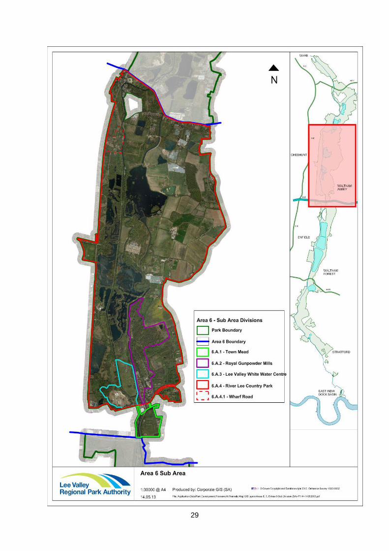
29
1
APPENDIX C Area 7 Proposals Wetland Park - Spitalbrook to Roydon Draft for Adoption April 2019 Note: Proposals relevant to Epping Forest District Council are shown in bold INTRODUCTION
Context Section
Area 7 is located towards the north of the Regional Park, defined by the London and Cambridge Railway to the north, and the B194 between Broxbourne and Lower Nazeing to the south. The western boundary follows the course of the River Lee Navigation around the edge of Rye Park and the edge of Hoddesdon. The eastern boundary is less well defined, following the edge of Roydon in the north, Low Hill Road which links Roydon, Netherhall and Lower Nazeing and the edge of Lower Nazeing to the south.
The area largely comprises a broad and flat valley floor, including large areas of reclaimed former gravel pits with important successional habitat and a number of large water bodies. Rolling farmland to the east provides a more open and rural context, in contrast to the urban setting to the west. Industrial and urban development outside the Park boundary (the Rye-House power station and small scale light industry) strongly influences the character of the valley floor to the west as does the extensive area of glasshouses in the south east, located both within and along the boundary of the Park.
Key Resources and Special Features
Key landscape features include the major water channels, with the confluence of the River Stort Navigation and River Lee Navigation at Fieldes Weir, Glen Faba Lake and the River Lee Navigation forming a corridor that links north to south across the area.
The valley floor contains numerous smaller tributaries and several large areas of open water and wetlands fringed by woodland and scrub interspersed with small meadows. A degree of tranquillity is created within more semi-enclosed areas and by the attractive waterside character of the River Stort, Admiral’s Walk Lake and within waterway corridors of the River Lee and the
2
Lee Navigation. The area suffers from a fragmented character caused by plant nurseries and extensive glasshouse development (particularly to the east) and suburban and industrial development and pylon lines that pass through the centre of the area. Some development, including the housing to the south east of Dobbs Weir, is however contained within a strong landscape structure. Areas of greater intactness include the wooded slopes of Roydon Hill.
Clay Hill and Roydon Park allow clear views across the northern part of the Park and include the ridge to the east dominated by mixed farmland. Within the area itself, views are generally shortened by woodland and willow belts that follow the water courses, lagoons and field boundaries. Views along the River Lee Navigation framed by trees, predominantly willows are characteristic.
The distinctive landscape heritage assets in the area include medieval sites such as Nether Hall and features associated with the Navigation, such as Dobb’s Weir, Roydon Locks and lock keeper’s cottages
Opportunities for visitors
Existing opportunities are focused on water based activities such as sailing, canoeing, leisure boating and angling. Proposals identify opportunities to enhance and consolidate the existing provision to improve the visitor offer.
A range of visitor accommodation is currently available within this area including the Lee Valley Caravan Site at Dobbs Weir and the range of facilities at Roydon Mill Leisure Park in the north of the area. Proposals explore the options for creating new types of accommodation in new areas of the Park such as at Broxbourne Riverside, Carthagena and on parts of Spitalbrook.
Large sites within Area 7 are being brought into leisure use now that gravel operations have ceased. New recreational routes around and through Spitalbrook and around parts of Glen Faba together with habitat creation, management and enhancement will improve opportunities for informal recreation and access to nature in areas previously out of bounds to the public. Existing opportunities at Glen Faba Lake and along the River Stort will be improved with new paths and signage. Plans for wetland restoration and enhancement will be delivered to the existing Local Wildlife Site. Opening up these new areas to the public will further enhance the role of the Park in meeting public health needs both physical and mental health.
Although existing access through and around this area using the towpath and the Lee Valley Pathway are now well established improved links through to Broxbourne Station and to Roydon Station are identified. These stations will become primary and secondary gateways respectively into the Park.
3
Mitigation for any adverse impacts on the amenity of the Park as a result of Crossrail 2 proposals will be sought; for example improved rail access at Broxbourne station and supporting infrastructure.
Adopted guiding principles guiding these proposals
The Authority’s proposals for each of these areas are designed to address the issues identified above and are based on the Authority’s adopted (July 2010) guiding principles for the future development and management of the Regional Park. These are:
Partnership work – recognising that many of the proposals can only be delivered through the collective efforts of a range of partners, stakeholders and landowners.
Regional Value – assessing the range of benefits that any particular facility or activity within the Park delivers to the people of Essex, Hertfordshire and London.
Multi-function and synergy – developing proposals which can be used to harness competing demands.
Flexibility – the design and management of facilities and open spaces of the park in a way which responds to changing needs and demands
Sustainability – ensuring that new development does not prejudice the lives of future generations.
Visitors Sport & Recreation Biodiversity Community Landscape & Heritage Environment
Proposals 7.A.1 WETLAND PARK WEST: SPITALBROOK, DOBBS WEIR AND ADMIRALS WALK LAKE
7.A.1 Visitors
Work with partners to establish a primary gateway into the Wetland Park at Spitalbrook from Broxbourne Station and Nazeing New Road by:
the provision of clearer signs and segregated cycle and pedestrian routes through the station car park out onto Station/Nazeing New Road
4
exploring the feasibility of using the existing ramp in the south west corner of the Spitalbrook site as a pedestrian access
promoting access into the Wetland Park by public transport in particular via Broxbourne train station and by bus
Enhance existing connecting routes into the Park from the adjoining residential areas in the west; these improvements will help deliver the Green Arc Strategic Infrastructure Lateral Links project.
Work with stakeholders to enable better access for cyclists to the new bridge at Mansers Railway Crossing at the northern end of Spitalbrook and support ongoing maintenance of this crossing point; this is key to maintaining connectivity between Admirals Walk Lake and the rest of the Wetland Park.
Work with stakeholders to improve connectivity between the three sites that form the western part of the Wetland Park; Admiral’s Walk Lake, Spitalbrook and Dobbs Weir, and links through to the rest of the Wetland Park to the east and north. This will be achieved by:
retaining and maintaining the existing pedestrian bridge over the River Lee in the southern part of Spitalbrook to enable access into the site from Nazeing New Road, and across the River Lynch in the north, to enable access out onto Dobbs Weir Road
reopening the bridge link between Spitalbrook and Carthagena Estate in the south east
maintaining safe access along the public footpath that forms the northern boundary of Dobbs Weir and Spitalbrook and continues across the railway through to Admirals Walk Lake
opening up access along the old haul route through the eastern part of Spitalbrook between Nazeing New Road and Dobbs Weir Road
providing a safe crossing point over Dobbs Weir Road with a pedestrian phase to the traffic lights
provision of a new pedestrian bridge over the River Lee between Spitalbrook and Nazeing Meads onto Meadgate Road
improving the existing public access to Admiral’s Walk Lake including the addition of signage, and maintaining the informal routes alongside the lake to connect with the public footpath in the north
improving and promoting links from the New River Walk, especially as an attractive link through into the Park from Broxbourne Station
Prepare a feasibility study for visitor infrastructure improvements at Dobbs Weir. This will include:
works to enhance the existing car park and entrance;
improvements to signage and route safety for pedestrians and cyclists, particularly for movements from the car park
5
and towpath across to the ‘Fish and Eels’ public house and the open space around the Weir;
protection and maintenance of the open space at Dobbs Weir for informal recreation, picnicking and enjoyment of the waterside environment;
provision of cycle parking and possibly cycle hire in association with Dobbs Weir Café; and.
collaborative working with the pub and café businesses to jointly promote and improve the area.
Wetland Park Visitor Accommodation Hub Expand provision of visitor accommodation at the Lee Valley Caravan Park Dobbs Weir, including improvements to touring provision and fixed camping and enhance facilities for the general Park visitor. Undertake feasibility studies into:
the provision of visitor accommodation on adjoining eastern areas within Spitalbrook, for example camping ‘pods’, yurts or lodge style;
creating a vehicular access bridge over the River Lynch linking the camp site with the old haul route within the Spitalbrook.
Feasibility work to consider the impact on biodiversity and access to nature potential of the eastern part of Spitalbrook
7.A.1 Sport and Recreation
Develop and promote the Wetland Park at Spitalbrook, Admirals Walk Lake and Dobbs Weir for informal recreation and angling.
Protect and enhance facilities for anglers at Admiral’s Walk Lake. Explore new opportunities for anglers on lakes in the north west of Spitalbrook taking account of their ecological potential.
Establish a recreational route for pedestrians and cyclists through Spitalbrook along the line of the original haul route linking together the River Lee Country Park with Dobbs Weir. This will form the first phase of works to open up this area for informal recreation and as an access to nature site. Explore options for further public access to parts of the site in accordance with the ecological management of the site and personal safety issues.
Improve the open space at Dobbs Weir including the Island site directly east of the camp site as informal waterside picnic
6
areas and as a stopping off spot on long distance walking and cycling routes.
Explore options with stakeholders for canoe access to Dobbs Weir pool, and a wider improvement in the recreational use of the Navigation including canoe launching/porterage points at Carthagena and Dobbs Weir locks, and visitor moorings. This would require careful management as the waterways are also popular for angling and the option may be to operate in the riverine closed season, March 15 to June 15.
7.A.1 Biodiversity
Fauna and Flora Work with stakeholders to ensure the designated County Wildlife Sites within the Wetland Park Complex; Admirals Walk Lake, River Lea, Lee Navigation and the lakes within the Carthagena Fishery are brought into positive conservation management status. Management of waterbodies to take account of their proximity to and their role in supporting the wider Lee Valley SPA. Areas of shallow flood to be maintained and managed for the benefit of designated SPA species (wintering Shoveler).
Management of Admirals Walk lake for both nature conservation and angling to continue. Protect the surrounding floodplain grassland and enhance and manage the site for key BAP species in particular wetland mammals, bats and dragonflies/damselflies.
Habitat improvements (and non-native invasive species removal) to be delivered on the gravel pits and waterways within the Wetland park complex as part of the NIA project as follows:
Selected areas around each lake will be targeted for tree removal to open up and expand upon key features such as reedbeds and existing emergent vegetation
Waterway and ditch enhancements for wetland mammals such as Otter and Water Vole to include tree management and removal, in-channel management of vegetation, and where possible reprofiling of areas along ditches to create deeper pools to retain water throughout the year.
The River Lynch Improve the River Lynch by removing scrub, reprofiling the banks to improve habitat for marginal vegetation, freshwater invertebrates and Water Voles. Protect and retain the existing mature trees to provide habitat for foraging bats and for Otters. Retain and manage a diverse range of wetland habitat.
7
Protect and manage land south of Dobbs Weir; the Island site lying between the River Lea and Lee Navigation for BAP species – for example Otter, Water Vole.
Access to Nature Work with Broxbourne Council and other stakeholders to restore, manage and protect habitats at Spitalbrook as a site of special biodiversity interest with visitor access. This could be delivered through enabling development on the site linked with the opportunities which Cross Rail 2 could realise. Any enabling development to integrate with and secure investment in the parklands and respect the sites unique biodiversity. The eastern part of Spitalbrook to be restored, managed and protected as an access to nature site showcasing natural colonisation and successional vegetation together with a focus on creating areas and habitats for reptiles. Increase the value of the river edge for species such as Sand Martin and Kingfisher.
Pedestrian access through the eastern part of the site to be provided along the old haul route linking Nazeing New Road to Dobbs Weir Road. The western part of the site to be left without major intervention beyond essential management undertaken in accordance with an ecological management plan. Access to be facilitated through guided walks for visitors and for nature conservation study.
At Dobbs Weir Caravan Park maintain and enhance the biodiversity and landscape interest in accordance with the site management plan.
7.A.1 Community
Undertake feasibility work to explore the potential of using Spitalbrook as a venue for learning activities as an extension to the offer at Broxbourne. Feasibility work to consider options for an outdoor classroom or shelter both at:
Spitalbrook within walking distance of Broxbourne Station where access via public transport can be included within educational programme, and at
Dobbs Weir where path improvements, pond dipping, mini orienteering course and facilities for coach parking would need to be investigated.
Volunteer activities to be developed at Spitalbrook for ecological management and monitoring and in respect of facilitating guided access through the western part of the site.
8
7.A.1 Landscape & Heritage
Landscape Protect, enhance and manage the landscape as set out in the Landscape Strategy Guidelines for Character Area: A3 Glen Faba and Nazeing Meads
Work with Borough of Broxbourne and other stakeholders to maintain and enhance the Park’s boundary treatment along the northern boundary at Spitalbrook, at Essex Road and Charlton Mead Lane to assist in reducing the negative impact on the Park of industrial buildings and activities. Acoustic screening to be sought, where appropriate through planning conditions.
Heritage Support protection of landscape heritage features associated with the Navigation at Dobbs Weir.
7.A.1 Environment
Water Work with the Environment Agency, C&RT and other stakeholders to remove non-native invasive species, for example Giant Hogweed from waterside sites across the different landholdings.
Work with the Environment Agency to improve, maintain and monitor water quality to meet Water Framework Directive objectives to enhance ecological conditions and recreational amenity. Ensure proposals support the implementation of the Thames River Basin Management Plan. Work with the Environment Agency to ensure any new development incorporates measures such as sustainable drainage systems that mitigate and reduce flood risk whilst also delivering wider sustainability benefits to biodiversity, water quality and recreational amenity.
Four Tracking & Crossrail 2 Support ongoing investment in the Greater Anglia service and Network Rail infrastructure and work with Network Rail/Crossrail 2 team, the local and county authorities to develop a strategy for retaining crossing points and access into the Park for all visitors and to enable operational management, without large areas of parkland being lost to new bridge landings, new roads or
9
related infrastructure. Retaining and enhancing these access points into the Park forms part of the Green Arc Strategic Green Infrastructure project ‘Lateral Links’ to improve connectivity linking the Park with the wider landscape and adjoining urban areas.
The Authority will seek mitigation for any adverse impacts on the amenity of the Park as a result of Crossrail 2 proposals; for example improved rail access at Broxbourne station and supporting infrastructure. These proposals may not be resolved within the timescale of these Area proposals
Contaminated Land Undertake appropriate mitigation for impacts and risks associated with contaminated land within the Authority’s ownership, in accordance with the Authority’s Contaminated Land Policy (2011). Land will be evaluated on the basis of the ‘suitable for use’ approach where land will be made suitable for any new use as planning permission is given for that use. Remediation will be carried out to a level that prevents unacceptable risks to human health or the environment in relation to the current use or future use of the land for which planning permission is being sought. Encourage other landowners to remediate contaminated land in accordance with the Authority’s Policy.
Regularly (at least annually) review available information relating to contaminated land and where necessary and in accordance with the Authority’s Contaminated Land Policy, update current information by carrying out further site investigations.
PROPOSALS: 7.A.2 WETLAND PARK CENTRAL AND EAST: NAZEING MEADS AND CARTHAGENA
7.A.2 Visitors
Work with stakeholders in particular the local and county authorities to enhance the safety of pedestrian and cycle access and movement along Nazeing Road and Dobbs Weir Road and improve the general amenity of the area for the visitor by;
provision of a separate cycle lanes
enhancement of the existing crossing island on Nazeing Road opposite Spitalbrook to improve pedestrian safety.
working with the County Councils and bus operating companies to improve the frequency of existing bus services that currently run along Nazeing Road and extend services to cover the Dobbs Weir entrance into the
10
Park,
improved directional signage to Park entrance points from existing bus stops
provision of clearer information and promotional material about this area of the Park to encourage people to visit
Maintain and promote the Lee Valley Pathway and routes that link with it such as the towpath/Lea Valley Walk, Meadgate Road and the public footpath lying to the east of North Street. Provide interpretation and information at key points along these routes for example at Carthagena Lock and at the Nazeing Road and Lee Valley Pathway junction.
Work with landowners and other stakeholder to create clearly signed and attractive entrances to the Park at the Meadgate Road entrance off from Pecks Hill and at the eastern end of Dobbs Weir Road. Work with Essex County Council to establish a lorry ban along Meadgate Road and improve pedestrian and cyclist safety.
Carthagena Visitor access to be improved by;
- opening up existing overgrown vegetation (gardens from former cleared dwellings), south of Meadgate Road, to form a series of interconnecting rides and glades
- Exploring options for creating/reinstating a pedestrian link through from the Lee Navigation towpath across Carthagena Lock over the River Lee and onto Spitalbrook, using existing bridges.
7.A.2 Sport & Recreation
Water Recreation and Sport The Authority is committed to working with ESSA and other stakeholders which currently have an interest in Nazeing Central lagoon. In the medium term the lake will remain as the base for the ESSA Water Activities Centre and the existing angling activity and use will continue. In the long term the Authority’s aim is to develop this lake as a Centre for Angling with sufficient infrastructure including, secure parking, new swims and a replacement lakeside building serving both Anglers and visitors.
11
In advance of the delivery of the long term aim studies should consider the impacts of this proposal on green belt designation, the range and type of angling which can be accommodated, flood risk management and other environmental and access issues. Engagement with all interested parties and users will be required. Studies will also need to consider the relocation of the Water Activities Centre sailing and boating activities to Holyfield Lake in Area 6. This Proposal should be read in conjunction with 6.A.4
Angling to continue to be improved as a core activity on the Nazeing Southern Lagoon and existing swims refurbished. Both angling and sailing to continue on the North Lagoon. Renovations to be undertaken to disabled angling sites around the central and northern Nazeing lagoons.
Support the range of sailing activity and training from beginner to world class sailor offered by the local Sailing Club on the North lagoon and the facilities they provide for disabled sailing.
The recreational use of the Navigation to be improved including canoe facilities, launching/porterage points at existing locks and visitor moorings.
Land based Recreation Promote circular walks within the Wetland Park linking together existing routes through Nazeing such as the Lee Valley Pathway, and the Lea Valley Walk with the New River Path to the west and Broxbourne Station.
Carthagena Enhance and develop Carthagena as an area for informal waterside recreation and natural play.
Maintain the good standard of angling swims provided along the edge of South Lagoon and Carthagena.
7.A.2 Biodiversity
Fauna and Flora Habitat improvements (and non-native invasive species removal) to be delivered within the Wetland Park as part of the NIA project as follows
12
Gravel pits and lakes - Selective tree removal and opening up of water bodies to allow expansion of key features such as reed beds and existing emergent vegetation
Waterway and ditch enhancements for wetland mammals such as Otter and Water Vole including tree management and removal, and in-channel management of vegetation.
Work with stakeholders to ensure the designated County Wildlife Sites; Nazeing Meads and Nazeing Lagoons, within the Wetland Park Complex are brought into positive conservation management status. Conservation and management to be focused on maintaining and improving their importance for bird populations, including designated SPA species, aquatic invertebrates and mammals together with their wildlife corridor function and swamp communities. In the winter, a “hard weather refuge” to be protected on the lagoons. Account to be taken of their proximity to and role in supporting the wider Lee Valley SPA.
At Carthagena new damp marsh habitats to be created along the edge of the north lagoon, including scrapes, boardwalks and low key interpretation. Manage selected lake banks (of north and south lagoon) to encourage use by Water Voles.
Access to Nature Improve access and circular routes through wooded areas at Carthagena and alongside the water and provide low key interpretation of wildlife interest.
Management plans to be implemented to protect current nature conservation value whilst catering for the needs of visitors.
7.A.2 Community
Carthagena Explore educational and volunteer opportunities for designing, constructing and operating sustainable visitor accommodation at Carthagena.
13
7.A.2 Landscape & Heritage
Landscape Protect, enhance and manage the landscape as set out in the Landscape Strategy Guidelines for Character Area: A3 Glen Faba and Nazeing Meads Nazeing Meads and Nazeing Lagoon The open character of the valley floor to be protected in line with the proposal for glasshouses as set out under 7.A.2 Environment below. Other forms of development not compatible with the Green Belt to be resisted. Where extensions are proposed to existing local businesses they will be considered against the criteria included in the glasshouse proposal 7.A.2 Environment
The Authority supports initiatives from the Environment Agency to improve the Flood Relief Channel to address landscape and biodiversity objectives.
Enhance the visual and environmental quality of Meadgate Road as a key route into the Park particularly at the eastern entrance to the Park.
Work with stakeholders to improve the impact on the Regional Park of industrial sites (and their intensification), structures and buildings through measures that contribute to a reduction in noise, traffic generation, visual impact and intrusion. High quality development to be sought and particular attention to be paid to enhancing the boundaries with open space.
Carthagena Work with the Canal and River Trust to repair and maintain the section of access track that services Carthagena (known as Meadgate Road) for cyclists and pedestrians.
Create and manage glades and rides in secondary woodland to improve light levels and edge conditions for birds and bats.
Deliver a landscape management plan for the area with particular emphasis on biodiversity enhancement and improved presentation particularly of the visible leading edges of secondary woodland/trackside hedges and scrub.
14
Create view corridors between the Navigation and the lagoons in conjunction with additional and enhanced path links.
Heritage Work with Canal and River Trust to protect and promote waterway heritage along Lee Navigation.
7.A.2 Environment
Glasshouses The expansion of existing or development of new glasshouse sites within and adjacent to the Park within Area 7.A.2 will be considered in relation to how the development impacts upon the openness of the Regional Park, the quality of its landscape character and visitor enjoyment. Cumulative impacts will also be a factor where large scale expansion has already taken place. The following issues will need to be addressed: The scale, height, and bulk of new glasshouse development including lighting and associated infrastructure should be appropriately located and designed so as
to protect the openness of the Park and views into and across the Nazeing Meads and Carthagena area, particularly those views out across the Park from Dobbs Weir Road and into the Park from the valley sides .
Avoid adverse impact upon the visual amenity of visitors or users of the Park
Enhance landscape character and preserve existing positive features such as wildlife areas, trees and woodland belts, attractive water edges.
Maintain the existing level and quality of pedestrian and cycle access within the Nazeing Meads and Carthagena area.
Avoid harm to or disturbance of wildlife either through loss or fragmentation of habitat or through noise, lighting or pollution
Protect and maintain water quantity and quality
To avoid increased flood risk by reducing the capacity of the floodplain or impacting upon existing flood defences
Applications for new or replacement glasshouses within the curtilage of existing sites will be considered subject to conditions to mitigate the impact of development on visual amenity, landscape character, flood risk biodiversity and recreational use, including pedestrian and cycle access.
15
Where development is proposed on land outside the ownership of the Authority it will seek planning obligations in line with the above proposal to mitigate adverse impacts.
Work with Epping Forest District Council and other stakeholders to identify sites which have been abandoned or are likely to be surplus to production in the next 10 – 15 years and carry out feasibility studies to identify development and design proposals that would be compatible with the remit of the Park.
The Authority may consider proposals for land swaps which would allow expansion of glasshouses providing there is an overall increase in land devoted to Park compatible uses and other PDF objectives are not prejudiced.
Contamination Undertake appropriate mitigation for impacts and risks associated with contaminated land within the Authority’s ownership, in accordance with the Authority’s Contaminated Land Policy (2011). Land will be evaluated on the basis of the ‘suitable for use’ approach where land will be made suitable for any new use as planning permission is given for that use. Remediation will be carried out to a level that prevents unacceptable risks to human health or the environment in relation to the current use or future use of the land for which planning permission is being sought. Encourage other landowners to remediate contaminated land in accordance with the Authority’s Policy.
Regularly (at least annually) review available information relating to contaminated land and where necessary and in accordance with the Authority’s Contaminated Land Policy, update current information by carrying out further site investigations.
Work with the Environment Agency and local authorities to agree, fund and deliver a phased programme of remediation to tackle dereliction and contamination to enable public use of open spaces at St Paul’s Field and Carthagena.
At Carthagena, the Authority will continue to purchase land and buildings to assemble an integrated recreational open space.
Water Work with the Environment Agency and other stakeholders to improve, maintain and monitor water quality to meet Water Framework Directive objectives to enhance ecological conditions, angling and sailing activity. Ensure
16
proposals support the implementation of the Thames River Basin Management Plan.
Work with the Environment Agency to ensure any new development incorporates measures such as sustainable drainage systems that mitigate and reduce flood risk whilst also delivering wider sustainability benefits to biodiversity, water quality and recreational amenity.
PROPOSALS: 7.A.3 WETLAND PARK CENTRAL AND NORTH: GLEN FABA AND ROYDON
7.A.3 Visitors
Promote Roydon Station as a secondary gateway into the Park and ensure links through to the Park both south of the station and to the north into Area 8 and Stanstead Innings are maintained and clearly signed.
Upgrade existing southern entrance to Glen Faba from Dobbs Weir Road adjacent to Crown Netherhall Fishery as a secondary gateway into the Park with a new visitor car park. Provision to be made for cycle parking and facilities to be jointly used by anglers.
Maintain and promote the Roydon Loop section of the Lee Valley Pathway from Dobbs Weir Road to Roydon Station for pedestrians and cyclists including the provision of clear signage from the Station into the Park. Examine the feasibility of cycle hire provision at Roydon Station to complement facilities at Broxbourne Meadows and potential facilities at Ware and St Margarets Stations
Create and promote circular walking routes using the Lee Valley Pathway and existing public footpaths with connections into Dobbs Weir, Roydon village and Roydon Station
Enhance access into the Park for pedestrians and cyclists from Glen Faba Road in the east.
Work with Canal & River Trust to
maintain the River Lee Navigation and River Stort towpaths as strategic routes that link the Park into the wider Hertfordshire and Essex regions.
remove illegal moorings at Fields Weir,
protect and enhance visitor moorings
17
Accommodation Support ongoing improvements to visitor accommodation at the Roydon Marina Village, including the holiday lodges, hotel and marina. Explore feasibility of promoting facilities on site such as the waterside café to the general Park visitor and for joint promotion ticketing with Park facilities such as the Lee Valley Farms or the Lee Valley White Water Centre.
7.A.3 Sport & Recreation
Protect, enhance and promote the Wetland Park north for informal recreation, angling, walking and cycling, based on the enjoyment of the waterside environment, open farmland and wildlife.
Explore options for horse riding routes through this area linked to bridle routes beyond the Park boundary
Improve facilities for anglers around Glen Faba Lake in association with habitat restoration and enhancement works. Support continuation of angling at the Crown Netherhall Lake private fishery
Work with the C&RT to enhance opportunities for river cruising.
7.A.3 Biodiversity
Flora and Fauna Habitat improvements (and non-native invasive species removal) to be delivered on the gravel pits and waterways within the Wetland park northern area to meet the objectives of the NIA project as follows
Selected areas around each lake will be targeted for tree removal to open up and expand upon key features such as reedbeds and existing emergent vegetation
Waterway and ditch enhancements for wetland mammals such as otter and water vole to include tree management and removal, in-channel management of vegetation, and where possible reprofiling of areas along ditches to create deeper pools to retain water throughout the year.
Management of waterbodies to take account of their proximity to and their role in supporting the wider Lee Valley SPA. Areas of shallow flood to be maintained and managed for the benefit of designated SPA species (wintering Shoveler).
18
Maintain the current positive conservation management status of Glen Faba Local Wildlife site Undertake restoration work and wetland enhancement at Glen Faba, as part of Lea Catchment NIA Project and Stort Catchment Management Plan The project will aim to include:
The creation of new areas of reedbed and restoration of 2ha of existing reedbed
Restoration of 400m of ditch line suitable for water voles
Creation of two new ponds suitable for Great Crested Newts
Enhancement works to 1.5km of bank to prevent enclosure by trees
Installation of a new Otter Holt, and
Restoration work to Heronry on site
Support agricultural good practice and nature conservation on farmland
Protect biodiversity value of wetland and water areas south of railway to maintain ecological connectivity between Glen Faba and Rye Meads and along Lee and Stort Navigations.
Access to Nature Establish and maintain a circular route around Glen Faba Lake and along the River Stort to enable people to enjoy the wildlife and get close to nature; to include enhancement of the path along the southern boundary of the lake, habitat works to maintain connectivity with the Stort Valley and the provision of sensitively designed and positioned signage. Create a new gateway to the Stort Valley by the construction of a new car park on Dobbs Weir Road. The creation of new associated infrastructure will link this to existing path networks.
Continue connectivity of the site into the Stort Valley (ecologically and for people)
Manage the woodland habitat on land adjacent to Dobbs Weir Road to provide for informal access.
7.A.3 Community
Develop volunteer opportunities at Glen Faba to help enhance and promote the site.
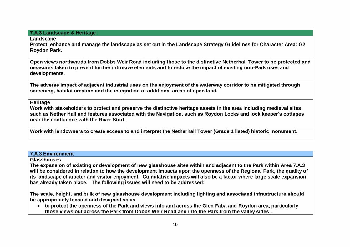
19
7.A.3 Landscape & Heritage
Landscape Protect, enhance and manage the landscape as set out in the Landscape Strategy Guidelines for Character Area: G2 Roydon Park.
Open views northwards from Dobbs Weir Road including those to the distinctive Netherhall Tower to be protected and measures taken to prevent further intrusive elements and to reduce the impact of existing non-Park uses and developments.
The adverse impact of adjacent industrial uses on the enjoyment of the waterway corridor to be mitigated through screening, habitat creation and the integration of additional areas of open land.
Heritage Work with stakeholders to protect and preserve the distinctive heritage assets in the area including medieval sites such as Nether Hall and features associated with the Navigation, such as Roydon Locks and lock keeper’s cottages near the confluence with the River Stort.
Work with landowners to create access to and interpret the Netherhall Tower (Grade 1 listed) historic monument.
7.A.3 Environment
Glasshouses The expansion of existing or development of new glasshouse sites within and adjacent to the Park within Area 7.A.3 will be considered in relation to how the development impacts upon the openness of the Regional Park, the quality of its landscape character and visitor enjoyment. Cumulative impacts will also be a factor where large scale expansion has already taken place. The following issues will need to be addressed: The scale, height, and bulk of new glasshouse development including lighting and associated infrastructure should be appropriately located and designed so as
to protect the openness of the Park and views into and across the Glen Faba and Roydon area, particularly those views out across the Park from Dobbs Weir Road and into the Park from the valley sides .
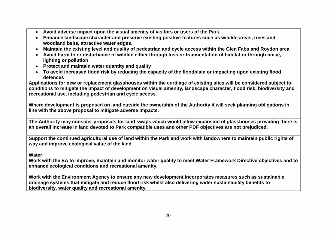
20
Avoid adverse impact upon the visual amenity of visitors or users of the Park
Enhance landscape character and preserve existing positive features such as wildlife areas, trees and woodland belts, attractive water edges.
Maintain the existing level and quality of pedestrian and cycle access within the Glen Faba and Roydon area.
Avoid harm to or disturbance of wildlife either through loss or fragmentation of habitat or through noise, lighting or pollution
Protect and maintain water quantity and quality
To avoid increased flood risk by reducing the capacity of the floodplain or impacting upon existing flood defences
Applications for new or replacement glasshouses within the curtilage of existing sites will be considered subject to conditions to mitigate the impact of development on visual amenity, landscape character, flood risk, biodiversity and recreational use, including pedestrian and cycle access. Where development is proposed on land outside the ownership of the Authority it will seek planning obligations in line with the above proposal to mitigate adverse impacts.
The Authority may consider proposals for land swaps which would allow expansion of glasshouses providing there is an overall increase in land devoted to Park compatible uses and other PDF objectives are not prejudiced.
Support the continued agricultural use of land within the Park and work with landowners to maintain public rights of way and improve ecological value of the land.
Water Work with the EA to improve, maintain and monitor water quality to meet Water Framework Directive objectives and to enhance ecological conditions and recreational amenity. Work with the Environment Agency to ensure any new development incorporates measures such as sustainable drainage systems that mitigate and reduce flood risk whilst also delivering wider sustainability benefits to biodiversity, water quality and recreational amenity.
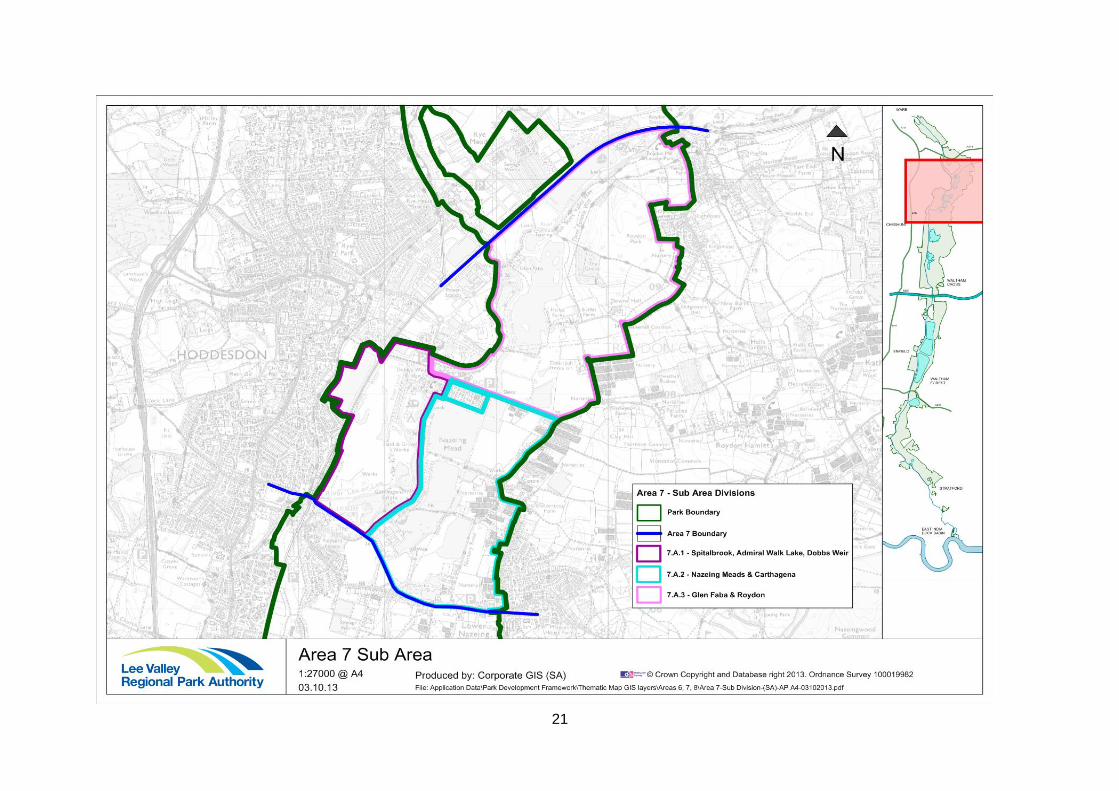
21