Embed Size (px)
Citation preview
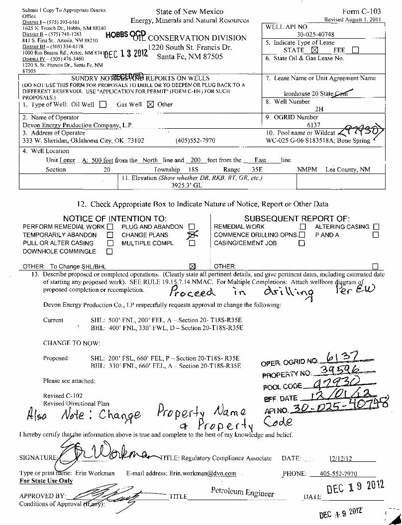
Submit 1 Copy To Appropriate District S ta te o f N e w MeXlCO
District i-{5751393-6I6I Energy, Minerals and Natural Resources 1625 N. French Dr., Hobbs, NM 88240
ESS; £1™,',2™ !!2,o H 0 B B S 9fi? CONSERVATION D.VISION
District iii-(505) 334-6178 „ n J , J220 South St. Francis Dr. 1000 Rio Brazos Rd., Aztec, NM 87410 CP 1 Q 9Q17 A r- . , , . 0 „ , f t .
District iv -(505) 476-3460 o t l 1 * tuic Santa Fe, NM 87505 1220 S. St. Francis Dr., Santa Fe, NM 87505
Form C-103 Revised August 1, 2011
Submit 1 Copy To Appropriate District S ta te o f N e w MeXlCO
District i-{5751393-6I6I Energy, Minerals and Natural Resources 1625 N. French Dr., Hobbs, NM 88240
ESS; £1™,',2™ !!2,o H 0 B B S 9fi? CONSERVATION D.VISION
District iii-(505) 334-6178 „ n J , J220 South St. Francis Dr. 1000 Rio Brazos Rd., Aztec, NM 87410 CP 1 Q 9Q17 A r- . , , . 0 „ , f t .
District iv -(505) 476-3460 o t l 1 * tuic Santa Fe, NM 87505 1220 S. St. Francis Dr., Santa Fe, NM 87505
WELL API NO. 30-025-40748
Submit 1 Copy To Appropriate District S ta te o f N e w MeXlCO
District i-{5751393-6I6I Energy, Minerals and Natural Resources 1625 N. French Dr., Hobbs, NM 88240
ESS; £1™,',2™ !!2,o H 0 B B S 9fi? CONSERVATION D.VISION
District iii-(505) 334-6178 „ n J , J220 South St. Francis Dr. 1000 Rio Brazos Rd., Aztec, NM 87410 CP 1 Q 9Q17 A r- . , , . 0 „ , f t .
District iv -(505) 476-3460 o t l 1 * tuic Santa Fe, NM 87505 1220 S. St. Francis Dr., Santa Fe, NM 87505
5. Indicate Type of Lease STATE |3 FEE •
Submit 1 Copy To Appropriate District S ta te o f N e w MeXlCO
District i-{5751393-6I6I Energy, Minerals and Natural Resources 1625 N. French Dr., Hobbs, NM 88240
ESS; £1™,',2™ !!2,o H 0 B B S 9fi? CONSERVATION D.VISION
District iii-(505) 334-6178 „ n J , J220 South St. Francis Dr. 1000 Rio Brazos Rd., Aztec, NM 87410 CP 1 Q 9Q17 A r- . , , . 0 „ , f t .
District iv -(505) 476-3460 o t l 1 * tuic Santa Fe, NM 87505 1220 S. St. Francis Dr., Santa Fe, NM 87505
6. State Oil & Gas Lease No.
SUNDRY N O l 8 E ^ f a » REPORTS ON WELLS (DO NOT USE THIS FORM FOR PROPOSALS TO DRILL OR TO DEEPEN OR PLUG BACK TO A DIFFERENT RESERVOIR. USE "APPLICATION FOR PERMIT" (FORM C-101) FOR SUCH PROPOSALS.)
1. Type of Well: Oil Well • Gas Well ^ Other
7. Lease Name or Unit Agreement Name
Ironhouse 20 State^Cerff'̂
SUNDRY N O l 8 E ^ f a » REPORTS ON WELLS (DO NOT USE THIS FORM FOR PROPOSALS TO DRILL OR TO DEEPEN OR PLUG BACK TO A DIFFERENT RESERVOIR. USE "APPLICATION FOR PERMIT" (FORM C-101) FOR SUCH PROPOSALS.)
1. Type of Well: Oil Well • Gas Well ^ Other 8. Well Number 2H
2. Name of Operator Devon Energy Production Company, L.P.
9. OGRID Number
6137 <7L-ld/2'TVN, 3. Address of Operator 333 W. Sheridan, Oklahoma City, OK 73102 (405)552-7970
10. Pool name or Wildcat <1 *Y V / WC-025 G-06 S183518A; Bone Spring *
4. Well Location Unit Letter A: 500 feet from the North line and 200 feet from the East line
Section 20 Township 18S Range 35E NMPM Lea County, NM 11. Elevation (Show whether DR, RKB, RT, GR, etc.)
3925.3' GL
12. Check Appropriate Box to Indicate Nature of Notice, Report or Other Data
NOTICE OF INTENTION TO: PERFORM REMEDIAL WORK • PLUG AND ABANDON • TEMPORARILY ABANDON • PULL OR ALTER CASING DOWNHOLE COMMINGLE
CHANGE PLANS • MULTIPLE COMPL •
•
OTHER: To Change SHL/BHL El
SUBSEQUENT REPORT OF: REMEDIAL WORK • ALTERING CASING • COMMENCE DRILLING OPNS. • PANDA • CASING/CEMENT JOB •
OTHER: • 13. Describe proposed or completed operations. (Clearly state all pertinent details, and give pertinent dates, including estimated date
of starting any proposed work). SEE RULE 19.15.7.14 NMAC. For Multiple Completions: Attach wellbore diagram of proposed completion or recompletion. P r O C . g _ e ^ "l T\ ^ " " l V \ A i r M ^ ' & r
Devon Energy Production Co., LP respectfully requests approval to change the following:
Current SHL: 500'FNL, 200'FEL, A - Section 20-T18S-R35E BHL: 400'FNL, 330'FWL, D - Section 20-T18S-R35E
CHANGE TO NOW:
Proposed: SHL: 200'FSL, 660'FEL, P - Section 20-T18S-R35E BHL: 330' FNL, 660' FEL, A - Section 20-T18S-R35E
Please see attached:
Revised C-102 Revised Directional Plan r\ t
AW : CKcuyp Prcpzch Mum a I hereby certify thauhe information above is true and complete to the best of my knowledge and belief.
OPER.OGR.IDNa.
BFF. DATE
AR P̂ O.
SIGNATURE ITLE: Regulatory Compliance Associate DATE: 12/12/12
Type or print name: Erin Workman For State Use Only
APPROVED BY: Conditions of Approval fff^etTy):
E-mail address: Erin.workman(a),dvn.com . PHONE: 405-552-7970
Petroleum Engineer TITLE DATE DEC 9 20U
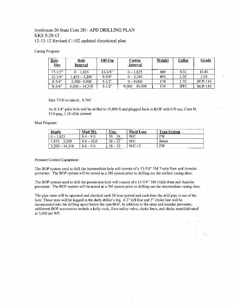
Ironhouse 20 State Com 2H- APD DRILLING PLAN KKS 5-28-12
12-12-12 Revised C-102 updated directional plan
Casing Program Hole
Size Hole
Interval OD Cse Casing
Interval Weight Collar Grade
17-1/2" 0-1,825 13-3/8" 0-1,825 48# STC H-40 12-1/4" 1,825-3,200 9-5/8" 0 - 3,200 40# LTC J-55 8-3/4" 3,200- 9,000 5-1/2" 0 - 9,000 17# LTC HCP-110 8-3/4" 9,000- 14,318 5-1/2" 9,000- 14,308 17# BTC HCP-110
Max TVD in lateral: 9,795'
An 8-3/4" pilot hole will be drilled to 10,800 ft and plugged back to KOP with 670 sxs, Class H, 15.6 ppg, 1.18 cf/sk cement
Mud Program:
Depth Mud Wt. Vise. Fluid Loss Type System 0-1,825 8.4-9.0 30-34 N/C FW 1,825-3,200 9.6-10.0 28-32 N/C Brine 3,200- 14,318 8.6-9.0 28-32 N/C-12 FW
Pressure Control Equipment:
The BOP system used to drill the intermediate hole will consist of a 13-5/8" 3M Triple Ram and Annular preventer. The BOP system will be tested as a 3M system prior to drilling out the surface casing shoe.
The BOP system used to drill the production hole will consist of a 13-5/8" 3M Triple Ram and Annular preventer. The BOP system will be tested as a 3M system prior to drilling out the intermediate casing shoe.
The pipe rams will be operated and checked each 24 hour period and each time the drill pipe is out of the hole. These tests will be logged in the daily driller's log. A 2" kill line and 3" choke line will be incorporated into the drilling spool below the ram BOP. In addition to the rams and annular preventer, additional BOP accessories include a kelly cock, floor safety valve, choke lines, and choke manifold rated at 3,000 psi WP.
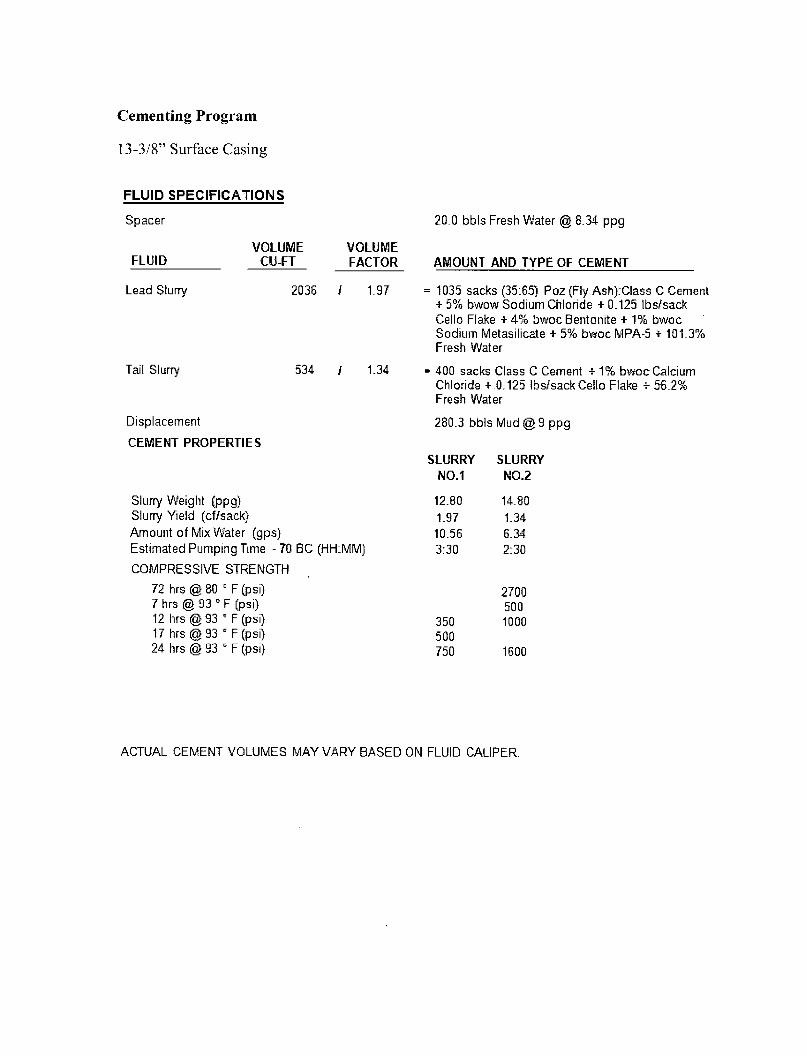
Cementing Program
13-3/8" Surface Casing
FLUID SPECIF ICAT IONS
Spacer
VOLUME VOLUME FLUID CU-FT FACTOR
Lead Slurry 2036 / 1.97
Tail Slurry 534 / 1.34
Displacement
CEMENT PROPERTIES
Slurry Weight (ppg) Slurry Yield (cf/sack) Amount of Mix Water (gps) Estimated Pumping Time - 70 BC (HH:MM)
COMPRESSIVE STRENGTH
72 hrs @ 80 " F (psi) 7 hrs @ 93 " F (psi) 12 hrs @ 93 * F (psi) 17 hrs @ 93 ° F (psi) 24 hrs @ 93 * F (psi)
20.0 bbls Fresh Water @ 8.34 ppg
AMOUNT AND TYPE OF CEMENT
= 1035 sacks (35:65) Poz (Fly Ash):Class C Cement + 5% bwow Sodium Chloride + 0.125 lbs/sack Cello Flake + 4% bwoc Bentonite + 1% bwoc Sodium Metasilicate + 5% bwoc MPA-5 + 101.3% Fresh Water
= 400 sacks Class C Cement + 1% bwoc Calcium Chloride +.0.125 lbs/sack Cello Flake + 56.2% Fresh Water
280.3 bbls Mud @ 9 ppg
SLURRY SLURRY NO.1 NO.2
12.80 14.80 1.97 1.34 10.56 6.34 3:30 2:30
2700 500
350 1000 500 750 1600
ACTUAL CEMENT VOLUMES MAY VARY BASED ON FLUID CALIPER.
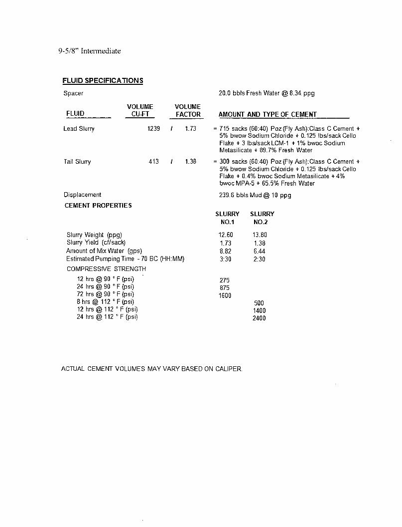
9-5/8" Intermediate
FLUID S P E C I F I C A T I O N S
Spacer
FLUID VOLUME
CU-FT VOLUME FACTOR
Lead Slurry
Tail Slurry
1239 / 1.73
413 / 1.38
Displacement
CEMENT PROPERTIES
Slurry Weight (ppg) Slurry Yield (cf/sack) Amount of Mix Water (gps) Estimated Pumping Time -70 BC (HHiMM)
COMPRESSIVE STRENGTH
12 hrs @ 90 0 F (psi) 24 hrs @ 90 E F (psi) 72 hrs @ 90 * F (psi) 8 hrs @ 112 c F(ps i ) 12 hrs @ 112 0 'F (psi) 24 hrs @ 112 c F (psi)
20.0 bbls Fresh Water @ 8.34. ppg
AMOUNT AND TYPE OF CEMENT
•• 715 sacks (60:40) Poz (Fly Ash)-Class C Cement + 5% bwow Sodium Chloride + 0.125 lbs/sack Cello Flake + 3 lbs/sack LCM-1 + 1% bwoc Sodium Metasilicate + 89.7% Fresh Water
: 300 sacks (60:40) Poz (Fly Ash): Class C Cement + 5% bwow Sodium Chloride + 0.125 lbs/sack Cello Flake + 0.4% bwoc Sodium Metasilicate + 4% bwoc MPA-5 + 65.5% Fresh Water
239.6 bbls Mud @ 10 ppg
SLURRY NO.1
12.60 1.73 8.82 3:30
275 875 1600
SLURRY NO.2
13.80 1.38 6.44 2:30
500 1400 2400
ACTUAL CEMENT VOLUMES MAY VARY BASED ON CALIPER.
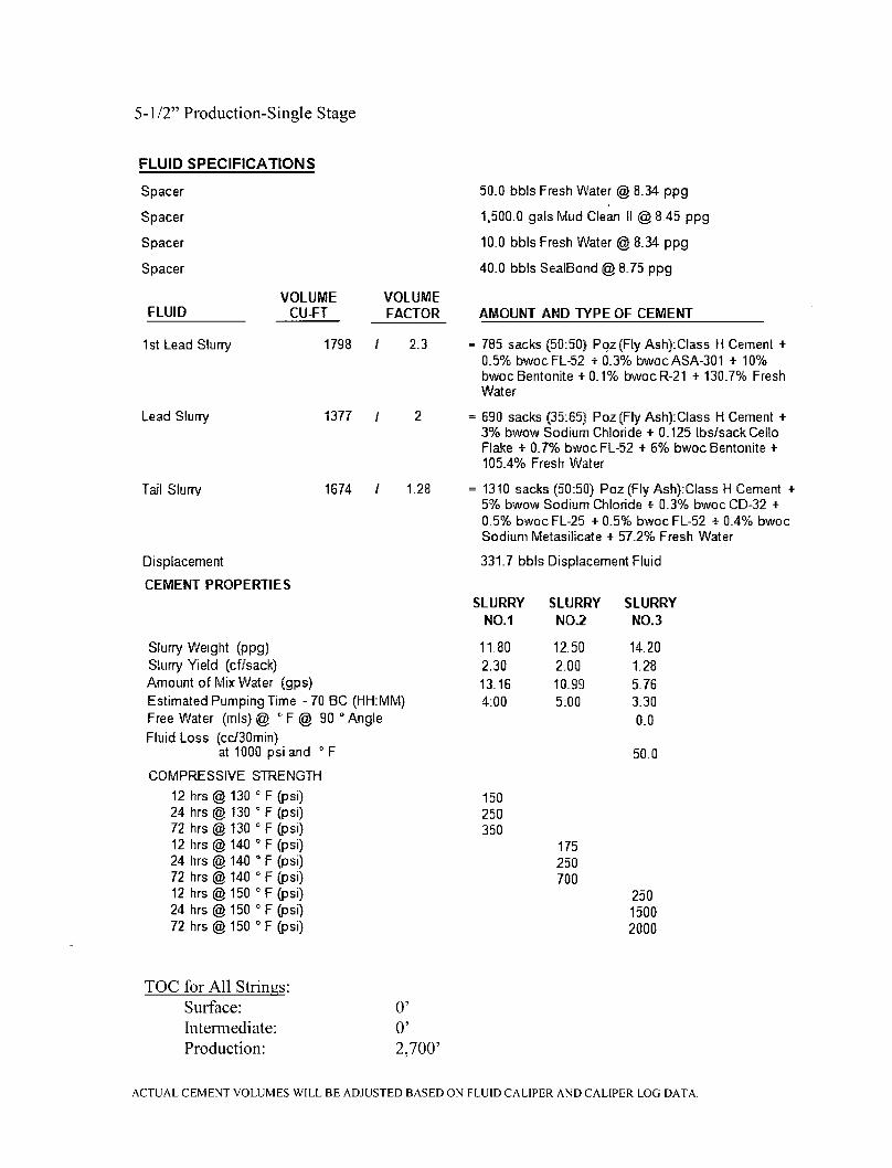
5-1/2" Production-Single Stage
FLUID SPECIF ICAT IONS
Spacer
Spacer
Spacer
Spacer
FLUID VOLUME
CU-FT VOLUME FACTOR
1st Lead Slurry
Lead Slurry
Tail Slurry
1798 / 2.3
1377 / 2
1674 / 1.28
Displacement
CEMENT PROPERTIES
50.0 bbls Fresh Water @ 8.34 ppg
1,500.0 gals Mud Clean II @ 8.45 ppg
10.0 bbls Fresh Water @ 8.34 ppg
40.0 bbls SealBond @ 8.75 ppg
AMOUNT AND TYPE OF CEMENT
= 785 sacks (50:50} Poz (Fly Ash):Class H Cement + 0.5% bwoc FL-52 +0.3% bwoc ASA-301 + 10% bwoc Bentonite + 0.1% bwoc R-21 + 130.7% Fresh Water
= 690 sacks (35:65) Poz (Fly Ash):Class H Cement + 3% bwow Sodium Chloride + 0.125 lbs/sack Cello Flake + 0.7% bwoc FL-52 + 6% bwoc Bentonite + 105.4% Fresh Water
= 1310 sacks (50:50) Poz (Fly Ash):Class H Cement + 5% bwow Sodium Chloride + 0.3% bwoc CD-32 + 0.5% bwoc FL-25 + 0.5% bwoc FL-52 + 0.4% bwoc Sodium Metasilicate + 57.2% Fresh Water
331.7 bbls Displacement Fluid
SLURRY SLURRY SLURRY NO.1 NO.2 NO.3
Slurry Weight (ppg) 11.80 12.50 14.20 Slurry Yield (cf/sack) 2.30 2.00 1.28 Amount of Mix Water (gps) 13.16 10.99 5.76 Estimated Pumping Time - 70 BC (HH:MM) 4:00 5:00 3:30 Free Water (mis) @ " F @ 90 ° Angle 0.0 Fluid Loss (cc/30min)
at 1000 psi and ° F 50.0
COMPRESSIVE STRENGTH
12 hrs @ 130 * F (psi) 150 24 hrs @ 130 "' F (psi) 250 72 hrs @ 130 15 F (psi) 350 12 hrs @ 140 ° F (psi) 175 24 hrs @ 140 0 F (psi) 250 72 hrs @ 140 c F (psi) 700 12 hrs @ 150 D F (psi) 250 24 hrs @ 150 ' F (psi) 1500 72 hrs @ 150 ° F (psi) 2000
TOC for All Strings: Surface: 0' Intermediate: 0' Production: 2,700'
ACTUAL CEMENT VOLUMES WILL BE ADJUSTED BASED ON FLUID CALIPER AND CALIPER LOG DATA.
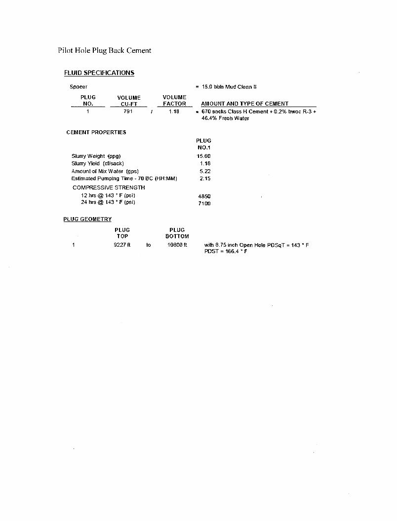
Pilot Hole Plug Back Cement
FLUID SPECIFICATIONS
Spacer
PLUG NO.
VOLUME CU-FT 791
VOLUME FACTOR
1.18
= 15.0 bbls Mud Clean 11
AMOUNT AMD TYPE OF CEMENT 670 sacks Class H Cement + 0.2% bwoc R-3 + 46.4% FresiiWater
CEMENT PROPERTIES
Slurry Weight (ppg) Slurry Yield (cf/sack)
Amount of Mix Water (gps) Estimated Pumping Time - 70 BC (HH:MM)
COMPRESSIVE STRENGTH 12 hrs @ 143 * F (psi) 24 hrs @ 143 ' F (psi)
PLUG NO.1
15.60 1.18 S..22 2:15
48SQ 7100
PLUG GEOMETRY
PLUG PLUG TOP BOTTOM
9227 ft to 1O80O ft with 8.75 inch Open Hole PDSqT = 143 ° F POST = 166.4 ' F
DEVON ENERGY Project: Lea County, NM (NAD-83)
Site: Ironhouse "20" State Well: 2H
Wellbore: OH Design: Plan #1
Azimuths to Grid North True North: -0.47"
Magnetic North: 6.93°
Magnetic Field Strength: 48776.3snT
Dip Angle: 60.63° Date: 12/12/2012
Model: IGRF2010
Section Lines 9427
won 330' Hard Line
PBHL(I20S #2)
DESIGN TARGET DETAILS
Name SHL(I20S #2) PBHL(I20S #2)
TVD 0.00
9427.00
+N/-S 0.00
4750.44
+E/-W 0.00
-57.78
Northing 629096.91 633847.35
Easting 805858.91 805801.13
Latitude 32" 43' 35.312 N 32° 44' 22.319 N
Longitude 103° 28' 23.404 W 103° 28' 23.629 W
SECTION DETAILS
Sec MD Inc Azi TVD +N/-S + E/-W Dleg TFace VSect Annotation 1 0.00 0.00 0.00 0.00 0.00 0.00 0.00 0.00 0.00 2 9224.31 0.00 0.00 9224.31 0.00 0.00 0.00 0.00 0.00 KOP: Start DLS 10.00 TFO 359.30 3 10175.27 95.10 359.30 9795.00 623.80 -7.59 10.00 359.30 623.85 EOC: Start 4143.32 hold at 10175.27 MD 4 14318.59 95.10 359.30 9427.00 4750.44 -57.78 0.00 0.00 4750.79 TD at 14318.59' MD
EOC: Start 4143.32 hold at 10175.27 MD
KOP: Start DLS 10.00 TFO 359.30
9000-
a> 9500 — Q
Si 10000 —
10500-
9427
-5000
— 4500
—4000
SHL(I20S #2)
KOP: Start DLS 10.00 TFO 359.30
EOC: Start 4143.32 hold at 10175.27 MD
ITD at 14318.59' MD
RBHL(I20S #2)
| I I I I [ I I I I | I I I I ] I I T
-2000 -1500 -1000 -500
—3000
— 2500
—2000
— 1000
-500
—0
| I I I I | I I I I
0 500 1000
West(-)/East(+) (1000 usft/in)
624 4751 | I I I I | I I I I | I I I I | I I I I | I I I I [ I I I I | I I I I | I I I I | I I I I | I I I I | I I I I | I I I I |
0 500 1000 1500 2000 2500 3000 3500 4000 4500 5000 5500 6000
Vertical Section at 359.31° (1000 usft/in)
LEAN! DRILLING SYSTEMS LLC p l a n p l a n m ( 2 H , 0 H )
Ironhouse "20' State Date: 15:43, December 12 2012
— — _ Date: umm-jsy^uc Phone: 936/756-7577, Fax 936/756-7595 Approved: L E A M 2010 East Davis, Conroe, Texas 77301 C r e a "^ w ca-is0n
LEAM Drilling Systems LLC Planning Report
Database: Company:
Project:
Site: Well: Wellbore: Design:
', EDM 5000.1 Single User Db ; DEVON ENERGY
; Lea County, NM (NAD-83)
i Ironhouse "20" State i 2H !0H • Plan #1
' Local Co-ordinate Reference: ' TVD Reference:
• MD Reference:
: North Reference: : Survey Calculation Method:
: Well 2H , GE: 3928' + KB: 18' @ 3946.OOusft (McVay : #8) i GE: 3928' + KB: 18' @ 3946.OOusft (McVay i #8) .
i Grid Minimum Curvature
Project Lea County, NM (NAD-83)
Map System: US State Plane 1983 System Datum: Mean Sea Level Geo Datum: North American Datum 1983 Map Zone: New Mexico Eastern Zone
Site Ironhouse "20" State ZZZZZZ.* " Z Z Z1ZZZZ1Z7" ~Z-Site Posit ion:
From:
Posit ion Uncertainty:
Map
0.00 usft
Northing:
Easting:
Slot Radius:
629,096.41 usft
804,539.12 usft
13-3/16"
Latitude:
Longitude:
Grid Convergence:
32° 43' 35.413 N
103° 28' 38.853 W
0.46 °
Well <2H.; ..zi" z i z Well Posit ion
Posit ion Uncertainty
+N/-S 0.50 usft
+E/-W 1,319.79 usft
0.00 usft
Northing:
Easting:
Wellhead Elevation:
629,096.91 usft Latitude:
805,858.91 usft Longitude:
Ground Level:
32° 43' 35.312 N
103° 28' 23.404 W
3,928.00 usft
Wellbore ' OH
Magnetics Model Name Sample Date Declination Dip Angle Field Strength n n (nT)
IGRF2010 12/12/12 7.39 60.63 48,776
Design _Plan#1_ ; z z z z z" z.in zzrz z Z Z Z Z Z Z Z Z . Z ] Audit Notes:
Version: Phase: PLAN Tie On Depth: 0.00
Vertical Section: Depth From (TVD) +N/-S +E/-W Direction (usft) (usft) (usft) , O
0.00 0.00 0.00 359.31
Plan Sections ; ... . _ . „ . _ _ 1 .ZZ „ . _ :zzzz zzzz. ZZZZ.'.' zzz^zzz, zzz Measured
Depth
(usft) Inclination
O Azimuth
n
Vertical
Depth
(usft) +N/-S
(usft)
+E/-W
(usft)
Dogleg
Rate
P100usf t )
Bui ld
Rate
OOusft)
Turn
Rate
(°/100usft) TFO
(°) Target
0.00 0.00 . 0.00 0.00 0.00 0.00 0.00 0.00 0.00 0.00
9,224.31 0.00 0.00- 9,224.31 0.00 0.00 0.00 0.00 0.00 0.00
10,175.27 95.10 359.30 9,795.00 623.80 -7.59 10.00 10.00 -0.07 359.30
14,318.59 95.10 359.30 9,427.00 4,750.44 -57.78 0.00 0.00 0.00 0.00 PBHL(I20S#2)
12/12/12 3:44:14PM Page 1 COMPASS 5000.1 Build 56
LEAM Drilling Systems L L C Planning Report
Database: 1 EDM 5000.1 Single User Db 1 Local Co-ordinate Reference: ! Well 2H
Company: ; DEVON ENERGY TVD Reference: ! GE: 3928' + KB: 18' @ 3946.00usft (McVay #8)
Project: ; Lea County, NM (NAD-83) MD Reference: • GE: 3928' + KB: 18' @ 3946.OOusft (McVay ; #8)
Site: Ironhouse "20" State North Reference: : Grid
Well: 2H Survey Calculation Method: Minimum Curvature
Wellbore: OH
Design: Plan #1
Planned Survey .. ...... .
-- • ~ - - - • . - . . . . . . . . - - - '
Measured Vertical Vertical Dogleg Build Turn
Depth Inclination Azimuth Depth +N/-S +E/-W Section Rate Rate Rate
(usft) (°) n (usft) (usft) (usft) (usft) (°/1 OOusft) (°/1 OOusft) (°/100usft)
0.00 0.00 0.00 0.00 0.00 0.00 0.00 0.00 0.00 0.00
100.00 0.00 0.00 100.00 0.00 0.00 0.00 0.00 0.00 0.00
200.00 0.00 0.00 200.00 0.00 0.00 0.00 0.00 0.00 0.00
300.00 0.00 0.00 300.00 0.00 0.00 0.00 0.00 0.00 0.00
400.00 0.00 0.00 400.00 0.00 0.00 0.00 0.00 0.00 0.00
500.00 0.00 0.00 500.00 0.00 0.00 0.00 0.00 0.00 0.00
600.00 0.00 0.00 600.00 0.00 0.00 0.00 0.00 0.00 0.00
700.00 0.00 0.00 700.00 0.00 0.00 0.00 0.00 0.00 0.00
800.00 0.00 0.00 800.00 0.00 0.00 0.00 0.00 0.00 0.00
900.00 0.00 0.00 900.00 0.00 0.00 0.00 0.00 0.00 0.00
1,000.00 0.00 0.00 1,000.00 0.00 0.00 0.00 0.00 0.00 0.00
1,100.00 0.00 0.00 1,100.00 0.00 0.00 0.00 0.00 0.00 0.00
1,200.00 0.00 0.00 1,200.00 0.00 0.00 0.00 0.00 0.00 0.00
1,300.00 0.00 0.00 1,300.00 0.00 0.00 0.00 0.00 0.00 0.00
1,400.00 0.00 0.00 1,400.00 0.00 0.00 0.00 0.00 0.00 0.00
1,500.00 0.00 0.00 1,500.00 0.00 0.00 0.00 0.00 0.00 0.00
1,600.00 0.00 0.00 1,600.00 0.00 0.00 0.00 0.00 0.00 0.00
1,700.00 0.00 0.00 1,700.00 0.00 0.00 0.00 0.00 0.00 0.00
1,800.00 0.00 0.00 1,800.00 0.00 0.00 0.00 0.00 0.00 0.00
1,900.00 0.00 0.00 1,900.00 0.00 0.00 0.00 0.00 0.00 0.00
2,000.00 0.00 0.00 2,000.00 0.00 0.00 0.00 0.00 0.00 0.00
2,100.00 0.00 0.00 2,100.00 0.00 0.00 0.00 0.00 0.00 0.00
2,200.00 0.00 0.00 2,200.00 0.00 0.00 0.00 0.00 0.00 0.00
2,300.00 0.00 0.00 2,300.00 0.00 0.00 0.00 0.00 0.00 0.00
2,400.00 0.00 0.00 2,400.00 0.00 0.00 0.00 0.00 0.00 0.00
2,500.00 0.00 0.00 2,500.00 0.00 0.00 0.00 0.00 0.00 0.00 2,600.00 0.00 0.00 2,600.00 0.00 0.00 0.00 0.00 0.00 0.00 2,700.00 0.00 0.00 2,700.00 0.00 0.00 0.00 0.00 0.00 0.00
2,800.00 0.00 0.00 2,800.00 0.00 0.00 0.00 0.00 0.00 0.00 2,900.00 0.00 0.00 2,900.00 0.00 0.00 0.00 0.00 0.00 0.00
3,000.00 0.00 0.00 3,000.00 0,00 0.00 0.00 0.00 0.00 0.00 3,100.00 0.00 0.00 3,100.00 0.00 0.00 0.00 0.00 0.00 0.00 3,200.00 0.00 0.00 3,200.00 0.00 0.00 0.00 0.00 0.00 0.00 3,300.00 0.00 0.00 3,300.00 0.00 0.00 0.00 0.00 0.00 0.00 3,400.00 0.00 0.00 3,400.00 0.00 0.00 0.00 0.00 0.00 0.00
3,500.00 0.00 0.00 3,500.00 0.00 0.00 0.00 0.00 0.00 0.00 3,600.00 0.00 0.00 3,600.00 0.00 0.00 0.00 0.00 0.00 0.00 3,700.00 0.00 0.00 3,700.00 0.00 0.00 0.00 0.00 0.00 0.00 3,800.00 0.00 0.00 3,800.00 0.00 0.00 0.00 0.00 0.00 0.00 3,900.00 0.00 0.00 3,900.00 0.00 0.00 0.00 0.00 0.00 0.00
4,000.00 0.00 0.00 4,000.00 0.00 0.00 0.00 0.00 0.00 0.00 4,100.00 0.00 0.00 4,100.00 0.00 0.00 0.00 0.00 0.00 0.00 4,200.00 0.00 0.00 4,200.00 0.00 0.00 0.00 0.00 0.00 0.00 4,300.00 0.00 0.00 4,300.00 0.00 0.00 0.00 0.00 0.00 0.00 4,400.00 0.00 0.00 4,400.00 0.00 0.00 0.00 0.00 0.00 0.00
4,500.00 0.00 0.00 4,500.00 0.00 0.00 0.00 0.00 0.00 0.00 4,600.00 0.00 0.00 4,600.00 0.00 0.00 0.00 0.00 0.00 0.00 4,700.00 0.00 0.00 4,700.00 0.00 0.00 0.00 0.00 0.00 0.00 4,800.00 0.00 0.00 4,800.00 0.00 0.00 0.00 0.00 0.00 0.00 4,900.00 0.00 0.00 4,900.00 0.00 0.00 0.00 0.00 0.00 0.00
5,000.00 0.00 0.00 5,000.00 0.00 0.00 0.00 0.00 0.00 0.00 5,100.00 0.00 0.00 5,100.00 0.00 0.00 0.00 0.00 0.00 0.00
12/12/12 3:44:14PM Page 2 COMPASS 5000.1 Build 56
LEAM Drilling Systems LLC Planning Report
Database: Company:
Project:
Site:
Well:
Wellbore:
Design:
. EDM 5000.1 Single User Db DEVON ENERGY
Lea County, NM (NAD-83)
Ironhouse "20" State
2H
OH
Plan #1
Local Co-ordinate Reference:
TVD Reference:
MD Reference:
, North Reference:
Survey Calculation Method:
Well 2H
GE: 3928' + KB: 18' @ 3946.OOusft (McVay #8)
GE: 3928' + KB: 18' @ 3946.OOusft (McVay
#8)
Grid
Minimum Curvature
Planned Survey
Measured Vertical Vertical Dogleg Build Turn
Depth Inclination Azimuth Depth +N/-S +E/-W Section Rate Rate Rate
(usft) n n (usft) (usft) (usft) (usft) P 1 OOusft) P100usf t ) (°/1 OOusft)
5,200.00 0.00 0.00 5,200.00 0.00 0.00 0.00 0.00 0.00 0.00 5,300.00 0.00 0.00 5,300.00 0.00 0.00 0.00 0.00 0.00 0.00
5,400.00 0.00 0.00 5,400.00 0.00 0.00 0.00 0.00 0.00 0.00
5,500.00 0.00 0.00 5,500.00 0.00 0.00 0.00 0.00 0.00 0.00 5,600.00 0.00 0.00 5,600.00 0.00 0.00 0.00 0.00 0.00 0.00
5,700.00 0.00 0.00 5,700.00 0.00 0.00 0.00 0.00 0.00 0.00
5,800.00 0.00 0.00 5,800.00 0.00 0.00 0.00 0.00 0.00 0.00
5,900.00 0.00 0.00 5,900.00 0.00 0.00 0.00 0.00 0.00 0.00
6,000.00 0.00 0.00 6,000.00 0.00 0.00 0.00 0.00 0.00 0.00
6,100.00 0.00 0.00 6,100.00 0.00 0.00 0.00 0.00 0.00 0.00 6,200.00 0.00 0.00 6,200.00 0.00 0.00 0.00 0.00 0.00 0.00
6,300.00 0.00 0.00 6,300.00 0.00 0.00 0.00 0.00 0.00 0.00 6,400.00 0.00 0.00 6,400.00 0.00 0.00 0.00 0.00 0.00 0.00
6,500.00 0.00 0.00 6,500.00 0.00 0.00 0.00 0.00 0.00 0.00 6,600.00 0.00 0.00 6,600.00 0.00 0.00 0.00 0.00 0.00 0.00 6,700.00 0.00 0.00 6,700.00 0.00 0.00 0.00 0.00 0.00 0.00 6,800.00 0.00 0.00 6,800.00 0.00 0.00 0.00 0.00 0.00 0.00 6,900.00 0.00 0.00 6,900.00 0.00 0.00 0.00 0.00 0.00 0.00
7,000.00 0.00 0.00 7,000.00 0.00 0.00 0.00 0.00 0.00 0.00 7,100.00 0.00 0.00 7,100.00 0.00 0.00 0.00 0.00 0.00 0.00 7,200.00 0.00 0.00 7,200.00 0.00 0.00 0.00 0.00 0.00 0.00 7,300.00 0.00 0.00 7,300.00 0.00 0.00 0.00 0.00 0.00 0.00 7,400.00 0.00 0.00 7,400.00 0.00 0.00 0.00 0.00 0.00 0.00
7,500.00 0.00 0.00 7,500.00 0.00 0.00 0.00 0.00 0.00 0.00 7,600.00 0.00 0.00 7,600.00 0.00 0.00 0.00 0.00 0.00 0.00 7,700.00 0.00 0.00 7,700.00 0.00 0.00 0.00 0.00 0.00 0.00 7,800.00 0.00 0.00 7,800.00 0.00 0.00 0.00 0.00 0.00 0.00 7,900.00 0.00 0.00 7,900.00 0.00 0.00 0.00 0.00 0.00 0.00
8,000.00 0.00 0.00 8,000.00 0.00 0.00 0.00 0.00 0.00 0.00 8,100.00 0.00 0.00 8,100.00 0.00 0.00 0.00 0.00 0.00 0.00 8,200.00 0.00 0.00 8,200.00 0.00 0.00 0.00 0.00 0.00 0.00 8,300.00 0.00 0.00 8,300.00 0.00 0.00 0.00 0.00 0.00 0.00 8,400.00 0.00 0.00 8,400.00 0.00 0.00 0.00 0.00 0.00 0.00
8,500.00 0.00 0.00 8,500.00 0.00 0.00 0.00 0.00 0.00 0.00 8,600.00 0.00 0.00 8,600.00 0.00 0.00 0.00 0.00 0.00 0.00 8,700.00 0.00 0.00 8,700.00 0.00 0.00 0.00 0.00 0.00 0.00 8,800.00 0.00 0.00 8,800.00 0.00 0.00 0.00 0.00 0.00 0.00 8,900.00 0.00 0.00 8,900.00 0.00 0.00 0.00 0.00 0.00 0.00
9,000.00 0.00 0.00 9,000.00 0.00 0.00 0.00 0.00 0.00 0.00 9,100.00 0.00 0.00 9,100.00 0.00 0.00 0.00 0.00 0.00 0.00 9,200.00 0.00 0.00 9,200.00 0.00 0.00 0.00 0.00 0.00 0.00 9,224.31 0.00 0.00 9,224.31 0.00 0.00 0.00 0.00 0.00 0.00
KOP: Start DLS 10.00 TFO 359.30
9,250.00 2.57 359.30 9,249.99 0.58 -0.01 0.58 10.00 10.00 0.00
9,300.00 7.57 359.30 9,299.78 4.99 -0.06 4.99 10.00 10.00 0.00 9,350.00 12.57 359.30 9,348.99 13.73 -0.17 13.73 10.00 10.00 0.00 9,400.00 17.57 359.30 9,397.26 26.72 -0.33 26.73 10.00 10.00 0.00 9,450.00 22.57 359.30 9,444.21 43.88 -0.53 43.88 10.00 10.00 0.00 9,500.00 27.57 359.30 9,489.48 65.05 -0.79 65.06 10.00 10.00 0.00
9,550.00 32.57 359.30 9,532.74 90.09 -1.10 90.10 10.00 10.00 0.00 9,600.00 37.57 359.30 9,573.65 118.81 -1.45 118.82 10.00 10.00 0.00 9,650.00 42.57 359.30 9,611.90 150.98 -1.84 151.00 10.00 10.00 0.00
12/12/12 3:44:14PM Page 3 COMPASS 5000.1 Build 56
LEAM Drilling Systems LLC Planning Report
Database: Company:
Project:
Site:
Well:
Wellbore:
Design:
; EDM 5000.1 Single User Db ; DEVON ENERGY
\ Lea County, NM (NAD-83)
Ironhouse "20" State
2H
OH
i Plan #1
' Local Co-ordinate Reference:
; TVD Reference:
MD Reference:
North Reference:
Survey Calculation Method:
Well 2H
GE: 3928' + KB: 18' @ 3946.OOusft (McVay #8)
GE: 3928' + KB: 18' @ 3946.00usft (McVay
#8)
Grid
Minimum Curvature
Planned Survey
Measured Vertical Vertical Dogleg Build Turn
Depth Inclination Azimuth Depth +N/-S +E/-W Section Rate Rate Rate
(usft) (°) (°) (usft) (usft) (usft) (usft) (°/100usft) fVIOOusft) ("/lOOusft)
9,700.00 47.57 359.30 9,647.20 186.37 -2.27 186.38 10.00 10.00 0.00 9,750.00 52.57 359.30 9,679.29 224.69 -2.73 224.71 10.00 10.00 0.00
9,800.00 57.57 359.30 9,707.91 265.67 -3.23 265.69 10.00 10.00 0.00
9,850.00 62.57 359.30 9,732.85 308.98 -3.76 309.01 10.00 10.00 0.00 9,900.00 67.57 359.30 9,753.92 354.31 -4.31 354.33 10.00 10.00 0.00
9,950.00 72.57 359.30 9,770.96 401.29 -4.88 401.32 10.00 10.00 0.00
10,000.00 77.57 359.30 9,783.84 449.59 -5.47 449.62 10.00 10.00 0.00
10,050.00 82.57 359.30 9,792.46 498.82 -6.07 498.86 10.00 10.00 0.00 10,100.00 87.57 359.30 9,796.75 548.61 -6.67 548.66 10.00 10.00 0.00
10,150.00 92.57 359.30 9,796.69 598.59 -7.28 598.64 10.00 10.00 0.00 10,175.27 95.10 359.30 9,795.00 623.80 -7.59 623.85 10.00 10.00 0.00
EOC: Start 4143.32 hold at 10175.27 MD
10,200.00 95.10 359.30 9,792.81 648.43 -7.89 648.48 0.00 0.00 0.00
10,300.00 95.10 359.30 9,783.92 748.03 -9.10 748.09 0.00 0.00 0.00 10,400.00 95.10 359.30 9,775.04 847.63 -10.31 847.69 0.00 0.00 0.00 10,500.00 95.10 359.30 9,766.16 947.23 -11.52 947.30 0.00 0.00 0.00 10,600.00 95.10 359.30 9,757.28 1,046.82 -12.73 1,046.90 0.00 0.00 0.00 10,700.00 95.10 359.30 9,748.40 1,146.42 -13.94 1,146.51 0.00 0.00 0.00
10,800.00 95.10 359.30 9,739.52 1,246.02 -15.16 1,246.11 0.00 0.00 0.00 10,900.00 95.10 359.30 9,730.63 1,345.62 -16.37 1,345.72 0.00 0.00 0.00 11,000.00 95.10 359.30 9,721.75 1,445.21 -17.58 1,445.32 0.00 0.00 0.00 11,100.00 95.10 359.30 9,712.87 1,544.81 -18.79 1,544.93 0.00 0.00 0.00 11,200.00 95.10 359.30 9,703.99 1,644.41 -20.00 1,644.53 0.00 0.00 0.00
11,300.00 95.10 359.30 9,695.11 1,744.01 -21.21 1,744.14 0.00 0.00 0.00 11,400.00 95.10 359.30 9,686.22 1,843.60 -22.42 1,843.74 0.00 0.00 0.00 11,500.00 95.10 359.30 9,677.34 1,943.20 -23.64 1,943.35 0.00 0.00 0.00 11,600.00 95.10 359.30 9,668.46 2,042.80 -24.85 2,042.95 0.00 0.00 0.00 11,700.00 95.10 359.30 9,659.58 2,142.40 -26.06 2,142.55 0.00 0.00 0.00
11,800.00 95.10 359.30 9,650.70 2,241.99 -27.27 2,242.16 0.00 0.00 0.00 11,900.00 95.10 359.30 9,641.82 2,341.59 -28.48 2,341.76 0.00 0.00 0.00 12,000.00 95.10 359.30 9,632.93 2,441.19 -2969 2,441.37 0.00 0.00 0.00 12,100.00 95.10 359.30 9,624.05 2,540.79 -30.90 2,540.97 0.00 0.00 0.00 12,200.00 95.10 359.30 9,615.17 2,640.38 -32.12 2,640.58 0.00 0.00 0.00
12,300.00 95.10 359.30 9,606.29 2,739.98 -33.33 2,740.18 0.00 0.00 0.00 12,400.00 95.10 359.30 9,597.41 2,839.58 -34.54 2,839.79 0.00 0.00 0.00 12,500.00 95.10 359.30 9,588.52 2,939.18 -35.75 2,939.39 0.00 0.00 0.00 12,600.00 95.10 359.30 9,579.64 3,038.77 -36.96 3,039.00 0.00 0.00 0.00 12,700.00 95.10 359.30 9,570.76 3,138.37 -38.17 3,138.60 0.00 0.00 0.00
12,800.00 95.10 359.30 9,561.88 3,237.97 -39.38 3,238.21 0.00 0.00 0.00 12,900.00 95.10 359.30 9,553.00 3,337.57 -40.60 3,337.81 o'.oo 0.00 0.00 13,000.00 95.10 359.30 9,544.12 3,437.16 -41.81 3,437.42 0.00 0.00 0.00 13,100.00 95.10 359.30 9,535.23 3,536.76 -43.02 3,537.02 0.00 0.00 0.00 13,200.00 95.10 359.30 9,526.35 3,636.36 -44.23 3,636.63 0.00 0.00 0.00
13,300.00 95.10 359.30 9,517.47 3,735.95 -45.44 3,736.23 0.00 0.00 0.00 13,400.00 95.10 359.30 9,508.59 3,835.55 -46.65 3,835.84 0.00 0.00 0.00 13,500.00 95.10 359.30 9,499.71 3,935.15 -47.86 3,935.44 0.00 0.00 0.00 13,600.00 95.10 359.30 9,490.82 4,034.75 -49.07 4,035.05 0.00 0.00 0.00 13,700.00 95.10 359.30 9,481.94 4,134.34 -50.29 4,134.65 0.00 0.00 0.00
13,800.00 95.10 359.30 9,473.06 4,233.94 -51.50 4,234.26 0.00 0.00 0.00 13,900.00 95.10 359.30 9,464.18 4,333.54 -52.71 4,333.86 0.00 0.00 0.00 14,000.00 95.10 359.30 9,455.30 4,433.14 -53.92 4,433.46 0.00 0.00 0.00 14,100.00 95.10 359.30 9,446.41 4,532.73 -55.13 4,533.07 0.00 0.00 0.00
12/12/12 3:44:14PM Page 4 COMPASS 5000.1 Build 56
LEAM Drilling Systems LLC Planning Report
— . . . . „ . ...... ... .- . ... ̂ Database: ; EDM 5000.1 Single User Db ! Local Co-ordinate Reference: ; Well 2H
Company: DEVON ENERGY TVD Reference: ! GE: 3928' + KB: 18' @ 3946.OOusft (McVay
! #8) Project: ; Lea County, NM (NAD-83) • MD Reference: ' GE: 3928' + KB: 18' @ 3946.OOusft (McVay
; s #8)
Site: | Ironhouse "20" State ' North Reference: ' Grid
Well: ;2H Survey Calculation Method: ' Minimum Curvature
Wellbore: IOH ; Design: '. Plan #1 :
Planned Survey
- •• - — . ...... ... - — — — —
Measured Vertical Vertical Dogleg Build Turn
Depth Inclination Azimuth Depth +N/-S +E/-W Section Rate Rate Rate
(usft) n n (usft) (usft) (usft) (usft) P100usf t ) (°/100usft) (°/1 OOusft)
14,200.00 95.10 359.30 9,437.53 4,632 33 -56.34 4,632.67 0.00 0.00 0.00
14,300.00 95.10 359.30 9,428.65 4,731.93 -57.55 4,732.28 0.00 0.00 0.00 14,318.59 95.10 359.30 9,427.00 4,750.44 -57.78 4,750.79 0.00 0.00 0.00
TD at 14318.59'MD
- • -Design Targets - - _ . .. ... - ....... _ - ^ .. ....... . . : Target Name
- hit/miss target
- Shape Dip Angle
O Dip Dir. TVD
(usft)
+N/-S
(usft)
+E/-W
(usft)
Northing
(usft)
Easting
(usft) Latitude Longitude
SHL(I20S #2) 0.00 - plan hits target center - Point
0.00 0.00 0.00 0.00 629,096.91 805,858.91 32° 43' 35.312 N 103° 28' 23.404 W
PBHL(I20S#2) 0.00 - plan hits target center - Point
0.00 9,427.00 4,750.44 -57.78 633,847.35 805,801.13 32° 44' 22.319 N 103° 28' 23.629 W
Plan Annotat ions ' . ......... . . .. ... . i:.''.:z:;::..'.::z;i.z:":.::i: Measured Vertical Local Coordinates
Depth Depth +N/-S +E/-W (usft) (usft) (usft) (usft) Comment
9,224.31 9,224.31 0.00 0.00 KOP: Start DLS 10.00 TFO 359.30 10,175.27 9,795.00 623.80 -7.59 EOC: Start 4143.32 hold at 10175.27 MD 14,318.59 9,427.00 4,750.44 -57.78 TD at 14318.59' MD
12/12/12 3:44:14PM Page 5 COMPASS 5000.1 Build 56