Embed Size (px)
Citation preview
6/29/15 8900.1 CHG 408
1 UNCONTROLLED COPY WHEN DOWNLOADED
Check with FSIMS to verify current version before using
VOLUME 8 GENERAL TECHNICAL FUNCTIONS
CHAPTER 3 MISCELLANEOUS TECHNICAL FUNCTIONS
Section 3 Evaluation and Surveillance of Heliports
8-210 PROGRAM TRACKING AND REPORTING SUBSYSTEM (PTRS) ACTIVITY CODES. Initial evaluation: 1846, 3683, or 5683.
8-211 OBJECTIVE. The objective of this task is to perform a safety evaluation of a proposed or existing heliport. Successful completion of this task results in a completed heliport evaluation report to the Airport District Office (ADO) through the regional Flight Standards division (RFSD) Regional NextGen Branch (RNGB).
8-212 BACKGROUND. The current edition of the Federal Aviation Administration (FAA) Advisory Circular (AC) 150/5390-2, Heliport Design, provides design criteria for heliport owners to help ensure safe helicopter operations. The AC states that heliport design criteria must be met at heliports that receive specific types of Federal funding. The AC provides recommendations at all other heliports where the FAA does not require full compliance with all design criteria. For example, the FAA does not require a private-use prior permission required (PPR) heliport to meet all design criteria, and the owner and any operator that the owner allows to use the heliport have the primary responsibility for ensuring a safe ground operation. However, there are certain States that mandate compliance with the AC in conjunction with certain municipality code criteria that may require AC compliance at a State or local level. If the State, region, or municipality has adopted code criteria from the International Fire Code (IFC), International Building Code (IBC), and/or the National Fire Protection Association (NFPA), AC compliance requires following that criteria. In the case of code assessment as it applies to the heliport under evaluation, the Aeronautics Division of the State’s Department of Transportation and the local municipality’s authority having jurisdiction (AHJ) (e.g., the fire marshal) should be consulted.
A. Notification of Construction or Alteration. Title 14 of the Code of Federal Regulations (14 CFR) part 157 requires heliport proponents to notify the FAA of construction, alteration, or deactivation of almost all permanent heliports (and temporary heliports with specific thresholds for operations and the number of days the heliport will be used).
B. Airspace Analysis Policy. The current edition of FAA Order JO 7400.2, Procedures for Handling Airspace Matters, describes the Airport and Airspace Analysis process, and tasks Flight Standards (AFS) to accomplish an onsite evaluation of new or existing heliports when the heliport proponent notifies the FAA in accordance with part 157. The designated AFS representative heliport evaluator determines if the owner/operator can conduct safe helicopter operations at the proposed location without undue risk to the operator, or to persons and property on the ground.
C. Evaluate Operational Safety. Some AC 150/5390-2 heliport design criteria, although not regulatory, provide a reasonable standard to help an inspector determine if helicopter operations can be conducted safely at the proposed location. There may be some heliport characteristics that do not strictly meet design criteria but also do not create an unsafe

6/29/15 8900.1 CHG 408
2 UNCONTROLLED COPY WHEN DOWNLOADED
Check with FSIMS to verify current version before using
condition. The following are some, but not all, examples of specific criteria to consider when determining if safe operations can be conducted:
1) Markings that do not meet the exact design criteria for paint width are less critical to safe operations than a sufficient area free from obstacles near the heliport center (to ensure the helicopter will not strike nearby obstructions), or the need for one or more clear approach/departure (A/D) routes that are free from obstacles. Fire protection is less critical at a ground level heliport that is 300 feet from the nearest building than at an elevated heliport on top of a hospital. A safety barrier around a heliport (e.g., a fence, bushes) helps to enhance security and prevents pedestrian and vehicle traffic, but that security benefit cannot outweigh the operational risk if the height and proximity of the barrier to the heliport creates a risk of drift collision, dynamic rollover, or contact with the barrier during normal or emergency maneuvers. In practice, the Touchdown and Liftoff Area (TLOF) and the Final Approach and Takeoff Area (FATO) should be kept clear. Security personnel are much more effective at this task than fences that can be easily scaled.
2) For example, perimeter lights that are three inches tall and 10 feet beyond the edge of a paved heliport TLOF may not meet AC design criteria, but pose little collision risk to an operating helicopter. Combination perimeter/floodlights on the edge of the TLOF that are higher than the maximum 2 inches can and have presented collision risks to the helicopters. Elevated perimeter lights and floodlights may pose a collision risk and/or a trigger point for dynamic rollover if they are installed on or too close to the TLOF. Floodlights that are angled upward or unshielded can potentially blind the pilot(s) or contribute to flicker vertigo.
3) As AC 150/5390-2 indicates, an extended FATO located on a high altitude heliport may have a merit for a runway type of heliport environment where a long area of in ground effect (IGE) compatible surface is available. All rooftop heliports essentially need out of ground effect (OGE) performance for safety, hence the extended FATO is not needed if OGE performance helicopters operating within the OGE performance envelope are used.
4) The heliport protection zone may be an acceptable option in those areas where the proponent has control of the property and wishes to keep that clear. In reality, only a few existing heliports can meet that criteria. Sites in urban areas are normally incompatible with that criteria.
5) Heliports that contain enlarged rooftop TLOFs where the entire FATO is not capable of providing an IGE environment are considered operationally safe if the performance of the helicopters-in-use stay within the OGE envelope and do not need the dubious advantage a few feet of TLOF surface may have on IGE performance.
D. Evaluation Results. The inspector should use his or her experience, judgment, the guidance in the paragraphs below, and the AC heliport design criteria to determine if safe operations may be conducted, or if structural or site modifications to include aircraft performance limitations are required for safe operations. When determining your response, consider the difference between minor modifications that are not required to support a safe operation (e.g., remove one tree on hospital grounds to clear a third approach route) and substantial modifications required for safe operations (e.g., remove 20 trees on adjacent

6/29/15 8900.1 CHG 408
3 UNCONTROLLED COPY WHEN DOWNLOADED
Check with FSIMS to verify current version before using
properties not under the proponent’s control to clear the only approach route and provide a sufficient obstacle-free area near the heliport).
E. RNGB Support. AFS inspectors are not authorized to shut down a heliport. Contact the RNGB with any safety concerns to determine how to proceed. The RNGB can work with FAA airports to amend an existing heliport’s airspace determination if necessary. The RNGB should only object to heliports that the evaluating inspector determines are unsafe without substantial modifications.
8-213 PREREQUISITES AND COORDINATION REQUIREMENTS.
A. Document Prerequisites. The heliport proponent will submit documents for the evaluation packet, which will include all or some of the following information:
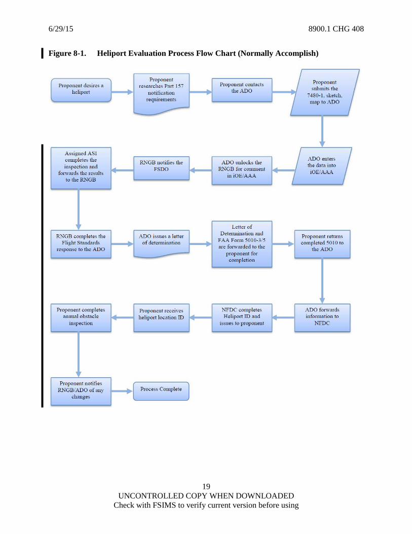
1) FAA Form 7480-1, Notice of Landing Area Proposal, with the applicable data completed by the proponent or their representative (see Figure 8-1A in this guidance);
2) A heliport layout diagram showing key dimensions of the TLOF, FATO, and FATO safety area with reference to the design helicopter size, distance from safety area perimeter to property edges, and A/D paths in relation to buildings, trees, fences, power lines, and other significant features; and
3) A heliport location map showing the location of the heliport site and the A/D paths (on this map, an arrow should indicate the heliport site).
B. Personnel Prerequisites. This task requires knowledge of the regulatory requirements of 14 CFR part 157, Order JO 7400.2, AC 150/5390-2, and FAA policy. Flight Standards District Office (FSDO) managers and supervisors are highly encouraged to send operations inspectors to the Heliport Evaluation training course the FAA conducts regularly in Oklahoma City. The FSDO manager/supervisor is highly encouraged to assign this task to a helicopter specialist, or to the most qualified operations inspector in the office with respect to helicopter operations (i.e., helicopter experience, completion of the Heliport Evaluation training course, etc.). If no FSDO personnel meets this criteria, the manager/supervisor should use someone from the Regional Office (RO) who does meet this criteria. The FAA authorizes the following personnel to conduct heliport evaluations:
1) An FAA Flight Standards Operations aviation safety inspector (ASI) or an Airspace System Inspection Pilot (ASIP);
2) At the RNGB manager’s discretion, RNGB All Weather Operations (AWO) inspectors;
3) At the supervisor’s discretion, other AFS ASIs if he/she is a certificated pilot and has completed the Heliport Evaluation training course; and/or
4) A Procedure Evaluation Pilot (PEP) that is authorized by the Flight Technologies and Procedures Division (AFS-400) to conduct heliport evaluations per this guidance who has completed the Heliport Evaluation Training Course.

6/29/15 8900.1 CHG 408
4 UNCONTROLLED COPY WHEN DOWNLOADED
Check with FSIMS to verify current version before using
C. Equipment Prerequisites. A combination of the following equipment is needed in order to complete an onsite evaluation of the proposed heliport, take pictures, and record distances, compass headings, and vertical angles (inclination):
1) Global Positioning System (GPS) receiver capable of verifying latitude and longitude in degrees, minutes, and seconds;
2) Inclinometer and compass;
3) Laser range finder;
4) Wheel measure for long distance and tape measure for short distance;
5) Digital camera; and
6) Calculator that is capable of doing tangent functions.
NOTE: Electronic devices (e.g., smartphone, tablet) may also substitute for separate equipment if the inspector is reasonably confident of achieving comparable accuracy with the applications (e.g., Theodolite, GeoCam, GPS, and calculator apps). Many applications, if calibrated and used correctly, are capable of accurately measuring location, measuring inclination angles, and taking pictures, but substituting for the laser range finder may lead to less accurate determinations of horizontal distance and vertical heights.
NOTE: The tools mentioned above can be very helpful in an overall screening process, but when the obstacles are close to critical items, such as the imaginary surfaces, TLOF, FATO, or FATO safety area, the inspectors can request accurate survey information from the proponent. However, if the proponent has performed the heliport design process properly, architectural or engineer scaled drawings using accurate survey data may be available for the inspectors to review.
D. Coordination. This task requires the FSDO to coordinate with the RFSD RNGB and the applicant/owner or operators of the heliport under evaluation.
8-214 REFERENCES, FORMS, AND JOB AIDS.
A. References (current editions):
• Title 14 CFR Parts 1 and 157; • PTRS Procedures Manual (PPM); • AC 20-35, Tiedown Sense; • AC 70/7460-1, Obstruction Marking and Lighting; • AC 150/5020-1, Noise Control and Compatibility Planning for Airports; • AC 150/5190-4, A Model Zoning Ordinance to Limit Height of Objects Around
Airports; • AC 150/5200-30, Airport Winter Safety and Operations;

6/29/15 8900.1 CHG 408
5 UNCONTROLLED COPY WHEN DOWNLOADED
Check with FSIMS to verify current version before using
• AC 150/5230-4, Aircraft Fuel Storage, Handling, Training, and Dispensing on Airports;
• AC 150/5345-27, Specification for Wind Cone Assemblies; • AC 150/5345-28, Precision Approach Path Indicator (PAPI) Systems; • AC 150/5345-52, Generic Visual Glideslope Indicators (GVGI); • AC 150/5390-2, Heliport Design; • FAA Order 1050.1, Environmental Impacts: Policies and Procedures; • FAA Order 5050.4, National Environmental Policy Act (NEPA), Implementing
Instructions for Airport Projects; • FAA Order JO 7400.2, Procedures of Handling Airspace Matters; • Office of Environment and Energy Noise Division (AEE-100), Integrated Noise
Model (INM); • National Fire Protection Association (NFPA) Pamphlet 10: Standard for Portable
Fire Extinguishers; • NFPA Pamphlet 403: Standard for Aircraft Rescue and Fire-Fighting Services at
Airports; • NFPA Pamphlet 407: Standard for Aircraft Fuel Servicing; • NFPA Pamphlet 409: Standard for Aircraft Hangars; and • NFPA Pamphlet 418: Standard for Heliports.
B. Forms. FAA Form 7480-1, Notice of Landing Area Proposal, can be found at http://www.faa.gov/forms/index.cfm/go/document.information/documentID/185334.
C. Job Aids. Included in this guidance:
• Figure 8-1, Heliport Evaluation Process Flow Chart (Normally Accomplish); • Figure 8-1A, Sample FAA Form 7480-1, Notice of Landing Area Proposal; • Figure 8-1B, Helipad Minimum Dimensions Job Aid; and • Figure 8-2, Heliport Evaluations Checklist Job Aid.
D. Other Job Aids. (These are available on the Flight Procedure Implementation and Oversight Branch (AFS-460) public Web site at http://www.faa.gov/about/office_org/headquarters_offices/avs/offices/afs/afs400/afs460/heliport_eval_tools/).
• Heliport Dimensions Tool, • Heliport Penetration Calculator, and • Fillable Checklist.
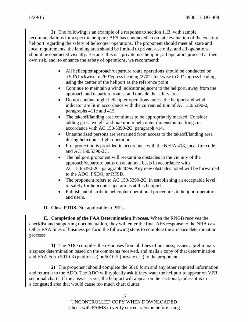
8-215 HELIPORT DETERMINATION PROCESS. A flow chart is provided in Figure 8-1 to show the full heliport evaluation process.
A. Filing and Notification. The heliport proponent or their representative files FAA Form 7480-1 and supporting documentation with FAA airports in accordance with 14 CFR part 157. The ADO enters the heliport information into the Obstruction Evaluation/Airport Airspace Analysis (iOE/AAA) database as a Non-Rulemaking Airport (NRA) case, unlocks the case to allow the RNGB to comment, and the RNGB will forward the NRA case to the FSDO to

6/29/15 8900.1 CHG 408
6 UNCONTROLLED COPY WHEN DOWNLOADED
Check with FSIMS to verify current version before using
request an onsite evaluation. The FSDO manager or designated supervisor assigns an inspector to the evaluation task or contacts the RNGB for support. An RNGB AWOPM may also complete the evaluation task if necessary. A helicopter operations inspector or the most qualified person (with respect to helicopter operations) should be assigned to evaluate the proposal.
B. Inspector Procedure. Upon receipt of a heliport evaluation request, open a PTRS 1846, 3683, or 5683 file. To evaluate proposed and existing heliports, and to resolve an applicant’s questions, the delegated inspector needs to be familiar with the contents of AC 150/5390-2, FAA Order JO 7400.2, part 157, and the guidance in this section.
1) Heliport Evaluation Checklist. It is the responsibility of the assigned inspector to determine if helicopter flight operations can be conducted safely within specified current guidelines and regulations. The inspector evaluates the suitability of the proposed or existing heliport and advises the RNGB of the findings. For recording the factual data, Figure 8-2 is provided in this guidance to assist the inspector on the heliport evaluation. A form-fillable version of this checklist is also available on the AFS-460 public Web site.
2) Reviewing Supporting Documentation. Review all supporting documentation to determine if you will need any additional information from the proponent, either verbally or through illustrations. When reviewing the supporting documentation, it is a good practice to start filling out the heliport evaluation checklist with the information available, to get a head start on the checklist and the specific heliport elements that you will evaluate. Figure 8-1A highlights specific sections of a sample FAA Form 7480-1 that directly relate to information on the checklist.
3) Types of Heliports. There are three different types of heliports: General Aviation (GA), Transport, and Hospital. Each of these types of heliports can be designated as either public-use or private-use PPR. AC 150/5390-2 has a chapter containing design criteria for each of the three types of heliports. Heliports may be located on the ground, water, rooftop level, or helideck.
a) Public-use heliports can be publicly or privately owned and can be used by any qualified pilot without requirements for prior approval from the owner or operator. The evaluator should consider the heliport facility requirements with regard to AC 150/5390-2 if they are to be used in the public interest (e.g., air carrier/passenger usage).
b) A PPR heliport is developed for exclusive use of the owner and persons authorized by the owner. The heliport owner and operator should ensure that all pilots are thoroughly knowledgeable about the heliport (including such features as A/D path characteristics, preferred heading, facility limitations, lighting, obstacles in the area, size of the facility, noise sensitive areas, etc.).
c) Hospital heliports are normally located in close proximity to a hospital emergency room or medical facility. Special considerations for standards relevant to a hospital heliport are found in AC 150/5390-2.
6/29/15 8900.1 CHG 408
7 UNCONTROLLED COPY WHEN DOWNLOADED
Check with FSIMS to verify current version before using
4) Preparation for Evaluation. Contact the proponent to:
a) Determine their design helicopter (e.g., the largest helicopter that the designed heliport should support). The evaluator needs this information to calculate the minimum dimensions of the heliport as described in subparagraph 8-215B5)b). Calculate the minimum heliport dimensions prior to the site visit.
b) Request any additional information that results from your initial document review.
c) Determine their construction progress and arrange an onsite evaluation.
1. Arrange the onsite evaluation as soon as practical if the heliport is at or near completion.
2. If the heliport is planned or under construction, a pre-construction site visit to review plans and examine the existing obstacle environment is also useful. In many cases, an onsite evaluation is still appropriate to analyze plans, determine the impacts of existing obstacles, and offer recommendations to the proponent so they can avoid the potential need to correct costly problems after construction. In some cases, an onsite evaluation may be of no benefit, such as a new rooftop heliport at a hospital when the building is not yet completed. If a site visit will not be beneficial, the inspector should postpone the site visit until a later stage of construction, or have the proponent send additional plans and drawings for a tabletop review. Follow the steps in subparagraph 8-215B5)b) as much as possible to conduct a tabletop review, using the proponent’s plans, drawings, and the current obstacle environment as necessary.
3. The proponent may need documentation indicating that the FAA has no objection to their plans and initial site selection to meet funding, insurance, state, or local requirements and begin construction. In these cases, complete a checklist and supporting documentation for the RNGB AWO in accordance with this guidance, but based on the existing obstacles around the heliport and the proponent's plans. The RNGB AWO can respond to the ADO with normal comments based on the proponent's plans, but with the additional stipulation that AFS will conduct an onsite evaluation when the proponent notifies the FAA that construction is complete.
4. When conducting the final site visit upon completion, if there are no new hazards and the heliport was constructed as planned, notify the RNGB AWO that you have no additional comments. If there are new hazards which may inhibit safe helicopter operations, document those hazards in as much detail as possible and contact the RNGB. The RNGB can work with the ADO to amend the previous heliport determination if the proponent does not fix those hazards.
d) Notify the proponent that they should consider or have completed the following items:
1. The appropriate building permit and zoning application approval from the local municipality, if applicable. Some communities have adopted and/or enacted zoning laws, building codes, and fire regulations that can impact heliport establishment and operation, so the

6/29/15 8900.1 CHG 408
8 UNCONTROLLED COPY WHEN DOWNLOADED
Check with FSIMS to verify current version before using
applicant is encouraged to contact the local zoning authorities and the AHJ (e.g., the fire marshal) and inform them of the proposed heliport.
2. The appropriate approval from the State aviation authorities (AA), if applicable. Many states require prior approval or licensing for the establishment and operation of a heliport, so the applicant is encouraged to contact the state to inform them of the proposed heliport.
3. The proponent addressed (or will address) the appropriate environmental requirements as necessary. FAA Order 1050.1, AC 150/5020-1, and the INM available from AEE-100, can provide the applicant with additional information.
4. Inspectors are not expected to know any of these regulations or requirements, just to remind proponents that they should fulfill their responsibilities in each of these areas.
e) Dimensions of a Heliport. See Figure 8-1B, Helipad Minimum Dimensions Job Aid, in this guidance for heliport layout and dimensions. To calculate minimum heliport dimensions prior to an onsite evaluation, refer to AC 150/5390-2 for dimensions of different helicopters. A heliport dimensions tool with instructions is also available on the AFS-460 public Web site to help simplify calculations.
1. A TLOF is a load-bearing helideck or helipad normally centered in the FATO where the helicopter lands or takes off. The TLOF dimensions (either length/width or diameter) should be the largest of the following:
a. 1 x the rotor diameter (RD) of the design helicopter of intended use.
NOTE: Refer to AC 150/5390-2, which allows for the TLOF to be as small as 2 x the maximum length or width of the undercarriage of the design helicopter for an elevated PPR TLOF.
b. For elevated heliports where the FATO is not load-bearing, the TLOF should be at least 1 x D, where “D” represents the overall length of the design helicopter. Heliports that contain enlarged rooftop TLOFs where the entire FATO is not capable of providing an IGE environment are considered operationally safe when the performance of the helicopters-in-use stay within the OGE envelope and do not need the dubious advantage a few feet of TLOF surface may have on IGE performance.
c. For hospital heliports, the TLOF should be at least 40 feet.
2. A FATO is a defined area over which the final phase of the approach to a hover or a landing is completed and from which the takeoff is initiated. Objects or structures should be outside the FATO to permit at least one, but preferably two or more, clear approach/takeoff paths aligned with the prevailing winds. The FATO dimensions are the larger of:

6/29/15 8900.1 CHG 408
9 UNCONTROLLED COPY WHEN DOWNLOADED
Check with FSIMS to verify current version before using
a. 1.5 x D, where “D” represents the overall length of the design helicopter.
b. The minimum separation between the TLOF and FATO perimeter should be at least (¾ x D) – (½ x RD). This minimum separation distance is added to each side of the minimum TLOF width to determine the overall FATO width. For example, if the TLOF is 40 feet and the minimum separation is 14 feet, the minimum FATO width is 68 feet (40 + 14 + 14).
NOTE: The shortcut to determine minimum FATO size is to calculate the minimum TLOF width and calculate FATO width of 1.5 x D. If the TLOF needs to be increased (e.g., for a hospital heliport with a minimum 40 feet width, or for an elevated heliport), the FATO width will increase the same amount that the TLOF width increased. For example, if the TLOF width increases 4 feet from a design helicopter’s 36 feet RD to 40 feet because it is a hospital, the FATO width of 1.5 x D will also increase by 4 feet.
3. The safety area is a defined area on a heliport surrounding the FATO, intended to reduce the risk of damage to helicopters accidentally diverging from the FATO. The type of heliport and heliport markings determine the distance between the FATO and safety area perimeters. The minimum separation distance is added to each side of the minimum FATO width to determine the overall safety area width. For example, if the FATO width is 68 feet and the minimum separation is 12 feet, the minimum total safety area width is 92 feet (68 + 12 + 12). Refer to AC 150/5390-2, Tables 2-1, 3-1, or 4-1, based on the type of heliport.
f) Prevailing Winds. It is helpful to know the rough direction of prevailing winds prior to conducting the onsite evaluation. Primary runways at nearby public-use airports are typically closely aligned with the historical prevailing winds. Refer to http://windhistory.com, a good resource for historical wind data.
g) Nearby Airports or Airspace. Review the proposed heliport location on a visual flight rules (VFR) sectional chart to find nearby airports or airspace that the proposed heliport may affect. In addition, since many private heliports are not depicted on a sectional chart, refer to the FAA Airport Master Record database at http://www.faa.gov/airports/airport_safety/airportdata_5010/. FAA Form 7480-1 typically states the number of based aircraft and planned operations. Many heliports have less than one flight per day on average, although heliports that support air tours or large hospitals/trauma centers may have a higher volume of operations.
5) Onsite Evaluation. When conducting an onsite evaluation, review and confirm the details on FAA Form 7480-1 for accuracy and completeness, complete the checklist, and perform any other necessary activities (e.g., sketches, pictures, obstacle data) to have sufficient details. Inspectors are not expected to be surveyors or to attain a perfect level of accuracy, but rather to use the available tools and guidance to determine if helicopter operations can be conducted safely. If the drawings or design was professionally produced, it is likely that accurate survey information on any critical items may already exist. If something like a group of trees, a building, wires, or light poles were not included in the heliport planning and design but are

6/29/15 8900.1 CHG 408
10 UNCONTROLLED COPY WHEN DOWNLOADED
Check with FSIMS to verify current version before using
a safety or compliance issue, this may be an excellent opportunity to inform the proponent of the FAA criteria and how to properly apply it.
a) Location. Determine that the geographic coordinates shown on FAA Form 7480-1 are the same as the actual location. Use of a GPS receiver is necessary to determine the latitude/longitude (in degrees, minutes, and seconds) and elevation of the heliport. If there is a large discrepancy between the actual coordinates and FAA Form 7480-1 (e.g., more than 250 feet), the evaluator should make note of this on the checklist job aid and consult with the RFSD AWO.
b) Measuring a Heliport’s Dimensions. Measure the TLOF, FATO, and FATO safety area to ensure the minimum distances described above by using a wheel measure, tape measure, or range finder.
1. The TLOF, FATO, and FATO safety area should be clear of objects, such as parked helicopters, buildings, or objects that could be struck by the main or tail rotor, or catch the skids of an arriving or departing helicopter. The evaluator should also consider automobile parking spaces or roads near the FATO or safety area, as vehicles in those areas could also be a hazard (or damaged by debris/rotor wash) if barriers or personnel do not secure the road during helicopter operations. The FATO and FATO safety area may have frangible mounted objects (e.g., lights) provided they are not so tall and/or so close to the center of the heliport that they pose a collision hazard.
NOTE: Frangible structures around heliports (e.g., lights) will easily destroy a tail rotor blade or contribute to a dynamic rollover incident.
2. A fence around a heliport helps to ensure security and prevents pedestrian and vehicle traffic around the heliport, but that security benefit cannot outweigh the operational risk if the fence is an obstruction due to its proximity to the heliport. If the proponent has not started construction on a ground level heliport, a good recommendation is to build the heliport at an elevation about 5 feet higher with a berm gently sloping downward from the outside edge of the TLOF to the outside edge of the FATO or FATO safety area, and installing a security fence at the lower elevation so that the top of the fence is below the 8:1 and 2:1 airspace areas. This allows a fence to enhance security, but the fence can be below the elevation of the heliport, and therefore not an obstruction in the safety area or A/D routes. A trained person performing security functions at a heliport is far more effective than any barrier and can provide assistance to any emergency that may occur.
c) Approach/Departure (A/D) Paths. The A/D path, also known as the ingress/egress routes for the heliport, has a clear slope free of objects. The clear slope is an imaginary 8:1 slope (rises 1 feet for every 8 feet horizontal, or 7.125°) surface centered on the A/D path that starts at the edge of the FATO at heliport elevation. Use an inclinometer or laser range finder to determine the slope. AC 150/5390-2 contains the dimensions of the A/D path.
1. When possible, A/D paths should avoid congested areas, heavily populated urban areas, existing air traffic operations, or environmentally sensitive areas. A/D paths may curve to avoid objects and/or noise-sensitive areas. In many situations, portions of the

6/29/15 8900.1 CHG 408
11 UNCONTROLLED COPY WHEN DOWNLOADED
Check with FSIMS to verify current version before using
A/D paths can use the airspace existing above public lands and waters, freeways, streets, parks, rivers, and lakes.
2. Public-use heliports should have more than one A/D path aligned as nearly as possible with the prevailing winds. Public-use heliports should have an 8:1 sloped A/D path protection zone to a distance of 4,000 feet from the forward edge of the FATO.
3. A PPR-use heliport should have at least one A/D path. It is highly recommended to have a second or third A/D path whenever possible because it will provide an additional safety margin as well as operational flexibility, particularly at busier heliports with daily operations. If a single A/D path is the only option available, a wind and/or performance restriction may be in order for safe operations.
4. Analyze the surrounding obstacles and determine any A/D paths that may be clear. Use an inclinometer, laser range finder, scientific calculator, and the job aids in this section to accurately determine obstructions and their height. In section 10B of the checklist, note the type and location of any obstacles laterally or vertically near an 8:1 A/D path, and note if removal, lowering, and/or obstacle identification lighting is recommended.
5. In section 6 of the checklist, note all clear paths by magnetic heading, as determined from the center of the heliport. Be aware that some heliports may have a high degree of magnetic interference associated with them due to a large amount of iron core rebar in their construction, or electromagnetic interference (EMI) created by a large electrical consumer nearby. Moving away from the heliport and taking a reading across the heliport is one technique that may work in these cases. Be clear that the heading is either an inbound or outbound heading (e.g., a NE route would be a 45° outbound heading and 225° inbound heading). If a wide area has clear 8:1 surfaces, note the full range of acceptable headings, such as “40° clockwise to 90° outbound heading.” There are a few methods for determining if a primary A/D surface is clear:
a. To use the “in the dirt” method, go to the edge of the FATO, lie on your stomach, and use the range finder to determine the inclination from the ground to the top of the obstacle. If the inclination is less than 7.1°, it is below the A/D surface (8:1 = 7.125°). When measuring the inclination, target the top of the obstacle at least 2 to 3 times to ensure a consistent reading.
b. To apply a similar logic without lying down, go an additional 24 feet past the edge of the FATO and use the range finder from a squatting position. The A/D surface is 3 feet high from that location, so your eye level should align with the A/D surface. Use the range finder to determine the inclination from the ground to the top of the obstacle. If the inclination is less than 7.1°, it is below the A/D surface (8 to 1 = 7.125°). When measuring the inclination, target the top of the obstacle at least 2 to 3 times to ensure a consistent reading.
c. The math intensive method for analyzing an obstacle is to stand in the center of the heliport and use a laser range finder to get the horizontal distance (HD) and vertical distance (VD) in feet. If you assume a 5-foot eye level, add 5 feet to the VD to get the height of the obstacle relative to the heliport elevation. Take your HD and subtract half of the minimum FATO required since the A/D surface starts at the edge of the FATO. For example:

6/29/15 8900.1 CHG 408
12 UNCONTROLLED COPY WHEN DOWNLOADED
Check with FSIMS to verify current version before using
• VD = 12 feet. • Obstacle Height = 12 + 5 feet eye level = 17 feet. • HD = 150 feet. • Minimum FATO = 79 feet (Sikorsky 76D). • Distance = 150 – 39.5 = 110.5. • 17 x 8 = 136 is greater than 110.5, so the obstacle is a penetration.
d. The A/D surfaces widen as the distance from the center of the heliport increases. The primary A/D surface is the same as the FATO width at the edge of the FATO, and widens so that it is 250 feet from the center line on each side of the course (500 feet total across). Because this widens, the divergence angle for the primary A/D surface is approximately 3.0° to 3.3° (lower for a larger FATO). The lateral extensions diverge even further by about 5.8°.
e. Therefore, one method of examining if the lateral boundaries are clear of obstructions is to find each corner of the FATO for a specific departure path, and ensure that there are no 8:1 penetrations within a 5.8° magnetic bearing of the departure path. For example, if the 180° departure route looks suitable, go to the SE corner of the FATO and make sure that any 8:1 penetrations are east of a 174.2° magnetic heading, then go to the SW corner of the FATO and make sure that any 8:1 penetrations are west of a 185.8° magnetic heading, with no penetrations in between.
f. AC 150/5390-2 states that the transitional surfaces at hospital heliports or private-use GA heliports do not need an evaluation if there are no lateral extension penetrations. Transitional surfaces start at the height of the primary surface and upslope 2 feet for every 1 foot from the edge of the primary surface, and are therefore very difficult to evaluate. Follow the instructions in the next paragraph below to determine if an obstacle penetrates a transitional surface.
g. The simplest method to ensure clear A/D surfaces requires using either the “Heliport Dimensions Tool” or the “Heliport Surface – Straight In” tool on the AFS-460 public Web site. Stand at the center of the heliport and, using the range finder, record the following information for each obstacle you want to analyze:
• The slant range distance (SD) to the top of the obstacle, • The inclination to the top of the obstacle, • The magnetic outbound course, and • The magnetic bearing to the obstacle.
NOTE: You will also need to know the minimum FATO width for the calculation.
NOTE: Accurate magnetic compass readings are critical to this calculation. The compass in the laser range finder is not as reliable as other methods. When using a magnetic compass (e.g., from a smartphone, clinometer, GPS, standalone), hold it level with the ground when determining a bearing and make sure that there are no magnetic anomalies in the vicinity to introduce error into your calculations.

6/29/15 8900.1 CHG 408
13 UNCONTROLLED COPY WHEN DOWNLOADED
Check with FSIMS to verify current version before using
d) Document Obstacle Data. Collect as much data about obstacles, particularly obstacles near possible A/D paths. It is best to take enough pictures to document the full 360° around the heliport as well as any specific pictures you may want for future reference. Use the laser range finder to target obstacles and record the VD or height of the obstacle above the heliport elevation, horizontal or SD from the heliport center, magnetic bearing from the heliport center, and inclination angle to the top of the obstacle from the heliport center. Although magnetic compass readings are sometimes unreliable, the height, distance, and inclination readings from a range finder tend to be reasonably accurate when the obstruction is measured 3 to 5 times to ensure an accurate reading.
e) Office Analysis. If necessary, use the Heliport Dimensions Tool available on the AFS-460 public Web site to perform a more detailed obstacle assessment. The tool will build a three-dimensional (3-D) Google Earth representation of the heliport environment and has an obstruction/penetration calculator for multiple A/D paths, but the tool is highly dependent on accurate data from the user.
1. Google Earth is a good resource to assess the obstacle environment, but its accuracy is dependent on the age of the overhead pictures. For this reason, confirm the Google Earth overhead view and obstacle environment by reviewing your data and pictures collected at the heliport site.
2. To ensure accurate obstacle locations, cross-check the onsite obstacle data, pictures, and the Google Earth overhead picture. Use the Google Earth ruler to measure the true course and distance from the heliport center (using the ruler icon located on the top bar or by clicking on the “Ruler” option located under “Tools”). You can then adjust the obstacle data in the tool if necessary, either by correcting the magnetic bearing (remember to adjust for variation if necessary) or entering the latitude, longitude, and height of the obstacle above mean sea level (MSL).
f) Heliport Surface. Confirm the type of surface of the touchdown area listed in Section E2 of FAA Form 7480-1. The weight-bearing capacity of the landing area should be no less than 1.5 x the maximum gross landing weight of the design helicopter intended for use. The proponent is responsible for the structural integrity of the landing area. The proponent should consult with a contractor or Architectural and Engineering (A&E) professional to ensure that elevated or rooftop landing sites are capable of supporting a landing helicopter with adequate safety margins. Verify that the information provided is enough to advise the proponent of the suitability of the proposed landing surface, and ensure that the proponent is aware of the following penalties or advantages associated with various surfaces:
1. Loose surface(s) (e.g., gravel, dirt) can cause visibility problems or foreign object damage (FOD) to the engines or blades and possible injury to bystanders.
2. Asphalt and other soft surfaces may also contain ruts or surface irregularities that increase the risk of dynamic rollover. Asphalt may also deteriorate to the point that it creates flying debris.

6/29/15 8900.1 CHG 408
14 UNCONTROLLED COPY WHEN DOWNLOADED
Check with FSIMS to verify current version before using
3. Surfaces consisting of concrete and/or concrete pavers may contain uneven joints. All surfaces should be free of surface defects that can catch helicopter skids or wheels, especially when side loads are involved.
g) Heliport Markings and Lighting. AC 150/5390-2 contains design criteria for heliport markings and lighting. It is recommended that all heliports meet this criteria, but normally the design criteria is not something that affects the safety of operations, unless the lights or the mounting bases are too tall or too close to the heliport center and creates a drift/dynamic rollover risk. Refer the proponent to the chapter in the AC relevant to that type of heliport (general aviation, transport, or hospital). Recommend that the proponent discuss lighting with their operator(s) to see if they use night vision goggles (NVG) and, if they do, to ensure that the heliport lights will not adversely affect NVG operations.
1. Outlining heliport markings with a contrasting color (e.g., black) will make all markings much more conspicuous to pilots during day, night, and NVG operations. Such markings provide pilots with better closure rate visualization during an approach and better drift correction correlation while hovering.
2. Caution for semi-flush lights imbedded within the surface of the TLOF where helicopters will touch down is advised. All such lights should be outside of the area where the landing may have contact.
3. Pay special attention to the numerous lights that are marketed as combination floodlights/perimeter lights. If they are mounted on the edge of the TLOF and extend higher than the maximum height of 2 inches allowed in the AC, they are potentially hazardous. The marketing includes disclaimers, such as “Check with the FAA” or similar verbiage, that are essentially legal disclaimers because the lights will not meet the AC recommendations if installed as illustrated.
h) Miscellaneous Items. Complete a general inspection of other heliport characteristics and annotate the following miscellaneous items on the checklist if applicable:
• Heliport beacon. Is there one and do you recommend one? In a dense urban environment with a large amount of background lighting, a beacon may be very beneficial. This is also a good way to alert general aviation pilots of high volume traffic areas in the case of a hospital trauma center.
• Communications systems, equipment, and procedures. Does the proponent have a plan to determine when a helicopter is arriving and to secure the heliport from vehicles and pedestrians during helicopter operations? How do they secure the area (e.g., with personnel, temporary or permanent barriers)?
• Rescue and firefighting equipment and access. Can local fire crews access the heliport? What equipment is available on site? This is more critical for rooftop-elevated heliports than ground heliports located at a distance from buildings and other property that would greatly reduce how fast a potential fire will spread. Refer to NFPA-418 Annex B for guidance and consult with the local AHJ for assistance.
6/29/15 8900.1 CHG 408
15 UNCONTROLLED COPY WHEN DOWNLOADED
Check with FSIMS to verify current version before using
• Wind direction indicators. Are there any present? Is the location appropriate for the surrounding environment, is it visible from the heliport and at a distance of 500 feet from the heliport on the A/D paths, and is it visible at night?
• Fuel systems, oxygen tanks, and other equipment. Are all fuel tanks, oxygen tanks, and any other equipment outside the safety area and clear of any A/D paths? Fuel and oxygen tanks should be a safe distance away from the heliport. NFPA-418 requires fuel tanks to be at least 50 feet outside the heliport FATO.
• Electromagnetic Interference (EMI). This can be caused by a Magnetic Resonance Imaging (MRI) device, a large electrical consumer such as an elevator equipment room or motor, a large ventilation motor, or in some cases improper wiring or a dead short in an electrical system. Is there MRI equipment nearby? Is it shielded to prevent interference with electronics (both on a helicopter and other electronic equipment in the hospital)? If an EMI situation is present, a hand-held magnetometer can often be used to track down the cause of the interference.
• Taxiway/taxi routes and parking. Is each taxi route and parking space clear of obstacles to allow safe operations? Does the parking space keep the parked helicopter out of the safety area and away from A/D routes?
NOTE: Contact the RFSD AWOPM if there are any questions on any of the above subjects or issues.
i) Nearby Landing Areas and Airspace. Consider other VFR of landing areas located within 5 nautical miles (NM) of the proposed site and instrument flight rules (IFR) of airports/heliports within 20 NMs. Use an aviation GPS receiver or aviation charts to determine which landing areas are nearby. Keep in mind some heliports may not have accurate information on file in the FAA Airport Master Record database. Is it safe to conduct helicopter operations? Are other landing areas too close? Do the only clear A/D paths lead directly to a nearby landing area? Should landing areas share a common traffic advisory frequency? Are there other airspace issues, such as heliports inside Class B, C, or D airspace that require the pilot to meet specific regulations for clearance or radio communication? Consider the volume of operations at each landing area when making this evaluation. Landing areas with very few daily/weekly operations greatly reduce safety risks.
j) Noise-Sensitive Areas. The proponent should list nearby schools, churches, and residential communities on FAA Form 7480-1. Hospitals and wildlife areas are also noted due to the noise sensitivity issue, keeping in mind that most hospitals have an integrated heliport. Although potential noise-sensitive areas are not safety-related, the proponent needs to know of them so that the helicopter operators are aware of the areas and try to avoid them whenever possible.
C. Submit Report.
1) At a minimum, submit the completed checklist and any additional details, pictures, maps, or supporting materials to your geographic RNGB. The most critical part of the

6/29/15 8900.1 CHG 408
16 UNCONTROLLED COPY WHEN DOWNLOADED
Check with FSIMS to verify current version before using
checklist is section 11, which the evaluator should complete in as much detail as possible. Note if operations can be conducted safely (check “Yes” or “No”). The RNGB or the FSDO manager/supervisor may require a memo or report at their discretion. Include as much detail and supporting documentation as possible, particularly if there are any elements of the heliport that are unsafe or likely to raise additional questions. If there is not enough detail in those situations, the RNGB may request additional information that necessitates an additional site visit at their discretion prior to entering the final AFS response.
a) If operations can be conducted safely, list all recommendations that will enhance helicopter safety at the heliport.
b) If operations cannot be conducted safely, describe why and explain what modifications and/or limitations are necessary to support safe helicopter operations. Inspectors should cite any safety-related conditions and limitations to the RFSD, which will become part of the RNGB’s response to the ADO.
NOTE: Some AC 150/5390-2 heliport design criteria, although not regulatory, provide a reasonable standard to help an inspector determine if helicopter operations can be conducted safely at the proposed location. There may be some heliport characteristics that do not strictly meet design criteria in the AC but also do not create an unsafe condition.
c) NRA studies are internally circulated to multiple FAA lines of business for response via iOE/AAA. This system provides automation support for general airspace study functions. RNGB AWOs should respond as follows:
• No objection – use when there is no operational safety concern. • No objection with provision – use when there is no operational safety
concern (the proposal is generally acceptable to AFS) but the inspector recommends specific changes or operational considerations.
• Objection – use when a proposal is clearly unacceptable due to operational safety concerns.
d) When a significant operational safety issue exists, “no objection with provision” may not transmit the correct level of concern. If necessary, respond with an “objection,” a summary of the hazards, and details about how to mitigate those hazards. After successful negotiation and necessary adaptations, AFS can change their response in iOE/AAA to “no objection with provision,” or “no objection.”
e) If you base your response on a pre-construction evaluation, you should base the safety determination on a combination of plans and the existing environment, and contingent upon a final site visit to verify that there are no unplanned hazards to safe operations. When conducting the final site visit upon completion, if there are new hazards, and safe helicopter operations are not possible, document those hazards in as much detail as possible and contact the RNGB. The RNGB can work with the ADO to amend the previous heliport determination.
6/29/15 8900.1 CHG 408
17 UNCONTROLLED COPY WHEN DOWNLOADED
Check with FSIMS to verify current version before using
2) The following is an example of a response to section 11B, with sample recommendations for a specific heliport: AFS has conducted an on-site evaluation of the existing heliport regarding the safety of helicopter operations. The proponent should meet all state and local requirements, the landing area should be limited to private-use only, and all operations should be conducted visually. Because this is a private-use heliport, all operators proceed at their own risk, and, to enhance the safety of operations, we recommend:
• All helicopter approach/departure route operations should be conducted on a 90°clockwise to 260°egress heading/270° clockwise to 80° ingress heading, using the center of the heliport as the reference point.
• Continue to maintain a wind indicator adjacent to the heliport, away from the approach and departure routes, and outside the safety area.
• Do not conduct night helicopter operations unless the heliport and wind indicator are lit in accordance with the current edition of AC 150/5390-2, paragraphs 411c and 415.
• The takeoff/landing area continues to be appropriately marked. Consider adding gross weight and maximum helicopter dimension markings in accordance with AC 150/5390-2C, paragraph 414.
• Unauthorized persons are restrained from access to the takeoff/landing area during helicopter flight operations.
• Fire protection is provided in accordance with the NFPA 418, local fire code, and AC 150/5390-2C.
• The heliport proponent will reexamine obstacles in the vicinity of the approach/departure paths on an annual basis in accordance with AC 150/5390-2C, paragraph 409e. Any new obstacles noted will be forwarded to the ADO, FSDO, or RFSD.
• The proponent refers to AC 150/5390-2C, in establishing an acceptable level of safety for helicopter operations at this heliport.
• Publish and distribute helicopter operational procedures to heliport operators and users.
D. Close PTRS. Not applicable to PEPs.
E. Completion of the FAA Determination Process. When the RNGB receives the checklist and supporting documentation, they will enter the final AFS response to the NRA case. Other FAA lines of business perform the following steps to complete the airspace determination process:
1) The ADO compiles the responses from all lines of business, issues a preliminary airspace determination based on the comments received, and mails a copy of that determination and FAA Form 5010-3 (public use) or 5010-5 (private use) to the proponent.
2) The proponent should complete the 5010 form and any other required information and return it to the ADO. The ADO will typically ask if they want the heliport to appear on VFR sectional charts. If the answer is yes, the heliport will appear on the sectional, unless it is in a congested area that would cause too much chart clutter.

6/29/15 8900.1 CHG 408
18 UNCONTROLLED COPY WHEN DOWNLOADED
Check with FSIMS to verify current version before using
3) The ADO then sends the determination, 5010 form, and supporting documentation to the National Flight Data Center (NFDC) for publication in the FAA databases, making the heliport accessible within the Notice to Airmen (NOTAM) system and air traffic control (ATC) computers. Pilots will also be able to file a flight plan (FP) to or from the heliport.
8-216 TASK OUTCOMES. Completion of this task results in:
• A completed heliport evaluation checklist; • Submittal of the heliport evaluation checklist and any necessary supporting
documentation to the RNGB; and • Retention of a copy (as necessary) of the completed evaluation in the files of the
office that conducted the evaluation.
8-217 FUTURE ACTIVITIES.
• Site visit upon completion of construction if necessary. • Future surveillance for work plans. • Evaluation of heliport for modifications or additional uses.
6/29/15 8900.1 CHG 408
19 UNCONTROLLED COPY WHEN DOWNLOADED
Check with FSIMS to verify current version before using
Figure 8-1. Heliport Evaluation Process Flow Chart (Normally Accomplish)
6/29/15 8900.1 CHG 408
20 UNCONTROLLED COPY WHEN DOWNLOADED
Check with FSIMS to verify current version before using
Figure 8-1A. Sample FAA Form 7480-1, Notice of Landing Area Proposal

6/29/15 8900.1 CHG 408
21 UNCONTROLLED COPY WHEN DOWNLOADED
Check with FSIMS to verify current version before using
Figure 8-1B. Helipad Minimum Dimensions Job Aid
A/B. Minimum TLOF Dimensions – This is the greater of: (1 x rotor diameter (RD)) OR (1 x overall length (D) at elevated heliports where the FATO is not load bearing) OR (40 feet at hospital heliports).
C/E. Minimum FATO Dimensions – This is the greater of: (1.5 x overall length (D)) OR (TLOF dimensions + the minimum separation between the TLOF and FATO perimeters (F below)).
F. Minimum Separation between the TLOF and FATO Perimeters = (¾ x D) – (½ x RD).
G. Minimum Separation between the FATO and Safety Area Perimeters. Based on the type of heliport and the heliport markings – refer to AC 150/5390-2 Tables 2-1, 3-1, or 4-1 as applicable.

6/29/15 8900.1 CHG 408
22 UNCONTROLLED COPY WHEN DOWNLOADED
Check with FSIMS to verify current version before using
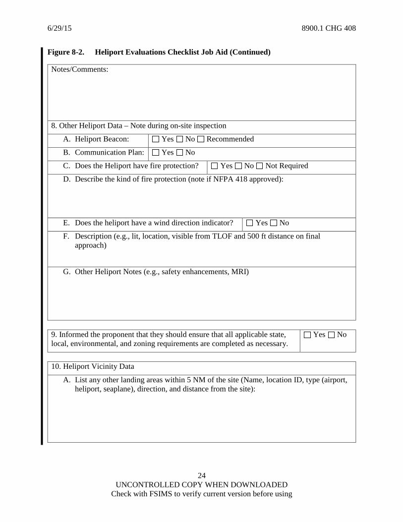
Figure 8-2. Heliport Evaluations Checklist Job Aid
NOTE: Use this checklist to complete the evaluation and confirm the data submitted on FAA Form 7480-1.
Name of Proponent: Site ID (if known):
NRA Tracking #: Date of Inspection:
1. Heliport Design
A. Duration of Use: Permanent Temporary
B. Ground Level Heliport Water Heliport Ship/Barge Heliport Elevated Heliport
C. Design helicopter to use the heliport:
2. Proponent Contact Information
A. Name:
B. Address:
C. City State
D. Telephone #: Fax #:
E. Email Address:
3. Location of Heliport – Use GPS to confirm the lat/long/elevation during on-site inspection.
A. Street Address
B. City State
C. Latitude: ° ’ ” N Longitude: ° ’ ” W
D. Elevation: ft
4. Type of Use:
A. Public Use Private (PPR) Private Use of Public Land/Waters
B. General Aviation Heliport Transport Heliport Hospital Heliport
C. VFR Use IFR Use (Identify Approach):
D. Day Night
5. Dimensions of Surfaces – Confirm during on-site inspection – All measurements in feet
A. Touchdown and Liftoff Area Length: ft Width: ft

6/29/15 8900.1 CHG 408
23 UNCONTROLLED COPY WHEN DOWNLOADED
Check with FSIMS to verify current version before using
Figure 8-2. Heliport Evaluations Checklist Job Aid (Continued)
B. Final Approach & Takeoff Area Length: ft Width: ft
C. Safety Area Length: ft Width: ft
D. Notes:
6. Suitability of Approach/Takeoff Paths
Note: Confirm that the 8:1 slope (7.125°) is satisfactory from the forward edge of the FATO to 4000 feet. All headings should be magnetic headings from the landing area using the center of the TLOF as the reference point unless otherwise described in the notes/comments.
A. Prevailing winds?
B. Satisfactory Ingress/Egress may be accomplished from all directions: Yes No
C. Satisfactory only in the following area: ° to °
D. Additional satisfactory area or route: ° to °
E. No suitable ingress/egress routes exist under the present conditions Yes No
F. No other ingress/egress routes should be used Yes No
Notes/Comments:
7. Landing Area Data – Note during on-site inspection
A. Type of surface: Concrete Asphalt Metal Water Wood Other
B. Weight Limit: lbs.
C. Heliport Markings (describe below): Yes No
D. Heliport Lighting (describe below): Yes No
E. Night Vision Goggle Ops Planned? Yes No Unknown
6/29/15 8900.1 CHG 408
24 UNCONTROLLED COPY WHEN DOWNLOADED
Check with FSIMS to verify current version before using
Figure 8-2. Heliport Evaluations Checklist Job Aid (Continued)
Notes/Comments:
8. Other Heliport Data – Note during on-site inspection
A. Heliport Beacon: Yes No Recommended
B. Communication Plan: Yes No
C. Does the Heliport have fire protection? Yes No Not Required
D. Describe the kind of fire protection (note if NFPA 418 approved):
E. Does the heliport have a wind direction indicator? Yes No
F. Description (e.g., lit, location, visible from TLOF and 500 ft distance on final approach)
G. Other Heliport Notes (e.g., safety enhancements, MRI)
9. Informed the proponent that they should ensure that all applicable state, local, environmental, and zoning requirements are completed as necessary.
Yes No
10. Heliport Vicinity Data
A. List any other landing areas within 5 NM of the site (Name, location ID, type (airport, heliport, seaplane), direction, and distance from the site):

6/29/15 8900.1 CHG 408
25 UNCONTROLLED COPY WHEN DOWNLOADED
Check with FSIMS to verify current version before using
Figure 8-2. Heliport Evaluations Checklist Job Aid (Continued)
B. List any obstructions in the vicinity of the approach/departure protection area. Include recommended mitigation for obstructions that penetrate the 8:1, such as limited ingress/egress routes to avoid, removal, lowering, lighting, marking the obstacle, etc.
C. List possible noise sensitive areas in the vicinity and direction/distance from site, such as schools, public areas, wildlife, etc.
11. Conclusion
A. Can helicopter operations be conducted safely at the proposed site?
Yes No
B. If “Yes”, enter recommendations for safe helicopter operations. If “No”, list the reason(s) why operations cannot be conducted safely and what specific items need to be corrected. For heliports that are not yet completed, include the recommendation that a follow up visit is required to verify that no additional unsafe conditions have been introduced.
Inspector Name Signature Date
RESERVED. Paragraphs 8-218 through 8-233.