Embed Size (px)
Citation preview
1
Executive Committee Meeting #9/13
Chair: Gerri Lynn O'ConnorVice Chair: Maria AugimeriMembers: Ben Cachola
Ronald ChopowickGlenn De BaeremaekerMichael Di BiaseJack HeathColleen JordanGloria Lindsay LubyMike MattosJim ToveyRichard Whitehead
November 1, 2013
9:30 A.M.WESTON ROOM B, BLACK CREEK PIONEER VILLAGE
AGENDAEX1. MINUTES OF MEETING #7/13, HELD ON OCTOBER 4, 2013
Minutes Summary Enclosed Herewith on PINK
EX2. BUSINESS ARISING FROM THE MINUTES
EX3. DISCLOSURE OF PECUNIARY INTEREST AND THE GENERAL NATURE THEREOF
EX4. DELEGATIONS
EX5. PRESENTATIONS
EX6. CORRESPONDENCE
2
EX7. SECTION I - ITEMS FOR AUTHORITY ACTION
EX7.1 TRIDEL CORPORATION Request for a Permanent Easement for a Sanitary Sewer Upgrade to Service Developments at 1 Old Mill Drive in the City of Toronto, Humber River WatershedCFN 49837 26
EX7.2 GREENLANDS ACQUISITION PROJECT FOR 2011-2015Flood Plain and Conservation Component, Humber River WatershedRavines of Islington Holdings Inc.CFN 49571 30
EX7.3 GREENLANDS ACQUISITION PROJECT FOR 2011-2015Flood Plain and Conservation Component, Humber River WatershedAverton Common (Kleinburg) Inc.CFN 49870 33
EX7.4 GREENLANDS ACQUISITION PROJECT FOR 2011-2015Flood Plain and Conservation Component, Humber River WatershedDelmanor Prince Edward Inc.CFN 49872 36
EX7.5 GREENLANDS ACQUISITION PROJECT FOR 2011-2015Flood Plain and Conservation Component, Don River Watershed1275621 Ontario Inc.CFN 49932 39
EX7.6 USE OF RESOURCES DURING AN ELECTIONApproval of Toronto and Region Conservation Authority Policy 42
EX7.7 2014 FEE SCHEDULE FOR PUBLIC FACILITIES AND PROGRAMMING 54
EX7.8 PLANNING AND PERMIT ADMINISTRATIONContinuous Strategic Improvements and Delegation of Permit ApprovalsReport to Follow
EX8. SECTION II - ITEMS FOR EXECUTIVE ACTION
EX8.1 ENVIRONICS ANALYTICS LTD.Report to Follow
EX9. SECTION IV - ITEMS FOR THE INFORMATION OF THE BOARD
3
EX10. ONTARIO REGULATION 166/06
PERMIT APPLICATION EX10.1 - EX10.3 ARE MAJOR APPLICATIONS
Applications that involved a more complex suite of technical studies to demonstrate consistency with policies; applications that cover a significant geographic area (e.g. subdivisions, stormwater management ponds), extensive modifications to the landscape, major infrastructure projects, emergency works, resolution of violations/after the fact permits, trail construction
CITY OF BRAMPTON
EX10.1 CITY OF BRAMPTONTo construct, reconstruct, erect or place a building or structure, site grade, temporarily or permanently place, dump or remove any material originating on the site or elsewhere and alter a watercourse on Countryside Drive between Bramalea Road and Torbram Road in the City of Brampton, Humber River Watershed, as located on property owned by the City of Brampton or through easement agreements. The purpose is to widen Countryside Drive from Bramalea Road to Airport Road. This project has been divided into 2 separate permits (CFN 40845 and 49863). This application (CFN 40845) covers the widening of Countryside Drive from Bramalea Road to Torbram Road including the replacement of an undersized culvert with a bridge at the H3 tributary crossing, construction of a sidewalk on the south side and a multi-use path on the north side of the road. The redside dace timing window will apply to any in or near water work at the H3 tributary (approximately Station 13+130) and the warmwater fisheries timing window will apply to the watercourse that outlets just east of Torbram Road, unless otherwise specified in writing by the Ministry of Natural Resources (MNR). A Letter of Advice will be written by TRCA staff on behalf of Fisheries and Oceans anada (DFO). 57
4
EX10.2 CITY OF BRAMPTONTo construct, reconstruct, erect or place a building or structure, site grade, temporarily or permanently place, dump or remove any material, originating on the site or elsewhere and alter a watercourse on Countryside Drive between Torbram Road and Airport Road, in the City of Brampton, Humber River Watershed as located on property owned by the City of Brampton or through easement agreements. The purpose is to widen Countryside Drive from Bramalea Road to Airport Road. This project has been divided into 2 separate permits (CFN 40845 and 49863). This application (CFN 49863) covers the widening of Countryside Drive from Torbram Road to Airport Road including realigning the road to eliminate the jog which currently exists approximately midway between Torbram Road and Airport Road. A sidewalk will be constructed on the south side and a multi-use path on the north side of the road. The warmwater fisheries timing window will apply to the watercourse located at approximately Station 14+510, unless otherwise specified in writing by the Ministry of Natural Resources (MNR). A Letter of Advice will be written by TRCA staff on behalf of Fisheries and Oceans Canada (DFO). 59
CITY OF MARKHAM
EX10.3 CITY OF MARKHAMTo site grade, temporarily or permanently place, dump or remove any material, originating on the site or elsewhere and interfere with a wetland on Lot 9, Concession 5, (8307 Warden Avenue), in the City of Markham, Rouge River Watershed as located on the property owned by City of Markham. The purpose is to undertake works within a Regulated Area of the Rouge River Watershed to facilitate the construction of a wetland as part of a compensation package associated with the construction of various infrastructure works associated with an approved plan of subdivision. 61
PERMIT APPLICATIONS EX10.4 IS A MAJOR ERRATA ITEM
Staff's recommendation for approval is based upon the review and acceptance of additional information from the applicant. The applicant has been informed that the information outstanding must be reviewed and accepted by staff prior to the Executive Committee Meeting. Staff will advise that this application be withdrawn from the Executive Committee Agenda should this information remain outstanding.
CITY OF BRAMPTON
EX10.4 7900 AIRPORT ROAD DEVELOPMENTS INC.To construct, reconstruct, erect or place a building or structure and site grade at 7900 Airport Road, in the City of Brampton, Mimico Creek Watershed as located on the property owned by 7900 Airport Road Developments Incorporated. The purpose is to undertake works within a TRCA Regulated Area of the Mimico Creek Watershed in order to facilitate the construction of an industrial warehouse and parking lot associated with a municipal site plan application. 64
5
EX10.5 CITY OF BRAMPTONTo construct, reconstruct, erect or place a building or structure on Lot 15, Concession 6 EHS, (H4 Tributary of West Humber River - east of Torbram Road - south of Countryside Drive), in the City of Brampton, Humber River Watershed as located on the property owned by City of Brampton. The purpose is to undertake works within a TRCA Regulated Area of the Humber River Watershed in order to facilitate the construction of a 2.4 metre wide pedestrian walkway within a valley corridor, located between Sled Dog Road and Executive Court, in the City of Brampton. 66
EX10.6 DILSAN HOLDINGS LTD.To construct, reconstruct, erect or place a building or structure and temporarily or permanently place, dump or remove any material, originating on the site or elsewhere on 16 Cadetta Road, in the City of Brampton, Humber River Watershed as located on the property owned by Dilsan Holdings Ltd.. The purpose is to undertake works within a TRCA Regulated Area of the Humber River Watershed in order to facilitate the installation of a 150 mm and 50 mm watermains from an existing Region of Peel watermain to the existing building located at 16 Cadetta Road, in the City of Brampton. 68
EX10.7 REGIONAL MUNICIPALITY OF PEELTo construct, reconstruct, erect or place a building or structure, site grade and temporarily or permanently place, dump or remove any material, originating on the site or elsewhere on Mayfield Road west of Bramalea Road, in the City of Brampton, Humber River Watershed as located on the property owned by the City of Brampton and Regional Municipality of Peel. The purpose is to widen Mayfield Road from two to six lanes and remove and replace an open footed culvert over Campbells Cross Creek located on Mayfield Road, approximately 230 m west of Bramalea Road. The Redside Dace fisheries timing window will be applied to the project unless otherwise specified in writing by the Ministry of Natural Resources (MNR) and a Letter of Advice will be written by TRCA staff on behalf of Fisheries and Oceans Canada (DFO). 70
CITY OF MARKHAM
EX10.8 BAYVIEW GLEN CHURCH INC.To site grade on Lot 1, Concession 2, (300 Steeles Avenue East), in the City of Markham, Don River Watershed as located on the property owned by Bayview Glen Church Inc.. The purpose is to acknowledge the placement of fill within a TRCA Regulated Area of the Don River watershed for the asphalt resurfacing of an existing surface parking lot for Bayview Glen Church at 300 Steeles Avenue East in the City of Markham. The described works were carried out without the benefit of any TRCA or municipal permits. 72
6
EX10.9 6127 HIGHWAY 7To construct, reconstruct, erect or place a building or structure on Lot 10, Concession 8, (6127 Highway 7), in the City of Markham, Rouge River Watershed. The purpose is to undertake works within TRCA's Regulated Area of the Rouge River Watershed in order to facilitate the construction of a vestibule with an underground storage room approximately 12' x 10' in size, associated with a municipal building permit. 74
CITY OF MISSISSAUGA
EX10.10 7161 LANCASTER AVENUETo construct, reconstruct, erect or place a building or structure on Lot 198, Plan 436, (7161 Lancaster Avenue), in the City of Mississauga, Mimico Creek Watershed. The purpose is to undertake works within a TRCA Regulated Area of the Mimico Creek Watershed in order to facilitate the construction of a 270.40 sq. m (2,910.30 sq. ft.) single family dwelling at 7161 Lancaster Avenue associated with a municipal building permit. 75
CITY OF TORONTO [ETOBICOKE YORK COMMUNITY COUNCIL AREA]
EX10.11 45 RIVERBANK DRIVETo construct, reconstruct, erect or place a building or structure, site grade, temporarily or permanently place, dump or remove any material, originating on the site or elsewhere and alter a watercourse on Lot 8, 9, 10, 11, 12, Concession A Lot 8, 9, 10, 11, 12, Plan 3390/2451, (45 Riverbank Drive), in the City of Toronto (Etobicoke York Community Council Area), Mimico Creek Watershed. The purpose is to replace an existing bridge and footings, minor channel realignment, stabilize a portion of the creek bank and reconfigure the 15th fairway and green. 77
EX10.12 MARKLAND WOOD COUNTRY CLUBTo site grade and temporarily or permanently place, dump or remove any material, originating on the site or elsewhere on Part Lot 9, Plan 2432, (245 Markland Drive), in the City of Toronto (Etobicoke York Community Council Area), Etobicoke Creek Watershed as located on the property owned by Markland Wood Country Club. The purpose is to undertake refurbishment works to existing greens, tees, and bunkers and service road. 79
7
CITY OF TORONTO [SCARBOROUGH COMMUNITY COUNCIL AREA]
EX10.13 CITY OF TORONTOTo construct, reconstruct, erect or place a building or structure, site grade, temporarily or permanently place, dump or remove any material, originating on the site or elsewhere, and alter a watercourse, at 51 Beechgrove Drive, in the City of Toronto (Scarborough Community Council Area), Highland Creek Watershed, as located on property owned by the City of Toronto. The purpose is to undertake upgrades to an existing wastewater treatment facility. Works will involve construction of new buildings and services, as well as expansion and upgrades to site facilities. The MNR warm water fisheries timing window will apply. A Letter of Advice will be written by TRCA staff on behalf of Fisheries and Oceans Canada (DFO) for this project. 81
EX10.14 97 CHINE DRIVETo change a building or structure so that it alters its use or potential use, increases its size or increases the number of dwelling units, site grade and temporarily or permanently place, dump or remove any material, originating on the site or elsewhere on Lot 458, Plan 1566, (97 Chine Drive), in the City of Toronto (Scarborough Community Council Area), Waterfront Watershed. The purpose is to construct a second storey addition, rear basement with one and two storey addition, raised rear deck and new rear patio to the existing dwelling at 97 Chine Drive in the City of Toronto (Scarborough Community Council Area). 83
CITY OF TORONTO [TORONTO AND EAST YORK COMMUNITY COUNCIL AREA]
EX10.15 22 GLENWOOD CRESCENTTo construct, reconstruct, erect or place a building or structure, site grade and temporarily or permanently place, dump or remove any material, originating on the site or elsewhere on Lot 19, 20, Plan 2983, (22 Glenwood Crescent), in the City of Toronto (Toronto and East York Community Council Area), Don River Watershed. The purpose is to construct a new two-storey single family detached dwelling at 22 Glenwood Crescent in the City of Toronto (Toronto and East York). 85
EX10.16 PHYLLO INVESTMENTS INC. / RUE DE LUXTo site grade and temporarily or permanently place, dump or remove any material, originating on the site or elsewhere on Lot 4, Plan 383E, (9 Thornwood Road), in the City of Toronto (Toronto and East York Community Council Area), Don River Watershed as located on the property owned by Phyllo Investments Inc. / Rue De Lux. The purpose is to reconstruct a failed portion of the slope and replace the french drain discharge pipes located to the rear of the existing multi-unit residential building at 9 Thornwood Road in the City of Toronto (Toronto and East York Community Council Area). 87
8
EX10.17 19 CASTLE FRANK CRESCENTTo construct, reconstruct, erect or place a building or structure on Lot 8, Plan 686, (19 Castle Frank Crescent), in the City of Toronto (Toronto and East York Community Council Area), Don River Watershed. The purpose is to construct a new two-tiered deck to the rear and carry out minor landscaping in the side yard of the existing single family detached dwelling at 19 Castle Frank Crescent in the City of Toronto (Toronto and East York). 89
CITY OF VAUGHAN
EX10.18 YORK CONDOMINIUM CORPORATION NO. 204To construct, reconstruct, erect or place a building or structure on Block A, B, C, Plan M-1466, (88 Rainbow Drive), in the City of Vaughan, Humber River Watershed as located on the property owned by York Condominium Corporation No. 204. The purpose is to reconstruct a number of existing wooden decks / balconies within a Regulated Area of the Humber River watershed at 88 Rainbow Drive in the City of Vaughan. 90
TOWN OF CALEDON
EX10.19 3561 KING STREETTo construct, reconstruct, erect or place a building or structure on Lot 13, Plan 43R-35293, (3561 King Street), in the Town of Caledon, Humber River Watershed. The purpose is to undertake works within a TRCA Regulated Area of the Humber River Watershed in order to facilitate the construction of a 3,250 sq. ft. (301.9 sq. m) single family dwelling with porch and septic system associated with a municipal building permit. 92
EX10.20 231 VICTORIA STREETTo construct, reconstruct, erect or place a building or structure on Part Lot 150, Block 1, (231 Victoria Street), in the Town of Caledon, Humber River Watershed. The purpose is to undertake works within a TRCA Regulated Area of the Humber River Watershed in order to facilitate the construction of an approximate 1,877 sq. ft. (174.37 sq. m) replacement single family dwelling located at 231 Victoria Street associated with a municipal building permit. 95
TOWN OF RICHMOND HILL
EX10.21 16 MAGISTRALE COURTTo construct, reconstruct, erect or place a building or structure on Lot 1, Plan 65M2921, (16 Magistrale Court), in the Town of Richmond Hill, Don River Watershed. The purpose is to undertake works within TRCA's Regulated Area of the Don River Watershed in order to facilitate the construction of an inground pool at the rear of an existing dwelling associated with a municipal building permit. 96
9
EX10.22 REGIONAL MUNICIPALITY OF YORKTo construct - reconstruct - erect or place a building or structure, temporarily or permanently place - dump or remove any material - originating on the site or elsewhere, interfere with a wetland and watercourse on Bathurst Street from Gamble Road to north Richmond Hill Reservoir, from Teston Road to Major Mackenzie Drive and on Teston Road, from the proposed West Richmond Hill Pumping Station to Bathurst Street, in the Town of Richmond Hill, Don River Watershed as located on the property owned by Regional Municipality of York. The purpose is to undertake construction of a watermain along Bathurst Street and Teston Road. The Redside Dace fisheries timing window will apply to this project unless otherwise specified in writing by Ministry of Natural Resources (MNR). A letter of Advice will be written by TRCA staff on behalf of Fisheries and Oceans Canada (DFO). 98
EX10.23 43 GAMBLE GLEN CRESCENTTo construct, reconstruct, erect or place a building or structure on Lot 55, Concession 1 Block 2, Plan 65M-4280, (43 Gamble Glen Crescent), in the Town of Richmond Hill, Don River Watershed. The purpose is to replace a wooden deck approximately 5.4m x 9m to the rear of an existing dwelling within TRCA's Regulated Area of the Don River Watershed. 100
TOWN OF WHITCHURCH-STOUFFVILLE
EX10.24 13231 KENNEDY ROADTo construct, reconstruct, erect or place a building or structure and change a building or structure so that it alters its use or potential use, increases its size or increases the number of dwelling units on Lot 7, Concession 6, (13231 Kennedy Road), in the Town of Whitchurch-Stouffville, Rouge River Watershed. The purpose is to reconstruct an ancillary log building on the west side of the residential property located at 13231 Kennedy Road in the Town of Whitchurch-Stouffville. 102
TOWNSHIP OF KING
EX10.25 3265 16TH SIDEROADTo construct, reconstruct, erect or place a building or structure and change a building or structure so that it alters its use or potential use, increases its size or increases the number of dwelling units on Part Lot 15, Concession 5, (3265 16th Sideroad), in the Township of King, Humber River Watershed. The purpose is to construct an addition to an existing dwelling within a Regulated Area of the Humber River watershed at 3265 16th Sideroad in the Township of King. 104
10
PERMIT APPLICATIONS EX10.26 - EX10.33 ARE ERRATA ITEMS
CITY OF TORONTO [ETOBICOKE YORK COMMUNITY COUNCIL AREA]
EX10.26 55 BONNYVIEW DRIVETo construct, reconstruct, erect or place a building or structure and change a building or structure so that it alters its use or potential use, increases its size or increases the number of dwelling units on Lot 27, Plan 2234, (55 Bonnyview Drive), in the City of Toronto (Etobicoke York Community Council Area), Mimico Creek Watershed. The purpose is to construct a new two-storey single family detached dwelling at 55 Bonnyview Drive in the City of Toronto (Etobicoke York). 106
CITY OF TORONTO [NORTH YORK COMMUNITY COUNCIL AREA]
EX10.27 AMIN TAHERZADEHTo construct, reconstruct, erect or place a building or structure, site grade and temporarily or permanently place, dump or remove any material, originating on the site or elsewhere on Lot 15, Plan 2405, Part Lot 14, Plan, (50 Donwoods Drive), in the City of Toronto (North York Community Council Area), Don River Watershed. The purpose is to construct a two-storey replacement dwelling, raised rear deck, new in-ground swimming pool with new cabanas and associated landscaping at 50 Donwoods Drive in the City of Toronto (North York Community Council Area). 107
EX10.28 CITY OF TORONTOTo construct, reconstruct, erect or place a building or structure, site grade, and temporarily or permanently place, dump or remove any material, originating on the site or elsewhere, near Eglinton Avenue East and Bermondsey Road, in the City of Toronto (North York Community Council Area), Don River Watershed, as located on property owned by the City of Toronto. The purpose is to construct a new sidewalk. Works will involve installation of new concrete sidewalk and retaining walls. No in-water works are within the scope of this project. 109
EX10.29 CITY OF TORONTOTo construct, reconstruct, erect or place a building or structure, site grade and temporarily or permanently place, dump or remove any material, originating on the site or elsewhere on Part Lot 11, Concession 3 EYS Part Block A, Plan 6098, (125 Moatfield Road), in the City of Toronto (North York Community Council Area), Don River Watershed as located on the property owned by City of Toronto. The purpose is to construct a new freestanding pylon sign at 125 Moatfield Drive in the City of Toronto (North York Community Council Area). 111
11
CITY OF TORONTO [TORONTO AND EAST YORK COMMUNITY COUNCIL AREA]
EX10.30 18 MINTO STREETTo construct, reconstruct, erect or place a building or structure and change a building or structure so that it alters its use or potential use, increases its size or increases the number of dwelling units on Part 2 Lot 20, Plan 633, (18 Minto Street), in the City of Toronto (Toronto and East York Community Council Area), Don River Watershed. The purpose is to construct a third storey and a new two-storey and basement addition to the rear of the existing two-storey semi-detached dwelling at 18 Minto Street in the City of Toronto (Toronto and East York Community Council Area). 112
EX10.31 11 THORNWOOD ROADTo construct, reconstruct, erect or place a building or structure and change a building or structure so that it alters its use or potential use, increases its size or increases the number of dwelling units on Lot 5, Plan 383 E, Part Lot 30, Plan 365 E, (11 Thornwood Road), in the City of Toronto (Toronto and East York Community Council Area), Don River Watershed. The purpose is to construct a new two-storey single family detached dwelling including an underground parking garage, rear at-grade permeable paver terrace and wood deck at 11 Thornwood Road. The existing dwelling is to be demolished. 114
EX10.32 20 MINTO STREETTo construct, reconstruct, erect or place a building or structure and change a building or structure so that it alters its use or potential use, increases its size or increases the number of dwelling units on Part 1 Lot 20, Plan 633, (20 Minto Street), in the City of Toronto (Toronto and East York Community Council Area), Don River Watershed. The purpose is to construct a third storey and a new two-storey and basement addition to the rear of the existing two-storey semi-detached dwelling at 20 Minto Street in the City of Toronto (Toronto and East York Community Council Area). 116
CITY OF VAUGHAN
EX10.33 12331 ALBION VAUGHAN ROADTo construct, reconstruct, erect or place a building or structure, site grade and temporarily or permanently place, dump or remove any material, originating on the site or elsewhere on Lot 1, Plan 65-2134, (12331 Albion Vaughan Road), in the City of Vaughan, Humber River Watershed. The purpose is to conduct grading works and construct a low retaining wall associated with the construction of a new driveway to an existing dwelling within a Regulated Area of the Humber River watershed at 12331 Albion-Vaughan Road in the City of Vaughan. 117
12
PERMIT APPLICATIONS EX10.34 - EX10.47 ARE PERMISSION FOR ROUTINE INFRASTRUCTURE WORKS
Permission for Routine Infrastructure Works Letter of Approval are implemented by Planning and Development Division staff and are received monthly by the Executive Committee. The permission of routine infrastructure works is subject to authorization by the Director, Planning and Development and signed by an appointed enforcement officer. All routine infrastructure works are located within a Regulated Area, generally within or adjacent to the hazard or natural feature and in the opinion of staff do not affect the control of flooding, erosion, dynamic beaches, pollution or the conservation of land.
CITY OF BRAMPTON
EX10.34 BELL CANADATo undertake sewer and watermain or utility installation within an existing road right of way on Bramalea Road, south of Mayfield Road, in the City of Brampton, Humber River Watershed, as located on the property owned by the City of Brampton. The purpose is to install a communication conduit by the method of trenchless tunnelling and open trench on Bramalea Road, south of Mayfield Road, in the City of Brampton. No in-water works will take place as a part of the proposed works.
CFN: 49365 - Application #: 0545/13/BRAMReport Prepared by: Shirin Varzgani, extension 5785For information contact: Shirin Varzgani, extension 5785Date: October 8, 2013
CITY OF TORONTO [ETOBICOKE YORK COMMUNITY COUNCIL AREA]
EX10.35 TRANS-NORTHERN PIPELINES INC.To undertake sewer and watermain or utility installation or maintenance within an existing right of way, east of Alhart Drive near Attercliff Court; east of Albion Road at Bankfield Drive; and east of Bankfield Drive at Edgebrook Drive, in the City of Toronto (Etobicoke York Community Council Area), Humber River Watershed, as located on property owned by Infrastructure Ontario, Hydro One Networks, Anga's Farm and Nursery, and TRCA under management agreement to the City of Toronto. The purpose is to undertake maintenance on existing pipeline infrastructure. Works will involve inspection and repairs to an existing pipeline. The MNR warm water fisheries timing window will apply. A Letter of Advice will be written by TRCA staff on behalf of Fisheries and Oceans Canada (DFO) for this project.
CFN: 49669 - Application #: 0719/13/TORReport Prepared by: Daniel Brent, extension 5774For information contact: Daniel Brent, extension 5774Date: October 22, 2013
13
EX10.36 TRANS-NORTHERN PIPELINES INC.To undertake sewer and watermain or utility installation or maintenance within an existing right of way, between Highway 27 and Skyway Avenue, near Mimico Creek, in the City of Toronto (Etobicoke York Community Council Area), Mimico Creek Watershed, as located on property owned by Infrastructure Ontario and Hydro One Networks. The purpose is to undertake maintenance on existing pipeline infrastructure. Works will involve inspection and repairs to an existing pipeline. No in-water works are within the scope of this project.
CFN: 49668 - Application #: 0718/13/TORReport Prepared by: Daniel Brent, extension 5774For information contact: Daniel Brent, extension 5774Date: October 8, 2013
CITY OF TORONTO [NORTH YORK COMMUNITY COUNCIL AREA]
EX10.37 TRANS-NORTHERN PIPELINES INC.To undertake sewer and watermain or utility installation or maintenance within an existing right of way in the Finch Hydro Corridor south of 45-47 Tobermory Drive, in the City of Toronto (North York Community Council Area, Humber River Watershed, as located on property owned by Infrastructure Ontario and Hydro One Networks. The purpose is to undertake maintenance on existing pipeline infrastructure. Works will involve inspection and repairs to an existing pipeline. No in-water works are within the scope of this project.
CFN: 49670 - Application #: 0720/13/TORReport Prepared by: Daniel Brent, extension 5774For information contact: Daniel Brent, extension 5774Date: October 17, 2013
CITY OF VAUGHAN
EX10.38 CITY OF VAUGHANTo undertake road/pathway resurfacing or reconstruction on Canada Company Avenue, east of Islington Avenue and south of Major Mackenzie Drive, in the City of Vaughan, Humber River Watershed as located on the property owned by City of Vaughan. The purpose is to carry out road works to reinstate road shoulder and safety guide posts in a Regulated Area.
CFN: 49855 - Application #: 0891/13/VAUGReport Prepared by: Suzanne Bevan, extension 5759For information contact: Suzanne Bevan, extension 5759Date: October 9, 2013
14
EX10.39 ENBRIDGE GAS DISTRIBUTION INC.To undertake sewer and watermain or utility installation or maintenance within an existing roadway along the north side of Highway 7 near Keele Street, in the City of Vaughan, Don River Watershed as located on property owned by the City of Vaughan under franchise agreement with Enbridge Gas Distribution Inc. The purpose is to install approximately 350 m of a NPS 12 ST HP gas pipeline along the north side of Highway 7 near Keele Street in the City of Vaughan. The warm water fisheries timing window will be applied to this project, unless otherwise specified in writing by the Ministry of Natural Resources (MNR). A Letter of Advice will be written by TRCA staff on behalf of Fisheries and Oceans Canada (DFO).
CFN: 49851 - Application #: 0860/13/VAUGReport Prepared by: Caroline Mugo, extension 5689For information contact: Caroline Mugo, extension 5689Date: October 8, 2013
TOWN OF AJAX
EX10.40 ENBRIDGE GAS DISTRIBUTION INC.To undertake sewer and watermain or utility installation or maintenance within an existing roadway on Achilles Road, east of Salem Road, in the Town of Ajax, Carruthers Creek Watershed as located on property owned by the Town of Ajax under franchise agreement with Enbridge Gas Distribution Inc. The purpose is to install a NPS 2 PE IP gas pipeline on Achilles Road, east of Salem Road, in the Town of Ajax. No in-water works are proposed as part of this project.
CFN: 49825 - Application #: 0838/13/AJAXReport Prepared by: Caroline Mugo, extension 5689For information contact: Caroline Mugo, extension 5689Date: October 11, 2013
EX10.41 ENBRIDGE PIPELINES INC.To undertake sewer and watermain or utility installation or maintenance at Enbridge locate MP1935.5221 within the Enbridge right of way, adjacent to the Deer Creek Golf Course and the Banquet Facility, north of Taunton Road East and west of Audley Road, in the Town of Ajax, Carruthers Creek Watershed, as located on the property owned by Ontario Hydro. The purpose is to conduct a visual inspection and undertake necessary repairs of the Line 9 pipeline at Enbridge locate MP1935.5221 within the Enbridge right of way, adjacent to Deer Creek Golf Course and the Banquet Facility, north of Taunton Road East and west of Audley Road, in the Town of Ajax. There are no in-water works involved in the project.
15
CFN: 49746 - Application #: 0787/13/AJAXReport Prepared by: Shirin Varzgani, extension 5785For information contact: Shirin Varzgani, extension 5785Date: October 4, 2013
EX10.42 TOWN OF AJAXTo undertake off-line stormwater management pond maintenance at the Annie Stormwater Management Pond located south of Annie Crescent and west of Elizabeth Street, in the Town of Ajax, Duffins Creek Watershed, as located on property owned by the Toronto and Region Conservation Authority (TRCA). The purpose is to undertake sediment removal, hickenbottom outlet structure repair works and removal of any live or dead vegetation interfering with the operation of the stormwater management pond located south of Annie Crescent and west of Elizabeth Street, in the Town of Ajax. The warmwater fisheries timing window will be applied to this project, unless otherwise specified in writing by the Ministry of Natural Resources (MNR). A Letter of Advice will be written by TRCA staff on behalf of Fisheries and Oceans Canada (DFO).
CFN: 48841 - Application #: 0142/13/AJAXReport Prepared by: Shirin Varzgani, extension 5785For information contact: Shirin Varzgani, extension 5785Date: October 4, 2013
TOWN OF CALEDON
EX10.43 REGIONAL MUNICIPALITY OF PEELTo undertake geotechnical investigations along the alignment of the future proposed Victoria Feedermain project, approximately 500 m south of King Street, between approximately Hurontario Street and Heart Lake Road and along Heart Lake Road, south of Old School Road, in the Town of Caledon, Etobicoke Creek and the Humber River Watersheds, as located on the properties owned by Regional Municipality of Peel, Broxton Holdings Ltd., 1029629 Ontario Inc., Roman Catholic Episcopal Corporation for the Diocese of Toronto, in Canada, Catholic Cemeteries - Archdiocese of Toronto, James Allen Livingston, Leroy Robert Livingston and Anne Petrie Livingston. The purpose is to undertake geotechnical investigations (boreholes) along the alignment of the future proposed Victoria Feedermain project, approximately 500 m south of King Street, between approximately Hurontario Street and Heart Lake Road and along Heart Lake Road, south of Old school Road, in the Town of Caledon. A modified fisheries timing window will be applied to the works. A Letter of Advice will be written by TRCA staff on behalf of Fisheries and Oceans Canada (DFO).
16
CFN: 49878 - Application #: 0865/13/CALReport Prepared by: Shirin Varzgani, extension 5785For information contact: Shirin Varzgani, extension 5785Date: October 7, 2013
TOWN OF RICHMOND HILL
EX10.44 ENBRIDGE GAS DISTRIBUTION INC.To undertake sewer and watermain or utility installation or maintenance within an existing roadway on Heathmount Court, south of Shadow Falls Drive, in the Town of Richmond Hill, Rouge River Watershed as located on property owned by the Town of Richmond Hill under franchise agreement with Enbridge Gas Distribution Inc. The purpose is to install a NPS 2 PE IP gas pipeline on Heathmount Court, in the Town of Richmond Hill. No in-water or near water works are proposed as part of this project.
CFN: 49242 - Application #: 0450/13/RHReport Prepared by: Caroline Mugo, extension 5689For information contact: Caroline Mugo, extension 5689Date: October 21, 2013
TOWN OF WHITCHURCH-STOUFFVILLE
EX10.45 REGIONAL MUNICIPALITY OF YORKTo undertake drainage structure general maintenance at 12797 Warden Avenue, in the Town of Whitchurch-Stouffville, Rouge River Watershed as located on the property owned by Regional Municipality of York. The purpose is to replace an existing 24m long, 1500mm diameter corrugated steep pipe (CSP) cross culvert with a culvert of the same dimensions. The culvert conveys a watercourse under Warden Avenue approximately 1700m north of Stouffville Road. The Ministry of Natural Resources (MNR) Redside Dace fisheries timing window will apply to this project unless otherwise specified in writing by MNR. A Letter of Advice will be written by TRCA staff on behalf of Fisheries and Oceans Canada (DFO) for this project.
CFN: 49686 - Application #: 0728/13/WSReport Prepared by: Scott Smith, extension 5758For information contact: Scott Smith, extension 5758Date: October 16, 2013
17
EX10.46 TOWN OF WHITCHURCH-STOUFFVILLETo undertake drainage structure general maintenance on 3216 Bethesda Sideroad, in the Town of Whitchurch-Stouffville, Rouge River Watershed as located on the property owned by Town of Whitchurch-Stouffville. The purpose is to undertake sediment removal from an existing ditch on the north side of Bethesda Road, east of Warden Avenue, in the Town of Whitchurch-Stouffville.
CFN: 49861 - Application #: 0900/13/WSReport Prepared by: Leah Chishimba, extension 5744For information contact: Leah Chishimba, extension 5744Date: October 10, 2013
TOWNSHIP OF KING
EX10.47 ENBRIDGE GAS DISTRIBUTION INC.To undertake sewer and watermain or utility installation or maintenance within an existing roadway on Dufferin Street, north of King Road in the Township of King, Humber River Watershed as located on property owned by the Town of King under franchise agreement with Enbridge Gas Distribution Inc. The purpose is to install a NPS 2 ST YJ HP gas pipeline on Dufferin Street, north of King Road in the Township of King. No in-water or near water works are proposed as part of this project.
CFN: 49882 - Application #: 0870/13/KINGReport Prepared by: Caroline Mugo, extension 5689For information contact: Caroline Mugo, extension 5689Date: October 22, 2013
PERMIT APPLICATIONS EX10.48 - EX10.74 ARE MINOR WORKS LETTER OF APPROVAL
Permission for Minor Works Letter of Approval are implemented by Planning and Development Division staff and are received monthly by the Executive Committee. The permission of minor works is subject to authorization by the Director, Planning and Development and signed by an appointed enforcement officer. All minor works are located within a Regulated Area, outside of the floodplain and in the opinion of staff do not affect the control of flooding, erosion, dynamic beaches, pollution or the conservation of land.
CITY OF BRAMPTON
EX10.48 16 BAYHAMPTON DRIVETo construct a non-habitable accessory structure up to 50 sq. m (538 sq. ft) on Lot 31, Plan 43M-1711, (16 Bayhampton Drive), in the City of Brampton, Humber River Watershed.
18
CFN: 49618 - Application #: 0691/13/BRAMReport Prepared by: Anant Patel, extension 5618For information contact: Anant Patel, extension 5618Date: October 1, 2013
EX10.49 27 SUNFOREST DRIVETo construct a non-habitable accessory structure up to 50 sq. m (538 sq. ft) on Lot 280, Plan 43M-608, (27 Sunforest Drive), in the City of Brampton, Etobicoke Creek Watershed.
CFN: 49782 - Application #: 0872/13/BRAMReport Prepared by: Anant Patel, extension 5618For information contact: Anant Patel, extension 5618Date: October 1, 2013
EX10.50 30 DEGREY DRIVETo construct a non-habitable accessory structure up to 50 sq. m (538 sq. ft) on Lot 23, Plan M1863, (30 Degrey Drive), in the City of Brampton, Humber River Watershed.
CFN: 49897 - Application #: 0899/13/BRAMReport Prepared by: Anant Patel, extension 5618For information contact: Anant Patel, extension 5618Date: October 21, 2013
EX10.51 14 BAYHAMPTON DRIVETo construct a non-habitable accessory structure up to 50 sq. m (538 sq. ft) on , (14 Bayhampton Drive), in the City of Brampton, Humber River Watershed.
CFN: 49759 - Application #: 0811/13/BRAMReport Prepared by: Anant Patel, extension 5618For information contact: Anant Patel, extension 5618Date: October 21, 2013
CITY OF MARKHAM
EX10.52 21 HERITAGE WOODS MANORTo construct a non-habitable accessory structure up to 50 sq. m (538 sq. ft) on , (21 Heritage Woods Manor), in the City of Markham, Rouge River Watershed.
19
CFN: 49880 - Application #: 0867/13/MARKReport Prepared by: Jeffrey Thompson, extension 5386For information contact: Doris Cheng, extension 5306Date: September 27, 2013
CITY OF PICKERING
EX10.53 5068 WILLIAM STREETTo construct a non-habitable accessory structure up to 50 sq. m (538 sq. ft) on Lot 11, Plan 40M-1482, (5068 William Street), in the City of Pickering, Duffins Creek Watershed.
CFN: 49879 - Application #: 0866/13/PICKReport Prepared by: Vanessa Aubrey, extension 5662For information contact: Chris Jones, extension 5718Date: October 15, 2013
EX10.54 2374 CONCESSION 6To construct a non-habitable accessory structure up to 50 sq. m (538 sq. ft) and construct a ground floor addition up to 50 sq. m (538 sq. ft) on , (2374 Concession 6), in the City of Pickering, Duffins Creek Watershed.
CFN: 49740 - Application #: 0775/13/PICKReport Prepared by: Vanessa Aubrey, extension 5662For information contact: Chris Jones, extension 5718Date: September 27, 2013
CITY OF TORONTO [ETOBICOKE YORK COMMUNITY COUNCIL AREA]
EX10.55 7 MEADOWCREST ROADTo construct a non-habitable accessory structure up to 50 sq. m (538 sq. ft) and change the use, size, or number of dwelling units of a structure, or undertake work that does not change the footprint of the existing structure on Part Lot 14, Concession 2 Plan 66R-8481, (7 Meadowcrest Road), in the City of Toronto (Etobicoke York Community Council Area), Mimico Creek Watershed.
CFN: 49891 - Application #: 0887/13/TORReport Prepared by: Vanessa Aubrey, extension 5662For information contact: Mark Rapus, extension 5259Date: October 15, 2013
20
CITY OF TORONTO [NORTH YORK COMMUNITY COUNCIL AREA]
EX10.56 98 OLD COLONY ROADTo change the use, size, or number of dwelling units of a structure, or undertake work that does not change the footprint of the existing structure on Part Lot 1, Plan 4135, (98 Old Colony Road), in the City of Toronto (North York Community Council Area), Don River Watershed.
CFN: 49731 - Application #: 0782/13/TORReport Prepared by: Tara Jahanarai, extension 5284For information contact: Mark Rapus, extension 5259Date: October 10, 2013
EX10.57 18 ALDBRURY GARDENSTo construct a non-habitable accessory structure up to 50 sq. m (538 sq. ft) on Part Lot 4, Concession 1 EYS, (18 Aldbury Gardens), in the City of Toronto (North York Community Council Area), Don River Watershed.
CFN: 49660 - Application #: 0744/13/TORReport Prepared by: Tara Jahanarai, extension 5284For information contact: Steve Heuchert, extension 5311Date: September 27, 2013
EX10.58 86 BRAESIDE ROADTo construct a non-habitable accessory structure up to 50 sq. m (538 sq. ft) and change the use, size, or number of dwelling units of a structure, or undertake work that does not change the footprint of the existing structure on Part Lot 9, 10, 11, Plan 2473, (86 Braeside Road), in the City of Toronto (North York Community Council Area), Don River Watershed.
CFN: 49722 - Application #: 0776/13/TORReport Prepared by: Tara Jahanarai, extension 5284For information contact: Mark Rapus, extension 5259Date: October 17, 2013
EX10.59 14 GWENDOLEN CRESCENTTo construct a non-habitable accessory structure up to 50 sq. m (538 sq. ft) and change the use, size, or number of dwelling units of a structure, or undertake work that does not change the footprint of the existing structure on Lot 121, 122, 123, Plan M-442, (14 Gwendolen Crescent), in the City of Toronto (North York Community Council Area), Don River Watershed.
CFN: 49786 - Application #: 0883/13/TORReport Prepared by: Tara Jahanarai, extension 5284For information contact: Mark Rapus, extension 5259Date: October 15, 2013
21
CITY OF TORONTO [SCARBOROUGH COMMUNITY COUNCIL AREA]
EX10.60 33 FISHLEIGH DRIVETo construct a non-habitable accessory structure up to 50 sq. m (538 sq. ft) and change the use, size, or number of dwelling units of a structure, or undertake work that does not change the footprint of the existing structure on Lot 27, Plan 4072, (33 Fishleigh Drive), in the City of Toronto (Scarborough Community Council Area), Waterfront Watershed.
CFN: 49728 - Application #: 0778/13/TORReport Prepared by: Tara Jahanarai, extension 5284For information contact: Mark Rapus, extension 5259Date: October 18, 2013
EX10.61 55 SATOK TERRACETo construct a non-habitable accessory structure up to 50 sq. m (538 sq. ft) on Lot 46, Plan M-1080, (55 Satok Terrace), in the City of Toronto (Scarborough Community Council Area), Highland Creek Watershed.
CFN: 49733 - Application #: 0784/13/TORReport Prepared by: Tara Jahanarai, extension 5284For information contact: Mark Rapus, extension 5259Date: October 1, 2013
EX10.62 86 CEDAR BRAE BOULEVARDTo construct a non-habitable accessory structure up to 50 sq. m (538 sq. ft) on Lot 57, Plan 3619, (86 Cedar Brae Boulevard), in the City of Toronto (Scarborough Community Council Area), Highland Creek Watershed.
CFN: 49732 - Application #: 0783/13/TORReport Prepared by: Tara Jahanarai, extension 5284For information contact: Mark Rapus, extension 5259Date: October 1, 2013
22
CITY OF TORONTO [TORONTO AND EAST YORK COMMUNITY COUNCIL AREA]
EX10.63 382 LUMSDEN AVENUETo undertake minor landscaping involving the placement, removal or regrading of material of less than 30 cubic metres (equivalent to 3 truckloads), construct a non-habitable accessory structure up to 50 sq. m (538 sq. ft) and change the use, size, or number of dwelling units of a structure, or undertake work that does not change the footprint of the existing structure on Lot 117, Plan 1351, (382 Lumsden Avenue), in the City of Toronto (Toronto and East York Community Council Area), Don River Watershed.
CFN: 49717 - Application #: 0764/13/TORReport Prepared by: Vanessa Aubrey, extension 5662For information contact: Mark Rapus, extension 5259Date: October 11, 2013
EX10.64 5 BEAUMONT ROADTo construct a non-habitable accessory structure up to 50 sq. m (538 sq. ft) and change the use, size, or number of dwelling units of a structure, or undertake work that does not change the footprint of the existing structure on Lot 9, Plan 661, (5 Beaumont Road), in the City of Toronto (Toronto and East York Community Council Area), Don River Watershed.
CFN: 49829 - Application #: 0843/13/TORReport Prepared by: Vanessa Aubrey, extension 5662For information contact: Mark Rapus, extension 5259Date: October 11, 2013
EX10.65 4 BEAUMONT ROADTo construct a non-habitable accessory structure up to 50 sq. m (538 sq. ft) on Lot 4, Plan 66, (4 Beaumont Road), in the City of Toronto (Toronto and East York Community Council Area), Don River Watershed.
CFN: 49830 - Application #: 0844/13/TORReport Prepared by: Vanessa Aubrey, extension 5662For information contact: Steve Heuchert, extension 5311Date: October 15, 2013
23
EX10.66 106 FERRIS ROADTo construct a non-habitable accessory structure up to 50 sq. m (538 sq. ft), construct a ground floor addition or structure greater than 50 sq. m (538 sq. ft) but less than 150 sq. m (1614 sq. ft) and change the use, size, or number of dwelling units of a structure, or undertake work that does not change the footprint of the existing structure on , (106 Ferris Road), in the City of Toronto (Toronto and East York Community Council Area), Don River Watershed.
CFN: 49719 - Application #: 0767/13/TORReport Prepared by: Vanessa Aubrey, extension 5662For information contact: Mark Rapus, extension 5259Date: October 21, 2013
CITY OF VAUGHAN
EX10.67 86 CALVIN CHAMBERS ROADTo install a swimming pool and undertake minor landscaping involving the placement, removal or regrading of material of less than 30 cubic metres (equivalent to 3 truckloads) on Lot 24, Concession 1, (86 Calvin Chambers Road), in the City of Vaughan, Don River Watershed.
CFN: 49911 - Application #: 0881/13/VAUGReport Prepared by: Anthony Sun, extension 5724For information contact: June Little, extension 5756Date: October 2, 2013
EX10.68 96 WOLF CREEK CRESCENTTo undertake minor landscaping involving the placement, removal or regrading of material of less than 30 cubic metres (equivalent to 3 truckloads) and construct a non-habitable accessory structure up to 50 sq. m (538 sq. ft) on Lot 133, Plan 65M4004, (96 Wolf Creek Crescent), in the City of Vaughan, Don River Watershed.
CFN: 49912 - Application #: 0882/13/VAUGReport Prepared by: Anthony Sun, extension 5724For information contact: June Little, extension 5756Date: October 2, 2013
EX10.69 96 WOLF CREEK CRESCENTTo construct a non-habitable accessory structure up to 50 sq. m (538 sq. ft) on Lot 133, Plan 65M-4004, (96 Wolf Creek Crescent), in the City of Vaughan, Don River Watershed.
24
CFN: 49941 - Application #: 0917/13/VAUGReport Prepared by: Anthony Sun, extension 5724For information contact: June Little, extension 5756Date: October 18, 2013
EX10.70 109 AUTUMN GROVE COURTTo undertake minor landscaping involving the placement, removal or regrading of material of less than 30 cubic metres (equivalent to 3 truckloads) on Lot 18, Plan 65M-3738, (109 Autumn Grove Court), in the City of Vaughan, Humber River Watershed.
CFN: 49924 - Application #: 0905/13/VAUGReport Prepared by: Anthony Sun, extension 5724For information contact: June Little, extension 5756Date: October 18, 2013
TOWN OF AJAX
EX10.71 65 GALEA DRIVETo construct a non-habitable accessory structure up to 50 sq. m (538 sq. ft) on Lot 68, Plan 60M-2396, (65 Galea Drive), in the Town of Ajax, Carruthers Creek Watershed.
CFN: 49848 - Application #: 0863/13/AJAXReport Prepared by: Vanessa Aubrey, extension 5662For information contact: Chris Jones, extension 5718Date: September 27, 2013
TOWN OF CALEDON
EX10.72 38 WILLOW STREETTo construct a non-habitable accessory structure up to 50 sq. m (538 sq. ft) on 38 Willow Street, in the Town of Caledon, Humber River Watershed.
CFN: 49657 - Application #: 0738/13/CALReport Prepared by: Anant Patel, extension 5618For information contact: Anant Patel, extension 5618Date: October 1, 2013
EX10.73 7599 PATTERSON SIDEROADTo undertake minor landscaping involving the placement, removal or regrading of material of less than 30 cubic metres (equivalent to 3 truckloads) on 7599 Patterson Sideroad, in the Town of Caledon, Humber River Watershed.
25
CFN: 49777 - Application #: 0856/13/CALReport Prepared by: Anant Patel, extension 5618For information contact: Anant Patel, extension 5618Date: October 1, 2013
EX10.74 26 DEER VALLEY DRIVETo install a swimming pool on Lot 110, Plan M651, (26 Deer Valley Drive), in the Town of Caledon, Humber River Watershed.
CFN: 49771 - Application #: 0826/13/CALReport Prepared by: Anant Patel, extension 5618For information contact: Anant Patel, extension 5618Date: October 1, 2013
EX11. NEW BUSINESS
NEXT MEETING OF THE EXECUTIVE COMMITTEE #10/13, TO BE HELD ON DECEMBER 13, 2013 AT 9:30 A.M. IN WESTON ROOM B, BLACK CREEK PIONEER VILLAGE
Brian DenneyChief Administrative Officer
/jr
26
Item EX7.1TO: Chair and Members of the Executive Committee
Meeting #9/13, November 1, 2013
FROM: Mike Fenning, Senior Manager, Property Services
RE: TRIDEL CORPORATION Request for a Permanent Easement for a Sanitary Sewer Upgrade to Service Developments at 1 Old Mill Drive in the City of Toronto, Humber River WatershedCFN 49837
____________________________________________________________________________KEY ISSUEReceipt of a request from Tridel Corporation to provide a permanent easement for an upgraded sanitary sewer to service developments at 1 Old Mill Drive in the City of Toronto, Humber River watershed.
RECOMMENDATION
THE EXECUTIVE COMMITTEE RECOMMENDS THAT WHEREAS Toronto and Region Conservation Authority (TRCA) is in receipt of a request from Tridel Corporation (Tridel) for a permanent sanitary sewer easement to service Tridel's developments at 1 Old Mill Drive, City of Toronto, Humber River watershed;
AND WHEREAS it is in the opinion of TRCA that it is in the best interests of TRCA in furthering its objectives, as set out in Section 20 of the Conservation Authorities Act, to cooperate with Tridel and the City of Toronto in this instance;
THEREFORE LET IT BE RESOLVED THAT a permanent easement containing 0.058 hectares (0.143 acres), more or less, be granted to the City of Toronto for an upgraded sanitary sewer to facilitate the development of adjacent lands owned by Tridel at 1 Old Mill Drive in the City of Toronto, said land being Part of Lots 1 and 2 Humber Range, Concession 2 from the Bay and designated as Part 1 and 2 on draft plan by I.M. Pastushak Limited OLS, job number #13-15-027-00, subject to the following terms and conditions:a) the easement price be $60,000.00, to be paid by Tridel, and in addition Tridel shall
pay all legal and survey costs incurred by TRCA to complete this transaction;b) sediment control measures in a manner satisfactory to TRCA be practiced by
Tridel during any construction;c) an archaeological investigation be conducted by TRCA staff prior to any site
disturbance, with any mitigative measures required being carried out, all at the sole expense of Tridel;
d) all permits pursuant to Ontario Regulation 166/06 be obtained by Tridel prior to commencement of any construction;
27
e) any TRCA-owned lands disturbed by the proposed works be revegetated/stabilized following construction and, where deemed appropriate by TRCA staff and City of Toronto staff, a landscape plan be prepared for TRCA staff review and approval in accordance with existing TRCA and City of Toronto landscaping guidelines;
f) Tridel and the City of Toronto are to fully indemnify and save harmless TRCA from any and all claims for injuries, damages or loss of any nature resulting in any way either directly or indirectly from the granting of this easement or the resulting construction;
g) any additional considerations as deemed appropriate by TRCA staff or its solicitors;
THAT said easement be subject to an Order in Council being issued in accordance with Section 21(2) of the Conservation Authorities Act, R.S.O. 1990, Chapter C.27 as amended, if required;
AND FURTHER THAT authorized TRCA officials be directed to take whatever action may be required to implement the easement agreement, including the obtaining of necessary approvals and the signing and execution of any documents.
BACKGROUNDTridel has formally requested a permanent easement for an upgraded sanitary sewer. The current sanitary sewer within the existing easement is not able to hold the capacity required for the proposed condominium development. Therefore Tridel is required to reconstruct the sanitary sewer to service their condominium development at 1 Old Mill Drive in the City of Toronto. The permanent easement will be assumed by the City of Toronto for maintenance after completion of construction.
Extensive public consultation has taken place throughout the planning process for this development. No concerns were raised regarding the sanitary sewer during the consultations.
The subjects lands are part of a larger parcel acquired from The Corporation of the City of York on October 25, 1984 for conservation purposes.
TRCA staff has carried out negotiations with Tridel's representatives and respectfully submit that the compensation relating to the 0.058 hectares (0.143 acres) easement, is fair and reasonable.
The total compensation package is composed of $60,000.00 for the purchase of the permanent easement and $20,000.00 in native plantings throughout the Humber River watershed to produce an ecological net gain and total compensation of approximately $80,000.00.
Plantings:All lands disturbed by construction will be stabilized and, where deemed appropriate by TRCA staff, revegetated with native woody and herbaceous plant material in accordance with existing TRCA landscaping guidelines. A landscaping plan was prepared and form part of the permit pursuant to Ontario Regulation 166/06.
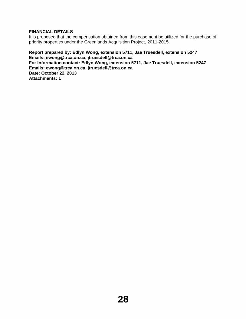
A plan illustrating the permanent easement location is attached.
28
FINANCIAL DETAILSIt is proposed that the compensation obtained from this easement be utilized for the purchase of priority properties under the Greenlands Acquisition Project, 2011-2015.
Report prepared by: Edlyn Wong, extension 5711, Jae Truesdell, extension 5247Emails: [email protected], [email protected] Information contact: Edlyn Wong, extension 5711, Jae Truesdell, extension 5247Emails: [email protected], [email protected]: October 22, 2013Attachments: 1
29
Attachment 1
30
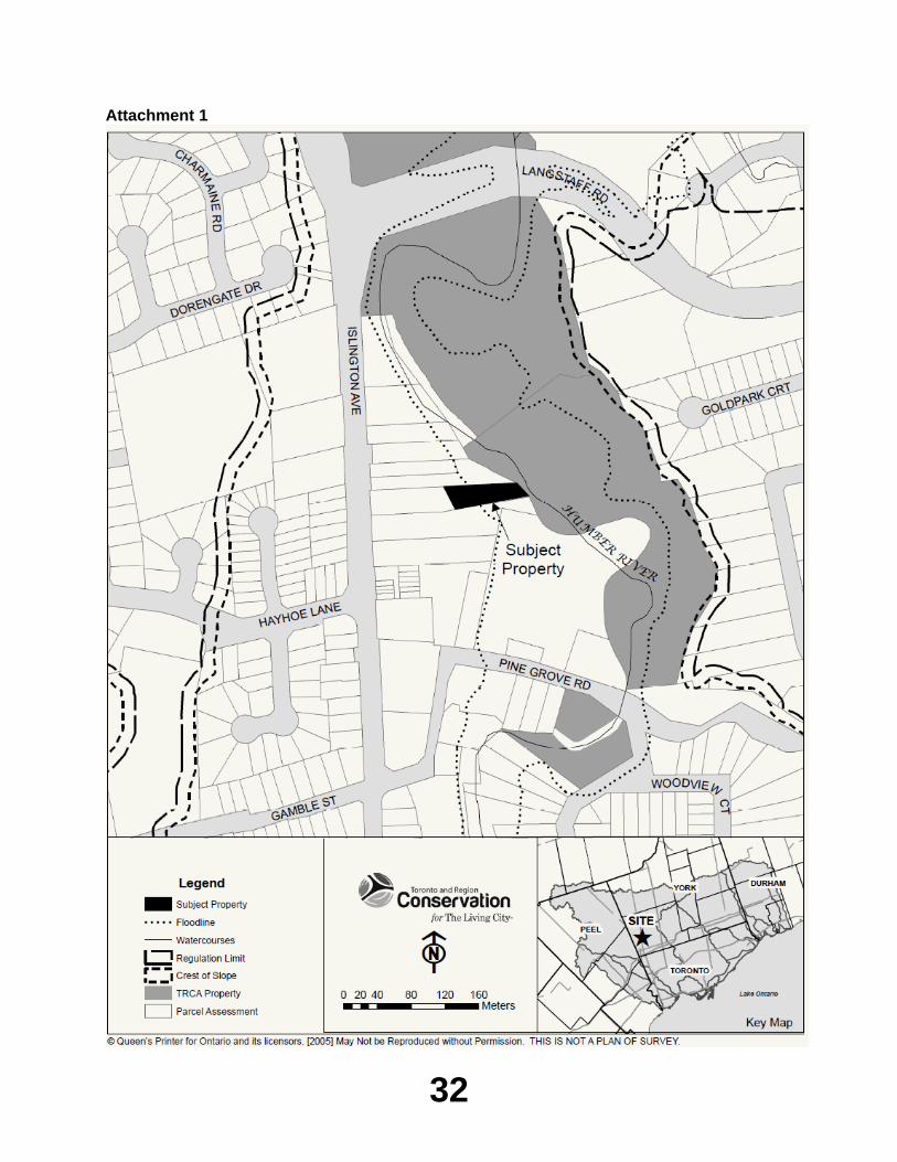
Item EX7.2TO: Chair and Members of the Executive Committee
Meeting #9/13, November 1, 2013
FROM: Mike Fenning, Senior Manager, Property Services
RE: GREENLANDS ACQUISITION PROJECT FOR 2011-2015Flood Plain and Conservation Component, Humber River WatershedRavines of Islington Holdings Inc.CFN 49571
____________________________________________________________________________KEY ISSUEAcquisition of property located south of Langstaff Road and west of Islington Avenue in the City of Vaughan, Regional Municipality of York, under the 'Greenlands Acquisition Project for 2011-2015', Flood Plain and Conservation Component, Humber River watershed.
RECOMMENDATION
THE EXECUTIVE COMMITTEE RECOMMENDS THAT 0.208 hectares ( 0.514 acres), more or less, of vacant land, being Part 26 on Plan 65R-34474, located south of Langstaff Road and west of Islington Avenue, City of Vaughan, Regional Municipality of York, be purchased from Ravines of Islington Holdings Inc.;
THAT the purchase price be $2.00;
THAT Toronto and Region Conservation Authority (TRCA) receive conveyance of the land free from encumbrance, subject to existing service easements;
THAT TRCA solicitors, Gardiner Roberts LLP, be instructed to complete the transaction at the earliest possible date. All reasonable expenses incurred incidental to the closing for land transfer tax, legal costs, and disbursements are to be paid;
AND FURTHER THAT authorized TRCA officials be directed to take the necessary action to finalize the transaction including obtaining needed approvals and signing and execution of documents.
BACKGROUNDResolution #A94/10 at Authority Meeting #5/10, held on June 25, 2010, approved the Greenlands Acquisition Project for 2011-2015.
As a condition of site plan approval, the valleylands are to be transferred to TRCA for the nominal fee of $2.00.
Negotiations have been conducted with Mary Morra of Parente, Borean LLP, acting as agent for the owner.
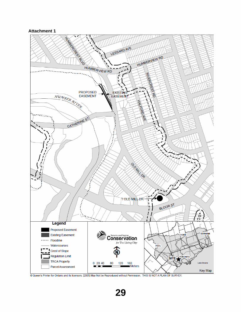
Attached is a plan showing the location of the subject lands.
31
RATIONALEThe subject property falls within TRCA’s approved master plan for acquisition for the Humber River watershed as outlined in the approved Greenlands Acquisition Project for 2011-2015. Through the review of the site plan for a proposed residential development of this site, TRCA staff established the limits of the valleylands (i.e. Part 26 on Plan 65R-34474). The subject property is also adjacent to TRCA lands to the west.
TAXES AND MAINTENANCEBased on preliminary review of the environmental criteria for lands that are eligible to receive a property tax exemption under the Provincial Conservation Land Tax Incentive Program, it would appear that all of the subject property would be eligible for exemption for the 2014 taxation year. The addition of the subject parcel of land will not significantly impact TRCA's maintenance costs at this location.
FINANCIAL DETAILSFunds for the costs related to this purchase are available in the TRCA land acquisition capital account.
Report prepared by: Edlyn Wong, extension 5711Emails: [email protected] Information contact: Edlyn Wong, extension 5711, Jae Truesdell, extension 5247Emails: [email protected], [email protected]: October 07, 2013Attachments:1
32
Attachment 1
33
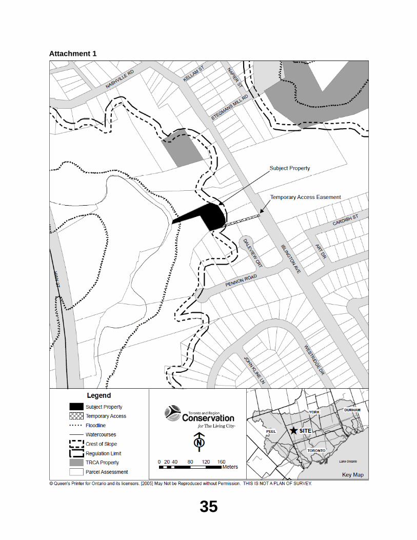
Item EX7.3TO: Chair and Members of the Executive Committee
Meeting #9/13, November 1, 2013
FROM: Mike Fenning, Senior Manager, Property Services
RE: GREENLANDS ACQUISITION PROJECT FOR 2011-2015Flood Plain and Conservation Component, Humber River WatershedAverton Common (Kleinburg) Inc.CFN 49870
____________________________________________________________________________KEY ISSUEPurchase of property located to the rear of 10360 and 10384 Islington Avenue - Kleinburg, City of Vaughan, Regional Municipality of York, under the "Greenlands Acquisition Project for 2011-2015", Flood Plain and Conservation Component, Humber River watershed.
RECOMMENDATION
THE EXECUTIVE COMMITTEE RECOMMENDS THAT 0.47 hectares (1.16 acres), more or less, of vacant land being Part of Lot 23, Concession 8 and designated as Parts 3, 4, 5 and 6 on a Draft Plan of Survey prepared by Schaeffer Dzaldov Bennett Ltd., Ontario Land Surveyors, under their Job No. 12-432-03C, dated October 16, 2013, City of Vaughan, Regional Municipality of York, located to the rear of 10360 & 10384 Islington Avenue - Kleinburg, be purchased from Averton Common (Kleinburg) Inc.;
THAT the purchase price be $2.00;
THAT Toronto and Region Conservation Authority (TRCA) receive conveyance of the lands free from encumbrance, subject to existing service easements;
THAT Gardiner Roberts LLP, be instructed to complete the transaction at the earliest possible date. All reasonable expenses incurred incidental to the closing for land transfer tax, legal costs, and disbursements are to be paid;
AND FURTHER THAT authorized TRCA officials be directed to take the necessary action to finalize the transaction including obtaining needed approvals and signing and execution of documents.
BACKGROUNDResolution #A94/10 at Authority Meeting #5/10, held on June 25, 2010, approved the Greenlands Acquisition Project for 2011-2015.
Negotiations have been conducted with Mr. Vince Baffa, Vice President, Development, of Averton Common (Kleinburg) Inc.
Since TRCA does not presently own any adjoining property, a temporary access easement over the south side of the developable portion of the property will be granted to TRCA as part of this transaction in order to periodically inspect and maintain the lands.
34
Attached is a plan showing the location of the subject lands.
RATIONALEThe subject property falls within TRCA's approved master plan for acquisition for the Humber River watershed as outlined in the approved Greenlands Acquisition Project for 2011-2015. Through the review of Rezoning Application Z.12.045 and Site Plan Application DA.12.112 for low rise, apartment type residential development, TRCA staff has established the limits of the open space lands (i.e. Parts 3 and 4 on Draft Plan of Survey) which are situated partially within the Regional Storm Flood Plain as well as entirely within the regulated area of the Humber River, including a 7.5 metre wide tableland landscape buffer.
TAXES AND MAINTENANCEBased on TRCA's preliminary review of the environmental criteria for lands that are eligible to receive a property tax exemption under the provincial Conservation Land Tax Incentive Program, it would appear that all of the subject property would be eligible for exemption for the 2014 taxation year. The addition of the subject parcel of land will not significantly impact TRCA's maintenance costs at this location.
FINANCIAL DETAILSFunds for the costs related to this purchase are available in the TRCA land acquisition capital account.
Report prepared by: George Leja, extension 5342Emails: [email protected] Information contact: George Leja, extension 5342, Jae Truesdell, extension 5247Emails: [email protected], [email protected]: August 15, 2013Attachments: 1
35
Attachment 1
36
Item EX7.4TO: Chair and Members of the Executive Committee
Meeting #9/13, November 1, 2013
FROM: Mike Fenning, Senior Manager, Property Services
RE: GREENLANDS ACQUISITION PROJECT FOR 2011-2015Flood Plain and Conservation Component, Humber River WatershedDelmanor Prince Edward Inc.CFN 49872
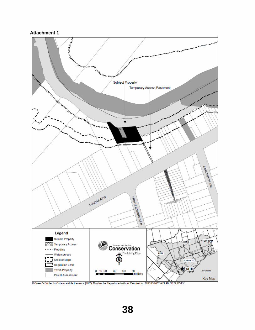
____________________________________________________________________________KEY ISSUEPurchase of property located to the rear of 4180-4190 Dundas Street West, City of Toronto - Etobicoke York Community Council Area, under the "Greenlands Acquisition Project for 2011-2015", Flood Plain and Conservation Component, Humber River watershed.
RECOMMENDATION
THE EXECUTIVE COMMITTEE RECOMMENDS THAT 0.19 hectares (0.47 acres), more or less, of vacant land being Part of Lot 10, Concession C, FTH and designated as Parts 1 and 4 on Plan 66R-27060, City of Toronto - Etobicoke York Community Council Area, located to the rear of 4180-4190 Dundas Street West, be purchased from Delmanor Prince Edward Inc.;
THAT the purchase price be $2.00;
THAT Toronto and Region Conservation Authority (TRCA) receive conveyance of the lands free from encumbrance, subject to existing service easements;
THAT Gardiner Roberts LLP, be instructed to complete the transaction at the earliest possible date. All reasonable expenses incurred incidental to the closing for land transfer tax, legal costs, and disbursements are to be paid;
AND FURTHER THAT authorized TRCA officials be directed to take the necessary action to finalize the transaction including obtaining needed approvals and signing and execution of documents.
BACKGROUNDResolution #A94/10 at Authority Meeting #5/10, held on June 25, 2010, approved the Greenlands Acquisition Project for 2011-2015.
Negotiations have been conducted with Ms. Mary Critelli of DelZotto Zorzi LLP, Barristers & Solicitors, acting as agent on behalf of the owner.
The proposed site development consists of an underground parking garage and multi-storey retirement apartment building. The works also include removal and restoration of an existing asphalt parking lot located at the top of the valley.
37
The proposed development is subject to City of Toronto and TRCA review and approvals which have now been finalized. The subject property is appropriately zoned for the intended use and currently contains an office building and surface parking lot. The existing surface parking lot is located within the slope hazard limit as well as up to the physical top of bank and the resulting storm flows are actively eroding the slope on the northwest corner of the site. This erosion scar requires remediation and replanting. The zoning approval was conditioned upon securing a comprehensive plan for slope remediation, valley renaturalization and conveyance of the restored valley lands to TRCA.
The proposed slope remediation and replanting plans need to be secured prior to moving forward with a permit for the new development. The owner has agreed to retain TRCA Restoration Services staff to design and construct the required works. An agreement is being put in place prior to the issuance of a permit under Ontario Regulation 166/06 in order to guarantee that the slope remediation works will take place.
Ultimately, the development will result in renaturalization of the former parking area and the hazard lands will be conveyed to public ownership for a net gain to the natural heritage system.
Access to the subject lands will be achieved along the east side of the property in order to complete the slope remediation works as well as to secure future access for maintenance purposes.
Attached is a plan showing the location of the subject lands.
RATIONALEThe subject property falls within TRCA's approved master plan for acquisition for the Humber River watershed as outlined in the Greenlands Acquisition Project for 2011-2015. Through our review of Official Plan and Zoning By-Law Amendment Application 10 223162 WET 04 OZ for retirement residential development, TRCA staff established the limits of the open space lands (i.e. Parts 1 and 4 on Plan 66R-27060) which are located partially within the Regional Storm Flood Plain and entirely within the Regulated Area of the Humber River valley corridor at this location.
TAXES AND MAINTENANCEIt is proposed that the lands be turned over to the City of Toronto for management.
FINANCIAL DETAILSFunds for the costs related to this purchase are available in the TRCA land acquisition capital account.
Report prepared by: George Leja, extension 5342Emails: [email protected] Information contact: George Leja, extension 5342, Jae Truesdell, extension 5247Emails: [email protected], [email protected]: August 15, 2013Attachments: 1
38
Attachment 1
39
Item EX7.5TO: Chair and Members of the Executive Committee
Meeting #9/13, November 1, 2013
FROM: Mike Fenning, Senior Manager, Property Services
RE: GREENLANDS ACQUISITION PROJECT FOR 2011-2015Flood Plain and Conservation Component, Don River Watershed1275621 Ontario Inc.CFN 49932
____________________________________________________________________________KEY ISSUEPurchase of property located on the south side of Major Mackenzie Drive, east of Dufferin Street, City of Vaughan, Regional Municipality of York, under the "Greenlands Acquisition Project for 2011-2015", Flood Plain and Conservation Component, Don River watershed.
RECOMMENDATION
THE EXECUTIVE COMMITTEE RECOMMENDS THAT 4.13 hectares (10.21 acres), more or less, of vacant land being Part of Lot 20, Concession 2 and designated as Block 57 on a Draft Plan of Subdivision prepared by Schaeffer & Dzaldov Ltd., Ontario Land Surveyors, Drawing No. A1, dated August 14, 2006, City of Vaughan, Regional Municipality of York, located on the south side of Major Mackenzie Drive, east of Dufferin Street, be purchased from 1275621 Ontario Inc.;
THAT the purchase price be $2.00;
THAT Toronto and Region Conservation Authority (TRCA) receive conveyance of the lands free from encumbrance, subject to existing service easements;
THAT Gardiner Roberts LLP, be instructed to complete the transaction at the earliest possible date. All reasonable expenses incurred incidental to the closing for land transfer tax, legal costs, and disbursements are to be paid;
AND FURTHER THAT authorized TRCA officials be directed to take the necessary action to finalize the transaction including obtaining needed approvals and signing and execution of documents.
BACKGROUNDResolution #A94/10 at Authority Meeting #5/10, held on June 25, 2010, approved the Greenlands Acquisition Project for 2011-2015.
Negotiations have been conducted with Mr. George Karakokkinos of Nu-Land Management Inc., who acts as agent on behalf of the owner.
40
The subject parcel to be conveyed to TRCA contains an on-stream pond with an outlet structure, utilizing stop logs to control water levels. The pond was built by a previous owner of the property sometime prior to 1960. From the outset of negotiations, which date back to 2006, staff has maintained that the existence of the on-stream pond is problematic from a liability perspective and that it is imperative that the pond be taken off-line before any acquisition by TRCA. Following much discussion between TRCA and the owner, it was decided that TRCA staff is best positioned to restore the pond due to expertise in natural heritage restoration. Accordingly, the owner has agreed to provide funds in the amount of $85,000.00, as estimated by TRCA Restoration Services staff, for removal of the outlet structure in order to gradually draw down the pond and allow the watercourse to re-establish its natural path. A portion of the funds will be used to purchase native plant material to restore the former pond area. Based on the above-noted agreement, staff is now prepared to proceed with acquisition of the subject lands.
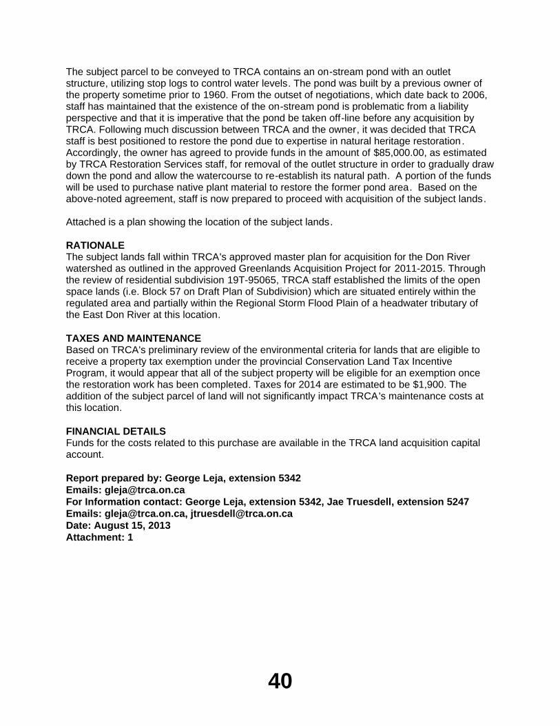
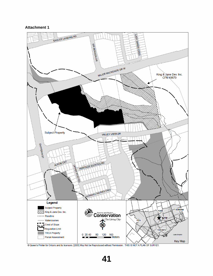
Attached is a plan showing the location of the subject lands.
RATIONALEThe subject lands fall within TRCA's approved master plan for acquisition for the Don River watershed as outlined in the approved Greenlands Acquisition Project for 2011-2015. Through the review of residential subdivision 19T-95065, TRCA staff established the limits of the open space lands (i.e. Block 57 on Draft Plan of Subdivision) which are situated entirely within the regulated area and partially within the Regional Storm Flood Plain of a headwater tributary of the East Don River at this location.
TAXES AND MAINTENANCEBased on TRCA's preliminary review of the environmental criteria for lands that are eligible to receive a property tax exemption under the provincial Conservation Land Tax Incentive Program, it would appear that all of the subject property will be eligible for an exemption once the restoration work has been completed. Taxes for 2014 are estimated to be $1,900. The addition of the subject parcel of land will not significantly impact TRCA's maintenance costs at this location.
FINANCIAL DETAILSFunds for the costs related to this purchase are available in the TRCA land acquisition capital account.
Report prepared by: George Leja, extension 5342Emails: [email protected] Information contact: George Leja, extension 5342, Jae Truesdell, extension 5247Emails: [email protected], [email protected]: August 15, 2013Attachment: 1
41
Attachment 1
42
Item EX7.6TO: Chair and Members of the Executive Committee
Meeting #9/13, November 1, 2013
FROM: Brian Denney, Chief Executive Officer
RE: USE OF RESOURCES DURING AN ELECTIONApproval of Toronto and Region Conservation Authority Policy
____________________________________________________________________________KEY ISSUEApproval of policy and receipt of procedures on Use of Resources During an Election.
RECOMMENDATION
THE EXECUTIVE COMMITTEE RECOMMENDS THAT the policy on Use of Resources During an Election be approved, as outlined in Attachment 1;
THAT the procedures on Use of Resources During an Election be received, as outlined in Attachment 2;
THAT the policy be added to the category of "Application to the General Public or Have Significant Implications" as outlined in the Policy Review staff report approved by the Authority on July 26, 2013;
AND FURTHER THAT the City of Toronto be so advised by the CEO's Office.
BACKGROUNDAt its meeting held on February 20 and 21, 2013, Toronto City Council approved a motion requesting that City agencies adopt policies similar to the City of Toronto's that clarify the appropriate actions of employees and use of facilities, events, information, infrastructure and other resources during an election.
At Authority Meeting #4/12, held on May 25, 2012, Resolution #A85/12 approved the Toronto and Region Conservation Authority (TRCA) policy on Conflict of Interest - Employee Participation in Municipal, Provincial or Federal Elections.
TRCA staff conducted a review of the City of Toronto policy, as well as those of the cities of Vaughan and Brampton, and towns of Markham and Richmond Hill in preparing the TRCA policy and procedures for Use of Resources During and Election.
RATIONALEThe rationale for this request is to provide a consistent approach to the use of public resources during an election, to help support confidence in the election process, and to be in keeping with the Municipal Elections Act,1996 which specifies that a municipality or local board cannot make a contribution to a municipal election candidate.
43
The policy strives to recognize the need to balance freedom of expression and assembly of candidates with responsibilities while ensuring there is no unfair advantage, promotion or contributions to any one candidate, party, registrant or supporter of a ballot question.
The policy recommended in Attachment 1, in conjunction with the already approved TRCA policy on employee participation in elections, meets these objectives, and is consistent with the City of Toronto policy.
Procedures for implementation of the policy have been approved by TRCA's Directors Committee, and are outlined for the information of the board in Attachment 2.
Staff recommends that the policy on Use of Resources During an Election be categorized as "Application to the General Public or Have Significant Implications", and as such requires Authority approval.
Report prepared by: Kathy Stranks, extension 5264Emails: [email protected] Information contact: Kathy Stranks, extension 5264Emails: [email protected]: September 16, 2013Attachments: 2

44
Attachment 11. PURPOSE
The Toronto and Region Conservation Authority (TRCA) policy on 'Use of Resources During an Election' provides a consistent approach and direction to TRCA employees on how TRCA resources can and cannot be used during municipal, school board, provincial and federal election campaigns or campaigns on a question on a ballot.
2. BACKGROUND
The Municipal Elections Act,1996 specifies that a municipality or local board cannot make a contribution to a municipal election candidate (Section 70(4)). A “contribution” includes money, goods and services given to and accepted by or on behalf of a person for his or her election campaign (Section 66 (1)).
Since a “contribution” may take the form of money, goods or services, any use by an Authority Member who is a candidate or by any candidate, of TRCA’s resources for an election campaign would be a contribution by TRCA.
This policy and accompanying procedures establishes guidelines on the appropriate use of resources during an election period, in order to:
protect the interests of Authority Members, candidates, staff and TRCA, and
ensure accountable and transparent election practices.
TRCA employees may be approached by some candidates to use TRCA resources for the purposes of campaigning. A clear policy is required to guide the action of TRCA employees and help determine which requests can be accommodated and which should be denied.
3. SCOPE
This policy and accompanying procedures applies to all Authority Members, candidates in a municipal, school board, provincial and federal election, and TRCA staff during an election period.
4. ROLES AND RESPONSIBILITIES
Chief Executive Officer (CEO): Procedures and guidelines pursuant to the 'Use of Resources During an Election' policy shall be developed to ensure audit implementation compliance. All issues with respect to this policy and associated procedures should be directed toward the CEO.
Directors: Directors are responsible for the application of this policy to TRCA resources, facilities and employees managed by their Divisions.
TRCA Employees: TRCA employees are responsible for understanding and applying this policy and for seeking clarification and advice if required.
45
5. POLICY
TRCA strives to recognize the need to balance freedom of expression and assembly of candidates with responsibilities while ensuring there is no unfair advantage, promotion or contributions to any one candidate, party, registrant or supporter of a ballot question.
TRCA cannot make a contribution (including money, goods and/or services) to any candidate, political party, registrant or a supporter of a question on a ballot during an election.
TRCA resources cannot be used to promote one candidate, political party, registrant or a supporter of a question on a ballot during an election over another candidate, political party, registrant or a supporter of a question on a ballot during an election.
This policy is intended to enable continued public and media access to candidates or registrants for information and interviews. The policy distinguishes between unplanned media scrums or chance public encounters by candidates and the media, whether in-person or online, and actual planned media events or rallies.
The policy recognizes that Authority Members are holders of their position until their successor is appointed, and supports Members in continuing to fulfill their responsibilities as Authority Members.
The policy recognizes that Members of Council are holders of their office until the end of their term and supports Members in continuing to fulfill their responsibilities as Members of Council .
The CEO's Office shall ensure the policy contained herein and associated procedures are reviewed on a regular basis (not to exceed three years) and remains relevant to the needs of TRCA, in accordance with legislative requirements and good business practices.
6. DEFINITIONS
"Authority Member"– means any individual appointed to the board of Toronto and Region Conservation Authority by a participating member municipality.
"Campaigning" – means any activity by or on behalf of a candidate, political party or question on a ballot meant to elicit support during the election period. Campaigning does not include the appearance of elected officials, other candidates or their supporters, or registrants at an event in their personal capacity without the display of any signage or graphic which identifies the individual as a candidate or registrant and without the solicitation of votes.
"Campaign Materials" – means any materials used to solicit votes for a candidate(s) or question in an election including but not limited to literature, banners, posters, pictures, buttons, clothing or other paraphernalia. Campaign materials include materials in all media, for example, print, displays, electronic radio or television, online including websites or social media.
"Candidate" – means any person who has filed and not withdrawn a nomination for an elected office at the municipal, school board, provincial or federal level in an election or by-election.
46
"TRCA Resources" – includes but is not limited to TRCA employees, TRCA events, TRCA facilities, TRCA funds, TRCA information and TRCA infrastructure. These are further defined as follows:
"TRCA employees" – for the purpose of this policy, Toronto and Region Conservation Authority employees includes: all TRCA employees, including full time, part time and contract employees, as well as paid or unpaid interns and registered volunteers
"TRCA events" – means events funded or organized by TRCA or any Authority Member, including events that may be jointly organized with community organizations and/or with external sponsors. TRCA events include, but are not limited to: community meetings and consultations, parks, recreation or cultural facility openings or celebrations and other special events.
"TRCA facilities" – means any facility which is owned or leased by TRCA and which is directly managed and operated by TRCA divisions or programs. TRCA facilities do not include public right-of-ways such as sidewalks, roads and boulevards and laneways.
"TRCA funds or monies" – means funding support through TRCA’s annual operating or capital budgets, including but not limited to funds provided directly to TRCA programs and services, Members expenses and staffing budgets.
"TRCA information" – means any information in the custody and control of TRCA, including databases that may be the repository of names, contact information, business records, financial information or other identifiers compiled and used by TRCA employees to conduct TRCA business. Examples of TRCA databases include but are not limited to: Contact Manager records, lists of event attendees, partners and TRCA tenants. Constituent information collected by TRCA Members are not under custody or control of TRCA and are not considered TRCA information for the purpose of this policy.
"TRCA infrastructure" – means any physical or technology systems that support the operation of TRCA programs and services, including but not limited to TRCA’s fleet and marine vehicles, computer network, telecommunications and Lotus Notes email system, wireless equipment, computer hardware, software and peripherals, internet and intranet. Excludes public right-of-way including sidewalks, roads, laneways and boulevards.
"Contribution" – as defined in the Municipal Elections Act, 1996, as amended means "money, in-kind support, goods and services given to and accepted by or on behalf of a person for his or her election campaign".
"Election" – means an election or by-election at the municipal, school board, provincial and federal level of government, or the submission of a question or by-law to the electors.
"Election Period" – means the official campaign period of an election.
For a municipal or school board election, the election period commences on June
30th and ends on voting day.
For a provincial or federal election, the election period commences the day the
writ for the election is issued and ends on voting day.
47
For a by-election, the period commences when the by-election is called and ends
on voting day.
"Elected Official" – means an individual elected to the House of Commons, the Legislative Assembly of Ontario, a municipal council or a school board.
"Glad-handing" – means attending a TRCA event as a private individual and interacting with other event attendees without displaying signage or disseminating material which identifies the individual as a candidate and without encouraging votes for a candidate, a political party or a position on a question on a ballot.
"Media Event" – means an event such as a press conference or photo opportunity to which the media is invited and the purpose of which is to promote a candidate, a political party or a position on a question on a ballot. Features of a media event can include but are not limited to, the issuing of a media advisory stating date, time and location of briefing/press conference, use of backdrops, podiums or public address systems, the distribution of media releases and/or media kits and/or the display of signage and/or other materials to promote a candidate or a position on a question on a ballot.
"Media Scrum" – means an unplanned encounter between a candidate, a registrant, their staff and/or a member or members of the media.
"New/Social Media" – means online technologies and practices used to share opinions, insights, experiences and perspectives through words, pictures, music, videos and audio. Social media can take many different forms, including but not limited to internet forums, web logs (blogs), social blogs, messaging, wikis, podcasts, pictures, video, music sharing, rating and bookmarking.
"Political Party" – Political parties for provincial and federal elections are those registered with the Ontario Election Finances Act or in the registry of parties referred to in section 374 of the Canada Elections Act . Political party for municipal, school board or question on a ballot means an organization whose fundamental purposes is to participate in public affairs by endorsing one or more of its members as candidates and supporting their election, or to promote the acceptance of a certain position on a question on a ballot.
"Question on a Ballot" – means any question or by-law submitted to the electors by Council, a school board, an elected local board, or the Minister of Municipal Affairs and Housing under the Municipal Elections Act, 1996.
"Registrant" – means an individual, corporation or trade union described in paragraphs 1 to 3 of subsection 70(3) who has registered with the clerk regarding a question on a ballot under the Municipal Elections Act, 1996 .
"Supporter" – means a supporter of a yes or no response to a question on a ballot but not incurring expenses like a registrant.
"Voting Day" – means the day on which the final vote is to be taken in an election.

48
RELATED POLICES AND PROCEDURES
Procedures for Use of Resources During an Election
Conflict of Interest - Employee Participation in Municipal, Provincial or Federal Elections
49
Attachment 2
1. Activities Allowable during an Election Period
1.1 Members of the Authority may directly book normally permitted space in a Toronto and Region Conservation Authority (TRCA) facility at the approved rate identified in the fee schedule for public facilities and programming, and any other conditions normally imposed under such permit, shall apply, except as outlined under Section 2.5 of the Procedures for Use of Resources During an Election, or any other such clause as may be applicable.
1.2 All-candidate meetings can be held at TRCA facilities provided that all candidates for an office or all registrants are invited to attend such meetings. This clause is subject to all applicable TRCA policies and procedures.
1.3 Candidate, political party, registrant or a supporter of a question on a ballot during an election are permitted to distribute campaign materials on public right of way sidewalks and thoroughfares and at public parks, subject to the existing permitting policies and procedures for these facilities.
1.4 Informal media scrums are permitted in public or common areas at TRCA facilities provided that no apparatus, mechanism or device for the amplification of the human voice or any sounds is used and that the activity is not disruptive to regular TRCA business in the vicinity. If the media scrum is disruptive, employees may ask the participants to find an alternative location. This clause is subject to all applicable TRCA policies and procedures.
1.5 Candidate, political party, registrant or a supporter of a question on a ballot during an election are permitted to attend TRCA events, or events held at TRCA facilities, in either their capacity as an appointee to TRCA, elected representatives or as private citizens to glad-hand with attendees and visitors, but may not solicit votes for themselves, a political party, registrant or a supporter of a question on a ballot. No election signs may be posted and no campaign materials may be disseminated at TRCA events. This clause is subject to all applicable TRCA policies and procedures.
1.6 Permits for generic election-related purposes, such as teaching members of the public how to become a candidate or the knowledge to organize an election campaign, can be issued for TRCA facilities as long as no one particular candidate, political party, registrant or a supporter of a question on a ballot during an election is promoted or endorsed at the event.
1.7 Elected officials are permitted to attend TRCA-organized events or events held on TRCA property and act as ceremonial participants in their capacity as elected officials, including speaking at the event and partaking in ceremonial activities. Once the writ is issued for provincial or federal elections, MPPs and MPs are no longer elected officials and therefore should not be invited to attend TRCA events.
1.8 TRCA online information related to Members will continue to be accessible by the public.
50
1.9 TRCA databases already made available for public use may be used by candidate, political party, registrant or a supporter of a question on a ballot during an election.
1.10 TRCA employees may work on a campaign or support a candidate outside of their work hours, as long as they abide by the Human Resources policy titled “Conflict of Interest - Employee Participation in Municipal, Provincial or Federal Elections” which defines permitted campaign activity. The policy also prohibits certain employees from participating in any campaign activity.
1.11 Information that is requested and/or provided by TRCA employees to one candidate, political party, registrant or a supporter of a question on a ballot during an election shall be made available to all other candidate, political party, registrant or a supporter of a question on a ballot, at their request, either through posting of the information on the internet or through other mechanisms. The provision of information to a candidate, political party, registrant or a supporter of a question on a ballot during an election will be coordinated through the CEO's Office.
1.12 Requests by a candidate, political party, registrant or a supporter of a question on a ballot for personal meetings with TRCA employees, and requests for tours of TRCA facilities may not always be accommodated due to resource and time constraints. If a meeting or a tour is organized for one candidate, political party, registrant or a supporter of a question on a ballot during an election, TRCA staff would need to commit to organizing a similar meeting or tour for all other candidates, political parties, registrants or supporters of a question on a ballot, at their request.
2. Activities Not Allowable during an Election Period
2.1 TRCA resources, including but not necessarily limited to monies, facilities, equipment, supplies, services or other TRCA resources, may not be used at anytime to support, endorse or otherwise provide an unfair advantage to any candidate, political party, registrant or a supporter of a question on a ballot during an election.
2.2 TRCA monies may not be used to acquire any resources for any campaign or election related activities.
2.3 TRCA employees may not campaign or actively work in support of a municipal, school board, provincial or federal candidate, political party, registrant or a supporter of a question on a ballot during an election during working hours, but may during non-working hours as described in the Human Resources policy titled “Conflict of Interest - Employee Participation in Municipal, Provincial or Federal Elections”.
2.4 TRCA facilities and TRCA infrastructure cannot be used for any election-related purposes by candidate, political party, registrant or a supporter of a question on a ballot, including for the display of any campaign-related signs in windows or on the facilities, as well as for any other form of campaigning on the facilities, including distribution of election-related material, except as described in section 1 of this procedure.
51
2.5 No permits, licenses, leases, or any other agreement for the use of TRCA facilities will be issued for the use or promotion of a particular candidate, political party, registrant or a supporter of a question on a ballot during an election.
2.6 Any candidate, political party, registrant or a supporter of a question on a ballot during an election shall not distribute any campaign materials in TRCA facilities or at TRCA events, except on public right-of ways, thoroughfares and in public parks as described in section 1.3 or during all-candidates meetings.
2.7 TRCA communications materials, whether for internal or for public distribution, must not be used to:
a. Profile (name or photograph), make reference to and/or identify any individual as a candidate in any election or a registrant in a question on a ballot.
b. Advocate for or against a particular candidate, political party, registrant or a supporter of a question on a ballot during an election.
Communications materials include but are not limited to: media releases, media advisories, invitations for special events, flyers, posters, banners, brochures and newsletters.
2.8 Websites or domain names that are funded by TRCA must not include any campaign materials, make reference to and/or identify any individual as a candidate, political party, registrant or a supporter of a question on a ballot during an election, or profile any slogan or symbol associated with a candidate, political party, registrant or a supporter of a question on a ballot during an election.
2.9 News/social media sites, blogs and other new media created and managed by TRCA employees must not make reference to and/or identify any individual as a candidate, political party, registrant or a supporter of a question on a ballot during an election.
2.10 Photographic or video materials which have been or may be created by TRCA employees or with TRCA resources must not be used in any campaign materials.
2.11 The TRCA logo must not be used in any campaign materials.
2.12 TRCA databases must not be used by any candidate, political party, registrant or a supporter of a question on a ballot during an election, unless the database has already been released for public use as per section 1.9.
2.13 TRCA infrastructure cannot be used for any election purposes.
2.14 TRCA employees will not perform any service, offer any advice or provide any information solely for the use of one Authority Member, candidate, political party, registrant or a supporter of a question on a ballot during an election.
52
2.15 All printing, high speed photocopying and distribution of materials, including stationery and business cards, will be discontinued for an Authority Member, candidate, political party, registrant or a supporter of a question on a ballot during an election, unless authorized by the Authority, except Agendas and Minutes of Authority, committee and advisory board meetings are exempt from this provision. If a compelling corporate need arises during the election period, an Authority Member who is a candidate may use corporate resources to advise or contact TRCA constituents, in keeping with the procedures contained herein, with the consent of the TRCA Chief Executive Officer.
2.16 Notices may not be distributed to any Authority Member, candidate, political party, registrant or a supporter of a question on a ballot during an election, for opening of parks, open spaces and facilities.
2.17 On any material printed or distributed by TRCA, any Authority Member, candidate, political party, registrant or a supporter of a question on a ballot during an election are not permitted to: illustrate that a person is a candidate registered in an election; identify where a person will be running for office; or profile or refer to candidates during an election.
2.18 Use of cell phones and PDA's that are funded by TRCA for any election-related campaign purpose is not permitted, unless TRCA is reimbursed.
2.19 Use of TRCA's voice mail system to record election related messages, and the computer network and related IT systems (including TRCA's email system) to distribute election related, correspondence is not permitted.
3. Restrictions related to Services Provided to Authority Members during an Election Year
As Authority Members may also be candidates in an election, after August 1 in the municipal or school board election year, or on the day the writ for election is issued for provincial or federal elections, TRCA employees will discontinue the following activities for Authority Members. The same rule applies to all Authority Members, irrespective of whether they are seeking election in the new term or not:
3.1 Advertising and other communications materials paid for by TRCA funds and distributed by TRCA will not reference the name of an Authority Member.
3.2 Event signage, including banners and posters, will not reference the name of an Authority Member.
3.3 Media releases issued by TRCA employees will not reference the name of an Authority Member.
4. Audit Compliance
4.1 The CEO's Office is responsible for communication of this protocol to Authority Members.
53
4.2 The CEO, Directors, Senior Managers, Managers and Supervisors are responsible for communication of this protocol to their staff and to investigate reported contraventions to ensure that there is compliance. All reported contraventions are to be reported to the CEO or designate.
4.2 TRCA staff shall consult with the CEO's Office prior to confirming a booking with a political client, to ensure the event booking is in compliance with the policy on Use of Resources During an Election.
4.3 Authority Members and staff are accountable to comply with this protocol.
5. Limitation
5.1 Nothing in this policy shall preclude an Authority Member from performing their job as an Authority Member, nor inhibit them from representing the interests of the governing body who appointed them.
RELATED POLICES AND PROCEDURES
Policy for Use of Resources During an Election
Conflict of Interest - Employee Participation in Municipal, Provincial or Federal Elections
54
Item EX7.7TO: Chair and Members of the Executive Committee
Meeting #9/13, November 1, 2013
FROM: Derek Edwards, Director, Parks and Culture
RE: 2014 FEE SCHEDULE FOR PUBLIC FACILITIES AND PROGRAMMING____________________________________________________________________________KEY ISSUEToronto and Region Conservation Authority 2014 Fee Schedule for Public Facilities and Programming.
RECOMMENDATION
THAT the 2014 Fee Schedule for Public Facilities and Programming be amended as set out in Attachment 1, and become effective January 1, 2014.
BACKGROUNDEach year staff conducts a review of the Toronto and Region Conservation Authority (TRCA) Fee Schedule for Public Facilities and Programming to determine any changes. The review of fees takes into account whether they are reflective of the value provided and in keeping with market conditions. The conclusion is that the fee schedule is reflective of market conditions and that no major changes are warranted for 2014, except for those noted in Attachment 1.
Staff propose to increase fees for two programs as outlined below in order to facilitate sustainable program offerings.
RATIONALEThe following notes the proposed fee increases and restructuring which are outlined in Attachment 1. Copies of the full 2014 Fee Schedule for Public Facilities and Programming are available upon request.
Increase program rates for each student participating in a general tour or program at the
Kortright Centre for Conservation to support program delivery costs.Increase program rates for each student participating in a specially designed tour program
at the Kortright Centre for Conservation to support program delivery costs.Increase membership fees to Glen Haffy Headwaters Fly Fisher’s Club to support program
delivery costs.
Report prepared by: Amanda Perricone, extension 5252Emails: [email protected] Information contact: Derek Edwards, extension 5672Emails: [email protected]: October 03, 2013Attachments: 1
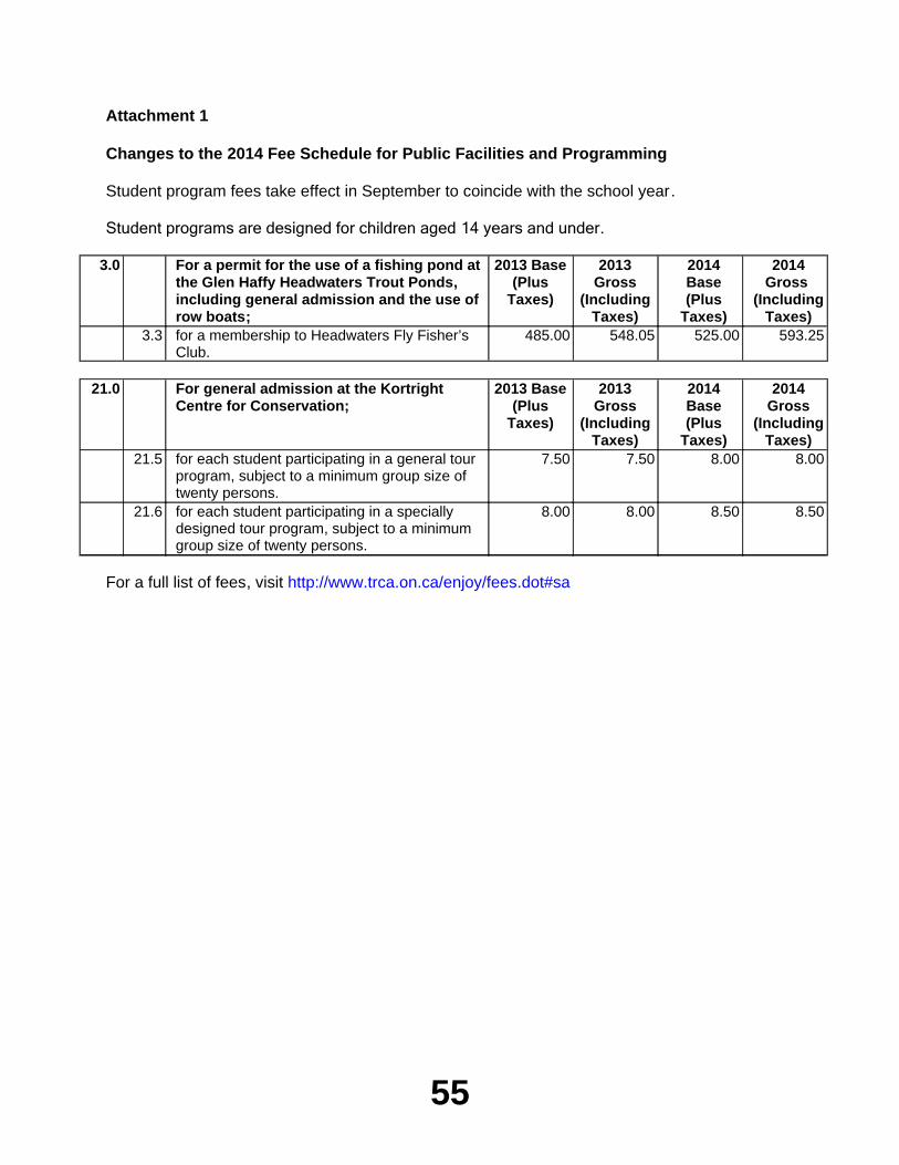
55
Attachment 1
Changes to the 2014 Fee Schedule for Public Facilities and Programming
Student program fees take effect in September to coincide with the school year.
Student programs are designed for children aged 14 years and under.
3.0 For a permit for the use of a fishing pond at the Glen Haffy Headwaters Trout Ponds, including general admission and the use of row boats;
2013 Base(Plus
Taxes)
2013 Gross
(Including Taxes)
2014 Base(Plus
Taxes)
2014 Gross
(Including Taxes)
3.3 for a membership to Headwaters Fly Fisher’s Club.
485.00 548.05 525.00 593.25
21.0 For general admission at the Kortright Centre for Conservation;
2013 Base (Plus
Taxes)
2013 Gross
(Including Taxes)
2014 Base(Plus
Taxes)
2014 Gross
(Including Taxes)
21.5 for each student participating in a general tour program, subject to a minimum group size of twenty persons.
7.50 7.50 8.00 8.00
21.6 for each student participating in a specially designed tour program, subject to a minimum group size of twenty persons.
8.00 8.00 8.50 8.50
For a full list of fees, visit http://www.trca.on.ca/enjoy/fees.dot#sa
56
Item EX10.1TO: Chair and Members of the Executive Committee
Meeting #9/13, November 1, 2013
FROM: Carolyn Woodland, Director, Planning and Development
RE: APPLICATIONS FOR PERMITS PURSUANT TO ONTARIO REGULATION 166/06Development, Interference with Wetlands and Alterations to Shorelines and Watercourses
____________________________________________________________________________KEY ISSUEPursuant to Ontario Regulation 166/06, written permission from the Authority is required for:
a) straightening, changing, diverting or interfering in any way with the existing channel of a river, creek, stream or watercourse, or for changing or interfering in any way with a wetland;
b) development, if in the opinion of the authority, the control of flooding, erosion, dynamic beaches or pollution or the conservation of land may be affected by the development.
A permit may be refused through a Hearing Process, if in the opinion of the Authority, the control of flooding, erosion, dynamic beaches, pollution or the conservation of land is affected.
RECOMMENDATION
THAT permits be granted in accordance with Ontario Regulation 166/06 for the applications which are listed below:
PERMIT APPLICATION EX10.1 - EX10.3 ARE MAJOR APPLICATIONS
Applications that involved a more complex suite of technical studies to demonstrate consistency with policies; applications that cover a significant geographic area (e.g. subdivisions, stormwater management ponds), extensive modifications to the landscape, major infrastructure projects, emergency works, resolution of violations/after the fact permits, trail construction
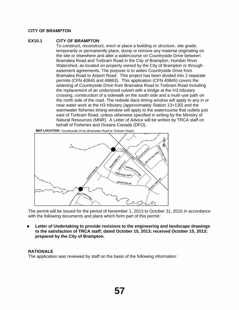
57
CITY OF BRAMPTON
EX10.1 CITY OF BRAMPTONTo construct, reconstruct, erect or place a building or structure, site grade, temporarily or permanently place, dump or remove any material originating on the site or elsewhere and alter a watercourse on Countryside Drive between Bramalea Road and Torbram Road in the City of Brampton, Humber River Watershed, as located on property owned by the City of Brampton or through easement agreements. The purpose is to widen Countryside Drive from Bramalea Road to Airport Road. This project has been divided into 2 separate permits (CFN 40845 and 49863). This application (CFN 40845) covers the widening of Countryside Drive from Bramalea Road to Torbram Road including the replacement of an undersized culvert with a bridge at the H3 tributary crossing, construction of a sidewalk on the south side and a multi-use path on the north side of the road. The redside dace timing window will apply to any in or near water work at the H3 tributary (approximately Station 13+130) and the warmwater fisheries timing window will apply to the watercourse that outlets just east of Torbram Road, unless otherwise specified in writing by the Ministry of Natural Resources (MNR). A Letter of Advice will be written by TRCA staff on behalf of Fisheries and Oceans Canada (DFO).
The permit will be issued for the period of November 1, 2013 to October 31, 2015 in accordance with the following documents and plans which form part of this permit:
Letter of Undertaking to provide revisions to the engineering and landscape drawings
to the satisfaction of TRCA staff; dated October 15, 2013; received October 15, 2013; prepared by the City of Brampton.
RATIONALEThe application was reviewed by staff on the basis of the following information:
58
Proposal:This proposal is one of two separate permit applications for the construction of Countryside Drive from Bramalea Road to Airport Road. Work for this section of the road involves widening Countryside Drive from Bramalea Road to Torbram Road from a 2-lane rural to a 4-lane urban cross-section with 6-lanes at major intersections. A 1.5 m wide sidewalk will be constructed on the south side of the road and a 3.0 m multi-use path will be constructed on the north side of the road. The existing 3.9 m span culvert at the H3 tributary (approximately Station 13+130) was found to be undersized. As a result, the City of Brampton together with MNR through their requirements as it relates to redside dace determined that the culvert will need to be replaced with a single 36 m span bridge and the watercourse realigned. In addition, a new 2.4 m by 1.5 m box culvert will be constructed in place of an existing 600 mm diameter CSP to accommodate the road widening near Torbram Road. This culvert will connect to an existing 2.4 m by 1.5 m concrete culvert that outlets to a watercourse south of Countryside Drive on the east side of Torbram Road.
Control of Flooding:Works within this area are not anticipated to affect the conveyance or storage of flood waters.
Pollution:Standard erosion and sediment control measures (silt fence, cofferdam, rock check dam) will be implemented prior to construction and maintained for the duration of construction, and until the site is stabilized and restored, in order to prevent construction generated sediments from entering any watercourse or wetland. Erosion and sediment control measures have been provided in accordance with the TRCA Erosion and Sediment Control Guideline for Urban Construction.
Dynamic Beaches:Not applicable
Erosion:No geotechnical/slope stability issues are anticipated for the proposal.
Conservation of Land:With erosion and sedimentation plans in effect, the potential for a Harmful, Alteration, Disruption or Destruction (HADD) of fish habitat will be mitigated and a Letter of Advice will be written by TRCA staff on behalf of Fisheries and Oceans Canada (DFO). This application is subject to the Ministry of Natural Resources (MNR) redside dace fisheries timing window (July 1 to September 15) for any in or near water work at the H3 tributary (approximately Station 13+130) and the warmwater fisheries timing window (July 1 to March 31) will apply for work at the tributary near Torbram Road, unless otherwise specified in writing by MNR.
PlantingsAll disturbed areas will be restored and a net ecological gain will be achieved. The City of Brampton will be planting approximately 287 boulevard trees between Bramalea Road and Airport Road, 45 park trees in Sesquicentennial Park, 5700 buffer plantings and 1269 restoration plantings along the H3 tributary.
Policy Guidelines:This proposal complies with Section 4.3 - Infrastructure and Servicing - of the Authority's Valley and Stream Corridor Management Program.
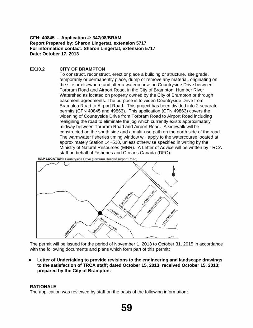
59
CFN: 40845 - Application #: 347/08/BRAMReport Prepared by: Sharon Lingertat, extension 5717For information contact: Sharon Lingertat, extension 5717Date: October 17, 2013
EX10.2 CITY OF BRAMPTONTo construct, reconstruct, erect or place a building or structure, site grade, temporarily or permanently place, dump or remove any material, originating on the site or elsewhere and alter a watercourse on Countryside Drive between Torbram Road and Airport Road, in the City of Brampton, Humber River Watershed as located on property owned by the City of Brampton or through easement agreements. The purpose is to widen Countryside Drive from Bramalea Road to Airport Road. This project has been divided into 2 separate permits (CFN 40845 and 49863). This application (CFN 49863) covers the widening of Countryside Drive from Torbram Road to Airport Road including realigning the road to eliminate the jog which currently exists approximately midway between Torbram Road and Airport Road. A sidewalk will be constructed on the south side and a multi-use path on the north side of the road. The warmwater fisheries timing window will apply to the watercourse located at approximately Station 14+510, unless otherwise specified in writing by the Ministry of Natural Resources (MNR). A Letter of Advice will be written by TRCA staff on behalf of Fisheries and Oceans Canada (DFO).
The permit will be issued for the period of November 1, 2013 to October 31, 2015 in accordance with the following documents and plans which form part of this permit:
Letter of Undertaking to provide revisions to the engineering and landscape drawings
to the satisfaction of TRCA staff; dated October 15, 2013; received October 15, 2013; prepared by the City of Brampton.
RATIONALEThe application was reviewed by staff on the basis of the following information:
60
Proposal:This proposal is one of two separate permit applications for the construction of Countryside Drive from Bramalea Road to Airport Road. Work for this section of the road involves widening Countryside Drive from Torbram Road to Airport Road from a 2-lane rural to a 4-lane urban cross-section with 6-lanes at major intersections. A 1.5 m wide sidewalk will be constructed on the south side of the road and a 3.0 m multi-use path will be constructed on the north side of the road. Countryside Drive will be realigned to eliminate the jog located approximately midway between Torbram Road and Airport Road. As a result, the existing culvert that conveys a small tributary will be removed and restored. A new 1.2 m wide concrete culvert will be constructed within the new realigned road segment to allow for conveyance of the tributary.
Control of Flooding:Works within this area are not anticipated to affect the conveyance or storage of flood waters.
Pollution:Standard erosion and sediment control measures (silt fence, rock check dam) will be implemented prior to construction and maintained for the duration of construction, and until the site is stabilized and restored, in order to prevent construction generated sediments from entering any watercourse or wetland. Erosion and sediment control measures have been provided in accordance with the TRCA Erosion and Sediment Control Guideline for Urban Construction.
Dynamic Beaches:Not applicable
Erosion:No geotechnical/slope stability issues are anticipated for the proposal.
Conservation of Land:With erosion and sedimentation plans in effect, the potential for a Harmful, Alteration, Disruption or Destruction (HADD) of fish habitat will be mitigated and a Letter of Advice will be written by TRCA staff on behalf of Fisheries and Oceans Canada (DFO). This application is subject to the Ministry of Natural Resources (MNR) warmwater fisheries timing window (July 1 to March 31), unless otherwise specified in writing by MNR.
PlantingsAll disturbed areas will be restored and a net ecological gain will be achieved. The City of Brampton will be planting approximately 287 boulevard trees between Bramalea Road and Airport Road and the section of road that will be removed near the tributary will be restored.
Policy Guidelines:This proposal complies with Section 4.3 - Infrastructure and Servicing - of the Authority's Valley and Stream Corridor Management Program.
CFN: 49863 - Application #: 0901/13/BRAMReport Prepared by: Sharon Lingertat, extension 5717For information contact: Sharon Lingertat, extension 5717Date: October 17, 2013
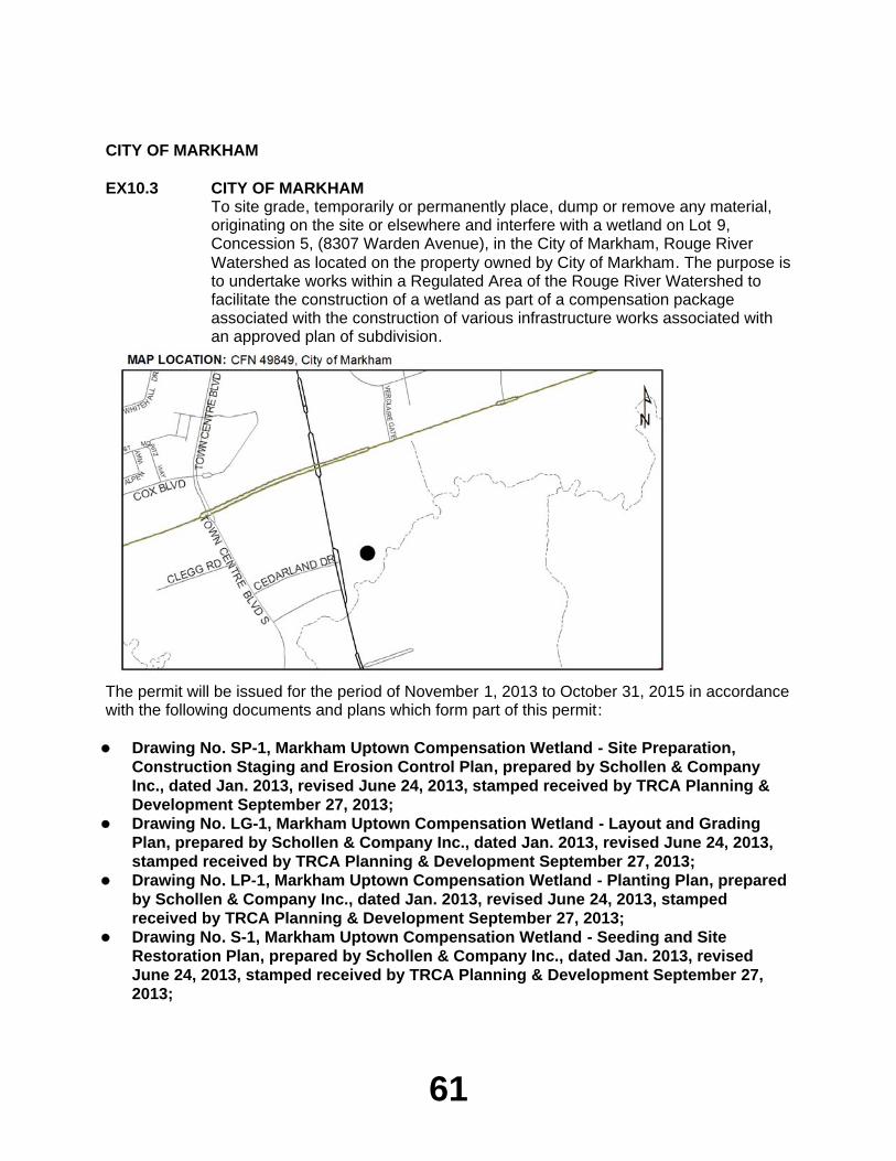
61
CITY OF MARKHAM
EX10.3 CITY OF MARKHAMTo site grade, temporarily or permanently place, dump or remove any material, originating on the site or elsewhere and interfere with a wetland on Lot 9, Concession 5, (8307 Warden Avenue), in the City of Markham, Rouge River Watershed as located on the property owned by City of Markham. The purpose is to undertake works within a Regulated Area of the Rouge River Watershed to facilitate the construction of a wetland as part of a compensation package associated with the construction of various infrastructure works associated with an approved plan of subdivision.
The permit will be issued for the period of November 1, 2013 to October 31, 2015 in accordance with the following documents and plans which form part of this permit:
Drawing No. SP-1, Markham Uptown Compensation Wetland - Site Preparation,
Construction Staging and Erosion Control Plan, prepared by Schollen & Company Inc., dated Jan. 2013, revised June 24, 2013, stamped received by TRCA Planning & Development September 27, 2013;Drawing No. LG-1, Markham Uptown Compensation Wetland - Layout and Grading
Plan, prepared by Schollen & Company Inc., dated Jan. 2013, revised June 24, 2013, stamped received by TRCA Planning & Development September 27, 2013;Drawing No. LP-1, Markham Uptown Compensation Wetland - Planting Plan, prepared
by Schollen & Company Inc., dated Jan. 2013, revised June 24, 2013, stamped received by TRCA Planning & Development September 27, 2013;Drawing No. S-1, Markham Uptown Compensation Wetland - Seeding and Site
Restoration Plan, prepared by Schollen & Company Inc., dated Jan. 2013, revised June 24, 2013, stamped received by TRCA Planning & Development September 27, 2013;
62
Drawing No. LD-1, Markham Uptown Compensation Wetland - Planting Details,
prepared by Schollen & Company Inc., dated Jan. 2013, revised June 24, 2013, stamped received by TRCA Planning & Development September 27, 2013;Drawing No. SP-1, Markham Uptown Compensation Wetland - Details, prepared by
Schollen & Company Inc., dated Jan. 2013, revised June 24, 2013, stamped received by TRCA Planning & Development September 27, 2013.
RATIONALEThe application was reviewed by staff on the basis of the following information:
Proposal:This project was previously approved by the Executive Committee on July 5, 2013, however during this time, the land was transferred to the ownership of the City of Markham, making the originally approved permit (C-130550) under the ownership of 1771107 Ontario Inc. no longer valid. As such, the consultants have provided a new permit application in the name of the City of Markham, the current landowner. No changes have occurred since the original approval in July 2013.
The lands subject to this permit are located within the floodplain of the Rouge River Watershed, located north of the Rouge River, south of Highway 7 East, and east of Warden Avenue. The works are compensatory in nature, in order to provide mitigation for the anticipated impacts to the species within the Rouge River as a result of the construction of infrastructure works outleting to the Rouge River in support of Draft Plan of Subdivision 19TM-070003. This plan of subdivision was the subject of a Master Environmental Servicing Plan (MESP), which was completed and approved by TRCA staff on June 30, 2011.
As part of the high density development, a number of infrastructure works have been constructed in phases, including the construction of underground stormwater detention chamber and outfall which services Phase 1 of subdivision the plan of subdivision (C-110996) and a the removal of a headwater drainage feature and the reconstruction construction of an outfall to serve Phase 2 of the development (C-120962). The permits associated with the works have been approved by the Executive Committee in 2011 and 2012 respectively. As this branch of the Rouge River has been identified as a regulated habitat for Redside Dace, the landowner was required to provide MNR with compensation works as per the Endangered Species Act 2007 to mitigate the impacts of the infrastructure works required to service the plan of subdivision, which outlet into the Rouge River. The proposed works are a component of the mitigation plan submitted to MNR for review and approval, which included the construction of the wetland feature, which is to provide an overall net benefit to the species. A letter of approval was received with the permit application from MNR (dated February 21, 2013) with respect to the Mitigation Plan. As the location of the wetland to be constructed is located within a Regulated Area of the TRCA, a permit pursuant to Ontario Regulation 166/06 (as amended) is required for the works.
63
The proposed works include the construction of a riverine wetland on City of Markham lands (with authorization from the City), as a compensatory piece in support of the infrastructure works associated with the draft approved plan of subdivision. The wetland is intended to become part of a much larger Natural Heritage System, known as the "Greenlands System" through Markham Centre. The existing location of the proposed works is currently comprised of a low, flat meadow/thicket area. The works include the impoundment of a low area along the Rouge River, which is designed to attenuate runoff during storm events, and attenuate shallow groundwater to enhance base flow and provide additional water quality improvements. The works include the creation of a small rock check dam structure within the floodplain, which will regulate the flows inleting and outleting from the feature, including a series of localized excavated areas, creating opportunities for a number of small habitats. The proposed works also include the installation of a number of native plant materials and native seed mixes.
The completed works will include a newly created wetland to be integrated within the overall Natural Heritage System, and a complementary terrestrial habitat as part of the overall compensation strategy.
Control of Flooding:The proposed works are located within the Regional Storm Floodplain. Intended to function as a riverine wetland, overflow from the river during storm events, will provide water to the man-made feature. Based on the design and TRCA review, there are no significant modifications to the conveyance of stream flows, and a minor increase in flood storage capacity is anticipated.
Pollution:Appropriate sediment and erosion controls will be installed and maintained on the subject property during all phases of construction.
Dynamic Beaches:Not applicable
Erosion:There are no anticipated geotechnical impacts with respect to slope stability or erosion concerns related to this application.
Conservation of Land:The Rouge River is considered a Recovery Reach for Redside Dace under MNR's Endangered Species Act, and as such, all in-water works shall adhere to the appropriate fisheries timing window (July 1 to September 15). A Letter of Advice will be required to be issued to facilitate the near and in-water works.
PlantingsAll plantings for the restoration works will be native, non-invasive species.
Policy Guidelines:This proposal is consistent with Section 4.1.1 - New Urban Development - of the Authority's Valley and Stream Corridor Management Program (VSCMP).
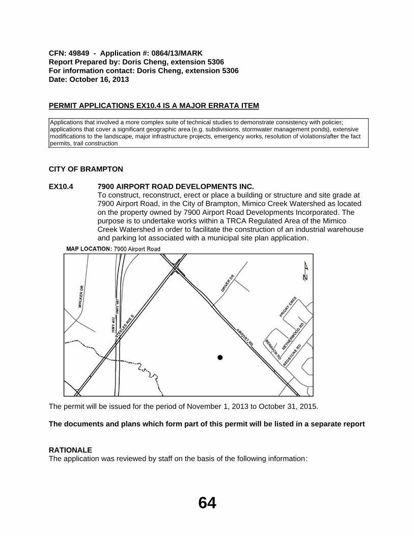
64
CFN: 49849 - Application #: 0864/13/MARKReport Prepared by: Doris Cheng, extension 5306For information contact: Doris Cheng, extension 5306Date: October 16, 2013
PERMIT APPLICATIONS EX10.4 IS A MAJOR ERRATA ITEM
Applications that involved a more complex suite of technical studies to demonstrate consistency with policies; applications that cover a significant geographic area (e.g. subdivisions, stormwater management ponds), extensive modifications to the landscape, major infrastructure projects, emergency works, resolution of violations/after the fact permits, trail construction
CITY OF BRAMPTON
EX10.4 7900 AIRPORT ROAD DEVELOPMENTS INC.To construct, reconstruct, erect or place a building or structure and site grade at 7900 Airport Road, in the City of Brampton, Mimico Creek Watershed as located on the property owned by 7900 Airport Road Developments Incorporated. The purpose is to undertake works within a TRCA Regulated Area of the Mimico Creek Watershed in order to facilitate the construction of an industrial warehouse and parking lot associated with a municipal site plan application.
The permit will be issued for the period of November 1, 2013 to October 31, 2015.
The documents and plans which form part of this permit will be listed in a separate report
RATIONALEThe application was reviewed by staff on the basis of the following information:
65
Proposal:The purpose of this application is to undertake works within a TRCA Regulated Area of the Mimico Creek Watershed in order to facilitate the construction of a 69,205.55 square metre (744,922 sq. ft.) industrial warehouse and parking lot associated with a municipal site plan application (City File No. SP12-054) at 7900 Airport Road, in the City of Brampton. The western portion of the 14.01 ha (34.62 acre) site is located immediately adjacent to a valley corridor of the Mimico Creek Watershed and was created by the approval of an industrial draft plan of subdivision application (City File No. 21T-060022B).
The subject property was previously a driver training centre operated by the Ministry of Transportation (MTO). The site was vacant for several years. Recently, the buildings and parking/driveway areas have been demolished and removed. Also, earthworks, the construction of a stormwater management pond, and the installation of infrastructure servicing associated with the approved industrial subdivision have been completed, which was approved by the TRCA Executive Committee (TRCA Permit No. C-120347) at the December 2, 2011 TRCA Executive Committee Meeting.
The subject property is located outside of the Regional Floodplain. The stormwater management pond associated with the approved subdivision provides controls to achieve quantity, quality and erosion control requirements for the site and entire subdivision. Grass swales underlain with clear stone are proposed to achieve TRCA's water balance requirements. As part of the TRCA permit for the subdivision works, an enhancement and restoration plan was submitted, reviewed and approved for the adjacent valley corridor and buffer area.
Control of Flooding:The subject property and the proposed development are located entirely outside of the Regional Floodplain. As such, no impacts to the storage and/or conveyance of flood waters are anticipated.
Pollution:Appropriate erosion and sediment controls will be installed and maintained throughout all phases of construction. Temporary sediment basins/ponds are proposed as part of the erosion and sediment control plan, which conforms to TRCA's Erosion and Sediment Control Guideline for Urban Construction.
Dynamic Beaches:Not applicable.
Erosion:There are no geotechnical and/or slope stability concerns associated with this proposal.
Conservation of Land:As a component of the subdivision works, the enhancement planting plan is premised on augmenting the existing valley vegetation, particularly in areas where natural vegetation is less dense. In addition, restoration efforts will also be directed in the valley in the western portion of the site to provide further riparian vegetation along the Mimico Creek. There are no fisheries related concerns associated with this application.
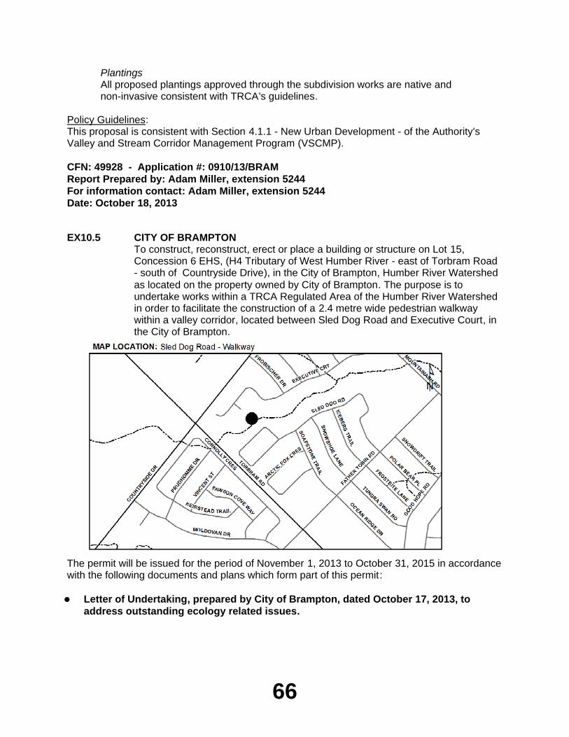
66
PlantingsAll proposed plantings approved through the subdivision works are native and non-invasive consistent with TRCA's guidelines.
Policy Guidelines:This proposal is consistent with Section 4.1.1 - New Urban Development - of the Authority's Valley and Stream Corridor Management Program (VSCMP).
CFN: 49928 - Application #: 0910/13/BRAMReport Prepared by: Adam Miller, extension 5244For information contact: Adam Miller, extension 5244Date: October 18, 2013
EX10.5 CITY OF BRAMPTONTo construct, reconstruct, erect or place a building or structure on Lot 15, Concession 6 EHS, (H4 Tributary of West Humber River - east of Torbram Road - south of Countryside Drive), in the City of Brampton, Humber River Watershed as located on the property owned by City of Brampton. The purpose is to undertake works within a TRCA Regulated Area of the Humber River Watershed in order to facilitate the construction of a 2.4 metre wide pedestrian walkway within a valley corridor, located between Sled Dog Road and Executive Court, in the City of Brampton.
The permit will be issued for the period of November 1, 2013 to October 31, 2015 in accordance with the following documents and plans which form part of this permit:
Letter of Undertaking, prepared by City of Brampton, dated October 17, 2013, to
address outstanding ecology related issues.
67
RATIONALEThe application was reviewed by staff on the basis of the following information:
Proposal:The purpose of this proposal is to undertake works within a TRCA Regulated Area of the Humber River Watershed to facilitate the construction of a 2.4 metre wide pedestrian walkway within a valley corridor, located between Sled Dog Road and Executive Court, in the City of Brampton. The proposed pedestrian walkway is located within the Springdale Neighbourhood #1001 - Stage 4 (Draft Plan of Subdivision 21T-02006B). This project is being managed and implemented by City of Brampton staff.
The proposed walkway will be constructed at-grade utilizing a permeable surface (i.e. turfstone to be filled with topsoil and seed mixture) that will allow for the passage and infiltration of surface flow. Additionally, there will be minimal disturbance to the vegetation as a result of the construction of the proposed walkway. A planting plan has been provided as part of this submission in order to improve the ecological condition of the natural area in this valley corridor .
TRCA staff recognizes that the intent of this walkway is to provide for a more solid and safe trail surface in an area where residents have established their own informal walkway. TRCA staff has recommended to City of Brampton staff that they should consider a more permanent and long-term solution as a part of the City's overall trail master planning process. Recognizing that the trail is located within a valley feature, the City of Brampton has committed to installing signage at the top of the walkway to inform and warn users of their safety during high water levels and flooding. Furthermore, the City has committed to implementing a protocol during heavy storm warnings that would require placing barriers at the top of the valley to prevent pedestrians from using the walkway.
Control of Flooding:A portion of the proposed walkway is located within the Regional Storm Floodplain. However, the existing grades are to be maintained. As such, TRCA staff do not anticipate any adverse impacts to the storage and/or conveyance of flood waters.
Pollution:Appropriate erosion and sediment control (i.e. silt fence) have been proposed with this application, and will be maintained throughout all phases of construction.
Dynamic Beaches:Not applicable
Erosion:There are no geotechnical and/or slope stability concerns anticipated with this application.
Conservation of Land:No significant vegetation will be removed as a result of construction. However, a planting plan has been provided with this application to enhance the landscaping within the riparian zone adjacent to the walkway. The landscape plan includes planting a diversity of native and non-invasive species. There are no fisheries related concerns associated with this application.
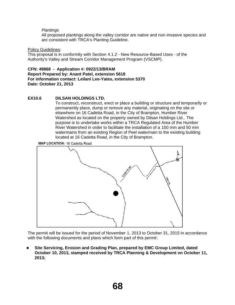
68
PlantingsAll proposed plantings along the valley corridor are native and non-invasive species and are consistent with TRCA's Planting Guideline.
Policy Guidelines:This proposal is in conformity with Section 4.1.2 - New Resource-Based Uses - of the Authority's Valley and Stream Corridor Management Program (VSCMP).
CFN: 49868 - Application #: 0922/13/BRAMReport Prepared by: Anant Patel, extension 5618For information contact: Leilani Lee-Yates, extension 5370Date: October 21, 2013
EX10.6 DILSAN HOLDINGS LTD.To construct, reconstruct, erect or place a building or structure and temporarily or permanently place, dump or remove any material, originating on the site or elsewhere on 16 Cadetta Road, in the City of Brampton, Humber River Watershed as located on the property owned by Dilsan Holdings Ltd.. The purpose is to undertake works within a TRCA Regulated Area of the Humber River Watershed in order to facilitate the installation of a 150 mm and 50 mm watermains from an existing Region of Peel watermain to the existing building located at 16 Cadetta Road, in the City of Brampton.
The permit will be issued for the period of November 1, 2013 to October 31, 2015 in accordance with the following documents and plans which form part of this permit:
Site Servicing, Erosion and Grading Plan, prepared by EMC Group Limited, dated
October 10, 2013, stamped received by TRCA Planning & Development on October 11, 2013;
69
Geotechnical Investigation Report Proposed New Watermain Installation and Creek
Crossing 16 Cadetta Road, Brampton, Ontario; prepared by Coffey Geotechnics Inc., dated June 7, 2013, stamped received by TRCA Planning & Development on June 11, 2013.
RATIONALEThe application was reviewed by staff on the basis of the following information:
Proposal:The purpose of this application is to undertake works within a TRCA Regulated area of the Humber River Watershed in order to facilitate the installation of a 150 mm and a 50 mm watermains from an existing Region of Peel watermain to the existing building located at 16 Cadetta Road, in the City of Brampton. The watermains will extend from the existing building to the Region of Peel watermain by 52.5 metres in length. The proposed watermains will be installed utilizing a Horizontal Directional Drill, and is to be installed approximately 3.8 metres below the invert of the watercourse feature. The pit entry and exit locations are sufficiently setback from the edge of the watercourse feature and will be appropriately isolated during installation, and restored after installation is complete. Additionally, TRCA technical staff have reviewed the proposal and are satisfied with the materials provided.
Control of Flooding:No permanent above-ground infrastructure is proposed with this project. The temporary above-ground works that are proposed with this project will be of short duration - associated with the watermain installation process. As such, no impacts to the storage and/or conveyance of the flood waters are anticipated as a result of this project.
Pollution:Appropriate erosion and sediment controls (i.e silt fence) have been proposed with this application and will be maintained throughout all phases of construction.
Dynamic Beaches:Not applicable
Erosion:There are no geotechnical and/or slope stability concerns anticipated with this project.
Conservation of Land:No significant vegetation will be removed as a result of construction. The watermains will be installed approximately 3.8 metres below the invert of the watercourse feature, which is consistent with the Fisheries and Oceans Canada (DFO) Operational Statement. As such, there no fisheries related concerns associated with this application.
PlantingsAs no significant vegetation will be removed as a result of this proposal, no plantings are required.
Policy Guidelines:This proposal is consistent with Section 4.3 - Infrastructure and Servicing - of the Authority's Valley and Stream Corridor Management Program (VSCMP).
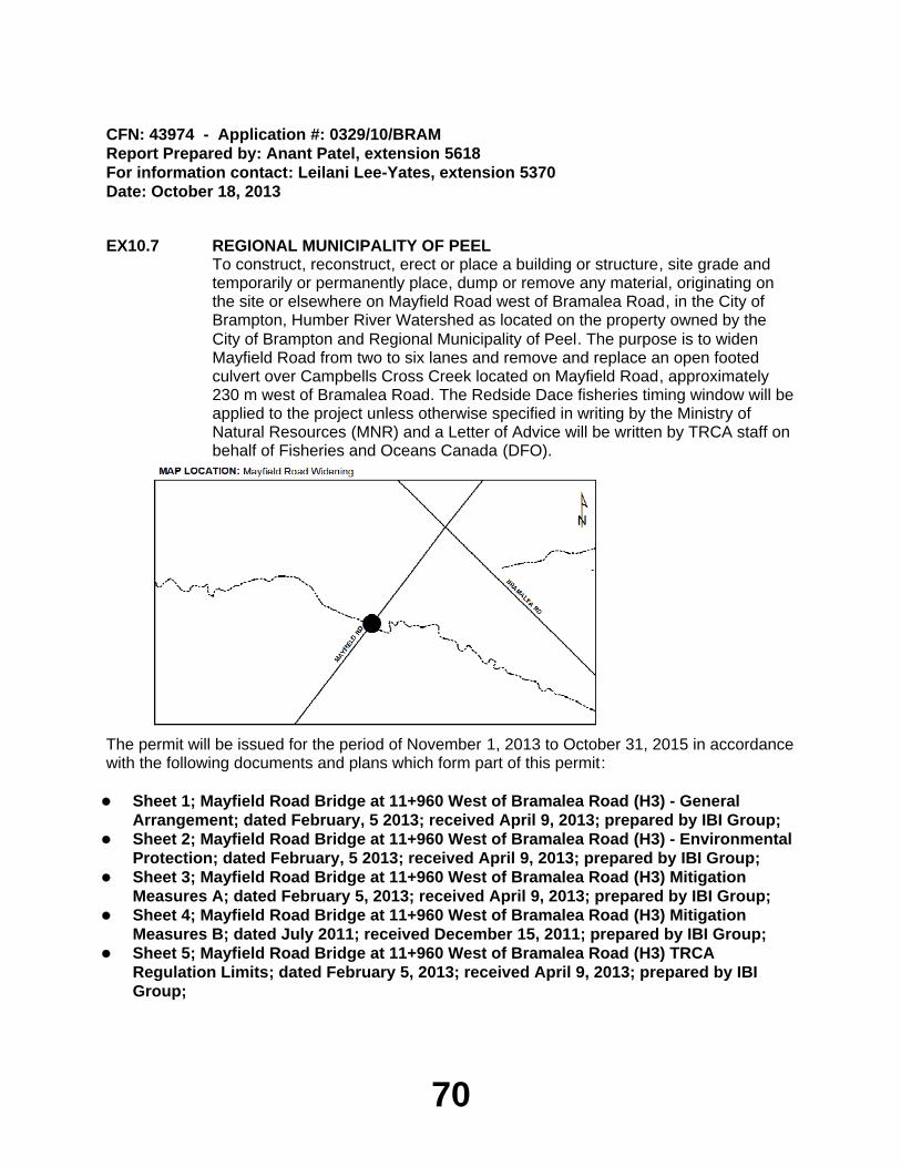
70
CFN: 43974 - Application #: 0329/10/BRAMReport Prepared by: Anant Patel, extension 5618For information contact: Leilani Lee-Yates, extension 5370Date: October 18, 2013
EX10.7 REGIONAL MUNICIPALITY OF PEELTo construct, reconstruct, erect or place a building or structure, site grade and temporarily or permanently place, dump or remove any material, originating on the site or elsewhere on Mayfield Road west of Bramalea Road, in the City of Brampton, Humber River Watershed as located on the property owned by the City of Brampton and Regional Municipality of Peel. The purpose is to widen Mayfield Road from two to six lanes and remove and replace an open footed culvert over Campbells Cross Creek located on Mayfield Road, approximately 230 m west of Bramalea Road. The Redside Dace fisheries timing window will be applied to the project unless otherwise specified in writing by the Ministry of Natural Resources (MNR) and a Letter of Advice will be written by TRCA staff on behalf of Fisheries and Oceans Canada (DFO).
The permit will be issued for the period of November 1, 2013 to October 31, 2015 in accordance with the following documents and plans which form part of this permit:
Sheet 1; Mayfield Road Bridge at 11+960 West of Bramalea Road (H3) - General
Arrangement; dated February, 5 2013; received April 9, 2013; prepared by IBI Group;Sheet 2; Mayfield Road Bridge at 11+960 West of Bramalea Road (H3) - Environmental
Protection; dated February, 5 2013; received April 9, 2013; prepared by IBI Group;Sheet 3; Mayfield Road Bridge at 11+960 West of Bramalea Road (H3) Mitigation
Measures A; dated February 5, 2013; received April 9, 2013; prepared by IBI Group;Sheet 4; Mayfield Road Bridge at 11+960 West of Bramalea Road (H3) Mitigation
Measures B; dated July 2011; received December 15, 2011; prepared by IBI Group;Sheet 5; Mayfield Road Bridge at 11+960 West of Bramalea Road (H3) TRCA
Regulation Limits; dated February 5, 2013; received April 9, 2013; prepared by IBI Group;
71
Sheet 6; Mayfield Road (From east of Dixie Road to East of Bramalea Road)
Landscaping; Sta. 11+800 To 12+100; dated December 12, 2011; received December 15, 2011.
RATIONALEThe application was reviewed by staff on the basis of the following information:
Proposal:The Region of Peel has proposed to widen Mayfield Road from two to six lanes from Dixie Road to Airport Road. This application specifically pertains to the works located at approximately 230 m west of Bramalea Road on Mayfield Road at Campbell's Cross Creek. The existing 3.65 m wide by 2.1 m high open footed culvert will be removed and replaced with a 10.6m wide by 2.4 m high open footed culvert. A temporary corrugated steel pipe (CSP) flume will be installed to convey flows during construction. In addition, a 3.2 m multi-use path will be constructed on the south side and a pedestrian sidewalk will be constructed on the north side of Mayfield Road.
Control of Flooding:No adverse impacts are anticipated to the storage or conveyance of flood waters as a result of this project.
Pollution:Standard sediment and erosion controls, silt fence, pea gravel cofferdams, coir mats and filterbags will be in place for the duration of construction, and until the site is restored, to prevent construction generated sediment from entering the watercourse.
Dynamic Beaches:Not applicable
Erosion:There are no geotechnical/slope stability issues associated with the proposal.
Conservation of Land:With the erosion and sedimentation controls in effect, the potential for a Harmful Alteration, Disruption or Destruction (HADD) of fish habitat will be mitigated. All construction activity will be carried out during the Redside Dace Fisheries timing window of July 1 to September 15 unless otherwise specified in writing by the Ministry of Natural Resources (MNR) and a Letter of Advice (LOA) will be written by TRCA staff on behalf of Fisheries and Oceans Canada (DFO).
PlantingsAll trees within the regulated area will be compensated for at a 3:1 ratio. All disturbed areas will be stabilized and restored with native, non-invasive species following construction.
Policy Guidelines:This proposal complies with Section 4.3, Infrastructure and Servicing, of the TRCA's Valley and Stream Corridor Management Program.
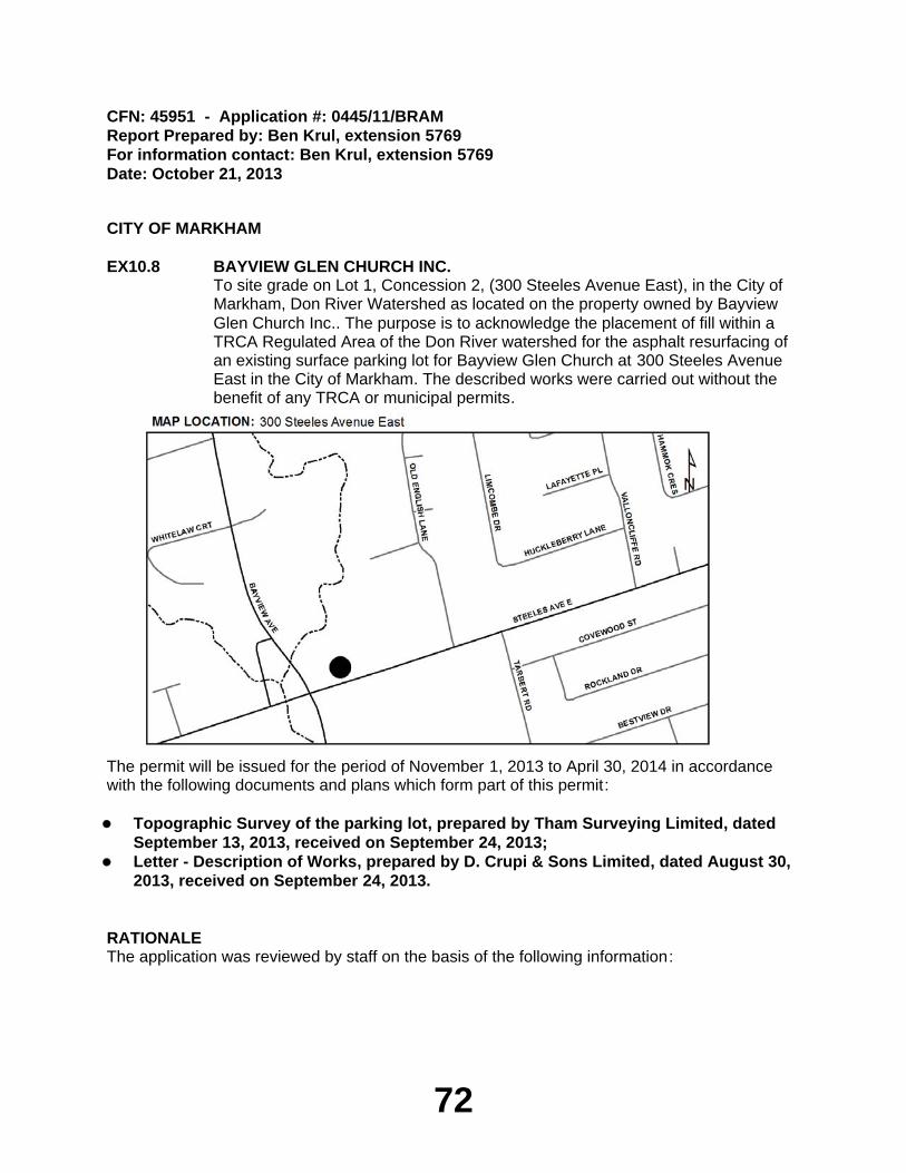
72
CFN: 45951 - Application #: 0445/11/BRAMReport Prepared by: Ben Krul, extension 5769For information contact: Ben Krul, extension 5769Date: October 21, 2013
CITY OF MARKHAM
EX10.8 BAYVIEW GLEN CHURCH INC.To site grade on Lot 1, Concession 2, (300 Steeles Avenue East), in the City of Markham, Don River Watershed as located on the property owned by Bayview Glen Church Inc.. The purpose is to acknowledge the placement of fill within a TRCA Regulated Area of the Don River watershed for the asphalt resurfacing of an existing surface parking lot for Bayview Glen Church at 300 Steeles Avenue East in the City of Markham. The described works were carried out without the benefit of any TRCA or municipal permits.
The permit will be issued for the period of November 1, 2013 to April 30, 2014 in accordance with the following documents and plans which form part of this permit:
Topographic Survey of the parking lot, prepared by Tham Surveying Limited, dated
September 13, 2013, received on September 24, 2013;Letter - Description of Works, prepared by D. Crupi & Sons Limited, dated August 30,
2013, received on September 24, 2013.
RATIONALEThe application was reviewed by staff on the basis of the following information:
73
Proposal:The purpose of this application is to resolve an outstanding violation and acknowledge the placement of fill for the asphalt resurfacing of an existing surface parking lot within a TRCA Regulated Area of the Don River watershed at 300 Steeles Avenue East, in the City of Markham. The footprint of the parking lot remains unchanged. The described works were carried out without the benefit of any TRCA or municipal permits.
The subject property is located on the north side of Steeles Avenue East, east of Bayview Avenue in the City of Markham. The area of disturbance was adjacent to a tributary of the Don River and within the Regional Storm Floodplain.
In order to complete the works, the proponent plans to install precast concrete curbs on the existing asphalt along the river side. Minor grading, a strip of topsoil (2-feet in width), is proposed on the eastern edge of the parking lot to ease the transition in site elevations. The top soil is to be seeded with a native seed mix.
Fee and Permit Timing:The applicant initiated works in advance of a permit under Ontario Regulation 166/06 being issued, therefore the permit is to be issued "after the fact". The applicant has paid the appropriate fees for a permit "after the fact" in association with the violation. In addition, the time frame for this permit will be adjusted and reduced to reflect the works that have already been completed to date.
Control of Flooding:The asphalt resurfacing took place entirely within a Regulated Floodplain of the Don River. These works will have no impact on flood conveyance or storage as the footprint of the parking lot remains unchanged and any grade changes are minor in nature.
Pollution:Sediment controls are not required as the proposed works are already completed. No construction debris will result from the remaining scope of work.
Dynamic Beaches:Not applicable.
Erosion:There are no slope stability/geotechnical concerns associated with this application.
Conservation of Land:No significant vegetation will be removed as a result of this project. Additionally, there are no fisheries related concerns associated with these works.
PlantingsAs no significant vegetation will be removed, no additional plantings are required.
Policy Guidelines:The proposal complies with Section 4.2.2(E) - Property Improvements and Ancillary Structures - of the Authority's Valley and Stream Corridor Management Program.
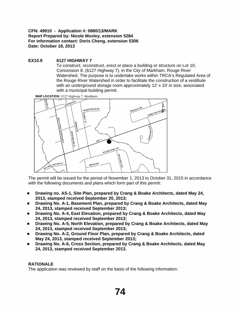
74
CFN: 49910 - Application #: 0880/13/MARKReport Prepared by: Nicole Moxley, extension 5284For information contact: Doris Cheng, extension 5306Date: October 18, 2013
EX10.9 6127 HIGHWAY 7To construct, reconstruct, erect or place a building or structure on Lot 10, Concession 8, (6127 Highway 7), in the City of Markham, Rouge River Watershed. The purpose is to undertake works within TRCA's Regulated Area of the Rouge River Watershed in order to facilitate the construction of a vestibule with an underground storage room approximately 12' x 10' in size, associated with a municipal building permit.
The permit will be issued for the period of November 1, 2013 to October 31, 2015 in accordance with the following documents and plans which form part of this permit:
Drawing no. AS-1, Site Plan, prepared by Crang & Boake Architects, dated May 24,
2013, stamped received September 20, 2013;Drawing No. A-1, Basement Plan, prepared by Crang & Boake Architects, dated May
24, 2013, stamped received September 2013;Drawing No. A-4, East Elevation, prepared by Crang & Boake Architects, dated May
24, 2013, stamped received September 2013;Drawing No. A-5, North Elevation, prepared by Crang & Boake Architects, dated May
24, 2013, stamped received September 2013;Drawing No. A-2, Ground Floor Plan, prepared by Crang & Boake Architects, dated
May 24, 2013, stamped received September 2013;Drawing No. A-6, Cross Section, prepared by Crang & Boake Architects, dated May
24, 2013, stamped received September 2013.
RATIONALEThe application was reviewed by staff on the basis of the following information:
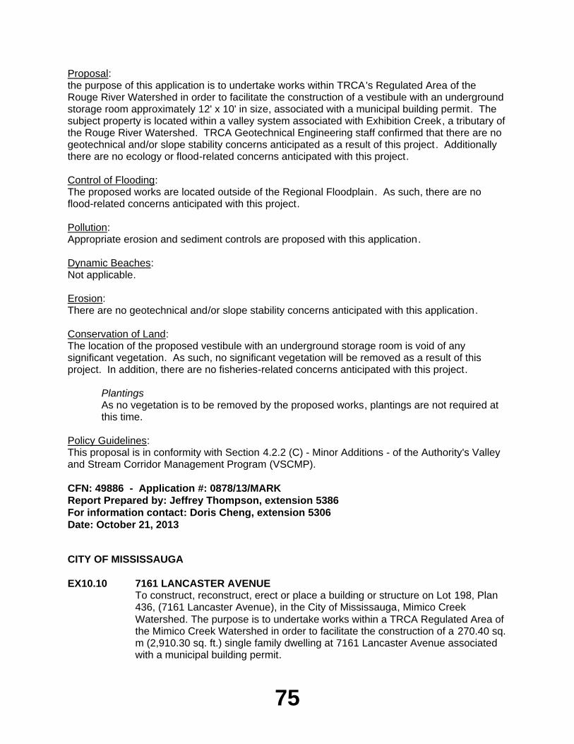
75
Proposal:the purpose of this application is to undertake works within TRCA's Regulated Area of the Rouge River Watershed in order to facilitate the construction of a vestibule with an underground storage room approximately 12' x 10' in size, associated with a municipal building permit. The subject property is located within a valley system associated with Exhibition Creek, a tributary of the Rouge River Watershed. TRCA Geotechnical Engineering staff confirmed that there are no geotechnical and/or slope stability concerns anticipated as a result of this project. Additionally there are no ecology or flood-related concerns anticipated with this project.
Control of Flooding:The proposed works are located outside of the Regional Floodplain. As such, there are no flood-related concerns anticipated with this project.
Pollution:Appropriate erosion and sediment controls are proposed with this application.
Dynamic Beaches:Not applicable.
Erosion:There are no geotechnical and/or slope stability concerns anticipated with this application.
Conservation of Land:The location of the proposed vestibule with an underground storage room is void of any significant vegetation. As such, no significant vegetation will be removed as a result of this project. In addition, there are no fisheries-related concerns anticipated with this project.
PlantingsAs no vegetation is to be removed by the proposed works, plantings are not required at this time.
Policy Guidelines:This proposal is in conformity with Section 4.2.2 (C) - Minor Additions - of the Authority's Valley and Stream Corridor Management Program (VSCMP).
CFN: 49886 - Application #: 0878/13/MARKReport Prepared by: Jeffrey Thompson, extension 5386For information contact: Doris Cheng, extension 5306Date: October 21, 2013
CITY OF MISSISSAUGA
EX10.10 7161 LANCASTER AVENUETo construct, reconstruct, erect or place a building or structure on Lot 198, Plan 436, (7161 Lancaster Avenue), in the City of Mississauga, Mimico Creek Watershed. The purpose is to undertake works within a TRCA Regulated Area of the Mimico Creek Watershed in order to facilitate the construction of a 270.40 sq. m (2,910.30 sq. ft.) single family dwelling at 7161 Lancaster Avenue associated with a municipal building permit.
76
The permit will be issued for the period of November 1, 2013 to October 31, 2015 in accordance with the following documents and plans which form part of this permit:
Drawing No. SP-1, Site Plan, prepared by Sanpro Engineering Inc., dated September
2013, stamped received by TRCA Planning & Development on September 26, 2013;Drawing No. A-1, Ground Floor & Basement Plan, prepared by Sanpro Engineering
Inc., dated September 2013, stamped received by TRCA Planning & Development on September 26, 2013;Drawing No. A-2, Roof Plan and Second Floor Plans, prepared by Sanpro Engineering
Inc., dated September 2013, stamped received by TRCA Planning & Development on September 26, 2013;Drawing No. A-3, Elevations and Building Sections, prepared by Sanpro Engineering
Inc., dated September 2013, stamped received by TRCA Planning & Development on September 26, 2013.
RATIONALEThe application was reviewed by staff on the basis of the following information:
Proposal:The purpose of this application is to undertake works within a TRCA Regulated Area of the Mimico Creek Watershed in order to facilitate the construction of a 270.40 sq. m (2,910.30 sq. ft.) replacement single family dwelling at 7161 Lancaster Avenue associated with a municipal building permit. The subject property is located east of Airport Road, north of Derry Road East and south of Morning Star Drive, in the City of Mississauga. The subject property is located within an approved subdivision and currently contains an existing dwelling, which is proposed to be demolished. The subject property is located outside of the Regional Floodplain and is sufficiently setback from the valley corridor. In addition, the area of the proposed works does not contain any significant natural features. As such, there are no flooding, geotechnical or ecology related concerns with this application.
77
Control of Flooding:The proposed works are located outside of the Regional Storm Floodplain. As such, there are no anticipated impacts to the storage and/or conveyance of flood waters.
Pollution:Appropriate erosion and sediment control (i.e. silt fence) have been proposed with this application, and will be maintained throughout all phases of construction.
Dynamic Beaches:Not applicable
Erosion:There are no geotechnical and/or slope stability concerns anticipated with this application.
Conservation of Land:No significant vegetation will be removed as a result of the proposed construction. In addition, there are no fisheries concerns with this application.
PlantingsAs no significant vegetation will be removed, no additional plantings are required.
Policy Guidelines:This proposal is consistent with Section 4.2.2 (D) - Replacement Structures - of the Authority's Valley and Stream Corridor Management (VSCMP).
CFN: 49893 - Application #: 0890/13/MISSReport Prepared by: Anant Patel, extension 5618For information contact: Leilani Lee-Yates, extension 5370Date: October 18, 2013
CITY OF TORONTO [ETOBICOKE YORK COMMUNITY COUNCIL AREA]
EX10.11 45 RIVERBANK DRIVETo construct, reconstruct, erect or place a building or structure, site grade, temporarily or permanently place, dump or remove any material, originating on the site or elsewhere and alter a watercourse on Lot 8, 9, 10, 11, 12, Concession A Lot 8, 9, 10, 11, 12, Plan 3390/2451, (45 Riverbank Drive), in the City of Toronto (Etobicoke York Community Council Area), Mimico Creek Watershed. The purpose is to replace an existing bridge and footings, minor channel realignment, stabilize a portion of the creek bank and reconfigure the 15th fairway and green.
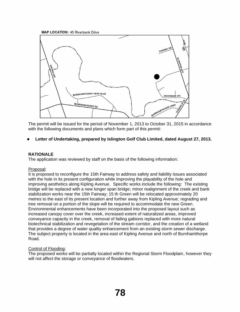
78
The permit will be issued for the period of November 1, 2013 to October 31, 2015 in accordance with the following documents and plans which form part of this permit:
Letter of Undertaking, prepared by Islington Golf Club Limited, dated August 27, 2013.
RATIONALEThe application was reviewed by staff on the basis of the following information:
Proposal:It is proposed to reconfigure the 15th Fairway to address safety and liability issues associated with the hole in its present configuration while improving the playability of the hole and improving aesthetics along Kipling Avenue. Specific works include the following: The existing bridge will be replaced with a new longer span bridge; minor realignment of the creek and bank stabilization works near the 15th Fairway; 15 th Green will be relocated approximately 20 metres to the east of its present location and further away from Kipling Avenue; regrading and tree removal on a portion of the slope will be required to accommodate the new Green. Environmental enhancements have been incorporated into the proposed layout such as increased canopy cover over the creek, increased extent of naturalized areas, improved conveyance capacity in the creek, removal of failing gabions replaced with more natural biotechnical stabilization and revegetation of the stream corridor, and the creation of a wetland that provides a degree of water quality enhancement from an existing storm sewer discharge. The subject property is located in the area east of Kipling Avenue and north of Burnhamthorpe Road.
Control of Flooding:The proposed works will be partially located within the Regional Storm Floodplain, however they will not affect the storage or conveyance of floodwaters.
79
Pollution:Silt fencing and/or riverstone coffer dams will be installed around all construction areas to prevent the migration of construction generated sediment into the watercourse.
Dynamic Beaches:Not applicable
Erosion:A geotechnical design report and meander belt assessment report were reviewed and approved by TRCA engineering staff.
Conservation of Land:All filled and disturbed areas will be stabilized and revegetated following construction. No significant resource features will be impacted by the proposed works. Some of the proposed works will be executed below the existing top of bank of the watercourse, however there will be no impact to fisheries as all work will be conducted in the dry. The works will not result in a HADD and a letter of advise will be issued on behalf of DFO. A comprehensive restoration plan has been reviewed and approved by TRCA and Urban Forestry Staff at the City of Toronto.
PlantingsAll plantings will be in accordance with TRCA's Post-Construction Restoration Guidelines and Seed Mix Guidelines.
Policy Guidelines:The proposal is consistent with Section 4.2.2 (H) Existing Resource-Based Uses of the Authorities Valley and Stream Corridor Management Program.
CFN: 49523 - Application #: 0610/13/TORReport Prepared by: Mark Rapus, extension 5259For information contact: Mark Rapus, extension 5259Date: October 18, 2013
EX10.12 MARKLAND WOOD COUNTRY CLUBTo site grade and temporarily or permanently place, dump or remove any material, originating on the site or elsewhere on Part Lot 9, Plan 2432, (245 Markland Drive), in the City of Toronto (Etobicoke York Community Council Area), Etobicoke Creek Watershed as located on the property owned by Markland Wood Country Club. The purpose is to undertake refurbishment works to existing greens, tees, and bunkers and service road.
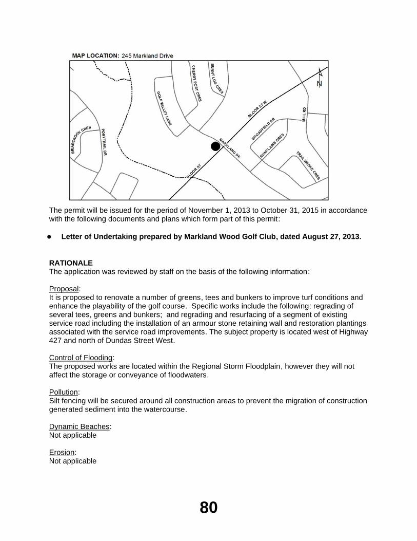
80
The permit will be issued for the period of November 1, 2013 to October 31, 2015 in accordance with the following documents and plans which form part of this permit:
Letter of Undertaking prepared by Markland Wood Golf Club, dated August 27, 2013.
RATIONALEThe application was reviewed by staff on the basis of the following information:
Proposal:It is proposed to renovate a number of greens, tees and bunkers to improve turf conditions and enhance the playability of the golf course. Specific works include the following: regrading of several tees, greens and bunkers; and regrading and resurfacing of a segment of existing service road including the installation of an armour stone retaining wall and restoration plantings associated with the service road improvements. The subject property is located west of Highway 427 and north of Dundas Street West.
Control of Flooding:The proposed works are located within the Regional Storm Floodplain, however they will not affect the storage or conveyance of floodwaters.
Pollution:Silt fencing will be secured around all construction areas to prevent the migration of construction generated sediment into the watercourse.
Dynamic Beaches:Not applicable
Erosion:Not applicable
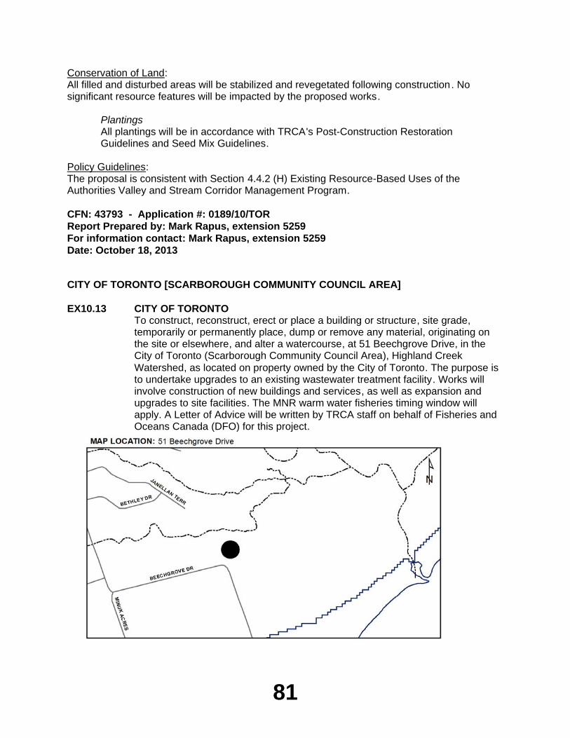
81
Conservation of Land:All filled and disturbed areas will be stabilized and revegetated following construction. No significant resource features will be impacted by the proposed works.
PlantingsAll plantings will be in accordance with TRCA's Post-Construction Restoration Guidelines and Seed Mix Guidelines.
Policy Guidelines:The proposal is consistent with Section 4.4.2 (H) Existing Resource-Based Uses of the Authorities Valley and Stream Corridor Management Program.
CFN: 43793 - Application #: 0189/10/TORReport Prepared by: Mark Rapus, extension 5259For information contact: Mark Rapus, extension 5259Date: October 18, 2013
CITY OF TORONTO [SCARBOROUGH COMMUNITY COUNCIL AREA]
EX10.13 CITY OF TORONTOTo construct, reconstruct, erect or place a building or structure, site grade, temporarily or permanently place, dump or remove any material, originating on the site or elsewhere, and alter a watercourse, at 51 Beechgrove Drive, in the City of Toronto (Scarborough Community Council Area), Highland Creek Watershed, as located on property owned by the City of Toronto. The purpose is to undertake upgrades to an existing wastewater treatment facility. Works will involve construction of new buildings and services, as well as expansion and upgrades to site facilities. The MNR warm water fisheries timing window will apply. A Letter of Advice will be written by TRCA staff on behalf of Fisheries and Oceans Canada (DFO) for this project.

82
The permit will be issued for the period of November 1, 2013 to October 31, 2015 in accordance with the following documents and plans which form part of this permit:
Letter of undertaking from the City of Toronto to TRCA to provide revisions to the
engineering and landscape drawings to the satisfaction of TRCA; dated October 2, 2013; received by TRCA on October 3, 2013.
RATIONALEThe application was reviewed by staff on the basis of the following information:
Proposal:The City of Toronto is proposing upgrades to the Highland Creek Wastewater Treatment Plant, located at 51 Beechgrove Drive, north of Copperfield Road. These works are being necessitated in order to replace the existing main treatment building. Works will involve construction of a new headworks building, biofilter structure and influent chamber to the north of the bend in Beechgrove Drive. Two new permanent roads are to be constructed to allow for access to the biofilter structure and influent chamber; the road to the influent chamber will be asphalt, while the road to the biofilter structure is to be comprised of permeable grass pavers. In order to accommodate the new influent chamber, an existing culvert conveying drainage under the roadway is to be realigned, and the lands south of Beechgrove Drive graded to accommodate the new location of the culvert. A coffer dam is to be established while the culvert is being realigned; flows will be diverted using a bypass pump and discharged through a filter bag to a vegetated area. Rip rap shall be placed at both the upstream and downstream end of the realigned culvert to prevent erosion. The downstream end of this culvert will also be constructed to receive flows from a new roadside drainage feature on the north side of Beechgrove Drive, running under the new permeable paver road. A 900mm concrete sanitary sewer running south from Beechgrove Drive is also part of this project, and will be installed using trench boxes. Once construction of the new facilities is complete, the existing treatment building will be decommissioned.
Heavy duty silt fencing will be used to isolate the work areas from the adjacent natural features, employed either as a single row, or as a dual row reinforced with straw bales. Tree protection fencing is also to be established in accordance with City of Toronto Urban Forestry standards. Several trees and several shrubs are to be removed within the TRCA regulated area to accommodate facility expansion. These removals will be compensated through an extensive planting plan that includes native trees, shrubs, sod, or a seed mix. Construction is anticipated to commence in early 2014 and be completed by mid-2016.
Control of Flooding:The proposed works are not located within the Regional Storm flood plain and are not anticipated to impact flooding, flood storage or conveyance of flood waters. All grades will be maintained or matched.
Pollution:Erosion and sediment control measures (silt fence, catch basin filter fabric, filter bag) will be installed prior to construction and maintained for its duration. These measures are being implemented to prevent the release of construction generated sediment into Highland Creek. Erosion and sediment control measures have been provided in accordance with the TRCA Erosion and Sediment Control Guideline for Urban Construction (2006).
83
Dynamic Beaches:The proposal will not have any implications to dynamic beaches.
Erosion:There are no impacts identified to slope stability or erosion as a result of these works.
Conservation of Land:With erosion and sedimentation plans in effect, the potential for a harmful alteration, disruption or destruction (HADD) of fish habitat will be mitigated. A Letter of Advice (LOA) will be written by TRCA staff on behalf of Fisheries and Oceans Canada (DFO). The Ministry of Natural Resources warm water fisheries timing window will apply to this proposal, unless otherwise specified in writing by MNR.
PlantingsSeveral trees and several shrubs are to be removed within the TRCA regulated area to accommodate facility expansion. These removals will be compensated through an extensive planting plan that includes native trees, shrubs, sod, or a seed mix. This restoration plan has been developed in consultation with City of Toronto Urban Forestry staff; tree protection fencing is also to be established in accordance with City of Toronto Urban Forestry standards. The proposed planting plan will ensure that all disturbed areas are restored to pre-construction conditions, or better, upon completion of work.
Policy Guidelines:This proposal complies with Section 4.1.2, New Resource-based Uses, of the TRCA’s Valley and Stream Corridor Management Program.
CFN: 49611 - Application #: 0679/13/TORReport Prepared by: Daniel Brent, extension 5774For information contact: Daniel Brent, extension 5774Date: October 17, 2013
EX10.14 97 CHINE DRIVETo change a building or structure so that it alters its use or potential use, increases its size or increases the number of dwelling units, site grade and temporarily or permanently place, dump or remove any material, originating on the site or elsewhere on Lot 458, Plan 1566, (97 Chine Drive), in the City of Toronto (Scarborough Community Council Area), Waterfront Watershed. The purpose is to construct a second storey addition, rear basement with one and two storey addition, raised rear deck and new rear patio to the existing dwelling at 97 Chine Drive in the City of Toronto (Scarborough Community Council Area).
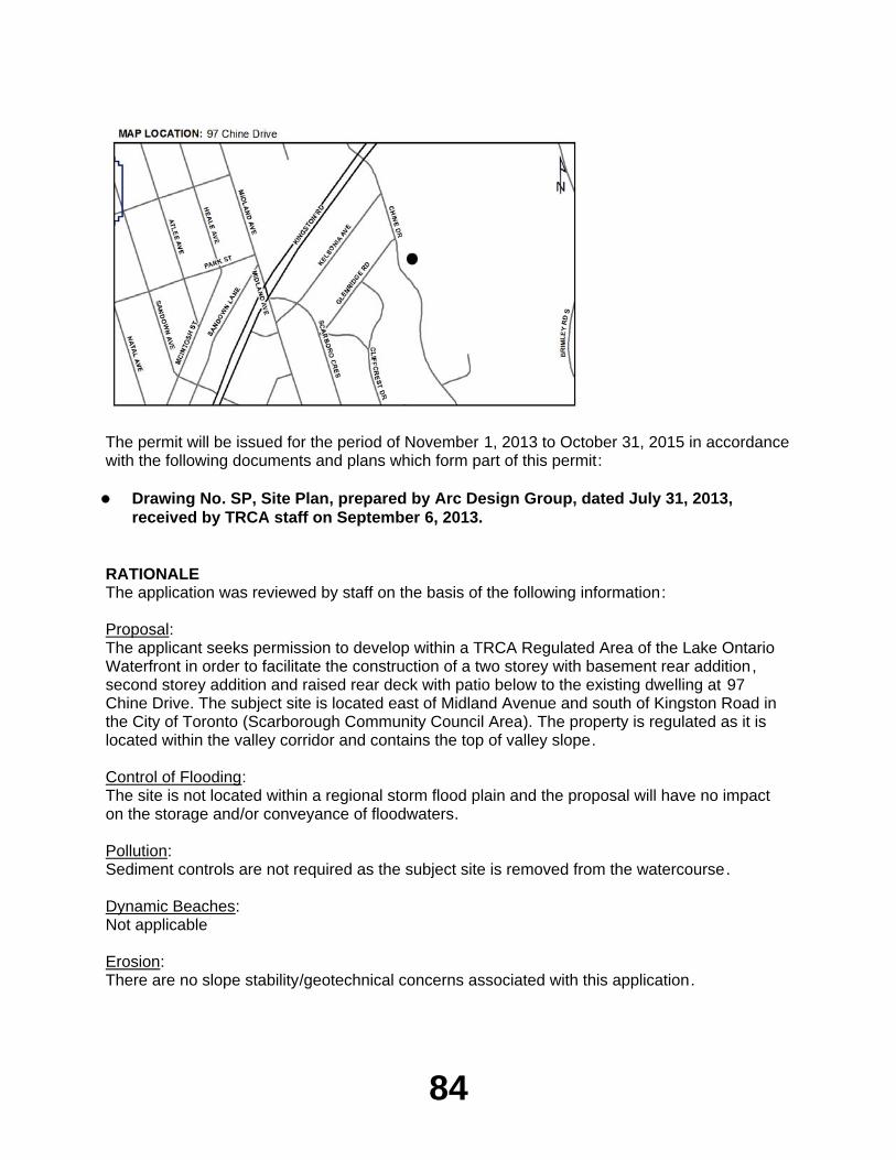
84
The permit will be issued for the period of November 1, 2013 to October 31, 2015 in accordance with the following documents and plans which form part of this permit:
Drawing No. SP, Site Plan, prepared by Arc Design Group, dated July 31, 2013,
received by TRCA staff on September 6, 2013.
RATIONALEThe application was reviewed by staff on the basis of the following information:
Proposal:The applicant seeks permission to develop within a TRCA Regulated Area of the Lake Ontario Waterfront in order to facilitate the construction of a two storey with basement rear addition, second storey addition and raised rear deck with patio below to the existing dwelling at 97 Chine Drive. The subject site is located east of Midland Avenue and south of Kingston Road in the City of Toronto (Scarborough Community Council Area). The property is regulated as it is located within the valley corridor and contains the top of valley slope.
Control of Flooding:The site is not located within a regional storm flood plain and the proposal will have no impact on the storage and/or conveyance of floodwaters.
Pollution:Sediment controls are not required as the subject site is removed from the watercourse.
Dynamic Beaches:Not applicable
Erosion:There are no slope stability/geotechnical concerns associated with this application.
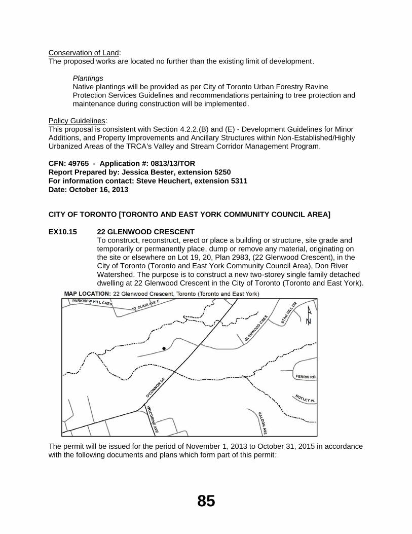
85
Conservation of Land:The proposed works are located no further than the existing limit of development.
PlantingsNative plantings will be provided as per City of Toronto Urban Forestry Ravine Protection Services Guidelines and recommendations pertaining to tree protection and maintenance during construction will be implemented.
Policy Guidelines:This proposal is consistent with Section 4.2.2.(B) and (E) - Development Guidelines for Minor Additions, and Property Improvements and Ancillary Structures within Non-Established/Highly Urbanized Areas of the TRCA's Valley and Stream Corridor Management Program.
CFN: 49765 - Application #: 0813/13/TORReport Prepared by: Jessica Bester, extension 5250For information contact: Steve Heuchert, extension 5311Date: October 16, 2013
CITY OF TORONTO [TORONTO AND EAST YORK COMMUNITY COUNCIL AREA]
EX10.15 22 GLENWOOD CRESCENTTo construct, reconstruct, erect or place a building or structure, site grade and temporarily or permanently place, dump or remove any material, originating on the site or elsewhere on Lot 19, 20, Plan 2983, (22 Glenwood Crescent), in the City of Toronto (Toronto and East York Community Council Area), Don River Watershed. The purpose is to construct a new two-storey single family detached dwelling at 22 Glenwood Crescent in the City of Toronto (Toronto and East York).
The permit will be issued for the period of November 1, 2013 to October 31, 2015 in accordance with the following documents and plans which form part of this permit:
86
Drawing No. SP-1, Site Plan, prepared by avtech designs, dated June 13, 2013,
received on June 19, 2013, redline revised by TRCA staff on October 21, 2013;Drawing No. 1, South Elevation, submitted by KC Au Architect Inc., received on
October 9, 2013;Drawing No. 2, East Elevation, submitted by KC Au Architect Inc., received on
October 9, 2013;Drawing No. 3, North Elevation, submitted by KC Au Architect Inc., received on
October 9, 2013;Drawing No. 4, West Elevation, submitted by KC Au Architect Inc., received on
October 9, 2013.
RATIONALEThe application was reviewed by staff on the basis of the following information:
Proposal:The purpose of this application is to develop within a TRCA Regulated Area of the Don River Watershed in order to facilitate the construction of a new two-storey single family detached dwelling at 22 Glenwood Crescent . The subject site is located south of St. Clair Avenue East and west of O'Connor Drive in the City of Toronto (Toronto and East York Community Council Area).
Control of Flooding:The site is not located within a regional storm flood plain and the proposal will have no impact on the storage and/or conveyance of floodwaters.
Pollution:Sediment controls will be installed and maintained during construction to prevent debris from entering the adjacent ravine.
Dynamic Beaches:Not applicable
Erosion:There are no slope stability/geotechnical concerns associated with this application.
Conservation of Land:The proposed works are located no further towards the valley slope. The appropriate tree protection fencing will be installed.
PlantingsNative plantings will be provided as per City of Toronto Urban Forestry Ravine Protection Services Guidelines and recommendations pertaining to tree protection and maintenance during construction will be implemented
Policy Guidelines:This proposal is consistent with Section 4.2.2.(D) - Development Guidelines for Replacement Structures within Non-Established/Highly Urbanized Areas of the TRCA's Valley and Stream Corridor Management Program.
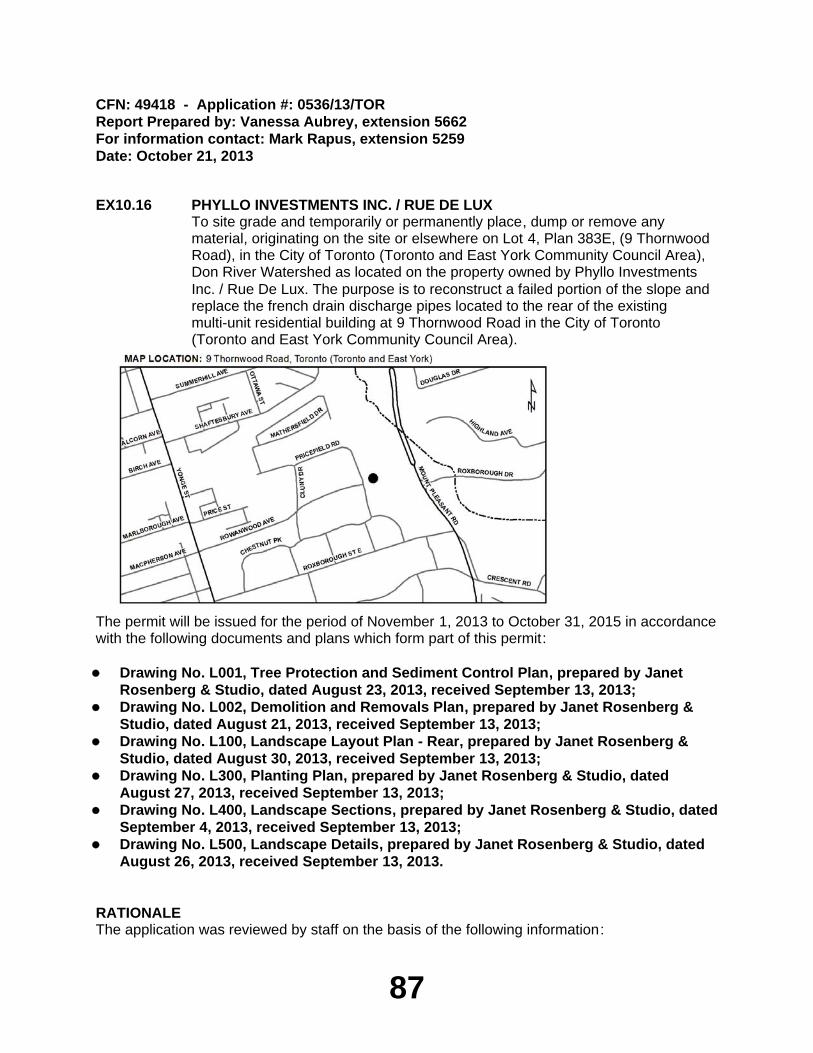
87
CFN: 49418 - Application #: 0536/13/TORReport Prepared by: Vanessa Aubrey, extension 5662For information contact: Mark Rapus, extension 5259Date: October 21, 2013
EX10.16 PHYLLO INVESTMENTS INC. / RUE DE LUXTo site grade and temporarily or permanently place, dump or remove any material, originating on the site or elsewhere on Lot 4, Plan 383E, (9 Thornwood Road), in the City of Toronto (Toronto and East York Community Council Area), Don River Watershed as located on the property owned by Phyllo Investments Inc. / Rue De Lux. The purpose is to reconstruct a failed portion of the slope and replace the french drain discharge pipes located to the rear of the existing multi-unit residential building at 9 Thornwood Road in the City of Toronto (Toronto and East York Community Council Area).
The permit will be issued for the period of November 1, 2013 to October 31, 2015 in accordance with the following documents and plans which form part of this permit:
Drawing No. L001, Tree Protection and Sediment Control Plan, prepared by Janet
Rosenberg & Studio, dated August 23, 2013, received September 13, 2013;Drawing No. L002, Demolition and Removals Plan, prepared by Janet Rosenberg &
Studio, dated August 21, 2013, received September 13, 2013;Drawing No. L100, Landscape Layout Plan - Rear, prepared by Janet Rosenberg &
Studio, dated August 30, 2013, received September 13, 2013;Drawing No. L300, Planting Plan, prepared by Janet Rosenberg & Studio, dated
August 27, 2013, received September 13, 2013;Drawing No. L400, Landscape Sections, prepared by Janet Rosenberg & Studio, dated
September 4, 2013, received September 13, 2013;Drawing No. L500, Landscape Details, prepared by Janet Rosenberg & Studio, dated
August 26, 2013, received September 13, 2013.
RATIONALEThe application was reviewed by staff on the basis of the following information:
88
Proposal:The purpose of this application is to develop within the TRCA Regulated Area of the Don River Watershed in order to facilitate the reconstruction of a failed portion of the valley slope and replace the french drain discharge pipes located to the rear of the existing multi -unit residential building at 9 Thornwoood Road. The subject property is located west of Mount Pleasant Road and south of St. Clair Avenue East, and backs onto David Balfour Park in the City of Toronto (Toronto and East York Community Council Area). During the major storm event on July 8, 2013, the large influx of rain caused the slope to fail and experience significant erosion. Given the proximity of the slope to the residence and adjoining public park, the slope should be reconstructed and restored as soon as possible.
Control of Flooding:The site is not located within a regional storm flood plain and the proposal will have no impact on the storage and/or conveyance of floodwaters.
Pollution:The applicant has provided an erosion and sediment and erosion control plan as well as a construction access and staging plan to ensure the adjoining properties will not be affected .
Dynamic Beaches:Not applicable
Erosion:A geotechnical report and the proposed drawings have been reviewed and approved by TRCA Geotechnical Engineering staff.
Conservation of Land:The proposal will restore an area of natural slope damaged due to the impact of a storm event. The slope will be restored and re-vegetated with native seed mix, trees and shrubs to allow it to re-naturalize over time. Tree protection fencing will also be in place to ensure there will be no further damage to existing trees.
PlantingsNative plantings will be provided as per City of Toronto Urban Forestry Ravine Protection Services Guidelines and recommendations pertaining to tree protection and maintenance during construction will be implemented.
Policy Guidelines:The proposal is consistent with Section 5.2 - Erosion Control and Slope Stability Remedial Works within the TRCA Valley and Stream Corridor Management Program.
CFN: 49890 - Application #: 0886/13/TORReport Prepared by: Vanessa Aubrey, extension 5662For information contact: Steve Heuchert, extension 5311Date: October 21, 2013
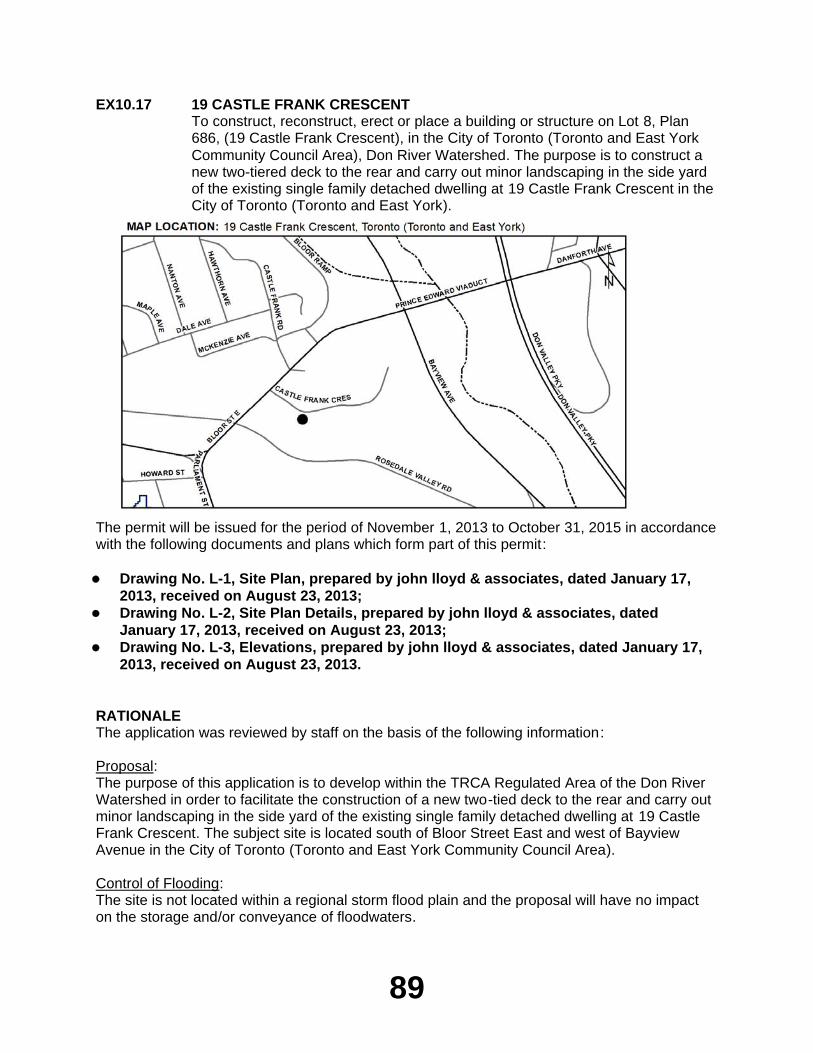
89
EX10.17 19 CASTLE FRANK CRESCENTTo construct, reconstruct, erect or place a building or structure on Lot 8, Plan 686, (19 Castle Frank Crescent), in the City of Toronto (Toronto and East York Community Council Area), Don River Watershed. The purpose is to construct a new two-tiered deck to the rear and carry out minor landscaping in the side yard of the existing single family detached dwelling at 19 Castle Frank Crescent in the City of Toronto (Toronto and East York).
The permit will be issued for the period of November 1, 2013 to October 31, 2015 in accordance with the following documents and plans which form part of this permit:
Drawing No. L-1, Site Plan, prepared by john lloyd & associates, dated January 17,
2013, received on August 23, 2013;Drawing No. L-2, Site Plan Details, prepared by john lloyd & associates, dated
January 17, 2013, received on August 23, 2013;Drawing No. L-3, Elevations, prepared by john lloyd & associates, dated January 17,
2013, received on August 23, 2013.
RATIONALEThe application was reviewed by staff on the basis of the following information:
Proposal:The purpose of this application is to develop within the TRCA Regulated Area of the Don River Watershed in order to facilitate the construction of a new two-tied deck to the rear and carry out minor landscaping in the side yard of the existing single family detached dwelling at 19 Castle Frank Crescent. The subject site is located south of Bloor Street East and west of Bayview Avenue in the City of Toronto (Toronto and East York Community Council Area).
Control of Flooding:The site is not located within a regional storm flood plain and the proposal will have no impact on the storage and/or conveyance of floodwaters.
90
Pollution:Sediment controls will be installed and maintained during construction to prevent debris from entering the adjacent ravine.
Dynamic Beaches:Not applicable
Erosion:A geotechnical brief has been reviewed and approved by TRCA geotechnical engineering staff and the proposal will be constructed in accordance with the recommendations of this report .
Conservation of Land:TRCA staff are satisfied that there will be no geotechnical/slope stability issues associated with the completed works. The proposed works are adequately set back from the top of bank. There are no other significant natural features on, or adjacent to, the site that would be negatively impacted by the project.
PlantingsNative plantings will be provided as per City of Toronto Urban Forestry Ravine Protection Services Guidelines and recommendations pertaining to tree protection and maintenance during construction will be implemented.
Policy Guidelines:The proposal is consistent with Section 4.2.2.(E) - Development Guidelines for Property Improvements and Ancillary Structures within Non-Established/Highly Urbanized Areas of the TRCA’s Valley and Stream Corridor Management Program.
CFN: 49140 - Application #: 0313/13/TORReport Prepared by: Vanessa Aubrey, extension 5662For information contact: Mark Rapus, extension 5259Date: October 21, 2013
CITY OF VAUGHAN
EX10.18 YORK CONDOMINIUM CORPORATION NO. 204To construct, reconstruct, erect or place a building or structure on Block A, B, C, Plan M-1466, (88 Rainbow Drive), in the City of Vaughan, Humber River Watershed as located on the property owned by York Condominium Corporation No. 204. The purpose is to reconstruct a number of existing wooden decks / balconies within a Regulated Area of the Humber River watershed at 88 Rainbow Drive in the City of Vaughan.
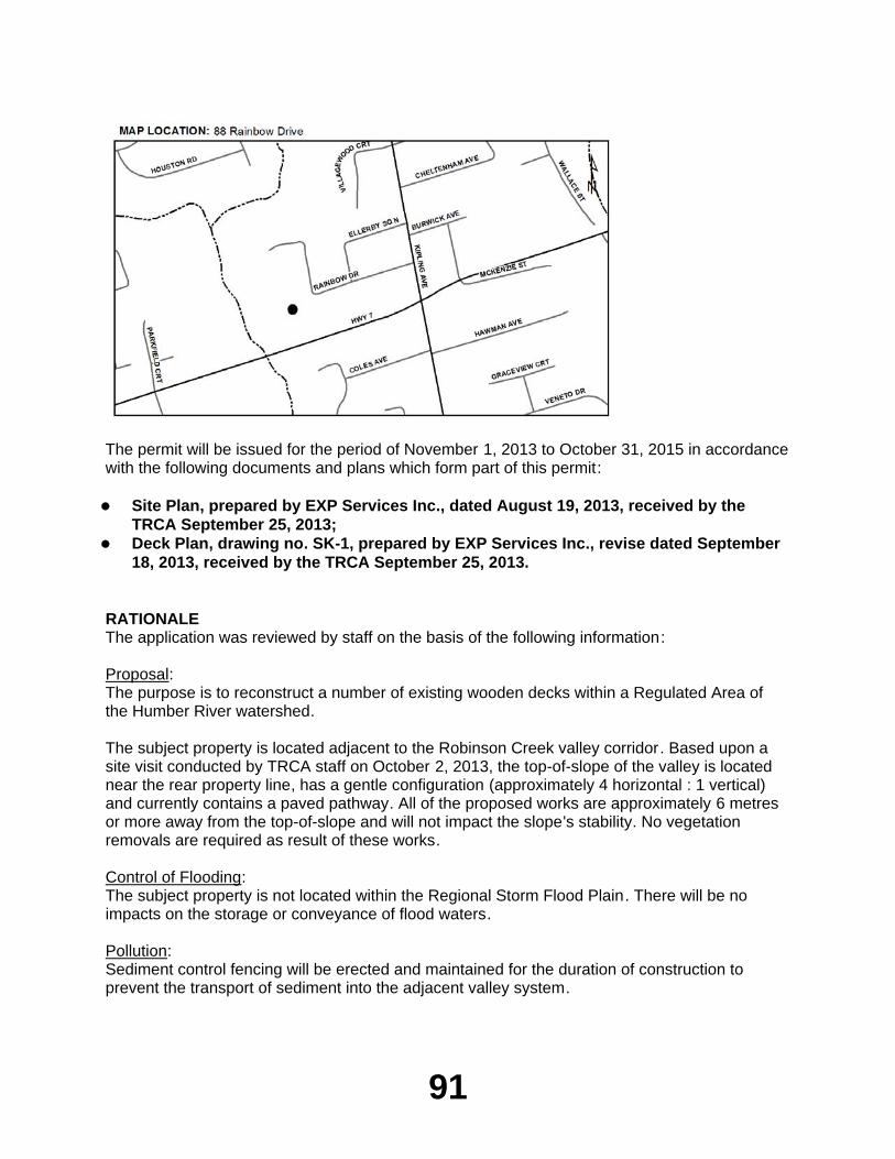
91
The permit will be issued for the period of November 1, 2013 to October 31, 2015 in accordance with the following documents and plans which form part of this permit:
Site Plan, prepared by EXP Services Inc., dated August 19, 2013, received by the
TRCA September 25, 2013;Deck Plan, drawing no. SK-1, prepared by EXP Services Inc., revise dated September
18, 2013, received by the TRCA September 25, 2013.
RATIONALEThe application was reviewed by staff on the basis of the following information:
Proposal:The purpose is to reconstruct a number of existing wooden decks within a Regulated Area of the Humber River watershed.
The subject property is located adjacent to the Robinson Creek valley corridor. Based upon a site visit conducted by TRCA staff on October 2, 2013, the top-of-slope of the valley is located near the rear property line, has a gentle configuration (approximately 4 horizontal : 1 vertical) and currently contains a paved pathway. All of the proposed works are approximately 6 metres or more away from the top-of-slope and will not impact the slope's stability. No vegetation removals are required as result of these works.
Control of Flooding:The subject property is not located within the Regional Storm Flood Plain. There will be no impacts on the storage or conveyance of flood waters.
Pollution:Sediment control fencing will be erected and maintained for the duration of construction to prevent the transport of sediment into the adjacent valley system.
92
Dynamic Beaches:Not applicable.
Erosion:There are no geotechnical issues associated with this application.
Conservation of Land:As a watercourse will not be impacted by the proposal, no fisheries concerns will result. There are no other significant natural features on or adjacent to the site that may be negatively impacted by the project.
PlantingsAll disturbed areas will be restored to the existing sodded condition and will not affect any significant natural features.
Policy Guidelines:The proposal is consistent with Section 4.2.2 E) - Property Improvements and Ancillary Structures - of the Authority's Valley and Stream Corridor Management Program.
CFN: 49884 - Application #: 0876/13/VAUGReport Prepared by: Anthony Sun, extension 5724For information contact: June Little, extension 5756Date: October 17, 2013
TOWN OF CALEDON
EX10.19 3561 KING STREETTo construct, reconstruct, erect or place a building or structure on Lot 13, Plan 43R-35293, (3561 King Street), in the Town of Caledon, Humber River Watershed. The purpose is to undertake works within a TRCA Regulated Area of the Humber River Watershed in order to facilitate the construction of a 3,250 sq. ft. (301.9 sq. m) single family dwelling with porch and septic system associated with a municipal building permit.
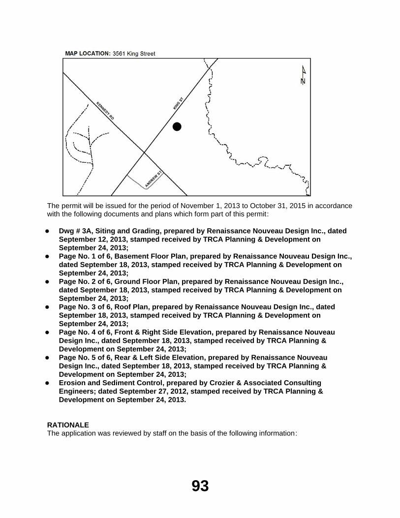
93
The permit will be issued for the period of November 1, 2013 to October 31, 2015 in accordance with the following documents and plans which form part of this permit:
Dwg # 3A, Siting and Grading, prepared by Renaissance Nouveau Design Inc., dated
September 12, 2013, stamped received by TRCA Planning & Development on September 24, 2013;Page No. 1 of 6, Basement Floor Plan, prepared by Renaissance Nouveau Design Inc.,
dated September 18, 2013, stamped received by TRCA Planning & Development on September 24, 2013;Page No. 2 of 6, Ground Floor Plan, prepared by Renaissance Nouveau Design Inc.,
dated September 18, 2013, stamped received by TRCA Planning & Development on September 24, 2013;Page No. 3 of 6, Roof Plan, prepared by Renaissance Nouveau Design Inc., dated
September 18, 2013, stamped received by TRCA Planning & Development on September 24, 2013;Page No. 4 of 6, Front & Right Side Elevation, prepared by Renaissance Nouveau
Design Inc., dated September 18, 2013, stamped received by TRCA Planning & Development on September 24, 2013;Page No. 5 of 6, Rear & Left Side Elevation, prepared by Renaissance Nouveau
Design Inc., dated September 18, 2013, stamped received by TRCA Planning & Development on September 24, 2013;Erosion and Sediment Control, prepared by Crozier & Associated Consulting
Engineers; dated September 27, 2012, stamped received by TRCA Planning & Development on September 24, 2013.
RATIONALEThe application was reviewed by staff on the basis of the following information:
94
Proposal:The purpose of this application is to undertake works within a TRCA Regulated Area of the Humber River Watershed in order to facilitate the construction of a 3,250 sq. ft. (301.9 sq. m) single family dwelling with a porch and septic system located at 3561 King Street associated with a municipal building permit. The subject property is located east of Kennedy Road, west of Heart Lake Road and south of King Street, in the Town of Caledon. The subject property is adjacent to the Campbell's Cross valley corridor, which is a tributary of the Humber River. The proposed works are located a sufficient distance from the valley corridor, and the subject property does not contain any significant natural features. As such, there are no ecology related concerns with this proposal. Additionally, there are no flooding, hydrological, or geotechnical related concerns with this application.
Control of Flooding:The proposed works are located outside of the Regional Storm Floodplain. As such, no impacts to the storage and/or conveyance of flood waters is anticipated as a result of the proposed works.
Pollution:Appropriate erosion and sediment controls (i.e. silt fence) have been proposed with this application and will be maintained throughout all phases of construction.
Dynamic Beaches:Not applicable
Erosion:There are no geotechnical and/or slope stability concerns anticipated with this project.
Conservation of Land:No significant vegetation will be removed as a result of construction. There are no fisheries concerns related to this project.
PlantingsAs no significant vegetation will be removed as a result of this proposal, no plantings are required.
Policy Guidelines:The proposal is in conformity with Section 4.1.1 - New Urban Development, of the Authority's Valley and Stream Corridor Management Program (VSCMP).
CFN: 49783 - Application #: 0873/13/CALReport Prepared by: Anant Patel, extension 5618For information contact: Leilani Lee-Yates, extension 5370Date: October 18, 2013
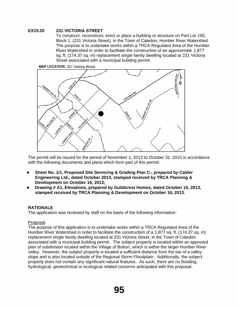
95
EX10.20 231 VICTORIA STREETTo construct, reconstruct, erect or place a building or structure on Part Lot 150, Block 1, (231 Victoria Street), in the Town of Caledon, Humber River Watershed. The purpose is to undertake works within a TRCA Regulated Area of the Humber River Watershed in order to facilitate the construction of an approximate 1,877 sq. ft. (174.37 sq. m) replacement single family dwelling located at 231 Victoria Street associated with a municipal building permit.
The permit will be issued for the period of November 1, 2013 to October 31, 2015 in accordance with the following documents and plans which form part of this permit:
Sheet No. 1/1, Proposed Site Servicing & Grading Plan C-, prepared by Calder
Engineering Ltd., dated October 2013, stamped received by TRCA Planning & Development on October 16, 2013;Drawing # A1, Elevations, prepared by Guildcrest Homes, dated October 15, 2013,
stamped received by TRCA Planning & Development on October 16, 2013.
RATIONALEThe application was reviewed by staff on the basis of the following information:
Proposal:The purpose of this application is to undertake works within a TRCA Regulated Area of the Humber River Watershed in order to facilitate the construction of a 1,877 sq. ft. (174.37 sq. m) replacement single family dwelling located at 231 Victoria Street, in the Town of Caledon associated with a municipal building permit. The subject property is located within an approved plan of subdivision located within the Village of Bolton, which is within the larger Humber River valley. However, the subject property is located a sufficient distance from the toe of a valley slope and is also located outside of the Regional Storm Floodplain. Additionally, the subject property does not contain any significant natural features. As such, there are no flooding, hydrological, geotechnical or ecological related concerns anticipated with this proposal .
96
Control of Flooding:The proposed works are located outside of the Regional Storm Floodplain. As such, no impact to the storage and/or conveyance of flood waters are anticipated.
Pollution:Appropriate erosion and sediment control (i.e. silt fence) have been proposed with this application, and will be maintained throughout all phases of construction.
Dynamic Beaches:Not applicable
Erosion:There are no geotechnical and/or slope stability concerns anticipated with this application.
Conservation of Land:No significant vegetation will be removed as a result of this project. Additionally, there are no fisheries related concerns associated with these works.
PlantingsAs no significant vegetation will be removed as a result of this proposal, no plantings are required.
Policy Guidelines:This proposal is consistent with Section 4.2.2 (D) - Replacement Structures - of the Authority's Valley and Stream Corridor Management (VSCMP).
CFN: 49925 - Application #: 0907/13/CALReport Prepared by: Anant Patel, extension 5618For information contact: Leilani Lee-Yates, extension 5370Date: October 18, 2013
TOWN OF RICHMOND HILL
EX10.21 16 MAGISTRALE COURTTo construct, reconstruct, erect or place a building or structure on Lot 1, Plan 65M2921, (16 Magistrale Court), in the Town of Richmond Hill, Don River Watershed. The purpose is to undertake works within TRCA's Regulated Area of the Don River Watershed in order to facilitate the construction of an inground pool at the rear of an existing dwelling associated with a municipal building permit.
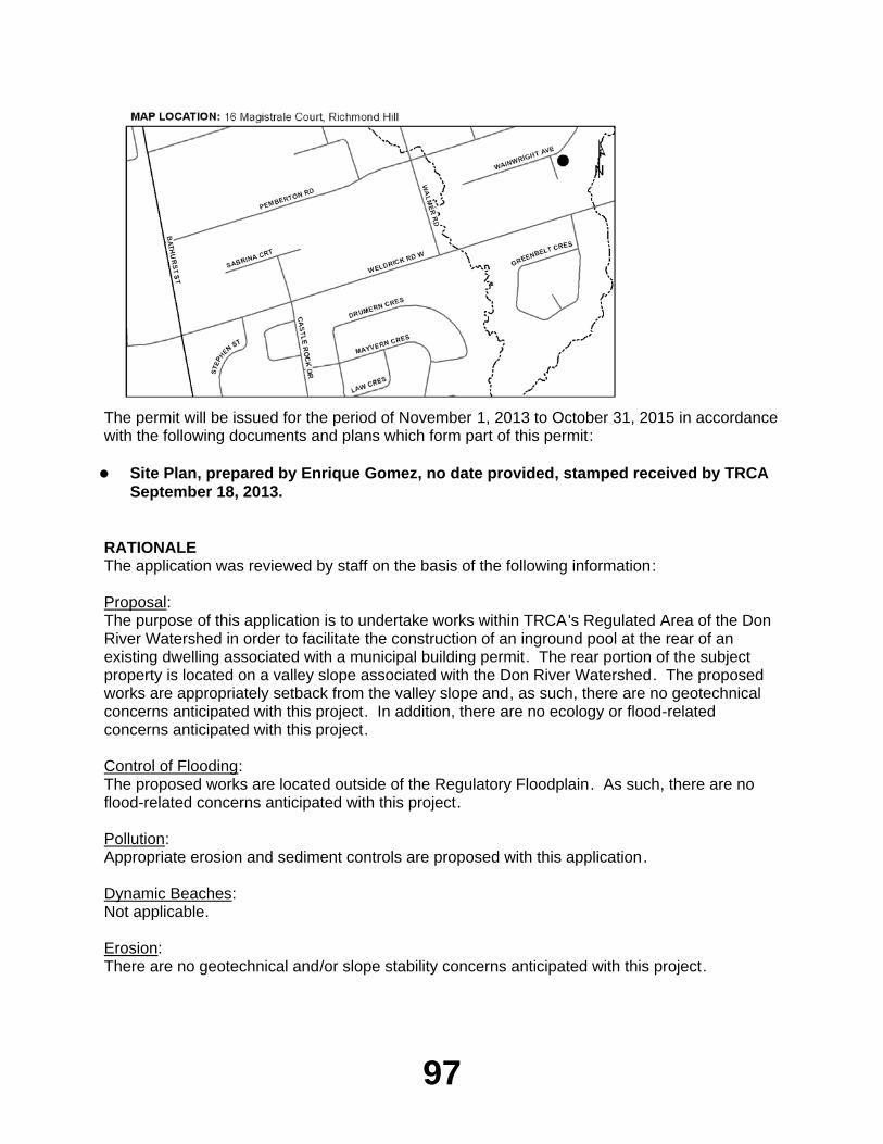
97
The permit will be issued for the period of November 1, 2013 to October 31, 2015 in accordance with the following documents and plans which form part of this permit:
Site Plan, prepared by Enrique Gomez, no date provided, stamped received by TRCA
September 18, 2013.
RATIONALEThe application was reviewed by staff on the basis of the following information:
Proposal:The purpose of this application is to undertake works within TRCA's Regulated Area of the Don River Watershed in order to facilitate the construction of an inground pool at the rear of an existing dwelling associated with a municipal building permit. The rear portion of the subject property is located on a valley slope associated with the Don River Watershed. The proposed works are appropriately setback from the valley slope and, as such, there are no geotechnical concerns anticipated with this project. In addition, there are no ecology or flood-related concerns anticipated with this project.
Control of Flooding:The proposed works are located outside of the Regulatory Floodplain. As such, there are no flood-related concerns anticipated with this project.
Pollution:Appropriate erosion and sediment controls are proposed with this application.
Dynamic Beaches:Not applicable.
Erosion:There are no geotechnical and/or slope stability concerns anticipated with this project.
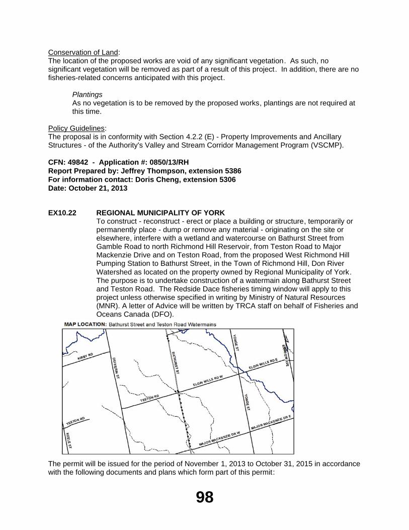
98
Conservation of Land:The location of the proposed works are void of any significant vegetation. As such, no significant vegetation will be removed as part of a result of this project. In addition, there are no fisheries-related concerns anticipated with this project.
PlantingsAs no vegetation is to be removed by the proposed works, plantings are not required at this time.
Policy Guidelines:The proposal is in conformity with Section 4.2.2 (E) - Property Improvements and Ancillary Structures - of the Authority's Valley and Stream Corridor Management Program (VSCMP).
CFN: 49842 - Application #: 0850/13/RHReport Prepared by: Jeffrey Thompson, extension 5386For information contact: Doris Cheng, extension 5306Date: October 21, 2013
EX10.22 REGIONAL MUNICIPALITY OF YORKTo construct - reconstruct - erect or place a building or structure, temporarily or permanently place - dump or remove any material - originating on the site or elsewhere, interfere with a wetland and watercourse on Bathurst Street from Gamble Road to north Richmond Hill Reservoir, from Teston Road to Major Mackenzie Drive and on Teston Road, from the proposed West Richmond Hill Pumping Station to Bathurst Street, in the Town of Richmond Hill, Don River Watershed as located on the property owned by Regional Municipality of York. The purpose is to undertake construction of a watermain along Bathurst Street and Teston Road. The Redside Dace fisheries timing window will apply to this project unless otherwise specified in writing by Ministry of Natural Resources (MNR). A letter of Advice will be written by TRCA staff on behalf of Fisheries and Oceans Canada (DFO).
The permit will be issued for the period of November 1, 2013 to October 31, 2015 in accordance with the following documents and plans which form part of this permit:
99
Letter of Undertaking to provide minor revisions to engineering drawings and notes
to the satisfaction of TRCA staff, prepared by Regional Municipality of York, dated October 22, 2013, received by TRCA on October 22, 2013.
RATIONALEThe application was reviewed by staff on the basis of the following information:
Proposal:The purpose is to undertake construction of a watermain along Bathurst Street and Teston Road in the Town of Richmond Hill, Don River Watershed, Regional Municipality of York. The works will include construction of a 1050mm watermain on Bathurst Street from Teston Road to approximately 100m north of Major Mackenzie Drive, along Bathurst Street from 60m south of Gamble Road to the existing North Richmond Hill Reservoir, and along Teston Road from proposed West Richmond Hill Pumping Station to Bathurst Street. The watermains will be constructed using open-cut methods through roads and boulevards and trenchless methods underneath watercourse crossings.
Control of Flooding:The proposed project is not anticipated to impact flooding, conveyance or storage of floodwaters.
Pollution:Standard erosion and sediment control measures, including silt fencing will be implemented prior to construction and maintained for the duration of construction and until the site is stabilized and restored in order to prevent construction generated sediments from entering any watercourse or wetland. Erosion and sediment control measures have been provided in accordance with the TRCA Erosion and Sediment Control Guideline for Urban Construction .
Dynamic Beaches:Not applicable
Erosion:No geotechnical/slope stability issues have been identified.
Conservation of Land:With erosion and sedimentation plans in effect, the potential for a Harmful, Alteration Disruption or Destruction (HADD) of fish habitat will be mitigated. A Letter of Advice will be written by TRCA staff on behalf of Fisheries and Oceans Canada (DFO). The Ministry of Natural Resources (MNR) Redside Dace fisheries timing window of July 1 to September 15 will apply to this proposal unless otherwise specified in writing by MNR.
PlantingsAll disturbed areas will be restored with native non-invasive species.
Policy Guidelines:This proposal complies with Section 4.3 - Infrastructure and Servicing - of the Toronto and Region Conservation Authority's Valley and Stream Corridor Management Program.
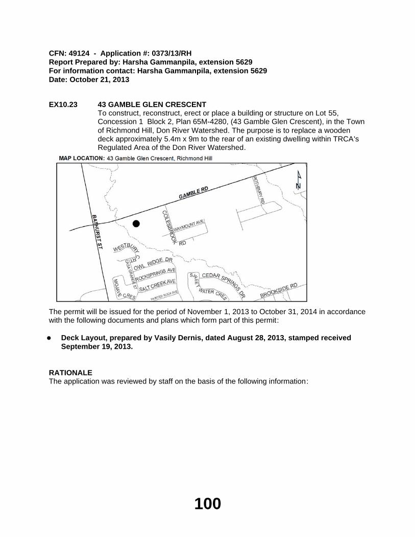
100
CFN: 49124 - Application #: 0373/13/RHReport Prepared by: Harsha Gammanpila, extension 5629For information contact: Harsha Gammanpila, extension 5629Date: October 21, 2013
EX10.23 43 GAMBLE GLEN CRESCENTTo construct, reconstruct, erect or place a building or structure on Lot 55, Concession 1 Block 2, Plan 65M-4280, (43 Gamble Glen Crescent), in the Town of Richmond Hill, Don River Watershed. The purpose is to replace a wooden deck approximately 5.4m x 9m to the rear of an existing dwelling within TRCA's Regulated Area of the Don River Watershed.
The permit will be issued for the period of November 1, 2013 to October 31, 2014 in accordance with the following documents and plans which form part of this permit:
Deck Layout, prepared by Vasily Dernis, dated August 28, 2013, stamped received
September 19, 2013.
RATIONALEThe application was reviewed by staff on the basis of the following information:
101
Proposal:The purpose of this application is to construct a replacement wooden deck approximately 5.4m x 9m to the rear of an existing dwelling within TRCA's Regulated Area of the Don River Watershed. The deck is being reduced in size to comply with municipal zoning requirements. The original deck was constructed without TRCA or municipal building permits. As such, the City required the landowner to comply with zoning standards and reduce the size of the deck. The subject property is located adjacent to a valley corridor associated with German Mills Creek, a tributary of the Don River watershed. TRCA Geotechnical Engineering staff have reviewed this application and do not anticipate any geotechnical and/or slope stability concerns as a result of the proposed works. In addition, there are no ecology or flood-related concerns anticipated with this application.
Fee and Permit Timing:The applicant initiated works in advance of a permit under Ontario Regulation 166/06 being issued, therefore the permit is to be issued "after the fact". The applicant has paid the application fee plus 100% as required for a permit "after the fact" in association with the violation. Given that the proposed works are being undertaken to adhere to municipal zoning by-law requirements, and that a portion of the undertaken works are complete, the time frame for this permit has been adjusted.
Control of Flooding:The proposed works are located outside of the Regulatory Floodplain. As such, there are no anticipated impacts to the storage and/or conveyance of floodwaters as a result of this application.
Pollution:Appropriate erosion and sediment controls will be in place throughout the completion of this project.
Dynamic Beaches:Not applicable.
Erosion:There are no geotechnical and/or slope stability concerns anticipated with this project.
Conservation of Land:The location of the existing deck, including all modifications and repairs, is void of any significant vegetation. As such, no significant vegetation will be removed as a result of this project. In addition, there are no fisheries-related concerns anticipated with this project.
PlantingsAs no vegetation is to be removed by the proposed works, plantings are not required at this time.
Policy Guidelines:The proposal is in conformity with Section 4.2.2 (E) - Property Improvements and Ancillary Structures - of the Authority's Valley and Stream Corridor Management Program (VSCMP).
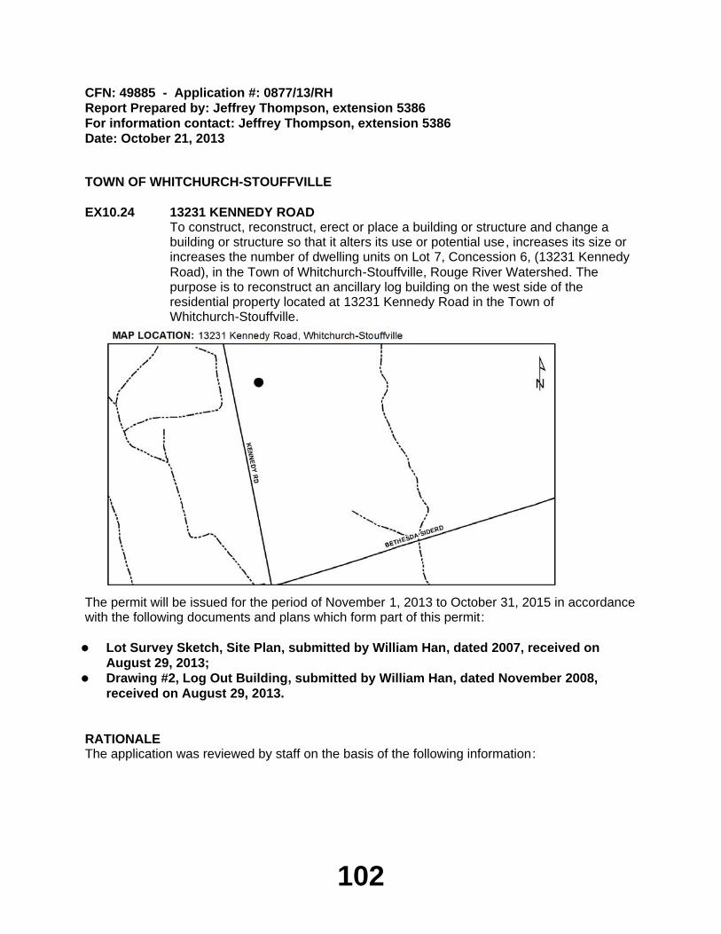
102
CFN: 49885 - Application #: 0877/13/RHReport Prepared by: Jeffrey Thompson, extension 5386For information contact: Jeffrey Thompson, extension 5386Date: October 21, 2013
TOWN OF WHITCHURCH-STOUFFVILLE
EX10.24 13231 KENNEDY ROADTo construct, reconstruct, erect or place a building or structure and change a building or structure so that it alters its use or potential use, increases its size or increases the number of dwelling units on Lot 7, Concession 6, (13231 Kennedy Road), in the Town of Whitchurch-Stouffville, Rouge River Watershed. The purpose is to reconstruct an ancillary log building on the west side of the residential property located at 13231 Kennedy Road in the Town of Whitchurch-Stouffville.
The permit will be issued for the period of November 1, 2013 to October 31, 2015 in accordance with the following documents and plans which form part of this permit:
Lot Survey Sketch, Site Plan, submitted by William Han, dated 2007, received on
August 29, 2013;Drawing #2, Log Out Building, submitted by William Han, dated November 2008,
received on August 29, 2013.
RATIONALEThe application was reviewed by staff on the basis of the following information:
103
Proposal:The purpose of this application is to develop within a TRCA Regulated Area of the Rouge River Watershed in order to facilitate the construction an ancillary log building on the west side of a residential property located at 13231 Kennedy Road. The proposed works will be located within an Area of Interference associated with a locally significant wetland within the Oak Ridges Moraine. The building will be constructed on pre-existing foundations in an area that is located outside of the wetlands and absent of any significant vegetation. The subject property is located northeast of Bethesda Road and is on the east side Kennedy Road in the Town of Whitchurch-Stouffville.
Control of Flooding:Not applicable.
Pollution:The proposed building will be constructed at present grades and only limited grading is anticipated. No sediment and erosion controls are required as part of this proposal.
Dynamic Beaches:Not applicable
Erosion:There are no slope stability and/or erosion concerns with this proposal.
Conservation of Land:The ancillary log building is sited away from the nearby wetlands and will be constructed on pre-existing foundations in a location that was formerly a manicured lawn. No significant vegetation will be removed as a result of construction.
PlantingsNo plantings are required as part of this project.
Policy Guidelines:The proposal is consistent with Section 4.2.2.(E) - Development Guidelines for Property Improvements and Ancillary Structures within Non-Established/Highly Urbanized Areas of the TRCA’s Valley and Stream Corridor Management Program.
CFN: 49808 - Application #: 0820/13/WSReport Prepared by: Vanessa Aubrey, extension 5662For information contact: Chris Jones, extension 5718Date: October 21, 2013
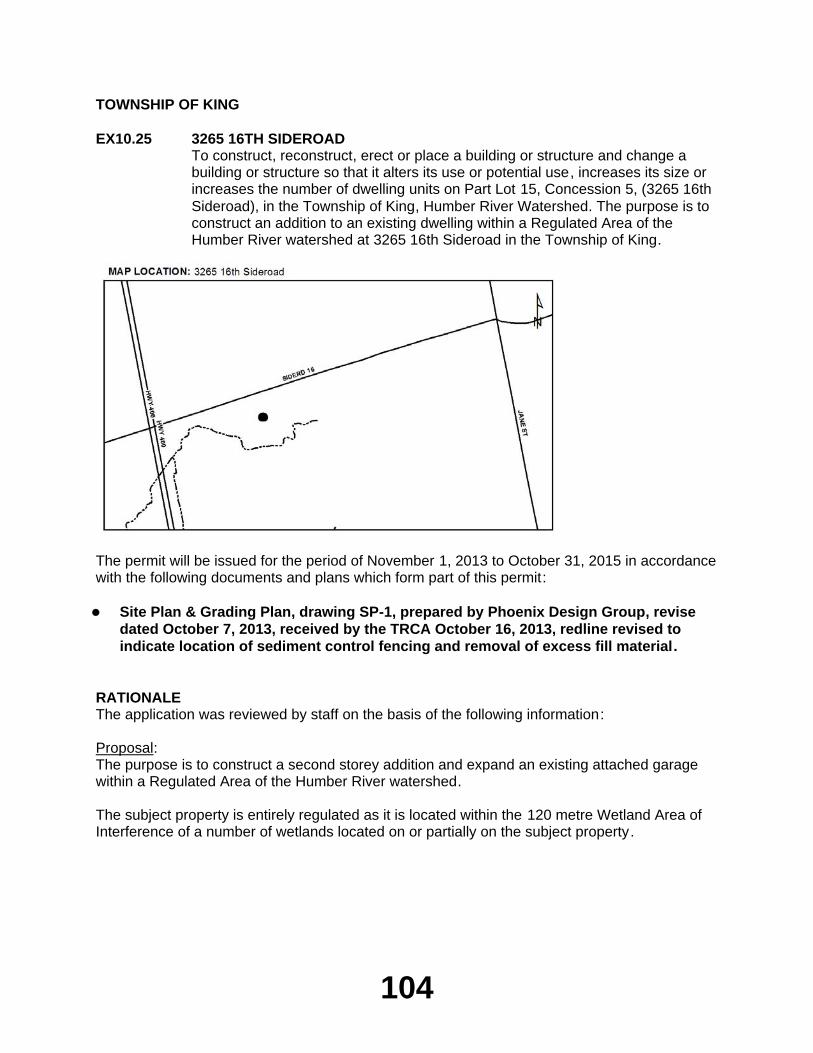
104
TOWNSHIP OF KING
EX10.25 3265 16TH SIDEROADTo construct, reconstruct, erect or place a building or structure and change a building or structure so that it alters its use or potential use, increases its size or increases the number of dwelling units on Part Lot 15, Concession 5, (3265 16th Sideroad), in the Township of King, Humber River Watershed. The purpose is to construct an addition to an existing dwelling within a Regulated Area of the Humber River watershed at 3265 16th Sideroad in the Township of King.
The permit will be issued for the period of November 1, 2013 to October 31, 2015 in accordance with the following documents and plans which form part of this permit:
Site Plan & Grading Plan, drawing SP-1, prepared by Phoenix Design Group, revise
dated October 7, 2013, received by the TRCA October 16, 2013, redline revised to indicate location of sediment control fencing and removal of excess fill material.
RATIONALEThe application was reviewed by staff on the basis of the following information:
Proposal:The purpose is to construct a second storey addition and expand an existing attached garage within a Regulated Area of the Humber River watershed.
The subject property is entirely regulated as it is located within the 120 metre Wetland Area of Interference of a number of wetlands located on or partially on the subject property.
105
Based upon a site visit conducted by TRCA staff on June 12, 2013, we note that the proposed works are all located on already disturbed areas that are flat and devoid of significant vegetation. The only expansion to the footprint of the existing dwelling does not result in increased encroachment towards the natural features on the property. All other works are located over the existing building footprint. The works are also significantly set back from the nearest wetland (approximately 25 metres). On this basis, TRCA Ecology staff are satisfied that the proposed addition will not have any impacts on the nearby wetland features.
A permit under Ontario Regulation 166/06 was previously issued to the construction of a septic system on the property (Permit No. C-130619, issued August 9, 2013).
Control of Flooding:The subject property is not located within the Regional Storm Flood Plain. There will be no impacts on the storage or conveyance of flood waters.
Pollution:Sediment control fencing will be erected and maintained for the duration of construction to prevent the transport of sediment into the nearby wetland features and vegetated areas.
Dynamic Beaches:Not applicable.
Erosion:There are no geotechnical issues associated with this application.
Conservation of Land:As a watercourse will not be impacted by the proposal, no fisheries concerns will result. There are no other significant natural features on or adjacent to the site that may be negatively impacted by the project.
PlantingsAll disturbed areas will be restored to the existing sodded condition and will not affect any significant natural features.
Policy Guidelines:The proposal is consistent with Section 4.2 - Existing Development - of the Authority's Valley and Stream Corridor Management Program.
CFN: 49939 - Application #: 0915/13/KINGReport Prepared by: Anthony Sun, extension 5724For information contact: June Little, extension 5756Date: October 18, 2013
PERMIT APPLICATIONS EX10.26 - EX10.33 MAJOR ERRATA ITEMS
Applications that involved a more complex suite of technical studies to demonstrate consistency with policies; applications that cover a significant geographic area (e.g. subdivisions, stormwater management ponds), extensive modifications to the landscape, major infrastructure projects, emergency works, resolution of violations/after the fact permits, trail construction
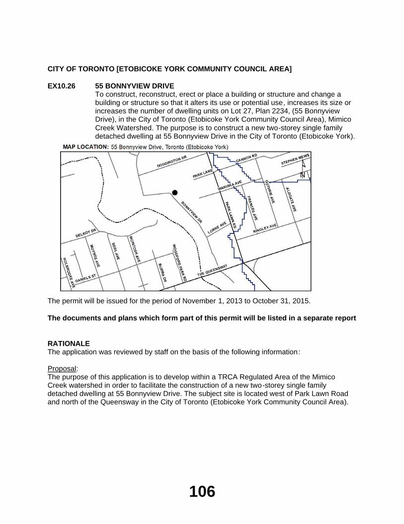
106
CITY OF TORONTO [ETOBICOKE YORK COMMUNITY COUNCIL AREA]
EX10.26 55 BONNYVIEW DRIVETo construct, reconstruct, erect or place a building or structure and change a building or structure so that it alters its use or potential use, increases its size or increases the number of dwelling units on Lot 27, Plan 2234, (55 Bonnyview Drive), in the City of Toronto (Etobicoke York Community Council Area), Mimico Creek Watershed. The purpose is to construct a new two-storey single family detached dwelling at 55 Bonnyview Drive in the City of Toronto (Etobicoke York).
The permit will be issued for the period of November 1, 2013 to October 31, 2015.
The documents and plans which form part of this permit will be listed in a separate report
RATIONALEThe application was reviewed by staff on the basis of the following information:
Proposal:The purpose of this application is to develop within a TRCA Regulated Area of the Mimico Creek watershed in order to facilitate the construction of a new two-storey single family detached dwelling at 55 Bonnyview Drive. The subject site is located west of Park Lawn Road and north of the Queensway in the City of Toronto (Etobicoke York Community Council Area).
107
Control of Flooding:The property is located within the Regulatory Floodplain of the Mimico Creek. The new dwelling will be dry passive flood proofed to the Regional Storm elevation. A letter prepared by a certified structural engineer confirms that the new dwelling has been designed to withstand the flood elevations and velocities associated with a Regional Storm Event. The proposed works will be constructed in accordance with this letter.
Pollution:Sediment controls are not required as the subject site is located at the toe of a slope and removed from the watercourse.
Dynamic Beaches:Not applicable
Erosion:There are no slope stability/geotechnical concerns associated with this application.
Conservation of Land:The proposed works are located no further towards the valley slope. There are no other significant natural features on, or adjacent to, the site that would be negatively impacted by the project.
PlantingsNo plantings are required as part of this project.
Policy Guidelines:This proposal is consistent with Section 4.2.2.(D) - Development Guidelines for Replacement Structures within Non-Established/Highly Urbanized Areas of the TRCA's Valley and Stream Corridor Management Program.
CFN: 49895 - Application #: 0893/13/TORReport Prepared by: Vanessa Aubrey, extension 5662For information contact: Mark Rapus, extension 5259Date: October 21, 2013
CITY OF TORONTO [NORTH YORK COMMUNITY COUNCIL AREA]
EX10.27 AMIN TAHERZADEHTo construct, reconstruct, erect or place a building or structure, site grade and temporarily or permanently place, dump or remove any material, originating on the site or elsewhere on Lot 15, Plan 2405, Part Lot 14, Plan, (50 Donwoods Drive), in the City of Toronto (North York Community Council Area), Don River Watershed. The purpose is to construct a two-storey replacement dwelling, raised rear deck, new in-ground swimming pool with new cabanas and associated landscaping at 50 Donwoods Drive in the City of Toronto (North York Community Council Area).
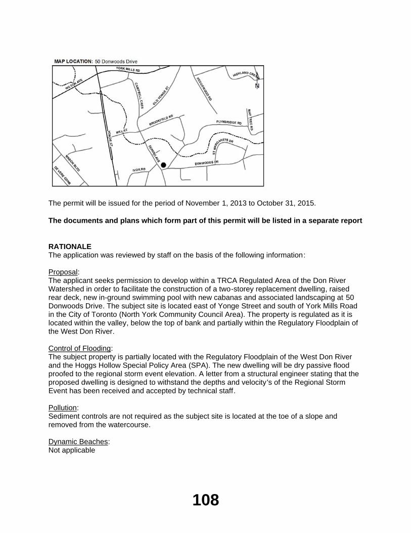
108
The permit will be issued for the period of November 1, 2013 to October 31, 2015.
The documents and plans which form part of this permit will be listed in a separate report
RATIONALEThe application was reviewed by staff on the basis of the following information:
Proposal:The applicant seeks permission to develop within a TRCA Regulated Area of the Don River Watershed in order to facilitate the construction of a two-storey replacement dwelling, raised rear deck, new in-ground swimming pool with new cabanas and associated landscaping at 50 Donwoods Drive. The subject site is located east of Yonge Street and south of York Mills Road in the City of Toronto (North York Community Council Area). The property is regulated as it is located within the valley, below the top of bank and partially within the Regulatory Floodplain of the West Don River.
Control of Flooding:The subject property is partially located with the Regulatory Floodplain of the West Don River and the Hoggs Hollow Special Policy Area (SPA). The new dwelling will be dry passive flood proofed to the regional storm event elevation. A letter from a structural engineer stating that the proposed dwelling is designed to withstand the depths and velocity's of the Regional Storm Event has been received and accepted by technical staff.
Pollution:Sediment controls are not required as the subject site is located at the toe of a slope and removed from the watercourse.
Dynamic Beaches:Not applicable
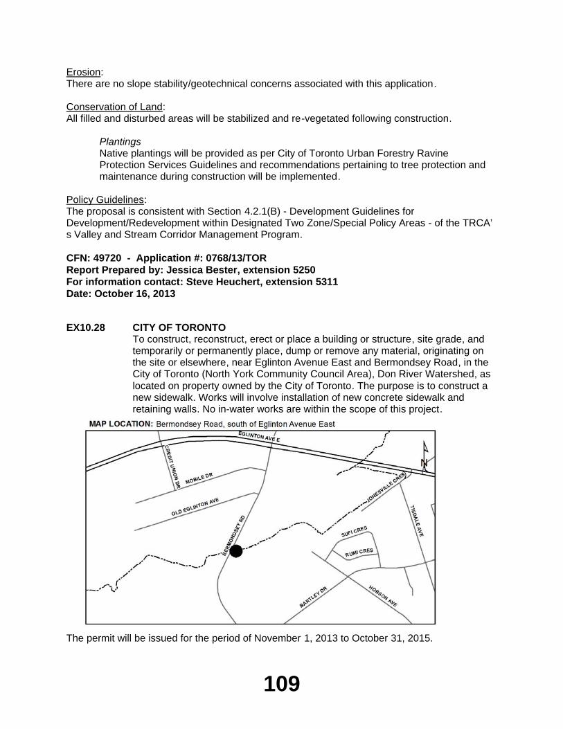
109
Erosion:There are no slope stability/geotechnical concerns associated with this application.
Conservation of Land:All filled and disturbed areas will be stabilized and re-vegetated following construction.
PlantingsNative plantings will be provided as per City of Toronto Urban Forestry Ravine Protection Services Guidelines and recommendations pertaining to tree protection and maintenance during construction will be implemented.
Policy Guidelines:The proposal is consistent with Section 4.2.1(B) - Development Guidelines for Development/Redevelopment within Designated Two Zone/Special Policy Areas - of the TRCA’s Valley and Stream Corridor Management Program.
CFN: 49720 - Application #: 0768/13/TORReport Prepared by: Jessica Bester, extension 5250For information contact: Steve Heuchert, extension 5311Date: October 16, 2013
EX10.28 CITY OF TORONTOTo construct, reconstruct, erect or place a building or structure, site grade, and temporarily or permanently place, dump or remove any material, originating on the site or elsewhere, near Eglinton Avenue East and Bermondsey Road, in the City of Toronto (North York Community Council Area), Don River Watershed, as located on property owned by the City of Toronto. The purpose is to construct a new sidewalk. Works will involve installation of new concrete sidewalk and retaining walls. No in-water works are within the scope of this project.
The permit will be issued for the period of November 1, 2013 to October 31, 2015.
110
The documents and plans which form part of this permit will be listed in a separate report
RATIONALEThe application was reviewed by staff on the basis of the following information:
Proposal:The City of Toronto is proposing to construct a new concrete sidewalk along Bermondsey Road between Old Eglinton Avenue East and Bartley Drive. Works will involve construction of the new sidewalk, which will be between 1.7 and 2.3m in width, along the east side of the roadway. To facilitate the proposed sidewalk alignment, several retaining walls will be constructed to maintain the existing slope on the east side of the roadway. These walls will vary in height from 0.6 to 3.5m, with a vegetated grass swale planted along the top. Silt fencing is to be established to isolate the construction area over the watercourse, while the catch basins will be outfitted with filter fabric. Trees that fall within the footprint of the proposed sidewalk and retaining walls will be removed; compensation is to be sought in accordance with City of Toronto Urban Forestry standards. Construction is anticipated to occur in fall 2013.
Control of Flooding:The proposed works are not located within the Regional Storm flood plain and are not anticipated to impact flooding, flood storage or conveyance of flood waters.
Pollution:Erosion and sediment control measures (silt fence, catch basin filter) will be installed prior to construction and maintained for its duration. These measures are being implemented to prevent the release of construction generated sediment into Wilson Brook, a tributary of the East Don River. Erosion and sediment control measures have been provided in accordance with the TRCA Erosion and Sediment Control Guideline for Urban Construction (2006).
Dynamic Beaches:The proposal will not have any implications to dynamic beaches.
Erosion:There are no impacts identified to slope stability or erosion as a result of these works.
Conservation of Land:No in-water works are within the scope of this project.
PlantingsSeveral tree removals are associated with this project; these will be compensated by the planting of new trees in accordance with City of Toronto Urban Forestry standards. All disturbed areas will be restored to pre-construction conditions, or better, upon completion of work.
Policy Guidelines:This proposal complies with Section 4.3, Infrastructure and Servicing, of the TRCA’s Valley and Stream Corridor Management Program.
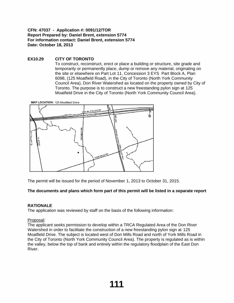
111
CFN: 47037 - Application #: 0091/12/TORReport Prepared by: Daniel Brent, extension 5774For information contact: Daniel Brent, extension 5774Date: October 18, 2013
EX10.29 CITY OF TORONTOTo construct, reconstruct, erect or place a building or structure, site grade and temporarily or permanently place, dump or remove any material, originating on the site or elsewhere on Part Lot 11, Concession 3 EYS Part Block A, Plan 6098, (125 Moatfield Road), in the City of Toronto (North York Community Council Area), Don River Watershed as located on the property owned by City of Toronto. The purpose is to construct a new freestanding pylon sign at 125 Moatfield Drive in the City of Toronto (North York Community Council Area).
The permit will be issued for the period of November 1, 2013 to October 31, 2015.
The documents and plans which form part of this permit will be listed in a separate report
RATIONALEThe application was reviewed by staff on the basis of the following information:
Proposal:The applicant seeks permission to develop within a TRCA Regulated Area of the Don River Watershed in order to facilitate the construction of a new freestanding pylon sign at 125 Moatfield Drive. The subject is located west of Don Mills Road and north of York Mills Road in the City of Toronto (North York Community Council Area). The property is regulated as is within the valley, below the top of bank and entirely within the regulatory floodplain of the East Don River.
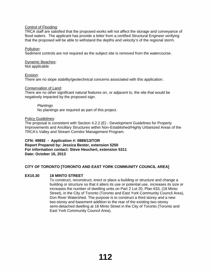
112
Control of Flooding:TRCA staff are satisfied that the proposed works will not affect the storage and conveyance of flood waters. The applicant has provide a letter from a certified Structural Engineer verifying that the proposed will be able to withstand the depths and velocity's of the regional storm.
Pollution:Sediment controls are not required as the subject site is removed from the watercourse.
Dynamic Beaches:Not applicable
Erosion:There are no slope stability/geotechnical concerns associated with this application.
Conservation of Land:There are no other significant natural features on, or adjacent to, the site that would be negatively impacted by the proposed sign.
PlantingsNo plantings are required as part of this project.
Policy Guidelines:The proposal is consistent with Section 4.2.2.(E) - Development Guidelines for Property Improvements and Ancillary Structures within Non-Established/Highly Urbanized Areas of the TRCA’s Valley and Stream Corridor Management Program.
CFN: 49892 - Application #: 0889/13/TORReport Prepared by: Jessica Bester, extension 5250For information contact: Steve Heuchert, extension 5311Date: October 16, 2013
CITY OF TORONTO [TORONTO AND EAST YORK COMMUNITY COUNCIL AREA]
EX10.30 18 MINTO STREETTo construct, reconstruct, erect or place a building or structure and change a building or structure so that it alters its use or potential use, increases its size or increases the number of dwelling units on Part 2 Lot 20, Plan 633, (18 Minto Street), in the City of Toronto (Toronto and East York Community Council Area), Don River Watershed. The purpose is to construct a third storey and a new two-storey and basement addition to the rear of the existing two-storey semi-detached dwelling at 18 Minto Street in the City of Toronto (Toronto and East York Community Council Area).
113
The permit will be issued for the period of November 1, 2013 to October 31, 2015.
The documents and plans which form part of this permit will be listed in a separate report
RATIONALEThe application was reviewed by staff on the basis of the following information:
Proposal:The purpose of this application is to develop within a TRCA Regulated Area of the Don River Watershed in order to facilitate the construction of a new third storey and a two-storey and basement addition to the rear of the existing two-storey semi-detached dwelling at 18 Minto Street. The subject site is located east of Leslie Street and north of Eastern Avenue in the City of Toronto (Toronto and East York Community Council Area).
Control of Flooding:The subject property is located within the Regional Storm Floodplain of the Don River and the provincially approved Lower Don Special Policy Area (SPA). The new dwelling will be above the 1:350 Year Storm elevation. A letter prepared by a certified structural engineer confirms that the new dwelling has been designed to withstand the flood elevations and velocities associated with a Regional Storm Event. The proposed works will be constructed in accordance with this letter.
Pollution:The proposed construction is well removed from the watercourse. The proponent is required to abide by the municipal sewer by-law so that sediment will not enter the storm sewer system.
Dynamic Beaches:Not applicable
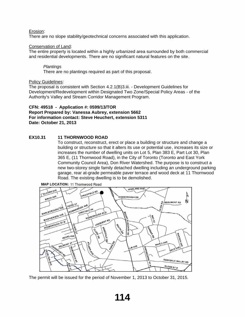
114
Erosion:There are no slope stability/geotechnical concerns associated with this application.
Conservation of Land:The entire property is located within a highly urbanized area surrounded by both commercial and residential developments. There are no significant natural features on the site.
PlantingsThere are no plantings required as part of this proposal.
Policy Guidelines:The proposal is consistent with Section 4.2.1(B)3.iii. - Development Guidelines for Development/Redevelopment within Designated Two Zone/Special Policy Areas - of the Authority's Valley and Stream Corridor Management Program.
CFN: 49518 - Application #: 0599/13/TORReport Prepared by: Vanessa Aubrey, extension 5662For information contact: Steve Heuchert, extension 5311Date: October 21, 2013
EX10.31 11 THORNWOOD ROADTo construct, reconstruct, erect or place a building or structure and change a building or structure so that it alters its use or potential use, increases its size or increases the number of dwelling units on Lot 5, Plan 383 E, Part Lot 30, Plan 365 E, (11 Thornwood Road), in the City of Toronto (Toronto and East York Community Council Area), Don River Watershed. The purpose is to construct a new two-storey single family detached dwelling including an underground parking garage, rear at-grade permeable paver terrace and wood deck at 11 Thornwood Road. The existing dwelling is to be demolished.
The permit will be issued for the period of November 1, 2013 to October 31, 2015.
115
The documents and plans which form part of this permit will be listed in a separate report
RATIONALEThe application was reviewed by staff on the basis of the following information:
Proposal:The purpose of this application is to develop within a TRCA Regulated Area of the Don River watershed in order to facilitate the construction of a new two-storey single family detached dwelling including an underground parking garage, rear at-grade permeable paver terrace and wood deck at 11 Thornwood Road. The existing dwelling is to be demolished. The subject site is located west of Mount Pleasant Road and south of St. Clair Avenue East in the City of Toronto (Toronto and East York Community Council Area).
Conditional Permit:The issuance of this permit is conditional upon the approval of a ravine stewardship plan by City of Toronto Urban Forestry Services. Minor revisions to the approved plans required on behalf of Urban Forestry Services will be addressed by TRCA staff through redline revisions.
Control of Flooding:The site is not located within a regional storm flood plain and the proposal will have no impact on the storage and/or conveyance of floodwaters.
Pollution:Appropriate erosion and sediment controls will be installed and maintained throughout all phases of construction.
Dynamic Beaches:Not applicable.
Erosion:A geotechnical slope stability report has been reviewed and approved by TRCA geotechnical engineering staff and the proposal will be constructed in accordance with the recommendations of this report.
Conservation of Land:The appropriate tree protection fencing will be installed.
PlantingsA ravine stewardship plan will be implemented. Native plantings will be provided as per Urban Forestry Ravine Protection Services Guidelines and recommendations pertaining to tree protection and maintenance during construction will be implemented.
Policy Guidelines:This proposal is consistent with Section 4.2.2.(D) and (E) - Development Guidelines for Replacement Structures, Property Improvements and Ancillary Structures within Non-Established/Highly Urbanized Areas of the TRCA's Valley and Stream Corridor Management Program.
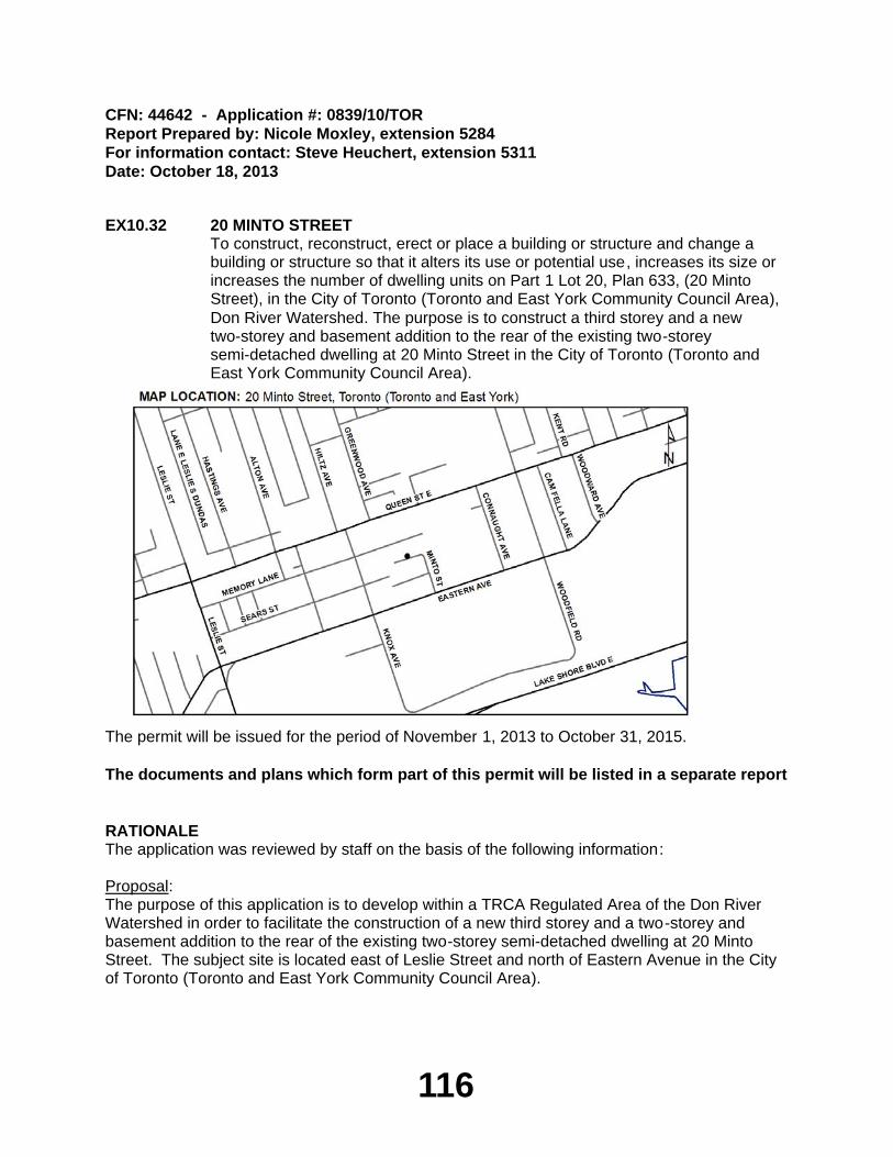
116
CFN: 44642 - Application #: 0839/10/TORReport Prepared by: Nicole Moxley, extension 5284For information contact: Steve Heuchert, extension 5311Date: October 18, 2013
EX10.32 20 MINTO STREETTo construct, reconstruct, erect or place a building or structure and change a building or structure so that it alters its use or potential use, increases its size or increases the number of dwelling units on Part 1 Lot 20, Plan 633, (20 Minto Street), in the City of Toronto (Toronto and East York Community Council Area), Don River Watershed. The purpose is to construct a third storey and a new two-storey and basement addition to the rear of the existing two-storey semi-detached dwelling at 20 Minto Street in the City of Toronto (Toronto and East York Community Council Area).
The permit will be issued for the period of November 1, 2013 to October 31, 2015.
The documents and plans which form part of this permit will be listed in a separate report
RATIONALEThe application was reviewed by staff on the basis of the following information:
Proposal:The purpose of this application is to develop within a TRCA Regulated Area of the Don River Watershed in order to facilitate the construction of a new third storey and a two-storey and basement addition to the rear of the existing two-storey semi-detached dwelling at 20 Minto Street. The subject site is located east of Leslie Street and north of Eastern Avenue in the City of Toronto (Toronto and East York Community Council Area).
117
Control of Flooding:The subject property is located within the Regional Storm Floodplain of the Don River and the provincially approved Lower Don Special Policy Area (SPA). The new dwelling will be above the 1:350 Year Storm elevation. A letter prepared by a certified structural engineer confirms that the new dwelling has been designed to withstand the flood elevations and velocities associated with a Regional Storm Event. The proposed works will be constructed in accordance with this letter.
Pollution:The proposed construction is well removed from the watercourse. The proponent is required to abide by the municipal sewer by-law so that sediment will not enter the storm sewer system.
Dynamic Beaches:Not applicable
Erosion:There are no slope stability/geotechnical concerns associated with this application.
Conservation of Land:The entire property is located within a highly urbanized area surrounded by both commercial and residential developments. There are no significant natural features on the site.
PlantingsThere are no plantings required as part of this proposal.
Policy Guidelines:The proposal is consistent with Section 4.2.1(B)3.iii. - Development Guidelines for Development/Redevelopment within Designated Two Zone/Special Policy Areas - of the Authority's Valley and Stream Corridor Management Program.
CFN: 49442 - Application #: 0591/13/TORReport Prepared by: Vanessa Aubrey, extension 5662For information contact: Steve Heuchert, extension 5311Date: October 21, 2013
CITY OF VAUGHAN
EX10.33 12331 ALBION VAUGHAN ROADTo construct, reconstruct, erect or place a building or structure, site grade and temporarily or permanently place, dump or remove any material, originating on the site or elsewhere on Lot 1, Plan 65-2134, (12331 Albion Vaughan Road), in the City of Vaughan, Humber River Watershed. The purpose is to conduct grading works and construct a low retaining wall associated with the construction of a new driveway to an existing dwelling within a Regulated Area of the Humber River watershed at 12331 Albion-Vaughan Road in the City of Vaughan.
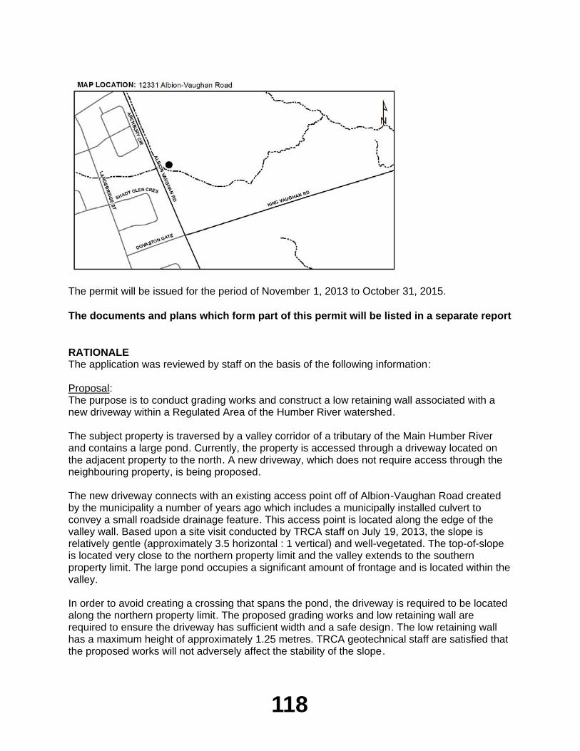
118
The permit will be issued for the period of November 1, 2013 to October 31, 2015.
The documents and plans which form part of this permit will be listed in a separate report
RATIONALEThe application was reviewed by staff on the basis of the following information:
Proposal:The purpose is to conduct grading works and construct a low retaining wall associated with a new driveway within a Regulated Area of the Humber River watershed.
The subject property is traversed by a valley corridor of a tributary of the Main Humber River and contains a large pond. Currently, the property is accessed through a driveway located on the adjacent property to the north. A new driveway, which does not require access through the neighbouring property, is being proposed.
The new driveway connects with an existing access point off of Albion-Vaughan Road created by the municipality a number of years ago which includes a municipally installed culvert to convey a small roadside drainage feature. This access point is located along the edge of the valley wall. Based upon a site visit conducted by TRCA staff on July 19, 2013, the slope is relatively gentle (approximately 3.5 horizontal : 1 vertical) and well-vegetated. The top-of-slope is located very close to the northern property limit and the valley extends to the southern property limit. The large pond occupies a significant amount of frontage and is located within the valley.
In order to avoid creating a crossing that spans the pond, the driveway is required to be located along the northern property limit. The proposed grading works and low retaining wall are required to ensure the driveway has sufficient width and a safe design. The low retaining wall has a maximum height of approximately 1.25 metres. TRCA geotechnical staff are satisfied that the proposed works will not adversely affect the stability of the slope.
119
Control of Flooding:The proposed works are not located within the Regional Storm Flood Plain. There will be no impacts on the storage or conveyance of flood waters
Pollution:Sediment control fencing will be erected and maintained for the duration of construction to prevent the transport of sediment into the valley system.
Dynamic Beaches:Not applicable.
Erosion:TRCA geotechnical staff are satisfied that the proposed works will not have an adverse impact on the stability of the valley wall.
Conservation of Land:As a watercourse will not be impacted by the proposal, no fisheries concerns will result. There are no other significant natural features on or adjacent to the site that may be negatively impacted by the project.
PlantingsAll disturbed areas will be restored to the existing sodded condition. Vegetation removals along the slope have been minimized to the extent possible.
Policy Guidelines:The proposal is consistent with Section 4.2.2 E) - Property Improvements and Ancillary Structures - of the Authority's Valley and Stream Corridor Management Program.
CFN: 49914 - Application #: 0895/13/VAUGReport Prepared by: Anthony Sun, extension 5724For information contact: June Little, extension 5756Date: October 18, 2013