Embed Size (px)
Citation preview
11
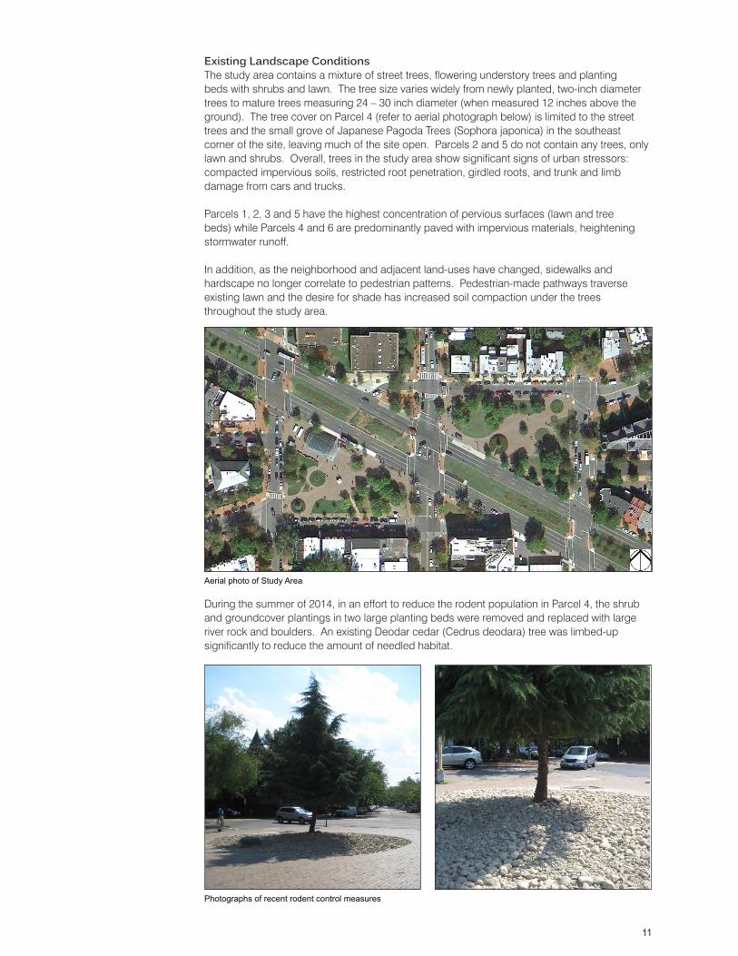
Existing Landscape ConditionsThe study area contains a mixture of street trees, flowering understory trees and planting beds with shrubs and lawn. The tree size varies widely from newly planted, two-inch diameter trees to mature trees measuring 24 – 30 inch diameter (when measured 12 inches above the ground). The tree cover on Parcel 4 (refer to aerial photograph below) is limited to the street trees and the small grove of Japanese Pagoda Trees (Sophora japonica) in the southeast corner of the site, leaving much of the site open. Parcels 2 and 5 do not contain any trees, only lawn and shrubs. Overall, trees in the study area show significant signs of urban stressors: compacted impervious soils, restricted root penetration, girdled roots, and trunk and limb damage from cars and trucks.
Parcels 1, 2, 3 and 5 have the highest concentration of pervious surfaces (lawn and tree beds) while Parcels 4 and 6 are predominantly paved with impervious materials, heightening stormwater runoff.
In addition, as the neighborhood and adjacent land-uses have changed, sidewalks and hardscape no longer correlate to pedestrian patterns. Pedestrian-made pathways traverse existing lawn and the desire for shade has increased soil compaction under the trees throughout the study area.
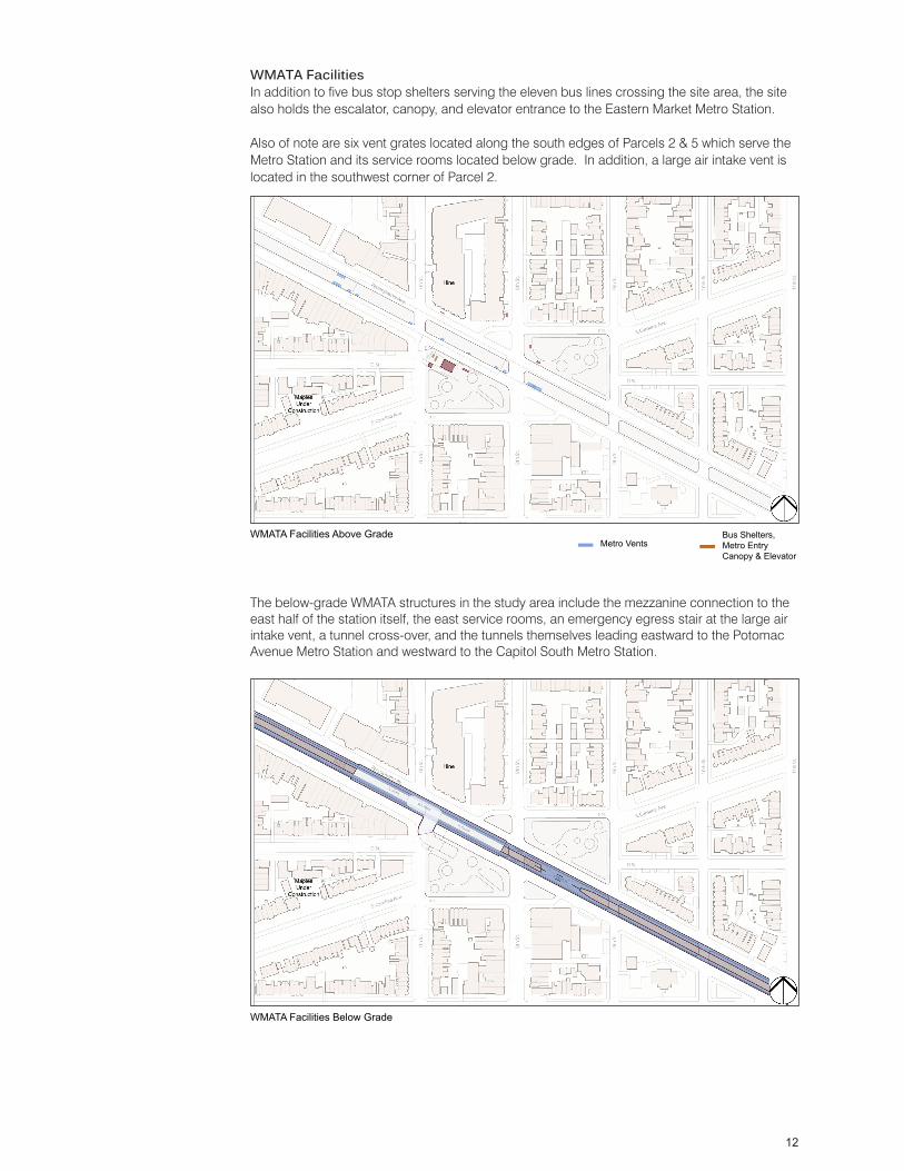
During the summer of 2014, in an effort to reduce the rodent population in Parcel 4, the shrub and groundcover plantings in two large planting beds were removed and replaced with large river rock and boulders. An existing Deodar cedar (Cedrus deodara) tree was limbed-up significantly to reduce the amount of needled habitat.
Aerial photo of Study Area
Photographs of recent rodent control measures
12
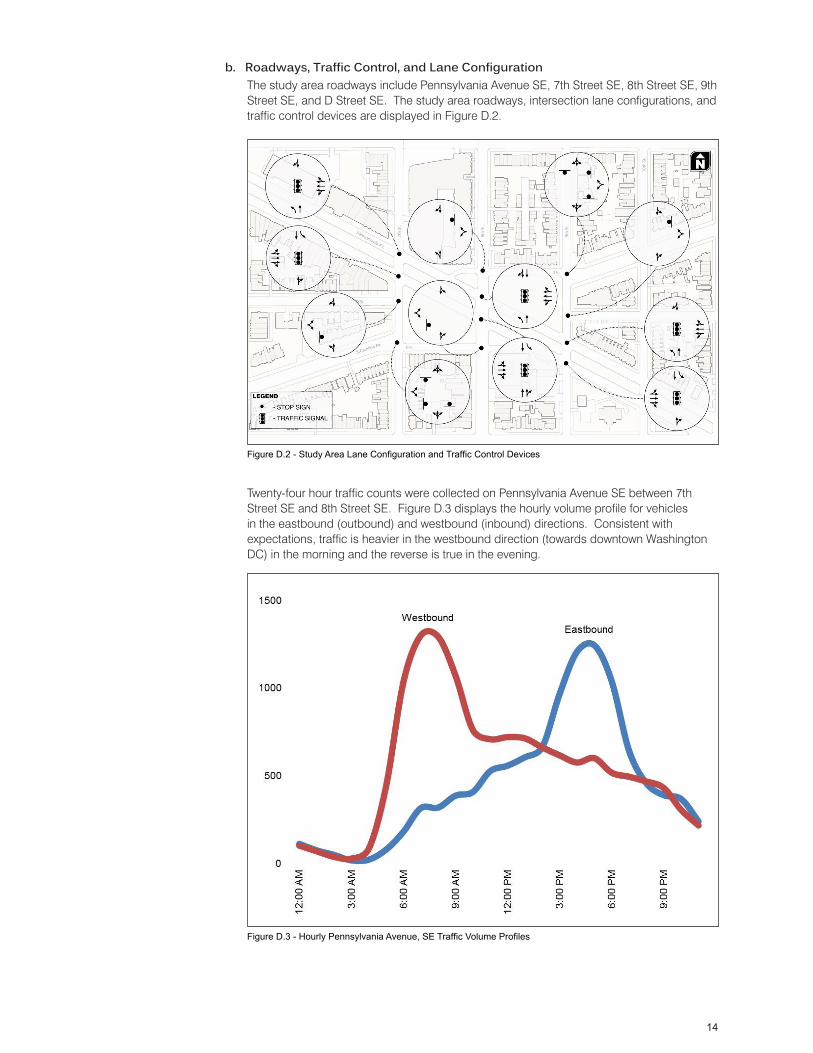
WMATA FacilitiesIn addition to five bus stop shelters serving the eleven bus lines crossing the site area, the site also holds the escalator, canopy, and elevator entrance to the Eastern Market Metro Station.
Also of note are six vent grates located along the south edges of Parcels 2 & 5 which serve the Metro Station and its service rooms located below grade. In addition, a large air intake vent is located in the southwest corner of Parcel 2.
The below-grade WMATA structures in the study area include the mezzanine connection to the east half of the station itself, the east service rooms, an emergency egress stair at the large air intake vent, a tunnel cross-over, and the tunnels themselves leading eastward to the Potomac Avenue Metro Station and westward to the Capitol South Metro Station.
Metro VentsBus Shelters, Metro Entry Canopy & Elevator
WMATA Facilities Above Grade
WMATA Facilities Below Grade

13
3. Traffic & TransportationThis section documents the current transportation conditions of the study area roadways and intersections, seen in Figure D.1, along with the bicycle, transit and pedestrian facilities.
a. Data Collection Methods:The design team coordinated with the District Department of Transportation (DDOT) to conduct an inventory of transportation conditions within and immediately adjacent to the project site. The data collected and used to perform the existing conditions analysis in the study area includes traffic counts, transit data, site visit information, and crash data.
Traffic counts were conducted in July 2013 when Congress was in session to collect traffic data representative of a typical midweek day. The counts recorded the number of vehicles making each movement at an intersection during weekday a.m. and p.m. peak hours. The traffic counts also included the number of study area pedestrian and bicycle movements during the same time periods, and were collected at all nine study area intersections.
In addition, a site visit was conducted in July 2013, during a representative weekday p.m. peak period to document existing conditions and highlight observations that would not be easily ascertained from other collected data.
The site visit observations and analysis were complemented by comments provided by the public through the community engagement process described in the Study Process & Outreach section of this report.
Figure D.1 - Transportation Study Area
14
b. Roadways, Traffic Control, and Lane Configuration
Twenty-four hour traffic counts were collected on Pennsylvania Avenue SE between 7th Street SE and 8th Street SE. Figure D.3 displays the hourly volume profile for vehicles in the eastbound (outbound) and westbound (inbound) directions. Consistent with expectations, traffic is heavier in the westbound direction (towards downtown Washington DC) in the morning and the reverse is true in the evening.
The study area roadways include Pennsylvania Avenue SE, 7th Street SE, 8th Street SE, 9th Street SE, and D Street SE. The study area roadways, intersection lane configurations, and traffic control devices are displayed in Figure D.2.
Figure D.2 - Study Area Lane Configuration and Traffic Control Devices
Figure D.3 - Hourly Pennsylvania Avenue, SE Traffic Volume Profiles
15
c. Vehicular Traffic ConditionsThe July 2013 traffic counts were used to conduct an operations analysis of the study area intersections. The operations analysis represents a worst case scenario typical of a midweek peak hour. Traffic conditions during all other weekday time periods and throughout the weekend will likely operate under better conditions than described in this report.
The average vehicle delay, volume-to-capacity (v/c) ratio, and level of service (LOS), for each intersection during the morning and evening peak hours, respectively, is indicated in Figures D.4 and D.5 below. See descriptions of LOS. in Appendix I, page 38. As seen in the two figures, all of the study area signalized intersections operate at LOS C or better, and with the exception of the 8th Street/D Street SE (south) intersection, all of the unsignalized intersections operate at LOS D or better. The 8th Street/D Street SE (south) intersection operates at LOS F during the a.m. and p.m. peak hours, with a v/c ratio of 0.70 during the a.m. peak hour, and at capacity during the p.m. peak hour.
Figure D.4 - Existing Weekday AM Peak Hour Traffic Volumes and Intersection Operations
Figure D.5 - Existing Weekday PM Peak Hour Traffic Volumes and Intersection Operations
16
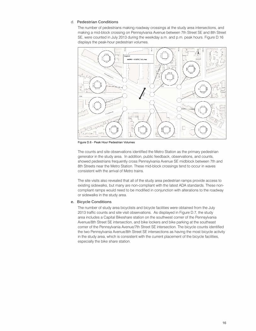
The number of pedestrians making roadway crossings at the study area intersections, and making a mid-block crossing on Pennsylvania Avenue between 7th Street SE and 8th Street SE, were counted in July 2013 during the weekday a.m. and p.m. peak hours. Figure D.16 displays the peak-hour pedestrian volumes.
The counts and site observations identified the Metro Station as the primary pedestrian generator in the study area. In addition, public feedback, observations, and counts, showed pedestrians frequently cross Pennsylvania Avenue SE midblock between 7th and 8th Streets near the Metro Station. These mid-block crossings tend to occur in waves consistent with the arrival of Metro trains.
The site visits also revealed that all of the study area pedestrian ramps provide access to existing sidewalks, but many are non-compliant with the latest ADA standards. These non-compliant ramps would need to be modified in conjunction with alterations to the roadway or sidewalks in the study area.
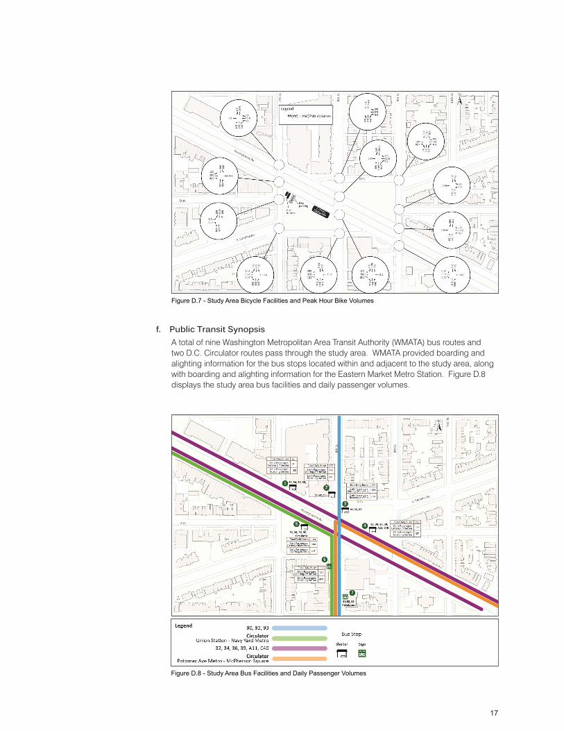
The number of study area bicyclists and bicycle facilities were obtained from the July 2013 traffic counts and site visit observations. As displayed in Figure D.7, the study area includes a Capital Bikeshare station on the southwest corner of the Pennsylvania Avenue/8th Street SE intersection, and bike lockers and bike parking at the southeast corner of the Pennsylvania Avenue/7th Street SE intersection. The bicycle counts identified the two Pennsylvania Avenue/8th Street SE intersections as having the most bicycle activity in the study area, which is consistent with the current placement of the bicycle facilities, especially the bike share station.
d. Pedestrian Conditions
e. Bicycle Conditions
Figure D.6 - Peak Hour Pedestrian Volumes
17
A total of nine Washington Metropolitan Area Transit Authority (WMATA) bus routes and two D.C. Circulator routes pass through the study area. WMATA provided boarding and alighting information for the bus stops located within and adjacent to the study area, along with boarding and alighting information for the Eastern Market Metro Station. Figure D.8 displays the study area bus facilities and daily passenger volumes.
f. Public Transit Synopsis
Figure D.7 - Study Area Bicycle Facilities and Peak Hour Bike Volumes
Figure D.8 - Study Area Bus Facilities and Daily Passenger Volumes
18
The Eastern Market Metro Station serves Metrorail’s Blue, Orange, and Silver Lines. The Metro Station entrance is located on the south side of Pennsylvania Avenue SE between 7th and 8th Street SE. Ridership data for the Eastern Market Metro stop was provided by WMATA. As an order of magnitude comparison, during the month of May 2013 on an average weekday, approximately 6,600 daily passengers exited from the Metro Station, and 6,400 daily passengers entered the Metro Station. This is approximately ten times more passenger activity than the bus stop activity immediately adjacent to the Metro Station.
Crash data over a five-year period for the study intersections was collected from the DC Department of Transportation (DDOT). The crash data was reviewed with respect to location, crash severity, crash type and vehicle type. Over the five year period, approximately four out of every five crashes resulted in property damage only, and there were no fatal crashes.
The intersections of Pennsylvania Avenue/8th Street SE and Pennsylvania Avenue/7th Street SE each accounted for approximately one third of the study area crashes, with the remaining intersections cumulatively accounting for the remaining one third. As shown in the preceding figures, these intersections have the most auto and pedestrian activity, and therefore have the most opportunities for collisions.
g. Safety - Crash Data Synopsis
19
E. Two Alternative Concepts
After the initial community input was reviewed by the Task Force in June 2013, the Task Force used the input to define the program for which two alternative master plan concepts were to be developed by the Design Team. The Team was directed to maintain the existing Pennsylvania Avenue SE roadbed configuration in both concepts. The Program was defined specifically in some areas, and generally as “important goals” in others. The Task Force indicated to the Design Team that, in addition to their instructions, the Team was to take into account the totality of the individual community comments received as the Concepts were developed. Below is a summary of the Task Force’s guidance:
Task Force Program GuidancePublic Safety• A redesign of Parcels 2 and 5 to prevent mid-block crossings• A redesign of sidewalks at intersections to increase public safety• Design of lighting for security• Design rodent control into the project
Sustainability• Design of rain-gardens in the bow-tie parcels• Engagement with the goals of the Anacostia Watershed Initiative
Multigenerational design• Design spaces that encourage all age groups to interact with each other, forming community
bonds.
Community Amenities• Include an interactive water feature located on Parcel 4• Improve visibility of the existing historic Southeast Branch DC Library• Include a play area located on Parcel 1
In general, the principal traffic characteristics of the streets were to be retained: the current alignment of Pennsylvania Avenue, the existing pattern of two-way and one-way street operations, the existing arrangement of traffic control devices, and the location of curb lane parking. The Team was asked to study the two D Street “spurs” to assess feasibility of modifications to improve circulation and potential for usable park space.
Traffic/Transportation guidance included:
• Improve the multimodal transportation hub efficiency and user friendliness• Relocation and expansion of the bicycle facilities• Relocation of bus stops to improve access• Improve 8th & D Streets intersections• Relocation of southbound Bus stops at 8th & D Streets (south).• Study curbside utilization for carshare, retail parking, loading.• As an alternate to a median design that precludes mid-block crossing, the Team was asked to
study a signalized midblock crossing to safely allow pedestrians to cross at the Pennsylvania Avenue natural desire line.
20
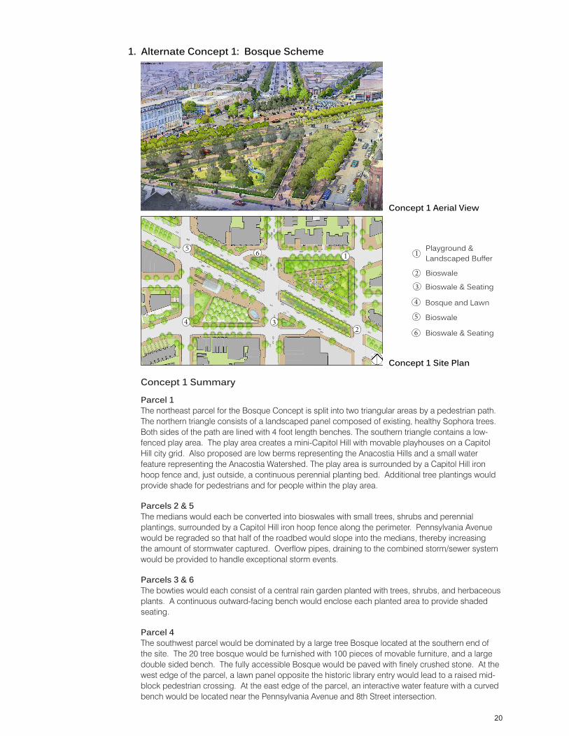
Concept 1 Summary
Parcel 1The northeast parcel for the Bosque Concept is split into two triangular areas by a pedestrian path. The northern triangle consists of a landscaped panel composed of existing, healthy Sophora trees. Both sides of the path are lined with 4 foot length benches. The southern triangle contains a low-fenced play area. The play area creates a mini-Capitol Hill with movable playhouses on a Capitol Hill city grid. Also proposed are low berms representing the Anacostia Hills and a small water feature representing the Anacostia Watershed. The play area is surrounded by a Capitol Hill iron hoop fence and, just outside, a continuous perennial planting bed. Additional tree plantings would provide shade for pedestrians and for people within the play area.
Parcels 2 & 5The medians would each be converted into bioswales with small trees, shrubs and perennial plantings, surrounded by a Capitol Hill iron hoop fence along the perimeter. Pennsylvania Avenue would be regraded so that half of the roadbed would slope into the medians, thereby increasing the amount of stormwater captured. Overflow pipes, draining to the combined storm/sewer system would be provided to handle exceptional storm events.
Parcels 3 & 6The bowties would each consist of a central rain garden planted with trees, shrubs, and herbaceous plants. A continuous outward-facing bench would enclose each planted area to provide shaded seating.
Parcel 4The southwest parcel would be dominated by a large tree Bosque located at the southern end of the site. The 20 tree bosque would be furnished with 100 pieces of movable furniture, and a large double sided bench. The fully accessible Bosque would be paved with finely crushed stone. At the west edge of the parcel, a lawn panel opposite the historic library entry would lead to a raised mid-block pedestrian crossing. At the east edge of the parcel, an interactive water feature with a curved bench would be located near the Pennsylvania Avenue and 8th Street intersection.
Playground & Landscaped Buffer
Concept 1 Aerial View
1. Alternate Concept 1: Bosque Scheme
1
234
6
Concept 1 Site Plan
1
2 Bioswale
3 Bioswale & Seating
Bosque and Lawn4
5 Bioswale
6 Bioswale & Seating
5

21
Parcel 1The northeast parcel for the Library Concept is split into two triangular areas by a pedestrian path aligned with the historic South Carolina Avenue axis. Along the path would be a series of 4 foot length benches. The northern triangle consists of a lawn panel and a landscaped buffer composed of existing, healthy Sophora trees. The southern triangle contains a play area, modeled after the nearby historic Navy Yard. Play equipment would consist of large mechanically operable pieces. Also proposed are berms representing the Anacostia Hills and a small water feature representing the Anacostia Watershed. The play area would be surrounded by a Capitol Hill iron hoop fence and, just outside, a continuous perennial planting bed. Additional tree plantings would provide shade for pedestrians and for people within the play area.
Parcels 2 & 5The medians would each be converted into raised planters with trees, shrubs and herbaceous plants. The planter structure would be a brick and stone corbelled retaining wall along the perimeter.
Parcels 3 & 6The bowties would each consist of a central rain garden planted with trees, shrubs, and herbaceous plants. A continuous outward-facing bench would enclose each planted area to provide shaded seating.
Parcel 4The southwest parcel for the Library Concept includes a new Library entrance pavilion on the South Carolina Avenue axis. The pavilion provides entry to a 13,000 square foot underground library addition that connects below grade under 7th Street to the original, historic library. The library pavilion and an adjacent interactive water feature would be bracketed by lawn panels along 7th Street and D Street. The interactive water feature would be located at a natural gathering point between the metro entrance and the library pavilion entrance.
2. Alternate Concept 2 (Library Scheme)
Concept 2 Summary
1
234
65 Playground & Landscaped Buffer
Concept 2 Aerial View
Concept 2 Site Plan
1
2 Raised Planters
3 Bioswale & Seating
Metro Plaza & Library4
5 Raised Planters
6 Bioswale & Seating
22
4. Other Modifications Not IncludedSome of the Task Force’s Traffic and Transportation requested program elements were studied, but ultimately not included. The following lists the modifications not included, and the reasons for their exclusion.
3. Proposed Traffic and Transportation ModificationsThe traffic and transportation modifications were studied independently from Concept 1 and 2 designs since they do not impact the feasibility of either design. The following lists the proposed traffic and transportation modifications.
Improve Multimodal Transportation HubParcel 4’s role as a multimodal transportation hub would be augmented by relocating bike facilities, and 8th Street SE bus stops, both described below.
Consolidation and Expansion of Bicycle FacilitiesExisting bicycle amenities, including a bike share station and bike racks would be consolidated and relocated to provided expanded facilities in the southeast quadrant adjacent to the 7th Street/Pennsylvania Avenue intersection.
Relocation of Bus StopsA common transit park is proposed on Parcel 4 through the relocation of 8th Street bus stops to locations adjacent to the parcel.
Improve the Pedestrian Experience The construction of curb extensions and ADA accessible ramps will help improve the pedestrian experience within the study area.
Relieve Pressure on the 8th Street/D Street SE (south) and 8th Street/D Street SE (north) IntersectionsReversing the direction of D Street SE (south) and D Street SE (north) will help relieve pressure on the 8th Street/D Street SE (south) and 8th Street/D Street SE (north) intersections, and address safety concerns related to the relocated southbound 8th Street SE bus stop.
Remove the D Street (south) Extension Removing the D Street (south) extension between 8th Street and Pennsylvania Avenue allows the existing public space to be connected with the community south of the street.
Bike Lanes on Pennsylvania Avenue SENo designated bicycle lanes currently exist within the study area. However, the 2005 Bicycle Master Plan, and the MoveDC Long Range Transportation Plan identify future bicycle facilities along Pennsylvania Avenue SE through the study area. Numerous community suggestions to incorporate bicycle lanes into the project were received early in the process. Accordingly, alternatives were developed incorporating bicycle lanes within the Pennsylvania Avenue SE right-of-way. After a review of alternatives with DDOT during subsequent meetings, DDOT informed the Design Team that DDOT had not yet developed a comprehensive Bicycle Plan for Pennsylvania Avenue SE. DDOT directed the Design Team to not include any modifications to the Avenue’s roadbed for bicycle purposes. For this reason, the Final Master Plan does not include bicycle lanes in the Pennsylvania Avenue SE right of way.
Provide a Signalized Midblock Crossing A signalized midblock crossing would provide a direct connection across Pennsylvania Avenue SE to the Eastern Market Metro station, and decrease out of distance travel time by pedestrians. Because of concerns related to queued vehicles at the mid-block crossing stacking up into adjacent Pennsylvania Avenue, SE intersections, DDOT recommended the development of other options for addressing the safety concerns related to the mid-block pedestrian crossings.
23
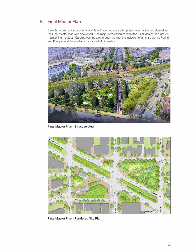
F. Final Master Plan
Based on community comments and Task Force guidance after presentation of the two alternatives, the Final Master Plan was developed. The major items addressed for the Final Master Plan include maintaining the South Carolina Avenue axis through the site, the inclusion of an entry Library Pavilion and Bosque, and the medians composed of bioswales.
Final Master Plan - Birdseye View
Final Master Plan - Rendered Site Plan
24
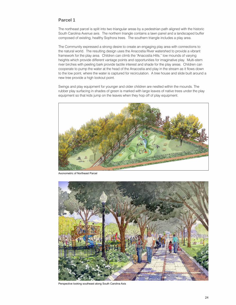
Parcel 1
The northeast parcel is split into two triangular areas by a pedestrian path aligned with the historic South Carolina Avenue axis. The northern triangle contains a lawn panel and a landscaped buffer composed of existing, healthy Sophora trees. The southern triangle includes a play area.
The Community expressed a strong desire to create an engaging play area with connections to the natural world. The resulting design uses the Anacostia River watershed to provide a vibrant framework for the play area. Children can climb the “Anacostia Hills,” low mounds of varying heights which provide different vantage points and opportunities for imaginative play. Multi-stem river birches with peeling bark provide tactile interest and shade for the play areas. Children can cooperate to pump the water at the head of the Anacostia and play in the stream as it flows down to the low point, where the water is captured for recirculation. A tree house and slide built around a new tree provide a high lookout point. Swings and play equipment for younger and older children are nestled within the mounds. The rubber play surfacing in shades of green is marked with large leaves of native trees under the play equipment so that kids jump on the leaves when they hop off of play equipment.
Axonometric of Northeast Parcel
Perspective looking southeast along South Carolina Axis