Embed Size (px)
Citation preview
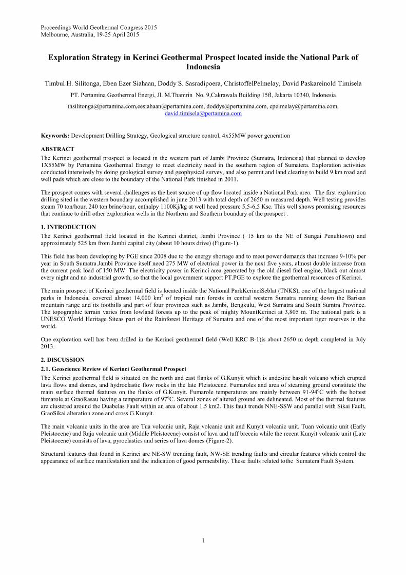
Proceedings World Geothermal Congress 2015
Melbourne, Australia, 19-25 April 2015
1
Exploration Strategy in Kerinci Geothermal Prospect located inside the National Park of
Indonesia
Timbul H. Silitonga, Eben Ezer Siahaan, Doddy S. Sasradipoera, ChristoffelPelmelay, David Paskareinold Timisela
PT. Pertamina Geothermal Energi, Jl. M.Thamrin No. 9,Cakrawala Building 15fl, Jakarta 10340, Indonesia
[email protected],[email protected], [email protected], [email protected],
Keywords: Development Drilling Strategy, Geological structure control, 4x55MW power generation
ABSTRACT
The Kerinci geothermal prospect is located in the western part of Jambi Province (Sumatra, Indonesia) that planned to develop
1X55MW by Pertamina Geothermal Energy to meet electricity need in the southern region of Sumatera. Exploration activities
conducted intensively by doing geological survey and geophysical survey, and also permit and land clearing to build 9 km road and
well pads which are close to the boundary of the National Park finished in 2011.
The prospect comes with several challenges as the heat source of up flow located inside a National Park area. The first exploration
drilling sited in the western boundary accomplished in june 2013 with total depth of 2650 m measured depth. Well testing provides
steam 70 ton/hour, 240 ton brine/hour, enthalpy 1100Kj/kg at well head pressure 5,5-6,5 Ksc. This well shows promising resources
that continue to drill other exploration wells in the Northern and Southern boundary of the prospect .
1. INTRODUCTION
The Kerinci geothermal field located in the Kerinci district, Jambi Province ( 15 km to the NE of Sungai Penuhtown) and
approximately 525 km from Jambi capital city (about 10 hours drive) (Figure-1).
This field has been developing by PGE since 2008 due to the energy shortage and to meet power demands that increase 9-10% per
year in South Sumatra.Jambi Province itself need 275 MW of electrical power in the next five years, almost double increase from
the current peak load of 150 MW. The electricity power in Kerinci area generated by the old diesel fuel engine, black out almost
every night and no industrial growth, so that the local government support PT.PGE to explore the geothermal resources of Kerinci.
The main prospect of Kerinci geothermal field is located inside the National ParkKerinciSeblat (TNKS), one of the largest national
parks in Indonesia, covered almost 14,000 km2 of tropical rain forests in central western Sumatra running down the Barisan
mountain range and its foothills and part of four provinces such as Jambi, Bengkulu, West Sumatra and South Sumtra Province.
The topographic terrain varies from lowland forests up to the peak of mighty MountKerinci at 3,805 m. The national park is a
UNESCO World Heritage Siteas part of the Rainforest Heritage of Sumatra and one of the most important tiger reserves in the
world.
One exploration well has been drilled in the Kerinci geothermal field (Well KRC B-1)is about 2650 m depth completed in July
2013.
2. DISCUSSION
2.1. Geoscience Review of Kerinci Geothermal Prospect
The Kerinci geothermal field is situated on the north and east flanks of G.Kunyit which is andesitic basalt volcano which erupted
lava flows and domes, and hydroclastic flow rocks in the late Pleistocene. Fumaroles and area of steaming ground constitute the
main surface thermal features on the flanks of G.Kunyit. Fumarole temperatures are mainly between 91-94oC with the hottest
fumarole at GraoRasau having a temperature of 97oC. Several zones of altered ground are delineated. Most of the thermal features
are clustered around the Duabelas Fault within an area of about 1.5 km2. This fault trends NNE-SSW and parallel with Sikai Fault,
GraoSikai alteration zone and cross G.Kunyit.
The main volcanic units in the area are Tua volcanic unit, Raja volcanic unit and Kunyit volcanic unit. Tuan volcanic unit (Early
Pleistocene) and Raja volcanic unit (Middle Pleistocene) consist of lava and tuff breccia while the recent Kunyit volcanic unit (Late
Pleistocene) consists of lava, pyroclastics and series of lava domes (Figure-2).
Structural features that found in Kerinci are NE-SW trending fault, NW-SE trending faults and circular features which control the
appearance of surface manifestation and the indication of good permeability. These faults related tothe Sumatera Fault System.

Silitonga et al.
2
Figure-1: Location Map of Kerinci Prospect
Surface alteration related to active geothermal system is argilic alteration (smectite) that found around the thermal manifestations
and upper southern flank of Mt. Kunyit. Minor amounts of sulphur deposit also found at GrauSikai.
The surface manifestation are divided into three groups: GrauRasau, GrauSikai and GrauDuabelas which consist of fumaroles, mud
pools and hotsprings. These surface manifestations are controlled by NE-SW faults and located at 1500 – 1800 masl.
Figure-2: Geological Map of Kerinci Area
Silitonga et al.
3
The Cl-SO4-HCO3 ternary diagram shows the sulphate water type which indicates the fluids heated by gases that very soluble in
water. From Na-K-Mg ternary diagram shows that high content of magnesium which indicates mixing with the meteoric water.
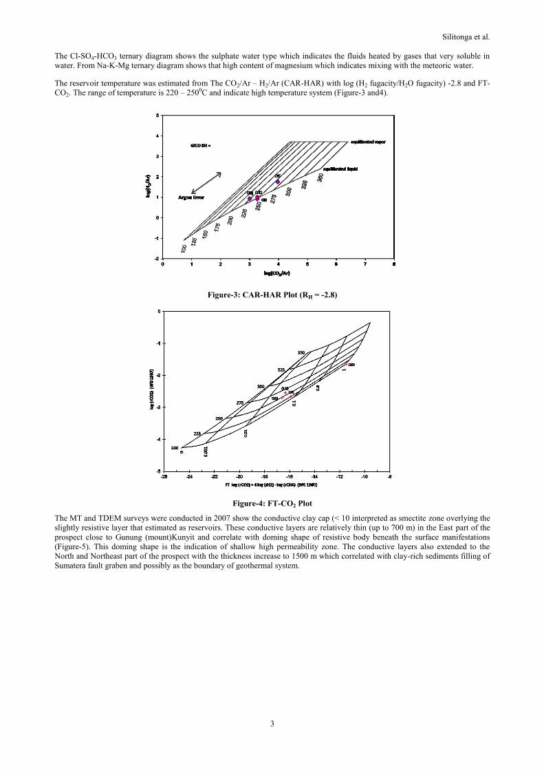
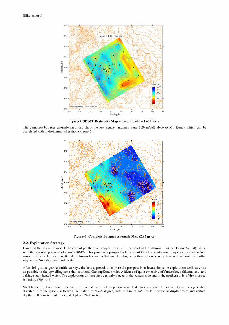
The reservoir temperature was estimated from The CO2/Ar – H2/Ar (CAR-HAR) with log (H2 fugacity/H2O fugacity) -2.8 and FT-
CO2. The range of temperature is 220 – 2500C and indicate high temperature system (Figure-3 and4).
Figure-3: CAR-HAR Plot (RH = -2.8)
Figure-4: FT-CO2 Plot
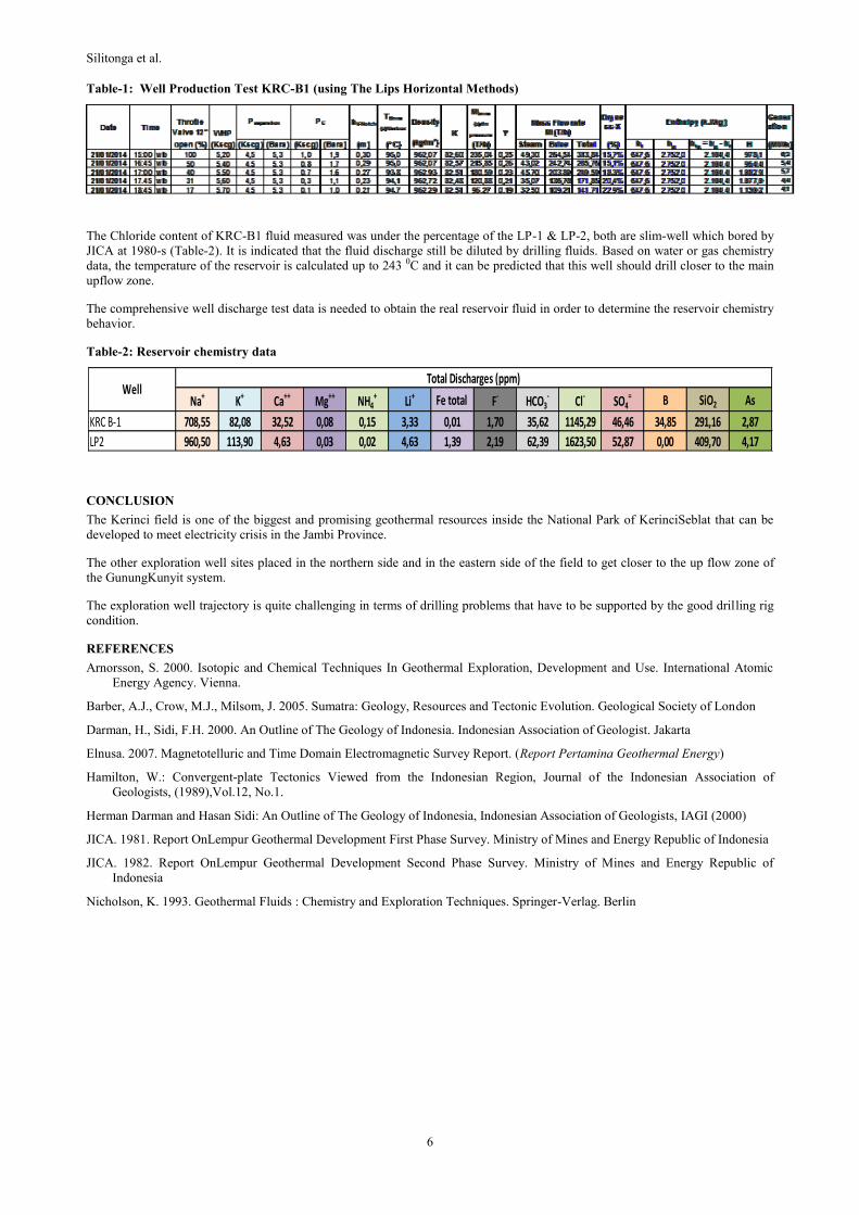
The MT and TDEM surveys were conducted in 2007 show the conductive clay cap (< 10 interpreted as smectite zone overlying the
slightly resistive layer that estimated as reservoirs. These conductive layers are relatively thin (up to 700 m) in the East part of the
prospect close to Gunung (mount)Kunyit and correlate with doming shape of resistive body beneath the surface manifestations
(Figure-5). This doming shape is the indication of shallow high permeability zone. The conductive layers also extended to the
North and Northeast part of the prospect with the thickness increase to 1500 m which correlated with clay-rich sediments filling of
Sumatera fault graben and possibly as the boundary of geothermal system.
Silitonga et al.
4
Figure-5: 3D MT Resistivity Map at Depth 1.400 – 1.610 meter
The complete bouguer anomaly map also show the low density anomaly zone (-20 mGal) close to Mt. Kunyit which can be
correlated with hydrothermal alteration (Figure-6).
Figure-6: Complete Bouguer Anomaly Map (2.67 gr/cc)
2.2. Exploration Strategy
Based on the scientific model, the core of geothermal prospect located in the heart of the National Park of KerinciSeblat(TNKS)
with the resource potential of about 200MW. This promising prospect is because of the clear geothermal play concept such as heat
source reflected by wide scattered of fumaroles and solfataras, lithological setting of quaternary lava and intensively faulted
segment of Sumatra great fault system.
After doing some geo-scientific surveys, the best approach to explore the prospect is to locate the some exploration wells as close
as possible to the upwelling zone that is around GunungKunyit with evidence of quite extensive of fumaroles, solfataras and acid
sulfate steam heated water. The exploration drilling sites can only placed in the eastern side and in the northern side of the prospect
boundary (Figure-7).
Well trajectory from these sites have to diverted well to the up flow zone that has considered the capability of the rig to drill
diverted in to the system with well inclination of 50-65 degree, with minimum 1650 meter horizontal displacement and vertical
depth of 1899 meter and measured depth of 2650 meter.

Silitonga et al.
5
In this first exploration well encountered so many drilling problems such as loss circulation in the shallow depth due to
unconsolidated rock/lahar, spent many days to combat loss zone by plugging loss circulation materials and cements, stuck pipe due
to swelling clay, side track problem and landslide due to heavy rain along the Barisan Mountain.
In order to develop 2X55MW, the exploration well sites are being prepared in the northern side and in the eastern side to drill closer
to the heat source of the GunungKunyit system to get higher pressure and temperature (Figure-7).
Figure-7: Map of Exploration Well Pad around the Boundary of National Park
2.3. Production Test of Exploration Well KRC-B
At July 26th 2013 (the 31st day of heating up after well completion day), the Well KRC-B1 reached a static condition with
maximum temperature of 2110C at 1800 md (measured depth). The temperature range within 1,200 - 2,375 md vary about 209 -
2110C and the well head pressure was 0 (zero) (Figure-8).
Figure-8: Temperature and Pressure Profile of KRC-B1
Referring to the AF/AC formula and the PT data, the chance of the well KRC-B1 to self-discharge without any stimulation was
only 32% which it means very little chance of successful (self) discharge (AF/AC < 70% - little chance of successful discharge;
AF/AC = 70%-85% - uncertainty; AF/AC >85% - excellent chance of successful discharge). Some number of pressure stimulation
from 10 to 100 bars in order to push down the water level to the heat zone, the greatest chance of discharge just raised a little to be
38,7% at 45 bars (still had little chance of successful discharge).
At early January 2014, the KRC-B1 was conducted any well stimulation by the air compressor. After compressed for 6 days, the
well head pressure reached 50 barg (excess 5 bar to prepare if any leakage at well / connection) and was hold at this pressure for 24
hours. At 6th January 2014, the well was shock-opened for the first time. Surprisingly, the steam was flowing for about 6 hours and
then shut in because the capacity of the ponds to support the brine.
Thesecond well production test of KRC-B1 conducted at 21st January 2014 discharged for one month and produced fluid with an
enthalpy of 1100kJ/kg. Steam production was about 70 ton/hr at wellhead pressures 5.5 – 6.6 barg.
Silitonga et al.
6
Table-1: Well Production Test KRC-B1 (using The Lips Horizontal Methods)
The Chloride content of KRC-B1 fluid measured was under the percentage of the LP-1 & LP-2, both are slim-well which bored by
JICA at 1980-s (Table-2). It is indicated that the fluid discharge still be diluted by drilling fluids. Based on water or gas chemistry
data, the temperature of the reservoir is calculated up to 243 0C and it can be predicted that this well should drill closer to the main
upflow zone.
The comprehensive well discharge test data is needed to obtain the real reservoir fluid in order to determine the reservoir chemistry
behavior.
Table-2: Reservoir chemistry data
CONCLUSION
The Kerinci field is one of the biggest and promising geothermal resources inside the National Park of KerinciSeblat that can be
developed to meet electricity crisis in the Jambi Province.
The other exploration well sites placed in the northern side and in the eastern side of the field to get closer to the up flow zone of
the GunungKunyit system.
The exploration well trajectory is quite challenging in terms of drilling problems that have to be supported by the good drilling rig
condition.
REFERENCES
Arnorsson, S. 2000. Isotopic and Chemical Techniques In Geothermal Exploration, Development and Use. International Atomic
Energy Agency. Vienna.
Barber, A.J., Crow, M.J., Milsom, J. 2005. Sumatra: Geology, Resources and Tectonic Evolution. Geological Society of London
Darman, H., Sidi, F.H. 2000. An Outline of The Geology of Indonesia. Indonesian Association of Geologist. Jakarta
Elnusa. 2007. Magnetotelluric and Time Domain Electromagnetic Survey Report. (Report Pertamina Geothermal Energy)
Hamilton, W.: Convergent-plate Tectonics Viewed from the Indonesian Region, Journal of the Indonesian Association of
Geologists, (1989),Vol.12, No.1.
Herman Darman and Hasan Sidi: An Outline of The Geology of Indonesia, Indonesian Association of Geologists, IAGI (2000)
JICA. 1981. Report OnLempur Geothermal Development First Phase Survey. Ministry of Mines and Energy Republic of Indonesia
JICA. 1982. Report OnLempur Geothermal Development Second Phase Survey. Ministry of Mines and Energy Republic of
Indonesia
Nicholson, K. 1993. Geothermal Fluids : Chemistry and Exploration Techniques. Springer-Verlag. Berlin
Na+ K+ Ca++ Mg++ NH4+ Li+ Fe total F- HCO3
- Cl- SO4= B SiO2 As
KRC B-1 708,55 82,08 32,52 0,08 0,15 3,33 0,01 1,70 35,62 1145,29 46,46 34,85 291,16 2,87
LP2 960,50 113,90 4,63 0,03 0,02 4,63 1,39 2,19 62,39 1623,50 52,87 0,00 409,70 4,17
WellTotal Discharges (ppm)