Embed Size (px)
Citation preview

Extract from NCTech Application Notes & Case Studies
Download the complete booklet fromnctechimaging.com/technotes
53NCTech Ltd 1 Boroughloch Square, Edinburgh, EH8 9NJ, UKT: +44 131 202 6258 - www.nctechimaging.com
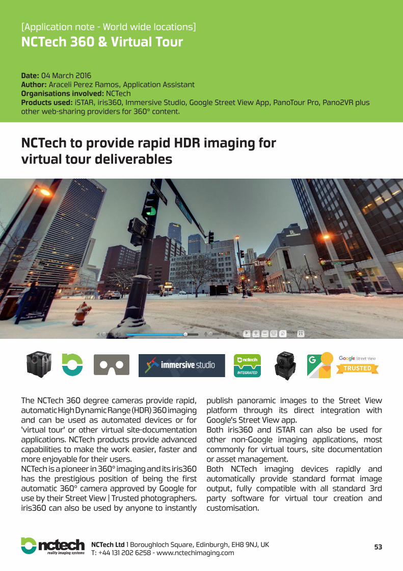
[Application note - World wide locations]
NCTech 360 & Virtual Tour
Date: 04 March 2016Author: Araceli Perez Ramos, Application AssistantOrganisations involved: NCTechProducts used: iSTAR, iris360, Immersive Studio, Google Street View App, PanoTour Pro, Pano2VR plus other web-sharing providers for 360° content.
The NCTech 360 degree cameras provide rapid, automatic High Dynamic Range (HDR) 360 imaging and can be used as automated devices or for ‘virtual tour’ or other virtual site-documentation applications. NCTech products provide advanced capabilities to make the work easier, faster and more enjoyable for their users.NCTech is a pioneer in 360° imaging and its iris360 has the prestigious position of being the first automatic 360° camera approved by Google for use by their Street View | Trusted photographers. iris360 can also be used by anyone to instantly
publish panoramic images to the Street View platform through its direct integration with Google’s Street View app.Both iris360 and iSTAR can also be used for other non-Google imaging applications, most commonly for virtual tours, site documentation or asset management.Both NCTech imaging devices rapidly and automatically provide standard format image output, fully compatible with all standard 3rd party software for virtual tour creation and customisation.
NCTech to provide rapid HDR imaging forvirtual tour deliverables
54NCTech Ltd 1 Boroughloch Square, Edinburgh, EH8 9NJ, UKT: +44 131 202 6258 - www.nctechimaging.com
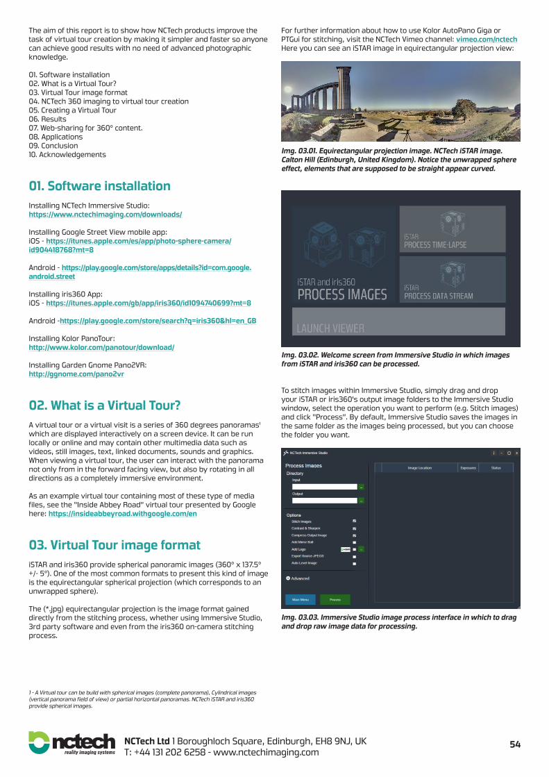
The aim of this report is to show how NCTech products improve the task of virtual tour creation by making it simpler and faster so anyone can achieve good results with no need of advanced photographic knowledge.
01. Software installation02. What is a Virtual Tour?03. Virtual Tour image format04. NCTech 360 imaging to virtual tour creation05. Creating a Virtual Tour06. Results 07. Web-sharing for 360° content.08. Applications09. Conclusion10. Acknowledgements
01. Software installationInstalling NCTech Immersive Studio:https://www.nctechimaging.com/downloads/
Installing Google Street View mobile app: iOS - https://itunes.apple.com/es/app/photo-sphere-camera/id904418768?mt=8
Android - https://play.google.com/store/apps/details?id=com.google.android.street Installing iris360 App: iOS - https://itunes.apple.com/gb/app/iris360/id1094740699?mt=8 Android -https://play.google.com/store/search?q=iris360&hl=en_GB
Installing Kolor PanoTour:http://www.kolor.com/panotour/download/
Installing Garden Gnome Pano2VR:http://ggnome.com/pano2vr
02. What is a Virtual Tour?A virtual tour or a virtual visit is a series of 360 degrees panoramas¹ which are displayed interactively on a screen device. It can be run locally or online and may contain other multimedia data such as videos, still images, text, linked documents, sounds and graphics.When viewing a virtual tour, the user can interact with the panorama not only from in the forward facing view, but also by rotating in all directions as a completely immersive environment.
As an example virtual tour containing most of these type of media files, see the “Inside Abbey Road” virtual tour presented by Google here: https://insideabbeyroad.withgoogle.com/en
03. Virtual Tour image formatiSTAR and iris360 provide spherical panoramic images (360° x 137.5° +/- 5°). One of the most common formats to present this kind of image is the equirectangular spherical projection (which corresponds to an unwrapped sphere).
The (*.jpg) equirectangular projection is the image format gained directly from the stitching process, whether using Immersive Studio, 3rd party software and even from the iris360 on-camera stitching process.
For further information about how to use Kolor AutoPano Giga or PTGui for stitching, visit the NCTech Vimeo channel: vimeo.com/nctechHere you can see an iSTAR image in equirectangular projection view:
Img. 03.01. Equirectangular projection image. NCTech iSTAR image. Calton Hill (Edinburgh, United Kingdom). Notice the unwrapped sphere effect, elements that are supposed to be straight appear curved.
Img. 03.02. Welcome screen from Immersive Studio in which images from iSTAR and iris360 can be processed.
To stitch images within Immersive Studio, simply drag and drop your iSTAR or iris360’s output image folders to the Immersive Studio window, select the operation you want to perform (e.g. Stitch images) and click “Process”. By default, Immersive Studio saves the images in the same folder as the images being processed, but you can choose the folder you want.
Img. 03.03. Immersive Studio image process interface in which to drag and drop raw image data for processing.
1 - A Virtual tour can be build with spherical images (complete panorama), Cylindrical images (vertical panorama field of view) or partial horizontal panoramas. NCTech iSTAR and iris360 provide spherical images.
55NCTech Ltd 1 Boroughloch Square, Edinburgh, EH8 9NJ, UKT: +44 131 202 6258 - www.nctechimaging.com
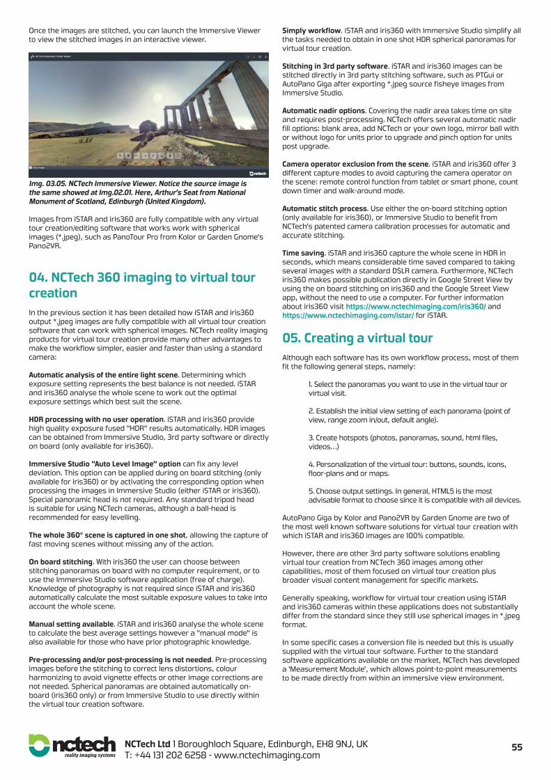
Once the images are stitched, you can launch the Immersive Viewer to view the stitched images in an interactive viewer.
Img. 03.05. NCTech Immersive Viewer. Notice the source image is the same showed at Img.02.01. Here, Arthur’s Seat from National Monument of Scotland, Edinburgh (United Kingdom).
Images from iSTAR and iris360 are fully compatible with any virtual tour creation/editing software that works work with spherical images (*.jpeg), such as PanoTour Pro from Kolor or Garden Gnome’s Pano2VR.
04. NCTech 360 imaging to virtual tour creationIn the previous section it has been detailed how iSTAR and iris360 output *.jpeg images are fully compatible with all virtual tour creation software that can work with spherical images. NCTech reality imaging products for virtual tour creation provide many other advantages to make the workflow simpler, easier and faster than using a standard camera:
Automatic analysis of the entire light scene. Determining which exposure setting represents the best balance is not needed. iSTAR and iris360 analyse the whole scene to work out the optimal exposure settings which best suit the scene.
HDR processing with no user operation. iSTAR and iris360 provide high quality exposure fused “HDR” results automatically. HDR images can be obtained from Immersive Studio, 3rd party software or directly on board (only available for iris360).
Immersive Studio “Auto Level Image” option can fix any level deviation. This option can be applied during on board stitching (only available for iris360) or by activating the corresponding option when processing the images in Immersive Studio (either iSTAR or iris360).Special panoramic head is not required. Any standard tripod head is suitable for using NCTech cameras, although a ball-head is recommended for easy levelling.
The whole 360° scene is captured in one shot, allowing the capture of fast moving scenes without missing any of the action.
On board stitching. With iris360 the user can choose between stitching panoramas on board with no computer requirement, or to use the Immersive Studio software application (free of charge).Knowledge of photography is not required since iSTAR and iris360 automatically calculate the most suitable exposure values to take into account the whole scene.
Manual setting available. iSTAR and iris360 analyse the whole scene to calculate the best average settings however a “manual mode” is also available for those who have prior photographic knowledge.
Pre-processing and/or post-processing is not needed. Pre-processing images before the stitching to correct lens distortions, colour harmonizing to avoid vignette effects or other image corrections are not needed. Spherical panoramas are obtained automatically on-board (iris360 only) or from Immersive Studio to use directly within the virtual tour creation software.
Simply workflow. iSTAR and iris360 with Immersive Studio simplify all the tasks needed to obtain in one shot HDR spherical panoramas for virtual tour creation.
Stitching in 3rd party software. iSTAR and iris360 images can be stitched directly in 3rd party stitching software, such as PTGui or AutoPano Giga after exporting *.jpeg source fisheye images from Immersive Studio.
Automatic nadir options. Covering the nadir area takes time on site and requires post-processing. NCTech offers several automatic nadir fill options: blank area, add NCTech or your own logo, mirror ball with or without logo for units prior to upgrade and pinch option for units post upgrade.
Camera operator exclusion from the scene. iSTAR and iris360 offer 3 different capture modes to avoid capturing the camera operator on the scene: remote control function from tablet or smart phone, count down timer and walk-around mode.
Automatic stitch process. Use either the on-board stitching option (only available for iris360), or Immersive Studio to benefit from NCTech’s patented camera calibration processes for automatic and accurate stitching.
Time saving. iSTAR and iris360 capture the whole scene in HDR in seconds, which means considerable time saved compared to taking several images with a standard DSLR camera. Furthermore, NCTech iris360 makes possible publication directly in Google Street View by using the on board stitching on iris360 and the Google Street View app, without the need to use a computer. For further information about iris360 visit https://www.nctechimaging.com/iris360/ and https://www.nctechimaging.com/istar/ for iSTAR.
05. Creating a virtual tourAlthough each software has its own workflow process, most of them fit the following general steps, namely:
1. Select the panoramas you want to use in the virtual tour or virtual visit.
2. Establish the initial view setting of each panorama (point of view, range zoom in/out, default angle).
3. Create hotspots (photos, panoramas, sound, html files, videos…)
4. Personalization of the virtual tour: buttons, sounds, icons, floor-plans and or maps.
5. Choose output settings. In general, HTML5 is the most advisable format to choose since it is compatible with all devices.
AutoPano Giga by Kolor and Pano2VR by Garden Gnome are two of the most well known software solutions for virtual tour creation with which iSTAR and iris360 images are 100% compatible.
However, there are other 3rd party software solutions enabling virtual tour creation from NCTech 360 images among other capabilities, most of them focused on virtual tour creation plus broader visual content management for specific markets. Generally speaking, workflow for virtual tour creation using iSTAR and iris360 cameras within these applications does not substantially differ from the standard since they still use spherical images in *.jpeg format. In some specific cases a conversion file is needed but this is usually supplied with the virtual tour software. Further to the standard software applications available on the market, NCTech has developed a ‘Measurement Module’, which allows point-to-point measurements to be made directly from within an immersive view environment.

56NCTech Ltd 1 Boroughloch Square, Edinburgh, EH8 9NJ, UKT: +44 131 202 6258 - www.nctechimaging.com
For information about NCTech Measurement Module check nctechimaging.com//downloads-files MeasurementModule.pdf andnctechimaging.com/downloads-files/Veesus-iSTAR.pdffor its integration within Veesus DataStudio ornctechimaging.com/downloads-files/SphereVisioniSTAR.pdf for its integration within Arithmetica SphereVision.
Virtual tour creation for Google Street View deserves a special mention since the iris360 was the first automatic spherical camera approved by Google for use by their Street View | Trusted photographers.
Furthermore, it is one of the few spherical cameras integrated to theStreet View mobile app, which enables anyone to instantly publish 360 image content to Street View, for private or public viewing.
The NCTech iris360 Open Spherical Camera (OSC) – Google API. (Notsuitable for iSTAR) enables integration of 360 image capture fromiris360 directly in 3rd party software and web platforms, enablingcamera control in a similar way to the Google Street View mobile app.Output 360 images are then handled directly within that 3rd party system with no manual data transfer needed. For further information and/or joint to the NCTech iris360 INTEGRATED network visit: http://www.nctechimaging.com/iris360-osc
06. ResultsVirtual Tour results can be displayed in different screen devices from computer, tablets or smartphones through immersive digital environment domes, 360 screen, CAVE environment to virtual reality headsets or glasses.
The user experience is like virtually being in the place where the images have been taken (immersive virtual reality) but depending on user immersive level provided:
Non-immersive systems: The virtual environment is viewed through a window on a screen device (computer, tablet or smart phone) and the user can interact by using conventional elements like the mouse or keyboard and viewers like the NCTech Immersive Viewer, the Google Street View web interface or other 3rd party viewers.
Semi-immersive systems: the display environment increases the feeling of immersion by using large screen monitors as curved 360 monitor, dome projectors or CAVE virtual environments (room- size cube). Device projection geometries need to be considered for these systems to avoid distortions and preserve image quality.
Immersive systems: The user feels as though they are in the virtual environment by using virtual reality headsets or glasses, generally known as head mounted displays (HMD). The graphics displays a stereo pair view (slightly different left and right images) so that the scene is perceived by the human brain as a 3D image. The user interacts with a 360 field of view by moving his head or body.
Some examples from iris360 within Google Street Viewgoogle.com/maps/contrib/112214911896929544998/photos/
or iris360 showcase gallery https://www.nctechimaging.com/showcase/
Img. 06.01. Train station immersive views during AEC survey operations.
Img. 06.02. Event venue virtual tour captured in 35 minutes.
Img. 06.03. Murder crime scene virtual re-visit.
Img. 06.04. Travelling visit to Algarve, Portugal (EU)
Img. 06.05. City visit during ILMF2015 in Denver, Colorado (USA)
57NCTech Ltd 1 Boroughloch Square, Edinburgh, EH8 9NJ, UKT: +44 131 202 6258 - www.nctechimaging.com
07. Web-sharing platforms for 360° content. The standard output that can be obtained directly from iSTAR and iris360 are spherical images. The 360° content can be opened as a standard image displayed in ‘equirectangular’ format. Alternatively, the same image can be displayed within an interactive immersive view. Dedicated platforms for 360° content usually display in immersive view and can provide additional capabilities for further enhancing the immersive experience, such as: linking 360° images (virtual tour creation), sound, text, links, calls, 3D objects, 2D images, branding logo, geolocation, social sharing etc. There are many different platform options available with different prices and capabilities. The following section is an overview of some of the immersive platforms specifically designed for web-sharing (as opposed to private or offline hosting). 07.01. 360CITIES. www.360cities.net 360cities is a web collection of geo-referenced panoramas from all around the world, where all images are reviewed before being published. Options for 360° video has also been added recently. It’s focus is on sharing still panoramas (and not for virtual tour creation) but within a panorama immersive view, the user can jump to other nearby locations created by the same user or others. Different account types are available: Basic (free), Plus (49€/year), Pro (179€/year) and Company (360€/year). 360cities can be explored from the website or by using their App (iOS, Android, Windows 8 Phone) Even when using a basic free account, uploading is unlimited with no sizes restrictions and each user has his own portfolio. Additionally, panoramas can be licensed via 360cities.net in partnership with GettyImages. Furthermore, spherical images from 360cities can be included in the default Photos layer in Google Earth as long as they are suitable http://www.360cities.net/help/google-earth . 07.02. SEEKBEAK. seekbeak.com SeekBeak is an online platform to share panoramic images (‘Snaps’). Interactive / linked 360° content (virtual tour creation) is available only with the paid account. The content is private by default unless a custom URL is published. Different account types are available: Free ($0), Basic ($14), Plus ($49), Premium ($199) with discounts if billed annually. It has multiple customizable hotspots options (call, buy now, 3rd party content, sound…). The number of snaps, storage and traffic are limited within a monthly basis and depends on account type, ranging from the free option enabling 3 snaps, 500MB storage (up to 10 MB per image) and 10.000 views limit/month, up to Premium level with 250 snaps, 50GB storage (up to 50 MB per image) and 1.000.000 views limit/month. 07.03. SPINATTIC. www.spinattic.com Spinattic (still in Beta version) is a platform for geo-located virtual tour creation and sharing with interfaces that can be easily customised by the author. Different account levels are available: Free, Advanced ($150/year), Pro (coming soon), Company (coming soon). Even when using a free account, the user can set different private settings (public, private, not listed) and authors profile. The number of panoramas and tours that can be upload is unlimited although the file size and with limited and linked to each account type: Free: 25MB max file size and 30.000 px max width size Advanced: 50MB max file size and 50.000 px max width size Customisation options are available by using different plugins packs. Note this platform is still under development (Beta) and some options are announced as coming soon. 07.04. ROUNDME. roundme.com Roundme is a community service dedicated to VR photography for geolocated virtual tour and panorama (space) sharing. Different account types are available: Free ($0) and Pro ($8.25/month). Roundme can be explored from the website or by using the App (iOS
and Android). Offline space viewing is available with the Pro Account. Private settings (unlisted spaces) are available only for Pro Accounts, otherwise all other content is publicly available. Even with the free account, the user has unlimited storage with Amazon S3 services, full customisation (sounds up to 5MB, maps, welcome screens…) and will have his own profile. However, upload and size limitations depend on each account type: Free: up to 10.000 px limited to 15 uploads/week Pro: up to 65.000 px with unlimited uploads Additional services can be purchased within any available account (Free or Pro): White label embedded for branding purposes ($15/space), Extended privacy settings including password protection ($10/space) or Custom maps (coming soon). 07.05. HOLOBUILDER. landing.holobuilder.com/construction HoloBuilder is a Web-based virtual tour creator and sharing. Different account types: Starter (free), Premium (Pro $7.99, Business $19.99and Business+ $34.99) Even free account users can upload unlimited projects with floor plans and many customisation options including the ability of adding 3D objects to your tour. Projects are public by default and can be copied by other user unless you have an upgraded account. Protection from copy and edition is also available for Premium account onwards.
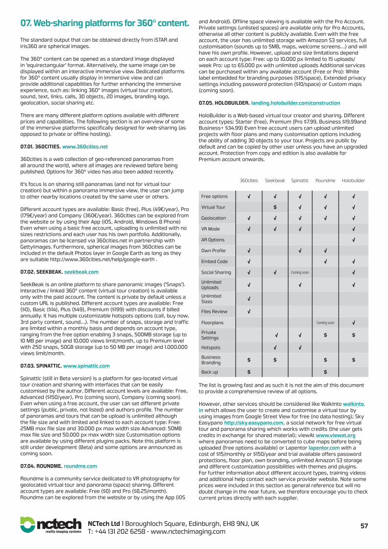
360cities Seekbeak Spinattic Roundme Holobuilder
Free options √ √ √ √ √
Virtual Tour $ √ √ √
Geolocation √ √ √ √ √
VR Mode √ √ √ √
AR Options √
Own Profile √ √ √
Embed Code √ √ √
Social Sharing √ √ Coming soon √
Unlimited Uploads √ √ √
Unlimited Sizes √
Files Review √
Floorplans Coming soon √
Private Settings √ √ $ $
Hotspots √ √
Business Branding $ $ $ $
Back up $ $ The list is growing fast and as such it is not the aim of this document to provide a comprehensive review of all options. However, other services should be considered like WalkInto walkinto.in which allows the user to create and customise a virtual tour by using images from Google Street View for free (no data hosting); Sky Easypano http://sky.easypano.com, a social network for free virtual tour and panorama sharing which works with credits (the user gets credits in exchange for shared material); viewAt www.viewat.org where panoramas need to be converted to cube maps before being uploaded (free options available) or Lapentor lapentor.com with a cost of $15/monthly or $150/year and trial available offers password protections, floor plan, own branding, unlimited Amazon S3 storage and different customization possibilities with themes and plugins. For further information about different account types, training videos and additional help contact each service provider website. Note some prices were included in this section as general reference but will no doubt change in the near future, we therefore encourage you to check current prices directly with each supplier.
58NCTech Ltd 1 Boroughloch Square, Edinburgh, EH8 9NJ, UKT: +44 131 202 6258 - www.nctechimaging.com
08. ApplicationsVirtual tour deliverables have multiple applications since they are customisable and can be displayed on different types of device. Some example applications:
Sales and Marketing. Virtually show your services or products in a simulated real environment. Websites and multimedia presentations.Property management. Virtual property visit & walk through experience prior to live viewing.
Tourism. Pre-visit planning in advance, providing information about position and characteristics of the main points of interest. Or simply enabling a virtual visit for people without time, ability or finances to visit in person. Also providing a view of inaccessible locations such as tombs, temples, caves, or other historical or natural environments which could be in danger in case of mass tourism.
Corporate. Branding tours to show facilities, company work space, schools and university virtual facility experiences.
Museums. Considered both education and tourism, nowadays it is becoming more common to find museums offering virtual ‘walk-through’ visits with information about the artwork they show, and even interactive 3D models embedded within the virtual tours.
Training. For visual merchandising teams of chain brands to capture or implement the displays of flagship stores. Assisting the technical preparation for future situation management. Simulated operational environments or landscapes to train for required skill before entering the real live situation.
Manage and service. Cinema or theatre virtual seat selection, virtual promotion for restaurants, sport centres, gyms, swimming pools, accommodation. Virtual tours for accommodation searches at universities, hotels and holiday apartments.
Entertainment. Interactive movies, full dome theatres and planetariums.
Events and exhibitions. Virtual experiences to explore and visit expositions and exhibitions online.
Social sharing. Sharing the experience that involves that specific scene with other people not present, to share the experience ‘virtually’.
Historic archive. Recording and monitoring change, enabling a virtual timeline, re-live the changes in an immersive environment.
Documentary. Adding additional dimensions to a documentary experience: multimedia data such as audio, text, video, still images or graphics.
Asset documentation & management. Immersive information to contextually represent industrial or AEC environment, potentially adding embedded documents or further data for reference.
Medical. Immersive interactive environments to treat and study behaviour patterns related with physical and mental health problems in both medical care and research.
Educational. Although is not the aim of this app note, Google Expeditions Pioneer Program must be named in this section as a virtual reality platform built for the classroom (go.co.expeditions)
The list is endless…
09. ConclusionThe advantages for virtual tour deliverable creation using iSTAR and iris360 along with NCTech’s software have been outlined in this document. As a summary, NCTech makes the task of capturing high quality image assets for virtual tours and other visual documentation needs both easier and faster, whether for Google Street View, public display, commercial website or any other virtual viewing, hosting or sharing platform.
“There is no doubt in my mind that NCTech is offering a simple solution to a previously complex series of
tasks. That simplicity opens the door for exponentially increasing camera users and will accelerate the
implementation of the new “Street View” project.The competitive price in combination with the improve easier workflow make iris360 ideal not only for Google
Street View but also any other imaging application, either professional or personal.”
[Robert Hewitt - MPA Nationally Accredited Master Photographer]
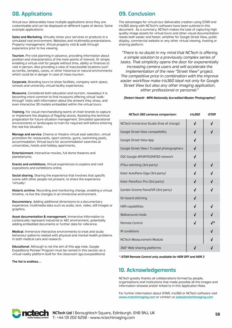
NCTech 360 cameras comparison: iris360 iSTAR
NCTech Immersive Studio (free of charge) √ √
Google Street View compatibility √ √
Google Street View App √
Google Street View | Trusted photographers √
OSC-Google API/INTEGRATED network √
PTGui stitching (3rd party) √ √
Kolor AutoPano Giga (3rd party) √ √
Kolor PanoTour Pro (3rd party) √ √
Garden Gnome Pano2VR (3rd party) √ √
On board stitching √
HDR capabilities √ √
Walkaround mode √ √
Remote Control √ √*
IR conditions √
NCTech Measurement Module √
360° Web-sharing platforms √ √
* iSTAR Remote Control only available for HDR OFF and HDR 3
10. AcknowledgementsNCTech greatly thanks all collaborations formed by people, organisations and institutions that made possible all the images and information showed and/or linked to in this Application Note.
For further information about iSTAR, iris360 or NCTech software visit www.nctechimaging.com or contact us [email protected]