Embed Size (px)
Citation preview

Final Draft South Congress Parking Strategy | Fact Book
[ i ]
Fact BookSouth Congress
Parking Strategy
Final Draft

[ ii ]
South Congress Parking Strategy | Fact Book Final Draft
ACKNOWLEDGEMENTS
PROJECT MANAGEMENT TEAM
Joseph Al-Hajeri, Austin Transportation Department
Melissa Barry, Downtown Austin Alliance
Andre Boudreau, Downtown Austin Alliance
Casey Burack, Downtown Austin Alliance
Tien-Tien Chan, Austin Transportation Department
Donald Jackson, City of Austin
Cole Kitten, Austin Transportation Department
Matt Parkerson, South Congress Public Improvement District
Jason Redfern, Austin Transportation Department
SRCC and BCNA representatives were added to the Project Management Team at the conclusion of Phase I/start of Phase II.
CONSULTANT TEAM
Nelson\Nygaard Consulting Associates
NuStats Research Solutions

Final Draft South Congress Parking Strategy | Fact Book
[ iii ]
South Congress Parking Strategy
Fact Book
Executive Summary
Project Overview
Planning Context
Corridor Mobility and Access
Parking in SoCo
Public Outreach
v
1
7
27
51
77

[ iv ]
South Congress Parking Strategy | Fact Book Final Draft

Final Draft South Congress Parking Strategy | Fact Book
[ v ]
The South Congress Parking Strategy is an effort to understand and comprehensively
address parking challenges facing the South Congress neighborhood. The strategy
is led by the City of Austin in partnership with the Downtown Austin Alliance with
support and guidance from local stakeholders. The project is divided into two phases:
Phase I of the strategy is focused on collecting, analyzing, and documenting detailed data about how parking is used and managed in SoCo today. This data will
allow for a better understanding of the parking challenges facing all users in SoCo.
Phase II of the strategy is focused on developing actionable solutions to address parking challenges in SoCo and adjacent neighborhoods. Recommendations will
include both near-term responses to immediate parking needs as well as long-term
strategies for future-proofing parking. These strategies and policies will link parking
supply and management solutions with other ongoing mobility and development
initiatives in the corridor.
Executive Summary
Fact Book

[ vi ]
South Congress Parking Strategy | Fact Book Final Draft
Data Collection and MethodsData was collected during Phase I using a variety of tools and methods, including:
• Inventory data for on- and off-street parking spaces to understand how much
parking exists in SoCo today
• Occupancy data for on- and off-street parking spaces to understand how well-
utilized existing parking is in SoCo
• Turnover data for off-street spaces to understand how usage of parking spaces
changes over the course of the day and week
• Parking and travel behavior data through an intercept survey in SoCo to
understand how and why people travel to and from SoCo
• Local knowledge through stakeholder interviews to understand the variety of
parking challenges and solutions that employees, business owners, and community
members experience in SoCo today
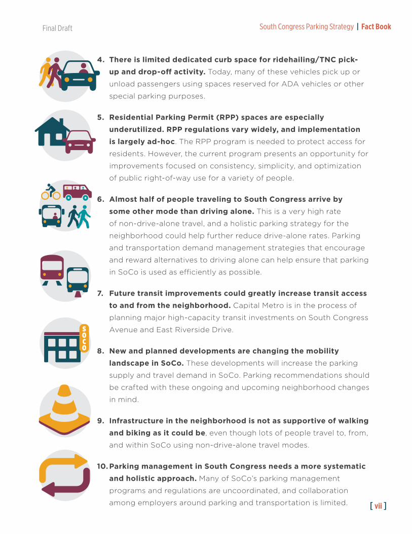
Top 10 Takeaways from Phase I1. Over half of all parking in the South Congress study area is
completely unregulated, meaning it is free and has no time limit.
About 70% of on-street parking is unregulated and nearly half (44%)
of off-street parking is unregulated, even in some of the busiest and
most popular parts of SoCo.
2. Peak parking occupancy across the entire study area is 60%.
Although there are on-street spaces in the commercial core and off-
street spaces north of Academy Drive that routinely fill to capacity,
nearby on- and off-street parking is underutilized.
3. Employees, visitors, and residents are competing for many of the same convenient, core area parking spaces. A comprehensive
set of strategies needs to be developed for how the most popular
spaces on South Congress are prioritized for different uses based on
location and land use.
FreeParking
Final Draft South Congress Parking Strategy | Fact Book
[ vii ]
4. There is limited dedicated curb space for ridehailing/TNC pick-up and drop-off activity. Today, many of these vehicles pick up or
unload passengers using spaces reserved for ADA vehicles or other
special parking purposes.
5. Residential Parking Permit (RPP) spaces are especially underutilized. RPP regulations vary widely, and implementation is largely ad-hoc. The RPP program is needed to protect access for
residents. However, the current program presents an opportunity for
improvements focused on consistency, simplicity, and optimization
of public right-of-way use for a variety of people.
6. Almost half of people traveling to South Congress arrive by some other mode than driving alone. This is a very high rate
of non-drive-alone travel, and a holistic parking strategy for the
neighborhood could help further reduce drive-alone rates. Parking
and transportation demand management strategies that encourage
and reward alternatives to driving alone can help ensure that parking
in SoCo is used as efficiently as possible.
7. Future transit improvements could greatly increase transit access to and from the neighborhood. Capital Metro is in the process of
planning major high-capacity transit investments on South Congress
Avenue and East Riverside Drive.
8. New and planned developments are changing the mobility landscape in SoCo. These developments will increase the parking
supply and travel demand in SoCo. Parking recommendations should
be crafted with these ongoing and upcoming neighborhood changes
in mind.
9. Infrastructure in the neighborhood is not as supportive of walking and biking as it could be, even though lots of people travel to, from,
and within SoCo using non-drive-alone travel modes.
10. Parking management in South Congress needs a more systematic and holistic approach. Many of SoCo’s parking management
programs and regulations are uncoordinated, and collaboration
among employers around parking and transportation is limited.
SOCO

[ viii ]
South Congress Parking Strategy | Fact Book Final Draft
Final Draft South Congress Parking Strategy | Fact Book
[ 1 ]
What is the South Congress Parking Strategy?The City of Austin initiated a two-phase study of parking along the South Congress
(SoCo) corridor to comprehensively address long-standing parking challenges.
The first phase will document the number of parking spaces, how many vehicles are
parking and for how long, and the varied parking needs of businesses, residents,
employees, and visitors.
The study’s collection of detailed data will allow for a better understanding of
the parking challenges for all users and inform the development of comprehensive
solutions.
The second phase of the parking strategy will provide short-term, actionable solutions to address the immediate parking issues on South Congress and adjacent
neighborhoods. The parking strategy will also future-proof parking in the district with a long-term framework that links parking supply and management solutions to
ongoing mobility and development initiatives in the corridor.
The study’s phased approach will ensure the continued economic prosperity of
local businesses and employees, while reducing the burden on residents caused by
increased parking demand in the area.
Project Overview
1

[ 2 ]
South Congress Parking Strategy | Fact Book Final Draft
What goals will guide the project?
Focus on comprehensive data collection, allowing for informed
dialogue and a decision-making process guided by data.
Address short-term parking challenges and develop an actionable
plan for improving parking for all users.
Future-proof any parking management, policy, and/or
programmatic recommendations regardless of changes to South
Congress Avenue.
Support the corridor’s long-term mobility vision, recognizing that
parking is ultimately one piece of a broader access strategy.
Ensure comprehensive public engagement that maximizes efficient
use of the public’s time and feedback and incorporates input from
neighborhood residents.
Create solutions to support a robust, economically stable
commercial corridor, while serving as a model process for similar
districts in Austin.
What is the study area?The study area is shown in Figure 1. The study boundaries are generally defined by
West Riverside Drive to the north, Brackenridge Street to the east, West Live Oak
Street to the south, and up to, but not including, South 1st Street to the west.

Final Draft South Congress Parking Strategy | Fact Book
[ 3 ][ 3 ]
Figure 1: Study Area Map

[ 4 ]
South Congress Parking Strategy | Fact Book Final Draft
Project Kickoff | March 2019
Stakeholder interviews, site visit and tour, and review of past plans and studies to understand issues and opportunities.
Collect Data | April - May 2019
Collect inventory and occupancy data for on- and off-street parking spaces.
Survey residents, workers, and visitors about how they travel to, from, and
within the neighborhood.
Study the Results | June-July 2019
Analyze the collected data, survey results, and stakeholder input to build a complete picture of parking challenges and opportunities in SoCo.
Share our Findings | July - August 2019
Compile the results of the data collection and create a Fact Book and Data Dashboard to share our findings
with the community.
Strategy Timeline: Phase I
What is the Fact Book?The Fact Book is a summary of the comprehensive data collection and analysis from Phase I. It provides a shared understanding of the key issues and opportunities and
offers a foundation for a collaborative and action-oriented set of recommendations in
Phase II. The Fact Book includes:
• Summary of the SoCo corridor (Chapter 2), including planning boundaries and
foundational plans and studies.
• Summary of corridor transportation (Chapter 3), including current mobility
services, policies, and programs.
• Detailed documentation of corridor parking (Chapter 4), including inventory,
demand, length of stay, turnover, and existing parking policies, programs, and
management practices.
• Highlights from stakeholder engagement (Chapter 5), including stakeholder
interviews and an intercept survey.
• Summary of key findings and next steps for Phase II (Chapter 6).

Final Draft South Congress Parking Strategy | Fact Book
[ 5 ]
Public Outreach | Sept. 2019 - Feb. 2020
Continue to meet with members of the community to present information, refine strategies, and share our progress as we develop parking recommendations for SoCo.
Final Strategy and Plan | Nov. 2019 - Feb. 2020
Craft a comprehensive parking strategy and implementation plan for SoCo and present it to
the community and the City of Austin.
Strategy Development | Sept. - Oct. 2019
Guided by data, community input, and best practices research, develop and refine potential policies and strategies to address
parking needs and challenges in SoCo.
Strategy Timeline: Phase II
Who is involved in the parking study?The City of Austin contracted with the Downtown Alliance to accelerate the project by expanding the
scope of their existing contract with Nelson\Nygaard
Consulting Associates. The Downtown Alliance will
also coordinate with projects across the corridor and
within downtown, recognizing that interconnectivity
between SoCo and the rest of the city is critical for
enhancing citywide mobility.
The parking strategy is guided by a Project Management Team, made up of key stakeholders
from departments within the City of Austin, the
South Congress Public Improvement District (PID),
South Congress Merchants Association, and Capital
Metro. SRCC and BCNA representatives were added
at the conclusion of Phase I and the start of Phase II.

[ 6 ]
South Congress Parking Strategy | Fact Book Final Draft
Final Draft South Congress Parking Strategy | Fact Book
[ 7 ]
South Congress (SoCo) is a vibrant and complex district where many neighborhoods,
histories, and planning efforts intersect and overlap. SoCo is home to many residents,
groups, organizations, and stakeholders who share common goals and face similar
challenges. This chapter summarizes these groups, organizations, plans, and studies
to document past and ongoing work. An understanding of the planning context will
inform recommendations made during Phase II of this project.
SoCo Groups and OrganizationsSeveral groups and organizations are currently active in the area (Figure 2). These
groups are working to improve the area and address a variety of neighborhood issues,
including parking and transportation. Some groups share overlapping boundaries,
objectives, and members.
South Congress Public Improvement District (PID)
The South Congress PID, also known as the South Congress Improvement Association
(SCIA), covers 22 acres along South Congress Avenue. Each year, property owners
within the PID boundary pay an additional $0.20 per $100 of assessed value to fund
Planning Context
2

[ 8 ]
South Congress Parking Strategy | Fact Book Final Draft
a variety of neighborhood initiatives. Recent PID efforts have focused on public
safety, infrastructure improvements, marketing opportunities, and local economic
development.
South Congress Merchants Association (SCMA)
The SCMA is comprised of local business owners working to support and promote
the needs and interests of South Congress-area businesses. SCMA members include
businesses within the defined service area (Figure 2) as well as some businesses
located outside of this boundary but within the vicinity of the core SoCo corridor.
Recent efforts of the SCMA have focused on public art, historic preservation,
employee retention, and marketing.
South River City Citizens Neighborhood Association (SRCC)
The SRCC is a membership-based neighborhood group which promotes
neighborhood interests on a variety of topics, including public education, parks,
zoning, transportation, and public safety. The neighborhood association boundary
includes areas along and to the east of South Congress Avenue.
Bouldin Creek Neighborhood Association (BCNA)
The BCNA is a membership-based neighborhood group which promotes
neighborhood interests on a variety of topics, including public education, parks,
zoning, transportation, and public safety. The neighborhood association boundary
includes areas along and to the west of South Congress Avenue.

Final Draft South Congress Parking Strategy | Fact Book
[ 9 ][ 9 ]
Figure 2: Study Area Organizations
[ 10 ]
South Congress Parking Strategy | Fact Book Final Draft
Plans and StudiesSeveral recent and ongoing planning efforts in Austin include guidelines,
recommendations, or studies that impact the transportation, parking, and mobility
landscape in the South Congress area. These plans and studies share some
overlapping themes and focus areas, including:
• Reducing vehicle trips and improving walking, biking, and transit options.
• Using a comprehensive, coordinated planning approach that prioritizes mobility
improvements alongside other neighborhood development goals.
• Rethinking how people travel to and from the South Congress area from other
neighborhoods, as well as how they get around while there.
Austin Strategic Mobility Plan (ASMP)
The ASMP1 is a planning effort led by the City of Austin that defines a framework for
achieving city-wide transportation goals. Most importantly, the ASMP establishes a
mode share target for the city that aims to reduce drive-alone commuting from 74% to
50% by the year 2039.
This mode share target will play an important role in guiding project prioritization and
coordination between Austin Transportation Department (ATD) and other agencies
and organizations on mobility-related efforts. The development and finalization of the
ASMP has been coordinated in parallel with Project Connect, Capital Metro’s high-
capacity transit plan.
As summarized in Figure 3, the ASMP outlines a variety of policy goals and priorities
relating to parking, curb management, and transportation demand management
(TDM) programs, as well as indicators for tracking progress towards city-wide
mobility goals. Many of these policies emphasize the importance of district-level
mobility planning and coordination, especially in relation to on- and off-street parking
management.
1 www.austintexas.gov/asmp

Final Draft South Congress Parking Strategy | Fact Book
[ 11 ]
Topic Policy Summary
Parking Indicators and Targets
• Increase the availability of managed on-street parking• Increase real-time information on space location and availability• Decrease the amount of parking spaces per capita• Increase the availability, distribution, and percentage of parking in Imagine Austin
activity centers and along activity corridors that is accessible• Increase the percentage of developments that reduce parking
Parking Policy 1 Efficiently use existing parking supply
Parking Policy 2 Right-size future parking supply to encourage sustainable trip options
Parking Policy 3 Coordinate on-street parking with curb management strategies for flexibility and adaptability with future parking and mobility technology
Curb Management Indicators and Targets
• Reduce the number of conflicts between parking and bicycle lanes• Reduce congestion on streets that incorporate curb management strategies• Increase the productivity of curb space to serve more people per hour• Reduce the number of crashes associated with conflicts at or along the curb on
streets that incorporate curb management strategies
Curb Management Policy 1 Use context to determine mobility and non-mobility curb uses
Curb Management Policy 2 Manage curb space dynamically
Curb Management Policy 3 Streamline objects at the curb to improve safety and mobility
TDM Indicators and Targets
• Increase the understanding of transportation options (aside from a personal vehicle) and satisfaction of users to get around Austin (ride share, bus/train, bike, walk, etc.), reported by socioeconomic demographic measures
• Reduce vehicle miles traveled per capita• Increase the share of Austin residents who carpool to work• Increase the number of people reached by TDM programming
TDM Policy 1 Implement community-wide strategies to increase use of all transportation options and manage congestion
Shared Mobility Indicators and Targets
• Increase the usage of shared mobility solutions • Increase the share of shared mobility trips that originate or end in areas that are
historically underrepresented and underserved• Increase the density of shared mobility vehicles• Increase the capacity of park-and-rides
Shared Mobility Policy 1 Emphasize and incentivize shared mobility solutions
Shared Mobility Policy 3 Support the creation of Mobility Hubs
Figure 3: Selected ASMP Policy Recommendations

[ 12 ]
South Congress Parking Strategy | Fact Book Final Draft
Project Connect
Project Connect2 is Capital Metro’s long-term system plan which aims to implement
high-capacity transit service in Austin. Since 2016 Capital Metro has comprehensively
studied the feasibility of high-capacity transit on major travel corridors throughout the
city. After the Project Connect Long Term Vision Plan was adopted in December 2018,
the agency moved forward with preliminary engineering and environmental studies for
two dedicated transitway corridors: the Orange Line and the Blue Line.
The Orange Line extends from Tech Ridge to the north to Slaughter Lane in the south
and includes South Congress Avenue. The Blue Line extends from ABIA airport to
downtown along East Riverside drive and could include a station in the South Central
Waterfront area. These two projects would make it easier for SoCo residents, visitors,
and workers to travel to and from the neighborhood without using a personal vehicle.
In particular, the Orange Line would provide faster, more frequent transit access from
SoCo to downtown Austin, UT, and other neighborhoods to the north. Regardless of
technology choice or transitway design, the Orange Line project would likely require
the reconstruction of South Congress Avenue, including sidewalks, bike lanes, and
general-purpose lanes.
Over the course of 2019, Capital Metro will continue meeting with community
members and stakeholder groups in neighborhoods along the Orange Line and the
Blue Line to refine details of the plan including station area designs, transitway design,
and mode. In late March 2020, Capital Metro will adopt the final plan for these projects
in anticipation of the City of Austin putting a funding referendum before voters in
November 2020.
2 www.capmetro.org/projectconnect/

Final Draft South Congress Parking Strategy | Fact Book
[ 13 ]
Figure 4: Project Connect Long-Term Vision Plan
[ 14 ]
South Congress Parking Strategy | Fact Book Final Draft
South Congress Avenue Corridor Mobility Plan
The South Congress Avenue Corridor Mobility Plan was initiated as part of the City
of Austin’s Corridor Mobility Program using funds from the 2016 Mobility Bond.
The purpose of the plan is to evaluate recommendations that will enhance mobility,
connectivity and safety for all users—including people who drive, walk, bike, and
take transit. Though preliminary work began on the plan in late 2018, this effort
has been put on hold pending the finalization and adoption of Project Connect’s
recommendations for South Congress Avenue.
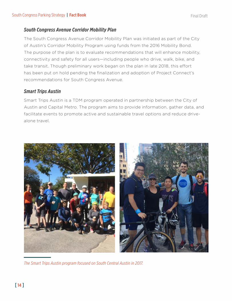
Smart Trips Austin
Smart Trips Austin is a TDM program operated in partnership between the City of
Austin and Capital Metro. The program aims to provide information, gather data, and
facilitate events to promote active and sustainable travel options and reduce drive-
alone travel.
The Smart Trips Austin program focused on South Central Austin in 2017.
Final Draft South Congress Parking Strategy | Fact Book
[ 15 ]
Driving Alone Carpooling Bus or Train Other Biking Walking
25%22%
9%6%
2% 2%3% 4%
14%
23%
47%44%
Post-Smart Trips ProgramSurvey (N=640 Trips)
Pre-Smart Trips ProgramSurvey (N=649 Trips)
Figure 5: Smart Trips Central South Austin Mode Share Survey Results
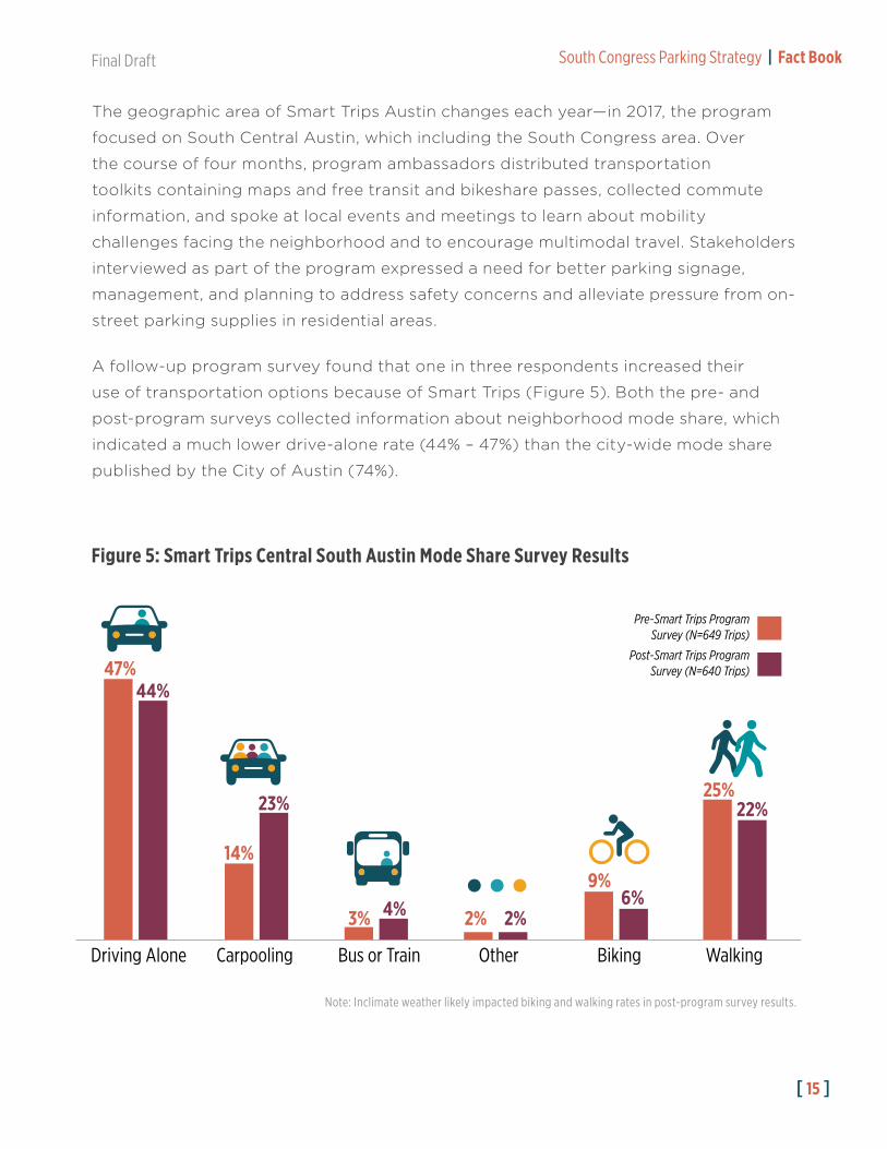
The geographic area of Smart Trips Austin changes each year—in 2017, the program
focused on South Central Austin, which including the South Congress area. Over
the course of four months, program ambassadors distributed transportation
toolkits containing maps and free transit and bikeshare passes, collected commute
information, and spoke at local events and meetings to learn about mobility
challenges facing the neighborhood and to encourage multimodal travel. Stakeholders
interviewed as part of the program expressed a need for better parking signage,
management, and planning to address safety concerns and alleviate pressure from on-
street parking supplies in residential areas.
A follow-up program survey found that one in three respondents increased their
use of transportation options because of Smart Trips (Figure 5). Both the pre- and
post-program surveys collected information about neighborhood mode share, which
indicated a much lower drive-alone rate (44% – 47%) than the city-wide mode share
published by the City of Austin (74%).
Note: Inclimate weather likely impacted biking and walking rates in post-program survey results.

[ 16 ]
South Congress Parking Strategy | Fact Book Final Draft
South Central Waterfront Initiative
The South Central Waterfront (SCWF) initiative will develop a planning framework to
guide redevelopment in the South Central Waterfront Area, just south of Lady Bird
Lake along Congress Avenue and East Riverside Drive. In 2016, the SCWF initiative
released the South Central Waterfront Vision Framework Plan, which outlines
circulation, transportation, open space, sustainability, and urban design priorities.
An initial market assessment conducted in support of the vision framework plan
estimated a need for the construction of up to 9,722 new parking spaces to meet
future development needs in the South Central Waterfront. As part of the discussion
on funding and implementation, the market assessment recommends public-private
parking partnerships to fund parking facilities in the area. Benefits of city participation
in these partnerships cited by the study include:
• Enabling shared parking partnerships and reducing single-use parking needs
• Generating revenues for the city from priced parking
• Enabling developers to invest more in non-parking uses that provide housing and jobs
South Congress District Economic Strategy
The South Congress District Economic Strategy was published in January 2018 by
the Austin Economic Development Department through the Souly Austin Program
in collaboration with the SCMA. The plan identifies policy goals and district priorities
that would support businesses in the South Congress area. Recommendations include
placemaking improvements, connectivity and transportation strategies, partnership
opportunities, and marketing concepts.
The South Congress District Economic Strategy also identifies the need for pedestrian
access and safety improvements along South Congress Avenue and on adjacent
streets in the study area. Recommended improvements include sidewalk construction,
crosswalk improvements, and pedestrian “scrambles” at key intersections.

Final Draft South Congress Parking Strategy | Fact Book
[ 17 ]

[ 18 ]
South Congress Parking Strategy | Fact Book Final Draft
Zoning and Development in SoCoZoning and Land Use
The study area and base zoning districts are shown in Figure 7. Areas along South
Congress Avenue, South 1st Street, and Riverside Drive are primarily zoned for a
variety of commercial uses, while neighborhoods to the east and west of South
Congress Avenue are zoned for single-family and multi-family residential uses.
Several zoning overlays further restrict or enable uses within the study area, including
the Neighborhood Conservation Combining District (NCCD) in the Fairview Park area
and the Vertical Mixed-Use Building Combining District (V).1 The Neighborhood Plan
Combining District (NP) designation, which allows neighborhoods to add special use
options and apply additional design standards through the adoption of neighborhood
plans, applies to all zoned areas within the study area. The Texas School for the Deaf,
which is a state-owned property, does not have a local zoning designation.
Use/Activity Minimum Parking Requirement†
Residential
Single-family residential 2 spaces per unit
Condominium residentialMultifamily residential
First bedroom: 1.5 spacesEach additional bedroom: 0.5 space
Accessory Dwelling Unit (ADU)Secondary Apartment
0 Spaces‡
Commercial Uses Schedule A Requirements
<2,500 sq. ft. 1 space for each 275 sq. ft.
2,500—10,000 sq. ft. 1 space for each 100 sq. ft.
>10,000 sq. ft. 1 space for each 50 sq. ft.
Office or administrative activity 1 space for each 275 sq. ft.
Indoor sales, service, or display 1 space for each 500 sq. ft.
Outdoor sales, services, or display 1 space for each 750 sq. ft.
Indoor storage, warehousing, equipment servicing, or manufacturing 1 space for each 1,000 sq. ft.
Outdoor storage, equipment servicing, or manufacturing 1 space for each 2,000 sq. ft.
†The SoCo study area is within the Reduced Parking Area established in Section 25-6-478 of Austin’s Land Development Code. This provision sets the minimum parking requirements within the area at 80% of the base requirements prescribed in the Land Development Code.
‡The entire SoCo study area is located within 1/4 mile of an Activity Corridor, within which no parking is required for ADUs and Secondary Apartments as stated in Ordinance 20151119-080 and in Appendix A of Chapter 25-6 of the Austin Land Development Code.1NCCD, V, and NP combining districts do not have specific implications for parking beyond the modification of permitted uses.
Figure 6: City of Austin Parking Requirements (Selected Land Uses)

Final Draft South Congress Parking Strategy | Fact Book
[ 19 ]
Figure 7: Study Area Zoning
Land Development Code RewriteAs of October 2019, the City of Austin is in the process
of revising of the Land Development Code. The effort
includes support and input from multiple city offices
and departments, including the Department of
Transportation. A draft of the code and a draft zoning
map was released on October 4th 2019. Revisions and
public comment on the draft will continue throughout
the fall before it is considered for adoption by Austin City
Council in December 2019.
The draft code and zoning map include significant
changes to the zoning designations and allowable
densities in the SoCo study area, especially in transition
zones on neighborhood blocks adjacent to South
Congress Avenue. The draft also proposes maximum
parking limits for developments over 10,000 square
feet and on lots located on an Imagine Austin Corridor
(including South Congress Avenue) or in an Imagine
Austin center (including the South Central Waterfront
area). Phase II of this study will continue to monitor the
progress of the LDC Rewrite, its potential impacts on
SoCo, and how it might affect study recommendations.

[ 20 ]
South Congress Parking Strategy | Fact Book Final Draft
Project Name Description Proposed Size Estimated† On-site Parking
Austin-American Statesman
Large mixed-use development on a 19-acre site adjacent to Lady Bird Lake on the east side of Congress Avenue
3.5million sq. ft. ~4,000 spaces
RiverSouth Office and retail development at Barton Springs Road and West Riverside Drive
318,000 sq. ft. 843 spaces
Hotel Magdalena Hotel and residential development under construction at 110 Academy drive (expected completion Fall 2019)
70,000 sq. ft. N/A
Music Lane Office, retail, and hotel development at the corner of Academy Drive and South Congress Avenue
163,000 sq. ft. 500 spaces
Saint Vincent Office and retail development (under construction as of July 2019)
20,000 sq. ft. 22 spaces
State House Office, retail, and dining development at 1221 Congress Avenue
100,000 sq. ft. N/A
Kimber Modern SoCo
Hotel with retail, dining, and entertainment space 34 hotel rooms N/A
H-E-B Grocery Store
Large supermarket with indoor/outdoor food hall and beer garden
100,000 sq. ft. 2 levels underground
Hummingbird Mixed-use development with retail, dining, office, and residential space.
18,000 sq. ft. 12 Parking Spaces
Ongoing or Proposed Projects
Numerous developments and construction projects are planned or underway along
South Congress Avenue. These new developments include a mix of hotels, office,
retail, and residential projects, many of which will be partially or fully completed in the
next two years. Additionally, the South Central Waterfront area is expected to undergo
major redevelopment as implementation of the South Central Waterfront Initiative
progresses and several major mixed-use projects break ground in the next five years.
Many of these projects include new parking spaces in either underground, street-level,
or above-ground parking facilities (Figure 8).
Figure 8: Recent and Planned Developments
†Parking estimates are based on publicly-available or reported development information.

Final Draft South Congress Parking Strategy | Fact Book
[ 21 ]
Figure 9: SoCo Developments
[ 22 ]
South Congress Parking Strategy | Fact Book Final Draft
[ 22 ]
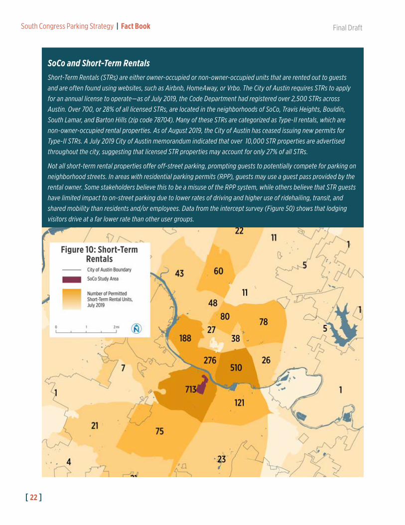
Figure 10: Short-Term Rentals
SoCo and Short-Term RentalsShort-Term Rentals (STRs) are either owner-occupied or non-owner-occupied units that are rented out to guests
and are often found using websites, such as Airbnb, HomeAway, or Vrbo. The City of Austin requires STRs to apply
for an annual license to operate—as of July 2019, the Code Department had registered over 2,500 STRs across
Austin. Over 700, or 28% of all licensed STRs, are located in the neighborhoods of SoCo, Travis Heights, Bouldin,
South Lamar, and Barton Hills (zip code 78704). Many of these STRs are categorized as Type-II rentals, which are
non-owner-occupied rental properties. As of August 2019, the City of Austin has ceased issuing new permits for
Type-II STRs. A July 2019 City of Austin memorandum indicated that over 10,000 STR properties are advertised
throughout the city, suggesting that licensed STR properties may account for only 27% of all STRs.
Not all short-term rental properties offer off-street parking, prompting guests to potentially compete for parking on
neighborhood streets. In areas with residential parking permits (RPP), guests may use a guest pass provided by the
rental owner. Some stakeholders believe this to be a misuse of the RPP system, while others believe that STR guests
have limited impact to on-street parking due to lower rates of driving and higher use of ridehailing, transit, and
shared mobility than residents and/or employees. Data from the intercept survey (Figure 50) shows that lodging
visitors drive at a far lower rate than other user groups.

Final Draft South Congress Parking Strategy | Fact Book
[ 23 ]

[ 24 ]
South Congress Parking Strategy | Fact Book Final Draft

Final Draft South Congress Parking Strategy | Fact Book
[ 25 ]
Planning Context: Top Five Takeaways1. SoCo sits at the intersection of numerous organizations, neighborhood groups,
and business districts. Parking strategies will need to balance the needs of all of
these groups, including both shared goals and differing perspectives.
2. City-wide plans and policies reflect similar goals and challenges as those experienced in SoCo. The recently-completed ASMP provides a range of parking
policy recommendations that could provide some direction for developing
strategies for SoCo.
3. Transit service in SoCo is limited to bus service today, but future improvements could greatly increase transit access to and from the neighborhood. Capital
Metro is in the process of planning major high-capacity transit investments on
South Congress Avenue and East Riverside Drive, which would provide fast and
frequent connections to downtown, UT, and the airport.
4. New and planned developments are changing the mobility landscape in SoCo. These developments will increase both the parking supply and travel demand
in SoCo. Parking recommendations should be crafted with these ongoing and
upcoming neighborhood changes in mind.
5. SoCo attracts many visitors, who present unique issues and opportunities for parking and mobility. On one hand, visitors staying in short-term rental units may
be unfamiliar with local mobility options or parking regulations. On the other hand,
visitors to the shopping, dining, and entertainment destinations in SoCo may be
eager to minimize driving and parking within the neighborhood.

[ 26 ]
South Congress Parking Strategy | Fact Book Final Draft

Final Draft South Congress Parking Strategy | Fact Book
[ 27 ]
South Congress Avenue and the greater SoCo neighborhood are well-served by a
diverse transportation system. On any given day, the area is bustling with cars, buses,
pedestrians, bikes, scooters, and ride-hail services as residents, workers, and visitors
traverse the corridor.
These mobility options help support the vibrant mix of neighborhood activities, while
also having an immediate and long-term impact on how parking should be supplied
and managed. This chapter provides an overview of how each of these modes is used
in SoCo today, and how they are expected to change based on ongoing planning
efforts.
TransitThe Capital Metro bus network is primarily a hub-and-spoke system—most routes
connect to and through downtown Austin, with only a handful of cross-town routes.
Recent updates to the network made as part of CapRemap1 focused on streamlining
1 https://capmetro.org/remap/
Corridor Mobility and Access
3

[ 28 ]
South Congress Parking Strategy | Fact Book Final Draft
route alignments and increasing service frequency along the highest ridership
corridors. Project Connect, Capital Metro’s long-term planning effort, has studied
many of these corridors to evaluate the potential for implementing high capacity
transit. Project Connect is discussed in Chapter 2.
Today, bus service is the only public transit option available in the South Congress
neighborhood. Several Capital Metro bus routes running along South Congress
Avenue connect the neighborhood to downtown as well as North Austin and South
Austin. Additionally, several routes that serve East Riverside Drive and South 1st Street
are within walking distance of SoCo.
Project Connect
Project Connect, Capital Metro’s ongoing high-capacity system planning effort, includes two high-capacity transit
corridors in the South Congress area on South Congress Avenue (the Orange Line) and East Riverside Drive (the
Blue Line). If implemented, these projects will greatly increase the level of transit service in SoCo, though impacts to
existing transit service are not yet known.

Final Draft South Congress Parking Strategy | Fact Book
[ 29 ]
Route Service AlignmentFrequency (Minutes)
Span Total Riders, FY 2019Peak Off-Peak
801 MetroRapid Southpark Meadows to Tech Ridge via South Congress Avenue, Guadalupe/Lavaca Streets, and North Lamar Boulevard
10 5-20 5:00AM – 12:30AM
2,142,000
10 MetroBus Southpark Meadows to Heritage Hills via South 1st Street, Trinity Street, Red River Street, and Berkman Drive
15 20-30 5:00AM – 11:30PM
1,440,000
7 MetroBus Crestview to William Cannon Drive via Duval Street, Trinity Street, East Riverside Drive, and Parker Lane
15 20-30 4:30AM – 11:30PM
1,412,000
20 MetroBus ABIA to Delco Center via East Riverside Drive, Guadalupe/Lavaca Streets, and Manor Road
15 20-30 5:00AM – 11:30PM
1,284,000
1 MetroBus William Cannon Drive to Tech Ridge via South Congress Avenue, Guadalupe/Lavaca Streets, and North Lamar Boulevard
30 30 4:30AM – 11:15PM
749,000
935 MetroExpress Tech Ridge to Travis Heights via I-35, downtown Austin, and Riverside Drive
15-30 -- AM and PM Peaks
185,000
987 MetroExpress Leander Station to Travis Heights via Route 183, Route 45, MoPac, and downtown Austin
15-30 -- AM and PM Peaks
52,000
142 Flyer North Burnet to Riverside Drive via Metric Boulevard, Rundberg Lane, and I-35
30 -- AM and PM Peaks
22,000
483 Night Owl Oltorf to downtown Austin via Burton Drive, Riverside Drive, and South Congress Avenue
-- 35 12:30AM – 3:30AM
22,000
486 Night Owl William Cannon to downtown Austin via Stassney Lane and South Congress Avenue
-- 30 12:30AM – 3:30AM
18,000
All-Day Bus Routes
Capital Metro operates five all-day bus routes in the SoCo area. These routes provide
direct transit connections between SoCo and major destinations around Austin
including downtown, UT, and Austin-Bergstrom International Airport. Route 801, which
runs on South Congress Avenue, has the highest average daily ridership among all
CapMetro routes. The five all-day routes in the SoCo area rank among the top seven
routes citywide by total annual riders. Capital Metro bus service in the SoCo area is
summarized in Figure 11.
Figure 11: Bus Routes in the SoCo Area

[ 30 ]
South Congress Parking Strategy | Fact Book Final Draft
[ 30 ]
Figure 12: Transit Service and Ridership in SoCo

Final Draft South Congress Parking Strategy | Fact Book
[ 31 ]
Avg.
Dai
ly B
oard
ings
/Alig
htin
gs -
SoCo
Sto
ps
500
Jan Feb Mar Apr May Jun Jul Aug Sep Oct Nov Dec
450
400
350
300
250
200
150
100
50
0
Boardings Alightings
Transit Ridership in SoCo
The busiest transit stop in SoCo is SoCo station, where over half of the daily riders in
the district utilize Route 801. Route 801 provides the fastest and most frequent transit
option for connecting to key destinations in downtown and around the UT campus—
the vast majority of people who ride route 801 to or from SoCo station depart in the
northbound direction in the morning and arrive in the southbound direction in the
afternoon (Figure 12).
The second highest-activity stop in the study area, located on East Riverside Drive just
east of South Congress Avenue, shows the opposite directional trend—most of the
boardings are in the outbound direction and arrivals in the inbound direction. The data
suggest that many visitors and employees are arriving from residential areas to the
east and walking to SoCo and nearby destinations.
Figure 13: Average Daily Transit Ridership in SoCo Area, All SoCo Routes (2018)

[ 32 ]
South Congress Parking Strategy | Fact Book Final Draft
In 2018, transit ridership in the SoCo study area did not vary much by season, despite
a major bus network redesign that was implemented in June (Figure 13). Among the
four all-day bus routes that pass through the study area, Route 20—which began
offering more frequent service and using a new alignment with a connection to the
airport—saw the greatest sustained route-wide increase in ridership in the months
following this service change (Figure 14).
Avg.
Wee
kday
Rid
ersh
ip -
Full
Rout
e
Jan Feb Mar Apr May Jun Jul Aug Sep Oct Nov Dec 0
2,000
4,000
6,000
8,000
10,000
12,000
Route 1
Route 20
Route 7
Route 801
2018 average weekday riderhip per route for all Capital Metro fixed-route service: 1,178
Figure 14: Average Weekday Ridership for SoCo All-Day Routes (2018)
Final Draft South Congress Parking Strategy | Fact Book
[ 33 ]
BikingThe Austin bicycle network consists of a mix of on- and off-street paths, lanes, and
routes. Some of these facilities offer ample space for cyclists and protection from
vehicle traffic, while others present safety and comfort challenges for both new and
experienced riders alike.
Expansion and enhancement of the citywide bicycle network is guided by the 2014
Bicycle Master Plan,1 although improvements on South Congress Avenue are on hold
while Project Connect’s Orange Line corridor plans are under development.
Infrastructure and Network
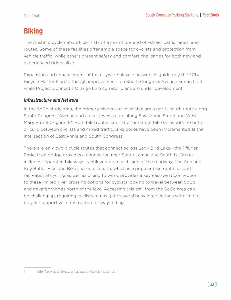
In the SoCo study area, the primary bike routes available are a north-south route along
South Congress Avenue and an east-west route along East Annie Street and West
Mary Street (Figure 15). Both bike routes consist of on-street bike lanes with no buffer
or curb between cyclists and mixed traffic. Bike boxes have been implemented at the
intersection of East Annie and South Congress.
There are only two bicycle routes that connect across Lady Bird Lake—the Pfluger
Pedestrian bridge provides a connection near South Lamar, and South 1st Street
includes separated bikeways cantilevered on each side of the roadway. The Ann and
Roy Butler Hike and Bike shared use path, which is a popular bike route for both
recreational cycling as well as biking to work, provides a key east-west connection
to these limited river crossing options for cyclists looking to travel between SoCo
and neighborhoods north of the lake. Accessing this trail from the SoCo area can
be challenging, requiring cyclists to navigate several busy intersections with limited
bicycle-supportive infrastructure or wayfinding.
1 http://www.austintexas.gov/page/austin-bicycle-master-plan

[ 34 ]
South Congress Parking Strategy | Fact Book Final Draft
[ 34 ]
Figure 15: SoCo Bike Access

Final Draft South Congress Parking Strategy | Fact Book
[ 35 ]
Bicycle Sharing Services
Austin B-Cycle is a dock-based bike sharing service with stations across central Austin.
Three stations are located in the northern portion of the SoCo study area along South
Congress Avenue, and two additional stations are located just outside the study area
boundary in the South Central Waterfront neighborhood.
B-Cycle usage across the city peaks
during March and October, likely driven
by the South by Southwest and the
Austin City Limits festivals. Ridership
is lowest during the winter and late
summer, when the weather presents a
challenge for both recreational users
and bike commuters.
Several dockless bike companies
began offering bike sharing services
throughout the city in 2018, but most of these services have since ceased operations.
Jump, which is owned and operated by Uber, continues to offer pedal-assisted electric
bikes throughout the city, including in SoCo. These bikes can be accessed through a
smartphone app, and trips can start and end anywhere within the designated service
area in central Austin.
Figure 16: Average Daily B-Cycle Trips from SoCo Area Stations, 2014-2018
Aver
age
Daily
Trip
s
Jan Feb Mar Apr May Jun Jul Aug Sep Oct Nov Dec0
50
100
150
200
250
2014 2015 2016 2017 2018

[ 36 ]
South Congress Parking Strategy | Fact Book Final Draft
Safety and Comfort
Biking in Austin can be challenging for cyclists with limited experience or confidence.
The hot weather during the summer months can also make commuting difficult for
employees who do not have access to a shower or other end-of-trip facilities at their
workplace. Furthermore, portions of the bicycle network are not well demarcated,
making conflicts with vehicles a challenge.
South Congress Avenue includes on-street bike lanes that are described as “medium comfort” by the City of Austin. The lanes can be uncomfortable for many cyclists.

Final Draft South Congress Parking Strategy | Fact Book
[ 37 ]
The bike lanes on South Congress Avenue are located between travel lanes and back-in parking where vehicles are often stopped waiting for space, picking up riders, or unloading freight. Some bike routes in SoCo require cyclists to share a travel lane with vehicular traffic.
At night, many of these conflicts and safety challenges are amplified by dim or intermittent lighting along South Congress Avenue.

[ 38 ]
South Congress Parking Strategy | Fact Book Final Draft
WalkingSoCo is one of the most vital and dynamic pedestrian centers in Austin, especially
along South Congress Avenue. On weekends, visitors flock to the neighborhood to
access shopping, dining, and entertainment destinations. Residents and workers also
travel on foot, both along South Congress Avenue and in the adjacent residential
neighborhoods to the east and west.
Pedestrian comfort and safety are also essential to the functioning of the parking
system—every driver becomes a pedestrian on their way to or from a vehicle.
Neighborhoods with well-connected sidewalks, lighting, and shade make it easier,
safer, and more appealing to walk farther to and from parking. These types of walkable
neighborhoods can support “park once” strategies that encourage parkers to walk,
and not drive, short distances within a district.
Infrastructure and Network
The sidewalk network quality varies significantly from block to block and from street
to street in SoCo. South Congress Avenue itself includes sidewalks on both sides of
the street, though the sidewalk width in some areas is uncomfortably narrow for a
busy pedestrian district.

Final Draft South Congress Parking Strategy | Fact Book
[ 39 ]
Though some steps, ramps, slabs, and other uneven surfaces are still found in the sidewalk in some areas, many blocks have been recently improved and repaired as part of adjacent redevelopment and construction projects.
In most areas along South Congress Avenue, back-in parking acts as a buffer between pedestrians and vehicle traffic. Only a few block faces have street trees or awnings that provide shade, potentially making pedestrian travel hot or uncomfortable during the summer months.

[ 40 ]
South Congress Parking Strategy | Fact Book Final Draft
Safety and Comfort
Pedestrian crossings on South Congress Avenue are well marked with stripes and
signals. At some intersections, the queuing area for pedestrians waiting to cross
overlaps with the large curbside drainage gutters. Though the crossing distance across
South Congress is relatively long, sidewalk bulbs at some intersections help make the
pedestrian experience safer and more comfortable.
Pedestrian Plans
The Sidewalk Master Plan (2016) and the Pedestrian Safety Action Plan (2018) provide a city-wide analysis of
pedestrian network challenges and potential policy solutions. Though neither of these plans identified SoCo as a
specific area of concern, both provide general guidance for prioritizing pedestrian safety improvements throughout
the city that are applicable to the study area.
The Pedestrian Safety Action Plan identified a hotspot of pedestrian and vehicle crashes at the intersection of South
Congress Avenue and East Riverside Drive, which is a major junction for pedestrian, bike, transit, and vehicular
traffic traveling to and from SoCo. Safety improvements at this intersection could improve multimodal travel to and
from the district.
The Action Plan ranked most streets in the study area as “very low” in terms of pedestrian safety risk characteristics,
with “demand for pedestrian improvements” highest along residential streets where the lack of sidewalks limits
walkability in otherwise pedestrian-friendly areas.

Final Draft South Congress Parking Strategy | Fact Book
[ 41 ]
Beyond South Congress Avenue itself, few streets in the neighborhood include sidewalks on both sides of the street, and many include no sidewalk at all. On these streets, residents walking from homes and visitors walking from on-street parking tend to walk in the roadway, creating a potential safety challenge.
Shade trees are plentiful along most of these side streets, but street lighting is limited—this can present safety challenges for pedestrians walking to homes or vehicles parked off of South Congress Avenue after dark.

[ 42 ]
South Congress Parking Strategy | Fact Book Final Draft
Shared MobilityShared mobility services are an increasingly popular mode of travel to access SoCo.
Many people, especially visitors, access the neighborhood using ride-hail services,
scooters, and bikeshare, especially on weekends and during special events.
While shared mobility options can reduce parking pressure by providing alternatives to
driving, they also compete with drivers and parked vehicles for curb access and street
space. Addressing neighborhood parking challenges in SoCo will require balancing
and prioritizing the needs of all modes.
Ride-hail and Taxis
Ride-hail services (also known as Transportation Network Companies, or TNCs)
provide private or shared point-to-point trips and are accessed using a smartphone
app. Services available in Austin include Uber, Lyft, and Ride Austin. The costs of using
these services vary depending on trip length, weather, real-time demand, and ride
type, but they are usually too expensive to meet daily commuting needs.

Final Draft South Congress Parking Strategy | Fact Book
[ 43 ]
In SoCo, where curb space for safe loading or unloading is limited, ride-hail vehicles
may make sudden stops in busy traffic areas, in crosswalks, or in bike lanes to pick up
or drop off passengers. Although service providers have some ways to help mitigate
these conflicts, such as geofencing for directing users towards designated safe pick-
up or drop-off areas, it can be difficult to completely prevent ride-hail vehicles from
making stops in high-traffic areas.
Ride-hailing can also create traffic challenges as vehicles circle the neighborhood
looking for riders and making drop-offs. Some drivers idle in on-street residential
spaces while waiting for ride requests. While making stops on side streets adjacent to
South Congress Avenue helps mitigate the safety threat of other high-speed cars, the
limited road space and sidewalk network can create other curb access challenges.
E-scooters
Dockless electric scooters, or e-scooters, have become popular in Austin since
launching in 2018. These services allow users to unlock a scooter using a smartphone
app and complete their trip anywhere within the designated service area in Central
Austin. E-scooters can travel up to 15 miles per hour and can make trips as far as 15
miles. As of July 2019, eight service providers operate in Austin.

[ 44 ]
South Congress Parking Strategy | Fact Book Final Draft
Since the widespread adoption of e-scooters, safety and parking have become key
areas of focus. The high speeds of travel, lack of safety equipment, and lack of safe
supporting infrastructure contribute to safety concerns. Some areas, such as the UT
campus, have begun to experiment with implementing slow-zones, digitally limiting
scooter speed when users are within a geofenced area.
Though e-scooter companies require users to park scooters in safe areas where
they do not obstruct the sidewalk, it can be difficult to enforce this policy. In SoCo,
where sidewalks are narrow and many e-scooters and bikes are distributed each day,
managing sidewalk clutter while supporting alternatives to driving will help some of
the neighborhood travel needs and parking challenges.

Final Draft South Congress Parking Strategy | Fact Book
[ 45 ]
Sunday Monday
Aver
age
Daily
Trip
s
Tuesday Wednesday Thursday SaturdayFriday0
500
1,000
1,500
2,000
2,500
3,000
3,500
4,000
Dockless Bikes Dockless E-Scooters
According to 2019 trip data provided by the City of Austin, most trips that start or
end in the study area census tracts are either between SoCo and the South 1st Street/
Bouldin area, between SoCo and downtown Austin, or entirely within SoCo (Figure
17). Over 40% of trips that start in SoCo or Bouldin also end in one of these two
neighborhoods, indicating that many users in the study area use e-scooters for short
trips to local destinations. The average trip length of scooter trips starting or ending
in study area census tracts was approximately 1.2 miles, and the average dockless bike
trip was 1.8 miles.
Scooter and dockless bike activity in the study area peaks on the weekend, with just
over 3,500 average trips to or from Bouldin and SoCo on a typical Saturday compared
with 1,500 on a typical Tuesday.
Figure 17: Average Daily SoCo-Based Dockless Bike and E-Scooter Trips, January-July 2019

[ 46 ]
South Congress Parking Strategy | Fact Book Final Draft
[ 46 ]
Figure 18: Dockless Mobility Trip Origins

Final Draft South Congress Parking Strategy | Fact Book
[ 47 ][ 47 ]
Figure 19: Dockless Mobility Trip Destinations

[ 48 ]
South Congress Parking Strategy | Fact Book Final Draft
[ 48 ]
Freight
Freight deliveries for restaurants and shops along South Congress Avenue also require safe curb access that avoids
conflicts with other street users. Freight deliveries may include large trucks and trailers, which require significant
space to maneuver. Alleyways and mid-block lanes in SoCo can support some freight and delivery activity, but many
are too narrow for large truck deliveries. Additionally, SoCo alleyways are also used by employees, residents, and
visitors for parking and neighborhood access. Trucks that stop on Congress Avenue to make deliveries can obstruct
bike lanes, parking stalls, and travel lanes.

Final Draft South Congress Parking Strategy | Fact Book
[ 49 ][ 49 ]
Corridor Mobility and Access: Top Five Takeaways1. Lots of people travel to, from, and within SoCo using non-drive-alone travel
modes, even though infrastructure in the neighborhood is not as supportive of
walking and biking as it could be. Holistic parking solutions for SoCo could better
leverage these other modes to help meet overall neighborhood travel needs.
2. SoCo Station is the busiest transit stop in SoCo today. Route 801, which only
stops at this location in the study area, has the highest ridership of all Capital Metro
routes. If implemented, the Orange Line would increase transit frequency and
travel speed between SoCo and downtown Austin/UT.
3. Some of the street features that create potential obstacles for pedestrians and those with mobility challenges are also perceived to be part of the signature character of SoCo. Parking strategies will have to balance the need to support
walkability while preserving the things that make SoCo unique.
4. There is limited dedicated curb space for ridehailing/TNC pick-up and drop-off activity. Today, many of these vehicles pick up or unload passengers using spaces
reserved for ADA vehicles or other special parking purposes. Others stop to pick
up or unload passengers in travel lanes, causing traffic and safety challenges for
passengers, cyclists, and other road users.
5. E-scooters are extremely popular in SoCo. They are primarily used for short
trips to the South 1st Street area and downtown Austin. These vehicles could be
used as first- or last-mile connections to nearby parking locations, but safety and
accessibility challenges should be addressed.
[ 50 ]
South Congress Parking Strategy | Fact Book Final Draft

Final Draft South Congress Parking Strategy | Fact Book
[ 51 ]
Parking in SoCo
4
This chapter summarizes the current state of parking in the South Congress study
area. The project team collected data to document the following parking system
elements:
• Inventory – how many on- and off-street parking spaces are there, and how are
they regulated?
• Occupancy – how are parking spaces utilized by time of day, day of week, and
space type?
• Duration and Turnover – how long are people parking, and how efficiently are
parking spaces being utilized?
Reviewing current parking management programs, and utilizing feedback from
stakeholders and field observations, the team also sought to answer the following
questions:
• Parking policies, regulations, and programs – what types of parking regulations
apply in SoCo? How do these programs work and are there opportunities for
improvement?
• Parking experience - What is the quality of wayfinding and signage for people
parking and visiting the area? What types of technology are available? How
walkable is the parking system?
• Travel behavior - How often do people come to SoCo, and for what purpose? How
long do they stay? What travel modes do they use to get to and from the district?

[ 52 ]
South Congress Parking Strategy | Fact Book Final Draft
It is important to emphasize that the data presented in this chapter represents a
snapshot summary. The number of parking spaces and how they are being used on
any given day or time is constantly changing. Nevertheless, the data highlights key
trends on a representative set of days. Additional and consistent data collection will
allow the city and stakeholders to monitor trends over time.
MethodologyFrom early April to mid-May of 2019, Austin Transportation Department (ATD) staff
collected data on key elements of the SoCo parking system—inventory, occupancy,
and turnover. Figure 20 summarizes the dates of data collection.
Inventory
On-street parking inventory data were collected at the block face level. A block face
is the area on one side of the street between two consecutive intersections. The type
and count of spaces available within each block face were recorded in the database.
Data collected by block face and individual space include:
• Regulations (loading, time-restricted, disabled, user group, etc.)
• Hours of enforcement
• Pricing, payment system, and technology
Off-street parking inventory data were collected for public and private lots and/or
garages,1 with the type and count of spaces available within each lot/garage recorded
in the database. Data collected by lot/garage include:
1 It is important to note that the data collection excluded parking spaces associated with hotels, single-family, and/or multi-family residential driveways, lots, or garages.
Data Type Dates of Collection
Inventory • Early April 2019
Occupancy • Weekdays – April 25th, May 1st, 8th, and 9th 2019• Saturdays – April 27th, May 4th, 11th, 2019• First Thursday – May 2nd, 2019
Turnover • Weekdays – May 7th, 9th, 14th, 16th, 21st• Saturdays – May 11th, 18th
Figure 20: Data Collection Dates

Final Draft South Congress Parking Strategy | Fact Book
[ 53 ]
• Owner and operator
• Regulations (loading, time-restricted, disabled, user group, etc.)
• Hours of enforcement
• Pricing, payment system, and technology
Occupancy
ATD collected occupancy data for a sample2 of on- and off-street spaces identified in
the parking inventory. Within the block faces and lots or garages for which occupancy
was collected, observations were broken down by identified space, user, and regulation
type. Occupancy counts were conducted every two hours during the time periods
illustrated in Figure 21 to represent a typical weekday, first Thursday, and Saturday.
Turnover
ATD also collected turnover and duration data for a sample of 14 block faces
throughout the study area. Turnover and duration data were collected by observing
the last four digits of a license plate number in each space every 30 minutes from
8 a.m. to 8 p.m. Turnover and duration data were collected to represent a typical
weekday and a typical Saturday. Using the collected data, the analysis can describe
trends related to the number of unique vehicles, average length of stay per vehicle,
and average vehicles per space.
Analysis Zones
The greater SoCo neighborhood has distinct zones with varied parking supply,
management practices, land uses, densities, built environments, and transportation
services. To facilitate analysis at a smaller scale, the study area was broken up into
2 A sample-based approach was required to accommodate available ATD staffing resources. Approximately 90% of all inventoried spaces were counted during the occupancy study, a very high sampling rate for a study area of this size.
Day Type 6 AM – 8 AM
8 AM – 10 AM
10 AM – 12 PM
12 PM – 2 PM
2 PM – 4 PM
4 PM – 6 PM
8 PM – 10 PM
10 PM – 12 AM
Weekday
First Thursday
Saturday
Figure 21: Occupancy Collection Time Periods

[ 54 ]
South Congress Parking Strategy | Fact Book Final Draft
[ 54 ]
Figure 22: Study Analysis Zones

Final Draft South Congress Parking Strategy | Fact Book
[ 55 ]
sub-zones. These sub-zones were developed based upon discussion with staff and
stakeholders based on common boundaries, a reasonable walk shed, and similar land
uses. The zone boundaries and names are specific to this project only.
Summary of Key FindingsInventory
• Overall, there are 5,372 parking spaces within the South Congress study area,
3,371 (63%) of which are off-street, and 2,001 (37%) of which are on-street.
• Over two thirds of on-street spaces are unrestricted, allowing any person who
drives to park for free for as long as they like.
• Most the area’s most popular and convenient spaces along South Congress Avenue are unrestricted—only a limited number of block faces have two-hour
restrictions.
• 100% of on-street parking spaces in the study area are free of charge.1
• 24% of on-street parking is reserved for residents and their guests through the
residential parking permit (RPP) program. On-street and RPP regulations vary,
however, throughout the study area, even from block to adjacent block.
• Public access to off-street parking varies throughout the study area.
» Nearly 44% of off-street parking is free and unregulated.
» Roughly 5% of off-street parking requires the public to pay.
» Over one third (36%) of the larger parking facilities north of Academy Drive
are restricted to employees only, customers only, or both.
• In all, almost half (48%) of all parking spaces in the study area are completely
unrestricted. Over 40% of spaces have some level of restriction to public usage.
• Based on available data (Chapter 2), more than 1,300 new off-street spaces are
planned for the study area in the near-term. Approximately 9,700 spaces were
estimated at full build out of the South Central Waterfront—4,000 are currently
planned for the Austin-American Statesman, just north of the study area.
Parking DashboardAdditional parking data and analysis can be viewed using the interactive SoCo Parking Dashboard, which is available online at: https://nelsonnygaard.shinyapps.io/soco_dashboard/
1A $15 fee is required to obtain an RPP permit each year. For more information, see figure 43.

[ 56 ]
South Congress Parking Strategy | Fact Book Final Draft
Space Type # Spaces % of Spaces
Unrestricted Parking1 1,402 70.1%
Residential Parking Permit 484 24.2%
Time Limited Zone 73 3.6%
Customer/Commercial Service Zone
20 1.0%
Marked ADA Parking 17 0.8%
Valet Parking Zone 4 0.2%
Zipcar Parking Only 1 0.0%
Total 2,001 100.0%
Space Type # Spaces % of Spaces
Public - Free 1,166 43.5%
Public - Paid 483 14.3%
Customer Only 456 13.5%
Employee Only 447 13.3%
Employee & Customer 271 8.0%
Resident 170 5.0%
Automotive/Car Sales Lots 114 3.4%
School 82 2.4%
ADA 79 2.3%
Valet 40 1.2%
Shared 47 1.4%
Other Reserved 16 0.5%
Total 3,371 100%
Combined Type Unrestricted to Public Parking? # of Spaces % of Spaces
Unrestricted Public Parking Yes 2,568 47.8%
Resident Reserved Parking No 654 12.2%
Customer Reserved Parking No 727 13.5%
Paid Public Parking Yes 483 9.0%
Employee Reserved Parking No 447 8.3%
Other Reserved Parking No 166 3.1%
Automotive/Car Sales Lots No 114 2.1%
Marked ADA Parking Yes 96 1.8%
Valet Parking No 44 0.8%
Time Limited Zone No 73 1.4%
Motorcycle Parking No 0 0.0%
Total 3,147 spaces (58%) publicly unrestricted 5,372 100%
Figure 23: On-Street Inventory by Space Type
Figure 24: Off-Street Inventory by Space Type
Figure 25: On- and Off-Street Inventory by Space Type
1There are no metered spaces in the SoCo study area.

Final Draft South Congress Parking Strategy | Fact Book
[ 57 ][ 57 ]
Figure 26: Parking Inventory
[ 58 ]
South Congress Parking Strategy | Fact Book Final Draft
[ 58 ]
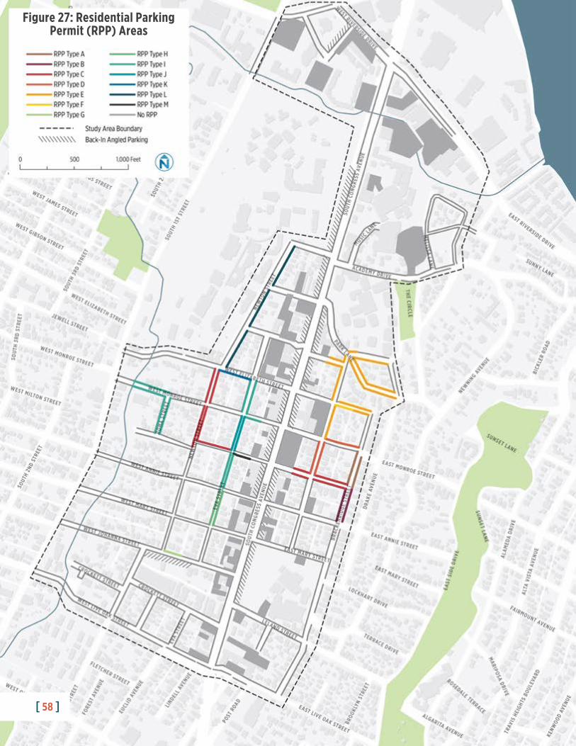
Figure 27: Residential Parking Permit (RPP) Areas
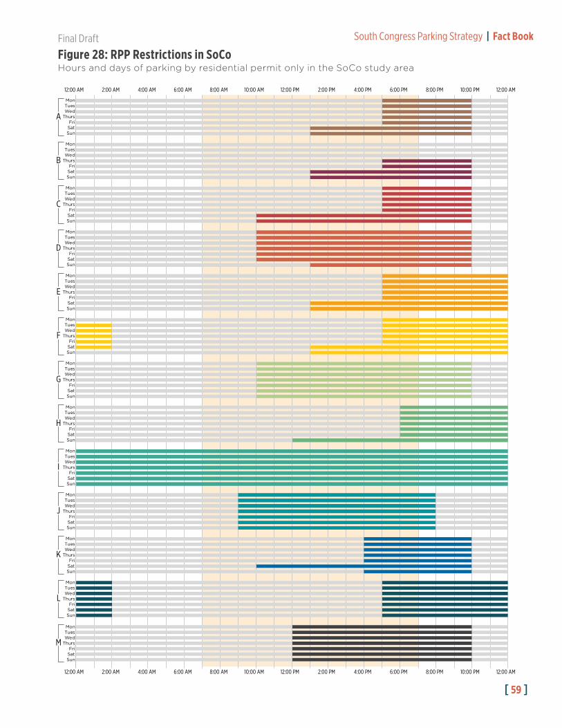
Final Draft South Congress Parking Strategy | Fact Book
[ 59 ]
MonTuesWedThurs
FriSatSun
MonTuesWedThurs
FriSatSun
MonTuesWedThurs
FriSatSun
MonTuesWedThurs
FriSatSun
MonTuesWedThurs
FriSatSun
MonTuesWedThurs
FriSatSun
MonTuesWedThurs
FriSatSun
MonTuesWedThurs
FriSatSun
MonTuesWedThurs
FriSatSun
MonTuesWedThurs
FriSatSun
MonTuesWedThurs
FriSatSun
MonTuesWedThurs
FriSatSun
MonTuesWedThurs
FriSatSun
A
B
C
D
E
F
G
H
I
J
K
L
M
12:00 AM 2:00 AM 4:00 AM 6:00 AM 8:00 AM 10:00 AM 12:00 PM 2:00 PM 4:00 PM 6:00 PM 8:00 PM 10:00 PM 12:00 AM
12:00 AM 2:00 AM 4:00 AM 6:00 AM 8:00 AM 10:00 AM 12:00 PM 2:00 PM 4:00 PM 6:00 PM 8:00 PM 10:00 PM 12:00 AM
Figure 28: RPP Restrictions in SoCoHours and days of parking by residential permit only in the SoCo study area

[ 60 ]
South Congress Parking Strategy | Fact Book Final Draft
Occupancy
• The peak occupancy observed for the overall study area (both on-street and off-
street spaces) was 61% from 12 p.m. to 2 p.m. on first Thursdays (Figure 32).
• At peak, there are about 1,350 to 1,620 spaces under-utilized across the whole study area, yet many of these spaces are not available to the general public or are
in less convenient locations. Spaces are considered under-utilized if they are below
the occupancy target of 85% to 90% (see Target Parking Occupancy below).
• Parking demand varies by geography, on- versus off-street, and time of day. At
certain locations and times of day, parking can be very difficult to find, such as:
» The most popular parking spaces, on South Congress Avenue, are in high
demand—occupancy peaks at 91% between 12 p.m. and 2 p.m. on weekdays
(Figure 33).
» The South Central Waterfront area occupancy peaks at 88% between 10 a.m.
and 12 p.m. on weekdays.
» Demand is typically much higher on blocks on or adjacent to South Congress
Avenue, north of Monroe Street.
• On-street parking adjacent to South Congress Avenue tends to have lower
demand, approximately 66% at peak. Of these spaces, only 50% are available to the
public, as most of the restricted spaces are only for RPP holders.
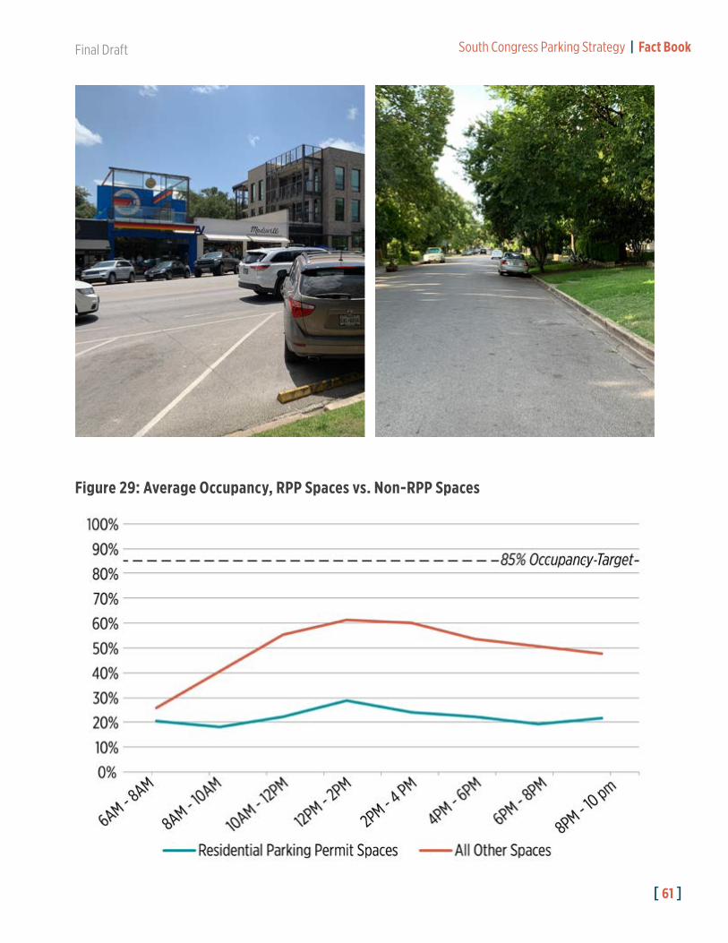
• Overall, RPP spaces were observed to be 30% full at peak. RPP spaces account
for 24.2% of the total on-street spaces in the study area.
• Off-street parking is typically underutilized at night and on weekends, especially
at the north end of the study area where parking facilities are restricted for 9-to-5
weekday employees. During a typical Saturday peak period, nearly 80% of the 1,831 off-street parking spaces north of Academy Drive are not utilized.
Target Parking OccupancyParking demand should not be too high or too low. At, or approaching, 100% occupancy, people who drive typically circle in search of parking, creating traffic congestion. By contrast, a street, lot, or garage that is consistently underutilized represents an ineffective use of resources and valuable land.
Therefore, parking demand is often assessed not against 100% of supply, but against an “effective” supply, typically 85-90% for on-street parking and 90-95% for off-street parking. Using effective supply as a target threshold ensures that there is always an available space for would-be parkers and that there is an adequate buffer in the parking system to accommodate typical fluctuations in daily or hourly demand. The target threshold for on-street occupancy is set slightly lower, as cruising for on-street parking generally generates greater externalities for traffic congestion.
Final Draft South Congress Parking Strategy | Fact Book
[ 61 ]
Figure 29: Average Occupancy, RPP Spaces vs. Non-RPP Spaces

[ 62 ]
South Congress Parking Strategy | Fact Book Final Draft
Figure 31: Off-Street Occupancy By Day
Figure 30: On-Street Occupancy By Day

Final Draft South Congress Parking Strategy | Fact Book
[ 63 ]
Figure 32: Combined On- and Off-Street Occupancy
Figure 33: Weekday Occupancy, South Congress “Core”

[ 64 ]
South Congress Parking Strategy | Fact Book Final Draft
[ 64 ]
Figure 34: Peak Occupancy, Weekday 12PM to 2PM

Final Draft South Congress Parking Strategy | Fact Book
[ 65 ][ 65 ]
Figure 35: Peak Occupancy, First Thursday 12PM to 2PM

[ 66 ]
South Congress Parking Strategy | Fact Book Final Draft
[ 66 ]
Figure 36: Peak Occupancy, Saturday 12PM to 2PM

Final Draft South Congress Parking Strategy | Fact Book
[ 67 ]
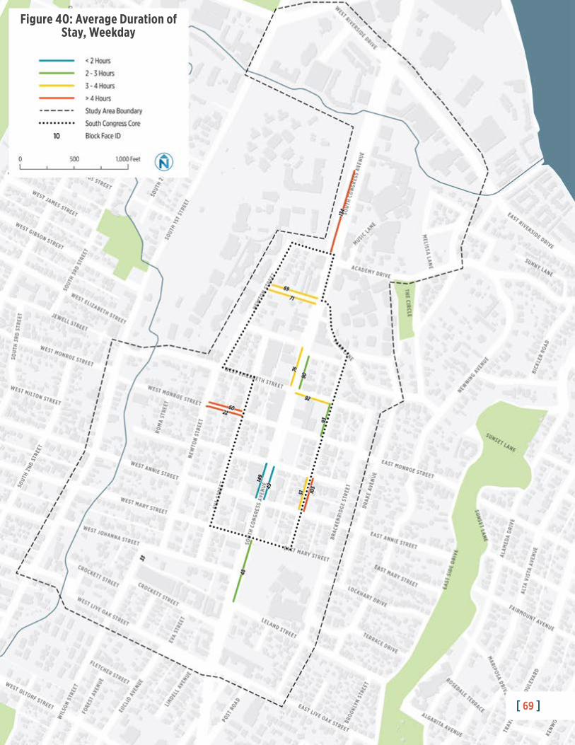
Turnover
• The average person who drives parks in the study area for 2.4 hours, but there is
significant variability in parking duration by area, day, and space type.
• For example, block face 134 (Figure 40) has vehicles often parking much longer
than 4 hours – sometimes up to and beyond 8 hours. This parking activity is likely
associated with the Texas School for the Deaf.
• People who park on weekdays are typically staying longer than people who park
on weekends (3 hours vs. 2.4 hours).
• Time limited spaces have higher turnover and lower average durations of stay (1.4
hours).
• While time limited spaces tend to have higher turnover, numerous instances of vehicles violating the time restriction were observed. For example, in space 3 on
Block 149, a vehicle was parked from before 9 a.m. to after 6 p.m (Figure 39).
Similar parking activity was observed throughout the two-hour zones and on
unrestricted blocks on South Congress.
Day Space Type # of Spaces Observed
# of Unique Vehicles
Avg. Vehicles per Space
Avg. Parking Duration (hours)
Weekday
Marked ADA Parking 6 4 1.1 3.8
Time Limited Zone 52 114 2.2 1.4
Unrestricted Parking 1,065 477 0.5 3.4
Total 1,122 657 0.6 3.0
Saturday
Marked ADA Parking 6 10 1.6 2.2
Time Limited Zone 52 129 2.5 1.4
Unrestricted Parking 1,064 828 0.8 2.5
Total 1,122 966 0.9 2.4
Figure 37: Duration and Turnover, by Day and Space Type

[ 68 ]
South Congress Parking Strategy | Fact Book Final Draft
# of
Veh
icles
<1hrs
1-2hrs
2-3hrs
3-4hrs
4-5hrs
5-6hrs
6-7hrs
7-8hrs
8-9hrs
9-10hrs
10-11hrs
11-12hrs
12+hrs
400
350
300
250
200
150
100
50
0
Weekday
Saturday
Figure 38: Distribution of Duration Observations by Day
Park
ing
Spac
e
8 AM 10 AM 12 PM 2 PM 4 PM 6 PM 8 PM
Space 4Space 3Space 2Space 1
Space 8Space 7Space 6Space 5
Space 12Space 11
Space 10Space 9
Space 16Space 15Space 14
Space 19Space 18Space 17
Space 13
7
3
4
9
7
7
5
7
3
8
4
6
8
6
6
6
2
3
5
Figure 39: Weekday Occupancy of Time-Limited Parking on Block 149Time Limit: 2 HoursNumber of
Vehicles:
Final Draft South Congress Parking Strategy | Fact Book
[ 69 ][ 69 ]
Figure 40: Average Duration of Stay, Weekday

[ 70 ]
South Congress Parking Strategy | Fact Book Final Draft
[ 70 ]
Figure 41: Average Duration of Stay, Saturday

Final Draft South Congress Parking Strategy | Fact Book
[ 71 ]
Zone ID and Name2
Inventory (# of Spaces) % of Supply Peak Occupancy4 Vehicles
per SpaceAvg. Duration
(hours)On-
StreetOff-Street3 Total
% Occupied Time Period
Wee
kday
Satu
rday
Wee
kday
Satu
rday
Surv
eyed
Non-
Surv
eyed
Tota
l
1South Central Waterfront
18 1,446 170 1,616 1,634 30.4% 87.8%First Thursday, 10 AM - 12 - PM
Data not collected
2Texas School for the Deaf
Data not collected
3South River City
185 177 38 215 400 7.5% 69.8%Weekday, 10 AM - 12 PM
2.0 2.6 5.2 3.9
4 Lower SoCo 300 258 140 398 698 13.0% 66.2%Saturday, 2 PM - 4 PM
3.2 4.0 3.0 2.2
5 East Bouldin 443 0 0 0 443 8.3% 56.2%Saturday, 6PM - 8 PM
1.8 2.2 4.5 3.9
6 Central SoCo 503 625 106 731 1,244 23.0% 46.6%First Thursday,12 PM - 2 PM
4.1 4.9 2.2 2.0
7 Live Oak 342 0 0 0 342 6.4% 44.8%Weekday, 2 PM - 4 PM Data not collected
8 Upper SoCo 212 118 283 401 613 11.4% 66.7%First Thursday, 12 PM - 2 PM
1.6 3.4 2.1 1.6
9 Oltorf Data not collected
Total 2,001 2,624 737 3,361 5,372 100% 60.7% First Thursday, 12 PM - 2 PM 2.8 3.7 3.0 2.4
2 See Figure 22 for zone map.
3 A sample-based approach was required to accommodate available ATD staffing resources. Approximately 90% of inventoried spaces were counted during the occupancy study, a very high sampling rate for a study area of this size.
4This is the observation period with the highest parking occupancy for that zone.
Figure 42: Summary of Inventory, Peak Occupancy, and Turnover by Zone

[ 72 ]
South Congress Parking Strategy | Fact Book Final Draft
Policies, Regulations, and ProgramsThe following section summarizes the policies, regulations, and programs governing
the current management of the parking system in South Congress.
Parking ExperienceThe parking experience is determined by more than just the price and the availability
of spaces. For example, a certain block face, parking lot, or garage may be inefficiently
utilized because people are unaware of these spaces or because there is not
convenient and comfortable access from these spaces to travelers’ final destinations.
Category Policy/Program Description
PermitsResidential Parking Permit (RPP)
The RPP program was instituted by the Austin City Council in 1996 to increase the availability on-street parking spaces for residents in areas where parking demand from nearby non-residential uses may be spilling over. At least 60% of the residents at addresses along the block face for which RPP is being considered must sign in support of the RPP application. Upon meeting this requirement, ATD will conduct a parking study—that parking study must indicate that the parking occupancy of the blocks is at least 75%, with no less than 25% of those vehicles being identified as “commuter traffic.” Upon meeting the requirements, signs are installed, and parking permits are distributed to residents along the street. Enforcement of the zone starts two weeks after the installation of the sign.Permits cost $15 each. Each year, households can purchase 1 or 2 resident decal permits and 1 or 2 visitor hangtag permits depending on location.There are a total of about 480 RPP spaces in the study area on 47 different block faces. Different block faces have the RPP program in effect for different times of day and day of week, as shown in Figure 27 and Figure 28.
Programs
Public Off-street Parking
Several areas throughout South Congress are signed for Public off-street parking, including under the South Congress Hotel. The facilities are managed not by the City of Austin, but by private operators, businesses, or both.
Valet ParkingThere are nine valet spaces throughout the South Congress area, such as those adjacent to the South Congress Hotel. Valet parking cost ranges from $12-$34.
ZipCarA single ZipCar is available for short-term car rental within the South Congress neighborhood—a space is reserved specifically for this vehicle.
Regulations
Time Limited Zones
Six block faces (comprising 64 spaces) on South Congress have a two-hour time limit for parking. These block faces are located directly adjacent to commercial and retail establishments.
Customer Loading Zones
Seven block faces (20 spaces) have a customer loading regulation, some of which limit the amount of time customers can park (e.g., for take-out food).
Figure 43: Parking Policies, Regulations, and Programs in SoCo

Final Draft South Congress Parking Strategy | Fact Book
[ 73 ]
Wayfinding and Signage
Public off-street parking is generally signed, but wayfinding varies throughout the
study area. There are different colors, fonts, and symbols to indicate the location of
parking facilities and their respective regulations. A consistent parking “brand” does
not exist in the SoCo area.
Some signage is obscured by trees or other structures, creating legibility challenges
for drivers seeking available public parking.
Most lots have “No Parking” or towing signs within the facility or at specific spaces.
The variety of signs and regulations can create user confusion and uncertainty about
what parking is publicly available versus what is restricted to specific users. This often
creates ticket anxiety and negative perceptions about the system.
Parking Information
The City of Austin does not offer online information for parking on South
Congress—a Google search generates private information providers (e.g., TripAdvisor,
ParkingPanda, etc.) with limited information and tips for parking. Doing the Streets

[ 74 ]
South Congress Parking Strategy | Fact Book Final Draft
is a website that provides trip planning and event information about South Congress
Avenue shops and restaurants and includes parking locations and pricing.1
Technology
Parking technology in the area is very limited and provides no real-time parking
availability information. One lot has a pay-by-plate kiosk that offers payment via a
smartphone application.
Walkability
Despite some challenges for pedestrians, including uneven pavement, sidewalk
network gaps, and inconsistent shade and lighting, SoCo is one of the most popular
districts for walking in Austin. SoCo’s identity as a vibrant, walkable neighborhood
is a valuable asset that can help support a successful parking strategy. Even so, the
perceived walkability of SoCo can vary greatly between different types of users.
Service employees with late or early shifts may be reluctant to walk to or from parking
through poorly lit areas. People with mobility challenges may have difficulty navigating
the irregular sidewalk network. Neighborhood residents may wish to avoid walking
through busy shopping and dining areas on a daily basis.
1 http://www.doingthestreets.com/southcongress

Final Draft South Congress Parking Strategy | Fact Book
[ 75 ]
Parking in SoCo: Top Five Takeaways1. There are nearly 5,372 parking spaces within the South Congress study area,
63% of which are off-street, and 37% of which are on-street.
2. Over half of all parking in the South Congress study area is completely unregulated. About 70% of on-street parking is unregulated, and about 44% of
off-street parking is unregulated. These include some of the most popular, highly
utilized blockfaces in the core business area of South Congress, as well as some
adjacent off-street facilities that are significantly underutilized.
3. Parking occupancy across the entire study area peaks at 60%. Nevertheless,
there are on-street spaces in the commercial core and off-street spaces north of
Academy Drive that do routinely fill to capacity. Nearby on- and off-street parking
goes underutilized.
4. Parking is underutilized and could be regulated differently and signed better to encourage use. Making these underutilized spaces more apparent and available to
the public with obvious and consistent parking signage could help.
5. RPP spaces are underutilized, regulations vary widely, and implementation is largely ad-hoc. The RPP program presents opportunity for improvements focused
on consistency, simplicity, and optimization of public right-of-way use for a variety
of people.

[ 76 ]
South Congress Parking Strategy | Fact Book Final Draft

Final Draft South Congress Parking Strategy | Fact Book
[ 77 ]
Public Outreach
5
During April and September of 2019, the consultant team engaged with community
members through a series of stakeholder discussions, as well as a travel and parking
survey along the corridor. The Phase I outreach efforts were designed to gain
insight into the travel behavior of SoCo workers, visitors, and residents, and to better
understand how parking challenges were impacting the neighborhood today. This
chapter provides a summary of the key themes and findings from these efforts.
Phase II of the parking strategy will include additional public outreach to facilitate
strategy development, including further stakeholder discussions, community
presentations, and public workshops.
Stakeholder DiscussionsDiscussion groups included residents, business owners, property developers,
neighborhood organization members, and representatives from regional and state
agencies (Figure 44).

[ 78 ]
South Congress Parking Strategy | Fact Book Final Draft
The primary goals were to gather input from stakeholders about neighborhood
parking needs and to provide an open forum for discussion about perceived
challenges and opportunities for improvement. Discussions touched on a variety of
subjects, many of which recurred throughout the day across multiple groups. Key
themes, as presented to the consultant team by stakeholders, are summarized below.
Key Theme: Users of local businesses, especially employees, struggle to find available parking.
• The challenge of finding parking for employees—especially longer-term, off-street
parking—is making hiring and retention difficult, which in turn can impact business
growth.
• Employee safety is a concern. Walking four to five blocks from a place of
employment to a car after a late shift, potentially with a large amount of cash on-
hand, presents risks for employees.
• Employees in lower-wage jobs are unlikely to be able to afford paid parking.
• Some business owners try to discourage employees from parking directly on South
Congress, but often it is their only option. People who consistently park in the area
know there is little to zero parking enforcement on South Congress.
• Off-street parking facilities can be underutilized, but their use is typically restricted.
There are barriers to sharing of off-street parking.
• Many visitors simply do not know where publicly available parking is located, as
signage and wayfinding is limited or ineffective.
Group April 2019 Participants September 2019 Participants
South Congress Merchants Association 7 5
South Congress Public Improvement District 7 6
Bouldin Creek Neighborhood Association 6 5
South Central Waterfront Initiative Project Planners 2 2
South Congress Developers and Property Owners 11 6
State and Regional Stakeholders 2 3
South River City Neighborhood 1 4
Public Partners Meeting -- 11
Figure 44: Stakeholder Discussion Groups

Final Draft South Congress Parking Strategy | Fact Book
[ 79 ]
Key Theme: Most merchants, businesses, and non-residents believe the Residential Parking Permit (RPP) program is inefficient. By contrast, residents highly value the RPP program to minimize parking spillover.
• Most businesses and commercial property owners believe the current application
of the RPP program is inefficient. A consistent theme was that many blocks sit
empty during the day, but employees or visitors are not allowed to park there,
resulting in an underutilized parking asset. Many also believe the RPP has primarily
shifted, rather than alleviated, parking challenges due to its ad hoc block-by-block
implementation.
• The RPP program is seen by some business owners as an unfair privatization of
what should be a shared public amenity.
• Many business owners believe the current RPP program could be improved by
allowing employees to obtain permits, or by allowing time-limited parking for
visitors in RPP zones during residential off-peak hours.
• Residents believe very strongly in the need for an RPP program to minimize
spillover into their neighborhood and to avoid the nuisances associated with non-
resident parking behavior, including blocked driveways and litter. The RPP program
is currently the only parking management tool available to residents.
• RPPs have been implemented in a piecemeal way throughout the neighborhood with
inconsistent rules—one block has a 24-hour restriction, while the immediately adjacent
block’s RPP is only for certain times of day. It can be very confusing for visitors.
RPPOnly
5 PM to10 PM
[ 80 ]
South Congress Parking Strategy | Fact Book Final Draft
Key Theme: Holistic parking and mobility solutions—rather than piecemeal strategies—are needed.
• To date, parking management has largely been ad hoc. RPPs have been rolled out
on a block-by-block basis without district-wide coordination. Pricing and meters
as potential solutions have primarily been presented independently, rather than as
part of a comprehensive approach.
• Parking enforcement is limited and highly inconsistent. The current regulations
make enforcement very resource-intensive for ATD staff.
• A previous effort to create a SoCo Parking Benefit District (PBD), which included
a plan for parking meters and a fund-sharing program for neighborhood
transportation initiatives, was unsuccessful. During this planning process, there was
significant opposition to parking meters.
• Without a comprehensive parking framework, parts of the parking supply can go
unused, including empty blocks covered by RPP permits and off-street supply that
is hard to find or unavailable for shared parking arrangements.
• Some business owners subsidize bulk transit passes, but those types of employee
benefits are implemented on a business-by-business basis and are not coordinated.
• No formal body helps facilitate mobility options for businesses and their employees
within the corridor. To date, Movability has not focused its work as a TMA in the
South Congress district.
• Many people who work in the district live far away and cannot get to South
Congress on transit without one or more bus transfers.
• Transit service does not run late enough into the night to accommodate the late
night shifts of people working in South Congress.
• Many people who work in the district have multiple jobs or family needs that
impact mobility options, travel choices, and vehicle availability.

Final Draft South Congress Parking Strategy | Fact Book
[ 81 ]
Key Theme: The current design of South Congress Avenue is a challenge to ongoing economic vitality, safety, and access.
• The current bike and pedestrian facilities make multimodal travel difficult or
unappealing. Challenges include unprotected bike lanes, narrow sidewalks, difficult
pedestrian crossings, lack of neighborhood sidewalks, and lack of shade.
• Many believe that the back-in angled parking on South Congress causes vehicle
delays and safety issues. SoCo stakeholders emphasized that back-in angled
parking was implemented with little input from local businesses and residents.
• The lack of lighting and street trees may reduce willingness to walk even short
distances to and from a parking spot, especially during the hot summer months.
• Though changes to South Congress are generally desired, the potential for
disruption during road construction and the uncertainty of change is a concern for
both local business owners and residents.
• Improved signage and wayfinding may be an opportunity for a “quick win.”
• With few designated pick-up and drop-off areas in the neighborhood, ride-hailing
vehicles often stop in unsafe locations and disrupt other traffic.
• Commercial vehicles sometimes compete for loading space with people who are
parking, especially on alleyways behind South Congress businesses.
Key Theme: Systemic changes in the neighborhood further complicate and exacerbate the parking challenges.
• As neighborhood growth puts additional pressure on the available parking supply,
tensions about who should have access to on-street parking have increased.
• The rise of short-term rentals in the residential areas adjacent to South Congress
Avenue further complicates perceptions about who is using and benefiting from
neighborhood parking.
• Most businesses and long-term residents value the historic, low(er)-density
character of the neighborhood, and some are averse to projects that threaten to
add density or allow structured parking.
• Developments at the northern and southern end of the study area may soon
provide significant off-street parking supply. These developments offer
opportunity to expand corridor parking supply through a shared parking program.
Such parking nodes must be connected to the neighborhood with mobility
improvements.
• Spillover parking from South 1st Street is also increasing pressure on neighborhood
parking supply in the blocks adjacent to South Congress.

[ 82 ]
South Congress Parking Strategy | Fact Book Final Draft
Key Theme: The economics of parking in the district needs to be revisited.
• “Hide-and-ride” users—commuters who park on South Congress Avenue and ride
the bus into downtown for work—are taking advantage of free and unregulated
on-street parking, which would otherwise be available to neighborhood employees,
residents, and visitors.
• RPP permit prices are very low; while there is a limit to how much can be legally
charged for permits, a pricing structure that better recognizes the market value of
on-street parking may be needed.
• Some types of parking programs are prohibitively expensive to enforce, even with
new technologies. For example, the cost of deploying parking officers to enforce
hourly time restrictions is typically greater than the ticket revenues collected, even
with license plate recognition technology.
• Some believe that the LDC lets businesses or developments “off the hook” by not
requiring them to provide more off-street parking. Other stakeholders noted that
the intent of reducing/eliminating parking requirements—especially in transit-rich
areas—is supportive of Austin’s city-wide goals to reduce vehicle trips.
Key Theme: There is a sense of neighborhood fatigue around all these issues.
• Business owners, property owners, and neighborhood residents expressed
frustration about long-running parking discussions and studies which have yielded
few actionable results.
• Many stakeholders believe that dialogue with city staff and elected officials to
express frustrations and implement solutions have not been successful.
Walking TourA walking tour of the South Congress neighborhood was held on Thursday, April 25.
Approximately 15 stakeholder attendees convened to walk through the neighborhood
and review parking conditions in the study area. Many of the discussion points raised
in the stakeholder meetings were observed in the field, including RPP regulations,
pedestrian and biking conditions, informal shared parking arrangements, wayfinding
and signage, and back-in parking dynamics.

Final Draft South Congress Parking Strategy | Fact Book
[ 83 ]

[ 84 ]
South Congress Parking Strategy | Fact Book Final Draft
Travel and Parking SurveyA survey was conducted along the South Congress Avenue corridor to capture travel
behavior and parking information from a cross-section of corridor users—residents,
employees, and visitors. The survey allows for a better understanding of how people
travel to SoCo, parking location by user type, perception of parking, and how travel
behaviors may or may not impact parking solutions in the area.
The questions were administered as an intercept survey in the South Congress
corridor, utilizing field surveyors with tablets. The survey collected data from a
representative sample of users at various times of day and days of week.
A total of 627 completed surveys were collected between April 22 and April 30. Data
elements collected are shown in Figure 45 and survey response locations are shown in
Figure 46. Note that some variability in survey locations shown in Figure 46 is the
result of GPS inaccuracies and geocoding anomalies.
Category Main Element Sub-elements
Trip Characteristics
Trip purpose If travel elsewhere, where?
Mode of travel to SoCo
If parked, where?
Ranking of parking experience
If bike, type of bike?
If ride-hail, which provider?
Frequency of visits
Length of trip
Estimated spending
Respondent Characteristics5-digit zip code of home address
Age
Observational by Surveyor Gender
Figure 45: Survey Elements

Final Draft South Congress Parking Strategy | Fact Book
[ 85 ][ 85 ]
Figure 46: Survey Response Locations

[ 86 ]
South Congress Parking Strategy | Fact Book Final Draft
Zone ID Zone Name Peak
OccupancyPeak Occupancy
PeriodSurvey
Responses% of
ResponsesDrove Alone Responses
Drive Alone Rate
1South Central Waterfront
87.8%First Thursday, 10 AM - 12 PM
55 8.8% 30 54.5%
2Texas School for the Deaf
13 2.1% 8 61.5%
3 South River City 67.8%Weekday, 10 AM - 2 PM
86 13.7% 32 37.2%
4 Lower SoCo 63.6%Saturday, 2 PM - 4 PM
209 33.3% 109 52.2%
5 East Bouldin 51.1%Saturday, 6 PM - 8 PM
7 1.1% 4 57.1%
6 Central SoCo 48.2%First Thursday, 12 PM - 2 PM
172 27.4% 96 55.8%
7 Live Oak 42.3%Weekday, 2 PM - 4 PM
0 0.0% - -
8 Upper SoCo 68.1%First Thursday, 12 PM - 2 PM
64 10.2% 30 46.9%
9 Oltorf 21 3.3% 7 33.3%
Total 59.7% First Thursday, 12 PM - 2 PM 627 100% 316 50.4%
Figure 47: Survey Response Location Summary
Respondent Home Address Location Share of Respondents
Austin 52.2%
Austin Suburbs 17.4%
Other Places in Texas 8.9%
Other States in the U.S. 18.5%
Figure 48: Survey Respondent Home Address Location
Parking DashboardAdditional parking data and analysis can be viewed using the interactive SoCo Parking Dashboard, which is available online at: https://nelsonnygaard.shinyapps.io/soco_dashboard/

Final Draft South Congress Parking Strategy | Fact Book
[ 87 ]
User Groups
All survey respondents were asked to describe the purpose of their trip to the SoCo
area. The distribution of those trip purposes is described in Figure 49.
Most respondents (53%) were in SoCo for relatively short, utilitarian purposes:
shopping, running errands, dining, meeting with friends or family, sightseeing, or
recreating. A quarter of the respondents were in South Congress traveling to work. An
additional fifth of respondents were residents (11%) or staying in the area temporarily
(10%).
These trip purposes were grouped into four primary user groups, plus an “other”
group, for analysis purposes.
Trip PurposeBy Trip Purpose
User GroupBy User Group
# of Respondents
% of Respondents
# of Respondents
% of Respondents
Dining out/Drinking 101 16.1%
Shopping, Errands, Dining, Social, and Recreation
334 53.3%
Shopping/Browsing 90 14.4%
Meeting with friends/family 59 9.4%
Entertainment/Sight-seeing 51 8.1%
Running errands 25 4.0%
Exercise 8 1.3%
Work 154 24.6% Employee 154 24.6%
I live here 70 11.2% Resident 70 11.2%
I am a visitor with lodging in the South Congress area
62 9.9% Lodging Visitor 62 9.9%
I am passing through or traveling elsewhere
6 1.0%Other 7 1.1%
Other, please specify 1 0.2%
Total 627 100% Total 627 100%
Figure 49: Respondent Trip Purpose by User Group

[ 88 ]
South Congress Parking Strategy | Fact Book Final Draft
Half of respondents come to South Congress by driving alone in a personal vehicle. More than 40% of respondents arrive by carpooling, bus, walking, biking, or other shared mobility service. People who work in the area are the most likely user group to drive alone or carpool.
Summary of Key Findings: Travel Mode
Summary of Key Findings: Frequency of Visits
Summary of Key Findings: Length of Trip
50%
75%
70%
40%HOTEL
Walking is a popular way of accessing SoCo. The highest rates of walking were among residents and lodging visitors. The highest rate of ride-hail and bicycle use was among lodging visitors.
Almost 75% of respondents indicated that they stay in SoCo for less than four hours. The most common trip length for respondents (33%) was between one and two hours. Nearly half of these travelers were shopping, running errands, dining, or making social trips.
Stay in SoCo for 4 Hours or Less
Come to SoCo more than Once per Month
The SoCo area attracts repeat visitors. More than 70% of respondents come a few times per month or more. Lodging visitors are the most likely user group to be first-time visitors. Most of those coming to SoCo more than four times a week either work or live in SoCo.

Final Draft South Congress Parking Strategy | Fact Book
[ 89 ]
Summary of Key Findings: Parking Location
Summary of Key Findings: Planned Spending
Summary of Key Findings: Parking Experience
50%
50%
$25 - $100
HOTEL
of Lodging Visitors Park in Central SoCo
Satisfied or Extremely Satisfied
Short-Term Visitors Plan to Spend Between
50% of lodging visitors parked in the Central SoCo area. People making short trips to SoCo and people who work in SoCo most often park in the Lower SoCo and Central SoCo areas.
Lodging visitors planned to spend the most money, on average. Short-term visitors planned to spend more than $25 but less than $100. Travelers using ride-hail services tended to spend more money than travelers using other modes of transportation, on average.
Overall, half of respondents rated their parking experience “satisfying” or “extremely satisfying.” The parking experience was rated most highly among lodging visitors and general visitors.
People working or living in SoCo rated the parking experience lower, with residents giving the worst average rating.

[ 90 ]
South Congress Parking Strategy | Fact Book Final Draft
Final Draft South Congress Parking Strategy | Fact Book
[ 91 ]
Public Outreach: Top Five Takeaways1. Parking management in South Congress needs a more systematic and holistic
approach. Many of SoCo’s parking management programs and regulations are
ad-hoc and uncoordinated, including the Residential Parking Permit program
(RPP), a lack of consistent time limited zones on key blocks in core areas, limited
coordination among employers around parking and transportation, and other
issues.
2. Employees, visitors, and residents are competing for some of the same convenient, core area parking spaces. A comprehensive set of strategies needs to
be developed for how parking spaces in South Congress are prioritized for different
uses based on location and land use. Employers feel that RPP spaces occupy much
of the on-street parking employees and visitors would like to be able to use, and
residents feel there is too much parking overflow into residential neighborhoods.
3. Almost half of people traveling to South Congress arrive by some other mode than driving alone. This is a very high rate of non-drive-alone travel, and a holistic
parking strategy for the neighborhood could help further reduce drive-alone rates.
Parking and transportation demand management strategies that encourage and
reward alternatives to driving alone can help ensure that parking in SoCo is used as
efficiently as possible.
4. Over half of people traveling to South Congress are making short trips—visiting
for shopping, errands, dining, social engagements, and recreation. These types of
trips support the South Congress economy and typically take less than four hours.
Less than half of them are made by people driving alone. The majority of these
people are satisfied with their parking experience.
5. Residents had the lowest opinion about the parking experience in South Congress. Visitors had the highest opinion, and employees were evenly spread
in the middle. Finding a parking management approach that addresses residents’
concerns but enables employees and visitors to easily access SoCo remains a key
priority for Phase II.

[ 92 ]
South Congress Parking Strategy | Fact Book Final Draft

Final Draft South Congress Parking Strategy | Fact Book
[ 93 ]
Appendix
A

[ 94 ]
South Congress Parking Strategy | Fact Book Final Draft
Travel Mode Resident Lodging Visitor
Shopping, Errands,
Dining, Social, and Recreation
Work Total Count by Mode
Total Proportion
by Mode
Proportion of Non-SOV
Travelers
Drove Alone (personal vehicle)
45.7% 33.9% 47.0% 67.5% 316 50.4% -
Walked 27.1% 24.2% 12.3% 7.8% 88 14.0% 28.3%
Carpool/Vanpool 2.9% 11.3% 13.2% 6.5% 65 10.4% 20.9%
Drove alone (car share/rental vehicle)
1.4% 11.3% 10.2% 2.6% 46 7.3% 14.8%
Bus 15.7% 8.1% 3.9% 9.7% 45 7.2% 14.5%
Ridehail/Taxi 0.0% 8.1% 6.9% 2.6% 33 5.3% 10.6%
Bicycle, Scooter, Skateboard
5.7% 3.2% 5.1% 2.6% 27 4.3% 8.7%
Dropped off by family/friend
1.4% 0.0% 0.9% 0.6% 5 0.8% 1.6%
Total Count by User Group 70 62 334 154 627 100% 100%
Survey Results and Key FindingsTravel Mode
• Half of respondents come to South Congress by driving alone in a personal vehicle.
Another 7% arrive by driving alone in car share vehicle.
• More than 40% of respondents arrive by carpooling, bus, walking, biking, or other
shared mobility service.
• Mode choice varies by trip purpose. Area employees are the most likely user group
to drive alone or carpool. Residents and visitors are less likely to drive to SoCo.
• Walking is a popular way of accessing SoCo. The highest rates of walking were
among residents and lodging visitors.
• Residents and employees are most likely to ride the bus, at 16% and 10%
respectively.
• The highest rate of ride-hail and bicycle use was among lodging visitors.
Figure 50: Respondent Travel Mode, by User Group
Note: Percentages within user group. ‘Other’ groups excluded for the sake of brevity.

Final Draft South Congress Parking Strategy | Fact Book
[ 95 ]
Length of Stay Resident Lodging Visitor
Shopping, Errands, Dining,
Social, and Recreation
Work Total Count by Length of Stay
Total Proportion by Length of Stay
Less than 30 minutes 2.9% 6.5% 5.4% 5.2% 34 5.4%
30-60 minutes 10.0% 3.2% 12.0% 2.6% 53 8.5%
1-2 hours 30.0% 32.3% 45.8% 8.4% 208 33.2%
2-4 hours 28.6% 29.0% 29.3% 14.9% 162 25.8%
4-8 hours 7.1% 12.9% 4.8% 44.8% 98 15.6%
More than 8 hours 21.4% 16.1% 2.7% 24.0% 72 11.5%
Total Count by User Group 70 62 334 154 627 100%
Length of Stay
• Almost 75% of respondents indicated that they stay in SoCo for less than four
hours.
• The most common trip length for respondents (33%) was between one and two
hours. Nearly half of these travelers were shopping, running errands, dining, or
making social trips.
• SoCo employees are most likely to stay for extended periods of time. Almost 70%
of employee respondents stay four hours or more.
Figure 51: Respondent Length of Stay, by User Group
Note: Percentages within user group. ‘Other’ groups excluded for the sake of brevity.

[ 96 ]
South Congress Parking Strategy | Fact Book Final Draft
Visit Frequency Resident Lodging Visitor
Shopping, Errands, Dining,
Social, and Recreation
WorkTotal Count by
Visit Frequency
Total Proportion by
Visit Frequency
This is my first time 5.7% 48.4% 18.9% 5.2% 108 17.2%
Once a month or less 2.9% 19.4% 13.5% 7.8% 72 11.5%
A few times a month 7.1% 11.3% 29.0% 9.7% 126 20.1%
1-3 times a week 11.4% 8.1% 23.4% 18.8% 120 19.1%
4-6 times a week 8.6% 8.1% 6.9% 33.8% 86 13.7%
Every day 64.3% 4.8% 8.4% 24.7% 115 18.3%
Total Count by User Group 70 62 334 154 627 100%
Frequency of Visits
• The SoCo area attracts repeat visitors. More than 70% of respondents come a few
times per month or more.
• Most of those coming to SoCo more than four times a week either work or live in
SoCo.
• Lodging visitors are the most likely user group to be first-time visitors.
Figure 52: Frequency of Visits, by User Group
Note: Percentages within user group. ‘Other’ groups excluded for the sake of brevity.

Final Draft South Congress Parking Strategy | Fact Book
[ 97 ]
Parking Location
Figure 53 describes the distribution of people parking by zone and user group – see
zones in Figure 46.
• The highest proportion of residents parked in the South River City and Lower SoCo
areas.
• The highest proportion of lodging visitors parked in the Central SoCo area.
• The highest proportion of short utilitarian/recreational visits parked in the Lower
SoCo/Central SoCo areas.
• The highest proportion of employees parked in the Lower SoCo/Central SoCo
areas.
Analysis Zone ID and Name Resident Lodging Visitor
Shopping, Errands,
Dining, Social, and Recreation
Work Total Count Total Proportion
1South Central Waterfront
12.1% 7.1% 11.0% 5.6% 33 9.1%
2Texas School for the Deaf
3.0% 0.0% 3.1% 1.9% 9 2.5%
3South River City
24.2% 17.9% 12.6% 3.7% 41 11.3%
4 Lower SoCo 24.2% 10.7% 35.6% 40.7% 125 34.5%
5 East Bouldin 0.0% 7.1% 0.5% 0.9% 4 1.1%
6 Central SoCo 21.2% 50.0% 24.1% 35.2% 105 29.0%
7 Live Oak Survey not Collected
8 Upper SoCo 12.1% 3.6% 12.0% 8.3% 37 10.2%
9 Oltorf 3.0% 3.6% 1.0% 3.7% 8 2.2%
Total County 33 28 191 108 362 100%
Figure 53: Parking Location (for Those Who Drive Alone), by User Group
Note: Percentages within zone.
[ 98 ]
South Congress Parking Strategy | Fact Book Final Draft
Parking Experience
• Overall, half of respondents rated their parking experience “satisfying” or
“extremely satisfying.” Another 25% were “neutral.”
• Less than one of ten respondents were “extremely dissatisfied” with their parking
experience.
• The parking experience was rated most highly among lodging visitors and general
visitors.
• Those working or living in SoCo rated the parking experience lower, with residents
giving the worst average rating.
Parking Experience Resident Lodging Visitor
Shopping, Errands,
Dining, Social, and Recreation
WorkTotal Count by
Satisfaction Category
Total Proportion by
Parking Experience
Extremely Dissatisfying (1)
17.1% 5.7% 5.1% 14.4% 37 8.7%
Dissatisfying (2) 14.3% 11.4% 14.0% 17.8% 63 14.8%
Neutral (3) 31.4% 28.6% 27.2% 21.2% 110 25.8%
Satisfying (4) 20.0% 34.3% 35.7% 22.0% 133 31.1%
Extremely Satisfying (5)
17.1% 20.0% 17.9% 24.6% 84 19.7%
Total Count by User Group 35 35 235 118 427
100%Average Parking
Experience Rating 3.06 3.51 3.47 3.25 3.38
Figure 54: Parking Experience (Drive Alone Respondents Only)
Note: Percentages within user groups. ‘Other’ groups excluded for the sake of brevity.

Final Draft South Congress Parking Strategy | Fact Book
[ 99 ]
Planned Spending
• Lodging visitors indicate they plan to spend the most money, on average.
• Short-term visitors indicate they plan to spend more than $25 but less than $100.
• Given their trip purpose, most residents and workers tended to spend the least on
their trips.
• Travelers using ride-hail services tended to spend more money than other modes,
on average.
Money Planned to Spend Resident Lodging Visitor
Shopping, Errands,
Dining, Social, and Recreation
Work Total Count by Money Spent
Total Proportion by Money Spent
None 34.3% 14.5% 6.9% 31.2% 107 17.1%
Less than $25 27.1% 11.3% 16.5% 33.1% 132 21.1%
$26-$50 15.7% 16.1% 35.0% 20.8% 172 27.4%
$51-$100 18.6% 12.9% 26.9% 11.7% 130 20.7%
$101-$150 1.4% 12.9% 9.3% 1.9% 43 6.9%
More than $150 2.9% 32.3% 5.4% 1.3% 43 6.9%
Total Count by User Group 70 62 334 154 627
100%Average Amount
Spent by User Group $30 $90 $55 $25 $45
Figure 55: Planned Spending, by User Group
Note: Percentages within user group. ‘Other’ groups excluded for the sake of brevity.
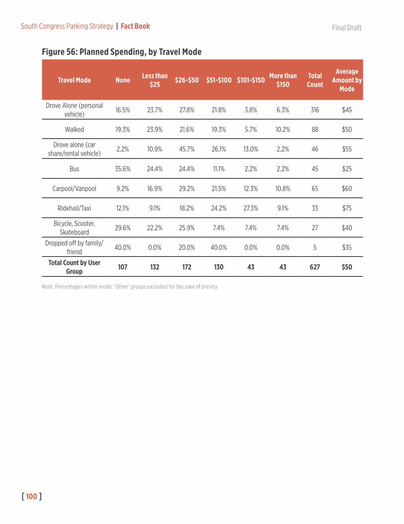
[ 100 ]
South Congress Parking Strategy | Fact Book Final Draft
Travel Mode None Less than $25 $26-$50 $51-$100 $101-$150 More than
$150Total Count
Average Amount by
Mode
Drove Alone (personal vehicle)
16.5% 23.7% 27.8% 21.8% 3.8% 6.3% 316 $45
Walked 19.3% 23.9% 21.6% 19.3% 5.7% 10.2% 88 $50
Drove alone (car share/rental vehicle)
2.2% 10.9% 45.7% 26.1% 13.0% 2.2% 46 $55
Bus 35.6% 24.4% 24.4% 11.1% 2.2% 2.2% 45 $25
Carpool/Vanpool 9.2% 16.9% 29.2% 21.5% 12.3% 10.8% 65 $60
Ridehail/Taxi 12.1% 9.1% 18.2% 24.2% 27.3% 9.1% 33 $75
Bicycle, Scooter, Skateboard
29.6% 22.2% 25.9% 7.4% 7.4% 7.4% 27 $40
Dropped off by family/friend
40.0% 0.0% 20.0% 40.0% 0.0% 0.0% 5 $35
Total Count by User Group 107 132 172 130 43 43 627 $50
Figure 56: Planned Spending, by Travel Mode
Note: Percentages within mode. ‘Other’ groups excluded for the sake of brevity.

Final Draft South Congress Parking Strategy | Fact Book
[ 101 ]

[ 102 ]
South Congress Parking Strategy | Fact Book Final Draft