Embed Size (px)
Citation preview
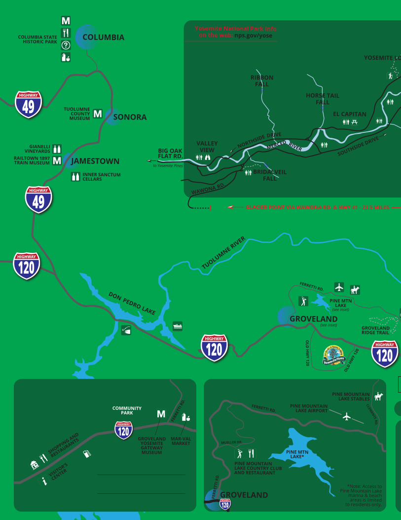
Nearby ActivitiesYosemite National Park - 22 miles from Yosemite Pines Resort to the Yosemite National Park Big Oak Flat en-trance. Valley floor is an additional 24-mile drive from park gate. YARTS motor coach shuttles depart Yosemite Pines right to the Yosemite Valley Visitor’s Center Spring through September. (877) 989-2787, yarts.com.All National Park Service information for Yosemite National Park: nps.gov/yose
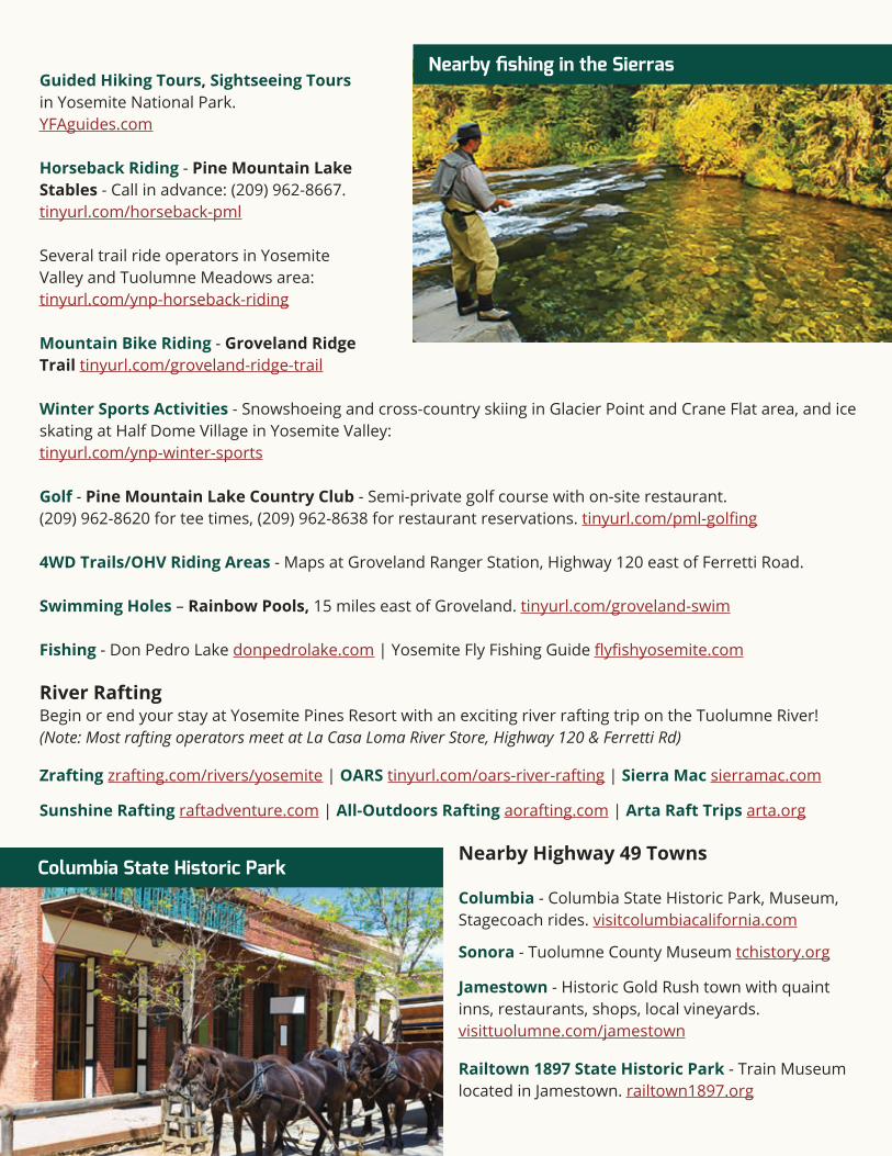
Groveland - This quaint town is just three miles west of Yosemite Pines Resort on Highway 120, and has a great “downtown” with a park, shops, restaurants and the fa-mous Iron Door Saloon - said to be California’s oldest continuously-operating saloon. Mar-Val Market also has a wide selection of groceries.
Information at Tuolumne County Visitors Center and the Yosemite Highway 120 Chamber of Commerce at 18687 Main Street in Groveland. visittuolumne.com and groveland.org
Groveland Yosemite Gateway Museumgrovelandmuseum.com
Hiking near Groveland - Day hikes on the Big Creek Trail and to Wapama Falls. tinyurl.com/groveland-hikingInformation on other hikes in Yosemite National Park area: tinyurl.com/ynp-area-hikes
Continued on back >>>
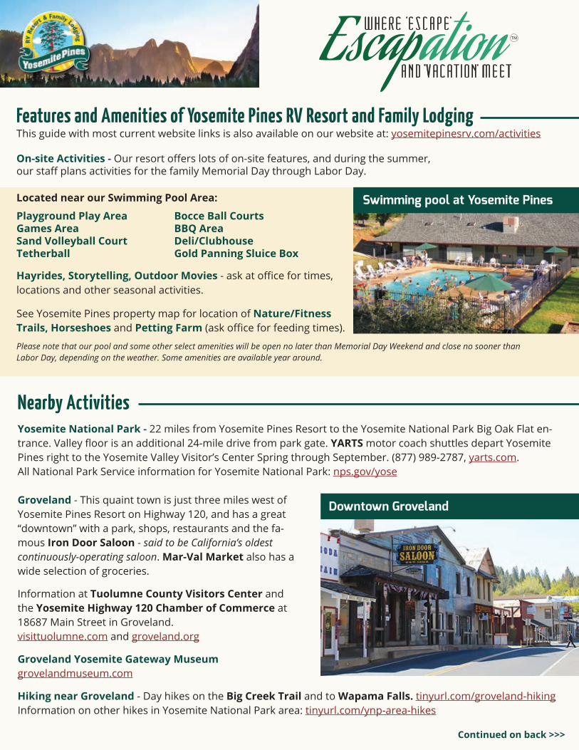
Playground Play AreaGames AreaSand Volleyball CourtTetherball
Bocce Ball CourtsBBQ AreaDeli/ClubhouseGold Panning Sluice Box
Features and Amenities of Yosemite Pines RV Resort and Family LodgingThis guide with most current website links is also available on our website at: yosemitepinesrv.com/activities
On-site Activities - Our resort offers lots of on-site features, and during the summer,our staff plans activities for the family Memorial Day through Labor Day.
Located near our Swimming Pool Area:
Hayrides, Storytelling, Outdoor Movies - ask at office for times,locations and other seasonal activities.
Swimming pool at Yosemite Pines
See Yosemite Pines property map for location of Nature/FitnessTrails, Horseshoes and Petting Farm (ask office for feeding times).
Please note that our pool and some other select amenities will be open no later than Memorial Day Weekend and close no sooner than Labor Day, depending on the weather. Some amenities are available year around.
Downtown Groveland
Guided Hiking Tours, Sightseeing Tours in Yosemite National Park. YFAguides.com
Horseback Riding - Pine Mountain Lake Stables - Call in advance: (209) 962-8667. tinyurl.com/horseback-pml
Several trail ride operators in Yosemite Valley and Tuolumne Meadows area: tinyurl.com/ynp-horseback-riding
Mountain Bike Riding - Groveland Ridge Trail tinyurl.com/groveland-ridge-trail
Winter Sports Activities - Snowshoeing and cross-country skiing in Glacier Point and Crane Flat area, and ice skating at Half Dome Village in Yosemite Valley:tinyurl.com/ynp-winter-sports
Golf - Pine Mountain Lake Country Club - Semi-private golf course with on-site restaurant. (209) 962-8620 for tee times, (209) 962-8638 for restaurant reservations. tinyurl.com/pml-golfing
4WD Trails/OHV Riding Areas - Maps at Groveland Ranger Station, Highway 120 east of Ferretti Road.
Swimming Holes – Rainbow Pools, 15 miles east of Groveland. tinyurl.com/groveland-swim
Fishing - Don Pedro Lake donpedrolake.com | Yosemite Fly Fishing Guide flyfishyosemite.com
River Rafting Begin or end your stay at Yosemite Pines Resort with an exciting river rafting trip on the Tuolumne River! (Note: Most rafting operators meet at La Casa Loma River Store, Highway 120 & Ferretti Rd)
Zrafting zrafting.com/rivers/yosemite | OARS tinyurl.com/oars-river-rafting | Sierra Mac sierramac.com
Sunshine Rafting raftadventure.com | All-Outdoors Rafting aorafting.com | Arta Raft Trips arta.org
Nearby Highway 49 Towns
Columbia - Columbia State Historic Park, Museum,Stagecoach rides. visitcolumbiacalifornia.com
Sonora - Tuolumne County Museum tchistory.org
Jamestown - Historic Gold Rush town with quaint inns, restaurants, shops, local vineyards. visittuolumne.com/jamestown
Railtown 1897 State Historic Park - Train Museum located in Jamestown. railtown1897.org
Nearby fishing in the Sierras
Columbia State Historic Park
TUOLUMNE RIVER
(see inset)
(see inset)
(see inset)
GIANELLIVINEYARDS
INNER SANCTUMCELLARS
RAILTOWN 1897TRAIN MUSEUM
COLUMBIA STATEHISTORIC PARK
TUOLUMNECOUNTY
MUSEUM
HIGHWAY
MAR-VALMARKET
GROVELANDYOSEMITEGATEWAYMUSEUM
FERR
ETTI
RD.
VISITOR’S
CENTER
DOWNTOWNGROVELAND
Groveland is 2.5 miles fromYosemite Pines Resort
YOSEMITE PINES TO YOSEMITEPARK WEST ENTRANCE - 22 MILES
HIGHWAYHIGHWAY
HIGHWAY
HIGHWAY
BIG OAK FLAT RD.
TO HETCH HETCHY
RESERVOIR - 16 M
ILES
FERRETTI RD.
FERRETTI RD.
OLD
HW
Y 120
OLD
HW
Y 12
0
PRESTON FALLS TRAIL
CARLONFALLS
MERCED GROVE TRAIL
GROVELANDRIDGE TRAIL
HIGHWAY
TUOLUMNEMEADOWS
TUOLU
MNE
MEA
DOWS V
IA
TIOGA P
ASS R
D - 38 M
ILES
Most operators of Tuolumne River rafting trips meet here at La Casa Loma River Store parkinglot, Ferretti Rd. & Hwy 120). Sunshine Rafting (Stanislaus River) meets in Knights Ferry. CRANE FLAT
YOSEMITE PARKWEST ENTRANCE
RAINBOWPOOLS
TUOLUMNEGROVE
(clos
ed N
ov-M
ay)
GROVELAND RANGER STATION (4WD/OHV TRAIL INFO)
TUEEULALAFALLS WAPAMA
FALLS
MAP LEGEND Map not to scale
National Park Entrance
Parking
Public Restrooms
Restaurant
Visitor/Info Center
Picnic Area
Winter Sports
Biking
Golf
Horseback Riding
Hiking Trailhead
Fishing
Swimming
Boating
Rafting (Meeting Place)
Museum
Ice Skating
Shopping/Gifts
Grocery Store
Airport
Gas Station
Wine Tasting
4WD/OHV Trail Info
Main highwaysSecondary roadsYosemite Valley roadsAccess roadsTrails
City
HIGHWAY
For reference only, not to be used for navigation
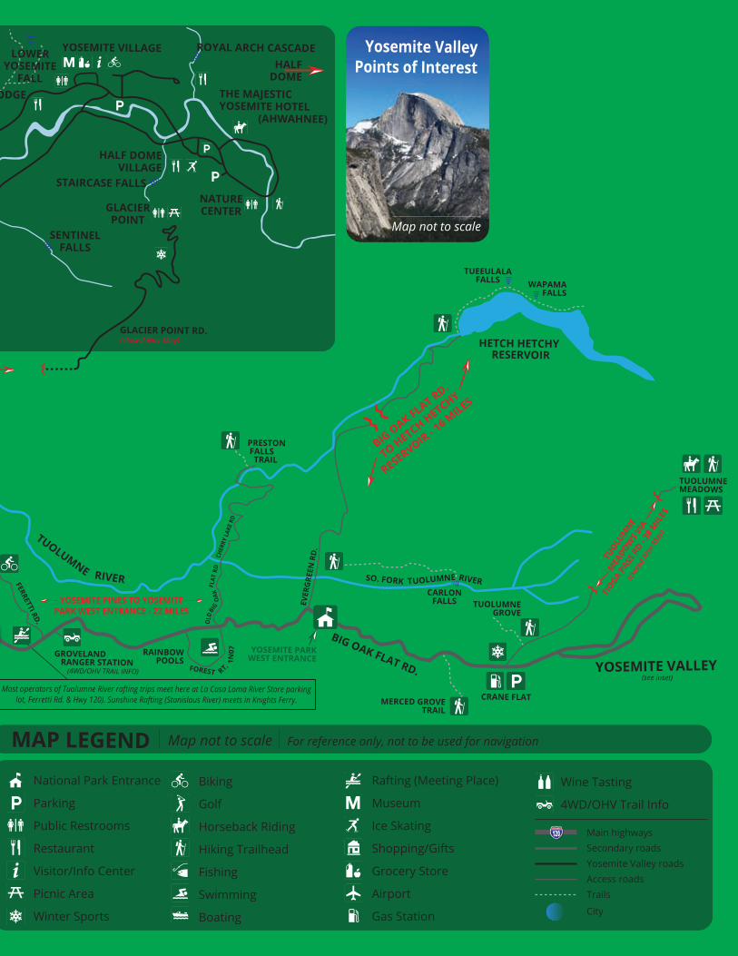
VALLEYVIEW
BRIDALVEILFALL
EL CAPITAN
LOWERYOSEMITE
FALL
YOSEMITE VILLAGE
THE MAJESTICYOSEMITE HOTEL (AHWAHNEE)
HALF DOMEVILLAGE
GLACIERPOINT
NATURECENTER
HALFDOME
GLACIER POINT RD.(closed Nov-May)
HORSE TAILFALL
YOSEMITE LODGE
SENTINELFALLS
STAIRCASE FALLS
ROYAL ARCH CASCADEYosemite National Park Info
on the web: nps.gov/yose
to Yosemite Pines
RIBBONFALL
Yosemite ValleyPoints of Interest
Map not to scale
PINE MTNLAKE
PINE MOUNTAINLAKE STABLES
PINE MOUNTAINLAKE AIRPORT
FERRETTI RD.
PINE MTNLAKE*
HIGHWAY
FERR
ETTI
RD
.
MUELLER DR.
PINE MTN LAKE AREA
SHOPPING AND
RESTAURANTS
PINE MOUNTAINLAKE COUNTRY CLUBAND RESTAURANT
*Note: Access toPine Mountain Lake
marina & beachareas is limited
to residents only.
GLACIER POINT VIA WAWONA RD. & HWY 41 - 23.5 MILES
TUOLUMNE RIVER
(see inset)
(see inset)
(see inset)
GIANELLIVINEYARDS
INNER SANCTUMCELLARS
RAILTOWN 1897TRAIN MUSEUM
COLUMBIA STATEHISTORIC PARK
TUOLUMNECOUNTY
MUSEUM
HIGHWAY
MAR-VALMARKET
GROVELANDYOSEMITEGATEWAYMUSEUM
FERR
ETTI
RD.
VISITOR’S
CENTER
DOWNTOWNGROVELAND
Groveland is 2.5 miles fromYosemite Pines Resort
YOSEMITE PINES TO YOSEMITEPARK WEST ENTRANCE - 22 MILES
HIGHWAYHIGHWAY
HIGHWAY
HIGHWAY
BIG OAK FLAT RD.
TO HETCH HETCHY
RESERVOIR - 16 M
ILES
FERRETTI RD.
FERRETTI RD.
OLD
HW
Y 120
OLD
HW
Y 12
0
PRESTON FALLS TRAIL
CARLONFALLS
MERCED GROVE TRAIL
GROVELANDRIDGE TRAIL
HIGHWAY
TUOLUMNEMEADOWS
TUOLU
MNE
MEA
DOWS V
IA
TIOGA P
ASS R
D - 38 M
ILES
Most operators of Tuolumne River rafting trips meet here at La Casa Loma River Store parkinglot, Ferretti Rd. & Hwy 120). Sunshine Rafting (Stanislaus River) meets in Knights Ferry. CRANE FLAT
YOSEMITE PARKWEST ENTRANCE
RAINBOWPOOLS
TUOLUMNEGROVE
(clos
ed N
ov-M
ay)
GROVELAND RANGER STATION (4WD/OHV TRAIL INFO)
TUEEULALAFALLS WAPAMA
FALLS
MAP LEGEND Map not to scale
National Park Entrance
Parking
Public Restrooms
Restaurant
Visitor/Info Center
Picnic Area
Winter Sports
Biking
Golf
Horseback Riding
Hiking Trailhead
Fishing
Swimming
Boating
Rafting (Meeting Place)
Museum
Ice Skating
Shopping/Gifts
Grocery Store
Airport
Gas Station
Wine Tasting
4WD/OHV Trail Info
Main highwaysSecondary roadsYosemite Valley roadsAccess roadsTrails
City
HIGHWAY
For reference only, not to be used for navigation
VALLEYVIEW
BRIDALVEILFALL
EL CAPITAN
LOWERYOSEMITE
FALL
YOSEMITE VILLAGE
THE MAJESTICYOSEMITE HOTEL (AHWAHNEE)
HALF DOMEVILLAGE
GLACIERPOINT
NATURECENTER
HALFDOME
GLACIER POINT RD.(closed Nov-May)
HORSE TAILFALL
YOSEMITE LODGE
SENTINELFALLS
STAIRCASE FALLS
ROYAL ARCH CASCADEYosemite National Park Info
on the web: nps.gov/yose
to Yosemite Pines
RIBBONFALL
Yosemite ValleyPoints of Interest
Map not to scale
PINE MTNLAKE
PINE MOUNTAINLAKE STABLES
PINE MOUNTAINLAKE AIRPORT
FERRETTI RD.
PINE MTNLAKE*
HIGHWAY
FERR
ETTI
RD
.
MUELLER DR.
PINE MTN LAKE AREA
SHOPPING AND
RESTAURANTS
PINE MOUNTAINLAKE COUNTRY CLUBAND RESTAURANT
*Note: Access toPine Mountain Lake
marina & beachareas is limited
to residents only.
GLACIER POINT VIA WAWONA RD. & HWY 41 - 23.5 MILES