Embed Size (px)
Citation preview

FIA-IMFIA-IM
Forest Inventory and Analysis Forest Inventory and Analysis
Information ManagementInformation Management

Who are we?Who are we?
A group of Information Technology A group of Information Technology and GIS specialists located in and GIS specialists located in Portland and Anchorage.Portland and Anchorage.

Team StructureTeam Structure IT SpecialistsIT Specialists
George BreazealeGeorge Breazeale Ron WanekRon Wanek Kurt CampbellKurt Campbell Bruce HiseroteBruce Hiserote Chuck VeneklaseChuck Veneklase Larry PottsLarry Potts Alison NimuraAlison Nimura Lisa Mahal Lisa Mahal Jane Reid Jane Reid
GIS SpecialistsGIS Specialists Dale Weyermann Dale Weyermann John ChaseJohn Chase Elaina Graham Elaina Graham

What do we do?What do we do?
GIS SupportGIS Support Data Base expertiseData Base expertise
Oracle and MS AccessOracle and MS Access Programming ServicesProgramming Services TrainingTraining Data DistributionData Distribution Hardware supportHardware support
PDR, Laptop, Printer, GPSPDR, Laptop, Printer, GPS


PNW FVS File Creator PNW FVS File Creator Version 1.1.0Version 1.1.0
Formats IDB data into FVS Formats IDB data into FVS ready input filesready input files

IDB Database ConnectionIDB Database Connection

IDB InventoryIDB Inventory

Boundary Viewer: View Plot Boundary and Tree Data from Nims Oracle, Access Database, or Field Crew Plot Files.

Boundary Viewer: View Plot Boundaries and trees

FSVEG NIMSLOAD InterfaceFSVEG NIMSLOAD Interface

FIA Klamath sample design data in FIA Klamath sample design data in FSVegFSVeg

Client RequestsClient Requests
Marbled MurreletMarbled Murrelet 5 needle pine 5 needle pine McNally Fire dataMcNally Fire data Data for Species distribution studyData for Species distribution study

Data Availability
Integrated Data Base (IDB)
Periodic (Alaska, California, Oregon, Washington)
Juniper
Western and Eastern Washington
Annual 2000-2003 (2004 July/05)
GIS requests
Fuzzed plot coordinates

The Pacific Northwest – Forest Inventory and AnalysisIntegrated Database
A database of forest inventory information for
California, Oregon, and Washington

IDB distributionIDB distribution
www.fs.fed.us/pnw/fia/publications/www.fs.fed.us/pnw/fia/publications/datadata
Version 2.0 release in April Version 2.0 release in April Latest version 1.4-1Latest version 1.4-1

Periodic data distribution
Contact George Breazeale ([email protected])
Visit the FIADB (www.ncrs2.fs.fed.us) Data, Mapping tools, Tabler

Annual data distribution
Direct contact FIADB www.fs.fed.us/pnw/fia/publications/
data

FIADB mirrors field proceduresFIADB mirrors field proceduresField Data
Plot
Subplot
Condition
Tree
Seedling
Site tree
Boundary
Oracle Tables
Plot
Subplot
Condition
Tree
Seedling
Site tree
Boundary
Survey & County
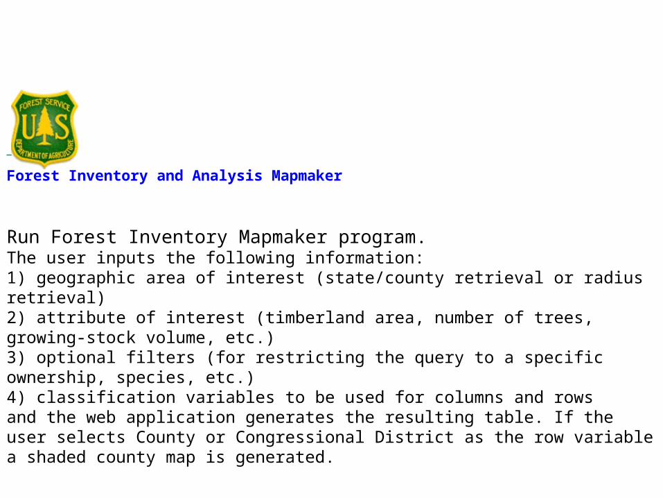
Forest Inventory and Analysis Mapmaker
Run Forest Inventory Mapmaker program.
The user inputs the following information: 1) geographic area of interest (state/county retrieval or radius retrieval)2) attribute of interest (timberland area, number of trees, growing-stock volume, etc.)3) optional filters (for restricting the query to a specific ownership, species, etc.)4) classification variables to be used for columns and rowsand the web application generates the resulting table. If the user selects County or Congressional District as the row variable a shaded county map is generated.


Two-way table (rows and columns)
Total Other
41001 Baker 209,445 209,445
41003 Benton 236,567 236,567
41005 Clackamas 322,254 322,254
41007 Clatsop 439,226 439,226
41009 Columbia 322,494 322,494
41011 Coos 642,741 642,741
41013 Crook 683,356 683,356
Total 2,856,083 2,856,083
Forest Inventory Mapmaker Version 1.0
Geographic area of interest is Oregon 1999 cycle 4 (Cycle 4 National Forest System land is not included: Western Oregon 1995-1997;Eastern Oregon 1998-1999 - Periodic inventory): Baker, Benton, Clackamas, Clatsop, Columbia, Coos, Crook.The attribute of interest is Area of forestland(acres).No filters were used.Pages are None.Rows are County code.Columns are National Forests.

Local vs. NationalLocal vs. National
FIA-IM has both local and National FIA-IM has both local and National dutiesduties
What is a Band?What is a Band?

National Development Efforts National Development Efforts
NIMS – National Information NIMS – National Information Management SystemManagement System
ePlot – National PDR programePlot – National PDR program

NIMS
• National Information Management System– Used to Load, Check, Compile, Output FIA
data

Load Tables NIMS
Core Tables
Pass Edits?
Nat’l Core
NIMS “Core”
Regional
QA
YesLoadComputations:
• National
• Regional
FIADB
Output

“Between the dream and reality lies the nightmare”
Hunter S. Thompson
Or in this case the Data Base!

V= b0*D2*b1*H
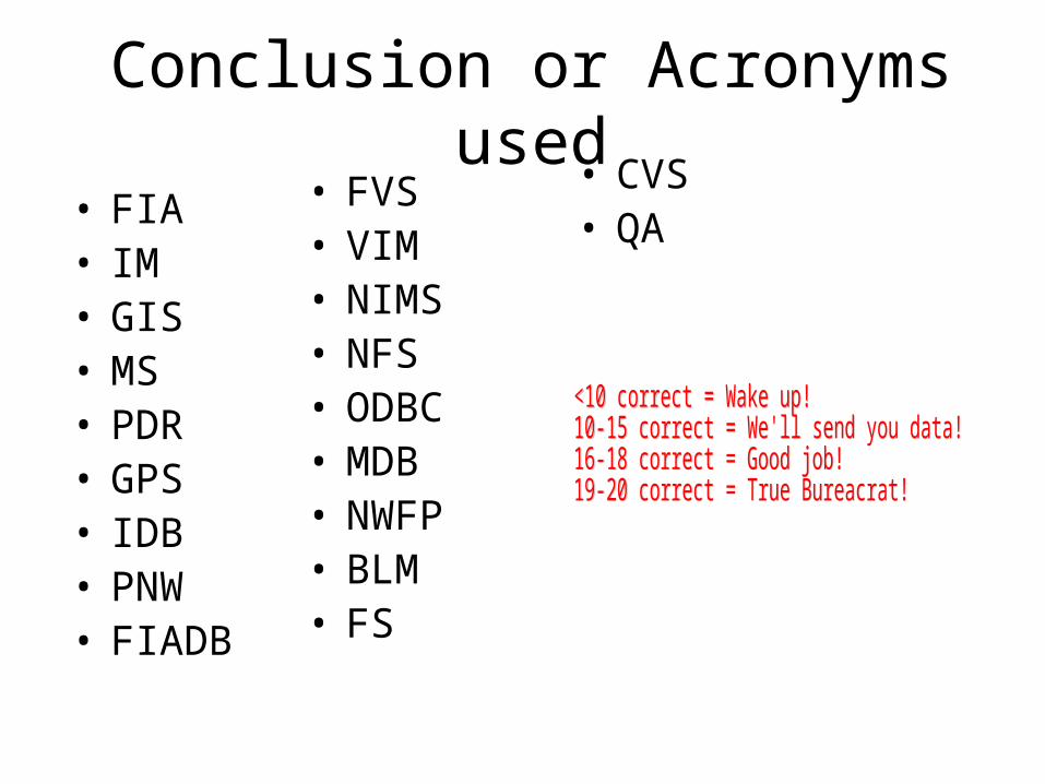
Conclusion or Acronyms used
• FIA• IM• GIS• MS• PDR• GPS• IDB• PNW• FIADB
• FVS• VIM• NIMS• NFS• ODBC• MDB• NWFP• BLM• FS
• CVS• QA

GIS / REMOTE SENSING
SUPPORT OF FIELD DATA COLLECTION
CLIENT REQUESTS
SUPPORT OF ANALYSIS AND REPORTING TEAMS
SUPPORT OF NATIONAL FIA PROJECTS

GIS / REMOTE SENSING
SUPPORT OF FIELD DATA COLLECTION
CLIENT REQUESTS
SUPPORT OF ANALYSIS AND REPORTING TEAMS
SUPPORT OF NATIONAL FIA PROJECTS

GIS / REMOTE SENSING
SUPPORT OF FIELD DATA COLLECTION
CLIENT REQUESTS
SUPPORT OF ANALYSIS AND REPORTING TEAMS
SUPPORT OF NATIONAL FIA PROJECTS
PLANNING AND FIELD NAVIGATION MAPS
MAINTENANCE OF PLOT GRID AND COORDINATES

GIS / REMOTE SENSING
SUPPORT OF FIELD DATA COLLECTION
CLIENT REQUESTS
SUPPORT OF ANALYSIS AND REPORTING TEAMS
SUPPORT OF NATIONAL FIA PROJECTS

GIS / REMOTE SENSING
SUPPORT OF FIELD DATA COLLECTION
CLIENT REQUESTS
SUPPORT OF ANALYSIS AND REPORTING TEAMS
SUPPORT OF NATIONAL FIA PROJECTS
ANALYSIS PROJECTS – BIOSUM, FOR EXAMPLE
MAPS FOR PUBLICATIONS AND MEETINGS
TRAINING IN ARCGIS

GIS / REMOTE SENSING
SUPPORT OF FIELD DATA COLLECTION
CLIENT REQUESTS
SUPPORT OF ANALYSIS AND REPORTING TEAMS
SUPPORT OF NATIONAL FIA PROJECTS

GIS / REMOTE SENSING
SUPPORT OF FIELD DATA COLLECTION
CLIENT REQUESTS
SUPPORT OF ANALYSIS AND REPORTING TEAMS
SUPPORT OF NATIONAL FIA PROJECTS
NATIONAL BIOMASS MAP
NATIONAL FOREST TYPE MAP

GIS / REMOTE SENSING
SUPPORT OF FIELD DATA COLLECTION
CLIENT REQUESTS
SUPPORT OF ANALYSIS AND REPORTING TEAMS
SUPPORT OF NATIONAL FIA PROJECTS

GIS / REMOTE SENSING
SUPPORT OF FIELD DATA COLLECTION
CLIENT REQUESTS
SUPPORT OF ANALYSIS AND REPORTING TEAMS
SUPPORT OF NATIONAL FIA PROJECTS
PLOT CONFIDENTIALITY
PLOT COORDINATE AVAILABILITY

PLOT CONFIDENTIALITY
PLOT COORDINATE AVAILABILITY
THE RULES ARE PRETTY MUCH STILL THE SAME – YOU NEED FORMAL AUTHORIZATION TO ACCESS THE ACTUAL PLOT COORDINATES. THE FUZZED COORDINATES ARE PUBLICALLY AVAILABLE.
ALL DATA UPLOADED TO FIADB CONTAINS FUZZED/SWAPPED COORDINATES, INCLUDING PERIODIC AND ANNUAL, AND ALL STATES

How can I keep up with all these changes??
fia.fs.fed.us – lots of info about FIA, links to FIADB
Dale Weyermann(503) [email protected]
PNW FIA access for confidentiality questions:
web access:
Elizabeth LaPoint(610) [email protected]
Forest Inventory and Analysis Spatial Data Services: