Embed Size (px)
Citation preview
AEG 60TH ANNUAL MEETINGFIELD TRIP GUIDEBOOK
Field Trip #4: Industrial Minerals Mining and
Geology in the Royal Gorge RegionSeptember 16, 2017
Field Trip Leaders: David Bieber, Martin/Marietta
Tom Newman, LafargeHolcim Inc.
Photograph Courtesy of Royal Gorge Route Railroad
AEG FIELD TRIP INDUSTRIAL MINERALS MINING AND GEOLOGY IN THE ROYAL GORGE REGION
Road Log and Field Trip Guide
!
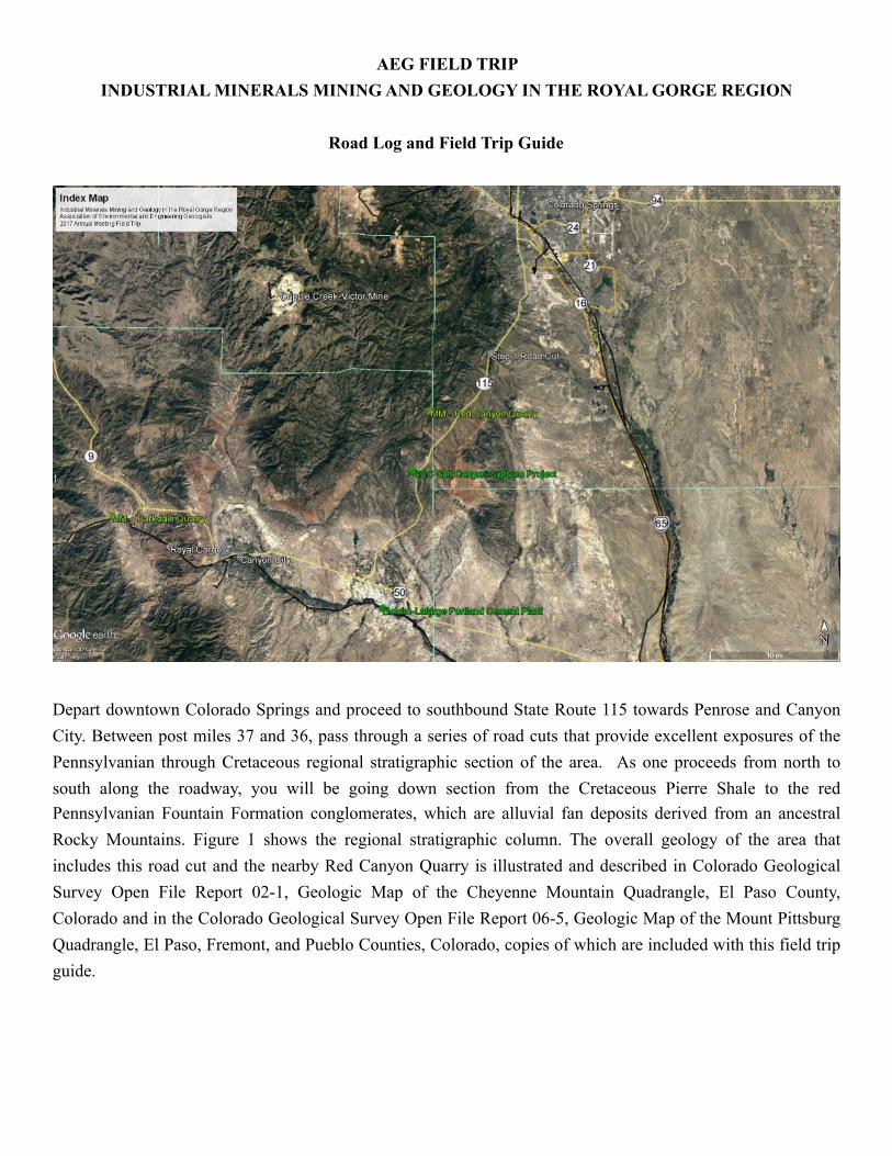
Depart downtown Colorado Springs and proceed to southbound State Route 115 towards Penrose and Canyon City. Between post miles 37 and 36, pass through a series of road cuts that provide excellent exposures of the Pennsylvanian through Cretaceous regional stratigraphic section of the area. As one proceeds from north to south along the roadway, you will be going down section from the Cretaceous Pierre Shale to the red Pennsylvanian Fountain Formation conglomerates, which are alluvial fan deposits derived from an ancestral Rocky Mountains. Figure 1 shows the regional stratigraphic column. The overall geology of the area that includes this road cut and the nearby Red Canyon Quarry is illustrated and described in Colorado Geological Survey Open File Report 02-1, Geologic Map of the Cheyenne Mountain Quadrangle, El Paso County, Colorado and in the Colorado Geological Survey Open File Report 06-5, Geologic Map of the Mount Pittsburg Quadrangle, El Paso, Fremont, and Pueblo Counties, Colorado, copies of which are included with this field trip guide.
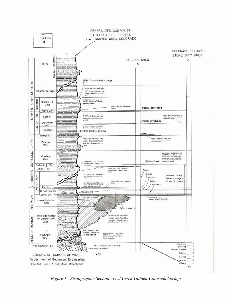
! Figure 1 - Stratigraphic Section - Owl Crrek-Golden-Colorado Springs.
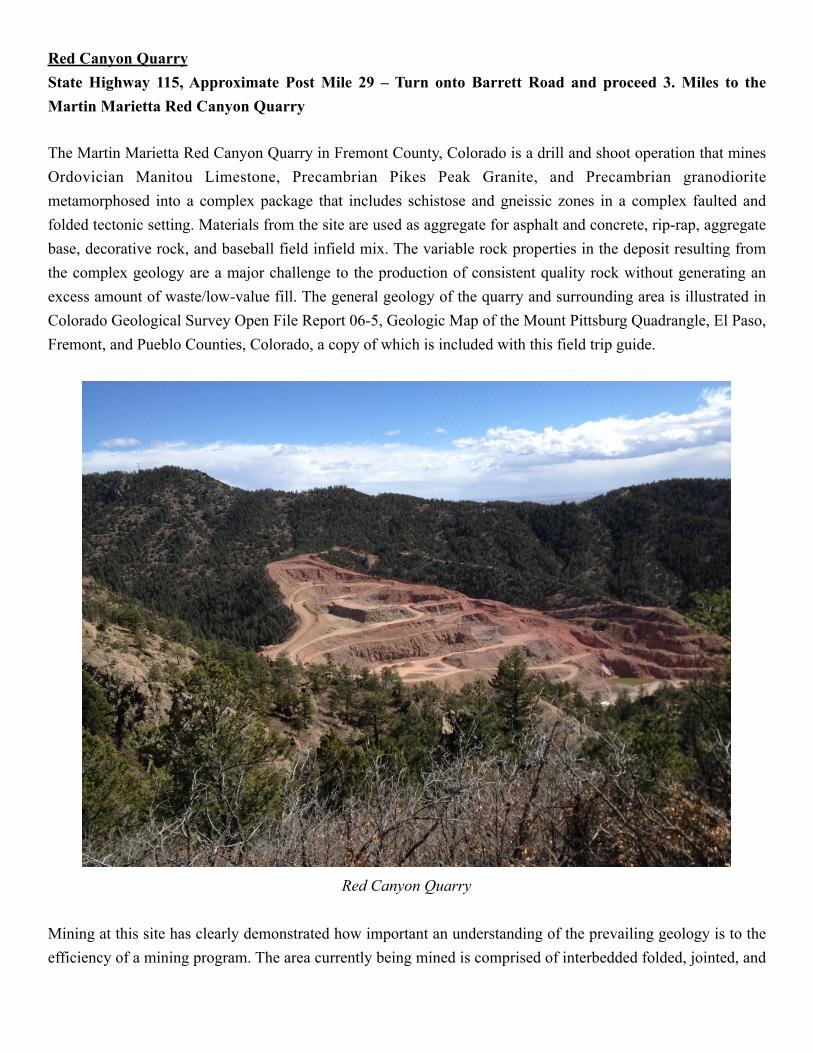
Red Canyon Quarry State Highway 115, Approximate Post Mile 29 – Turn onto Barrett Road and proceed 3. Miles to the Martin Marietta Red Canyon Quarry
The Martin Marietta Red Canyon Quarry in Fremont County, Colorado is a drill and shoot operation that mines Ordovician Manitou Limestone, Precambrian Pikes Peak Granite, and Precambrian granodiorite metamorphosed into a complex package that includes schistose and gneissic zones in a complex faulted and folded tectonic setting. Materials from the site are used as aggregate for asphalt and concrete, rip-rap, aggregate base, decorative rock, and baseball field infield mix. The variable rock properties in the deposit resulting from the complex geology are a major challenge to the production of consistent quality rock without generating an excess amount of waste/low-value fill. The general geology of the quarry and surrounding area is illustrated in Colorado Geological Survey Open File Report 06-5, Geologic Map of the Mount Pittsburg Quadrangle, El Paso, Fremont, and Pueblo Counties, Colorado, a copy of which is included with this field trip guide.
! Red Canyon Quarry
Mining at this site has clearly demonstrated how important an understanding of the prevailing geology is to the efficiency of a mining program. The area currently being mined is comprised of interbedded folded, jointed, and
highly fractured schistose and gneissic rocks. The degree of fracturing varies with the mica content of the rocks, which also affects each rock type’s suitability for use as concrete or asphalt aggregate. The more schistose rocks with a higher mica content are weaker and more fractured. The previous operator of the quarry had oriented the mining benches roughly perpendicular to the axis of the valley at which the quarry is located, without regard to the prevailing geology. Blasting was also conducted on a one size fits all approach where shot holes were loaded with equal amounts of explosive without regard to the type of rock the shot hole was drilled in. This approach led to excessive rock fragmentation in weaker rock masses and an excess of oversize material too large to fit in the onsite primary crusher in the most competent rock types. The current quarry manager has been reorienting the mining benched so that they are parallel to the dominant jointing planes within the rock mass. This orientation takes advantage of the natural planes of weakness in the rock, so reduces the quantity of explosive needed to achieve efficient breakage without creating as much pulverization of the rock. Shot holes are also differentially loaded based on the type of rock present. This approach to mining has reduced the percent of waste/low value material generated by approximately 15 to 30 percent.
The Ordovician Manitou Limestone is mined on the site for use as a decorative rock. It is used for landscape boulders, gravel, and the fines are used to make infield mix for baseball fields.
The current processing plant is undersized for being able to produce the volume of material for which the quarry is permitted, and will eventually be replaced. However, it provides a good opportunity to observe the general processes used to manufacture various hardrock aggregate products.
Portland Limestone Mine and Cement Production Facility. Participants will be guided through Holcim's cement on-site quarries where limestone from the Cretaceous Fort Hays Member of the Niobrara Formation is mined as the principal raw ingredient, and the Cretaceous Codell Sandstone is mined for use as a silica additive. Pyrite nodules and fossils may be collected from spoils piles of the Niobrara Formation. The Fort Hays Member is the principal target of the horizontal drilling programs in the Denver Basin and the quarry provides one of the best local exposures of the Fort Hays.
Holcim’s Portland cement plant is the first in the United States to use solar panels to help provide power to the plant. A total of 528 solar panels produce an estimated 156,201 kW/hr of power – enough to power the administrative offices.
The tour continues as our group is guided through the cement quarry to see the massive blending hall, corrective raw material silos, and operations control room. Cement manufacturing is one of the most complex processes in the industrial minerals industry. The tour will be an excellent time to fully understand its manufacture.
How is cement made. Portland cement is the basic ingredient of concrete. Concrete is formed when portland cement creates a paste with water that binds with sand and rock to harden. Cement is manufactured through a closely controlled chemical combination of calcium, silicon, aluminum, iron and other ingredients. Common materials used to manufacture cement include limestone, shells, and chalk or marl combined with shale, clay, slate, blast furnace slag, silica sand, and iron ore. These ingredients, when heated at high temperatures form a rock-like substance that is ground into the fine powder that we commonly think of as cement.
Bricklayer Joseph Aspdin of Leeds, England, first made portland cement early in the 19th century by burning powdered limestone and clay in his kitchen stove. With this crude method, he laid the foundation for an industry that annually processes literally mountains of limestone, clay, cement rock, and other materials into a powder so fine it will pass through a sieve capable of holding water. Cement plant laboratories check each step in the manufacture of portland cement by frequent chemical and physical tests. The labs also analyze and test the finished product to ensure that it complies with all industry specifications.
The most common way to manufacture portland cement is through a dry method. The first step is to quarry the principal raw materials, mainly limestone, clay, and other materials. After quarrying the rock is crushed. This involves several stages. The first crushing reduces the rock to a maximum size of about 6 inches. The rock then goes to secondary crushers or hammer mills for reduction to about 3 inches or smaller. The crushed rock is combined with other ingredients such as iron ore or fly ash and ground, mixed, and fed to a cement kiln.
The cement kiln heats all the ingredients to about 2,700 degrees Fahrenheit in huge cylindrical steel rotary kilns lined with special firebrick. Kilns are frequently as much as 12 feet in diameter—large enough to accommodate an automobile and longer in many instances than the height of a 40-story building. The large kilns are mounted with the axis inclined slightly from the horizontal. The finely ground raw material or the slurry is fed into the higher end. At the lower end is a roaring blast of flame, produced by precisely controlled burning of powdered coal, oil, alternative fuels, or gas under forced draft. As the material moves through the kiln, certain elements are driven off in the form of gases. The remaining elements unite to form a new substance called clinker. Clinker comes out of the kiln as grey balls, about the size of marbles.
Clinker is discharged red-hot from the lower end of the kiln and generally is brought down to handling temperature in various types of coolers. The heated air from the coolers is returned to the kilns, a process that saves fuel and increases burning efficiency. After the clinker is cooled, cement plants grind it and mix it with small amounts of gypsum and limestone. Cement is so fine that 1 pound of cement contains 150 billion grains. The cement is now ready for transport to ready-mix concrete companies to be used in a variety of construction projects.
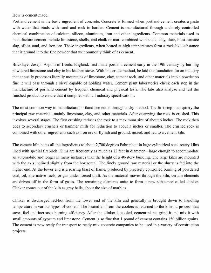
Although the dry process is the most modern and popular way to manufacture cement, some kilns in the United States use a wet process. The two processes are essentially alike except in the wet process, the raw materials are ground with water before being fed into the kiln.
! Holcim Lafarge’s Portland, Colorado, Cement Plant
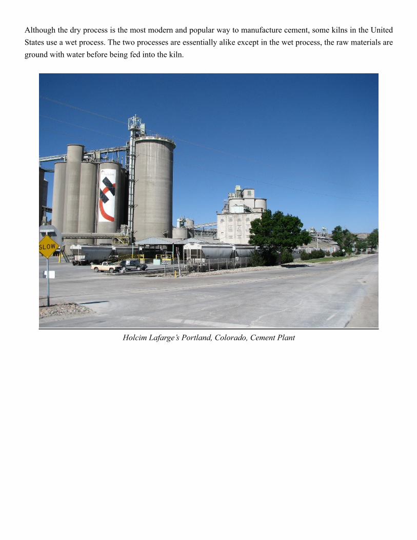
Royal Gorge Railroad
! Rock and Rail Railroad train hauling material from the Parkdale Quarry through Royal Gorge.
The Royal Gorge Railroad shares the trackway through the Royal Gorge with the Rock and Rail Railroad, both of which were established in 1998. The Rock and Rail Railroad was purchased by Martin Marietta in 2015, along with the Parkdale Quarry. Over 95-percent of the aggregate materials that leave the Parkdale Quarry are transported through Royal Gorge by the Rock and Rail Railroad. Rock and Rail transports the aggregate materials to the Pueblo Colorado rail yards. The Rock & Rail Railroad train crew hands the train off to crews from the Union Pacific Railroad or Burlington Northern Santa Fe Railroad for transport to Martin Marietta sales locations in Colorado, Kansas, or wherever else it may be needed.
Royal Gorge Railroad - A History of Rivals Amid Scenic Splendor (Copied from the railroad website at https://royalgorgeroute.com/about-us/history/)
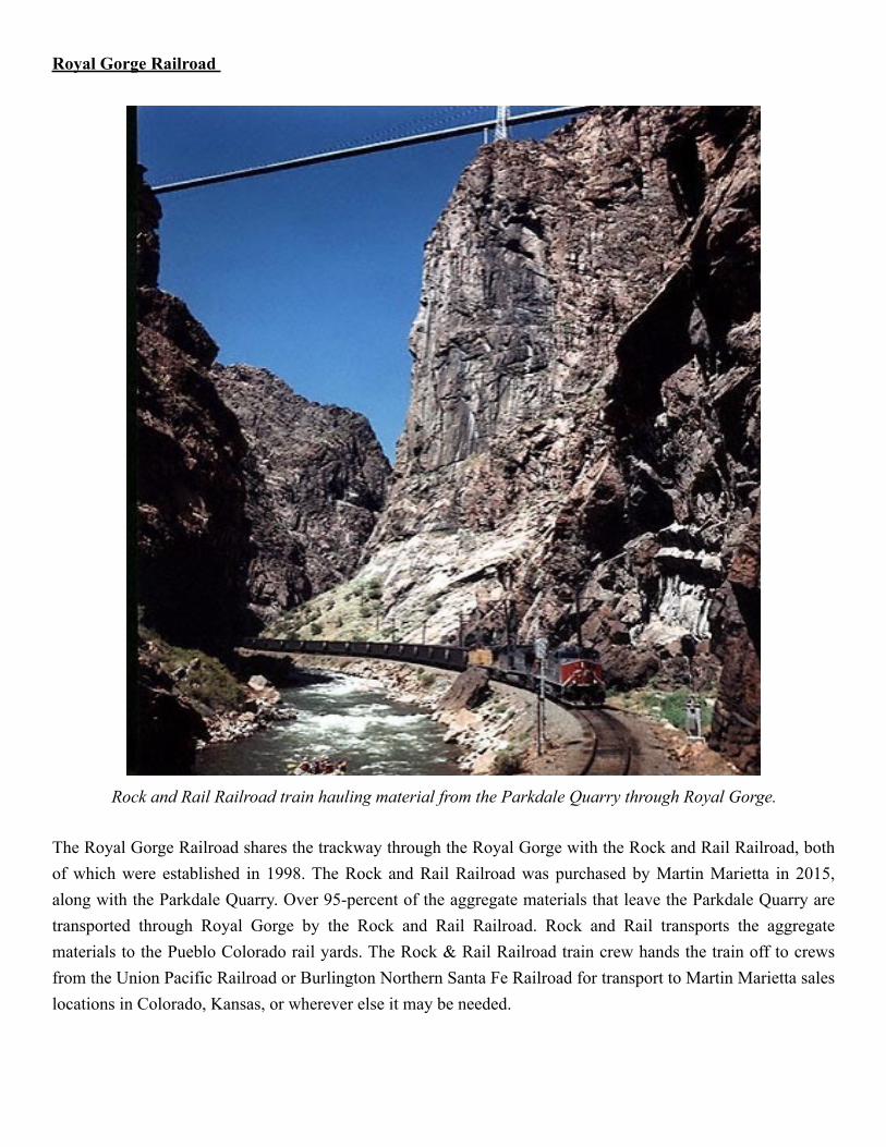
Silver! In the late 1870s miners descended on the upper Arkansas Valley of Colorado in search of carbonate ores rich in lead and silver. The feverish mining activity in what would become the Leadville district attracted the attention of the Denver & Rio Grande and the Santa Fe railroads, each already having tracks in the Arkansas valley. The Santa Fe was at Pueblo, and the D&RG near Canon City some 35 miles west. Leadville was over 100 miles away. For two railroads to occupy a river valley ordinarily was not a problem, but west of Canon City was an incredible obstacle – an obstacle that would result in a war between the railroads in the race to the new bonanza.
West of Canon City the Arkansas River cuts through a high plateau of igneous rocks forming a spectacular steep-walled gorge over a thousand feet deep. At its narrowest point sheer walls on both sides plunge into the river creating an impassible barrier. On April 19, 1878, a hastily assembled construction crew from the Santa Fe began grading for a railroad just west of Canon City in the mouth of the gorge. The D&RG whose end of track was only ¾ of a mile from Canon City raced crews to the same area, but were blocked by the Santa Fe graders in the narrow canyon. By a few hours they had lost the first round in what became a two-year struggle between the two railroads that would be known as the Royal Gorge War.
The D&RG crews tried leapfrogging the Santa Fe grading crews, but were met with court injunctions from the Santa Fe in the contest for the right-of-way. The D&RG built several stone “forts” (such as Fort DeRemer at Texas Creek) upstream in an attempt to block the Santa Fe. Grading crews were harassed by rocks rolled down on them, tools thrown in the river and other acts of sabotage. Both sides hired armed guards for their crews. Rifles and pistols accompanied picks and shovels as tools. The railroads went to court with each trying to establish their primacy to the right of way. After a long legal battle that ended in the U.S. Supreme Court, on April 21, 1879, the D&RG was granted the primary right to build through the gorge that in places was wide enough at best for only one railroad.
The Santa Fe resorted to its larger corporate power and announced it would build tracks parallel to and in competition with the existing D&RG lines. The bondholders of the D&RG, fearing financial ruin from this threat, pressured the management of the D&RG to lease the existing railroad to the Santa Fe for a 30-year period. This created a short-lived truce in the struggle. The Santa Fe soon manipulated freight rates south of Denver to favor shippers from Kansas City (over its lines to the east) to the detriment of Denver merchants and traffic over the leased D&RG lines. During this period the Santa Fe constructed the railroad through the gorge itself. The D&RG, however, continued construction in areas west of the gorge still trying to block the Santa Fe.
After months of shrinking earnings from their leased railroad, the D&RG management went to court to break the lease. An injunction from a local court restraining the Santa Fe from operating the D&RG on June 10, 1879, sparked an armed retaking of their railroad by D&RG crews – war in earnest in the old west. Trains were
commandeered, depots and engine house put under siege, bullets flew and a few men died. A final peace in the war came after the intervention of the Federal courts, and the railroad “robber baron” Jay Gould who loaned the D&RG $400, 000 and announced the intention to complete a rail lime in competition to the Santa Fe from St. Louis to Pueblo. On March 27, 1880, the two railroads signed what was called the “Treaty of Boston” which settles all litigation, and gave the D&RG back its railroad. The D&RG paid the Santa Fe $1.8 million for the railroad it had built in the gorge, the grading it had completed, materials on hand and interest. The Royal Gorge War was over. D&RG construction resumes, and rails reached Leadville on July 20, 1880.
Hanging Bridge An interesting part of the Santa Fe construction through the gorge is the hanging bridge at a point where the gorge narrows to 30 feet. Here the railroad had to be suspended over the river along the north side of the gorge as sheer rock walls go right down into the river on both sides. C. Shallor Smith, a Kansas engineer, designed a 175-ft plate girder suspended on one side by “A” frame girders spanning the river and anchored to the rock walls. The bridge cost $11,759 in 1879, a princely sum in those days. Although it has been strengthened over the years, this unique structure has served on a main rail line for over 118 years.
Passenger Service Ends Through the Royal Gorge (Taken from the Green Light Vol. 28, No. 5 Published monthly by the Denver & Rio Grande Western Railroad August, 1967) The Colorado Public Utilities Commission (PUC) granted the Rio Grande railroad authority to discontinue trains No. 1 and No. 2, the daily passenger trains between Denver and Salida, on July 28. This authority meant the last run of the two trains would be on July 27.
The first passenger train arrived at Salida in 1880. In 1882 the Royal Gorge route became a transcontinental rail link between Denver and Salt Lake. The first rails laid were “slim gauge,” 36″ between rails; later it was standard gauged to 4’81/2″ between rails to facilitate the movement of foreign line cars.
The Grand Canyon of the Arkansas River, known as the Royal Gorge, was one of the highlights on the route through the Rockies. The Denver & Rio Grande was then known as the Scenic Line of the World. When surveying parties first examined the route, it seemed impossible to construct a railway through the rugged canyon. The perpendicular granite walls scarcely left room for the river. Blasting away the obstructions, a roadbed was constructed hugging the canyon walls. As the railway progressed, the rugged canyon walls grew higher and higher, the river became a raging torrent to the sea, and areas the sun could not penetrate. At the narrowest point, which is 30 feet wide, a long, iron bridge was suspended from the smooth canyon walls. This became the famed hanging bridge. Passenger trains have stopped at this point for decades to allow passenger to alight and marvel at the sights and sounds of nature and see how man had conquered one of nature’s obstacles. The walls of the canyon at this point rise 2,600 feet above the track.
During the 1890’s, four transcontinental passenger trains a day passed through the Royal Gorge. The original route between Denver and Salt Lake went over Marshall Pass, through Gunnison, Montrose, and Grand
Junction. Later, the main line was constructed over Tennessee Pass through Glenwood Springs and into Grand Junction. With the opening of the Moffat Tunnel in 1928, passengers could go either way to Salt Lake. If they chose the Royal Gorge route, they would leave early in the morning arriving at Grand Junction in time for their train to be combined with the overnight Prospector for the run into Salt Lake. Planes, with their faster schedules, automobiles, for the independent traveler, and buses, were the downfall of the Royal Gorge, as passengers took to other forms of transportation.
The last segment of this famous train was between Denver and Salida. April 1 was the crowning blow, when the U.S. Post Office Department cancelled the mail contract on this train, leaving the Rio Grande with empty head-end cars and coaches. The handwriting was on the wall. Authority was soon forthcoming for discontinuance of the Royal Gorge trains No. 1 and No.2. On July 26, 56 passengers and 34 Head Start children boarded train No. 1 at Denver. The children, many having their first train ride, detrained at Littleton. Passengers boarded the train at every station along the way that day.
Arriving at Cañon City, 104 passengers got on the train for the ride through the Royal Gorge, getting off at Parkdale, the first stop beyond the hanging bridge. Over 300 passengers had ridden the train the day before it was to be discontinued. Arrival at Salida saw 171 passengers still on board. To many at the depot, the alighting mass brought back memories of days of long ago. For the final run of No.2 out of Salida, 120 persons found their seats in the three coaches. The trip was uneventful except for the feeling of nostalgia that prevailed at a time like this. Each one on the train knew they were part of Rio Grande history, being made on the last trip through the Gorge from the west.
The Royal Gorge Route Railroad was reestablished in the fall of 1998 and has become a premier destination attraction carrying over 100,000 guests through the Royal Gorge each year. Our vision is to provide a quality experience, combining the spectacular scenery of the Royal Gorge, the nostalgia of 1950’s train travel, with unique dining options and exceptional service. The Royal Gorge Route has been instrumental in preserving this breathtaking canyon and ensuring a vital part of Colorado history will be passed along to the next generation. Why do so many people ride the train? We are not a theme park or carnival experience. We do not offer thrill rides, but instead have grown as a major destination attraction through ensuring the Royal Gorge remains a special place and should be preserved much like any one of our National Parks. We believe riding the rails through the Royal Gorge and spotting Big Horn Sheep, Blue Heron, Bald Eagles, and enjoying the tumbling Arkansas River with your family or special someone is a very unique experience. The train provides the means to unwind, enjoy family time and Mother Nature up close.
When we began operating trains through the Royal Gorge, we had 5-coach cars and one class of service. Our dream was to introduce levels of service not seen in the rail industry. We were met with much pessimism as many thought attracting travelers both from the international and national markets to the Royal Gorge region who would enjoy a high quality culinary experience impossible. Now, after 11-years we find other rail lines attempting to copy our “recipe for success.”
THE ORIGIN OF THE ROYAL GORGE
By Dr. Don B. Gould, Assistant Professor of Geology,
Colorado College.
The Royal Gorge of the Arkansas River, in Colorado, is a bottleneck for the upper Arkansas Valley; it is a deep and unusually narrow canyon which cuts across the grain of the Rocky Mountains. The Rocky Mountains have a grain, something like a piece of wood. This is shown by the northwest-southeast trend of the main ranges. Between the ranges are lower areas, in which several major rivers have their source. The Arkansas River heads in one of these linear depressions in central Colorado, being fed by the melting snows of the Sawatch Range on the west, and the Mosquito Range on the east. The crests of these parallel ranges are about 15 miles apart, and their peaks rise more than a mile above the valley to elevations greater than 14,000 feet.
The upper Arkansas Valley is relatively open and conforms perfectly to the grain of the Rockies. From Tennessee Pass, at the north end of the Sawatch Range, the river flows southeastward for about 75 miles to a point below Salida, following the "straight and narrow path." But here, in spite of topographic and geologic arguments that the river should continue to follow the grain of the Rockies, it makes a sharp right angle turn to the northeast and flows "cross-grained" for about 30 miles through a granite-walled canyon which gets narrower and deeper downstream. The narrowest and deepest part of this canyon is known as the Royal Gorge. The Gorge opens abruptly onto the flat lowlands surrounding Canon City, where the Arkansas River begins its long journey eastward across the plains.
To visitors who look down into the Royal Gorge from its rim, the Arkansas River far below looks so small and insignificant that it seems incapable of cutting such a deep gash into the earth's surface. It is not surprising that these visitors occasionally suggest that the gash must have been opened by a mighty earthquake. To passengers on the railroad, which follows the bottom of the Gorge, the river is much more impressive as it rushes turbulently through the narrow passage. Those who realize the cutting power of sand-laden water are willing to concede the ability of the Arkansas River to saw its way down through the hard rocks of the canyon walls.
Several phases of the history of the Royal Gorge and the upper Arkansas Valley are not fully known, but geologists agree that the Gorge has been formed by the incessant grinding of pebbles and sand grains against the river bed as they are carried along by the stream. But why is the Gorge so deep, and why so narrow in relation to its depth, and in relation to its much greater width upstream and downstream? These questions can be answered more clearly after a detailed examination of the Gorge and the land surface in its vicinity.
At its narrowest point, the Gorge is approximately 1,250 feet wide and 1,050 feet deep; its walls consist of granite and gneiss of pre-Cambrian age. On each side of the Gorge a gently rolling plateau extends away from the rim for several miles. Rising above this plateau on the north are hills which represent the southernmost
extension of the Front Range, and on the south rises the northern end of the Wet Mountains. Both of these ranges have been pushed up and later eroded sufficiently to expose the granite core which is typical of Rocky Mountain ranges. The Royal Gorge Plateau is a connecting link which ties these two ranges together, since the granite and gneiss of the Gorge walls are continuous with the great masses of similar rocks which make up the cores of the two ranges.
The Front Range extends from the Royal Gorge northward to the Wyoming line. Throughout its length, most of its summit area is a relatively flat upland, above which the higher peaks of the range, such as Long's Peak and Pike's Peak, rise to elevations greater than 14,000 feet. At the southern end of the range the flat upland has an elevation of approximately 10,000 feet, and this portion has been dissected by stream erosion to form the hills which rise above the Royal Gorge Plateau. The elevation of the plateau is approximately 6,600 feet; the Gorge itself has been cut more than 1,000 feet below the plateau.
To illustrate these facts and figures more clearly, suppose that a passenger got off the railroad at the bottom of the Royal Gorge and started to walk to the summit of Pike's Peak. Leaving the Arkansas River, at an elevation of about 5,550 feet, he would have to clamber more than 1,000 feet up the steep canyon wall, and when he reached the rim he would be only 600 feet away from his starting point, measured horizontally. From the rim he would take off across the flat Royal Gorge Plateau to the northeast, at an elevation of about 6,600 feet, for nearly 3 miles, where he would enter the hilly tract resulting from the dissection of the southern end of the Front Range upland. After crossing the hilly area for about 15 miles, he would arrive at Cripple Creek, built on the upland at an elevation of nearly 10,000 feet. Leaving Cripple Creek, he would cross the upland surface of the Front Range for about 5 miles before beginning the steep ascent to the summit of Pike's Peak. In the next 4 miles of his journey, he would climb more than 4,000 feet to the summit of Pike's Peak at 14,110 feet above the sea.
The history of the Front Range has been investigated more thoroughly than that of any other range in the Rockies. Details have been added to this history by many workers since the masterly study by Davis 30 years ago, but the sequence of events is still recognized to be as he described them. Davis used the Front Range as an example of a two-cycle mountain range; this means that it has passed through one complete cycle of uplift and erosion, and is now in its second cycle, having been reelevated so as to revive the streams and put them back to work cutting canyons into the uplifed mass. The second cycle is sometimes called the canyon cycle.
The first uplift occurred during the folding of the Rockies, at the end of the Cretaceous period about 60,000,000 years ago. Streams carved the uplifted area into rugged ridges and valleys, and aided by weathering, eventually removed most of the land above the level of the streams, leaving a gently rolling surface. A few hills stood above this flat surface as much as 4,000 feet. Then a second uplift raised this face to its present elevation of 10,000 feet, probably during the Pliocene period about 10,000,000 years ago. Since that time, streams have been working away at their appointed task of removing everything above stream level, although most of them have
not progressed beyond the initial stage, which is the cutting of canyons. The foregoing summary of the history of the Front Range provides a background for the history of the Arkansas River and the Royal Gorge.
Prior to the second uplift, the Arkansas River was a major stream flowing in approximately its present location across the old erosion surface worn flat during the first cycle. It carried a large amount of water received from numerous tributaries. After the second uplift, which revived the drainage of the Rocky Mountain region, this large volume of water enabled the ancient Arkansas River to transport a heavy load of sand and gravel. Then, due to this combination of large volume and heavy load, it cut into its bed more effectively than did its tributaries, and rapidly passed through the canyon-cutting stage, after which it began to widen its valley. That is, it soon sawed its channel downward to the lowest point and the gentlest gradient at which a stream of that size could carry such a load, and then, by undercutting its banks as it swung from side to side in wide bends, it slowly ate away the walls of the canyon until a wide valley floor was established. This process continued until the valley floor, consisting of granite and gneiss and veneered with alluvium, was 5 or 6 miles wide. Upstream from the area of hard rocks, the valley was wider, and downstream in the soft rocks of the Great Plains, it was wider still.
This broad-valley, gentle-gradient condition would characterize the valley of the Arkansas River today, were it not for the occurrence of one more event of great importance - another uplift. This uplift began just before the Glacial period, possibly 1,000,000 years ago. Its effect was apparently local, since the entire Rocky Mountain region was not involved, as in the first and second uplifts. This third movement raised the area now occupied by the Royal Gorge Plateau along an axis which lay directly athwart the course of the Arkansas River. The adjoining ranges to the north and south may have participated, but this is not certain. The rise of the old valley floor was probably intermittent, and fairly rapid, but slow enough for the downcutting of the river to keep pace with the uplift. By grinding away its bed, with the sand and gravel it carried, the river sawed a deep trench into the rising mass of granite. Slow as this process must have been according to human standards, it was much faster than the action of weathering by which canyons are normally widened. This trench is the Royal Gorge.
In short, the Royal Gorge was caused by the deep intrenchment of the Arkansas River into its rising valley floor so recently that weathering has not had time to widen the trench to normal canyon proportions. The complete history of the Arkansas River may be summarized into three stages:
1. Uplift of the Rockies at the end of the Cretaceous period, followed by stream erosion to a flat surface during the early Tertiary. The course of the Arkansas River was established at this time. 2. Reelevation of the Rocky Mountain region during the Pliocene period, followed by canyon-cutting. The Arkansas River passed through the canyon-cutting stage and developed a valley floor several miles wide. 3. Local uplift of the old valley floor in the Royal Gorge area began just before the Glacial period. Intrenchment of the Arkansas River into the rising mass to form the Royal Gorge.
Most of the many people who see the Royal Gorge each year probably do not realize that it has had a complex history, but all are impressed by its depth and scenic grandeur. The construction in recent years of a suspension bridge across the Gorge from rim to rim, and an inclined railway from the rim to the railroad platform at the bottom has increased the feasibility of seeing and appreciating the Gorge from all possible angles.
Many of the visitors have been passengers on the Denver and Rio Grande Western Railroad. This railroad, after overcoming many knotty engineering problems and legal difficulties, finally completed the water level railway route through the Rockies in 1880, by following the Arkansas River through the Royal Gorge. Officials of the railroad estimate that 7,800,000 people have passed through the Gorge during the 60-year period since trains started operating over this route. A large number of people visit the rim of the Gorge by automobile, as a side trip from U. S. Highway 50, about 10 miles from Canon City.
Parkdale Quarry
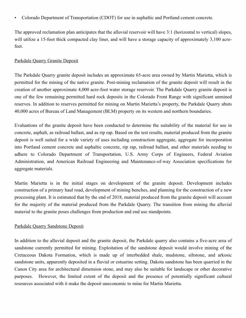
Leaving Canon City, proceed west on U.S. Highway 50 to Post Mile 266. The Parkdale Quarry is across the bridge on the north side of the Arkansas River.
! A rock train being loaded at the Parkdale Quarry.
The Parkdale Quarry is located in Fremont County, Colorado, approximately 12 miles west of Canon City. Permitted in 1998, the Parkdale Quarry was the last major hard rock quarry to be permitted on or near the Front
Range of Colorado. Martin Marietta purchased the Parkdale Quarry in 2015, and is the current quarry operator. The Parkdale Quarry contains reserves of Quaternary alluvium (alluvial deposit) and considerable reserves of Precambrian granite (granite deposit). An approximate five-acre area of Cretaceous Dakota sandstone (sandstone deposit) is also permitted for mining on the Parkdale Quarry. The Parkdale Quarry is Colorado’s only rail-served aggregate quarry. The quarry is unique in that it mines an alluvial deposit as a traditional sand and gravel operation and mines a hardrock deposit as a drill and shoot operation. The locations of the three deposits on the Parkdale Quarry are shown on the appended Parkdale Quarry Mining Area figure.
Martin Marietta is in the initial stages of pursuing a permit to mine the granite deposit on the United States Department of the Interior Bureau of Land Management (BLM) property north of the currently permitted reserves. Development of the Parkdale Quarry moving forward will require the coordination of resource development; reclamation activities; regulatory and permitting processes for expansion onto BLM lands; and plant/infrastructure modifications, additions, and upgrades.
Parkdale Quarry Alluvial Deposit
The Parkdale Quarry alluvial deposit is primarily comprised of material derived from granitic, gneissic, and amphibolite source rocks. The alluvial deposit was the initial deposit mined at the Parkdale Quarry, and as of September of 2017, had provided the majority of the material being mined on the site. Mining of the alluvial deposit was initially limited to the material above high groundwater. In 2008 the mine permit for the Parkdale Quarry was amended to allow the alluvial deposit to be excavated to bedrock, and to change the mine reclamation end use for the granite and alluvial deposits from agriculture/grazing to water storage. The alluvial deposit was deposited by the Arkansas River where Bighorn Sheep Canyon discharges to Webster Park. This material making up the alluvial deposit is graded in size and includes boulders in excess of 10 feet in diameter. The aggregate produced from the Parkdale alluvial deposit is some of the hardest in the region; a reflection of its transport history. The alluvial deposit was thought to be a glacial moraine deposit because of its poor sorting, the presence of large boulders in the deposit, and because it is topographically higher than the sedimentary deposits on its flanks. However, the deposit can be demonstrated to be deposited by a series of flood events. The flood events may have been the result of the breaking of ice dams upriver which allowed for the formation of density flows capable of transporting the boulders observed in the deposit and resulting in the poor sorting observed. The modern topography of the deposit is a result of inverse topography. The deposit was more resistant to erosion than the adjacent cretaceous shale and sandstone deposits, so streams entering Webster Park from drainages adjacent to the Arkansas eroded those softer materials on the flanks to form their channels.
Material produced from the alluvial deposit has been tested for, and is certified for use by the following agencies: • Federal Aviation Administration (FAA) for use as specialized fill; • The Kansas Department of Transportation for use in Portland cement concrete; • U.S. Army Corps of Engineers (USACE) for use as aggregate in at-grade Portland cement concrete; and
• Colorado Department of Transportation (CDOT) for use in asphaltic and Portland cement concrete.
The approved reclamation plan anticipates that the alluvial reservoir will have 3:1 (horizontal to vertical) slopes, will utilize a 15-foot thick compacted clay liner, and will have a storage capacity of approximately 3,100 acre-feet.
Parkdale Quarry Granite Deposit
The Parkdale Quarry granite deposit includes an approximate 65-acre area owned by Martin Marietta, which is permitted for the mining of the native granite. Post-mining reclamation of the granite deposit will result in the creation of another approximate 4,000 acre-foot water storage reservoir. The Parkdale Quarry granite deposit is one of the few remaining permitted hard rock deposits in the Colorado Front Range with significant unmined reserves. In addition to reserves permitted for mining on Martin Marietta’s property, the Parkdale Quarry abuts 40,000 acres of Bureau of Land Management (BLM) property on its western and northern boundaries.
Evaluations of the granite deposit have been conducted to determine the suitability of the material for use in concrete, asphalt, as railroad ballast, and as rip rap. Based on the test results, material produced from the granite deposit is well suited for a wide variety of uses including construction aggregate, aggregate for incorporation into Portland cement concrete and asphaltic concrete, rip rap, railroad ballast, and other materials needing to adhere to Colorado Department of Transportation, U.S. Army Corps of Engineers, Federal Aviation Administration, and American Railroad Engineering and Maintenance-of-way Association specifications for aggregate materials.
Martin Marietta is in the initial stages on development of the granite deposit. Development includes construction of a primary haul road, development of mining benches, and planning for the construction of a new processing plant. It is estimated that by the end of 2018, material produced from the granite deposit will account for the majority of the material produced from the Parkdale Quarry. The transition from mining the alluvial material to the granite poses challenges from production and end use standpoints.
Parkdale Quarry Sandstone Deposit
In addition to the alluvial deposit and the granite deposit, the Parkdale quarry also contains a five-acre area of sandstone currently permitted for mining. Exploitation of the sandstone deposit would involve mining of the Cretaceous Dakota Formation, which is made up of interbedded shale, mudstone, siltstone, and arkosic sandstone units, apparently deposited in a fluvial or estuarine setting. Dakota sandstone has been quarried in the Canon City area for architectural dimension stone, and may also be suitable for landscape or other decorative purposes. However, the limited extent of the deposit and the presence of potentially significant cultural resources associated with it make the deposit uneconomic to mine for Martin Marietta.
Salt Canyon Project gypsum mine
Leaving the Parkdale Quarry, proceed east on Highway 50 through Canon City, proceed west on U.S. Highway 50 to the Penrose exit and Highway 115 North. Proceed north approximately 10.8 miles on Highway 115 to the mine entrance on the west side of the road.
The Salt Canyon Gypsum Project was permitted in 1977 as a source for agricultural gypsum. However, the original permittee apparently never mined the deposit. The current operator, GCC Rio Grande, took over the mine and repermitted it in 2009 as a source of gypsum for the manufacture of Portland cement. The mine is operated as an open pit operation and material is excavated and stockpiled on the site using conventional earthmoving equipment. One sufficient material is stockpiled, it is transported to GCC’s cement plant in Pueblo, Colorado.
The source of the gypsum mined at the Salt Canyon Gypsum Project reported to be evaporates within the Jurassic Ralston Creek Formation. The gypsum beds within the Ralston Creek formation are thought to have been deposited in a shallow marine sabkha environment (Carter, M. H., 1984, Paleoenvironmental Analysis of the Ralston Creek Formation Within the Canon City Embayment, Canon City, Colorado: Unpublished M.S. Thesis, University of Oklahoma).