Embed Size (px)
Citation preview
CHAPTER 2
GEOLOGY, GEOMORPHOLOGY AND HYDROGRAPHY
2.0 INTRODUCTION
The area of study is encompassed by the Indian sub-
continent and the Arabian Sea. Hence, it is felt essential
to summarise here the relevant information about these areas
which will be of help in interpreting the results.
2.1 CLIMATE
The climate of the area has a regular variation and
the weather is more seasonal than in most parts of the
world. These seasons are :
The cool season, December to Mareh, when winds are
north-westerly and the weather is dry with little cloud
except in the south.
The hot season, April and May, when winds are light
and variable with sea breezes on the coast. Tropical cyclonic
storms (cyclones) may cross the Arabian Sea.
The southwest monsoon or rainy season, June to
115
September, the wind over the sea is between southwest and
west but mainly west to northwest along the coast.
2.2 ONSHORE
2.21 COASTAL FEATURES AND GEOLOGY
2.211 RIVERS - The Indus, the Narmada, the Tapti, the
Sabarmati and the Mahi are the major rivers in the adjacent
areas of the north-western continental shelf of India (Fig. 4).
These rivers drain a variety of geological formations cover-
ing vast drainage basins before deboiching onto the sea.
The Indus River rises over the Himalayas and flows over the
Pleistocene and Recent deposits for the major part before
entering the sea. The Narmada River flows mostly over the
Deccan Trap and the Quaternary deposits of the coastal areas.
The river rises in the Amarkantak Plateau and flows over the
marble rocks and widens into a estuary entering the Gulf of
Khambhat. The Tapti rises in the Satpura Hills and traverses
an extensive stretch of allUvium filling a deep basin. The
Sabarmati river rises in the Mewar Hills and enters the sea
at head of the Gulf of Khambhat. The Mahi River rises in
Gwalior region and flows through Dhar, Jhibua and Gujarat into
the Gulf of Kbambhat.
Besides these a number of medium and minor rivers are
there which become active during the monsoon and flow down the
Western Ghats into the sea (Rao, 1979).
16
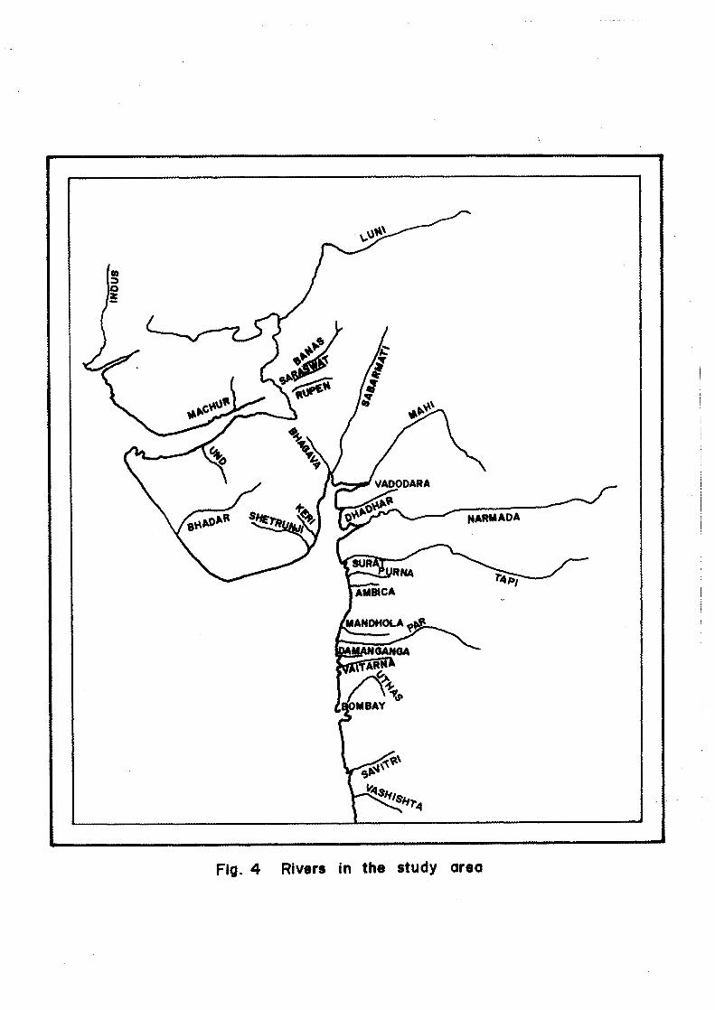
Fig. 4 Rivers in the study area
Medium Rivers : Shetrunji, Bhadar, Dhadhar, Puma, Ambica,
Vaiturna, Uthas and Savitri.
Minor Rivers : Lunt, Banas, Saraswati, Rupen, Machur, Und,
Kari, Bhagva, Mandhola, Par, Daman Ganga and Vashishti.
2.212 Morphology - The Indian coastline, including major
indentations and the shores of Islands, is about 9,000 km
long. About 55 per cent has beaches (spits, barriers or
sandy stretches on the shore). The total length of prograd-
ing shore including deltas, is about one-fourth of the
Indian coastline. The rest includes rocky overhanging cliff
or combinations of rocky and beach shore (Ahmed, 1972). In
particular the coastal features of the two states (Gujarat
and Maharashtra) bordering the north-western continental
shelf of India are described in the following paragraphs from
north to south (West coast of India Pilot, 1961, 1975).
Gujarat - The coastline of the state of Gujarat extends
from the eastern boundary of Pakistan and includes Kathiawar
Peninsula to the northern boundary of Daman (20° 24' N :
72°49' E).
The most striking physical feature of the State of
Gujarat is Ranns or salt marshes in the north-western part
of the state. The Rann of Kachchh (Great western Rann) lying
north of the district of the same name, is about 250 km long
and 128 km broad, with an estimated area of about 17,900 square
kilometres. The little Rann, at the head of the Gulf of
17
Kachchh is about 110 km in length and covers an area of
nearly 5,000 square kilometres. With the exception of some
of the smaller islands, where grass and a few stunted bushes
may be found, there is no sign of floral life. During the
southwest monsoon high tides cover the Ranns to a depth of
from 0.3 to 0.6 m. The little Rann is undergoing marked
changes, there is encroaching further east, making places
accessible to boats which were formerly dry. Kai Dongar,
the highest point in Kachchh about 465 m high stands out
from bed of the Ram of Kachchh.
Kachchh district is practically an island, being
almost entirely cut off from the mainland by Kori branch of
Indus River, the Rann of Kachchh and the Little Rana. On the
whole the country is treeless, barren and rocky with ranges
of hills and isolated peaks, but it contains many well filled
valleys. To the south, behind a high bank of sand that lines
the sea coast, there is a low, fertile land from 30 - 45 km
wide, inland of this a broad belt of hilly ground, from 150 m
to over 300 m high stretches east and west; Nanu or Nunnomar,
Krikubbah and Katrura are the principal submits.
Kathiawar peninsula, except in its northern part,
which is almost entirely flat is generally undulating with
low ranges of hills running in irregular directions. There
are extensive mountain tracts lying within about 60 km of its
southwest seaboard; Gir hills, north of Diu Head and Barda
Range, northeast of Porbandar, are the principal mountain
18
groups. The highest submit, however that of Gorakhnath
(Girnar) with an elevation of 1,116 m, lies about midway
between them.
Broach district forms an alluvial plain, sloping
gently west-ward, varying in breadth from 30 to 65 km; with
the exception of few hillocks of sand drift along the coast,
there is no rising ground. The soil is highly fertile and
well cultivated.
Narmada River, the only other major river of the
west coast of India, enters the sea through a wide estuary
40 km north of Tapti River.
Surat district consists of a broad alluvial plain,
with small hillocks of drifted sand fringing the greater
part of the coast, which in some parts is dry and barren,
and in others watered by springs. Through the springs of
the river mouths the tide flows up behind the barrier of
sand hills, and floods a large area of salt marshes. Beyond
spreads a belt of highly cultivated land, restricted by the
hills towards the south to a breadth of little more than 25
km, but with a width of about 95 km in the north, where
Tapti River forms a deep and fertile delta.
Maharashtra - The coast of the State of Maharashtra extends
along the Konkan coast between Daman in the north and Goa in
the south. The districts of Greater Bombay, Thana, Kolaba
19
Ratnagiri and Sindhdurg front the Konkan coast from north to
south. The Western Ghats, with general elevations from 600
to 900 m but with some peaks over 1,500 m high,run almost
parallel with the coast leaving a strip of land upto 95 km wide.
/ Th, lisLlict o `' Greater Bombay 1 ;3 , 19 0 1F, — and
72°42', 72°58'E) encompasses Bombay, South Salcette and Trombay
Island with an area of 603 sq. km . consists of mostly low
lands.
The 955.3 sq. km. coastal region of Thana district,
lying between 19°00', 20°22'N and 72°52', 73°45'E, consists
of a strip of low land intersected by hill tracks of upto
over 750 m high; the flat alluvial belt between Ulhas and
Vaitarna rivers is known as North Konkan. To the east and
northeast the country becomes elevated and wooded while, near
the coast, the land is low and fertile with abundant palm growth.
Kolaba district lying between 17°53', 19°08'N and
72°53', 73°42 'E, is very hilly, some of the hill being spurs
of considerable regularity and height, running west at right
angles to the main range, and the coast. The sea frontage
is mostly fringed by a belt of coconut and arecanut palms,
behind which lies a stretch of flat rice producing country.
Sindhdurg district and Ratnagiri lying between Savitri
River and Goa (15°32', 18°05'N and 73°02', 74°13'E) is generally
rocky and rugged; near the coast it consists of bare elevated
20
plateaus, intersected by numerous creeks and navigable rivers,
flowing between steep and lofty hills. About 15 km inland
the country becomes more open, but a little further it is
occupied by spurs of the Western Ghats. The coast is almost
uniformly rocky, and consists of small bays coves shut in
between jutting headlands, and edged with sand of dazzling
whiteness.
2.213 Geology - Along the coast of Kachchh a 5 - 16 km wide
strip is largely covered by alluvium consisting of wind blown
loam and sand underlain by clay. Between the alluvial belt
and the traps, there are two belts of Tertiaries roughly
parallel to the shore. The older beds consist of clays and
limestones of Eocene age. The younger beds are sandstones and
clays ranging in age from lower Miocene to Pliocene (Ahmed, 1972).
Occurrence of Miliolite rocks is also reported from Kachchh
but no outcrops are seen along the coast (Biswas, 1971).
Deccan Traps occur very close to shore in northern
part of Kathiawar coast, while in other areas the traps recede
to the interior. Along the southwest coast from Porbandar to
Veraval miliolites are extensively exposed along the coast
and extend 30 to 40 km inland. The formation over the
Pliocene and Miocene rocks directly overlies the Deccan Traps
towards the north and east. On the coast, their thickness
increase appreciably and these form a thick wedge against the
older traps. Along the southern part of the coast, the thickness
21
of the miliolite formation has been estimated to be 60 m or
more (Biswas, 1971). The formation is marked by thin bedding
oblique lamination and a gently seaward dip of 5 - 15° . The
miliolite is coarser near the shore but becomes progressively
finer grained with increasing distance from the shores
(Krishnaswamy, 1972).
On the south Gujarat coast, the rivers Mahi, Tapti,
and Narmada form broad and fertile alluvial plain at their
confluence with the sea. The plain covers a greater part of
Surat, Broach and Ahmedabad districts. It extends from the
Rann of Kachchh to just south of Daman. In the north it
joins the recent deposits of the Indus Valley (Lele, 1973).
Cambay trough runs nearly north-south and it is
bounded by faults on its eastern and western sides. The
Deccan Traps which are exposed at the surface on both the
sides of the trough, in Kathiawar and Baroda areas, have been
faulted down to a depth of over 1800 m in the trough. The
traps are covered by a full succession of Tertiaries. The
Tertiaries between Broach and Surat are capped with laterites.
A number of small detached outcrops of Bagh beds (Cretaceous)
occur along the east-west trending Narmada Valley from Bagh
to beyond Baroda. The formations are cherts, impure shelly
limestones, quartzitic sandstones and shales (Wadia, 1970,1975).
22
On Konkan Coast from Daman to Vijaydurg, Ratnagiri
District, the Deccan Traps is the dominant geological formation
and extends upto the coast and possibly continue to the shelf
also. The lava flows at some places are separated by thin
beds of lacustrine or fluviatile sediments (Wadia, 1970,1975).
The traps usually consist of basalt or dolerite. The most
common being a dark green or nearly black normal augite basalt
without olivine and often with significant assembly of basic
glass. The rocks do not vary in its composition over wide areas.
Most of the varieties are homogenous, hard and compact
(Pascoe, 1964) but some are vesicular and scoriaceous. The
amygdaloidal cavities are filled up by numerous secondary
minerals like; calcite, quartz and zeolites. The quartzites
are magascopically uniform micaceous (usually biotite) which
give rise to a feeble schistosity. The quartzites are dark
grey to whitish grey and buffish white fine to coarse grained
and massive to well stratified. Massive milky white quartz
veins are seen cutting across the quartzites at many places.
The quartzites have been intruded by quartz veins and basic
dykes.
A laterite of variable thickness caps the geological
formations along the coast. The laterite covers almost the
entire track except very steep slopes, rivers, valleys and
the alluvial area.
23
2.3 OFFSHORE
2.31 ARABIAN SEA
2.311 Boundary, Structure and Sediments - The Arabian
Sea is bordered by arid land masses; the Horn of Africa,
the Arabian Peninsula and the Iran-Makran-Thar Desert
regions towards the west and north and by the coastal
highlands of western India towards the east. According
to the International Hydrographic Bureau (Sp. PUbl. 23,
1953 IN Robinson, 1966) the geographic boundaries of the
Arabian Sea are established in the south-west by a line
from Ras Hafun (Somalia) to Addu Atoll, thence up the
western edge of the Maldives and Laccadives to Sadashivgad
Light on the west coast of India (14 ° 48' N : 74° 07' E).
From an oceanographic point of view, Schott (1935 IN Robinson,
1966) bounded the Arabian Sea as follow : the southern
boundary runs from the Indian coast near Goa, along the
west side of Laccadive Islands to the equator, then it tends
slightly to the south to a point on the East Africa coast
near Mombasa at approximately 5o S latitude. According to
Le Pichon and Heirtzlar(1968) and Mckenzie and Sclater (1971)
the Arabian Sea is formed as a result of seafloor spreading.
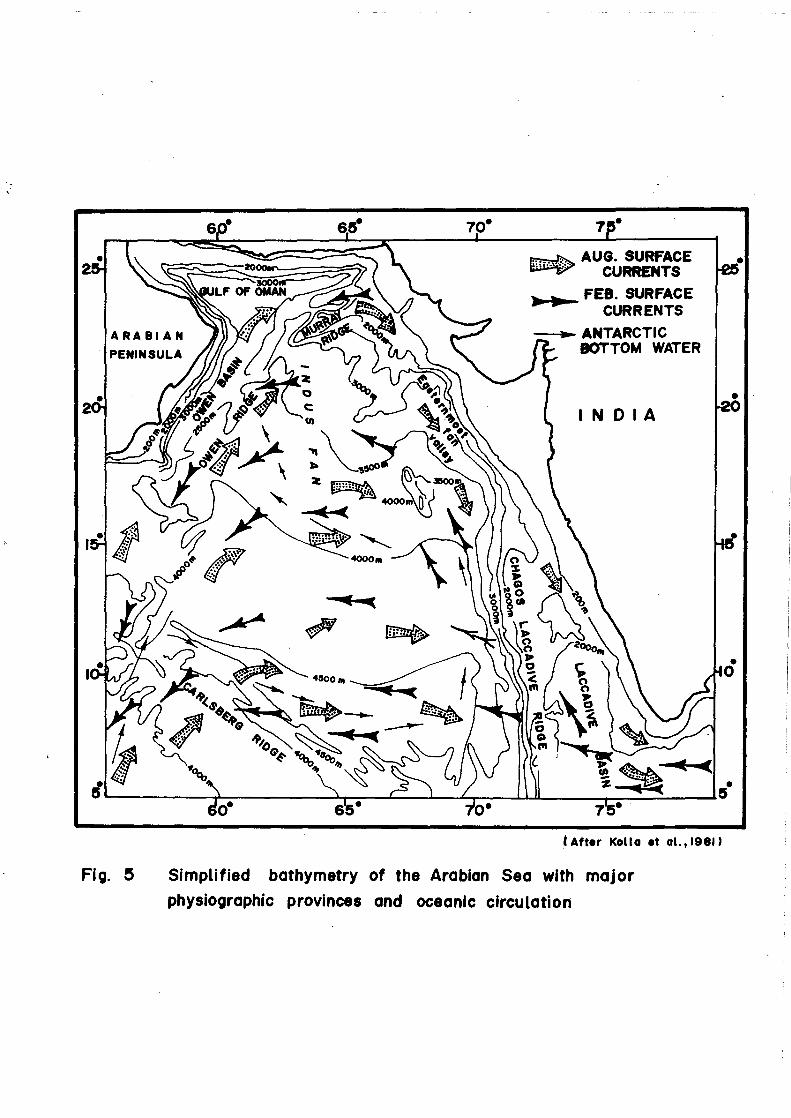
The important physiographic features of the seafloor
beneath the Arabian Sea are : Carlsberg Ridge, Owen Fracture
Zone, Murray Ridge, Chagos-Laccadive Ridge and the Indus
Cone (Fig. 5).
24
AUG. SURFACE CURRENTS
)041•••- • FEB SURFACE CURRENTS
--v.- ANTARCTIC BOTTOM WATER
After Kolla et a1.,1981)
Fig. 5 Simplified bathymetry of the Arabian Sea with major
physiographic provinces and oceanic circulation
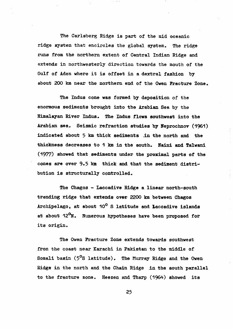
The Carlsberg Ridge is part of the mid oceanic
ridge system that encircles the global system. The ridge
runs from the northern extent of Central Indian Ridge and
extends in northwesterly direction towards the mouth of the
Gulf of Aden where it is offset in a dextral fashion by
about 200 km near the northern end of the Owen Fracture Zone.
The Indus cone was formed by deposition of the
enormous sediments brought into the Arabian Sea by the
Himalayan River Indus. The Indus flows southwest into the
Arabian sea. Seismic refraction studies by Neprochnov (1961)
indicated about 5 km thick sediments in the north and the
thickness decreases to 1 km in the south. Naini and Taiwani
(1977) showed that sediments under the proximal parts of the
cones are over 9.5 km thick and that the sediment distri-
bution is structurally controlled.
The Chagos - Laccadive Ridge a linear north-south
trending ridge that extends over 2200 km between Chagos
Archipelago, at about 10° S latitude and Laccadive islands
at about 12°N. Numerous hypotheses have been proposed for
its origin.
The Owen Fracture Zone extends towards southwest
from the coast near Karachi in Pakistan to the middle of
Somali basin (5°S latitude). The Murray Ridge and the Owen
Ridge in the north and the Chain Ridge in the south parallel
to the fracture zone. Heezen and Tharp (1964) showed its
25
extension further south along the western margin of the
Amirante Ridge and the eastern boundary fault of the east
coast of Madagascar.
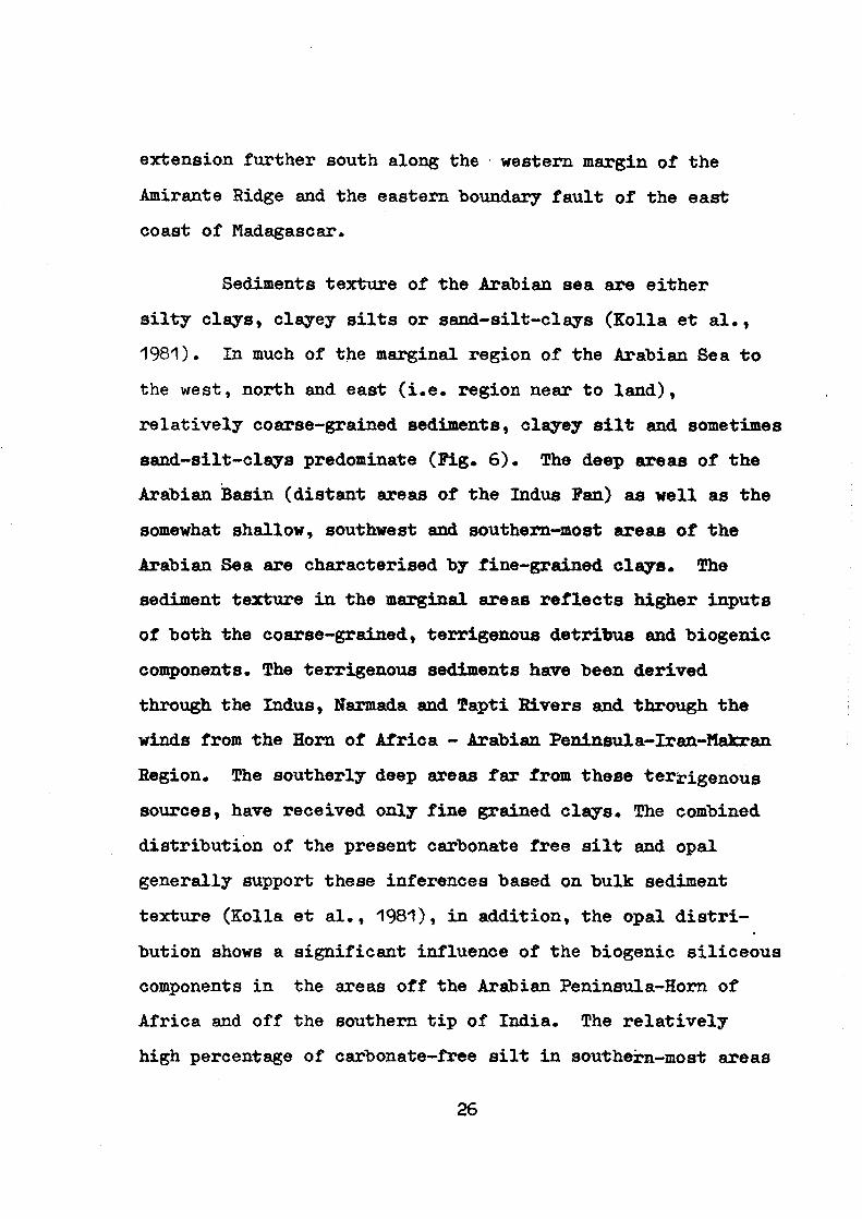
Sediments texture of the Arabian sea are either
silty clays, clayey silts or sand-silt-clays (Kolla et al.,
1981). In much of the marginal region of the Arabian Sea to
the west, north and east (i.e. region near to land),
relatively coarse-grained sediments, clayey silt and sometimes
sand-silt-clays predominate (Fig. 6). The deep areas of the
Arabian Basin (distant areas of the Indus Fan) as well as the
somewhat shallow, southwest and southern-most areas of the
Arabian Sea are characterised by fine-grained clays. The
sediment texture in the marginal areas reflects higher inputs
of both the coarse-grained, terrigenous detritus and biogenic
components. The terrigenous sediments have been derived
through the Indus, Narmada and Tapti Rivers and through the
winds from the Horn of Africa - Arabian Peninsula-Iran-Makran
Region. The southerly deep areas far from these ter rigenous sources, have received only fine grained clays. The combined
distribution of the present carbonate free silt and opal
generally support these inferences based on bulk sediment
texture (Kolla et al., 1981), in addition, the opal distri-
bution shows a significant influence of the biogenic siliceous
components in the areas off the Arabian Peninsula-Horn of
Africa and off the southern tip of India. The relatively
high percentage of carbonate-free silt in southein-most areas
26
(After Kolla et al., 1981 )
Fig. 6 Distribution of textural types in surface bulk sediments of the
Arabian Sea.
with low opaline contents reflects a considerable influx of
volcanic rock fragments from the Mid Indian Ridge. Significant
amount of silt in the western and southwestern Arabian Sea
may also have been derived by aeolian transport from Africa-
Arabian Peninsula (Kolla et al., 1981).
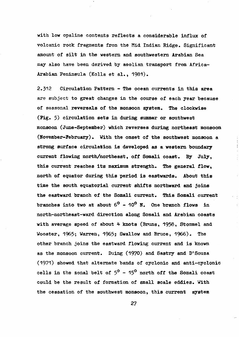
2.312 Circulation Pattern - The ocean currents in this area
are subject to great changes in the course of each year because
of seasonal reversals of the monsoon system. The clockwise
(Fig. 5) circulation sets in during summer or southwest
monsoon (June-September) which reverses during northeast monsoon
(tiovember-February). With the onset of the southwest monsoon a
strong surface circulation is developed as a western boundary
current flowing north/northeast, off Somali coast. By July,
this current reaches its maximum strength. The general flow,
north of equator during this period is eastwards. About this
time the south equatorial current shifts northward and joins
the eastward branch of the Somali current. This Somali current
branches into two at about 6 ° - 10° N. One branch flows in
north-northeast-ward direction along Somali and Arabian coasts
with average speed of about 4 knots (Bruns, 1958, Stommel and
Wooster, 1965; Warren, 19651 Swallow and Bruce, 1966). The
other branch joins the eastward flowing current and is known
as the monsoon current. Duing (1970) and Sastry and D'Souza
(1971) showed that alternate bands of cyclonic and anti-cyclonic
cells in the zonal belt of 5° - 15° north off the Somali coast
could be the result of formation of small scale eddies. With
the cessation of the southwest monsoon, this current system
27
reverses in the Arabian Sea and an anticlockwise (Fig. 5)
circulation is developed and established with its maximum
strength by January. The monsoon current flowing eastwards
also ceases and the westward flowing north equatorial current
develops. The north equatorial current brings water from
the Bay of Bengal and flushes into the Arabian Sea and appears
to have no influence on the water below the thermocline
(Wyrtki, 1973).
2.313 Temperature - The sea surface temperature of the
Arabian Sea has a bimodal distribution and differs from the
usual pattern of a single maximum at the end of the winter.
Most of the incoming solar radiations in summer is utilised
in raising the water temperature and thereby developing a
strong summer thermocline near surface. The maximum water
temperature are recorded in May. With the advance of summer
monsoon, predominant cooling takes place through (i) advection
of cold water from the African coast (ii) increased heat flux
to the atmosphere (iii) the reduction in the incoming solar
radiation and (iv) entrainment of cold sub-surfaces waters
into the surface layer (Rao et al., 1976; Murty et al., 1983
and Ramesh Babu and Sastry, 1984). Along Somali and Arabia
coasts, summer cooling is supported by horizontal advection
of cold waters and coastal upwelling due to strong offshore t4A,A•o•t(.v-
winds ( Wooster et al., 1967; Colborn, 1971, 1975 ).3:14.1. -4),
28
of waters and prevention of subsequent formation of the
summer thermocline the Arabian Sea exhibits the character-
istics of sub-tropical water (Colborn, 1975). The net surface
heat loss in the western regions of the Arabian Sea reaches
peak towards the end of June, while in the eastern Arabian Sea
the peak loss of heat occurs around August because of the four
processes mentioned above. The large scale advection of cold
water in the vertical and horizontal also contributes con-
siderably. The secondary maximum in the water temperature
occurs after the cessation of southern monsoon with the
decrease in cloudiness and consequent increase in the incoming
solar radiation and reduction in evaporation. During: the
southwest monsoon the surface temperature in the eastern
Arabian Sea drop from 30°C in March to 27° C in August. The
extent of cooling will be 2-5 ° C in the Arabian Sea (Rao et al.,
1976). However, temperatures as low as 14° C off Somali coast
have been reported in July (Warren et al., 1966; Bruce 1968, 1970).
Marty et al. (1983) and Ramesh Babu and Sastry (1984) have
investigated the various mechanisms responsible for the lowering
of water temperature in the upper layers in the eastern Arabian
Sea during the southwest monsoon of 1979. They concluded that
this lowering of the temperature is primarily due to downward
transfer of heat which accounts to 55 per cent of the total
heat loss in the upper layers, while 45 per cent of heat is
lost to the atmosphere. The water temperature increases from
September onwards once again and reaches to about 29° C over
most of the Arabian Sea by November and remains steady over the
entire region. The surface layers once again starts cooling
29
from December. This cooling first sets in the western and
central regions while the eastern parts maintain relatively
higher temperature. By January, the surface temperature will
be around 25° C north of 10° N and west of 65° E. The central
and eastern regions do not cool appreciably and the temperature
remains around 27° C. This cooling process ceases by February
and warming starts. By May the warming is completed and the
surface temperature increases to 30° C in the open sea while
still higher temperatures are reported immediately off west
coast of India. In Gulf of Aden, the surface temperature
reaches as high as 34° C. In this region, the maximum tempera-
ture is recorded in August unlike the rest of Arabian Sea
(Wyrtki, 1971).
2.314 Salinity - The Arabian Sea is connected to the Persian
Gulf through the Gulf of Oman by a 50 m deep still at the
Hormuz Strait. Similarly, a 125 m deep still at the Strait of
Bab-el-Mandeb separated the Red Sea from the Arabian Sea
through the Gulf of Aden. This is a negative water balance
where evaporation exceeds precipitation and runoff. The excess
of evaporation over precipitation is maximum (100-150 cm) off
the Arabian Coast and decreases steadily towards southeast. A
slight excess of precipitation over evaporation (420 cm) occurs
annually off the southwest coast of India (Venkateshwaran,1956).
30
The high rate of evaporation results in formation of
several high salinity water masses. The Arabian Sea high salinity
water, formed in the north eastern Arabian Sea, flows southward
and can be traced as a tongue of high salinity water within the
surface layer. The high salinity water in the Persian Gulf,
characterised by thecrp value of 26.6, flows through the Hormuz
Strait and the Gulf of Oman into the Arabian Sea and maintains
its density level at about 300 m depth (Wyrtki, 1971). The
water mass flows south, mostly east of 63 ° E longitude (Tama
et al., 1980) and loses its characteristics in the southern
Arabian Sea (Ramesh Babu et al., 1980). The Red Sea water
enters the Arabian Sea through the Strait of Bab-el-Mandab and
Gulf of Aden along TO= 27.2 surface (Wyrtki, 1971). This water
mass is generally confined to south about 17° N latitude
(Ramesh Babu et al., 1980). Occasionally, the sub-surface high
salinity water mass, the Arabian Sea water and the water masses
originating in the Persian Gulf and the Red Sea form a thick
layer which is vertically of almost uniform salinity, although
the individual layers could still be recognised as weak
salinity maxima. The whole layer could be called as the North
Indian High Salinity Intermediate Water (Wyrtki, 1973). The
occurrence of a salinity minimum at intermediate depths in the
Arabian Sea has been a subject of considerable debate.
Tchernia et al. (1958) suggested that the Antarctic Intermediate
Water may penetrate into the Arabian Sea as a layer of lower
31
salinity. Warren et al. (1966), however, attributed the
salinity minimum to the sub-tropical sub-surface water, a
layer of decreasing salinity with an oxygen maxima. The deep
and bottom waters are of circumpolar origin, probably trans-
ported by a deep western boundary current through a chain of
basins (Warren et al., 1966; Warren, 1978, 1981). Following
the nomenclature of Ivamenkov and Gubin (1960) they could be
called as North Indian Deep Water and North Indian Bottom Water.
2.315 Tropical cyclones - Most of the tropical cyclones in
the Arabian Sea are locally generated. Occassionally tropical
cyclones from the Bay of Bengal traverse the peninsular part of
India and get reintensified over the Arabian Sea. Storm surge
causing tropical cyclones occur predominantly either during the
pre-monsoon season or during the post-monsoon season, but
rarely during the monsoon season (Murty and El-Sabh, 1984).
This fact should be emphasised because it is not generally
appreciated that there is no relationship, atleast directly
between the monsoon and the storm surges in the Arabian Sea or
in the Bay of Bengal (Murty, 1984).
The predominance occurrence of tropical cyclones during
the pre-monsoon and post-monsoon periods is not only true for
the severe storms, but holds in general for less severe storms
and even for cyclonic disturbances. The fact that a similar
result is true for the western part of the Arabian Sea, i.e.,
those cyclones that hit the southern coast of the Arabian
32
Peninsula, is also supported by observations. Some cyclones
recurve and make a landfall on the west coast of India or on
the Pakistan coast whereas others travel towards west northwest
and strike the south coast of the Arabian Peninsula. The
important point made here is that only rarely, if at all,
tropical cyclones from the Arabian Sea travel towards the Gulf
of Oman and the Arabian Gulf.
2.32 NORTHWESTERN CONTINENTAL SHELF OF INDIA
2.321 Topography - The topography of the ocean floor to a
large extent reflects the structure, tectonics and geological
history of the area. The continental margins are the first order
features of the earth's crust and the shelves account for almost
the world's offshore minerals and oil production. The study of
the geomorphology of the continental margin is, therefore, of
considerable importance in understanding the structure and
origin of this important region. The study of the topographic
features of the shelf provides valuable informations on the
processes that have shaped the origin in sub-recent times.
Most of the earlier work on the topography of the
western continental margin of India was carried out by foreign
ships during the International Indian Ocean Expedition. The
studies formed part of a regional oceanographic programme and
therefore, did not provide the details. Zatonski's (1964)
33
description of the two profiles off Bombay collected during
the 33rd cruise of R. V. Vitiaz indicated that the shelf has a
slope of 0-0.5° , the shelf break occurs at 140-150 m and the
outer shelf shows rugged topography. Ulrich (1968) studied
the echograms of 1964-65 Indian Ocean Cruise of R. V. Meteor
and observed that the shelf break occurs between 120-130 m
but in profile it is close to 160 m while in others it rises
to 100 m. Hari Narain et al. (1968) and Cloose et al. (1974)
in their papers on continental margins of India and Harbison
and Bassinger (1970, 1973) in their study of the data collected
by the USC & GS Oceanographer presented some bathymetric
profiles but not descriptions. Harbison and Bassinger (1970),
however, indicated that the narrowing of the shelf off southwest
Kathiawar is probably due to a fault.
Heezen and Tharp (1964) prepared the physiographic
diagram of the Indian Ocean which shows the broad geomorphic
features of the western continental margin of India. The
Soviet Oceanographers presented a synthesis of the then
available data in the geomorphological maps published in the
Physico-Geographical Atlas of the world (Gerasimov, 1964) and
later in the Geological-Geophysical Atlas of Indian Ocean
(Udintsev, 1975).
Nair (1972, 1975) noted small scale irregularities on
the outer western shelf and concluded that these are algal and
oolitic ridges formed during Holocene period. Siddiquie and
34
Rajamanickam (1974) carried out a preliminary study of the
echograms collected during the INS Darshak cruises indicated
that on the western shelf, the shelf break occurs between
120-150 m (Fig. 7). Furthermore, they divided the continental
shelf based on topographic features into even (practically no
variation), uneven (about 5 m) and rugged (upto 20 m variations)
regions (Fig. 8 A, B and C). The even topography on the Kathiawar
shelf and the inner shelf off Bombay probably originated due to
the recent deposition of the sediments brought down by the
Indus and the Khambhat Rivers (Narmada, Tapti, Mahi and Sabarmati).
The uneven and rugged topography on the outer shelf is relict
which was formed during the period of lowered sea level. While
the area of uneven topography has been covered partly by recent
sediments, the area of rugged topography has remained outside
the influence of the sediment and uncovered. The abrupt
narrowing of the shelf at places off Kathiawar is associated
with a fall in the depth of the shelf break. Siddiquie et al.
(1977) described the Darshak and other sea mounts in the area
and discussed their origin. During the surveys in Gulf of
Khamhhat and the Bombay Harbour area Vora et al. (1980)
reported sand waves in the Gulf and Almeida and Bhattacharya
(1980) ripples in the Harbour area.
2.322 Tides and Tidal Streams - The tides at the heads of
Gulf of Kachchh and the Gulf of Khambhat maximum spring ranges
are about 6.5 and 9 m respectively, as the distance, south
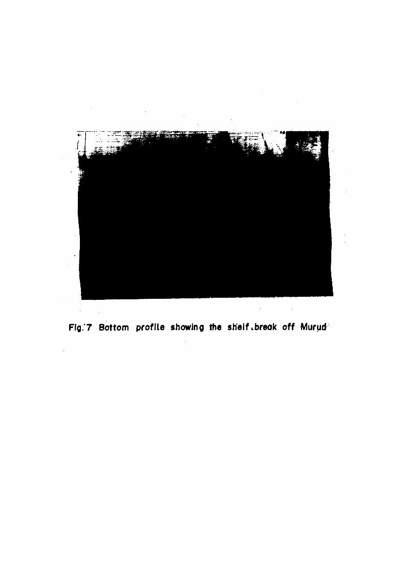
Fig.7 Bottom profile showing the shelf .break off Mural,
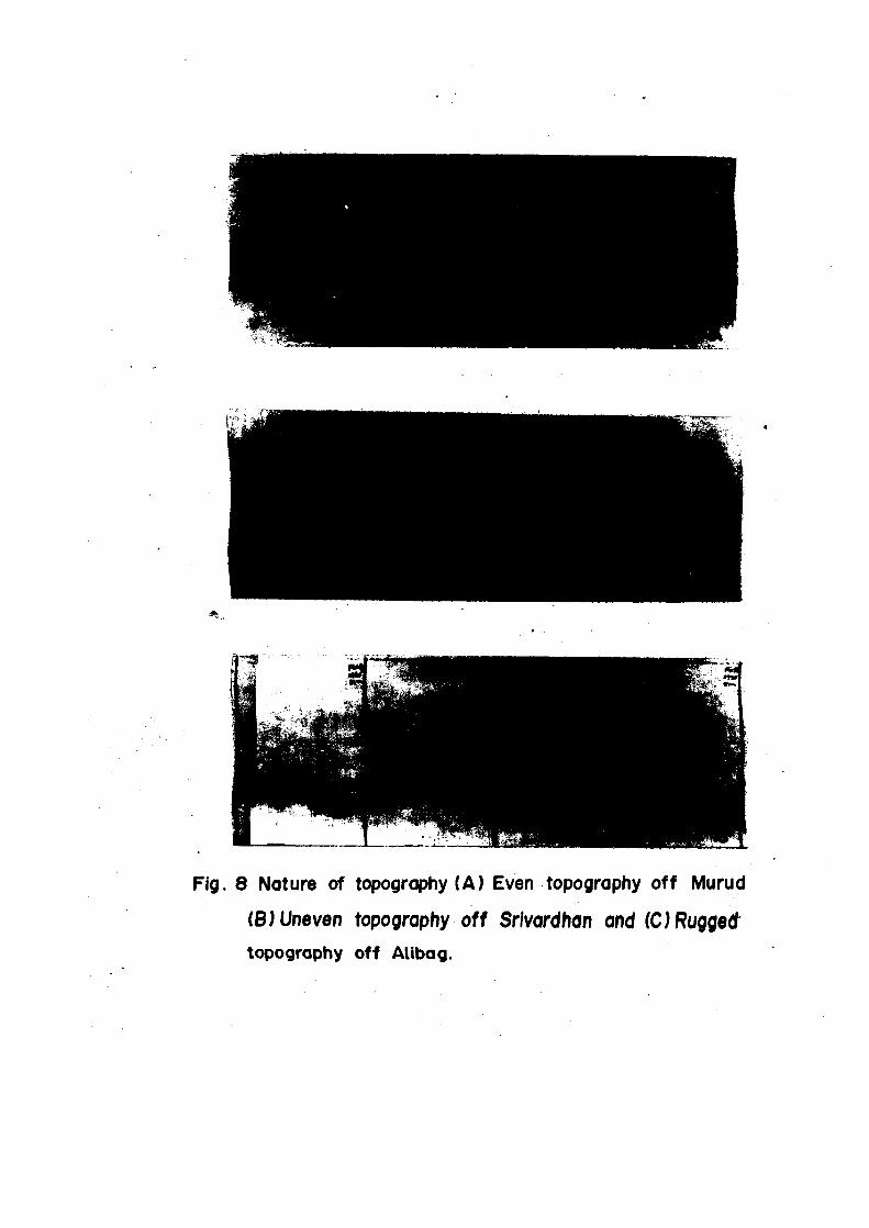
Fig. 8 Nature of topography (A) Even topography off Murud
(B) Uneven topography off Srlvardhan and (C) Rugged topography off Atibag.
from the Gulf of Khambhat, increases the semi-diurnal tide
decreases until, in about latitude 15 ° N, the diurnal tide
again predominates and the range is about 1 m.
Tidal streams along the Konkan coast sets north wards
and strongly so off Port Bankot (17° 59' N : 73° 02' E), its
strength increases with the latitude as far as the Gulf of
Khambhat.
Along the south and west coasts of Kathiawar peninsula
the flood stream sets eastwards between the Gulf of Khambhat
and Porbandar and a northern direction to the north of Porbandar.
It has been found to set eastward at a rate of from I to 1.5 knots
off Diu Head, where there are frequent eddies, dubtless caused
by the tidal stream during the ebb in the Gulf of Khambhat
setting westwards while the flood stream at Porbandar is setting
eastwards.
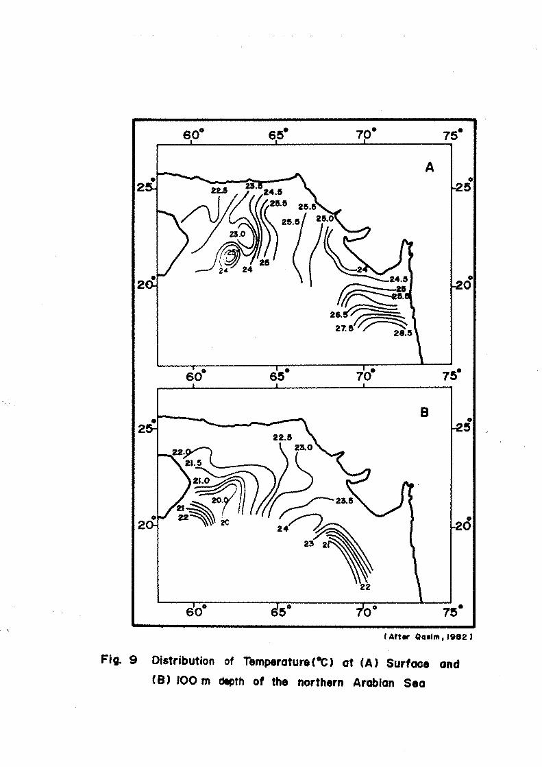
2.323 Temperature - Temperature data collected during the
same INS Darshak cruises and subsequently supplement with data
collected during R V Gaveshani have shown that at surface, the
temperature ranged from 22.5 to 28.5° C with a distinct increase
from north to south (Qasim, 1982). Deeper (500 and 1000 m) there
was a decrease from north to south. In the inshore areas, the
water was isothermal in the upper 30 to 40 m, but in the deeper
parts the isothermal layer extends 75 to 125 m, below which
36
there was a sharp thermocline between 100 and 200 m. At
500 m, the temperature was 12.25 to 13.75° C lower than at
the surface. At 1000 m, the temperature varied from 8.5 to
9.25° C. In the southwest the water at this depth was warmer
than in the southeast. The temperature at 1000 m was from
14 to 19° C lower than at the surface (Fig. 9).
2.324 Salinity - Qasim (1982) summarising the salinity
variations in the northern Arabian Sea based on the data
collected during the above mention cruises found that the
surface salinity varied from 35.4 to 36.6Zyhich decreased from
north to south. At 100 m there was no significant difference
in the salinity range (35.3 to 35.5%0), with an average of
about 35.4 %othroughout the region. The low surface salinity
off the west coast of India south of 20 ° N is not due to
rainfall or land runoff as no major rivers enter this area
and rainfall is moderate. The low salinity water largely
confined to the top 100 m, may be due to the inflow of water
of lower salinity from the south. From the surface to 1000 m
the salinity decreases from north to south and from west to
east (Fig. 10). The high salinity in the north is due to the
inflow of highly saline water from the Persian Gulf.
37
Atter Qaslm , 1982 )
Fig. 9 Distribution of Temperature ( °C) at (A) Surface and
(B) 100 rn depth of the northern Arabian Sea
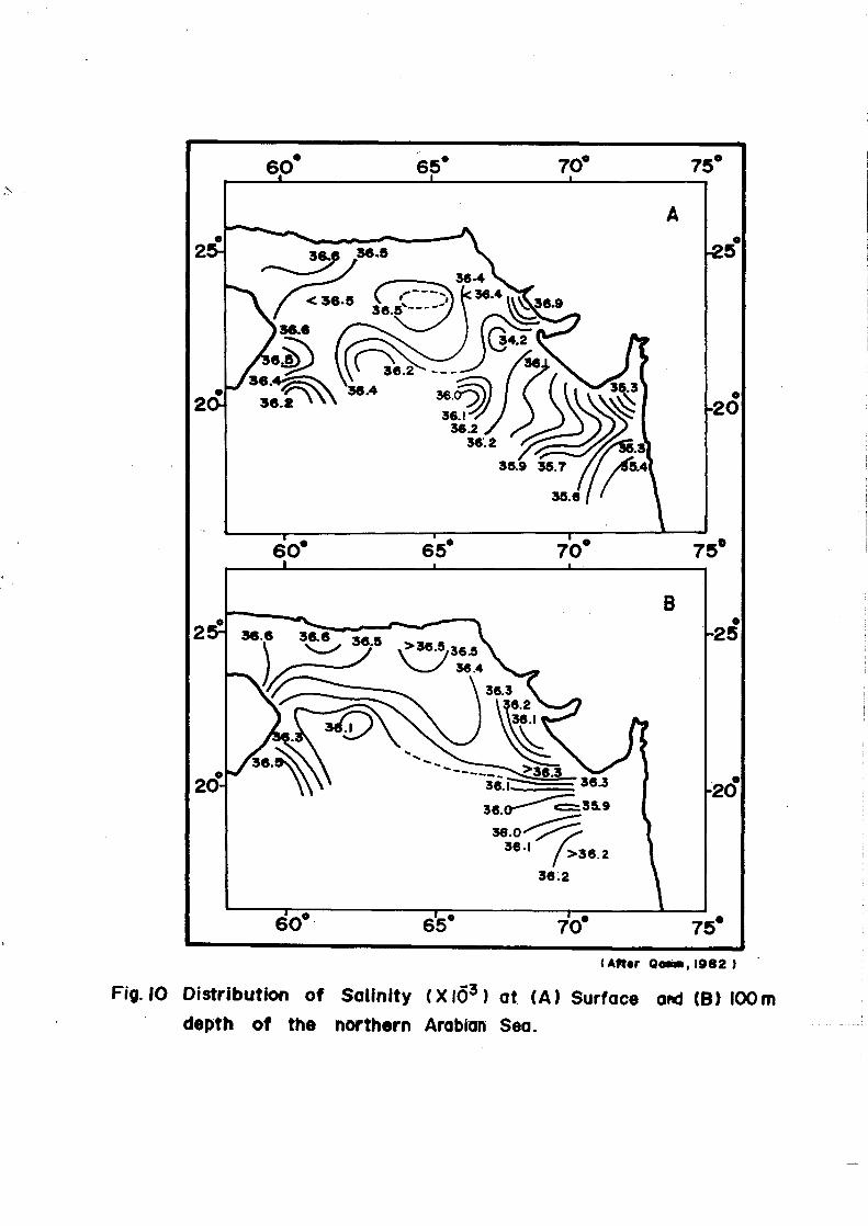
(Atter Q0110,1982 )
Fig. 10 Distribution of Salinity (X16 3 ) at (A) Surface and (3) 100m depth of the northern Arabian Sea.