Embed Size (px)
Citation preview

Final Comprehensive Site Evaluation Phase II Report
Site:
Military Munitions Response Program
Duluth Air National Guard Base
148th Fighter Wing
Duluth, Minnesota
Prepared for:
Departments of the Army and the Air Force
National Guard Bureau
1411 Jefferson Davis Highway
Arlington, Virginia 22202-3231
Prepared by:
AECOM
675 North Washington Street, Suite 300
Alexandria, Virginia 22314
February 2010
AECOM Project No. 106177.05

This page intentionally left blank.
Signature Page
Site:
Military Munitions Response Program
Duluth Air National Guard Base
148th Fighter Wing
Duluth, Minnesota
Prepared for:
Departments of the Army and the Air Force
National Guard Bureau
1411 Jefferson Davis Highway
Arlington, Virginia 22202-3231
Prepared by:
AECOM
675 North Washington Street, Suite 300
Alexandria, Virginia 22314
February 2010
AECOM Project No. 106177.05
Author: 1 Feb 2010 Brendan McGuinness Date Field Manager/Project Geologist AECOM
Author: 2 Feb 2010 Amanda McNally Date Environmental Engineer AECOM
Reviewer: 1 Feb 2010 Mike Ervine, P.E. Date Project Manager AECOM
Reviewer:
2 Feb 2010 Mark MacEwan, P.E. Date Program Manager AECOM
Brendan McGuinness

This page intentionally left blank.

AECOM Comprehensive Site Evaluation Phase II Report February 2010 Military Munitions Response Program – Duluth ANGB
Duluth ANGB Final CSE Phase II i AECOM PROJECT NO. 106177.05
Table of Contents
1.0 INTRODUCTION ............................................................................................................................. 1-1
1.1 Purpose ....................................................................................................................................... 1-1 1.2 Project Data Quality Objectives ................................................................................................... 1-8 1.3 Project Management ................................................................................................................... 1-8
1.3.1 AECOM ................................................................................................................................... 1-8 1.3.2 Air National Guard .................................................................................................................. 1-9 1.3.3 Minnesota Pollution Control Agency ....................................................................................... 1-9 1.3.4 Duluth Air National Guard Base Environmental Manager ...................................................... 1-9
1.4 Project Scope .............................................................................................................................. 1-9 1.5 Report Organization .................................................................................................................... 1-9
2.0 INSTALLATION BACKGROUND .................................................................................................... 2-1
2.1 Location and Setting .................................................................................................................... 2-1 2.2 Installation Mission ...................................................................................................................... 2-1 2.3 Installation Operational History .................................................................................................... 2-1 2.4 Munitions Related Training/Storage/Usage ................................................................................. 2-1 2.5 Previous Investigations ................................................................................................................ 2-1
3.0 PHYSICAL AND ENVIRONMENTAL SETTING ............................................................................. 3-1
3.1 Climate ......................................................................................................................................... 3-1 3.2 Topography .................................................................................................................................. 3-1 3.3 Hydrology ..................................................................................................................................... 3-1
3.3.1 Surface Drainage .................................................................................................................... 3-2 3.3.2 Wetlands ................................................................................................................................. 3-2
3.4 Soil and Vegetation Types ........................................................................................................... 3-2 3.4.1 Soil Types and Characteristics ............................................................................................... 3-2 3.4.2 Vegetation Types .................................................................................................................... 3-2
3.5 Geology and Hydrogeology ......................................................................................................... 3-2 3.5.1 Geology ................................................................................................................................... 3-2 3.5.2 Hydrogeology .......................................................................................................................... 3-3
3.6 Cultural and Natural Resources .................................................................................................. 3-3 3.6.1 Threatened, Endangered, and Special Status Species .......................................................... 3-3 3.6.2 Sensitive Ecological Settings .................................................................................................. 3-4
4.0 INVESTIGATION SCOPE AND APPROACH ................................................................................. 4-1
4.1 Site Reconnaissance and Visual Survey ..................................................................................... 4-1 4.2 Geophysical Survey ..................................................................................................................... 4-1
4.2.1 Geophysical Instrument Performance Evaluation .................................................................. 4-1 4.2.2 Geophysical Investigation Quality Control .............................................................................. 4-1 4.2.3 Geophysical Data Collection ................................................................................................... 4-5 4.2.4 Geophysical Data Processing ................................................................................................. 4-5
4.3 Environmental Media Sampling and Analysis ............................................................................. 4-6 4.3.1 X-Ray Fluorescence Analysis ................................................................................................. 4-6 4.3.2 Soil .......................................................................................................................................... 4-7 4.3.3 Groundwater ........................................................................................................................... 4-7 4.3.4 Surface Water and Sediment .................................................................................................. 4-7
4.4 Screening Levels ....................................................................................................................... 4-19 4.4.1 Soil Screening Levels ........................................................................................................... 4-19 4.4.2 Groundwater Screening Levels ............................................................................................ 4-19 4.4.3 Surface Water Screening Levels .......................................................................................... 4-19 4.4.4 Sediment Screening Levels .................................................................................................. 4-20
4.5 Data Quality ............................................................................................................................... 4-20
AECOM Comprehensive Site Evaluation Phase II Report February 2010 Military Munitions Response Program – Duluth ANGB
Duluth ANGB Final CSE Phase II ii AECOM PROJECT NO. 106177.05
4.5.1 Data Quality Objectives ........................................................................................................ 4-20 4.5.1.1 Geophysical Survey ........................................................................................................... 4-20 4.5.1.2 Analytical Data ................................................................................................................... 4-21 4.5.2 Analytical Methodology ......................................................................................................... 4-21 4.5.3 Laboratory Data Review and Reporting................................................................................ 4-21 4.5.4 Data Validation ...................................................................................................................... 4-22
4.6 Data Management ..................................................................................................................... 4-23 4.6.1 Electronic Data ...................................................................................................................... 4-23 4.6.2 Hardcopy Data ...................................................................................................................... 4-23 4.6.3 Geographic Information System Data................................................................................... 4-23
5.0 MUNITIONS RESPONSE AREA CHARACTERISTICS ................................................................. 5-1
5.1 Explosive Ordnance Disposal Range .......................................................................................... 5-1 5.1.1 Site Description ....................................................................................................................... 5-1 5.1.2 History of Munitions and Explosives of Concern Activities ..................................................... 5-1 5.1.3 Current Land Use .................................................................................................................... 5-1 5.1.4 Access Control ........................................................................................................................ 5-1 5.1.5 Restrictions ............................................................................................................................. 5-2 5.1.6 Field Investigation Results ...................................................................................................... 5-2 5.1.7 Potential Receptors............................................................................................................... 5-13
5.2 Small Arms Range ..................................................................................................................... 5-13 5.2.1 Site Description ..................................................................................................................... 5-13 5.2.2 History of Munitions and Explosives of Concern Activities ................................................... 5-13 5.2.3 Current Land Use .................................................................................................................. 5-14 5.2.4 Access Control ...................................................................................................................... 5-14 5.2.5 Restrictions ........................................................................................................................... 5-14 5.2.6 Field Investigation Results .................................................................................................... 5-14 5.2.7 Potential Receptors............................................................................................................... 5-25
5.3 Trap Range ................................................................................................................................ 5-25 5.3.1 Site Description ..................................................................................................................... 5-25 5.3.2 History of Munitions and Explosives of Concern Activities ................................................... 5-26 5.3.3 Current Land Use .................................................................................................................. 5-26 5.3.4 Access Control ...................................................................................................................... 5-26 5.3.5 Restrictions ........................................................................................................................... 5-26 5.3.6 Field Investigation Results .................................................................................................... 5-26 5.3.7 Potential Receptors............................................................................................................... 5-31
5.4 Skeet Range .............................................................................................................................. 5-39 5.4.1 Site Description ..................................................................................................................... 5-39 5.4.2 History of Munitions and Explosives of Concern Activities ................................................... 5-39 5.4.3 Current Land Use .................................................................................................................. 5-39 5.4.4 Access Control ...................................................................................................................... 5-39 5.4.5 Restrictions ........................................................................................................................... 5-40 5.4.6 Field Investigation Results .................................................................................................... 5-40 5.4.7 Potential Receptors............................................................................................................... 5-51
5.5 Lead Contaminated Soils Area .................................................................................................. 5-51 5.5.1 Site Description ..................................................................................................................... 5-51 5.5.2 History of Munitions and Explosives of Concern Activities ................................................... 5-52 5.5.3 Current Land Use .................................................................................................................. 5-52 5.5.4 Access Control ...................................................................................................................... 5-52 5.5.5 Restrictions ........................................................................................................................... 5-52 5.5.6 Field Investigation Results .................................................................................................... 5-52 5.5.7 Potential Receptors............................................................................................................... 5-61

AECOM Comprehensive Site Evaluation Phase II Report February 2010 Military Munitions Response Program – Duluth ANGB
Duluth ANGB Final CSE Phase II iii AECOM PROJECT NO. 106177.05
6.0 EVALUATION OF KNOWN/SUSPECTED MUNITIONS AND EXPLOSIVES OF CONCERN ...... 6-1
6.1 Munitions and Explosives of Concern Technical Data ................................................................ 6-1 6.1.1 Explosive Ordnance Disposal Range ..................................................................................... 6-1 6.1.2 Small Arms Range .................................................................................................................. 6-1 6.1.3 Trap Range ............................................................................................................................. 6-1 6.1.4 Skeet Range ........................................................................................................................... 6-1 6.1.5 Lead Contaminated Soils Area ............................................................................................... 6-1
6.2 Primary Sources and Release Mechanisms ............................................................................... 6-1 6.2.1 Explosive Ordnance Disposal Range ..................................................................................... 6-2 6.2.2 Small Arms Range .................................................................................................................. 6-2 6.2.3 Trap Range ............................................................................................................................. 6-2 6.2.4 Skeet Range ........................................................................................................................... 6-2 6.2.5 Lead Contaminated Soils Area ............................................................................................... 6-2
6.3 Munitions and Explosives of Concern Locations (Secondary Sources) ...................................... 6-2 6.4 Munitions and Explosives of Concern Penetration Estimates ..................................................... 6-3 6.5 Special Consideration Munitions and Explosives of Concern ..................................................... 6-3 6.6 Known/Suspected Munitions Constituents .................................................................................. 6-3 6.7 Explosive Safety Submission Information ................................................................................... 6-3
6.7.1 Munitions with the Greatest Fragmentation Distance ............................................................. 6-3 6.7.2 Maximum Credible Event ........................................................................................................ 6-4 6.7.3 Frost Line ................................................................................................................................ 6-4
7.0 EVALUATION OF HAZARDOUS WASTE/SUBSTANCES ............................................................ 7-1
7.1 Explosive Ordnance Disposal Range .......................................................................................... 7-1 7.2 Small Arms Range ....................................................................................................................... 7-1 7.3 Trap Range .................................................................................................................................. 7-1 7.4 Skeet Range ................................................................................................................................ 7-1 7.5 Lead Contaminated Soils Area .................................................................................................... 7-1
8.0 EXPOSURE PATHWAY AND HAZARD ASSESSMENT ............................................................... 8-1
8.1 Munitions and Explosives of Concern Exposure Pathway Analysis ............................................ 8-1 8.1.1 Munitions and Explosives of Concern Transport Processes .................................................. 8-1 8.1.2 Munitions and Explosives of Concern Exposure Media and Accessibility .............................. 8-1 8.1.3 Munitions and Explosives of Concern Exposure Receptors ................................................... 8-1 8.1.4 Munitions and Explosives of Concern Exposure Conclusions ............................................... 8-1
8.2 Munitions Constituents Exposure Pathway Analysis ................................................................... 8-1 8.2.1 Groundwater Migration Pathway Analysis .............................................................................. 8-3
8.2.1.1 Groundwater Receptors ................................................................................................... 8-3 8.2.1.2 Groundwater Conclusions ................................................................................................ 8-3
8.2.2 Surface Water/Sediment Migration Pathway Analysis ............................................................... 8-4 8.2.2.1 Surface Water/Sediment Receptors ................................................................................ 8-4 8.2.2.2 Surface Water/Sediment Conclusions ............................................................................. 8-4
8.2.3 Soil Exposure Pathway Analysis ................................................................................................ 8-4 8.2.3.1 Soil Exposure Receptors ................................................................................................. 8-4 8.2.3.2 Soil Exposure Conclusions .............................................................................................. 8-4
9.0 CONCEPTUAL SITE MODEL ......................................................................................................... 9-1
9.1 Munitions and Explosives of Concern Conceptual Site Model .................................................... 9-1 9.2 Munitions Constituents Conceptual Site Models ......................................................................... 9-1
9.2.1 Explosive Ordnance Disposal Range ..................................................................................... 9-1 9.2.2 Small Arms Range .................................................................................................................. 9-5 9.2.3 Trap Range ............................................................................................................................. 9-5

AECOM Comprehensive Site Evaluation Phase II Report February 2010 Military Munitions Response Program – Duluth ANGB
Duluth ANGB Final CSE Phase II iv AECOM PROJECT NO. 106177.05
9.2.4 Skeet Range ........................................................................................................................... 9-5 9.2.5 Lead Contaminated Soils Area ............................................................................................. 9-13
9.3 Conclusions ............................................................................................................................... 9-13
10.0 MUNITIONS RESPONSE SITE PRIORITIZATION PROTOCOL ............................................. 10-1
10.1 Explosive Hazard Evaluation Module ........................................................................................ 10-1 10.2 Chemical Warfare Material Hazard Evaluation Module ............................................................ 10-1 10.3 Health Hazard Evaluation Module ............................................................................................. 10-5 10.4 Munitions Response Site Prioritization Protocol Score ............................................................. 10-5
11.0 PERCHLORATE REPORTING ................................................................................................. 11-1
12.0 SUMMARY AND CONCLUSIONS ............................................................................................ 12-1
12.1 Summary of Comprehensive Site Evaluation Phase II Activities .............................................. 12-1 12.2 Summary of Comprehensive Site Evaluation Phase II Findings ............................................... 12-1
12.2.1 Explosive Ordnance Disposal Range ................................................................................. 12-1 12.2.2 Small Arms Range .............................................................................................................. 12-2 12.2.3 Trap Range ......................................................................................................................... 12-2 12.2.4 Skeet Range ....................................................................................................................... 12-3 12.2.5 Lead Contaminated Soils Area ........................................................................................... 12-3
12.3 Assessment of Potential Munitions Constituent Releases ........................................................ 12-4 12.4 Summary of the Munitions Response Site Prioritization Protocol ............................................. 12-4
13.0 RECOMMENDATIONS ............................................................................................................. 13-1
13.1 Cohort Assignments .................................................................................................................. 13-1 13.1.1 Small Arms Ranges ............................................................................................................ 13-1 13.1.2 Boresight Ranges ............................................................................................................... 13-2 13.1.3 Open Burn/Open Detonation Sites/Explosive Ordnance Disposal Ranges ....................... 13-2 13.1.4 Chemical Warfare Material Sites ........................................................................................ 13-2 13.1.5 Pyrotechnic/Practice Ordnance Sites ................................................................................. 13-2 13.1.6 Munitions Constituents Sites .............................................................................................. 13-2 13.1.7 All Other Sites ..................................................................................................................... 13-3 13.1.8 Propellants .......................................................................................................................... 13-3 13.1.9 Duluth Air National Guard Base Cohort Assignment .......................................................... 13-3
13.2 Process Streamlining Opportunities .......................................................................................... 13-3 13.3 Additional Munitions Response Sites (Splitting the Munitions Response Area) ....................... 13-4 13.4 Change to the Munitions Response Area/Munitions Response Site Footprint ......................... 13-4 13.5 Future Response Actions and Objectives ................................................................................. 13-4 13.6 Identify Gaps in Conceptual Site Model .................................................................................... 13-4 13.7 Department of Defense Munitions Response Site Prioritization Protocol ................................. 13-4 13.8 Site Sequencing Considerations ............................................................................................... 13-4

AECOM Comprehensive Site Evaluation Phase II Report February 2010 Military Munitions Response Program – Duluth ANGB
Duluth ANGB Final CSE Phase II v AECOM PROJECT NO. 106177.05
Appendices
Appendix A Definitions Appendix B Acronyms and Abbreviations Appendix C References Appendix D Analytical Laboratory Data Appendix E Geophysical Survey Data
Appendix F Ordnance Technical Data Sheets Appendix G Boring Logs and Well Logs Appendix H Data Quality Reports Appendix I Munitions Response Site Prioritization Protocol Tables Appendix J RACER MMRP Module Data Input Worksheet Appendix K AFRIMS Data Input Worksheet Appendix L Documentation of Public Participation
Appendix M Site Photographs
Figures
Figure 1-1 Duluth Air National Guard Base Location ........................................................................ 1-3 Figure 1-2 Duluth ANGB MRA Locations .......................................................................................... 1-5 Figure 1-3 PDT Organizational Chart ................................................................................................ 1-8 Figure 4-1 EOD Range Aerial Photograph and Sampling Locations ................................................ 4-3 Figure 4-2 Small Arms Range Aerial Photograph and Sampling Locations ..................................... 4-9 Figure 4-3 Trap Range Aerial Photograph and Sampling Locations............................................... 4-11 Figure 4-4 Skeet Range Aerial Photograph and Sampling Locations ............................................. 4-13 Figure 4-5 Lead Contaminated Soils Area Aerial Photograph and Sampling Locations................. 4-15 Figure 5-1 EOD Range (SR502) – Electromagnetic Data Collected with EM61 Mk2,
December 2008 ................................................................................................................ 5-3 Figure 5-2 EOD Range (SR502) Analytical Results – Detected Metals Concentrations .................. 5-7 Figure 5-3 Small Arms Range (SR736) Analytical Results – Metals Concentrations ..................... 5-23 Figure 5-4 Trap Range (TS737) Analytical Results – Metals Concentrations ................................ 5-35 Figure 5-5 Skeet Range (TS738) Analytical Results – Metals Concentrations ............................... 5-47 Figure 5-6 Lead Contaminated Soils Area (SR739) Analytical Results – Metals Concentrations .. 5-59 Figure 9-1 MEC Conceptual Site Model for the EOD Range (SR502) ............................................. 9-3 Figure 9-2 MC Conceptual Site Model for the EOD Range .............................................................. 9-7 Figure 9-3 MC Conceptual Site Model for the Small Arms Range .................................................... 9-9 Figure 9-4 MC Conceptual Site Model for the Trap Range ............................................................. 9-11 Figure 9-5 MC Conceptual Site Model for the Skeet Range ........................................................... 9-15 Figure 9-6 MC Conceptual Site Model for the Lead Contaminated Soils Area ............................... 9-17

AECOM Comprehensive Site Evaluation Phase II Report February 2010 Military Munitions Response Program – Duluth ANGB
Duluth ANGB Final CSE Phase II vi AECOM PROJECT NO. 106177.05
Tables
Table 2-1 Summary of CSE Phase I Findings ................................................................................. 2-3 Table 4-1 Summary of CSE Phase II Analytical Samples and Chemical Analyses ....................... 4-17 Table 5-1 Summary of Analytical Results at the EOD Range (SR502) ........................................... 5-5 Table 5-2 Summary of Metals Concentrations Compared to MPCA Tier 1 Soil Leaching Values .. 5-9 Table 5-3 Summary of BaP Equivalent Concentrations at the EOD Range .................................. 5-11 Table 5-4 Summary of XRF Screening Results at the Small Arms Range (SR736) ..................... 5-15 Table 5-5 Comparison of XRF and Analytical Lab Results at the Small Arms Range (SR736) .... 5-19 Table 5-6 Summary of Analytical Results at the Small Arms Range (SR736) .............................. 5-21 Table 5-7 Summary of XRF Screening Results at the Trap Range (TS737) ................................. 5-27 Table 5-8 Comparison of XRF and Analytical Lab Results at the Trap Range (TS737)................ 5-29 Table 5-9 Summary of Analytical Results at the Trap Range (TS737) .......................................... 5-33 Table 5-10 Summary of BaP Equivalent Concentrations at the Trap Range .................................. 5-37 Table 5-11 Summary of XRF Screening Results at the Skeet Range (TS738) ............................... 5-41 Table 5-12 Comparison of XRF and Analytical Lab Results at the Skeet Range (TS738) .............. 5-43 Table 5-13 Summary of Analytical Results at the Skeet Range (TS738) ........................................ 5-45 Table 5-14 Summary of BaP Equivalent Concentrations at the Skeet Range ................................. 5-49 Table 5-15 Summary of XRF Screening Results at the Lead Contaminated Soils Area (SR739) .. 5-53 Table 5-16 Comparison of XRF and Analytical Lab Results at the Lead Contaminated Soils
Area (SR739) ................................................................................................................. 5-55 Table 5-17 Summary of Analytical Results at the Lead Contaminated Soils Area (SR739) ........... 5-57 Table 10-1 Summary and Total of the EHE Data Element Scores .................................................. 10-3 Table 10-2 Summary and Total of the HHE Data Element Scores .................................................. 10-7 Table 10-3 Priority Rating for Duluth ANGB MRAs .......................................................................... 10-9 Table 13-1 Air Force MMRP Cohort Assignments ........................................................................... 13-1 Table 13-2 Comprehensive Site Evaluation Phase II Conclusions .................................................. 13-5
AECOM Comprehensive Site Evaluation Phase II Report February 2010 Military Munitions Response Program – Duluth ANGB
Duluth ANGB Final CSE Phase II 1-1 AECOM PROJECT NO. 106177.05
1.0 INTRODUCTION
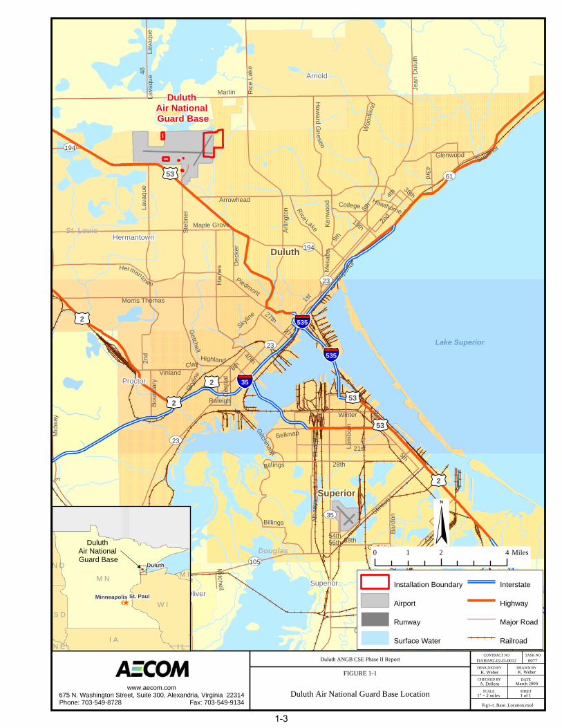
A Comprehensive Site Evaluation (CSE) Phase II was performed at the 148th Fighter Wing (FW), Duluth Air National Guard Base (ANGB), Minnesota (see Figure 1-1), under the United States Air Force’s (USAF’s) Military Munitions Response Program (MMRP). The objective of the MMRP is to make the Duluth ANGB munitions response areas (MRAs) safe for reuse, such that these sites are compatible with their anticipated future land use (AFLU), while protecting human health and the environment. Within the framework of the MMRP, the CSE identifies and characterizes the explosives safety issues related to munitions and explosives of concern (MEC) and associated releases of munitions constituents (MC) (e.g., hazardous substances, pollutants, and contaminants) to the environment.
An initial CSE Phase I investigation was completed at Duluth ANGB in July 2007 and results presented in the Comprehensive Site Evaluation Phase I, Duluth Air National Guard Base Minnesota (URS, 2007). The CSE Phase I investigation identified five MRAs for evaluation including an Explosive Ordnance Disposal (EOD) Range (SR502), Small Arms Range (SR736), Trap Range (TS737), Skeet Range (TS738), and Lead Contaminated Soils Area (LCSA) (SR739) (Figure 1-2). The CSE Phase I was performed to characterize the MRAs for the actual or potential presence of MEC and to evaluate actual or potential release(s) of MC to migration/exposure pathways based on historical records review, visual surveys, and interviews. The CSE Phase I is analogous to the Comprehensive Environmental Response, Compensation, and Liability Act (CERCLA) Preliminary Assessment (PA).
This follow-up CSE Phase II investigation is analogous to the CERCLA Site Inspection (SI). This CSE Phase II effort was conducted to fulfill CERCLA SI requirements and included MEC geophysical survey and/or MC environmental sampling at each of the five MRAs in December 2008. In accordance with the National Oil and Hazardous Substances Pollution Contingency Plan (NCP), on-site actions did not require Federal, State or local permits. Activities in locations that presented MEC hazards were conducted in compliance with Department of Defense (DoD) and USAF safety requirements and procedures.
This CSE Phase II Report has been prepared by Earth Tech AECOM for the Air National Guard (ANG) in accordance with the Air Force Guide for Conducting the Comprehensive Site Evaluation Phase II at Air Force Munitions Response Areas (Version 4.0) (USAF, 2006) under the National Guard Bureau (NGB) Environmental Engineering, Professional, Technical and Remediation Support Services Contract Number DAHA92-02-D-0012, Task Order (TO) 0077.
1.1 Purpose
The CSE is an initial step in achieving the MMRP goal of making MRAs safe for potential reuse and compatible with their reasonably AFLU. The CSE process provides the historical, anecdotal, visual, analytical and geophysical data that serves as the basis for USAF decision-making regarding follow-on munitions response actions. Where the CSE Phase I consists of historical records review, visual survey, and interviews, the CSE Phase II generally consists of geophysical survey and environmental sampling.
To meet the goals established by the DoD, the PA and SI are primarily focused on obtaining data to input into the DoD Munitions Response Site Prioritization Protocol (MRSPP) and for the purposes of site sequencing for cleanup. The CSE, however, includes an expanded array of analytical, tracking and reporting tools to support decision-making and, therefore, has greater data requirements. Tools utilized as part of the CSE include:
Conceptual Site Model (CSM) for planning, modeling and data interpretation of source/receptor interaction, and communication among the project team;

AECOM Comprehensive Site Evaluation Phase II Report February 2010 Military Munitions Response Program – Duluth ANGB
Duluth ANGB Final CSE Phase II 1-2 AECOM PROJECT NO. 106177.05
This page intentionally left blank.
Duluth
Superior
Hermantown
Arnold
Proctor
OliverSuperior
§̈¦35
§̈¦535
§̈¦535
tu53
tu2
tu2
tu2
tu53
tu53
tu2
UV61
UV35
UV23
UV105
UV3
UV194
UV39
UV13
UV23
UV23
UV194
Z
Martin
A
C
28th
21st
5th
Lava
que
WSt
ebne
r
Ric
e La
ke
Arrowhead
Hai
nes
Maple Grove
Stinso
n
Jean
Dul
uth
8th
Morris Thomas
Hermanto wn
Woo
dlan
d
Winter
Billings Alba
ny
Arlin
gton
Mid
way
1st
58th
19th
43rd
2nd
42nd
9th
Bard
on 39th
Elm
ira
Dec
ker
27th
Glenwood
Skyli
ne
Piedmont
How
ard Gnesen
40th
Kenw
ood
Cen
tral
4th
Vinland
Belknap
Getchell
Boun
dary
Mes
a ba
College
48
36th
Highland
Superior
Dop
pRaleigh
Hill
3
56th54th
Mitchell
Lam
born
State
Golf View
Hawthorne
Clay
Gitchinadji
27thSup
erior
Lava
que
Lava
que
Skylin
e
8th
Billings
Rice Lake
2nd
St. Louis
Douglas
Lake Superior
DAHA92-02-D-0012 0077
K. Weber K. Weber
A. Dellens
1" = 2 miles 1 of 1
Fig1-1_Base_Location.mxd
Duluth ANGB CSE Phase II Report
FIGURE 1-1
Duluth Air National Guard Base Location
CONTRACT NO TASK NO
DESIGNED BY DRAWN BY
CHECKED BY DATE
SCALE SHEETwww.aecom.com
675 N. Washington Street, Suite 300, Alexandria, Virginia 22314Phone: 703-549-8728 Fax: 703-549-9134
St. PaulMinneapolis
M N
W I
I A
S D
N D
I LN E
M I
March 2009
Duluth Air National Guard Base
Duluth
Duluth Air National Guard Base
Installation Boundary
Airport
Runway
Surface Water
Interstate
Highway
Major Road
Railroad
§0 2 41 Miles
1-3

AECOM Comprehensive Site Evaluation Phase II Report February 2010 Military Munitions Response Program – Duluth ANGB
Duluth ANGB Final CSE Phase II 1-4 AECOM PROJECT NO. 106177.05
This page intentionally left blank.

K. Weber K. Weber
A. Dellens
1" = 1,000' 1 of 1
DAHA92-02-D-0012 0077 Duluth ANGB CSE Phase II Report
FIGURE 1-2
Duluth ANGB MRA Locations
CONTRACT NO. TASK NO.
DESIGNED BY
CHECKED BY
SCALE
DRAWN BY
DATE
SHEET
March 2009
§0
1,05
02,
100
525
Feet
Mun
ition
s R
espo
nse
Area
Inst
alla
tion
Bou
ndar
y
Surfa
ce W
ater
Airfi
eld
Lead
Con
tam
inat
edSo
ils A
rea
(SR
739)
EOD
Ran
ge(S
R50
2)
Smal
l Arm
s R
ange
(SR
736)
Trap
Ran
ge(T
S73
7)Sk
eet R
ange
(TS
738)
Fig1-2_MRA_Locations.mxd
www.aecom.com675 N. Washington Street, Suite 300, Alexandria, Virginia 22314Phone: 703-549-8728 Fax: 703-549-9134
Mun
ition
s St
orag
e A
rea
1-5

AECOM Comprehensive Site Evaluation Phase II Report February 2010 Military Munitions Response Program – Duluth ANGB
Duluth ANGB Final CSE Phase II 1-6 AECOM PROJECT NO. 106177.05
This page intentionally left blank.

AECOM Comprehensive Site Evaluation Phase II Report February 2010 Military Munitions Response Program – Duluth ANGB
Duluth ANGB Final CSE Phase II 1-7 AECOM PROJECT NO. 106177.05
MRSPP to prioritize sites for further munitions response actions, based on relative risk;
Air Force Restoration Information Management System (AFRIMS) for a range of program management functions, including data calls and audits; and
Remedial Action Cost Engineering Requirements (RACER), MMRP Module for estimating the costs of future munitions response actions.
The objective of conducting the CSE Phase II investigation is to obtain sufficient data to determine whether further munitions response actions are required (USAF, 2006). The goals of this project are to:
Determine if further munitions response actions are required at each MRA investigated;
Determine if there is a need for an emergency response and/or other removal action at each MRA evaluated;
Determine the boundaries of the MRAs investigated, and where appropriate, make recommendations to subdivide the MRAs into discrete munitions response sites (MRSs);
Clarify the original munitions-related activities or sources of MEC (e.g., target areas, open burn/open detonation [OB/OD] areas) that occurred on the MRSs;
Identify the locations of anomalies potentially representing MEC and estimate anomaly densities;
Identify specific receptors located on or near the MRS boundaries;
Determine the accessibility of the MRSs by specific receptors and the likelihood that known or suspected MEC can affect said receptors;
Identify any hazardous substances, pollutants, or other contaminants of potential concern that may be present;
Determine whether MC, hazardous substances, pollutants and contaminants, or other constituents have been released to the environment;
Collect sufficient data for evaluation pursuant to the DoD’s MRSPP (including the Explosive Hazard Evaluation [EHE], Health Hazard Evaluation [HHE], and Chemical Warfare Material Hazard Evaluation [CHE] modules);
Collect information (e.g., frost heave potential, overland flow, geologic conditions, erosion activity) to determine the migration potential for MEC and/or MC;
Collect sufficient data to facilitate evaluation of pathway characteristics, analytical data, and target receptor information;
Identify specific current and future land use activities within the MRS;
Collect sufficient data to support the refinement of the CSE Phase I interim conceptual site models (ICSMs);
Collect sufficient data to support cost estimating for further munitions response actions, using RACER; and
Collect sufficient data to support updating program management information in AFRIMS.
AECOM Comprehensive Site Evaluation Phase II Report February 2010 Military Munitions Response Program – Duluth ANGB
Duluth ANGB Final CSE Phase II 1-8 AECOM PROJECT NO. 106177.05
1.2 Project Data Quality Objectives
Data Quality Objectives (DQOs) are qualitative and quantitative statements that clarify the objectives of each response action, define the appropriate type of data needed, and specify the tolerable levels of potential decision errors for the data used to support decisions. The DQO development process used for the CSE Phase II investigation at Duluth ANGB is described in Engineer Manual 200-1-2, Technical Project Planning (TPP) Process (USACE, 1998), U.S. Environmental Protection Agency Publication QA/G-4, Guidance for the Data Quality Objectives Process (USEPA, 2000), and Engineer Regulation 1110-1-12, Engineering and Design - Quality Management (USACE, 2006). DQOs for the CSE Phase II investigation are discussed further in Section 4.4.
1.3 Project Management
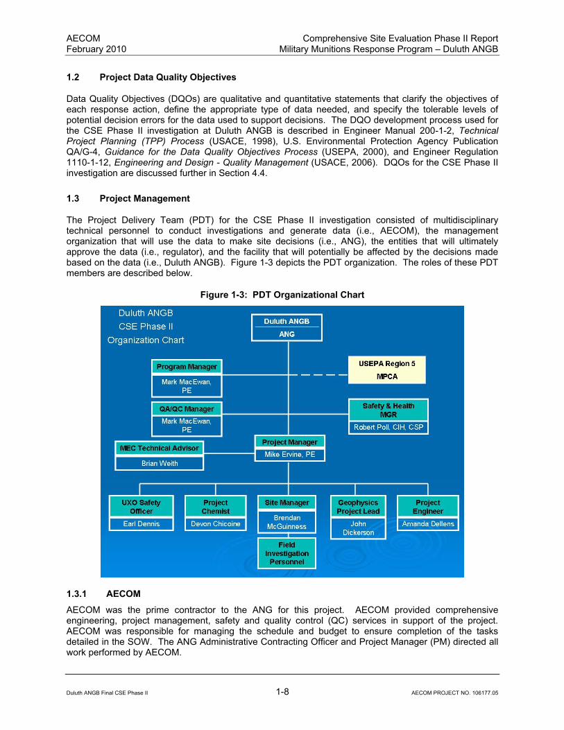
The Project Delivery Team (PDT) for the CSE Phase II investigation consisted of multidisciplinary technical personnel to conduct investigations and generate data (i.e., AECOM), the management organization that will use the data to make site decisions (i.e., ANG), the entities that will ultimately approve the data (i.e., regulator), and the facility that will potentially be affected by the decisions made based on the data (i.e., Duluth ANGB). Figure 1-3 depicts the PDT organization. The roles of these PDT members are described below.
Figure 1-3: PDT Organizational Chart
1.3.1 AECOM
AECOM was the prime contractor to the ANG for this project. AECOM provided comprehensive engineering, project management, safety and quality control (QC) services in support of the project. AECOM was responsible for managing the schedule and budget to ensure completion of the tasks detailed in the SOW. The ANG Administrative Contracting Officer and Project Manager (PM) directed all work performed by AECOM.

AECOM Comprehensive Site Evaluation Phase II Report February 2010 Military Munitions Response Program – Duluth ANGB
Duluth ANGB Final CSE Phase II 1-9 AECOM PROJECT NO. 106177.05
1.3.2 Air National Guard
The ANG provided technical leadership, project management and funding agency for this project. The NGB was responsible for reviewing project plans and documents, supporting the team with obtaining site access, working with the news media and the public, and coordinating with State and local regulatory agencies on issues pertaining to public safety and the environment.
1.3.3 Minnesota Pollution Control Agency
The Minnesota Pollution Control Agency (MPCA) is the regulatory agency and signatory to the Federal Facility Agreement for Duluth ANGB. The MPCA has been the lead agency providing regulatory oversight of munitions response actions and review of project documents to ensure that munitions response actions are protective of human health and the environment.
1.3.4 Duluth Air National Guard Base Environmental Manager
The Duluth ANGB Environmental Manager (EM) was responsible for coordinating with other base agencies to provide site access, reviewing project plans and documents, and coordinating activities with public and regulatory stakeholders.
1.4 Project Scope
The scope of CSE Phase II efforts at Duluth ANGB is detailed in the project SOW issued by the NGB on 14 July 2008. Activities consisted of:
Scheduling of meetings with appropriate stakeholders (to include one kick off meeting and four additional meetings) and preparation of agendas, briefing materials, and meeting minutes.
Submittal of a Draft, Draft Final, and October 2008 Final CSE Phase II Work Plan (Earth Tech AECOM, 2008), including a Geophysical Investigation Plan, Site-Specific Health and Safety Plan, and Sampling and Analysis Plan (SAP) (includes a Field Sampling Plan and a Quality Assurance Project Plan [QAPP]).
Completion of field work including: vegetation clearance (as necessary); visual site inspection, geophysical investigation of areas with known or suspected MEC and/or subsurface anomalies; and collection and analysis of environmental samples of appropriate quality and in sufficient quantity as necessary to characterize the nature and extent of contamination at each MRA.
Support of public participation, including: preparation and submittal of pre- and post-investigation fact sheets; publishing of public notices on CSE Phase II activities in local media; and organization of one public meeting to facilitate public participation for development of the MRS Priority (including preparation of agendas and briefing materials).
Submittal of Draft, Draft Final, and Final CSE Phase II Report documenting results of investigative fieldwork and recommendations for further actions, as appropriate.
Submittal of results in a Microsoft Access database for utilization in the Air Force MMRP Data Management Tool (DMT), including data elements for DoD MRSPP tables, AFRIMS, and RACER software, and preparation of hardcopies of the MRSPP tables, AFRIMS data input worksheets, and RACER data input worksheets.
1.5 Report Organization
This CSE Phase II Report is composed of thirteen sections as follows:
AECOM Comprehensive Site Evaluation Phase II Report February 2010 Military Munitions Response Program – Duluth ANGB
Duluth ANGB Final CSE Phase II 1-10 AECOM PROJECT NO. 106177.05
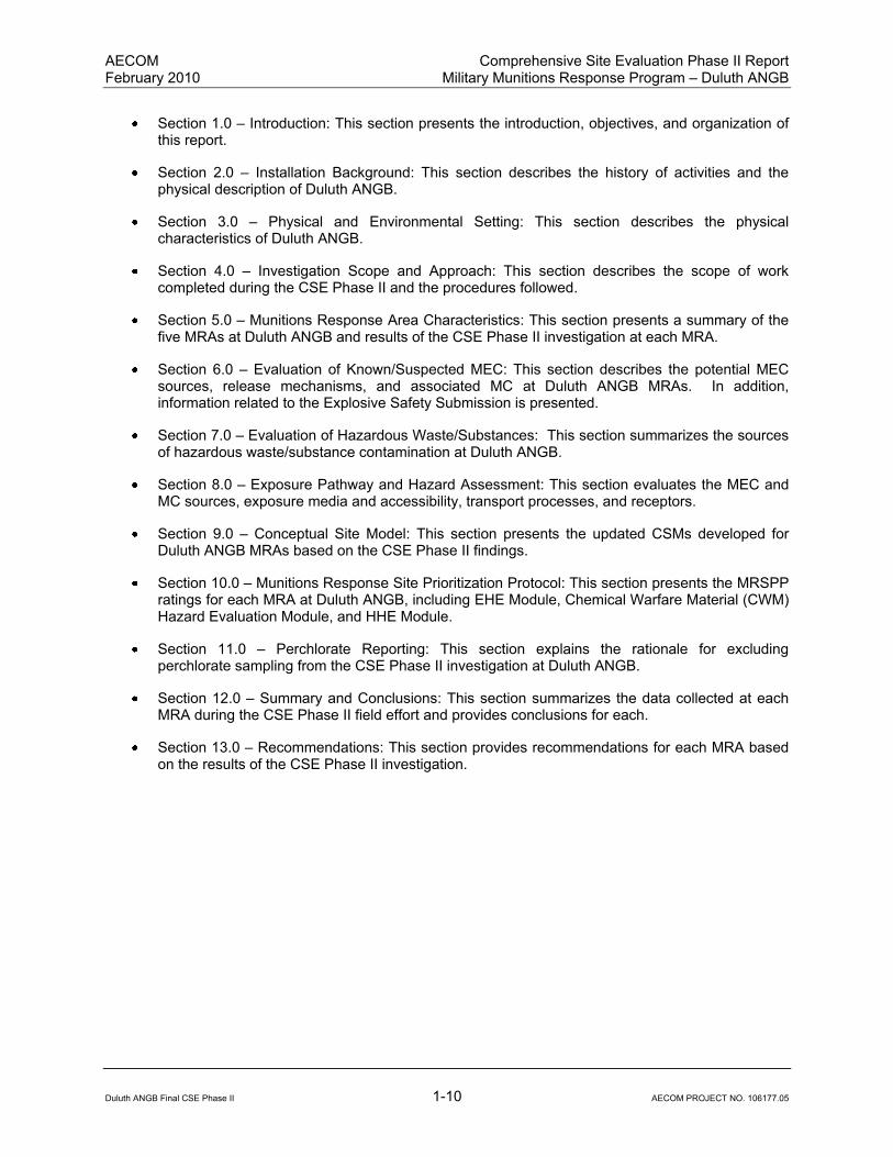
Section 1.0 – Introduction: This section presents the introduction, objectives, and organization of this report.
Section 2.0 – Installation Background: This section describes the history of activities and the physical description of Duluth ANGB.
Section 3.0 – Physical and Environmental Setting: This section describes the physical characteristics of Duluth ANGB.
Section 4.0 – Investigation Scope and Approach: This section describes the scope of work completed during the CSE Phase II and the procedures followed.
Section 5.0 – Munitions Response Area Characteristics: This section presents a summary of the five MRAs at Duluth ANGB and results of the CSE Phase II investigation at each MRA.
Section 6.0 – Evaluation of Known/Suspected MEC: This section describes the potential MEC sources, release mechanisms, and associated MC at Duluth ANGB MRAs. In addition, information related to the Explosive Safety Submission is presented.
Section 7.0 – Evaluation of Hazardous Waste/Substances: This section summarizes the sources of hazardous waste/substance contamination at Duluth ANGB.
Section 8.0 – Exposure Pathway and Hazard Assessment: This section evaluates the MEC and MC sources, exposure media and accessibility, transport processes, and receptors.
Section 9.0 – Conceptual Site Model: This section presents the updated CSMs developed for Duluth ANGB MRAs based on the CSE Phase II findings.
Section 10.0 – Munitions Response Site Prioritization Protocol: This section presents the MRSPP ratings for each MRA at Duluth ANGB, including EHE Module, Chemical Warfare Material (CWM) Hazard Evaluation Module, and HHE Module.
Section 11.0 – Perchlorate Reporting: This section explains the rationale for excluding perchlorate sampling from the CSE Phase II investigation at Duluth ANGB.
Section 12.0 – Summary and Conclusions: This section summarizes the data collected at each MRA during the CSE Phase II field effort and provides conclusions for each.
Section 13.0 – Recommendations: This section provides recommendations for each MRA based on the results of the CSE Phase II investigation.

AECOM Comprehensive Site Evaluation Phase II Report February 2010 Military Munitions Response Program – Duluth ANGB
Duluth ANGB Final CSE Phase II 2-1 AECOM PROJECT NO. 106177.05
2.0 INSTALLATION BACKGROUND
2.1 Location and Setting
The Duluth ANGB is co-located with Duluth International Airport in St. Louis County, Minnesota, approximately seven miles northwest of the City of Duluth, Minnesota (Figure 1-1). The main base occupies 153.3 acres on the northeast corner of the airport (Figure 1-2). Additionally, the Munitions Storage Area (located west of the main base) occupies 16.71 acres north of Runway 09/27. The base has a total of 37 buildings – 18 industrial and 19 administrative. The normal base population is 420 personnel, but surges to 1,100 personnel occur once each month during drill sessions. Figure 1-2 shows the relative locations of the five MRAs at Duluth ANGB.
2.2 Installation Mission
The Duluth ANGB is the home of the 148th FW. The 148
th FW flies the F-16 ADF Fighting Falcon. The
current mission of the 148th FW is to “provide the best trained personnel to defeat America’s adversaries
with speed and precision in war and respond to state and local emergencies in times of peace.”
2.3 Installation Operational History
In 1948, the Air National Guard 179th Fighter Squadron was formed at Duluth municipal airport. The unit
was under control of the 133rd
FW located in the Minneapolis/St. Paul, Minnesota area until the 148th
Fighter Group was formed in 1960. During this time, the unit was housed in temporary Works Project Administration shacks and portions of the Duluth Armory. In 1960, the mission of the 148
th Fighter Group
was to support of the Air Defense Command in Duluth until 1976 when it became the 148th Tactical
Reconnaissance Group. In 1983, the mission returned to Air Defense and the unit renamed to the 148th
Fighter Interceptor Group.
In 1992, the 148th Fighter Interceptor Group and the 179
th Flying Squadron were renamed in accordance
with USAF policy to the 148th Fighter Group and the 179
th Fighter Squadron, respectively. In 1995, the
unit was officially designated as the 148th FW. In 1999, the 148
th FW transitioned from a mission in air
superiority to the general purpose mission, training in all essentials of air to ground tactics and in the delivery of guided and unguided bombs. The general purpose mission included air superiority and air defense functions and officially covered “any mission the aircraft can accomplish, anywhere in the world.”
2.4 Munitions Related Training/Storage/Usage
The five MRAs at Duluth ANGB have each been used for various munitions related training activities, except for the LCSA, which was a disposal site for berm soils removed from the Small Arms Range (SR736). Details of the training activities are discussed for the five MRAs in Section 5.0.
2.5 Previous Investigations
The CSE Phase I investigation (URS, 2007) was completed in July 2007 to evaluate the following: (1) actual or potential releases of MEC and munitions-related hazardous substances, pollutants, or contaminants to migration or exposure pathways (including groundwater, surface water, soil, and air); (2) site physical conditions; and (3) future land uses and activities. The data collected during the CSE Phase I investigation served as the basis for recommending additional MRA investigation. Information was gathered from Duluth ANGB archival records, personnel, public archival sources, and observations made during field reconnaissance. These data were used to develop ICSMs of potential human and ecological exposures to MEC and MC based on current and projected AFLUs.

AECOM Comprehensive Site Evaluation Phase II Report February 2010 Military Munitions Response Program – Duluth ANGB
Duluth ANGB Final CSE Phase II 2-2 AECOM PROJECT NO. 106177.05
The findings of the CSE Phase I for each of the five MRAs at the Duluth ANG are summarized in Table 2-1. The recommendations made as part of the findings of the CSE Phase I included sampling of potentially impacted media in each of the five MRAs to determine if MC has been released to the environment. Geophysical mapping was also recommended for the EOD Range and the LCSA to evaluate the density of potential subsurface anomalies across these sites. These recommendations were taken into consideration by the PDT during CSE Phase II planning activities.

Table 2-1
Summary of CSE Phase I Findings
Duluth Air National Guard Base - Duluth, Minnesota
MRA EOD Range Small Arms Range Trap Range Skeet RangeLead Contaminated
Soils Area
Type EOD Range Small Arms Range Small Arms Range Skeet Range
Munitions
Constituents Site
Size ~0.3 acres ~2.5 acres ~4.0 acres ~15.3 acres ~0.3 acres
Topography Flat Flat Flat Sloping to the east Flat
Vegetative Cover Grass Trees Trees/Barren Ground Grass Grass
Soil Type Sandy Loam Sandy Loam Sandy Loam Sandy Loam sandy Loam
Features
Grass field with two holes
on north quarter of range
Aircraft maintenance
hangar, parking lot, and
grassy areas
Partially developed; includes
grassy area, aircraft
maintenance hangar, and
parking lot. Remaining area
is forested Developed Fallow field
MEC/Munitions Debris None Identified
None found but would be
small arms is present
None found but would be
small arms is present
None found but would
be small arms is
present
None found but would
be small arms is
present
Anomaly Density
Low (<10 anomalies per
acre)
Low (<10 anomalies per
acre)
Low (<10 anomalies per
acre)
Low (<10 anomalies
per acre)
Low (<10 anomalies
per acre)
Evidence of High
Explosives (HE) Found None None None None None
Access
No Public Access
Authorized
Employees of company
leasing building
Employees of leasing
building have unrestricted
access
No Public Access
Authorized Base Workers
Potentially Impacted
Media Soil Soil Soil Soil
Soil, Surface Water,
Sediment
Ownership
Duluth Airport Authority
with a restrictive easement
to the Duluth ANGB
Duluth Airport Authority;
previously controlled by
the DoD (USAF)
Duluth Airport Authority;
previously controlled by the
DoD (USAF)
Owned concurrently
by the DoD (USAF)
and the Minnesota
Department of
Military Affairs
Duluth Airport
Authority
MRS Priority 4 8 8 8 8
Recommended Sampling
Surface/Subsurface Soil,
Groundwater; Geophysical
Mapping
Surface/Subsurface Soil,
Groundwater
Surface/Subsurface Soil,
Sediment, Surface Water
Surface/Subsurface
Soil, Sediment,
Surface Water
Surface/Subsurface
Soil, Sediment,
Surface Water;
Geophysical Mapping
Source: AECOM, 2008
Duluth ANGB Final CSE Phase II 2-3 AECOM PROJECT NO. 106177.05

AECOM Comprehensive Site Evaluation Phase II Report February 2010 Military Munitions Response Program – Duluth ANGB
Duluth ANGB Final CSE Phase II 2-4 AECOM PROJECT NO. 106177.05
This page intentionally left blank.

AECOM Comprehensive Site Evaluation Phase II Report February 2010 Military Munitions Response Program – Duluth ANGB
Duluth ANGB Final CSE Phase II 3-1 AECOM PROJECT NO. 106177.05
3.0 PHYSICAL AND ENVIRONMENTAL SETTING
3.1 Climate
Minnesota has a continental-type climate, characterized by winter temperatures that are cold enough to support an annual period of fixed snow cover, and moderate precipitation during the summer months. Pacific Ocean air masses that move across the western United States produce relatively mild and dry weather year-round; however, occasional periods of prolonged heat occur during summer when warm air moves northward from the Gulf of Mexico. Mean annual temperatures range from 36 degrees Fahrenheit (°F) in the extreme north to 49°F in the southeast along the Mississippi River. In Duluth, temperatures average approximately 20°F in January and approximately 75°F in July. Areas near Lake Superior (including Duluth) tend to be relatively cool in the summer and relatively warm in the winter, as compared to the northern region of the state.
Approximately two thirds of Minnesota’s annual precipitation occurs between May and September. Mean annual rainfall ranges from 35 inches in the southwest portion of the state to approximately 19 inches in the extreme northwest portion of the state. Seasonal snowfall averages near 70 inches in the highlands along the north shore of Lake Superior in northeast Minnesota, and averages around 40 inches along the Iowa border in the south. Snow cover of at least one inch across the state occurs on average 110 days per year.
Heavy snowfalls with greater than four inches can be expected any time from mid-November through mid-April. Blizzard conditions are characterized by visibility less than one quarter of a mile for several hours due to falling and/or blowing snow and wind speeds at least 35 miles per hour, and occur two times per year on average. Drought conditions with an annual Palmer Drought Index of -3 or lower occur about once every 25 years in the eastern portion of the state. The average annual frequency of thunderstorm days is ranges from about 45 days in southern Minnesota to about 30 days along the Canadian border. Approximately 80 percent of these storms typically occur between May and September. On average, 35 tornadoes are reported annually in Minnesota. Approximately 75 percent of those occur in May, June, and July, with the highest frequency occurring in June. Generally, the soil freezes around the first week in December and thaws in mid-April. Average maximum freeze depth ranges from three to four feet in the south to five to six feet in the north. Forested regions typically have much shallower freeze depths. (UMN Climatology Working Group, 2006)
3.2 Topography
The area around Duluth ANGB lies at an approximate elevation of 1,400 feet above mean sea level (msl), which is slightly higher than Minnesota’s average elevation of 1,200 feet above msl. Several small hills and valleys surround the installation, but the area is relatively flat, with a relief of less than 50 feet within the installation. Elevations gradually decline toward Wild Rice Lake, located approximately two miles to the north at an elevation of approximately 1,375 feet above msl. Elevations steeply decline toward Lake Superior, located approximately six miles to the southeast, near downtown Duluth, at an elevation of approximately 602 feet above msl (USGS, 1993).
3.3 Hydrology
Hydrology in the vicinity of Duluth ANGB was evaluated as part of CSE Phase I investigation (URS, 2007). No previous detailed reports regarding surface water features in the area were identified. Wild Rice Lake is the largest body of water near the facility and is located approximately two miles to the north. During CSE Phase I activities, more than 15 small lakes within two miles of the facility were identified through aerial photographs.
AECOM Comprehensive Site Evaluation Phase II Report February 2010 Military Munitions Response Program – Duluth ANGB
Duluth ANGB Final CSE Phase II 3-2 AECOM PROJECT NO. 106177.05
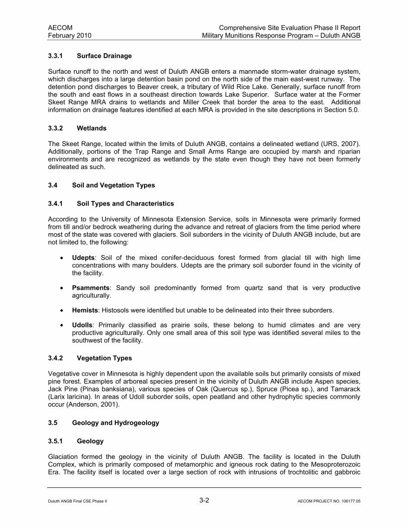
3.3.1 Surface Drainage
Surface runoff to the north and west of Duluth ANGB enters a manmade storm-water drainage system, which discharges into a large detention basin pond on the north side of the main east-west runway. The detention pond discharges to Beaver creek, a tributary of Wild Rice Lake. Generally, surface runoff from the south and east flows in a southeast direction towards Lake Superior. Surface water at the Former Skeet Range MRA drains to wetlands and Miller Creek that border the area to the east. Additional information on drainage features identified at each MRA is provided in the site descriptions in Section 5.0.
3.3.2 Wetlands
The Skeet Range, located within the limits of Duluth ANGB, contains a delineated wetland (URS, 2007). Additionally, portions of the Trap Range and Small Arms Range are occupied by marsh and riparian environments and are recognized as wetlands by the state even though they have not been formerly delineated as such.
3.4 Soil and Vegetation Types
3.4.1 Soil Types and Characteristics
According to the University of Minnesota Extension Service, soils in Minnesota were primarily formed from till and/or bedrock weathering during the advance and retreat of glaciers from the time period where most of the state was covered with glaciers. Soil suborders in the vicinity of Duluth ANGB include, but are not limited to, the following:
Udepts: Soil of the mixed conifer-deciduous forest formed from glacial till with high lime concentrations with many boulders. Udepts are the primary soil suborder found in the vicinity of the facility.
Psamments: Sandy soil predominantly formed from quartz sand that is very productive agriculturally.
Hemists: Histosols were identified but unable to be delineated into their three suborders.
Udolls: Primarily classified as prairie soils, these belong to humid climates and are very productive agriculturally. Only one small area of this soil type was identified several miles to the southwest of the facility.
3.4.2 Vegetation Types
Vegetative cover in Minnesota is highly dependent upon the available soils but primarily consists of mixed pine forest. Examples of arboreal species present in the vicinity of Duluth ANGB include Aspen species, Jack Pine (Pinas banksiana), various species of Oak (Quercus sp.), Spruce (Picea sp.), and Tamarack (Larix laricina). In areas of Udoll suborder soils, open peatland and other hydrophytic species commonly occur (Anderson, 2001).
3.5 Geology and Hydrogeology
3.5.1 Geology
Glaciation formed the geology in the vicinity of Duluth ANGB. The facility is located in the Duluth Complex, which is primarily composed of metamorphic and igneous rock dating to the Mesoproterozoic Era. The facility itself is located over a large section of rock with intrusions of trochtolitic and gabbroic
AECOM Comprehensive Site Evaluation Phase II Report February 2010 Military Munitions Response Program – Duluth ANGB
Duluth ANGB Final CSE Phase II 3-3 AECOM PROJECT NO. 106177.05
rocks. Immediately to the southeast, these formations give way to anorthositic gabbro and other related rocks. Near the coast of Lake Superior, the Beaver Bay Complex and related subvolcanic mafic rocks (including olivine gabbro in dikes and sills) take over with influence from the North Shore Volcanic Group, which includes basalt, andesitic basalt, rhyolite, and related volcanogenic interflow sedimentary rocks. This formation also includes basal quartz arenite in the vicinity of Duluth (Morey and Meints, 2000).
3.5.2 Hydrogeology
During advance and retreat of glaciers, at least three phases of Lake Superior existed, giving rise to stratigraphy consisting of thin shallow water lacustrine sequences four to seven meters thick. These sequences are interbedded with layers of lacustrine clays or clayey tills up to 40 meters thick. Shallow-water sands are hydraulically connected to sediments of a large moraine complex that is primarily composed of coarse outwash; recharge and conductivity in the area are sufficient to result in artesian conditions in the Lake Duluth sedimentary sequences. The potentiometric surface of the confined aquifers exceeds surface elevations (which slope toward the axis of the Lake Duluth Basin) throughout much of the central portions of the former lake basin. Groundwater seeps are common in this area, concentrated where the potentiometric surface intersects the ground surface (Mooers, 2005). The depth to groundwater in the vicinity of Duluth ANGB varies from 2 feet to 35 feet.
3.6 Cultural and Natural Resources
The Minnesota Air National Guard (MNANG), in conjunction with the National Guard Bureau/ Environmental Planning Branch (NGB/A7CVP), is in the final stages of completing a cultural/archaeological resources survey. Although the document is not considered final, no cultural or archaeological resources have been identified for the MRAs addressed in this CSE Phase II. In coordination with the Minnesota State Historic Preservation Office and the MNANG, Building 500, located on the Duluth ANGB, has recently been identified as eligible for listing on the National Register of Historic Places. The active Munitions Storage Area is also eligible, but is covered by a Nationwide Program Comment Letter, which has not received final approval. No additional cultural or archaeological sites are known to be present within five miles of Duluth ANGB.
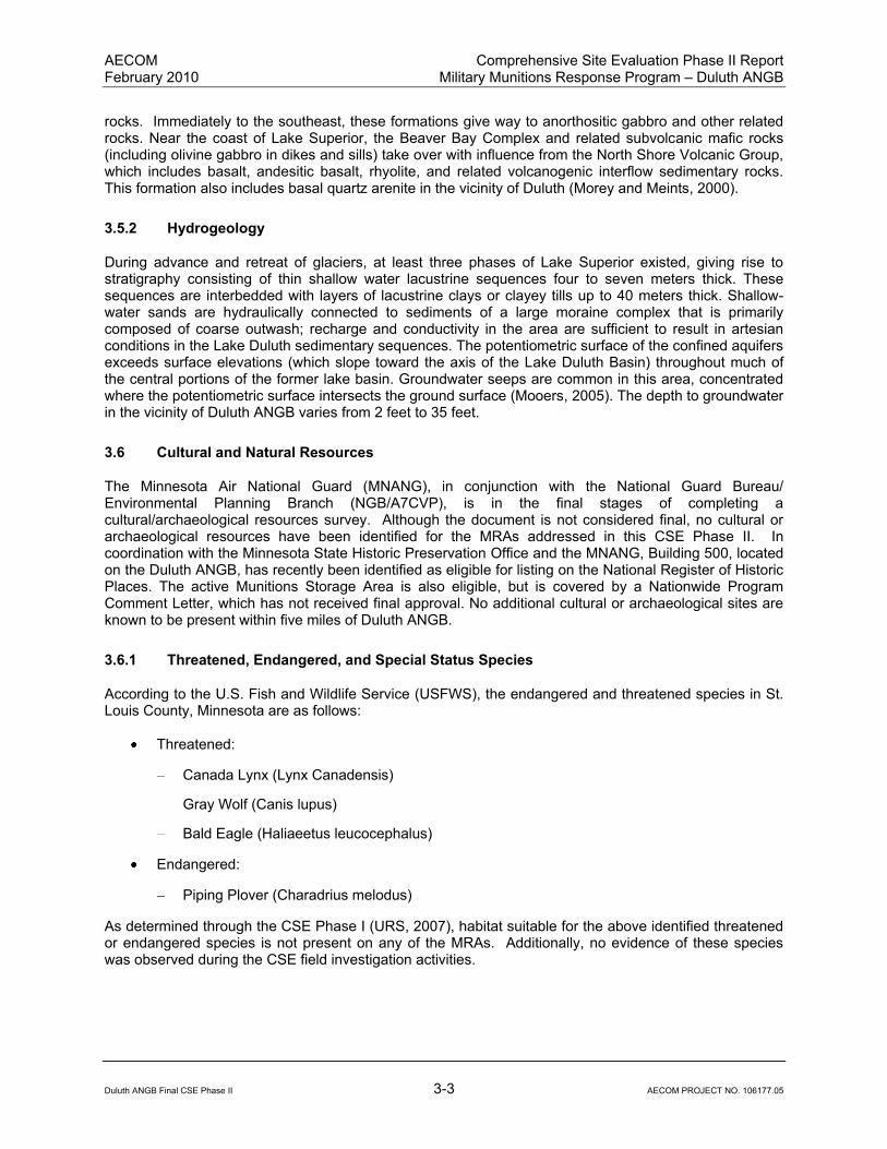
3.6.1 Threatened, Endangered, and Special Status Species
According to the U.S. Fish and Wildlife Service (USFWS), the endangered and threatened species in St. Louis County, Minnesota are as follows:
Threatened:
Canada Lynx (Lynx Canadensis)
Gray Wolf (Canis lupus)
Bald Eagle (Haliaeetus leucocephalus)
Endangered:
Piping Plover (Charadrius melodus)
As determined through the CSE Phase I (URS, 2007), habitat suitable for the above identified threatened or endangered species is not present on any of the MRAs. Additionally, no evidence of these species was observed during the CSE field investigation activities.
AECOM Comprehensive Site Evaluation Phase II Report February 2010 Military Munitions Response Program – Duluth ANGB
Duluth ANGB Final CSE Phase II 3-4 AECOM PROJECT NO. 106177.05
3.6.2 Sensitive Ecological Settings
St. Louis County is listed as critical habitat for two species, the Gray Wolf (Canis lupus) and the Piping Plover (Charadrius melodus), by the USFWS. Minnesota as a whole has many wetlands, which are covered by both state and federal regulations. The Duluth ANGB is bordered by wetlands to the north, east, and south. A portion of the Skeet Range is delineated as a wetland that drains directly into Miller Creek, which is a state-designated trout stream. No additional wetlands have been delineated within the boundaries of the remaining MRAs.

AECOM Comprehensive Site Evaluation Phase II Report February 2010 Military Munitions Response Program – Duluth ANGB
Duluth ANGB Final CSE Phase II 4-1 AECOM PROJECT NO. 106177.05
4.0 INVESTIGATION SCOPE AND APPROACH
This section summarizes the scope and approach utilized to complete CSE Phase II investigation activities at the Duluth ANGB MRAs. Results for these investigation activities are presented in Section 5.0. Detailed plans and procedures for all field activities may be found in the CSE Phase II Work Plan (Earth Tech AECOM, 2008).
4.1 Site Reconnaissance and Visual Survey
Immediately following the September 24, 2008 project kickoff meeting at the Duluth ANGB, a site-reconnaissance of the MRAs on- and off-base was conducted. During this reconnaissance, the Duluth ANGB EM escorted AECOM personnel to each of the five MRAs, except for the Trap Range, which was located outside a fence and was inaccessible from base or airport property. The Trap Range was viewed from inside the airport perimeter fence. AECOM personnel took several photographs at each MRA during the site reconnaissance and these are included as Appendix M.
When the AECOM field team mobilized to Duluth ANGB in December 2008, visual surveys of the MRAs were conducted prior to the geophysical survey and environmental sampling. The field team noted the proposed sampling locations and any site conditions (e.g., frozen ground/surface water, existing buildings or pavement, access to the MRAs, etc.) that would interfere with the planned field investigation activities.
4.2 Geophysical Survey
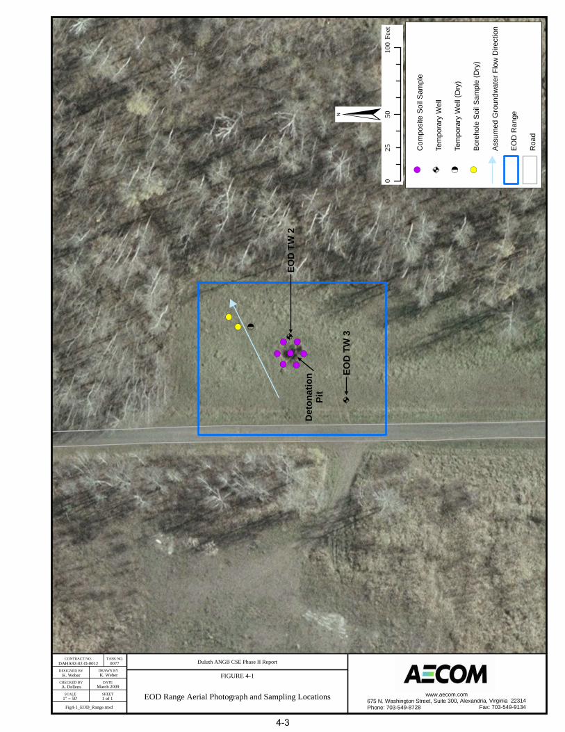
A non-intrusive geophysical survey of the EOD Range MRA was conducted during the December 2008 field investigations to identify potential subsurface anomalies. Figure 4-1 is a photo-image of the survey area. Results of the geophysical survey were analyzed by the Project Geophysicist to identify potential MEC anomalies. The following sections summarize the geophysical survey and data analysis approach.
4.2.1 Geophysical Instrument Performance Evaluation
An Equipment Detection Performance Evaluation plot was initially used to determine and document the detection and resolution performance of the electromagnetic induction (EMI) system deployed for the geophysical survey. Due to frozen ground conditions, multiple targets of differing sizes simulating potential kick-out from an OB/OD pit were placed at the ground surface and data were collected over them. While this does not directly show the depth of detection, it does provide a measure of the soil matrix-target contrast for the existing site conditions. Detection “fall off” with increasing depth could then be qualified based on the demonstrated signal to background response recorded for the individual targets.
4.2.2 Geophysical Investigation Quality Control
The geophysical investigation followed a multi-step process to ensure high-quality data collection, processing and interpretation as well as execution of high-quality workmanship. These steps were designed to: (1) verify positional accuracy and precision of the collected data; (2) ensure that good field practices were employed; (3) verify that equipment was properly operating and that data was repeatable; (4) ensure adequate coverage and completeness of data, with sufficient signal-to-noise ratio to identify significant geophysical anomalies; and (5) ensure that the project objectives were met.
The Site Geophysicist performed sensor standardization tests to document the operation of the field instruments prior to commencing the survey. These tests document the functionality of the survey equipment and allow instrument calibration for noise, stability, and repeatability to be monitored. These tests and their functions included:

AECOM Comprehensive Site Evaluation Phase II Report February 2010 Military Munitions Response Program – Duluth ANGB
Duluth ANGB Final CSE Phase II 4-2 AECOM PROJECT NO. 106177.05
This page intentionally left blank.
! (
! (
A
! ( ! (! (! (
! (! (A
! ( <
K. Weber K. Weber
A. Dellens
1" = 50' 1 of 1
DAHA92-02-D-0012 0077 Duluth ANGB CSE Phase II Report
FIGURE 4-1
EOD Range Aerial Photograph and Sampling Locations
CONTRACT NO. TASK NO.
DESIGNED BY
CHECKED BY
SCALE
DRAWN BY
DATE
SHEET
March 2009
EOD
TW
2
EOD
TW
3
§0
5010
025
Feet
! (C
ompo
site
Soi
l Sam
ple
ATe
mpo
rary
Wel
l
<Te
mpo
rary
Wel
l (D
ry)
! (Bo
reho
le S
oil S
ampl
e (D
ry)
Assu
med
Gro
undw
ater
Flo
w D
irect
ion
EOD
Ran
ge
Roa
d
www.aecom.com675 N. Washington Street, Suite 300, Alexandria, Virginia 22314Phone: 703-549-8728 Fax: 703-549-9134Fig4-1_EOD_Range.mxd
Det
onat
ion
Pit
4-3

AECOM Comprehensive Site Evaluation Phase II Report February 2010 Military Munitions Response Program – Duluth ANGB
Duluth ANGB Final CSE Phase II 4-4 AECOM PROJECT NO. 106177.05
This page intentionally left blank.

AECOM Comprehensive Site Evaluation Phase II Report February 2010 Military Munitions Response Program – Duluth ANGB
Duluth ANGB Final CSE Phase II 4-5 AECOM PROJECT NO. 106177.05
Record Sensor Position: Field crews checked and recorded any changes to the geometry configuration of the survey platform.
Static Background and Spike Test: Checks the instrument’s background response, spike response and drift, and identifies potential interference. Static tests were performed using a 1
1/2-inch by 3-inch pipe nipple under rear of left tire.
Personnel Test: Checks the operators for potential sources of noise.
Cable Shake Test: Measures any anomalous readings caused by cable movement, wire shorts and/or bad connectors.
Time Calibration Test: Measures the time latency in the instrument readings. The instruments have a built-in latency between the measurement and the output of the readings.
Point Position Test: Checks the function and accuracy of the positioning system, and also acts as a secondary check for the Time Calibration Test.
4.2.3 Geophysical Data Collection
The boundary of the 0.3-acre EOD Range was initially reacquired in the field. Site conditions at the time of the survey were light snow covering the ground with knee to waist-high grass and small trees. North, west, and east survey perimeters were bordered by 25- to 35-foot trees with the south consisting primarily of more waist-high grass. A large pit (approximately 4 feet deep) was located in center of survey area. This is believed to be the location of former EOD detonation. A 14-inch-diameter corrugated steel culvert was located between the road (western survey boundary) and EOD demolition pit. An initial surface sweep of the area for metallic anomalies was performed using a Schonstedt GA-52cx and a clear area was found in which to perform EM-61 QA/QC tests (latency, personnel, cable shake, etc.).
Survey lanes were laid out east to west to cover the survey area and extend beyond the area boundaries to ensure coverage and preclude “turning” or end-of-line anomalies. Data were collected using a wheel-mounted, manually towed Geonics, Ltd EM61 Mk2 metal detector. This instrument was directly coupled to a Trimble 5800 real-time kinematic global positioning system (RTK-GPS). The RTK-GPS base station was set up over an existing land survey control point on the installation. Geophysical responses were recorded at five readings per second and correlated with RTK-GPS positional data recorded at a frequency of one reading per second. Intervening geophysical data were linearly interpolated with the GPS positions.
The positional data collected with the RTK-GPS yielded an overall survey accuracy of ±8 inches. The GPS satellite clock time was used to time-stamp both position and sensor data needed for later correlation. The GPS and EMI data were recorded simultaneously in the data logger. The GPS data were referenced to geographic latitude and longitude and subsequently converted to the State Plane (SP) coordinate system, in U.S. Survey Feet. Error introduced by erratic motion of the roving antenna was less than 0.2 meter.
The data were collected at a walking pace that enabled capture of a long line data spaced at 0.5-foot intervals (or smaller). Survey coverage of contiguous transects was achieved by laying out a 2-foot lane spacing, ensuring probability of overlap on each transect. Data coverage was complete, except for the remnants of the OB/OD pit in the center of the survey area.
4.2.4 Geophysical Data Processing
The geophysical survey data was processed using standard, IBM-compatible PC platforms. Processing software was comprised of downloading routines specific to the geophysical and positional instrumentation deployed, Geosoft’s Oasis montaj and/or Golden Software’s SURFER, and Microsoft Excel, Word, and Access programs.

AECOM Comprehensive Site Evaluation Phase II Report February 2010 Military Munitions Response Program – Duluth ANGB
Duluth ANGB Final CSE Phase II 4-6 AECOM PROJECT NO. 106177.05
Data were exported spatially referenced to WGS84 latitude and longitude. The spatially referenced readings were then filtered using a 101-element demedian filter. The effect is to remove broad wavelength contributions to the EM field caused by local geologic sources, while retaining the relatively shorter wavelength responses/excursions caused by nearby, discrete metal sources.
Noise levels in the data were quite low and readily allowed differentiation of target sources versus background matrix. An automated picking algorithm was initially used to pre-select anomalous responses for potential intrusive activities. These picks were then visually inspected and replicate anomalies noted.
Final anomaly selection was accomplished by identification of discrete responses that were distinct from background levels. The data analysis included:
Plotting the sensor data in grid and pixel format;
Applying filters (when necessary) to aid in target identification;
Manually identifying additional targets;
Manually removing targets attributed to edge effects and cultural features; and
A hardcopy map of the geophysical data with superimposed target locations was generated along with a final target list with position and peak anomaly values.
4.3 Environmental Media Sampling and Analysis
Environmental media sampling and analysis was conducted at all five MRAs during the December 2008 field investigations to characterize MC contamination. Some modifications to the sample collection program were implemented due to the extremely cold temperatures (10°F with wind chills below 0°F) encountered at the base. These modifications are identified in this section. These modifications did not significantly influence the quality of collected data or achieving the goals of the investigation. The following sections summarize the sampling and analysis program for soil, groundwater, surface water, and/or sediment at the five MRAs.
4.3.1 X-Ray Fluorescence Analysis
X-ray fluorescence (XRF) analysis was used for both in-situ and ex-situ screening of metals concentrations in soils at the Small Arms Range, Trap Range, Skeet Range, and the LCSA. Initial field efforts included collection of soil samples in gallon size re-sealable plastic bags, drying and sieving (No. 20 sieve), and XRF analysis of samples in the field office (ex-situ). As frozen soil conditions were encountered, in-situ XRF analysis was conducted more frequently. This was due to fact that many of the samples were found to contain significant frozen moisture which would liquefy the sample during drying. Significant time was required to melt and dry out the samples, defeating the purpose of using XRF as a quick-turnaround field-screening tool for the investigation. For in-situ analysis, no sample preparation (i.e., drying or sieving) was conducted. Instead, vegetation and any accumulated organic material were scraped from the ground surface and the XRF analyzer was held directly in contact with the ground surface for a 60-second test.
The accuracy of the metals concentrations recorded with the XRF analyzer is affected by soil moisture content and the heterogeneity of the soil material. To validate the XRF screening results, confirmation samples were collected at a rate of one laboratory sample for every ten (i.e., 10%) of XRF samples. While the XRF results did not always correlate well to laboratory results, generally the XRF results provided a good indication of the areas of highest metals concentrations within the MRAs. Overall, the XRF results tended to be biased low compared to the laboratory results.
For XRF as well as laboratory analysis samples, a screening value for lead of 100 mg/kg was used to determine whether or not other metals results were reported. If XRF or laboratory results did not exceed

AECOM Comprehensive Site Evaluation Phase II Report February 2010 Military Munitions Response Program – Duluth ANGB
Duluth ANGB Final CSE Phase II 4-7 AECOM PROJECT NO. 106177.05
this lead screening value, the concentrations of the remaining metals commonly associated with small arms ranges (antimony, arsenic, copper [Cu], iron, tin, and zinc) were not reported for that sample (ITRC, 2003). This reporting method was used because the other metals associated with small arms are not typically detected at elevated concentrations if lead is not detected at an elevated level. The 100 mg/kg screening value was selected based on discussions with the MPCA and since it is slightly below the Tier II Sediment Quality Target (SQT) and terrestrial wildlife screening values used by MPCA, but is still higher than probable background concentrations for lead. XRF sample locations are identified in Figures 4-2 through 4-5.
4.3.2 Soil
Surface and subsurface soil samples for laboratory analysis were collected at each of the five MRAs. The numbers of samples, sample identifications (IDs), depths, and the laboratory analyses that were conducted are summarized in Table 4-1. Surface samples (and shallow subsurface soil samples at the Trap and Skeet Ranges) were extracted using a pickaxe (due to frozen soil conditions) and transported in gallon size re-sealable plastic bags to the field office, where samples were transferred into labeled laboratory sample containers. The subsurface soil samples were collected with a GeoProbe direct push technology (DPT) drill rig. Soil sample locations are identified in Figures 4-1 through 4-5.
4.3.3 Groundwater
Groundwater samples were collected at the EOD Range from two temporary wells. The sample IDs, depths, and the laboratory analyses that were conducted are summarized in Table 4-1. The GeoProbe drill rod was utilized to install the temporary wells. Drill rod refusal was encountered at all the attempted borehole locations at the EOD Range at depths ranging from 3 to 11 feet below ground surface (bgs). Visual inspection of the soil cores indicated that the drill rod met refusal on shallow rock boulders.
Two temporary wells were successfully installed upgradient of the detonation pit (EOD TW3) and adjacent to the detonation pit (EOD TW2) at depths of 10 and 11 feet bgs, respectively. The boring for a third planned temporary well, downgradient of the detonation pit, was relocated three times due to shallow drill rod refusal. One downgradient temporary well was installed at the depth of refusal (9 feet bgs); however, the well was dry when measured and no groundwater was available for sample collection. Groundwater was measured in temporary monitoring wells EOD TW2 and EOD TW3 at 6.5 and 8.1 feet, respectively, below the top of the temporary monitoring well casing.
Unfiltered groundwater samples were collected from the temporary wells upgradient and adjacent to the detonation pit. These two wells yielded insufficient groundwater to collect the 5 liters required for a duplicate sample or matrix spike/matrix spike duplicate for laboratory quality assurance purposes. In addition, there was not enough volume to sample for polycyclic aromatic hydrocarbons (PAHs) using both the conventional method 8270C with low detection levels and the 8270 SIM method that includes more constituents but higher detection levels for some constituents. Since there was not enough water for both analyses, it was decided to only run the 8270 SIM method. Groundwater sample locations at the EOD Range are identified in Figure 4-1.
4.3.4 Surface Water and Sediment
Surface water and co-located sediment samples were collected from the Trap Range, Skeet Range, and the LCSA. The numbers of samples, sample IDs, and the laboratory analyses that were conducted are summarized in Table 4-1.
In accordance with the CSE Phase II Work Plan, AECOM intended to collect pore water samples at each of the sites where surface water was collected. However, due to sub-freezing temperatures, water froze within the pore water sampling device and could not be collected for laboratory analysis. For this reason,

AECOM Comprehensive Site Evaluation Phase II Report February 2010 Military Munitions Response Program – Duluth ANGB
Duluth ANGB Final CSE Phase II 4-8 AECOM PROJECT NO. 106177.05
This page intentionally left blank.

! (
! (
! (! (
! (
! (
! (
! (
! (! (
! (
! (
! (
! (
! (
! (
! (
! (
! (
! (
! (! (
! (
! (
! (
! (
! (
! (
! (! (
! (
! (
! (
! (
! (! (
! (
! (
! (
! (
! (
! (
! (
! (
! (
! (
! (
! (
! (
! (
! (
! (
! (
! (
! (
! (
! (
! (
! (
! (
! (! (
! (
! (
! (
! (
! (
! (
! (
! (
! (
! (
! (
! (
! (
! (
! (
! (
! (
! (
! (
! (
! (! (
! (
! (
! (
! (
! (
! (
! (
! (
! (
! (
! (
! (! (
! (
! (
! (! (
! (
! (
! (
! (! (
! (
! (
K. Weber K. Weber
A. Dellens
1" = 100' 1 of 1
DAHA92-02-D-0012 0077 Duluth ANGB CSE Phase II Report
FIGURE 4-2
Small Arms Range Aerial Photograph and Sampling Locations
CONTRACT NO. TASK NO.
DESIGNED BY
CHECKED BY
SCALE
DRAWN BY
DATE
SHEET
March 2009
§0
100
200
50Fe
et
! (So
il S
ampl
e
! (XR
F S
oil S
ampl
e
! (Bo
reho
le S
oil S
ampl
e
25' x
25'
Grid
Non
-Nat
ive
Fill
Mat
eria
l
Con
cret
e P
ad /
Build
ings
- N
o Sa
mpl
es
Smal
l Arm
s R
ange
www.aecom.com675 N. Washington Street, Suite 300, Alexandria, Virginia 22314Phone: 703-549-8728 Fax: 703-549-9134Fig4-2_Small_Arms_Range.mxd
His
toric
al R
ange
Fea
ture
s (1
988)
Targ
ets
Targ
et Berm
Firing
Directi
on of F
ire
Line
4-9

AECOM Comprehensive Site Evaluation Phase II Report February 2010 Military Munitions Response Program – Duluth ANGB
Duluth ANGB Final CSE Phase II 4-10 AECOM PROJECT NO. 106177.05
This page intentionally left blank.

! (
! (
! (
! (
! (
! (
! (
! (
! (
! (
! (
! (
! (
! (
! (
! (
! (
! (
! (
! (
! (! (
! (! (
! (! (
! (! (
! (! (
! (! (
! (! (
! (! (
! (
! (
! (
! (
! (
K. Weber K. Weber
A. Dellens
1" = 175' 1 of 1
DAHA92-02-D-0012 0077 Duluth ANGB CSE Phase II Report
FIGURE 4-3
Trap Range Aerial Photograph and Sampling Locations
CONTRACT NO. TASK NO.
DESIGNED BY
CHECKED BY
SCALE
DRAWN BY
DATE
SHEET
March 2009
§0
175
350
87.5
Feet
! (Se
dim
ent S
ampl
e / S
urfa
ce W
ater
Sam
ple
! (So
il S
ampl
e
! (XR
F So
il S
ampl
e
Grid
Surfa
ce W
ater
Trap
Ran
ge
Roa
d
Airfi
eld
www.aecom.com675 N. Washington Street, Suite 300, Alexandria, Virginia 22314Phone: 703-549-8728 Fax: 703-549-9134Fig4-3_Trap_Range.mxd
Firin
g Po
int
4-11

AECOM Comprehensive Site Evaluation Phase II Report February 2010 Military Munitions Response Program – Duluth ANGB
Duluth ANGB Final CSE Phase II 4-12 AECOM PROJECT NO. 106177.05
This page intentionally left blank.

DD
D D
D
D
D
DD
D
D
D
D
D
D
D
D
DD
DD
DD
DD
DD
DD
D
DD
D D DD
D
D
D
D
D
D
D
D
D
D
D
D
D
D
D
D
D
D
D
D
D
D
D
D
D
D
D
D
D
D
D
D
D D D D
D
D
D
D
D
DD
DD
DD
DD
DD
D
D
D
D
D
D
D
D
D
D
D
D
D
D
D
D
D
D
D
DD
DD
DD
D
D
D D
DD
DD
D
DDD
DD
DD
DD
D
D
D
D
D
D
D
D
D
D
D
D
D
D
D
D
D
D
D
D
D
D
D
D
D
D
D
D
D
D
D
D
D
D
D
D
D
D
D
D
D
D
D
D
D
D
D
D
D
D
D
D
D
D
DD
D
D
D
D
D
D
D
D
D
D
D
D
D
D
D
D
DD
DD
DD
DD
DD
DD
D
D
D
D
D
D
D
DD
DD
DD
D D D D D D D D D D D D D D D D D D D D D D D D D D D D D D D D D D D D D D D D D D D D D D D D D D D D D
DD
DD
DD
DD
DD
DD
DD
DD
DD
DD
DD
DD
DD
DD
DD
DD
DD
DD
DD
DD
DD
DD
DD
DD
DD
DD
DD
DD
DD
DD
DD
DD
DD
DD
DD
DD
DD
DD
DD
DD
DD
DD
DD
DD
DD
DD
DD
DD
DD
DD
DD
DD
DD
DD
DD
DD
DD
DD
DD
DD
DD
DD
DD
D
DDDD
D
D
DDDDDDDDDDDDDD
DD
DD
DD
DD
DD
D
!(
!(
!(
!(
!(
!(
!(
!(
!(
!(
!(
!(
!(
!(
!(
!(
!(
!(
!(
!(
!(
!(
!(
!(
!(!(
!(
!(
!(
!(
!(
!(
!(
!(
!(
!(
!(
!(
!(
!(
!(
!(
!(
!(
!(
!(
!(
!(
!(
!(
!(
!(
!(
!(
!(
!(
!(
!(
!(
!(
!(
!(
!(
!(
Duluth ANGB CSE Phase II Report
FIGURE 4-4
DAHA92-02-D-0012
K. Weber
0077
K. Weber
A. Dellens
1" = 110' 1 of 1
Fig4-4_Skeet_Range.mxd
CONTRACT NO TASK NO.
DESIGNED BY DRAWN BY
CHECKED BY DATE
SCALE SHEETSkeet Range Aerial Photograph and Sampling LocationsMarch 2009
§0 110 22055 Feet
!( Sediment Surface / Surface Water Sample
!( Soil Sample
!( XRF Soil Sample
100' x 100' Grid
D D D Fence
Building
Road
Surface water
Skeet Range
Installation Boundary
www.aecom.com675 N. Washington Street, Suite 300, Alexandria, Virginia 22314Phone: 703-549-8728 Fax: 703-549-9134
4-13

AECOM Comprehensive Site Evaluation Phase II Report February 2010 Military Munitions Response Program – Duluth ANGB
Duluth ANGB Final CSE Phase II 4-14 AECOM PROJECT NO. 106177.05
This page intentionally left blank.
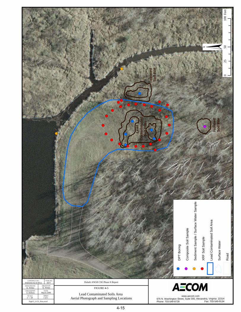
! (
! (
! (
! ( ! (
! (! (! (
! (
! (
! (! (
! (
! (
! (
! (
! (
! (! (
! (
! (
! (
! (
! (
! (
! (
! (! (
! (
! (! ( ! (
! (
! (
K. Weber K. Weber
A. Dellens
1" = 50' 1 of 1
DAHA92-02-D-0012 0077 Duluth ANGB CSE Phase II Report
FIGURE 4-5
Lead Contaminated Soils Area Aerial Photograph and Sampling Locations
CONTRACT NO. TASK NO.
DESIGNED BY
CHECKED BY
SCALE
DRAWN BY
DATE
SHEET
March 2009
§0
5010
025
Feet
! (D
PT
Bor
ing
! (C
ompo
site
Soi
l Sam
ple
! (Se
dim
ent S
ampl
e / S
urfa
ce W
ater
Sam
ple
! (XR
F So
il S
ampl
e
Lead
Con
tam
inat
ed S
oil A
rea
Surfa
ce W
ater
Roa
d
www.aecom.com675 N. Washington Street, Suite 300, Alexandria, Virginia 22314Phone: 703-549-8728 Fax: 703-549-9134Fig4-5_LCS_Area.mxd
Isol
ated
Soil
Pile
Isol
ated
Soil
Pile
Lead
C
onta
min
ated
Soil
Pile
s
4-15

AECOM Comprehensive Site Evaluation Phase II Report February 2010 Military Munitions Response Program – Duluth ANGB
Duluth ANGB Final CSE Phase II 4-16 AECOM PROJECT NO. 106177.05
This page intentionally left blank.

Table 4-1 (page 1 of 2)
Summary of CSE Phase II Analytical Samples and Chemical Analyses
Comprehensive Site Evaluation Phase II
Duluth Air National Guard Base - Duluth, Minnesota
Chemical Laboratory Analysis
Sample Designation
Sample 1
Depth
(ft bgs)
Date(s)
Collected
Sample
Type
SVOCs EPA
SW-846
Method 8270C
SVOCs EPA
SW-846
Method 8270C
SIM
Explosives
EPA SW-846
Method 8330B
Nitroguanadine
EPA SW-846
Method 8330M
Picirc Acid EPA
SW-846 Method
8321A MOD
Metals EPA SW-
846 Method
6010/6020/7471
SURFACE SOIL
EOD Range (SR502)
SR502-SS001 0-0.5 12/5/2008 Normal X X X X X
SR502-SS002 0-0.5 12/4/2008 Normal X X X X X
SR502-SS003 0-0.5 12/5/2008 Normal X X X
SR502-SS004 0-0.5 12/5/2008 Normal X X X X X X
Small Arms Range (SR736)
SR736-SS029 0-0.5 12/5/2008 Normal X
SR736-SS035 0-0.5 12/5/2008 Normal X
SR736-SS040 0-0.5 12/5/2008 Normal X
SR736-SS041 0-0.5 12/5/2008 Normal X
SR736-SS041 DUP 0-0.5 12/5/2008 Duplicate X
SR736-SS042 0-0.5 12/5/2008 Normal X
SR736-SS043 0-0.5 12/5/2008 Normal X
SR736-SS049 0-0.5 12/5/2008 Normal X
SR736-SS050 0-0.5 12/5/2008 Normal X
SR736-SS051 0-0.5 12/5/2008 Normal X
SR736-SS060 0-0.5 12/5/2008 Normal X
Trap Range (TS737)
TS737-SS008 0-0.5 12/2/2008 Normal X X
TS737-SS015 0-0.5 12/2/2008 Normal X X
TS737-SS024 0-0.5 12/2/2008 Normal X X
TS737-SS030 0-0.5 12/2/2008 Normal X X
Skeet Range (TS738)
TS738-SS028 0-0.5 12/2/2008 Normal X X X
TS738-SS032 0-0.5 12/2/2008 Normal X X X
TS738-SS033 0-0.5 12/2/2008 Normal X X X
TS738-SS047 0-0.5 12/2/2008 Normal X X X
TS738-SS051 0-0.5 12/2/2008 Normal X X X
TS738-SS058 0-0.5 12/2/2008 Normal X X X
Lead Contaminated Soils Area (SR739)
SR739-SS018 0-0.5 12/4/2008 Normal X
SR739-SS020 0-0.5 12/4/2008 Normal X
SR739-SS021 0-0.5 12/5/2008 Normal X
SUBSURFACE SOIL
EOD Range (SR502)
SR502-SB001 4-6 12/5/2008 Normal X X X X X X
SR502-SB003 4-6 12/4/2008 Normal X X X
SR502-SB004 8-10 12/4/2008 Normal X X X X X X
SR502-SB005 4-6 12/4/2008 Normal X X X X X X
SR502-SB006 8-10 12/4/2008 Normal X X X X X X
SR502-SB007 0.5-1 12/5/2008 Normal X X X X X X
Small Arms Range (SR736)
SR736-SB032 2.85 12/3/2008 Normal X
SR736-SB037 10.35 12/3/2008 Normal X
SR736-SB038 4.75 12/3/2008 Normal X
SR736-SB045 12.54 12/3/2008 Normal X
SR736-SB046 6.88 12/3/2008 Normal X
SR736-SB050 1-2 12/3/2008 Normal X
SR736-SB050 DUP 1-2 12/3/2008 Duplicate X
SR736-SB054 14.4 12/3/2008 Normal X
SR736-SB056 4.55 12/3/2008 Normal X
SR736-SB063 11.49 12/3/2008 Normal X
SR736-SB064 6.58 12/3/2008 Normal X
SR736-SB081 4.33 12/3/2008 Normal X
Trap Range (TS737)
TS737-SB008 0.5-1 12/4/2008 Normal X X
TS737-SB014 0.5-1 12/4/2008 Normal X X
TS737-SB023 0.5-1 12/4/2008 Normal X X
TS737-SB023 DUP 0.5-1 12/4/2008 Duplicate X X
TS737-SB025 0.5-1 12/4/2008 Normal X X
Skeet Range (TS738)
TS738-SB026 0.5-1 12/3/2008 Normal X X X
TS738-SB027 0.5-1 12/3/2008 Normal X X X
TS738-SB032 0.5-1 12/3/2008 Normal X X X
TS738-SB033 0.5-1 12/3/2008 Normal X X X
TS738-SB044 0.5-1 12/3/2008 Normal X X X
TS738-SB050 0.5-1 12/3/2008 Normal X X X
Duluth ANGB Final CSE Phase II 4-17 AECOM PROJECT NO. 106177.05

Table 4-1 (page 2 of 2)
Summary of CSE Phase II Analytical Samples and Chemical Analyses
Comprehensive Site Evaluation Phase II
Duluth Air National Guard Base - Duluth, Minnesota
Chemical Laboratory Analysis
Sample Designation
Sample 1
Depth
(ft bgs)
Date(s)
Collected
Sample
Type
SVOCs EPA
SW-846
Method 8270C
SVOCs EPA
SW-846
Method 8270C
SIM
Explosives
EPA SW-846
Method 8330B
Nitroguanadine
EPA SW-846
Method 8330M
Picirc Acid EPA
SW-846 Method
8321A MOD
Metals EPA SW-
846 Method
6010/6020/7471
SUBSURFACE SOIL (continued)
Lead Contaminated Soils Area (SR739)
SR739-SB0101 4.0-4.5 12/4/2008 Normal X
SR739-SB0101 DUP 4.0-4.5 12/4/2008 Duplicate X
SR739-SB0102 7.5-8.0 12/4/2008 Normal X
SR739-SB0201 1.0-1.5 12/4/2008 Normal X
SR739-SB0202 2.8-3.3 12/4/2008 Normal X
SR739-SB0301 2.5-3.0 12/4/2008 Normal X
SR739-SB0302 4.5-5.0 12/4/2008 Normal X
SR739-SB0401 2.5-3.0 12/4/2008 Normal X
SR739-SB0402 4.5-5.0 12/4/2008 Normal X
SR739-SB0501 1.0-1.5 12/4/2008 Normal X
SR739-SB0502 2.0-2.5 12/4/2008 Normal X
SR739-SB0601 1.0-1.5 12/4/2008 Normal X
SR739-SB0602 1.5-2.0 12/4/2008 Normal X
GROUNDWATER2
EOD Range (SR502)
SR502-GW002 6.5-10 12/5/2008 Normal X X X X
SR502-GW003 8.0-12 12/5/2008 Normal X X X X X
SEDIMENT
Trap Range (TS737)
TS737-SD001 -- 12/4/2008 Normal X X
TS737-SD002 -- 12/4/2008 Normal X X
Skeet Range (TS738)
TS738-SD001 -- 12/3/2008 Normal X X
TS738-SD002 -- 12/3/2008 Normal X X
Lead Contaminated Soils Area (SR739)
SR739-SD001 -- 12/5/2008 Normal X
SR739-SD001 DUP -- 12/5/2008 Duplicate X
SR739-SD002 -- 12/5/2008 Normal X
SURFACE WATER
Trap Range (TS737)
TS737-SW001 -- 12/4/2008 Normal X X
TS737-SW001 DUP -- 12/4/2008 Duplicate X
TS737-SW002 -- 12/5/2008 Normal X X
Skeet Range (TS738)
TS738-SW001 -- 12/3/2008 Normal X X
TS738-SW002 -- 12/3/2008 Normal X X
Lead Contaminated Soils Area (SR739)
SR739-SW001 -- 12/5/2008 Normal X
SR739-SW002 -- 12/5/2008 Normal X
Notes
ft bgs = feet below ground surface.1 The sample depth for the Small Arms Range represents the original range ground surface under clean fill, and is the beginning depth of the soil sample, which typically
included a 6-inch interval. For groundwater sample depth, the sample interval shown is the screened interval.
Duluth ANGB Final CSE Phase II 4-18 AECOM PROJECT NO. 106177.05

AECOM Comprehensive Site Evaluation Phase II Report February 2010 Military Munitions Response Program – Duluth ANGB
Duluth ANGB Final CSE Phase II 4-19 AECOM PROJECT NO. 106177.05
only surface water was collected from each site. Based on the multimedia sampling conducted and the results yielded, the absence of soil pore water sample results is not believed to have affected the achievement of the goals of this investigation nor the conclusions rendered.
In locations where surface water was frozen, the surface ice was broken with a pickaxe and the water was sampled from below the ice surface. Surface water and sediment sample locations are identified in Figures 4-3 through 4-5.
4.4 Screening Levels
In order to evaluate the results of environmental sampling at the five MRAs, relevant screening levels were compared to detected site concentrations. The following sections identify the screening levels used for each sampled media (soil, groundwater, surface water, and sediment). The numeric screening level values are presented in the results tables in Section 5.0.
4.4.1 Soil Screening Levels
Concentrations of detected chemicals in soils at Duluth ANGB were compared to the MPCA Tier I Soil Reference Values (SRVs) (MPCA, 1999) and MPCA Tier I Soil Leaching Values (SLVs) (MPCA, 2005) to aid in evaluating future actions at each MRA.
For several PAH compounds, no MPCA Tier I SRVs are available; however, United States Environmental Protection Agency (USEPA) has classified seven compounds as probable (B2) carcinogens among the PAHs. These include: benzo(a)pyrene (BaP), benz(a)anthracene, benzo(b)fluoranthene, benzo(k)fluoranthene, chrysene, dibenz(a,h)anthracene, and indeno(1,2,3-c,d)pyrene. BaP has an established cancer slope factor and the carcinogenic potency of the other six compounds can be estimated relative to BaP. The relative potencies of the six other compounds can be used to calculate BaP equivalent concentrations. The cumulative sum of the BaP equivalents can then be compared to the MPCA Tier I SRV for BaP. These conversions were completed for the PAH compounds detected at the EOD Range, Trap Range, and Skeet Range and compared to the MPCA Tier I SRV for BaP (MPCA, 1999).
4.4.2 Groundwater Screening Levels
Due to the potential for future residential use and the presence of offsite residential water supply wells, the chemical concentrations detected in MRA groundwater were compared to Federal Drinking Water levels (maximum contaminant levels [MCLs]) (USEPA, 2003). For chemicals in which an MCL has not been established, the Minnesota Department of Health (MDH) Health Risk Limits (HRLs) were used (MDH, 2007).
4.4.3 Surface Water Screening Levels
Surface waters of the state are protected for multiple beneficial uses. These multiple uses, or classifications, have differing protection standards (Minnesota Rules Chapter 7050.0220). Due to the proximity of the MRAs to Miller Creek, a Minnesota State designated trout stream, and bordering wetland areas, Class 1B, 2A, 2D and 3B surface water protection standards are applicable at the MRAs. Class 1 waters are protected by domestic consumption standards and are based on the USEPA primary MCLs and secondary drinking water standards. Class 2 standards are for the protection of cold-water fisheries including wetlands. Class 3 standards are for industrial consumption protection. The most restrictive standards of the applicable classifications for a site were used as screening levels.

AECOM Comprehensive Site Evaluation Phase II Report February 2010 Military Munitions Response Program – Duluth ANGB
Duluth ANGB Final CSE Phase II 4-20 AECOM PROJECT NO. 106177.05
4.4.4 Sediment Screening Levels
Concentrations of chemicals in sediment were compared to MPCA Tier I SQTs. The National Oceanic and Atmospheric Administration (NOAA) Probable Effects Levels (PELs) for freshwater sediment were also referenced for context (Buchman, 2008).
4.5 Data Quality
This section summarizes the QA and QC procedures and presents the results of the QC assessment for analytical data (compiled in Appendix D) and geophysical survey data (compiled in Appendix E) acquired during the December 2008 field investigations at Duluth ANGB.
A QAPP was developed as part of the CSE Phase II Work Plan. The QAPP was implemented through the integration of well-defined QC elements for activities associated with the task assignment. The QC criteria defined for sampling and analysis activities were developed in accordance with specifications contained in the USACE, EM 200-1-3, Requirements for the Preparation of SAPs, (USACE, 2001); Engineer Manual 200-1-2, TPP Process (USACE, 1998); USEPA Publication QA/G-4, Guidance for the DQOs Process (USEPA, 2000); and Engineer Regulation 1110-1-12, Engineering and Design – Quality Management (USACE, 2006).
Documentation required for this project was reviewed and deficiencies, if any, were identified. Required project documentation included the following:
Field Logbooks/Forms – Spiral-bound logbooks were used to log daily activities and data collected during the course of field activities. Designated logbooks were also used to record calibration records and equipment maintenance as they were performed.
Chain of Custody – Samples were collected and relinquished under stringent chain-of custody protocols as specified in the project QC Plan. A review of Chain of Custody forms indicates that all sample collection, identification, and project information was correctly supplied.
Sampling activities were performed in compliance with standard operating procedures (SOPs), and each individual performing sampling was aware of the requisite protocols for collection of environmental samples. Team members were provided with copies of the CSE Phase II Work Plan, which included the Field Sampling Plan, QAPP, and Health and Safety Plan.
4.5.1 Data Quality Objectives
DQOs were developed concurrently with the CSE Phase II Work Plan to ensure 1) the reliability of field sampling and chemical/field analyses, 2) the collection of sufficient data, 3) the quality of data generated was acceptable for its intended use, and 4) valid assumptions could be inferred from the data.
4.5.1.1 Geophysical Survey
For the geophysical survey work, the following DQOs were established to ensure the collection of high quality data at the EOD Range.
Positioning System Performance – The survey positioning systems will have a ±1 ft (0.3 meters [m]) precision for locating MEC and accuracies of ±2.5 ft (0.8 m) for update and enhancement of the position and geographic features. Horizontal positioning will be based on the North American Datum 1983 (NAD83) and the State Plane coordinate system.
Survey Completeness – Data will be collected in such a manner that a profile with a station spacing that is appropriate to the specific targets of concern can be generated for each transect

AECOM Comprehensive Site Evaluation Phase II Report February 2010 Military Munitions Response Program – Duluth ANGB
Duluth ANGB Final CSE Phase II 4-21 AECOM PROJECT NO. 106177.05
surveyed to ensure no data gaps in survey coverage. Any unavoidable obstacles (pit) will be mapped on the field sketches.
Geophysical Data Fidelity, Utility, and Objectivity – To ensure the usefulness of the data for detecting and resolving potential MEC anomalies, an Equipment Detection Performance Validation was conducted prior to survey efforts to ensure a range of MEC items are detectable, noise levels in the data will be analyzed to ensure that they were sufficiently low to allow adequate signal-to-noise (S/N) differentiation of pertinent anomalies, and daily QC checks of instrument performance will be conducted to ensure system is performing within acceptable limits. Survey efforts are expected to provide the same detection capability as identified during the Equipment Detection Performance Validation.
4.5.1.2 Analytical Data
For the analytical data, attainment of DQOs was assessed through evaluation of all data collected using the following data quality indicators:
Precision – a quantitative measure of the variability of a group of measurements in comparison to the average value measured using relative percent difference or percent difference. This included evaluating field sample duplicates, laboratory sample duplicates, and matrix spike duplicates.
Accuracy – the bias in a measurement system measured using %R. This included evaluating laboratory control samples, matrix spikes, serial dilutions, and surrogates.
Representativeness – the degree to which the measured results accurately reflect the medium being sampled. Representativeness is assessed based on accuracy, precision, and completeness. This includes evaluating holding times and laboratory control systems.
Completeness – the percentage of measurements, which are judged to be useable, measured using %R. This included evaluating sampling and analytical completeness.
Comparability – defined as a qualitative parameter expressing the confidence with which one data set can be compared with another. This includes evaluating the analytical methods performed.
Sensitivity – describes the method detection limits (MDLs), quantitation limits, and method reporting limits (MRLs), which are dependent upon the sample characteristics (i.e., sample volumes used, percent solids, dilutions, etc.) and the analytical method performed. It also may be expressed as the slope of the analytical curve (intensity verses concentration). The MDL and MRL sensitivities were evaluated for each sample and reported analyte.
4.5.2 Analytical Methodology
The analytical services for the sampling effort were provided by Test America, Inc. located in Arvada, Colorado, which is a National Environmental Laboratory Accreditation Conference-accredited laboratory. The laboratory provided analytical support for collected soil, groundwater, sediment, and surface water samples using USEPA SW-846, Third Edition, Test Methods for Evaluating Solid Waste, Update IIIB (USEPA, 2004b) methodologies, as well as laboratory SOPs for this project. The analytical scope included analysis for select explosives (8330B), semivolatile organic compounds (8270C), PAHs (8270C Selective Ion Monitoring), nitroguanidine (8330M), picric acid (8321AMod), and metals (6010B/6020/7470A/7471A).
4.5.3 Laboratory Data Review and Reporting
All analytical data packages were provided to AECOM in Contract Laboratory Program-like Level 4 deliverables with Environmental Restoration Program Information Management System (ERPIMS) and

AECOM Comprehensive Site Evaluation Phase II Report February 2010 Military Munitions Response Program – Duluth ANGB
Duluth ANGB Final CSE Phase II 4-22 AECOM PROJECT NO. 106177.05
ASCII delimited electronic data deliverable files from the laboratory. Detected target compound values above the MRL and within the acceptable calibration range were reported as determined to no more than three significant figures. Target analytes detected below the lower calibration standard or MRL and above the MDL were reported as estimated values.
4.5.4 Data Validation
Data obtained from the laboratory were reviewed and data validation was conducted by the AECOM Project Chemist to determine whether the project-specific DQOs, as defined in the CSE Phase II Work Plan, were met. No more than twenty samples were analyzed per sample batch. Appropriate data qualifiers were applied during the validation process. The data validation reports are contained in Appendix H. Data values were also recorded in an electronic database.
AECOM used a combination of project specific CSE Phase II Work Plan/QAPP criteria, DoD QSM (DoD, 2006), method-specific criteria, and subcontract laboratory SOPs. The data qualifier scheme was consistent with the USEPA Contract Laboratory Program National Functional Guidelines for Organic Data Review (USEPA, 1999), and the USEPA Contract Laboratory Program National Functional Guidelines for Inorganic Data Review (USEPA, 2004a).
All analytical data packages were validated to ensure compliance with specified analytical, QA/QC requirements, data reduction procedures, data reporting requirements, and required accuracy, precision, and completeness criteria. This includes (as applicable), but is not limited to the following:
Sample preservation and holding times,
Instrument performance checks,
Calibrations (initial and continuing),
Blanks (method and rinse),
Matrix spikes and spike duplicates,
Laboratory and field sample duplicates,
Serial dilutions,
Surrogates,
Laboratory control samples,
Internal standards and retention times, and
Quantitative verification (5 percent minimum per matrix).
Analytical results were assessed for accuracy and precision of laboratory analysis to determine the limitations and quantity of data. The quality of the data collected in support of the sampling activity was considered acceptable, unless qualified rejected “R” during the validation process. Samples qualified “J”, “J+”, “J-“, or “UJ” were considered acceptable as estimated with noted definitions.

AECOM Comprehensive Site Evaluation Phase II Report February 2010 Military Munitions Response Program – Duluth ANGB
Duluth ANGB Final CSE Phase II 4-23 AECOM PROJECT NO. 106177.05
4.6 Data Management
4.6.1 Electronic Data
The electronic files provided by Test America were securely stored within a specified project directory on a secure private network located at the AECOM office in Alexandria, Virginia. Access to these files is restricted to only those personnel with key responsibilities to the project and who have been granted authority by the AECOM PM. These electronic files are backed-up daily, weekly, monthly, and yearly.
4.6.2 Hardcopy Data
Various hardcopy files including technical reports, correspondences, figures, and drawings also are stored within the secure AECOM project files located at the AECOM office in Alexandria, Virginia. Access to the office is limited to AECOM personnel though a door security system and all employees and visitors are badged.
4.6.3 Geographic Information System Data
The Geographic Information System (GIS) data layer files are stored within a specified project directory within the secure private network located at the AECOM office in Alexandria, Virginia. Again, access to these files is restricted to only those personnel with key responsibilities to the project and who have been granted explicit access rights. These electronic files also are backed-up daily, weekly, monthly, and yearly.
The conversion of raw data into the database and mapping software was performed at AECOM’s Alexandria, Virginia office. Field data collected during sampling was entered manually into the database and checked by another member of the field team.

AECOM Comprehensive Site Evaluation Phase II Report February 2010 Military Munitions Response Program – Duluth ANGB
Duluth ANGB Final CSE Phase II 4-24 AECOM PROJECT NO. 106177.05
This page intentionally left blank.

AECOM Comprehensive Site Evaluation Phase II Report February 2010 Military Munitions Response Program – Duluth ANGB
Duluth ANGB Final CSE Phase II 5-1 AECOM PROJECT NO. 106177.05
5.0 MUNITIONS RESPONSE AREA CHARACTERISTICS
This section discusses the five MRAs at the Duluth ANGB including the site characteristics, history, current land use, access controls, restrictions, CSE Phase II field investigation results, and potential receptors at each MRA.
5.1 Explosive Ordnance Disposal Range
5.1.1 Site Description
The former EOD Range is located west of the main base on a restrictive easement owned by the Duluth Airport Authority and just northeast of the base’s active Munitions Storage Area. This range consists of a rectangular shaped parcel that is approximately 0.3 acres in size. The terrain at the range is generally flat, and is bordered to the west by a gravel road and wooded areas to the north, east, and south. The nearest surface water feature is a drainage ditch associated with a detention basin that is part of the Duluth International Airport storm water drainage system. The drainage ditch is located approximately 250 feet to the east and the detention basin is located approximately 750 feet to the north (Figure 1-2).
The CSE Phase I visual reconnaissance at the EOD Range identified two holes on the north quarter of the range. One hole was identified as approximately 4 feet in diameter and 3 feet deep while the other was approximately 1-foot in diameter and 1-foot deep. The CSE Phase I identified the holes as former locations of small controlled training detonations. During the CSE Phase II field investigation, the location of the larger hole was confirmed within the site; however, the smaller hole was not identified. Photographs taken during site reconnaissance in September 2008 (following the project kick-off meeting) at the EOD Range are included in Appendix M.
5.1.2 History of Munitions and Explosives of Concern Activities
The EOD Range was used by the USAF from 1960 to 1994 for OB/OD training activities, and to detonate and dispose of munitions. Interviews and a search of historical records conducted during the CSE Phase I investigation did not reveal a detailed listing of munitions used/disposed of at the site (URS, 2007). Munitions typical to OB/OD operations that may have been used for training or disposed of at this range include detonators, blasting caps, fuses, boosters, bursters, primers, squibs, bulk high explosives, demolition charges, and pyrotechnics (flares, signals, simulators, etc.).
5.1.3 Current Land Use
The EOD Range was closed in 1994. The range is currently an open grassy field.
5.1.4 Access Control
The main base of the Duluth ANGB is a secure facility that is fenced on the north, east, and south sides. The Duluth International Airport is located to the west of the main base. Security personnel from the 148
th FW and the Duluth International Airport Authority patrol the base/airport at all times. The EOD
Range is located on a restrictive easement owned by the Duluth Airport Authority, outside of the airport security fencing. Access from the south is through a locked gate controlled by Duluth Airport Authority personnel. There are no access restrictions from the north.
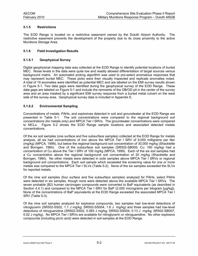
AECOM Comprehensive Site Evaluation Phase II Report February 2010 Military Munitions Response Program – Duluth ANGB
Duluth ANGB Final CSE Phase II 5-2 AECOM PROJECT NO. 106177.05
5.1.5 Restrictions
The EOD Range is located on a restrictive easement owned by the Duluth Airport Authority. The restrictive easement prevents the development of the property due to its close proximity to the active Munitions Storage Area.
5.1.6 Field Investigation Results
5.1.6.1 Geophysical Survey
Digital geophysical mapping data was collected at the EOD Range to identify potential locations of buried MEC. Noise levels in the data were quite low and readily allowed differentiation of target sources versus background matrix. An automated picking algorithm was used to pre-select anomalous responses that may represent buried MEC. These picks were then visually inspected and replicate anomalies noted. A total of 19 anomalies were identified as potential MEC and are labeled on the EMI survey results shown in Figure 5-1. Two data gaps were identified during the geophysical survey of the EOD Range. These data gaps are labeled on Figure 5-1 and include the remnants of the OB/OD pit in the center of the survey area and an area masked by a significant EMI survey response from a buried metal culvert on the west side of the survey area. Geophysical survey data is included in Appendix E.
5.1.6.2 Environmental Sampling
Concentrations of metals, PAHs, and explosives detected in soil and groundwater at the EOD Range are presented in Table 5-1. The soil concentrations were compared to the regional background soil concentrations (for metals only) and MPCA Tier I SRVs. The groundwater concentrations were compared to MCLs. Figure 5-2 shows the EOD Range sample locations and associated detected metals concentrations.
Of the six soil samples (one surface and five subsurface samples) collected at the EOD Range for metals analysis, all six had concentrations of iron above the MPCA Tier I SRV of 9,000 milligrams per liter (mg/kg) (MPCA, 1999), but below the regional background soil concentration of 30,000 mg/kg (Shacklette and Borngen, 1984). One of the subsurface soil samples (SR502-SB005; Cu: 160 mg/kg) had a concentration of Cu above the Tier I SRV of 100 mg/kg (MPCA, 1999). Each of the six soil samples had a Cu concentration above the regional background soil concentration of 20 mg/kg (Shacklette and Borngen, 1984). No other metals were detected in soils samples above MPCA Tier I SRVs or regional background soil concentrations. Each soil sample which exceeded the screening value for one or more metals was compared to the MPCA Tier I SLVs (Table 5-2). None of the six samples exceeded the SLVs for reported metals.
Of the nine soil samples (four surface and five subsurface samples) analyzed for PAHs, select PAHs were detected in six samples, though none were detected above the available MPCA Tier I SRVs. The seven probable (B2) human carcinogen compounds were converted to BaP equivalents (as described in Section 4.4.1) and compared to the MPCA Tier I SRV for BaP (2,000 micrograms per kilogram [µg/kg]). None of the concentrations of BaP equivalents at the EOD Range exceeded the associated MPCA Tier I SRV (Table 5-3).
Of the nine soil samples analyzed for explosive compounds, two samples had low-level detections of nitroglycerin (SR502-SS02, 1.1 J mg/kg; SR502-SS004, 1.8 J mg/kg) and three samples had low-level detections of nitroguanidine (SR502-SS02, 0.083 J mg/kg; SR502-SS004, 0.13 J mg/kg; SR502-SB007, 0.02 J mg/kg). No MPCA Tier I SRVs are available for nitroglycerin or nitroguanidine. No other explosive compounds (including picric acid) were detected in soil samples at the EOD Range.

DAHA92-02-D-0012 0077
K. Weber K. Weber
A. Dellens
see figure 1 of 1
Fig5-1_Geophys_Survey_Results.mxd
Duluth ANGB CSE Phase II Report
FIGURE 5-1EOD Range (SR502) - Electromagnetic Data
Collected with EM61 Mk2 December 2008
CONTRACT NO TASK NO
DESIGNED BY DRAWN BY
CHECKED BY DATE
SCALE SHEETwww.aecom.com
675 N. Washington Street, Suite 300, Alexandria, Virginia 22314Phone: 703-549-8728 Fax: 703-549-9134
March 2009
§
5-3

AECOM Comprehensive Site Evaluation Phase II Report February 2010 Military Munitions Response Program – Duluth ANGB
Duluth ANGB Final CSE Phase II 5-4 AECOM PROJECT NO. 106177.05
This page intentionally left blank.
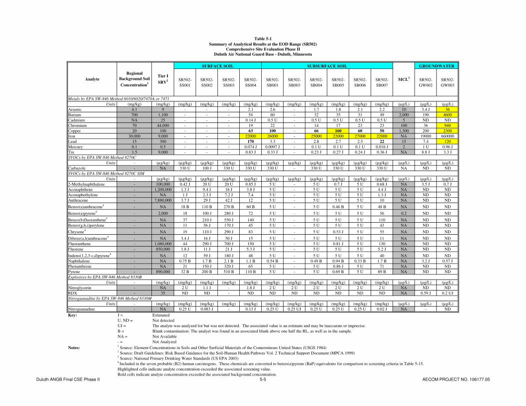
Table 5-1
Summary of Analytical Results at the EOD Range (SR502)
Comprehensive Site Evaluation Phase II
Duluth Air National Guard Base - Duluth, Minnesota
SR502-
SS001
SR502-
SS002
SR502-
SS003
SR502-
SS004
SR502-
SB001
SR502-
SB003
SR502-
SB004
SR502-
SB005
SR502-
SB006
SR502-
SB007
SR502-
GW002
SR502-
GW003
Metals by EPA SW-846 Method 6010/6020/7470A or 7471
Units (mg/kg) (mg/kg) (mg/kg) (mg/kg) (mg/kg) (mg/kg) (mg/kg) (mg/kg) (mg/kg) (mg/kg) (mg/kg) (mg/kg) (µg/L) (µg/L) (µg/L)
Arsenic 4.1 9 - - - 2.1 2.6 - 1.7 1.8 2.1 2.2 10 3.4 J 36
Barium 700 1,100 - - - 54 60 - 32 35 31 49 2,000 190 4600
Cadmium NA 25 - - - 0.14 J 0.5 U - 0.5 U 0.5 U 0.5 U 0.5 U 5 ND ND
Chromium 70 44,000 - - - 19 22 - 14 17 23 23 100 36 940
Copper 20 100 - - - 63 100 - 66 160 60 50 1,300 200 2300
Iron 30,000 9,000 - - - 22000 26000 - 25000 22000 27000 22000 NA 19000 660000
Lead 15 300 - - - 170 3.3 - 2.8 2.7 2.5 22 15 7.4 120
Mercury 0.1 0.5 - - - 0.074 J 0.0097 J - 0.1 U 0.1 U 0.1 U 0.016 J 2 1 U 0.96 J
Tin 1.5 9,000 - - - 0.83 J 0.33 J - 0.23 J 0.27 J 0.24 J 0.36 J NA 8.8 J 3.3 J
SVOCs by EPA SW-846 Method 8270C
Units - (µg/kg) (µg/kg) (µg/kg) (µg/kg) (µg/kg) (µg/kg) (µg/kg) (µg/kg) (µg/kg) (µg/kg) (µg/kg) (µg/L) (µg/L) (µg/L)
Carbazole - NA 330 U 100 J 330 U 330 U 330 U - 330 U 330 U 330 U 330 U NA ND ND
SVOCs by EPA SW-846 Method 8270C SIM
Units - (µg/kg) (µg/kg) (µg/kg) (µg/kg) (µg/kg) (µg/kg) (µg/kg) (µg/kg) (µg/kg) (µg/kg) (µg/kg) (µg/L) (µg/L) (µg/L)
2-Methylnaphthalene - 100,000 0.42 J 20 U 20 U 0.85 J 5 U - 5 U 0.7 J 5 U 0.68 J NA 3.5 J 0.7 J
Acenaphthene - 1,200,000 1.3 J 9.4 J 16 J 3.8 J 5 U - 5 U 5 U 5 U 4.4 J NA ND ND
Acenaphethylene - NA 1 J 2.3 J 7.2 J 7.4 5 U - 5 U 5 U 5 U 1.3 J NA ND ND
Anthracene - 7,880,000 3.7 J 29 J 42 J 12 5 U - 5 U 5 U 5 U 10 NA ND ND
Benzo(a)anthracene4
- NA 18 B 110 B 270 B 60 B 5 U - 5 U 0.46 B 5 U 48 B NA ND ND
Benzo(a)pyrene4
- 2,000 18 100 J 280 J 72 5 U - 5 U 5 U 5 U 56 0.2 ND ND
Benzo(b)fluoranthene4
- NA 37 210 J 550 J 140 5 U - 5 U 5 U 5 U 110 NA ND ND
Benzo(g,h,i)perylene - NA 11 56 J 170 J 45 5 U - 5 U 5 U 5 U 43 NA ND ND
Chrysene4
- NA 19 110 J 290 J 83 5 U - 5 U 0.53 J 5 U 55 NA ND ND
Dibenz(a,h)anthracene4
- NA 3.4 J 16 J 50 J 15 5 U - 5 U 5 U 5 U 11 NA ND ND
Fluoranthene - 1,080,000 44 290 J 700 J 150 5 U - 5 U 0.81 J 5 U 130 NA ND ND
Fluorene - 850,000 1.8 J 11 J 21 J 5.3 J 5 U - 5 U 5 U 5 U 5.2 J NA ND ND
Indeno(1,2,3-c,d)pyrene4
- NA 12 59 J 180 J 48 5 U - 5 U 5 U 5 U 40 NA ND ND
Naphthalene - NA 0.75 B 1.7 B 2.1 B 1.1 B 0.54 B - 0.49 B 0.94 B 0.33 B 1.7 B NA 3.2 J 0.57 J
Phenanthrene - NA 21 150 J 320 J 65 5 U - 5 U 0.86 J 5 U 71 NA ND ND
Pyrene - 890,000 32 B 200 B 510 B 110 B 5 U - 5 U 0.69 B 5 U 89 B NA ND ND
Explosives by EPA SW-846 Method 8330B
Units - (mg/kg) (mg/kg) (mg/kg) (mg/kg) (mg/kg) (mg/kg) (mg/kg) (mg/kg) (mg/kg) (mg/kg) (mg/kg) (µg/L) (µg/L) (µg/L)
Nitroglycerin - NA 2 U 1.1 J - 1.8 J 2 U 2 U 2 U 2 U 2 U 2 U NA ND ND
RDX - 35 ND ND - ND ND ND ND ND ND ND NA 0.59 J 0.2 UJ
Nitroguanadine by EPA SW-846 Method 8330M
Units - (mg/kg) (mg/kg) (mg/kg) (mg/kg) (mg/kg) (mg/kg) (mg/kg) (mg/kg) (mg/kg) (mg/kg) (mg/kg) (µg/L) (µg/L) (µg/L)
Nitroguanadine - NA 0.25 U 0.083 J - 0.13 J 0.25 U 0.25 UJ 0.25 U 0.25 U 0.25 U 0.02 J NA - ND
Key: J = Estimated
U, ND = Not detected
UJ = The analyte was analyzed for but was not detected. The associated value is an estimate and may be inaccurate or imprecise.
B = Blank contamination: The analyet was found in an associated blank above one half the RL, as well as in the sample.
NA = Not Available
- = Not Analyzed
Notes:1 Source: Element Concentrations in Soils and Other Surficial Materials of the Conterminous United States (USGS 1984)
2 Source: Draft Guidelines: Risk Based Guidance for the Soil-Human Health Pathway Vol. 2 Technical Support Document (MPCA 1999)
3 Source: National Primary Drinking Water Standards (US EPA 2003)
4 Included in the seven probable (B2) human carcinogens. These chemicals are converted to benzo(a)pyrene (BaP) equivalents for comparison to screening criteria in Table 5-15.
Highlighted cells indicate analyte concentration exceeded the associated screening value.
Bold cells indicate analyte concentration exceeded the associated background concentration.
GROUNDWATER
Analyte
Regional
Background Soil
Concentration1
Tier I
SRV2 MCL
3
SURFACE SOIL SUBSURFACE SOIL
Duluth ANGB Final CSE Phase II 5-5 AECOM PROJECT NO. 106177.05

AECOM Comprehensive Site Evaluation Phase II Report February 2010 Military Munitions Response Program – Duluth ANGB
Duluth ANGB Final CSE Phase II 5-6 AECOM PROJECT NO. 106177.05
This page intentionally left blank.

! (
! (
A
! ( ! (! (! (
! (! (A
! ( <
K. Weber K. Weber
A. Dellens
1" = 50' 1 of 1
DAHA92-02-D-0012 0077 Duluth ANGB CSE Phase II Report
FIGURE 5-2
EOD Range (SR502)Analytical Results – Detected Metals Concentrations
CONTRACT NO. TASK NO.
DESIGNED BY
CHECKED BY
SCALE
DRAWN BY
DATE
SHEET
March 2009
Sam
ple
IDD
epth
(ft)
SS00
40-
0.5
SB00
70.
5-1
Det
onat
ion
Pit
Sam
ple
IDD
epth
(ft)
Ana
lyte
Con
cent
ratio
n (m
g/kg
)Le
ad22
Ars
enic
2.2
Bar
ium
49C
adm
ium
0.5
UC
hrom
ium
23C
oppe
r50
Iron
2200
0M
ercu
ry0.
016
JTi
n0.
36 J
SB00
70.
5-1
Sam
ple
IDD
epth
(ft)
Ana
lyte
Con
cent
ratio
n (m
g/kg
)Le
ad17
0A
rsen
ic2.
1B
ariu
m54
Cad
miu
m0.
14 J
Chr
omiu
m19
Cop
per
63Ir
on22
000
Mer
cury
0.07
4 J
Tin
0.83
J
SS00
40.
0 - 0
.5
Sam
ple
IDD
epth
(ft)
SS00
30-
0.5
SB00
54.
0-6.
0SB
006
8.0-
10.0
GW
003
8.1-
12.1
Tem
pora
ry W
ell 3
Sam
ple
IDD
epth
(ft)
SS00
20-
0.5
SB00
34.
0-6.
0SB
004
8.0-
10.0
GW
002
6.53
-10.
0
Tem
pora
ry W
ell 2
EOD
TW
2
EOD
TW
3
§0
5010
025
Feet
! (C
ompo
site
Soi
l Sam
ple
ATe
mpo
rary
Wel
l
<Te
mpo
rary
Wel
l (D
ry)
! (Bo
reho
le S
oil S
ampl
e (D
ry)
Assu
med
Gro
undw
ater
Flo
w D
irect
ion
EOD
Ran
ge
Roa
dH
ighl
ight
ed c
ells
indi
cate
ana
lyte
con
cent
ratio
n ex
ceed
ed th
e as
soci
ated
scr
eeni
ng v
alue
.Bo
ld c
ells
indi
cate
ana
lyte
con
cent
ratio
n ex
ceed
ed th
e as
soci
ated
bac
kgro
und
conc
entra
tion.
www.aecom.com675 N. Washington Street, Suite 300, Alexandria, Virginia 22314Phone: 703-549-8728 Fax: 703-549-9134Fig5_2_EOD_Range_Data_Boxes.mxd
Sam
ple
IDD
epth
(ft)
SS00
10-
0.5
Sam
ple
IDD
epth
(ft)
Ana
lyte
Con
cent
ratio
n (m
g/kg
)SB
001
4.0-
6.0
Lead
3.3
Ars
enic
2.6
Bar
ium
60C
hrom
ium
22C
oppe
r10
0Ir
on26
000
Mer
cury
0.00
97 J
Tin
0.33
J
SB00
14.
0-6.
0
Sam
ple
IDD
epth
(ft)
Ana
lyte
Con
cent
ratio
n (m
g/kg
)Le
ad2.
8A
rsen
ic1.
7B
ariu
m32
Chr
omiu
m14
Cop
per
66Ir
on25
000
Tin
0.23
J
SB00
48.
0-10
.0
Sam
ple
IDD
epth
(ft)
Ana
lyte
Con
cent
ratio
n (m
g/kg
)Le
ad7.
4A
rsen
ic3.
4 J
Bar
ium
190
Chr
omiu
m36
Cop
per
200
Iron
1900
0Ti
n8.
8 J
GW
002
6.53
-10.
0
Sam
ple
IDD
epth
(ft)
Ana
lyte
Con
cent
ratio
n (m
g/kg
)Le
ad2.
5A
rsen
ic2.
1B
ariu
m31
Chr
omiu
m23
Cop
per
60Ir
on27
000
Mer
cury
0.1
UTi
n0.
24 J
SB00
68.
0-10
.0
Det
onat
ion
Pit
Sam
ple
IDD
epth
(ft)
Ana
lyte
Con
cent
ratio
n (m
g/kg
)Le
ad2.
7A
rsen
ic1.
8B
ariu
m35
Chr
omiu
m17
Cop
per
160
Iron
2200
0M
ercu
ry0.
1 U
Tin
0.27
J
SB00
54.
0-6.
0
Sam
ple
IDD
epth
(ft)
Ana
lyte
Conc
entra
tion
(µg/
L)Le
ad12
0A
rsen
ic36
Bariu
m46
00Ch
rom
ium
940
Copp
er23
00Iro
n66
0000
Mer
cury
0.96
JTi
n3.
3 J
GW00
38.
1-12
.1
Sam
ple
IDD
epth
(ft)
Ana
lyte
Conc
entra
tion
(µg/
L)Le
ad7.
4A
rsen
ic3.
4 J
Bariu
m19
0Ch
rom
ium
36Co
pper
200
Iron
1900
0Ti
n8.
8 J
GW00
26.
53-1
0.0
5-7

AECOM Comprehensive Site Evaluation Phase II Report February 2010 Military Munitions Response Program – Duluth ANGB
Duluth ANGB Final CSE Phase II 5-8 AECOM PROJECT NO. 106177.05
This page intentionally left blank.

Table 5-2
Summary of Metals Concentrations Compared to MPCA Tier I Soil Leaching Values
Comprehensive Site Evaluation Phase II
Duluth Air National Guard Base - Duluth, Minnesota
Small Arms Range
SR502-
SS004
SR502-
SB001
SR502-
SB004
SR502-
SB005
SR502-
SB006
SR502-
SB007SR736-SB046
TS737-
SS008
TS737-
SS015
TS737-
SS024
TS737-
SS030
TS737-
SB008
TS737-
SB014
TS737-
SB023
TS737-
SB023
DUP
TS737-
SB025
TS738-
SS028
TS738-
SS032
TS738-
SS033
TS738-
SB027
TS738-
SB033
SR739-
SB0201
SR739-
SB0301
SR739-
SB0401
SR739-
SB0601
Metals by EPA SW-846 Method 6010/6020/7471
Units (mg/kg) (mg/kg) (mg/kg) (mg/kg) (mg/kg) (mg/kg) (mg/kg) (mg/kg) (mg/kg) (mg/kg) (mg/kg) (mg/kg) (mg/kg) (mg/kg) (mg/kg) (mg/kg) (mg/kg) (mg/kg) (mg/kg) (mg/kg) (mg/kg) (mg/kg) (mg/kg) (mg/kg) (mg/kg) (mg/kg) (mg/kg) (mg/kg)
Antimony <1 12 2.7 - - - - - - 0.13 J 8.8 2.5 6.7 6.5 0.28 0.51 7.3 J 38 J 1.5 J 0.25 J 0.16 J 0.52 0.084 J 0.62 0.97 0.5 1.1 3
Arsenic 4.1 9 15.1 2.1 2.6 1.7 1.8 2.1 2.2 2.3 19 13 19 7.3 2.9 5.3 21 J 59 J 7.4 3.3 2.8 3 2.6 2.8 3.7 2.8 3.6 12
Barium 700 1,100 842 54 60 32 35 31 49 - - - - - - - - - - - - - - - - - - -
Cadmium NA 25 4.4 0.14 J 0.5 U 0.5 U 0.5 U 0.5 U 0.5 U - - - - - - - - - - - - - - - - - - -
Chromium 70 44,000 1000000 (III) 19 22 14 17 23 23 - - - - - - - - - - - - - - - - - - -
Copper 20 100 400 63 100 66 160 60 50 61 91 42 130 40 20 28 37 36 40 J 27 41 71 14 30 140 110 110 32
Iron 30,000 9,000 NA 22000 26000 25000 22000 27000 22000 36000 17000 19000 19000 14000 18000 27000 21000 24000 24000 J 23000 22000 17000 24000 16000 27000 31000 28000 11000
Lead 15 300 525 170 3.3 2.8 2.7 2.5 22 110 2200 2500 2400 1700 110 370 1700 J 3800 J 880 J 260 140 290 100 470 1800 700 2900 1300
Mercury 0.1 0.5 1.6 0.074 J 0.0097 J 0.1 U 0.1 U 0.1 U 0.016 J - - - - - - - - - - - - - - - - - - -
Tin 1.5 9,000 2964 0.83 J 0.33 J 0.23 J 0.27 J 0.24 J 0.36 J 0.22 J 0.12 J 0.17 J 0.13 J 0.15 J 0.24 J 0.25 J 0.15 J 0.33 J 0.2 J 0.24 J 0.17 J 0.29 J 0.24 J 0.28 J 1.1 J 0.52 J 1 J 0.095 J
Zinc 120-3500 8,700 1500 - - - - - - 48 74 78 79 110 39 46 55 61 46 J 68 52 75 52 46 73 53 57 39
Key: J = Estimated
U = Not detected
NA = Not Available
- = Not Analyzed
Notes:1 Source: Element Concentrations in Soils and Other Surficial Materials of the Conterminous United States (USGS 1984)
2 Source: Draft Guidelines: Risk Based Guidance for the Soil-Human Health Pathway Vol. 2 Technical Support Document (MPCA 1999)
3 Source: Draft Guidelines: Risk Based Guidance for the Soil-Human Health Pathway Vol. 2 Technical Support Document (MPCA 1999)
Highlighted cells indicate analyte concentration exceeded the MPCA Tier I SRV.
Bold cells indicate analyte concentration exceeded the associated background concentration.
Red text indicates analyte concentration exceeded the MPCA Tier I SLV.
EOD Range Trap Range Skeet Range Lead Contaminated Soils Area
Analyte Tier I SLV3
Regional
Background
Soil
Concentration1
Tier I SRV2
Duluth ANGB Final CSE Phase II 5-9 AECOM PROJECT NO. 106177.05

AECOM Comprehensive Site Evaluation Phase II Report February 2010 Military Munitions Response Program – Duluth ANGB
Duluth ANGB Final CSE Phase II 5-10 AECOM PROJECT NO. 106177.05
This page intentionally left blank.

Table 5-3
Summary of BaP Equivalent Concentrations at the EOD Range
Comprehensive Site Evaluation Phase II
Duluth Air National Guard Base - Duluth, Minnesota
SR502-
SS001
SR502-
SS002
SR502-
SS003
SR502-
SS004
SR502-
SB001
SR502-
SB004
SR502-
SB005
SR502-
SB006
SR502-
SB007
EOD Range
Probable (B2) Human Carcinogens
Units (mg/kg-d)-1
- (µg/kg) (µg/kg) (µg/kg) (µg/kg) (µg/kg) (µg/kg) (µg/kg) (µg/kg) (µg/kg) (µg/kg)
Benzo(a)anthracene NA 0.1 NA 18 B 110 B 270 B 60 B 5 U 5 U 0.46 B 5 U 48 B
Benzo(a)pyrene 0.73 1 2,000 18 100 J 280 J 72 5 U 5 U 5 U 5 U 56
Benzo(b)fluoranthene NA 0.1 NA 37 210 J 550 J 140 5 U 5 U 5 U 5 U 110
Benzo(k)fluoranthene NA 0.1 NA ND ND ND ND ND ND ND ND ND
Chrysene NA 0.01 NA 19 110 J 290 J 83 5 U 5 U 0.53 J 5 U 55
Dibenz(a,h)anthracene 4.1 0.56 NA 3.4 J 16 J 50 J 15 5 U 5 U 5 U 5 U 11
Indeno(1,2,3-c,d)pyrene NA 0.1 NA 12 59 J 180 J 48 5 U 5 U 5 U 5 U 40
2,000 25 136.986 383.982 100.055 0 0 0.005 0 77.728
Key: J = Estimated
U, ND = Not detected
B = Blank contamination: The analyet was found in an associated blank above one half the RL, as well as in the sample.
NA = Not Available
BaP = Benzo(a)pyrene
Notes:1 Source: Draft Guidelines: Risk Based Guidance for the Soil-Human Health Pathway Vol. 2 Technical Support Document (MPCA 1999)
2 BaP equivalents are calculated by multiplying the site concentration of each chemical by its Relative Potency Factor. The sum of the BaP
equivalent concentrations can be compared to the MPCA Tier I SRV.
SURFACE SOILRelative
Potency
Factor1
Total BaP Equivalents2
SUBSURFACE SOILTier I
SRV1Analyte
Oral Cancer
Slope Factor1
Duluth ANGB Final CSE Phase II 5-11 AECOM PROJECT NO. 106177.05

AECOM Comprehensive Site Evaluation Phase II Report February 2010 Military Munitions Response Program – Duluth ANGB
Duluth ANGB Final CSE Phase II 5-12 AECOM PROJECT NO. 106177.05
This page intentionally left blank.
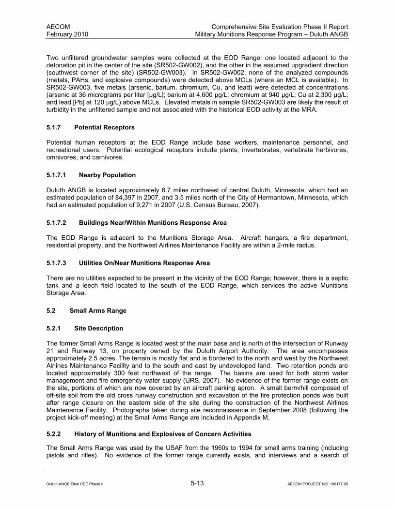
AECOM Comprehensive Site Evaluation Phase II Report February 2010 Military Munitions Response Program – Duluth ANGB
Duluth ANGB Final CSE Phase II 5-13 AECOM PROJECT NO. 106177.05
Two unfiltered groundwater samples were collected at the EOD Range: one located adjacent to the detonation pit in the center of the site (SR502-GW002), and the other in the assumed upgradient direction (southwest corner of the site) (SR502-GW003). In SR502-GW002, none of the analyzed compounds (metals, PAHs, and explosive compounds) were detected above MCLs (where an MCL is available). In SR502-GW003, five metals (arsenic, barium, chromium, Cu, and lead) were detected at concentrations (arsenic at 36 micrograms per liter [µg/L]; barium at 4,600 µg/L; chromium at 940 µg/L; Cu at 2,300 µg/L; and lead [Pb] at 120 µg/L) above MCLs. Elevated metals in sample SR502-GW003 are likely the result of turbidity in the unfiltered sample and not associated with the historical EOD activity at the MRA.
5.1.7 Potential Receptors
Potential human receptors at the EOD Range include base workers, maintenance personnel, and recreational users. Potential ecological receptors include plants, invertebrates, vertebrate herbivores, omnivores, and carnivores.
5.1.7.1 Nearby Population
Duluth ANGB is located approximately 6.7 miles northwest of central Duluth, Minnesota, which had an estimated population of 84,397 in 2007, and 3.5 miles north of the City of Hermantown, Minnesota, which had an estimated population of 9,271 in 2007 (U.S. Census Bureau, 2007).
5.1.7.2 Buildings Near/Within Munitions Response Area
The EOD Range is adjacent to the Munitions Storage Area. Aircraft hangars, a fire department, residential property, and the Northwest Airlines Maintenance Facility are within a 2-mile radius.
5.1.7.3 Utilities On/Near Munitions Response Area
There are no utilities expected to be present in the vicinity of the EOD Range; however, there is a septic tank and a leech field located to the south of the EOD Range, which services the active Munitions Storage Area.
5.2 Small Arms Range
5.2.1 Site Description
The former Small Arms Range is located west of the main base and is north of the intersection of Runway 21 and Runway 13, on property owned by the Duluth Airport Authority. The area encompasses approximately 2.5 acres. The terrain is mostly flat and is bordered to the north and west by the Northwest Airlines Maintenance Facility and to the south and east by undeveloped land. Two retention ponds are located approximately 300 feet northwest of the range. The basins are used for both storm water management and fire emergency water supply (URS, 2007). No evidence of the former range exists on the site, portions of which are now covered by an aircraft parking apron. A small berm/hill composed of off-site soil from the old cross runway construction and excavation of the fire protection ponds was built after range closure on the eastern side of the site during the construction of the Northwest Airlines Maintenance Facility. Photographs taken during site reconnaissance in September 2008 (following the project kick-off meeting) at the Small Arms Range are included in Appendix M.
5.2.2 History of Munitions and Explosives of Concern Activities
The Small Arms Range was used by the USAF from the 1960s to 1994 for small arms training (including pistols and rifles). No evidence of the former range currently exists, and interviews and a search of

AECOM Comprehensive Site Evaluation Phase II Report February 2010 Military Munitions Response Program – Duluth ANGB
Duluth ANGB Final CSE Phase II 5-14 AECOM PROJECT NO. 106177.05
historical records conducted during the CSE Phase I (URS, 2007) did not reveal a detailed listing of munitions used at the site. The range was closed in 1994 due to the construction of the Northwest Airlines Maintenance Facility. Construction activities included the removal of several feet of soil. Most of the soil was used in construction activities, except for the former target berm, which was moved to the LCSA. No small caliber ammunition or related components were encountered at the Small Arms Range during CSE Phase II activities.
5.2.3 Current Land Use
The Small Arms Range is currently developed with an aircraft parking apron and other small buildings associated with the Northwest Airlines Maintenance Facility. The remainder of the area is maintained lawn.
5.2.4 Access Control
The main base of the Duluth ANGB is a secure facility that is fenced on the north, east, and south sides. The Duluth International Airport is located to the west of the main base. Security personnel from the 148
th FW and the Duluth International Airport Authority patrol the base/airport at all times. The Small
Arms Range is located on property owned by the Duluth Airport Authority. No site-specific access controls are in place.
5.2.5 Restrictions
There are no administrative land use restrictions in place at the Small Arms Range.
5.2.6 Field Investigation Results
5.2.6.1 X-Ray Fluorescence Analysis
In-situ and ex-situ XRF screening at the Small Arms Range was conducted throughout a 25-foot-by- 25-foot grid (Figure 4-2) for a total of 94 sample points. Samples were not taken from beneath concrete or asphalt surfaces. Since the soil used to construct the berm/hill on the eastern side of the MRA did not come from the range area, these soils were not sampled. In order to sample the native soil beneath the berm, GeoProbe boreholes were drilled to depths below the original grade of the site. The soil from these boreholes was placed in gallon size re-sealable plastic bags and screened ex-situ with XRF. The XRF screening results for the Small Arms Range are presented in Table 5-4.
The XRF screening results did not indicate any exceedances of the MPCA Tier I SRV for lead of 300 mg/kg, nor the field screening value of 100 mg/kg. One sample (SR736-SB063) had an initial reading of 530.14 ± 22.55 mg/kg for lead; however due to the inconsistency with the rest of the site, a second reading was taken. The second test provided a concentration of 14.47 ± 5.46 mg/kg for lead. A laboratory confirmation sample was taken at this location and the result was 21 mg/kg for lead, confirming the second XRF screening result. A total of 10 samples were containerized and sent to the laboratory for confirmation of metals concentrations. Comparison of the XRF screening results and the analytical laboratory results for these samples is presented in Table 5-5.
5.2.6.2 Environmental Sampling
Surface and subsurface soil samples were collected to confirm XRF results where detectable levels of lead were encountered. Concentrations of metals detected in soil at the Small Arms Range are presented in Table 5-6. The soil concentrations are compared to the regional background soil concentrations and MPCA Tier I SRVs. Figure 5-3 shows the Small Arms Range sample locations and associated detected metals concentrations.

Table 5-4 (page 1 of 3)
Summary of XRF Screening Results at the Small Arms Range (SR736)
Comprehensive Site Evaluation Phase II
Duluth Air National Guard Base - Duluth, Minnesota
LOC ID Lab Sample ID Sample Type Date/Time XRF Model Pb Pb Variance
-- -- -- -- -- (mg/kg) (mg/kg)
SS001 IN-SITU 12/3/2008 11:40 NITON 13.4 6.26
SS002 IN-SITU 12/3/2008 11:43 NITON 10.67 6.55
SS003 IN-SITU 12/3/2008 11:46 NITON 14.01 5.5
SS004 IN-SITU 12/3/2008 11:49 NITON < LOD 7.03
SS005 IN-SITU 12/3/2008 11:50 NITON 12.78 6.24
SS006 IN-SITU 12/3/2008 11:52 NITON 37.4 7.39
SS007 IN-SITU 12/3/2008 11:55 NITON 13.3 6.24
SS008 IN-SITU 12/3/2008 11:57 NITON 11.66 5.93
SS009 IN-SITU 12/3/2008 11:58 NITON 10.8 4.75
SS010 IN-SITU 12/3/2008 12:00 NITON < LOD 7.05
SS011 IN-SITU 12/3/2008 12:01 NITON 18.52 6.79
SS012 IN-SITU 12/3/2008 12:03 NITON < LOD 7.73
SS013 IN-SITU 12/3/2008 12:04 NITON 8.48 5.2
SS014 IN-SITU 12/3/2008 12:06 NITON 10.3 5.28
SS015 IN-SITU 12/3/2008 12:07 NITON 8.62 5.45
SS016 IN-SITU 12/3/2008 12:22 NITON < LOD 8.59
SS017 IN-SITU 12/3/2008 12:30 NITON 24.41 7.17
SS018 IN-SITU 12/3/2008 12:33 NITON 9.21 4.73
SS019 IN-SITU 12/3/2008 12:35 NITON < LOD 8.15
SS020 IN-SITU 12/3/2008 12:39 NITON < LOD 7.34
SS021 IN-SITU 12/3/2008 12:42 NITON 7.56 4.35
SS022 IN-SITU 12/3/2008 12:44 NITON 15.92 5.58
SS023 IN-SITU 12/3/2008 12:46 NITON 14.78 5.87
SS024 IN-SITU 12/3/2008 12:49 NITON 11.27 5.05
SS025 IN-SITU 12/3/2008 12:51 NITON < LOD 7.05
SS026 IN-SITU 12/3/2008 12:57 NITON 20.89 5.14
SS027 IN-SITU 12/3/2008 12:58 NITON 11.41 5.3
SS028 IN-SITU 12/3/2008 12:59 NITON < LOD 7.96
SS0292 IN-SITU 12/3/2008 13:01 NITON 7.35 4.88
SS030 IN-SITU 12/3/2008 13:02 NITON 7.62 4.62
SS031 IN-SITU 12/3/2008 13:03 NITON 11.66 5.83
SB0321 SR736-SB032 EX-SITU (BORING) 12/3/2008 17:55 NITON 28.83 7.07
SS033 IN-SITU 12/3/2008 13:25 NITON 10.04 4.59
SS034 IN-SITU 12/3/2008 13:27 NITON 9.11 4.84
SS0352 IN-SITU 12/3/2008 13:29 NITON 20.41 7.18
SS036 IN-SITU 12/3/2008 13:30 NITON 11.87 5.11
SB0371 SR736-SB037 EX-SITU (BORING) 12/3/2008 17:54 NITON 12.97 5.23
SB0381 SR736-SB038 EX-SITU (BORING) 12/3/2008 17:53 NITON 25.54 7.11
SS039 IN-SITU 12/3/2008 13:33 NITON 7.32 4.3
SS0402 IN-SITU 12/3/2008 13:37 NITON 8.19 4.62
SS0412 IN-SITU 12/3/2008 13:39 NITON 9.47 4.86
SS042 IN-SITU 12/3/2008 13:41 NITON 9.19 5.42
SS0432 IN-SITU 12/3/2008 13:43 NITON 8.54 4.54
SS044 IN-SITU 12/3/2008 13:44 NITON 11.63 5.41
Duluth ANGB Final CSE Phase II 5-15 AECOM PROJECT NO. 106177.05

Table 5-4 (page 2 of 3)
Summary of XRF Screening Results at the Small Arms Range (SR736)
Comprehensive Site Evaluation Phase II
Duluth Air National Guard Base - Duluth, Minnesota
LOC ID Lab Sample ID Sample Type Date/Time XRF Model Pb Pb Variance
-- -- -- -- -- (mg/kg) (mg/kg)
SB0451 SR736-SB045 EX-SITU (BORING) 12/3/2008 17:09 NITON 32.36 6.59
SB0461 SR736-SB046 EX-SITU (BORING) 12/3/2008 17:12 NITON 25.25 6.37
SS047 IN-SITU 12/3/2008 15:33 NITON 15.34 5.62
SS048 IN-SITU 12/3/2008 15:35 NITON < LOD 7.88
SS0492 IN-SITU 12/3/2008 15:36 NITON 18.63 6.81
SS0502 IN-SITU 12/3/2008 15:37 NITON < LOD 6.13
SS0512 IN-SITU 12/3/2008 15:54 NITON < LOD 5.94
SS052 IN-SITU 12/3/2008 15:52 NITON 9.29 5.12
SS053 IN-SITU 12/3/2008 15:40 NITON 8.46 4.72
SB0541 SR736-SB054 EX-SITU (BORING) 12/3/2008 17:10 NITON 28.83 7.3
SB055 EX-SITU (BORING) 12/3/2008 17:13 NITON 30.98 7.27
SB0561 SR736-SB056 EX-SITU (BORING) 12/3/2008 14:06 NITON 18.32 5.78
SS057 IN-SITU 12/3/2008 15:58 NITON < LOD 5.92
SS058 IN-SITU 12/3/2008 16:00 NITON < LOD 6.39
SS059 IN-SITU 12/3/2008 16:01 NITON < LOD 6.37
SS0602 IN-SITU 12/3/2008 16:02 NITON 8.36 5.36
SS061 IN-SITU 12/3/2008 16:03 NITON 17.48 6.09
SS062 IN-SITU 12/3/2008 16:05 NITON < LOD 7.81
SB0631 SR736-SB063 EX-SITU (BORING) 12/3/2008 14:02 NITON 530.14 22.55
SB063 (Retest) EX-SITU (BORING) 12/3/2008 14:08 NITON 14.47 5.46
SB0641 SR736-SB064 EX-SITU (BORING) 12/3/2008 14:05 NITON 10.98 5.54
SS065 IN-SITU 12/3/2008 16:08 NITON < LOD 5.57
SS066 IN-SITU 12/3/2008 16:09 NITON < LOD 6.17
SS067 IN-SITU 12/3/2008 16:10 NITON < LOD 6.8
SS068 IN-SITU 12/3/2008 16:12 NITON < LOD 5.52
SS069 IN-SITU 12/3/2008 16:13 NITON < LOD 7.26
SS070 IN-SITU 12/3/2008 16:15 NITON < LOD 6.14
SS071 IN-SITU 12/3/2008 16:16 NITON 8.96 5.01
SB072 EX-SITU (BORING) 12/3/2008 14:00 NITON 12.33 5.53
SS073 IN-SITU 12/3/2008 16:31 NITON 11.27 5.23
SS074 IN-SITU 12/3/2008 16:32 NITON 6.83 4.52
SS075 IN-SITU 12/3/2008 16:34 NITON < LOD 4.6
SS076 IN-SITU 12/3/2008 16:35 NITON < LOD 6.26
SS077 IN-SITU 12/3/2008 16:36 NITON < LOD 5.52
SS078 IN-SITU 12/3/2008 16:37 NITON < LOD 6.93
SS079 IN-SITU 12/3/2008 16:39 NITON 10.92 4.99
SS080 IN-SITU 12/3/2008 16:40 NITON < LOD 8.57
SB0811 SR736-SB081 EX-SITU (BORING) 12/3/2008 17:52 NITON 13.1 5.57
SS082 IN-SITU 12/3/2008 16:42 NITON < LOD 5.68
SS083 IN-SITU 12/3/2008 16:43 NITON < LOD 5.3
SS084 IN-SITU 12/3/2008 16:45 NITON 11.7 5.4
SS085 IN-SITU 12/3/2008 16:46 NITON < LOD 7.58
SS086 IN-SITU 12/3/2008 16:49 NITON < LOD 9.01
SS087 IN-SITU 12/3/2008 16:50 NITON 8.45 5.14
Duluth ANGB Final CSE Phase II 5-16 AECOM PROJECT NO. 106177.05

Table 5-4 (page 3 of 3)
Summary of XRF Screening Results at the Small Arms Range (SR736)
Comprehensive Site Evaluation Phase II
Duluth Air National Guard Base - Duluth, Minnesota
LOC ID Lab Sample ID Sample Type Date/Time XRF Model Pb Pb Variance
-- -- -- -- -- (mg/kg) (mg/kg)
SS088 IN-SITU 12/3/2008 16:53 NITON < LOD 6.86
SS0893
SS090 IN-SITU 12/3/2008 16:57 NITON < LOD 6.5
SS091 IN-SITU 12/3/2008 16:58 NITON < LOD 5.41
SS092 IN-SITU 12/3/2008 17:01 NITON < LOD 6.95
SS093 IN-SITU 12/3/2008 17:02 NITON < LOD 6.95
SS094 IN-SITU 12/3/2008 17:04 NITON < LOD 7.45
SS095 IN-SITU 12/3/2008 17:05 NITON < LOD 8.71
Notes:1
Confirmation sample collected for laboratory analysis.2
Subsurface sample taken at this location.3
Ground surface unaccessible due to frozen conditions.
Highlighted cells indicate exceedance of field screening value for lead of 100 mg/kg.
LOD = Limit of Detection. XRF LOD ranged between 6 and 14 mg/kg.
Duluth ANGB Final CSE Phase II 5-17 AECOM PROJECT NO. 106177.05

AECOM Comprehensive Site Evaluation Phase II Report February 2010 Military Munitions Response Program – Duluth ANGB
Duluth ANGB Final CSE Phase II 5-18 AECOM PROJECT NO. 106177.05
This page intentionally left blank.
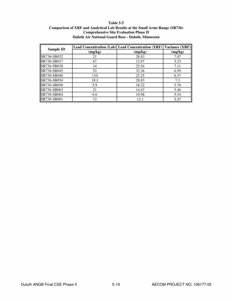
Table 5-5
Comparison of XRF and Analytical Lab Results at the Small Arms Range (SR736)
Comprehensive Site Evaluation Phase II
Duluth Air National Guard Base - Duluth, Minnesota
Lead Concentration (Lab) Lead Concentration (XRF) Variance (XRF)
(mg/kg) (mg/kg) (mg/kg)
SR736-SB032 21 28.83 7.07
SR736-SB037 67 12.97 5.23
SR736-SB038 14 25.54 7.11
SR736-SB045 52 32.36 6.59
SR736-SB046 110 25.25 6.37
SR736-SB054 18 J 28.83 7.3
SR736-SB056 5.9 18.32 5.78
SR736-SB063 21 14.47 5.46
SR736-SB064 6.6 10.98 5.54
SR736-SB081 12 13.1 5.57
Sample ID
Duluth ANGB Final CSE Phase II 5-19 AECOM PROJECT NO. 106177.05

AECOM Comprehensive Site Evaluation Phase II Report February 2010 Military Munitions Response Program – Duluth ANGB
Duluth ANGB Final CSE Phase II 5-20 AECOM PROJECT NO. 106177.05
This page intentionally left blank.
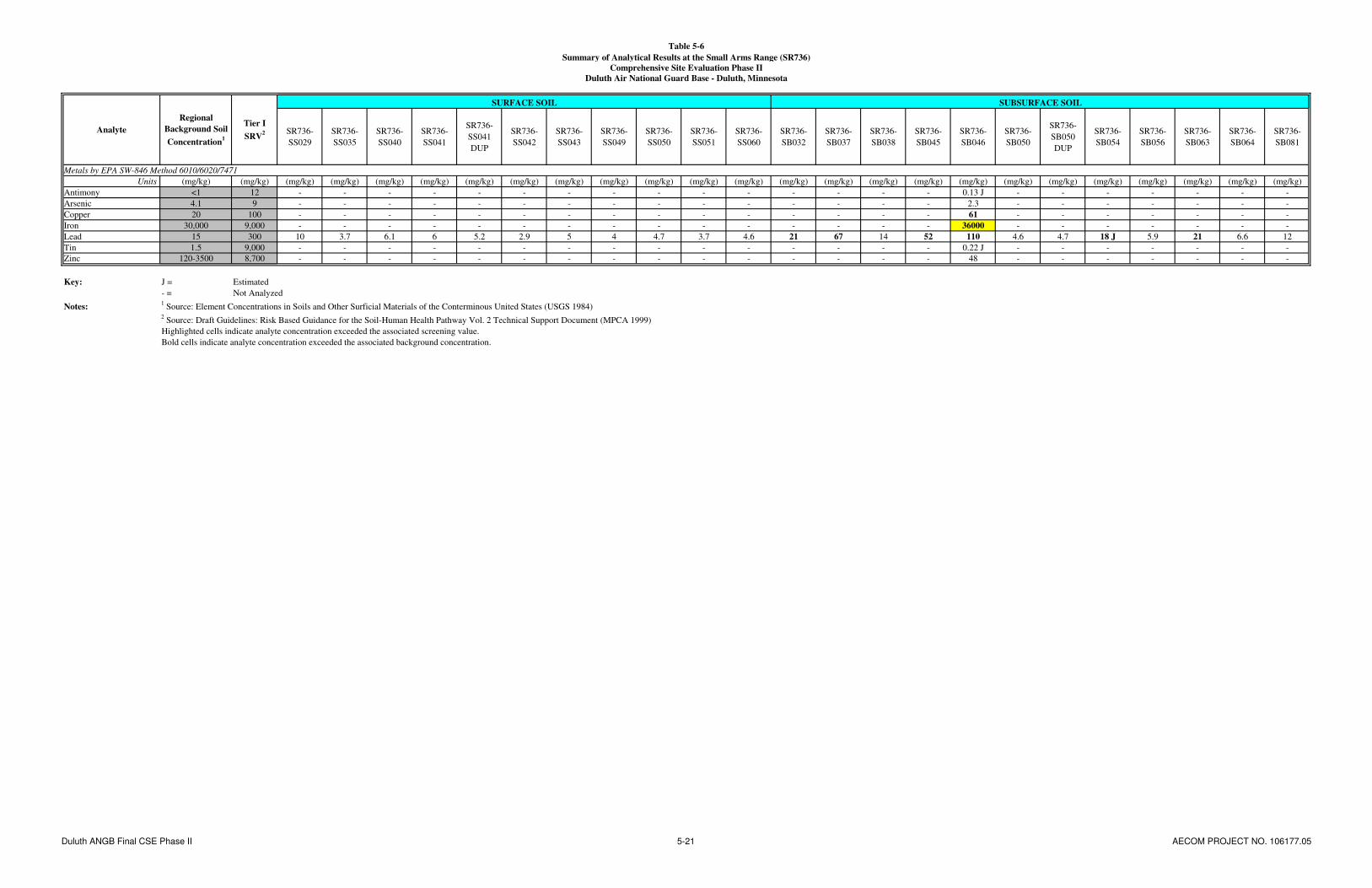
Table 5-6
Summary of Analytical Results at the Small Arms Range (SR736)
Comprehensive Site Evaluation Phase II
Duluth Air National Guard Base - Duluth, Minnesota
SR736-
SS029
SR736-
SS035
SR736-
SS040
SR736-
SS041
SR736-
SS041
DUP
SR736-
SS042
SR736-
SS043
SR736-
SS049
SR736-
SS050
SR736-
SS051
SR736-
SS060
SR736-
SB032
SR736-
SB037
SR736-
SB038
SR736-
SB045
SR736-
SB046
SR736-
SB050
SR736-
SB050
DUP
SR736-
SB054
SR736-
SB056
SR736-
SB063
SR736-
SB064
SR736-
SB081
Metals by EPA SW-846 Method 6010/6020/7471
Units (mg/kg) (mg/kg) (mg/kg) (mg/kg) (mg/kg) (mg/kg) (mg/kg) (mg/kg) (mg/kg) (mg/kg) (mg/kg) (mg/kg) (mg/kg) (mg/kg) (mg/kg) (mg/kg) (mg/kg) (mg/kg) (mg/kg) (mg/kg) (mg/kg) (mg/kg) (mg/kg) (mg/kg) (mg/kg)
Antimony <1 12 - - - - - - - - - - - - - - - 0.13 J - - - - - - -
Arsenic 4.1 9 - - - - - - - - - - - - - - - 2.3 - - - - - - -
Copper 20 100 - - - - - - - - - - - - - - - 61 - - - - - - -
Iron 30,000 9,000 - - - - - - - - - - - - - - - 36000 - - - - - - -
Lead 15 300 10 3.7 6.1 6 5.2 2.9 5 4 4.7 3.7 4.6 21 67 14 52 110 4.6 4.7 18 J 5.9 21 6.6 12
Tin 1.5 9,000 - - - - - - - - - - - - - - - 0.22 J - - - - - - -
Zinc 120-3500 8,700 - - - - - - - - - - - - - - - 48 - - - - - - -
Key: J = Estimated
- = Not Analyzed
Notes:1 Source: Element Concentrations in Soils and Other Surficial Materials of the Conterminous United States (USGS 1984)
2 Source: Draft Guidelines: Risk Based Guidance for the Soil-Human Health Pathway Vol. 2 Technical Support Document (MPCA 1999)
Highlighted cells indicate analyte concentration exceeded the associated screening value.
Bold cells indicate analyte concentration exceeded the associated background concentration.
SUBSURFACE SOIL
Analyte
Regional
Background Soil
Concentration1
Tier I
SRV2
SURFACE SOIL
Duluth ANGB Final CSE Phase II 5-21 AECOM PROJECT NO. 106177.05

AECOM Comprehensive Site Evaluation Phase II Report February 2010 Military Munitions Response Program – Duluth ANGB
Duluth ANGB Final CSE Phase II 5-22 AECOM PROJECT NO. 106177.05
This page intentionally left blank.

! (
! (
! (! (
! (
! (
! (
! (
! (! (
! (
! (
! (
! (
! (
! (
! (
! (
! (
! (
! (! (
! (
! (
! (
! (
! (
! (
! (! (
! (
! (
! (
! (
! (! (
! (
! (
! (
! (
! (
! (
! (
! (
! (
! (
! (
! (
! (
! (
! (
! (
! (
! (
! (
! (
! (
! (
! (
! (
! (! (
! (
! (
! (
! (
! (
! (
! (
! (
! (
! (
! (
! (
! (
! (
! (
! (
! (
! (
! (
! (
! (! (
! (
! (
! (
! (
! (
! (
! (
! (
! (
! (
! ( ! (
! (
! (
! (! (
! (
! (
! (
! (! (
! (
! (
K. Weber K. Weber
A. Dellens
1" = 100' 1 of 1
DAHA92-02-D-0012 0077 Duluth ANGB CSE Phase II Report
FIGURE 5-3
Small Arms Range (SR736)Analytical Results – Metals Concentrations
CONTRACT NO. TASK NO.
DESIGNED BY
CHECKED BY
SCALE
DRAWN BY
DATE
SHEET
March 2009
§0
100
200
50Fe
et
! (S
oil S
ampl
e
! (X
RF
Soi
l Sam
ple
! (Bo
reho
le S
oil S
ampl
e
25' x
25'
Grid
Non
-Nat
ive
Fill
Mat
eria
l
Con
cret
e P
ad /
Bui
ldin
gs -
No
Sam
ples
Smal
l Arm
s R
ange
Hig
hlig
hted
cel
ls in
dica
te a
naly
te c
once
ntra
tion
exce
eded
the
asso
ciat
ed s
cree
ning
val
ue.
Bold
cel
ls in
dica
te a
naly
te c
once
ntra
tion
exce
eded
the
asso
ciat
ed b
ackg
roun
d co
ncen
tratio
n.
www.aecom.com675 N. Washington Street, Suite 300, Alexandria, Virginia 22314Phone: 703-549-8728 Fax: 703-549-9134
Sam
ple
IDD
epth
(ft)
Ana
lyte
Con
cent
ratio
n (m
g/kg
)SS
035
0-0.
5Le
ad3.
7
Sam
ple
IDD
epth
(ft)
Ana
lyte
Con
cent
ratio
n (m
g/kg
)SS
041
0-0.
5Le
ad6
Sam
ple
IDD
epth
(ft)
Ana
lyte
Con
cent
ratio
n (m
g/kg
)SS
042
0-0.
5Le
ad2.
9
Sam
ple
IDD
epth
(ft)
Ana
lyte
Con
cent
ratio
n (m
g/kg
)SS
043
0-0.
5Le
ad5
Sam
ple
IDD
epth
(ft)
Ana
lyte
Con
cent
ratio
n (m
g/kg
)SS
029
0-0.
5Le
ad10
Sam
ple
IDD
epth
(ft)
Ana
lyte
Con
cent
ratio
n (m
g/kg
)SS
040
0-0.
5Le
ad6.
1
Sam
ple
IDD
epth
(ft)
Ana
lyte
Con
cent
ratio
n (m
g/kg
)SS
049
0-0.
5Le
ad4
Sam
ple
IDD
epth
(ft)
Ana
lyte
Con
cent
ratio
n (m
g/kg
)SS
050
0-0.
5Le
ad4.
7
Sam
ple
IDD
epth
(ft)
Ana
lyte
Con
cent
ratio
n (m
g/kg
)SS
051
0-0.
5Le
ad3.
7
Sam
ple
IDD
epth
(ft)
Ana
lyte
Con
cent
ratio
n (m
g/kg
)SS
060
0-0.
5Le
ad4.
6
Sam
ple
IDD
epth
(ft)
Ana
lyte
Con
cent
ratio
n (m
g/kg
)SB
032
2.85
Lead
21
Sam
ple
IDD
epth
(ft)
Ana
lyte
Con
cent
ratio
n (m
g/kg
)SB
037
10.3
5Le
ad67
Sam
ple
IDD
epth
(ft)
Ana
lyte
Con
cent
ratio
n (m
g/kg
)SB
038
4.75
Lead
14
Sam
ple
IDD
epth
(ft)
Ana
lyte
Con
cent
ratio
n (m
g/kg
)SB
045
12.5
4Le
ad52
Sam
ple
IDD
epth
(ft)
Ana
lyte
Con
cent
ratio
n (m
g/kg
)SB
054
14.4
Lead
18 J
Sam
ple
IDD
epth
(ft)
Ana
lyte
Con
cent
ratio
n (m
g/kg
)SB
056
4.55
Lead
5.9
Sam
ple
IDD
epth
(ft)
Ana
lyte
Con
cent
ratio
n (m
g/kg
)SB
063
11.4
9Le
ad21
Sam
ple
IDD
epth
(ft)
Ana
lyte
Con
cent
ratio
n (m
g/kg
)SB
064
6.58
Lead
6.6
Sam
ple
IDD
epth
(ft)
Ana
lyte
Con
cent
ratio
n (m
g/kg
)SB
081
4.33
Lead
12
Fig5_3_Small_Arms_Range_Data_Boxes.mxd
Sam
ple
IDD
epth
(ft)
Ana
lyte
Con
cent
ratio
n (m
g/kg
)SS
050
1-2
Lead
4.7
Sam
ple
IDD
epth
(ft)
Ana
lyte
Con
cent
ratio
n (m
g/kg
)Le
ad11
0A
ntim
ony
0.13
JA
rsen
ic2.
3C
oppe
r61
Iron
3600
0Ti
n0.
22 J
Zinc
48
SB04
66.
88
5-23

AECOM Comprehensive Site Evaluation Phase II Report February 2010 Military Munitions Response Program – Duluth ANGB
Duluth ANGB Final CSE Phase II 5-24 AECOM PROJECT NO. 106177.05
This page intentionally left blank.

AECOM Comprehensive Site Evaluation Phase II Report February 2010 Military Munitions Response Program – Duluth ANGB
Duluth ANGB Final CSE Phase II 5-25 AECOM PROJECT NO. 106177.05
Of the 21 soil samples (10 surface soil and 11 subsurface soil) analyzed for metals at the Small Arms Range, only one sample exceeded the lead field screening value of 100 mg/kg (SR736-SB046; 110 mg/kg lead); however this concentration is below the MPCA Tier I SRV of 300 mg/kg and the SLV of 525 mg/kg. Because lead was detected in soil sample SR736-SB046 above the field screening value, the results for antimony (0.13 J mg/kg), arsenic (2.3 mg/kg), Cu (61 mg/kg), iron (36,000 mg/kg), tin (0.22 J mg/kg), and zinc (48 mg/kg) were also reported. Of these metals, iron was the only metal for which the concentration exceeded the MPCA Tier I SRV of 9,000 mg/kg. This concentration also exceeded the regional background soil concentration of 30,000 mg/kg. There is no MPCA Tier I SLV for iron.
5.2.7 Potential Receptors
Potential human receptors at the Small Arms Range include base workers, maintenance personnel, and recreational users. Potential ecological receptors include plants, invertebrates, vertebrate herbivores, omnivores, and carnivores.
5.2.7.1 Nearby Population
Duluth ANGB is located approximately 6.7 miles northwest of central Duluth, Minnesota, which had an estimated population of 84,397 in 2007, and 3.5 miles north of the City of Hermantown, Minnesota, which had an estimated population of 9,271 in 2007 (U.S. Census Bureau, 2007).
5.2.7.2 Buildings Near/Within Munitions Response Area
The former Small Arms Range is now the site of the Northwest Airlines Maintenance Facility. Aircraft hangars, a fire department, and residential property are within a two-mile radius.
5.2.7.3 Utilities On/Near Munitions Response Area
The Small Arms Range is associated with the Northwest Airlines Maintenance Facility. Utilities expected to be present in the vicinity of the Small Arms Range include electric, gas, water, sanitary sewer, and phone.
5.3 Trap Range
5.3.1 Site Description
The Trap Range is located west of the main base, and is north of the intersection of Runway 21 and Runway 13, on property owned by the Duluth Airport Authority. The former range covers approximately 4 acres. The terrain is bordered to the north, west, and east by building developments and to the south by undeveloped land. Two retention ponds are located near the Trap Range and are used for both storm water management and fire emergency water supply (URS, 2007). During Phase II site reconnaissance, it was determined that the majority of the former range is located outside the Duluth International Airport Authority fence line, and is only accessible via a dirt access road through the off-base recycling facility. Visual survey of the MRA indicated wet conditions throughout the site. The center of the former range is a low-lying marshland with vegetation consisting of tall grasses and densely wooded areas. During the December site reconnaissance, the frozen ground facilitated access to most sampling locations within the wetland. Photographs taken during site reconnaissance in September 2008 (following the project kick-off meeting) of the Trap Range are included in Appendix M.

AECOM Comprehensive Site Evaluation Phase II Report February 2010 Military Munitions Response Program – Duluth ANGB
Duluth ANGB Final CSE Phase II 5-26 AECOM PROJECT NO. 106177.05
5.3.2 History of Munitions and Explosives of Concern Activities
The Trap Range was used by the 148 FW from 1985 to 1992 for small arms training (shotguns). No evidence of the former range exists, and interviews and a search of historical records conducted during the CSE Phase I (URS, 2007) did not reveal a detailed listing of munitions used at the site. This range was closed in 1992 as part of the planned construction of the Northwest Airlines Maintenance Facility; however, portions of the firing fan may still be undisturbed. No small caliber ammunition or related trap range debris (i.e., clay pigeons) were encountered at the Trap Range during the CSE Phase II activities.
5.3.3 Current Land Use
The area is primarily forested wetland with a small grassy area associated with the Northwest Airlines Maintenance Facility.
5.3.4 Access Control
The main base of the Duluth ANGB is a secure facility that is fenced on the north, east, and south sides. The Duluth International Airport is located to the west of the main base. Security personnel from the 148
th FW and the Duluth International Airport Authority patrol the base/airport at all times. The Trap
Range is on property owned by the Duluth Airport Authority; however, access to the site from the airport is limited because the area is fenced, and most gates are permanently locked. The Trap Range can be accessed via a dirt road from an off-base recycling center located to the north.
5.3.5 Restrictions
There are no administrative land use restrictions in place at the Trap Range.
5.3.6 Field Investigation Results
5.3.6.1 X-Ray Fluorescence Analysis
Surface soil samples were collected for XRF analysis at the nodes of a 50 ft by 50 ft grid in the center of the Trap Range, which was considered to be the area with the highest potential for contamination. A larger 100 ft by 100 ft grid was utilized in the areas near and far from the firing point, which were the areas considered to have the lowest potential for contamination (Figure 4-3) (ITRC, 2003). A total of 36 samples were collected in gallon size re-sealable plastic bags, transported to the field office, and screened ex-situ with XRF. Due to the significant time required to thaw and dry ex-situ samples from the Trap Range, XRF analysis was conducted using an in-situ approach. The XRF screening results for the Trap Range are presented in Table 5-7.
Of the 36 samples screened with XRF, 19 had concentrations (XRF readings) of lead exceeding the 100 mg/kg field screening value and 15 had concentrations of lead exceeding the MPCA Tier I SRV of 300 mg/kg. The highest concentration of lead measured with XRF was at sampling location SS013, at a concentration of 2,478.54 ± 36.82 mg/kg. A total of four confirmation soil samples (TS737-SS008, TS737-SS015, TS737-SS024, and TS737-SS030) were sent to the laboratory for analysis of metals concentrations. Comparison of the XRF screening results and the analytical laboratory results for these samples is presented in Table 5-8.
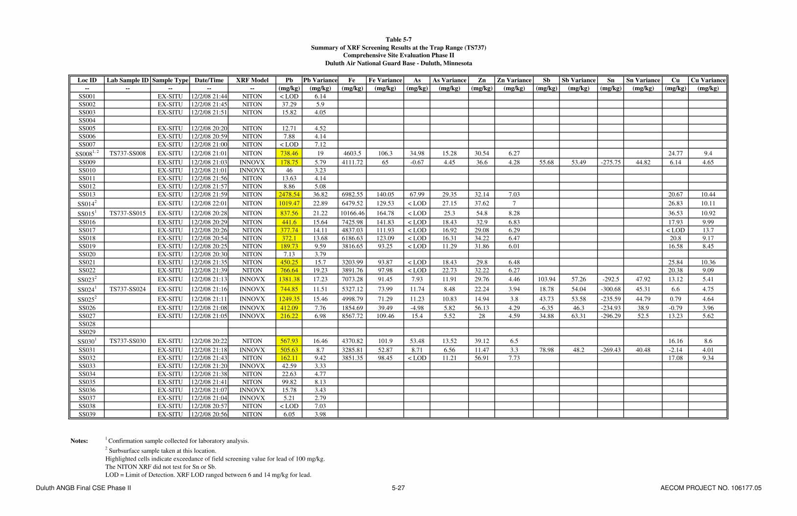
Table 5-7
Summary of XRF Screening Results at the Trap Range (TS737)
Comprehensive Site Evaluation Phase II
Duluth Air National Guard Base - Duluth, Minnesota
Loc ID Lab Sample ID Sample Type Date/Time XRF Model Pb Pb Variance Fe Fe Variance As As Variance Zn Zn Variance Sb Sb Variance Sn Sn Variance Cu Cu Variance
-- -- -- -- -- (mg/kg) (mg/kg) (mg/kg) (mg/kg) (mg/kg) (mg/kg) (mg/kg) (mg/kg) (mg/kg) (mg/kg) (mg/kg) (mg/kg) (mg/kg) (mg/kg)
SS001 EX-SITU 12/2/08 21:44 NITON < LOD 6.14
SS002 EX-SITU 12/2/08 21:45 NITON 37.29 5.9
SS003 EX-SITU 12/2/08 21:51 NITON 15.82 4.05
SS004
SS005 EX-SITU 12/2/08 20:20 NITON 12.71 4.52
SS006 EX-SITU 12/2/08 20:59 NITON 7.88 4.14
SS007 EX-SITU 12/2/08 21:00 NITON < LOD 7.12
SS0081, 2 TS737-SS008 EX-SITU 12/2/08 21:01 NITON 738.46 19 4603.5 106.3 34.98 15.28 30.54 6.27 24.77 9.4
SS009 EX-SITU 12/2/08 21:03 INNOVX 178.75 5.79 4111.72 65 -0.67 4.45 36.6 4.28 55.68 53.49 -275.75 44.82 6.14 4.65
SS010 EX-SITU 12/2/08 21:01 INNOVX 46 3.23
SS011 EX-SITU 12/2/08 21:56 NITON 13.63 4.14
SS012 EX-SITU 12/2/08 21:57 NITON 8.86 5.08
SS013 EX-SITU 12/2/08 21:59 NITON 2478.54 36.82 6982.55 140.05 67.99 29.35 32.14 7.03 20.67 10.44
SS0142 EX-SITU 12/2/08 22:01 NITON 1019.47 22.89 6479.52 129.53 < LOD 27.15 37.62 7 26.83 10.11
SS0151 TS737-SS015 EX-SITU 12/2/08 20:28 NITON 837.56 21.22 10166.46 164.78 < LOD 25.3 54.8 8.28 36.53 10.92
SS016 EX-SITU 12/2/08 20:29 NITON 441.6 15.64 7425.98 141.83 < LOD 18.43 32.9 6.83 17.93 9.99
SS017 EX-SITU 12/2/08 20:26 NITON 377.74 14.11 4837.03 111.93 < LOD 16.92 29.08 6.29 < LOD 13.7
SS018 EX-SITU 12/2/08 20:54 NITON 372.1 13.68 6186.63 123.09 < LOD 16.31 34.22 6.47 20.8 9.17
SS019 EX-SITU 12/2/08 20:25 NITON 189.73 9.59 3816.65 93.25 < LOD 11.29 31.86 6.01 16.58 8.45
SS020 EX-SITU 12/2/08 20:30 NITON 7.13 3.79
SS021 EX-SITU 12/2/08 21:35 NITON 450.25 15.7 3203.99 93.87 < LOD 18.43 29.8 6.48 25.84 10.36
SS022 EX-SITU 12/2/08 21:39 NITON 766.64 19.23 3891.76 97.98 < LOD 22.73 32.22 6.27 20.38 9.09
SS0232 EX-SITU 12/2/08 21:13 INNOVX 1381.38 17.23 7073.28 91.45 7.93 11.91 29.76 4.46 103.94 57.26 -292.5 47.92 13.12 5.41
SS0241 TS737-SS024 EX-SITU 12/2/08 21:16 INNOVX 744.85 11.51 5327.12 73.99 11.74 8.48 22.24 3.94 18.78 54.04 -300.68 45.31 6.6 4.75
SS0252 EX-SITU 12/2/08 21:11 INNOVX 1249.35 15.46 4998.79 71.29 11.23 10.83 14.94 3.8 43.73 53.58 -235.59 44.79 0.79 4.64
SS026 EX-SITU 12/2/08 21:08 INNOVX 412.09 7.76 1854.69 39.49 -4.98 5.82 56.13 4.29 -6.35 46.3 -234.93 38.9 -0.79 3.96
SS027 EX-SITU 12/2/08 21:05 INNOVX 216.22 6.98 8567.72 109.46 15.4 5.52 28 4.59 34.88 63.31 -296.29 52.5 13.23 5.62
SS028
SS029
SS0301 TS737-SS030 EX-SITU 12/2/08 20:22 NITON 567.93 16.46 4370.82 101.9 53.48 13.52 39.12 6.5 16.16 8.6
SS031 EX-SITU 12/2/08 21:18 INNOVX 505.63 8.7 3285.81 52.87 8.71 6.56 11.47 3.3 78.98 48.2 -269.43 40.48 -2.14 4.01
SS032 EX-SITU 12/2/08 21:43 NITON 162.11 9.42 3851.35 98.45 < LOD 11.21 56.91 7.73 17.08 9.34
SS033 EX-SITU 12/2/08 21:20 INNOVX 42.59 3.33
SS034 EX-SITU 12/2/08 21:38 NITON 22.63 4.77
SS035 EX-SITU 12/2/08 21:41 NITON 99.82 8.13
SS036 EX-SITU 12/2/08 21:07 INNOVX 15.78 3.43
SS037 EX-SITU 12/2/08 21:04 INNOVX 5.21 2.79
SS038 EX-SITU 12/2/08 20:57 NITON < LOD 7.03
SS039 EX-SITU 12/2/08 20:56 NITON 6.05 3.98
Notes:1
Confirmation sample collected for laboratory analysis.2 Surbsurface sample taken at this location.
Highlighted cells indicate exceedance of field screening value for lead of 100 mg/kg.
The NITON XRF did not test for Sn or Sb.
LOD = Limit of Detection. XRF LOD ranged between 6 and 14 mg/kg for lead.
Duluth ANGB Final CSE Phase II 5-27 AECOM PROJECT NO. 106177.05

AECOM Comprehensive Site Evaluation Phase II Report February 2010 Military Munitions Response Program – Duluth ANGB
Duluth ANGB Final CSE Phase II 5-28 AECOM PROJECT NO. 106177.05
This page intentionally left blank.

Table 5-8
Comparison of XRF and Analytical Lab Results at the Trap Range (TS737)
Comprehensive Site Evaluation Phase II
Duluth Air National Guard Base - Duluth, Minnesota
Lead Concentration (Lab) Lead Concentration (XRF) Variance (XRF)
(mg/kg) (mg/kg) (mg/kg)
TS737-SS008 2200 738.46 19
TS737-SS015 2500 837.56 21.22
TS737-SS024 2400 744.85 11.51
TS737-SS030 1700 567.93 16.46
Iron Concentration (Lab) Iron Concentration (XRF) Variance (XRF)
(mg/kg) (mg/kg) (mg/kg)
TS737-SS008 17000 4603.5 106.3
TS737-SS015 19000 10166.46 164.78
TS737-SS024 19000 5327.12 73.99
TS737-SS030 14000 4370.82 101.9
Arsenic Concentration (Lab) Arsenic Concentration (XRF) Variance (XRF)
(mg/kg) (mg/kg) (mg/kg)
TS737-SS008 19 34.98 15.28
TS737-SS015 13 < LOD 25.3
TS737-SS024 19 11.74 8.48
TS737-SS030 7.3 53.48 13.52
Zinc Concentration (Lab) Zinc Concentration (XRF) Variance (XRF)
(mg/kg) (mg/kg) (mg/kg)
TS737-SS008 74 30.54 6.27
TS737-SS015 78 54.8 8.28
TS737-SS024 79 22.24 3.94
TS737-SS030 110 39.12 6.5
Antimony Concentration (Lab) Antimony Concentration (XRF) Variance (XRF)
(mg/kg) (mg/kg) (mg/kg)
TS737-SS0081
8.8
TS737-SS0151
2.5
TS737-SS024 6.7 18.78 54.04
TS737-SS0301
6.5
Tin Concentration (Lab) Tin Concentration (XRF) Variance (XRF)
(mg/kg) (mg/kg) (mg/kg)
TS737-SS0081
0.12 J
TS737-SS0151
0.17 J
TS737-SS024 0.13 J -300.68 45.31
TS737-SS0301
0.15 J
Copper Concentration (Lab) Copper Concentration (XRF) Variance (XRF)
(mg/kg) (mg/kg) (mg/kg)
TS737-SS008 91 24.77 9.4
TS737-SS015 42 36.53 10.92
TS737-SS024 130 6.6 4.75
TS737-SS030 40 16.16 8.6
Notes:1 NITON XRF Model did not test for Sn or Sb
LOD = Limit of Detection.
Sample ID
Sample ID
Sample ID
Sample ID
Sample ID
Sample ID
Sample ID
Duluth ANGB Final CSE Phase II 5-29 AECOM PROJECT NO. 106177.05

AECOM Comprehensive Site Evaluation Phase II Report February 2010 Military Munitions Response Program – Duluth ANGB
Duluth ANGB Final CSE Phase II 5-30 AECOM PROJECT NO. 106177.05
This page intentionally left blank.
AECOM Comprehensive Site Evaluation Phase II Report February 2010 Military Munitions Response Program – Duluth ANGB
Duluth ANGB Final CSE Phase II 5-31 AECOM PROJECT NO. 106177.05
5.3.6.2 Environmental Sampling
Concentrations of metals and PAHs detected in soil, sediment and surface water at the Trap Range are presented in Table 5-9. The soil concentrations are compared to the regional background soil concentrations (for metals only) and MPCA Tier I SRVs. Sediment concentrations are compared to MPCA Tier I SQTs. Surface water concentrations are compared to applicable water quality standards. Figure 5-4 shows the Trap Range sample locations and associated detected metals concentrations.
Surface and subsurface soil samples were collected to confirm XRF results where lead levels were detected or exceeding screening levels. Of the eight soil samples (four surface and four subsurface samples) collected at the Trap Range, the following metals were detected above the associated MPCA Tier I SRVs: lead (seven samples), antimony (one sample), arsenic (four samples), Cu (one sample), and iron (eight samples). The highest concentration of lead detected in surface soil was found at TS737-SS015 with a concentration of 2,500 mg/kg. The highest concentration of lead detected in subsurface soil was found at TS737-SB023 (duplicate sample) with a concentration of 3,800 J mg/kg.
PAHs were not detected above the available MPCA Tier I SRVs in any soil sample. The seven probable (B2) human carcinogen compounds were converted to BaP equivalents (as described in Section 4.4.1) and compared to the MPCA Tier I SRV for BaP (2,000 µg/kg). None of the concentrations of BaP equivalents at the Trap Range exceeded the associated MPCA Tier I SRV (Table 5-10).
Each soil sample which exceeded the screening value for one or more metals was compared to the MPCA Tier I SLVs (Table 5-2). For lead, all four surface soil samples and two of the subsurface soil samples (TS737-SB023 and TS737-SB025) exceeded the MPCA Tier I SLV of 525 mg/kg. For antimony, three of the surface soil samples (TS737-SS008, TS737-SS024, and TS737-SS030) and one of the subsurface soil samples (TS737-SB023) exceeded the MPCA Tier I SLV of 2.7 mg/kg. For arsenic, two of the surface soil samples (TS737-SS008 and TS737-SS024) and one of the subsurface soil samples (TS737-SB023) exceeded the MPCA Tier I SLV of 15.1 mg/kg.
Two sediment samples were collected at the Trap Range and analyzed for metals and PAHs. No metals were detected at concentrations exceeding screening values in either sample. Acenaphethylene was detected in both sediment samples (TS737-SD001, 110 J µg/kg; TS737-SD002, 77 J µg/kg) above the MPCA Tier I SQT of 5.9 µg/kg. Benzo(a)pyrene was detected in both sediment samples (TS737-SD001, 300 J µg/kg; TS737-SD002, 180 J µg/kg) above the MPCA Tier I SQT of 150 µg/kg. No other PAHs were detected in sediment samples above the associated MPCA Tier I SQT.
Two surface water samples (and one duplicate sample) were collected at the Trap Range (co-located with the sediment samples) and analyzed for metals and PAHs. Lead was detected in TS737-SW001 (6.3J µg/L) and in TS737-SW002 (230 µg/L) above the surface water screening value of 3.2 µg/L. No other analytes were detected in either sample above the associated screening values.
5.3.7 Potential Receptors
Potential human receptors at the Trap Range include base workers, maintenance personnel, and recreational users. Potential ecological receptors include plants, invertebrates, vertebrate herbivores, omnivores, and carnivores.
5.3.7.1 Nearby Population
Duluth ANGB is located approximately 6.7 miles northwest of central Duluth, Minnesota, which had an estimated population of 84,397 in 2007, and 3.5 miles north of the City of Hermantown, Minnesota, which had an estimated population of 9,271 in 2007 (U.S. Census Bureau, 2007).

AECOM Comprehensive Site Evaluation Phase II Report February 2010 Military Munitions Response Program – Duluth ANGB
Duluth ANGB Final CSE Phase II 5-32 AECOM PROJECT NO. 106177.05
This page intentionally left blank.
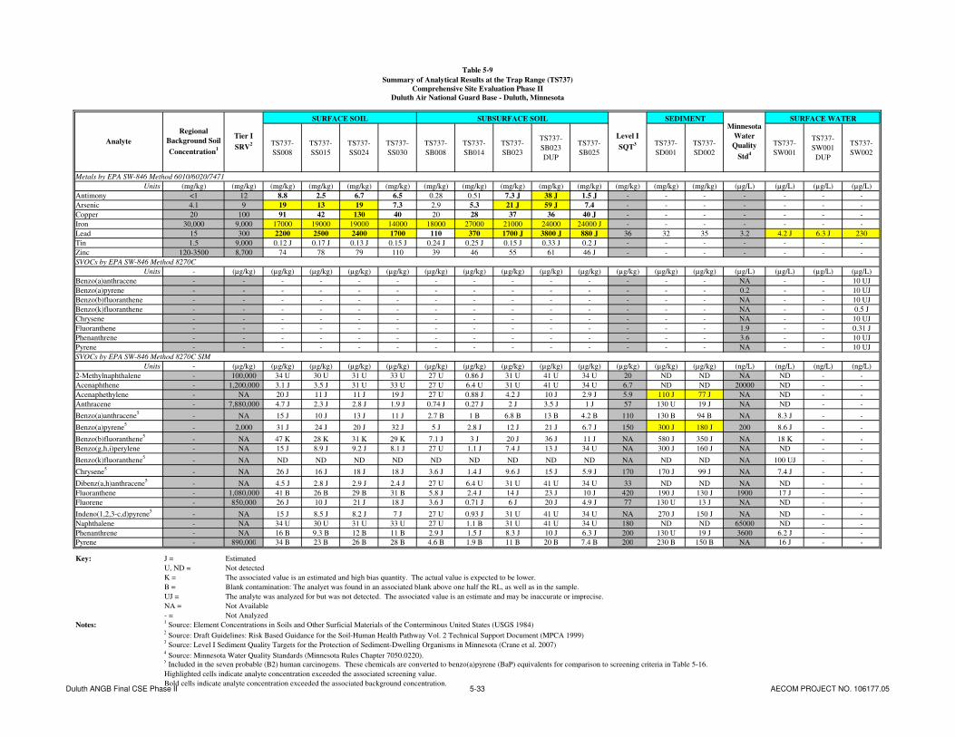
Table 5-9
Summary of Analytical Results at the Trap Range (TS737)
Comprehensive Site Evaluation Phase II
Duluth Air National Guard Base - Duluth, Minnesota
TS737-
SS008
TS737-
SS015
TS737-
SS024
TS737-
SS030
TS737-
SB008
TS737-
SB014
TS737-
SB023
TS737-
SB023
DUP
TS737-
SB025
TS737-
SD001
TS737-
SD002
TS737-
SW001
TS737-
SW001
DUP
TS737-
SW002
Metals by EPA SW-846 Method 6010/6020/7471
Units (mg/kg) (mg/kg) (mg/kg) (mg/kg) (mg/kg) (mg/kg) (mg/kg) (mg/kg) (mg/kg) (mg/kg) (mg/kg) (mg/kg) (mg/kg) (mg/kg) (µg/L) (µg/L) (µg/L) (µg/L)
Antimony <1 12 8.8 2.5 6.7 6.5 0.28 0.51 7.3 J 38 J 1.5 J - - - - - - -
Arsenic 4.1 9 19 13 19 7.3 2.9 5.3 21 J 59 J 7.4 - - - - - - -
Copper 20 100 91 42 130 40 20 28 37 36 40 J - - - - - - -
Iron 30,000 9,000 17000 19000 19000 14000 18000 27000 21000 24000 24000 J - - - - - - -
Lead 15 300 2200 2500 2400 1700 110 370 1700 J 3800 J 880 J 36 32 35 3.2 4.2 J 6.3 J 230
Tin 1.5 9,000 0.12 J 0.17 J 0.13 J 0.15 J 0.24 J 0.25 J 0.15 J 0.33 J 0.2 J - - - - - - -
Zinc 120-3500 8,700 74 78 79 110 39 46 55 61 46 J - - - - - - -
SVOCs by EPA SW-846 Method 8270C
Units - (µg/kg) (µg/kg) (µg/kg) (µg/kg) (µg/kg) (µg/kg) (µg/kg) (µg/kg) (µg/kg) (µg/kg) (µg/kg) (µg/kg) (µg/kg) (µg/L) (µg/L) (µg/L) (µg/L)
Benzo(a)anthracene - - - - - - - - - - - - - - NA - - 10 UJ
Benzo(a)pyrene - - - - - - - - - - - - - - 0.2 - - 10 UJ
Benzo(b)fluoranthene - - - - - - - - - - - - - - NA - - 10 UJ
Benzo(k)fluoranthene - - - - - - - - - - - - - - NA - - 0.5 J
Chrysene - - - - - - - - - - - - - - NA - - 10 UJ
Fluoranthene - - - - - - - - - - - - - - 1.9 - - 0.31 J
Phenanthrene - - - - - - - - - - - - - - 3.6 - - 10 UJ
Pyrene - - - - - - - - - - - - - - NA - - 10 UJ
SVOCs by EPA SW-846 Method 8270C SIM
Units - (µg/kg) (µg/kg) (µg/kg) (µg/kg) (µg/kg) (µg/kg) (µg/kg) (µg/kg) (µg/kg) (µg/kg) (µg/kg) (µg/kg) (µg/kg) (ng/L) (ng/L) (ng/L) (ng/L)
2-Methylnaphthalene - 100,000 34 U 30 U 31 U 33 U 27 U 0.86 J 31 U 41 U 34 U 20 ND ND NA ND - -
Acenaphthene - 1,200,000 3.1 J 3.5 J 31 U 33 U 27 U 6.4 U 31 U 41 U 34 U 6.7 ND ND 20000 ND - -
Acenaphethylene - NA 20 J 11 J 11 J 19 J 27 U 0.88 J 4.2 J 10 J 2.9 J 5.9 110 J 77 J NA ND - -
Anthracene - 7,880,000 4.7 J 2.3 J 2.8 J 1.9 J 0.74 J 0.27 J 2 J 3.5 J 1 J 57 130 U 19 J NA ND - -
Benzo(a)anthracene5
- NA 15 J 10 J 13 J 11 J 2.7 B 1 B 6.8 B 13 B 4.2 B 110 130 B 94 B NA 8.3 J - -
Benzo(a)pyrene5
- 2,000 31 J 24 J 20 J 32 J 5 J 2.8 J 12 J 21 J 6.7 J 150 300 J 180 J 200 8.6 J - -
Benzo(b)fluoranthene5
- NA 47 K 28 K 31 K 29 K 7.1 J 3 J 20 J 36 J 11 J NA 580 J 350 J NA 18 K - -
Benzo(g,h,i)perylene - NA 15 J 8.9 J 9.2 J 8.1 J 27 U 1.1 J 7.4 J 13 J 34 U NA 300 J 160 J NA ND - -
Benzo(k)fluoranthene5
- NA ND ND ND ND ND ND ND ND ND NA ND ND NA 100 UJ - -
Chrysene5
- NA 26 J 16 J 18 J 18 J 3.6 J 1.4 J 9.6 J 15 J 5.9 J 170 170 J 99 J NA 7.4 J - -
Dibenz(a,h)anthracene5
- NA 4.5 J 2.8 J 2.9 J 2.4 J 27 U 6.4 U 31 U 41 U 34 U 33 ND ND NA ND - -
Fluoranthene - 1,080,000 41 B 26 B 29 B 31 B 5.8 J 2.4 J 14 J 23 J 10 J 420 190 J 130 J 1900 17 J - -
Fluorene - 850,000 26 J 10 J 21 J 18 J 3.6 J 0.71 J 6 J 20 J 4.9 J 77 130 U 13 J NA ND - -
Indeno(1,2,3-c,d)pyrene5
- NA 15 J 8.5 J 8.2 J 7 J 27 U 0.93 J 31 U 41 U 34 U NA 270 J 150 J NA ND - -
Naphthalene - NA 34 U 30 U 31 U 33 U 27 U 1.1 B 31 U 41 U 34 U 180 ND ND 65000 ND - -
Phenanthrene - NA 16 B 9.3 B 12 B 11 B 2.9 J 1.5 J 8.3 J 10 J 6.3 J 200 130 U 19 J 3600 6.2 J - -
Pyrene - 890,000 34 B 23 B 26 B 28 B 4.6 B 1.9 B 11 B 20 B 7.4 B 200 230 B 150 B NA 16 J - -
Key: J = Estimated
U, ND = Not detected
K = The associated value is an estimated and high bias quantity. The actual value is expected to be lower.
B = Blank contamination: The analyet was found in an associated blank above one half the RL, as well as in the sample.
UJ = The analyte was analyzed for but was not detected. The associated value is an estimate and may be inaccurate or imprecise.
NA = Not Available
- = Not Analyzed
Notes:1 Source: Element Concentrations in Soils and Other Surficial Materials of the Conterminous United States (USGS 1984)
2 Source: Draft Guidelines: Risk Based Guidance for the Soil-Human Health Pathway Vol. 2 Technical Support Document (MPCA 1999)
3 Source: Level I Sediment Quality Targets for the Protection of Sediment-Dwelling Organisms in Minnesota (Crane et al. 2007)
4 Source: Minnesota Water Quality Standards (Minnesota Rules Chapter 7050.0220).
5 Included in the seven probable (B2) human carcinogens. These chemicals are converted to benzo(a)pyrene (BaP) equivalents for comparison to screening criteria in Table 5-16.
Highlighted cells indicate analyte concentration exceeded the associated screening value.
Bold cells indicate analyte concentration exceeded the associated background concentration.
SURFACE WATER
Level I
SQT3
Minnesota
Water
Quality
Std4
Analyte
Regional
Background Soil
Concentration1
Tier I
SRV2
SURFACE SOIL SUBSURFACE SOIL SEDIMENT
Duluth ANGB Final CSE Phase II 5-33 AECOM PROJECT NO. 106177.05

AECOM Comprehensive Site Evaluation Phase II Report February 2010 Military Munitions Response Program – Duluth ANGB
Duluth ANGB Final CSE Phase II 5-34 AECOM PROJECT NO. 106177.05
This page intentionally left blank.

! (
! (
! (
! (
! (
! (
! (
! (
! (
! (
! (
! (
! (
! (
! (
! (
! (
! (
! (
! (
! (! (
! (! (
! (! (
! (! (
! (! (
! (! (
! (! (
! (! (
! (
! (
! (
! (
! (
K. Weber K. Weber
A. Dellens
1" = 175' 1 of 1
DAHA92-02-D-0012 0077 Duluth ANGB CSE Phase II Report
FIGURE 5-4
Trap Range (TS737)Analytical Results – Metals Concentrations
CONTRACT NO. TASK NO.
DESIGNED BY
CHECKED BY
SCALE
DRAWN BY
DATE
SHEET
March 2009
§0
175
350
87.5
Feet
! (Se
dim
ent S
ampl
e / S
urfa
ce W
ater
Sam
ple
! (So
il S
ampl
e
! (XR
F So
il S
ampl
e
Grid
Surfa
ce W
ater
Trap
Ran
ge
Airfi
eld
Hig
hlig
hted
cel
ls in
dica
te a
naly
te c
once
ntra
tion
exce
eded
the
asso
ciat
ed s
cree
ning
val
ue.
Bold
cel
ls in
dica
te a
naly
te c
once
ntra
tion
exce
eded
the
asso
ciat
ed b
ackg
roun
d co
ncen
tratio
n.
www.aecom.com675 N. Washington Street, Suite 300, Alexandria, Virginia 22314Phone: 703-549-8728 Fax: 703-549-9134
Sam
ple
IDD
epth
(ft)
Ana
lyte
Con
cent
ratio
n (m
g/kg
)Le
ad22
00A
ntim
ony
8.8
Ars
enic
19C
oppe
r91
Iron
1700
0Ti
n0.
12 J
Zinc
74
SS00
80-
0.5
Sam
ple
IDD
epth
(ft)
Ana
lyte
Con
cent
ratio
n (m
g/kg
)Le
ad17
00A
ntim
ony
6.5
Ars
enic
7.3
Cop
per
40Ir
on14
000
Tin
0.15
JZi
nc11
0
SS03
00-
0.5
Sam
ple
IDD
epth
(ft)
Ana
lyte
Con
cent
ratio
n (m
g/kg
)Le
ad11
0A
ntim
ony
0.28
Ars
enic
2.9
Cop
per
20Ir
on18
000
Tin
0.24
JZi
nc39
SB00
80.
5-1.
0
Sam
ple
IDD
epth
(ft)
Ana
lyte
Con
cent
ratio
n (m
g/kg
)Le
ad37
0A
ntim
ony
0.51
Ars
enic
5.3
Cop
per
28Ir
on27
000
Tin
0.25
JZi
nc46
SB01
40.
5-1.
0
Sam
ple
IDD
epth
(ft)
Ana
lyte
Con
cent
ratio
n (m
g/kg
)Le
ad38
00 J
Ant
imon
y38
JA
rsen
ic59
JC
oppe
r37
Iron
2400
0Ti
n0.
33 J
Zinc
61
SB02
30.
5-1.
0
Sam
ple
IDD
epth
(ft)
Ana
lyte
Con
cent
ratio
n (m
g/kg
)SD
001
Lead
32
Sam
ple
IDD
epth
(ft)
Ana
lyte
Con
cent
ratio
n (m
g/kg
)Le
ad25
00A
ntim
ony
2.5
Ars
enic
13C
oppe
r42
Iron
1900
0Ti
n0.
17 J
Zinc
78
SS01
50-
0.5
Sam
ple
IDD
epth
(ft)
Ana
lyte
Con
cent
ratio
n (m
g/kg
)Le
ad24
00A
ntim
ony
6.7
Ars
enic
19C
oppe
r13
0Ir
on19
000
Tin
0.13
JZi
nc79
SS02
40-
0.5
Sam
ple
IDD
epth
(ft)
Ana
lyte
Con
cent
ratio
n (m
g/kg
)SD
002
Lead
35
Sam
ple
IDD
epth
(ft)
Ana
lyte
Con
cent
ratio
n (m
g/kg
)Le
ad88
0 J
Ant
imon
y1.
5 J
Ars
enic
7.4
Cop
per
40 J
Iron
2400
0 J
Tin
0.2
JZi
nc46
J
SB02
50.
5-1.
0
Sam
ple
IDD
epth
(ft)
Ana
lyte
Con
cent
ratio
n (µ
g/L)
SW00
2Le
ad23
0
Fig5_4_Trap_Range_Data_Boxes.mxd
Firin
g Po
int
Sam
ple
IDD
epth
(ft)
Ana
lyte
Conc
entra
tion
(µg/
L)SW
001
Lead
6.3
J
5-35

AECOM Comprehensive Site Evaluation Phase II Report February 2010 Military Munitions Response Program – Duluth ANGB
Duluth ANGB Final CSE Phase II 5-36 AECOM PROJECT NO. 106177.05
This page intentionally left blank.

Table 5-10
Summary of BaP Equivalent Concentrations at the Trap Range
Comprehensive Site Evaluation Phase II
Duluth Air National Guard Base - Duluth, Minnesota
TS737-
SS008
TS737-
SS015
TS737-
SS024
TS737-
SS030
TS737-
SB008
TS737-
SB014
TS737-
SB023
TS737-
SB023 DUP
TS737-
SB025
Trap Range
Probable (B2) Human Carcinogens
Units (mg/kg-d)-1
- (µg/kg) (µg/kg) (µg/kg) (µg/kg) (µg/kg) (µg/kg) (µg/kg) (µg/kg) (µg/kg) (µg/kg)
Benzo(a)anthracene NA 0.1 NA 15 J 10 J 13 J 11 J 2.7 B 1 B 6.8 B 13 B 4.2 B
Benzo(a)pyrene 0.73 1 2,000 31 J 24 J 20 J 32 J 5 J 2.8 J 12 J 21 J 6.7 J
Benzo(b)fluoranthene NA 0.1 NA 47 K 28 K 31 K 29 K 7.1 J 3 J 20 J 36 J 11 J
Benzo(k)fluoranthene NA 0.1 NA ND ND ND ND ND ND ND ND ND
Chrysene NA 0.01 NA 26 J 16 J 18 J 18 J 3.6 J 1.4 J 9.6 J 15 J 5.9 J
Dibenz(a,h)anthracene 4.1 0.56 NA 4.5 J 2.8 J 2.9 J 2.4 J 27 U 6.4 U 31 U 41 U 34 U
Indeno(1,2,3-c,d)pyrene NA 0.1 NA 15 J 8.5 J 8.2 J 7 J 27 U 0.93 J 31 U 41 U 34 U
2,000 41.487 30.383 27.029 38.228 5.746 3.207 14.096 24.75 7.859
Key: J = Estimated
U, ND = Not detected
K = The associated value is an estimated and high bias quantity. The actual value is expected to be lower.
B = Blank contamination: The analyet was found in an associated blank above one half the RL, as well as in the sample.
NA = Not Available
BaP = Benzo(a)pyrene
Notes:1 Source: Draft Guidelines: Risk Based Guidance for the Soil-Human Health Pathway Vol. 2 Technical Support Document (MPCA 1999)
2 BaP equivalents are calculated by multiplying the site concentration of each chemical by its Relative Potency Factor. The sum of the BaP
equivalent concentrations can be compared to the MPCA Tier I SRV.
Tier I
SRV1
SURFACE SOIL SUBSURFACE SOIL
Total BaP Equivalents2
Oral Cancer
Slope Factor1
Relative
Potency
Factor1
Analyte
Duluth ANGB Final CSE Phase II 5-37 AECOM PROJECT NO. 106177.05

AECOM Comprehensive Site Evaluation Phase II Report February 2010 Military Munitions Response Program – Duluth ANGB
Duluth ANGB Final CSE Phase II 5-38 AECOM PROJECT NO. 106177.05
This page intentionally left blank.
AECOM Comprehensive Site Evaluation Phase II Report February 2010 Military Munitions Response Program – Duluth ANGB
Duluth ANGB Final CSE Phase II 5-39 AECOM PROJECT NO. 106177.05
5.3.7.2 Buildings Near/Within Munitions Response Area
The Trap Range is located adjacent to the Northwest Airlines Maintenance Facility. Aircraft hangars, a fire department, and residential property are within a 2-mile radius.
5.3.7.3 Utilities On/Near Munitions Response Area
This site is located near the Northwest Airlines Maintenance Facility. Utilities expected to be present in the vicinity of the Trap Range include electric, gas, water, sanitary sewer, and phone.
5.4 Skeet Range
5.4.1 Site Description
The former Skeet Range is located within the main base on property owned by the Minnesota Department of Military Affairs that is leased to the MNANG. A portion of the firing fan extends across the installation boundary onto an adjacent parcel to the east also owned by the Minnesota Department of Military Affairs. The Skeet Range is approximately 15.3 acres. Based on aerial photography of the area, the site was redeveloped with a building between 1964 and 1971; however, portions of the firing fan may still be undisturbed in undeveloped areas. Surface waters on the site include a delineated wetland, which drains into Miller Creek, a State designated trout stream (URS, 2007). During Phase II site reconnaissance, it was confirmed that much of the site is occupied with buildings and associated parking areas. Visual survey of the MRA indicated the center of the former range (to the east of the Base buildings) is a low-lying, densely wooded wetland. The frozen ground and limited vegetation facilitated access to most sampling locations within the wetland without substantial site clearing. Sampling locations falling within concrete covered areas or within buildings were relocated to nearby grassy areas. Photographs taken during site reconnaissance in September 2008 (following the project kick-off meeting) at the Skeet Range are included in Appendix M.
5.4.2 History of Munitions and Explosives of Concern Activities
The Skeet Range was used by the USAF from 1960 to 1970 for small arms training (shotguns). No evidence of the former range exists, and interviews and a search of historical records conducted during the CSE Phase I (URS, 2007) did not reveal a detailed listing of munitions used at the site. Much of the former range was developed in the 1960s; however, portions of the firing fan may still be undisturbed. No small caliber ammunition or related skeet range debris were encountered at the Skeet Range during CSE Phase II activities.
5.4.3 Current Land Use
The former Skeet Range is currently developed with buildings and parking lots associated with the main base. Portions of the MRA remain undeveloped and consist of forested wetland.
5.4.4 Access Control
The main base of the Duluth ANGB is a secure facility that is fenced on the north, east, and south sides. The Duluth International Airport is located to the west of the main base. Security personnel from the 148
th FW and the Duluth International Airport Authority patrol the base/airport at all times. The Skeet
Range is located within the main base, which is owned concurrently by the DoD/USAF and the Minnesota Department of Military Affairs. No public access to the site is permitted.

AECOM Comprehensive Site Evaluation Phase II Report February 2010 Military Munitions Response Program – Duluth ANGB
Duluth ANGB Final CSE Phase II 5-40 AECOM PROJECT NO. 106177.05
5.4.5 Restrictions
There are no administrative land use restrictions in place at the Skeet Range.
5.4.6 Field Investigation Results
5.4.6.1 X-Ray Fluorescence Analysis
Surface soil samples were collected for XRF analysis at the nodes of a 100 feet by 100 feet grid at the Skeet Range (Figure 4-4), for a total of 56 sample points. Samples were collected in gallon size re-sealable plastic bags, transported to the field office, and screened ex-situ with XRF. Due to time constraints, only select samples from the Skeet Range were prepared prior to analysis (i.e., dried and sieved). Table 5-11 indicates which samples were prepared prior to screening and presents the XRF screening results for the Skeet Range.
Of the 56 samples screened with XRF, two had concentrations (XRF readings) of lead exceeding the 100 mg/kg field screening value. None exceeded the lead MPCA Tier I SRV of 300 mg/kg. The highest concentration of lead measured with XRF was at sampling location SS033, at a concentration of 155 ± 6 mg/kg. Six surface soil samples (TS738-SS028, TS738-SS032, TS738-SS033, TS738-SS047, TS738-SS051, and TS738-SS058) were sent to the laboratory for analysis of metals concentrations. Comparison of the XRF screening results and the analytical laboratory results for these samples is presented in Table 5-12.
5.4.6.2 Environmental Sampling
Concentrations of metals and PAHs detected in soil, sediment, and surface water at the Skeet Range are presented in Table 5-13. The soil concentrations are compared to the regional background soil concentrations (for metals only) and MPCA Tier I SRVs. Sediment concentrations are compared to MPCA Tier I SQTs. Surface water concentrations are compared to applicable water quality standards. Figure 5-5 shows the Skeet Range sample locations and associated detected metals concentrations.
Surface and subsurface soil samples were collected to confirm XRF results where lead levels were detected or exceeding screening levels. Of the 12 soil samples (six surface and six subsurface samples) collected at the Skeet Range, lead was detected above the MPCA Tier I SRV of 300 mg/kg in one soil sample at the Skeet Range (TS737-SB033, 470 mg/kg lead). Lead was also detected above the field screening value of 100 mg/kg in four additional soil samples (TS738-SS028, 260 mg/kg; TS738-SS032, 140 mg/kg; TS738-SS033, 290 mg/kg; and TS738-SB027, 100 mg/kg). Of the five samples for which iron was analyzed, all five contained iron at a concentration exceeding the MPCA Tier I SRV of 9,000 mg/kg; however, all concentrations were below the regional background soil concentration of iron of 30,000 mg/kg.
PAHs were not detected above the available MPCA Tier I SRVs in any soil sample. The seven probable (B2) human carcinogen compounds were converted to BaP equivalents (as described in Section 4.4.1) and compared to the MPCA Tier I SRV for BaP (2,000 µg/kg). None of the concentrations of BaP equivalents at the Skeet Range exceeded the associated MPCA Tier I SRV (Table 5-14).
Each soil sample which exceeded the screening value for one or more metals was compared to the MPCA Tier I SLVs (Table 5-2). None of the samples from the Skeet Range exceeded the associated MPCA Tier I SLVs for reported metals.
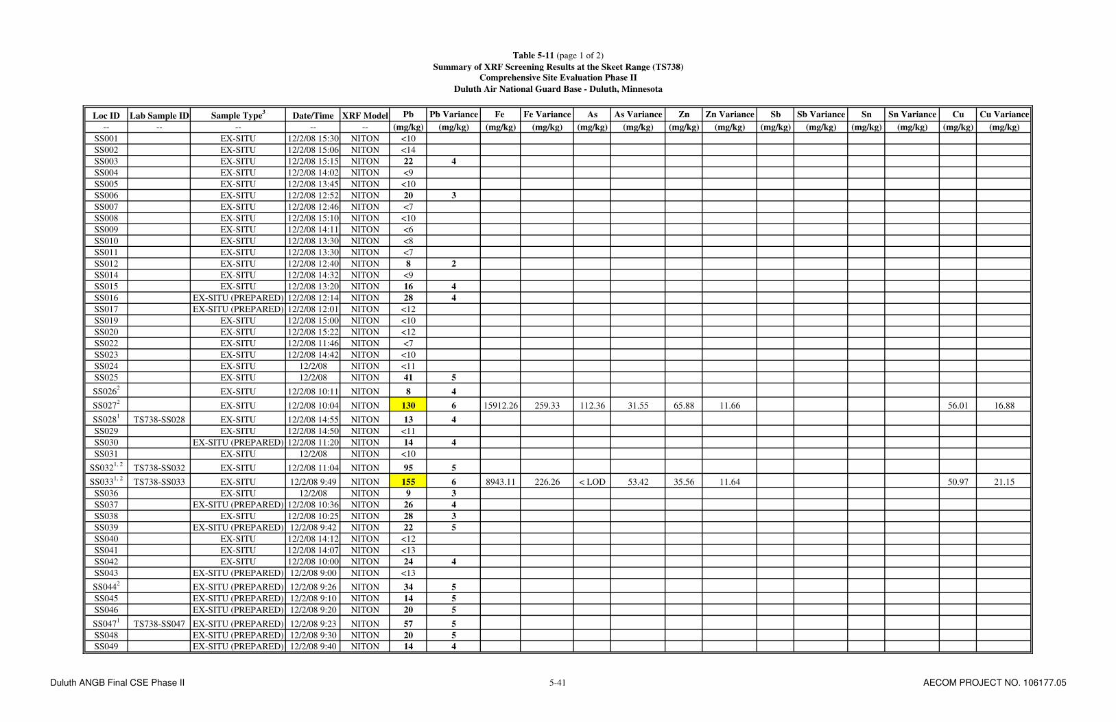
Table 5-11 (page 1 of 2)
Summary of XRF Screening Results at the Skeet Range (TS738)
Comprehensive Site Evaluation Phase II
Duluth Air National Guard Base - Duluth, Minnesota
Loc ID Lab Sample ID Sample Type3
Date/Time XRF Model Pb Pb Variance Fe Fe Variance As As Variance Zn Zn Variance Sb Sb Variance Sn Sn Variance Cu Cu Variance
-- -- -- -- -- (mg/kg) (mg/kg) (mg/kg) (mg/kg) (mg/kg) (mg/kg) (mg/kg) (mg/kg) (mg/kg) (mg/kg) (mg/kg) (mg/kg) (mg/kg) (mg/kg)
SS001 EX-SITU 12/2/08 15:30 NITON <10
SS002 EX-SITU 12/2/08 15:06 NITON <14
SS003 EX-SITU 12/2/08 15:15 NITON 22 4
SS004 EX-SITU 12/2/08 14:02 NITON <9
SS005 EX-SITU 12/2/08 13:45 NITON <10
SS006 EX-SITU 12/2/08 12:52 NITON 20 3
SS007 EX-SITU 12/2/08 12:46 NITON <7
SS008 EX-SITU 12/2/08 15:10 NITON <10
SS009 EX-SITU 12/2/08 14:11 NITON <6
SS010 EX-SITU 12/2/08 13:30 NITON <8
SS011 EX-SITU 12/2/08 13:30 NITON <7
SS012 EX-SITU 12/2/08 12:40 NITON 8 2
SS014 EX-SITU 12/2/08 14:32 NITON <9
SS015 EX-SITU 12/2/08 13:20 NITON 16 4
SS016 EX-SITU (PREPARED) 12/2/08 12:14 NITON 28 4
SS017 EX-SITU (PREPARED) 12/2/08 12:01 NITON <12
SS019 EX-SITU 12/2/08 15:00 NITON <10
SS020 EX-SITU 12/2/08 15:22 NITON <12
SS022 EX-SITU 12/2/08 11:46 NITON <7
SS023 EX-SITU 12/2/08 14:42 NITON <10
SS024 EX-SITU 12/2/08 NITON <11
SS025 EX-SITU 12/2/08 NITON 41 5
SS0262
EX-SITU 12/2/08 10:11 NITON 8 4
SS0272
EX-SITU 12/2/08 10:04 NITON 130 6 15912.26 259.33 112.36 31.55 65.88 11.66 56.01 16.88
SS0281
TS738-SS028 EX-SITU 12/2/08 14:55 NITON 13 4
SS029 EX-SITU 12/2/08 14:50 NITON <11
SS030 EX-SITU (PREPARED) 12/2/08 11:20 NITON 14 4
SS031 EX-SITU 12/2/08 NITON <10
SS0321, 2
TS738-SS032 EX-SITU 12/2/08 11:04 NITON 95 5
SS0331, 2
TS738-SS033 EX-SITU 12/2/08 9:49 NITON 155 6 8943.11 226.26 < LOD 53.42 35.56 11.64 50.97 21.15
SS036 EX-SITU 12/2/08 NITON 9 3
SS037 EX-SITU (PREPARED) 12/2/08 10:36 NITON 26 4
SS038 EX-SITU 12/2/08 10:25 NITON 28 3
SS039 EX-SITU (PREPARED) 12/2/08 9:42 NITON 22 5
SS040 EX-SITU 12/2/08 14:12 NITON <12
SS041 EX-SITU 12/2/08 14:07 NITON <13
SS042 EX-SITU 12/2/08 10:00 NITON 24 4
SS043 EX-SITU (PREPARED) 12/2/08 9:00 NITON <13
SS0442
EX-SITU (PREPARED) 12/2/08 9:26 NITON 34 5
SS045 EX-SITU (PREPARED) 12/2/08 9:10 NITON 14 5
SS046 EX-SITU (PREPARED) 12/2/08 9:20 NITON 20 5
SS0471
TS738-SS047 EX-SITU (PREPARED) 12/2/08 9:23 NITON 57 5
SS048 EX-SITU (PREPARED) 12/2/08 9:30 NITON 20 5
SS049 EX-SITU (PREPARED) 12/2/08 9:40 NITON 14 4
Duluth ANGB Final CSE Phase II 5-41 AECOM PROJECT NO. 106177.05

Table 5-11 (page 2 of 2)
Summary of XRF Screening Results at the Skeet Range (TS738)
Comprehensive Site Evaluation Phase II
Duluth Air National Guard Base - Duluth, Minnesota
Loc ID Lab Sample ID Sample Type3
Date/Time XRF Model Pb Pb Variance Fe Fe Variance As As Variance Zn Zn Variance Sb Sb Variance Sn Sn Variance Cu Cu Variance
-- -- -- -- -- (mg/kg) (mg/kg) (mg/kg) (mg/kg) (mg/kg) (mg/kg) (mg/kg) (mg/kg) (mg/kg) (mg/kg) (mg/kg) (mg/kg) (mg/kg) (mg/kg)
SS0502
EX-SITU (PREPARED) 12/2/08 9:02 NITON 31 5
SS0511
TS738-SS051 EX-SITU (PREPARED) 12/2/08 NITON <12
SS052/53 EX-SITU (PREPARED) 12/2/08 8:35 NITON <12
SS054 EX-SITU (PREPARED) 12/2/08 NITON 18 5
SS055 EX-SITU (PREPARED) 12/2/08 8:40 NITON <14
SS056 EX-SITU (PREPARED) 12/2/08 8:30 NITON <14
SS057 EX-SITU (PREPARED) 12/2/08 NITON 17 5
SS0581
TS738-SS058 EX-SITU (PREPARED) 12/2/08 0:00 NITON 24 5
SS059 EX-SITU (PREPARED) 12/2/08 15:15 NITON <12
SS060 EX-SITU (PREPARED) 12/2/08 9:00 NITON 15 5
SS061 EX-SITU (PREPARED) 12/2/08 8:45 NITON 24 5
SS062 EX-SITU (PREPARED) 12/2/08 15:25 NITON <13
Notes:1
Confirmation sample collected for laboratory analysis.2
Subsurface sample taken at this location.3
Sample preparation included soil drying and sieving through a No. 20 sieve.
Highlighted cells indicate exceedance of field screening value for lead of 100 mg/kg.
The NITON XRF did not test for Sn or Sb.
Duluth ANGB Final CSE Phase II 5-42 AECOM PROJECT NO. 106177.05

Table 5-12
Comparison of XRF and Analytical Lab Results at the Skeet Range (TS738)
Comprehensive Site Evaluation Phase II
Duluth Air National Guard Base - Duluth, Minnesota
Lead Concentration (Lab) Lead Concentration (XRF) Variance (XRF)
(mg/kg) (mg/kg) (mg/kg)
TS738-SS028 260 13 4
TS738-SS032 140 95 5
TS738-SS033 290 155 6
TS738-SS047 14 57 5
TS738-SS051 6.9 <12
TS738-SS058 7.5 24 5
Iron Concentration (Lab) Iron Concentration (XRF) Variance (XRF)
(mg/kg) (mg/kg) (mg/kg)
TS738-SS033 17000 8943.11 226.26
Arsenic Concentration (Lab) Arsenic Concentration (XRF) Variance (XRF)
(mg/kg) (mg/kg) (mg/kg)
TS738-SS033 3 < LOD 53.42
Zinc Concentration (Lab) Zinc Concentration (XRF) Variance (XRF)
(mg/kg) (mg/kg) (mg/kg)
TS738-SS033 75 35.56 11.64
Copper Concentration (Lab) Copper Concentration (XRF) Variance (XRF)
(mg/kg) (mg/kg) (mg/kg)
TS738-SS033 71 50.97 21.15
Notes: LOD = Limit of Detection.
Sample ID
Sample ID
Sample ID
Sample ID
Sample ID
Duluth ANGB Final CSE Phase II 5-43 AECOM PROJECT NO. 106177.05

AECOM Comprehensive Site Evaluation Phase II Report February 2010 Military Munitions Response Program – Duluth ANGB
Duluth ANGB Final CSE Phase II 5-44 AECOM PROJECT NO. 106177.05
This page intentionally left blank.
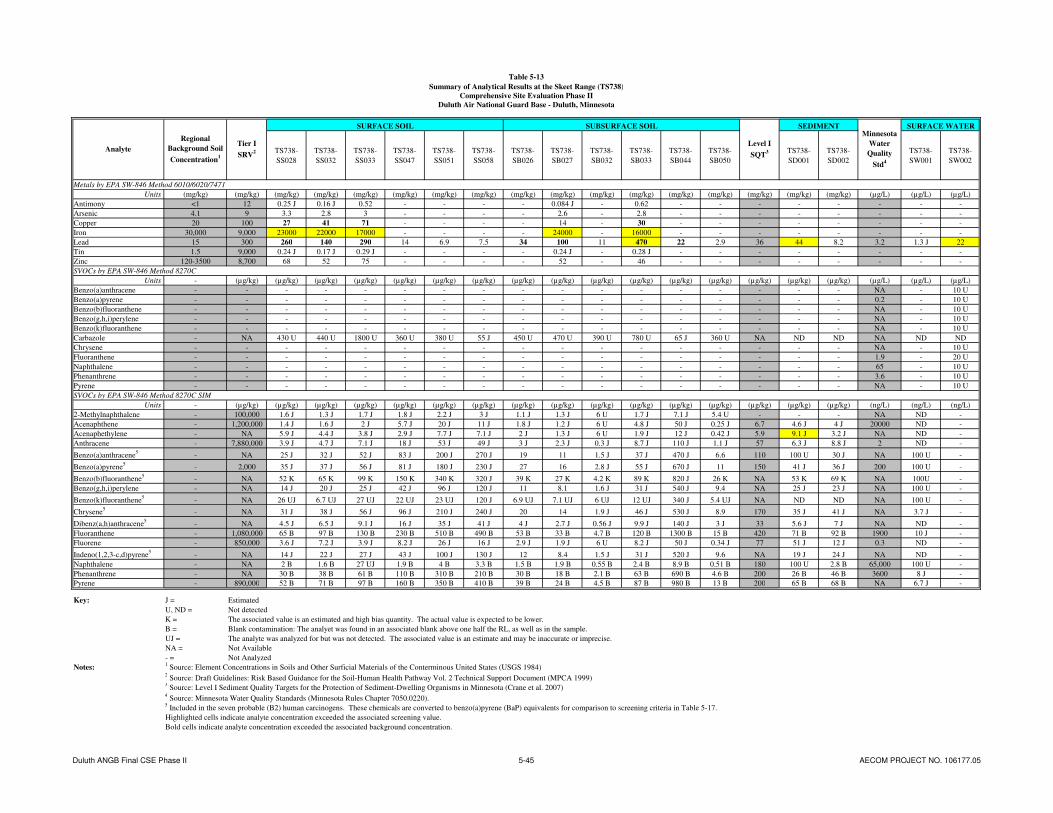
Table 5-13
Summary of Analytical Results at the Skeet Range (TS738)
Comprehensive Site Evaluation Phase II
Duluth Air National Guard Base - Duluth, Minnesota
TS738-
SS028
TS738-
SS032
TS738-
SS033
TS738-
SS047
TS738-
SS051
TS738-
SS058
TS738-
SB026
TS738-
SB027
TS738-
SB032
TS738-
SB033
TS738-
SB044
TS738-
SB050
TS738-
SD001
TS738-
SD002
TS738-
SW001
TS738-
SW002
Metals by EPA SW-846 Method 6010/6020/7471
Units (mg/kg) (mg/kg) (mg/kg) (mg/kg) (mg/kg) (mg/kg) (mg/kg) (mg/kg) (mg/kg) (mg/kg) (mg/kg) (mg/kg) (mg/kg) (mg/kg) (mg/kg) (mg/kg) (mg/kg) (µg/L) (µg/L) (µg/L)
Antimony <1 12 0.25 J 0.16 J 0.52 - - - - 0.084 J - 0.62 - - - - - - - -
Arsenic 4.1 9 3.3 2.8 3 - - - - 2.6 - 2.8 - - - - - - - -
Copper 20 100 27 41 71 - - - - 14 - 30 - - - - - - - -
Iron 30,000 9,000 23000 22000 17000 - - - - 24000 - 16000 - - - - - - - -
Lead 15 300 260 140 290 14 6.9 7.5 34 100 11 470 22 2.9 36 44 8.2 3.2 1.3 J 22
Tin 1.5 9,000 0.24 J 0.17 J 0.29 J - - - - 0.24 J - 0.28 J - - - - - - - -
Zinc 120-3500 8,700 68 52 75 - - - - 52 - 46 - - - - - - - -
SVOCs by EPA SW-846 Method 8270C
Units - (µg/kg) (µg/kg) (µg/kg) (µg/kg) (µg/kg) (µg/kg) (µg/kg) (µg/kg) (µg/kg) (µg/kg) (µg/kg) (µg/kg) (µg/kg) (µg/kg) (µg/kg) (µg/kg) (µg/L) (µg/L) (µg/L)
Benzo(a)anthracene - - - - - - - - - - - - - - - - - NA - 10 U
Benzo(a)pyrene - - - - - - - - - - - - - - - - - 0.2 - 10 U
Benzo(b)fluoranthene - - - - - - - - - - - - - - - - - NA - 10 U
Benzo(g,h,i)perylene - - - - - - - - - - - - - - - - - NA - 10 U
Benzo(k)fluoranthene - - - - - - - - - - - - - - - - - NA - 10 U
Carbazole - NA 430 U 440 U 1800 U 360 U 380 U 55 J 450 U 470 U 390 U 780 U 65 J 360 U NA ND ND NA ND ND
Chrysene - - - - - - - - - - - - - - - - - NA - 10 U
Fluoranthene - - - - - - - - - - - - - - - - - 1.9 - 20 U
Naphthalene - - - - - - - - - - - - - - - - - 65 - 10 U
Phenanthrene - - - - - - - - - - - - - - - - - 3.6 - 10 U
Pyrene - - - - - - - - - - - - - - - - - NA - 10 U
SVOCs by EPA SW-846 Method 8270C SIM
Units - (µg/kg) (µg/kg) (µg/kg) (µg/kg) (µg/kg) (µg/kg) (µg/kg) (µg/kg) (µg/kg) (µg/kg) (µg/kg) (µg/kg) (µg/kg) (µg/kg) (µg/kg) (µg/kg) (ng/L) (ng/L) (ng/L)
2-Methylnaphthalene - 100,000 1.6 J 1.3 J 1.7 J 1.8 J 2.2 J 3 J 1.1 J 1.3 J 6 U 1.7 J 7.1 J 5.4 U - - - NA ND -
Acenaphthene - 1,200,000 1.4 J 1.6 J 2 J 5.7 J 20 J 11 J 1.8 J 1.2 J 6 U 4.8 J 50 J 0.25 J 6.7 4.6 J 4 J 20000 ND -
Acenaphethylene - NA 5.9 J 4.4 J 3.8 J 2.9 J 7.7 J 7.1 J 2 J 1.3 J 6 U 1.9 J 12 J 0.42 J 5.9 9.1 J 3.2 J NA ND -
Anthracene - 7,880,000 3.9 J 4.7 J 7.1 J 18 J 53 J 49 J 3 J 2.3 J 0.3 J 8.7 J 110 J 1.1 J 57 6.3 J 8.8 J 2 ND -
Benzo(a)anthracene5
- NA 25 J 32 J 52 J 83 J 200 J 270 J 19 11 1.5 J 37 J 470 J 6.6 110 100 U 30 J NA 100 U -
Benzo(a)pyrene5
- 2,000 35 J 37 J 56 J 81 J 180 J 230 J 27 16 2.8 J 55 J 670 J 11 150 41 J 36 J 200 100 U -
Benzo(b)fluoranthene5
- NA 52 K 65 K 99 K 150 K 340 K 320 J 39 K 27 K 4.2 K 89 K 820 J 26 K NA 53 K 69 K NA 100U -
Benzo(g,h,i)perylene - NA 14 J 20 J 25 J 42 J 96 J 120 J 11 8.1 1.6 J 31 J 540 J 9.4 NA 25 J 23 J NA 100 U -
Benzo(k)fluoranthene5
- NA 26 UJ 6.7 UJ 27 UJ 22 UJ 23 UJ 120 J 6.9 UJ 7.1 UJ 6 UJ 12 UJ 340 J 5.4 UJ NA ND ND NA 100 U -
Chrysene5
- NA 31 J 38 J 56 J 96 J 210 J 240 J 20 14 1.9 J 46 J 530 J 8.9 170 35 J 41 J NA 3.7 J -
Dibenz(a,h)anthracene5
- NA 4.5 J 6.5 J 9.1 J 16 J 35 J 41 J 4 J 2.7 J 0.56 J 9.9 J 140 J 3 J 33 5.6 J 7 J NA ND -
Fluoranthene - 1,080,000 65 B 97 B 130 B 230 B 510 B 490 B 53 B 33 B 4.7 B 120 B 1300 B 15 B 420 71 B 92 B 1900 10 J -
Fluorene - 850,000 3.6 J 7.2 J 3.9 J 8.2 J 26 J 16 J 2.9 J 1.9 J 6 U 8.2 J 50 J 0.34 J 77 51 J 12 J 0.3 ND -
Indeno(1,2,3-c,d)pyrene5
- NA 14 J 22 J 27 J 43 J 100 J 130 J 12 8.4 1.5 J 31 J 520 J 9.6 NA 19 J 24 J NA ND -
Naphthalene - NA 2 B 1.6 B 27 UJ 1.9 B 4 B 3.3 B 1.5 B 1.9 B 0.55 B 2.4 B 8.9 B 0.51 B 180 100 U 2.8 B 65,000 100 U -
Phenanthrene - NA 30 B 38 B 61 B 110 B 310 B 210 B 30 B 18 B 2.1 B 63 B 690 B 4.6 B 200 26 B 46 B 3600 8 J -
Pyrene - 890,000 52 B 71 B 97 B 160 B 350 B 410 B 39 B 24 B 4.5 B 87 B 980 B 13 B 200 65 B 68 B NA 6.7 J -
Key: J = Estimated
U, ND = Not detected
K = The associated value is an estimated and high bias quantity. The actual value is expected to be lower.
B = Blank contamination: The analyet was found in an associated blank above one half the RL, as well as in the sample.
UJ = The analyte was analyzed for but was not detected. The associated value is an estimate and may be inaccurate or imprecise.
NA = Not Available
- = Not Analyzed
Notes:1 Source: Element Concentrations in Soils and Other Surficial Materials of the Conterminous United States (USGS 1984)
2 Source: Draft Guidelines: Risk Based Guidance for the Soil-Human Health Pathway Vol. 2 Technical Support Document (MPCA 1999)
3 Source: Level I Sediment Quality Targets for the Protection of Sediment-Dwelling Organisms in Minnesota (Crane et al. 2007)
4 Source: Minnesota Water Quality Standards (Minnesota Rules Chapter 7050.0220).
5 Included in the seven probable (B2) human carcinogens. These chemicals are converted to benzo(a)pyrene (BaP) equivalents for comparison to screening criteria in Table 5-17.
Highlighted cells indicate analyte concentration exceeded the associated screening value.
Bold cells indicate analyte concentration exceeded the associated background concentration.
SURFACE WATER
Level I
SQT3
Minnesota
Water
Quality
Std4
Analyte
Regional
Background Soil
Concentration1
Tier I
SRV2
SURFACE SOIL SUBSURFACE SOIL SEDIMENT
Duluth ANGB Final CSE Phase II 5-45 AECOM PROJECT NO. 106177.05

AECOM Comprehensive Site Evaluation Phase II Report February 2010 Military Munitions Response Program – Duluth ANGB
Duluth ANGB Final CSE Phase II 5-46 AECOM PROJECT NO. 106177.05
This page intentionally left blank.
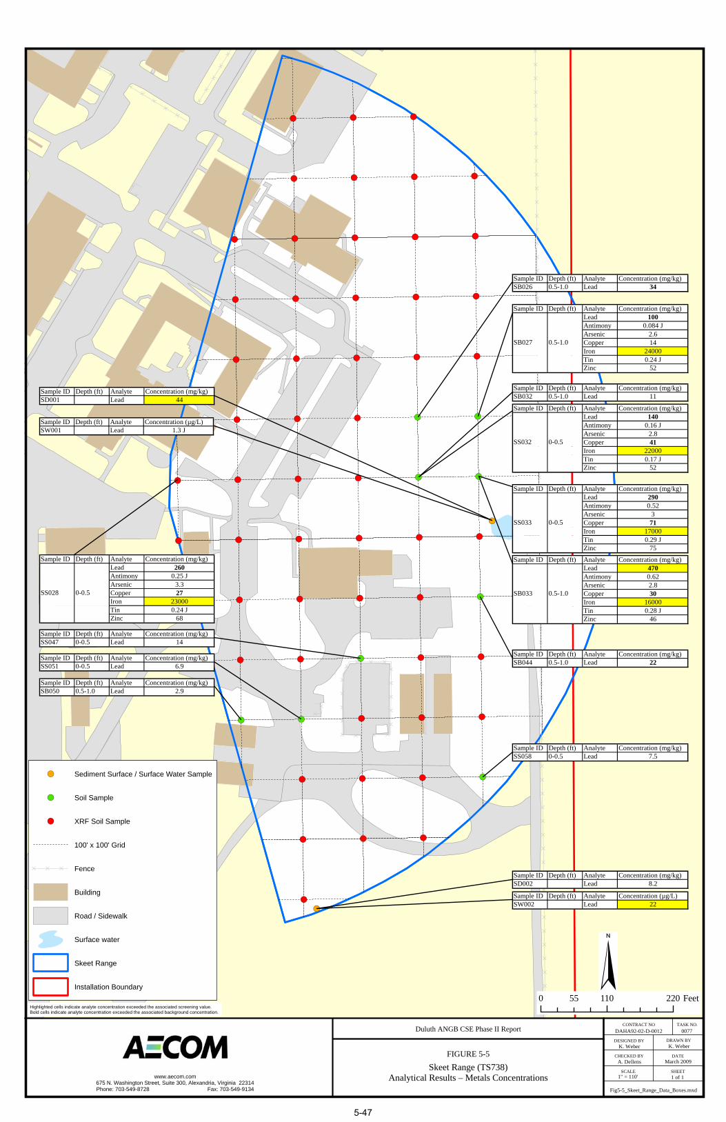
DD
D D
D
D
D D
DD
DD
D
DDD
DD
DD
DD
D
D
D
D
D
D
D
D
D
D
D
D
D
D
D
D
D
DD
DD
DD
DD
DD
DD
DD
DD
DD
DD
DD
DD
DD
DD
DD
DD
DD
DD
DD
DD
DD
DD
DD
DD
DD
DD
DD
DD
DD
DD
DD
DD
DD
DD
DD
D
!(
!(
!(
!(
!(
!(
!(
!(
!(
!(
!(
!(
!(
!(
!(
!(
!(
!(
!(
!(
!(
!(
!(
!(
!(!(
!(
!(
!(
!(
!(
!(
!(
!(
!(
!(
!(
!(
!(
!(
!(
!(
!(
!(
!(
!(
!(
!(
!(
!(
!(
!(
!(
!(
!(
!(
!(
!(
!(
!(
!(
!(
!(
!(
Duluth ANGB CSE Phase II Report
FIGURE 5-5
DAHA92-02-D-0012
K. Weber
0077
K. Weber
A. Dellens
1" = 110' 1 of 1
Fig5-5_Skeet_Range_Data_Boxes.mxd
CONTRACT NO TASK NO.
DESIGNED BY DRAWN BY
CHECKED BY DATE
SCALE SHEETSkeet Range (TS738)Analytical Results – Metals Concentrations
March 2009
Sample ID Depth (ft) Analyte Concentration (mg/kg)Lead 260Antimony 0.25 JArsenic 3.3Copper 27Iron 23000Tin 0.24 JZinc 68
SS028 0-0.5
Sample ID Depth (ft) Analyte Concentration (mg/kg)SS047 0-0.5 Lead 14
Sample ID Depth (ft) Analyte Concentration (mg/kg)SS051 0-0.5 Lead 6.9
Sample ID Depth (ft) Analyte Concentration (mg/kg)SB050 0.5-1.0 Lead 2.9
Sample ID Depth (ft) Analyte Concentration (mg/kg)SD001 Lead 44
Sample ID Depth (ft) Analyte Concentration (µg/L)SW001 Lead 1.3 J
Sample ID Depth (ft) Analyte Concentration (mg/kg)Lead 140Antimony 0.16 JArsenic 2.8Copper 41Iron 22000Tin 0.17 JZinc 52
SS032 0-0.5
Sample ID Depth (ft) Analyte Concentration (mg/kg)Lead 290Antimony 0.52Arsenic 3Copper 71Iron 17000Tin 0.29 JZinc 75
SS033 0-0.5
Sample ID Depth (ft) Analyte Concentration (mg/kg)SS058 0-0.5 Lead 7.5
Sample ID Depth (ft) Analyte Concentration (mg/kg)SB026 0.5-1.0 Lead 34
Sample ID Depth (ft) Analyte Concentration (mg/kg)Lead 100Antimony 0.084 JArsenic 2.6Copper 14Iron 24000Tin 0.24 JZinc 52
SB027 0.5-1.0
Sample ID Depth (ft) Analyte Concentration (mg/kg)SB032 0.5-1.0 Lead 11
Sample ID Depth (ft) Analyte Concentration (mg/kg)Lead 470Antimony 0.62Arsenic 2.8Copper 30Iron 16000Tin 0.28 JZinc 46
SB033 0.5-1.0
Sample ID Depth (ft) Analyte Concentration (mg/kg)SB044 0.5-1.0 Lead 22
Sample ID Depth (ft) Analyte Concentration (mg/kg)SD002 Lead 8.2
Sample ID Depth (ft) Analyte Concentration (µg/L)SW002 Lead 22
Highlighted cells indicate analyte concentration exceeded the associated screening value.Bold cells indicate analyte concentration exceeded the associated background concentration.
§0 110 22055 Feet
!( Sediment Surface / Surface Water Sample
!( Soil Sample
!( XRF Soil Sample
100' x 100' Grid
D D D Fence
Building
Road / Sidewalk
Surface water
Skeet Range
Installation Boundary
www.aecom.com675 N. Washington Street, Suite 300, Alexandria, Virginia 22314Phone: 703-549-8728 Fax: 703-549-9134
5-47

AECOM Comprehensive Site Evaluation Phase II Report February 2010 Military Munitions Response Program – Duluth ANGB
Duluth ANGB Final CSE Phase II 5-48 AECOM PROJECT NO. 106177.05
This page intentionally left blank.

Table 5-14
Summary of BaP Equivalent Concentrations at the Skeet Range
Comprehensive Site Evaluation Phase II
Duluth Air National Guard Base - Duluth, Minnesota
TS738-
SS028
TS738-
SS032
TS738-
SS033
TS738-
SS047
TS738-
SS051
TS738-
SS058
TS738-
SB026
TS738-
SB027
TS738-
SB032
TS738-
SB033
TS738-
SB044
TS738-
SB050
Skeet Range
Probable (B2) Human Carcinogens
Units (mg/kg-d)-1
- (µg/kg) (µg/kg) (µg/kg) (µg/kg) (µg/kg) (µg/kg) (µg/kg) (µg/kg) (µg/kg) (µg/kg) (µg/kg) (µg/kg) (µg/kg)
Benzo(a)anthracene NA 0.1 NA 25 J 32 J 52 J 83 J 200 J 270 J 19 11 1.5 J 37 J 470 J 6.6
Benzo(a)pyrene 0.73 1 2,000 35 J 37 J 56 J 81 J 180 J 230 J 27 16 2.8 J 55 J 670 J 11
Benzo(b)fluoranthene NA 0.1 NA 52 K 65 K 99 K 150 K 340 K 320 J 39 K 27 K 4.2 K 89 K 820 J 26 K
Benzo(k)fluoranthene NA 0.1 NA 26 UJ 6.7 UJ 27 UJ 22 UJ 23 UJ 120 J 6.9 UJ 7.1 UJ 6 UJ 12 UJ 340 J 5.4 UJ
Chrysene NA 0.01 NA 31 J 38 J 56 J 96 J 210 J 240 J 20 14 1.9 J 46 J 530 J 8.9
Dibenz(a,h)anthracene 4.1 0.56 NA 4.5 J 6.5 J 9.1 J 16 J 35 J 41 J 4 J 2.7 J 0.56 J 9.9 J 140 J 3 J
Indeno(1,2,3-c,d)pyrene NA 0.1 NA 14 J 22 J 27 J 43 J 100 J 130 J 12 8.4 1.5 J 31 J 520 J 9.6
2,000 46.937 52.931 79.471 118.546 265.758 339.427 36.447 22.296 3.854 76.72 968.93 16.994
Key: J = Estimated
K = The associated value is an estimated and high bias quantity. The actual value is expected to be lower.
UJ = The analyte was analyzed for but was not detected. The associated value is an estimate and may be inaccurate or imprecise.
NA = Not Available
BaP = Benzo(a)pyrene
Notes:1 Source: Draft Guidelines: Risk Based Guidance for the Soil-Human Health Pathway Vol. 2 Technical Support Document (MPCA 1999)
2 BaP equivalents are caluclated by multplying the site concentration of each chemical by its Relative Potency Factor. The sum of the BaP equivalent concentrations can be
compared to the MPCA Tier I SRV.
SURFACE SOIL SUBSURFACE SOILRelative
Potency
Factor1
Total BaP Equivalents2
AnalyteOral Cancer
Slope Factor1
Tier I
SRV1
Duluth ANGB Final CSE Phase II 5-49 AECOM PROJECT NO. 106177.05

AECOM Comprehensive Site Evaluation Phase II Report February 2010 Military Munitions Response Program – Duluth ANGB
Duluth ANGB Final CSE Phase II 5-50 AECOM PROJECT NO. 106177.05
This page intentionally left blank.
AECOM Comprehensive Site Evaluation Phase II Report February 2010 Military Munitions Response Program – Duluth ANGB
Duluth ANGB Final CSE Phase II 5-51 AECOM PROJECT NO. 106177.05
Two sediment samples were collected at the Skeet Range and analyzed for metals and PAHs. Lead was detected in one sample (TS738-SD001, 44 µg/kg) at a concentration above the MPCA Tier I SQT of 36 µg/kg. This concentration, however, is below the NOAA PEL for freshwater sediment of 91.3 µg/kg (Buchman, 2008). Acenaphethylene was detected in one sediment sample (TS737-SD001, 9.1 J µg/kg) above the MPCA Tier I SQT of 5.9 µg/kg. No other PAHs were detected in sediment samples above the associated MPCA Tier I SQT.
Two surface water samples were collected at the Skeet Range (co-located with the sediment samples) and analyzed for metals and PAHs. Lead was detected in TS737-SW002 at a concentration of 22 µg/L, above the surface water screening value of 3.2 µg/L. No other analytes were detected in either sample above the associated screening values.
5.4.7 Potential Receptors
Potential human receptors at the Skeet Range include base workers, maintenance personnel, and recreational users. Potential ecological receptors include plants, invertebrates, vertebrate herbivores, omnivores, and carnivores.
5.4.7.1 Nearby Population
Duluth ANGB is located approximately 6.7 miles northwest of central Duluth, Minnesota, which had an estimated population of 84,397 in 2007, and 3.5 miles north of the City of Hermantown, Minnesota, which had an estimated population of 9,271 in 2007 (U.S. Census Bureau, 2007).
5.4.7.2 Buildings Near/Within Munitions Response Area
The Skeet Range is located in the main base area of Duluth ANGB with most of the ANG buildings and hangars within one half mile of the site. Residential property is located within a 2-mile radius.
5.4.7.3 Utilities On/Near Munitions Response Area
The Skeet Range is located in the main base area of Duluth ANGB with utilities of all types present. Utilities expected to be present in the vicinity of the Skeet Range include electric, gas, water, sanitary sewer, and phone.
5.5 Lead Contaminated Soils Area
5.5.1 Site Description
The LCSA is located west of the main base and northeast of the EOD Range on a restrictive easement owned by the Duluth Airport Authority. The area is irregular shaped and covers approximately 0.3 acres which is primarily grass covered and partially wooded. The area is bordered to the west by a gravel road, to the south by a wooded area, to the north by a detention basin, and to the east by a drainage ditch. The detention basin and drainage ditch are associated with the Duluth International Airport storm water drainage system (URS, 2007). Soil from the former Small Arms Range berm disposal was deposited in several small piles within the site, with heights approximately 3 feet above the surrounding ground surface. Photographs taken during site reconnaissance in September 2008 (following the project kick-off meeting) at the LCSA are included in Appendix M.

AECOM Comprehensive Site Evaluation Phase II Report February 2010 Military Munitions Response Program – Duluth ANGB
Duluth ANGB Final CSE Phase II 5-52 AECOM PROJECT NO. 106177.05
5.5.2 History of Munitions and Explosives of Concern Activities
During the construction of the Northwest Airlines Maintenance Facility, which began the summer of 1995 and was completed in October of 1996, the soil removed from the Small Arms Range berm was placed at what is now the LCSA. The deposition of this soil was coordinated between the MNANG and the MPCA. No small caliber ammunition or related components were encountered at the LCSA during CSE Phase II activities.
5.5.3 Current Land Use
The LCSA is currently an open field with mixed grasses and trees. The area is not regularly accessed or used.
5.5.4 Access Control
The main base of the Duluth ANGB is a secure facility that is fenced on the north, east, and south sides. The Duluth International Airport is located to the west of the main base. Security personnel from the 148
th FW and the Duluth International Airport Authority patrol the base/airport at all times. The LCSA is
located on a restrictive easement owned by the Duluth Airport Authority, outside of the airport security fencing. Access from the south is through a locked gate controlled by Duluth Airport Authority personnel. There are no access restrictions to the LCSA from the north.
5.5.5 Restrictions
The LCSA is located on a restrictive easement owned by the Duluth Airport Authority. The restrictive easement prevents the development of the property due to its close proximity to the active Munitions Storage Area.
5.5.6 Field Investigation Results
5.5.6.1 X-Ray Fluorescence Analysis
In-situ XRF screening was conducted at the LCSA to determine the lateral extent of surface soil contamination surrounding the soil piles. The initial sampling included 20 points around the perimeter of the piles. For those samples where the concentration of lead was elevated, an additional XRF reading was taken radially outward a distance of 5 to 10 feet from the center of the LCSA (Figure 4-5). A total of 25 sample points were screened with XRF at the LCSA and the results are included in Table 5-15.
Of the 25 XRF sample locations, seven had concentrations exceeding the lead field screening value of 100 mg/kg. The maximum concentration of lead was found at sampling location SS004 with a concentration of 1,050.8 ± 28.24 mg/kg. A total of three surface soil samples (SR739-SS018, SR739-SS020, and SR739-SS021) were sent to the laboratory for analysis of metals concentrations. Comparison of the XRF screening results and the analytical laboratory results for these samples is presented in Table 5-16.
5.5.6.2 Environmental Sampling
Concentrations of metals detected in soil, sediment, and surface water at the LCSA are presented in Table 5-17. The soil concentrations are compared to the regional background soil concentrations and MPCA Tier I SRVs. Sediment concentrations are compared to MPCA Tier I SQTs. Surface water concentrations are compared to applicable water quality standards. Figure 5-6 shows the LCSA sample locations and associated metals concentrations.

Table 5-15
Summary of XRF Screening Results at the Lead Contaminated Soils Area (SR739)
Comprehensive Site Evaluation Phase II
Duluth Air National Guard Base - Duluth, Minnesota
Loc ID Sample ID Sample Type Date/Time XRF Model Pb Pb Variance Fe Fe Variance As As Variance Zn Zn Variance Sb Sb Variance Sn Sn Variance Cu Cu Variance
-- -- -- (mg/kg) (mg/kg) (mg/kg) (mg/kg) (mg/kg) (mg/kg) (mg/kg) (mg/kg) (mg/kg) (mg/kg) (mg/kg) (mg/kg) (mg/kg) (mg/kg)
SS001 IN-SITU 12/4/08 10:47 NITON 13.69 4.74
SS002 IN-SITU 12/4/08 10:49 NITON 11.58 6.02
SS003 IN-SITU 12/4/08 10:52 NITON 9.49 4.8
SS004 IN-SITU 12/4/08 10:56 NITON 1050.8 28.24 16139.25 246.82 87.71 23.13 48.59 9.96 86.07 16.84
SS005 IN-SITU 12/4/08 10:58 NITON 438.68 18.26 19177.34 265.35 < LOD 21.68 32.06 8.72 72.46 15.75
SS006 IN-SITU 12/4/08 11:14 NITON 11.87 5.25
SS007 IN-SITU 12/4/08 11:16 NITON 23.68 5.66
SS008 IN-SITU 12/4/08 11:17 NITON < LOD 4.82
SS009 IN-SITU 12/4/08 11:19 NITON 258.03 13.41 16793.31 234.22 < LOD 16.12 50.26 9.07 51.15 13.46
SS010 IN-SITU 12/4/08 11:33 NITON 178.27 11.99 18785.28 261.82 < LOD 14.27 49 9.74 57.79 15
SS011 IN-SITU 12/4/08 11:35 NITON 8.69 4.62
SS012 IN-SITU 12/4/08 11:36 NITON 11.93 5.94
SS013 IN-SITU 12/4/08 11:38 NITON 14.39 5.39
SS014 IN-SITU 12/4/08 11:40 NITON 518.33 21.09 18318.58 276.4 33.64 17.09 39.19 10.08 69.83 17.34
SS015 IN-SITU 12/4/08 11:42 NITON 626.29 24.35 15926.33 271.74 < LOD 28.93 35.01 10.22 65.95 18.48
SS016 IN-SITU 12/4/08 11:43 NITON 154.26 11.73 15349.39 247.38 < LOD 13.85 34.54 9.22 38.34 15.03
SS017 IN-SITU 12/4/08 11:46 NITON 49.41 7.84
SS0181 TS739-SS018 IN-SITU 12/4/08 11:47 NITON < LOD 7.25
SS019 IN-SITU 12/4/08 11:48 NITON 12.14 4.88
SS0201 TS739-SS020 IN-SITU 12/4/08 11:50 NITON 45.52 6.39
SS0211 TS739-SS021 IN-SITU 12/4/08 11:19 NITON 6.91 4.46
SS022 IN-SITU 12/4/08 16:07 NITON 15.77 4.9
SS023 IN-SITU 12/4/08 16:12 NITON < LOD 6.24
SS024 IN-SITU 12/4/08 16:14 NITON 8.34 4.46
SS025 IN-SITU 12/4/08 16:18 NITON 16.35 5.6
Notes:1
Confirmation sample collected for laboratory analysis.
Highlighted cells indicate exceedance of field screening value for lead of 100 mg/kg.
The NITON XRF did not test for Sn or Sb.
LOD = Limit of Detection. The XRF LOD ranged between 6 and 14 mg/kg for lead.
Duluth ANGB Final CSE Phase II 5-53 AECOM PROJECT NO. 106177.05

AECOM Comprehensive Site Evaluation Phase II Report February 2010 Military Munitions Response Program – Duluth ANGB
Duluth ANGB Final CSE Phase II 5-54 AECOM PROJECT NO. 106177.05
This page intentionally left blank.

Table 5-16
Comparison of XRF and Analytical Lab Results at the Lead Contaminated Soils Area (SR739)
Comprehensive Site Evaluation Phase II
Duluth Air National Guard Base - Duluth, Minnesota
Lead Concentration (Lab) Lead Concentration (XRF) Variance (XRF)
(mg/kg) (mg/kg) (mg/kg)
SR739-SS018 21 < LOD 7.25
SR739-SS020 68 45.52 6.39
SR739-SS021 5.8 6.91 4.46
Notes: LOD = Limit of Detection. XRF LOD ranged between 6 and 14 mg/kg.
Sample ID
Duluth ANGB Final CSE Phase II 5-55 AECOM PROJECT NO. 106177.05

AECOM Comprehensive Site Evaluation Phase II Report February 2010 Military Munitions Response Program – Duluth ANGB
Duluth ANGB Final CSE Phase II 5-56 AECOM PROJECT NO. 106177.05
This page intentionally left blank.
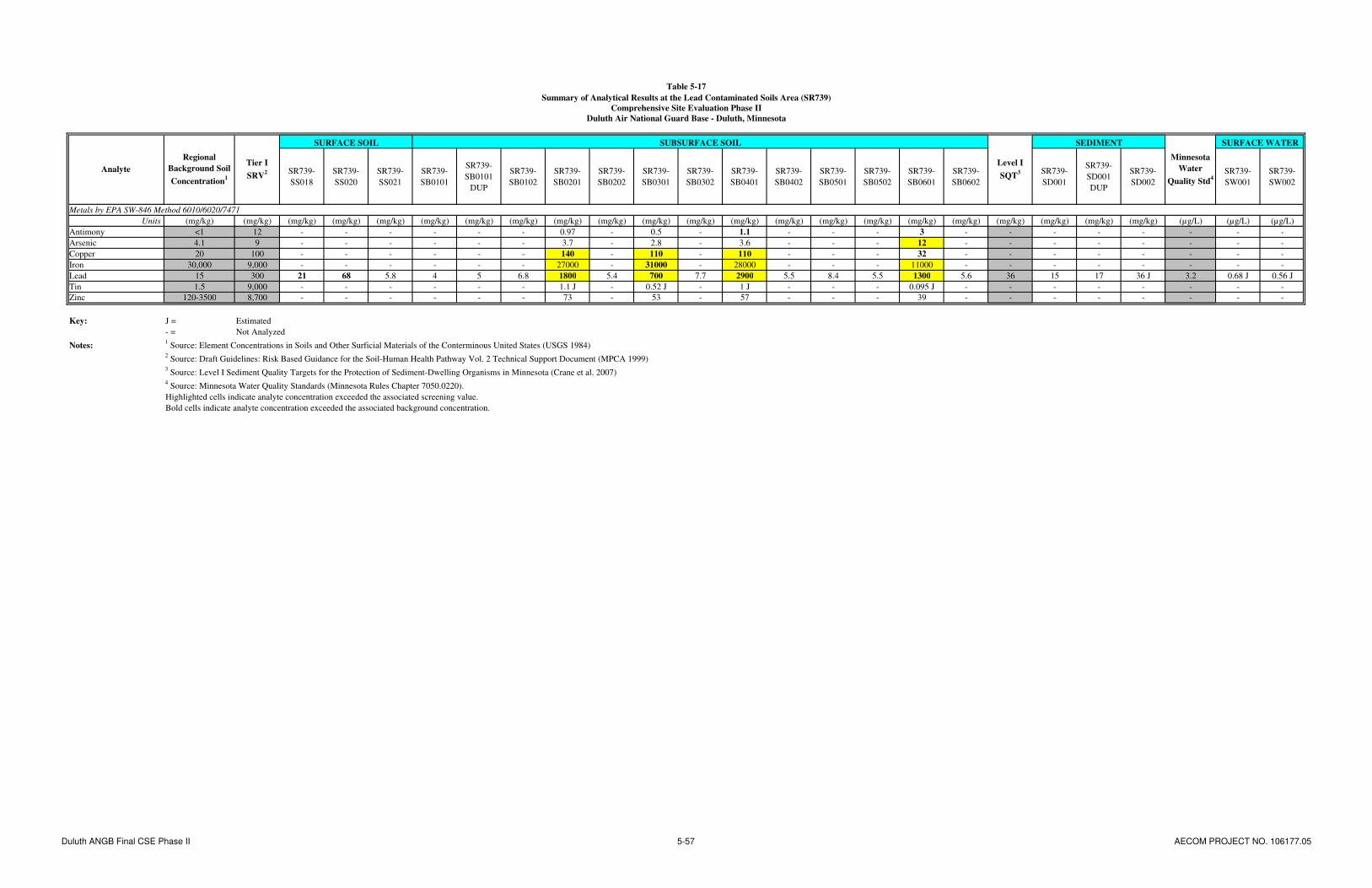
Table 5-17
Summary of Analytical Results at the Lead Contaminated Soils Area (SR739)
Comprehensive Site Evaluation Phase II
Duluth Air National Guard Base - Duluth, Minnesota
SR739-
SS018
SR739-
SS020
SR739-
SS021
SR739-
SB0101
SR739-
SB0101
DUP
SR739-
SB0102
SR739-
SB0201
SR739-
SB0202
SR739-
SB0301
SR739-
SB0302
SR739-
SB0401
SR739-
SB0402
SR739-
SB0501
SR739-
SB0502
SR739-
SB0601
SR739-
SB0602
SR739-
SD001
SR739-
SD001
DUP
SR739-
SD002
SR739-
SW001
SR739-
SW002
Metals by EPA SW-846 Method 6010/6020/7471
Units (mg/kg) (mg/kg) (mg/kg) (mg/kg) (mg/kg) (mg/kg) (mg/kg) (mg/kg) (mg/kg) (mg/kg) (mg/kg) (mg/kg) (mg/kg) (mg/kg) (mg/kg) (mg/kg) (mg/kg) (mg/kg) (mg/kg) (mg/kg) (mg/kg) (mg/kg) (µg/L) (µg/L) (µg/L)
Antimony <1 12 - - - - - - 0.97 - 0.5 - 1.1 - - - 3 - - - - - - - -
Arsenic 4.1 9 - - - - - - 3.7 - 2.8 - 3.6 - - - 12 - - - - - - - -
Copper 20 100 - - - - - - 140 - 110 - 110 - - - 32 - - - - - - - -
Iron 30,000 9,000 - - - - - - 27000 - 31000 - 28000 - - - 11000 - - - - - - - -
Lead 15 300 21 68 5.8 4 5 6.8 1800 5.4 700 7.7 2900 5.5 8.4 5.5 1300 5.6 36 15 17 36 J 3.2 0.68 J 0.56 J
Tin 1.5 9,000 - - - - - - 1.1 J - 0.52 J - 1 J - - - 0.095 J - - - - - - - -
Zinc 120-3500 8,700 - - - - - - 73 - 53 - 57 - - - 39 - - - - - - - -
Key: J = Estimated
- = Not Analyzed
Notes:1 Source: Element Concentrations in Soils and Other Surficial Materials of the Conterminous United States (USGS 1984)
2 Source: Draft Guidelines: Risk Based Guidance for the Soil-Human Health Pathway Vol. 2 Technical Support Document (MPCA 1999)
3 Source: Level I Sediment Quality Targets for the Protection of Sediment-Dwelling Organisms in Minnesota (Crane et al. 2007)
4 Source: Minnesota Water Quality Standards (Minnesota Rules Chapter 7050.0220).
Highlighted cells indicate analyte concentration exceeded the associated screening value.
Bold cells indicate analyte concentration exceeded the associated background concentration.
SURFACE WATER
Level I
SQT3
Minnesota
Water
Quality Std4
Analyte
Regional
Background Soil
Concentration1
Tier I
SRV2
SURFACE SOIL SEDIMENTSUBSURFACE SOIL
Duluth ANGB Final CSE Phase II 5-57 AECOM PROJECT NO. 106177.05

AECOM Comprehensive Site Evaluation Phase II Report February 2010 Military Munitions Response Program – Duluth ANGB
Duluth ANGB Final CSE Phase II 5-58 AECOM PROJECT NO. 106177.05
This page intentionally left blank.
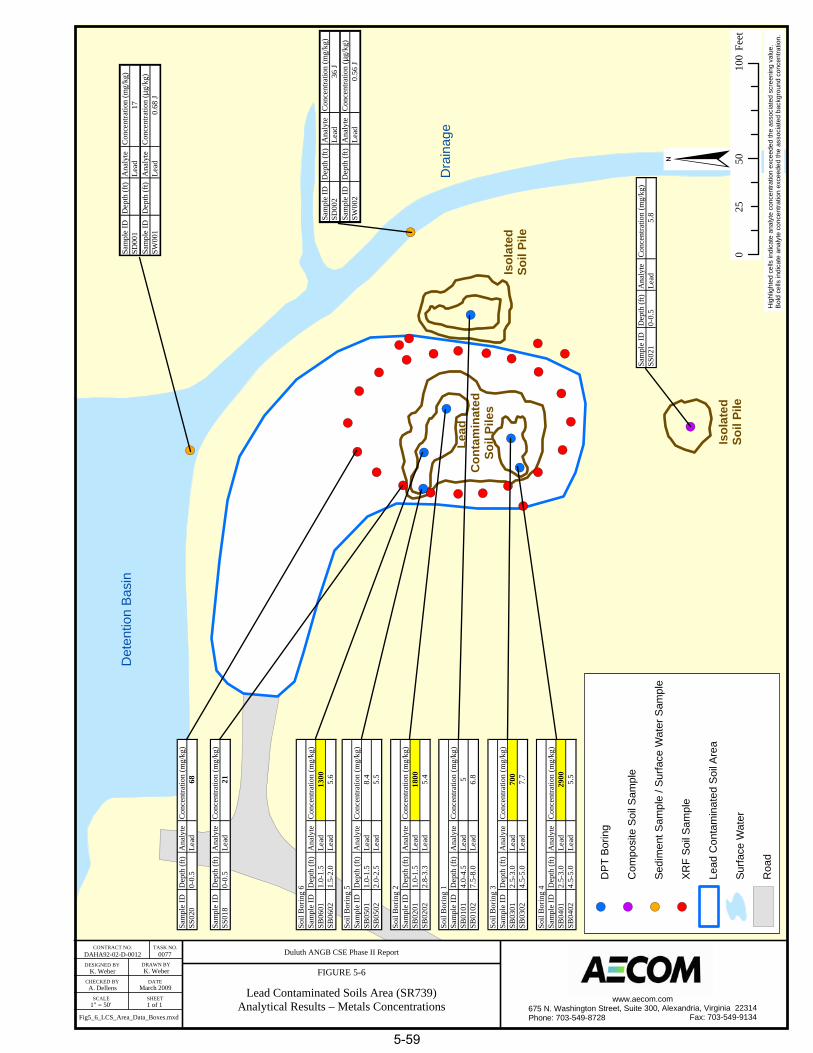
! (
! (
! (
! ( ! (
! (! (! (
! (
! (
! (! (
! (
! (
! (
! (
! (
! (! (
! (
! (
! (
! (
! (
! (
! (
! (! (
! (
! (! ( ! (
! (
! (
K. Weber K. Weber
A. Dellens
1" = 50' 1 of 1
DAHA92-02-D-0012 0077 Duluth ANGB CSE Phase II Report
FIGURE 5-6
Lead Contaminated Soils Area (SR739)Analytical Results – Metals Concentrations
CONTRACT NO. TASK NO.
DESIGNED BY
CHECKED BY
SCALE
DRAWN BY
DATE
SHEET
March 2009
§0
5010
025
Feet
! (D
PT
Bor
ing
! (C
ompo
site
Soi
l Sam
ple
! (Se
dim
ent S
ampl
e / S
urfa
ce W
ater
Sam
ple
! (XR
F So
il S
ampl
e
Lead
Con
tam
inat
ed S
oil A
rea
Surfa
ce W
ater
Roa
dH
ighl
ight
ed c
ells
indi
cate
ana
lyte
con
cent
ratio
n ex
ceed
ed th
e as
soci
ated
scr
eeni
ng v
alue
.B
old
cells
indi
cate
ana
lyte
con
cent
ratio
n ex
ceed
ed th
e as
soci
ated
bac
kgro
und
conc
entra
tion.
www.aecom.com675 N. Washington Street, Suite 300, Alexandria, Virginia 22314Phone: 703-549-8728 Fax: 703-549-9134Fig5_6_LCS_Area_Data_Boxes.mxd
Sam
ple
IDD
epth
(ft)
Ana
lyte
Con
cent
ratio
n (m
g/kg
)SD
001
Lead
17Sa
mpl
e ID
Dep
th (f
t)A
naly
teC
once
ntra
tion
( µg/
kg)
SW00
1Le
ad0.
68 J
Sam
ple
IDD
epth
(ft)
Ana
lyte
Con
cent
ratio
n (m
g/kg
)SD
002
Lead
36 J
Sam
ple
IDD
epth
(ft)
Ana
lyte
Con
cent
ratio
n ( µ
g/kg
)SW
002
Lead
0.56
J
Sam
ple
IDD
epth
(ft)
Ana
lyte
Con
cent
ratio
n (m
g/kg
)SS
021
0-0.
5Le
ad5.
8
Sam
ple
IDD
epth
(ft)
Ana
lyte
Con
cent
ratio
n (m
g/kg
)SB
0101
4.0-
4.5
Lead
5SB
0102
7.5-
8.0
Lead
6.8
Soil
Bor
ing
1
Sam
ple
IDD
epth
(ft)
Ana
lyte
Con
cent
ratio
n (m
g/kg
)SB
0201
1.0-
1.5
Lead
1800
SB02
022.
8-3.
3Le
ad5.
4
Soil
Bor
ing
2
Sam
ple
IDD
epth
(ft)
Ana
lyte
Con
cent
ratio
n (m
g/kg
)SB
0301
2.5-
3.0
Lead
700
SB03
024.
5-5.
0Le
ad7.
7
Soil
Bor
ing
3
Sam
ple
IDD
epth
(ft)
Ana
lyte
Con
cent
ratio
n (m
g/kg
)SB
0401
2.5-
3.0
Lead
2900
SB04
024.
5-5.
0Le
ad5.
5
Soil
Bor
ing
4
Sam
ple
IDD
epth
(ft)
Ana
lyte
Con
cent
ratio
n (m
g/kg
)SB
0501
1.0-
1.5
Lead
8.4
SB05
022.
0-2.
5Le
ad5.
5
Soil
Bor
ing
5
Sam
ple
IDD
epth
(ft)
Ana
lyte
Con
cent
ratio
n (m
g/kg
)SB
0601
1.0-
1.5
Lead
1300
SB06
021.
5-2.
0Le
ad5.
6
Soil
Bor
ing
6
Sam
ple
IDD
epth
(ft)
Ana
lyte
Con
cent
ratio
n (m
g/kg
)SS
018
0-0.
5Le
ad21
Sam
ple
IDD
epth
(ft)
Ana
lyte
Con
cent
ratio
n (m
g/kg
)SS
020
0-0.
5Le
ad68
Det
entio
n B
asin
Dra
inag
e
Isol
ated
Soil
Pile
Isol
ated
Soil
Pile
Lead
C
onta
min
ated
Soil
Pile
s
5-59

AECOM Comprehensive Site Evaluation Phase II Report February 2010 Military Munitions Response Program – Duluth ANGB
Duluth ANGB Final CSE Phase II 5-60 AECOM PROJECT NO. 106177.05
This page intentionally left blank.
AECOM Comprehensive Site Evaluation Phase II Report February 2010 Military Munitions Response Program – Duluth ANGB
Duluth ANGB Final CSE Phase II 5-61 AECOM PROJECT NO. 106177.05
A total of 15 soil samples (three surface soil XRF confirmation samples and two subsurface samples from each of six boreholes) were collected at the LCSA. The three XRF confirmation samples were randomly selected to confirm the XRF perimeter sampling. Subsurface sample boreholes were drilled into the individual soil piles suspected to contain lead contaminated soil. Two samples were taken from each borehole: one from the non-native soil pile and one at a greater depth (beneath the soil pile) in native soil. In some cases, a layer of plastic sheeting was observed separating the native and non-native soil. This indicated that plastic sheeting was likely placed beneath the soil when it was deposited in this area. Lead was not detected above MPCA Tier I SRVs in any of the three surface soil samples collected along or outside the perimeter of the soil piles. Of the twelve subsurface samples, four contained lead at concentrations above the MPCA Tier I SRV of 300 mg/kg. All four of those samples were taken from the shallower non-native soil. The maximum concentration of lead was identified in SR739-SB0401 at a concentration of 2,900 mg/kg. Of the six subsurface samples taken from the native soil beneath the soil pile, none contained lead at concentrations above either the MPCA Tier I SRV or the regional background soil concentration of 15 mg/kg. The following metals were detected above MPCA Tier I SRVs: arsenic (SR739-SB0601, 12 mg/kg); Cu (SR739-SB0201, 140 mg/kg; SR739-SB0301, 110 mg/kg; and SR739-SB0401, 110 mg/kg); and iron (SR739-SB0201, 27,000 mg/kg; SR739-SB0301, 31,000 mg/kg; SR739-SB0401, 28,000 mg/kg; and SR739-SB0601, 11,000 mg/kg). Of the four samples which exceeded the MPCA Tier I SRV for iron, three were below the regional background soil concentration of 30,000 mg/kg. The composite surface soil sample, which was collected from an area south of the main soil piles, did not contain lead at a concentration above the MPCA Tier I SRV. This sample was intended to evaluate whether a secondary soil pile presented an additional hazard at the LCSA.
Each soil sample which exceeded the screening value for one or more metals was compared to the MPCA Tier I SLV (Table 5-2). All four samples (SR739-SB0201, SR739-SB0301, SR739-SB0401, and SR739-SB0601) contained lead at concentrations above the MPCA Tier I SLV of 525 mg/kg. Sample SR739-SB0301 also contained antimony (3 mg/kg) at a concentration above the MPCA Tier I SLV of 2.7 mg/kg. No other metals were detected at concentrations above the associated MPCA Tier I SLV.
Two sediment samples were collected at the LCSA and analyzed for metals. Lead was not detected above the MPCA Tier I SQT of 36 mg/kg in either sample. Two surface water samples were also collected at the LCSA (co-located with the sediment samples) and analyzed for metals. No metals were detected above water quality standards in either sample.
5.5.7 Potential Receptors
Potential human receptors at the LCSA include base workers, maintenance personnel, and recreational users. Potential ecological receptors include plants, invertebrates, vertebrate herbivores, omnivores, and carnivores.
5.5.7.1 Nearby Population
Duluth ANGB is located approximately 6.7 miles northwest of central Duluth, Minnesota, which had an estimated population of 84,397 in 2007, and 3.5 miles north of the City of Hermantown, Minnesota, which had an estimated population of 9,271 in 2007 (U.S. Census Bureau, 2007).
5.5.7.2 Buildings Near/Within Munitions Response Area
The LCSA is isolated in a section of the airport property, north of the EOD Range, where no buildings are located. The nearest buildings are in the active Munitions Storage Area. Aircraft hangars, a fire department, residential property, and the Northwest Airlines Maintenance Facility are within a 2-mile radius.

AECOM Comprehensive Site Evaluation Phase II Report February 2010 Military Munitions Response Program – Duluth ANGB
Duluth ANGB Final CSE Phase II 5-62 AECOM PROJECT NO. 106177.05
5.5.7.3 Utilities On/Near Munitions Response Area
There are no inhabited buildings near the LCSA. This area is isolated, and the nearest building is the active Munitions Storage Area. There are no utilities expected to be present in the vicinity of the LCSA.

AECOM Comprehensive Site Evaluation Phase II Report February 2010 Military Munitions Response Program – Duluth ANGB
Duluth ANGB Final CSE Phase II 6-1 AECOM PROJECT NO. 106177.05
6.0 EVALUATION OF KNOWN/SUSPECTED MUNITIONS AND EXPLOSIVES OF CONCERN
This section discusses MEC that have been encountered, historically used, or suspected at the Duluth ANGB MRAs. Based on CSE Phase I and Phase II investigation results, the potential for human exposure to MEC is only applicable at the EOD Range MRA. The other four MRAs are former small arms firing ranges (SAFRs) or soil originating from a SAFR, which only fired non-exploding small arms ammunition.
6.1 Munitions and Explosives of Concern Technical Data
The ordnance technical data sheets for the MEC discussed in this section are included in Appendix F.
6.1.1 Explosive Ordnance Disposal Range
Interviews and a search of historical records conducted during the CSE Phase I did not reveal a detailed listing of munitions or explosives used or disposed of at the EOD Range. Suspected MEC items that may have been used in OB/OD operations at the EOD Range include (URS, 2007): detonators, blasting caps, fuzes, boosters, bursters, primers, squibs, bulk high explosives, demolition charges, and pyrotechnics (flares, signals, simulators, etc.).
6.1.2 Small Arms Range
No MEC is known or suspected at the Small Arms Range based on CSE investigation results.
6.1.3 Trap Range
No MEC is known or suspected at the Trap Range based on CSE investigation results.
6.1.4 Skeet Range
No MEC is known or suspected at the Skeet Range based CSE investigation results.
6.1.5 Lead Contaminated Soils Area
No MEC is known or suspected at the LCSA based on CSE investigation results.
6.2 Primary Sources and Release Mechanisms
Source areas are typically identified by reviewing the previous uses of MRAs. Source areas may include: firing points, range fans, impact areas, safety buffer zones, MEC handling or storage areas, maneuver areas, defensive positions, and authorized and unauthorized disposal or burial sites. In general, the MRA is the primary source, while the secondary sources are the media to which the MEC has been released. Release mechanisms are the actions that occurred at an MRA resulting in the release of MEC to the environment. Where MEC are suspected of being released to a MRA, the historical munitions use that potentially resulted in contamination may be considered the primary release mechanism (i.e., ordnance that was fired or dropped from a weapons system). The primary sources and release mechanisms for MEC at the Duluth ANGB MRAs are discussed below.
AECOM Comprehensive Site Evaluation Phase II Report February 2010 Military Munitions Response Program – Duluth ANGB
Duluth ANGB Final CSE Phase II 6-2 AECOM PROJECT NO. 106177.05
6.2.1 Explosive Ordnance Disposal Range
Primary sources and release mechanisms at the EOD Range are based on historical OB/OD operations. Although range maintenance during active use of the EOD Range likely would have included MEC sweeps and clearance, the former disposal of MEC at the EOD Range could have resulted in burial of incompletely treated MEC, burial of MEC scrap, ejection of MEC in the EOD area, and MEC residue in soils. The large pit in the center of the site, identified during CSE Phase I and Phase II activities, serves as primary area of concern at the site where most OB/OD operations likely occurred or originated. Based on site reconnaissance and visual survey conducted at the site, no MEC is currently present on the ground surface. Based on the 19 subsurface anomalies identified during the CSE Phase II geophysical survey, residual MEC may be present in the subsurface.
6.2.2 Small Arms Range
The Small Arms Range was redeveloped and significant site grading and permanent structure construction has occurred over the former range footprint. Additionally, the former range berm soils were removed and deposited at the LCSA. Any munitions components at the site have likely been removed or are located in the subsurface soil beneath fill materials or structures. No small arms or related components were encountered during CSE Phase II investigation activities.
6.2.3 Trap Range
The Trap Range has been partially redeveloped due to neighboring site grading and construction activities. Any munitions components in this redeveloped area likely have been removed or are located in the subsurface soil. Small arms and related trap range debris (i.e., clay pigeons) may remain in surface soils in undisturbed areas of the range; however, none were encountered during CSE Phase II investigation activities.
6.2.4 Skeet Range
The Skeet Range has been significantly redeveloped including site grading and permanent structure construction activities. Any munitions components in this redeveloped area likely have been removed or are located in the subsurface soil. Small arms and related skeet range debris may remain in surface soils in undisturbed areas of the range; however, none were encountered during CSE Phase II investigation activities.
6.2.5 Lead Contaminated Soils Area
The LCSA consists of soil from the Small Arms Range berm that was deposited in the late 1990s. Because the soil was from the Small Arms Range berm, munitions components could potentially be present in the materials. However, no small arms or related components were encountered during CSE Phase II investigation activities.
6.3 Munitions and Explosives of Concern Locations (Secondary Sources)
Secondary sources are the media to which MEC may have been released. Potentially impacted media at Duluth ANGB include soils, shallow groundwater, surface water, and sediments. Following the initial release of MEC, its detonation, damage on impact, or degradation may release MC to the environment. Leaching or other transport mechanisms may transfer released MC between two or more media. These media were sampled for MC during the CSE Phase II at Duluth ANGB and the results are discussed in Section 5.0.

AECOM Comprehensive Site Evaluation Phase II Report February 2010 Military Munitions Response Program – Duluth ANGB
Duluth ANGB Final CSE Phase II 6-3 AECOM PROJECT NO. 106177.05
6.4 Munitions and Explosives of Concern Penetration Estimates
As previously noted, historical records of OB/OD training and destruction operations at the EOD Range are not available. Suspected MEC potentially used at the EOD Range is listed in Section 6.1.1. Since the EOD Range is not an impact area, the depth of potential MEC contamination is largely a function of the type/size of the munition and donor charge, and the engineering controls (pit depth, soil cover thickness, etc.) utilized during destruction. Penetration depths could potentially range from near surface to a foot or more below ground surface.
For SAFRs, the estimated penetration depth for the primary berm behind the targets is up to 24 inches, and penetration in the side berms and range floor is generally 12 inches or less (ITRC, 2003). Since portions of the SAFRs at Duluth ANGB have been redeveloped, penetrations depths of small arms may be inconsistent with this typical pattern.
6.5 Special Consideration Munitions and Explosives of Concern
No evidence indicating the potential use of radioactive or chemical weapons was found during CSE Phase I activities. Based on these conclusions, the special consideration MEC were not investigated during CSE Phase II activities.
6.6 Known/Suspected Munitions Constituents
The MC associated with each general category of MEC that may be present in the vicinity of the MRAs associated with Duluth ANGB are summarized below:
MEC: metals (arsenic, barium, cadmium, chromium, Cu, iron, lead, mercury, selenium, silver, and tin); explosives (HMX, hexahydro-trinitro-triazine [RDX], 2,4,6-TNT, tetryl, 3,5-dinitroaniline, 1,3,5-TNB, 1,3-DNB, 2-amino-4,6-dinitrotoluene, 4-amino-2,6-dinitrotoluene, 2,4- dinitritoluene [DNT], 2,6-DNT, nitrobenzene, nitroglycerine, PETN, 2-nitrotoluene, 3-nitrotoluene, 4-nitrotoluene, and nitroguanidine), and PAHs.
Small Arms: metals (antimony, arsenic, Cu, iron, lead, tin, and zinc) and PAHs (from clay pigeons used at Trap and Skeet Ranges).
During CSE Phase II activities, the Duluth ANGB MRAs were sampled for the MC listed above. The results of the environmental sampling are included in Section 5.0. The recommendations for each site where MC was identified are included in Section 13.0.
6.7 Explosive Safety Submission Information
The purpose of an Explosives Safety Submission (ESS) is to ensure that applicable DoD and U.S. Army standards for explosives safety are followed during MEC removal or remedial actions. ESSs are generally not required for investigations; as such, no ESSs have been prepared for the Duluth ANGB CSE investigations. Prior to a MEC removal/remedial action at a MRA/MRS, an ESS would need to be prepared. Several design elements for consideration in planning a removal or remedial action are described below.
6.7.1 Munitions with the Greatest Fragmentation Distance
For quantity-distance purposes, the munition with the greatest fragmentation distance (MGFD) shall be established. The MGFD is the munitions item with the greatest fragment distance that can reasonably be expected to exist at a particular MRA. The MGFD can be selected based on historical or site investigation data; site investigation data is preferred if it is available.

AECOM Comprehensive Site Evaluation Phase II Report February 2010 Military Munitions Response Program – Duluth ANGB
Duluth ANGB Final CSE Phase II 6-4 AECOM PROJECT NO. 106177.05
6.7.2 Maximum Credible Event
A maximum credible event (MCE) shall be established for explosives-contaminated soil, if present. The MCE is the concentration of explosives multiplied by the weight of the soil/explosives mixture. Weighted averages or similar mathematical techniques may be used if the concentration varies within the area. Since explosives-contaminated soil was not encountered in the Duluth ANG MRAs, an MCE is not applicable.
6.7.3 Frost Line
Frost lines in the vicinity of Duluth ANGB can reach up to 72 inches bgs. This is considered to be the maximum depth where frost may occur, and thus the maximum depth where frost-related migration of MEC is possible.
AECOM Comprehensive Site Evaluation Phase II Report February 2010 Military Munitions Response Program – Duluth ANGB
Duluth ANGB Final CSE Phase II 7-1 AECOM PROJECT NO. 106177.05
7.0 EVALUATION OF HAZARDOUS WASTE/SUBSTANCES
7.1 Explosive Ordnance Disposal Range
The CSE Phase II investigation of the EOD Range identified potential subsurface MEC. The intrusive evaluation of this potential MEC could uncover explosive hazardous waste (EHW). USEPA’s 1997 Munitions Rule (MR) defines when used or unused munitions are considered EHW. The MR defines military munitions as EHW when they are: abandoned by being disposed of, burned, detonated, incinerated, or treated prior to disposal; removed from storage for the purpose of being disposed or destroyed; or damaged beyond repair. MEC uncovered through further intrusive action at the EOD Range should be treated as EHW and managed according to all DoD and regulatory guidelines.
7.2 Small Arms Range
The CSE Phase II investigation of the Small Arms Range did not identify any potential for hazardous waste or substances at the MRA.
7.3 Trap Range
The CSE Phase II investigation of the Trap Range identified elevated MC constituents including a maximum concentration of lead at 3,800 mg/kg. Prior to future management of soil at this MRA, such as transport and disposal activities, the lead levels in the soil must be verified to be within acceptable non-hazardous waste characterization limits according to regulatory guidelines. The regulatory threshold concentration for lead under the toxicity characteristic leaching procedure (TCLP) for determination of hazardous waste is 5 milligrams per liter (mg/L). Soils exhibiting a TCLP lead concentration greater than 5 mg/L are considered hazardous waste and assigned EPA Hazardous Waste Code D008.
7.4 Skeet Range
The CSE Phase II investigation of the Skeet Range did not identify any potential for hazardous waste or substances at the MRA.
7.5 Lead Contaminated Soils Area
The CSE Phase II investigation of the LCSA identified surface soil piles with a maximum lead concentration of 2,900 mg/kg. Prior to future management of these soil piles, such as transport and disposal activities, the lead levels in the soil must be verified to be within acceptable non-hazardous waste characterization TCLP limits as identified above.

AECOM Comprehensive Site Evaluation Phase II Report February 2010 Military Munitions Response Program – Duluth ANGB
Duluth ANGB Final CSE Phase II 7-2 AECOM PROJECT NO. 106177.05
This page intentionally left blank.

AECOM Comprehensive Site Evaluation Phase II Report February 2010 Military Munitions Response Program – Duluth ANGB
Duluth ANGB Final CSE Phase II 8-1 AECOM PROJECT NO. 106177.05
8.0 EXPOSURE PATHWAY AND HAZARD ASSESSMENT
8.1 Munitions and Explosives of Concern Exposure Pathway Analysis
The MEC exposure pathway is the course MEC takes from a primary source to a receptor. Exposure pathways may include the following components: primary sources, release mechanisms, secondary sources, transport and migration, exposure media, activity and access, and human receptors.
Based on the CSE Phase I evaluation of MRA site information and the CSE Phase II investigation results, the potential for human exposure to MEC explosive hazards is only present at the EOD Range MRA. The other four MRAs are former SAFRs or soil originating from a SAFR. SAFRs are defined as ranges accepting 50-caliber or smaller non-exploding ammunition (ITRC, 2003).
8.1.1 Munitions and Explosives of Concern Transport Processes
The EOD Range was utilized by the USAF for OB/OD training activities and to detonate and dispose of munitions from 1960 to 1994. Although range maintenance during active use of the EOD Range likely would have included MEC sweeps and clearance, the former disposal of MEC at the EOD Range could have resulted in burial or ejection of MEC into site soils. The two primary MEC transport or migration processes in soil include erosion and frost heave. However, MEC generally has a low migration potential and receptors will generally need to gain access to the primary source area to be exposed to explosive hazards.
8.1.2 Munitions and Explosives of Concern Exposure Media and Accessibility
No MEC was identified at the ground surface of the EOD Range during the CSE Phase I or CSE Phase II activities. Digital geophysical mapping data collected during the CSE Phase II identified locations of potential subsurface MEC at the EOD Range. The locations have the potential for future exposure to receptors at the ground surface through naturally occurring processes including erosion and frost heave. A variety of intrusive activities by people also may alter the condition of the land in a manner that a subsurface MEC item may become exposed at the surface. These activities may include construction or redevelopment that involves excavation or grading activities.
8.1.3 Munitions and Explosives of Concern Exposure Receptors
Two categories of receptors have exposure potential for MEC explosive hazards at the EOD Range. These include workers and recreational users. Both categories were evaluated for current and future use scenarios. There is no fence or other man-made physical barrier to prevent access to the EOD Range from the north.
8.1.4 Munitions and Explosives of Concern Exposure Conclusions
No MEC was identified at the ground surface of the EOD Range during the CSE activities. Digital geophysical mapping data collected during the CSE Phase II identified locations of potential buried MEC. The locations of possible buried MEC have the potential for future exposure to receptors at the ground surface through naturally occurring processes including erosion and frost heave or through excavation or grading activities at the site.
8.2 Munitions Constituents Exposure Pathway Analysis
The MC exposure pathway is the course MC takes from a primary source to a receptor. Exposure pathways may include the following components: primary sources, release mechanisms, secondary sources, transport and migration, impacted media, exposure routes, and human and ecological receptors.

AECOM Comprehensive Site Evaluation Phase II Report February 2010 Military Munitions Response Program – Duluth ANGB
Duluth ANGB Final CSE Phase II 8-2 AECOM PROJECT NO. 106177.05
A complete exposure pathway does not exist if a source (i.e., MC contamination) or receptor does not exist.
As discussed in Section 5.0, the chemicals investigated at Duluth ANGB MRAs based on past munitions training or destruction operations included metals, PAHs, and explosive compounds. The fate and transport of MC in the exposure pathway are dependent on a wide variety of factors. Contaminant fate refers to the expected final state that an element, compound, or group of compounds will achieve following release to the environment. Contaminant transport refers to migration mechanisms of MC away from the source area. Migration pathways often include air, water, soil, and the interfaces between the phases of the contaminant (i.e., solid, liquid, or gas). The fate and transport of contaminants occur in all three environmental media: terrestrial, aquatic, and atmospheric. Terrestrial environments are comprised of soil and groundwater; aquatic environments include surface water, marsh, and sediment; and air is the only component of the atmospheric environment.
In the terrestrial environment, if the contaminant is released to soil, the contaminant may volatilize, adhere to the soil by sorption, leach into the groundwater, or degrade due to chemical (abiotic) or biological (biotic) processes. If the contaminant is volatilized, the compound may be released to the atmosphere, or if volatilization occurs in the subsurface, the contaminated vapor may migrate and sorb to previously uncontaminated soil or dissolve in groundwater. Constituents that are dissolved eventually may be transported to an aquatic environment. Once a contaminant is released to the aquatic environment, it can either volatilize or remain in the aquatic environment. In the aquatic environment, contaminants may be dissolved in the surface water or sorbed to the sediment. Contaminants may move between dissolved and sorbed states depending on a variety of physical and chemical factors. In the atmospheric environment, contaminants may exist as vapors or as particulate matter.
The fate and transport of contaminants at Duluth ANGB are strongly influenced by physical and chemical properties, as well as by environmental factors such as soil characteristics. It is important to understand the affects these properties and factors might have on fate and transport of contaminants to receptors.
Metals: Most metals are indigenous to the earth and are found at varying concentration levels in most environmental media. In soil, metal contaminants are dissolved in the soil solution, adsorbed or ion exchanged in inorganic soil constituents, complexed with soluble soil organic matter, and precipitated as pure or mixed solids. Metals in the soil solution are subject to movement with water particles and may be transported through the vadose zone to groundwater, and then either volatilized or consumed by plants and aquatic organisms. Unlike organic constituents, metals cannot be degraded; however, the mobility and toxicity of some metals (i.e., arsenic, chromium) can be altered due to changes in oxidation states. The metal contaminants of potential concern detected at concentrations exceeding background and regulatory screening criteria at Duluth ANGB MRAs included primarily lead and Cu. The fate and transport properties of these metals are discussed below.
Lead (Pb) is a naturally occurring metal found in small amounts in the earth’s crust. The most common form of Pb found in nature is Pb
2+, although Pb also exists to a lesser extent as Pb
4+, and in the organic
form with up to four Pb-carbon bonds. Most Pb deposited on surface soil is retained and eventually becomes mixed into the surface layer. The migration of Pb in the subsurface environment is controlled by the solubility of Pb complexes and adsorption to aquifer materials. Adsorption to soil greatly limits the mobility of Pb in the environment. Pb may be immobilized by ion exchange with hydrous oxides or clays or by chelation with humic or fulvic acids in the soil. Adsorption of Pb increases with increasing pH with most Pb precipitating out at a pH greater than 6. Adsorption of Pb also increases as the amount of total organic carbon in the soil increases, thereby decreasing its mobility.
Cu is strongly sorbed by soil particles (e.g., clays, metal oxides, and organic matter). Cu binds to soil much more strongly than other divalent cations, and the distribution of Cu in the soil solution is less affected by pH than other metals. The adsorption of Cu generally increases with increasing pH. Like other heavy metals, the movement of Cu in soil is also influenced by the permeability of the soil and the amount of clay, lime, and hydrous iron oxides present. These factors tend to attenuate the mobility of Cu
AECOM Comprehensive Site Evaluation Phase II Report February 2010 Military Munitions Response Program – Duluth ANGB
Duluth ANGB Final CSE Phase II 8-3 AECOM PROJECT NO. 106177.05
through adsorption and cation exchange. Volatilization of Cu happens to a slight degree, but is insignificant relative to other processes that aid in the reduction of Cu concentrations. It sorbs significantly to suspended organic materials and bed sediments, thus reducing its mobility. Much of Cu discharged to waterways is in particulate matter and settles out, precipitates out, or adsorbs to organic matter, hydrous iron and manganese oxides, and clay in sediment or in the water column.
Polycyclic Aromatic Hydrocarbons: PAHs are a group of more than a hundred organic compounds with two or more aromatic rings. Two PAHs: acenaphethylene and benzo(a)pyrene, were detected above screening levels in sediment at the Skeet Range and Trap Range MRAs. As a general rule, when PAH compounds grow in molecular weight, their solubility in water decreases, solubility in fat tissue increases, and their melting and boiling points increase. The vapor pressure of most PAHs indicates that most PAHs will not readily volatilize into the atmosphere. This is confirmed by their Henry’s Law Constants. Based on their high soil adsorption coefficient values, PAHs will rarely leach into groundwater or surface water runoff. PAHs were not detected in surface water samples at the Skeet and Trap Ranges.
In summary, the physical properties indicate the strong tendency of PAHs to have relatively low mobility and to be very persistent in the environment. For the most part, when released to water or soil systems, PAHs will be adsorbed to soil, sediment, and organic materials.
Explosives: An explosive’s molecule breaks down more slowly due to low-temperature kinetics as well as the influence of light, infrared, ultraviolet radiation, or microbial action. Upon decomposition, products such as nitric oxide (NO), NO2, H2O, nitrogen (N2), acids, aldehydes, ketones, and large radicals of the parent explosive molecule are formed. Though the temperature dependent decomposition of explosives can proceed at low temperatures, the rate of decomposition can be very slow.
The following sections discuss the various exposure pathways for MC contamination at the MRAs by media.
8.2.1 Groundwater Migration Pathway Analysis
8.2.1.1 Groundwater Receptors
Receptors with potential to be exposed to MC through ingestion or dermal contact with groundwater include current/future base workers (including maintenance and construction personnel) exposed during intrusive activities, recreational users exposed to shallow groundwater or seeps, and on- and off-site residents exposed via water supply wells. No on-site water supply wells currently exist at the MRAs; however, the Minnesota Department of Health records indicate that there may be as many as 15 off-site residential water supply wells located within one mile of the MRAs. Additionally, potential ecological receptors include plants, invertebrates, herbivores, omnivores, and carnivores.
8.2.1.2 Groundwater Conclusions
As summarized in Section 4.3.3, groundwater sampling was only planned for and performed during the CSE Phase II at the EOD Range. Analytical results for MC in groundwater adjacent to the former detonation pit indicated only a low detection of RDX. All other metals and PAHs were either not detected or below MCLs. Detections of compounds in the upgradient site well are believed to be the result of sample turbidity and not site related. Based on these sampling results, a complete exposure pathway via groundwater does not exist.
Based on MC contaminants above screening criteria in Trap Range and Skeet Range soil, sediment, and surface water, a potentially complete exposure pathway via groundwater exists for current/future base workers, recreational users, and residents. Additionally, plants and animals may be exposed to possible MC-impacted shallow groundwater.

AECOM Comprehensive Site Evaluation Phase II Report February 2010 Military Munitions Response Program – Duluth ANGB
Duluth ANGB Final CSE Phase II 8-4 AECOM PROJECT NO. 106177.05
At the LCSA, MC in surface soil piles is present at concentrations above screening criteria. However, based on the CSE Phase II, the MC contaminants are confined within the surface soil piles via plastic sheeting and migration to groundwater has not occurred. Therefore, a complete exposure pathway via groundwater does not exist.
At the Small Arms Range, soil sampling results demonstrate that MC is not present at levels which indicate migration to groundwater is occurring. Therefore, a complete exposure pathway via groundwater does not exist.
8.2.2 Surface Water/Sediment Migration Pathway Analysis
8.2.2.1 Surface Water/Sediment Receptors
Receptors with potential to be exposed to MC through ingestion or dermal contact with surface water/sediment include current/future base workers exposed during maintenance or construction activities and recreational users exposed to stream or wetland areas. Additionally, potential ecological receptors include plants, invertebrates, herbivores, omnivores, and carnivores.
8.2.2.2 Surface Water/Sediment Conclusions
Surface water and sediment sampling was planned for and performed during the CSE Phase II at the Trap Range, Skeet Range, and LCSA. At the Trap Range and Skeet Range, concentrations of MC were detected at levels above screening criteria in surface water and sediment. Therefore, exposure pathways via surface water/sediment are considered complete for current/future base workers and recreational users. Additionally, plants and animals may be exposed to possible MC-impacted surface water/sediment.
Analytical results for MC in surface water and sediment at the LCSA indicated only low detections of MC below screening criteria. Therefore, MC is not present at levels which indicate a complete surface water/sediment exposure pathway exists.
At the Small Arms Range and EOD Range, soil sampling results demonstrate that MC is not present at levels which indicate migration to surface water/sediment is occurring. Therefore, a complete surface water/sediment exposure pathway does not exist.
8.2.3 Soil Exposure Pathway Analysis
8.2.3.1 Soil Exposure Receptors
Receptors with potential to be exposed to MC through ingestion, dermal contact, or inhalation of soil include current/future base workers exposed during maintenance or construction activities and recreational users exposed to surface soils. Additionally, potential ecological receptors include plants, invertebrates, herbivores, omnivores, and carnivores.
8.2.3.2 Soil Exposure Conclusions
Soil sampling was planned for and performed during the CSE Phase II at all MRAs. At the Trap Range and Skeet Range, concentrations of MC are present above screening criteria in surface soil and subsurface soil. Therefore, exposure pathways are considered complete via soil (surface and subsurface).
At the LCSA, MC in surface soil piles are present at concentrations above screening criteria. Therefore, exposure pathways are considered complete via the soil piles.
Analytical results for MC in soil at the EOD Range and Small Arms Range indicated only low detections of site related MC below screening criteria. Therefore, MC is not present at levels which indicate a complete soil exposure pathway exists.
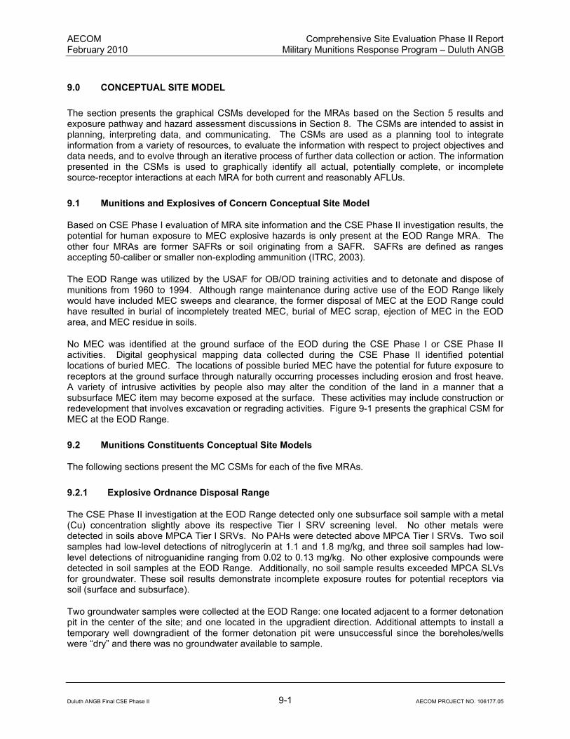
AECOM Comprehensive Site Evaluation Phase II Report February 2010 Military Munitions Response Program – Duluth ANGB
Duluth ANGB Final CSE Phase II 9-1 AECOM PROJECT NO. 106177.05
9.0 CONCEPTUAL SITE MODEL
The section presents the graphical CSMs developed for the MRAs based on the Section 5 results and exposure pathway and hazard assessment discussions in Section 8. The CSMs are intended to assist in planning, interpreting data, and communicating. The CSMs are used as a planning tool to integrate information from a variety of resources, to evaluate the information with respect to project objectives and data needs, and to evolve through an iterative process of further data collection or action. The information presented in the CSMs is used to graphically identify all actual, potentially complete, or incomplete source-receptor interactions at each MRA for both current and reasonably AFLUs.
9.1 Munitions and Explosives of Concern Conceptual Site Model
Based on CSE Phase I evaluation of MRA site information and the CSE Phase II investigation results, the potential for human exposure to MEC explosive hazards is only present at the EOD Range MRA. The other four MRAs are former SAFRs or soil originating from a SAFR. SAFRs are defined as ranges accepting 50-caliber or smaller non-exploding ammunition (ITRC, 2003).
The EOD Range was utilized by the USAF for OB/OD training activities and to detonate and dispose of munitions from 1960 to 1994. Although range maintenance during active use of the EOD Range likely would have included MEC sweeps and clearance, the former disposal of MEC at the EOD Range could have resulted in burial of incompletely treated MEC, burial of MEC scrap, ejection of MEC in the EOD area, and MEC residue in soils.
No MEC was identified at the ground surface of the EOD during the CSE Phase I or CSE Phase II activities. Digital geophysical mapping data collected during the CSE Phase II identified potential locations of buried MEC. The locations of possible buried MEC have the potential for future exposure to receptors at the ground surface through naturally occurring processes including erosion and frost heave. A variety of intrusive activities by people also may alter the condition of the land in a manner that a subsurface MEC item may become exposed at the surface. These activities may include construction or redevelopment that involves excavation or regrading activities. Figure 9-1 presents the graphical CSM for MEC at the EOD Range.
9.2 Munitions Constituents Conceptual Site Models
The following sections present the MC CSMs for each of the five MRAs.
9.2.1 Explosive Ordnance Disposal Range
The CSE Phase II investigation at the EOD Range detected only one subsurface soil sample with a metal (Cu) concentration slightly above its respective Tier I SRV screening level. No other metals were detected in soils above MPCA Tier I SRVs. No PAHs were detected above MPCA Tier I SRVs. Two soil samples had low-level detections of nitroglycerin at 1.1 and 1.8 mg/kg, and three soil samples had low-level detections of nitroguanidine ranging from 0.02 to 0.13 mg/kg. No other explosive compounds were detected in soil samples at the EOD Range. Additionally, no soil sample results exceeded MPCA SLVs for groundwater. These soil results demonstrate incomplete exposure routes for potential receptors via soil (surface and subsurface).
Two groundwater samples were collected at the EOD Range: one located adjacent to a former detonation pit in the center of the site; and one located in the upgradient direction. Additional attempts to install a temporary well downgradient of the former detonation pit were unsuccessful since the boreholes/wells were “dry” and there was no groundwater available to sample.

AECOM Comprehensive Site Evaluation Phase II Report February 2010 Military Munitions Response Program – Duluth ANGB
Duluth ANGB Final CSE Phase II 9-2 AECOM PROJECT NO. 106177.05
This page intentionally left blank.

Figure 9-1
MEC Conceptual Site Model for the EOD Range (SR502)
Comprehensive Site Evaluation Phase II
Duluth Air National Guard Base - Duluth, Minnesota
MRAPrimary
Source
Secondary
Source
Transport
and
Migration
Exposure
MediaActivity
Receptor Current Future
Source Interaction Receptors
Kick-Out/Incomplete
Human: Current and FutureAccessRelease Mechanism -
Expected Contamination
Duluth ANGB Final CSE Phase II 9-3 AECOM PROJECT NO. 106177.05
Receptor Current Future
Worker P P
Intrusive
OB/ODMEC at
Surface (1)Surface Soil
Recreational
UserP P
Non-
Intrusive
Kick-Out/Incomplete
Detonation - MEC/MC
Components/MC
Burning/Detonation -
Incompletely Treated Intrusive
EOD Range
(SR502)
Erosion,
Frost
Heave
Access
Available
Incompletely Treated
MEC/MC Contamination
Scrap/MC Residue
MEC in
Subsurface
Subsurface
SoilIntrusive
Burial of
MEC
Burial - Unfired
MEC/possible
retrograde MEC
Non-
Intrusive
Additional Information
(1) No MEC was detected in
Flow chart stops here
Flow chart continues
Munitions
Constituents
MEC/MC
(Go to MC
CSM)LEGEND
I
C
Potential Pathway
(1) No MEC was detected in
Surface Soil During the CSE Phase
II Site Investigation
Incomplete Pathway
Flow chart continues
Partial/Possible flow
Complete Pathway
P
Duluth ANGB Final CSE Phase II 9-3 AECOM PROJECT NO. 106177.05

AECOM Comprehensive Site Evaluation Phase II Report February 2010 Military Munitions Response Program – Duluth ANGB
Duluth ANGB Final CSE Phase II 9-4 AECOM PROJECT NO. 106177.05
This page intentionally left blank.

AECOM Comprehensive Site Evaluation Phase II Report February 2010 Military Munitions Response Program – Duluth ANGB
Duluth ANGB Final CSE Phase II 9-5 AECOM PROJECT NO. 106177.05
The laboratory analysis of groundwater collected adjacent to the former detonation pit detected a low estimated concentration of the explosive compound RDX at 0.59 µg/L. This compound does not have a published screening criterion. All other explosive compounds, metals, and PAHs analysis results were either not detected or below MCLs. The upgradient groundwater sample analysis detected metals (arsenic, barium, chromium, Cu, and lead) above MCLs; however, these metals are believed to be a result of turbidity in the unfiltered groundwater sample and not associated with site EOD activity. All other compounds in the upgradient groundwater sample were either not detected or below MCLs.
In summary, there are no complete MC exposure pathways at the EOD Range for potential current/future receptors based on soil and groundwater media sampling results. Figure 9-2 presents the graphical CSM for MC at the EOD Range.
9.2.2 Small Arms Range
The CSE Phase II investigation at the Small Arms Range detected only iron in one subsurface soil sample above the regional background soil concentration and MPCA Tier I SRV. This elevated subsurface iron concentration is believed to be related to regionally high iron concentrations found within the Duluth ANGB area. No other potential MC were detected above screening criteria in soil (surface or subsurface).
In summary, there are no complete MC exposure pathways at the Small Arms Range for potential current/future receptors based on soil sampling results. Figure 9-3 presents the graphical MC CSM for the Small Arms Range.
9.2.3 Trap Range
The CSE Phase II investigation at the Trap Range detected elevated concentrations of MC constituents in surface soil, subsurface soil, sediment, and surface water. The maximum concentrations for lead included; surface soil at 2,500 mg/kg, subsurface soil at 3,800 mg/kg, and surface water at 230 µg/L. No lead was detected in sediment above MPCA Tier I SQT ecological screening levels; however, PAHs were detected in both sediment samples above the MPCA Tier I SQT screening criteria. All four surface soil samples and two of the subsurface soil samples exceeded the MPCA Tier I SLV, indicating a concern for potential leaching to groundwater.
In summary, complete MC exposure pathways are present at the Trap Range for potential current/future receptors based on soil, sediment, and surface water sampling results. Figure 9-4 presents the graphical MC CSM for the Trap Range.
9.2.4 Skeet Range
The CSE Phase II investigation at the Skeet Range detected only lead in one subsurface soil sample above the MPCA Tier I SRV of 300 mg/kg (TS737-SB033, 470 mg/kg lead). Lead was also detected above the regional background level (15 mg/kg) in five additional samples ranging from 22 to 290 mg/kg. No other MC concentrations were detected above the MPCA Tier I SRV screening criteria. Additionally, no soil samples from the Skeet Range exceeded the MPCA Tier I SLVs, indicating that migration of MC to groundwater from soil is likely not occurring.
Two sediment samples were collected at the Skeet Range and analyzed for metals and PAHs. Lead was detected in one sample at a concentration of 44 µg/kg, slightly above the MPCA Tier I SQT of 36 µg/kg. PAH analysis detected the compound acenaphethylene in one sediment sample at an estimated concentration of 9.1 µg/kg, slightly above the MPCA Tier I SQT of 5.9 µg/kg. Additionally, two surface water samples were collected at the Skeet Range (co-located with the sediment samples) and analyzed for metals and PAHs. Lead was detected in TS737-SW002 at a concentration of 22 µg/L, above the surface water screening value of 3.2 µg/L. No other analytes were detected in either sample above the associated screening values.

AECOM Comprehensive Site Evaluation Phase II Report February 2010 Military Munitions Response Program – Duluth ANGB
Duluth ANGB Final CSE Phase II 9-6 AECOM PROJECT NO. 106177.05
This page intentionally left blank.
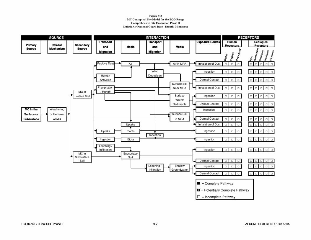
Figure 9-2
MC Conceptual Site Model for the EOD Range
Comprehensive Site Evaluation Phase II
Duluth Air National Guard Base - Duluth, Minnesota
Carn
ivore
s
Exposure Routes Human
Receptors
Ecological
Receptors
Work
er
Resid
ent
Recre
ational
Pla
nt
Invert
ebra
tes
Herb
ivore
s
Om
niv
ore
s
SOURCE INTERACTION RECEPTORS
Primary
Source
Release
Mechanism
Secondary
Source
Transport
and
Migration
Media
Transport
and
Migration
Media
Air Air in MRA □ □ □ □ □ □ □ □
Carn
ivore
s
Fugitive Dust Inhalation of Dust
Exposure Routes
Work
er
Resid
ent
Recre
ational
Pla
nt
Invert
ebra
tes
Herb
ivore
s
Om
niv
ore
s
Primary
Source
Release
Mechanism
Secondary
Source
Transport
and
Migration
Media
Transport
and
Migration
Media
Duluth ANGB Final CSE Phase II 9-7 AECOM PROJECT NO. 106177.05
Air Air in MRA □ □ □ □ □ □ □ □
□ □ □ □ □ □ □ □
□ □ □ □ □ □ □ □
□ □ □ □ □ □ □ □
Surface Soil
Near MRAPrecipitation
/ Runoff
Inhalation of Dust
MC in
Fugitive Dust Inhalation of Dust
Wind
Deposition
Ingestion
Human
Activities Dermal Contact
□ □ □ □ □ □ □ □
□ □ □ □ □ □ □ □
□ □ □ □ □ □ □ □
□ □ □ □ □ □ □ □
MC in the
Surface or
Subsurface
Weathering
or Removal
of MC
Ingestion
Surface Soil
in MRA Dermal Contact
/ RunoffMC in
Surface Soil Surface
Water/
Sediments
Ingestion
Dermal Contact
□ □ □ □ □ □ □ □
Uptake □ □ □ □ □ □ □ □
Uptake Plants □ □ □ □ □ □ □ □
Ingestion
Ingestion Biota □ □ □ □ □ □ □ □
Ingestion
Ingestion
Leaching /
Subsurface of MC in MRA Dermal Contact
Inhalation of Dust
□ □ □ □ □ □ □ □
Subsurface
Soil
□ □ □ □ □ □ □ □
□ □ □ □ □ □ □ □
□ □ □ □ □ □ □ □Dermal Contact
MC in
Subsurface
Soil Dermal Contact
Leaching /
Infiltration
Shallow
Groundwater
Ingestion
Leaching /
Infiltration Ingestion
■ = Complete Pathway
◘ = Potentially Complete Pathway
□ = Incomplete Pathway
Duluth ANGB Final CSE Phase II 9-7 AECOM PROJECT NO. 106177.05

AECOM Comprehensive Site Evaluation Phase II Report February 2010 Military Munitions Response Program – Duluth ANGB
Duluth ANGB Final CSE Phase II 9-8 AECOM PROJECT NO. 106177.05
This page intentionally left blank.

Figure 9-3
MC Conceptual Site Model for the Small Arms Range
Comprehensive Site Evaluation Phase II
Duluth Air National Guard Base - Duluth, Minnesota
Exposure Routes Human
Receptors
Ecological
Receptors
Work
er
Pla
nt
Invert
ebra
tes
Herb
ivore
s
Om
niv
ore
s
Carn
ivore
s
Recre
ational
Resid
ent
SOURCE INTERACTION RECEPTORS
Primary
Source
Release
Mechanism
Secondary
Source
Transport
and
Migration
Media
Transport
and
Migration
Media
Air Air in MRA □ □ □ □ □ □ □ □
Exposure Routes
Fugitive Dust Inhalation of Dust
Work
er
Pla
nt
Invert
ebra
tes
Herb
ivore
s
Om
niv
ore
s
Carn
ivore
s
Recre
ational
Resid
ent
Primary
Source
Release
Mechanism
Secondary
Source
Transport
and
Migration
Media
Transport
and
Migration
Media
Duluth ANGB Final CSE Phase II 9-9 AECOM PROJECT NO. 106177.05
Air Air in MRA □ □ □ □ □ □ □ □
□ □ □ □ □ □ □ □
□ □ □ □ □ □ □ □
□ □ □ □ □ □ □ □Precipitation
/ Runoff
Inhalation of Dust
MC in
Surface Soil
Near MRA
Fugitive Dust Inhalation of Dust
Wind
Deposition
Ingestion
Human
Activities Dermal Contact
□ □ □ □ □ □ □ □
□ □ □ □ □ □ □ □
□ □ □ □ □ □ □ □
□ □ □ □ □ □ □ □
MC in the
Surface or
Subsurface
Weathering
or Removal
of MC
Ingestion
Surface Soil
in MRA Dermal Contact
/ RunoffMC in
Surface Soil Surface
Water/
Sediments
Ingestion
Dermal Contact
□ □ □ □ □ □ □ □
Uptake □ □ □ □ □ □ □ □
Uptake Plants □ □ □ □ □ □ □ □
Ingestion
Ingestion Biota □ □ □ □ □ □ □ □Ingestion
Inhalation of Dust
Ingestion
Subsurface of MC in MRA Dermal Contact
Leaching /
□ □ □ □ □ □ □ □
Subsurface
Soil
□ □ □ □ □ □ □ □
□ □ □ □ □ □ □ □
□ □ □ □ □ □ □ □
MC in
Subsurface
Soil
Leaching /
Infiltration Ingestion
Dermal Contact
Leaching /
Infiltration
Shallow
Groundwater
Ingestion
Dermal Contact
■ = Complete Pathway
◘ = Potentially Complete Pathway
□ = Incomplete Pathway
Duluth ANGB Final CSE Phase II 9-9 AECOM PROJECT NO. 106177.05

AECOM Comprehensive Site Evaluation Phase II Report February 2010 Military Munitions Response Program – Duluth ANGB
Duluth ANGB Final CSE Phase II 9-10 AECOM PROJECT NO. 106177.05
This page intentionally left blank.

Figure 9-4
MC Conceptual Site Model for the Trap Range
Comprehensive Site Evaluation Phase II
Duluth Air National Guard Base - Duluth, Minnesota
Herb
ivore
s
Om
niv
ore
s
Carn
ivore
s
Resid
ent
Media
Transport
and
Migration
Media
Exposure Routes Human
Receptors
Ecological
Receptors
Invert
ebra
tes
SOURCE INTERACTION RECEPTORS
Primary
Source
Release
Mechanism
Secondary
Source
Transport
and
Migration
Work
er
Recre
ational
Pla
nt
Air Air in MRA ◘ ◘ ◘ ◘ ◘ ◘ ◘ ◘
Herb
ivore
s
Om
niv
ore
s
Carn
ivore
s
Resid
ent
Media
Transport
and
Migration
Media
Exposure Routes
Invert
ebra
tes
Fugitive Dust Inhalation of Dust
Primary
Source
Release
Mechanism
Secondary
Source
Transport
and
Migration
Work
er
Recre
ational
Pla
nt
Duluth ANGB Final CSE Phase II 9-11 AECOM PROJECT NO. 106177.05
Air Air in MRA ◘ ◘ ◘ ◘ ◘ ◘ ◘ ◘
◘ ◘ ◘ ◘ ◘ ◘ ◘ ◘
◘ ◘ ◘ ◘ ◘ ◘ ◘ ◘
◘ ◘ ◘ ◘ ◘ ◘ ◘ ◘
Surface Soil
Near MRAPrecipitation
/ Runoff
Inhalation of Dust
Fugitive Dust Inhalation of Dust
Wind
Deposition
Ingestion
Human
Activities Dermal Contact
MC in
■ ■ ■ ■ ■ ■ ■ ■
■ ■ ■ ■ ■ ■ ■ ■
■ ■ ■ ■ ■ ■ ■ ■
■ ■ ■ ■ ■ ■ ■ ■
/ Runoff
MC in the
Surface or
Subsurface
Weathering
or Removal
of MC
Ingestion
Surface Soil
in MRA Dermal Contact
Dermal Contact
MC in
Surface Soil Surface
Water/
Sediments
Ingestion
Uptake ■ ■ ■ ■ ■ ■ ■ ■
Uptake Plants ■ ■ ■ ■ ■ ■ ■ ■
Ingestion
Ingestion Biota ■ ■ ■ ■ ■ ■ ■ ■
■ ■ ■ ■ ■ ■ ■ ■Ingestion
Inhalation of Dust
Ingestion
Ingestion
Leaching /
■ ■ ■ ■ ■ ■ ■ ■
■ ■ ■ ■ ■ ■ ■ ■
◘ ◘ ◘ ◘ ◘ ◘ ◘ ◘
◘ ◘ ◘ ◘ ◘ ◘ ◘ ◘
Ingestion
Subsurface
Soil
MC in
Subsurface
Soil
Infiltration
Dermal Contact
Dermal Contact
Leaching /
Infiltration
Shallow
Groundwater
Ingestion
◘ ◘ ◘ ◘ ◘ ◘ ◘ ◘
■ = Complete Pathway
◘ = Potentially Complete Pathway
□ = Incomplete Pathway
Duluth ANGB Final CSE Phase II 9-11 AECOM PROJECT NO. 106177.05

AECOM Comprehensive Site Evaluation Phase II Report February 2010 Military Munitions Response Program – Duluth ANGB
Duluth ANGB Final CSE Phase II 9-12 AECOM PROJECT NO. 106177.05
This page intentionally left blank.

AECOM Comprehensive Site Evaluation Phase II Report February 2010 Military Munitions Response Program – Duluth ANGB
Duluth ANGB Final CSE Phase II 9-13 AECOM PROJECT NO. 106177.05
In summary, potentially complete MC exposure pathways are present at the Skeet Range for potential current/future receptors based on soil, sediment, and surface water sampling results. Figure 9-5 presents the graphical MC CSM for the Skeet Range.
9.2.5 Lead Contaminated Soils Area
The CSE Phase II investigation at the LCSA detected lead and other MC constituents in soil samples obtained from the surface soil piles above the MPCA Tier I SRV. With the exception of iron slightly exceeding the regional background soil concentration, lead and other MC constituents were not detected above MPCA Tier I SRVs in subsurface soil immediately below the LCSA soil piles. The subsurface iron concentration exceeding screening criteria is believed to be related to regionally elevated iron concentrations found within the Duluth ANGB area. The Phase II CSE analytical results demonstrate that lead and other MC constituents are confined within the LCSA surface soil piles.
Two sediment samples were collected at the LCSA and analyzed for metals. Lead was not detected above the MPCA Tier I SQT in either sample. Two surface water samples were collected at the LCSA and analyzed for metals. Lead was not detected above the MCL in either sample.
In summary, complete MC exposure pathways are present at the LCSA for potential current/future receptors based on soil sampling results. Figure 9-6 presents the graphical MC CSM for the LCSA.
9.3 Conclusions
Although no MEC was identified on the ground surface during investigation activities, digital geophysical mapping data collected during the CSE Phase II identified locations of potential buried MEC at the EOD Range. If present, the MEC provides a complete pathway for future human exposure to MEC within the EOD Range surface and subsurface soil. No MEC has been identified or is suspected at the other Duluth ANGB MRAs.
Based on the CSE Phase II at the Trap Range and Skeet Range, concentrations of MC constituents are present above screening criteria in soil, sediment, and surface water. Exposure pathways are considered complete or potentially complete for soil (surface and subsurface), sediment, surface water, and groundwater. Potential human receptors include current/future base workers, recreational users, and residents. Ecological receptors include plants, invertebrates, herbivores, omnivores, and carnivores.
Based on the CSE Phase II at the LCSA, MC constituents in surface soil piles are present in concentrations above screening criteria. Exposure pathways are considered complete for soil. Potential human receptors include current/future base workers, recreational users, and residents. Ecological receptors include plants, invertebrates, herbivores, omnivores, and carnivores.
At the Small Arms Range and EOD Range, site-related MC constituents in soil were found to be below screening criteria and therefore no complete exposure pathways are present.

AECOM Comprehensive Site Evaluation Phase II Report February 2010 Military Munitions Response Program – Duluth ANGB
Duluth ANGB Final CSE Phase II 9-14 AECOM PROJECT NO. 106177.05
This page intentionally left blank.

Figure 9-5
MC Conceptual Site Model for the Skeet Range
Comprehensive Site Evaluation Phase II
Duluth Air National Guard Base - Duluth, Minnesota
Resid
ent
Exposure Routes Human
Receptors
Ecological
Receptors
Work
er
Recre
ational
Pla
nt
Invert
ebra
tes
Herb
ivore
s
Om
niv
ore
s
Carn
ivore
s
SOURCE INTERACTION RECEPTORS
Primary
Source
Release
Mechanism
Secondary
Source
Transport
and
Migration
Media
Transport
and
Migration
Media
Air Air in MRA ◘ ◘ ◘ ◘ ◘ ◘ ◘ ◘
Resid
ent
Fugitive Dust Inhalation of Dust
Exposure Routes
Work
er
Recre
ational
Pla
nt
Invert
ebra
tes
Herb
ivore
s
Om
niv
ore
s
Carn
ivore
s
Primary
Source
Release
Mechanism
Secondary
Source
Transport
and
Migration
Media
Transport
and
Migration
Media
Duluth ANGB Final CSE Phase II 9-15 AECOM PROJECT NO. 106177.05
Air Air in MRA ◘ ◘ ◘ ◘ ◘ ◘ ◘ ◘
◘ ◘ ◘ ◘ ◘ ◘ ◘ ◘
◘ ◘ ◘ ◘ ◘ ◘ ◘ ◘
◘ ◘ ◘ ◘ ◘ ◘ ◘ ◘
Fugitive Dust
Surface Soil
Near MRAPrecipitation
/ Runoff
Inhalation of Dust
MC in
Inhalation of Dust
Wind
Deposition
Ingestion
Human
Activities Dermal Contact
◘ ◘ ◘ ◘ ◘ ◘ ◘ ◘
◘ ◘ ◘ ◘ ◘ ◘ ◘ ◘
◘ ◘ ◘ ◘ ◘ ◘ ◘ ◘
◘ ◘ ◘ ◘ ◘ ◘ ◘ ◘
Ingestion
Surface Soil
in MRA Dermal Contact
/ RunoffMC in
Surface Soil Surface
Water/
Sediments
Ingestion
Dermal Contact
MC in the
Surface or
Subsurface
Weathering
or Removal
of MC
Uptake ◘ ◘ ◘ ◘ ◘ ◘ ◘ ◘
Uptake Plants ◘ ◘ ◘ ◘ ◘ ◘ ◘ ◘
Ingestion
Ingestion Biota ◘ ◘ ◘ ◘ ◘ ◘ ◘ ◘
◘ ◘ ◘ ◘ ◘ ◘ ◘ ◘
Leaching /
Infiltration
Inhalation of Dust
Ingestion
Ingestion
Ingestion ◘ ◘ ◘ ◘ ◘ ◘ ◘ ◘
◘ ◘ ◘ ◘ ◘ ◘ ◘ ◘
□ □ □ □ □ □ □ □
□ □ □ □ □ □ □ □Dermal Contact
Leaching /
Infiltration
Shallow
Groundwater
Ingestion
Infiltration
Subsurface
Soil
MC in
Subsurface
SoilDermal Contact
Ingestion
■ = Complete Pathway
◘ = Potentially Complete Pathway
□ = Incomplete Pathway
Duluth ANGB Final CSE Phase II 9-15 AECOM PROJECT NO. 106177.05

AECOM Comprehensive Site Evaluation Phase II Report February 2010 Military Munitions Response Program – Duluth ANGB
Duluth ANGB Final CSE Phase II 9-16 AECOM PROJECT NO. 106177.05
This page intentionally left blank.
Figure 9-6
MC Conceptual Site Model for the Lead Contaminated Soils Area
Comprehensive Site Evaluation Phase II
Duluth Air National Guard Base - Duluth, Minnesota
Resid
ent
Exposure Routes Human
Receptors
Ecological
Receptors
Work
er
Pla
nt
Invert
ebra
tes
Herb
ivore
s
Om
niv
ore
s
Carn
ivore
s
Recre
ational
SOURCE INTERACTION RECEPTORS
Primary
Source
Release
Mechanism
Secondary
Source
Transport
and
Migration
Media
Transport
and
Migration
Media
Air Air in MRA ◘ ◘ ◘ ◘ ◘ ◘ ◘ ◘
Resid
ent
Fugitive Dust Inhalation of Dust
Exposure Routes
Work
er
Pla
nt
Invert
ebra
tes
Herb
ivore
s
Om
niv
ore
s
Carn
ivore
s
Recre
ational
Primary
Source
Release
Mechanism
Secondary
Source
Transport
and
Migration
Media
Transport
and
Migration
Media
Duluth ANGB Final CSE Phase II 9-17 AECOM PROJECT NO. 106177.05
Air Air in MRA ◘ ◘ ◘ ◘ ◘ ◘ ◘ ◘
□ □ □ □ □ □ □ □
□ □ □ □ □ □ □ □
□ □ □ □ □ □ □ □
Surface Soil
Near MRAPrecipitation
/ Runoff
Inhalation of Dust
MC in
Fugitive Dust Inhalation of Dust
Wind
Deposition
Ingestion
Human
Activities Dermal Contact
□ □ □ □ □ □ □ □
□ □ □ □ □ □ □ □
■ ■ ■ ■ ■ ■ ■ ■
■ ■ ■ ■ ■ ■ ■ ■
MC in the
Surface or
Subsurface
Weathering
or Removal
of MC
Ingestion
Surface Soil
in MRA Dermal Contact
/ RunoffMC in
Surface Soil Surface
Water/
Sediments
Ingestion
Dermal Contact
Uptake ■ ■ ■ ■ ■ ■ ■ ■
Uptake Plants ■ ■ ■ ■ ■ ■ ■ ■
Ingestion
Ingestion Biota ■ ■ ■ ■ ■ ■ ■ ■Ingestion
Leaching /
Ingestion
Inhalation of Dust
□ □ □ □ □ □ □ □
Subsurface
Soil
□ □ □ □ □ □ □ □
□ □ □ □ □ □ □ □
□ □ □ □ □ □ □ □
MC in
Subsurface
Soil
Dermal Contact
Leaching /
Infiltration
Shallow
Groundwater
Ingestion
Dermal Contact
Leaching /
Infiltration Ingestion
□ □ □ □ □ □ □ □
■ = Complete Pathway
◘ = Potentially Complete Pathway
□ = Incomplete Pathway
Dermal Contact
Duluth ANGB Final CSE Phase II 9-17 AECOM PROJECT NO. 106177.05

AECOM Comprehensive Site Evaluation Phase II Report February 2010 Military Munitions Response Program – Duluth ANGB
Duluth ANGB Final CSE Phase II 9-18 AECOM PROJECT NO. 106177.05
This page intentionally left blank.

AECOM Comprehensive Site Evaluation Phase II Report February 2010 Military Munitions Response Program – Duluth ANGB
Duluth ANGB Final CSE Phase II 10-1 AECOM PROJECT NO. 106177.05
10.0 MUNITIONS RESPONSE SITE PRIORITIZATION PROTOCOL
DoD proposed the MRSPP (32 CFR Part 179) to assign a relative risk priority to each defense site in the MMRP Inventory for response activities. These response activities are to be based on the overall conditions at each location, and taking into consideration various factors related to explosive safety and environmental hazards (68 FR 50900). The application of the MRSPP applies to all locations:
That are or were, owned, leased to, or otherwise possessed or used by DoD;
That are known to or are suspected of containing MEC or MC; and
That are included in the MMRP Inventory.
In assigning a relative priority for response activities, DoD generally considers MRSs posing the greatest hazard as being the highest priority. In the NGB program, the MRS priority will be one factor in determining the sequence in which munitions response actions are funded. The following sections are a brief summary of the scoring modules of the MRSPP.
For additional information on the MRSPP, the DOD has produced a MRSPP Primer as an instruction manual for munitions response project managers and other environmental personnel responsible for applying the Protocol. The Primer details the development of the Protocol, requirements for its application, opportunities for stakeholder involvement, and data management responsibilities. This technical guide also includes site evaluation tools, a glossary of Protocol-specific terms, and references to other munitions-related resources. The MRSPP scoring modules for the Duluth ANGB are presented as Appendix I to this report.
10.1 Explosive Hazard Evaluation Module
The EHE module assesses the presence of known or suspected explosive hazards. The EHE module is composed of three factors, each of which has two to four data elements that are intended to assess the specific conditions at an MRS. These factors are as follows:
Explosive Hazard, which has the data elements Munitions Type and Source of Hazard;
Accessibility, which has the data elements Location of Munitions, Ease of Access, and Status of Property; and
Receptors, which has the data elements Population Density, Population near Hazard, Types of Activities/Structures, and Ecological and/or Cultural Resources.
Based on site-specific information, each data element is assigned a numeric value, and the sum of these values is the EHE module score. The EHE module score results in an MRS receiving a rating. The MRSPP tables for Duluth ANGB are presented as Appendix I. The scores for each specific data element for the EHE module of the MRSPP above are compiled in Appendix I and summarized in Table 10-1.
10.2 Chemical Warfare Material Hazard Evaluation Module
The CHE module provides an evaluation of the chemical hazards associated with the physiological effects of CWM. The CHE module is used only when CWM in the form of MEC or MC, are known or suspected of being present at an MRA. Like the EHE module, the CHE module has three factors, each of which has two to four data elements that are intended to assess the conditions at an MRA. These factors are as follows:
CWM Hazard, which has the data elements, CWM Configuration and Sources of CWM;

AECOM Comprehensive Site Evaluation Phase II Report February 2010 Military Munitions Response Program – Duluth ANGB
Duluth ANGB Final CSE Phase II 10-2 AECOM PROJECT NO. 106177.05
This page intentionally left blank.

Table 10-1
Summary and Total of the EHE Data Element Scores
Comprehensive Site Evaluation Phase II
Duluth Air National Guard Base - Duluth, Minnesota
Specific Data ElementEOD Range
(SR502)
Small Arms Range
(SR736)
Trap Range
(TS737)
Skeet Range
(TS738)
Lead Contaminated
Soils Area (SR739)
Explosive Hazard
Muntions Type 25 NA NA NA NA
Source of Hazard 8 NA NA NA NA
Accessibility
Information on the
Location of Munitions0 NA NA NA NA
Ease of Access 8 NA NA NA NA
Status of Property 0 NA NA NA NA
Receptors
Population Density 1 NA NA NA NA
Population Near Hazard 5 NA NA NA NA
Types of
Activities/Structures5 NA NA NA NA
Ecological and/or Cultural
Resources0 NA NA NA NA
Total EHE Module Score 52 NA NA NA NA
Total EHE Module Rating E ** ** ** **
Notes: NA = Not Applicable
** No Known or Suspected Explosives Hazard
Duluth ANGB Final CSE Phase II 10-3 AECOM PROJECT NO. 106177.05

AECOM Comprehensive Site Evaluation Phase II Report February 2010 Military Munitions Response Program – Duluth ANGB
Duluth ANGB Final CSE Phase II 10-4 AECOM PROJECT NO. 106177.05
This page intentionally left blank.

AECOM Comprehensive Site Evaluation Phase II Report February 2010 Military Munitions Response Program – Duluth ANGB
Duluth ANGB Final CSE Phase II 10-5 AECOM PROJECT NO. 106177.05
Accessibility, which focuses on the potential for receptors to encounter the CWM known or suspected to be present on an MRA. This factor consists of three data elements, Location of CWM, Ease of Access, and Status of Property; and
Receptor, which focuses on the human and ecological populations that may be impacted by the presence of CWM. It has the data elements Population Density, Population near Hazard, Types of Activities/Structures, and Ecological and/or Cultural Resources.
Similar to the EHE module, each data element is assigned a numeric value, and the sum of these values (i.e., the CHE module score) is used to determine the CHE rating. There is no history of CWM use at Duluth ANGB. Therefore, the CHE module does not apply to this site. All MRS receive the alternative module rating of “No Known or Suspected CWM Hazard”.
10.3 Health Hazard Evaluation Module
The HHE module provides a consistent Department-wide approach for evaluating the relative risk to human health and the environment posed by contaminants (i.e., MC) present at an MRA. The module has three factors that are as follows:
Contamination Hazard Factor (CHF), which indicates contaminants present. This factor contributes a level of High (H), Middle (M), or Low (L) based on Significant, Moderate, or Minimal contaminants present, respectively;
Receptor Factor (RF), which indicates the receptors. This factor contributes a level of H, M, or L based on Identified, Potential, or Limited receptors, respectively; and
Migration Pathway Factor (MPF), which indicates environmental migration pathways, and contributes a level of H, M, or L based on Evident, Potential or Confined pathways, respectively.
The HHE builds on the Relative Risk Site Evaluation framework that is used in the Installation Restoration Program. The CHF, RF, and MPF are based on a quantitative evaluation of MC and/or CERCLA hazardous substances, and a qualitative evaluation of pathways and human and ecological receptors in groundwater, surface water, sediment, and surface soils. Please note that the HHE does not address subsurface soils. However, as the depth appropriate for evaluation is 0 to 2 ft and the soil samples collected from the Trap Range and Skeet Range were 0 to 0.5 ft and 0.5 to 1.0 ft, all soil results obtained from these two sites were utilized in the HHE module. The subsurface samples collected at depths greater than 2 feet at the EOD Range, Small Arms Range, and LCSA were not included in the HHE module. In addition, the HHE does not consider air as a pathway, because the risk through this medium from DoD MMRP sites with soil contamination generally is minimal.
The H, M, and L levels for the CHF, RF, and MPF are combined in a matrix to obtain composite three-letter combination levels that integrate considerations of all three factors. The three-letter combination levels are organized by frequency, and the resulting frequencies result in an HHE Hazard Evaluation rating. The ratings for each of the HHE modules of the MRSPP for the remaining MRS above are compiled in Appendix I and summarized in Table 10-2.
10.4 Munitions Response Site Prioritization Protocol Score
Each MRA or discrete MRS is assigned a MRS Priority ranging from 1 to 8. Priority 1 indicates the highest potential hazard and Priority 8 indicates the lowest potential hazard. Only a site with a chemical warfare hazard can receive a MRS Priority of 1. The MRS Priority is determined by selecting the highest rating from amongst the EHE, CHE, and HHE modules. For example, if the EHE rating is 2, the CHE rating is 5, and the HHE rating is 4, the MRS Priority assigned would be 2. The MRS Priority will be used to determine the future funding sequence of MRAs and/or MRSs for further munitions response action. The MRS Priorities for the Duluth ANGB MRAs are presented in Table 10-3. For reference, the MRS Priorities prior to the CSE Phase II are also presented.

AECOM Comprehensive Site Evaluation Phase II Report February 2010 Military Munitions Response Program – Duluth ANGB
Duluth ANGB Final CSE Phase II 10-6 AECOM PROJECT NO. 106177.05
This page intentionally left blank.

Table 10-2
Summary and Total of the HHE Data Element Scores
Comprehensive Site Evaluation Phase II
Duluth Air National Guard Base - Duluth, Minnesota
Specific Data ElementEOD Range
(SR502)
Small Arms
Range (SR736)
Trap Range
(TS737)
Skeet Range
(TS738)
Lead Contaminated
Soils Area (SR739)
Groundwater
Contamination Hazard Factor M NA NA NA NA
Migration Pathway Factor L NA NA NA NA
Receptor Factor H NA NA NA NA
HHE Combination Level HML NA NA NA NA
Media Rating D NA NA NA NA
Surface Water/Human Endpoint
Contamination Hazard Factor NA NA M M L
Migration Pathway Factor NA NA M M M
Receptor Factor NA NA M M M
HHE Combination Level NA NA MMM MMM MML
Media Rating NA NA D D E
Sediment/Human Endpoint
Contamination Hazard Factor NA NA M L L
Migration Pathway Factor NA NA M L M
Receptor Factor NA NA M M M
HHE Combination Level NA NA MMM MLL MML
Media Rating NA NA D F E
Surface Water/Ecological Endpoint
Contamination Hazard Factor NA NA H H L
Migration Pathway Factor NA NA M M M
Receptor Factor NA NA H H M
HHE Combination Level NA NA HHM HHM MML
Media Rating NA NA B B E
Sediment/Ecological Endpoint
Contamination Hazard Factor NA NA H H L
Migration Pathway Factor NA NA M L M
Receptor Factor NA NA H H M
HHE Combination Level NA NA HHM HHL MML
Media Rating NA NA B C E
Soil
Contamination Hazard Factor M M M H M
Migration Pathway Factor M L M L L
Receptor Factor M L M M M
HHE Combination Level MMM MLL MMM HML MML
Media Rating D F D D E
Total HHE Module Rating D F B B E
Notes: NA = Not Applicable
Duluth ANGB Final CSE Phase II 10-7 AECOM PROJECT NO. 106177.05

AECOM Comprehensive Site Evaluation Phase II Report February 2010 Military Munitions Response Program – Duluth ANGB
Duluth ANGB Final CSE Phase II 10-8 AECOM PROJECT NO. 106177.05
This page intentionally left blank.

Table 10-3
Priority Rating for Duluth ANGB MRAs
Comprehensive Site Evaluation Phase II
Duluth Air National Guard Base - Duluth, Minnesota
Specific Data ElementEOD Range
(SR502)
Small Arms
Range (SR736)
Trap Range
(TS737)
Skeet Range
(TS738)
Lead Contaminated
Soils Area (SR739)
EHE Module Rating E ** ** ** **
CHE Module Rating ** ** ** ** **
HHE Module Rating D F B B E
Priority 5 7 3 3 6
Priority Prior to CSE Phase II 4 8 8 8 8
Notes: ** No Known or Suspected Hazard
Duluth ANGB Final CSE Phase II 10-9 AECOM PROJECT NO. 106177.05

AECOM Comprehensive Site Evaluation Phase II Report February 2010 Military Munitions Response Program – Duluth ANGB
Duluth ANGB Final CSE Phase II 10-10 AECOM PROJECT NO. 106177.05
This page intentionally left blank.
AECOM Comprehensive Site Evaluation Phase II Report February 2010 Military Munitions Response Program – Duluth ANGB
Duluth ANGB Final CSE Phase II 11-1 AECOM PROJECT NO. 106177.05
11.0 PERCHLORATE REPORTING
Perchlorate sampling was not performed at Duluth ANGB during the CSE Phase II investigation. Based on the assessment of the munitions types identified and/or historically used and the non-use of perchlorate associated with these munitions, sampling for perchlorate was not warranted and is not proposed to be completed in the future at the Duluth ANGB MRAs.
Perchlorate is found in man-made compounds used as combustion accelerants, predominantly in solid-fueled rockets and missiles, and to a lesser extent in some munitions and pyrotechnics. Based on historical records and CSE Phase I and II field investigations, there is no evidence that solid fueled rockets or missiles were ever used/disposed of at the Duluth ANGB MRAs. Additionally, there are no records of perchlorate-containing munitions or pyrotechnics encountered at any of the MRAs. Although very unlikely, if during future RI or RA efforts munitions are discovered that suggest perchlorate may in fact be a potential concern at an MRA, additional investigation could be implemented.

AECOM Comprehensive Site Evaluation Phase II Report February 2010 Military Munitions Response Program – Duluth ANGB
Duluth ANGB Final CSE Phase II 11-2 AECOM PROJECT NO. 106177.05
This page intentionally left blank.

AECOM Comprehensive Site Evaluation Phase II Report February 2010 Military Munitions Response Program – Duluth ANGB
Duluth ANGB Final CSE Phase II 12-1 AECOM PROJECT NO. 106177.05
12.0 SUMMARY AND CONCLUSIONS
This section summarizes the results obtained and conclusions reached as a result of CSE Phase II investigation activities conducted at Duluth ANGB MRAs. Only the most significant findings are presented in this section and are reproduced directly or abstracted from information contained in this report.
12.1 Summary of Comprehensive Site Evaluation Phase II Activities
This CSE Phase II investigation compiled and evaluated information with respect to Duluth ANGB relating to the possible presence of MEC and associated contamination of environmental media from MC. The sources of this information were observations during detailed visual survey, environmental media sampling, and geophysical survey. This information was reviewed and used to develop and refine the CSMs for potential exposures to MEC and MC. The CSMs related the indicated sources of MEC or MC to potential direct-contact exposures of potential receptors at Duluth ANGB, in consideration of both the current and projected future land uses.
These relationships, or potentially complete exposure pathways, also considered the possible transport or migration of potentially explosive MEC items from place to place as the result of natural processes or the activities of people, as well as impacts associated with migration of MC associated with the MEC. These land use scenarios were evaluated with respect to how potential receptors would interact with the land and water bodies at Duluth ANGB. The compiled information was then used to conduct an assessment of the potential explosive and environmental hazards at each MRA.
12.2 Summary of Comprehensive Site Evaluation Phase II Findings
The CSE Phase II has resulted in the collection, evaluation, and synthesis of a large amount of information including; past ordnance-related activities at Duluth ANGB, current conditions on-site with respect to the presence of MEC and MC, physical setting of the land, and plans for the future use of the property. A summary of the findings for each MRA based on the CSE Phase II is provided in this section.
The CSE Phase I and Phase II investigation results found the potential for exposure to MEC is only present at the EOD Range MRA. The other four MRAs are former SAFRs or soil originating from a SAFR. SAFRs are defined as those ranges accepting 50-caliber or smaller non-exploding ammunition (ITRC, 2003).
12.2.1 Explosive Ordnance Disposal Range
The former EOD Range was used by the USAF from 1960 to 1994 for OB/OD training activities, and to detonate and dispose of munitions. The former range is located west of the main base on a restrictive easement owned by the Duluth Airport Authority and just northeast of the base’s active Munitions Storage Area. This range consists of a rectangular shaped parcel that is approximately 0.3 acres in size. The terrain at the range is generally flat, and is bordered to the west by a gravel road and wooded areas to the north, east, and south.
The findings for the EOD Range during the CSE Phase II are listed as follows:
No MEC was identified on the ground surface of the EOD Range during the CSE Phase I or Phase II activities. Digital geophysical mapping data collected during the CSE Phase II identified potential locations of buried MEC. The locations of possible buried MEC have the potential for exposure to receptors at the ground surface through naturally occurring processes including erosion and frost heave. A variety of intrusive activities by people also may alter the condition of

AECOM Comprehensive Site Evaluation Phase II Report February 2010 Military Munitions Response Program – Duluth ANGB
Duluth ANGB Final CSE Phase II 12-2 AECOM PROJECT NO. 106177.05
the land in a manner that a subsurface MEC item may become exposed at the surface. These may include construction that involves excavation or redevelopment activities.
CSE Phase II investigation of MC at the EOD Range detected only one subsurface soil sample with a metal (Cu) concentration slightly above its respective Tier I SRV screening level. No other metals were detected in soils above MPCA Tier I SRVs. No PAHs were detected above MPCA Tier I SRVs. Two soil samples had low-level detections of nitroglycerin at 1.1 and 1.8 mg/kg, and three soil samples had low-level detections of nitroguanadine ranging from 0.02 to 0.13 mg/kg. No other explosive compounds were detected in soil samples. No soil sample results exceeded MPCA soil leaching values.
CSE Phase II investigation of MC at the EOD Range detected a low concentration of the explosive compound RDX at 0.59 µg/L in groundwater collected adjacent to the former detonation pit. All other analytes including metals and PAHs at this location were either not detected or below MCLs. An upgradient groundwater sample analysis detected metals (arsenic, barium, chromium, Cu, and lead) above MCLs; however, these metals are believed to be a result of turbidity in the unfiltered groundwater sample and not associated with EOD activity. All other analytes in the upgradient sample were either not detected or below MCLs.
In summary, based on the CSE Phase II investigation results, MEC exposure is a potential concern to current/future receptors at the EOD Range. However, MC exposure is not a concern to current/future receptors at the EOD Range.
12.2.2 Small Arms Range
The former Small Arms Range was used by the USAF from the 1960s to 1994 for small arms training (including pistols and rifles). The former range is located west of the main base is north of the intersection of Runway 21 and Runway 13, on property owned by the Duluth Airport Authority. The area encompasses approximately 2.5 acres and portions of it are covered by an aircraft parking apron. The terrain is mostly flat and is bordered to the north and west by the Northwest Airlines Maintenance Facility and to the south and east by undeveloped land.
The findings for the Small Arms Range during the CSE Phase II are listed as follows:
CSE Phase II investigation of MC at the Small Arms Range included significant field screening (94 XRF sample points) and laboratory analysis (10 surface soil samples and 11 subsurface soil samples) of soil for metals. Only one metal, iron, was detected in one subsurface soil sample at a concentration exceeding the background soil concentration and MPCA Tier I SRV screening level. No other detected metals exceeded Tier I SRVs.
In summary, based on the CSE Phase II investigation results, MEC and MC exposure is not a concern to current/future receptors at the Small Arms Range.
12.2.3 Trap Range
The former Trap Range was used by the 148 FW from 1985 to 1992 for small arms training (shotguns). The former range is located west of the main base and is north of the intersection of Runway 21 and Runway 13, on property owned by the Duluth Airport Authority. The former range encompasses approximately 4 acres. The terrain is bordered to the north, west, and east by building developments and to the south by undeveloped land.
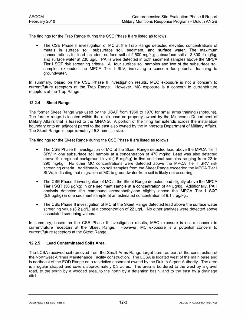
AECOM Comprehensive Site Evaluation Phase II Report February 2010 Military Munitions Response Program – Duluth ANGB
Duluth ANGB Final CSE Phase II 12-3 AECOM PROJECT NO. 106177.05
The findings for the Trap Range during the CSE Phase II are listed as follows:
The CSE Phase II investigation of MC at the Trap Range detected elevated concentrations of metals in surface soil, subsurface soil, sediment, and surface water. The maximum concentrations for lead included: surface soil at 2,500 mg/kg; subsurface soil at 3,800 J mg/kg; and surface water at 230 µg/L. PAHs were detected in both sediment samples above the MPCA Tier I SQT risk screening criteria. All four surface soil samples and two of the subsurface soil samples exceeded the MPCA Tier I SLV, indicating a concern for potential leaching to groundwater.
In summary, based on the CSE Phase II investigation results, MEC exposure is not a concern to current/future receptors at the Trap Range. However, MC exposure is a concern to current/future receptors at the Trap Range.
12.2.4 Skeet Range
The former Skeet Range was used by the USAF from 1960 to 1970 for small arms training (shotguns). The former range is located within the main base on property owned by the Minnesota Department of Military Affairs that is leased to the MNANG. A portion of the firing fan extends across the installation boundary onto an adjacent parcel to the east also owned by the Minnesota Department of Military Affairs. The Skeet Range is approximately 15.3 acres in size.
The findings for the Skeet Range during the CSE Phase II are listed as follows:
The CSE Phase II investigation of MC at the Skeet Range detected lead above the MPCA Tier I SRV in one subsurface soil sample at a concentration of 470 mg/kg. Lead was also detected above the regional background level (15 mg/kg) in five additional samples ranging from 22 to 290 mg/kg. No other MC concentrations were detected above the MPCA Tier I SRV risk screening criteria. Additionally, no soil samples from the Skeet Range exceeded the MPCA Tier I SLVs, indicating that migration of MC to groundwater from soil is likely not occurring.
The CSE Phase II investigation of MC at the Skeet Range detected lead slightly above the MPCA Tier I SQT (36 µg/kg) in one sediment sample at a concentration of 44 µg/kg. Additionally, PAH analysis detected the compound acenaphethylene slightly above the MPCA Tier I SQT (5.9 µg/kg) in one sediment sample at an estimated concentration of 9.1 J µg/kg,.
The CSE Phase II investigation of MC at the Skeet Range detected lead above the surface water screening value (3.2 µg/L) at a concentration of 22 µg/L. No other analytes were detected above associated screening values.
In summary, based on the CSE Phase II investigation results, MEC exposure is not a concern to current/future receptors at the Skeet Range. However, MC exposure is a potential concern to current/future receptors at the Skeet Range.
12.2.5 Lead Contaminated Soils Area
The LCSA received soil removed from the Small Arms Range target berm as part of the construction of the Northwest Airlines Maintenance Facility construction. The LCSA is located west of the main base and is northeast of the EOD Range on a restrictive easement owned by the Duluth Airport Authority. The area is irregular shaped and covers approximately 0.3 acres. The area is bordered to the west by a gravel road, to the south by a wooded area, to the north by a detention basin, and to the east by a drainage ditch.

AECOM Comprehensive Site Evaluation Phase II Report February 2010 Military Munitions Response Program – Duluth ANGB
Duluth ANGB Final CSE Phase II 12-4 AECOM PROJECT NO. 106177.05
The findings for the LCSA during the CSE Phase II are listed as follows:
The CSE Phase II investigation of MC at the LCSA detected arsenic, Cu, iron and lead above MPCA Tier I SRVs in one or more soil samples obtained from the LCSA soil piles. No metals were detected at concentrations above MPCA Tier I SRVs in subsurface native soil immediately below the LCSA soil piles. These results suggest that the metals contamination is confined within the LCSA surface soil piles above the plastic sheeting which may be acting as a barrier to migration.
The CSE Phase II investigation of MC at the LCSA detected only low concentrations of metals below screening criteria in nearby sediment or surface water samples.
In summary, based on the CSE Phase II investigation results, MEC exposure is not a concern to current/future receptors at the LCSA. However, MC exposure is a potential concern to current/future receptors at the LCSA.
12.3 Assessment of Potential Munitions Constituent Releases
Based on the CSE Phase II sampling results at the Trap Range and Skeet Range, MC concentrations in soil, sediment, and surface water are above screening criteria. Exposure pathways are considered complete for soil (surface and subsurface), sediment, and surface water, and potentially complete for groundwater. Potential human receptors include current/future workers, recreational users, and residents. Ecological receptors include plants, invertebrates, herbivores, omnivores, and carnivores.
Based on the CSE Phase II sampling results at the LCSA, MC concentrations in surface soil piles are above screening criteria. Exposure pathways are considered complete for surface soil piles and incomplete for subsurface soil, sediment, surface water, and groundwater media. Potential human receptors include current/future workers, recreational users, and residents. Ecological receptors include plants, invertebrates, herbivores, omnivores, and carnivores.
Based on CSE Phase II sampling results at the Small Arms Range and EOD Range, MC concentrations in soil are below screening criteria; therefore, exposure pathways are considered incomplete for soil and groundwater.
12.4 Summary of the Munitions Response Site Prioritization Protocol
The results of the MRSPP assessment of each MRA presented in Section 10 is summarized as follows (Note: MRS Priority ranges from 1 to 8. Priority 1 indicates the highest potential hazard and Priority 8 indicates the lowest potential hazard):
Priority 3
TS737: Trap Range
As shown in Table 10-3, the Trap Range scored a MRSPP priority of 3. This score is primarily due to metals and PAH concentrations in surface water and sediment exceeding the MRSPP ecological screening values at the MRA.
TS738: Skeet Range
As shown in Table 10-3, the Skeet Range also scored a MRSPP priority of 3. This score is primarily due to the metals and PAH concentrations in surface water exceeding the MRSPP ecological screening values at the MRA.

AECOM Comprehensive Site Evaluation Phase II Report February 2010 Military Munitions Response Program – Duluth ANGB
Duluth ANGB Final CSE Phase II 12-5 AECOM PROJECT NO. 106177.05
Priority 5
SR502: EOD Range
As shown in Table 10-3, the EOD Range scored a MRSPP priority of 5 primarily due to the potential for buried MEC. Buried MEC has the potential for exposure to receptors at the ground surface through naturally occurring processes including erosion and frost heave, or through excavation by workers.
Priority 6
SR739: Lead Contaminated Soils Area
As shown in Table 10-3, the LCSA scored a MRSPP priority of 6. This score is primarily due to the metals concentrations in the soil piles exceeding the MRSPP soil screening values at the MRA.
Priority 7
SR736: Small Arms Range
As shown in Table 10-3, the Small Arms Range scored the lowest MRSPP priority of 7. This low score is primarily due to only low MC concentrations being detected at the MRA.

AECOM Comprehensive Site Evaluation Phase II Report February 2010 Military Munitions Response Program – Duluth ANGB
Duluth ANGB Final CSE Phase II 12-6 AECOM PROJECT NO. 106177.05
This page intentionally left blank.

AECOM Comprehensive Site Evaluation Phase II Report February 2010 Military Munitions Response Program – Duluth ANGB
Duluth ANGB Final CSE Phase II 13-1 AECOM PROJECT NO. 106177.05
13.0 RECOMMENDATIONS
This section presents the recommendations for future investigation and/or action at the Duluth ANGB MRAs. Sites in which no MEC or MC concerns were identified are recommended for no further action (NFA).
13.1 Cohort Assignments
To comply with USAF Knowledge Driven/Performance-based Management initiative, MRAs are subdivided into seven “cohorts.” The assignment of MRAs to different cohorts supports the streamlining of the restoration process, including the development and implementation of munitions response actions for specific cohort types. The cohort type will be reflected in the site description in AFRIMS. The seven USAF MMRP cohorts are shown in Table 13-1.
Table 13-1: Air Force MMRP Cohort Assignments
Cohort Description
A Small Arms Ranges
B Boresight Ranges
C Explosive Ordnance Disposal (EOD) Ranges
D Open Burn/Open Detonation (OB/OD) Sites
E Chemical Warfare Materiel (CWM) Sites
F Pyrotechnic/Practice Sites
G All Other Sites
As the USAF MMRP evolves, the cohort assignments may be expanded or consolidated to reflect what has been learned about the MRA. In implementation of the CSE Phase II, the cohort type was defined by the range-type as designated in documentation. The cohort assignment will be further refined based on field investigation in future phases. Any MRA with a site description of “multi-use” in AFRIMS shall be assigned a site description that reflects a specific cohort. The site description shall be revised to the range-type designated in documentation. Reassignments of cohort or site descriptions may be required in the future and will be based on the types of munitions found during fieldwork. A description of each of the cohort types follows.
13.1.1 Small Arms Ranges
Small arms ranges include those sites where ammunition of .50 caliber or less and no longer than 4 inches is fired from rifles, shotguns, pistols, and machine guns. Small arms ranges include Pistol Ranges; Rifle Ranges; and Skeet and Trap Ranges. The primary impacts at small arms ranges are due to spent cartridges and clay target debris (in the case of skeet and trap ranges). The primary MC associated with small arms ranges are heavy metals, primarily lead, and PAHs associated with the coal tar binding material in the clay targets used at skeet and trap ranges. As a result, small arms ranges are not anticipated to present explosive hazards (i.e., unexploded ordnance [UXO], discarded military munitions, explosive soils) or MC associated with high explosive (i.e., TNT, RDX, HMX, etc.).

AECOM Comprehensive Site Evaluation Phase II Report February 2010 Military Munitions Response Program – Duluth ANGB
Duluth ANGB Final CSE Phase II 13-2 AECOM PROJECT NO. 106177.05
13.1.2 Boresight Ranges
Boresight ranges were used to align the fixed machine guns or cannon on an airplane, so that the rounds would impact at a desired point in front of the aircraft. The specific types of MEC and MC likely to be encountered are a function of the types of aircraft and armaments tested at the ranges. If the range was used to align aircraft-mounted machine guns, then it is anticipated that munitions of .50 calibers or less (i.e., small arms) would be present. If the range was used to align aerial cannon, then it is anticipated that munitions of 20mm or larger would be present.
13.1.3 Open Burn/Open Detonation Sites/Explosive Ordnance Disposal Ranges
OB/OD operations are used to destroy excess, obsolete, or unserviceable munitions and energetic materials. In OB operations, munitions are destroyed by self-sustained combustion that is ignited by an external source, such as flame, heat, or a detonation wave. In OD operations, detonatable explosives and munitions are destroyed by the detonation of an energetic charge. MEC and MC encountered at OB/OD sites are a function of the past disposal practices during the operational lifecycle of the site. MC commonly detected at former OB/OD sites include incompletely combusted explosives (i.e., TNT, RDX, HMX, and pentaerythritol tetranitrate [PETN]) and metals.
EOD ranges are areas that were used for the training of EOD unit personnel and/or for the disposal of MEC items by EOD personnel. MEC and MC encountered at EOD ranges are a function of the training activities and/or disposal operations conducted during the operational life cycle of the ranges.
13.1.4 Chemical Warfare Material Sites
CWM sites present unique challenges not encountered at sites within other MMRP cohorts. In addition to the explosive hazards posed by conventional MEC, CWM presents significant acute toxicity risks to human health, due to its chemical or biological filler (i.e., mustard gas, VX nerve agent, etc.). When CWM is present or suspected to be present at an MRA, explosive hazards are addressed and mitigated first, followed by non-stockpile CWM hazards. The U.S. Army has performed extensive testing and research determining the appropriate course of action for remediation of CWM sites.
13.1.5 Pyrotechnic/Practice Ordnance Sites
Pyrotechnics are used to send signals, illuminate areas, simulate weapons during training, and as ignition elements for some weapons. Pyrotechnics consist of a wide range of materials that, when combined, produce the desired effects of specific time delays, heat, noise, smoke, light or infrared radiation. Practice ordnance is used to simulate the weight and flight characteristics of an actual weapon. Practice ordnance usually carries a small spotting charge (i.e., black powder) to allow observers to assess the accuracy of impact. MEC and MC encountered at pyrotechnic/practice sites include, but are not limited to, practice bombs, various metals (aluminum, iron, and zinc), white phosphorous, and perchlorate.
13.1.6 Munitions Constituents Sites
This cohort includes MRAs where the presence of MC is likely, but MEC are not anticipated to be encountered. MC may include metals, explosives, propellants, pyrotechnic chemicals, and the intermediate compounds that result from environmental degradation of the munitions fillers. The type of MC encountered at an MRA is a function of past MEC usage, storage, and disposal practices. The likelihood of the potential presence or absence of MEC is confirmed during the CSE through historical records reviews, visual surveys, interviews, and geophysical surveys.

AECOM Comprehensive Site Evaluation Phase II Report February 2010 Military Munitions Response Program – Duluth ANGB
Duluth ANGB Final CSE Phase II 13-3 AECOM PROJECT NO. 106177.05
13.1.7 All Other Sites
This generic category was created due to the large number of sites within the USAF MMRP that either could not be placed under any of the other six cohort types, or for which sufficient information was not readily available to allow an accurate classification. After completing the CSE investigations, the USAF may choose to move certain MRAs from within this cohort type into one of the other six cohort types. Alternatively, the USAF may seek to expand its MMRP cohorts to include the following types of MRAs:
Bombing Ranges;
Air-to-Air Ranges;
Air-to-Ground Ranges;
Artillery Ranges;
Missile Ranges;
Medium Caliber Ranges;
Large Caliber Ranges;
Aerial Rocket Ranges; and
Munitions Storage Facilities.
With the exception of munitions storage facilities, the categories listed above primarily include those sites where ammunition of greater than .50 caliber and other ordnance types (i.e., bombs, missiles, rockets, projectiles, etc.) have been fired, launched, or dropped.
13.1.8 Propellants
Propellants are explosives that can be used to provide controlled propulsion for projectiles, including bullets, mortar rounds, artillery rounds, rockets, and missiles. The MC commonly found in propellants include, but are not limited to, 2-4 DNT, 2-6 DNT, nitrocellulose, nitroglycerine, and nitroguanidine. Propellants do not constitute a unique site type, as this class of explosives may be found at sites within all of the MMRP cohorts.
13.1.9 Duluth Air National Guard Base Cohort Assignment
The cohort types assigned to the Duluth ANGB MRAs are as follows:
SR502: EOD Range – C (OB/OD range);
SR736: Small Arms Range – A (small arms range);
TS737: Trap Range – A (small arms range);
TS738: Skeet Range – A (small arms range); and,
SR739: LCSA – F (all other sites).
13.2 Process Streamlining Opportunities
For the EOD Range (SR502) and the LCSA (SR739) where risks from explosive and chemical hazards, respectively, are known and well defined, non-time critical removal actions are recommended to address these hazards through readily available, proven methods. The benefits of using the non-time-critical

AECOM Comprehensive Site Evaluation Phase II Report February 2010 Military Munitions Response Program – Duluth ANGB
Duluth ANGB Final CSE Phase II 13-4 AECOM PROJECT NO. 106177.05
removal action process for these sites includes promptly addressing site risks and accelerating the sites more quickly through the CERCLA response process.
13.3 Additional Munitions Response Sites (Splitting the Munitions Response Area)
Based on information gathered during the CSE Phase II and depending on site-specific factors, each MRA may be designated as a single MRS, or it may be subdivided for the purposes of evaluation and response into multiple MRS. Subdividing MRAs into multiple MRSs may allow for more efficient characterization so that munitions responses specific to local conditions can be conducted.
For the Duluth ANGB MRAs, splitting of the MRA into MRSs is not warranted. Each MRA is considered to be one MRS, equal in acreage to the total MRA.
13.4 Change to the Munitions Response Area/Munitions Response Site Footprint
No change to the footprint of the Duluth ANGB MRAs is recommended.
13.5 Future Response Actions and Objectives
For the Small Arms Range (SR736) where impacts from MEC and MC were not observed, NFA is recommended. Documentation of an NFA decision should be obtained.
For the EOD Range (SR502) where potential subsurface MEC was identified, and the LCSA (SR739) where lead contaminated soils are present, non-time critical removal actions are recommended. For the EOD Range, potential subsurface MEC identified by geophysical mapping should be intrusively investigated and MEC treated or disposed according to DOD regulations and regulatory guidelines. For the LCSA, the surface soil piles should be removed and disposed according to regulatory guidelines. An Engineering Evaluation/Cost Analysis, Action Memorandum, Work Plan, and Completion Report should be prepared for these sites. Additionally, an ESS is required for a MEC removal action at the EOD Range.
For the Trap Range (TS737) and Skeet Range (TS738), additional investigation activities are warranted due to elevated MC constituents identified in surface soil, subsurface soil, surface water, and sediment. It is recommended that these sites proceed to a remedial investigation (RI) to complete the characterization of the nature and extent of site contamination.
A summary of the results and recommendations for the Duluth ANGB MRAs from the CSE Phase II is presented as Table 13-2.
13.6 Identify Gaps in Conceptual Site Model
The CSMs for Small Arms Range and LCSA MRAs at Duluth ANGB are well defined. For the EOD Range, potential subsurface MEC identified by geophysical mapping should be intrusively investigated in a non-time critical removal action, and the CSM updated. For the Trap Range and Skeet Range, additional investigation activities are warranted to refine the extent of contamination in the CSM due to elevated MC constituents identified in surface soil, subsurface soil, surface water, and sediment.
13.7 Department of Defense Munitions Response Site Prioritization Protocol
The DoD MSRPP Priorities for the Duluth ANGB MRAs are presented in Table 10-3.
13.8 Site Sequencing Considerations
There are no unusual site sequencing considerations at Duluth ANGB.
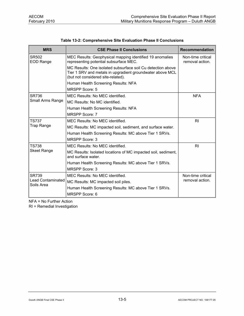
AECOM Comprehensive Site Evaluation Phase II Report February 2010 Military Munitions Response Program – Duluth ANGB
Duluth ANGB Final CSE Phase II 13-5 AECOM PROJECT NO. 106177.05
Table 13-2: Comprehensive Site Evaluation Phase II Conclusions
MRS CSE Phase II Conclusions Recommendation
SR502 EOD Range
MEC Results: Geophysical mapping identified 19 anomalies representing potential subsurface MEC.
MC Results: One isolated subsurface soil Cu detection above Tier 1 SRV and metals in upgradient groundwater above MCL (but not considered site-related).
Human Health Screening Results: NFA
MRSPP Score: 5
Non-time critical removal action.
SR736 Small Arms Range
MEC Results: No MEC identified.
MC Results: No MC identified.
Human Health Screening Results: NFA
MRSPP Score: 7
NFA
TS737 Trap Range
MEC Results: No MEC identified.
MC Results: MC impacted soil, sediment, and surface water.
Human Health Screening Results: MC above Tier 1 SRVs.
MRSPP Score: 3
RI
TS738 Skeet Range
MEC Results: No MEC identified.
MC Results: Isolated locations of MC impacted soil, sediment, and surface water.
Human Health Screening Results: MC above Tier 1 SRVs.
MRSPP Score: 3
RI
SR739 Lead Contaminated Soils Area
MEC Results: No MEC identified.
MC Results: MC impacted soil piles.
Human Health Screening Results: MC above Tier 1 SRVs.
MRSPP Score: 6
Non-time critical removal action.
NFA = No Further Action
RI = Remedial Investigation

AECOM Comprehensive Site Evaluation Phase II Report February 2010 Military Munitions Response Program – Duluth ANGB
Duluth ANGB Final CSE Phase II 13-6 AECOM PROJECT NO. 106177.05
This page intentionally left blank.

Appendix A: Definitions

This page intentionally left blank.
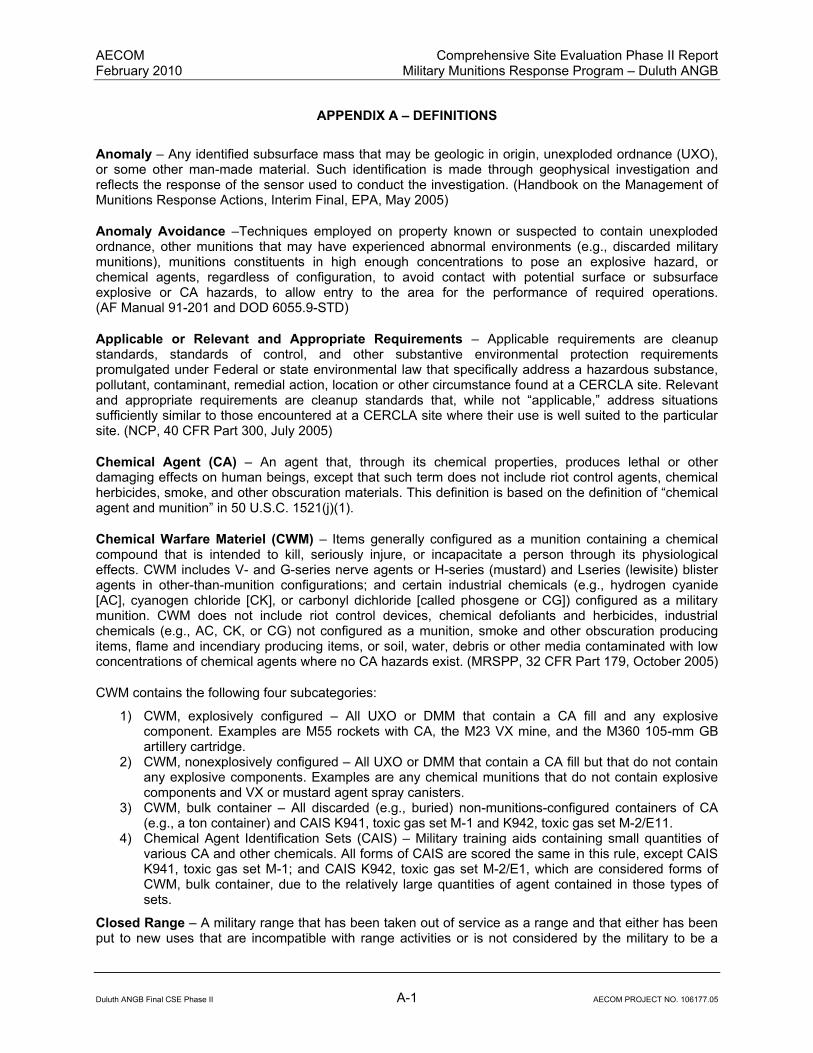
AECOM Comprehensive Site Evaluation Phase II Report February 2010 Military Munitions Response Program – Duluth ANGB
Duluth ANGB Final CSE Phase II A-1 AECOM PROJECT NO. 106177.05
APPENDIX A – DEFINITIONS
Anomaly – Any identified subsurface mass that may be geologic in origin, unexploded ordnance (UXO), or some other man-made material. Such identification is made through geophysical investigation and reflects the response of the sensor used to conduct the investigation. (Handbook on the Management of Munitions Response Actions, Interim Final, EPA, May 2005)
Anomaly Avoidance –Techniques employed on property known or suspected to contain unexploded ordnance, other munitions that may have experienced abnormal environments (e.g., discarded military munitions), munitions constituents in high enough concentrations to pose an explosive hazard, or chemical agents, regardless of configuration, to avoid contact with potential surface or subsurface explosive or CA hazards, to allow entry to the area for the performance of required operations. (AF Manual 91-201 and DOD 6055.9-STD)
Applicable or Relevant and Appropriate Requirements – Applicable requirements are cleanup standards, standards of control, and other substantive environmental protection requirements promulgated under Federal or state environmental law that specifically address a hazardous substance, pollutant, contaminant, remedial action, location or other circumstance found at a CERCLA site. Relevant and appropriate requirements are cleanup standards that, while not “applicable,” address situations sufficiently similar to those encountered at a CERCLA site where their use is well suited to the particular site. (NCP, 40 CFR Part 300, July 2005)
Chemical Agent (CA) – An agent that, through its chemical properties, produces lethal or other damaging effects on human beings, except that such term does not include riot control agents, chemical herbicides, smoke, and other obscuration materials. This definition is based on the definition of “chemical agent and munition” in 50 U.S.C. 1521(j)(1).
Chemical Warfare Materiel (CWM) – Items generally configured as a munition containing a chemical compound that is intended to kill, seriously injure, or incapacitate a person through its physiological effects. CWM includes V- and G-series nerve agents or H-series (mustard) and Lseries (lewisite) blister agents in other-than-munition configurations; and certain industrial chemicals (e.g., hydrogen cyanide [AC], cyanogen chloride [CK], or carbonyl dichloride [called phosgene or CG]) configured as a military munition. CWM does not include riot control devices, chemical defoliants and herbicides, industrial chemicals (e.g., AC, CK, or CG) not configured as a munition, smoke and other obscuration producing items, flame and incendiary producing items, or soil, water, debris or other media contaminated with low concentrations of chemical agents where no CA hazards exist. (MRSPP, 32 CFR Part 179, October 2005)
CWM contains the following four subcategories:
1) CWM, explosively configured – All UXO or DMM that contain a CA fill and any explosive component. Examples are M55 rockets with CA, the M23 VX mine, and the M360 105-mm GB artillery cartridge.
2) CWM, nonexplosively configured – All UXO or DMM that contain a CA fill but that do not contain any explosive components. Examples are any chemical munitions that do not contain explosive components and VX or mustard agent spray canisters.
3) CWM, bulk container – All discarded (e.g., buried) non-munitions-configured containers of CA (e.g., a ton container) and CAIS K941, toxic gas set M-1 and K942, toxic gas set M-2/E11.
4) Chemical Agent Identification Sets (CAIS) – Military training aids containing small quantities of various CA and other chemicals. All forms of CAIS are scored the same in this rule, except CAIS K941, toxic gas set M-1; and CAIS K942, toxic gas set M-2/E1, which are considered forms of CWM, bulk container, due to the relatively large quantities of agent contained in those types of sets.
Closed Range – A military range that has been taken out of service as a range and that either has been put to new uses that are incompatible with range activities or is not considered by the military to be a

AECOM Comprehensive Site Evaluation Phase II Report February 2010 Military Munitions Response Program – Duluth ANGB
Duluth ANGB Final CSE Phase II A-2 AECOM PROJECT NO. 106177.05
potential range area. A closed range is still under the control of a Component. (MGDERP, September 2001)
Defense Sites – Locations that are or were owned by, leased to, or otherwise possessed or used by the Department of Defense. The term does not include any operational range, operating storage or manufacturing facility, or facility that is used for or was permitted for the treatment or disposal of military munitions. (10 U.S.C. 2710(e)(1))
Department of Defense Components – The Office of the Secretary of Defense (OSD), the Military Departments, the Defense Agencies, the Department Field Activities, and any other Department organizational entity or instrumentality established to perform a government function. (MRSPP, 32 CFR Part 179, October 2005)
Discarded Military Munitions (DMM) – Military munitions that have been abandoned without proper disposal or removed from storage in a military magazine or other storage area for the purpose of disposal. The term does not include unexploded ordnance, military munitions that are being held for future use or planned disposal, or military munitions that have been properly disposed of consistent with applicable environmental laws and regulations. (10 U.S.C. 2710(e)(2))
Explosive Ordnance Disposal (EOD) Personnel – Active duty military personnel of any military service branch that are trained in the detection, identification, field evaluation, safe rendering, recovery, and final disposal of explosive ordnance and of other munitions that have become an imposing danger, for example, by damage or deterioration. (Handbook on the Management of Munitions Response Actions, Interim Final, EPA, May 2005)
Facility – A building, structure, or other improvement to real property, in relation to work classification. (10 U.S.C. 2801)
Formerly Used Defense Sites (FUDS) – Facility or site (property) that was under the jurisdiction of the Secretary of Defense and owned by, leased to, or otherwise possessed by the United States at the time of actions leading to the contamination by hazardous substances. By the DoD Environmental Restoration Program (ERP) policy, the FUDS program is limited to those real properties that were transferred from DoD control prior to 17 October 1986. FUDS properties can be located within the 50 States, District of Columbia, Territories, Commonwealths, and possessions of the United States. (FUDS Program Policy, ER 200 3-1, May 2004)
Hazardous Substance – (A) Any substance designated pursuant to Section 1321(b)(2)(A) of title 33, (B) any element, compound, mixture, solution, or substance designated pursuant to Section 9602 of this title, (C) any hazardous waste having the characteristics identified under or listed pursuant to Section 3001 of the Solid Waste Disposal Act [42 U.S.C. 6921] (but not including any waste the regulation of which under the Solid Waste Disposal Act [42 U.S.C. 6901 et seq.] has been suspended by Act of Congress), (D) any toxic pollutant listed under section 1317(a) of title 33, (E) any hazardous air pollutant listed under Section 112 of the Clean Air Act [42 U.S.C. 7412], and (F) any imminently hazardous chemical substance or mixture with respect to which the Administrator has taken action pursuant to Section 2606 of Title 15. The term does not include petroleum, including crude oil or any fraction thereof, which is not otherwise specifically listed or designated as a hazardous substance under subparagraphs (A) through (F) of this paragraph, and the term does not include natural gas, natural gas liquids, liquefied natural gas, or synthetic gas usable for fuel (or mixtures of natural gas and such synthetic gas). (CERCLA, 42 U.S.C. § 9601 et seq.)
Installation (as defined by the RMIS Data Element Dictionary for a Federal Facility Identification [FFID]) – The FFID number is a unique identifier, assigned to an installation/property in RMIS. The 14-character aggregate string is used in RMIS as the key column for each data table and is used to track all associated records for each installation. An installation may have a single range or multiple ranges (and each range may have more than one site contained within its boundaries) and a single or multiple sites, not
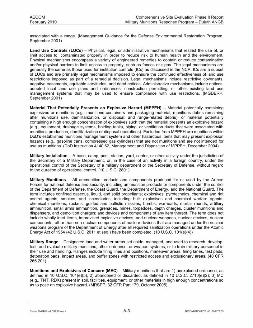
AECOM Comprehensive Site Evaluation Phase II Report February 2010 Military Munitions Response Program – Duluth ANGB
Duluth ANGB Final CSE Phase II A-3 AECOM PROJECT NO. 106177.05
associated with a range. (Management Guidance for the Defense Environmental Restoration Program, September 2001)
Land Use Controls (LUCs) – Physical, legal, or administrative mechanisms that restrict the use of, or limit access to, contaminated property in order to reduce risk to human health and the environment. Physical mechanisms encompass a variety of engineered remedies to contain or reduce contamination and/or physical barriers to limit access to property, such as fences or signs. The legal mechanisms are generally the same as those used for institution controls (ICs) as discussed in the NCP. ICs are a subset of LUCs and are primarily legal mechanisms imposed to ensure the continued effectiveness of land use restrictions imposed as part of a remedial decision. Legal mechanisms include restrictive covenants, negative easements, equitable servitudes, and deed notices. Administrative mechanisms include notices, adopted local land use plans and ordinances, construction permitting, or other existing land use management systems that may be used to ensure compliance with use restrictions. (MGDERP, September 2001)
Material That Potentially Presents an Explosive Hazard (MPPEH) – Material potentially containing explosives or munitions (e.g., munitions containers and packaging material; munitions debris remaining after munitions use, demilitarization, or disposal; and range-related debris), or material potentially containing a high enough concentration of explosives such that the material presents an explosive hazard (e.g., equipment, drainage systems, holding tanks, piping, or ventilation ducts that were associated with munitions production, demilitarization or disposal operations). Excluded from MPPEH are munitions within DoD’s established munitions management system and other hazardous items that may present explosion hazards (e.g., gasoline cans, compressed gas cylinders) that are not munitions and are not intended for use as munitions. (DoD Instruction 4140.62, Management and Disposition of MPPEH, December 2004)
Military Installation – A base, camp, post, station, yard, center, or other activity under the jurisdiction of the Secretary of a Military Department, or, in the case of an activity in a foreign country, under the operational control of the Secretary of a military department or the Secretary of Defense, without regard to the duration of operational control. (10 U.S.C. 2801)
Military Munitions – All ammunition products and components produced for or used by the Armed Forces for national defense and security, including ammunition products or components under the control of the Department of Defense, the Coast Guard, the Department of Energy, and the National Guard. The term includes confined gaseous, liquid, and solid propellants; explosives, pyrotechnics, chemical and riot control agents, smokes, and incendiaries, including bulk explosives and chemical warfare agents; chemical munitions, rockets, guided and ballistic missiles, bombs, warheads, mortar rounds, artillery ammunition, small arms ammunition, grenades, mines, torpedoes, depth charges, cluster munitions and dispensers, and demolition charges; and devices and components of any item thereof. The term does not include wholly inert items, improvised explosive devices, and nuclear weapons, nuclear devices, nuclear components, other than non-nuclear components of nuclear devices that are managed under the nuclear weapons program of the Department of Energy after all required sanitization operations under the Atomic Energy Act of 1954 (42 U.S.C. 2011 et seq.) have been completed. (10 U.S.C. 101(e)(4))
Military Range – Designated land and water areas set aside, managed, and used to research, develop, test, and evaluate military munitions, other ordnance, or weapon systems, or to train military personnel in their use and handling. Ranges include firing lines and positions, maneuver areas, firing lanes, test pads, detonation pads, impact areas, and buffer zones with restricted access and exclusionary areas. (40 CFR 266.201)
Munitions and Explosives of Concern (MEC) – Military munitions that are 1) unexploded ordnance, as defined in 10 U.S.C. 101(e)(5); 2) abandoned or discarded, as defined in 10 U.S.C. 2710(e)(2); 3) MC (e.g., TNT, RDX) present in soil, facilities, equipment, or other materials in high enough concentrations so as to pose an explosive hazard. (MRSPP, 32 CFR Part 179, October 2005)

AECOM Comprehensive Site Evaluation Phase II Report February 2010 Military Munitions Response Program – Duluth ANGB
Duluth ANGB Final CSE Phase II A-4 AECOM PROJECT NO. 106177.05
Munitions Constituent (MC) – Any material that originates from UXO, DMM, or other military munitions, including explosive and non-explosive materials, and emission, degradation, or breakdown elements of such ordnance or munitions. (10 U.S.C. 2710(e)(4))
Munitions Debris – Remnants of munitions (e.g., fragments, penetrators, projectiles, shell casings, links, fins) remaining after munitions use, demilitarization, or disposal. (DoD 6055.9- STD)
Munitions Response – Response actions, including investigation, removal actions, and remedial actions, to address the explosives safety, human health, or environmental risks presented by UXO, DMM, or MC or to support a determination that no removal or remedial action is required. (MRSPP, 32 CFR Part 179, October 2005)
Munitions Response Area (MRA) – Any area on a defense site that is known or suspected to contain UXO, DMM, or MC. Examples include former ranges and munitions burial areas. A munitions response area is comprised of one or more munitions response sites. (MRSPP, 32 CFR Part 179, October 2005)
Munitions Response Site (MRS) – A discrete location within an MRA that is known to require a munitions response. (MRSPP, 32 CFR Part 179, October 2005)
Operational Range – A range that is under the jurisdiction, custody, or control of the Secretary of Defense and that is used for range activities, or although not currently being used for range activities, that is still considered by the Secretary to be a range and has not been put to a new use that is incompatible with range activities. (10 U.S.C. 101(e)(3))
Outlier – An outlier is an observation that lies an abnormal distance from other values in a random sample from a population. In a sense, this definition leaves it up to the analyst (or a consensus process) to decide what will be considered abnormal. Before abnormal observations can be singled out, it is necessary to characterize normal observations.
Pollutant and Contaminant – These terms include, but are not be limited to, any element, substance, compound, or mixture, including disease-causing agents, which after release into the environment and upon exposure, ingestion, inhalation, or assimilation into any organism, either directly from the environment or indirectly by ingestion through food chains, will or may reasonably be anticipated to cause death, disease, behavioral abnormalities, cancer, genetic mutation, physiological malfunctions (including malfunctions in reproduction) or physical deformations, in such organisms or their offspring; except that the term pollutant or contaminant shall not include petroleum, including crude oil or any fraction thereof which is not otherwise specifically listed or designated as a hazardous substance under subparagraphs (A) through (F) of paragraph (14) and shall not include natural gas, liquefied natural gas, or synthetic gas of pipeline quality (or mixtures of natural gas and such synthetic gas). (CERCLA, 42 U.S.C. § 9601 et seq)
Range Activities – Research, development, testing, and evaluation of military munitions, other ordnance, and weapons systems; and the training of members of the Armed Forces in the use and handling of military munitions, other ordnance, and weapons systems. (10 U.S.C. 101(3)(2))
Range-Related Debris – Debris, other than munitions debris, collected from operational ranges or from former ranges (e.g., targets, military munitions packaging and crating material) . (DoD 6055.9-STD)
Range Residue – Material, including but not limited to, parts and sections of practice bombs, artillery, small arms, mortars, projectiles, bombs, missiles, rockets, rocket mortars, targets, grenades, incendiary devices, experimental items, demolition devices, and any other material fired on or discovered on a range. (AFI 13-212, Range Planning and Operations, August 2001)
AECOM Comprehensive Site Evaluation Phase II Report February 2010 Military Munitions Response Program – Duluth ANGB
Duluth ANGB Final CSE Phase II A-5 AECOM PROJECT NO. 106177.05
Real Property – Real estate owned by the United States and under the control of the DoD. Includes lands, buildings, structures, utilities systems, improvements and appurtenances thereto. Includes equipment attached to and made part of buildings and structures (such as heating systems) but not moveable equipment (such as plant equipment). (MGDERP, September 2001)
Relative Risk – The evaluation of individual sites to determine high, medium, or low relative risk to human health and the environment, based on contaminant hazards, migration pathways and receptors, in accordance with the DoD's Risk-Based Site Evaluation Primer. (MGDERP, September 2001)
Removal – The cleanup or removal of released hazardous substances from the environment. Such actions may be taken in the event of the threat of release of hazardous substances into the environment, such actions as may be necessary to monitor, assess, and evaluate the release or threat of release of hazardous substances, the disposal of removed material, or the taking of such other actions as may be necessary to prevent, minimize, or mitigate damage to the public health or welfare or to the environment, which may otherwise result from a release or threat of release. The term includes, in addition, without being limited to, security fencing or other measures to limit access, provision of alternative water supplies, temporary evacuation and housing of threatened individuals not otherwise provided for, action taken under Section 9604(b) of this title, and any emergency assistance which may be provided under the Disaster Relief and Emergency Assistance Act [42 U.S.C. 5121 et seq.] The requirements for removal actions are addressed in 40 CFR §§300.410 and 300.415. The three types of removals are emergency, timecritical, and non-time critical removals. (CERCLA, 42 U.S.C. § 9601 et seq.) There are three types of removals:
1) Emergency – Emergency removal or response is performed when an immediate or imminent danger to public health or the environment is present and action is required within hours. Trained responders identify the explosive threat and make the decision as to whether the munitions and explosive of concern should be moved or blown in place and ensure the threat is removed safely and expeditiously.
2) Time-critical – A response to a release or threat of release that poses such a risk to public health (serious injury or death), or the environment, that cleanup or stabilization actions must be initiated within six months.
3) Non-time critical – An action initiated in response to a release or threat of a release that poses a risk to human health and welfare, or the environment. Initiation of removal cleanup actions may be delayed for six months or more.
Risk Reduction – The movement of any site from a higher to lower relative risk category as a result of natural attenuation, interim remedial, remedial, or removal actions taken. (DoD Instruction 4715.7, Environmental Restoration Program, April 1996)
Site (as defined in the Restoration Management Information System Data Element Dictionary for a SITE_ID) – A unique name given to a distinct area of an installation containing one or more releases or threatened releases of hazardous substances treated as a discreet entity or consolidated grouping for response purposes. Includes any building, structure, impoundment, landfill, storage container, or other site or area where a hazardous substance was or has come to be located, including formerly used sites eligible for building demolition/debris removal. Installations and ranges may have more than one site. (MGDERP, September 2001)
Stakeholder – Groups or individuals who were interested in, concerned about, affected by, who had a vested interest in, or would be involved in the munitions response at an MRA/MRS.
Transferred Range – A property formerly used as a military range that is no longer under military control and had been leased by the DoD, transferred, or returned from the DoD to another entity, including federal entities. This includes a military range that is no longer under military control but was used under the terms of a withdrawal, executive order, special-use permit or authorization, right-of-way, public land order, or other instrument issued by the federal land manager. (MGDERP, September 2001)

AECOM Comprehensive Site Evaluation Phase II Report February 2010 Military Munitions Response Program – Duluth ANGB
Duluth ANGB Final CSE Phase II A-6 AECOM PROJECT NO. 106177.05
Transferring Range – A military range that is proposed to be transferred or returned from the DoD to another entity, including federal entities. This includes a military range that is used under the terms of a withdrawal, executive order, act of Congress, public land order, special-use permit or authorization, right-of-way, or other instrument issued by the federal land manager or property owner. An operational or closed range will not be considered a “transferring range” until the transfer is imminent. (MGDERP, September 2001)
Unexploded Ordnance (UXO) – Military munitions that have been primed, fuzed, armed, or otherwise prepared for action and have been fired, dropped, launched, projected, or placed in such a manner as to constitute a hazard to operations, installations, personnel, or material, and remain unexploded either by malfunction, design, or any other cause. (10 U.S.C. 101(e)(5))
UXO Technicians – Personnel who are qualified for and filling Department of Labor, Service Contract Act, Directory of Occupations, contractor positions of UXO Technician I, UXO Technician II, and UXO Technician III. (Department of Defense Explosive Safety Board TP18, December 2004)

Appendix B: Acronyms and Abbreviations

This page intentionally left blank.

AECOM Comprehensive Site Evaluation Phase II Report February 2010 Military Munitions Response Program – Duluth ANGB
Duluth ANGB Final CSE Phase II B-1 AECOM PROJECT NO. 106177.05
APPENDIX B – ABREVIATIONS AFLU Anticipated Future Land Use AFRIMS Air Force Restoration Information Management System ANG Air National Guard ANGB Air National Guard Base BaP Benzo(a)pyrene bgs Below Ground Surface CERCLA Comprehensive Environmental Response, Compensation, and Liability Act CHE Chemical Warfare Material Hazard Evaluation CHF Contamination Hazard Factor COC Chain of Custody CSE Comprehensive Site Evaluation CSM Conceptual Site Model CWM Chemical Warfare Material DGM Digital Geophysical Mapping DoD Department of Defense DNB Dinitrobenzene DNT Dinitrotoluene DQO Data Quality Objectives DQR Daily Quality Reports EE/CA Engineering Evaluation/Cost Analysis EHE Explosive Hazard Evaluation EM Environmental Manager EMI Electromagnetic Induction EOD Explosive Ordnance Disposal ESS Explosive Safety Submission FIS Fighter Interceptor Squadron FSP Field Sampling Plan FW Fighter Wing GPS Global Positioning System HE High Explosive HHE Health Hazard Evaluation HRL Health Risk Limit ICSM Interim Conceptual Site Model IRP Installation Restoration Program LCSA Lead Contaminated Soils Area MC Munitions Constituents MCE Maximum Credible Event MCL Maximum Contaminant Level MDH Minnesota Department of Health MDL Method Detection Limit MEC Munitions and Explosives of Concern MGFD Munition with the Greatest Fragmentation Distance mg/kg Milligram per Kilogram

AECOM Comprehensive Site Evaluation Phase II Report February 2010 Military Munitions Response Program – Duluth ANGB
Duluth ANGB Final CSE Phase II B-2 AECOM PROJECT NO. 106177.05
MMRP Military Munitions Response Program MN Minnesota MNANG Minnesota Air National Guard MPF Migration Pathway Factor MR Munitions Rule MRA Munitions Response Area MRL Method Reporting Limit MRS Munitions Response Site MRSPP Munitions Response Site Prioritization Protocol msl Mean Sea Level NCP National Oil and Hazardous Substances Pollution Contingency Plan NFA No Further Action NGB National Guard Bureau NOAA National Oceanic and Atmospheric Administration NTCRA Non-Time Critical Removal Action PA Preliminary Assessment PAH Polycyclic Aromatic Hydrocarbon PDT Project Delivery Team PE Professional Engineer PEL Probable Effects Level PM Project Manager ppm Parts Per Million PRG Preliminary Remediation Goals QA/QC Quality Assurance/Quality Control QAPP Quality Assurance Project Plan RACER Remedial Action Cost Engineering Requirements RF Receptor Factor RI/FS Remedial Investigation/Feasibility Study RRSE Relative Risk Site Evaluation SAFR Small Arms Firing Range SAP Sampling and Analysis Plan S&H Safety & Health SI Site Inspection SLV Soil Leaching Value SOW Scope of Work SQT Sediment Quality Target SRV Soil Reference Value SSHSP Site Specific Health and Safety Plan TCL Target Compound List TNB Trinitrobenzene TNT Trinitrotoluene TO Task Order URS URS Group, Inc. USACE United States Army Corps of Engineers USAF United States Air Force USEPA United States Environmental Protection Agency USFWS United States Fish and Wildlife Service

AECOM Comprehensive Site Evaluation Phase II Report February 2010 Military Munitions Response Program – Duluth ANGB
Duluth ANGB Final CSE Phase II B-3 AECOM PROJECT NO. 106177.05
UXO Unexploded Ordnance UXOSO Unexploded Ordnance Safety Officer UXOTIII Unexploded Ordnance Technician III WP Work Plan WPA Works Project Administration XRF X-Ray Fluorescence

AECOM Comprehensive Site Evaluation Phase II Report February 2010 Military Munitions Response Program – Duluth ANGB
Duluth ANGB Final CSE Phase II B-4 AECOM PROJECT NO. 106177.05
This page intentionally left blank.

Appendix C: References

This page intentionally left blank.
AECOM Comprehensive Site Evaluation Phase II Report February 2010 Military Munitions Response Program – Duluth ANGB
Duluth ANGB Final CSE Phase II C-1 AECOM PROJECT NO. 106177.05
APPENDIX C – REFERENCES
AECOM, 2008. Final Work Plan for CSE Phase II, Duluth ANGB, Duluth, Minnesota. December 2008.
Anderson, J.L., J.C. Bell, T.H. Cooper, and D.F. Grigal, 2001. Soils and Landscapes of Minnesota. University of Minnesota Extension Service. Minneapolis, MN. http://www.extension.umn.edu/distribution/cropsystems/DC2331.html.
Buchman, M.F., 2008. NOAA Screening Quick Reference Tables, NOAA OR&R Report 08-1, Seattle, WA, Office of Response and Restoration Division, National Oceanic and Atmospheric Administration, 34 pages.
Crane, et al., 2007. Guidance for the Use and Application of Sediment Quality Targets for the Protection of Sediment-Dwelling Organisms in Minnesota. Minnesota Pollution Control Agency. February 2007.
ITRC, 2003. Characterization and Remediation of Soils at Closed Small Arms Firing Ranges. Technical/Regulatory Guidelines, Interstate Technology and Regulatory Council Small Arms Firing Range Team. January 2003.
MDH, 2007. Health Risk Limits. Minnesota Department of Health. http://www.health.state.mn.us/divs/eh/ groundwater/hrltable.html.
Mooers, Howard D.1, Wattrus, Nigel J.2, and Mossberger, Irvin G.1, (1) Geological Sciences, University of Minnesota, 230 Heller Hall, 1114 Kirby Drive, Duluth, MN 55812, [email protected], (2) Large Lakes Observatory and Department of Geological Sciences, University of Minnesota, 203 Research Laboratory Building, 10 University Drive, Duluth, MN 55812 http://gsa.confex.com/gsa/2005AM/finalprogram/abstract_95344.htm.
Morey and Meints, 2000. Geologic Map of Minnesota, Bedrock Geology. Duluth Streams. http://duluthstreams.org/understanding/mn_geology_map.pdf.
MPCA, 1999. Draft Guidelines; Risk-Based Guidance for the Soil-Human Health Pathway Volume 2. Technical Support Document. Minnesota Pollution Control Agency, Site Remediation Section, January 1999 (Tables updated 2007).
MPCA, 2005. Risk Based Guidance for Evaluating the Soil Leaching Pathway. Minnesota Pollution Control Agency, Site Remediation Section. June 2005.
Shacklette, H.T. and Josephine G. Borngen, 1984. Element Concentrations in Soils and Other Surficial Materials of the Conterminous United States. U.S. Geological Survey Professional Paper 1270. U.S. Department of the Interior.
Shaw Environmental, Inc., 2007. New Boston Air Force Station Comprehensive Site Evaluation Revised Draft Final Phase II Report. November 2007.
UMN Climatology Working Group, 2006. Climate of Minnesota. http://www.climate.umn.edu.
URS, 2007. Comprehensive Site Evaluation Phase I, Duluth Air National Guard Base, Minnesota. Prepared for Air National Guard and 148
th Fighter Wing under Contract to U.S. Army Corps of Engineers
Omaha District. July 2007.
USACE, 1998. Technical Project Planning (TPP) Process, EM 200-1-2, U.S. Army Corps of Engineers, August 1998.

AECOM Comprehensive Site Evaluation Phase II Report February 2010 Military Munitions Response Program – Duluth ANGB
Duluth ANGB Final CSE Phase II C-2 AECOM PROJECT NO. 106177.05
USACE, 2001. Requirements for the Preparation of Sampling and Analysis Plans. EM 200-1-3, U.S. Army Corps of Engineers, February 2001.
USACE, 2006. Quality Management ER 1110-1-12, U.S. Army Corps of Engineers, July 2006.
U.S. Air Force, 2006. Air Force Guide for Conducting the Comprehensive Site Evaluation Phase II at Air Force Munitions Response Areas (Version 4.0), U.S. Air Force, October 2006.
U.S. Census Bureau. 2007. St. Louis County, Minnesota Quick Facts, http://quickfacts.census.gov/qfd/states/27/2717000.html. Last accessed January 2009.
USEPA, 2000. Publication QA/G-4, Guidance for the Data Quality Objectives Process.
USEPA, 2003. National Primary Drinking Water Standards. EPA 816-F-03-016. June 2003.
USGS, 1993. Duluth heights, Minnesota, SW/4 Duluth 15’ Quadrangle, 46092-G2-TF-024 (map). United States Department of the Interior Geological Survey. 1953 (rev. 1993).

Appendix D: Analytical Laboratory Data

This page intentionally left blank.

This Appendix is available in the enclosed Report CD.

This page intentionally left blank.

Appendix E: Geophysical Survey Data

This page intentionally left blank.

This Appendix is available in the enclosed Report CD.

This page intentionally left blank.

Appendix F: Ordnance Technical Data Sheets

This page intentionally left blank.

AECOM Comprehensive Site Evaluation Phase II Report February 2010 Military Munitions Response Program – Duluth ANGB
Duluth ANGB Final CSE Phase II F-1 AECOM PROJECT NO. 106177.05

AECOM Comprehensive Site Evaluation Phase II Report February 2010 Military Munitions Response Program – Duluth ANGB
Duluth ANGB Final CSE Phase II F-2 AECOM PROJECT NO. 106177.05

AECOM Comprehensive Site Evaluation Phase II Report February 2010 Military Munitions Response Program – Duluth ANGB
Duluth ANGB Final CSE Phase II F-3 AECOM PROJECT NO. 106177.05

AECOM Comprehensive Site Evaluation Phase II Report February 2010 Military Munitions Response Program – Duluth ANGB
Duluth ANGB Final CSE Phase II F-4 AECOM PROJECT NO. 106177.05

AECOM Comprehensive Site Evaluation Phase II Report February 2010 Military Munitions Response Program – Duluth ANGB
Duluth ANGB Final CSE Phase II F-5 AECOM PROJECT NO. 106177.05

AECOM Comprehensive Site Evaluation Phase II Report February 2010 Military Munitions Response Program – Duluth ANGB
Duluth ANGB Final CSE Phase II F-6 AECOM PROJECT NO. 106177.05
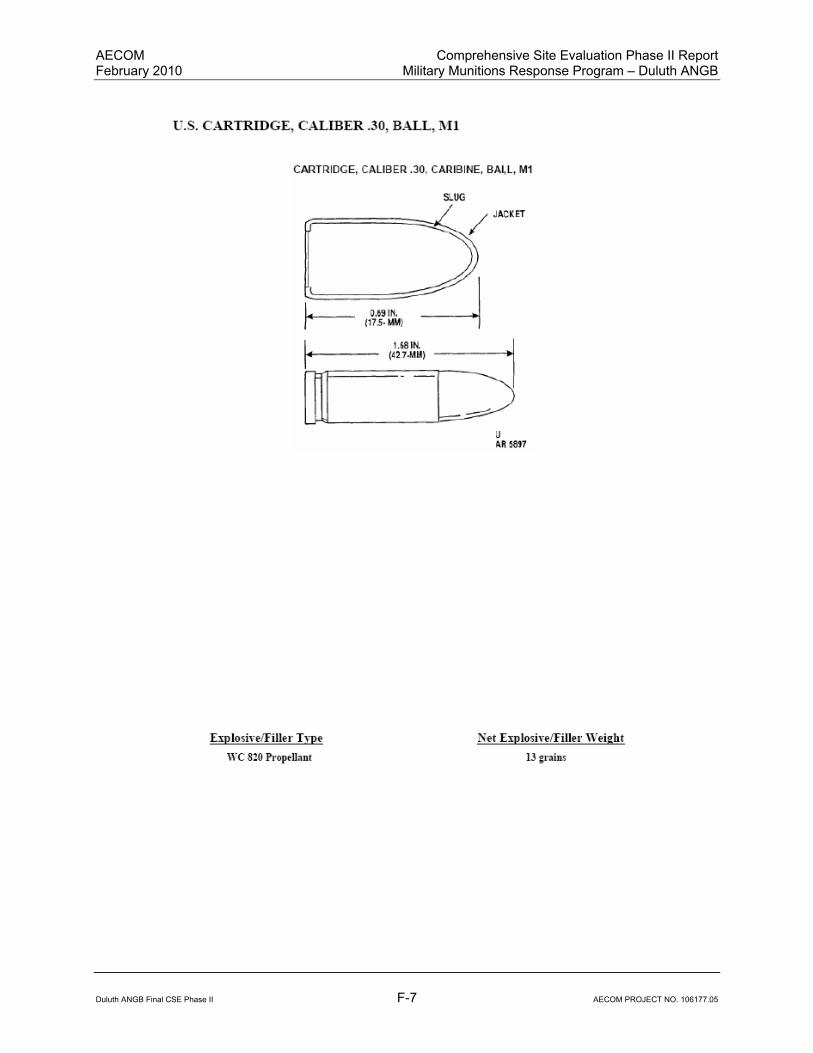
AECOM Comprehensive Site Evaluation Phase II Report February 2010 Military Munitions Response Program – Duluth ANGB
Duluth ANGB Final CSE Phase II F-7 AECOM PROJECT NO. 106177.05

AECOM Comprehensive Site Evaluation Phase II Report February 2010 Military Munitions Response Program – Duluth ANGB
Duluth ANGB Final CSE Phase II F-8 AECOM PROJECT NO. 106177.05

AECOM Comprehensive Site Evaluation Phase II Report February 2010 Military Munitions Response Program – Duluth ANGB
Duluth ANGB Final CSE Phase II F-9 AECOM PROJECT NO. 106177.05

AECOM Comprehensive Site Evaluation Phase II Report February 2010 Military Munitions Response Program – Duluth ANGB
Duluth ANGB Final CSE Phase II F-10 AECOM PROJECT NO. 106177.05

AECOM Comprehensive Site Evaluation Phase II Report February 2010 Military Munitions Response Program – Duluth ANGB
Duluth ANGB Final CSE Phase II F-11 AECOM PROJECT NO. 106177.05

AECOM Comprehensive Site Evaluation Phase II Report February 2010 Military Munitions Response Program – Duluth ANGB
Duluth ANGB Final CSE Phase II F-12 AECOM PROJECT NO. 106177.05
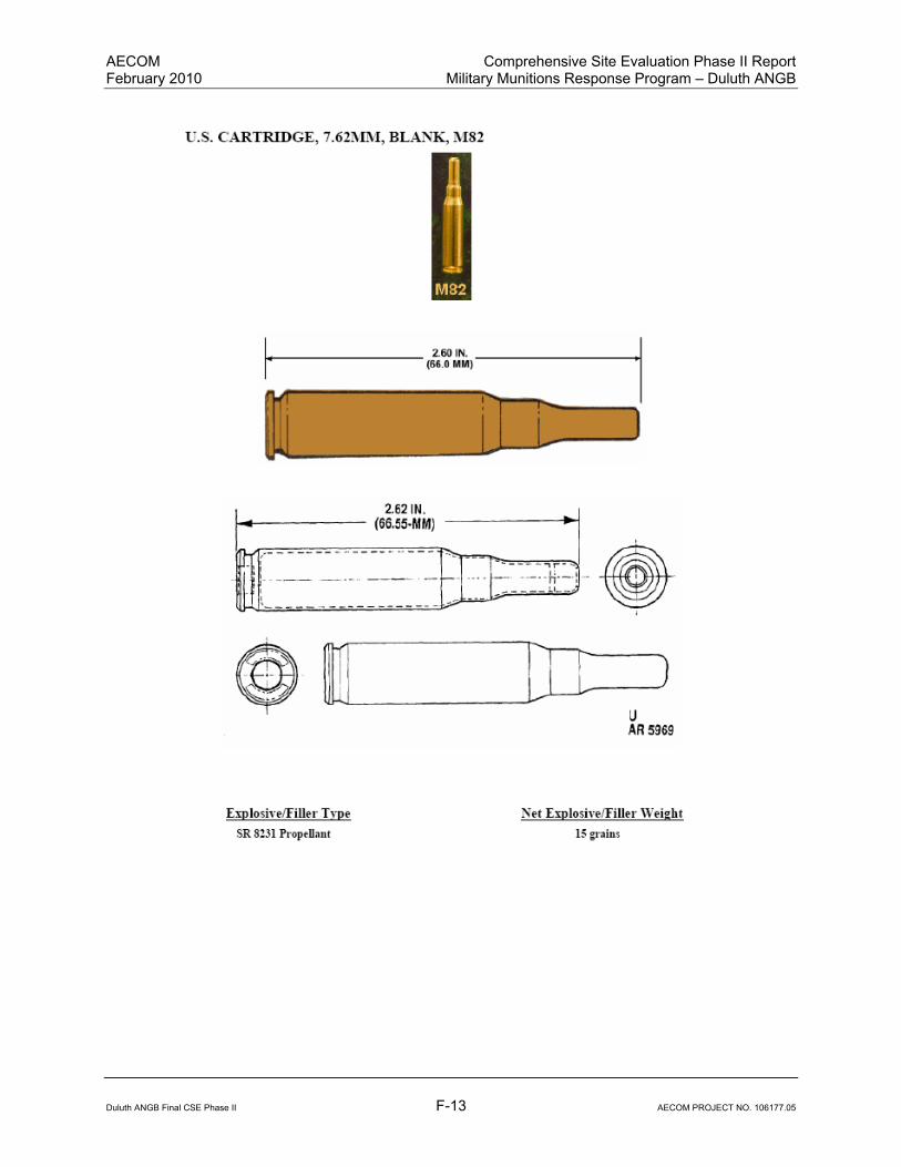
AECOM Comprehensive Site Evaluation Phase II Report February 2010 Military Munitions Response Program – Duluth ANGB
Duluth ANGB Final CSE Phase II F-13 AECOM PROJECT NO. 106177.05

AECOM Comprehensive Site Evaluation Phase II Report February 2010 Military Munitions Response Program – Duluth ANGB
Duluth ANGB Final CSE Phase II F-14 AECOM PROJECT NO. 106177.05

AECOM Comprehensive Site Evaluation Phase II Report February 2010 Military Munitions Response Program – Duluth ANGB
Duluth ANGB Final CSE Phase II F-15 AECOM PROJECT NO. 106177.05

AECOM Comprehensive Site Evaluation Phase II Report February 2010 Military Munitions Response Program – Duluth ANGB
Duluth ANGB Final CSE Phase II F-16 AECOM PROJECT NO. 106177.05

AECOM Comprehensive Site Evaluation Phase II Report February 2010 Military Munitions Response Program – Duluth ANGB
Duluth ANGB Final CSE Phase II F-17 AECOM PROJECT NO. 106177.05

AECOM Comprehensive Site Evaluation Phase II Report February 2010 Military Munitions Response Program – Duluth ANGB
Duluth ANGB Final CSE Phase II F-18 AECOM PROJECT NO. 106177.05
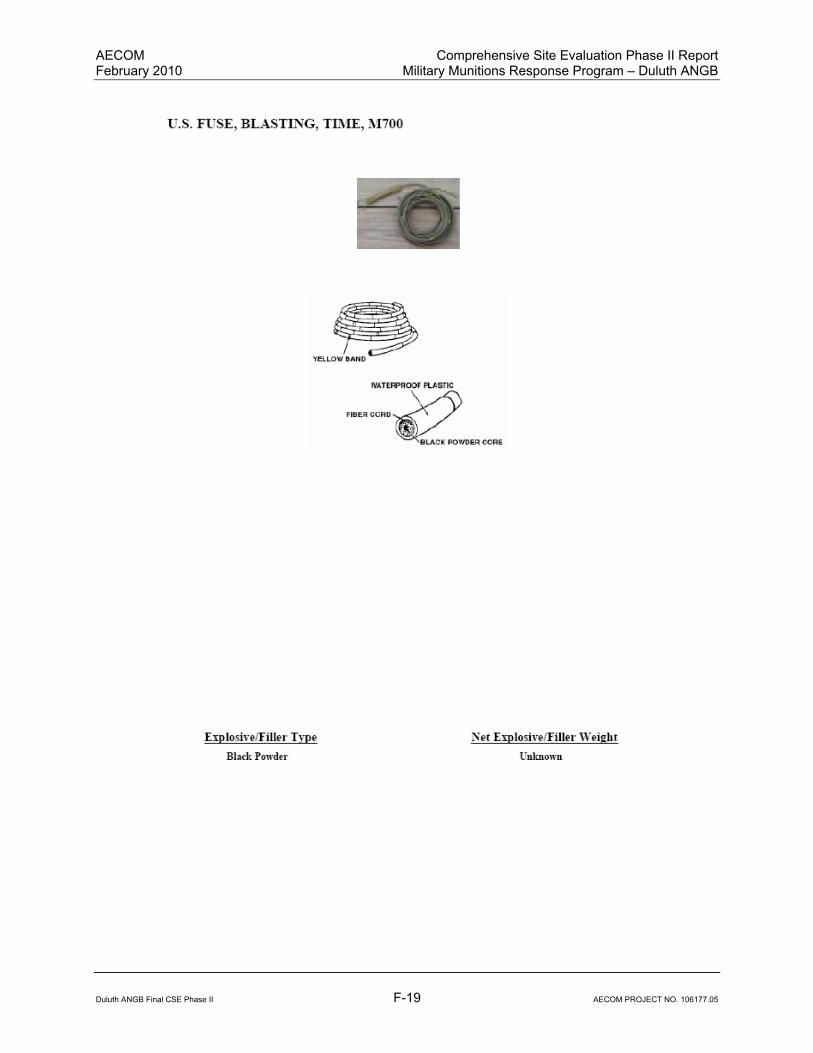
AECOM Comprehensive Site Evaluation Phase II Report February 2010 Military Munitions Response Program – Duluth ANGB
Duluth ANGB Final CSE Phase II F-19 AECOM PROJECT NO. 106177.05

AECOM Comprehensive Site Evaluation Phase II Report February 2010 Military Munitions Response Program – Duluth ANGB
Duluth ANGB Final CSE Phase II F-20 AECOM PROJECT NO. 106177.05
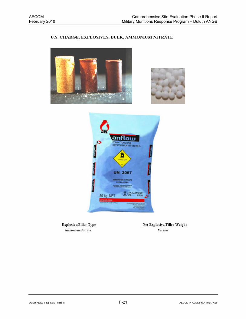
AECOM Comprehensive Site Evaluation Phase II Report February 2010 Military Munitions Response Program – Duluth ANGB
Duluth ANGB Final CSE Phase II F-21 AECOM PROJECT NO. 106177.05
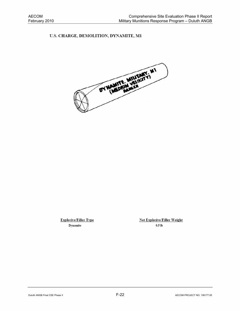
AECOM Comprehensive Site Evaluation Phase II Report February 2010 Military Munitions Response Program – Duluth ANGB
Duluth ANGB Final CSE Phase II F-22 AECOM PROJECT NO. 106177.05
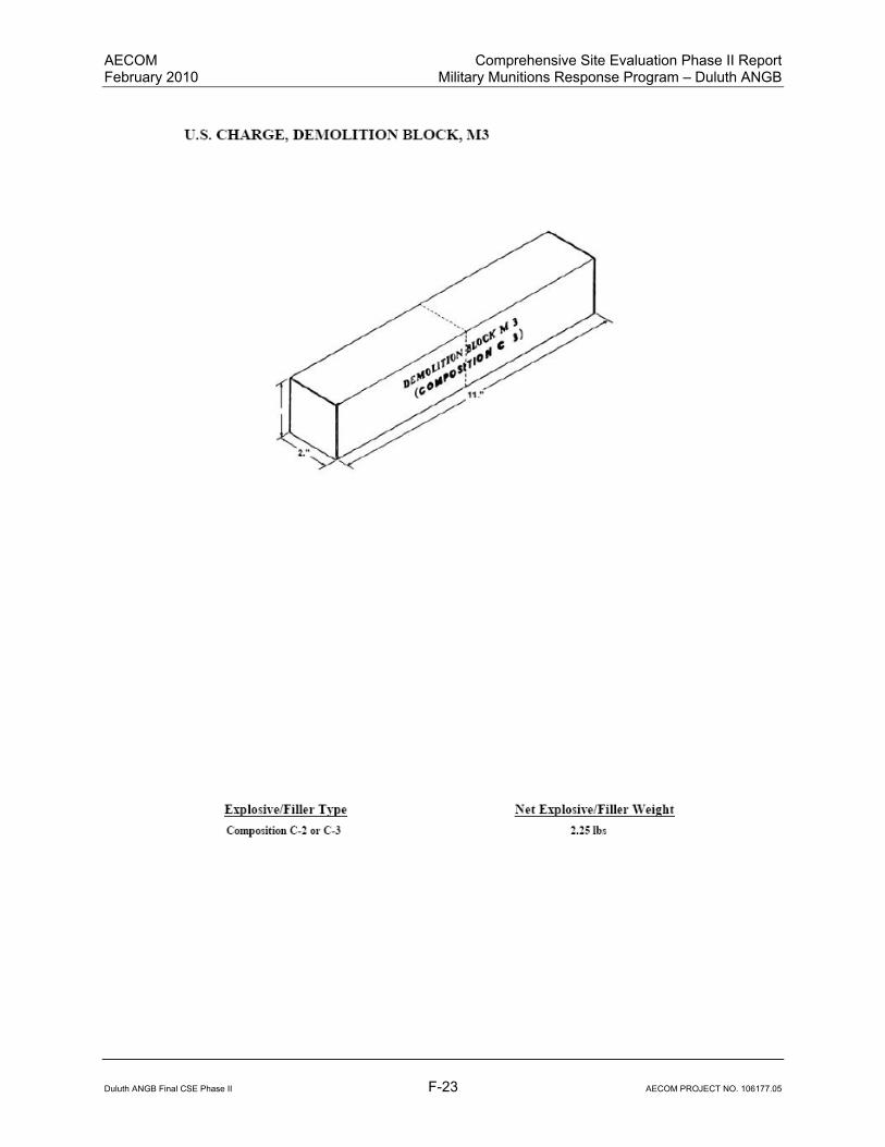
AECOM Comprehensive Site Evaluation Phase II Report February 2010 Military Munitions Response Program – Duluth ANGB
Duluth ANGB Final CSE Phase II F-23 AECOM PROJECT NO. 106177.05
AECOM Comprehensive Site Evaluation Phase II Report February 2010 Military Munitions Response Program – Duluth ANGB
Duluth ANGB Final CSE Phase II F-24 AECOM PROJECT NO. 106177.05
AECOM Comprehensive Site Evaluation Phase II Report February 2010 Military Munitions Response Program – Duluth ANGB
Duluth ANGB Final CSE Phase II F-25 AECOM PROJECT NO. 106177.05

AECOM Comprehensive Site Evaluation Phase II Report February 2010 Military Munitions Response Program – Duluth ANGB
Duluth ANGB Final CSE Phase II F-26 AECOM PROJECT NO. 106177.05

AECOM Comprehensive Site Evaluation Phase II Report February 2010 Military Munitions Response Program – Duluth ANGB
Duluth ANGB Final CSE Phase II F-27 AECOM PROJECT NO. 106177.05

AECOM Comprehensive Site Evaluation Phase II Report February 2010 Military Munitions Response Program – Duluth ANGB
Duluth ANGB Final CSE Phase II F-28 AECOM PROJECT NO. 106177.05
AECOM Comprehensive Site Evaluation Phase II Report February 2010 Military Munitions Response Program – Duluth ANGB
Duluth ANGB Final CSE Phase II F-29 AECOM PROJECT NO. 106177.05

AECOM Comprehensive Site Evaluation Phase II Report February 2010 Military Munitions Response Program – Duluth ANGB
Duluth ANGB Final CSE Phase II F-30 AECOM PROJECT NO. 106177.05

AECOM Comprehensive Site Evaluation Phase II Report February 2010 Military Munitions Response Program – Duluth ANGB
Duluth ANGB Final CSE Phase II F-31 AECOM PROJECT NO. 106177.05

AECOM Comprehensive Site Evaluation Phase II Report February 2010 Military Munitions Response Program – Duluth ANGB
Duluth ANGB Final CSE Phase II F-32 AECOM PROJECT NO. 106177.05

AECOM Comprehensive Site Evaluation Phase II Report February 2010 Military Munitions Response Program – Duluth ANGB
Duluth ANGB Final CSE Phase II F-33 AECOM PROJECT NO. 106177.05

AECOM Comprehensive Site Evaluation Phase II Report February 2010 Military Munitions Response Program – Duluth ANGB
Duluth ANGB Final CSE Phase II F-34 AECOM PROJECT NO. 106177.05
This page intentionally left blank.

Appendix G: Boring Logs and Well Logs

This page intentionally left blank.

Duluth ANGB Final CSE Phase II G-1 AECOM PROJECT NO. 106177.05

Duluth ANGB Final CSE Phase II G-2 AECOM PROJECT NO. 106177.05

Duluth ANGB Final CSE Phase II G-3 AECOM PROJECT NO. 106177.05
Duluth ANGB Final CSE Phase II G-4 AECOM PROJECT NO. 106177.05

Duluth ANGB Final CSE Phase II G-5 AECOM PROJECT NO. 106177.05

Duluth ANGB Final CSE Phase II G-6 AECOM PROJECT NO. 106177.05

Duluth ANGB Final CSE Phase II G-7 AECOM PROJECT NO. 106177.05
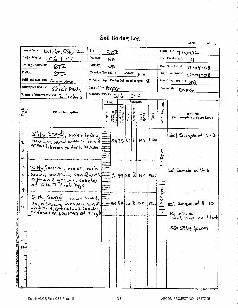
Duluth ANGB Final CSE Phase II G-8 AECOM PROJECT NO. 106177.05
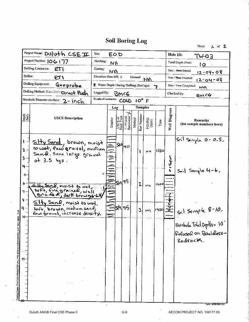
Duluth ANGB Final CSE Phase II G-9 AECOM PROJECT NO. 106177.05
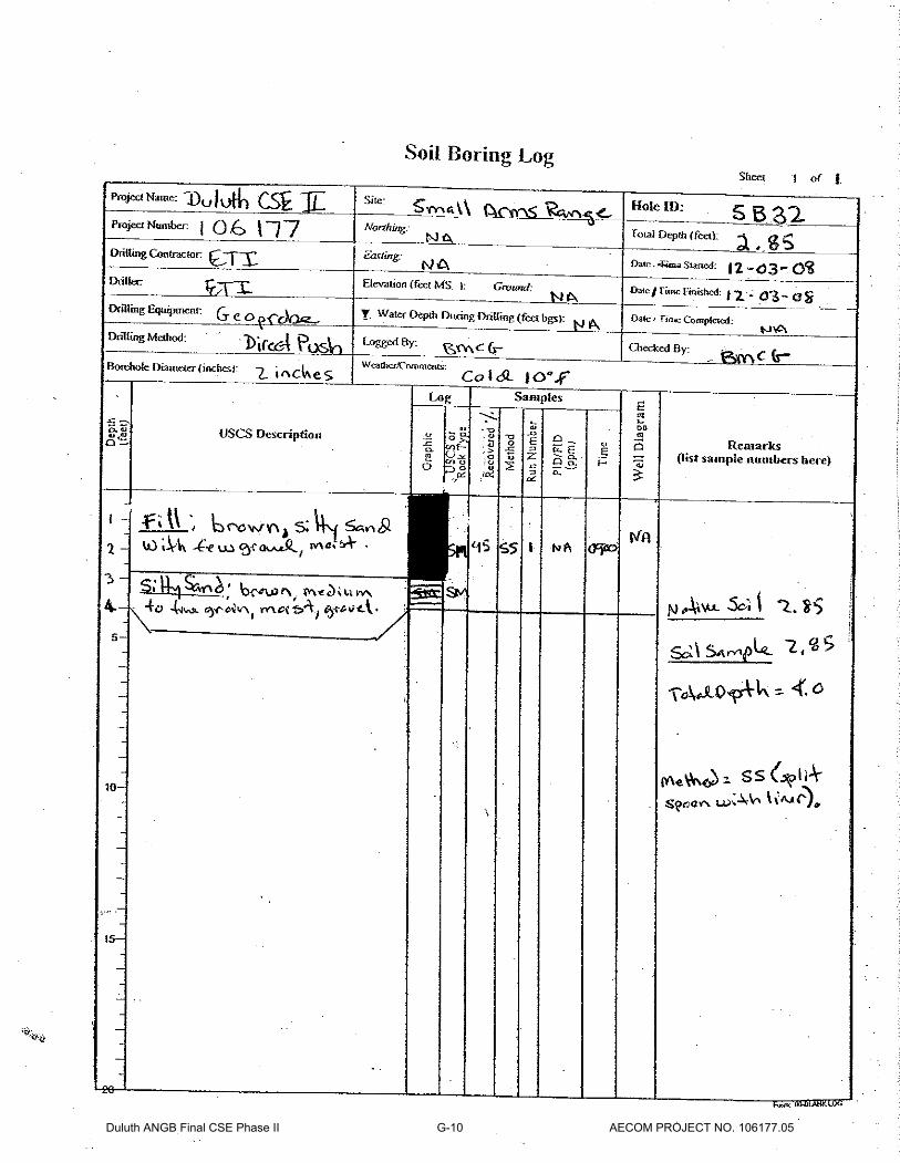
Duluth ANGB Final CSE Phase II G-10 AECOM PROJECT NO. 106177.05

Duluth ANGB Final CSE Phase II G-11 AECOM PROJECT NO. 106177.05

Duluth ANGB Final CSE Phase II G-12 AECOM PROJECT NO. 106177.05

Duluth ANGB Final CSE Phase II G-13 AECOM PROJECT NO. 106177.05

Duluth ANGB Final CSE Phase II G-14 AECOM PROJECT NO. 106177.05

Duluth ANGB Final CSE Phase II G-15 AECOM PROJECT NO. 106177.05
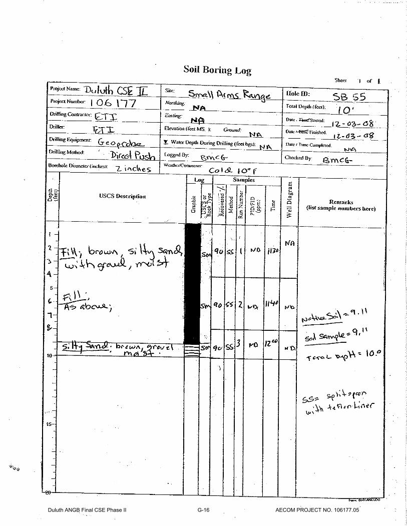
Duluth ANGB Final CSE Phase II G-16 AECOM PROJECT NO. 106177.05

Duluth ANGB Final CSE Phase II G-17 AECOM PROJECT NO. 106177.05

Duluth ANGB Final CSE Phase II G-18 AECOM PROJECT NO. 106177.05
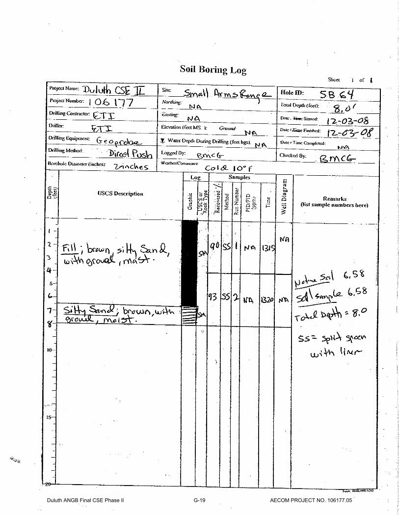
Duluth ANGB Final CSE Phase II G-19 AECOM PROJECT NO. 106177.05
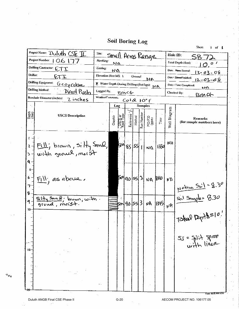
Duluth ANGB Final CSE Phase II G-20 AECOM PROJECT NO. 106177.05

Duluth ANGB Final CSE Phase II G-21 AECOM PROJECT NO. 106177.05

Duluth ANGB Final CSE Phase II G-22 AECOM PROJECT NO. 106177.05

Appendix H: Data Quality Reports

This page intentionally left blank.
Data Validation Review December 2008 Event
Duluth Air National Guard, Duluth, Minnesota
Data Validation Report No. 1
Duluth Air National Guard Base
CSE Phase II Report Appendix
D8L050316 January2009 H-1

Data Validation Review December 2008 Event
Duluth Air National Guard, Duluth, Minnesota
This page intentionally left blank.
D8L050316 January2009 H-2

Data Validation Review December 2008 Event
Duluth Air National Guard, Duluth, Minnesota
TABLE OF CONTENTS 1.0 INTRODUCTION 2.0 METALS
2.1 Holding Times 2.2 Calibration 2.3 Laboratory Control Samples 2.4 Blanks 2.5 Matrix Spike / Matrix Spike Duplicates 2.6 ICP Interference Check Sample 2.7 Serial Dilutions 2.8 Duplicates 2.9 Summary
TABLES
1 Data Qualifiers 2 Field Sample ID/Lab Sample ID Cross Reference
APPENDICES A Hand-Annotated Analysis Reports
D8L050316 January2009 iH-3

Data Validation Review December 2008 Event
Duluth Air National Guard, Duluth, Minnesota
This page intentionally left blank.
D8L050316 January2009 iiH-4
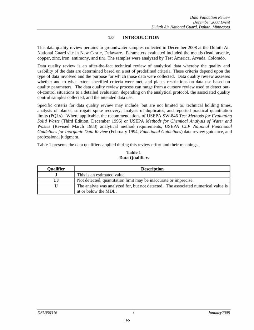
Data Validation Review December 2008 Event
Duluth Air National Guard, Duluth, Minnesota
1.0 INTRODUCTION This data quality review pertains to groundwater samples collected in December 2008 at the Duluth Air National Guard site in New Castle, Delaware. Parameters evaluated included the metals (lead, arsenic, copper, zinc, iron, antimony, and tin). The samples were analyzed by Test America, Arvada, Colorado.
Data quality review is an after-the-fact technical review of analytical data whereby the quality and usability of the data are determined based on a set of predefined criteria. These criteria depend upon the type of data involved and the purpose for which those data were collected. Data quality review assesses whether and to what extent specified criteria were met, and places restrictions on data use based on quality parameters. The data quality review process can range from a cursory review used to detect out-of-control situations to a detailed evaluation, depending on the analytical protocol, the associated quality control samples collected, and the intended data use.
Specific criteria for data quality review may include, but are not limited to: technical holding times, analysis of blanks, surrogate spike recovery, analysis of duplicates, and reported practical quantitation limits (PQLs). Where applicable, the recommendations of USEPA SW-846 Test Methods for Evaluating Solid Waste (Third Edition, December 1996) or USEPA Methods for Chemical Analysis of Water and Wastes (Revised March 1983) analytical method requirements, USEPA CLP National Functional Guidelines for Inorganic Data Review (February 1994, Functional Guidelines) data review guidance, and professional judgment.
Table 1 presents the data qualifiers applied during this review effort and their meanings.
Table 1 Data Qualifiers
Qualifier Description
J This is an estimated value. UJ Not detected, quantitation limit may be inaccurate or imprecise. U The analyte was analyzed for, but not detected. The associated numerical value is
at or below the MDL.
D8L050316 January2009 1
H-5

Data Validation Review December 2008 Event
Duluth Air National Guard, Duluth, Minnesota
Table 2 provides a cross-reference list for field sample IDs and lab Sample Identifications.
Table 2
Field Sample ID/Lab Sample ID Cross Reference SDG D8L050316
Sample Identification Lab ID Sample Identification Lab ID DULUTH-SR736-SB063
D8L050316-001 DULUTH-SR736-SB037
D8L050316-007
DULUTH-SR736-SB046
D8L050316-002 DULUTH-SR736-SB054
D8L050316-008
DULUTH-SR736-SB056
D8L050316-003 DULUTH-SR736-SB032
D8L050316-009
DULUTH-SR736-SB050
D8L050316-004 DULUTH-SR736-SB081
D8L050316-010
DULUTH-SR736-SB038
D8L050316-005 DULUTH-SR736-SB045
D8L050316-011
DULUTH-SR736-SB050DUP
D8L050316-006 DULUTH-SR736-SB064
D8L050316-012
During the data quality review process, laboratory qualified and unqualified data are verified against all available supporting documentation. Based on this review, qualifier codes may be added, deleted, or modified by the validator. For all data packages, it is noted that for those results which were less than the RL but greater than the MDL, the laboratory assigned a J flag, indicating an estimated value. Thus, the data validator agrees with the J flag unless the result has been qualified otherwise by the validator. Final results are therefore either qualified or unqualified. Changes to the data are reflected on the Form I’s in Appendix A.
D8L050316 January2009 2
H-6

Data Validation Review December 2008 Event
Duluth Air National Guard, Duluth, Minnesota
2.0 METALS
Samples were analyzed for lead, arsenic, copper, zinc, iron, antimony, and tin) using EPA SW-846 Method 6010B (iron) and Method 6020 (antimony, arsenic, copper, lead, tin, and zinc). Note: If lead > 100 mg/kg, the lab analyzed for metals. Hand-annotated data summary sheets (referred to as Analysis Reports) are provided as Appendix A.
2.1 Holding Times The sample was analyzed within the 6 month hold time. No qualification is needed. 2.2 Calibration Initial calibration verification (ICV) and continuing calibration verification (CCV) results were within control limits. No qualification is needed. Unless qualified otherwise, the validator qualifies J those positive results that fall between the Limit of Quantitation (LOQ) and the Method Detection Limit (MDL). Non-detect values are qualified U by the laboratory. 2.3 Laboratory Control Samples Results from the associated laboratory control sample were within control limits. No qualification is needed. 2.4 Blanks No positive results above the corresponding method detection limit were detected in method blank. No qualification is needed. 2.5 Matrix Spike / Matrix Spike Duplicates MS/MSD analyses were performed on sample DULUTH-SR736-SB054. The MS/MSD for method 6010B exhibited spike compound recoveries outside the QC limits for iron. The acceptable LCS analysis data indicated that the analytical system was operating within control. The laboratory flagged iron in DULUTH-SR736-SB054 “J” only and the validator agrees with it. MS/MSD analyses were performed on sample DULUTH-SR736-SB054. The MS/MSD for method 6020 exhibited spike compound recoveries outside the QC limits for antimony, lead, and tin. The acceptable LCS analysis data indicated that the analytical system was operating within control. The laboratory flagged lead in DULUTH-SR736-SB054 “J” only and the validator agrees with it. 2.6 Interference Check Samples Recoveries for both antimony, arsenic, copper, lead, tin, zinc, and iron were within the control limits indicating no significant physical or chemical interferences were present. No qualification is needed.
D8L050316 January2009 3
H-7

Data Validation Review December 2008 Event
Duluth Air National Guard, Duluth, Minnesota
2.7 ICP Serial Dilutions Differences were less than 10% for designated sample DULUTH-SR736-SB054. No qualification is needed. 2.8 Duplicates Sample DULUTH-SR736-SB050 was analyzed in duplicate. Positive results in the sample and duplicate are summarized below. Constituent DULUTH-SR736-SB050 DULUTH-SR736-SB050DUP RPD Lead 4600 4700 2.2% Agreement is satisfactory and no qualification is needed. 2.9 Summary Data are acceptable with validator-assigned qualifiers.
D8L050316 January2009 4
H-8

Data Validation Review December 2008 Sampling Event
Duluth Air National Guard, Duluth, Minnesota
Data Validation Report No. 2
Duluth Air National Guard Base
CSE Phase II Report Appendix
D8L050324 January 2009 H-9

Data Validation Review December 2008 Sampling Event
Duluth Air National Guard, Duluth, Minnesota
This page intentionally left blank.
D8L050324 January 2009 H-10

Data Validation Review December 2008 Sampling Event
Duluth Air National Guard, Duluth, Minnesota
TABLE OF CONTENTS 1.0 INTRODUCTION
2.0 SEMIVOLATILE ORGANIC CONSTITUENTS
2.1 Holding Times 2.2 Calibration 2.3 Laboratory Control Samples 2.4 Blanks 2.5 Matrix Spike / Matrix Spike Duplicates 2.6 Surrogate Recovery 2.7 Internal Standards 2.8 Duplicates 2.9 Summary
3.0 POLYCYCLIC AROMATIC HYDROCARBONS BY SIM
3.1 Holding Times 3.2 Calibration 3.3 Laboratory Control Samples 3.4 Blanks 3.5 Matrix Spike / Matrix Spike Duplicates 3.6 Surrogate Recovery 3.7 Internal Standards 3.8 Duplicates 3.9 Summary
4.0 METALS 4.1 Holding Times 4.2 Calibration 4.3 Laboratory Control Samples 4.4 Blanks 4.5 Matrix Spike / Matrix Spike Duplicates 4.6 ICP Interference Check Sample 4.7 Serial Dilutions 4.8 Duplicates 4.9 Summary
5.0 METALS 5.1 Holding Times 5.2 Calibration 5.3 Laboratory Control Samples 5.4 Blanks 5.5 Matrix Spike / Matrix Spike Duplicates 5.6 Summary
1 Data Qualifiers 2 Field Sample ID/Lab Sample ID Cross Reference
APPENDICES A Hand-Annotated Analysis Reports
D8L050324 January 2009 iH-11

Data Validation Review December 2008 Sampling Event
Duluth Air National Guard, Duluth, Minnesota
This page intentionally left blank.
D8L050324 January 2009 iiH-12

Data Validation Review December 2008 Sampling Event
Duluth Air National Guard, Duluth, Minnesota
1.0 INTRODUCTION This data quality review pertains to soil samples collected in December 2008 at the Duluth Air National Guard site in Duluth, Minnesota. Parameters evaluated included the semivolatile organic constituents (SVOC), polycyclic aromatic hydrocarbons (PAH), and metals. The samples were analyzed by Test America, Arvada, Colorado.
Data quality review is an after-the-fact technical review of analytical data whereby the quality and usability of the data are determined based on a set of predefined criteria. These criteria depend upon the type of data involved and the purpose for which those data were collected. Data quality review assesses whether and to what extent specified criteria were met, and places restrictions on data use based on quality parameters. The data quality review process can range from a cursory review used to detect out-of-control situations to a detailed evaluation, depending on the analytical protocol, the associated quality control samples collected, and the intended data use.
Specific criteria for data quality review may include, but are not limited to: technical holding times, analysis of blanks, surrogate spike recovery, analysis of duplicates, and reported practical quantitation limits (PQLs). Where applicable, the recommendations of USEPA SW-846 Test Methods for Evaluating Solid Waste (Third Edition, December 1996) or USEPA Methods for Chemical Analysis of Water and Wastes (Revised March 1983) analytical method requirements, USEPA CLP National Functional Guidelines for Organic and Inorganic Data Review (February 1994, Functional Guidelines) data review guidance, and professional judgment.
Table 1 presents the data qualifiers applied during this review effort and their meanings.
Table 1 Data Qualifiers
Qualifier Description
R Unreliable result. Analyte may or may not be present in the sample. Supporting data necessary to confirm result.
J This is an estimated value. B Blank contamination: The analyte was found in an associated blank above one
half the RL, as well as in the sample. UJ Not detected, quantitation limit may be inaccurate or imprecise. U The analyte was analyzed for, but not detected. The associated numerical value is
at or below the MDL.
D8L050324 January 2009 1
H-13

Data Validation Review December 2008 Sampling Event
Duluth Air National Guard, Duluth, Minnesota
Table 2 provides a cross-reference list for field sample IDs and lab Sample Identifications.
Table 2
Field Sample ID/Lab Sample ID Cross Reference SDG D8L050324
Sample Identification Lab ID Sample Identification Lab ID DULUTH-SR739-SB0101
D8L050324-001 DULUTH-SR739-SB0601
D8L050324-012
DULUTH-SR739-SB0101DUP
D8L050324-002 DULUTH-SR739-SB0602
D8L050324-013
DULUTH-SR739-SB0102
D8L050324-003 DULUTH-TS737-SW001
D8L050324-014
DULUTH-SR739-SB0201
D8L050324-004 DULUTH-TS737-SW001DUP
D8L050324-015
DULUTH-SR739-SB0202
D8L050324-005 DULUTH-TS737-SD001
D8L050324-016
DULUTH-SR739-SB0301
D8L050324-006 DULUTH-TS737-SB023
D8L050324-017
DULUTH-SR739-SB0302
D8L050324-007 DULUTH-TS737-SB023DUP
D8L050324-018
DULUTH-SR739-SB0401
D8L050324-008 DULUTH-TS737-SD002
D8L050324-019
DULUTH-SR739-SB0402
D8L050324-009 DULUTH-TS737-SB025
D8L050324-020
DULUTH-SR739-SB0501
D8L050324-010 DULUTH-TS737-SB014
D8L050324-021
DULUTH-SR739-SB0502
D8L050324-011 DULUTH-TS737-SB008
D8L050324-022
During the data quality review process, laboratory qualified and unqualified data are verified against all available supporting documentation. Based on this review, qualifier codes may be added, deleted, or modified by the validator. For all data packages, it is noted that for those results which were less than the RL but greater than the MDL, the laboratory assigned a J flag, indicating an estimated value. Thus, the data validator agrees with the J flag unless the result has been qualified otherwise by the validator. Final results are therefore either qualified or unqualified. Changes to the data are reflected on the Form I’s in Appendix A.
D8L050324 January 2009 2
H-14
Data Validation Review December 2008 Sampling Event
Duluth Air National Guard, Duluth, Minnesota
2.0 SEMIVOLATILE ORGANIC CONSTITUENTS Semivolatile organic constituents were analyzed using EPA Test Method for Evaluating Solid Waste (SW-846) Method 8270C. Hand-annotated data summary sheets (referred to as Analysis Reports) are provided as Appendix A. Results were reported on a dry weight basis. 2.1 Holding Times All of the samples were analyzed for volatile organic compounds within the recommended holding time of 14 days. No qualification is necessary. 2.2 Calibration In the Initial Calibration, the RSD was less than 30% for all target constituents, and the RRF value was greater than 0.05. The %D values in the continuing calibration checks were less than +20% for all target constituents. No qualification is needed. Neither sample required dilution prior to analysis. 2.3 Laboratory Control Samples Recoveries of target constituents from the laboratory control sample were within control limits except for aniline which is not a target compound for the project. Acceptable precision and accuracy have been demonstrated. No qualification is needed. 2.4 Blanks No positive results above the corresponding method detection limit were detected in method blank. No qualification is needed. 2.5 Matrix Spike / Matrix Spike Duplicates
MS/MSD analyses were performed on samples DULUTH-TS737-SD001 and DULUTH-TS737-SB025. Both the MS/MSD analyses for exhibited spike compound recoveries and RPD data within control limits. No qualification is necessary.
The method required MS/MSD could not be performed for batch 8344206 (water), due to insufficient sample volume. Method precision and accuracy have been verified by the acceptable LCS/LCSD analysis data.
2.6 Surrogate Recovery Surrogate recoveries were within control limits for all samples and standards. No qualification is needed. 2.7 Internal Standards Internal standard area counts were within control limits and no qualification is needed.
D8L050324 January 2009 3
H-15
Data Validation Review December 2008 Sampling Event
Duluth Air National Guard, Duluth, Minnesota
2.8 Duplicates Duplicate samples were not included in this sample delivery group. No qualification is needed based on this information alone. 2.9 Summary
The data are acceptable with validator-assigned qualifiers. Note: The tentatively identified compounds were reported on the Form Is.
D8L050324 January 2009 4
H-16

Data Validation Review December 2008 Sampling Event
Duluth Air National Guard, Duluth, Minnesota
3.0 POLYCYCLIC AROMATIC HYDROCARBONS BY SIM Polycyclic aromatic hydrocarbons (PAH) were analyzed using EPA Test Method for Evaluating Solid Waste (SW-846) Method 8270C Selected Ion Monitoring (SIM). Hand-annotated data summary sheets (referred to as Analysis Reports) are provided as Appendix A. Results were reported on a dry weight basis.
3.1 Holding Times All of the samples were analyzed for volatile organic compounds within the recommended holding time of 14 days. No qualification is necessary. 3.2 Calibration For the Initial Calibration, the %RSD was less than 30% for all target constituents. Continuing calibration standards exhibited %D values less than 20% for all constituents. No qualification is needed. No samples required dilution prior to analysis except for DULUTH-TS737-SD001, DULUTH-TS737-SB023, DULUTH-TS737-SB025, and DULUTH-TS737-SB008. This was due to the presence of interfering, non-target compounds. The reporting limits were adjusted relative to the dilution required. 3.3 Laboratory Control Samples Recoveries were within control limits for laboratory control sample. No qualification is needed. 3.4 Blanks Low levels of naphthalene, benzo(a)anthracene, and pyrene are present in the method blank associated with QC batch 8351196. Because the concentrations in the method blank are present at a level greater than the reporting limits, corrective action wasn’t necessary. Associated results have been flagged with a “B” and the validator agrees with it. 3.5 Matrix Spike / Matrix Spike Duplicates A MS/MSD could not be performed for batch 8344189, due to insufficient sample volume. Method precision and accuracy have been verified by the acceptable LCS/LCSD analysis data. 3.6 Surrogate Recovery Surrogate recoveries were within control limits for all samples except for samples DULUTH-TS737-SD001, DULUTH-TS737-SB023, DULUTH-TS737-SB025, and DULUTH-TS737-SB008. The surrogate recoveries could not be calculated because the extracts were diluted beyond the ability to quantitate recoveries. The validator qualifies J the positive results for the following constituents in samples DULUTH-TS737-SD001, DULUTH-TS737-SB023, DULUTH-TS737-SB025, and DULUTH-TS737-SB008 only. Surrogate terphenyl-d14 was above the control limits in sample DULUTH-TS737-SB014. This anomaly is due to obvious matrix interference. The validator qualifies J the positive results for the following constituents in sample DULUTH-TS737-SB014.
D8L050324 January 2009 5
H-17

Data Validation Review December 2008 Sampling Event
Duluth Air National Guard, Duluth, Minnesota
3.7 Internal Standards Internal standard area counts were within control limits and no qualification is needed. 3.8 Duplicates Sample DULUTH-TS737-SB023 was analyzed in duplicate. Positive results in the sample and duplicate are summarized below. Constituent DULUTH-TS737-SB023 DULUTH-SR737-SB023DUP RPD Acenaphthylene 4.2J 10J 82% Anthracene 2.0J 3.5J 55% Benzo(a)pyrene 12J 21J 55% Benzo(b)fluoranthene 20J 36J 57% Benzo(ghi)perylene 7.4J 13J 55% Chrysene 9.6J 15J 44% Fluoranthene 14J 23J 49% Fluorene 6.0J 20J 108% Phenanthrene 8.3J 10J 9.3% Agreement is unsatisfactory and the validator qualifies J to the acenaphthylene, anthracene, benzo(a)pyrene, benzo(b)fluoranthene, benzo(ghi)perylene, chrysene, fluoranthene, fluorene, and phenanthrene results in sample DULUTH-TS737-SB023. 3.9 Summary
The data are acceptable with validator-assigned qualifiers. Note: Compounds benzo(b)fluoranthene and benzo(k)fluoranthene could not be resolved in sample DULUTH-TS737-SW001; therefore, the combined peak reported as benzo(b)fluoranthene is most likely a combination of the two compounds. The validator qualifies benzo(b)fluoranthene “K” and benzo(k)fluoranthene “UJ” in sample DULUTH-TS737-SW001 only.
D8L050324 January 2009 6
H-18

Data Validation Review December 2008 Sampling Event
Duluth Air National Guard, Duluth, Minnesota
4.0 METALS
Selected samples were analyzed for the total concentration of iron and manganese using EPA SW-846 Method 6010B (cadmium, iron, selenium, and silver) and Method 6020 (arsenic, barium, chromium, copper, lead, and tin). Hand-annotated data summary sheets (referred to as Analysis Reports) are provided as Appendix A.
4.1 Holding Times Samples were analyzed within the 6 month hold time. No qualification is needed. 4.2 Calibration Initial calibration verification (ICV) and continuing calibration verification (CCV) results were within control limits. No qualification is needed. 4.3 Laboratory Control Samples Results from the associated laboratory control sample were within control limits. No qualification is needed. 4.4 Blanks Low levels of copper was present in the method blanks associated with QC batches 8348093, but the concentrations in the method blanks are not present at levels greater than the reporting limit. No qualification necessary. Associated results have been flagged with a “B.” 4.5 Matrix Spike / Matrix Spike Duplicates MS/MSD analyses were performed on sample DULUTH-TS737-SD001 and DULUTH-TS737-SB025. The MS/MSD for method 6010B exhibited spike compound recoveries outside the QC limits for iron. The acceptable LCS analysis data indicated that the analytical system was operating within control. The laboratory flagged iron in DULUTH-TS737-SD001 and DULUTH-TS737-SB025 “J” only and the validator agrees with it. MS/MSD analyses were performed on sample DULUTH-TS737-SB025. The MS for method 6020 exhibited spike compound recoveries outside the QC limits for antimony, lead, and tin. The MSD exhibited spike compound recoveries outside the QC limits for antimony, copper, lead, tin, and zinc and RPD data outside the QC limits for copper. The acceptable LCS analysis data indicated that the analytical system was operating within control. The laboratory flagged iron in DULUTH-TS737-SB025 “J” only and the validator agrees with it. 4.6 Interference Check Samples Recoveries for both antimony, arsenic, copper, lead, tin, zinc, and iron were within the control limits indicating no significant physical or chemical interferences were present. No qualification is needed.
D8L050324 January 2009 7
H-19

Data Validation Review December 2008 Sampling Event
Duluth Air National Guard, Duluth, Minnesota
4.7 ICP Serial Dilutions Differences were less than 10% for designated sample DULUTH-SR737-SD001. No qualification is needed. 4.8 Duplicates Sample DULUTH-TS737-SW001, DULUTH-TS737-SB023, and DULUTH-SR739-SB0101 was analyzed in duplicate. Positive results in the sample and duplicate are summarized below. Constituent DULUTH-TS737-SW001 DULUTH-SR737-SW001DUP RPD Lead 4.2 6.3 40% Agreement is unsatisfactory and the validator qualifies J to the lead results in sample DULUTH-TS737-SW001. Constituent DULUTH-TS737-SB023 DULUTH-TS737-SB023DUP RPD Iron 21000 24000 13% Lead 1700000 3800000 76% Antimony 7300 38000 136% Arsenic 21000 59000 95% Copper 37000 36000 2.7% Tin 150 330 68% Zinc 55000 61000 10% Agreement is unsatisfactory and the validator qualifies J to the lead, antimony, arsenic, and tin results in sample DULUTH-TS737-SB023. Constituent DULUTH-SR739-SB0101 DULUTH-SR739-SB0101DUP RPD Lead 4000 5000 22% Agreement is satisfactory and no qualification is necessary. 4.9 Summary Data are acceptable with validator-assigned qualifiers. Note: The ICSA for Method 6020 was greater than two times the MDL for arsenic, antimony, barium, chromium, and zinc. The lab confirmed with the vendor that the solution contained trace impurities of the associated compounds, and that the results are not due to matrix interference. No corrective action was needed.
D8L050324 January 2009 8
H-20
Data Validation Review December 2008 Sampling Event
Duluth Air National Guard, Duluth, Minnesota
5.0 Mercury
Selected samples were analyzed for the total concentration of iron and manganese using EPA SW-846 Method 7471A and 7470A. Hand-annotated data summary sheets (referred to as Analysis Reports) are provided as Appendix A.
5.1 Holding Times Samples were analyzed within the 6 month hold time. No qualification is needed. 5.2 Calibration Initial calibration verification (ICV) and continuing calibration verification (CCV) results were within control limits. No qualification is needed. Unless qualified otherwise, the validator qualifies J those positive results that fall between the Limit of Quantitation (LOQ) and the Method Detection Limit (MDL). Non-detect values are qualified U by the validator. 5.3 Laboratory Control Samples Results from the associated laboratory control sample were within control limits. No qualification is needed. 5.4 Blanks Results associated with the Initial Calibration Blank (ICB), Continuing Calibration Blanks (CCB) and Preparation Blank (PB) were non-detect. 5.5 Matrix Spike / Matrix Spike Duplicates A non-batch specific sample served as the MS/MSD. No qualification is made based on this information alone. 5.6 Summary Data are acceptable with validator-assigned qualifiers.
D8L050324 January 2009 9
H-21

Data Validation Review December 2008 Sampling Event
Duluth Air National Guard, Duluth, Minnesota
This page intentionally left blank.
D8L050324 January 2009 10
H-22
Data Validation Review December 2008 Sampling Event
Duluth Air National Guard, Duluth, Minnesota
Data Validation Report No. 3
Duluth Air National Guard Base
CSE Phase II Report Appendix
D8L050340 January 2009 H-23

Data Validation Review December 2008 Sampling Event
Duluth Air National Guard, Duluth, Minnesota
This page intentionally left blank.
D8L050340 January 2009 H-24

Data Validation Review December 2008 Sampling Event
Duluth Air National Guard, Duluth, Minnesota
TABLE OF CONTENTS 1.0 INTRODUCTION
2.0 SEMIVOLATILE ORGANIC CONSTITUENTS
2.1 Holding Times 2.2 Calibration 2.3 Laboratory Control Samples 2.4 Blanks 2.5 Matrix Spike / Matrix Spike Duplicates 2.6 Surrogate Recovery 2.7 Internal Standards 2.8 Duplicates 2.9 Summary
3.0 POLYCYCLIC AROMATIC HYDROCARBONS BY SIM
3.1 Holding Times 3.2 Calibration 3.3 Laboratory Control Samples 3.4 Blanks 3.5 Matrix Spike / Matrix Spike Duplicates 3.6 Surrogate Recovery 3.7 Internal Standards 3.8 Duplicates 3.9 Summary
4.0 METALS 4.1 Holding Times 4.2 Calibration 4.3 Laboratory Control Samples 4.4 Blanks 4.5 Matrix Spike / Matrix Spike Duplicates 4.6 ICP Interference Check Sample 4.7 Serial Dilutions 4.8 Duplicates 4.9 Summary
1 Data Qualifiers 2 Field Sample ID/Lab Sample ID Cross Reference
APPENDICES A Hand-Annotated Analysis Reports
D8L050340 January 2009 iH-25

Data Validation Review December 2008 Sampling Event
Duluth Air National Guard, Duluth, Minnesota
This page intentionally left blank.
D8L050340 January 2009 iiH-26

Data Validation Review December 2008 Sampling Event
Duluth Air National Guard, Duluth, Minnesota
1.0 INTRODUCTION This data quality review pertains to soil samples collected in December 2008 at the Duluth Air National Guard site in Duluth, Minnesota. Parameters evaluated included the semivolatile organic constituents (SVOC), polycyclic aromatic hydrocarbons (PAH), and metals. The samples were analyzed by Test America, Arvada, Colorado.
Data quality review is an after-the-fact technical review of analytical data whereby the quality and usability of the data are determined based on a set of predefined criteria. These criteria depend upon the type of data involved and the purpose for which those data were collected. Data quality review assesses whether and to what extent specified criteria were met, and places restrictions on data use based on quality parameters. The data quality review process can range from a cursory review used to detect out-of-control situations to a detailed evaluation, depending on the analytical protocol, the associated quality control samples collected, and the intended data use.
Specific criteria for data quality review may include, but are not limited to: technical holding times, analysis of blanks, surrogate spike recovery, analysis of duplicates, and reported practical quantitation limits (PQLs). Where applicable, the recommendations of USEPA SW-846 Test Methods for Evaluating Solid Waste (Third Edition, December 1996) or USEPA Methods for Chemical Analysis of Water and Wastes (Revised March 1983) analytical method requirements, USEPA CLP National Functional Guidelines for Organic and Inorganic Data Review (February 1994, Functional Guidelines) data review guidance, and professional judgment.
Table 1 presents the data qualifiers applied during this review effort and their meanings.
Table 1 Data Qualifiers
Qualifier Description
R Unreliable result. Analyte may or may not be present in the sample. Supporting data necessary to confirm result.
J This is an estimated value. B Blank contamination: The analyte was found in an associated blank above one
half the RL, as well as in the sample. UJ Not detected, quantitation limit may be inaccurate or imprecise. U The analyte was analyzed for, but not detected. The associated numerical value is
at or below the MDL.
D8L050340 January 2009 1
H-27

Data Validation Review December 2008 Sampling Event
Duluth Air National Guard, Duluth, Minnesota
Table 2 provides a cross-reference list for field sample IDs and lab Sample Identifications.
Table 2
Field Sample ID/Lab Sample ID Cross Reference SDG D8L050340
Sample Identification Lab ID Sample Identification Lab ID DULUTH-SR738-SB033
D8L050340-001 DULUTH-TS738-SD002
D8L050340-012
DULUTH-SR738-SB032
D8L050340-002 DULUTH-TS737-SS015
D8L050340-013
DULUTH-SR738-SB050
D8L050340-003 DULUTH-TS737-SS024
D8L050340-014
DULUTH-SR738-SB027
D8L050340-004 DULUTH-TS737-SS008
D8L050340-015
DULUTH-SR738-SB026
D8L050340-005 DULUTH-TS738-SW001
D8L050340-016
DULUTH-SR738-SB044
D8L050340-006 DULUTH-TS738-SW002
D8L050340-017
DULUTH-TS737-SS030
D8L050340-007 DULUTH-TS738-SS047
D8L050340-018
DULUTH-TS738-SS033
D8L050340-008 DULUTH-TS738-SS051
D8L050340-019
DULUTH-TS738-SS032
D8L050340-009 DULUTH-TS738-SS058
D8L050340-020
DULUTH-TS738-SS028
D8L050340-010 DULUTH-TS738-SW001
D8L050340-021
DULUTH-TS738-SD001
D8L050340-011
During the data quality review process, laboratory qualified and unqualified data are verified against all available supporting documentation. Based on this review, qualifier codes may be added, deleted, or modified by the validator. For all data packages, it is noted that for those results which were less than the RL but greater than the MDL, the laboratory assigned a J flag, indicating an estimated value. Thus, the data validator agrees with the J flag unless the result has been qualified otherwise by the validator. Final results are therefore either qualified or unqualified. Changes to the data are reflected on the Form I’s in Appendix A.
D8L050340 January 2009 2
H-28

Data Validation Review December 2008 Sampling Event
Duluth Air National Guard, Duluth, Minnesota
2.0 SEMIVOLATILE ORGANIC CONSTITUENTS Semivolatile organic constituents were analyzed using EPA Test Method for Evaluating Solid Waste (SW-846) Method 8270C. Hand-annotated data summary sheets (referred to as Analysis Reports) are provided as Appendix A. Results were reported on a dry weight basis. 2.1 Holding Times All of the samples were analyzed for volatile organic compounds within the recommended holding time of 14 days. No qualification is necessary. 2.2 Calibration In the Initial Calibration, the RSD was less than 30% for all target constituents, and the RRF value was greater than 0.05. The %D values in the continuing calibration checks were less than +20% for all target constituents. No qualification is needed. Each sample was analyzed to achieve the lowest reporting limits within the constraints of the method. Due to the viscous nature, samples DULUTH-TS737-SS030, DULUTH-TS738-SS033, DULUTH-TS738-SD001, and DULUTH-TS737-SS008 were analyzed at dilutions. The reporting limits have been adjusted and samples were not analyzed at lesser dilutions so as to protect the integrity of instrument. 2.3 Laboratory Control Samples Recoveries of target constituents from the laboratory control sample were within control limits except for pentachlorphenol. Pentachlorophenol is not a constituent of interest and all other associated QC was 100% in control. Acceptable precision and accuracy have been demonstrated and no qualification is necessary. 2.4 Blanks No positive results above the corresponding method detection limit were detected in method blank. No qualification is needed. 2.5 Matrix Spike / Matrix Spike Duplicates
MS/MSD analyses were performed on samples DULUTH-TS738-SB032. Both the MS/MSD analyses for exhibited spike compound recoveries and RPD data within control limits except for benzoic acid. No qualification is necessary based on that information alone.
The method required MS/MSD could not be performed for batch 8344206 (water), due to insufficient sample volume. Method precision and accuracy have been verified by the acceptable LCS/LCSD analysis data.
2.6 Surrogate Recovery The surrogate recovery could not be calculated for sample DULUTH-TS737-SS008, because the extract was diluted beyond the ability to quantitate a recovery. The validator qualifies J the positive results for the following constituents in samples DULUTH-TS737-SS008 only.
D8L050340 January 2009 3
H-29

Data Validation Review December 2008 Sampling Event
Duluth Air National Guard, Duluth, Minnesota
2.7 Internal Standards Internal standard area counts were within control limits and no qualification is needed. 2.8 Duplicates Duplicate samples were not included in this sample delivery group. No qualification is needed based on this information alone. 2.9 Summary
The data are acceptable with validator-assigned qualifiers. Note: The tentatively identified compounds were reported on the Form Is.
D8L050340 January 2009 4
H-30

Data Validation Review December 2008 Sampling Event
Duluth Air National Guard, Duluth, Minnesota
3.0 POLYCYCLIC AROMATIC HYDROCARBONS BY SIM Polycyclic aromatic hydrocarbons (PAH) were analyzed using EPA Test Method for Evaluating Solid Waste (SW-846) Method 8270C Selected Ion Monitoring (SIM). Hand-annotated data summary sheets (referred to as Analysis Reports) are provided as Appendix A. Results were reported on a dry weight basis.
3.1 Holding Times All of the samples were analyzed for volatile organic compounds within the recommended holding time of 14 days. No qualification is necessary. 3.2 Calibration For the Initial Calibration, the %RSD was less than 30% for all target constituents. Continuing calibration standards exhibited %D values less than 20% for all constituents. No qualification is needed. No samples required dilution prior to analysis except for DULUTH-TS738-SB044, DULUTH-TS737-SS030, DULUTH-TS738-SS033, DULUTH-TS738-SS028, DULUTH-TS738-SD001, DULUTH-TS738-SD002, DULUTH-TS737-SS015, DULUTH-TS737-SS024, DULUTH-TS737-SS008, DULUTH-TS738-SS047, DULUTH-TS738-SS051, DULUTH-TS738-SS058, and DULUTH-TS738-SW001. This was due to the presence of interfering, non-target compounds. The reporting limits were adjusted relative to the dilution required. Sample DULUTH-TS738-SB044 required a second dilution due to compounds over the range of quantitation. 3.3 Laboratory Control Samples Recoveries were within control limits for laboratory control sample. No qualification is needed. 3.4 Blanks Low levels of naphthalene, fluoranthene, phenanthene, and pyrene are present in the method blank associated with QC batch 8351196. Because the concentrations in the method blank are present at a level greater than the reporting limits, corrective action wasn’t necessary. Associated results have been flagged with a “B” and the validator agrees with it. 3.5 Matrix Spike / Matrix Spike Duplicates A MS/MSD could not be performed for batch 8344189, due to insufficient sample volume. Method precision and accuracy have been verified by the acceptable LCS/LCSD analysis data. MS/MSD was performed on sample DULUTH-TS738-SB032. All recoveries and RPD data were within QC limits. 3.6 Surrogate Recovery Surrogate recoveries were within control limits for all samples except for samples DULUTH-TS738-SB044, DULUTH-TS737-SS030, DULUTH-TS738-SS033, DULUTH-TS738-SS028, DULUTH-TS738-SD001, DULUTH-TS738-SD002, DULUTH-TS737-SS015, DULUTH-TS737-SS024,
D8L050340 January 2009 5
H-31
Data Validation Review December 2008 Sampling Event
Duluth Air National Guard, Duluth, Minnesota
DULUTH-TS737-SS008, DULUTH-TS738-SS047, DULUTH-TS738-SS051, DULUTH-TS738-SS058, and DULUTH-TS738-SW001. The surrogate recoveries could not be calculated because the extracts were diluted beyond the ability to quantitate recoveries. The validator qualifies J the positive results for the following constituents in samples DULUTH-TS738-SB044, DULUTH-TS737-SS030, DULUTH-TS738-SS033, DULUTH-TS738-SS028, DULUTH-TS738-SD001, DULUTH-TS738-SD002, DULUTH-TS737-SS015, DULUTH-TS737-SS024, DULUTH-TS737-SS008, DULUTH-TS738-SS047, DULUTH-TS738-SS051, DULUTH-TS738-SS058, and DULUTH-TS738-SW001 only. Surrogate terphenyl-d14 was recovered above the QC limits in sample DULUTH-TS738-SB033 and DULUTH-TS738-SS032. These anomalies were due to matrix interferences so therefore no qualification is necessary. 3.7 Internal Standards Internal standard area counts were within control limits and no qualification is needed. 3.8 Duplicates Duplicate samples were not included in this sample delivery group. No qualification is needed based on this information alone. 3.9 Summary
The data are acceptable with validator-assigned qualifiers. Note: Compounds benzo(b)fluoranthene and benzo(k)fluoranthene could not be resolved in sample DULUTH-TS738-SB033, DULUTH-TS738-SB032, DULUTH-TS738-SB050, DULUTH-TS738-SB027, DULUTH-TS738-SB026, DULUTH-TS738-SB044, DULUTH-TS737-SS030, DULUTH-TS738-SS033, DULUTH-TS738-SS032, DULUTH-TS738-SS028, DULUTH-TS738-SS028, DULUTH-TS738-SD001, DULUTH-TS738-SD002, DULUTH-TS737-SS015, DULUTH-TS737-SS024, DULUTH-TS737-SS008, DULUTH-TS738-SW001, DULUTH-TS738-SS047, and DULUTH-TS738-SS051; therefore, the combined peak reported as benzo(b)fluoranthene is most likely a combination of the two compounds. The validator qualifies benzo(b)fluoranthene “K” and benzo(k)fluoranthene “UJ” in sample DULUTH-TS737-SW001 only.
D8L050340 January 2009 6
H-32
Data Validation Review December 2008 Sampling Event
Duluth Air National Guard, Duluth, Minnesota
4.0 METALS
Selected samples were analyzed for the total concentration of iron and manganese using EPA SW-846 Method 6010B (cadmium, iron, selenium, and silver) and Method 6020 (arsenic, barium, chromium, copper, lead, and tin). Hand-annotated data summary sheets (referred to as Analysis Reports) are provided as Appendix A.
4.1 Holding Times Samples were analyzed within the 6 month hold time. No qualification is needed. 4.2 Calibration Initial calibration verification (ICV) and continuing calibration verification (CCV) results were within control limits. No qualification is needed. 4.3 Laboratory Control Samples Results from the associated laboratory control sample were within control limits. No qualification is needed. 4.4 Blanks Method blanks did not have positive constituents. No qualification is necessary. 4.5 Matrix Spike / Matrix Spike Duplicates MS/MSD analyses were performed on sample DULUTH-TS738-SW001. The MS/MSD for method 6020 exhibited spike compound recoveries within the QC limits. Percent recoveries and RPD data could not be calculated for iron due to the sample concentration reading greater than four times the spike amount. MS/MSD analyses were performed on sample DULUTH-TS738-SB032. The MS for method 6020 exhibited spike compound recoveries outside the QC limits for arsenic, antimony, lead, and tin. The MSD exhibited spike compound recoveries outside the QC limits for arsenic, antimony, copper, lead, tin, and zinc and RPD data outside the QC limits for copper. The acceptable LCS analysis data indicated that the analytical system was operating within control. The laboratory flagged iron in DULUTH-TS738-SB032 “J” only and the validator agrees with it. 4.6 Interference Check Samples Recoveries for both antimony, arsenic, copper, lead, tin, zinc, and iron were within the control limits indicating no significant physical or chemical interferences were present. No qualification is needed. 4.7 ICP Serial Dilutions Differences were less than 10% for designated sample DULUTH-SR737-SD001. No qualification is needed.
D8L050340 January 2009 7
H-33

Data Validation Review December 2008 Sampling Event
Duluth Air National Guard, Duluth, Minnesota
4.8 Duplicates Duplicate samples were not included in this sample delivery group. No qualification is needed based on this information alone. 4.9 Summary Data are acceptable with validator-assigned qualifiers. Note: The ICSA for Method 6020 was greater than two times the MDL for arsenic, antimony, barium, chromium, and zinc. The lab confirmed with the vendor that the solution contained trace impurities of the associated compounds, and that the results are not due to matrix interference. No corrective action was needed.
D8L050340 January 2009 8
H-34

Data Validation Review December 2008 Sampling Event
Duluth Air National Guard, Duluth, Minnesota
Data Validation Report No. 4
Duluth Air National Guard Base
CSE Phase II Report Appendix
D8L080142 January 2009 H-35

Data Validation Review December 2008 Sampling Event
Duluth Air National Guard, Duluth, Minnesota
This page intentionally left blank.
D8L080142 January 2009 H-36

Data Validation Review December 2008 Sampling Event
Duluth Air National Guard, Duluth, Minnesota
TABLE OF CONTENTS 1.0 INTRODUCTION
2.0 SEMIVOLATILE ORGANIC CONSTITUENTS
2.1 Holding Times 2.2 Calibration 2.3 Laboratory Control Samples 2.4 Blanks 2.5 Matrix Spike / Matrix Spike Duplicates 2.6 Surrogate Recovery 2.7 Internal Standards 2.8 Duplicates 2.9 Summary
3.0 POLYCYCLIC AROMATIC HYDROCARBONS BY SIM
3.1 Holding Times 3.2 Calibration 3.3 Laboratory Control Samples 3.4 Blanks 3.5 Matrix Spike / Matrix Spike Duplicates 3.6 Surrogate Recovery 3.7 Internal Standards 3.8 Duplicates 3.9 Summary
4.0 EXPLOSIVES BY HPLC 4.1 Holding Times 4.2 Calibration 4.3 Laboratory Control Samples 4.4 Blanks 4.5 Matrix Spike / Matrix Spike Duplicates 4.6 Surrogate Recovery 4.7 Internal Standards 4.8 Duplicates 4.9 Summary
5.0 NITROGUANIDINE BY HPLC
5.1 Holding Times 5.2 Calibration 5.3 Laboratory Control Samples 5.4 Blanks 5.5 Matrix Spike / Matrix Spike Duplicates 5.6 Surrogate Recovery 5.7 Internal Standards 5.8 Duplicates 5.9 Summary
D8L080142 January 2009 iH-37
Data Validation Review December 2008 Sampling Event
Duluth Air National Guard, Duluth, Minnesota
6.0 PICRIC ACID BY LC/MS 6.1 Holding Times 6.2 Calibration 6.3 Laboratory Control Samples 6.4 Blanks 6.5 Matrix Spike / Matrix Spike Duplicates 6.7 Internal Standards 6.8 Duplicates 6.9 Summary
7.0 METALS 7.1 Holding Times 7.2 Calibration 7.3 Laboratory Control Samples 7.4 Blanks 7.5 Matrix Spike / Matrix Spike Duplicates 7.6 Interference Check Sample 7.7 ICP Serial Dilutions 7.8 Duplicates 7.9 Summary
8.0 MERCURY 8.1 Holding Times 8.2 Calibration 8.3 Laboratory Control Samples 8.4 Blanks 8.5 Matrix Spike / Matrix Spike Duplicates 8.6 Summary
1 Data Qualifiers 2 Field Sample ID/Lab Sample ID Cross Reference
APPENDICES A Hand-Annotated Analysis Reports
D8L080142 January 2009 iiH-38

Data Validation Review December 2008 Sampling Event
Duluth Air National Guard, Duluth, Minnesota
1.0 INTRODUCTION This data quality review pertains to soil samples collected in December 2008 at the Duluth Air National Guard site in Duluth, Minnesota. Parameters evaluated included the semivolatile organic constituents (SVOC), polycyclic aromatic hydrocarbons (PAH), explosives, nitroguanidine, picric acid, and metals. The samples were analyzed by Test America, Arvada, Colorado.
Data quality review is an after-the-fact technical review of analytical data whereby the quality and usability of the data are determined based on a set of predefined criteria. These criteria depend upon the type of data involved and the purpose for which those data were collected. Data quality review assesses whether and to what extent specified criteria were met, and places restrictions on data use based on quality parameters. The data quality review process can range from a cursory review used to detect out-of-control situations to a detailed evaluation, depending on the analytical protocol, the associated quality control samples collected, and the intended data use.
Specific criteria for data quality review may include, but are not limited to: technical holding times, analysis of blanks, surrogate spike recovery, analysis of duplicates, and reported practical quantitation limits (PQLs). Where applicable, the recommendations of USEPA SW-846 Test Methods for Evaluating Solid Waste (Third Edition, December 1996) or USEPA Methods for Chemical Analysis of Water and Wastes (Revised March 1983) analytical method requirements, USEPA CLP National Functional Guidelines for Organic and Inorganic Data Review (February 1994, Functional Guidelines) data review guidance, and professional judgment.
Table 1 presents the data qualifiers applied during this review effort and their meanings.
Table 1 Data Qualifiers
Qualifier Description
R Unreliable result. Analyte may or may not be present in the sample. Supporting data necessary to confirm result.
J This is an estimated value. B Blank contamination: The analyte was found in an associated blank above one
half the RL, as well as in the sample. UJ Not detected, quantitation limit may be inaccurate or imprecise. U The analyte was analyzed for, but not detected. The associated numerical value is
at or below the MDL.
D8L080142 January 2009 1
H-39

Data Validation Review December 2008 Sampling Event
Duluth Air National Guard, Duluth, Minnesota
Table 2 provides a cross-reference list for field sample IDs and lab Sample Identifications.
Table 2
Field Sample ID/Lab Sample ID Cross Reference SDG D8L080142
Sample Identification Lab ID Sample Identification Lab ID DULUTH-SR502-SB003
D8L080142-001 DULUTH-SR739-SD002
D8L080142-010
DULUTH-SR502-SB004
D8L080142-002 DULUTH-SR739-SS003
D8L080142-011
DULUTH-SR502-SB007
D8L080142-003 DULUTH-SR739-SS018
D8L080142-012
DULUTH-SR502-SS004
D8L080142-004 DULUTH-SR739-SS020
D8L080142-013
DULUTH-SR502-SS003
D8L080142-005 DULUTH-SR502-SB005
D8L080142-014
DULUTH-SR502-SS001
D8L080142-006 DULUTH-SR502-SB006
D8L080142-015
DULUTH-SR502-SB001
D8L080142-007 FQCEB-12408-001 D8L080142-016
DULUTH-SR739-SD001
D8L080142-008 DULUTH-SR502-SS02
D8L080142-017
DULUTH-SR739-SD001DUP
D8L080142-009
During the data quality review process, laboratory qualified and unqualified data are verified against all available supporting documentation. Based on this review, qualifier codes may be added, deleted, or modified by the validator. For all data packages, it is noted that for those results which were less than the RL but greater than the MDL, the laboratory assigned a J flag, indicating an estimated value. Thus, the data validator agrees with the J flag unless the result has been qualified otherwise by the validator. Final results are therefore either qualified or unqualified. Changes to the data are reflected on the Form I’s in Appendix A.
D8L080142 January 2009 2
H-40

Data Validation Review December 2008 Sampling Event
Duluth Air National Guard, Duluth, Minnesota
2.0 SEMIVOLATILE ORGANIC CONSTITUENTS Semivolatile organic constituents were analyzed using EPA Test Method for Evaluating Solid Waste (SW-846) Method 8270C. Hand-annotated data summary sheets (referred to as Analysis Reports) are provided as Appendix A. Results were reported on a dry weight basis. 2.1 Holding Times All of the samples were analyzed for volatile organic compounds within the recommended holding time of 14 days. No qualification is necessary. 2.2 Calibration In the Initial Calibration, the RSD was less than 30% for all target constituents, and the RRF value was greater than 0.05. The %D values in the continuing calibration checks were less than +20% for all target constituents. No qualification is needed. Neither sample required dilution prior to analysis. 2.3 Laboratory Control Samples Recoveries of target constituents from the laboratory control sample were within control limits. RPD values were less than the upper control limit. No qualification is needed. 2.4 Blanks No positive results above the corresponding method detection limit were detected in method blank. No qualification is needed. 2.5 Matrix Spike / Matrix Spike Duplicates
No site-specific MS/MSD set was analyzed with this batch. Laboratory generated MS/MSD analysis data have been provided. The MS/MSD analyses for QC batch 8351216 (soils) exhibited spike compound recoveries outside the QC limits for aniline, 3,3-dichlorobenzidine, and hexachlorocyclopentadiene, which are all non-target compounds. The acceptable LCS analysis data indicated that the analytical system was operating within control so no qualification is needed based on this information.
The method required MS/MSD could not be performed for batch 8344206 (water), due to insufficient sample volume. Method precision and accuracy have been verified by the acceptable LCS/LCSD analysis data.
2.6 Surrogate Recovery Surrogate recoveries were within control limits for all samples and standards. No qualification is needed.
D8L080142 January 2009 3
H-41

Data Validation Review December 2008 Sampling Event
Duluth Air National Guard, Duluth, Minnesota
2.7 Internal Standards Internal standard area counts were within control limits and no qualification is needed. 2.8 Duplicates Duplicate samples were not included in this sample delivery group. No qualification is needed based on this information alone. 2.9 Summary
The data are acceptable with validator-assigned qualifiers. Note: The tentatively identified compounds were reported on the Form Is.
D8L080142 January 2009 4
H-42

Data Validation Review December 2008 Sampling Event
Duluth Air National Guard, Duluth, Minnesota
3.0 POLYCYCLIC AROMATIC HYDROCARBONS BY SIM Polycyclic aromatic hydrocarbons (PAH) were analyzed using EPA Test Method for Evaluating Solid Waste (SW-846) Method 8270C Selected Ion Monitoring (SIM). Hand-annotated data summary sheets (referred to as Analysis Reports) are provided as Appendix A. Results were reported on a dry weight basis.
3.1 Holding Times All of the samples were analyzed for volatile organic compounds within the recommended holding time of 14 days. No qualification is necessary. 3.2 Calibration For the Initial Calibration, the %RSD was less than 30% for all target constituents. Continuing calibration standards exhibited %D values less than 20% for all constituents. No qualification is needed. No samples required dilution prior to analysis except for DULUTH-SR502-SS003 and DULUTH-SR502-SS002. This was due to the presence of interfering, non-target compounds. The reporting limits were adjusted relative to the dilution required. 3.3 Laboratory Control Samples Recoveries were within control limits for laboratory control sample. No qualification is needed. 3.4 Blanks Low levels of naphthalene, benzo(a)anthracene, and pyrene are present in the method blank associated with QC batch 8351196. Because the concentrations in the method blank are present at a level greater than the reporting limits, corrective action wasn’t necessary. Associated results have been flagged with a “B” and the validator agrees with it. 3.5 Matrix Spike / Matrix Spike Duplicates Percent recoveries, RPD data and surrogate recoveries could not be calculated, for the laboratory generated MS/MSD for QC batch 83511196, because the parent sample was diluted beyond the ability to quantitate recoveries. The associated LCS was in control. 3.6 Surrogate Recovery Surrogate recoveries were within control limits for all samples except for samples DULUTH-SR502-SS003 and DULUTH-SR502-SS002. The surrogate recoveries could not be calculated because the extracts were diluted beyond the ability to quantitate recoveries. The validator qualifies J the positive results for the following constituents in samples DULUTH-SR502-SS003 and DULUTH-SR502-SS002 only. 3.7 Internal Standards Internal standard area counts were within control limits and no qualification is needed.
D8L080142 January 2009 5
H-43

Data Validation Review December 2008 Sampling Event
Duluth Air National Guard, Duluth, Minnesota
3.8 Duplicates Duplicate samples were not included in this sample delivery group. No qualification is needed based on this information alone. 3.9 Summary
The data are acceptable with validator-assigned qualifiers.
D8L080142 January 2009 6
H-44
Data Validation Review December 2008 Sampling Event
Duluth Air National Guard, Duluth, Minnesota
4.0 Explosives by HPLC
Explosives were analyzed using EPA Test Method for Evaluating Solid Waste (SW-846) Method 8330B. Hand-annotated data summary sheets (referred to as Analysis Reports) are provided as Appendix A. Results were reported on a dry weight basis.
4.1 Holding Times All of the samples were analyzed for volatile organic compounds within the recommended holding time of 14 days. No qualification is necessary. 4.2 Calibration For the Initial Calibration, the %RSD was less than 30% for all target constituents. Continuing calibration standards exhibited %D values less than 20% for all constituents except for 2-nitrotoluene in batch 8344502. The validator qualifies UJ the non-detect 2-nitrotoluene results in the associated samples. No samples required dilution prior to analysis 4.3 Laboratory Control Samples Recoveries were within control limits for laboratory control sample. No qualification is needed. 4.4 Blanks No positive results above the corresponding method detection limit were detected in method blank. No qualification is needed. 4.5 Matrix Spike / Matrix Spike Duplicates MS/MSD analyses were performed on sample DULUTH-SR502-SB004. The MS/MSD exhibited spike compound recoveries outside the QC limits for 4-amino-2,6-dinitrotoluene. The laboratory flagged 4-amino-2,6-dinitrotoluene in DULUTH-SR502-SB004 UJ only and the validator agrees with it. 4.6 Surrogate Recovery Surrogate recoveries were within control limits for all samples and standards. No qualification is needed. 4.7 Internal Standards Internal standard area counts were within control limits and no qualification is needed.
D8L080142 January 2009 7
H-45

Data Validation Review December 2008 Sampling Event
Duluth Air National Guard, Duluth, Minnesota
4.8 Duplicates Duplicate samples were not included in this sample delivery group. No qualification is needed based on this information alone. 4.9 Summary
The data are acceptable with validator-assigned qualifiers.
D8L080142 January 2009 8
H-46
Data Validation Review December 2008 Sampling Event
Duluth Air National Guard, Duluth, Minnesota
5.0 Nitroguanidine by HPLC
Explosives were analyzed using EPA Test Method for Evaluating Solid Waste (SW-846) Method 8330M. Hand-annotated data summary sheets (referred to as Analysis Reports) are provided as Appendix A. Results were reported on a dry weight basis. Note: Test America’s West Sacramento Laboratory cannot produce CLP forms packages.
5.1 Holding Times All of the samples were analyzed for volatile organic compounds within the recommended holding time of 14 days. No qualification is necessary. 5.2 Calibration For the Initial Calibration, the %RSD was less than 30% for all target constituents. Continuing calibration standards exhibited %D values less than 20% for all constituents. No samples required dilution prior to analysis 5.3 Laboratory Control Samples Recoveries were within control limits for laboratory control sample. No qualification is needed. 5.4 Blanks No positive results above the corresponding method detection limit were detected in method blank. No qualification is needed. 5.5 Matrix Spike / Matrix Spike Duplicates MS/MSD analyses were performed on sample DULUTH-SR502-SB003. The MS/MSD exhibited spike compound recoveries outside the QC limits for nitroguanidine. The validator flagged UJ in DULUTH-SR502-SB003 only. 5.6 Surrogate Recovery Surrogate recoveries were within control limits for all samples and standards. No qualification is needed. 5.7 Internal Standards Internal standard area counts were within control limits and no qualification is needed.
D8L080142 January 2009 9
H-47

Data Validation Review December 2008 Sampling Event
Duluth Air National Guard, Duluth, Minnesota
5.8 Duplicates Duplicate samples were not included in this sample delivery group. No qualification is needed based on this information alone. 5.9 Summary
The data are acceptable with validator-assigned qualifiers.
D8L080142 January 2009 10
H-48

Data Validation Review December 2008 Sampling Event
Duluth Air National Guard, Duluth, Minnesota
6.0 Picric Acid by LC/MS
Explosives were analyzed using EPA Test Method for Evaluating Solid Waste (SW-846) Method 8321A MOD. Hand-annotated data summary sheets (referred to as Analysis Reports) are provided as Appendix A. Results were reported on a dry weight basis. Note: Test America’s West Sacramento Laboratory cannot produce CLP forms packages.
6.1 Holding Times All of the samples were analyzed for volatile organic compounds within the recommended holding time of 14 days. No qualification is necessary. 6.2 Calibration For the Initial Calibration, the %RSD was less than 30% for all target constituents. Continuing calibration standards exhibited %D values less than 20% for all constituents. No samples required dilution prior to analysis 6.3 Laboratory Control Samples Recoveries were within control limits for laboratory control sample. No qualification is needed. 6.4 Blanks No positive results above the corresponding method detection limit were detected in method blank. No qualification is needed. 6.5 Matrix Spike / Matrix Spike Duplicates MS/MSD analyses were performed on sample DULUTH-SR502-SB007. The MS/MSD exhibited spike compound recoveries outside the QC limits for picric acid. The validator flagged UJ in DULUTH-SR502-SB007 only. 6.6 Surrogate Recovery Surrogate recoveries were within control limits for all samples and standards. No qualification is needed. 6.7 Internal Standards Internal standard area counts were within control limits and no qualification is needed.
D8L080142 January 2009 11
H-49

Data Validation Review December 2008 Sampling Event
Duluth Air National Guard, Duluth, Minnesota
6.8 Duplicates Duplicate samples were not included in this sample delivery group. No qualification is needed based on this information alone. 6.9 Summary
The data are acceptable with validator-assigned qualifiers.
D8L080142 January 2009 12
H-50

Data Validation Review December 2008 Sampling Event
Duluth Air National Guard, Duluth, Minnesota
7.0 METALS
Selected samples were analyzed for the total concentration of iron and manganese using EPA SW-846 Method 6010B (cadmium, iron, selenium, and silver) and Method 6020 (arsenic, barium, chromium, copper, lead, and tin). Hand-annotated data summary sheets (referred to as Analysis Reports) are provided as Appendix A.
7.1 Holding Times Samples were analyzed within the 6 month hold time. No qualification is needed. 7.2 Calibration Initial calibration verification (ICV) and continuing calibration verification (CCV) results were within control limits. No qualification is needed. 7.3 Laboratory Control Samples Results from the associated laboratory control sample were within control limits. No qualification is needed. 7.4 Blanks Low levels of iron and copper were present in the method blanks associated with QC batches 8348121 and 8348118, respectively but the concentrations in the method blanks are not present at levels greater than the reporting limit. No qualification necessary. Tin was present in the continuing calibration blank (CCB) associated with QC batch 8348123 at a concentration greater than 2X the MDL of 0.17 ug/L. All associated sample results were less than the reporting limit and the result in the method blank was less than the MDL. As the associated method blank result was less than the MDL for tin, it was evident that the level of tin found in the CCB was related to the CCB solution used in the run. 7.5 Matrix Spike / Matrix Spike Duplicates MS/MSD analyses were performed on sample DULUTH-SR739-SD002. The MS/MSD for method 6020 exhibited spike compound recoveries outside the QC limits for barium, chromium, lead, and tin. The acceptable LCS analysis data indicated that the analytical system was operating within control so no qualification is necessary. The laboratory flagged iron in DULUTH-SR739-SD002 “J” only and the validator agrees with it. Laboratory generated MS/MSD analysis data was provided for QC batch 8348123. The MS for method 6010B exhibited spike compound recoveries outside the QC limits for iron. The acceptable LCS analysis data indicated that the analytical system was operating within control, therefore, no qualification is necessary. The laboratory flagged iron in DULUTH-SR739-SD002 “J” only and the validator agrees with it.
D8L080142 January 2009 13
H-51
Data Validation Review December 2008 Sampling Event
Duluth Air National Guard, Duluth, Minnesota
7.6 Interference Check Samples Recoveries for both antimony, arsenic, copper, lead, tin, zinc, and iron were within the control limits indicating no significant physical or chemical interferences were present. No qualification is needed. 7.7 ICP Serial Dilutions Differences were less than 10% for designated sample DULUTH-SR739-SB002. No qualification is needed. 7.8 Duplicates Sample DULUTH-SR739-SD001 was analyzed in duplicate. Positive results in the sample and duplicate are summarized below. Constituent DULUTH-SR739-SD001 DULUTH-SR739-SD001DUP RPD Lead 15000 17000 12.5% Agreement is satisfactory and no qualification is needed. 7.9 Summary Data are acceptable with validator-assigned qualifiers. Note: The ICSA for Method 6020 was greater than two times the MDL for barium (solid samples) and for arsenic, antimony, barium, chromium, and zinc (water sample). The lab confirmed with the vendor that the solution contained trace impurities of the associated compounds, and that the results are not due to matrix interference. No corrective action was needed.
D8L080142 January 2009 14
H-52
Data Validation Review December 2008 Sampling Event
Duluth Air National Guard, Duluth, Minnesota
8.0 Mercury
Selected samples were analyzed for the total concentration of mercury using EPA SW-846 Method 7471A and 7470A. Hand-annotated data summary sheets (referred to as Analysis Reports) are provided as Appendix A.
8.1 Holding Times Samples were analyzed within the 6 month hold time. No qualification is needed. 8.2 Calibration Initial calibration verification (ICV) and continuing calibration verification (CCV) results were within control limits. No qualification is needed. Unless qualified otherwise, the validator qualifies J those positive results that fall between the Limit of Quantitation (LOQ) and the Method Detection Limit (MDL). Non-detect values are qualified U by the validator. 8.3 Laboratory Control Samples Results from the associated laboratory control sample were within control limits. No qualification is needed. 8.4 Blanks Results associated with the Initial Calibration Blank (ICB), Continuing Calibration Blanks (CCB) and Preparation Blank (PB) were non-detect. 8.5 Matrix Spike / Matrix Spike Duplicates A non-batch specific sample served as the MS/MSD. No qualification is made based on this information alone. 8.6 Summary Data are acceptable with validator-assigned qualifiers.
D8L080142 January 2009 15
H-53

Data Validation Review December 2008 Sampling Event
Duluth Air National Guard, Duluth, Minnesota
This page intentionally left blank.
D8L080142 January 2009 16
H-54

Data Validation Review December 2008 Sampling Event
Duluth Air National Guard, Duluth, Minnesota
Data Validation Report No. 5
Duluth Air National Guard Base
CSE Phase II Report Appendix
D8L080148 January 2009 H-55

Data Validation Review December 2008 Sampling Event
Duluth Air National Guard, Duluth, Minnesota
This page intentionally left blank.
D8L080148 January 2009 H-56

Data Validation Review December 2008 Sampling Event
Duluth Air National Guard, Duluth, Minnesota
TABLE OF CONTENTS 1.0 INTRODUCTION
2.0 SEMIVOLATILE ORGANIC CONSTITUENTS
2.1 Holding Times 2.2 Calibration 2.3 Laboratory Control Samples 2.4 Blanks 2.5 Matrix Spike / Matrix Spike Duplicates 2.6 Surrogate Recovery 2.7 Internal Standards 2.8 Duplicates 2.9 Summary
3.0 POLYCYCLIC AROMATIC HYDROCARBONS BY SIM
3.1 Holding Times 3.2 Calibration 3.3 Laboratory Control Samples 3.4 Blanks 3.5 Matrix Spike / Matrix Spike Duplicates 3.6 Surrogate Recovery 3.7 Internal Standards 3.8 Duplicates 3.9 Summary
4.0 EXPLOSIVES BY HPLC 4.1 Holding Times 4.2 Calibration 4.3 Laboratory Control Samples 4.4 Blanks 4.5 Matrix Spike / Matrix Spike Duplicates 4.6 Surrogate Recovery 4.7 Internal Standards 4.8 Duplicates 4.9 Summary
5.0 NITROGUANIDINE BY HPLC
5.1 Holding Times 5.2 Calibration 5.3 Laboratory Control Samples 5.4 Blanks 5.5 Matrix Spike / Matrix Spike Duplicates 5.6 Surrogate Recovery 5.7 Internal Standards 5.8 Duplicates 5.9 Summary
D8L080148 January 2009 iH-57

Data Validation Review December 2008 Sampling Event
Duluth Air National Guard, Duluth, Minnesota
6.0 PICRIC ACID BY LC/MS 6.1 Holding Times 6.2 Calibration 6.3 Laboratory Control Samples 6.4 Blanks 6.5 Matrix Spike / Matrix Spike Duplicates 6.6 Surrogate Recovery 6.7 Internal Standards 6.8 Duplicates 6.9 Summary
7.0 METALS 7.1 Holding Times 7.2 Calibration 7.3 Laboratory Control Samples 7.4 Blanks 7.5 Matrix Spike / Matrix Spike Duplicates 7.6 ICP Interference Check Sample 7.7 Serial Dilutions 7.8 Duplicates 7.9 Summary
1 Data Qualifiers 2 Field Sample ID/Lab Sample ID Cross Reference
APPENDICES A Hand-Annotated Analysis Reports
D8L080148 January 2009 iiH-58

Data Validation Review December 2008 Sampling Event
Duluth Air National Guard, Duluth, Minnesota
1.0 INTRODUCTION This data quality review pertains to soil samples collected in December 2008 at the Duluth Air National Guard site in Duluth, Minnesota. Parameters evaluated included the semivolatile organic constituents (SVOC), polycyclic aromatic hydrocarbons (PAH), explosives, nitroguanidine, picric acid, and metals. The samples were analyzed by Test America, Arvada, Colorado.
Data quality review is an after-the-fact technical review of analytical data whereby the quality and usability of the data are determined based on a set of predefined criteria. These criteria depend upon the type of data involved and the purpose for which those data were collected. Data quality review assesses whether and to what extent specified criteria were met, and places restrictions on data use based on quality parameters. The data quality review process can range from a cursory review used to detect out-of-control situations to a detailed evaluation, depending on the analytical protocol, the associated quality control samples collected, and the intended data use.
Specific criteria for data quality review may include, but are not limited to: technical holding times, analysis of blanks, surrogate spike recovery, analysis of duplicates, and reported practical quantitation limits (PQLs). Where applicable, the recommendations of USEPA SW-846 Test Methods for Evaluating Solid Waste (Third Edition, December 1996) or USEPA Methods for Chemical Analysis of Water and Wastes (Revised March 1983) analytical method requirements, USEPA CLP National Functional Guidelines for Organic and Inorganic Data Review (February 1994, Functional Guidelines) data review guidance, and professional judgment.
Table 1 presents the data qualifiers applied during this review effort and their meanings.
Table 1 Data Qualifiers
Qualifier Description
R Unreliable result. Analyte may or may not be present in the sample. Supporting data necessary to confirm result.
J This is an estimated value. B Blank contamination: The analyte was found in an associated blank above one
half the RL, as well as in the sample. UJ Not detected, quantitation limit may be inaccurate or imprecise. U The analyte was analyzed for, but not detected. The associated numerical value is
at or below the MDL.
D8L080148 January 2009 1
H-59

Data Validation Review December 2008 Sampling Event
Duluth Air National Guard, Duluth, Minnesota
Table 2 provides a cross-reference list for field sample IDs and lab Sample Identifications.
Table 2
Field Sample ID/Lab Sample ID Cross Reference SDG D8L080148
Sample Identification Lab ID Sample Identification Lab ID DULUTH-SR739-SS021
D8L080148-001 DULUTH-SR736-SS043
D8L080148-010
DULUTH-SR739-SW001
D8L080148-002 DULUTH-SR736-SS049
D8L080148-011
DULUTH-SR739-SW002
D8L080148-003 DULUTH-SR736-SS050
D8L080148-012
DULUTH-SR736-SS029
D8L080148-004 DULUTH-SR736-SS051
D8L080148-013
DULUTH-SR736-SS035
D8L080148-005 DULUTH-SR736-SS060
D8L080148-014
DULUTH-SR736-SS040
D8L080148-006 DULUTH-SR502-GW002
D8L080148-015
DULUTH-SR736-SS042
D8L080148-007 DULUTH-SR502-GW003
D8L080148-016
DULUTH-SR736-SS041
D8L080148-008 DULUTH-TS737-SW002
D8L080148-017
DULUTH-SR736-SS041DUP
D8L080148-009
During the data quality review process, laboratory qualified and unqualified data are verified against all available supporting documentation. Based on this review, qualifier codes may be added, deleted, or modified by the validator. For all data packages, it is noted that for those results which were less than the RL but greater than the MDL, the laboratory assigned a J flag, indicating an estimated value. Thus, the data validator agrees with the J flag unless the result has been qualified otherwise by the validator. Final results are therefore either qualified or unqualified. Changes to the data are reflected on the Form I’s in Appendix A.
D8L080148 January 2009 2
H-60

Data Validation Review December 2008 Sampling Event
Duluth Air National Guard, Duluth, Minnesota
2.0 SEMIVOLATILE ORGANIC CONSTITUENTS Semivolatile organic constituents were analyzed using EPA Test Method for Evaluating Solid Waste (SW-846) Method 8270C. Hand-annotated data summary sheets (referred to as Analysis Reports) are provided as Appendix A. Results were reported on a dry weight basis. 2.1 Holding Times All of the samples were analyzed for volatile organic compounds within the recommended holding time of 14 days. No qualification is necessary. 2.2 Calibration In the Initial Calibration, the RSD was less than 30% for all target constituents, and the RRF value was greater than 0.05. The %D values in the continuing calibration checks were less than +20% for all target constituents. No qualification is needed. 1,4-Dinitrobenzene was recovered outside the QC limits, biased high, in the initial calibration verification standard. The validator qualifies J the positive results and UJ for non detects for the following constituents in samples DULUTH-SR502-GW002, DULUTH-SR502-GW003, and DULUTH-TS737-SW002 only. Neither sample required dilution prior to analysis. 2.3 Laboratory Control Samples Recoveries of target constituents from the laboratory control sample were within control limits. RPD values were less than the upper control limit. No qualification is needed. 2.4 Blanks No positive results above the corresponding method detection limit were detected in method blank. No qualification is needed. 2.5 Matrix Spike / Matrix Spike Duplicates
No site-specific MS/MSD set was analyzed with this batch. Laboratory generated MS/MSD analysis data have been provided. The MS/MSD analyses for QC batch 8345138 exhibited spike compound recoveries outside the QC limits for 3,3-dichlorobenzidine, which is a non-target compounds. The acceptable LCS analysis data indicated that the analytical system was operating within control so no qualification is needed based on this information.
2.6 Surrogate Recovery Surrogate recoveries (terphenyl-d14) were within control limits for all samples except for samples DULUTH-TS737-SW002. The surrogate was recovered below QC limits. The validator qualifies J the positive results and UJ for non detects for the following constituents in samples DULUTH-TS737-SW002 only.
D8L080148 January 2009 3
H-61

Data Validation Review December 2008 Sampling Event
Duluth Air National Guard, Duluth, Minnesota
2.7 Internal Standards Internal standard area counts were within control limits and no qualification is needed. 2.8 Duplicates Duplicate samples were not included in this sample delivery group. No qualification is needed based on this information alone. 2.9 Summary
The data are acceptable with validator-assigned qualifiers. Note: The tentatively identified compounds were reported on the Form Is.
D8L080148 January 2009 4
H-62

Data Validation Review December 2008 Sampling Event
Duluth Air National Guard, Duluth, Minnesota
3.0 POLYCYCLIC AROMATIC HYDROCARBONS BY SIM Note: The laboratory was unable to perform Method 8270C SIM analysis on samples DULUTH-SR502-GW002, DULUTH-SR502-GW003, and DULUTH-TS737-SW002 as requested, due to insufficient sample volume received. These samples were analyzed by Method 8270C Open Scan.
D8L080148 January 2009 5
H-63

Data Validation Review December 2008 Sampling Event
Duluth Air National Guard, Duluth, Minnesota
This page intentionally left blank.
D8L080148 January 2009 6
H-64
Data Validation Review December 2008 Sampling Event
Duluth Air National Guard, Duluth, Minnesota
4.0 Explosives by HPLC
Explosives were analyzed using EPA Test Method for Evaluating Solid Waste (SW-846) Method 8330B. Hand-annotated data summary sheets (referred to as Analysis Reports) are provided as Appendix A. Results were reported on a dry weight basis.
4.1 Holding Times All of the samples were analyzed for volatile organic compounds within the recommended holding time of 14 days. No qualification is necessary. 4.2 Calibration For the Initial Calibration, the %RSD was less than 30% for all target constituents. Continuing calibration standards exhibited %D values less than 20% for all constituents except for 2-nitrotoluene in batch 8344502. The validator qualifies UJ the non-detect 2-nitrotoluene results in the associated samples. The RPD between the primary and confirmation columns exceeded 40% for RDX in sample DULUTH-SR502-GW002. The lower of the two values have been reported, as matrix interference is evident. The results have been flagged with “J.” No samples required dilution prior to analysis 4.3 Laboratory Control Samples Recoveries were within control limits for laboratory control sample. No qualification is needed. 4.4 Blanks No positive results above the corresponding method detection limit were detected in method blank. No qualification is needed. 4.5 Matrix Spike / Matrix Spike Duplicates MS/MSD analyses could not be performed due to insufficient volume. 4.6 Surrogate Recovery Surrogate recoveries were within control limits for all samples and standards. No qualification is needed. 4.7 Internal Standards Internal standard area counts were within control limits and no qualification is needed.
D8L080148 January 2009 7
H-65

Data Validation Review December 2008 Sampling Event
Duluth Air National Guard, Duluth, Minnesota
4.8 Duplicates Duplicate samples were not included in this sample delivery group. No qualification is needed based on this information alone. 4.9 Summary
The data are acceptable with validator-assigned qualifiers.
D8L080148 January 2009 8
H-66

Data Validation Review December 2008 Sampling Event
Duluth Air National Guard, Duluth, Minnesota
5.0 Nitroguanidine by HPLC
Explosives were analyzed using EPA Test Method for Evaluating Solid Waste (SW-846) Method 8330M. Hand-annotated data summary sheets (referred to as Analysis Reports) are provided as Appendix A. Results were reported on a dry weight basis. Note: Test America’s West Sacramento Laboratory cannot produce CLP forms packages.
5.1 Holding Times All of the samples were analyzed for volatile organic compounds within the recommended holding time of 14 days. No qualification is necessary. 5.2 Calibration For the Initial Calibration, the %RSD was less than 30% for all target constituents. Continuing calibration standards exhibited %D values less than 20% for all constituents. No samples required dilution prior to analysis 5.3 Laboratory Control Samples Recoveries were within control limits for laboratory control sample. No qualification is needed. 5.4 Blanks No positive results above the corresponding method detection limit were detected in method blank. No qualification is needed. 5.5 Matrix Spike / Matrix Spike Duplicates MS/MSD analyses could not be performed due to insufficient volume. 5.6 Surrogate Recovery Surrogate recoveries were within control limits for all samples and standards. No qualification is needed. 5.7 Internal Standards Internal standard area counts were within control limits and no qualification is needed. 5.8 Duplicates Duplicate samples were not included in this sample delivery group. No qualification is needed based on this information alone.
D8L080148 January 2009 9
H-67

Data Validation Review December 2008 Sampling Event
Duluth Air National Guard, Duluth, Minnesota
5.9 Summary
The data are acceptable with validator-assigned qualifiers.
D8L080148 January 2009 10
H-68

Data Validation Review December 2008 Sampling Event
Duluth Air National Guard, Duluth, Minnesota
6.0 Picric Acid by LC/MS
Explosives were analyzed using EPA Test Method for Evaluating Solid Waste (SW-846) Method 8321A MOD. Hand-annotated data summary sheets (referred to as Analysis Reports) are provided as Appendix A. Results were reported on a dry weight basis. Note: Test America’s West Sacramento Laboratory cannot produce CLP forms packages.
6.1 Holding Times All of the samples were analyzed for volatile organic compounds within the recommended holding time of 14 days. No qualification is necessary. 6.2 Calibration For the Initial Calibration, the %RSD was less than 30% for all target constituents. Continuing calibration standards exhibited %D values less than 20% for all constituents. No samples required dilution prior to analysis 6.3 Laboratory Control Samples Recoveries were within control limits for laboratory control sample. No qualification is needed. 6.4 Blanks No positive results above the corresponding method detection limit were detected in method blank. No qualification is needed. 6.5 Matrix Spike / Matrix Spike Duplicates MS/MSD analyses could not be performed due to insufficient volume. 6.6 Surrogate Recovery Surrogate recoveries were within control limits for all samples and standards. No qualification is needed. 6.7 Internal Standards Internal standard area counts were within control limits and no qualification is needed. 6.8 Duplicates Duplicate samples were not included in this sample delivery group. No qualification is needed based on this information alone.
D8L080148 January 2009 11
H-69

Data Validation Review December 2008 Sampling Event
Duluth Air National Guard, Duluth, Minnesota
6.9 Summary
The data are acceptable with validator-assigned qualifiers.
D8L080148 January 2009 12
H-70
Data Validation Review December 2008 Sampling Event
Duluth Air National Guard, Duluth, Minnesota
7.0 METALS
Selected samples were analyzed for the total concentration of iron and manganese using EPA SW-846 Method 6010B (cadmium, iron, selenium, and silver) and Method 6020 (arsenic, barium, chromium, copper, lead, and tin). Hand-annotated data summary sheets (referred to as Analysis Reports) are provided as Appendix A.
7.1 Holding Times Samples were analyzed within the 6 month hold time. No qualification is needed. 7.2 Calibration Initial calibration verification (ICV) and continuing calibration verification (CCV) results were within control limits. No qualification is needed. Each sample was analyzed to achieve the lowest possible reporting limits within the constraints of the method. Due to analytes above the linear calibration curve, sample DULUTH-SR502-GW003 was analyzed at a dilution for barium. The reporting limits have been adjusted to the dilution required. 7.3 Laboratory Control Samples Results from the associated laboratory control sample were within control limits. No qualification is needed. 7.4 Blanks Tin was present in the continuing calibration blank (CCB) associated with QC batch 8348123 at a concentration greater than 2X the MDL of 0.17 ug/L. All associated sample results were less than the reporting limit and the result in the method blank was less than the MDL. As the associated method blank result was less than the MDL for tin, it was evident that the level of tin found in the CCB was related to the CCB solution used in the run. 7.5 Matrix Spike / Matrix Spike Duplicates MS/MSD analyses were performed on sample DULUTH-SR736-SS043. The MS/MSD for method 6020 exhibited spike compound recoveries outside the QC limits for copper, antimony, tin, and zinc. The acceptable LCS analysis data indicated that the analytical system was operating within control so no qualification is necessary. Laboratory generated MS/MSD analysis data was provided for QC batch 8348123. The MS for method 6010B exhibited spike compound recoveries outside the QC limits for iron. The acceptable LCS analysis data indicated that the analytical system was operating within control, therefore, no qualification is necessary. The laboratory flagged iron in DULUTH-SR736-SS043 “J” only and the validator agrees with it.
D8L080148 January 2009 13
H-71

Data Validation Review December 2008 Sampling Event
Duluth Air National Guard, Duluth, Minnesota
7.6 Interference Check Samples Recoveries for both antimony, arsenic, copper, lead, tin, zinc, and iron were within the control limits indicating no significant physical or chemical interferences were present. No qualification is needed. 7.7 ICP Serial Dilutions Differences were less than 10% for designated sample DULUTH-SR736-SS043. No qualification is needed. 7.8 Duplicates Sample DULUTH-SR736-SS041 was analyzed in duplicate. Positive results in the sample and duplicate are summarized below. Constituent DULUTH-SR736-SS041 DULUTH-SR736-SS041DUP RPD Lead 6000 5200 14% Agreement is satisfactory and no qualification is needed. 7.9 Summary Data are acceptable with validator-assigned qualifiers. Note: The ICSA for Method 6020 was greater than two times the MDL for barium (solid samples) and for arsenic, antimony, barium, chromium, and zinc (water sample). The lab confirmed with the vendor that the solution contained trace impurities of the associated compounds, and that the results are not due to matrix interference. No corrective action was needed.
D8L080148 January 2009 14
H-72
Appendix I: Munitions Response Site Prioritization Protocol Tables

This page intentionally left blank.

MAJCOM: ANGFFID: MN557282847300
Installation: DULUTH INTERNATIONAL AIRPORTMRAID: 502 MRS: SR502
Table AMRS Background Information
Munitions Response Site Name: NGB-Duluth ANG Base - 88-S4
Component: Air Force
Installation/Property Name: DULUTH INTERNATIONAL AIRPORT
Location (City, County, State): Duluth, St. Louis, MN
Site Name/Project name (Project No.): NGB-Duluth ANG Base - 88-S4
Date Information Entered\Updated: 1/29/2010 9:24:45 AM
Point of Contact Name: Ryan Blazevic
Project Phase (check only one):
PA SI RI FS RD
RA RIP RC
Groundwater Sediment (human receptor)
Surface soil Surface Water (ecological receptor)
Media Evaluated (check all that apply):
Sediment (ecological receptor) Surface Water (human receptor)
MRS Summary:
The former EOD Range is located west of the main base on a restrictive easement owned by the Duluth Airport Authority and just northeast of the base’s active Munitions Storage Area. This range consists of a rectangular shaped parcel that is approximately 0.3 acres in size. The terrain at the range is generally flat, and is bordered to the west by a gravel road and wooded areas to the north, east, and south. The nearest surface water feature is a drainage ditch associated with a detention basin that is part of the Duluth International Airport storm water drainage system. The drainage ditch is located approximately 250 feet to the east and the detention basin is located approximately 750 feet to the north.The CSE Phase I visual reconnaissance at the EOD Range identified two holes on the north quarter of the range. One hole was identified as approximately 4 feet in diameter and 3 feet deep while the other was approximately 1-foot in diameter and 1-foot deep. The CSE Phase I identified the holes as former locations of small controlled training detonations. During the CSE Phase II field investigation, the location of the larger hole was confirmed within the site; however, the smaller hole was not identified.
MRS Description: Describe the munitions-related activities that occurred at the installation, the dates of operation, and the UXO, DMM, or MC known or suspected to be present. When possible, identify munitions, CWM, and MC by type:
Description of Pathways for Human and Ecological Receptors:
Description of Receptors (Human and Ecological):
The locations of possible buried MEC have the potential for future exposure to receptors at the ground surface through naturally occurring processes including erosion and frost heave or through excavation or grading activities at the site.Receptors with potential to be exposed to MCs through ingestion, dermal contact, or inhalation of soil include base workers, maintenance personnel, recreational users, and construction workers.
Potential human receptors at the EOD Range include base workers, maintenance personnel, and recreational users. Potential ecological receptors include plants, invertebrates, vertebrate herbivores, omnivores, and carnivores.
(218) 788-7868Point of Contact Phone:
CSE Report Reference (Section, Page #):GENERAL - 5.1.1, 5-1/ 8.1.4, 8-1/ 5.1.7, 5-13, LOCATION - , POC - , CONTRACTOR -
1/29/2010
I-1
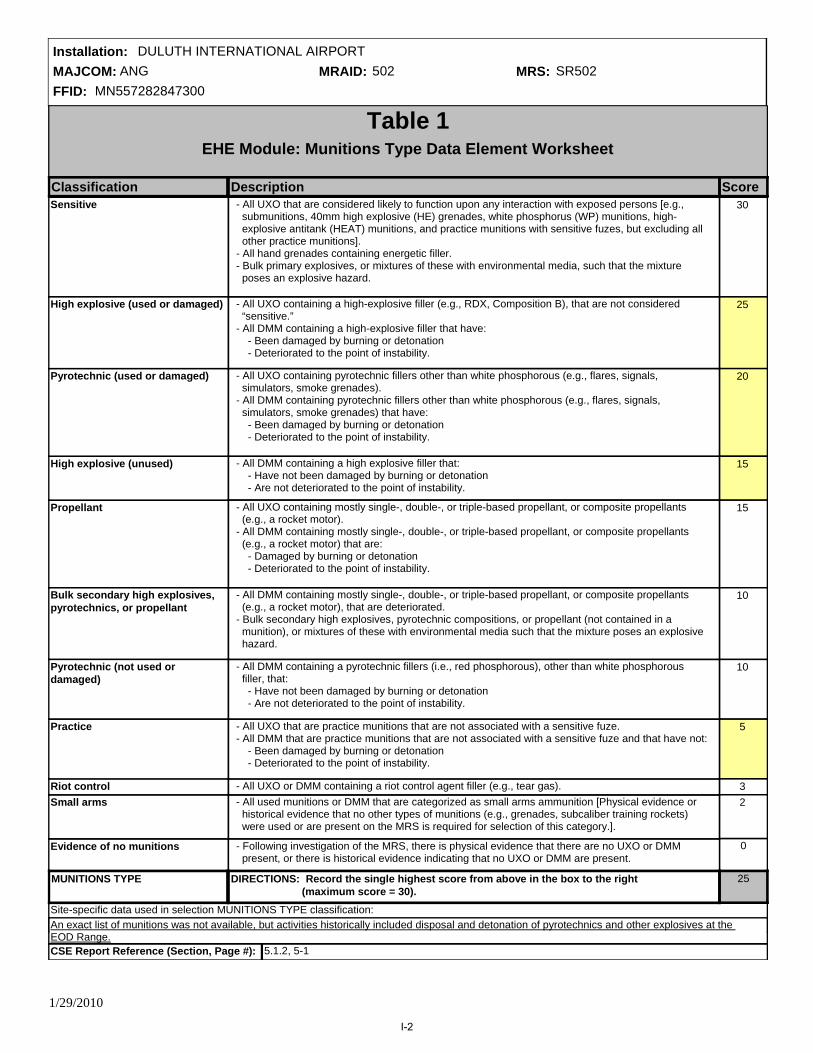
MAJCOM: ANGFFID: MN557282847300
Installation: DULUTH INTERNATIONAL AIRPORTMRAID: 502 MRS: SR502
Site-specific data used in selection MUNITIONS TYPE classification:
Propellant 0
Sensitive 0
High explosive (used or damaged) 25
Pyrotechnic (used or damaged) 20
High explosive (unused) 15
Bulk secondary high explosives, pyrotechnics, or propellant
0
Pyrotechnic (not used or damaged)
0
Practice 5
Riot control 0Small arms 0
Evidence of no munitions 0
MUNITIONS TYPE 25
An exact list of munitions was not available, but activities historically included disposal and detonation of pyrotechnics and other explosives at the EOD Range.
Table 1EHE Module: Munitions Type Data Element Worksheet
Classification Description Score - All UXO that are considered likely to function upon any interaction with exposed persons [e.g., submunitions, 40mm high explosive (HE) grenades, white phosphorus (WP) munitions, high- explosive antitank (HEAT) munitions, and practice munitions with sensitive fuzes, but excluding all other practice munitions]. - All hand grenades containing energetic filler. - Bulk primary explosives, or mixtures of these with environmental media, such that the mixture poses an explosive hazard.
- All UXO containing a high-explosive filler (e.g., RDX, Composition B), that are not considered “sensitive.” - All DMM containing a high-explosive filler that have: - Been damaged by burning or detonation - Deteriorated to the point of instability.
- All UXO containing pyrotechnic fillers other than white phosphorous (e.g., flares, signals, simulators, smoke grenades). - All DMM containing pyrotechnic fillers other than white phosphorous (e.g., flares, signals, simulators, smoke grenades) that have: - Been damaged by burning or detonation - Deteriorated to the point of instability.
- All DMM containing a high explosive filler that: - Have not been damaged by burning or detonation - Are not deteriorated to the point of instability.
- All UXO containing mostly single-, double-, or triple-based propellant, or composite propellants (e.g., a rocket motor). - All DMM containing mostly single-, double-, or triple-based propellant, or composite propellants (e.g., a rocket motor) that are: - Damaged by burning or detonation - Deteriorated to the point of instability.
- All DMM containing mostly single-, double-, or triple-based propellant, or composite propellants (e.g., a rocket motor), that are deteriorated. - Bulk secondary high explosives, pyrotechnic compositions, or propellant (not contained in a munition), or mixtures of these with environmental media such that the mixture poses an explosive hazard.
- All DMM containing a pyrotechnic fillers (i.e., red phosphorous), other than white phosphorous filler, that: - Have not been damaged by burning or detonation - Are not deteriorated to the point of instability.
- All UXO that are practice munitions that are not associated with a sensitive fuze. - All DMM that are practice munitions that are not associated with a sensitive fuze and that have not: - Been damaged by burning or detonation - Deteriorated to the point of instability.
- All UXO or DMM containing a riot control agent filler (e.g., tear gas). - All used munitions or DMM that are categorized as small arms ammunition [Physical evidence or historical evidence that no other types of munitions (e.g., grenades, subcaliber training rockets) were used or are present on the MRS is required for selection of this category.].
- Following investigation of the MRS, there is physical evidence that there are no UXO or DMM present, or there is historical evidence indicating that no UXO or DMM are present.
DIRECTIONS: Record the single highest score from above in the box to the right (maximum score = 30).
15
30
25
20
15
10
10
5
32
CSE Report Reference (Section, Page #): 5.1.2, 5-1
1/29/2010
I-2

MAJCOM: ANGFFID: MN557282847300
Installation: DULUTH INTERNATIONAL AIRPORTMRAID: 502 MRS: SR502
Site-specific data characteristics used to select the SOURCE OF HAZARD classification:
Former burial pit or other disposal area
5
Former Range 0
Former Munitions treatment (i.e., OB/OD unit)
8
Former practice munitions range 0
Former maneuver area 0
Former industrial operating facilities
0
Former firing points 0
Former missile or air defense artillery emplacements
0
Former storage or transfer points 0
Former small arms range 0
Evidence of no munitions 0
Source of Hazard 8
Table 2EHE Module: Source of Hazard Data Element Worksheet
Classification Description Score - The MRS is a former military range where munitions (including practice munitions with sensitive fuzes) have been used. Such areas include: impact or target areas, associated buffer and safety zones, firing points, and live-fire maneuver areas.
- The MRS is a location where UXO or DMM (e.g., munitions, bulk explosives, bulk pyrotechnic, or bulk propellants) were burned or detonated for the purpose of treatment prior to disposal.
- The MRS is a former military range on which only practice munitions without sensitive fuzes were used. - The MRS is a former maneuver area where no munitions other than flares, simulators, smokes, and blanks were used. There must be evidence that no other munitions were used at the location to place an MRS into this category.
- The MRS is a location where DMM were buried or disposed of (e.g., disposed of into a water body) without prior thermal treatment.
- The MRS is a location that is a former munitions maintenance, manufacturing, or demilitarization facility.
- The MRS is a firing point, where the firing point is delineated as an MRS separate from the rest of a former military range.
- The MRS is a former missile defense or air defense artillery (ADA) emplacement not associated with a military range.
- The MRS is a location where munitions were stored or handled for transfer between different modes of transportation (e.g., rail to truck, truck to weapon system).
- The MRS is a former military range where only small arms ammunition was used [There must be evidence that no other types of munitions (e.g., grenades) were used or are present to place an MRS into this category.].
- Following investigation of the MRS, there is physical evidence that no UXO or DMM are present, or there is historical evidence indicating that no UXO or DMM are present.
DIRECTIONS: Record the single highest score from above in the box to the right (maximum score = 10).
5
10
8
6
5
4
4
2
2
1
CSE Report Reference (Section, Page #): 5.1.2, 5-1
1/29/2010
I-3
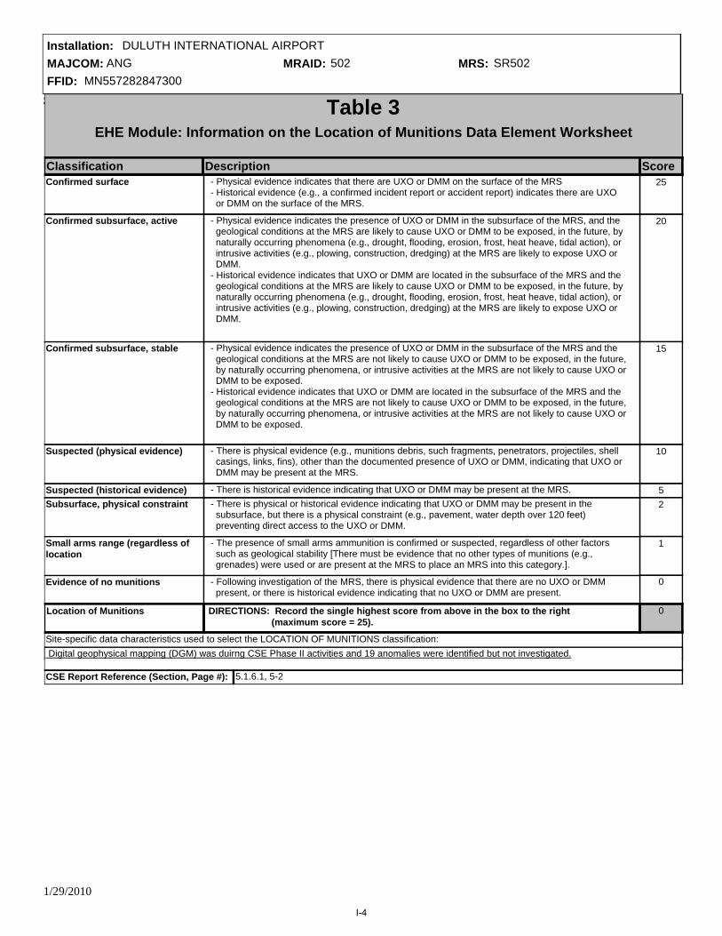
MAJCOM: ANGFFID: MN557282847300
Installation: DULUTH INTERNATIONAL AIRPORTMRAID: 502 MRS: SR502
29-Jan-1029-Jan-10
Site-specific data characteristics used to select the LOCATION OF MUNITIONS classification:
Suspected (historical evidence) 0
Confirmed surface 0
Confirmed subsurface, active 0
Confirmed subsurface, stable 0
Suspected (physical evidence) 0
Subsurface, physical constraint 0
Small arms range (regardless of location
0
Evidence of no munitions 0
Location of Munitions 0
Digital geophysical mapping (DGM) was duirng CSE Phase II activities and 19 anomalies were identified but not investigated.
Table 3EHE Module: Information on the Location of Munitions Data Element Worksheet
Classification Description Score - Physical evidence indicates that there are UXO or DMM on the surface of the MRS - Historical evidence (e.g., a confirmed incident report or accident report) indicates there are UXO or DMM on the surface of the MRS.
- Physical evidence indicates the presence of UXO or DMM in the subsurface of the MRS, and the geological conditions at the MRS are likely to cause UXO or DMM to be exposed, in the future, by naturally occurring phenomena (e.g., drought, flooding, erosion, frost, heat heave, tidal action), or intrusive activities (e.g., plowing, construction, dredging) at the MRS are likely to expose UXO or DMM. - Historical evidence indicates that UXO or DMM are located in the subsurface of the MRS and the geological conditions at the MRS are likely to cause UXO or DMM to be exposed, in the future, by naturally occurring phenomena (e.g., drought, flooding, erosion, frost, heat heave, tidal action), or intrusive activities (e.g., plowing, construction, dredging) at the MRS are likely to expose UXO or DMM.
- Physical evidence indicates the presence of UXO or DMM in the subsurface of the MRS and the geological conditions at the MRS are not likely to cause UXO or DMM to be exposed, in the future, by naturally occurring phenomena, or intrusive activities at the MRS are not likely to cause UXO or DMM to be exposed. - Historical evidence indicates that UXO or DMM are located in the subsurface of the MRS and the geological conditions at the MRS are not likely to cause UXO or DMM to be exposed, in the future, by naturally occurring phenomena, or intrusive activities at the MRS are not likely to cause UXO or DMM to be exposed.
- There is physical evidence (e.g., munitions debris, such fragments, penetrators, projectiles, shell casings, links, fins), other than the documented presence of UXO or DMM, indicating that UXO or DMM may be present at the MRS.
- There is historical evidence indicating that UXO or DMM may be present at the MRS. - There is physical or historical evidence indicating that UXO or DMM may be present in the subsurface, but there is a physical constraint (e.g., pavement, water depth over 120 feet) preventing direct access to the UXO or DMM.
- The presence of small arms ammunition is confirmed or suspected, regardless of other factors such as geological stability [There must be evidence that no other types of munitions (e.g., grenades) were used or are present at the MRS to place an MRS into this category.].
- Following investigation of the MRS, there is physical evidence that there are no UXO or DMM present, or there is historical evidence indicating that no UXO or DMM are present.
DIRECTIONS: Record the single highest score from above in the box to the right (maximum score = 25).
5
25
20
15
10
2
1
CSE Report Reference (Section, Page #): 5.1.6.1, 5-2
1/29/2010
I-4

MAJCOM: ANGFFID: MN557282847300
Installation: DULUTH INTERNATIONAL AIRPORTMRAID: 502 MRS: SR502
Site-specific characteristics used to select the EASE OF ACCESS classification:
No barrier 0
Barrier to MRS access is incomplete
8
Barrier to MRS access is complete but not monitored
0
Barrier to MRS access is complete and monitored
0
Ease of Access 8
Table 4EHE Module: Ease of Access Data Element Worksheet
Classification Description Score
The former EOD Range is located west of the main base on a restrictive easement owned by the Duluth Airport Authority and is outside of the airport's security fencing.St. Louis County has a population density of approximately 32 persons per square mile.Numerous threatened and endangered species have been identified in St. Louis County, and the EOD Range is maintained such that it could potentially provide habitat for protected ecological receptors; however, no ecological or cultural resources were reported or observed in this MRA.
- There is no barrier preventing access to any part of the MRS (i.e., all parts of the MRS are accessible).
- There is a barrier preventing access to parts of the MRS, but not the entire MRS.
- There is a barrier preventing access to all parts of the MRS, but there is no surveillance (e.g., by a guard) to ensure that the barrier is effectively preventing access to all parts of the MRS.
- There is a barrier preventing access to all parts of the MRS, and there is active, continual surveillance (e.g., by a guard, video monitoring) to ensure that the barrier is effectively preventing access to all parts of the MRS.
DIRECTIONS: Record the single highest score from above in the box to the right (maximum score = 10).
10
8
5
CSE Report Reference (Section, Page #): 5.1.4, 5-1/5.1.1, 5-1/5.1.7.1, 5-13/5.1.7.2, 5-13
1/29/2010
I-5

MAJCOM: ANGFFID: MN557282847300
Installation: DULUTH INTERNATIONAL AIRPORTMRAID: 502 MRS: SR502
Non-DoD control 0
Scheduled for transfer from DoD control
0
DoD control 0
Status of Property 0
Table 5EHE Module: Status of Property Data Element Worksheet
Classification Description Score
Site-specific characteristics used to select the EASE OF ACCESS classification:
- The MRS is at a location that is no longer owned by, leased to, or otherwise possessed or used by DoD. Examples are privately owned land or water bodies; land or water bodies owned or controlled by state, tribal, or local governments; and land or water bodies managed by other federal agencies.
- The MRS is on land or is a water body that is owned, leased, or otherwise possessed by DoD, and DoD plans to transfer that land or water body to the control of another entity (e.g., a state, tribal, or local government; a private party; another federal agency) within 3 years from the date the rule is applied.
- The MRS is on land or is a water body that is owned, leased, or otherwise possessed by DoD. With respect to property that is leased or otherwise possessed, DoD must control access to the MRS 24 hours per day, every day of the calendar year.
DIRECTIONS: Record the single highest score from above in the box to the right (maximum score = 5).
5
3
CSE Report Reference (Section, Page #): 5.1.6.1, 5-2
1/29/2010
I-6

MAJCOM: ANGFFID: MN557282847300
Installation: DULUTH INTERNATIONAL AIRPORTMRAID: 502 MRS: SR502
Site-specific characteristics that helped select the POPULATION DENSITY classification
> 500 persons per square mile 0
100- 500 persons per square mile 0
< 100 persons per square mile 1
Population Density 1
The former EOD Range is located west of the main base on a restrictive easement owned by the Duluth Airport Authority and is outside of the airport's security fencing.St. Louis County has a population density of approximately 32 persons per square mile.Numerous threatened and endangered species have been identified in St. Louis County, and the EOD Range is maintained such that it could potentially provide habitat for protected ecological receptors; however, no ecological or cultural resources were reported or observed in this MRA.
Table 6EHE Module: Population Density Data Element Worksheet
Classification Description Score - There are more than 500 persons per square mile in the county in which the MRS is located, based on U.S. Census Bureau data.
- There are 100 to 500 persons per square mile in the county in which the MRS is located, based on U.S. Census Bureau data.
- There are fewer than 100 persons per square mile in the county in which the MRS is located, based on U.S. Census Bureau data.
DIRECTIONS: Record the single highest score from above in the box to the right (maximum score = 5).
5
3
1
CSE Report Reference (Section, Page #): 5.1.4, 5-1/5.1.1, 5-1/5.1.7.1, 5-13/5.1.7.2, 5-13
1/29/2010
I-7

MAJCOM: ANGFFID: MN557282847300
Installation: DULUTH INTERNATIONAL AIRPORTMRAID: 502 MRS: SR502
Site-specific data characteristics used to select the POPULATION NEAR HAZARD classification:
1 to 5 inhabited structures 0
26 or more inhabited structures 5
16 to 25 inhabited structures 0
11 to 15 inhabited structures 0
6 to 10 inhabited structures 0
0 inhabited structures 0
Population Near Hazard 5
Table 7EHE Module: Population Near Hazard Data Element Worksheet
Classification Description Score - There are 26 or more inhabited structures located up to 2 miles from the boundary of the MRS, within the boundary of the MRS, or both.
- There are 16 to 25 inhabited structures located up to 2 miles from the boundary of the MRS, within the boundary of the MRS, or both.
- There are 11 to 15 inhabited structures located up to 2 miles from the boundary of the MRS, within the boundary of the MRS, or both.
- There are 6 to 10 inhabited structures located up to 2 miles from the boundary of the MRS, within the boundary of the MRS, or both.
- There are 1 to 5 inhabited structures located up to 2 miles from the boundary of the MRS, within the boundary of the MRS, or both.
- There are no inhabited structures located up to 2 miles from the boundary of the MRS, within the boundary of the MRS, or both.
DIRECTIONS: Record the single highest score from above in the box to the right (maximum score = 5).
1
5
4
3
2
CSE Report Reference (Section, Page #): 5.1.4, 5-1/5.1.1, 5-1/5.1.7.1, 5-13/5.1.7.2, 5-13
1/29/2010
I-8

MAJCOM: ANGFFID: MN557282847300
Installation: DULUTH INTERNATIONAL AIRPORTMRAID: 502 MRS: SR502
Site-specific data characteristics used to select the LOCATION OF MUNITIONS classification:
No known or recurring activities 0
Residential. educational, or subsitence
5
Parks and recreational areas 0
Agricultural, forestry 3
Industrial or warehousing 2
Types of Activites/Structures 5
Table 8EHE Module: Types of Activities/Structures Data Element Worksheet
Classification Description Score - Activities are conducted, or inhabited structures are located up to two miles from the MRS’s boundary or within the MRS’s boundary, that are associated with any of the following purposes: residential, educational, child care, critical assets (e.g., hospitals, fire and rescue, police stations, dams), hotels, commercial, shopping centers, playgrounds, community gathering areas, religious sites, or sites used for subsistence hunting, fishing, and gathering.
- Activities are conducted, or inhabited structures are located up to two miles from the MRS’s boundary or within the MRS’s boundary, that are associated with parks, nature preserves, or other recreational uses.
- Activities are conducted, or inhabited structures are located up to two miles from the MRS’s boundary or within the MRS’s boundary, that are associated with agriculture or forestry.
- Activities are conducted, or inhabited structures are located up to two miles from the MRS’s boundary or within the MRS’s boundary, that are associated with industrial activities or warehousing.
- There are no known or recurring activities occurring up to two miles from the MRS’s boundary or within the MRS’s boundary.
DIRECTIONS: Record the single highest score from above in the box to the right (maximum score = 5).
1
5
4
3
2
CSE Report Reference (Section, Page #): 5.1.4, 5-1/5.1.1, 5-1/5.1.7.1, 5-13/5.1.7.2, 5-13
1/29/2010
I-9

MAJCOM: ANGFFID: MN557282847300
Installation: DULUTH INTERNATIONAL AIRPORTMRAID: 502 MRS: SR502
Site-specific characteristics used to select the ECOLOGICAL AND/OR CULTURAL RESOURCES classification:
Ecological and cultural resources present
0
Ecological resources present 0
Cultural resources present 0
No ecological or cultural resources present
0
Ecological and/or Cultural Resources
0
Table 9EHE Module: Ecological and/or Cultural Resources Data Element Worksheet
Classification Description Score
The former EOD Range is located west of the main base on a restrictive easement owned by the Duluth Airport Authority and is outside of the airport's security fencing.St. Louis County has a population density of approximately 32 persons per square mile.Numerous threatened and endangered species have been identified in St. Louis County, and the EOD Range is maintained such that it could potentially provide habitat for protected ecological receptors; however, no ecological or cultural resources were reported or observed in this MRA.
- There are both ecological and cultural resources present on the MRS.
- There are ecological resources present on the MRS.
- There are cultural resources present on the MRS.
- There are no ecological resources or cultural resources present on the MRS.
DIRECTIONS: Record the single highest score from above in the box to the right (maximum score = 5).
Ecological and cultural resources present
5
Ecological resources present 3
Cultural resources present 3
CSE Report Reference (Section, Page #): 5.1.4, 5-1/5.1.1, 5-1/5.1.7.1, 5-13/5.1.7.2, 5-13
1/29/2010
I-10

MAJCOM: ANGFFID: MN557282847300
Installation: DULUTH INTERNATIONAL AIRPORTMRAID: 502 MRS: SR502
Table 10Determining the EHE Module Rating
Source Score
Table 1
Source of Hazard 8Table 2
Information on Location of Munitions 0Table 3
Ease of Access 8Table 4
Status of Property 0Table 5
Population Density 1Table 6
Population Near Hazard 5Table 7
Types of Activities/Structures 5Table 8
Ecological and/or Cultural Resources 0Table 9
52
Explosive Hazard Factor Data Elements
Accessibility Factor Data Elements
Receptors Factor Data Elements
92 to 100
82 to 91
71 to 81
60 to 70
48 to 59
less than 38
38 to 47
A
F
B
D
C
E
G
Alternative Module Ratings
EHE Module Value EHE Module Rating
Sum
Prioritization No Longer Required
No Known or Suspected Explosive Hazard
25Munitions Type
Evaluation Pending
1/29/2010
I-11

MAJCOM: ANGFFID: MN557282847300
Installation: DULUTH INTERNATIONAL AIRPORTMRAID: 502 MRS: SR502
CWM Configuration N/A
Table 20Determining the CHE Module Rating
Source Score
Table 11
Source of CWM N/ATable 12
Information on Location of Munitions N/ATable 13
Ease of Access N/ATable 14
Status of Property N/ATable 15
Population Density N/ATable 16
Population Near Hazard N/ATable 17
Types of Activities/Structures N/ATable 18
Ecological and/or Cultural Resources N/ATable 19
N/A
CWM Hazard Factor Data Elements
Accessibility Factor Data Elements
Receptors Factor Data Elements
92 to 100
82 to 91
71 to 81
60 to 70
48 to 59
less than 38
38 to 47
A
F
B
D
C
E
G
CHE Module Value
Sum
CHE Module Rating
Alternative Module RatingsPrioritization No Longer Required
No Known or Suspected CWM Hazard
Evaluation Pending
Tables 11-19 were not generated because there is no known or suspected CWM hazard at the MRS.
1/29/2010
I-12

MAJCOM: ANGFFID: MN557282847300
Installation: DULUTH INTERNATIONAL AIRPORTMRAID: 502 MRS: SR502
CHF = [Maximum Concentration of Contaminant]
[Comparison Value for Contaminant] Σ
Table 21HHE Module: Groundwater Data Element Worksheet
Contaminant Maximum Concentration (ug/L) RatiosComparison Value (ug/L)
CHF Scale CHF Value Contamination Hazard Factor (CHF)
CHF Value
CHF > 100100 > CHF > 22 > CHF
H (High)M (Medium)
L (Low)
3.7
CHF VALUE M
Migratory Pathway FactorEvident
Potential
Confined
Migratory Pathway Factor
L
H
M
L
Analytical data or observable evidence indicates that contamination in the groundwater is present at, moving toward, or has moved to a point of exposure.
Contamination in groundwater has moved only slightly beyond the source (i.e., tens of feet), could move but is not moving appreciably, or information is not sufficient to make a determination of Evident or Confined.
The single highest value from above in the box to the right (maximum value = H).
Information indicates a low potential for contaminant migration from the source via the groundwater to a potential point of exposure (possibly due to geological structures or physical controls).
Receptor FactorIdentified
Potential
Limited
Receptor Factor
H
M
L
There is a threatened water supply well downgradient of the source and the groundwater is a current source of drinking water or source of water for other beneficial uses such as irrigation/agriculture (equivalent to Class I or IIA aquifer).
There is no threatened water supply well downgradient of the source and the groundwater is currently or potentially usable for drinking water, irrigation, or agriculture (equivalent to Class I, IIA, or IIB aquifer).
The single highest value from above in the box to the right (maximum value = H).
There is no potentially threatened water supply well downgradient of the source and the groundwater is not considered a potential source of drinking water and is of limited beneficial use (equivalent to Class IIIA or IIIB aquifer, or where perched aquifer exists only).
Alternative Module RatingsNo Known or Suspected Hazard
Prioritization No Longer Required
H
Minnesota Department of Health records indicate that there may be as many as 15 residential water supply wells located within one mile of the LCSA, EOD Range, and Trap Range MRAs.
Above noted concentrations were identified in the presumed downgradient sampling location, which is believed to be most representative of site concentrations. Concentrationbs are low and localized, and thus are not suspected to have migrated off-site toward downgradient receptors.
Rationale for Selection of MPF:
Rationale for Selection of RF:
Sample comments:
RDX (Cyclonite) 0.59 61 0.0
Naphthalene 3.2 6.2 0.5
2-Methylnaphthalene 3.5 150 0.0
Tin (inorganic, also see tributyltin oxide)
8.8 22000 0.0
Iron 19000 11000 1.7
Arsenic 3.4 4.5 0.8
Barium and compounds 190 7300 0.0
Copper and compounds 200 1500 0.1
Lead 7.4 15 0.5
1/29/2010
I-13

MAJCOM: ANGFFID: MN557282847300
Installation: DULUTH INTERNATIONAL AIRPORTMRAID: 502 MRS: SR502
Two unfiltered groundwater samples were collected at the EOD Range: one located adjacent to the detonation pit in the center of the site (SR502-GW002), and the other in the assumed upgradient direction (southwest corner of the site) (SR502-GW003). Elevated metals in sample SR502-GW0003 are likely the result of turbidity in the unfiltered sample and not associated with the historical EOD activity at the MRA.
CSE Report Reference (Section, Page #):5.1.6.2, 5-13
1/29/2010
I-14

MAJCOM: ANGFFID: MN557282847300
Installation: DULUTH INTERNATIONAL AIRPORTMRAID: 502 MRS: SR502
CHF = [Maximum Concentration of Contaminant]
[Comparison Value for Contaminant] Σ
Table 22HHE Module: Surface Water - Human Endpoint Data Element Worksheet
Contaminant Maximum Concentration (ug/L) RatiosComparison Value (ug/L)CHF Scale CHF Value Contamination Hazard Factor (CHF)
CHF Value
CHF > 100100 > CHF > 22 > CHF
H (High)M (Medium)
L (Low)
No Data
CHF VALUE NA
Migratory Pathway FactorEvident
Potential
Confined
Migratory Pathway Factor
H
M
L
Analytical data or observable evidence indicates that contamination in the surface water is present at, moving toward, or has moved to a point of exposure.
Contamination in surface water has moved only slightly beyond the source (i.e., tens of feet), could move but is not moving appreciably, or information is not sufficient to make a determination of Evident or Confined.
The single highest value from above in the box to the right (maximum value = H).
Information indicates a low potential for contaminant migration from the source via the surface water to a potential point of exposure (possibly due to geological structures or physical controls).
Receptor FactorIdentified
Potential
Limited
Receptor Factor
H
M
L
Identified receptors to have access to surface water to whick contamination has moved or can move.
Potential for receptors to have access to surface water to whick contamination has moved or can move.
The single highest value from above in the box to the right (maximum value = H).
Little or no potential for receptors to have access to surface water to whick contamination has moved or can move.
Alternative Module Ratings
NA
NA
No Known or Suspected Hazard
Prioritization No Longer Required
Sample comments:
Rationale for Selection of MPF:
Rationale for Selection of RF:
CSE Report Reference (Section, Page #):
1/29/2010
I-15

MAJCOM: ANGFFID: MN557282847300
Installation: DULUTH INTERNATIONAL AIRPORTMRAID: 502 MRS: SR502
No Known or Suspected Hazard
Prioritization No Longer Required
CHF = [Maximum Concentration of Contaminant]
[Comparison Value for Contaminant] Σ
Table 23HHE Module: Sediment - Human Endpoint Data Element Worksheet
Contaminant Maximum Concentration (mg/kg) RatiosComparison Value (mg/kg)CHF Scale CHF Value Contamination Hazard Factor (CHF)
CHF Value
CHF > 100100 > CHF > 22 > CHF
H (High)M (Medium)
L (Low)
No Data
CHF VALUE NA
Migratory Pathway FactorEvident
Potential
Confined
Migratory Pathway Factor
NA
H
M
L
Analytical data or observable evidence indicates that contamination in the sediment is present at, moving toward, or has moved to a point of exposure.
Contamination in sediment has moved only slightly beyond the source (i.e., tens of feet), could move but is not moving appreciably, or information is not sufficient to make a determination of Evident or Confined.
The single highest value from above in the box to the right (maximum value = H).
Information indicates a low potential for contaminant migration from the source via the sediment to a potential point of exposure (possibly due to geological structures or physical controls).
Receptor FactorIdentified
Potential
Limited
Receptor Factor
H
M
L
Identified receptors to have access to sediment to which contamination has moved or can move.
Potential for receptors to have access to sediment to which contamination has moved or can move
The single highest value from above in the box to the right (maximum value = H).
Little or no potential for receptors to have access to sediment to which contamination has moved or can move
NA
Alternative Module Ratings
Sample comments:
Rationale for Selection of MPF:
Rationale for Selection of RF:
CSE Report Reference (Section, Page #):
1/29/2010
I-16
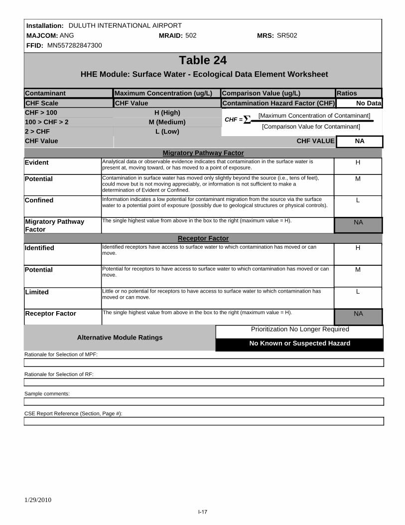
MAJCOM: ANGFFID: MN557282847300
Installation: DULUTH INTERNATIONAL AIRPORTMRAID: 502 MRS: SR502
No Known or Suspected Hazard
Prioritization No Longer Required
CHF = [Maximum Concentration of Contaminant]
[Comparison Value for Contaminant] Σ
Table 24HHE Module: Surface Water - Ecological Data Element Worksheet
Contaminant Maximum Concentration (ug/L) RatiosComparison Value (ug/L)CHF Scale CHF Value Contamination Hazard Factor (CHF)
CHF Value
CHF > 100100 > CHF > 22 > CHF
H (High)M (Medium)
L (Low)
No Data
CHF VALUE NA
Migratory Pathway FactorEvident
Potential
Confined
Migratory Pathway Factor
H
M
L
Analytical data or observable evidence indicates that contamination in the surface water is present at, moving toward, or has moved to a point of exposure.
Contamination in surface water has moved only slightly beyond the source (i.e., tens of feet), could move but is not moving appreciably, or information is not sufficient to make a determination of Evident or Confined.
The single highest value from above in the box to the right (maximum value = H).
Information indicates a low potential for contaminant migration from the source via the surface water to a potential point of exposure (possibly due to geological structures or physical controls).
Receptor FactorIdentified
Potential
Limited
Receptor Factor
H
M
L
Identified receptors have access to surface water to which contamination has moved or can move.
Potential for receptors to have access to surface water to which contamination has moved or can move.
The single highest value from above in the box to the right (maximum value = H).
Little or no potential for receptors to have access to surface water to which contamination has moved or can move.
NA
NA
Alternative Module Ratings
Sample comments:
Rationale for Selection of MPF:
Rationale for Selection of RF:
CSE Report Reference (Section, Page #):
1/29/2010
I-17

MAJCOM: ANGFFID: MN557282847300
Installation: DULUTH INTERNATIONAL AIRPORTMRAID: 502 MRS: SR502
No Known or Suspected Hazard
Prioritization No Longer Required
CHF = [Maximum Concentration of Contaminant]
[Comparison Value for Contaminant] Σ
Table 25HHE Module: Sediment - Ecological Endpoint Data Element Worksheet
Contaminant Maximum Concentration (mg/kg) RatiosComparison Value (mg/kg)CHF Scale CHF Value Contamination Hazard Factor (CHF)
CHF Value
CHF > 100100 > CHF > 22 > CHF
H (High)M (Medium)
L (Low)
No Data
CHF VALUE NA
Migratory Pathway FactorEvident
Potential
Confined
Migratory Pathway Factor
H
M
L
Analytical data or observable evidence indicates that contamination in the sediment is present at, moving toward, or has moved to a point of exposure.
Contamination in sediment has moved only slightly beyond the source (i.e., tens of feet), could move but is not moving appreciably, or information is not sufficient to make a determination of Evident or Confined.
The single highest value from above in the box to the right (maximum value = H).
Information indicates a low potential for contaminant migration from the source via the sediment to a potential point of exposure (possibly due to geological structures or physical controls).
Receptor FactorIdentified
Potential
Limited
Receptor Factor
H
M
L
Identified receptors to have access to sediment to which contamination has moved or can move.
potential for receptors to have access to sediment to which contamination has moved or can move.
The single highest value from above in the box to the right (maximum value = H).
Little or no potential for receptors to have access to sediment to which contamination has moved or can move.
NA
NA
Alternative Module Ratings
Sample comments:
Rationale for Selection of MPF:
Rationale for Selection of RF
CSE Report Reference (Section, Page #):
1/29/2010
I-18

MAJCOM: ANGFFID: MN557282847300
Installation: DULUTH INTERNATIONAL AIRPORTMRAID: 502 MRS: SR502
No Known or Suspected Hazard
Prioritization No Longer Required
CHF = [Maximum Concentration of Contaminant]
[Comparison Value for Contaminant] Σ
Table 26HHE Module: Soil - Data Element Worksheet
Contaminant Maximum Concentration (mg/kg) RatiosComparison Value (mg/kg)
CHF Scale CHF Value Contamination Hazard Factor (CHF)
CHF Value
CHF > 100100 > CHF > 22 > CHF
H (High)M (Medium)
L (Low)
1.8
CHF VALUE M
Migratory Pathway FactorEvident
Potential
Confined
Migratory Pathway Factor
M
H
M
L
Analytical data or observable evidence indicates that contamination in the soil is present at, moving toward, or has moved to a point of exposure.
Contamination in soil has moved only slightly beyond the source (i.e., tens of feet), could move but is not moving appreciably, or information is not sufficient to make a determination of Evident or Confined.
The single highest value from above in the box to the right (maximum value = H).
Information indicates a low potential for contaminant migration from the source via the soil to a potential point of exposure (possibly due to geological structures or physical controls).
Receptor FactorIdentified
Potential
Limited
Receptor Factor
H
M
L
Identified receptors to have access to soil to which contamination has moved or can move.
Potential for receptors to have access to soil to which contamination has moved or can move.
The single highest value from above in the box to the right (maximum value = H).
Little or no potential for receptors to have access to soil to which contamination has moved or can move.
M
Alternative Module Ratings
Sample comments:
There is potential for receptors have access to surface soil at the EOD Range.
Soil contaminants at elevated concentrations were identified near oi the source of contamination at the EOD RangeRationale for Selection of MPF:
Rationale for Selection of RF:
Iron was detected above the soil screening level in one surface soil and five subsurface soil samples at the EOD Range. Copper was detected above the screening level in one subsurface soil sample at the EOD Range. All other detections were below screening levels.
Tin (inorganic, also see tributyltin oxide)
0.83 47000 0.0
Mercury and compounds 0.074 23 0.0
Lead 170 400 0.4
Cadmium and compounds 0.14 39 0.0
Barium and compounds 60 16000 0.0
Arsenic 2.6 22 0.1
Copper and compounds 160 3100 0.1
Iron 27000 23000 1.2
1/29/2010
I-19

MAJCOM: ANGFFID: MN557282847300
Installation: DULUTH INTERNATIONAL AIRPORTMRAID: 502 MRS: SR502
CSE Report Reference (Section, Page #):5.1.6.2, 5-2
1/29/2010
I-20

MAJCOM: ANGFFID: MN557282847300
Installation: DULUTH INTERNATIONAL AIRPORTMRAID: 502 MRS: SR502
Evaluation Pending
Migratory Pathway
Factor ValueL
NA
NA
NA
NA
M
D
Prioritization No Longer Required
No Known or Suspected MC Hazard
B
Table 27Determining the HHE Module Rating
Groundwater (Table 21)
Surface Water/Human Endpoint (Table 22)
Sediment/Ecological Endpoint (Table 25)
Sediment/Human Endpoint (Table 23)
Surface Water/Ecological Endpoint (Table 24)
Soil (Table 26)
Media Source Contaminant Hazard Factor
Receptor Factor Value
3-Letter Ratings
(Hs-Ms-Ls)
Media Rating (A-G)
H
NA
NA
NA
NA
M
D
NA
NA
NA
NA
D
HML
NA
M
NA
NA
NA
NA
M
NA
NA
NA
MMM
HHH
HHL
HMM
HML
HLL
MMM
Combination
Alternative Module Ratings
MML
MLL
LLL
C
A
D
E
F
G
Rating
HHM
HHE Module Ratings
HHE Ratings (for reference only)
1/29/2010
I-21
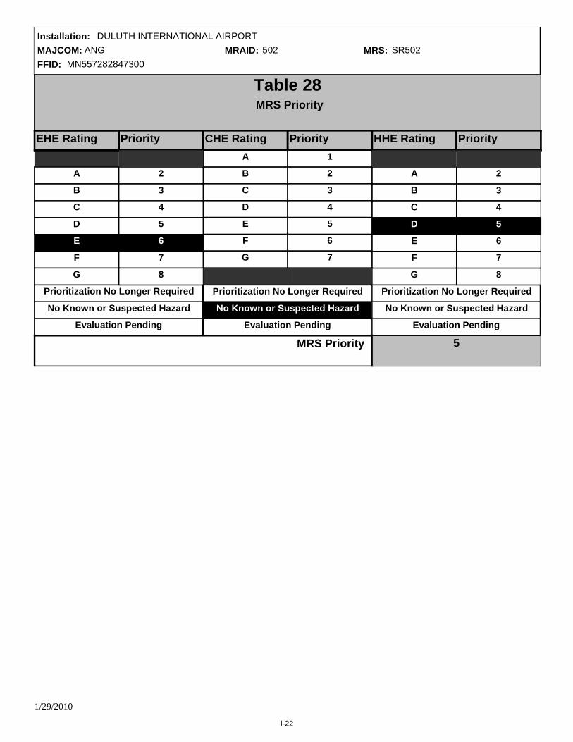
MAJCOM: ANGFFID: MN557282847300
Installation: DULUTH INTERNATIONAL AIRPORTMRAID: 502 MRS: SR502
Table 28MRS Priority
EHE RatingEHE Rating Priority CHE Rating Priority HHE Rating Priority
A
F
B
D
C
E
G
Prioritization No Longer Required
No Known or Suspected Hazard
2
7
3
5
4
6
8
A
F
B
D
C
E
G
1
6
2
4
3
5
7
A
F
B
D
C
E
G
Prioritization No Longer Required
No Known or Suspected Hazard
2
7
3
5
4
6
8
Prioritization No Longer Required
No Known or Suspected Hazard
MRS Priority 5Evaluation Pending Evaluation Pending Evaluation Pending
1/29/2010
I-22

MAJCOM: ANGFFID: MN557282847300
Installation: DULUTH INTERNATIONAL AIRPORTMRAID: 736 MRS: SR736
Table AMRS Background Information
Munitions Response Site Name: Small Arms Ranges
Component: Air Force
Installation/Property Name: DULUTH INTERNATIONAL AIRPORT
Location (City, County, State): Duluth, St. Louis, MN
Site Name/Project name (Project No.): Small Arms Ranges
Date Information Entered\Updated: 12/22/2009 3:00:06 PM
Point of Contact Name: Ryan Blazevic
Project Phase (check only one):
PA SI RI FS RD
RA RIP RC
Groundwater Sediment (human receptor)
Surface soil Surface Water (ecological receptor)
Media Evaluated (check all that apply):
Sediment (ecological receptor) Surface Water (human receptor)
MRS Summary:
The former Small Arms Range is located west of the main base and is north of the intersection of Runway 21 and Runway 13, on property owned by the Duluth Airport Authority. The area encompasses approximately 2.5 acres. The terrain is mostly flat and is bordered to the north and west by the Northwest Airlines Maintenance Facility and to the south and east by undeveloped land. Two retention ponds are located approximately 300 feet northwest of the range. The basins are used for both storm water management and fire emergency water supply. No evidence of the former range exists on the site, portions of which are covered by an aircraft parking apron. A small hill, consisting of non-native fill (assumed placed during the construction of the Northwest Airlines Maintenance Facility) is located on the eastern side of the site.
MRS Description: Describe the munitions-related activities that occurred at the installation, the dates of operation, and the UXO, DMM, or MC known or suspected to be present. When possible, identify munitions, CWM, and MC by type:
Description of Pathways for Human and Ecological Receptors:
Description of Receptors (Human and Ecological):
Receptors with potential to be exposed to MCs through ingestion, dermal contact, or inhalation of soil include base workers, maintenance personnel, recreational users, and construction workers.
Potential human receptors at the Small Arms Range include base workers, maintenance personnel, and recreational users. Potential ecological receptors include plants, invertebrates, vertebrate herbivores, omnivores, and carnivores.
(218) 788-7868Point of Contact Phone:
CSE Report Reference (Section, Page #):GENERAL - 5.2.1, 5-13/8.2.3.1, 8-4/5.2.7, 5-25, LOCATION - , POC - , CONTRACTOR -
1/29/2010
I-23

MAJCOM: ANGFFID: MN557282847300
Installation: DULUTH INTERNATIONAL AIRPORTMRAID: 736 MRS: SR736
Table 10Determining the EHE Module Rating
Source Score
Table 1
Source of Hazard N/ATable 2
Information on Location of Munitions N/ATable 3
Ease of Access N/ATable 4
Status of Property N/ATable 5
Population Density N/ATable 6
Population Near Hazard N/ATable 7
Types of Activities/Structures N/ATable 8
Ecological and/or Cultural Resources N/ATable 9
N/A
Explosive Hazard Factor Data Elements
Accessibility Factor Data Elements
Receptors Factor Data Elements
92 to 100
82 to 91
71 to 81
60 to 70
48 to 59
less than 38
38 to 47
A
F
B
D
C
E
G
Alternative Module Ratings
EHE Module Value EHE Module Rating
Sum
Prioritization No Longer Required
No Known or Suspected Explosive Hazard
N/AMunitions Type
Evaluation Pending
Tables 1-9 were not generated because there is no known or suspected explosive hazard at the MRS.
1/29/2010
I-24

MAJCOM: ANGFFID: MN557282847300
Installation: DULUTH INTERNATIONAL AIRPORTMRAID: 736 MRS: SR736
CWM Configuration N/A
Table 20Determining the CHE Module Rating
Source Score
Table 11
Source of CWM N/ATable 12
Information on Location of Munitions N/ATable 13
Ease of Access N/ATable 14
Status of Property N/ATable 15
Population Density N/ATable 16
Population Near Hazard N/ATable 17
Types of Activities/Structures N/ATable 18
Ecological and/or Cultural Resources N/ATable 19
N/A
CWM Hazard Factor Data Elements
Accessibility Factor Data Elements
Receptors Factor Data Elements
92 to 100
82 to 91
71 to 81
60 to 70
48 to 59
less than 38
38 to 47
A
F
B
D
C
E
G
CHE Module Value
Sum
CHE Module Rating
Alternative Module RatingsPrioritization No Longer Required
No Known or Suspected CWM Hazard
Evaluation Pending
Tables 11-19 were not generated because there is no known or suspected CWM hazard at the MRS.
1/29/2010
I-25

MAJCOM: ANGFFID: MN557282847300
Installation: DULUTH INTERNATIONAL AIRPORTMRAID: 736 MRS: SR736
CHF = [Maximum Concentration of Contaminant]
[Comparison Value for Contaminant] Σ
Table 21HHE Module: Groundwater Data Element Worksheet
Contaminant Maximum Concentration (ug/L) RatiosComparison Value (ug/L)CHF Scale CHF Value Contamination Hazard Factor (CHF)
CHF Value
CHF > 100100 > CHF > 22 > CHF
H (High)M (Medium)
L (Low)
No Data
CHF VALUE NA
Migratory Pathway FactorEvident
Potential
Confined
Migratory Pathway Factor
NA
H
M
L
Analytical data or observable evidence indicates that contamination in the groundwater is present at, moving toward, or has moved to a point of exposure.
Contamination in groundwater has moved only slightly beyond the source (i.e., tens of feet), could move but is not moving appreciably, or information is not sufficient to make a determination of Evident or Confined.
The single highest value from above in the box to the right (maximum value = H).
Information indicates a low potential for contaminant migration from the source via the groundwater to a potential point of exposure (possibly due to geological structures or physical controls).
Receptor FactorIdentified
Potential
Limited
Receptor Factor
H
M
L
There is a threatened water supply well downgradient of the source and the groundwater is a current source of drinking water or source of water for other beneficial uses such as irrigation/agriculture (equivalent to Class I or IIA aquifer).
There is no threatened water supply well downgradient of the source and the groundwater is currently or potentially usable for drinking water, irrigation, or agriculture (equivalent to Class I, IIA, or IIB aquifer).
The single highest value from above in the box to the right (maximum value = H).
There is no potentially threatened water supply well downgradient of the source and the groundwater is not considered a potential source of drinking water and is of limited beneficial use (equivalent to Class IIIA or IIIB aquifer, or where perched aquifer exists only).
Alternative Module RatingsNo Known or Suspected Hazard
Prioritization No Longer Required
NA
Rationale for Selection of MPF:
Rationale for Selection of RF:
Sample comments:
CSE Report Reference (Section, Page #):
1/29/2010
I-26

MAJCOM: ANGFFID: MN557282847300
Installation: DULUTH INTERNATIONAL AIRPORTMRAID: 736 MRS: SR736
CHF = [Maximum Concentration of Contaminant]
[Comparison Value for Contaminant] Σ
Table 22HHE Module: Surface Water - Human Endpoint Data Element Worksheet
Contaminant Maximum Concentration (ug/L) RatiosComparison Value (ug/L)CHF Scale CHF Value Contamination Hazard Factor (CHF)
CHF Value
CHF > 100100 > CHF > 22 > CHF
H (High)M (Medium)
L (Low)
No Data
CHF VALUE NA
Migratory Pathway FactorEvident
Potential
Confined
Migratory Pathway Factor
H
M
L
Analytical data or observable evidence indicates that contamination in the surface water is present at, moving toward, or has moved to a point of exposure.
Contamination in surface water has moved only slightly beyond the source (i.e., tens of feet), could move but is not moving appreciably, or information is not sufficient to make a determination of Evident or Confined.
The single highest value from above in the box to the right (maximum value = H).
Information indicates a low potential for contaminant migration from the source via the surface water to a potential point of exposure (possibly due to geological structures or physical controls).
Receptor FactorIdentified
Potential
Limited
Receptor Factor
H
M
L
Identified receptors to have access to surface water to whick contamination has moved or can move.
Potential for receptors to have access to surface water to whick contamination has moved or can move.
The single highest value from above in the box to the right (maximum value = H).
Little or no potential for receptors to have access to surface water to whick contamination has moved or can move.
Alternative Module Ratings
NA
NA
No Known or Suspected Hazard
Prioritization No Longer Required
Sample comments:
Rationale for Selection of MPF:
Rationale for Selection of RF:
CSE Report Reference (Section, Page #):
1/29/2010
I-27
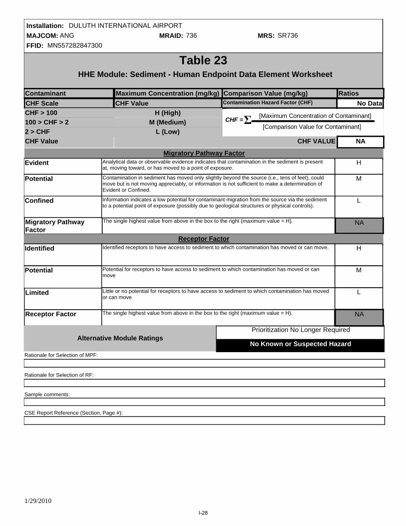
MAJCOM: ANGFFID: MN557282847300
Installation: DULUTH INTERNATIONAL AIRPORTMRAID: 736 MRS: SR736
No Known or Suspected Hazard
Prioritization No Longer Required
CHF = [Maximum Concentration of Contaminant]
[Comparison Value for Contaminant] Σ
Table 23HHE Module: Sediment - Human Endpoint Data Element Worksheet
Contaminant Maximum Concentration (mg/kg) RatiosComparison Value (mg/kg)CHF Scale CHF Value Contamination Hazard Factor (CHF)
CHF Value
CHF > 100100 > CHF > 22 > CHF
H (High)M (Medium)
L (Low)
No Data
CHF VALUE NA
Migratory Pathway FactorEvident
Potential
Confined
Migratory Pathway Factor
NA
H
M
L
Analytical data or observable evidence indicates that contamination in the sediment is present at, moving toward, or has moved to a point of exposure.
Contamination in sediment has moved only slightly beyond the source (i.e., tens of feet), could move but is not moving appreciably, or information is not sufficient to make a determination of Evident or Confined.
The single highest value from above in the box to the right (maximum value = H).
Information indicates a low potential for contaminant migration from the source via the sediment to a potential point of exposure (possibly due to geological structures or physical controls).
Receptor FactorIdentified
Potential
Limited
Receptor Factor
H
M
L
Identified receptors to have access to sediment to which contamination has moved or can move.
Potential for receptors to have access to sediment to which contamination has moved or can move
The single highest value from above in the box to the right (maximum value = H).
Little or no potential for receptors to have access to sediment to which contamination has moved or can move
NA
Alternative Module Ratings
Sample comments:
Rationale for Selection of MPF:
Rationale for Selection of RF:
CSE Report Reference (Section, Page #):
1/29/2010
I-28

MAJCOM: ANGFFID: MN557282847300
Installation: DULUTH INTERNATIONAL AIRPORTMRAID: 736 MRS: SR736
No Known or Suspected Hazard
Prioritization No Longer Required
CHF = [Maximum Concentration of Contaminant]
[Comparison Value for Contaminant] Σ
Table 24HHE Module: Surface Water - Ecological Data Element Worksheet
Contaminant Maximum Concentration (ug/L) RatiosComparison Value (ug/L)CHF Scale CHF Value Contamination Hazard Factor (CHF)
CHF Value
CHF > 100100 > CHF > 22 > CHF
H (High)M (Medium)
L (Low)
No Data
CHF VALUE NA
Migratory Pathway FactorEvident
Potential
Confined
Migratory Pathway Factor
H
M
L
Analytical data or observable evidence indicates that contamination in the surface water is present at, moving toward, or has moved to a point of exposure.
Contamination in surface water has moved only slightly beyond the source (i.e., tens of feet), could move but is not moving appreciably, or information is not sufficient to make a determination of Evident or Confined.
The single highest value from above in the box to the right (maximum value = H).
Information indicates a low potential for contaminant migration from the source via the surface water to a potential point of exposure (possibly due to geological structures or physical controls).
Receptor FactorIdentified
Potential
Limited
Receptor Factor
H
M
L
Identified receptors have access to surface water to which contamination has moved or can move.
Potential for receptors to have access to surface water to which contamination has moved or can move.
The single highest value from above in the box to the right (maximum value = H).
Little or no potential for receptors to have access to surface water to which contamination has moved or can move.
NA
NA
Alternative Module Ratings
Sample comments:
Rationale for Selection of MPF:
Rationale for Selection of RF:
CSE Report Reference (Section, Page #):
1/29/2010
I-29

MAJCOM: ANGFFID: MN557282847300
Installation: DULUTH INTERNATIONAL AIRPORTMRAID: 736 MRS: SR736
No Known or Suspected Hazard
Prioritization No Longer Required
CHF = [Maximum Concentration of Contaminant]
[Comparison Value for Contaminant] Σ
Table 25HHE Module: Sediment - Ecological Endpoint Data Element Worksheet
Contaminant Maximum Concentration (mg/kg) RatiosComparison Value (mg/kg)CHF Scale CHF Value Contamination Hazard Factor (CHF)
CHF Value
CHF > 100100 > CHF > 22 > CHF
H (High)M (Medium)
L (Low)
No Data
CHF VALUE NA
Migratory Pathway FactorEvident
Potential
Confined
Migratory Pathway Factor
H
M
L
Analytical data or observable evidence indicates that contamination in the sediment is present at, moving toward, or has moved to a point of exposure.
Contamination in sediment has moved only slightly beyond the source (i.e., tens of feet), could move but is not moving appreciably, or information is not sufficient to make a determination of Evident or Confined.
The single highest value from above in the box to the right (maximum value = H).
Information indicates a low potential for contaminant migration from the source via the sediment to a potential point of exposure (possibly due to geological structures or physical controls).
Receptor FactorIdentified
Potential
Limited
Receptor Factor
H
M
L
Identified receptors to have access to sediment to which contamination has moved or can move.
potential for receptors to have access to sediment to which contamination has moved or can move.
The single highest value from above in the box to the right (maximum value = H).
Little or no potential for receptors to have access to sediment to which contamination has moved or can move.
NA
NA
Alternative Module Ratings
Sample comments:
Rationale for Selection of MPF:
Rationale for Selection of RF
CSE Report Reference (Section, Page #):
1/29/2010
I-30

MAJCOM: ANGFFID: MN557282847300
Installation: DULUTH INTERNATIONAL AIRPORTMRAID: 736 MRS: SR736
No Known or Suspected Hazard
Prioritization No Longer Required
CHF = [Maximum Concentration of Contaminant]
[Comparison Value for Contaminant] Σ
Table 26HHE Module: Soil - Data Element Worksheet
Contaminant Maximum Concentration (mg/kg) RatiosComparison Value (mg/kg)
CHF Scale CHF Value Contamination Hazard Factor (CHF)
CHF Value
CHF > 100100 > CHF > 22 > CHF
H (High)M (Medium)
L (Low)
2.0
CHF VALUE M
Migratory Pathway FactorEvident
Potential
Confined
Migratory Pathway Factor
L
H
M
L
Analytical data or observable evidence indicates that contamination in the soil is present at, moving toward, or has moved to a point of exposure.
Contamination in soil has moved only slightly beyond the source (i.e., tens of feet), could move but is not moving appreciably, or information is not sufficient to make a determination of Evident or Confined.
The single highest value from above in the box to the right (maximum value = H).
Information indicates a low potential for contaminant migration from the source via the soil to a potential point of exposure (possibly due to geological structures or physical controls).
Receptor FactorIdentified
Potential
Limited
Receptor Factor
H
M
L
Identified receptors to have access to soil to which contamination has moved or can move.
Potential for receptors to have access to soil to which contamination has moved or can move.
The single highest value from above in the box to the right (maximum value = H).
Little or no potential for receptors to have access to soil to which contamination has moved or can move.
L
Alternative Module Ratings
Sample comments:
Due to the lack of contamination in surface soils, there is limited potential for receptors to have access to any residual contamination.
Low detections of metals within the limits of the Small Arms Range suggest that the source of contamination is no longer present, and any residual contamination is confined to the former range.
Rationale for Selection of MPF:
Rationale for Selection of RF:
Iron wasdetected in one subsurface soil sample above the srceening level at the Small Arms Range. All other detections were below screening levels.
CSE Report Reference (Section, Page #):5.2.6.2, 5-14
Zinc 48 23000 0.0
Tin (inorganic, also see tributyltin oxide)
0.22 47000 0.0
Lead 110 400 0.3
Iron 36000 23000 1.6
Copper and compounds 61 3100 0.0
Arsenic 2.3 22 0.1
Antimony and compounds 0.13 31 0.0
1/29/2010
I-31

MAJCOM: ANGFFID: MN557282847300
Installation: DULUTH INTERNATIONAL AIRPORTMRAID: 736 MRS: SR736
Evaluation Pending
Migratory Pathway
Factor ValueNA
NA
NA
NA
NA
L
F
Prioritization No Longer Required
No Known or Suspected MC Hazard
B
Table 27Determining the HHE Module Rating
Groundwater (Table 21)
Surface Water/Human Endpoint (Table 22)
Sediment/Ecological Endpoint (Table 25)
Sediment/Human Endpoint (Table 23)
Surface Water/Ecological Endpoint (Table 24)
Soil (Table 26)
Media Source Contaminant Hazard Factor
Receptor Factor Value
3-Letter Ratings
(Hs-Ms-Ls)
Media Rating (A-G)
NA
NA
NA
NA
NA
L
NA
NA
NA
NA
NA
F
NA
NA
NA
NA
NA
NA
NA
M
NA
NA
NA
MLL
HHH
HHL
HMM
HML
HLL
MMM
Combination
Alternative Module Ratings
MML
MLL
LLL
C
A
D
E
F
G
Rating
HHM
HHE Module Ratings
HHE Ratings (for reference only)
1/29/2010
I-32

MAJCOM: ANGFFID: MN557282847300
Installation: DULUTH INTERNATIONAL AIRPORTMRAID: 736 MRS: SR736
Table 28MRS Priority
EHE RatingEHE Rating Priority CHE Rating Priority HHE Rating Priority
A
F
B
D
C
E
G
Prioritization No Longer Required
No Known or Suspected Hazard
2
7
3
5
4
6
8
A
F
B
D
C
E
G
1
6
2
4
3
5
7
A
F
B
D
C
E
G
Prioritization No Longer Required
No Known or Suspected Hazard
2
7
3
5
4
6
8
Prioritization No Longer Required
No Known or Suspected Hazard
MRS Priority 7Evaluation Pending Evaluation Pending Evaluation Pending
1/29/2010
I-33

MAJCOM: ANGFFID: MN557282847300
Installation: DULUTH INTERNATIONAL AIRPORTMRAID: 739 MRS: SR739
Table AMRS Background Information
Munitions Response Site Name: Lead Contaminated Soil Area
Component: Air Force
Installation/Property Name: DULUTH INTERNATIONAL AIRPORT
Location (City, County, State): Duluth, St. Louis, MN
Site Name/Project name (Project No.): Lead Contaminated Soil Area
Date Information Entered\Updated: 1/29/2010 9:29:32 AM
Point of Contact Name: Ryan Blazevic
Project Phase (check only one):
PA SI RI FS RD
RA RIP RC
Groundwater Sediment (human receptor)
Surface soil Surface Water (ecological receptor)
Media Evaluated (check all that apply):
Sediment (ecological receptor) Surface Water (human receptor)
MRS Summary:
The LCSA is located west of the main base and northeast of the EOD Range on a restrictive easement owned by the Duluth Airport Authority. The area is irregular shaped and covers approximately 0.3 acres. The area is bordered to the west by a gravel road, to the south by a wooded area, to the north by a detention basin, and to the east by a drainage ditch. The detention basin and drainage ditch are associated with the Duluth International Airport storm water drainage system. Soil from the former Small Arms Range berm disposal was deposited in several small piles within the site, with heights approximately 3 feet above the surrounding ground surface.
MRS Description: Describe the munitions-related activities that occurred at the installation, the dates of operation, and the UXO, DMM, or MC known or suspected to be present. When possible, identify munitions, CWM, and MC by type:
Description of Pathways for Human and Ecological Receptors:
Description of Receptors (Human and Ecological):
Receptors with potential to be exposed to MCs through ingestion, dermal contact, or inhalation of soil include base workers, maintenance personnel, recreational users, and construction workers.
Potential human receptors at the LCSA include base workers, maintenance personnel, and recreational users. Potential ecological receptors include plants, invertebrates, vertebrate herbivores, omnivores, and carnivores.
(218) 788-7868Point of Contact Phone:
CSE Report Reference (Section, Page #):GENERAL - 5.5.1, 5-51/8.2.3.1, 8-4/5.5.7, 5-61, LOCATION - , POC - , CONTRACTOR -
1/29/2010
I-34

MAJCOM: ANGFFID: MN557282847300
Installation: DULUTH INTERNATIONAL AIRPORTMRAID: 739 MRS: SR739
Table 10Determining the EHE Module Rating
Source Score
Table 1
Source of Hazard N/ATable 2
Information on Location of Munitions N/ATable 3
Ease of Access N/ATable 4
Status of Property N/ATable 5
Population Density N/ATable 6
Population Near Hazard N/ATable 7
Types of Activities/Structures N/ATable 8
Ecological and/or Cultural Resources N/ATable 9
N/A
Explosive Hazard Factor Data Elements
Accessibility Factor Data Elements
Receptors Factor Data Elements
92 to 100
82 to 91
71 to 81
60 to 70
48 to 59
less than 38
38 to 47
A
F
B
D
C
E
G
Alternative Module Ratings
EHE Module Value EHE Module Rating
Sum
Prioritization No Longer Required
No Known or Suspected Explosive Hazard
N/AMunitions Type
Evaluation Pending
Tables 1-9 were not generated because there is no known or suspected explosive hazard at the MRS.
1/29/2010
I-35

MAJCOM: ANGFFID: MN557282847300
Installation: DULUTH INTERNATIONAL AIRPORTMRAID: 739 MRS: SR739
CWM Configuration N/A
Table 20Determining the CHE Module Rating
Source Score
Table 11
Source of CWM N/ATable 12
Information on Location of Munitions N/ATable 13
Ease of Access N/ATable 14
Status of Property N/ATable 15
Population Density N/ATable 16
Population Near Hazard N/ATable 17
Types of Activities/Structures N/ATable 18
Ecological and/or Cultural Resources N/ATable 19
N/A
CWM Hazard Factor Data Elements
Accessibility Factor Data Elements
Receptors Factor Data Elements
92 to 100
82 to 91
71 to 81
60 to 70
48 to 59
less than 38
38 to 47
A
F
B
D
C
E
G
CHE Module Value
Sum
CHE Module Rating
Alternative Module RatingsPrioritization No Longer Required
No Known or Suspected CWM Hazard
Evaluation Pending
Tables 11-19 were not generated because there is no known or suspected CWM hazard at the MRS.
1/29/2010
I-36
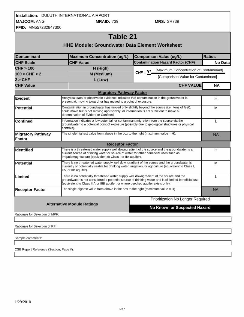
MAJCOM: ANGFFID: MN557282847300
Installation: DULUTH INTERNATIONAL AIRPORTMRAID: 739 MRS: SR739
CHF = [Maximum Concentration of Contaminant]
[Comparison Value for Contaminant] Σ
Table 21HHE Module: Groundwater Data Element Worksheet
Contaminant Maximum Concentration (ug/L) RatiosComparison Value (ug/L)CHF Scale CHF Value Contamination Hazard Factor (CHF)
CHF Value
CHF > 100100 > CHF > 22 > CHF
H (High)M (Medium)
L (Low)
No Data
CHF VALUE NA
Migratory Pathway FactorEvident
Potential
Confined
Migratory Pathway Factor
NA
H
M
L
Analytical data or observable evidence indicates that contamination in the groundwater is present at, moving toward, or has moved to a point of exposure.
Contamination in groundwater has moved only slightly beyond the source (i.e., tens of feet), could move but is not moving appreciably, or information is not sufficient to make a determination of Evident or Confined.
The single highest value from above in the box to the right (maximum value = H).
Information indicates a low potential for contaminant migration from the source via the groundwater to a potential point of exposure (possibly due to geological structures or physical controls).
Receptor FactorIdentified
Potential
Limited
Receptor Factor
H
M
L
There is a threatened water supply well downgradient of the source and the groundwater is a current source of drinking water or source of water for other beneficial uses such as irrigation/agriculture (equivalent to Class I or IIA aquifer).
There is no threatened water supply well downgradient of the source and the groundwater is currently or potentially usable for drinking water, irrigation, or agriculture (equivalent to Class I, IIA, or IIB aquifer).
The single highest value from above in the box to the right (maximum value = H).
There is no potentially threatened water supply well downgradient of the source and the groundwater is not considered a potential source of drinking water and is of limited beneficial use (equivalent to Class IIIA or IIIB aquifer, or where perched aquifer exists only).
Alternative Module RatingsNo Known or Suspected Hazard
Prioritization No Longer Required
NA
Rationale for Selection of MPF:
Rationale for Selection of RF:
Sample comments:
CSE Report Reference (Section, Page #):
1/29/2010
I-37
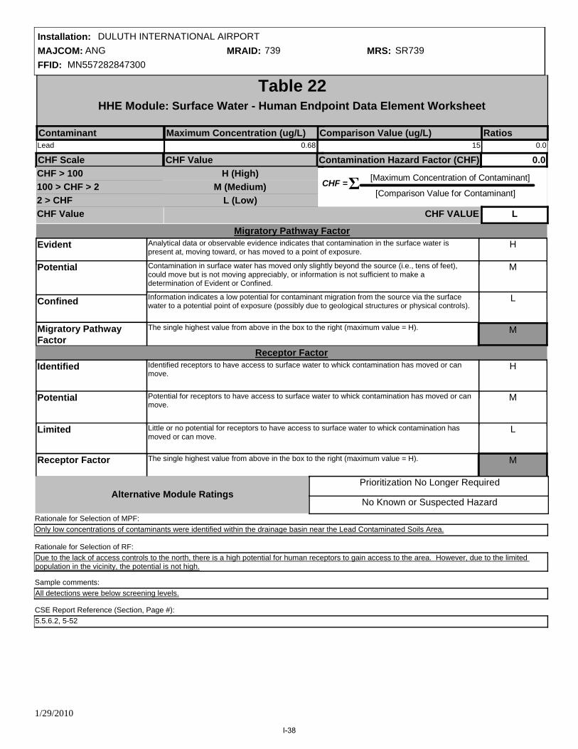
MAJCOM: ANGFFID: MN557282847300
Installation: DULUTH INTERNATIONAL AIRPORTMRAID: 739 MRS: SR739
CHF = [Maximum Concentration of Contaminant]
[Comparison Value for Contaminant] Σ
Table 22HHE Module: Surface Water - Human Endpoint Data Element Worksheet
Contaminant Maximum Concentration (ug/L) RatiosComparison Value (ug/L)
CHF Scale CHF Value Contamination Hazard Factor (CHF)
CHF Value
CHF > 100100 > CHF > 22 > CHF
H (High)M (Medium)
L (Low)
0.0
CHF VALUE L
Migratory Pathway FactorEvident
Potential
Confined
Migratory Pathway Factor
H
M
L
Analytical data or observable evidence indicates that contamination in the surface water is present at, moving toward, or has moved to a point of exposure.
Contamination in surface water has moved only slightly beyond the source (i.e., tens of feet), could move but is not moving appreciably, or information is not sufficient to make a determination of Evident or Confined.
The single highest value from above in the box to the right (maximum value = H).
Information indicates a low potential for contaminant migration from the source via the surface water to a potential point of exposure (possibly due to geological structures or physical controls).
Receptor FactorIdentified
Potential
Limited
Receptor Factor
H
M
L
Identified receptors to have access to surface water to whick contamination has moved or can move.
Potential for receptors to have access to surface water to whick contamination has moved or can move.
The single highest value from above in the box to the right (maximum value = H).
Little or no potential for receptors to have access to surface water to whick contamination has moved or can move.
Alternative Module Ratings
M
M
No Known or Suspected Hazard
Prioritization No Longer Required
Sample comments:
Due to the lack of access controls to the north, there is a high potential for human receptors to gain access to the area. However, due to the limited population in the vicinity, the potential is not high.
Only low concentrations of contaminants were identified within the drainage basin near the Lead Contaminated Soils Area.Rationale for Selection of MPF:
Rationale for Selection of RF:
All detections were below screening levels.
CSE Report Reference (Section, Page #):5.5.6.2, 5-52
Lead 0.68 15 0.0
1/29/2010
I-38

MAJCOM: ANGFFID: MN557282847300
Installation: DULUTH INTERNATIONAL AIRPORTMRAID: 739 MRS: SR739
No Known or Suspected Hazard
Prioritization No Longer Required
CHF = [Maximum Concentration of Contaminant]
[Comparison Value for Contaminant] Σ
Table 23HHE Module: Sediment - Human Endpoint Data Element Worksheet
Contaminant Maximum Concentration (mg/kg) RatiosComparison Value (mg/kg)
CHF Scale CHF Value Contamination Hazard Factor (CHF)
CHF Value
CHF > 100100 > CHF > 22 > CHF
H (High)M (Medium)
L (Low)
0.1
CHF VALUE L
Migratory Pathway FactorEvident
Potential
Confined
Migratory Pathway Factor
M
H
M
L
Analytical data or observable evidence indicates that contamination in the sediment is present at, moving toward, or has moved to a point of exposure.
Contamination in sediment has moved only slightly beyond the source (i.e., tens of feet), could move but is not moving appreciably, or information is not sufficient to make a determination of Evident or Confined.
The single highest value from above in the box to the right (maximum value = H).
Information indicates a low potential for contaminant migration from the source via the sediment to a potential point of exposure (possibly due to geological structures or physical controls).
Receptor FactorIdentified
Potential
Limited
Receptor Factor
H
M
L
Identified receptors to have access to sediment to which contamination has moved or can move.
Potential for receptors to have access to sediment to which contamination has moved or can move
The single highest value from above in the box to the right (maximum value = H).
Little or no potential for receptors to have access to sediment to which contamination has moved or can move
M
Alternative Module Ratings
Sample comments:
Due to the lack of access controls to the north, there is a high potential for human receptors to gain access to the area. However, due to the limited population in the vicinity, the potential is not high.
The sediment samples collected at the Lead Contaminated Soils Area were located 50 to 100 feet away from the central area of contamination, but were detected at low levels, indicating minimal contaminant migration.
Rationale for Selection of MPF:
Rationale for Selection of RF:
Concentrations of lead were above the sediment screening level.
CSE Report Reference (Section, Page #):5.5.6.2, 5-52
Lead 36 400 0.1
1/29/2010
I-39
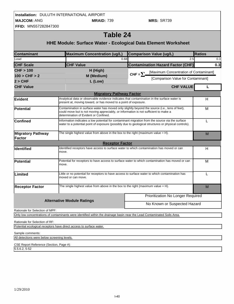
MAJCOM: ANGFFID: MN557282847300
Installation: DULUTH INTERNATIONAL AIRPORTMRAID: 739 MRS: SR739
No Known or Suspected Hazard
Prioritization No Longer Required
CHF = [Maximum Concentration of Contaminant]
[Comparison Value for Contaminant] Σ
Table 24HHE Module: Surface Water - Ecological Data Element Worksheet
Contaminant Maximum Concentration (ug/L) RatiosComparison Value (ug/L)
CHF Scale CHF Value Contamination Hazard Factor (CHF)
CHF Value
CHF > 100100 > CHF > 22 > CHF
H (High)M (Medium)
L (Low)
0.3
CHF VALUE L
Migratory Pathway FactorEvident
Potential
Confined
Migratory Pathway Factor
H
M
L
Analytical data or observable evidence indicates that contamination in the surface water is present at, moving toward, or has moved to a point of exposure.
Contamination in surface water has moved only slightly beyond the source (i.e., tens of feet), could move but is not moving appreciably, or information is not sufficient to make a determination of Evident or Confined.
The single highest value from above in the box to the right (maximum value = H).
Information indicates a low potential for contaminant migration from the source via the surface water to a potential point of exposure (possibly due to geological structures or physical controls).
Receptor FactorIdentified
Potential
Limited
Receptor Factor
H
M
L
Identified receptors have access to surface water to which contamination has moved or can move.
Potential for receptors to have access to surface water to which contamination has moved or can move.
The single highest value from above in the box to the right (maximum value = H).
Little or no potential for receptors to have access to surface water to which contamination has moved or can move.
M
M
Alternative Module Ratings
Sample comments:
Potential ecological receptors have direct access to surface water.
Only low concentrations of contaminants were identified within the drainage basin near the Lead Contaminated Soils Area.Rationale for Selection of MPF:
Rationale for Selection of RF:
All detections were below screening levels.
CSE Report Reference (Section, Page #):5.5.6.2, 5-52
Lead 0.68 2.5 0.3
1/29/2010
I-40

MAJCOM: ANGFFID: MN557282847300
Installation: DULUTH INTERNATIONAL AIRPORTMRAID: 739 MRS: SR739
No Known or Suspected Hazard
Prioritization No Longer Required
CHF = [Maximum Concentration of Contaminant]
[Comparison Value for Contaminant] Σ
Table 25HHE Module: Sediment - Ecological Endpoint Data Element Worksheet
Contaminant Maximum Concentration (mg/kg) RatiosComparison Value (mg/kg)
CHF Scale CHF Value Contamination Hazard Factor (CHF)
CHF Value
CHF > 100100 > CHF > 22 > CHF
H (High)M (Medium)
L (Low)
1.0
CHF VALUE L
Migratory Pathway FactorEvident
Potential
Confined
Migratory Pathway Factor
H
M
L
Analytical data or observable evidence indicates that contamination in the sediment is present at, moving toward, or has moved to a point of exposure.
Contamination in sediment has moved only slightly beyond the source (i.e., tens of feet), could move but is not moving appreciably, or information is not sufficient to make a determination of Evident or Confined.
The single highest value from above in the box to the right (maximum value = H).
Information indicates a low potential for contaminant migration from the source via the sediment to a potential point of exposure (possibly due to geological structures or physical controls).
Receptor FactorIdentified
Potential
Limited
Receptor Factor
H
M
L
Identified receptors to have access to sediment to which contamination has moved or can move.
potential for receptors to have access to sediment to which contamination has moved or can move.
The single highest value from above in the box to the right (maximum value = H).
Little or no potential for receptors to have access to sediment to which contamination has moved or can move.
M
M
Alternative Module Ratings
Sample comments:
Potential ecological receptors have direct access to surface sediment.
The sediment samples collected at the Lead Contaminated Soils Area were located 50 to 100 feet away from the central area of contamination, but were detected at low levels, indicating minimal contaminant migration.
Rationale for Selection of MPF:
Rationale for Selection of RF
Concentrations of lead were above the sediment screening level.
CSE Report Reference (Section, Page #):5.5.6.2, 5-52
Lead 36 35.80000 1.0
1/29/2010
I-41

MAJCOM: ANGFFID: MN557282847300
Installation: DULUTH INTERNATIONAL AIRPORTMRAID: 739 MRS: SR739
No Known or Suspected Hazard
Prioritization No Longer Required
CHF = [Maximum Concentration of Contaminant]
[Comparison Value for Contaminant] Σ
Table 26HHE Module: Soil - Data Element Worksheet
Contaminant Maximum Concentration (mg/kg) RatiosComparison Value (mg/kg)
CHF Scale CHF Value Contamination Hazard Factor (CHF)
CHF Value
CHF > 100100 > CHF > 22 > CHF
H (High)M (Medium)
L (Low)
9.3
CHF VALUE M
Migratory Pathway FactorEvident
Potential
Confined
Migratory Pathway Factor
L
H
M
L
Analytical data or observable evidence indicates that contamination in the soil is present at, moving toward, or has moved to a point of exposure.
Contamination in soil has moved only slightly beyond the source (i.e., tens of feet), could move but is not moving appreciably, or information is not sufficient to make a determination of Evident or Confined.
The single highest value from above in the box to the right (maximum value = H).
Information indicates a low potential for contaminant migration from the source via the soil to a potential point of exposure (possibly due to geological structures or physical controls).
Receptor FactorIdentified
Potential
Limited
Receptor Factor
H
M
L
Identified receptors to have access to soil to which contamination has moved or can move.
Potential for receptors to have access to soil to which contamination has moved or can move.
The single highest value from above in the box to the right (maximum value = H).
Little or no potential for receptors to have access to soil to which contamination has moved or can move.
M
Alternative Module Ratings
Sample comments:
Due to the lack of access controls to the north, there is a high potential for human receptors to gain access to the area. However, due to the limited population in the vicinity, the potential is not high.
Based on the samples collected at the Lead Contaminated Soils Area, contamination has been limited to the soil piles where the original soil from the Small Arms Range berm was deposited. Additionally, a plastic sheet acts as a barrier between the piles and the native soil.
Rationale for Selection of MPF:
Rationale for Selection of RF:
Iron and lead were detected above the soil screening levels in four subsurface soil samples at the Lead Contaminated Soils Area. Copper was detected above the screening level in three subsurface soil samples at the Lead Contaminated Soils Area. Arsenic was detected above the screening level in one subsurface soil sample at the Lead Contaminated Soils Area. All other detections were below screening levels.
Zinc 73 23000 0.0
Tin (inorganic, also see tributyltin oxide)
1.1 47000 0.0
Lead 2900 400 7.3
Iron 31000 23000 1.3
Copper and compounds 140 3100 0.0
Arsenic 12 22 0.5
Antimony and compounds 3 31 0.1
1/29/2010
I-42

MAJCOM: ANGFFID: MN557282847300
Installation: DULUTH INTERNATIONAL AIRPORTMRAID: 739 MRS: SR739
CSE Report Reference (Section, Page #):5.5.6.2, 5-52
1/29/2010
I-43

MAJCOM: ANGFFID: MN557282847300
Installation: DULUTH INTERNATIONAL AIRPORTMRAID: 739 MRS: SR739
Evaluation Pending
Migratory Pathway
Factor ValueNA
M
M
M
M
L
E
Prioritization No Longer Required
No Known or Suspected MC Hazard
B
Table 27Determining the HHE Module Rating
Groundwater (Table 21)
Surface Water/Human Endpoint (Table 22)
Sediment/Ecological Endpoint (Table 25)
Sediment/Human Endpoint (Table 23)
Surface Water/Ecological Endpoint (Table 24)
Soil (Table 26)
Media Source Contaminant Hazard Factor
Receptor Factor Value
3-Letter Ratings
(Hs-Ms-Ls)
Media Rating (A-G)
NA
M
M
M
M
M
NA
E
E
E
E
E
NA
MML
NA
L
L
L
L
M
MML
MML
MML
MML
HHH
HHL
HMM
HML
HLL
MMM
Combination
Alternative Module Ratings
MML
MLL
LLL
C
A
D
E
F
G
Rating
HHM
HHE Module Ratings
HHE Ratings (for reference only)
1/29/2010
I-44

MAJCOM: ANGFFID: MN557282847300
Installation: DULUTH INTERNATIONAL AIRPORTMRAID: 739 MRS: SR739
Table 28MRS Priority
EHE RatingEHE Rating Priority CHE Rating Priority HHE Rating Priority
A
F
B
D
C
E
G
Prioritization No Longer Required
No Known or Suspected Hazard
2
7
3
5
4
6
8
A
F
B
D
C
E
G
1
6
2
4
3
5
7
A
F
B
D
C
E
G
Prioritization No Longer Required
No Known or Suspected Hazard
2
7
3
5
4
6
8
Prioritization No Longer Required
No Known or Suspected Hazard
MRS Priority 6Evaluation Pending Evaluation Pending Evaluation Pending
1/29/2010
I-45
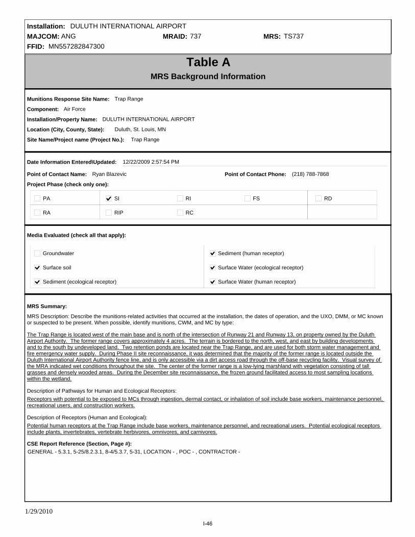
MAJCOM: ANGFFID: MN557282847300
Installation: DULUTH INTERNATIONAL AIRPORTMRAID: 737 MRS: TS737
Table AMRS Background Information
Munitions Response Site Name: Trap Range
Component: Air Force
Installation/Property Name: DULUTH INTERNATIONAL AIRPORT
Location (City, County, State): Duluth, St. Louis, MN
Site Name/Project name (Project No.): Trap Range
Date Information Entered\Updated: 12/22/2009 2:57:54 PM
Point of Contact Name: Ryan Blazevic
Project Phase (check only one):
PA SI RI FS RD
RA RIP RC
Groundwater Sediment (human receptor)
Surface soil Surface Water (ecological receptor)
Media Evaluated (check all that apply):
Sediment (ecological receptor) Surface Water (human receptor)
MRS Summary:
The Trap Range is located west of the main base and is north of the intersection of Runway 21 and Runway 13, on property owned by the Duluth Airport Authority. The former range covers approximately 4 acres. The terrain is bordered to the north, west, and east by building developments and to the south by undeveloped land. Two retention ponds are located near the Trap Range, and are used for both storm water management and fire emergency water supply. During Phase II site reconnaissance, it was determined that the majority of the former range is located outside the Duluth International Airport Authority fence line, and is only accessible via a dirt access road through the off-base recycling facility. Visual survey of the MRA indicated wet conditions throughout the site. The center of the former range is a low-lying marshland with vegetation consisting of tall grasses and densely wooded areas. During the December site reconnaissance, the frozen ground facilitated access to most sampling locations within the wetland.
MRS Description: Describe the munitions-related activities that occurred at the installation, the dates of operation, and the UXO, DMM, or MC known or suspected to be present. When possible, identify munitions, CWM, and MC by type:
Description of Pathways for Human and Ecological Receptors:
Description of Receptors (Human and Ecological):
Receptors with potential to be exposed to MCs through ingestion, dermal contact, or inhalation of soil include base workers, maintenance personnel, recreational users, and construction workers.
Potential human receptors at the Trap Range include base workers, maintenance personnel, and recreational users. Potential ecological receptors include plants, invertebrates, vertebrate herbivores, omnivores, and carnivores.
(218) 788-7868Point of Contact Phone:
CSE Report Reference (Section, Page #):GENERAL - 5.3.1, 5-25/8.2.3.1, 8-4/5.3.7, 5-31, LOCATION - , POC - , CONTRACTOR -
1/29/2010
I-46
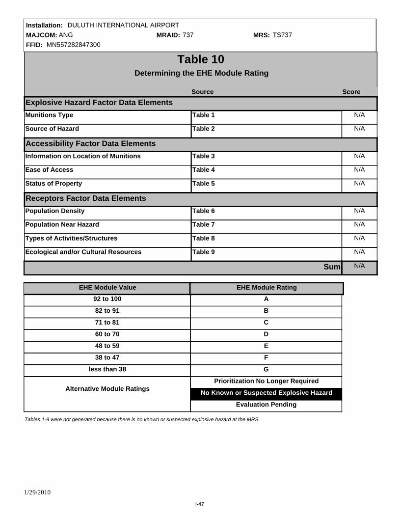
MAJCOM: ANGFFID: MN557282847300
Installation: DULUTH INTERNATIONAL AIRPORTMRAID: 737 MRS: TS737
Table 10Determining the EHE Module Rating
Source Score
Table 1
Source of Hazard N/ATable 2
Information on Location of Munitions N/ATable 3
Ease of Access N/ATable 4
Status of Property N/ATable 5
Population Density N/ATable 6
Population Near Hazard N/ATable 7
Types of Activities/Structures N/ATable 8
Ecological and/or Cultural Resources N/ATable 9
N/A
Explosive Hazard Factor Data Elements
Accessibility Factor Data Elements
Receptors Factor Data Elements
92 to 100
82 to 91
71 to 81
60 to 70
48 to 59
less than 38
38 to 47
A
F
B
D
C
E
G
Alternative Module Ratings
EHE Module Value EHE Module Rating
Sum
Prioritization No Longer Required
No Known or Suspected Explosive Hazard
N/AMunitions Type
Evaluation Pending
Tables 1-9 were not generated because there is no known or suspected explosive hazard at the MRS.
1/29/2010
I-47

MAJCOM: ANGFFID: MN557282847300
Installation: DULUTH INTERNATIONAL AIRPORTMRAID: 737 MRS: TS737
CWM Configuration N/A
Table 20Determining the CHE Module Rating
Source Score
Table 11
Source of CWM N/ATable 12
Information on Location of Munitions N/ATable 13
Ease of Access N/ATable 14
Status of Property N/ATable 15
Population Density N/ATable 16
Population Near Hazard N/ATable 17
Types of Activities/Structures N/ATable 18
Ecological and/or Cultural Resources N/ATable 19
N/A
CWM Hazard Factor Data Elements
Accessibility Factor Data Elements
Receptors Factor Data Elements
92 to 100
82 to 91
71 to 81
60 to 70
48 to 59
less than 38
38 to 47
A
F
B
D
C
E
G
CHE Module Value
Sum
CHE Module Rating
Alternative Module RatingsPrioritization No Longer Required
No Known or Suspected CWM Hazard
Evaluation Pending
Tables 11-19 were not generated because there is no known or suspected CWM hazard at the MRS.
1/29/2010
I-48

MAJCOM: ANGFFID: MN557282847300
Installation: DULUTH INTERNATIONAL AIRPORTMRAID: 737 MRS: TS737
CHF = [Maximum Concentration of Contaminant]
[Comparison Value for Contaminant] Σ
Table 21HHE Module: Groundwater Data Element Worksheet
Contaminant Maximum Concentration (ug/L) RatiosComparison Value (ug/L)CHF Scale CHF Value Contamination Hazard Factor (CHF)
CHF Value
CHF > 100100 > CHF > 22 > CHF
H (High)M (Medium)
L (Low)
No Data
CHF VALUE NA
Migratory Pathway FactorEvident
Potential
Confined
Migratory Pathway Factor
NA
H
M
L
Analytical data or observable evidence indicates that contamination in the groundwater is present at, moving toward, or has moved to a point of exposure.
Contamination in groundwater has moved only slightly beyond the source (i.e., tens of feet), could move but is not moving appreciably, or information is not sufficient to make a determination of Evident or Confined.
The single highest value from above in the box to the right (maximum value = H).
Information indicates a low potential for contaminant migration from the source via the groundwater to a potential point of exposure (possibly due to geological structures or physical controls).
Receptor FactorIdentified
Potential
Limited
Receptor Factor
H
M
L
There is a threatened water supply well downgradient of the source and the groundwater is a current source of drinking water or source of water for other beneficial uses such as irrigation/agriculture (equivalent to Class I or IIA aquifer).
There is no threatened water supply well downgradient of the source and the groundwater is currently or potentially usable for drinking water, irrigation, or agriculture (equivalent to Class I, IIA, or IIB aquifer).
The single highest value from above in the box to the right (maximum value = H).
There is no potentially threatened water supply well downgradient of the source and the groundwater is not considered a potential source of drinking water and is of limited beneficial use (equivalent to Class IIIA or IIIB aquifer, or where perched aquifer exists only).
Alternative Module RatingsNo Known or Suspected Hazard
Prioritization No Longer Required
NA
Rationale for Selection of MPF:
Rationale for Selection of RF:
Sample comments:
CSE Report Reference (Section, Page #):
1/29/2010
I-49

MAJCOM: ANGFFID: MN557282847300
Installation: DULUTH INTERNATIONAL AIRPORTMRAID: 737 MRS: TS737
CHF = [Maximum Concentration of Contaminant]
[Comparison Value for Contaminant] Σ
Table 22HHE Module: Surface Water - Human Endpoint Data Element Worksheet
Contaminant Maximum Concentration (ug/L) RatiosComparison Value (ug/L)
CHF Scale CHF Value Contamination Hazard Factor (CHF)
CHF Value
CHF > 100100 > CHF > 22 > CHF
H (High)M (Medium)
L (Low)
15.4
CHF VALUE M
Migratory Pathway FactorEvident
Potential
Confined
Migratory Pathway Factor
H
M
L
Analytical data or observable evidence indicates that contamination in the surface water is present at, moving toward, or has moved to a point of exposure.
Contamination in surface water has moved only slightly beyond the source (i.e., tens of feet), could move but is not moving appreciably, or information is not sufficient to make a determination of Evident or Confined.
The single highest value from above in the box to the right (maximum value = H).
Information indicates a low potential for contaminant migration from the source via the surface water to a potential point of exposure (possibly due to geological structures or physical controls).
Receptor FactorIdentified
Potential
Limited
Receptor Factor
H
M
L
Identified receptors to have access to surface water to whick contamination has moved or can move.
Potential for receptors to have access to surface water to whick contamination has moved or can move.
The single highest value from above in the box to the right (maximum value = H).
Little or no potential for receptors to have access to surface water to whick contamination has moved or can move.
Alternative Module Ratings
M
M
No Known or Suspected Hazard
Prioritization No Longer Required
Sample comments:
The Trap Range is located outside the airport fenceline, but due to the lack of access controls from the north, potential human receptors could access the contaminated surface water. However, the contaminated area is located in a heavily wooded marsh area that is not easily accessed by human receptors.
The detection of elevated lead in surface water at the Trap Range was located in the central area of the former range, suggesting limited contaminant migration; however, contamination could migrate through surface water.
Rationale for Selection of MPF:
Rationale for Selection of RF:
Lead was detected in one surface water sample above the screening level at the Trap Range. All other detections were below screening levels.
CSE Report Reference (Section, Page #):5.3.6.2, 5-31
Pyrene 16 180 0.1
Chrysene 7.4 920 0.0
Fluoranthene 17 1500 0.0
Lead 230 15 15.3
1/29/2010
I-50

MAJCOM: ANGFFID: MN557282847300
Installation: DULUTH INTERNATIONAL AIRPORTMRAID: 737 MRS: TS737
No Known or Suspected Hazard
Prioritization No Longer Required
CHF = [Maximum Concentration of Contaminant]
[Comparison Value for Contaminant] Σ
Table 23HHE Module: Sediment - Human Endpoint Data Element Worksheet
Contaminant Maximum Concentration (mg/kg) RatiosComparison Value (mg/kg)
CHF Scale CHF Value Contamination Hazard Factor (CHF)
CHF Value
CHF > 100100 > CHF > 22 > CHF
H (High)M (Medium)
L (Low)
50.8
CHF VALUE M
Migratory Pathway FactorEvident
Potential
Confined
Migratory Pathway Factor
M
H
M
L
Analytical data or observable evidence indicates that contamination in the sediment is present at, moving toward, or has moved to a point of exposure.
Contamination in sediment has moved only slightly beyond the source (i.e., tens of feet), could move but is not moving appreciably, or information is not sufficient to make a determination of Evident or Confined.
The single highest value from above in the box to the right (maximum value = H).
Information indicates a low potential for contaminant migration from the source via the sediment to a potential point of exposure (possibly due to geological structures or physical controls).
Receptor FactorIdentified
Potential
Limited
Receptor Factor
H
M
L
Identified receptors to have access to sediment to which contamination has moved or can move.
Potential for receptors to have access to sediment to which contamination has moved or can move
The single highest value from above in the box to the right (maximum value = H).
Little or no potential for receptors to have access to sediment to which contamination has moved or can move
M
Alternative Module Ratings
Sample comments:
Since contamination was identified in surface sediment, potential human receptors could have access to the contamination; however, the Trap Range is located outside the airport fenceline, and there is limited population in the vicinity of the former range.
The low levels of contamination identified in sediment at the Trap Range are located in the area of anticipated impact within the former range, but could migrate through surface water and sediment.
Rationale for Selection of MPF:
Rationale for Selection of RF:
Acenaphethylene and benzo(a)pyrene were detected in two sediment samples above above ecological screening levels at the Trap Range. All other detections were below screening levels.
Pyrene 230 2300 0.1
Fluorene 13 2700 0.0
Fluoranthene 190 2300 0.1
Chrysene 170 6200 0.0
Benzo[a]pyrene 300 6.2 48.4
Benz[a]anthracene 130 62 2.1
Anthracene 19 22000 0.0
Lead 35 400 0.1
1/29/2010
I-51

MAJCOM: ANGFFID: MN557282847300
Installation: DULUTH INTERNATIONAL AIRPORTMRAID: 737 MRS: TS737
CSE Report Reference (Section, Page #):5.3.6.2, 5-31
1/29/2010
I-52

MAJCOM: ANGFFID: MN557282847300
Installation: DULUTH INTERNATIONAL AIRPORTMRAID: 737 MRS: TS737
No Known or Suspected Hazard
Prioritization No Longer Required
CHF = [Maximum Concentration of Contaminant]
[Comparison Value for Contaminant] Σ
Table 24HHE Module: Surface Water - Ecological Data Element Worksheet
Contaminant Maximum Concentration (ug/L) RatiosComparison Value (ug/L)
CHF Scale CHF Value Contamination Hazard Factor (CHF)
CHF Value
CHF > 100100 > CHF > 22 > CHF
H (High)M (Medium)
L (Low)
2226.5
CHF VALUE H
Migratory Pathway FactorEvident
Potential
Confined
Migratory Pathway Factor
H
M
L
Analytical data or observable evidence indicates that contamination in the surface water is present at, moving toward, or has moved to a point of exposure.
Contamination in surface water has moved only slightly beyond the source (i.e., tens of feet), could move but is not moving appreciably, or information is not sufficient to make a determination of Evident or Confined.
The single highest value from above in the box to the right (maximum value = H).
Information indicates a low potential for contaminant migration from the source via the surface water to a potential point of exposure (possibly due to geological structures or physical controls).
Receptor FactorIdentified
Potential
Limited
Receptor Factor
H
M
L
Identified receptors have access to surface water to which contamination has moved or can move.
Potential for receptors to have access to surface water to which contamination has moved or can move.
The single highest value from above in the box to the right (maximum value = H).
Little or no potential for receptors to have access to surface water to which contamination has moved or can move.
H
M
Alternative Module Ratings
Sample comments:
Since contamination was identified in surface water, potential ecological receptors have direct access to the contaminated water.
The detection of elevated lead in surface water at the Trap Range was located in the central area of the former range, suggesting limited contaminant migration; however, contamination could migrate through surface water.
Rationale for Selection of MPF:
Rationale for Selection of RF:
Lead was detected in one surface water sample above the screening level at the Trap Range. All other detections were below screening levels.
Pyrene 16 0.025 640.0
Phenanthrene 6.2 0.4 15.5
Chrysene 7.4 7 1.1
Benzo(b)fluoranthene 18
Benzo(a)pyrene 8.6 0.015 573.3
Benzo(a)anthracene 8.3 0.018 461.1
Fluoranthene 17 0.04 425.0
Benzo(k)fluoranthene 0.5 0.027 18.5
Lead 230 2.5 92.0
1/29/2010
I-53

MAJCOM: ANGFFID: MN557282847300
Installation: DULUTH INTERNATIONAL AIRPORTMRAID: 737 MRS: TS737
CSE Report Reference (Section, Page #):5.3.6.2, 5-31
1/29/2010
I-54

MAJCOM: ANGFFID: MN557282847300
Installation: DULUTH INTERNATIONAL AIRPORTMRAID: 737 MRS: TS737
No Known or Suspected Hazard
Prioritization No Longer Required
CHF = [Maximum Concentration of Contaminant]
[Comparison Value for Contaminant] Σ
Table 25HHE Module: Sediment - Ecological Endpoint Data Element Worksheet
Contaminant Maximum Concentration (mg/kg) RatiosComparison Value (mg/kg)
CHF Scale CHF Value Contamination Hazard Factor (CHF)
CHF Value
CHF > 100100 > CHF > 22 > CHF
H (High)M (Medium)
L (Low)
22097.8
CHF VALUE H
Migratory Pathway FactorEvident
Potential
Confined
Migratory Pathway Factor
H
M
L
Analytical data or observable evidence indicates that contamination in the sediment is present at, moving toward, or has moved to a point of exposure.
Contamination in sediment has moved only slightly beyond the source (i.e., tens of feet), could move but is not moving appreciably, or information is not sufficient to make a determination of Evident or Confined.
The single highest value from above in the box to the right (maximum value = H).
Information indicates a low potential for contaminant migration from the source via the sediment to a potential point of exposure (possibly due to geological structures or physical controls).
Receptor FactorIdentified
Potential
Limited
Receptor Factor
H
M
L
Identified receptors to have access to sediment to which contamination has moved or can move.
potential for receptors to have access to sediment to which contamination has moved or can move.
The single highest value from above in the box to the right (maximum value = H).
Little or no potential for receptors to have access to sediment to which contamination has moved or can move.
H
M
Alternative Module Ratings
The low levels of contamination identified in sediment at the Trap Range are located in the area of anticipated impact within the former range, but could migrate through surface water and sediment.
Rationale for Selection of MPF:
Pyrene 230 0.19500 1179.5
Phenanthrene 19 0.20400 93.1
Indeno(1,2,3-cd)pyrene 270 0.01700 15882.4
Fluorene 13 0.07740 168.0
Fluoranthene 190 0.42300 449.2
Chrysene 170 0.16600 1024.1
Benzo(g,h,i)perylene 300 0.17000 1764.7
Benzo(b)fluoranthene 580
Benzo[a]pyrene 300
Benzo(a)anthracene 130 0.10800 1203.7
Anthracene 19 0.05720 332.2
Acenaphethylene 110
Lead 35 35.80000 1.0
1/29/2010
I-55

MAJCOM: ANGFFID: MN557282847300
Installation: DULUTH INTERNATIONAL AIRPORTMRAID: 737 MRS: TS737
Sample comments:
Since contamination was identified in surface sediment, potential ecological receptors have direct access to the contamination.Rationale for Selection of RF
Acenaphethylene and benzo(a)pyrene were detected in two sediment samples above above ecological screening levels at the Trap Range. All other detections were below screening levels.
CSE Report Reference (Section, Page #):5.3.6.2, 5-31
1/29/2010
I-56
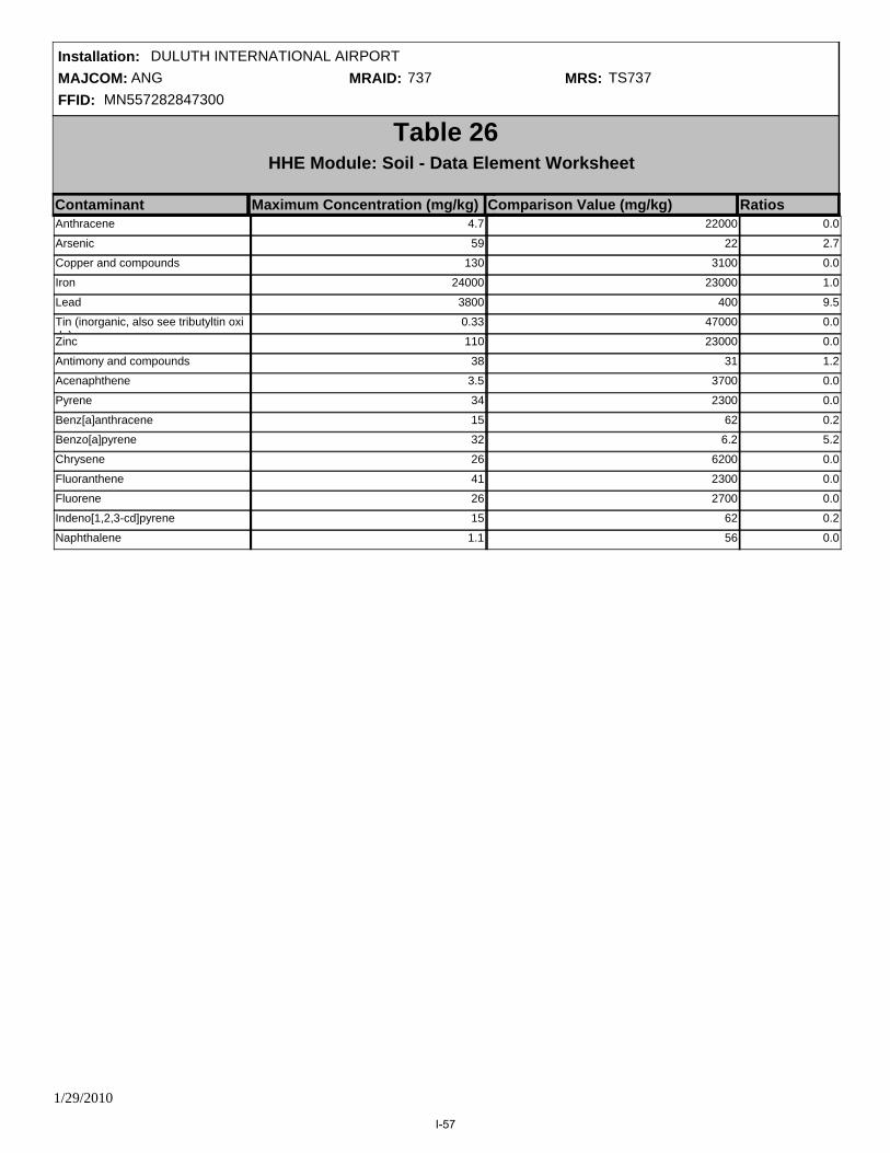
MAJCOM: ANGFFID: MN557282847300
Installation: DULUTH INTERNATIONAL AIRPORTMRAID: 737 MRS: TS737
Table 26HHE Module: Soil - Data Element Worksheet
Contaminant Maximum Concentration (mg/kg) RatiosComparison Value (mg/kg)Anthracene 4.7 22000 0.0
Arsenic 59 22 2.7
Copper and compounds 130 3100 0.0
Iron 24000 23000 1.0
Lead 3800 400 9.5
Tin (inorganic, also see tributyltin oxide)
0.33 47000 0.0
Zinc 110 23000 0.0
Antimony and compounds 38 31 1.2
Acenaphthene 3.5 3700 0.0
Pyrene 34 2300 0.0
Benz[a]anthracene 15 62 0.2
Benzo[a]pyrene 32 6.2 5.2
Chrysene 26 6200 0.0
Fluoranthene 41 2300 0.0
Fluorene 26 2700 0.0
Indeno[1,2,3-cd]pyrene 15 62 0.2
Naphthalene 1.1 56 0.0
1/29/2010
I-57

MAJCOM: ANGFFID: MN557282847300
Installation: DULUTH INTERNATIONAL AIRPORTMRAID: 737 MRS: TS737
No Known or Suspected Hazard
Prioritization No Longer Required
CHF = [Maximum Concentration of Contaminant]
[Comparison Value for Contaminant] Σ
CHF Scale CHF Value Contamination Hazard Factor (CHF)
CHF Value
CHF > 100100 > CHF > 22 > CHF
H (High)M (Medium)
L (Low)
20.2
CHF VALUE M
Migratory Pathway FactorEvident
Potential
Confined
Migratory Pathway Factor
M
H
M
L
Analytical data or observable evidence indicates that contamination in the soil is present at, moving toward, or has moved to a point of exposure.
Contamination in soil has moved only slightly beyond the source (i.e., tens of feet), could move but is not moving appreciably, or information is not sufficient to make a determination of Evident or Confined.
The single highest value from above in the box to the right (maximum value = H).
Information indicates a low potential for contaminant migration from the source via the soil to a potential point of exposure (possibly due to geological structures or physical controls).
Receptor FactorIdentified
Potential
Limited
Receptor Factor
H
M
L
Identified receptors to have access to soil to which contamination has moved or can move.
Potential for receptors to have access to soil to which contamination has moved or can move.
The single highest value from above in the box to the right (maximum value = H).
Little or no potential for receptors to have access to soil to which contamination has moved or can move.
M
Alternative Module Ratings
Sample comments:
Since contamination was identified in surface and shallow subsurface soil, potential human receptors could have access to the contamination; however, the Trap Range is located outside the airport fenceline, and there is limited population in the vicinity of the former range.
The contamination identified in soil at the Trap Range is located in the area of anticipated impact within the former range, but could migrate through the soil leaching pathway.
Rationale for Selection of MPF:
Rationale for Selection of RF:
Antomony was detected in one subsurface soil sample above the screening level at the Trap Range. Arsenic was detected in three surface soil and two subsurface soil samples above the screening level. Copper was detected in one surface soil sample above the screening level. Iron was detected in four surface soil and five subsurface soil samples above the screening level. Lead was detected in four surface soil and four subsurface soil samples. All other detectiuons were below screening levels.
CSE Report Reference (Section, Page #):5.3.6.2, 5-31
2-Methylnaphthalene 0.86 310 0.0
1/29/2010
I-58

MAJCOM: ANGFFID: MN557282847300
Installation: DULUTH INTERNATIONAL AIRPORTMRAID: 737 MRS: TS737
Evaluation Pending
Migratory Pathway
Factor ValueNA
M
M
M
M
M
B
Prioritization No Longer Required
No Known or Suspected MC Hazard
B
Table 27Determining the HHE Module Rating
Groundwater (Table 21)
Surface Water/Human Endpoint (Table 22)
Sediment/Ecological Endpoint (Table 25)
Sediment/Human Endpoint (Table 23)
Surface Water/Ecological Endpoint (Table 24)
Soil (Table 26)
Media Source Contaminant Hazard Factor
Receptor Factor Value
3-Letter Ratings
(Hs-Ms-Ls)
Media Rating (A-G)
NA
M
M
H
H
M
NA
D
D
B
B
D
NA
MMM
NA
M
M
H
H
M
MMM
HHM
HHM
MMM
HHH
HHL
HMM
HML
HLL
MMM
Combination
Alternative Module Ratings
MML
MLL
LLL
C
A
D
E
F
G
Rating
HHM
HHE Module Ratings
HHE Ratings (for reference only)
1/29/2010
I-59

MAJCOM: ANGFFID: MN557282847300
Installation: DULUTH INTERNATIONAL AIRPORTMRAID: 737 MRS: TS737
Table 28MRS Priority
EHE RatingEHE Rating Priority CHE Rating Priority HHE Rating Priority
A
F
B
D
C
E
G
Prioritization No Longer Required
No Known or Suspected Hazard
2
7
3
5
4
6
8
A
F
B
D
C
E
G
1
6
2
4
3
5
7
A
F
B
D
C
E
G
Prioritization No Longer Required
No Known or Suspected Hazard
2
7
3
5
4
6
8
Prioritization No Longer Required
No Known or Suspected Hazard
MRS Priority 3Evaluation Pending Evaluation Pending Evaluation Pending
1/29/2010
I-60

MAJCOM: ANGFFID: MN557282847300
Installation: DULUTH INTERNATIONAL AIRPORTMRAID: 738 MRS: TS738
Table AMRS Background Information
Munitions Response Site Name: Skeet Range
Component: Air Force
Installation/Property Name: DULUTH INTERNATIONAL AIRPORT
Location (City, County, State): Duluth, St. Louis, MN
Site Name/Project name (Project No.): Skeet Range
Date Information Entered\Updated: 12/22/2009 2:56:56 PM
Point of Contact Name: Ryan Blazevic
Project Phase (check only one):
PA SI RI FS RD
RA RIP RC
Groundwater Sediment (human receptor)
Surface soil Surface Water (ecological receptor)
Media Evaluated (check all that apply):
Sediment (ecological receptor) Surface Water (human receptor)
MRS Summary:
The former Skeet Range is located within the main base on property owned by the Minnesota Department of Military Affairs that is leased to the MNANG. A portion of the firing fan extends across the installation boundary onto an adjacent parcel to the east also owned by the Minnesota Department of Military Affairs. The Skeet Range is approximately 15.3 acres. Based on aerial photography of the area, the site was redeveloped with a building between 1964 and 1971; however, portions of the firing fan may still be undisturbed in undeveloped areas. Surface waters on the site include a delineated wetland, which drains into Miller Creek, a State designated trout stream. During Phase II site reconnaissance, it was confirmed that much of the site is occupied with buildings and associated parking areas. Visual survey of the MRA indicated the center of the former range (to the east of the Base buildings) is a low-lying, densely wooded wetland. The frozen ground and limited vegetation facilitated access to most sampling locations within the wetland without substantial site clearing. Sampling locations located in concrete covered areas or within buildings were relocated to grass or dirt covered areas.
MRS Description: Describe the munitions-related activities that occurred at the installation, the dates of operation, and the UXO, DMM, or MC known or suspected to be present. When possible, identify munitions, CWM, and MC by type:
Description of Pathways for Human and Ecological Receptors:
Description of Receptors (Human and Ecological):
Receptors with potential to be exposed to MCs through ingestion, dermal contact, or inhalation of soil include base workers, maintenance personnel, recreational users, and construction workers.
Potential human receptors at the Skeet Range include base workers, maintenance personnel, and recreational users. Potential ecological receptors include plants, invertebrates, vertebrate herbivores, omnivores, and carnivores.
(218) 788-7868Point of Contact Phone:
CSE Report Reference (Section, Page #):GENERAL - 5.4.1, 5-39/8.2.3.1, 8-4/5.4.7, 5-51, LOCATION - , POC - , CONTRACTOR -
1/29/2010
I-61

MAJCOM: ANGFFID: MN557282847300
Installation: DULUTH INTERNATIONAL AIRPORTMRAID: 738 MRS: TS738
Table 10Determining the EHE Module Rating
Source Score
Table 1
Source of Hazard N/ATable 2
Information on Location of Munitions N/ATable 3
Ease of Access N/ATable 4
Status of Property N/ATable 5
Population Density N/ATable 6
Population Near Hazard N/ATable 7
Types of Activities/Structures N/ATable 8
Ecological and/or Cultural Resources N/ATable 9
N/A
Explosive Hazard Factor Data Elements
Accessibility Factor Data Elements
Receptors Factor Data Elements
92 to 100
82 to 91
71 to 81
60 to 70
48 to 59
less than 38
38 to 47
A
F
B
D
C
E
G
Alternative Module Ratings
EHE Module Value EHE Module Rating
Sum
Prioritization No Longer Required
No Known or Suspected Explosive Hazard
N/AMunitions Type
Evaluation Pending
Tables 1-9 were not generated because there is no known or suspected explosive hazard at the MRS.
1/29/2010
I-62
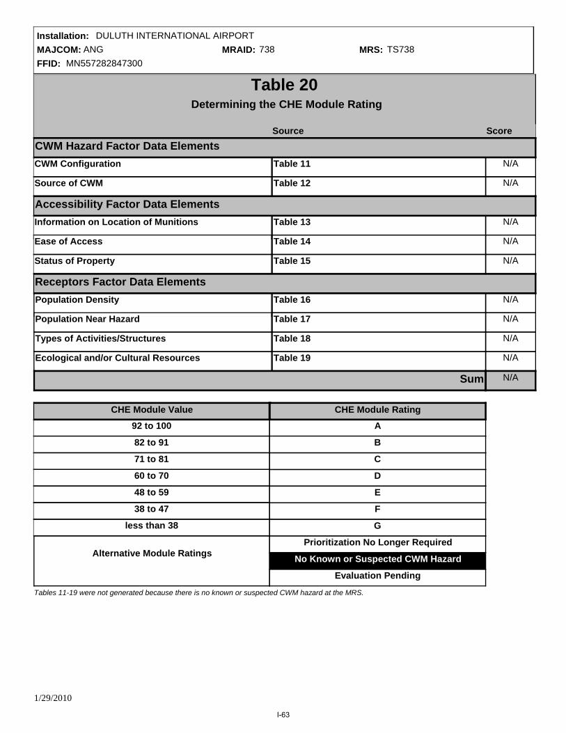
MAJCOM: ANGFFID: MN557282847300
Installation: DULUTH INTERNATIONAL AIRPORTMRAID: 738 MRS: TS738
CWM Configuration N/A
Table 20Determining the CHE Module Rating
Source Score
Table 11
Source of CWM N/ATable 12
Information on Location of Munitions N/ATable 13
Ease of Access N/ATable 14
Status of Property N/ATable 15
Population Density N/ATable 16
Population Near Hazard N/ATable 17
Types of Activities/Structures N/ATable 18
Ecological and/or Cultural Resources N/ATable 19
N/A
CWM Hazard Factor Data Elements
Accessibility Factor Data Elements
Receptors Factor Data Elements
92 to 100
82 to 91
71 to 81
60 to 70
48 to 59
less than 38
38 to 47
A
F
B
D
C
E
G
CHE Module Value
Sum
CHE Module Rating
Alternative Module RatingsPrioritization No Longer Required
No Known or Suspected CWM Hazard
Evaluation Pending
Tables 11-19 were not generated because there is no known or suspected CWM hazard at the MRS.
1/29/2010
I-63

MAJCOM: ANGFFID: MN557282847300
Installation: DULUTH INTERNATIONAL AIRPORTMRAID: 738 MRS: TS738
CHF = [Maximum Concentration of Contaminant]
[Comparison Value for Contaminant] Σ
Table 21HHE Module: Groundwater Data Element Worksheet
Contaminant Maximum Concentration (ug/L) RatiosComparison Value (ug/L)CHF Scale CHF Value Contamination Hazard Factor (CHF)
CHF Value
CHF > 100100 > CHF > 22 > CHF
H (High)M (Medium)
L (Low)
No Data
CHF VALUE NA
Migratory Pathway FactorEvident
Potential
Confined
Migratory Pathway Factor
NA
H
M
L
Analytical data or observable evidence indicates that contamination in the groundwater is present at, moving toward, or has moved to a point of exposure.
Contamination in groundwater has moved only slightly beyond the source (i.e., tens of feet), could move but is not moving appreciably, or information is not sufficient to make a determination of Evident or Confined.
The single highest value from above in the box to the right (maximum value = H).
Information indicates a low potential for contaminant migration from the source via the groundwater to a potential point of exposure (possibly due to geological structures or physical controls).
Receptor FactorIdentified
Potential
Limited
Receptor Factor
H
M
L
There is a threatened water supply well downgradient of the source and the groundwater is a current source of drinking water or source of water for other beneficial uses such as irrigation/agriculture (equivalent to Class I or IIA aquifer).
There is no threatened water supply well downgradient of the source and the groundwater is currently or potentially usable for drinking water, irrigation, or agriculture (equivalent to Class I, IIA, or IIB aquifer).
The single highest value from above in the box to the right (maximum value = H).
There is no potentially threatened water supply well downgradient of the source and the groundwater is not considered a potential source of drinking water and is of limited beneficial use (equivalent to Class IIIA or IIIB aquifer, or where perched aquifer exists only).
Alternative Module RatingsNo Known or Suspected Hazard
Prioritization No Longer Required
NA
Rationale for Selection of MPF:
Rationale for Selection of RF:
Sample comments:
CSE Report Reference (Section, Page #):
1/29/2010
I-64

MAJCOM: ANGFFID: MN557282847300
Installation: DULUTH INTERNATIONAL AIRPORTMRAID: 738 MRS: TS738
CHF = [Maximum Concentration of Contaminant]
[Comparison Value for Contaminant] Σ
Table 22HHE Module: Surface Water - Human Endpoint Data Element Worksheet
Contaminant Maximum Concentration (ug/L) RatiosComparison Value (ug/L)
CHF Scale CHF Value Contamination Hazard Factor (CHF)
CHF Value
CHF > 100100 > CHF > 22 > CHF
H (High)M (Medium)
L (Low)
1.5
CHF VALUE M
Migratory Pathway FactorEvident
Potential
Confined
Migratory Pathway Factor
H
M
L
Analytical data or observable evidence indicates that contamination in the surface water is present at, moving toward, or has moved to a point of exposure.
Contamination in surface water has moved only slightly beyond the source (i.e., tens of feet), could move but is not moving appreciably, or information is not sufficient to make a determination of Evident or Confined.
The single highest value from above in the box to the right (maximum value = H).
Information indicates a low potential for contaminant migration from the source via the surface water to a potential point of exposure (possibly due to geological structures or physical controls).
Receptor FactorIdentified
Potential
Limited
Receptor Factor
H
M
L
Identified receptors to have access to surface water to whick contamination has moved or can move.
Potential for receptors to have access to surface water to whick contamination has moved or can move.
The single highest value from above in the box to the right (maximum value = H).
Little or no potential for receptors to have access to surface water to whick contamination has moved or can move.
Alternative Module Ratings
M
M
No Known or Suspected Hazard
Prioritization No Longer Required
Sample comments:
Since the Skeet Range is located in an area populated by base workers and buildings, human receptors have the potential to access the contaminated sediment; however, the contaminated area is located in a heavily wooded area that is not often accessed by workers.
The location of the surface water detection of elevated lead at the Skeet Range is near the edge, but still within the limits of the former range.Rationale for Selection of MPF:
Rationale for Selection of RF:
Lead was detected above the surface water screening level in one sample at the Skeet Range. All other detections were below screening levels.
CSE Report Reference (Section, Page #):5.4.6.2, 5-40
Pyrene 6.7 180 0.0
Fluoranthene 10 1500 0.0
Chrysene 3.7 920 0.0
Lead 22 15 1.5
1/29/2010
I-65

MAJCOM: ANGFFID: MN557282847300
Installation: DULUTH INTERNATIONAL AIRPORTMRAID: 738 MRS: TS738
No Known or Suspected Hazard
Prioritization No Longer Required
CHF = [Maximum Concentration of Contaminant]
[Comparison Value for Contaminant] Σ
Table 23HHE Module: Sediment - Human Endpoint Data Element Worksheet
Contaminant Maximum Concentration (mg/kg) RatiosComparison Value (mg/kg)
CHF Scale CHF Value Contamination Hazard Factor (CHF)
CHF Value
CHF > 100100 > CHF > 22 > CHF
H (High)M (Medium)
L (Low)
0.3
CHF VALUE L
Migratory Pathway FactorEvident
Potential
Confined
Migratory Pathway Factor
L
H
M
L
Analytical data or observable evidence indicates that contamination in the sediment is present at, moving toward, or has moved to a point of exposure.
Contamination in sediment has moved only slightly beyond the source (i.e., tens of feet), could move but is not moving appreciably, or information is not sufficient to make a determination of Evident or Confined.
The single highest value from above in the box to the right (maximum value = H).
Information indicates a low potential for contaminant migration from the source via the sediment to a potential point of exposure (possibly due to geological structures or physical controls).
Receptor FactorIdentified
Potential
Limited
Receptor Factor
H
M
L
Identified receptors to have access to sediment to which contamination has moved or can move.
Potential for receptors to have access to sediment to which contamination has moved or can move
The single highest value from above in the box to the right (maximum value = H).
Little or no potential for receptors to have access to sediment to which contamination has moved or can move
M
Alternative Module Ratings
Sample comments:
Since the Skeet Range is located in an area populated by base workers and buildings, human receptors have the potential to access the contaminated sediment; however, the contaminated area is located in a heavily wooded area that is not often accessed by workers.
The detection of elevated lead in sediment at the Skeet Range was located in the central area of the former range, suggesting limited contaminant migration.
Rationale for Selection of MPF:
Rationale for Selection of RF:
Lead and acenaphethylene were detected in one sediment sample above ecological sediment screening levels. All other detections were below screening levels.
Pyrene 68 2300 0.0
Naphthalene 2.8 56 0.0
Fluorene 51 2700 0.0
Fluoranthene 92 2300 0.0
Chrysene 41 6200 0.0
Anthracene 8.8 22000 0.0
Acenaphthene 4.6 3700 0.0
Lead 44 400 0.1
1/29/2010
I-66

MAJCOM: ANGFFID: MN557282847300
Installation: DULUTH INTERNATIONAL AIRPORTMRAID: 738 MRS: TS738
CSE Report Reference (Section, Page #):5.4.6.2, 5-40
1/29/2010
I-67

MAJCOM: ANGFFID: MN557282847300
Installation: DULUTH INTERNATIONAL AIRPORTMRAID: 738 MRS: TS738
No Known or Suspected Hazard
Prioritization No Longer Required
CHF = [Maximum Concentration of Contaminant]
[Comparison Value for Contaminant] Σ
Table 24HHE Module: Surface Water - Ecological Data Element Worksheet
Contaminant Maximum Concentration (ug/L) RatiosComparison Value (ug/L)
CHF Scale CHF Value Contamination Hazard Factor (CHF)
CHF Value
CHF > 100100 > CHF > 22 > CHF
H (High)M (Medium)
L (Low)
547.3
CHF VALUE H
Migratory Pathway FactorEvident
Potential
Confined
Migratory Pathway Factor
H
M
L
Analytical data or observable evidence indicates that contamination in the surface water is present at, moving toward, or has moved to a point of exposure.
Contamination in surface water has moved only slightly beyond the source (i.e., tens of feet), could move but is not moving appreciably, or information is not sufficient to make a determination of Evident or Confined.
The single highest value from above in the box to the right (maximum value = H).
Information indicates a low potential for contaminant migration from the source via the surface water to a potential point of exposure (possibly due to geological structures or physical controls).
Receptor FactorIdentified
Potential
Limited
Receptor Factor
H
M
L
Identified receptors have access to surface water to which contamination has moved or can move.
Potential for receptors to have access to surface water to which contamination has moved or can move.
The single highest value from above in the box to the right (maximum value = H).
Little or no potential for receptors to have access to surface water to which contamination has moved or can move.
H
M
Alternative Module Ratings
Sample comments:
Since contamination was identified in surface water, potential ecological receptors have direct access to contaminated water.
The location of the surface water detection of elevated lead at the Skeet Range is near the edge, but still within the limits of the former range.Rationale for Selection of MPF:
Rationale for Selection of RF:
Lead was detected above the surface water screening level in one sample at the Skeet Range. All other detections were below screening levels.
CSE Report Reference (Section, Page #):5.4.6.2, 5-40
Pyrene 6.7 0.025 268.0
Phenanthrene 8 0.4 20.0
Fluoranthene 10 0.04 250.0
Chrysene 3.7 7 0.5
Lead 22 2.5 8.8
1/29/2010
I-68

MAJCOM: ANGFFID: MN557282847300
Installation: DULUTH INTERNATIONAL AIRPORTMRAID: 738 MRS: TS738
Table 25HHE Module: Sediment - Ecological Endpoint Data Element Worksheet
Contaminant Maximum Concentration (mg/kg) RatiosComparison Value (mg/kg)Chrysene 41 0.16600 247.0
Acenaphthene 4.6 0.00670 686.6
Acenaphethylene 9.1
Anthracene 8.8 0.05720 153.8
Benzo(a)anthracene 30 0.10800 277.8
Benzo(a)pyrene 41 0.15000 273.3
Lead 44 35.80000 1.2
Benzo(g,h,i)perylene 25 0.17000 147.1
Pyrene 68 0.19500 348.7
Dibenz[a,h]anthracene 7 0.03300 212.1
Fluoranthene 92 0.42300 217.5
Fluorene 51 0.07740 658.9
Indeno(1,2,3-cd)pyrene 24 0.01700 1411.8
Naphthalene 2.8 0.17600 15.9
Phenanthrene 46 0.20400 225.5
1/29/2010
I-69
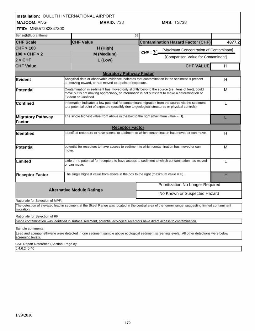
MAJCOM: ANGFFID: MN557282847300
Installation: DULUTH INTERNATIONAL AIRPORTMRAID: 738 MRS: TS738
No Known or Suspected Hazard
Prioritization No Longer Required
CHF = [Maximum Concentration of Contaminant]
[Comparison Value for Contaminant] Σ
CHF Scale CHF Value Contamination Hazard Factor (CHF)
CHF Value
CHF > 100100 > CHF > 22 > CHF
H (High)M (Medium)
L (Low)
4877.2
CHF VALUE H
Migratory Pathway FactorEvident
Potential
Confined
Migratory Pathway Factor
H
M
L
Analytical data or observable evidence indicates that contamination in the sediment is present at, moving toward, or has moved to a point of exposure.
Contamination in sediment has moved only slightly beyond the source (i.e., tens of feet), could move but is not moving appreciably, or information is not sufficient to make a determination of Evident or Confined.
The single highest value from above in the box to the right (maximum value = H).
Information indicates a low potential for contaminant migration from the source via the sediment to a potential point of exposure (possibly due to geological structures or physical controls).
Receptor FactorIdentified
Potential
Limited
Receptor Factor
H
M
L
Identified receptors to have access to sediment to which contamination has moved or can move.
potential for receptors to have access to sediment to which contamination has moved or can move.
The single highest value from above in the box to the right (maximum value = H).
Little or no potential for receptors to have access to sediment to which contamination has moved or can move.
H
L
Alternative Module Ratings
Sample comments:
Since contamination was identified in surface sediment, potential ecological receptors have direct access to contamination.
The detection of elevated lead in sediment at the Skeet Range was located in the central area of the former range, suggesting limited contaminant migration.
Rationale for Selection of MPF:
Rationale for Selection of RF
Lead and acenaphethylene were detected in one sediment sample above ecological sediment screening levels. All other detections were below screening levels.
CSE Report Reference (Section, Page #):5.4.6.2, 5-40
Benzo(b)fluoranthene 69
1/29/2010
I-70

MAJCOM: ANGFFID: MN557282847300
Installation: DULUTH INTERNATIONAL AIRPORTMRAID: 738 MRS: TS738
Table 26HHE Module: Soil - Data Element Worksheet
Contaminant Maximum Concentration (mg/kg) RatiosComparison Value (mg/kg)Benz[a]anthracene 470 62 7.6
Arsenic 3.3 22 0.1
Copper and compounds 71 3100 0.0
Iron 24000 23000 1.0
Lead 470 400 1.2
Tin (inorganic, also see tributyltin oxide)
0.29 47000 0.0
Zinc 75 23000 0.0
2-Methylnaphthalene 7.1 310 0.0
Antimony and compounds 0.62 31 0.0
Anthracene 110 22000 0.0
Pyrene 980 2300 0.4
Benzo[a]pyrene 670 6.2 108.1
Benzo[b]fluoranthene 820 62 13.2
Chrysene 530 6200 0.1
Fluoranthene 1300 2300 0.6
Fluorene 50 2700 0.0
Indeno[1,2,3-cd]pyrene 520 62 8.4
Naphthalene 8.9 56 0.2
1/29/2010
I-71
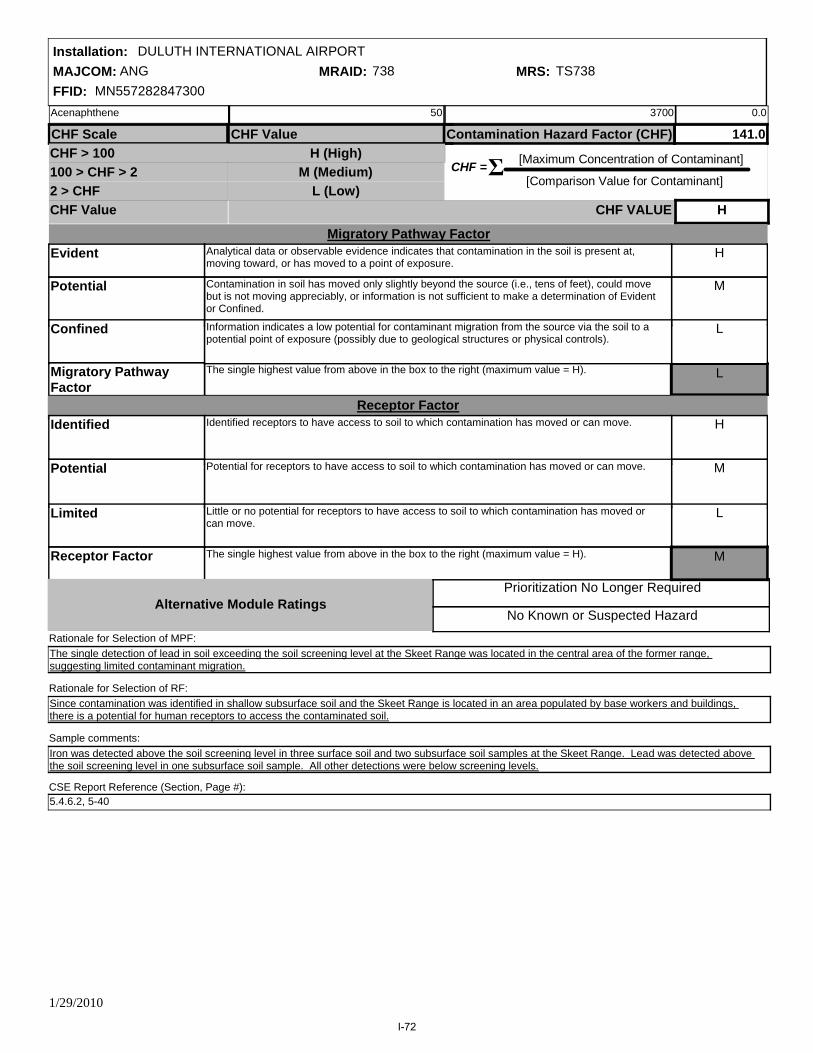
MAJCOM: ANGFFID: MN557282847300
Installation: DULUTH INTERNATIONAL AIRPORTMRAID: 738 MRS: TS738
No Known or Suspected Hazard
Prioritization No Longer Required
CHF = [Maximum Concentration of Contaminant]
[Comparison Value for Contaminant] Σ
CHF Scale CHF Value Contamination Hazard Factor (CHF)
CHF Value
CHF > 100100 > CHF > 22 > CHF
H (High)M (Medium)
L (Low)
141.0
CHF VALUE H
Migratory Pathway FactorEvident
Potential
Confined
Migratory Pathway Factor
L
H
M
L
Analytical data or observable evidence indicates that contamination in the soil is present at, moving toward, or has moved to a point of exposure.
Contamination in soil has moved only slightly beyond the source (i.e., tens of feet), could move but is not moving appreciably, or information is not sufficient to make a determination of Evident or Confined.
The single highest value from above in the box to the right (maximum value = H).
Information indicates a low potential for contaminant migration from the source via the soil to a potential point of exposure (possibly due to geological structures or physical controls).
Receptor FactorIdentified
Potential
Limited
Receptor Factor
H
M
L
Identified receptors to have access to soil to which contamination has moved or can move.
Potential for receptors to have access to soil to which contamination has moved or can move.
The single highest value from above in the box to the right (maximum value = H).
Little or no potential for receptors to have access to soil to which contamination has moved or can move.
M
Alternative Module Ratings
Sample comments:
Since contamination was identified in shallow subsurface soil and the Skeet Range is located in an area populated by base workers and buildings, there is a potential for human receptors to access the contaminated soil.
The single detection of lead in soil exceeding the soil screening level at the Skeet Range was located in the central area of the former range, suggesting limited contaminant migration.
Rationale for Selection of MPF:
Rationale for Selection of RF:
Iron was detected above the soil screening level in three surface soil and two subsurface soil samples at the Skeet Range. Lead was detected above the soil screening level in one subsurface soil sample. All other detections were below screening levels.
CSE Report Reference (Section, Page #):5.4.6.2, 5-40
Acenaphthene 50 3700 0.0
1/29/2010
I-72
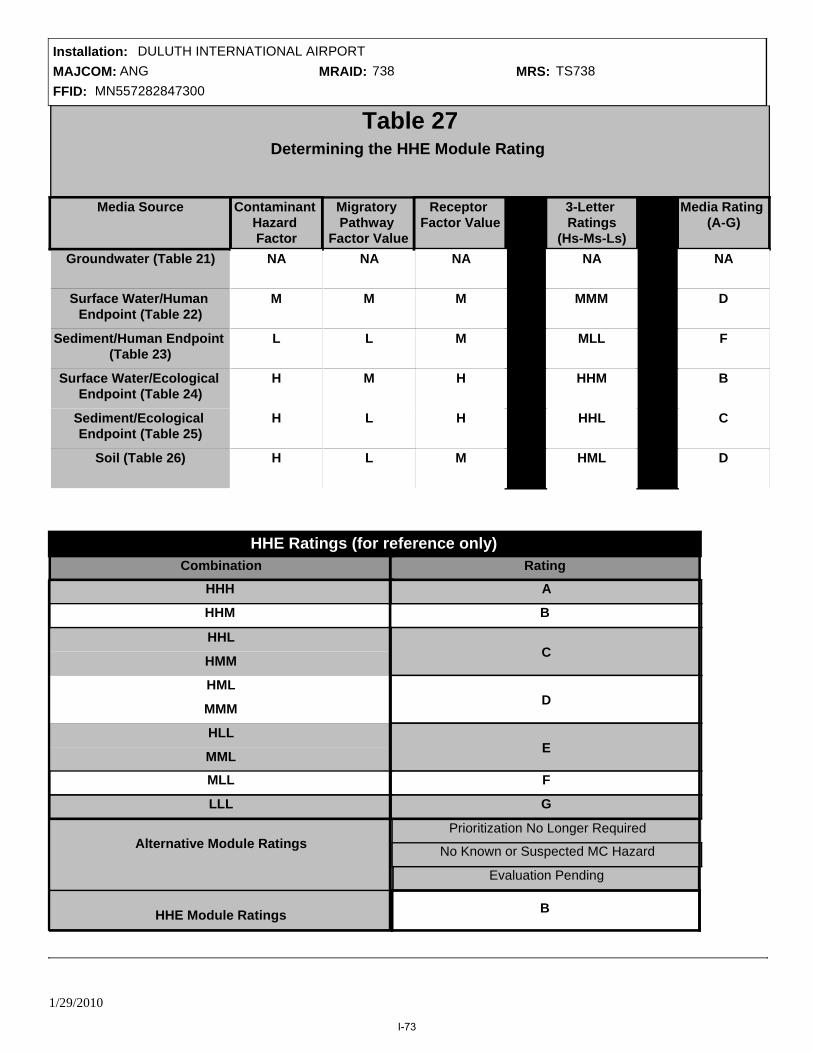
MAJCOM: ANGFFID: MN557282847300
Installation: DULUTH INTERNATIONAL AIRPORTMRAID: 738 MRS: TS738
Evaluation Pending
Migratory Pathway
Factor ValueNA
M
L
M
L
L
B
Prioritization No Longer Required
No Known or Suspected MC Hazard
B
Table 27Determining the HHE Module Rating
Groundwater (Table 21)
Surface Water/Human Endpoint (Table 22)
Sediment/Ecological Endpoint (Table 25)
Sediment/Human Endpoint (Table 23)
Surface Water/Ecological Endpoint (Table 24)
Soil (Table 26)
Media Source Contaminant Hazard Factor
Receptor Factor Value
3-Letter Ratings
(Hs-Ms-Ls)
Media Rating (A-G)
NA
M
M
H
H
M
NA
D
F
B
C
D
NA
MMM
NA
M
L
H
H
H
MLL
HHM
HHL
HML
HHH
HHL
HMM
HML
HLL
MMM
Combination
Alternative Module Ratings
MML
MLL
LLL
C
A
D
E
F
G
Rating
HHM
HHE Module Ratings
HHE Ratings (for reference only)
1/29/2010
I-73

MAJCOM: ANGFFID: MN557282847300
Installation: DULUTH INTERNATIONAL AIRPORTMRAID: 738 MRS: TS738
Table 28MRS Priority
EHE RatingEHE Rating Priority CHE Rating Priority HHE Rating Priority
A
F
B
D
C
E
G
Prioritization No Longer Required
No Known or Suspected Hazard
2
7
3
5
4
6
8
A
F
B
D
C
E
G
1
6
2
4
3
5
7
A
F
B
D
C
E
G
Prioritization No Longer Required
No Known or Suspected Hazard
2
7
3
5
4
6
8
Prioritization No Longer Required
No Known or Suspected Hazard
MRS Priority 3Evaluation Pending Evaluation Pending Evaluation Pending
1/29/2010
I-74
Appendix J: Remedial Action Cost Engineering Requirements (RACER) Military Munitions Response
Program Module Data Input Worksheet

This page intentionally left blank.

COMPREHENSIVE SITE EVALUATION: RACER DATAMAJCOM: ANG FFID: MN55728284730 MRAID: 502 MRS: SR502
City: Duluth State: MN County: St. Louis
Site Name: NGB-Duluth ANG Base - 88-S4
Acreage: 0.3SITE DIMENSIONS:
Length (Feet): 140.72 Width (Feet): 113.82 Perimeter (Feet):511.33
CONTAMINANTS OF CONCERN:
Acids/caustics
Asbestos
Fuels
SVOCs
VOCs
Ordnance (not residual)
Ordnance (residual)
PCBs
Pesticides
Metals
Low Level Radioactive
Other*
*Description of other:
Air to Air
Air to Ground
Artillery
Bombing
Burial Pits
Guided Missiles
Hand Grenade
OB/OD
Mortar
Multiple/combined Use
Rifle Grenade, Anti-tank Rocket
Small Arm
Other*
*Description of other: EOD Range
RANGE TYPES:
Section, Page #:SITE DIMENSIONS REFERENCES:
Page:
Section:
5.1.6, 5-2
CONTAMINANTS OF CONCERN REFERENCES:
Page:
Section:
5.1, 5-1
RANGE TYPES REFERENCES:
Installation: DULUTH INTERNATIONAL AIRPORT
1/6/2010 Page 1 of 15
J-1
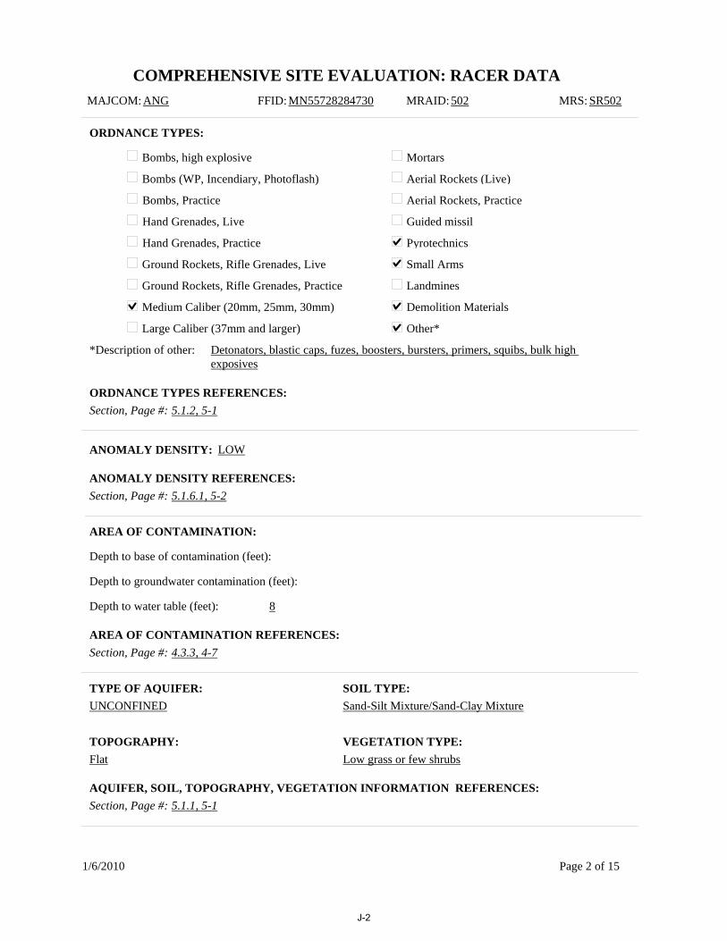
COMPREHENSIVE SITE EVALUATION: RACER DATAMAJCOM: ANG FFID: MN55728284730 MRAID: 502 MRS: SR502
Bombs, high explosive
Bombs (WP, Incendiary, Photoflash)
Bombs, Practice
Hand Grenades, Live
Hand Grenades, Practice
Ground Rockets, Rifle Grenades, Live
Ground Rockets, Rifle Grenades, Practice
Medium Caliber (20mm, 25mm, 30mm)
Large Caliber (37mm and larger)
Mortars
Aerial Rockets (Live)
Aerial Rockets, Practice
Guided missil
Pyrotechnics
Small Arms
Landmines
Demolition Materials
Other*
*Description of other: Detonators, blastic caps, fuzes, boosters, bursters, primers, squibs, bulk high exposives
ORDNANCE TYPES:
Depth to base of contamination (feet):
Depth to groundwater contamination (feet):
AREA OF CONTAMINATION:
UNCONFINEDTYPE OF AQUIFER: SOIL TYPE:
Sand-Silt Mixture/Sand-Clay Mixture
TOPOGRAPHY:Flat
VEGETATION TYPE:Low grass or few shrubs
Section, Page #: 5.1.2, 5-1ORDNANCE TYPES REFERENCES:
Section, Page #: 4.3.3, 4-7AREA OF CONTAMINATION REFERENCES:
Section, Page #: 5.1.1, 5-1AQUIFER, SOIL, TOPOGRAPHY, VEGETATION INFORMATION REFERENCES:
Depth to water table (feet): 8
ANOMALY DENSITY: LOW
Section, Page #: 5.1.6.1, 5-2ANOMALY DENSITY REFERENCES:
1/6/2010 Page 2 of 15
J-2

COMPREHENSIVE SITE EVALUATION: RACER DATAMAJCOM: ANG FFID: MN55728284730 MRAID: 502 MRS: SR502
IMPACTED MEDIA:
Surface soil
Subsurface
Groundwater
Surface water
Sediments
TYPICAL SAFETY LEVEL USED AT THE SITE: D
ADDITIONAL INFORMATION THAT MAY INFLUENCE COST:
The EOD Range is located on a restrictive easement owned by the Duluth Airport Authority. The restrictive easement prevents the development of the property due to its close proximity to the active Munitions Storage Area.
Section, Page #: 5.1.6.2, 5-2IMPACTED MEDIA REFERENCES:
Section, Page #:SAFETY LEVEL REFERENCES:
Section, Page #: 5.1.5, 5-2ADDITIONAL INFORMATION REFERENCES:
1/6/2010 Page 3 of 15
J-3
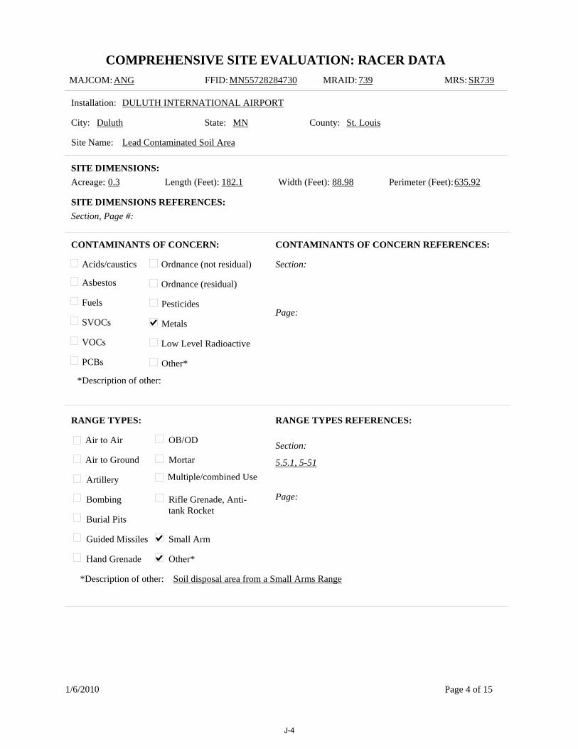
COMPREHENSIVE SITE EVALUATION: RACER DATAMAJCOM: ANG FFID: MN55728284730 MRAID: 739 MRS: SR739
City: Duluth State: MN County: St. Louis
Site Name: Lead Contaminated Soil Area
Acreage: 0.3SITE DIMENSIONS:
Length (Feet): 182.1 Width (Feet): 88.98 Perimeter (Feet):635.92
CONTAMINANTS OF CONCERN:
Acids/caustics
Asbestos
Fuels
SVOCs
VOCs
Ordnance (not residual)
Ordnance (residual)
PCBs
Pesticides
Metals
Low Level Radioactive
Other*
*Description of other:
Air to Air
Air to Ground
Artillery
Bombing
Burial Pits
Guided Missiles
Hand Grenade
OB/OD
Mortar
Multiple/combined Use
Rifle Grenade, Anti-tank Rocket
Small Arm
Other*
*Description of other: Soil disposal area from a Small Arms Range
RANGE TYPES:
Section, Page #:SITE DIMENSIONS REFERENCES:
Page:
Section:
CONTAMINANTS OF CONCERN REFERENCES:
Page:
Section:
5.5.1, 5-51
RANGE TYPES REFERENCES:
Installation: DULUTH INTERNATIONAL AIRPORT
1/6/2010 Page 4 of 15
J-4

COMPREHENSIVE SITE EVALUATION: RACER DATAMAJCOM: ANG FFID: MN55728284730 MRAID: 739 MRS: SR739
Bombs, high explosive
Bombs (WP, Incendiary, Photoflash)
Bombs, Practice
Hand Grenades, Live
Hand Grenades, Practice
Ground Rockets, Rifle Grenades, Live
Ground Rockets, Rifle Grenades, Practice
Medium Caliber (20mm, 25mm, 30mm)
Large Caliber (37mm and larger)
Mortars
Aerial Rockets (Live)
Aerial Rockets, Practice
Guided missil
Pyrotechnics
Small Arms
Landmines
Demolition Materials
Other*
*Description of other:
ORDNANCE TYPES:
Depth to base of contamination (feet): 3
Depth to groundwater contamination (feet):
AREA OF CONTAMINATION:
UNCONFINEDTYPE OF AQUIFER: SOIL TYPE:
Sand-Silt Mixture/Sand-Clay Mixture
TOPOGRAPHY:Gently rolling
VEGETATION TYPE:Low grass or few shrubs
Section, Page #: 5.5.2, 5-52ORDNANCE TYPES REFERENCES:
Section, Page #: 5.5.6.2, 5-52/4.3.3, 4-7AREA OF CONTAMINATION REFERENCES:
Section, Page #: 5.5.1, 5-51AQUIFER, SOIL, TOPOGRAPHY, VEGETATION INFORMATION REFERENCES:
Depth to water table (feet): 8
ANOMALY DENSITY:
Section, Page #:ANOMALY DENSITY REFERENCES:
1/6/2010 Page 5 of 15
J-5

COMPREHENSIVE SITE EVALUATION: RACER DATAMAJCOM: ANG FFID: MN55728284730 MRAID: 739 MRS: SR739
IMPACTED MEDIA:
Surface soil
Subsurface
Groundwater
Surface water
Sediments
TYPICAL SAFETY LEVEL USED AT THE SITE: D
ADDITIONAL INFORMATION THAT MAY INFLUENCE COST:
The LCSA is located on a restrictive easement owned by the Duluth Airport Authority. The restrictive easement prevents the development of the property due to its close proximity to the active Munitions Storage Area.
Section, Page #: 5.5.6.2, 5-52IMPACTED MEDIA REFERENCES:
Section, Page #:SAFETY LEVEL REFERENCES:
Section, Page #: 5.5.5, 5-52ADDITIONAL INFORMATION REFERENCES:
1/6/2010 Page 6 of 15
J-6

COMPREHENSIVE SITE EVALUATION: RACER DATAMAJCOM: ANG FFID: MN55728284730 MRAID: 738 MRS: TS738
City: Duluth State: MN County: St. Louis
Site Name: Skeet Range
Acreage: 15.3SITE DIMENSIONS:
Length (Feet): 1448.77 Width (Feet): 743.56 Perimeter (Feet):3446.95
CONTAMINANTS OF CONCERN:
Acids/caustics
Asbestos
Fuels
SVOCs
VOCs
Ordnance (not residual)
Ordnance (residual)
PCBs
Pesticides
Metals
Low Level Radioactive
Other*
*Description of other:
Air to Air
Air to Ground
Artillery
Bombing
Burial Pits
Guided Missiles
Hand Grenade
OB/OD
Mortar
Multiple/combined Use
Rifle Grenade, Anti-tank Rocket
Small Arm
Other*
*Description of other: Skeet Range
RANGE TYPES:
Section, Page #:SITE DIMENSIONS REFERENCES:
Page:
Section:
5.4.6.2, 5-40
CONTAMINANTS OF CONCERN REFERENCES:
Page:
Section:
5.4.1, 5-39
RANGE TYPES REFERENCES:
Installation: DULUTH INTERNATIONAL AIRPORT
1/6/2010 Page 7 of 15
J-7

COMPREHENSIVE SITE EVALUATION: RACER DATAMAJCOM: ANG FFID: MN55728284730 MRAID: 738 MRS: TS738
Bombs, high explosive
Bombs (WP, Incendiary, Photoflash)
Bombs, Practice
Hand Grenades, Live
Hand Grenades, Practice
Ground Rockets, Rifle Grenades, Live
Ground Rockets, Rifle Grenades, Practice
Medium Caliber (20mm, 25mm, 30mm)
Large Caliber (37mm and larger)
Mortars
Aerial Rockets (Live)
Aerial Rockets, Practice
Guided missil
Pyrotechnics
Small Arms
Landmines
Demolition Materials
Other*
*Description of other:
ORDNANCE TYPES:
Depth to base of contamination (feet):
Depth to groundwater contamination (feet):
AREA OF CONTAMINATION:
UNCONFINEDTYPE OF AQUIFER: SOIL TYPE:
Sand-Silt Mixture/Sand-Clay Mixture
TOPOGRAPHY:Gently rolling
VEGETATION TYPE:Heavy shrubs with trees
Section, Page #: 5.4.2, 5-39ORDNANCE TYPES REFERENCES:
Section, Page #: 4.3.3, 4-7AREA OF CONTAMINATION REFERENCES:
Section, Page #: 5.4.1, 5-39AQUIFER, SOIL, TOPOGRAPHY, VEGETATION INFORMATION REFERENCES:
Depth to water table (feet): 8
ANOMALY DENSITY: LOW
Section, Page #: 5.4.2, 5-39ANOMALY DENSITY REFERENCES:
1/6/2010 Page 8 of 15
J-8

COMPREHENSIVE SITE EVALUATION: RACER DATAMAJCOM: ANG FFID: MN55728284730 MRAID: 738 MRS: TS738
IMPACTED MEDIA:
Surface soil
Subsurface
Groundwater
Surface water
Sediments
TYPICAL SAFETY LEVEL USED AT THE SITE: D
ADDITIONAL INFORMATION THAT MAY INFLUENCE COST:
The Skeet Range is located within the main base, which is owned concurrently by the DoD/USAF and the Minnesota Department of Military Affairs. No public access to the site is permitted.
Section, Page #: 5.4.6.2, 5-40IMPACTED MEDIA REFERENCES:
Section, Page #:SAFETY LEVEL REFERENCES:
Section, Page #: 5.4.4, 5-39ADDITIONAL INFORMATION REFERENCES:
1/6/2010 Page 9 of 15
J-9

COMPREHENSIVE SITE EVALUATION: RACER DATAMAJCOM: ANG FFID: MN55728284730 MRAID: 737 MRS: TS737
City: Duluth State: MN County: St. Louis
Site Name: Trap Range
Acreage: 4SITE DIMENSIONS:
Length (Feet): 973.58 Width (Feet): 308.33 Perimeter (Feet):2646.7
CONTAMINANTS OF CONCERN:
Acids/caustics
Asbestos
Fuels
SVOCs
VOCs
Ordnance (not residual)
Ordnance (residual)
PCBs
Pesticides
Metals
Low Level Radioactive
Other*
*Description of other:
Air to Air
Air to Ground
Artillery
Bombing
Burial Pits
Guided Missiles
Hand Grenade
OB/OD
Mortar
Multiple/combined Use
Rifle Grenade, Anti-tank Rocket
Small Arm
Other*
*Description of other:
RANGE TYPES:
Section, Page #:SITE DIMENSIONS REFERENCES:
Page:
Section:
5.3.6.2, 5-31
CONTAMINANTS OF CONCERN REFERENCES:
Page:
Section:
5.3.1, 5-25
RANGE TYPES REFERENCES:
Installation: DULUTH INTERNATIONAL AIRPORT
1/6/2010 Page 10 of 15
J-10

COMPREHENSIVE SITE EVALUATION: RACER DATAMAJCOM: ANG FFID: MN55728284730 MRAID: 737 MRS: TS737
Bombs, high explosive
Bombs (WP, Incendiary, Photoflash)
Bombs, Practice
Hand Grenades, Live
Hand Grenades, Practice
Ground Rockets, Rifle Grenades, Live
Ground Rockets, Rifle Grenades, Practice
Medium Caliber (20mm, 25mm, 30mm)
Large Caliber (37mm and larger)
Mortars
Aerial Rockets (Live)
Aerial Rockets, Practice
Guided missil
Pyrotechnics
Small Arms
Landmines
Demolition Materials
Other*
*Description of other:
ORDNANCE TYPES:
Depth to base of contamination (feet):
Depth to groundwater contamination (feet):
AREA OF CONTAMINATION:
UNCONFINEDTYPE OF AQUIFER: SOIL TYPE:
Sand-Silt Mixture/Sand-Clay Mixture
TOPOGRAPHY:Flat
VEGETATION TYPE:Heavy shrubs with trees
Section, Page #: 5.3.2, 5-26ORDNANCE TYPES REFERENCES:
Section, Page #: 4.3.3, 4-7AREA OF CONTAMINATION REFERENCES:
Section, Page #: 5.3.1, 5-25AQUIFER, SOIL, TOPOGRAPHY, VEGETATION INFORMATION REFERENCES:
Depth to water table (feet): 8
ANOMALY DENSITY: LOW
Section, Page #: 5.3.2, 5-26ANOMALY DENSITY REFERENCES:
1/6/2010 Page 11 of 15
J-11

COMPREHENSIVE SITE EVALUATION: RACER DATAMAJCOM: ANG FFID: MN55728284730 MRAID: 737 MRS: TS737
IMPACTED MEDIA:
Surface soil
Subsurface
Groundwater
Surface water
Sediments
TYPICAL SAFETY LEVEL USED AT THE SITE: D
ADDITIONAL INFORMATION THAT MAY INFLUENCE COST:
The Trap Range is on property owned by the Duluth Airport Authority; however, access to the site from the airport is limited because the area is fenced, and most gates are permanently locked. The Trap Range can be accessed via a dirt road from an off-base recycling center located to the north.
Section, Page #: 5.3.6.2, 5-31IMPACTED MEDIA REFERENCES:
Section, Page #:SAFETY LEVEL REFERENCES:
Section, Page #: 5.3.4, 5-26ADDITIONAL INFORMATION REFERENCES:
1/6/2010 Page 12 of 15
J-12
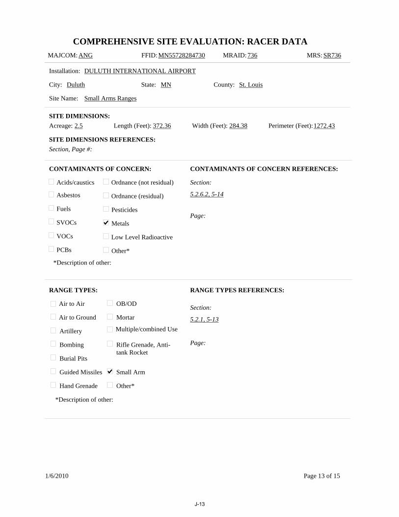
COMPREHENSIVE SITE EVALUATION: RACER DATAMAJCOM: ANG FFID: MN55728284730 MRAID: 736 MRS: SR736
City: Duluth State: MN County: St. Louis
Site Name: Small Arms Ranges
Acreage: 2.5SITE DIMENSIONS:
Length (Feet): 372.36 Width (Feet): 284.38 Perimeter (Feet):1272.43
CONTAMINANTS OF CONCERN:
Acids/caustics
Asbestos
Fuels
SVOCs
VOCs
Ordnance (not residual)
Ordnance (residual)
PCBs
Pesticides
Metals
Low Level Radioactive
Other*
*Description of other:
Air to Air
Air to Ground
Artillery
Bombing
Burial Pits
Guided Missiles
Hand Grenade
OB/OD
Mortar
Multiple/combined Use
Rifle Grenade, Anti-tank Rocket
Small Arm
Other*
*Description of other:
RANGE TYPES:
Section, Page #:SITE DIMENSIONS REFERENCES:
Page:
Section:
5.2.6.2, 5-14
CONTAMINANTS OF CONCERN REFERENCES:
Page:
Section:
5.2.1, 5-13
RANGE TYPES REFERENCES:
Installation: DULUTH INTERNATIONAL AIRPORT
1/6/2010 Page 13 of 15
J-13

COMPREHENSIVE SITE EVALUATION: RACER DATAMAJCOM: ANG FFID: MN55728284730 MRAID: 736 MRS: SR736
Bombs, high explosive
Bombs (WP, Incendiary, Photoflash)
Bombs, Practice
Hand Grenades, Live
Hand Grenades, Practice
Ground Rockets, Rifle Grenades, Live
Ground Rockets, Rifle Grenades, Practice
Medium Caliber (20mm, 25mm, 30mm)
Large Caliber (37mm and larger)
Mortars
Aerial Rockets (Live)
Aerial Rockets, Practice
Guided missil
Pyrotechnics
Small Arms
Landmines
Demolition Materials
Other*
*Description of other:
ORDNANCE TYPES:
Depth to base of contamination (feet):
Depth to groundwater contamination (feet):
AREA OF CONTAMINATION:
UNCONFINEDTYPE OF AQUIFER: SOIL TYPE:
Sand-Silt Mixture/Sand-Clay Mixture
TOPOGRAPHY:Flat
VEGETATION TYPE:Barren or Low grass
Section, Page #: 5.2.2, 5-13ORDNANCE TYPES REFERENCES:
Section, Page #: 4.3.3, 4-7AREA OF CONTAMINATION REFERENCES:
Section, Page #: 5.2.1, 5-13AQUIFER, SOIL, TOPOGRAPHY, VEGETATION INFORMATION REFERENCES:
Depth to water table (feet): 8
ANOMALY DENSITY: LOW
Section, Page #: 5.2.2, 5-13ANOMALY DENSITY REFERENCES:
1/6/2010 Page 14 of 15
J-14
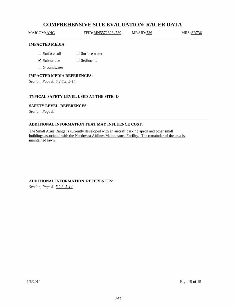
COMPREHENSIVE SITE EVALUATION: RACER DATAMAJCOM: ANG FFID: MN55728284730 MRAID: 736 MRS: SR736
IMPACTED MEDIA:
Surface soil
Subsurface
Groundwater
Surface water
Sediments
TYPICAL SAFETY LEVEL USED AT THE SITE: D
ADDITIONAL INFORMATION THAT MAY INFLUENCE COST:
The Small Arms Range is currently developed with an aircraft parking apron and other small buildings associated with the Northwest Airlines Maintenance Facility. The remainder of the area is maintained lawn.
Section, Page #: 5.2.6.2, 5-14IMPACTED MEDIA REFERENCES:
Section, Page #:SAFETY LEVEL REFERENCES:
Section, Page #: 5.2.3, 5-14ADDITIONAL INFORMATION REFERENCES:
1/6/2010 Page 15 of 15
J-15

Appendix K: Air Force Restoration Information Management System (AFRIMS) Data Input Worksheet

This page intentionally left blank.
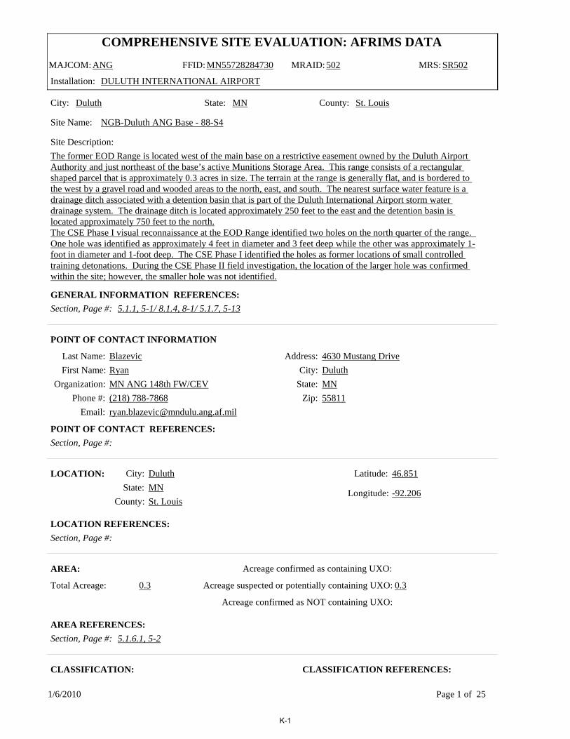
COMPREHENSIVE SITE EVALUATION: AFRIMS DATA
MAJCOM: ANG FFID: MN55728284730 MRAID: 502 MRS: SR502
Installation: DULUTH INTERNATIONAL AIRPORT
City: Duluth State: MN County: St. Louis
Site Name: NGB-Duluth ANG Base - 88-S4
Last Name: BlazevicFirst Name: Ryan
Organization: MN ANG 148th FW/CEVPhone #: (218) 788-7868
Email: [email protected]
Address: 4630 Mustang DriveCity: Duluth
State: MNZip: 55811
POINT OF CONTACT INFORMATION
City: DuluthState: MN
County: St. Louis
Latitude: 46.851
Longitude: -92.206
LOCATION:
AREA:
Total Acreage: 0.3
Acreage confirmed as containing UXO:
Acreage suspected or potentially containing UXO: 0.3
Acreage confirmed as NOT containing UXO:
CLASSIFICATION:
Section, Page #: 5.1.1, 5-1/ 8.1.4, 8-1/ 5.1.7, 5-13GENERAL INFORMATION REFERENCES:
Section, Page #:POINT OF CONTACT REFERENCES:
Section, Page #:LOCATION REFERENCES:
Section, Page #: 5.1.6.1, 5-2AREA REFERENCES:
CLASSIFICATION REFERENCES:
Site Description:The former EOD Range is located west of the main base on a restrictive easement owned by the Duluth Airport Authority and just northeast of the base’s active Munitions Storage Area. This range consists of a rectangular shaped parcel that is approximately 0.3 acres in size. The terrain at the range is generally flat, and is bordered to the west by a gravel road and wooded areas to the north, east, and south. The nearest surface water feature is a drainage ditch associated with a detention basin that is part of the Duluth International Airport storm water drainage system. The drainage ditch is located approximately 250 feet to the east and the detention basin is located approximately 750 feet to the north.The CSE Phase I visual reconnaissance at the EOD Range identified two holes on the north quarter of the range. One hole was identified as approximately 4 feet in diameter and 3 feet deep while the other was approximately 1-foot in diameter and 1-foot deep. The CSE Phase I identified the holes as former locations of small controlled training detonations. During the CSE Phase II field investigation, the location of the larger hole was confirmed within the site; however, the smaller hole was not identified.
1/6/2010 Page 1 of 25
K-1

COMPREHENSIVE SITE EVALUATION: AFRIMS DATA
MAJCOM: ANG FFID: MN55728284730 MRAID: 502 MRS: SR502
Installation: DULUTH INTERNATIONAL AIRPORT
TestingTrainingTreatment OBOD RCRADisposal RCRABuffer Area
Small Arms RangeSkeet RangeWaste Military MunitionsOther*
*Description of other: Emergency Destruction
Section: 5.1, 5-1
Page:
Air to AirAir to water
Air to landLand to air
Land to landLand to water
Other*
*Description of other: EOD Range
RANGE TYPES:
Section, Page #: 5.1, 5-1RANGE/SITE TYPES REFERENCES:
ORDNANCE TYPES AND RELATED ANOMALY DENSITY:
Section, Page #: 5.1.2, 5-1ORDNANCE TYPES REFERENCES:
Medium/Large Caliber (20 mm and larger)Explosive grenades (hand or rifle)
Explosive landmine
Explosive rockets
Guided Missiles
Explosive detonators
Blasting caps
Practice grenades (with spotting charges)Practice landmines (with spotting charges)Small arms complete round (.22-.50 cal)
Small arms, expended
Practice ordnance (without spotting charges)
White phosphorous
Incendiary material
Primary or initiating explosives
Demolition charges
Military dynamite
Less sensitive explosives (Ammonium Nitrate, etc.)
Solid or liquid propellants
Toxic chem. agents (choking, nerve, blood, blister)
War gas identification sets
Radiological ordnance (e.g., depleted Uranium)Riot control agents (vomiting, tear)
Bombs (explosive)
Bombs (practice)
Fuses, Boosters, Bursters
Flares, signals, & simulators (other than white phos.)
Torpedoes/Sea Mines
Secondary explosives (PETN, Compositions A, B, C, Tetryl, TNT, RDX, HMX, HBX, Black Powder, etc.)
Contaminant is a Chemical residue of munitions?
Ordnance Types (check all that apply) Density
Contaminant is a Chemical residue of munitions?
Ordnance Types (check all that apply) Density
LOW
LOW
LOW
LOW
LOW
LOW
LOW
LOW
1/6/2010 Page 2 of 25
K-2

COMPREHENSIVE SITE EVALUATION: AFRIMS DATA
MAJCOM: ANG FFID: MN55728284730 MRAID: 502 MRS: SR502
Installation: DULUTH INTERNATIONAL AIRPORT
Section, Page #: 5.1.6.1, 5-2ANOMALY DENSITY REFERENCES:
Are there any wetland areas associated with this site? NO If yes, please list acreage:
Section, Page #: 5.1, 5-1
ARCHAEOLOGICAL/ECOLOGICAL:
Section: 5.1, 5-1ARCHEOLOGICAL/ECOLOGICAL REFERENCES:
WETLANDS:
WETLANDS REFERENCES:
Archaeological or cultural sites present? Yes N
Yes NThreatened or endangered species present?
Predominant Soil Type: Sand-Silt/Sand-Clay Predominant Topography: Flat
Predominant Vegetation: Low grass and few shrubs
Potential for contamination of drinking water: NO POTENTIAL
Is the MRS located above a drinking water aquifer? NO
Section, Page #: 5.1, 5-1
Section, Page #: 4.3.3, 4-7
Depth to Groundwater (feet): 8
GENERAL MEDIA:
GENERAL MEDIA REFERENCES:
GROUNDWATER:
GROUNDWATER REFERENCES:
Sole source aquifer? No
1/6/2010 Page 3 of 25
K-3

COMPREHENSIVE SITE EVALUATION: AFRIMS DATA
MAJCOM: ANG FFID: MN55728284730 MRAID: 502 MRS: SR502
Installation: DULUTH INTERNATIONAL AIRPORT
ENVIRONMENTAL RESPONSE:
Have environmental response activities been initiated/conducted on this MRS? Yes No
Past practices
Current practices
If yes, what is the scope of the response activities?
If yes, what is the status of theresponse activities?
Chemical contamination
Ordnance and explosives, including UXO
Data collection Investigation Response/remedial action
Monitoring Close out Operation and maintenance
Section, Page #: 5.1.6, 5-2
If yes, is contamination monitoring (i.e., groundwater sampling and analysis) needed? YES
If yes, under what authority were/are response actions conducted? CERCLA
ENVIRONMENTAL RESPONSE REFERENCES:
What types of UXO response actions have been initiated/conducted on the site?
None
Unknown
Other*
Emergency response actions
Routine range clearance/maintenance
Time-critical removal actions
UXO response actions associated with ERP activitiesNon-time-critical removal actions with Engineering Evaluation/Cost Analysis
*Please specify other: Geophysical Survey
Section: 5.1.6.1, 5-2 Page:
UXO RESPONSE:
UXO RESPONSE REFERENCES:
LAND USE RESTRICTIONS:
ACCESS CONTROLS:
No public access
Limited public access
Restricted public access
Unrestricted public access
No controls
Access signs
Fencing
Locked gates
Log book
Security patrol
1/6/2010 Page 4 of 25
K-4
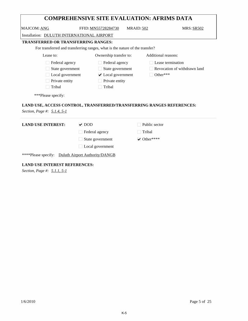
COMPREHENSIVE SITE EVALUATION: AFRIMS DATA
MAJCOM: ANG FFID: MN55728284730 MRAID: 502 MRS: SR502
Installation: DULUTH INTERNATIONAL AIRPORT
Section, Page #: 5.1.4, 5-1
***Please specify:
TRANSFERRED OR TRANSFERRING RANGES:For transferred and transferring ranges, what is the nature of the transfer?
Federal agencyState governmentLocal governmentPrivate entityTribal
Federal agencyState governmentLocal governmentPrivate entityTribal
Lease to: Ownership transfer to: Additional reasons:
Lease terminationRevocation of withdrawn landOther***
LAND USE, ACCESS CONTROL, TRANSFERRED/TRANSFERRING RANGES REFERENCES:
DOD
Federal agency
State government
Local government
Public sector
Tribal
Other****
****Please specify: Duluth Airport Authority/DANGB
Section, Page #: 5.1.1, 5-1
LAND USE INTEREST:
LAND USE INTEREST REFERENCES:
1/6/2010 Page 5 of 25
K-5

COMPREHENSIVE SITE EVALUATION: AFRIMS DATA
MAJCOM: ANG FFID: MN55728284730 MRAID: 736 MRS: SR736
Installation: DULUTH INTERNATIONAL AIRPORT
City: Duluth State: MN County: St. Louis
Site Name: Small Arms Ranges
Last Name: BlazevicFirst Name: Ryan
Organization: MN ANG 148th FW/CEVPhone #: (218) 788-7868
Email: [email protected]
Address: 4630 Mustang DriveCity: Duluth
State: MNZip: 55811
POINT OF CONTACT INFORMATION
City: DuluthState: MN
County: St. Louis
Latitude: 46.847
Longitude: -92.186
LOCATION:
AREA:
Total Acreage: 2.5
Acreage confirmed as containing UXO:
Acreage suspected or potentially containing UXO:
Acreage confirmed as NOT containing UXO: 2.5
CLASSIFICATION:
Section, Page #: 5.2.1, 5-13/8.2.3.1, 8-4/5.2.7, 5-25GENERAL INFORMATION REFERENCES:
Section, Page #:POINT OF CONTACT REFERENCES:
Section, Page #:LOCATION REFERENCES:
Section, Page #: 5.2.6.1, 5-14AREA REFERENCES:
CLASSIFICATION REFERENCES:
Site Description:The former Small Arms Range is located west of the main base and is north of the intersection of Runway 21 and Runway 13, on property owned by the Duluth Airport Authority. The area encompasses approximately 2.5 acres. The terrain is mostly flat and is bordered to the north and west by the Northwest Airlines Maintenance Facility and to the south and east by undeveloped land. Two retention ponds are located approximately 300 feet northwest of the range. The basins are used for both storm water management and fire emergency water supply. No evidence of the former range exists on the site, portions of which are covered by an aircraft parking apron. A small hill, consisting of non-native fill (assumed placed during the construction of the Northwest Airlines Maintenance Facility) is located on the eastern side of the site.
1/6/2010 Page 6 of 25
K-6

COMPREHENSIVE SITE EVALUATION: AFRIMS DATA
MAJCOM: ANG FFID: MN55728284730 MRAID: 736 MRS: SR736
Installation: DULUTH INTERNATIONAL AIRPORT
TestingTrainingTreatment OBOD RCRADisposal RCRABuffer Area
Small Arms RangeSkeet RangeWaste Military MunitionsOther*
*Description of other:
Section: 5.2.1, 5-13
Page:
Air to AirAir to water
Air to landLand to air
Land to landLand to water
Other*
*Description of other: Small Arms Range
RANGE TYPES:
Section, Page #: 5.2.1, 5-13RANGE/SITE TYPES REFERENCES:
ORDNANCE TYPES AND RELATED ANOMALY DENSITY:
Section, Page #:ORDNANCE TYPES REFERENCES:
Medium/Large Caliber (20 mm and larger)Explosive grenades (hand or rifle)
Explosive landmine
Explosive rockets
Guided Missiles
Explosive detonators
Blasting caps
Practice grenades (with spotting charges)Practice landmines (with spotting charges)Small arms complete round (.22-.50 cal)
Small arms, expended
Practice ordnance (without spotting charges)
White phosphorous
Incendiary material
Primary or initiating explosives
Demolition charges
Military dynamite
Less sensitive explosives (Ammonium Nitrate, etc.)
Solid or liquid propellants
Toxic chem. agents (choking, nerve, blood, blister)
War gas identification sets
Radiological ordnance (e.g., depleted Uranium)Riot control agents (vomiting, tear)
Bombs (explosive)
Bombs (practice)
Fuses, Boosters, Bursters
Flares, signals, & simulators (other than white phos.)
Torpedoes/Sea Mines
Secondary explosives (PETN, Compositions A, B, C, Tetryl, TNT, RDX, HMX, HBX, Black Powder, etc.)
Contaminant is a Chemical residue of munitions?
Ordnance Types (check all that apply) Density
Contaminant is a Chemical residue of munitions?
Ordnance Types (check all that apply) Density
1/6/2010 Page 7 of 25
K-7

COMPREHENSIVE SITE EVALUATION: AFRIMS DATA
MAJCOM: ANG FFID: MN55728284730 MRAID: 736 MRS: SR736
Installation: DULUTH INTERNATIONAL AIRPORT
Section, Page #:ANOMALY DENSITY REFERENCES:
Are there any wetland areas associated with this site? NO If yes, please list acreage:
Section, Page #:
ARCHAEOLOGICAL/ECOLOGICAL:
Section:ARCHEOLOGICAL/ECOLOGICAL REFERENCES:
WETLANDS:
WETLANDS REFERENCES:
Archaeological or cultural sites present? Yes N
Yes NThreatened or endangered species present?
Predominant Soil Type: Sand-Silt/Sand-Clay Predominant Topography: Flat
Predominant Vegetation: Barren or low grass
Potential for contamination of drinking water: NO POTENTIAL
Is the MRS located above a drinking water aquifer? NO
Section, Page #: 5.2.1, 5-13
Section, Page #: 4.3.3, 4-7
Depth to Groundwater (feet): 8
GENERAL MEDIA:
GENERAL MEDIA REFERENCES:
GROUNDWATER:
GROUNDWATER REFERENCES:
Sole source aquifer? No
1/6/2010 Page 8 of 25
K-8

COMPREHENSIVE SITE EVALUATION: AFRIMS DATA
MAJCOM: ANG FFID: MN55728284730 MRAID: 736 MRS: SR736
Installation: DULUTH INTERNATIONAL AIRPORT
ENVIRONMENTAL RESPONSE:
Have environmental response activities been initiated/conducted on this MRS? Yes No
Past practices
Current practices
If yes, what is the scope of the response activities?
If yes, what is the status of theresponse activities?
Chemical contamination
Ordnance and explosives, including UXO
Data collection Investigation Response/remedial action
Monitoring Close out Operation and maintenance
Section, Page #: 5.2.6.2, 5-14
If yes, is contamination monitoring (i.e., groundwater sampling and analysis) needed? NO
If yes, under what authority were/are response actions conducted? CERCLA
ENVIRONMENTAL RESPONSE REFERENCES:
What types of UXO response actions have been initiated/conducted on the site?
None
Unknown
Other*
Emergency response actions
Routine range clearance/maintenance
Time-critical removal actions
UXO response actions associated with ERP activitiesNon-time-critical removal actions with Engineering Evaluation/Cost Analysis
*Please specify other:
Section: Page:
UXO RESPONSE:
UXO RESPONSE REFERENCES:
LAND USE RESTRICTIONS:
ACCESS CONTROLS:
No public access
Limited public access
Restricted public access
Unrestricted public access
No controls
Access signs
Fencing
Locked gates
Log book
Security patrol
1/6/2010 Page 9 of 25
K-9
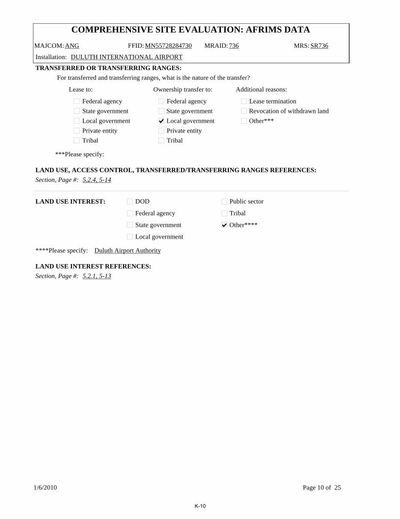
COMPREHENSIVE SITE EVALUATION: AFRIMS DATA
MAJCOM: ANG FFID: MN55728284730 MRAID: 736 MRS: SR736
Installation: DULUTH INTERNATIONAL AIRPORT
Section, Page #: 5.2.4, 5-14
***Please specify:
TRANSFERRED OR TRANSFERRING RANGES:For transferred and transferring ranges, what is the nature of the transfer?
Federal agencyState governmentLocal governmentPrivate entityTribal
Federal agencyState governmentLocal governmentPrivate entityTribal
Lease to: Ownership transfer to: Additional reasons:
Lease terminationRevocation of withdrawn landOther***
LAND USE, ACCESS CONTROL, TRANSFERRED/TRANSFERRING RANGES REFERENCES:
DOD
Federal agency
State government
Local government
Public sector
Tribal
Other****
****Please specify: Duluth Airport Authority
Section, Page #: 5.2.1, 5-13
LAND USE INTEREST:
LAND USE INTEREST REFERENCES:
1/6/2010 Page 10 of 25
K-10

COMPREHENSIVE SITE EVALUATION: AFRIMS DATA
MAJCOM: ANG FFID: MN55728284730 MRAID: 737 MRS: TS737
Installation: DULUTH INTERNATIONAL AIRPORT
City: Duluth State: MN County: St. Louis
Site Name: Trap Range
Last Name: BlazevicFirst Name: Ryan
Organization: MN ANG 148th FW/CEVPhone #: (218) 788-7868
Email: [email protected]
Address: 4630 Mustang DriveCity: Duluth
State: MNZip: 55811
POINT OF CONTACT INFORMATION
City: DuluthState: MN
County: St. Louis
Latitude: 46.846
Longitude: -92.185
LOCATION:
AREA:
Total Acreage: 4
Acreage confirmed as containing UXO:
Acreage suspected or potentially containing UXO:
Acreage confirmed as NOT containing UXO: 4
CLASSIFICATION:
Section, Page #: 5.3.1, 5-25/8.2.3.1, 8-4/5.3.7, 5-31GENERAL INFORMATION REFERENCES:
Section, Page #:POINT OF CONTACT REFERENCES:
Section, Page #:LOCATION REFERENCES:
Section, Page #: 5.3.6.1, 5-26AREA REFERENCES:
CLASSIFICATION REFERENCES:
Site Description:The Trap Range is located west of the main base and is north of the intersection of Runway 21 and Runway 13, on property owned by the Duluth Airport Authority. The former range covers approximately 4 acres. The terrain is bordered to the north, west, and east by building developments and to the south by undeveloped land. Two retention ponds are located near the Trap Range, and are used for both storm water management and fire emergency water supply. During Phase II site reconnaissance, it was determined that the majority of the former range is located outside the Duluth International Airport Authority fence line, and is only accessible via a dirt access road through the off-base recycling facility. Visual survey of the MRA indicated wet conditions throughoutthe site. The center of the former range is a low-lying marshland with vegetation consisting of tall grasses and densely wooded areas. During the December site reconnaissance, the frozen ground facilitated access to most sampling locations within the wetland.
1/6/2010 Page 11 of 25
K-11
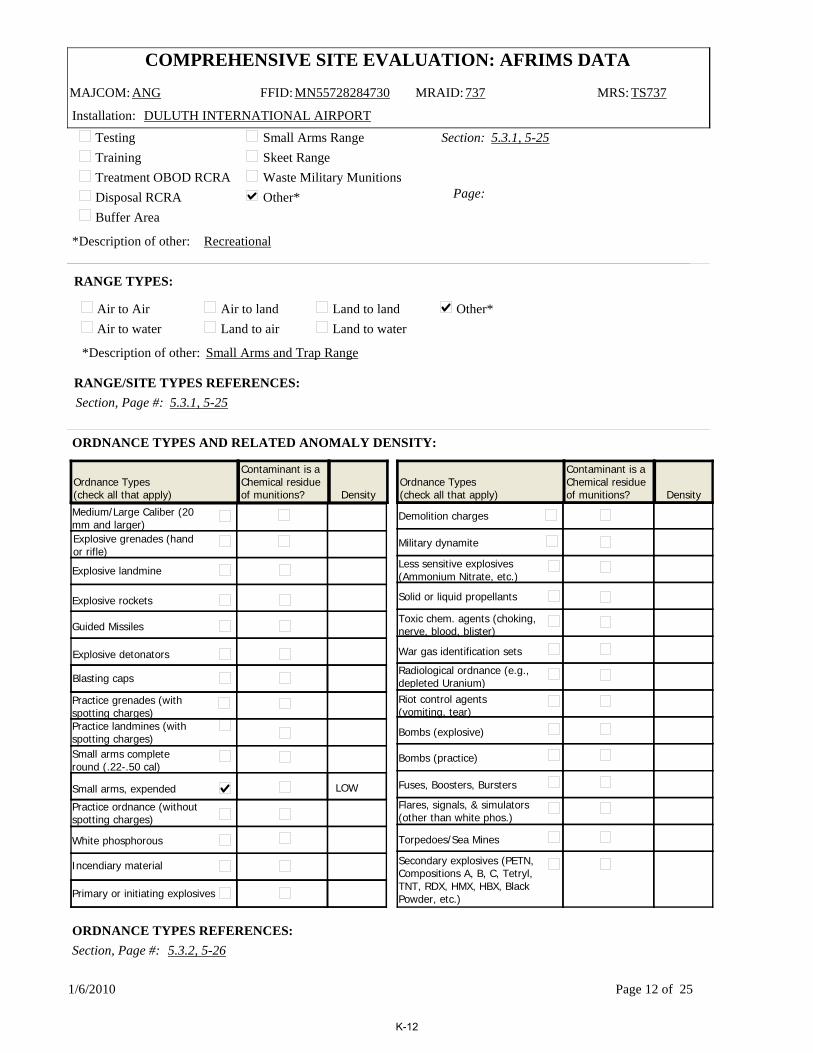
COMPREHENSIVE SITE EVALUATION: AFRIMS DATA
MAJCOM: ANG FFID: MN55728284730 MRAID: 737 MRS: TS737
Installation: DULUTH INTERNATIONAL AIRPORT
TestingTrainingTreatment OBOD RCRADisposal RCRABuffer Area
Small Arms RangeSkeet RangeWaste Military MunitionsOther*
*Description of other: Recreational
Section: 5.3.1, 5-25
Page:
Air to AirAir to water
Air to landLand to air
Land to landLand to water
Other*
*Description of other: Small Arms and Trap Range
RANGE TYPES:
Section, Page #: 5.3.1, 5-25RANGE/SITE TYPES REFERENCES:
ORDNANCE TYPES AND RELATED ANOMALY DENSITY:
Section, Page #: 5.3.2, 5-26ORDNANCE TYPES REFERENCES:
Medium/Large Caliber (20 mm and larger)Explosive grenades (hand or rifle)
Explosive landmine
Explosive rockets
Guided Missiles
Explosive detonators
Blasting caps
Practice grenades (with spotting charges)Practice landmines (with spotting charges)Small arms complete round (.22-.50 cal)
Small arms, expended
Practice ordnance (without spotting charges)
White phosphorous
Incendiary material
Primary or initiating explosives
Demolition charges
Military dynamite
Less sensitive explosives (Ammonium Nitrate, etc.)
Solid or liquid propellants
Toxic chem. agents (choking, nerve, blood, blister)
War gas identification sets
Radiological ordnance (e.g., depleted Uranium)Riot control agents (vomiting, tear)
Bombs (explosive)
Bombs (practice)
Fuses, Boosters, Bursters
Flares, signals, & simulators (other than white phos.)
Torpedoes/Sea Mines
Secondary explosives (PETN, Compositions A, B, C, Tetryl, TNT, RDX, HMX, HBX, Black Powder, etc.)
Contaminant is a Chemical residue of munitions?
Ordnance Types (check all that apply) Density
Contaminant is a Chemical residue of munitions?
Ordnance Types (check all that apply) Density
LOW
1/6/2010 Page 12 of 25
K-12

COMPREHENSIVE SITE EVALUATION: AFRIMS DATA
MAJCOM: ANG FFID: MN55728284730 MRAID: 737 MRS: TS737
Installation: DULUTH INTERNATIONAL AIRPORT
Section, Page #: 5.3.2, 5-26ANOMALY DENSITY REFERENCES:
Are there any wetland areas associated with this site? YES If yes, please list acreage:
Section, Page #: 3.3.2, 3-2
ARCHAEOLOGICAL/ECOLOGICAL:
Section:ARCHEOLOGICAL/ECOLOGICAL REFERENCES:
WETLANDS:
WETLANDS REFERENCES:
Archaeological or cultural sites present? Yes N
Yes NThreatened or endangered species present?
Predominant Soil Type: Sand-Silt/Sand-Clay Predominant Topography: Flat
Predominant Vegetation: Heavily wooded
Potential for contamination of drinking water: POTENTIAL
Is the MRS located above a drinking water aquifer? NO
Section, Page #: 5.3.1, 5-25
Section, Page #: 4.3.3, 4-7
Depth to Groundwater (feet): 8
GENERAL MEDIA:
GENERAL MEDIA REFERENCES:
GROUNDWATER:
GROUNDWATER REFERENCES:
Sole source aquifer? No
1/6/2010 Page 13 of 25
K-13

COMPREHENSIVE SITE EVALUATION: AFRIMS DATA
MAJCOM: ANG FFID: MN55728284730 MRAID: 737 MRS: TS737
Installation: DULUTH INTERNATIONAL AIRPORT
ENVIRONMENTAL RESPONSE:
Have environmental response activities been initiated/conducted on this MRS? Yes No
Past practices
Current practices
If yes, what is the scope of the response activities?
If yes, what is the status of theresponse activities?
Chemical contamination
Ordnance and explosives, including UXO
Data collection Investigation Response/remedial action
Monitoring Close out Operation and maintenance
Section, Page #: 5.3.6.2, 5-31
If yes, is contamination monitoring (i.e., groundwater sampling and analysis) needed? YES
If yes, under what authority were/are response actions conducted? CERCLA
ENVIRONMENTAL RESPONSE REFERENCES:
What types of UXO response actions have been initiated/conducted on the site?
None
Unknown
Other*
Emergency response actions
Routine range clearance/maintenance
Time-critical removal actions
UXO response actions associated with ERP activitiesNon-time-critical removal actions with Engineering Evaluation/Cost Analysis
*Please specify other:
Section: Page:
UXO RESPONSE:
UXO RESPONSE REFERENCES:
LAND USE RESTRICTIONS:
ACCESS CONTROLS:
No public access
Limited public access
Restricted public access
Unrestricted public access
No controls
Access signs
Fencing
Locked gates
Log book
Security patrol
1/6/2010 Page 14 of 25
K-14

COMPREHENSIVE SITE EVALUATION: AFRIMS DATA
MAJCOM: ANG FFID: MN55728284730 MRAID: 737 MRS: TS737
Installation: DULUTH INTERNATIONAL AIRPORT
Section, Page #: 5.3.4, 5-26
***Please specify:
TRANSFERRED OR TRANSFERRING RANGES:For transferred and transferring ranges, what is the nature of the transfer?
Federal agencyState governmentLocal governmentPrivate entityTribal
Federal agencyState governmentLocal governmentPrivate entityTribal
Lease to: Ownership transfer to: Additional reasons:
Lease terminationRevocation of withdrawn landOther***
LAND USE, ACCESS CONTROL, TRANSFERRED/TRANSFERRING RANGES REFERENCES:
DOD
Federal agency
State government
Local government
Public sector
Tribal
Other****
****Please specify: Duluth Airport Authority
Section, Page #: 5.3.1, 5-25
LAND USE INTEREST:
LAND USE INTEREST REFERENCES:
1/6/2010 Page 15 of 25
K-15

COMPREHENSIVE SITE EVALUATION: AFRIMS DATA
MAJCOM: ANG FFID: MN55728284730 MRAID: 738 MRS: TS738
Installation: DULUTH INTERNATIONAL AIRPORT
City: Duluth State: MN County: St. Louis
Site Name: Skeet Range
Last Name: BlazevicFirst Name: Ryan
Organization: MN ANG 148th FW/CEVPhone #: (218) 788-7868
Email: [email protected]
Address: 4630 Mustang DriveCity: Duluth
State: MNZip: 55811
POINT OF CONTACT INFORMATION
City: DuluthState: MN
County: St. Louis
Latitude: 46.845
Longitude: -92.171
LOCATION:
AREA:
Total Acreage: 15.3
Acreage confirmed as containing UXO:
Acreage suspected or potentially containing UXO:
Acreage confirmed as NOT containing UXO: 15.3
CLASSIFICATION:
Section, Page #: 5.4.1, 5-39/8.2.3.1, 8-4/5.4.7, 5-51GENERAL INFORMATION REFERENCES:
Section, Page #:POINT OF CONTACT REFERENCES:
Section, Page #:LOCATION REFERENCES:
Section, Page #: 5.4.2, 5-39AREA REFERENCES:
CLASSIFICATION REFERENCES:
Site Description:The former Skeet Range is located within the main base on property owned by the Minnesota Department of Military Affairs that is leased to the MNANG. A portion of the firing fan extends across the installation boundary onto an adjacent parcel to the east also owned by the Minnesota Department of Military Affairs. The Skeet Range is approximately 15.3 acres. Based on aerial photography of the area, the site was redeveloped with a building between 1964 and 1971; however, portions of the firing fan may still be undisturbed in undeveloped areas. Surface waters on the site include a delineated wetland, which drains into Miller Creek, a State designated trout stream. During Phase II site reconnaissance, it was confirmed that much of the site is occupied with buildings and associated parking areas. Visual survey of the MRA indicated the center of the former range (to the east of the Base buildings) is a low-lying, densely wooded wetland. The frozen ground and limited vegetation facilitated access to most sampling locations within the wetland without substantial site clearing. Sampling locations located in concrete covered areas or within buildings were relocated to grass or dirt covered areas.
1/6/2010 Page 16 of 25
K-16

COMPREHENSIVE SITE EVALUATION: AFRIMS DATA
MAJCOM: ANG FFID: MN55728284730 MRAID: 738 MRS: TS738
Installation: DULUTH INTERNATIONAL AIRPORT
TestingTrainingTreatment OBOD RCRADisposal RCRABuffer Area
Small Arms RangeSkeet RangeWaste Military MunitionsOther*
*Description of other: Recreation
Section: 5.4.1, 5-39
Page:
Air to AirAir to water
Air to landLand to air
Land to landLand to water
Other*
*Description of other: Skeet Range
RANGE TYPES:
Section, Page #: 5.4.1, 5-39RANGE/SITE TYPES REFERENCES:
ORDNANCE TYPES AND RELATED ANOMALY DENSITY:
Section, Page #: 5.4.2, 5-39ORDNANCE TYPES REFERENCES:
Medium/Large Caliber (20 mm and larger)Explosive grenades (hand or rifle)
Explosive landmine
Explosive rockets
Guided Missiles
Explosive detonators
Blasting caps
Practice grenades (with spotting charges)Practice landmines (with spotting charges)Small arms complete round (.22-.50 cal)
Small arms, expended
Practice ordnance (without spotting charges)
White phosphorous
Incendiary material
Primary or initiating explosives
Demolition charges
Military dynamite
Less sensitive explosives (Ammonium Nitrate, etc.)
Solid or liquid propellants
Toxic chem. agents (choking, nerve, blood, blister)
War gas identification sets
Radiological ordnance (e.g., depleted Uranium)Riot control agents (vomiting, tear)
Bombs (explosive)
Bombs (practice)
Fuses, Boosters, Bursters
Flares, signals, & simulators (other than white phos.)
Torpedoes/Sea Mines
Secondary explosives (PETN, Compositions A, B, C, Tetryl, TNT, RDX, HMX, HBX, Black Powder, etc.)
Contaminant is a Chemical residue of munitions?
Ordnance Types (check all that apply) Density
Contaminant is a Chemical residue of munitions?
Ordnance Types (check all that apply) Density
LOW
1/6/2010 Page 17 of 25
K-17

COMPREHENSIVE SITE EVALUATION: AFRIMS DATA
MAJCOM: ANG FFID: MN55728284730 MRAID: 738 MRS: TS738
Installation: DULUTH INTERNATIONAL AIRPORT
Section, Page #: 5.4.2, 5-39ANOMALY DENSITY REFERENCES:
Are there any wetland areas associated with this site? YES If yes, please list acreage:
Section, Page #: 3.3.2, 3-2
ARCHAEOLOGICAL/ECOLOGICAL:
Section:ARCHEOLOGICAL/ECOLOGICAL REFERENCES:
WETLANDS:
WETLANDS REFERENCES:
Archaeological or cultural sites present? Yes N
Yes NThreatened or endangered species present?
Predominant Soil Type: Sand-Silt/Sand-Clay Predominant Topography: Gently rolling
Predominant Vegetation: Heavy shrubs and trees
Potential for contamination of drinking water: NO POTENTIAL
Is the MRS located above a drinking water aquifer? NO
Section, Page #: 5.4.1, 5-39
Section, Page #: 4.3.3, 4-7
Depth to Groundwater (feet): 8
GENERAL MEDIA:
GENERAL MEDIA REFERENCES:
GROUNDWATER:
GROUNDWATER REFERENCES:
Sole source aquifer? No
1/6/2010 Page 18 of 25
K-18

COMPREHENSIVE SITE EVALUATION: AFRIMS DATA
MAJCOM: ANG FFID: MN55728284730 MRAID: 738 MRS: TS738
Installation: DULUTH INTERNATIONAL AIRPORT
ENVIRONMENTAL RESPONSE:
Have environmental response activities been initiated/conducted on this MRS? Yes No
Past practices
Current practices
If yes, what is the scope of the response activities?
If yes, what is the status of theresponse activities?
Chemical contamination
Ordnance and explosives, including UXO
Data collection Investigation Response/remedial action
Monitoring Close out Operation and maintenance
Section, Page #: 5.4.6.2, 5-40
If yes, is contamination monitoring (i.e., groundwater sampling and analysis) needed? YES
If yes, under what authority were/are response actions conducted? CERCLA
ENVIRONMENTAL RESPONSE REFERENCES:
What types of UXO response actions have been initiated/conducted on the site?
None
Unknown
Other*
Emergency response actions
Routine range clearance/maintenance
Time-critical removal actions
UXO response actions associated with ERP activitiesNon-time-critical removal actions with Engineering Evaluation/Cost Analysis
*Please specify other:
Section: Page:
UXO RESPONSE:
UXO RESPONSE REFERENCES:
LAND USE RESTRICTIONS:
ACCESS CONTROLS:
No public access
Limited public access
Restricted public access
Unrestricted public access
No controls
Access signs
Fencing
Locked gates
Log book
Security patrol
1/6/2010 Page 19 of 25
K-19
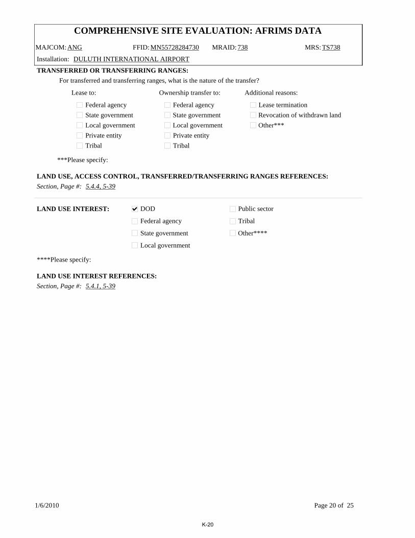
COMPREHENSIVE SITE EVALUATION: AFRIMS DATA
MAJCOM: ANG FFID: MN55728284730 MRAID: 738 MRS: TS738
Installation: DULUTH INTERNATIONAL AIRPORT
Section, Page #: 5.4.4, 5-39
***Please specify:
TRANSFERRED OR TRANSFERRING RANGES:For transferred and transferring ranges, what is the nature of the transfer?
Federal agencyState governmentLocal governmentPrivate entityTribal
Federal agencyState governmentLocal governmentPrivate entityTribal
Lease to: Ownership transfer to: Additional reasons:
Lease terminationRevocation of withdrawn landOther***
LAND USE, ACCESS CONTROL, TRANSFERRED/TRANSFERRING RANGES REFERENCES:
DOD
Federal agency
State government
Local government
Public sector
Tribal
Other****
****Please specify:
Section, Page #: 5.4.1, 5-39
LAND USE INTEREST:
LAND USE INTEREST REFERENCES:
1/6/2010 Page 20 of 25
K-20

COMPREHENSIVE SITE EVALUATION: AFRIMS DATA
MAJCOM: ANG FFID: MN55728284730 MRAID: 739 MRS: SR739
Installation: DULUTH INTERNATIONAL AIRPORT
City: Duluth State: MN County: St. Louis
Site Name: Lead Contaminated Soil Area
Last Name: BlazevicFirst Name: Ryan
Organization: MN ANG 148th FW/CEVPhone #: (218) 788-7868
Email: [email protected]
Address: 4630 Mustang DriveCity: Duluth
State: MNZip: 55811
POINT OF CONTACT INFORMATION
City: DuluthState: MN
County: St. Louis
Latitude: 46.852
Longitude: -92.205
LOCATION:
AREA:
Total Acreage: 0.3
Acreage confirmed as containing UXO:
Acreage suspected or potentially containing UXO:
Acreage confirmed as NOT containing UXO: 0.3
CLASSIFICATION:
Section, Page #: 5.5.1, 5-51/8.2.3.1, 8-4/5.5.7, 5-61GENERAL INFORMATION REFERENCES:
Section, Page #:POINT OF CONTACT REFERENCES:
Section, Page #:LOCATION REFERENCES:
Section, Page #: 5.5.2, 5-52AREA REFERENCES:
CLASSIFICATION REFERENCES:
Site Description:The LCSA is located west of the main base and northeast of the EOD Range on a restrictive easement owned by the Duluth Airport Authority. The area is irregular shaped and covers approximately 0.3 acres. The area is bordered to the west by a gravel road, to the south by a wooded area, to the north by a detention basin, and to the east by a drainage ditch. The detention basin and drainage ditch are associated with the Duluth International Airport storm water drainage system. Soil from the former Small Arms Range berm disposal was deposited in several small piles within the site, with heights approximately 3 feet above the surrounding ground surface.
1/6/2010 Page 21 of 25
K-21

COMPREHENSIVE SITE EVALUATION: AFRIMS DATA
MAJCOM: ANG FFID: MN55728284730 MRAID: 739 MRS: SR739
Installation: DULUTH INTERNATIONAL AIRPORT
TestingTrainingTreatment OBOD RCRADisposal RCRABuffer Area
Small Arms RangeSkeet RangeWaste Military MunitionsOther*
*Description of other: Small Arms Range Bern Disposal
Section: 5.5.1, 5-51
Page:
Air to AirAir to water
Air to landLand to air
Land to landLand to water
Other*
*Description of other: Small Arms Range Bern Disposal
RANGE TYPES:
Section, Page #: 5.5.1, 5-51RANGE/SITE TYPES REFERENCES:
ORDNANCE TYPES AND RELATED ANOMALY DENSITY:
Section, Page #: 5.5.2, 5-52ORDNANCE TYPES REFERENCES:
Medium/Large Caliber (20 mm and larger)Explosive grenades (hand or rifle)
Explosive landmine
Explosive rockets
Guided Missiles
Explosive detonators
Blasting caps
Practice grenades (with spotting charges)Practice landmines (with spotting charges)Small arms complete round (.22-.50 cal)
Small arms, expended
Practice ordnance (without spotting charges)
White phosphorous
Incendiary material
Primary or initiating explosives
Demolition charges
Military dynamite
Less sensitive explosives (Ammonium Nitrate, etc.)
Solid or liquid propellants
Toxic chem. agents (choking, nerve, blood, blister)
War gas identification sets
Radiological ordnance (e.g., depleted Uranium)Riot control agents (vomiting, tear)
Bombs (explosive)
Bombs (practice)
Fuses, Boosters, Bursters
Flares, signals, & simulators (other than white phos.)
Torpedoes/Sea Mines
Secondary explosives (PETN, Compositions A, B, C, Tetryl, TNT, RDX, HMX, HBX, Black Powder, etc.)
Contaminant is a Chemical residue of munitions?
Ordnance Types (check all that apply) Density
Contaminant is a Chemical residue of munitions?
Ordnance Types (check all that apply) Density
MEDIUM
1/6/2010 Page 22 of 25
K-22

COMPREHENSIVE SITE EVALUATION: AFRIMS DATA
MAJCOM: ANG FFID: MN55728284730 MRAID: 739 MRS: SR739
Installation: DULUTH INTERNATIONAL AIRPORT
Section, Page #: 5.5.1, 5-51ANOMALY DENSITY REFERENCES:
Are there any wetland areas associated with this site? NO If yes, please list acreage:
Section, Page #:
ARCHAEOLOGICAL/ECOLOGICAL:
Section:ARCHEOLOGICAL/ECOLOGICAL REFERENCES:
WETLANDS:
WETLANDS REFERENCES:
Archaeological or cultural sites present? Yes N
Yes NThreatened or endangered species present?
Predominant Soil Type: Sand-Silt/Sand-Clay Predominant Topography: Gently rolling
Predominant Vegetation: Low grass and few shrubs
Potential for contamination of drinking water: NO POTENTIAL
Is the MRS located above a drinking water aquifer? NO
Section, Page #: 5.5.1, 5-51
Section, Page #: 4.3.3, 4-7
Depth to Groundwater (feet): 8
GENERAL MEDIA:
GENERAL MEDIA REFERENCES:
GROUNDWATER:
GROUNDWATER REFERENCES:
Sole source aquifer? No
1/6/2010 Page 23 of 25
K-23
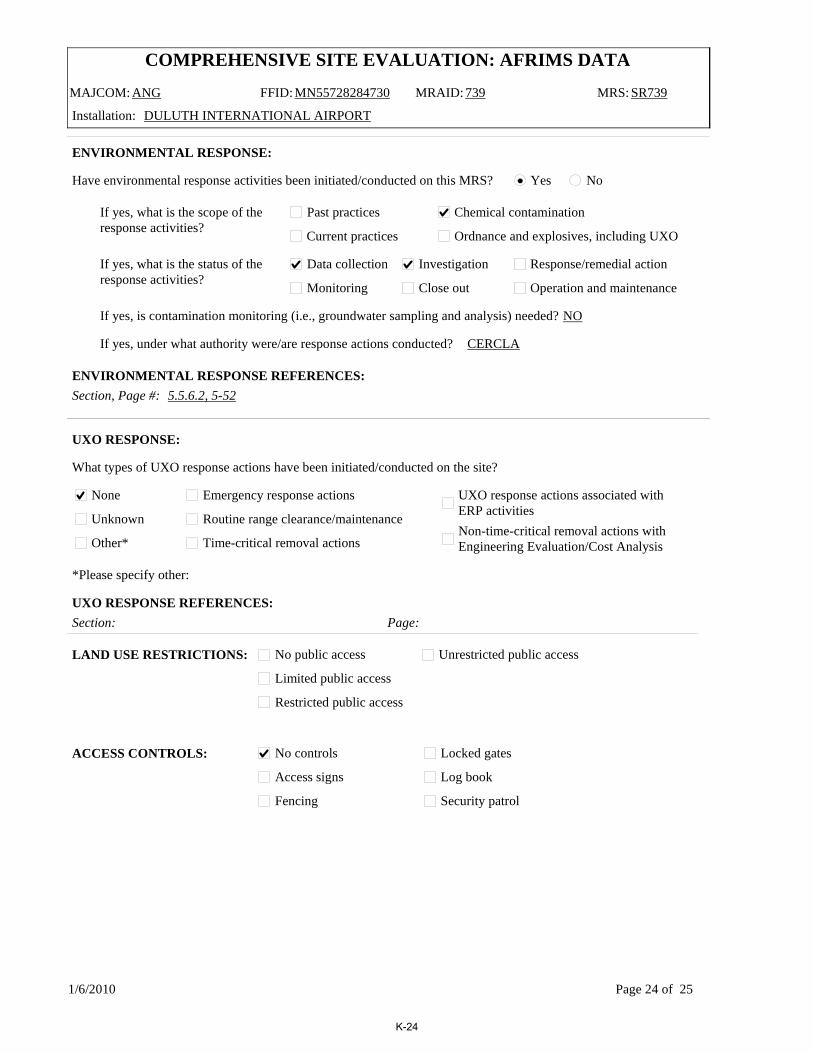
COMPREHENSIVE SITE EVALUATION: AFRIMS DATA
MAJCOM: ANG FFID: MN55728284730 MRAID: 739 MRS: SR739
Installation: DULUTH INTERNATIONAL AIRPORT
ENVIRONMENTAL RESPONSE:
Have environmental response activities been initiated/conducted on this MRS? Yes No
Past practices
Current practices
If yes, what is the scope of the response activities?
If yes, what is the status of theresponse activities?
Chemical contamination
Ordnance and explosives, including UXO
Data collection Investigation Response/remedial action
Monitoring Close out Operation and maintenance
Section, Page #: 5.5.6.2, 5-52
If yes, is contamination monitoring (i.e., groundwater sampling and analysis) needed? NO
If yes, under what authority were/are response actions conducted? CERCLA
ENVIRONMENTAL RESPONSE REFERENCES:
What types of UXO response actions have been initiated/conducted on the site?
None
Unknown
Other*
Emergency response actions
Routine range clearance/maintenance
Time-critical removal actions
UXO response actions associated with ERP activitiesNon-time-critical removal actions with Engineering Evaluation/Cost Analysis
*Please specify other:
Section: Page:
UXO RESPONSE:
UXO RESPONSE REFERENCES:
LAND USE RESTRICTIONS:
ACCESS CONTROLS:
No public access
Limited public access
Restricted public access
Unrestricted public access
No controls
Access signs
Fencing
Locked gates
Log book
Security patrol
1/6/2010 Page 24 of 25
K-24

COMPREHENSIVE SITE EVALUATION: AFRIMS DATA
MAJCOM: ANG FFID: MN55728284730 MRAID: 739 MRS: SR739
Installation: DULUTH INTERNATIONAL AIRPORT
Section, Page #: 5.5.4, 5-52
***Please specify:
TRANSFERRED OR TRANSFERRING RANGES:For transferred and transferring ranges, what is the nature of the transfer?
Federal agencyState governmentLocal governmentPrivate entityTribal
Federal agencyState governmentLocal governmentPrivate entityTribal
Lease to: Ownership transfer to: Additional reasons:
Lease terminationRevocation of withdrawn landOther***
LAND USE, ACCESS CONTROL, TRANSFERRED/TRANSFERRING RANGES REFERENCES:
DOD
Federal agency
State government
Local government
Public sector
Tribal
Other****
****Please specify:
Section, Page #: 5.5.1, 5-51
LAND USE INTEREST:
LAND USE INTEREST REFERENCES:
1/6/2010 Page 25 of 25
K-25

Appendix L: Documentation of Public Participation

This page intentionally left blank.

USAF Military Muntions Response Program Comprehensive Site Evaluation Phase IIDuluth Air National Guard Base
The Air Force performed a Comprehensive Site Evaluation (CSE) Phase I at Duluth Air
National Guard Base (ANGB) in June 2006. The CSE Phase I compiled and evaluated information on Duluth ANGB relating to the potential presence of munitions and explosives of concern (MEC) and munitions constituents (MC). The results of this investigation concluded that MEC and/or MC were potentially present at five munitions response areas (MRAs) at the Duluth ANGB. These MRAs included the Explosive Ordnance Disposal (EOD) Range (SR502), Small Arms Range (SR736), Trap Range (TS737), Skeet Range (TS738), and Lead Contaminated Soils Area (SR739).
Based on these results, a CSE Phase II was performed in December 2008 to further identify the type and extent of MEC and MC remaining from past site operations. The CSE Phase II activities included visual survey, geophysical survey, and/or environmental sampling at the five MRAs.
Visual SurveysVisual surveys were initially completed at each of the five MRAs prior to geophysical survey and environmental sampling. The field team evaluated the site conditions and the proposed sampling locations for hazards or conditions that would impact planned investigation activities.
Geophysical SurveyA non-intrusive Digital Geophysical Mapping (DGM) survey was conducted at the EOD Range (SR502) to identify potential subsurface metallic anomalies that could be munitions-related. Survey data was collected, processed, and mapped to identify individual anomaly locations for future subsurface investigation.
Environmental SamplingSoil, sediment, surface water, and/or groundwater sampling was conducted at each of the five MRAs. Sample locations were biased to areas of potential contamination to identify worst-case contaminant contamination, if present.
FACT SHEETFebruary 2010
ACRONYMSANGB: AirNationalGuardBase
CSE: ComprehensiveSite Evaluation
DGM: DigitalGeophysicalMapping
EOD: ExplosiveOrdnanceDisposal
MC: MunitionsConstituents
MEC: Munitions&Explosives ofConcern
MMRP: MilitaryMunitions ResponseProgram
MRSPP:MunitionsResponseSite PrioritizationProtocol
MRA: MunitionsResponseArea
NFA: NoFurtherAction
USAF: UnitedStatesAirForce
XRF: X-RayFluorescence
FORMOREINFORMATIONPleasecontacttheU.S.AirForce’sOfficeoftheCivilEngineer,EnvironmentalDivision,RestorationBranch(HQUSAF/A7VR)bywritingto:
HQUSAF/A7VR1260AirForcePentagonWashington,D.C.22030-1260
Orbycalling(703)607-0223
ForfurtherinformationregardingDuluthANGBCSEPhaseIIactivitiesorresults,contact:
2ndLTRyanBlazevic(218)788-7868
Duluth
Hermantown
Arnold
Superior
Proctor
§̈¦35
§̈¦535
§̈¦535
tu53
tu2
tu2
tu53tu2
UV23
UV194
UV35
UV194
UV23
Martin
Lavaque Stebner
Haines
8th
Arrowhead
Maple Grove
Morris Thomas
Hermantown
RiceLake
Arlington
1st
21st
Decker
27th
Winter
Skyline
Piedmont
2nd
How
ardGnesen
40th
Kenw
ood
Centra
lVinland
Belknap
Getchell
Boundary
Mesaba
5th
Highland
Superior
Elmira
9th
61st
Raleigh
46th
Wyoming
Clay
7th
Gitchinadji
Susquehanna
Airport Approach
Skyli
ne
Superior
Superior
Rice
Lake
27th
Skyline
St. Louis
Douglas
Lake Superior
MMiillllee rr CCrre ee ek k
RRoocckkyy RRuunn MM ii dd
ww aayy RR
ii vv ee rr
CC hheesstteerr CCrreeeekk
KKnnoowwllttoonn CCrreeeekk
TTiisscchheerr CCrreeeekk
BBuucckkiinngghhaamm CC rreeeekk
EEaasstt BBrraanncchhCChheesstteerrCC
rreeeekk
EE aass tt
BB rr aann cc hh
CC hh eess tt ee rr CCrreeeekk
Duluth Air National Guard Base
²0 1 20.5 Miles
Duluth ANGB Final CSE Phase II L-1 AECOM PROJECT NO. 106177.05

Samples were analyzed at an off-site commercial analytical laboratory for MC compounds including select metals, polycyclic aromatic hydrocarbons (PAHs), and/or explosive compounds based on site-specific historical munitions operations. Additionally, a portable X-Ray Fluorescence (XRF) instrument was used as a screening tool to efficiently identify and bound lead contamination in surface soils at the small arms ranges.
Munitions Response Site Prioritization Protocol
The MRAs were evaluated using the Munitions Response Site Prioritization Protocol (MRSPP) to assess sites for further munitions response actions. Response activities are based on the overall conditions at each site and take into consideration various factors related to explosive safety
and environmental hazards. Priority 1 indicates the highest funding priority and Priority 8 indicates the lowest funding priority. All five MRAs at the Duluth ANGB were evaluated using the MRSPP and scores ranged from a priority of 3 to a priority of 7. A summary of these scores and rationale are provided in the table below.
Conclusions & Recommendations
Based on the results of the CSE Phase II investigations, it was recommended that four out of the five MRAs proceed to further investigation or a removal action. For the EOD Range (SR502) where potential subsurface MEC was identified, and the Lead Contaminated Soils Area (SR739) where lead-contaminated soils are present, non-time critical removal actions are recommended. For the Trap Range (TS737) and Skeet Range (TS738),
additional contaminant investigation is warranted due to elevated MC identified in surface and subsurface soil, surface water, and/or sediment. For the Small Arms Range (SR736) where impacts from MEC and MC were not observed, no further action (NFA) is recommended.
MRA Size (Acres) MRA Type MRSPP Score Rationale
SR502 0.3 EOD Range 5Geophysical mapping identified multiple anomalies representing potential subsurface MEC.
SR736 2.5 Small Arms 7 No MEC or MC were identified.
TS737 4 Small Arms 3 No MEC was identified. MC was identified at elevated levels.
TS738 15.3 Small Arms 3 No MEC was identified. MC was identified at elevated levels.
TS739 0.3Munitions
Constituents6 No MEC was identified. MC was identified at elevated levels.
A public notification period for the MRSPP will be held from TBD 2010 through TBD 2010 during which input on the MRSPP scores will be solicited.
Comments can be directed to Mr. Ryan Blazevic. (see preceding page)
THEAIRFORCE
• is dedicated to protecting human health and the environment by making MRAs safetoreuse.
• is developing the MMRP by maximizingefficiencies and lesson learned from 20 years of environmental restoration experience.
• will prioritizeMRAs according to environmental, health, and safety considerations; current and future planned resource use; and site attributes.
²0 1,000 2,000500 Feet
Lead ContaminatedSoils Area (SR739)
EOD Range(SR502)
Small Arms Range (SR736)
Trap Range(TS737)
Skeet Range(TS738)
tu53
Duluth ANGB Final CSE Phase II L-2 AECOM PROJECT NO. 106177.05

Appendix M: Site Photographs

This page intentionally left blank.

AECOM Comprehensive Site Evaluation Phase II Report February 2010 Military Munitions Response Program – Duluth ANGB
Duluth ANGB Final CSE Phase II M-1 AECOM PROJECT NO. 106177.05
Photo 1: Inside EOD Range Facing South (Munitions Storage Area in background)
Photo 2: Inside EOD Range Facing East

AECOM Comprehensive Site Evaluation Phase II Report February 2010 Military Munitions Response Program – Duluth ANGB
Duluth ANGB Final CSE Phase II M-2 AECOM PROJECT NO. 106177.05
Photo 3: EOD Range OB/OD Pit
Photo 3: EOD Range Detonation Pit
Photo 4: Inside Small Arms Range (NWA Maintenance Facility Aircraft Parking Apron) Facing East

AECOM Comprehensive Site Evaluation Phase II Report February 2010 Military Munitions Response Program – Duluth ANGB
Duluth ANGB Final CSE Phase II M-3 AECOM PROJECT NO. 106177.05
Photo 5: West of Trap Range (located on opposite side of fence) Facing East
Photo 6: Retention Basin northwest of Trap Range (located on opposite side of fence) Facing East
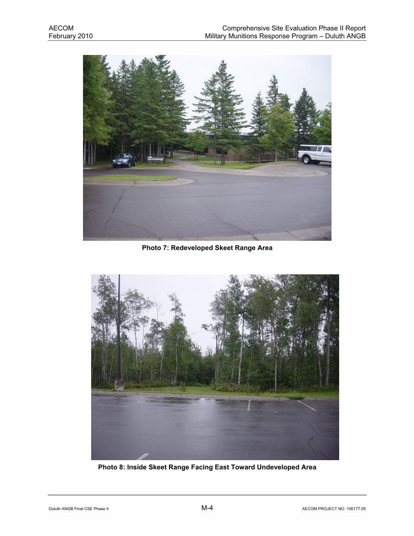
AECOM Comprehensive Site Evaluation Phase II Report February 2010 Military Munitions Response Program – Duluth ANGB
Duluth ANGB Final CSE Phase II M-4 AECOM PROJECT NO. 106177.05
Photo 7: Redeveloped Skeet Range Area
Photo 8: Inside Skeet Range Facing East Toward Undeveloped Area

AECOM Comprehensive Site Evaluation Phase II Report February 2010 Military Munitions Response Program – Duluth ANGB
Duluth ANGB Final CSE Phase II M-5 AECOM PROJECT NO. 106177.05
Photo 9: Inside Lead Contaminated Soils Area Facing West
Photo 10: Detention Basin north of Lead Contaminated Soils Area

AECOM Comprehensive Site Evaluation Phase II Report February 2010 Military Munitions Response Program – Duluth ANGB
Duluth ANGB Final CSE Phase II M-6 AECOM PROJECT NO. 106177.05
This page intentionally left blank.
About AECOM AECOM (NYSE: ACM) is a global provider of professional technical and management support services to a broad range of markets, including transportation, facilities, environmental and energy. With more than 40,000 employees around the world, AECOM is a leader in all of the key markets that it serves. AECOM provides a blend of global reach, local knowledge, innovation, and technical excellence in delivering solutions that enhance and sustain the world’s built, natural, and social environments.
AECOM 675 N. Washington St, Suite 300 Alexandria, Virginia 22314 T 703.549.8728 F 703.549.9134 www.aecom.com