Embed Size (px)
DESCRIPTION
This presentation by expert planner, Patricia Maloney, MCIP, explains the problems with the proposed Badlands Motorsports Resort from a development perspective.Go to http://savetherosebud.com or visit our Facebook page at https://www.facebook.com/helpsavetherosebud for more information.
Citation preview
Patricia Maloney & Associates 1636 Queequeg Turnabout, Gabriola, BC, V0R 1X5
Office: 250-247-7956 Cell: 403-819-8196 Email: [email protected]
November 26 2013 Hugh Ham, BA, LLP Barristers and Solicitors Municipal Counsellors 1 – 5508 1st Street Calgary, AB, T2H 2W9 Dear Hugh, Badlands Motorsport Resort Area Structure Plan Compliance As requested, I am submitting this letter report with my review of the Badlands Motorsport Resort Area Structure Plan (ASP) application. I have considered this application from the legislative and statutory plan aspects, as well as best planning practices for the profession of land use planning for the purpose of determining , from the perspective of best planning practices of the land use planning profession, whether the ASP “complies” with the Kneehill County Municipal Development Plan and the Provincial Land Use Policies as required by the Municipal Government Act, 2000 RSA c.M-26, as amended (MGA) The relevant documents guiding the development of an Area Structure Plan are, the Municipal Government Act, the Provincial Land Use Policies, and the Municipal Development Plan. The Badlands Motorsport Resort Area Structure Plan is required to be consistent with these documents. This review will look at the legislated requirements for each component. The first issue is whether the Badlands Motorsport Resort Area Structure Plan is consistent with the Municipal Development Plan. The Municipal Government Act says:
Land use policies 622 (3) Every statutory plan, land use bylaw and action undertaken pursuant to this Part by a municipality, municipal planning commission, subdivision authority, development authority or subdivision and development appeal board or the Municipal Government Board must be consistent with the land use policies. Plans consistent 638 All statutory plans adopted by a municipality must be consistent with each other
The Kneehill Municipal Development Plan and the Badlands Motorsport Resort Area Structure Plan are both statutory plans adopted by the County of Kneehill. Consequently they must both comply with the Land Use Policies (LUP) pursuant to Section 622 of the MGA, and they must both also comply with each other pursuant to Section 638 of the MGA. The Province of Alberta, through Alberta Municipal Affairs, has developed Land Use Policies to guide

Patricia Maloney & Associates November 26th
, 2013
2
municipal decision making regarding land use issues. The Land Use Policies were adopted on November 6th, 1996 pursuant to Section 622 of the Municipal Government Act. The Land Use Policies are intended to help municipalities to harmonize provincial and municipal policy initiatives at the local land use planning level. The Land Use Policies say,
“The Land Use Policies supplement the planning provisions of MGA and the Subdivision and Development Regulation. It is expected that all municipalities will implement these policies in the course of carrying out their planning responsibilities.”
This report outlines how the Badlands Motorsport Resort Area Structure Plan does not comply with the MGA, the relevant policies of the Province of Alberta Land Use Policies and the County of Kneehill Municipal Development Plan. 1. Municipal Government Act
The Municipal Government Act sets out the following requirements for an Area Structure Plan;
633(1) For the purpose of providing a framework for subsequent subdivision and development of an area of land, a council may by bylaw adopt an area structure plan. (2) An area structure plan (a) must describe (i) the sequence of development proposed for the area,
(ii) the land uses proposed for the area, either generally or with respect to specific parts of the area, (iii) the density of population proposed for the area either generally or with respect to specific parts of the area, and
(iv) the general location of major transportation routes and public utilities, and (b) may contain any other matters the council considers necessary
The Badlands Motorsport Resort ASP (BMRASP) meets the bare minimum requirements of the MGA. Sequence of Development While the BMRASP provides a short discussion on the phasing of the development but rather than outlining what the phasing will be, the document states that market conditions, financing and access to services will determine the phasing. The document goes on to outline what portions of the development will be constructed first. Apparently the order of development is:
i. Establish the road course and associated facilities ii. Construct the top paddock
iii. Complete the Mountain and Valley Courses iv. Clubhouse and Resort Recreational at the same time as the Top Course and Paddock v. Attached housing will commence at the same time as the Clubhouse
vi. Residential housing may be completed in stages depending on demand and available resources
Generally the phasing plans provided in an Area Structure Plan contain more detail including the infrastructure required for each phase, a Transportation or Traffic impact Study that

Patricia Maloney & Associates November 26th
, 2013
3
demonstrates what road upgrades will be required for each phase of development and population projections for each phase of development.
Land Uses Proposed for the Area
The BMRASP does outline the land uses proposed for the Area. However, the uses outlined in the ASP and the uses outlined in the Direct Control District do not match the Kneehill County Land Use Bylaw and certainly don’t fit into the natural landscape and the agricultural community.
Density of Population
The ASP breaks down the people on the site by day users, recreationalists and residents. The combined number of road course users and their guests and staff would total 1400. The document also outlines that the 125 townhomes and 60 apartments will generate a population of 433 but that they will be seasonal/vacation/secondary residences.
General Location of Transportation and Public Utilities The document provides a description of the three access points and routes anticipated by the developer. The document addresses upgrading certain roads, but without a Traffic Impact Assessment there is no validation on the extent of the upgrades. The Area Structure Plan is exceeds the one half mile referral zone mandated by the Highway Development Control Regulations. However, the standards for Provincial Highways are very specific and controlled by the Department and the ASP does not reflect this other than to say that the “existing connection to Highway 9 will be redesigned to meet the standards and requirements of Alberta Transportation”. Alberta Transportation reviewed the Badlands Motorsport Resort Area Structure Plan and send their comments in a letter dates December 2, 2009. The letter states that:
The Area Structure Plan does not appear to address how much business might be expected, but the indication is that there will be no major spectator events. The development appears will be limited to accommodating motorsports enthusiasts with higher end sport vehicles. Therefore it can be inferred that no peak periods with large traffic volumes are likely. However, if this development eventually creates unsafe conditions or traffic problems at highway intersections the County will be responsible for constructing proper intersection treatments at no cost to the department. You may wish to explore these ramifications prior to the approval of the development.
The County chose not to investigation the traffic situation further, has not required a Traffic Impact Assessment, and is considering approving a Direct Control District that will virtually approve the development as permitted uses without any requirements for additional studies. The risk of liability taken on by the County, to be responsible for future highway upgrades at the cost of the general tax payer is significant.
2. Land Use Policies
The Municipal Government Act states the following in regards to the Land use policies 622(1) The Lieutenant Governor in Council may by order, on the recommendation of the Minister, establish land use policies.

Patricia Maloney & Associates November 26th
, 2013
4
(2) The Regulations Act does not apply to an order under subsection (1). (3) Every statutory plan, land use bylaw and action undertaken pursuant to this Part by a municipality, municipal planning commission, subdivision authority, development authority or subdivision and development appeal board or the Municipal Government Board must be consistent with the land use policies. (4) Land use policies do not apply in any planning region within the meaning of the Alberta Land Stewardship Act in respect of which there is an ALSA regional plan.
Policies of the Land Use Policies Badlands Motorsport Resort Area Structure Plan
2.1 Municipalities are expected to take steps
to inform both interested and potentially affected
parties of municipal planning activities and to
provide appropriate opportunities and sufficient
information to allow meaningful participation in
the planning process by residents, landowners,
community groups, interest groups, municipal
service providers, and other stakeholders.
This ASP has been under preparation for over 5
years and while the developer conducted an open
house in June 2009, the document was circulated
in the fall of 2009 and the public hearing for the
ASP was advertised for June 2013. The gap
between the open house and the public hearing
was extensive and many members of the public
had considered the initial development to have
stalled or been withdrawn. In addition, the policy
says that participation is by residents, landowners,
community groups, interest groups and other
stakeholders – this does not refer to where the
people live and as such, being a resident of
Kneehill County or Wheatland County has no
bearing on the ability to be heard, even though the
Kneehill Council discounted the concerns and
comments of residents of Wheatland County.
2.2 Municipalities are expected to ensure that
each proposed plan amendment,
reclassification, development application
and subdivision application is processed in a
thorough, timely and diligent manner. The
ASP states on pages 25 and 28, that the ASP
has received support “in principle” from the
Kneehill County Council. This implies a
decision being made prior to the public
hearing and the public input.
Predetermination of a decision is improper
The County of Kneehill has not rushed this
development. The County did provide time to
consider the adoption of the plan after the public
hearing. However, consultation and public
hearings were schedule at the time of planting and
harvest. A very difficult time for an agricultural
community to become meaningfully involved.

Patricia Maloney & Associates November 26th
, 2013
5
process.
2.4 In carrying out their planning
responsibilities, municipalities are expected to
respect the rights of individual citizens and
landowners and to consider the impact of any
policy or decision within the context of the overall
public interest
Planning responsibilities implies that a certified
registered planner is involved. Kneehill County has
no such qualified person on staff. It is apparent
that the Badlands Motorsport Resort ASP was
written by a lay preson.
The overall public interest in this case included
both environmental and agricultural groups, both
of which the County says they support, and yet the
document was approved when it both threatens
the environment and disrupts the agricultural
community.
3.1 Municipalities are encouraged to expand
intermunicipal planning efforts to address
common planning issues, especially where valued
natural features are of interest to more than one
municipality and where the possible effect of
development transcends municipal boundaries.
The Area Structure Plan borders Wheatland
County. Several of the access points travel
through Wheatland County. There is no clear
indication of how the intermunicipal issues will be
dealt with. Wheatland County requested the
preparation of an Intermunicipal Development
Plan prior to the adoption of the ASP and were
told that Kneehill did not want to work on one at
this time.
4.2 Municipalities are encouraged to establish
land use patterns which embody the principles of
sustainable development, thereby contributing to
a healthy environment, a healthy economy and a
high quality of life.
The proposed land use pattern take an intrusive
development and locates it in an environmentally
sensitive area. The development will be hours
away from the market it will serve. Traffic
volumes must be projected based on the proposed
uses and the number of proposed residential units.
The roadways that will bring the market to the
development are not capable of handling the
project volumes. While Kneehill County may
consider the Badlands Motorsport Resort as an
economic benefit, it is not contributing to a
healthy environment. The resulting because it is
intrusive development. Residents stated loud and
clear at the ASP public hearing that this
development will negatively affect their quality of
life and their ability to continue agricultural
operations on this land, clearly contrary to the

Patricia Maloney & Associates November 26th
, 2013
6
Municipal Development Plan.
5.0 To contribute to the maintenance and
enhancement of a healthy natural environment.
The proposed development does not contribute to
a healthy environment – in fact it is negative and
will destroy natural environment. The proximity to
the river valley, the native grasses, the as risk
species and the agricultural community will all be
negatively impacted.
5.1 Municipalities are encouraged to identify, in
consultation with Alberta Environmental
Protection, significant ravines, valleys, stream
corridors, lakeshores, wetlands, and any other
unique landscape area, and to establish land use
patterns in the vicinity of these features, having
regard to their value to the municipality and to the
Province.
There is no evidence of Alberta Environment
participation in the assessment of the river valley,
and wetlands. There are several wetlands on the
property and the Rosebud River Valley that are
significant, impact larger eco systems and may
have far reaching impacts. This is contrary to the
Municipal Development Plan and the adopted
Environmentally Significant Area Study.
5.2 If subdivision and development is to be
approved in the areas identified in accordance
with policy 5.1, municipalities are encouraged to,
within the scope of their jurisdiction, utilize
mitigative measures designed to minimize possible
negative impacts
The BIA and ASP provide ideas for mitigation of
impacts but until there is an actual design, it
cannot be determined if the development will
protect and enhance the important environmental
features.
No mitigative measures have been identified in the
ASP other than building around the wetlands. The
County does have a minimum set back from a river
but does not address the top of the river valley.
Because subdivision was not part of the first
phases and the County has not acknowledged the
residential or condominium development as
subdivision (which it is), the Environmental
Reserve lands to be dedicated should include the
steep slopes, the top of the river bank, the
wetlands and any other water courses or ravines.
Page 74 of the ASP says that “Kneehill County has
designated the site an environmentally sensitive
area” and yet they approve an ASP that would see
devastation of the natural area. Map 12 of the
ASP outlines lands to be taken as Environmental
Reserve or Conservation Reserve.
However, this can only be taken at subdivision.

Patricia Maloney & Associates November 26th
, 2013
7
The first phases of development do not require
subdivision and are located on the top of the river
bank, and around wetlands and in other significant
areas. Therefore, the development could occur
and damage the lands prior to protecting the
environmentally significant lands and prior to
dedicating environmental reserves. The ASP says
that the development enhances the natural
features of the site. A race track, paddock, and
residential units cannot enhance the natural
features of the site.
5.3 Municipalities are encouraged to identify, in
consultation with Alberta Environmental
Protection, areas which are prone to flooding,
erosion, landslides, subsidence or wildfire, to
establish appropriate land use patterns within and
adjacent to these areas.
The background documents for the ASP have
indicated that this site is prone to erosion. The
locals have indicated that this area is prone to
grass fires. The proposed uses of road track and
paddock as well as the terrain regrading have
significant possibility of causing erosion and
creating grass fires in an area with no fire
department services and a large agricultural
community.
5.5 Municipalities are encouraged to identify, in
consultation with Alberta Environmental
Protection, areas of significant fish, wildlife and
plan habitat and to establish appropriate land use
patterns designed to minimize the loss of valued
habitat within and adjacent to these areas.
Due to the significant natural features and steep
slopes and the importance of the Rosebud River
Valley, it would seem important that Alberta
Environmental Protection would have had some
concerns. The ASP outlines an Environmental
Reserve Area, which can only be taken at time of
subdivision.
6.1.3 Where possible, municipalities are
encouraged to direct non-agricultural
development to areas where such development
will not constrain agricultural activities.
The proposed development will constrain
agricultural activities by creating conflicting traffic
on the roads, causing conflict with agricultural
vehicles and takes agricultural land out of
production.
6.3.2 Municipalities are encouraged to determine
appropriate land use patterns in the vicinity of the
resources identified in accordance with policy 1
(identify significant water resources), having
regard to impacts on an entire watershed as well
as local impacts.
The concern with the watershed is the runoff from
the site, the treatment of sanitary and the
discharge of the treated waste water into the
Rosebud River. The ASP does provide a strategy
but there is very little data or detail about the
collection and evaporation ponds.

Patricia Maloney & Associates November 26th
, 2013
8
7.3 If subdivision and development is to be
approved in the vicinity of the areas identified in
accordance with Policy #1 (identify the location,
nature, and purpose of key transportation
corridors and facilities), municipalities are
encouraged to employ appropriate setback
distances and other mitigative measures relating
to noise, air pollution and safety, to limit access,
and to enter into highway vicinity agreements with
Alberta Transportation and Utilities
The setbacks and mitigative measures are not
totally clear in the ASP. Particularly noise
mitigation is not addressed. The ASP did complete
a noise study and while well prepared, it looks at
the average noise of a specific vehicle and does
not deal with the impact of one time noise events
that far exceed normal noise in the area, other
types of vehicles that could use the site
(motorcycles, drag racing etc). The ASP states that
the cars using this facility will be new and quieter
than stock cars and drag racing cars. However,
compared to the existing noise in the area of an
agricultural community, the noise will be
excessive. Similar noise studies are completed for
airports. The noise model looks at the type of
aircraft, the number of aircraft, the time of day of
the flight, the wind patterns and other and maps
noise contours. While there are areas of
“acceptable” noise, there are many individual
events that cause people who live near airports
significant noise pollution. The proposed Direct
Control District does not provide any specificity
regarding the types of vehicles that can use the
site.
3. Municipal Development Plan
Kneehill County adopted the Badlands Motorsport Resort Area Structure Plan in June 2013. The new Kneehill County Municipal Development Plan was adopted in July 2013. All Area Structure Plans are required to conform to the Municipal Development Plan. The Badlands Motorsport Resort Area Structure Plan does not conform to the Municipal Development Plan. Therefore, this allows the County the opportunity to:
amend the ASP to conform to the MDP
rescind the ASP
not approve the application for Redesignation of the land to Direct Control District until the Area Structure Plan conforms to the MDP, or
rethink the proposed development and determine if it is suitable for the proposed site.
The following illustrates the policies and provisions of the Kneehill County Municipal Development Plan and how the Area Structure Plan does not comply with the MDP.

Patricia Maloney & Associates November 26th
, 2013
9
Provisions of the Municipal Development Plan Clarification on how the ASP does not Conform
The vision for Kneehill County outlined in the MDP is: Kneehill County is first and foremost a rural community that values safety and good government for our citizens. We will grow as a community by encouraging responsible development that supports our resource-based economy. This means investing in and enhancing infrastructure and services. Through Council policy, our Administration will continue to promote and protect our community through environmental responsibility, prosperity, and positive relationships with our citizens, private sector and government partners.
While this vision is broad enough to be interpreted to include economic development, it is very clear that “environmental responsibility” is a critical component. The proposed development does not demonstrate environmental responsibility by proposing an intrusive land use in a sensitive environmental area. The citizens are very clear that by approving this intrusive development, the Council and administration are not protecting the community but instead are fostering negative relations and creating an atmosphere of distrust.
Goals for Agriculture:
Agriculture is recognized as a primary economic activity.
Agricultural land is protected for agricultural uses.
A diversity of agricultural uses is encouraged with a main focus on primary production.
The proposed development takes agricultural land out of production and the proposed development interferes with the safe continuation of agricultural uses on adjacent lands. Therefore, the ASP does not conform to the MDP.
Goals for Industrial/Commercial Development:
Industry and commerce is developed in a manner that enhances the economy and quality of life while not jeopardizing the environment.
The ASP allows for commerce that jeopardizes the environment. Therefore, the ASP does not conform to the MDP.
Goals for Environment:
The County is a good steward of the environment.
The land itself, including agricultural land, is recognized as an important resource.
Environmentally Significant Areas (ESAs) are recognized for their intrinsic value and are protected from potentially harmful use and development. ESAs are identified within the Environmentally Significant Area Study (Summit 2010) in four categories (i.e. ESAs 1-4 with ESA1 having the highest significance).
ESAs, hazard lands, and other natural, environmental and historical resources shall be protected from inappropriate
The ASP does not demonstrate good stewardship of the environment by allowing development in the Rosebud River Valley. This part of the County was identified as an Environmentally Significant Area and yet is being allowed to be developed without clear guidelines or regulations about setbacks or comments from Alberta Environment to demonstrate appropriateness. The ASP does not clearly outline the voluntary policy and the County has not applied prescriptive policies.

Patricia Maloney & Associates November 26th
, 2013
10
development through the use of voluntary policy wherever possible and prescriptive policy when required for the purposes of due diligence and planning applications.
Unless waived by the development authority, development within all ESA Categories shall require Environmental Impact Assessment prior to approval.
Such scientific or engineering analysis shall be undertaken by qualified technical Professionals with all costs borne by the developer
The MDP requires the preparation of an EIA. An EIA is a specific study defined as “An assessment of the possible impacts that a
proposed project may have on the environment,
consisting of the environmental, social and
economic aspects.
The purpose of the assessment is to ensure
that decision makers consider the
environmental impacts when deciding whether
or not to proceed with a project. The
International Association for Impact
Assessment (IAIA) defines an environmental
impact assessment as "the process of
identifying, predicting, evaluating and mitigating
the biophysical, social, and other relevant
effects of development proposals prior to major
decisions being taken and commitments made."
EIAs are unique in that they do not require
adherence to a predetermined environmental
outcome, but rather they require decision -
makers to account for environmental values in
their decisions and to justify those decisions in
light of detailed environmental studies and
public comments on the potential environmental
impacts.
This study was not prepared and as such, the ASP does not conform to the MDP.
1.3 Policies Information to be provided 1.3.1 When making decisions concerning redesignation, subdivision or development for certain areas, the County shall, unless waived by Council regarding redesignation or MPC regarding subdivision or development, require the proponent to submit additional information with their request for redesignation or approval of an application for subdivision or development.
Generally, development on lands within an ESA Level 1 or ESA Level 2 should be avoided or minimized. If unavoidable, and
The subject lands are identified as Level 1 and Level 2. While some of this land is proposed for future Environmental Reserve (only taken at

Patricia Maloney & Associates November 26th
, 2013
11
unless this requirement is waived by Council or the MPC, the proponent shall submit an environmental impact assessment (EIA) by a qualified professional addressing the potential impact of the proposal on lands designated and any actions that should be taken to prevent or minimize any impacts.
time of subdivision) the proximity of the development should require the EIA. Without the EIA and the specified actions, this ASP does not conform to the MDP
Agricultural Goals; 3.1.1 To protect agricultural land and existing and potential agricultural operations from inappropriate non-agricultural uses and development. 3.1.2 To minimize potential conflicts between agricultural and non-agricultural uses.
The development proposed in the ASP is an inappropriate use in an agricultural area and does not conform to the MDP. The development proposed in the ASP causes conflict with the existing agricultural uses.
Agricultural Objectives: 3.2.1 To ensure that agriculture remains an integral and viable component of the regional economy; 3.2.2 To protect agricultural land from unnecessary encroachment; 3.2.3 To minimize the fragmentation of agricultural land; 3.2.4 To partner with the agricultural industry to protect land that is environmentally significant;
The development of the Badlands Motorsport Resort reduces the viability of agriculture and creates encroachment in the area due to traffic conflict, noise and environmental impacts. When the development of the residential uses occurs, the parcel will be fragmented. Dense residential development also encroaches and restricts the continuation of agricultural uses. The approval of the ASP demonstrates non-partnering with the agricultural industry.
Industrial Commercial Policies: 4.2.2 To allow commercial and industrial development at appropriate locations in the County. 4.2.4 To minimize conflicts between commercial and existing or future non-commercial land uses.
The determination of this location is an appropriate location for commercial development was not identified in the MDP. The approval of the ASP has created conflicts between commercial and the existing agricultural lands.
4.3.1 Compatibility with other Uses Commercial and industrial development shall be compatible with surrounding land uses. Approval of a commercial or industrial use may be conditional upon the applicant addressing existing or potential negative impacts on adjacent land uses.
The proposed development is not compatible with surrounding lands uses. The adoption of the ASP does not make approval of the development conditional upon completing further studies and addressing the negative impacts on adjacent land uses. The ASP does not sufficiently address the negative impacts.
4.3.5 Access to Transportation Whenever possible, commercial developments should be located in hamlets and/or near major
This development is not in a hamlet and Highway 840 may or may not be considered a

Patricia Maloney & Associates November 26th
, 2013
12
transportation routes major transportation route. But, the MDP wants development, wherever possible, in hamlets. This does not comply.
6.0 RESIDENTIAL DEVELOPMENT 6.1 Goals 6.1.1 To facilitate rural residential uses that are compatible with agricultural uses. 6.1.2 To facilitate sustainable single or multi-lot residential development on land with low agricultural capability and low environmental significance while ensuring that surrounding agricultural lands and uses are not adversely affected by such development. 6.1.3 The purpose of the Country Residential (CR) designation is to allow for grouped residential developments, when appropriate, in a rural setting. 6.2 Objectives 6.2.2 To accommodate residential uses in hamlets. 6.2.3 To accommodate grouped country residential development (minimum of five country residential lots within one quarter section) where impacts on the environment, natural resources and agricultural land/uses are minimized. 6.2.4 To minimize potential impacts of residential development on adjacent land uses
The type of residential development proposed in the ASP is generally not considered compatible with agricultural uses. The proposed residential development is not considered sustainable under good planning principles, smart growth and conservation design principles. It appears that this development will have adverse impacts on surrounding agricultural lands. The ASP proposes a DC district that does not address the details of the residential development and as such, does not conform to the MDP. The ASP is not in a hamlet. The proposed residential development is not country residential – much higher density – and it does have impacts on the environment and adjacent agricultural uses and does not demonstrate that the impacts are minimized. The impacts of the residential uses have not been assessed.
9.0 OPEN SPACE and ENVIRONMENT 9.1 Goal 9.1.1 To protect significant environmental and natural areas and resources, including water resources, and to promote integrated, accessible and well-planned open spaces supporting appropriate leisure and recreation opportunities. 9.2 Objectives 9.2.1 To conserve and sensitively incorporate natural areas as an integral part of the County’s open space system. 9.2.2 To ensure that the various approval authorities, both within and outside the County, consider the natural environment when making decisions concerning applications for land use
While this development may potentially provide an open space, it is not accessible or well planned or connected and the road track is not considered an appropriate leisure and recreation opportunity. The County does not have an open space system, but the proposed development may dedicate open space along the river valley at time of subdivision. The ASP was circulated to Alberta Environment. The Department indicated that they only get involved when an application has
Patricia Maloney & Associates November 26th
, 2013
13
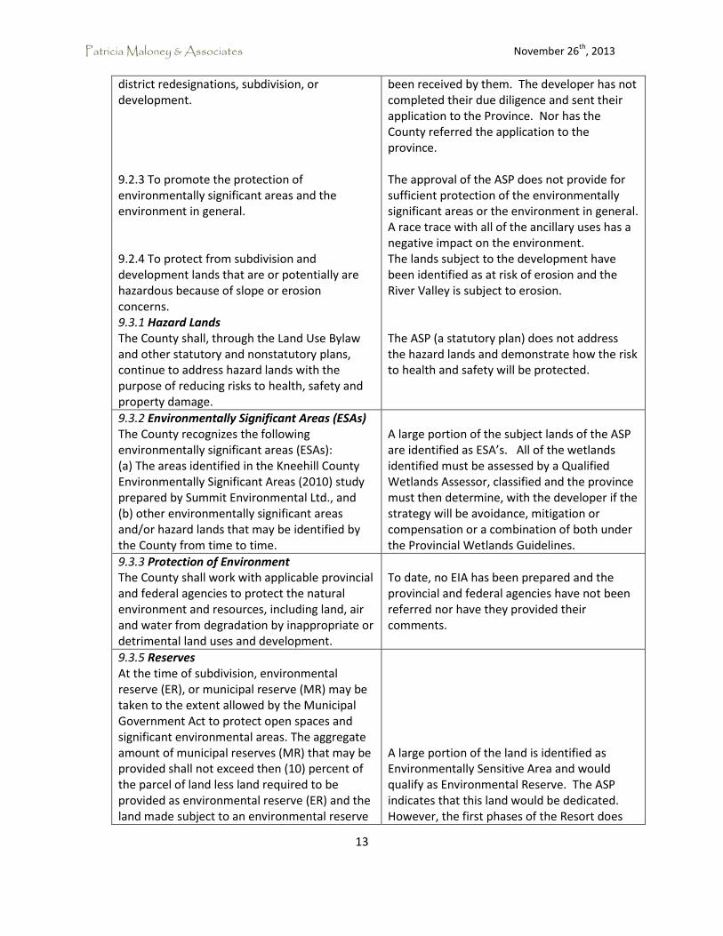
district redesignations, subdivision, or development. 9.2.3 To promote the protection of environmentally significant areas and the environment in general. 9.2.4 To protect from subdivision and development lands that are or potentially are hazardous because of slope or erosion concerns. 9.3.1 Hazard Lands The County shall, through the Land Use Bylaw and other statutory and nonstatutory plans, continue to address hazard lands with the purpose of reducing risks to health, safety and property damage.
been received by them. The developer has not completed their due diligence and sent their application to the Province. Nor has the County referred the application to the province. The approval of the ASP does not provide for sufficient protection of the environmentally significant areas or the environment in general. A race trace with all of the ancillary uses has a negative impact on the environment. The lands subject to the development have been identified as at risk of erosion and the River Valley is subject to erosion. The ASP (a statutory plan) does not address the hazard lands and demonstrate how the risk to health and safety will be protected.
9.3.2 Environmentally Significant Areas (ESAs) The County recognizes the following environmentally significant areas (ESAs): (a) The areas identified in the Kneehill County Environmentally Significant Areas (2010) study prepared by Summit Environmental Ltd., and (b) other environmentally significant areas and/or hazard lands that may be identified by the County from time to time.
A large portion of the subject lands of the ASP are identified as ESA’s. All of the wetlands identified must be assessed by a Qualified Wetlands Assessor, classified and the province must then determine, with the developer if the strategy will be avoidance, mitigation or compensation or a combination of both under the Provincial Wetlands Guidelines.
9.3.3 Protection of Environment The County shall work with applicable provincial and federal agencies to protect the natural environment and resources, including land, air and water from degradation by inappropriate or detrimental land uses and development.
To date, no EIA has been prepared and the provincial and federal agencies have not been referred nor have they provided their comments.
9.3.5 Reserves At the time of subdivision, environmental reserve (ER), or municipal reserve (MR) may be taken to the extent allowed by the Municipal Government Act to protect open spaces and significant environmental areas. The aggregate amount of municipal reserves (MR) that may be provided shall not exceed then (10) percent of the parcel of land less land required to be provided as environmental reserve (ER) and the land made subject to an environmental reserve
A large portion of the land is identified as Environmentally Sensitive Area and would qualify as Environmental Reserve. The ASP indicates that this land would be dedicated. However, the first phases of the Resort does

Patricia Maloney & Associates November 26th
, 2013
14
easement (ER). Subject to the Act, the subdivision authority may require the owner of a parcel that is the subject of a proposed subdivision to provide part of that parcel of land as environmental reserve (ER) or environmental reserve easement (ERE) if it consists of: ● a swamp, gully, ravine, coulee or natural drainage course, ● land that is subject to flooding or is unstable, or ● a strip of land, not less than 6 metres in width, abutting the bed and shore of any lake, river, stream or other body of water for the purpose of ○ preventing pollution, or ○ providing public access to and beside the bed and shore
not include residential uses or subdivision. Therefore, the development will occur, with the potential to damage the river valley, top of bank and other significant areas before any dedication is required. This does not appear to conform to the MDP intent.
9.3.6 Development in Valleys Unless otherwise provided for in a statutory plan or non-statutory plan acceptable to the Council, subdivision and development within river or stream valleys will be limited to non-intensive agricultural uses, parks and public open spaces.
The development is located within the Rosebud River Valley and it includes uses other than non-intensive agricultural uses, parks and public open spaces. This does not conform to the MDP. While the Council has discretion in allowing these uses, it does not appear that their decisions are based on any sound planning principles. It does not appear that Council was given sufficient information to clearly make a decision. The lack of background reports, application and decision from Alberta Environment and Public Lands regarding the wetlands, and other important information, have left gaps. A recommendation from a Professional Planner would have asked for more background work to provide the Council with a better opportunity to consider approval or refusal.
9.3.7 Development near Valleys Development of permanent structures shall be directed away from the brink of valleys, protrusions, escarpments and the toe of slopes in accordance with the standards of the Land Use Bylaw. Those requests for development closer to the escarpment than the regulations required by the Land Use Bylaw (e.g. dwellings
The exact location of the development has not been determined. The Area Structure Plan is conceptual and as such it is difficult to determine how close the development will be to the top of the river bank. However, the Top

Patricia Maloney & Associates November 26th
, 2013
15
designed with walk-out basement) may be considered; however the developer shall be required to demonstrate, through reports prepared and certified by a professional engineer, the proper management and maintenance of slope stability, stormwater, appropriate discharge of sewage effluent and other measures and requirements as identified in the professional engineer's analyses of the site. The report shall be registered on the subject title by way of a Restrictive Covenant for the benefit and safety of current and future landowners/developers.
Course appears to be on the top of the bank. Race tracks are development and as such will require construction, dirt moving and storm water management. The Top Course approved in the ASP does not conform to the MDP. The ASP does not provide any detailed engineering studies and so it is also difficult to ascertain how the storm water, sewage effluent and other measures will impact the river valley. The registration of the Restrictive Covenant will be registered at Subdivision stage.
9.3.9 Design Flood Levels) No permanent structures will be permitted within the Floodway or Flood Fringe of any river, stream or lake, except accessory buildings, which may be allowed in accordance with the provisions and standards of the Land Use Bylaw. New development may be permitted within the flood fringe areas as defined within a detailed hydraulic analysis establishing a flood fringe elevation plus 0.5m freeboard allowance, if it can be shown that floodproofing techniques are incorporated in to the design of the structure. (Floodproofing methods may include, but are not limited to: no basements, raised main floor, utilities above projected flood levels, raised site elevations and dyking incorporated into landscaping etc.)
The ASP has not identified the Floodway or the Flood Fringe of the Rosebud River. It is not clear if the development is outside of the floodway and the floodfringe. One of the concerns is that the recent extreme weather events may have altered the flood way, flood fringe and the flood plain. The ASP does not anticipate this or include flood proofing the development.
9.3.10 Environmental Impact Assessment (EIA) When considering a proposal that the County determines may have significant environmental consequences, such as multi-lot country residential, the County may require the proponent (at the proponent's expense) to submit an environmental impact assessment (EIA) prepared by a qualified professional, which is satisfactory, in its form and content, to the County.
While this policy does not specify when the EIA is required, the county has not requested an EIA and as such the ASP does not conform to the MDP.
9.3.11 Conservation Easements Although the County will consider allowing some types of development within ESAs, when it is appropriate, it is the general policy of the County to preserve and protect important recognized ESAs. To this end the County will support the use of conservation easements as a
The ASP indicates that the environmental reserve lands could be dedicated as environmental reserve easement at the time of subdivision. The issue is the protection of these lands prior to the subdivision.

Patricia Maloney & Associates November 26th
, 2013
16
means of preserving the natural qualities of privately held land within ESAs.
10.3.1 Provision of Municipal Reserves Subject to the provisions and criteria of the Municipal Government Act, the provision of municipal reserves resulting from subdivision shall be equal to ten (10) percent of the land in title that is the subject of the subdivision application.
The Area Structure Plan provides an area that is identified as municipal and environmental reserve and then is also shown as a developed area of the project. No development may occur on ER and only municipal uses such as parks and schools and community facilities may be placed on Municipal Reserve – generally not private recreational uses . While taking Municipal Reserve is technically at the discretion of the Council, it is generally taken for the betterment of the community either in land for public use or as cash in lieu (based on the market value of 10% of the land prior to redesignation). The cash in lieu is then used to either purchase other municipal reserve or contribute to public recreational facilities or to purchase future school site. Reserves are only taken at time of subdivision. The condominium development is a form of subdivision and will require the dedication of 10% of the site in land or cash in lieu or a combination of the two.
10.3.5 Historic Resources The County's historic resources inventory can be found as Appendix "D" in the County's Environmentally Significant Areas (Summit 2010) document "Historical Resources Report Arrow Archaeology Limited" and identifies means to protect, preserve, and interpret historic resources.
Appendix D was not attached to the ESA report on line. A Historical clearance should be obtained for the entire site. Given the sensitivity of the Rosebud River Valley, it may require a full Historical Resource Impact Assessment. The MDP does not say when the clearance should be provided, but it would be reasonable to request this as part of the ASP. Therefore, the ASP falls short of the MDP requirements.
4. General Comments Based on Good Planning Principles
While residential development as part of a race track development may seem contradictory and conflicting lands uses, people who enjoy racing often enjoy living or staying near the track and their cars. This is evident with the success of Residential Airparks where people want to live near their aircraft and near the runways. Therefore the actual basic uses of the development do not conflict with good planning principles. However, the development does not meet good planning principles for the following reasons:

Patricia Maloney & Associates November 26th
, 2013
17
i. Poor Design - The design of the development does not follow conservation design, smart
growth or green principles in any way. By developing residential development that is spread out at low density across the large parcel of land the development is inefficient use of the land. The density does not warrant the provision of services and the development is 30 km from Drumheller and 115 km from the City of Calgary. The development does not follow the natural terrain of the land.
ii. Location - The development of a race track with vehicles, servicing, fuel, services and the
other uses proposed in the draft Direct Control District provided in the ASP in this location does not meet the guidelines of keeping residential development in hamlets or more densely populated areas. Putting this development in such a rural location without services poses a risk to the future residents. The distance from fire protection and other protective services is beyond the 10 minute response time. While the ASP indicates the potential for a clinic, this does not provide full medical services.
iii. Extended List of Uses – The ASP provides a draft Direct Control District and it provides an
extensive list of future permitted uses that are unreasonable and unlikely to be developed in this remote area such as government services. The land use concept for the development illustrates the tracks, the paddocks, the location of the condominium lots and the condominium hotel but does not show the location for all of the commercial uses proposed in the DC District. In addition, the low population is unlikely to support the child day care, gas bar, general retail etc. The location of the site does not support the extensive uses proposed. A retail market demand study would have been helpful to determine the actual need for the uses and the ASP should have been more explanatory about where the other uses were to be developed on the site. The ASP refers to retail studies but these studies were not made available for review.
iv. Environmental Protection – The development of the Top Course and the Condo/hotel are
both located on the top of the bank. The wetlands have been retained but are surrounded by race tracks. This reduces the value of the wetland for continued habitat greatly. The native grasslands have the potential to be protected in certain areas.
v. Access – When a development is proposed, the access to the site is critical. The
development will have a carrying capacity of 400 drivers, 1400 guests and employees, and 185 residential units. In addition, the ASP addresses many different retail uses that would require outside customers to succeed and would therefore generate significant traffic. Without the outside customers for the retail uses, this development could generage 4,260 vehicles per day on a peak day. in the first phases of development. There was no Traffic Impact Assessment completed but it is likely that several roads will have to be upgraded. Two of the access points are provincial highways. Others are Wheatland County roads. The county roads are very substandard for this type of development. However, there is no intermunicipal agreement as to how Wheatland County will manage and maintain these roads. Also, there is no indication that Alberta Transportation has approved this Area Structure Plan. The issue of road standards, road widths, intersection treatments, surface treatment and traffic control devices has not been dealt with in the ASP.

Patricia Maloney & Associates November 26th
, 2013
18
5.0 Summary I have submitted his review based on my 36 years of professional planning experience in Canada. I have been a full Member of the Canadian Institute of Planners for 31 years and follow the Code of Ethics and Professional Practice. I have prepared and reviewed over 20 Area Structure Plans and over 30 Land Use Bylaw Amendments. One of the questions that could be raised is, what is “good planning”. The Canadian Institute of Planners, (CIP website, what is planning) the professional association that regulates and controls planners in Canada, says:
“Planning” means the scientific, aesthetic and orderly disposition of land, resources, facilities and services with a view to securing the physical, economic and social efficiency, health and well-being of urban and rural communities. Responsible planning has always been vital to the sustainability of safe, healthy, and secure urban environments…the planning profession must increasingly deal with urbanization issues, such as: o Conversion of land from natural habitats to urban built areas, o Maintenance and use of natural resources and habitats, o Development of transportation related infrastructure, o Ensuring environmental protection.
Not only do planners deal with land use, but also
o Planning social and community services o Managing cultural and heritage resources o Creating economic capability in local communities o Addressing transportation and infrastructure
Planners recommend what they believe to be good planning practices. While in most instances the planner is an advisor to the decision maker, it is the role and responsibility of the planner to provide the best, most complete information with an educated recommendation as to the direction the Council may wish to take. Planning is a process that follows regulations, guidelines and statutes approved by higher levels of government, and takes into account diverse perspectives and impacts, allowing decision makers to identify and implement the most efficient ways to achieve their goals. Planners are the professionals that have the requisite training to guide decisions that will help balance our society. In this instance, I believe the Kneehill County Municipal Development Plan to be generally good planning. However, I believe that the Badlands Motorsport Resort Area Structure Plan demonstrates poor planning. There is insufficient background research, use of poor planning principles, and the ASP does not meet the intent and requirements of the Municipal Government Act, Land Use Policies or the Kneehill County Municipal Development Plan. The plan shows no consideration for environmental protection or sanctity of the agricultural community as outlined in both the MDP and the Land Use Policies. Kneehill County website lists three other Area Structure Plans adopted in the County. Two are old and were for a very small number of country residential lots along river valleys. The third is a comprehensive

Patricia Maloney & Associates November 26th
, 2013
19
ASP prepared for a 99 lot country residential subdivision. This ASP was prepared by a qualified certified planner who is a Member of the Canadian Institute of Planners who employed municipal engineers and transportation engineers. It is evident that the County and their staff are not experienced in the review and approval of unique intense Area Structure Plans in environmentally sensitive areas. The Area Structure Plan is poorly prepared and gives only superficial attention to some very important issues such as traffic, environmental protection, sanitary sewer etc. I trust that this provides the information you required. If you have any questions regarding this opinion, please contact me. Sincerely, Patricia A. Maloney, MICP Principal