Embed Size (px)
Citation preview

FINAL REPORT
ENVIRONMENTAL IMPACT ASSESSMENT
OF THEPROPOSED RESIDENTIAL DEVELOPMENT
AT RICHMOND HILL, ST. ANN
Submitted to the National Environment and Planning Agency (NEPA)For: M. MaffessanttiBy: R. KerrlR.Allen
September 2004
1
TABLE OF CONTENTS Page Number Environmental Impact Assessment 1 The Executive Summary 2 – 5 Section 1: Introduction 6 1.1 Background 6 1.2 Objective 6 1.3 Terms of Reference 6-7 1.4 Location and Access 7 Section 2: Site Description 8 2.1 Topography 8 2.2 Geomorphology 8 2.3 Surface Soil 9 2.4 Surface Drainage 9-10 2.5 Vegetation Analyis 10 2.6 Geology 11 2.6.1 Lithology 11 2.6.2 Physical Properties of Geological Material 11-12 2.6.3 Small Scale Mining 13 2.6.4 Geological Structure 13 2.7 Hydrology 13 2.7.1 Surface Water Hydrology 13-15 2.7.2 Groundwater Hydrology 16 Section 3: Legal and Regulatory Framework 17 3.1 Legislative Framework 17 3.1.1 Natural Resource Conservation Authority Act 17 3.2.2 The Town and Country (TCPA) 18 3.2.3 Water Resources Authority Act 19 3.2.4 The Environmental Control Division (ECD) 19 3.2.5 The Public Health Act 19 3.2.6 The Watershed Protection Act 19 3.2.7 The Local Improvements Act 20 3.2.8 The Housing Act 20-21 Section 4: Specific Impacts and Proposed Mitigation 22 4.1 Flooding Impact 22-23 4.2 Flooding Mitigation 24 4.3 Soil Erosion Impact 24

2
4.4 Soil Erosion Mitigation 24 – 25
TABLE OF CONTENTS (Cont’d) Page Number 4.5 Pollution Impact 25 4.6 Pollution Mitigation 25 4.7 Water Supply Impact 26 4.8 Water Supply Mitigation 26 4.9 Water Supply Mitigation 26 Section 5: Analyses of Alternatives 27 5.1 Collections, Treatment and Disposal of Solid Waste 27 5.1.1 Alternative #1 Linking with NWC Sewage System 27 5.1.2 Alternative #2: Septic Tank/Tile Field and Drain 27 5.1.3 Alternative #3: On-Site Treatment 27 Section 6: Impact Identification 28 6.1 Pre-Construction 28 6.1.1 Air Pollution 28 6.1.2 Noise Pollution 28 6.1.3 Water Pollution 28 6.1.4 Loss of Vegetation 28 6.2 Construction 29 6.2.1 Air Pollution 29 6.2.2 Noise Pollution 29 6.2.3 Socio-Economic Impact 29 6.2.4 Solid Waste 29 6.3 Post Construction /Closure 29 6.3.1 Air Pollution 29 Section 7: Impact Mitigation/Conservation 30 7.1 Flood Mitigation 30 7.1.1 Alignment of Gully Courses 30 7.1.1.1 Green Areas aligned Gully Courses 31 7.1.1.2 Other Considerations for On-Site Drainage Designs 31 7.1.1.3 Drains Maintenance 31 7.1.2 Erosion Control Measures 32 7.2 Control of Ground Subsidence/Settlement 32 7.3 Earthquake Hazard Mitigation 33 7.4 Air Pollution 33 7.5 Water Pollution 33 7.6 Water Supply 34 7.7 Noise Pollution 34 7.8 Solid Waste 34
3
7.9 Greening of Reserved Area 34 LIST OF FIGURES Page Number Figure 1: Site Location of Proposed Development 7 Figure 2: Map of Part of Richmond showing Site Drainage 9 Figure 3: Geological Map of Part of Richmond 12

4
LIST OF TABLES Page Number Table 1A: Physical Properties of Geological Material From Field 12
and empirical Data Table 2: 30 Year Mean Rainfall (1951-1980) 14 Table 3: Estimated Maximum 24- Hour Rainfall (mm) 14 Table 4A: Estimated Peak Flow 22 Table 4B: Pre and Post Development Surface Runoff from Site 23

5
LIST OF APPENDICES Appendix 1: Approval Letter from Ministry of Health –Environmental Health Unit Appendix 2: Letter for Solid waste Collection – Jamaica Waste Industries Appendix 3: Rural and Physical Planning Division, Ministry of Agriculture Appendix 4: Approval letter from National Works Agency Appendix 5: Proof of Ownership of Land by M. Maffessantti Appendix 6: Methodology for Hydrological Study Appendix 7: Proposed Water Supply by M. Maffessantti and Sons Ltd.

6
ENVIRONMENTAL IMPACT ASSESSMENT
This report serves to describe the proposed plan for the Richmond Hill development. It
serves to further assess the current environment, the proposed works and its impact on the
environment. The report has assessed the potential impacts and has addressed both the
positive impacts of the project as well as the negative. The negative impacts have been
few and mitigate measures, which if followed, will serve to reduce or avoid those
identified.

7
THE EXECUTIVE SUMMARY
The proposed site is located in an area known as Richmond, St. Ann. The development,
“Plantation Village”, is earmarked for residential development. It is comprised of 163
hectares (400 acres) and is located approximately 2.5 km west of the capital town of St.
Ann’s Bay in the Parish of St. Ann. It is adjacent to the small community of Priory
situated on its northeastern boundary (Figure 1.)
The site ranges from flat to gently sloping and is interrupted by various drainage features,
which give rise to gullies and erosion channels. The site does not contain any significant
vegetation as it was once predominantly in sugar cane and has subsequently been used for
the purpose of cattle. The soil type varies from silt to clay soil to limestone cobbles and
boulder size material. The flat part of the land – which ironically was used for sugar cane
farming, has very little soil cover, less than 0.1 metres.
The site may be considered well drained. Two drainage features are the Stony River and
the Sleepy Tree Gully. There are also two (2) gullies, which drain the land.
The proposed subdivision consists of approximately 750 lots, amongst which there will
be designated green spaces/areas. The 750 lots are expected to have a water demand of
approximately 200,000 GPD. The developers will treat water from a nearby spring at
Coolshade, St. Ann to supply individual lots. The sewage will be treated via septic
tanks; this has been approved by the Ministry of Health – Environmental Health Unit (see
Appendices).
There is a small –scale mining operation of the Falmouth Formation, which has been a
long standing practice by the community. It is not sanctioned by the developers and takes
place on the captured property as well as upstream in the neighboring community.

8
The alternatives to this development have been considered and are as follows:
• The No Action alternative
This alternative would see the cessation of project plans and the site retained as is. This
option is not a favored action by the developers or community. The “No Action”
Alternative will invariably have the greatest implications on the socio-economic
environment. This action would result in the loss of a major direct and indirect
employment generating activity – both with the surrounding communities who are eager
for employment as well as persons eager to invest in housing.
• Farming
This option is not a feasible or economically viable one. Only a very small portion of the
land has soils, which are conducive for farming. As indicated in the inspection report by
the Rural Physical Planning Division - Ministry of Agriculture the present land use was
sugar cane (poor) improve pasture (poor) and ruina te. While they recommended that
some other crop could be planted it would be restricted to only that small portion of land
with soil conducive for growing. Such restriction makes it economically impossible to
have agriculture. This option is therefore not recommended.
• The Proposed Development
This alternative would see the construction of a number of homes as proposed by the
developers. It would provide positive benefits such as employment for a significant
number of persons; many who will be employed from the wider community.
Additionally, the cumulative effect of this type of development would result in noticeable
economic benefits for the community. The proposed project will also make a positive
contribution to social infrastructure and overall residential development.
All development applications have been submitted for approval to the Parish Council as
well as an application was made to NEPA – July 11, 2002. In response, NEPA required
that an environmental impact assessment (EIA) be conducted (October 10, 2001 – Desai
to Maffessanti) along with the development plan for the Authority's approval.

9
Since the site was previously cleared for agricultural purposes, the remaining vegetation
communities on the site are scant and varied; containing only a portion of the species
usually found in this area. There were no endemic, rare, threatened or endangered
species.
Summary of the Study Area - St. Ann
The parish of St. Ann receives an average of 1,016 mm (40") of rainfall per year and has
two distinct rainy periods, between the months of May and June and from October to
November. Temperatures range from 21 0C to 32 0C during the hottest months and 18 °C
to 28 °C during the colder months. Hurricanes are a serious seasonal threat from July to
November. The site is not in a major earthquake zone, as only three earthquakes events of
intensity greater than six have been reported in the area between 1897 and 1978.
The enumerated population usually resident in St. Ann at Cencus Day, April 7, 1991 was
147,000 representing an overall increase of 9, 300 in the intercensal period since 1982.
(73,800M; 73,200F). The bulk of the population in the economically active age group
(15-64). The area is in a designated resort area, where tourism, agriculture and mining as
important elements of the economic base of the region. The parish capital, St. Ann’s Bay
(population 10,961) is west of the project area, and the town of Ocho Rios, the second
largest tourism centre (population 8,189), is east of the project area.
A walkthrough the neighboring community was done and interviews held with a number
of persons. Almost all the young men were eager for the project to start as they were
eagerly seeking employment. Women also cited that they too would also like to be
employed on the site. In general, residents in the community were all in favour of the
development being constructed.
In terms of environmental impacts, no major impacts on the environment were identified
in the proposed development. The defined project area was previously cleared and no

10
significant flora or fauna were identified. The new development will bring with it the re
vegetation and re-forestation of some areas. It is recommended that a number of fruit
trees be planted so as to ensure the return of important bird species to the area.
Noise and dust nuisances will be addressed in the same manner that the previous
development by O. Maffessanti and Sons. That is, sprinkling of water on marled road
surface to prevent fugitive dust formation as well as heavy equipment will be operated in
the working hours only. (The area is surrounded by un -occupied land so less persons
will be impacted by noise and dust.)
Conclusion:
This development is timely and is supported by the local and wider community. Since
the previous development, the developers have shown that they can develop quality
housing developments with reduced environmental impacts. As seen in their previous
development, they have provided not only quality residential areas but done so with
efficient infrastructure (drains, roads, etc), with little or no environmental impacts. A
significant benefit being the major positive socio-economic impacts on the surrounding
communities, as well as greening of area, which will invariably increase the biodiversity
in the area.
11
SECTION 1: INTRODUCTION
1.1 BACKGROUND
In implementing measures to comply with the policies and guidelines of the National
Environment and Planning Agency (NEPA); Mr. Robert Kerr was commissioned by Mr.
M. Maffessanti to conduct and Environmental Impact Assessment of the proposed
development, Plantation Village, Richmond, St. Ann.
1.2 Objective
The objective of this report is to define the proposed project, examine various
characteristics of the site – specifically the geological, hydrological and ecological
makeup of the site. In so doing, all the potential impacts of the site that may arise from
the construction of the development will be identified. It is therefore the intention of the
report to furnish all the findings, discuss all the recommendations and mitigative
measures which will be taken to protect the environment as well as ensure that these
options are recognized and implemented.
1.3 Terms of Reference
Executive Summary
Project Description
Description of Physical Characteristics of Site
Policy, Legal and Administrative Framework
Physical Assessment:
Geology
Hydrology
Climatic and Meteorological Conditions of Area
Ecological Assessment

12
Analyses of Sewage
Analyses of Drainage
Identification of Impacts
Pre –Construction
During Construction
Post Construction
Appendices
Photo Inventory
1.4 Location and Access
The Richmond Property earmarked for residential development is comprised of 163
hectares (400 acres) and is located approximately 2.5 km west of the capital town of
St.Ann’s Bay in the Parish of St. Ann. It is also adjacent to the small community of
Priory situated on its North boundary (Fig. 1)
The proposed site is bordered on the North by the North Coast Highway between St.
Ann’s Bay and Laughlands and on the east by the Priory to Bamboo main road. On the
western boundary is the Stony River, which drains the western section of the property.
Its location can also be identified on the 1:12,500 topography Sheet north of 72 B. There
is also a parochial road off the north that leads to the community of Lewis.
Access to the site can be easily gained from the North Coast Highway using a 2X wheel
drive motor vehicle.

13
SECTION 2: SITE DESCRIPTION
An assessment of potential environmental impacts can only be possible after a thorough
investigation of the current conditions. Documenting these prevailing conditions as they
relate to the project is the first step in setting the stage for the proposed development.
The environmental variables that will be borne in mind are geology and drainage as they
relate to site and location.
2.1 Topography
The site topography ranges from flat to gently sloping land in the north which changes
gradually to moderate slopes in the south. Slope gradients vary from a little under 4
degrees in the north to approximately 17 degrees in the southern section of the site.
Incised drainage features interrupt the general topographic trend giving rise to gullies and
erosion channels.
The surrounding topography follows the general trend of the site i.e., there is a general
increase in slope gradient from north to south.
Site elevation varies from 7.5 metres (25 ft.) above Mean Sea Level in the extreme north
to approximately 83 metres (275 ft.) in the extreme south.
2.2 Geomorphology
Two distinct geomorphological features are identified. The first consists of flat to gentle
sloping land on the northern-third of the site, comprised of Gravel Fans as well as thin
alluvial soils deposited by drainage from inland sources.
The second geomorphic feature is identified on the southern half of the property, forming
undulating landform consisting of limestone mounds and interspersed with shallow
depressions. Drainage features which flow from south to north cuts through the land to
form gullies and erosion features.
14
2.3. Surface Soil
The soils present are those identified on the different types of landform. Essentially the
surface soil on the Gravel Fan in the north consists of silt and clay with calcareous
(limestone) fragments. There is a gradual decrease in silt and clay soil cover
accompanied by an increase in limestone cobbles and boulder size material (Gravel Fan)
towards the south. Maximum soil thickness is estimated at 1 metre to 1.5 metres.
Soil cover on the undulating limestone landform in the south is very thin to non-existent,
with estimated maximum soil cover of less than 0.1 metre.
2.4. Surface Drainage
Four drainage features are identified which contribute to storm water discharge on the
property and trend in a general south-north direction (Figure 2). The housing site can be
considered to be well -drained. On the western boundary is the Stony River, which
drains from the south in the upland region in the interior. This drainage feature is
actually a perennial stream, but water disappears underground in the vicinity of the
property. The Sleepy Tree Gully also drains the upper southern slope and carries storm
water through the south western section of the site and merges with Stony River on the
western boundary.
On the eastern - third of the property are two other gullies which drain the land and
empties out across the highway and eventually into the Caribbean Sea. The most easterly
of the gullies carries additional storm water discharge from a subdivision development on
the eastern side of the site, cont ributing to flows through the property.
The drainage channels enter the proposed subdivision via culverts and bridges. Both the
Stony River and Sleepy Tree Gully meander through sections of the property, resulting in
erosion surfaces along the bends of channels. There are indications that the gully has
been aligned at different locations on the site to facilitate proper drainage for agricultural

15
purposes. Remnants of erosion surfaces from meanders on the drainage channel are seen
through the southern half of the site.
2.5 Vegetation Analysis
The field assessment indicated that there was no significant flora or fauna associated with
the site. The land to the North west were previously cleared and used for agricultural
purposes before being abandoned. The remainder was, however ruinate, marginal
pasture. The predominant type of agriculture was sugar cane, in which case all
vegetation would have had to been cleared in that section of land to facilitate this crop.
Early a.m. site visits as well as interviews with a number of inhabitants on the site area,
indicated that there was not any significant flora or fauna in the area. It is recommended
that a number of trees be replanted at the onset of this project. It should be noted that a
number of fruit trees should be planted on each lot to facilitate the re introduction of
significant bird species. This would be one major positive impact of the project.

16
2.6 Geology
2.6.1 Lithology
The property is comprised of two types of geological formations; the Falmouth
Formation and Undifferentiated Limestone of the Coastal Group (Figure 3).
The Falmouth Formation consists of Gravel Fans composed of well- rounded, poorly
sorted reworked White Limestone boulders, flint and minor amounts of reefal material.
Usually, the Gravel Fan is poorly cemented and therefore occurs as loose material, which
can be easily eroded. They are found on the northern section of the site.
The Undifferentiated Limestone of the Coastal Group consists of rubble or nodular
limestone and cha lky material. They are to be found on moderate slopes in the central
and southern areas of the property.
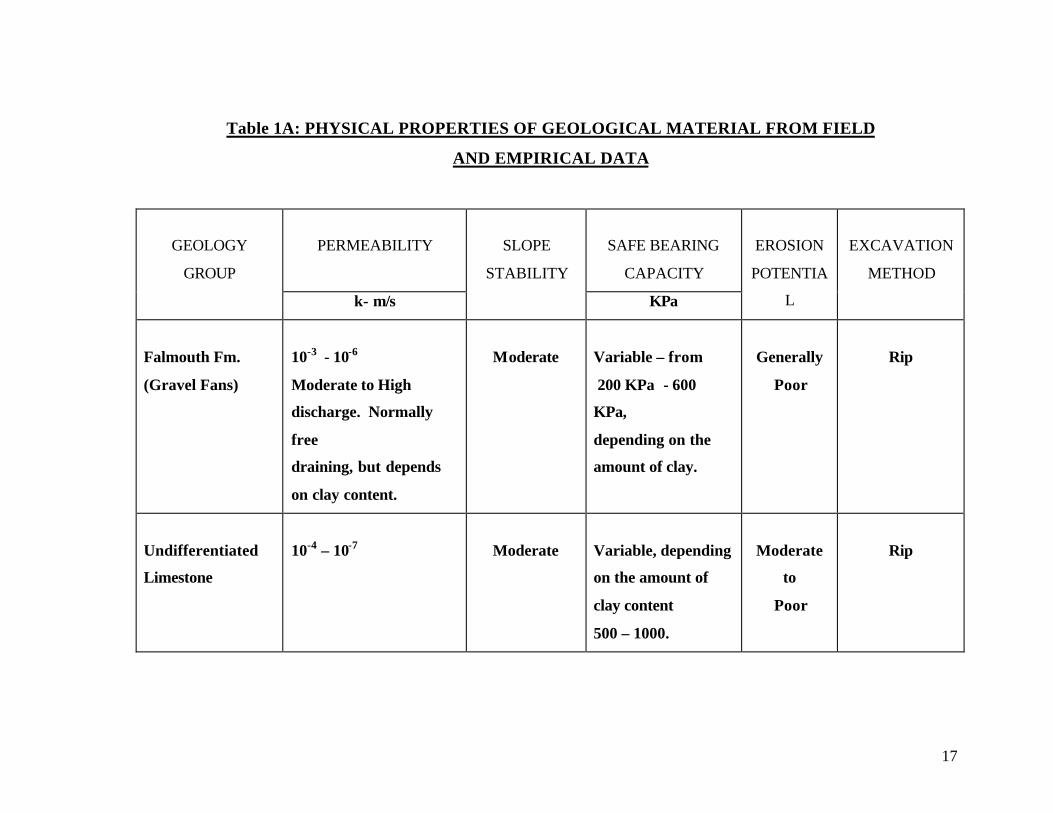
2.6.2 Physical Properties of Geological Material
- See Table Attached
17
Table 1A: PHYSICAL PROPERTIES OF GEOLOGICAL MATERIAL FROM FIELD
AND EMPIRICAL DATA
PERMEABILITY
SAFE BEARING
CAPACITY
GEOLOGY
GROUP
k- m/s
SLOPE
STABILITY
KPa
EROSION
POTENTIA
L
EXCAVATION
METHOD
Falmouth Fm.
(Gravel Fans)
10-3 - 10-6
Moderate to High
discharge. Normally
free
draining, but depends
on clay content.
Moderate
Variable – from
200 KPa - 600
KPa,
depending on the
amount of clay.
Generally
Poor
Rip
Undifferentiated
Limestone
10-4 – 10-7
Moderate
Variable, depending
on the amount of
clay content
500 – 1000.
Moderate
to
Poor
Rip
18
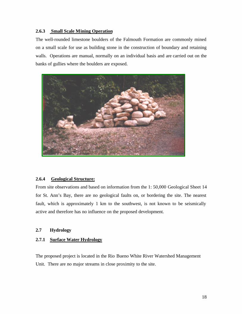
2.6.3 Small Scale Mining Operation
The well-rounded limestone boulders of the Falmouth Formation are commonly mined
on a small scale for use as building stone in the construction of boundary and retaining
walls. Operations are manual, normally on an individual basis and are carried out on the
banks of gullies where the boulders are exposed.
2.6.4 Geological Structure:
From site observations and based on information from the 1: 50,000 Geological Sheet 14
for St. Ann’s Bay, there are no geological faults on, or bordering the site. The nearest
fault, which is approximately 1 km to the southwest, is not known to be seismically
active and therefore has no influence on the proposed development.
2.7 Hydrology
2.7.1 Surface Water Hydrology
The proposed project is located in the Rio Bueno White River Watershed Management
Unit. There are no major streams in close proximity to the site.

19
The nearest rainfall station to the site is located at Richmond Estate. The 30 Year (1951-
1980) mean annual rainfall for this station 1506 mm. The 30 Year monthly mean varies
from a low of 59 mm in July to a high of 262 mm in November (Table 1).
TABLE 2: 30 YEAR MEAN RAINFALL (1951-1980)
STATION J F M A M J J A S O N D Total
Richmond
Estate
132 96 76 98 168 89 59 62 96 135 262 233 1506
Lime Hall 193 114 153 246 213 97 83 66 115 396 298 300 2194
Priory 156 81 95 95 180 99 78 64 78 129 228 260 1448
The estimated maximum 24-hour rainfall for the Richmond Station varies from 189mm
for the 5-year return period to 342 mm for the 100-Year Return Period (Table 2).
Table 3: Estimated Maximum 24-Hour Rainfall (mm)
STATION 5 Year 10 Year 25 Year 50 Year 100 Year
Richmond Estate 189 226 273 307 342
St. Anns Bay 166 199 239 269 300
The rainfall depth typically increases from north to south. Higher rainfall depth is
expected in the upper catchment area of the gullies crossing the site.
Drainage to and from the site is controlled largely by the Stony River and it's tributary;
the Sleepy Tree Gully. The north-eastern section of the site is drained by a small gully
(Gully A) that crosses the highway approximately 600m west of Priory (See Map).
The drainage area of both drainage systems (Stony River and Gully A) extends to a
significant distance south of the site. The drainage area of the Stony River inclusive of

20
the drainage area of Sleepy Tree Gully is 586 hectares (1446 acres). The drainage are of
Gully A is 105 hectares (258 acres).
The Stony River defines the western boundary of the Site. The Stony River is perennial
in its upper reaches North of the community of Lewis; the river is seasonal as the flow
sinks into the riverbed. The Sleepy Tree Gully crosses the South-Western corner of the
property. This gully is seasonal for its entire length.
The Stony River and its tributary -Sleepy Tree Gully-carries substantial flow subsequent
to heavy rainfall in the upper catchment area. This is evident from the large boulders and
logs deposited by the river at the bridge crossing the North Coast Main Road subsequent
to the heavy rains over the period May 22-31, 2002.
Gully A drains the north-eastern section of the property. This gully is also seasonal.
Surface run off from the central area of the site flow north and eventually east or west
into either of the two drainage systems (gully).
In general the site is well drained and there is little or no ponding of water on the Site
subsequent to rainfall events.
The Stony River crosses the North Coast Main Road via a bridge and Gully A via a box-
culvert. Blockage of these structures by debris transported by both gullies has caused
flooding on the main road. With the construction of the North Coast Highway, it is
expected that both structures will be replaced by larger structures.

21
2.7.2 Groundwater Hydrology
A Coastal Limestone Formation underlies the site. Due to the low permeability of this
formation it is classified as an aquiclude (i.e rocks that will not allow significant flow of
groundwater). There is the potential for groundwater flow where fracturing or solution
processes has increased the permeability.
Based on the nature of the underlying rock type, groundwater resources immediately
below the site are considered to be negligible and there is little scope for groundwater
development below the site. There are no production wells in close proximity to the site.

22
SECTION 3: LEGAL AND REGULATORY CONSIDERATIONS
3.1 Legislative Framework
In Jamaica all plans for development have to be approved by the Town and Country
Planning Authority (TCPA). This authority consults with other relevant organizations
before a final decision is taken. These include the National Environment and Planning
Agency (NEPA) and the Environmental Health Unit (EHU). The former authority is
the coordinating and regulatory body for all environmental matters. If there is a
possibility that the proposed development could have detrimental effects on the
environment the NRCA (under the NRCA Act) may request the preparation of an
Environmental Impact Assessment (EIA) or Statement (EIS) as the situation may dictate.
The latter division (ECD) operates under the Ministry of Health and is responsible for
imposing air, water and soil standards that are to be maintained during and after
construction.
Environmental Legislation
The following environmental legislation is relevant to the proposed Development Plan:
3.1.1 The Natural Resources Conservation Authority Act
Under the NRCA Act the whole island has been designated as a prescribed area and the
law binds the Crown. This Act empowers the NEPA issue permits to persons undertaking
any new development, construction or enterprise, anywhere in Jamaica, and licences for
the construction or modification of any work causing the discharge of trade or sewage
effluent into the environment. Under Section 9, designated or Prescribed Activities will
require a permit from the NRCA and the agency may request the preparation of an
Environmental Impact Assessment of the proposed activity under Section 10 of the Act.
Natural Resources Conservation (Permits and Licences) Regulations, 1996 and Natural
Resources (Prescribed Areas Prohibition of Categories of Enterprise, Construction and
23
Development) Order, 1996 are pieces of legislation that guide development in an
environmental sustainable way.
The Order prohibits the construction and development of a number of listed enterprises
without a permit. The list of prescribed categories includes housing subdivisions of 10
lots or more or housing projects of 10 houses or more, as well as sewage treatment
facilities. The application for a development permit requires submission and review of a
Project Information Form (PIF). An EIA or EIS may be required, the latter in the case of
this project.
A permit is issued once the project proponent has satisfied the requirements of the NRCA
and the permit fee has been paid.
The NRCA usually requires implementation of an environmental monitoring programme
during construction works. The ECD and local planning authorities are also supposed to
monitor construction to ensure that their development restrictions and requirements are
adhered to.
3.2.2The Town and Country Planning Act
The Town and Country Planning Authority (TCPA) formulated and coordinates
strategic plans for area development in the form of Development Orders (broad based
land use plans and regulations) consistent with the Town Planning Law of 1975.
In General, Development Orders cover such development issues as, historic buildings to
be preserved; areas designated for present and future conservation and the reason for
designation; heights of buildings to be constructed; development which needs the
NRCA’s permission, such as those in watersheds; density of development and policies
that govern overall development in the area. The Act also authorizes the issue of Tree
Preservation Orders, providing for the protection of designated trees, groups of trees and
woodlands.

24
3.2.3 Water Resources Authority Act
This act empowers the Water Resources Authority (WRA) with the responsibility for
the conservation and proper use of the underground water resources.
3.2.4 The Environmental Control Division (ECD)
The ECD, in the Ministry of Health, administers the Public Health Regulations (1976)
under which air; soil and water pollution control standards are established and monitored.
This agency is primarily concerned with public health issues insofar as pollution is
concerned.
3.2.5 The Public Health Act (1976) specifies that persons responsible for any
construction repair or alteration activities must take reasonable precautions to prevent
particulate matter from becoming airborne. With regards to the proposed project, the
Public Health Act will have a bearing on the construction phase of the project,
specifically those activities that may generate significant levels of fugitive dust.
The Act also covers details for sewage disposal; in particular, design criteria for pumping
stations, screening and grit removal facilities, treatment ponds, sludge handling and
disposal, and outfalls. It deals with issues such as emergency power facilities, fencing and
appropriate signage around the treatment facilities as well.
3.2.6 The Watershed Protection Act
The watershed Act was incorporated into the NRCA Act of 1991, provides for the
designation of watersheds for conservation purposes, to reduce soil erosion, ensure
regular flow in rivers and streams, maintain optimum levels of ground water and
encourage proper land use to protect watershed recharge. All of Jamaica twenty-six (26)
watersheds have been designated as protected under this Act administered by the NRCA.

25
3.2.7 The Local Improvements Acts
The local Improvements Act controls the subdivisions of land. The act is administered
by the Local Planning Authority, which has the power to approve and deny sub-division
applications within their boundaries, based on advise of their planning and building sub-
committees and other local agencies. In the case of the Success Estate Subdivision, the
Parish Council must refer the subdivision application to the Government Town Planner
for advice and approval.
3.2.8 The Housing Act
The Housing Act (1973) requires that any proposal for the subdivision of land and the
construction of houses thereon be accompanied by a plan of the area inclusive of, but not
restricted to, the following:
• The manner in which it is intended that the area shall be laid out, in particular, the
land intended to be used for the provision respectively of houses, roads and open
spaces for public and commercial uses.
• the approximate area of the land
• the approximate number and nature of the houses and other buildings to be provided
• the average number of houses to be constructed per acre;
• Particulars relating to water supply drainage and sewage disposal.
Additionally, the Minister shall not submit a scheme for approval unless the housing
association has furnished each Local Authority within the area of the proposed
development the above particulars for their approval. The Local Authority may propose
modifications to the plan (or part thereof) and modifications accepted by the Minister
shall form part of the scheme to be submitted to the Senate and the House of
Representatives. The Minister is also empowered to make regulations relating to the
prevention and abatement of overcrowding and the use of the dwelling with a view to the
prevention of nuisances and sanitary defects.

26
The Housing Act does not relate to impacts on the natural environment but the NRCA
Act binds the Crown and supersedes that Act.
27
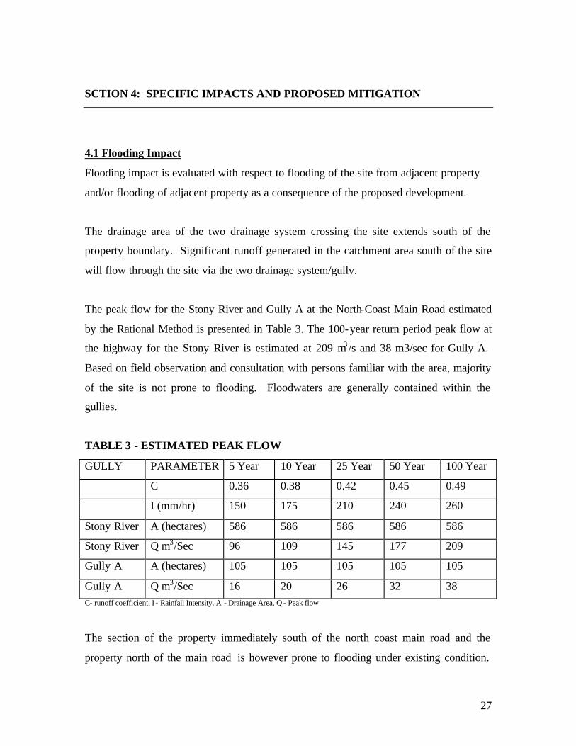
SCTION 4: SPECIFIC IMPACTS AND PROPOSED MITIGATION
4.1 Flooding Impact
Flooding impact is evaluated with respect to flooding of the site from adjacent property
and/or flooding of adjacent property as a consequence of the proposed development.
The drainage area of the two drainage system crossing the site extends south of the
property boundary. Significant runoff generated in the catchment area south of the site
will flow through the site via the two drainage system/gully.
The peak flow for the Stony River and Gully A at the North-Coast Main Road estimated
by the Rational Method is presented in Table 3. The 100-year return period peak flow at
the highway for the Stony River is estimated at 209 m3 /s and 38 m3/sec for Gully A.
Based on field observation and consultation with persons familiar with the area, majority
of the site is not prone to flooding. Floodwaters are generally contained within the
gullies.
TABLE 3 - ESTIMATED PEAK FLOW
GULLY PARAMETER 5 Year 10 Year 25 Year 50 Year 100 Year
C 0.36 0.38 0.42 0.45 0.49
I (mm/hr) 150 175 210 240 260
Stony River A (hectares) 586 586 586 586 586
Stony River Q m3/Sec 96 109 145 177 209
Gully A A (hectares) 105 105 105 105 105
Gully A Q m3/Sec 16 20 26 32 38 C- runoff coefficient, I - Rainfall Intensity, A - Drainage Area, Q - Peak flow
The section of the property immediately south of the north coast main road and the
property north of the main road is however prone to flooding under existing condition.

28
Flood of the section of the property immediately south of the north-coast main road is
caused mainly by blockage of the bridge across the Stony River and the box culvert
across Gully A.
The pre and post development surface runoff from the site estimated by the Rational
Method is presented in Table 4.
Table 4: Pre and Post Development Surface Runoff from Site
STATE PARAMETER 5 Yr. 10 Yr. 25 Yr. 50 Yr. 100 Yr.
AREA
(hectares)
163 163 163 163 163
Rainfall
Intensity (mm)
150 175 210 240 260
Pre
Development
C o.34 0.36 0.40 0.43 0.47
Pre
Development
Q 23 29 38 47 55
Post
Development
C 0.63 0.66 0.70 0.74 0.78
Post
Development
Q 43 53 67 81 93
% Increase 54 55 57 58 59
The proposed development will result in some areas becoming impervious (e.g. roads and
buildings). While other areas will be less pervious than at present.
As with any development it is expected to result in an increase in runoff from the site.
The increase in runoff as a consequent of the development is considered significant as it
could cause flooding on the section of site immediately south of the north coast main
road. It is important to note the effect of lack of maintenance on the drains and the
impact of flooding.
29
4.2 Flooding Mitigation
Constructing roadside ditches to convey at minimum 10 Year Return Period stormwater
flow can mitigate flooding on the site. Stormwater from the site should be directed to the
Stony River of Gully A and not towards the north coast main road.
Flooding of the north coast main road can be mitigated by regular cleaning of the gullies
of debris especially logs, in the vicinity of the bridges and culverts. This will also
mitigated flooding of the property north of the main road.
4.3 Soil Erosion Impact
Erosion and deposition are natural process in a stream or gully. These processes become
a major concern in a development where there is increase surface runoff, modification to
stream channel geometry or constructions (e. bridges, culverts) placed across the channel.
Both bank and bed scour were observed in both gullies passing through the site. A
number of box culverts will be constructed in the sub-division. These structures could be
prone to scouring. The bridge across the Stony River at the North Coast High Way is also
prone to scouring under existing condition.
4.4 Soil Erosion Mitigation
The impact of soil erosion on the proposed development may be minimized by:
1) Having a minimum setback from all gullies through the site.
2) Stabilize gully banks in the vicinity of the site.
3) Appropriate protection for scour should be provided in the vicinity of all
hydraulic structures.
4) Roadside ditches or kerb and channel drains should be paved.
5) There should be no reduction in channel capacity by the construction of hydraulic
structures across gullies.

30
6) All open space should have at minimum grass cover.
4.5 Pollution Impact
There are no perennial water sources in close proximity to the site to be polluted by
activities on the development site. Solid waste generated during both the construction
and operation phase of the development could end-up in the gullies. During seasonal
flow these could be transported to the coast, thus causing pollution of the coastal
environment.
The formation underlying the site is considered an aquiclude and therefore there are no
significant groundwater resources at risk to pollution. The improper construction of an
on-site treatment system could cause pollution of the coastal waters due to subsurface
flow.
4.6 Pollution Mitigation
The following mitigation measures should be enforced to minimized pollution of water
resources.
1) There should be no disposal of solid waste to gullies during either the
construction or operation phase of the project.
2) Relevant Government Authority must approve any subsurface deposal of effluent
at the site. Which must be constructed properly.
3) There should be no disposal of untreated effluent to the gullies.
4.7 Water Supply Impact

31
The proposed development will create an additional water demand of 1050 m3/day
(200,000gpd). The National Water Commission (NWC) from the treatment plant at
Liberty presently supplies The Tanglewood area with water. The estimated capacity of
the plant is 3020 m3/day and it also serves the communities of Liberty, Lewis and
roadside.
4.8 Water Supply Mitigation
The options to provide additional potable water to the development are:
1) Development of new surface water supply source to include storage reservoirs.
2) Development of groundwater supply source (wells) in the limestone aquifer south
of the site.

32
SECTION 5: ANALYSES OF ALTERNATIVES
These alternatives were examined against social, economic and environmental
considerations. Alternative analyses were considered for the following:
1) Collection, Treatment and Disposal of Sewage
2) Drainage System
5.1 Collection, Treatment and disposal of Sewage
5.1.1 Alternative #1 Linking with a NWC Sewage System
This alternative would prove to be extremely costly as the closest Treatment Plant is in
Ocho Rios, which is approximately 14 km away. Also, the NWC Treatment plant was not
built with this development in mind. As such, any additional input of sewage would
compromise the integrity of the quality effluent.
5.1.2 Alternative #2: Septic Tank/Tile Field and Drain
This is the proposed option for the development. The Ministry of Health –Environmental
Health Unit, has approved this proposed septic tank designs along with tile field and
drainage system.
5.1.3 Alternative #3: On-Site Treatment
While this option may prove to be the most expensive and environmentally sound one, if
the system is not maintained properly it will prove to have significant negative
environmental impacts.

33
SECTION 6: IMPACT IDENTIFICATION
The proposed development at Richmond, St. Ann will be conducted without
damage to the environment. Most negative impacts are temporary, while the positive
impacts are long term.
This section serves to identify all of the potential impacts both negative and positive. In
identifying these potent ial impacts, mitigative measures have been proposed so that the
developer may construct the developments in an environmentally sound way. That is,
avoidance or reduction, where possible of the negative impacts.
Pre-Construction:
6.1.1 Air Pollution
There will be a substantial amount of fugitive dust formation, due to the cutting of the
road. Although temporary, it will be a significant nuisance problem given the fact that
soil is very dry and prone to become airborne.
6.1.2 Noise Pollution:
This will be temporary and due to the noise from motors and engines, etc. However, the
site is mostly isolated and any noise to legal residents will be temporary and negligible.
6.1.3 Water Pollution:
Rainfall during this phase may cause the run off to pose an impact. The exposure of soil,
to the elements may pose an impact.
6.1.4 Loss of Vegetation:
There will be no negative impact as the site was previously cleared and used for
agricultural purposes.

34
6.2 Construction
6.2.1 Air Pollution:
Vehicular traffic on site as well as equipment will emit gaseous emissions. Some fugitive
dust will be formed during this time. These impacts will be temporary and negligible
6.2.2 Noise Pollution:
During the construction of houses there will be an increase in noise levels. This
will be temporary and negligible.
6.2.2 Water Pollution:
Rainfall during this phase may cause the run off to pose an impact. The exposure of soil,
to the elements may pose an impact.
6.2.3 Socio-Economic Benefits:
Development of infrastructure and construction of these houses will provide construction
jobs for numerous persons for many years.
6.2.4 Solid Waste:
There will be an increase in solid waste due to the workforce, as well as the construction
debris. One will invariably find an increase in “vendors” on or near the site from which
stem the increase in solid waste such as “juice boxes” and “cook lunch” boxes. There
will invariably be a specific amount of solid waste generated from construction materials,
i.e. packaging.
6.3 Post-Construction/Closure
6.3.1 Air Pollution:
During this phase of the development there should be minimal air pollution. There may
be some fugitive dust formation due to the laying on of top soil for landscaping, however
this will be minimal

35
SECTION 7: IMPACT MITIGATION/CONSERVATION
The proposed development will serve a number of functions, such as provision of
employment during and after construction, provision of homes, etc. As with all
developments there will be some potential negative impacts, most of which can be
reduced and/or avoided if proper mitigative actions are followed. Through the greening
of areas and reintroduction of trees, this project will impact positively by increasing the
biodiversity in the area.
7.1 Flood Mitigation
7.1.1 Alignment of Gully Courses
The Sleepy Tree Gully contains a number of deep bends on the south of the project site.
There needs to be proper alignment of this drainage feature to minimize erosion and to
allow for the efficient discharge of storm water during peak flows. This recommendation
will undoubtedly mitigate against flooding on the site.
The gully immediately to the east of Sleepy Tree Gully must have its channel redefined
and aligned where it runs near the centre of the property.
Further, constructing roadside ditches to convey at minimum 10 Year Return Period
stormwater flow can mitigate flooding on the site. Stormwater from the site should be
directed to the Stony River Gully A and not towards the north coast main road.
Flooding of the north coast main road can be mitigated by regular cleaning of the gullies
of debris especially logs, in the vicinity of the bridges and culverts.
36
7.1.1.1 Green Areas aligned along Gully Courses
In discussion with the applicant, it is proposed that green areas will be created along the
sides of some sections of gully courses. This green area will serve as a common area for
walking trails as well as a setback from the gully, which will aid in flood mitigation.
7.1.1.2 Other Considerations for On-Site Drainage Designs
With the expected increase in run-off from the development during
and after construction phases, a proper functioning storm water drainage system is
required. Additionally, existing water developments such as Tanglewood Subdivision
(no apparent system in place) will also contribute to peak flows in the design of a storm
water drainage system.
Storm water on the Bamboo to Lewis Main Road should be directed into the Sleepy Tree
Gully using gutters/drainage trench in order to control run-off into the property.
Kerb and channel/structures, gutters, and cross drains should be used where appropriate
as part of a storm water system for in order to reduce velocity of flow and control run-off.
Where subdivision roads cross over gullies, they should be ‘culverted’ to allow for free
flow of drainage through the development.
7.1.1.3 Drains Maintenance
Maintenance of drains will be critical in order to prevent blockage in the drainage
channels and reduce flooding. In Particular, overflows for the drainage system must be
cleared and properly maintained so as to minimize or prevent backflows in the system
during peak flows.

37
7.1.2 Erosion Control Measures
Alignments of drains at critical points particularly at major bends along the Sleepy Tree
Gully will assist in reducing erosion of the discharge channels.
Erosion surfaces left behind from the training of gullies should be backfilled. It will be
desirable to protect the backfill by using erosion protection measures such as gabion
structures.
Given that the material at the sides of the drainage channels is highly erodable, some
erosion may occur during high flows particularly near to where hydraulic structures are
located. These areas are also to be protected using gabions.
The impact of soil erosion on the proposed development may be minimized by:
1) Having a minimum setback from all gullies through the site
2) Stabilize gully banks in the vicinity of the site
3) Appropriate protection for scour should be provided in the
vicinity o all hydraulic structures
4) Roadside ditches or kerb and channel drains should be paved
5) There should be no reduction in channel capacity by the
construction of hydraulic structures across gullies.
6) All open space should have at minimum, grass cover
7.2 Control of Ground Subsidence/Settlement
Imported fill used for site grading purposes must be properly sorted to ensure that
biodegradable material is not present. Further fill material placed in shallow
depressions where load bearing structures are to be constructed should be rolled
and properly compacted under the guidelines and specification of American
Standard Testing Methods (ASTM) for compaction of fill and aggregates.
38
7.3. Earthquake Hazard Mitigation
The type of buildings that will withstand moderate to large earthquakes are short,
stiff structures recommended for the development. Single- storey and two-storey
structures are within this category as they respond best to long period waves
which normally occur in large earthquakes. The structures should be designed to
exhibit some amount of ductility to tolerate dynamic loads generated from seismic
activity. Reinforced concrete structures are recommended for such purposes.
Pre-stressed concrete structures are also useful, but do not perform as well as
reinforced concrete under earthquake conditions.
The subsurface at the site eliminate the possibility of soil liquefaction or excessive
ground acceleration and therefore adverse reaction of the ground to seismic
occurrences is not anticipated.
7.4 Air Pollution
The problem of fugitive dust formation due to transportation and stockpiling of
any construction material (marl, sand, soil, etc) may be greatly reduced if the
following mitigative actions are followed:
The unpaved road, etc, should be rolled as quickly as possible and sprinkled
occasionally. During the transportation of construction material, water should be
sprinkled on the material and covered with tarpaulin.
When necessary, workers must be made to wear dust masks.
7.5 Water Pollution:
The following measures should be enforced to minimize pollution of water
resources.
1) There should be no disposal of solid waste to gullies during either
the construction or operation phase of the project.
2) Any subsurface disposal of effluent at the site must be approved by
the relevant Government Agencies.

39
3) There should be no disposal of untreated effluent to the gullies.
7.6 Water Supply
The options to provide additional potable water to the development are:
1) Development of new surface water supply source to include
storage reservoirs
2) Development of groundwater supply source (wells) in the
limestone aquifer south of the site
7.7 Noise Pollution:
This impact will be negligible and temporary. All operators of heavy equipment
MUST be made to wear earplugs.
7.8 Solid Waste:
One or two skips should be provided for workers to put all cement bags, lunch
boxes, etc. in. A private contractor will collect solid waste. (See attached letter)
7.9 Greening of Reserved Area:
There will be a number of green areas located throughout the property. These
should be quickly developed and landscaped to maintain the aesthetics of the
property during and after construction. A number of fruit trees should be planted
to bring back the bird population, thereby increasing the biodiversity of the area.

40
PHOTO INVENTORY

41
Plate 1: Old gated entrance to property –boundary of south of property.
Plate 2: Parochial road on eastern border of property. School in background.

42
Plate 3: Stones that were illegally mined outside of eastern boundary of property.
Plate 4: Remnants of sugar cane, which was once grown on property.
No significant vegetation was noted.

43
Plate 5: Boundary on North of property; North Coast Highway.
Plate 6: Boundary on North of property

44
th
Plate 7: Area that was once cleared.
Plate 8: Gully that was cleared.

45
Plate 9: Cleared existing channel.
Plate 10: Old channel found on property.

46
Plate 11: Rock and other geological formations found on site.
Plate 12: Rock formation found on site.

47
Plate 13: Scrub vegetation. Old dirt tracks leading through property.
Plate 14: Typical vegetation on north of property. Very low biodiversity.

48
Plate 15: Vegetation found in northern part of property.
No significant vegetation was noted.
Plate 16: Trees planted in Green Area of previous Mafesantti development.

49
Plate 17: Property boundary on southern side of site.
Plate 18: Parochial road on eastern boundary of site.
50
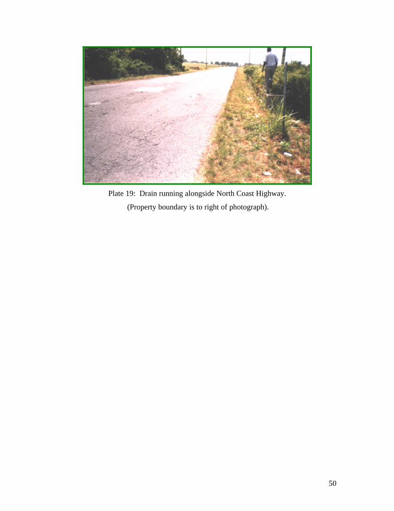
Plate 19: Drain running alongside North Coast Highway.
(Property boundary is to right of photograph).