Embed Size (px)
Citation preview
©2008 1
Contents
Contents .......................................................................................................................1
1. Introduction and Overview .................................................................................. 2
2. Design Guidelines: Commercial Areas ............................................................ 10
3. Design Guidelines: Residential Areas .............................................................. 30
4. Public Realm .................................................................................................... 41
5. Vehicle Access, Parking and Other Recommendations ................................... 49
6. Implementing the Urban Improvement Project and the Structure Plan ............. 53
Appendix A: Strategic Context .................................................................................... 63
Appendix B: Precinct Analysis, Issues and Opportunities .......................................... 68
Appendix C: Potential Dwelling Yields ........................................................................ 97
Appendix D: Estimated number of car parks required .............................................. 103
Appendix E: Summary of UDF Strategies ............................................................... 107
Appendix F: Hardy Street to Melba Park Cross Section ........................................... 110
©2008 2
1. Introduction and Overview
Brief
This project is intended to supplement the Lilydale Major Activity Centre Structure Plan which was adopted by Council in June 2006. The project brief outlined the following detailed tasks: 1. Analyse built form characteristics and identify those key neighbourhood character
and commercial streetscape elements that need to be retained and incorporated in any new development.
2. Identify opportunities to accommodate additional housing, mixed use and other commercial development within the activity centre.
3. Apply three dimensional modelling techniques to identify preferred building form concepts for strategic redevelopment sites and for infill developments in other areas
4. Calculate anticipated increases in dwelling numbers within the activity centre based on preferred housing forms
5. Identify techniques to ensure that new development achieves the objectives of providing for additional and more diverse housing whilst retaining and reinforcing the valued neighbourhood characteristics of the activity centre.
6. Calculate anticipated increases in car parking within the activity centre based on preferred new development forms.
The Structure Plan has provided the basis for the recommendations in this report. Additional investigation has been undertaken to further examine the findings of the Structure Plan and provide additional detail where it was required. This investigation has included site visits by the study team, extensive desktop analysis, and visual modelling to test various built form outcomes.
©2008 3
Study Area
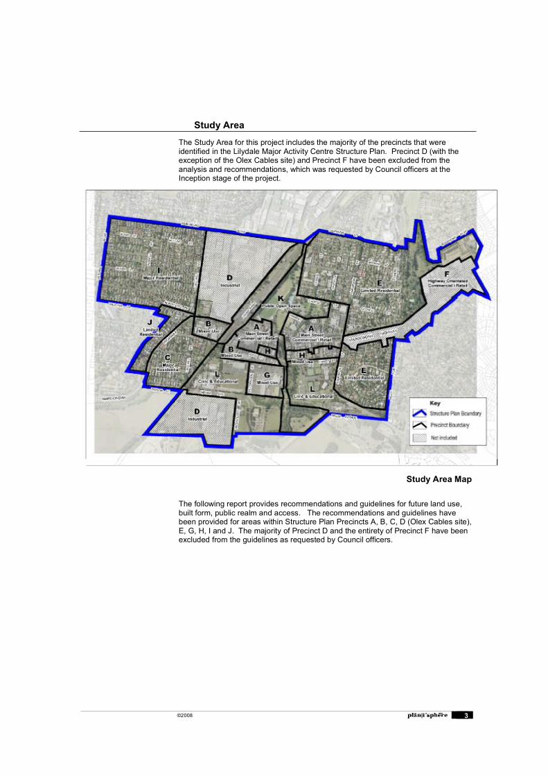
The Study Area for this project includes the majority of the precincts that were identified in the Lilydale Major Activity Centre Structure Plan. Precinct D (with the exception of the Olex Cables site) and Precinct F have been excluded from the analysis and recommendations, which was requested by Council officers at the Inception stage of the project.
The following report provides recommendations and guidelines for future land use, built form, public realm and access. The recommendations and guidelines have been provided for areas within Structure Plan Precincts A, B, C, D (Olex Cables site), E, G, H, I and J. The majority of Precinct D and the entirety of Precinct F have been excluded from the guidelines as requested by Council officers.
Study Area Map
©2008 4
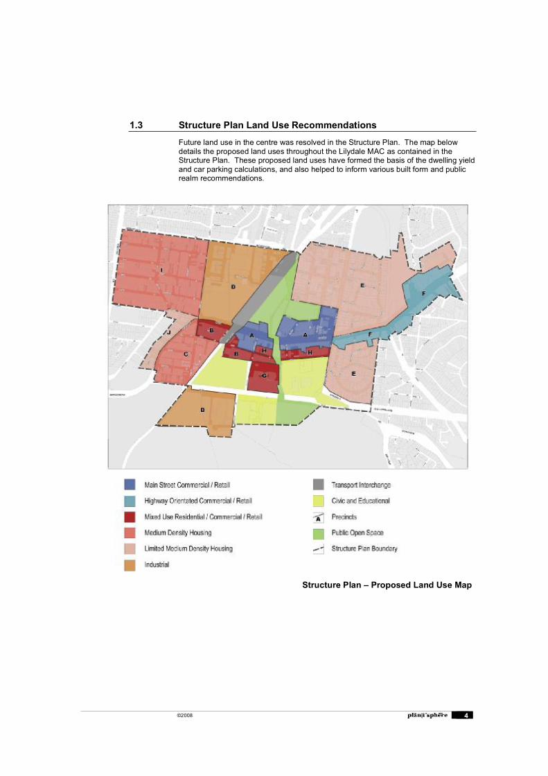
1.3 Structure Plan Land Use Recommendations
Future land use in the centre was resolved in the Structure Plan. The map below details the proposed land uses throughout the Lilydale MAC as contained in the Structure Plan. These proposed land uses have formed the basis of the dwelling yield and car parking calculations, and also helped to inform various built form and public realm recommendations.
Structure Plan � Proposed Land Use Map
©2008 5
1.4 Building Heights
The Structure Plan provided recommended building heights for commercial and residential allotments throughout the Centre. The recommended heights ranged from 2 to 4 storeys within the commercial areas and 1-3 storeys in the residential areas.
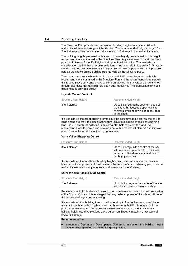
The building heights proposed in this section have largely been based on the height recommendations contained in the Structure Plan. A greater level of detail has been provided in terms of specific heights and upper level setbacks. The analysis and consideration behind these recommendations is included within Appendix A: Strategic Context, and Appendix B: Precinct Analysis, Issues and Opportunities. The proposed heights are shown on the Building Heights Map on the following page.
There are some areas where there is a substantial difference between the height recommendations contained in the Structure Plan and the recommendations made in this report. These differences have arisen from additional analysis of particular sites through site visits, desktop analysis and visual modelling. The justification for these differences is provided below:
Lilydale Market Precinct
Structure Plan Height Recommended Height
3 to 4 storeys Up to 6 storeys at the southern edge of the site with recessed upper levels to minimise overshadowing of open space to the south
It is considered that taller building forms could be accommodated on this site as it is large enough to provide setbacks for upper levels to minimise impacts on adjoining land uses. Taller building forms in this area also help to satisfy the land use recommendations for mixed use development with a residential element and improve passive surveillance of the adjoining open space.
Yarra Valley Shopping Centre
Structure Plan Height Recommended Height
3 to 4 storeys Up to 6 storeys in the centre of the site with recessed upper levels to minimise impacts on the streetscape and nearby heritage properties
It is considered that additional building height could be accommodated on this site because of its large size which allows for substantial buffers to adjoining properties. A residential element on upper levels could take advantage of views.
Shire of Yarra Ranges Civic Centre
Structure Plan Height Recommended Height
1 to 2 storeys Up to 4-5 storeys in the centre of the site and close to the southern boundary.
Redevelopment of this site would need to be undertaken in conjunction with relocation of the Council Offices. It is envisaged that any redevelopment of this site would be for the purposes of high density housing.
It is considered that building forms could extend up to four to five storeys and have minimal impacts on adjoining land uses. A three storey building frontage could be provided at the southern frontage to minimise overshadowing and a two storey building height could be provided along Anderson Street to match the low scale of residential areas.
Recommendation
Introduce a Design and Development Overlay to implement the building height requirements specified on the Building Heights Map.
©2008 6
Building Heights Map
©2008 7
1.5 Setbacks
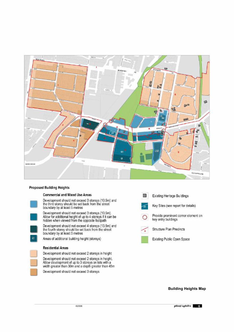
The Structure Plan provided limited recommendations for building setbacks within the Centre. This report adopts the findings of the Structure Plan and provides setback recommendations for the remaining business and residential areas. The map below details the recommended building setbacks throughout the Centre.
Zero front and side setbacks have been recommended for the majority of retail properties throughout the Centre. There are some commercial areas (John Street) where a small front setback is recommended in order to provide for additional landscaping in the street.
It is recommended that the majority of residential areas maintain existing setbacks in accordance with the ResCode standards so that new development has minimal impact on streetscapes. A small number of residential areas have been designated for reduced front setbacks to allow for higher densities of development.
Recommendation
Introduce a Design and Development Overlay to implement the setback requirements specified on the Building Setbacks Map.
Building Setbacks Map
©2008 8
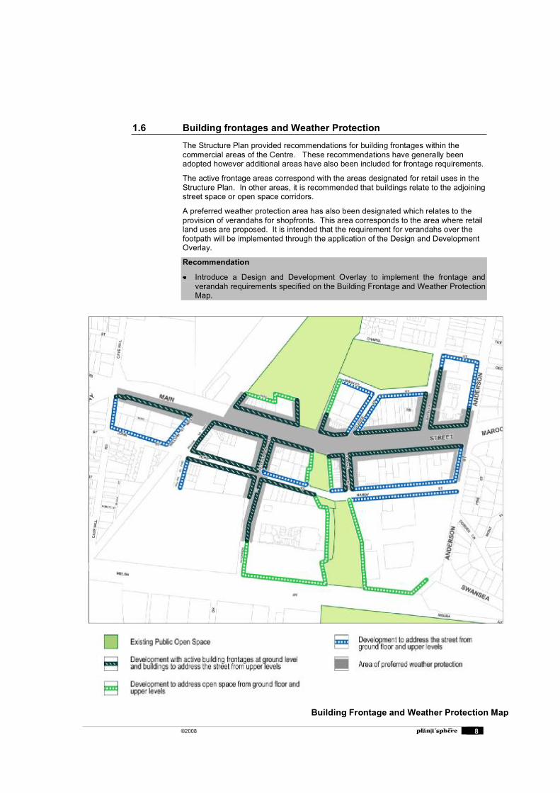
1.6 Building frontages and Weather Protection
The Structure Plan provided recommendations for building frontages within the commercial areas of the Centre. These recommendations have generally been adopted however additional areas have also been included for frontage requirements.
The active frontage areas correspond with the areas designated for retail uses in the Structure Plan. In other areas, it is recommended that buildings relate to the adjoining street space or open space corridors.
A preferred weather protection area has also been designated which relates to the provision of verandahs for shopfronts. This area corresponds to the area where retail land uses are proposed. It is intended that the requirement for verandahs over the footpath will be implemented through the application of the Design and Development Overlay.
Recommendation
Introduce a Design and Development Overlay to implement the frontage and verandah requirements specified on the Building Frontage and Weather Protection Map.
Building Frontage and Weather Protection Map
©2008 9
1.7 Design Guidelines
Design Guidelines have been produced which will assist planners, developers, and the community in preparing and deciding on planning permit applications within the Centre. The preparation of design guidelines was recommended in the Implementation Program of the Structure Plan.
Chapter 2 of this report provides Design Guidelines for commercial allotments within the Centre. The guidelines relate to built form, interface of the private and public realm, landscaping, car parking and vehicle access, and Environmental Sustainability.
Within these guidelines, there is a set of General Design Guidelines which apply to all development within the commercial areas, and a set of more specific guidelines for development within each precinct and key sites. General design guidance for signage has also been provided.
Chapter 3 of this report provides Design Guidelines for Residential Zoned allotment within the Centre. These guidelines relate to the siting and design of buildings, landscaping, fences, private open space, driveways, and car parking.
A set of guidelines has been provided for all residential development within the Structure Plan area and more specific guidelines for development within Precinct E where there is a presence of heritage buildings.
Guidelines for development on consolidated allotments have also been provided. This is intended to encourage the consolidation of allotments by demonstrating that higher densities and quality design can be achieved on larger allotments.
1.8 Public Realm Recommendations
The Structure Plan provided several recommendations for improvements to the public realm within the Centre. These recommendations have been investigated in more detail within this report.
Chapter 4 outlines a number of recommendations and concepts for improvements to public open spaces, streetscapes, and pedestrian movement.
1.9 Vehicle Access, Parking and Other Recommendations The recommendations in Chapter 5 focus on how vehicle access and car parking will need to respond to the proposed increases in floor areas and changes in land uses. Guidance is provided for the widening of laneways and also the consolidation of car parks. In addition,
Additional discussion is provided for the redevelopment of the transport interchange area.
1.10 Other Investigations
In addition to all of the recommendations, further investigation has been undertaken into the potential dwelling yields for the Centre arising from the built form and land use recommendations contained in this report. The dwelling yield estimate is included as Appendix C.
An estimate for the number of car parks that are likely to be required as a result of the land use and built form recommendations has also been provided, and is included as Appendix D. This has been undertaken for the commercial allotments in the Centre.
©2008 10
2. Design Guidelines: Commercial Areas
The following design guidelines have been prepared to guide future built form, landscaping and access in the commercial areas of the Lilydale MAC. The guidelines have been structured with general design guidelines for all commercial and mixed use development, and then more detailed guidelines for each precinct and the identified key sites (refer to the Building Heights Map for locations).
It is intended that these guidelines will be included in a Design and Development Overlay (DDO) that will be accompanied with a map detailing the precincts and key sites. The guidelines are structured in similar way to another DDO that was recently implemented into the Banyule Planning Scheme.
Recommendation
Introduce a Design and Development Overlay to implement the Design Guidelines: Commercial Areas.
2.1 General Design Guidelines for Commercial and Mixed Use Buildings
Element Design Requirement Outcome to be achieved
Building Appearance
New developments should be designed and sited to complement the specific context in which they site and take account of existing landform, vegetation and historic character.
Building facades should be composed with an appropriate scale, rhythm and proportion which respond to the building�s use and the desired contextual character.
Articulated facades, fenestration, parapet treatments and other detailing and materials should be incorporated in the upper levels of developments.
Development on key corner sites should emphasise the corner location with buildings of high architectural quality and provide an emphasised feature such as a low tower, articulated roof form, or more prominent verandah design.
Buildings should utilise glazing and roofing materials of low reflectivity
Provide appropriate waste storage, loading and recycling facilities and screen them from public view.
Buildings of high architectural quality.
Building façades will define the public realm and reflect the form and character of Lilydale
Public/private interface
The street façade and internal layout of the ground floor should be designed to facilitate visual and physical access between the building and the adjoining public realm/street.
Pedestrian entrances into buildings should be located at the same level as the footpath, clearly visible from the street, well lit, and allow for mobility-impaired access.
Buildings should be designed to minimise the overshadowing of the public realm.
Corner sites should actively address both frontages at street level and ensure that the corner allows for safe and comfortable pedestrian movement.
Provide verandahs for pedestrian weather protection where the verandah form dominates and in locations identified on the Frontage and Weather Protection Map in Section 1.6.
Buildings will relate positively and add life to adjacent streets and public realm.
Building frontages will provide for natural surveillance and security of public spaces.
Development will be coherent and clearly connected to public spaces.
Development will
©2008 11
Element Design Requirement Outcome to be achieved Verandahs should be provided for the full width of properties and the height of verandahs should be consistent with adjoining properties.
provide comfort and amenity to pedestrians.
Landscaping Landscaping should be designed to complement the landscape treatments of adjoining public realm areas.
Protect and retain existing canopy trees when constructing new buildings and avoid damage to environmentally sensitive areas.
Landscaping will be integrated with the design of the development and complement the landscaping of any adjoining public realm.
New development will be well landscaped, including canopy trees.
Vehicle access and parking
The number of vehicle crossovers should be minimised and where possible provided from laneways or secondary street frontages.
On site parking for vehicles should be located to have a minimal visual impact on the streetscape and adjoining public spaces. Parking between the front of the building and the street should generally be avoided.
On site parking should be provided through underground or undercroft car parking where possible to maximise useable floor space in the Centre.
Locate entry and exit points to facilitate safe vehicle and pedestrian movements.
All parking areas, including entry and exit points, should be well lit and clearly identified with signage.
Vehicle access points should be separate from pedestrian access points.
Basement car parks should be naturally ventilated wherever possible.
Views of cars on upper levels should be screened from the public realm.
Loading facilities should be screened from the public realm.
Use trees to provide shade in open lot car parks
Design of parking and access will be safe, practical and visually unobtrusive.
Convenient, safe and efficient vehicle movements and connections within the development and the street network.
Environmental Sustainability
Design new buildings and building alterations for energy efficiency, considering solar access and utilising sustainable energy and construction techniques wherever possible and early in the design process (refer to the Building Code of Australia, ResCode and Council�s Environmental Sustainability Policies).
Buildings should be designed to allow for adaptive re-use in the future, where possible.
Sites should be developed to maximise retention of existing vegetation and landscape design that assists in passive solar heating/cooling.
Make use of building materials with minimal environmental impact such as recycled materials and re-use of existing buildings where possible.
Development will adopt best practice environmentally sustainable development principles.
©2008 12
Element Design Requirement Outcome to be achieved
New development should incorporate water sensitive urban design techniques.
Encourage the use of environmental management plans and green travel plans for larger development proposals or where there are site constraints to encourage more innovative solutions for achieving ESD features (such as energy and water conservation, vegetation retention, waste minimisation, more public transport, walking and cycling).
General Design Guidelines for Heritage Development
These guidelines have been prepared for development of Heritage properties, and for infill development adjacent to heritage buildings, or adjacent to historic shopfronts that aren�t covered by a Heritage Overlay. This includes many of the two storey shopfronts on the north side of Main Street.
These guidelines should be considered in conjunction with Heritage Overlay Guidelines prepared by Heritage Victoria.
Heritage Conserve buildings having heritage significance as identified in the Yarra Ranges Planning Scheme.
Generally encourage conservation and restoration of existing Victorian two-storey buildings and other buildings of architectural significance.
Ensure that alterations and additions to heritage buildings in the Centre are undertaken in a way that respects their design, appearance and significance in accordance with Council�s Heritage Policy.
For new buildings adjoining heritage properties, use simple building forms with similar proportions to the heritage building. Avoid the use of traditional details.
Generally adopt front and side setbacks of adjoining heritage buildings. Where the heritage building has atypical setbacks adopt the predominant setbacks in the street or provide a transition in setbacks from the adjoining heritage building to the predominant setback in the street.
Generally adopt façade heights of adjoining heritage buildings and avoid building facades that are substantially lower. Where the heritage building is atypically tall, adopt the predominant façade height in the street.
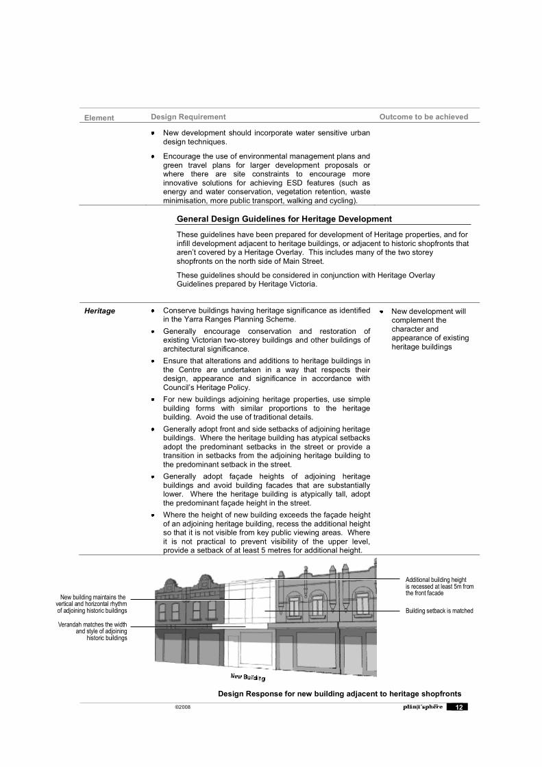
Where the height of new building exceeds the façade height of an adjoining heritage building, recess the additional height so that it is not visible from key public viewing areas. Where it is not practical to prevent visibility of the upper level, provide a setback of at least 5 metres for additional height.
New development will complement the character and appearance of existing heritage buildings
Additional building heightis recessed at least 5m fromthe front facade
Building setback is matched
New building maintains thevertical and horizontal rhythmof adjoining historic buildings
Verandah matches the widthand style of adjoining
historic buildings
Design Response for new building adjacent to heritage shopfronts
©2008 13
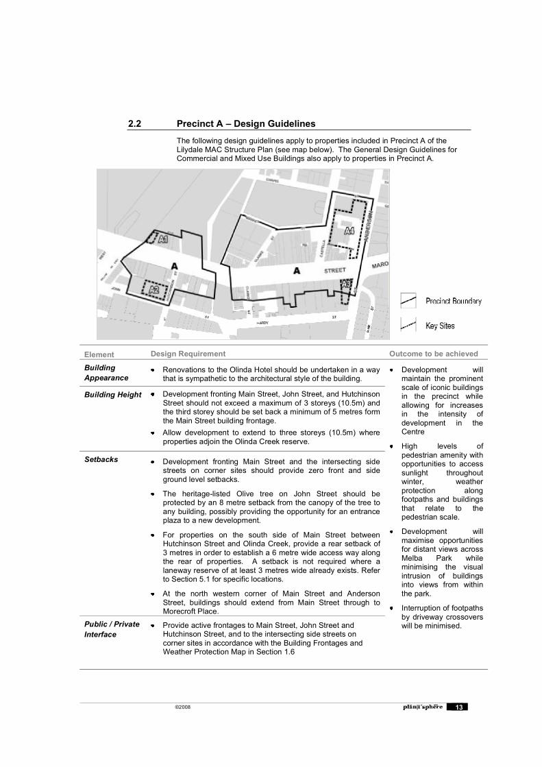
2.2 Precinct A � Design Guidelines
The following design guidelines apply to properties included in Precinct A of the Lilydale MAC Structure Plan (see map below). The General Design Guidelines for Commercial and Mixed Use Buildings also apply to properties in Precinct A.
Element Design Requirement Outcome to be achieved
Building Appearance
Renovations to the Olinda Hotel should be undertaken in a way that is sympathetic to the architectural style of the building.
Development will maintain the prominent scale of iconic buildings in the precinct while allowing for increases in the intensity of development in the Centre
High levels of pedestrian amenity with opportunities to access sunlight throughout winter, weather protection along footpaths and buildings that relate to the pedestrian scale.
Development will maximise opportunities for distant views across Melba Park while minimising the visual intrusion of buildings into views from within the park.
Interruption of footpaths by driveway crossovers will be minimised.
Building Height Development fronting Main Street, John Street, and Hutchinson Street should not exceed a maximum of 3 storeys (10.5m) and the third storey should be set back a minimum of 5 metres form the Main Street building frontage.
Allow development to extend to three storeys (10.5m) where properties adjoin the Olinda Creek reserve.
Setbacks Development fronting Main Street and the intersecting side streets on corner sites should provide zero front and side ground level setbacks.
The heritage-listed Olive tree on John Street should be protected by an 8 metre setback from the canopy of the tree to any building, possibly providing the opportunity for an entrance plaza to a new development.
For properties on the south side of Main Street between Hutchinson Street and Olinda Creek, provide a rear setback of 3 metres in order to establish a 6 metre wide access way along the rear of properties. A setback is not required where a laneway reserve of at least 3 metres wide already exists. Refer to Section 5.1 for specific locations.
At the north western corner of Main Street and Anderson Street, buildings should extend from Main Street through to Morecroft Place.
Public / Private Interface
Provide active frontages to Main Street, John Street and Hutchinson Street, and to the intersecting side streets on corner sites in accordance with the Building Frontages and Weather Protection Map in Section 1.6

©2008 14
Element Design Requirement Outcome to be achieved
For properties on the north side of Main Street between the rail line and Olinda Creek, provide offices and secondary entries along the north side of allotments to improve passive surveillance of the reserve.
Provide verandahs for pedestrian weather protection along Main Street and Hutchinson Street.
For properties adjoining the Olinda Hotel, provide verandahs that complement the hotel verandah in style and function.
Building forms facing the Olinda Creek open space corridor and Melba Park should be of high architectural quality to provide an attractive frontage to the public open space passive surveillance of the adjoining open space.
Vehicle access and parking
Establish rear laneways for car park access and servicing by implementing the rear setbacks specified in the setbacks section of these guidelines.
For properties on the south side of Main Street between Olinda Creek and Anderson Street, vehicle access to properties should be provided from Hardy Street where possible.
©2008 15
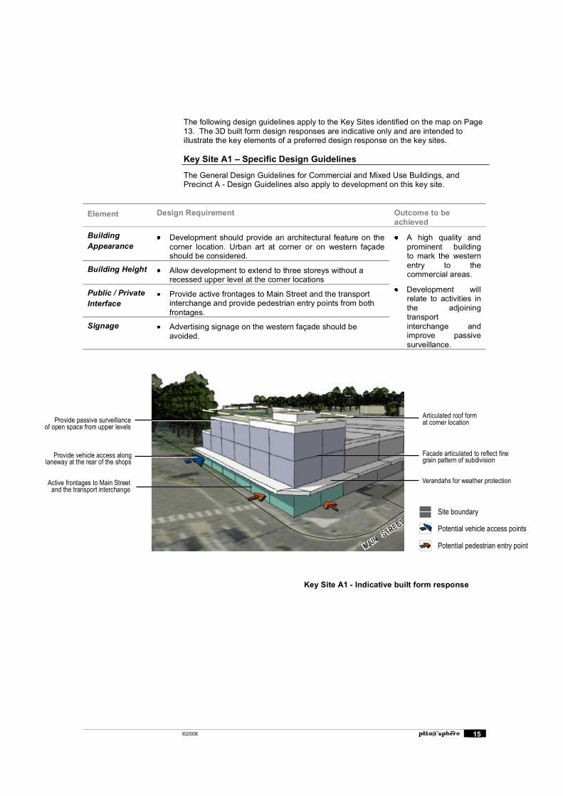
The following design guidelines apply to the Key Sites identified on the map on Page 13. The 3D built form design responses are indicative only and are intended to illustrate the key elements of a preferred design response on the key sites.
Key Site A1 � Specific Design Guidelines
The General Design Guidelines for Commercial and Mixed Use Buildings, and Precinct A - Design Guidelines also apply to development on this key site.
Element Design Requirement Outcome to be achieved
Building Appearance
Development should provide an architectural feature on the corner location. Urban art at corner or on western façade should be considered.
A high quality and prominent building to mark the western entry to the commercial areas.
Development will relate to activities in the adjoining transportinterchange and improve passive surveillance.
Building Height Allow development to extend to three storeys without a recessed upper level at the corner locations
Public / Private Interface
Provide active frontages to Main Street and the transport interchange and provide pedestrian entry points from both frontages.
Signage Advertising signage on the western façade should be avoided.
Verandahs for weather protection
Provide vehicle access alonglaneway at the rear of the shops
Provide passive surveillanceof open space from upper levels
Active frontages to Main Streetand the transport interchange
Articulated roof format corner location
Facade articulated to reflect finegrain pattern of subdivision
Site boundary
Potential vehicle access points
Potential pedestrian entry point
Key Site A1 - Indicative built form response
©2008 16
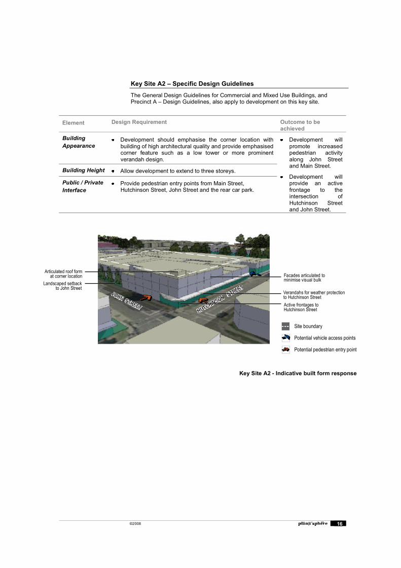
Key Site A2 � Specific Design Guidelines
The General Design Guidelines for Commercial and Mixed Use Buildings, and Precinct A � Design Guidelines, also apply to development on this key site.
Element Design Requirement Outcome to be achieved
Building Appearance
Development should emphasise the corner location with building of high architectural quality and provide emphasised corner feature such as a low tower or more prominent verandah design.
Development will promote increased pedestrian activity along John Street and Main Street.
Development will provide an active frontage to the intersection of Hutchinson Street and John Street.
Building Height Allow development to extend to three storeys.
Public / Private Interface
Provide pedestrian entry points from Main Street, Hutchinson Street, John Street and the rear car park.
Verandahs for weather protectionto Hutchinson Street
Landscaped setbackto John Street
Active frontages toHutchinson Street
Articulated roof format corner location Facades articulated to
minimise visual bulk
Site boundary
Potential vehicle access points
Potential pedestrian entry point
Key Site A2 - Indicative built form response
©2008 17
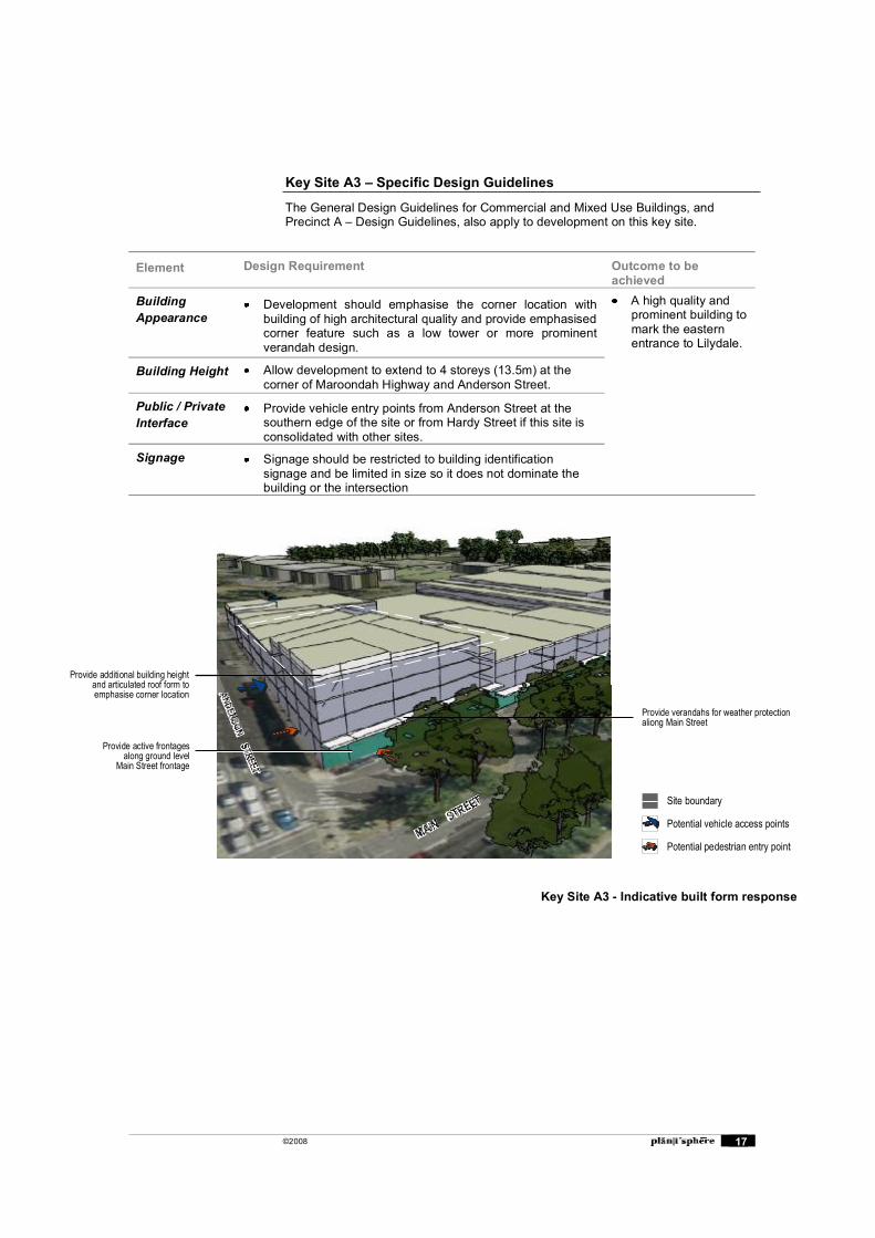
Key Site A3 � Specific Design Guidelines
The General Design Guidelines for Commercial and Mixed Use Buildings, and Precinct A � Design Guidelines, also apply to development on this key site.
Element Design Requirement Outcome to be achieved
Building Appearance
Development should emphasise the corner location with building of high architectural quality and provide emphasised corner feature such as a low tower or more prominent verandah design.
A high quality and prominent building to mark the eastern entrance to Lilydale.
Building Height Allow development to extend to 4 storeys (13.5m) at the corner of Maroondah Highway and Anderson Street.
Public / Private Interface
Provide vehicle entry points from Anderson Street at the southern edge of the site or from Hardy Street if this site is consolidated with other sites.
Signage Signage should be restricted to building identification signage and be limited in size so it does not dominate the building or the intersection
Key Site A3 - Indicative built form response
Provide additional building heightand articulated roof form to emphasise corner location
Provide verandahs for weather protectionaliong Main Street
Provide active frontagesalong ground level
Main Street frontage
Site boundary
Potential vehicle access points
Potential pedestrian entry points
©2008 18
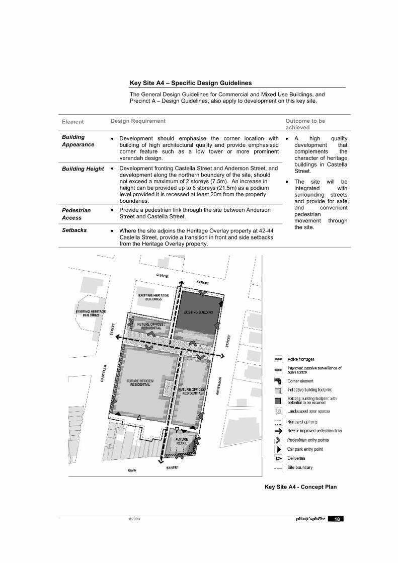
Key Site A4 � Specific Design Guidelines
The General Design Guidelines for Commercial and Mixed Use Buildings, and Precinct A � Design Guidelines, also apply to development on this key site.
Element Design Requirement Outcome to be achieved
Building Appearance
Development should emphasise the corner location with building of high architectural quality and provide emphasised corner feature such as a low tower or more prominent verandah design.
A high quality development that complements the character of heritage buildings in Castella Street.
The site will be integrated with surrounding streets and provide for safe and convenient pedestrian movement through the site.
Building Height Development fronting Castella Street and Anderson Street, and development along the northern boundary of the site, should not exceed a maximum of 2 storeys (7.5m). An increase in height can be provided up to 6 storeys (21.5m) as a podium level provided it is recessed at least 20m from the property boundaries.
Pedestrian Access
Provide a pedestrian link through the site between Anderson Street and Castella Street.
Setbacks Where the site adjoins the Heritage Overlay property at 42-44 Castella Street, provide a transition in front and side setbacks from the Heritage Overlay property.
Key Site A4 - Concept Plan
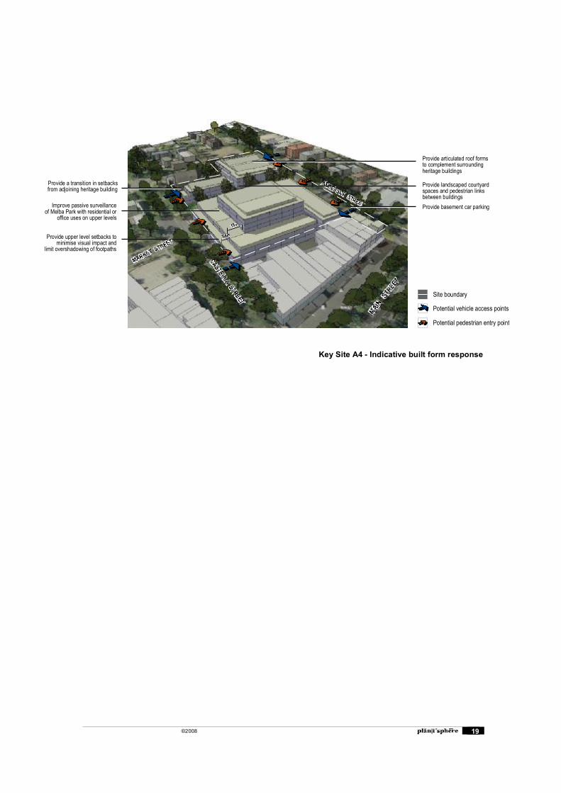
©2008 19
Key Site A4 - Indicative built form response
Provide a transition in setbacksfrom adjoining heritage building
Improve passive surveillanceof Melba Park with residential or
office uses on upper levels
Provide upper level setbacks tominimise visual impact and
limit overshadowing of footpaths
Site boundary
Potential vehicle access points
Potential pedestrian entry point
Provide articulated roof formsto complement surroundingheritage buildings
Provide landscaped courtyardspaces and pedestrian linksbetween buildingsProvide basement car parking
©2008 20
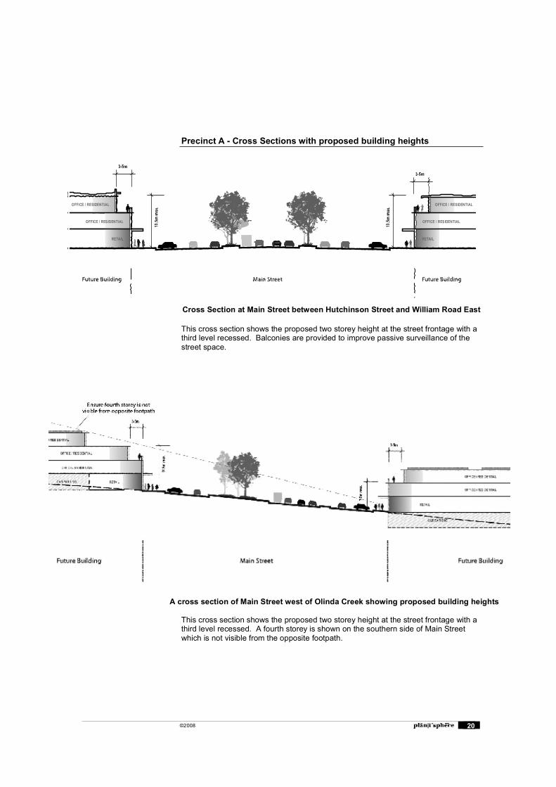
Precinct A - Cross Sections with proposed building heights
This cross section shows the proposed two storey height at the street frontage with a third level recessed. Balconies are provided to improve passive surveillance of the street space.
This cross section shows the proposed two storey height at the street frontage with a third level recessed. A fourth storey is shown on the southern side of Main Street which is not visible from the opposite footpath.
OFFICE / RESIDENTIAL OFFICE / RESIDENTIAL
OFFICE / RESIDENTIAL OFFICE / RESIDENTIAL
RETAIL RETAIL
A cross section of Main Street west of Olinda Creek showing proposed building heights
Cross Section at Main Street between Hutchinson Street and William Road East
©2008 21
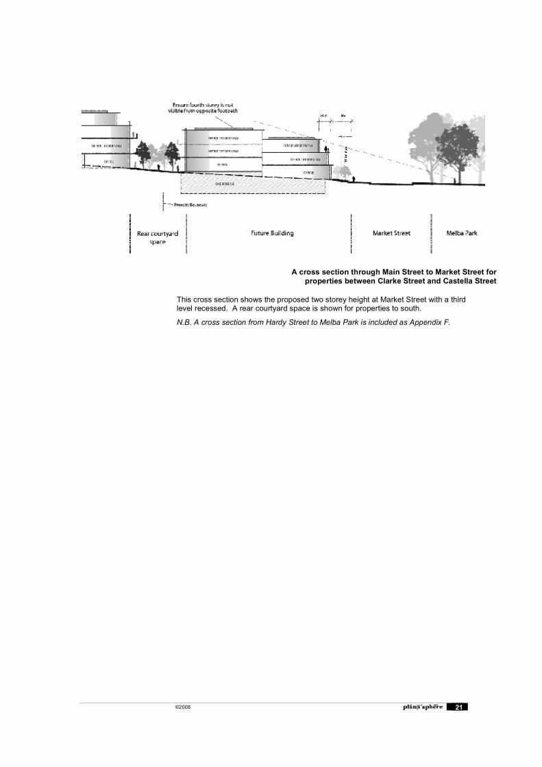
This cross section shows the proposed two storey height at Market Street with a third level recessed. A rear courtyard space is shown for properties to south.
N.B. A cross section from Hardy Street to Melba Park is included as Appendix F.
A cross section through Main Street to Market Street for properties between Clarke Street and Castella Street
©2008 22
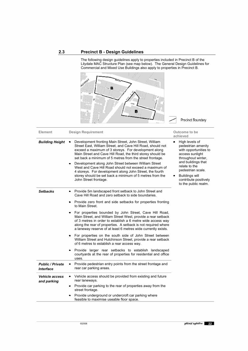
2.3 Precinct B - Design Guidelines
The following design guidelines apply to properties included in Precinct B of the Lilydale MAC Structure Plan (see map below). The General Design Guidelines for Commercial and Mixed Use Buildings also apply to properties in Precinct B.
Element Design Requirement Outcome to be achieved
Building Height Development fronting Main Street, John Street, William Street East, William Street, and Cave Hill Road, should not exceed a maximum of 3 storeys. For development along Main Street and Cave Hill Road, the third storey should be set back a minimum of 5 metres from the street frontage.
Development along John Street between William Street West and Cave Hill Road should not exceed a maximum of 4 storeys. For development along John Street, the fourth storey should be set back a minimum of 5 metres from the John Street frontage.
High levels of pedestrian amenity with opportunities to access sunlight throughout winter, and buildings that relate to the pedestrian scale.
Buildings will contribute positively to the public realm.
Setbacks Provide 5m landscaped front setback to John Street and Cave Hill Road and zero setback to side boundaries.
Provide zero front and side setbacks for properties fronting to Main Street.
For properties bounded by John Street, Cave Hill Road, Main Street, and William Street West, provide a rear setback of 3 metres in order to establish a 6 metre wide access way along the rear of properties. A setback is not required where a laneway reserve of at least 6 metres wide currently exists.
For properties on the south side of John Street between William Street and Hutchinson Street, provide a rear setback of 6 metres to establish a rear access way.
Provide larger rear setbacks to establish landscaped courtyards at the rear of properties for residential and office uses.
Public / Private Interface
Provide pedestrian entry points from the street frontage and rear car parking areas.
Vehicle access and parking
Vehicle access should be provided from existing and future rear laneways.
Provide car parking to the rear of properties away from the street frontage.
Provide underground or undercroft car parking where feasible to maximise useable floor space.
©2008 23
2.4 Precinct D (Olex Cables Site) � Design Guidelines
The following design guidelines apply to the Olex Cables site included within of the Lilydale MAC Structure Plan. The General Design Guidelines for Commercial and Mixed Use Buildings also apply to this site.
Element Design Requirement Outcome to be achieved
Building Appearance
The building should be designed to emphasise the entry into the Centre and follow the alignment of the road.
The southern and wester facades that are visible from the Maroondah Highway should be articulated.
The roof form of the building should be articulated to provide visual interest and emphasise the view across the Yarra Valley.
Colours and materials should be selected to complement the view to the surrounding landscape.
A high quality building that contributes positively to the western entry to Lilydale.
The building is scaled to maintain views from the Maroondah Highway across the Yarra Valley.
Building Height Buildings on the Olex Cable site should not exceed two storeys (8 metres). The building height should not exceed the height of the sawtooth roof line of the existing building to the east.
A landscaped ground level setback of 5 metres should be provided.

©2008 24
2.5 Precinct G � Design Guidelines
The following design guidelines apply to properties included in Precinct G of the Lilydale MAC Structure Plan (see map below). The General Design Guidelines for Commercial and Mixed Use Buildings also apply to properties in Precinct G.
Element Design Requirement Outcome to be achieved
Building Appearance
Provide strongly articulated and active building frontages to the adjoining streets, and the inclusion of covered car parking areas with retail, commercial or residential floorspace above.
Development on the south side of John Street should incorporate individual shopfronts rather than large unarticulated facades.
Development on the south side of John Street should be visually and functionally integrated with the Lilydale Market site.
Development at the proposed Lilydale By-pass frontage should be designed to form and important southern gateway into the Centre, if the By-pass is constructed.
Comprehensive redevelopment of the precinct in a form that promotes strong visual and pedestrian linkages with , the Town Centre precinct the Olinda Creek Parklands and the Swinburne University Campus
Building Height Development along John Street and Hutchinson Street should not exceed a maximum of 3 storeys. Allow development to extend up to 6 storeys (21.5m) at the Melba Avenue (future By-Pass) frontage provided it is set back 20 metres from the southern property boundary.
Setbacks Provide zero front and side setbacks for properties fronting to Hutchinson Street.
Provide a 5m landscaped front setback to John Street and zero side setbacks
For the property to the south, provide a landscaped setback along the northern boundary to screen the servicing area of the shopping centre from future residential development.
For properties fronting the future By-Pass, provide front landscaped setbacks and side setbacks to allow vegetation to permeate between building forms.
Public / Private Interface
Provide active building frontages to Hutchinson Street with verandahs for weather protection.
Provide pedestrian entry points to buildings from the street
©2008 25
Element Design Requirement Outcome to be achieved
frontage and rear car parking areas.
Limit the number and width of vehicle crossing points onto John Street in order to minimise disruption to the footpath.
Provide a pedestrian access path along the east west axis of the shopping Centre site to connect Hutchinson Street to Olinda Creek.
Remove the current impediments to pedestrian connections between the site and the rest of the Town Centre, such as the open car parking area and petrol station,
Create an active interface with the adjoining Olinda Creek parklands which avoid bland and visually dominating building forms. Encourage buildings to take advantage of views into the parkland.
Vehicle access and parking
Vehicle access should be provided from existing and future rear laneways.
Provide underground or, undercroft or roof top car parking where feasible to maximise useable floor space.
Ensure that the car parking and loading bay areas, together with associated vehicle accessways do not provide an impediment to pedestrian traffic moving between the site and the Town Centre and Olinda Creek parklands.
Minimise the potential for conflict between vehicle and pedestrian movements by reducing the number of vehicle crossing points on to John Street.
Landscaping Provide landscaped courtyard spaces within the development of the shopping area.
Ensure any at grade car parking areas are well landscaped.
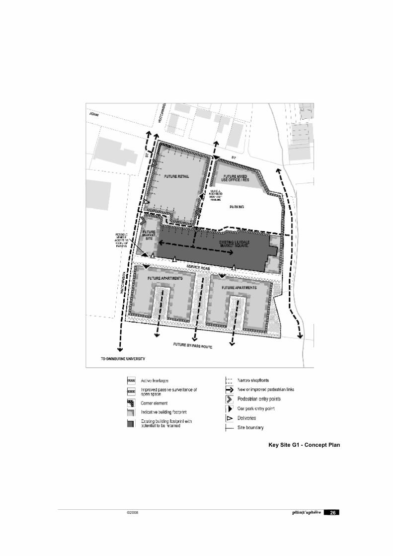
©2008 26
Key Site G1 - Concept Plan
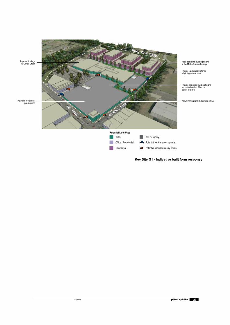
©2008 27
Provide additional building heightand articulated roof form atcorner location
Potential rooftop carparking area
Improve frontageto Olinda Creek
Active frontages to Hutchinson Street
Allow additional building heightat the Melba Avenue frontage
Provide landscape buffer toadjoining service area
Potential vehicle access points
Site Boundary
Potential pedestrian entry points
Office / Residential
Retail
Potential Land Uses
Residential
Key Site G1 - Indicative built form response
©2008 28
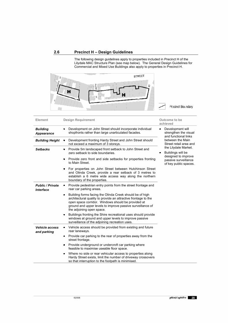
2.6 Precinct H � Design Guidelines
The following design guidelines apply to properties included in Precinct H of the Lilydale MAC Structure Plan (see map below). The General Design Guidelines for Commercial and Mixed Use Buildings also apply to properties in Precinct H.
Element Design Requirement Outcome to be achieved
Building Appearance
Development on John Street should incorporate individual shopfronts rather than large unarticulated facades.
Development will strengthen the visual and functional links between the Main Street retail area and the Lilydale Market.
Buildings will be designed to improve passive surveillance of key public spaces.
Building Height Development fronting Hardy Street and John Street should not exceed a maximum of 3 storeys.
Setbacks Provide 5m landscaped front setback to John Street and zero setback to side boundaries.
Provide zero front and side setbacks for properties fronting to Main Street.
For properties on John Street between Hutchinson Street and Olinda Creek, provide a rear setback of 3 metres to establish a 6 metre wide access way along the northern boundary of the properties.
Public / Private Interface
Provide pedestrian entry points from the street frontage and rear car parking areas.
Building forms facing the Olinda Creek should be of high architectural quality to provide an attractive frontage to the open space corridor. Windows should be provided at ground and upper levels to improve passive surveillance of the adjoining open space.
Buildings fronting the Shire recreational uses should provide windows at ground and upper levels to improve passive surveillance of the adjoining recreation uses.
Vehicle access and parking
Vehicle access should be provided from existing and future rear laneways.
Provide car parking to the rear of properties away from the street frontage.
Provide underground or undercroft car parking where feasible to maximise useable floor space.
Where no side or rear vehicular access to properties along Hardy Street exists, limit the number of driveway crossovers so that interruption to the footpath is minimised.
©2008 29
2.7 Signage
This Report is not a comprehensive signage policy for the Lilydale Major Activity Centre, but is limited to some general principles regarding signage to buildings. Signs are to meet the relevant provisions of Council�s �Streets and Roads Local Law�.
Three types of signage are identified: Business identification Product advertisement (for products which are not directly related to the premises
on which the sign is sited) Civic
Business identification signage is critical to users of the centre as it advises of the nature of goods and services offered at particular premises, including by business names or brand names. Brand names, while being a product advertisement, are also widely recognised and used as identification of a particular type of business. This raises the issue of the overlap between business identification and product advertisement.
Product Advertisement Signage promotes products or services which are not available at the premises on which it is sited, and includes billboards and the like. While these are an accepted element of commercial environments, their number, location and size should be controlled to avoid their dominance of the public realm.
Civic signage includes information and advisory signage installed by Council in public areas to designate public facilities and places. Among other signs, such as road and traffic signs, civic signage can make a positive contribution to the character of an area, by its design, location, size and style. It is impractical to expect all civic signage to be of the same style or design as signs are progressively installed over time.
Recommendation
Implement the following principles for signage through the application of a Design and Development Overlay
Business identification, Product Advertisement and Civic signage should be: Of a size and height that is complementary to the built form of the building and
surrounding landscape, and does not detract from public viewlines; externally illuminated rather than internally; and of a design, and of colours and style that harmonise with the environment rather
that dominate it or contrast with it;
Business Identification Signage should: be integrated into the built form of the building so it becomes a logical element of
the façade; be limited in number and incorporate limited detail other than is necessary to
identify the building name and key tenants; be consolidated in mixed use and commercial developments to avoid the visual
clutter of signage and displays; and not use bold coloured painted surfaces on building walls or windows for the
purposes of advertising.
Civic Signage should: Where fixed to a building, be integrated into the built form so it becomes a logical
element of the façade; where free-standing, be combined with other signs to minimise the number of
support poles and reduce visual clutter; and reflect the nature of the site or service that it applies to.
©2008 30
3. Design Guidelines: Residential Areas
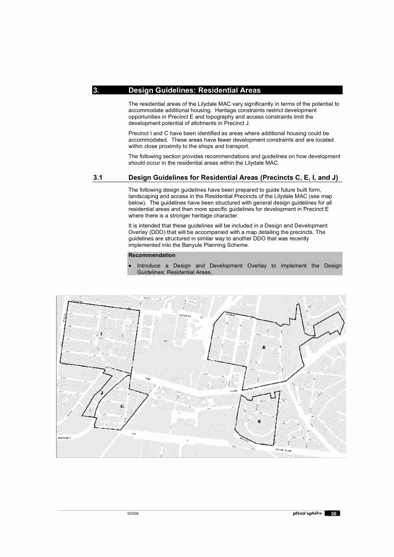
The residential areas of the Lilydale MAC vary significantly in terms of the potential to accommodate additional housing. Heritage constraints restrict development opportunities in Precinct E and topography and access constraints limit the development potential of allotments in Precinct J.
Precinct I and C have been identified as areas where additional housing could be accommodated. These areas have fewer development constraints and are located within close proximity to the shops and transport.
The following section provides recommendations and guidelines on how development should occur in the residential areas within the Lilydale MAC.
3.1 Design Guidelines for Residential Areas (Precincts C, E, I, and J)
The following design guidelines have been prepared to guide future built form, landscaping and access in the Residential Precincts of the Lilydale MAC (see map below). The guidelines have been structured with general design guidelines for all residential areas and then more specific guidelines for development in Precinct E where there is a stronger heritage character.
It is intended that these guidelines will be included in a Design and Development Overlay (DDO) that will be accompanied with a map detailing the precincts. The guidelines are structured in similar way to another DDO that was recently implemented into the Banyule Planning Scheme.
Recommendation
Introduce a Design and Development Overlay to implement the Design Guidelines: Residential Areas.
©2008 31
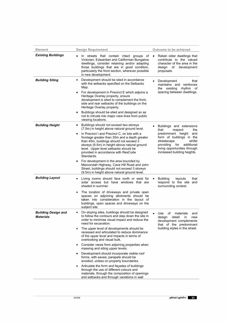
Element Design Requirement Outcome to be achieved Existing Buildings In streets that contain intact groups of
Victorian, Edwardian and Californian Bungalow dwellings, consider retaining and/or adapting those buildings that are in good condition, particularly the front section, wherever possible in new development.
Retain older dwellings that contribute to the valued character of the area in the design of development proposals.
Building Siting Development should be sited in accordance with the setbacks specified on the Setbacks Map.
For development in Precinct E which adjoins a Heritage Overlay property, ensure development is sited to complement the front, side and rear setbacks of the buildings on the Heritage Overlay property.
Buildings should be sited and designed so as not to intrude into major view lines from public viewing locations.
Development that maintains and reinforces the existing rhythm of spacing between dwellings.
Building Height Buildings should not exceed two storeys (7.5m) in height above natural ground level.
In Precinct I and Precinct C, on lots with a frontage greater than 30m and a depth greater than 45m, buildings should not exceed 3 storeys (9.5m) in height above natural ground level. Upper level setbacks should be provided in accordance with ResCode Standards.
For development in the area bounded by Maroondah Highway, Cave Hill Road and John Street, buildings should not exceed 3 storeys (9.5m) in height above natural ground level.
Buildings and extensions that respect the predominant height and form of buildings in the streetscape whilst providing for additional living opportunities through increased building heights.
Building Layout Living rooms should face north or west for solar access but have windows that are shaded in summer.
The location of driveways and private open spaces on adjoining allotments should be taken into consideration in the layout of buildings, open spaces and driveways on the subject site.
Building layouts that respond to the site and surrounding context.
Building Design and Materials
On sloping sites, buildings should be designed to follow the contours and step down the site in order to minimise visual impact and reduce the need for excavation.
The upper level of developments should be recessed and articulated to reduce dominance of the upper level and impacts in terms of overlooking and visual bulk.
Consider views from adjoining properties when massing and siting upper levels.
Development should incorporate visible roof forms, with eaves; parapets should be avoided, unless on property boundaries.
Articulate the form and façades of buildings through the use of different colours and materials, through the composition of openings and setbacks and through variations in wall
Use of materials and design detail in new development complements that of the predominant building styles in the street.
©2008 32
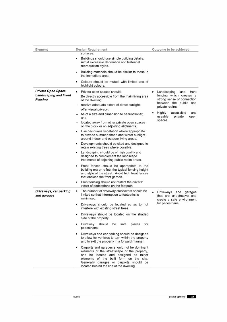
Element Design Requirement Outcome to be achieved surfaces.
Buildings should use simple building details. Avoid excessive decoration and historical reproduction styles.
Building materials should be similar to those in the immediate area.
Colours should be muted, with limited use of highlight colours.
Private Open Space, Landscaping and Front Fencing
Private open spaces should: Be directly accessible from the main living area
of the dwelling; receive adequate extent of direct sunlight; offer visual privacy; be of a size and dimension to be functional;
and located away from other private open spaces
on the block or on adjoining allotments. Use deciduous vegetation where appropriate
to provide summer shade and winter sunlight around indoor and outdoor living areas.
Developments should be sited and designed to retain existing trees where possible.
Landscaping should be of high quality and designed to complement the landscape treatments of adjoining public realm areas.
Front fences should be appropriate to the building era or reflect the typical fencing height and style of the street. Avoid high front fences that enclose the front garden.
Front fencing should not restrict the drivers� views of pedestrians on the footpath.
Landscaping and front fencing which creates a strong sense of connection between the public and private realms.
Highly accessible and useable private open spaces.
Driveways, car parking and garages
The number of driveway crossovers should be limited so that interruption to footpaths is minimised.
Driveways should be located so as to not interfere with existing street trees.
Driveways should be located on the shaded side of the property.
Driveway should be safe places for pedestrians.
Driveways and car parking should be designed to allow for vehicles to turn within the property and to exit the property in a forward manner.
Carports and garages should not be dominant elements of the streetscape or the property, and be located and designed as minor elements of the built form on the site. Generally garages or carports should be located behind the line of the dwelling.
Driveways and garages that are unobtrusive and create a safe environment for pedestrians.
©2008 33
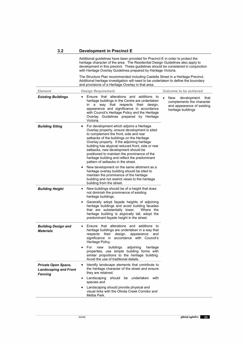
3.2 Development in Precinct E
Additional guidelines have been provided for Precinct E in order to protect the heritage character of the area. The Residential Design Guidelines also apply to development in this precinct. These guidelines should be considered in conjunction with Heritage Overlay Guidelines prepared by Heritage Victoria.
The Structure Plan recommended including Castella Street in a Heritage Precinct. Additional heritage investigation will need to be undertaken to define the boundary and provisions of a Heritage Overlay in that area.
Element Design Requirement Outcome to be achieved Existing Buildings Ensure that alterations and additions to
heritage buildings in the Centre are undertaken in a way that respects their design, appearance and significance in accordance with Council�s Heritage Policy and the Heritage Overlay Guidelines prepared by Heritage Victoria.
New development that complements the character and appearance of existing heritage buildings
Building Siting For development which adjoins a Heritage Overlay property, ensure development is sited to complement the front, side and rear setbacks of the buildings on the Heritage Overlay property. If the adjoining heritage building has atypical reduced front, side or rear setbacks, new development should be positioned to maintain the prominence of the heritage building and reflect the predominant pattern of setbacks in the street.
New development on the same allotment as a heritage overlay building should be sited to maintain the prominence of the heritage building and not restrict views to the heritage building from the street.
Building Height New buildings should be of a height that does not diminish the prominence of existing heritage buildings.
Generally adopt façade heights of adjoining heritage buildings and avoid building facades that are substantially lower. Where the heritage building is atypically tall, adopt the predominant façade height in the street.
Building Design and Materials
Ensure that alterations and additions to heritage buildings are undertaken in a way that respects their design, appearance and significance in accordance with Council�s Heritage Policy.
For new buildings adjoining heritage properties, use simple building forms with similar proportions to the heritage building. Avoid the use of traditional details.
Private Open Space, Landscaping and Front Fencing
Identify landscape elements that contribute to the heritage character of the street and ensure they are retained.
Landscaping should be undertaken with species and
Landscaping should provide physical and visual links with the Olinda Creek Corridor and Melba Park.

©2008 34
Element Design Requirement Outcome to be achieved New front fencing should reflect fencing related
to the dwelling style
Driveways, car parking and garages
Driveway crossovers should be limited and the bluestone channelling should be retained if crossovers are altered.
©2008 35
3.3 Encouraging consolidation of residential lots in Precinct I and C
The structure Plan advocates the consolidation of allotments in Precinct I and Precinct C in order to achieve more efficient development and better design outcomes. There are a number of options that can be explored to encourage the consolidation of allotments through the application of a Design and Development Overlay.
Capturing consolidated allotments
Allotments within precinct C and Precinct I are very consistent in their dimensions. Lot widths are typically between 15m and 20m and lot depths are between 45m and 60m. Therefore it is possible to make assumptions about the future width and depth of consolidated allotments so that incentives can be provided for properties with those particular dimensions.
It is considered that a width of at least 30m and a depth of at least 45m would be a sufficient dimension to capture consolidated allotments in Precinct C and I. The incentives below could be applied to lots that meet these dimensions.
Incentives for development on consolidated allotments
A number of options have been provided to encourage development on consolidated allotments. Each of these options could be implemented through the Design and Development Overlay.
Increasing building site coverage
The ResCode Standard for building site coverage could be increased for consolidated allotments. The current building site coverage requirement in ResCode is 60%.
The option to increase the building site coverage is a less desirable option. Medium density housing developments rarely achieve current maximum of 60% because of the space required for car parking and access ways, the setback requirements, and the provision of private open space. Increasing the site coverage could potentially impact on the spacious character of the area and could result in less useable private open space areas. Therefore this option is not supported.
Reducing building setbacks
Front, side and rear setbacks could be reduced for development on consolidated allotments.
Reducing the side and rear setback requirements could have negative impacts on neighbourhood character and amenity.
Allowing additional building height
Additional height could be permitted on consolidated sites as large sites can provide for taller building forms with minimal impact on the street and neighbouring properties.
This option is in accordance with the Structure Plan and potentially provides the greatest incentive for lot consolidation. Additional height within the site away from the property boundaries, would provide for efficient use of land, and could have minimal impact on streetscapes and neighbouring properties.
The design studies we have undertaken (see diagrams below) show that a consolidation of two lots can produce a yield as high as ten dwellings if the height is increased to three storeys. This should provide a substantial incentive over and above the three dwelling yield for a single site (pro rata six dwellings for two individual lots) that is typically approved at present. An even greater net gain in yield arises from three storey development on a triple allotment.
Allowing higher yields
Standards can be applied in a way that allows a higher yield of dwellings on a consolidated site than on individual lots.
©2008 36
The first of the design studies shows that, even without the third storey �bonus�, a worthwhile gain of one additional dwelling can be obtained when two lots are consolidated (see diagram with seven 2 storey dwellings). To apply this as an incentive for consolidation, the Council would need to make clear that it will apply the DDO in a way that will generally limit development on a single standard lot to a maximum of three dwellings. Under the present VPPs, this cannot take the form of a density control. Rather it would represent the outcome of assessing a development�s qualities against a range of performance standards.
Conclusion
Out of all of the above options, the option to allow additional height has been recommended in the Design Guidelines in Section 3.1. This recommendation is consistent with the Structure Plan.
Recommendation
Introduce a Design and Development Overlay to allow for additional building height on sites with a width greater than 30m and a depth greater than 45m. Refer to the Residential Design Guidelines in Section 3.1 for more detail.
3.4 Examples of development on consolidated allotments
Two examples have been provided to demonstrate how development should occur on consolidated allotments.
These examples could be developed into brochures to assist applicants and Council planners in developing and assessing design responses of consolidated allotments.
Recommendation
Prepare illustrated brochures detailing appropriate design responses for consolidated allotments. The brochures could be used by applicants to assist with the preparation of design responses and used by Council officers to help with assessing permit applications.
©2008 37
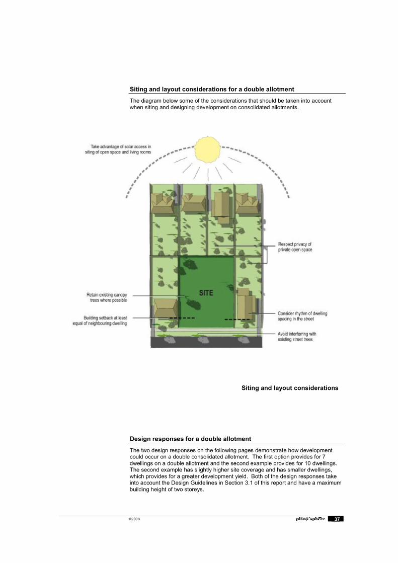
Siting and layout considerations for a double allotment
The diagram below some of the considerations that should be taken into account when siting and designing development on consolidated allotments.
Design responses for a double allotment
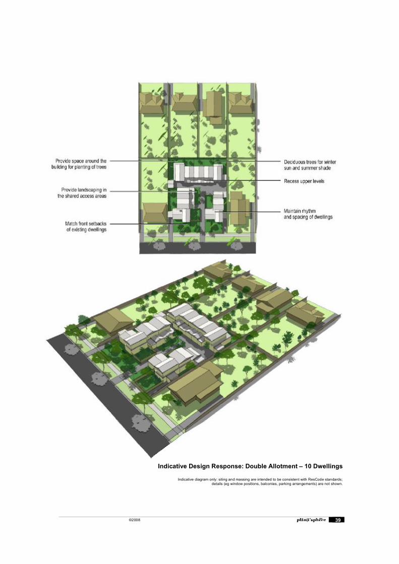
The two design responses on the following pages demonstrate how development could occur on a double consolidated allotment. The first option provides for 7 dwellings on a double allotment and the second example provides for 10 dwellings. The second example has slightly higher site coverage and has smaller dwellings, which provides for a greater development yield. Both of the design responses take into account the Design Guidelines in Section 3.1 of this report and have a maximum building height of two storeys.
Siting and layout considerations
©2008 38
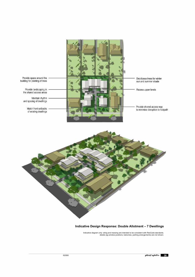
Indicative Design Response: Double Allotment � 7 Dwellings
Indicative diagram only: siting and massing are intended to be consistent with ResCode standards;details (eg window positions, balconies, parking arrangements) are not shown.
©2008 39
Indicative Design Response: Double Allotment � 10 Dwellings
Indicative diagram only: siting and massing are intended to be consistent with ResCode standards;details (eg window positions, balconies, parking arrangements) are not shown.

©2008 40
Design Response for a triple allotment
The design response below indicates how development could occur on a triple consolidated allotment. This example provides for an apartment style development which extends to three storeys in some parts. The potential dwelling yield from this development is up to 15 apartments depending on the desired floor areas.
The design response takes into account the Design Guidelines contained in Section 3.1 of this report.

©2008 41
4. Public Realm
The recommendations for public realm improvements build on the findings of the Structure Plan. A number of landscape improvements are proposed in the Centre as shown on the map below. Many of these recommendations are described in more detail in this section.
4.1 Public Realm Recommendations Map
Indicative Design Response: Triple Allotment � 15 dwellings approx.
Indicative diagram only: siting and massing are intended to be consistent with ResCode standards;details (eg window positions, balconies, parking arrangements) are not shown.
©2008 42
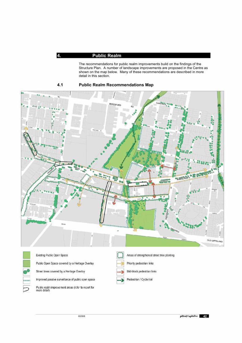
4. Public Realm
The recommendations for public realm improvements build on the findings of the Structure Plan. A number of landscape improvements are proposed in the Centre as shown on the map below. Many of these recommendations are described in more detail in this section.
4.1 Public Realm Recommendations Map
©2008 43
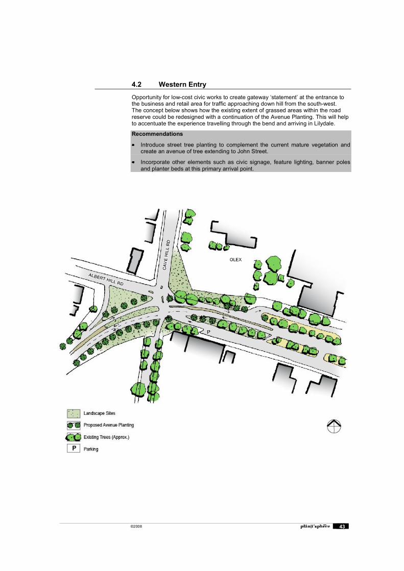
4.2 Western Entry
Opportunity for low-cost civic works to create gateway �statement� at the entrance to the business and retail area for traffic approaching down hill from the south-west. The concept below shows how the existing extent of grassed areas within the road reserve could be redesigned with a continuation of the Avenue Planting. This will help to accentuate the experience travelling through the bend and arriving in Lilydale.
Recommendations
Introduce street tree planting to complement the current mature vegetation and create an avenue of tree extending to John Street.
Incorporate other elements such as civic signage, feature lighting, banner poles and planter beds at this primary arrival point.
©2008 44
4.3 Eastern Entry
Buildings on north-west and south-west corners of Anderson Street and Main Street can be more prominent and designed with �civic� landmark role as a key built form element. This is recommended in the design guidelines for these sites. The Lilydale Structure Plan proposes treatments to Maroondah Highway further east.
Recommendations
Provide for distinctive building forms with strong corner element to mark the eastern entrance to the Centre. This is supported in the Design Guidelines for these key sites.
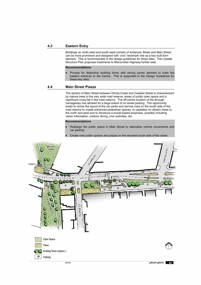
4.4 Main Street Piazza
The section of Main Street between Olinda Creek and Castella Street is characterised by mature trees in the very wide road reserve, areas of public open space and a significant cross-fall in the road reserve. The off-centre location of the through carriageway has allowed for a large extent of on-street parking. The opportunity exists to revise the layout of the car parks and service road on the south side of the road reserve to create enhanced pedestrian spaces, to capitalise on distant views to the north and west and to introduce a tourist-based emphasis, possibly including visitor information, outdoor dining, civic activities, etc.
Recommendations
Redesign the public space in Main Street to rationalise vehicle movements and car parking.
Create new public spaces and plazas on the elevated south side of the street.
©2008 45
4.5 Priority Pedestrian Routes
Several major in-centre pedestrian routes have been identified in the Structure Plan. A number of the routes are currently functioning well and provide high levels of amenity and a perception of safety for pedestrians. Some streets however, will require additional public and private realm works to improve their function as pedestrian routes.
Hutchinson Street
Hutchinson Street provides access from the Main Street and the station to the Lilydale Market Square Shopping Centre and Swinburne University. The footpaths are currently very narrow particularly for a primary pedestrian route. This is mainly due to the wide grassed nature strips, which occupy about two thirds of the footpath reserve. An opportunity exists to remove the grassed nature strips and replace with paved surfaces which will provide for a path of approximately 3 metres wide.
The absence of street trees is another element which diminishes pedestrian comfort and amenity. There is a possibility of providing street trees between car parking bays in the road reserve, which will ensure the footpath is not interrupted. Street furniture could be located to take advantage of the shade.
Recommendations
Promote retail uses along Hutchinson Street with active ground floor uses and office and residential uses on upper levels.
Increase the width of the footpaths to 3 metres by removing unnecessary grassed nature strips.
Provide street tree planting within the road reserve for beautification and shade.
Limit the number of driveway crossovers per business and implement rear laneways for vehicle access to properties.
John Street
John Street is an important pedestrian route that will connect residential areas from the east and west to the shops and businesses. Currently the street is unattractive and unsafe for pedestrians because of narrow footpaths, no street trees, limited active uses and buildings to provide passive surveillance of the street, and a large number of driveway crossovers which interrupt the footpath.
Recommendations
Promote uses which increase activity on the street
Provide reduced landscaped building setback to create a presence of buildings and activity in the street (refer to Setbacks section)
Provide wider pedestrian paths by removing grassed nature strips and replacing with paved surfacing.
Provide street tree planting for beautification and shade. Species should be carefully selected for durability and size and tree protection may be necessary to prevent damage from vehicles.
Limit the number of driveway crossovers and establish a rear laneway for vehicle access.
William Street East (School Route)
This is the primary route for students moving between the station and the school. Recent work has been undertaken between Main Street and John Street with widened footpaths and street tree planting. South of John Street the footpath is narrow and some parking on the nature strip occurs. There are no street trees for shade in this area.
©2008 46
The roundabout at John Street presents an issue for students crossing the road. Roundabouts allow for a constant flow of traffic which gives pedestrians little time to cross between vehicle movements. Consideration should be given to pedestrian priority at the roundabout on the eastern side.
Recommendations
Provide a wider pedestrian path between John Street and the school by removing the grassed nature strip on the east side of the road and replacing with paved surfacing.
Provide street tree planting for shade between John Street and the school.
Consider providing pedestrian priority at the John Street / William Street East roundabout. This could be implemented with a zebra pedestrian crossing on the east side of William Street east.
Kidgell Street and Albert Hill Road (northern section)
These streets form a primary pedestrian route to the town centre from residential areas in the west. There is currently and lack of street trees along this route providing minimal shade for pedestrians. The absence of footpaths along Kidgell Street could limit access opportunities for people with limited mobility.
Recommendations
Establish a footpath on at least one side of Kidgell Street, preferably both sides.
Implement street tree planting with species that will provide sufficient shade for pedestrians
4.6 New or improved mid block pedestrian links
Council Offices to Main Street
This link is important for connecting civic uses to the shopping areas in Main Street and the Castella Heritage Precinct. From the council offices, a link through the property of the White Dog Hotel is currently used. This link is not formalised and occurs through private property.
There is no signalised pedestrian crossing at the conclusion of this link to provide access to the opposite side of Main Street and the Castella Street Heritage Precinct. The closest crossings are located approximately 130 metres to the east and west. It may not be feasible to provide an additional crossing at this location give the proximity of the other crossings.
Recommendations
Negotiate with the owner of the White Dog Hotel to formalise pedestrian access through the site. If agreed, provide a paved surface with sufficient lighting along the east side of the property.
Give consideration to an additional signalised crossing at the intersection of Castella Street and Main Street. The need for this crossing may become less important if traffic flows are reduced through the implementation of the Bypass.
©2008 47
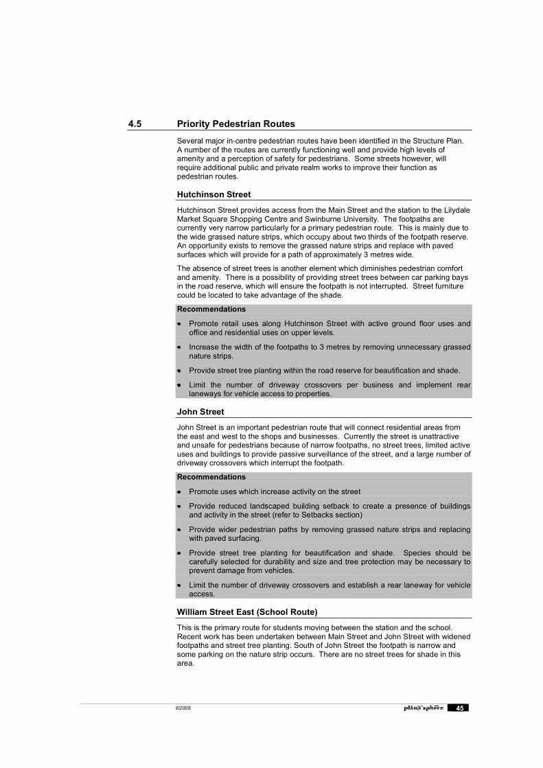
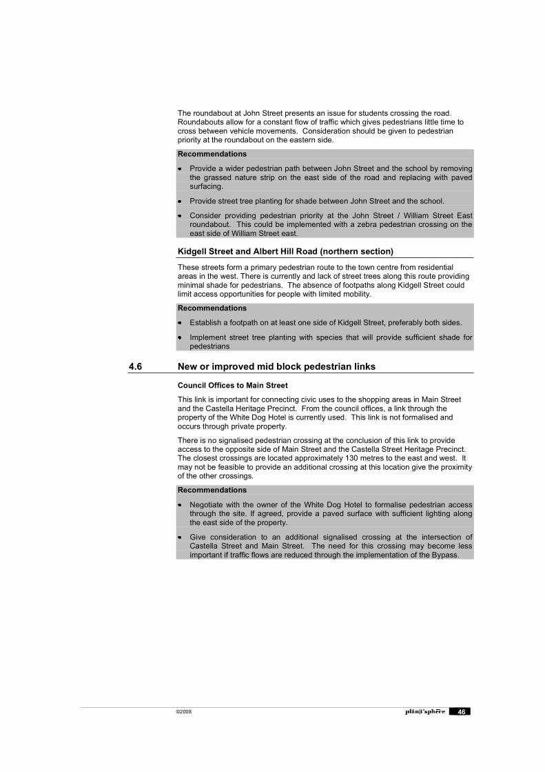
Main Street to Market Street
A gap in the buildings at 267 Main Street provides a link between Main Street and Market Street through a rear car park. Pedestrian access through the car park is not defined and parking bays are located along the preferred pedestrian route. There is an opportunity to improve access through to Market Street and Melba Park by defining the preferred route for pedestrians.
Recommendations
Negotiate with the owner 267 Main Street formalise pedestrian access through the rear car park to Market Street. If agreed, delineate a path through the car park through paving and asphalt markings.
Ensure a mid block link is provided in any redevelopment of the property.
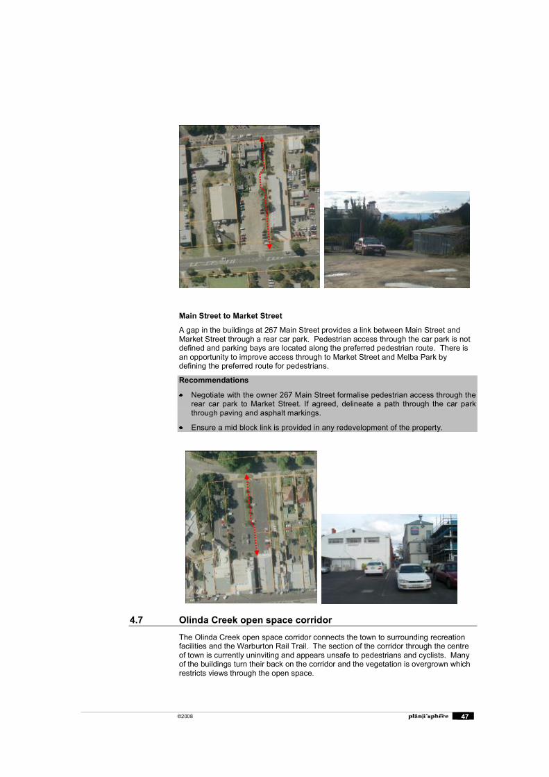
4.7 Olinda Creek open space corridor
The Olinda Creek open space corridor connects the town to surrounding recreation facilities and the Warburton Rail Trail. The section of the corridor through the centre of town is currently uninviting and appears unsafe to pedestrians and cyclists. Many of the buildings turn their back on the corridor and the vegetation is overgrown which restricts views through the open space.
©2008 48
Dense understorey vegetation limits views of the Olinda Creek Open Space corridor from adjoining areas.
There is potential to focus new and existing buildings to address open space visually and functionally and to improve use of and surveillance of corridor. There would be benefit to these abutting land uses if some reduction in understorey planting occurred and the level of lighting was upgraded.
Recommendations
Re-orientate buildings to face Olinda Creek to improve visual surveillance of the open space (refer to the open space plan for locations). Provide upper level residential and office land uses which also overlook the space.
Provide enhanced lighting of the pedestrian paths.
Undertake the thinning of understorey vegetation in key locations to provide views to the open space.
Consider temporary planting to screen unsightly development on the east side of Olinda Creek until buildings are redeveloped.
Improve pedestrian safety and pedestrian priority at road crossings.
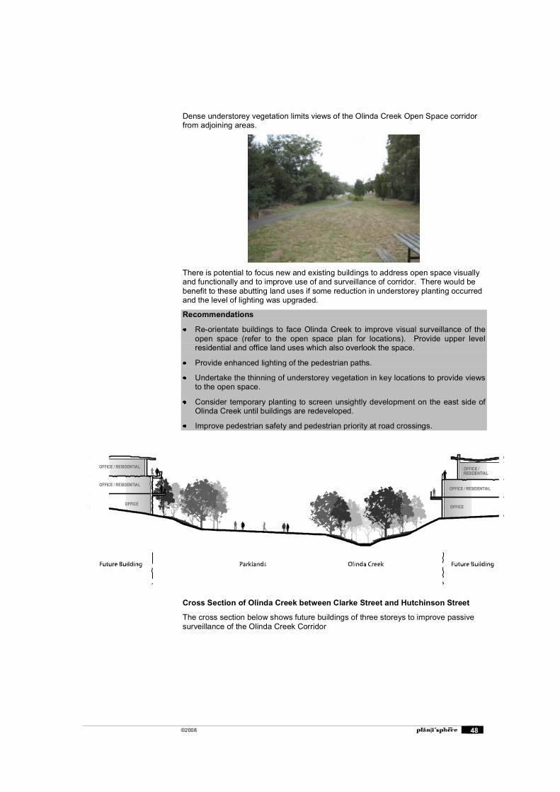
Cross Section of Olinda Creek between Clarke Street and Hutchinson Street
The cross section below shows future buildings of three storeys to improve passive surveillance of the Olinda Creek Corridor
OFFICE / RESIDENTIAL
OFFICEOFFICE
OFFICE / RESIDENTIAL
OFFICE / RESIDENTIAL
OFFICE /RESIDENTIAL
©2008 49
5. Vehicle Access, Parking and Other Recommendations
5.1 Vehicle Access
The design guidelines included in Chapter 2 of this report provide general guidance for the design and location of vehicle access within the Lilydale MAC. This section provides specific locations for improved vehicle access which will be achieved through the establishment and widening of laneways to access properties in the Centre.
Rear laneway improvements
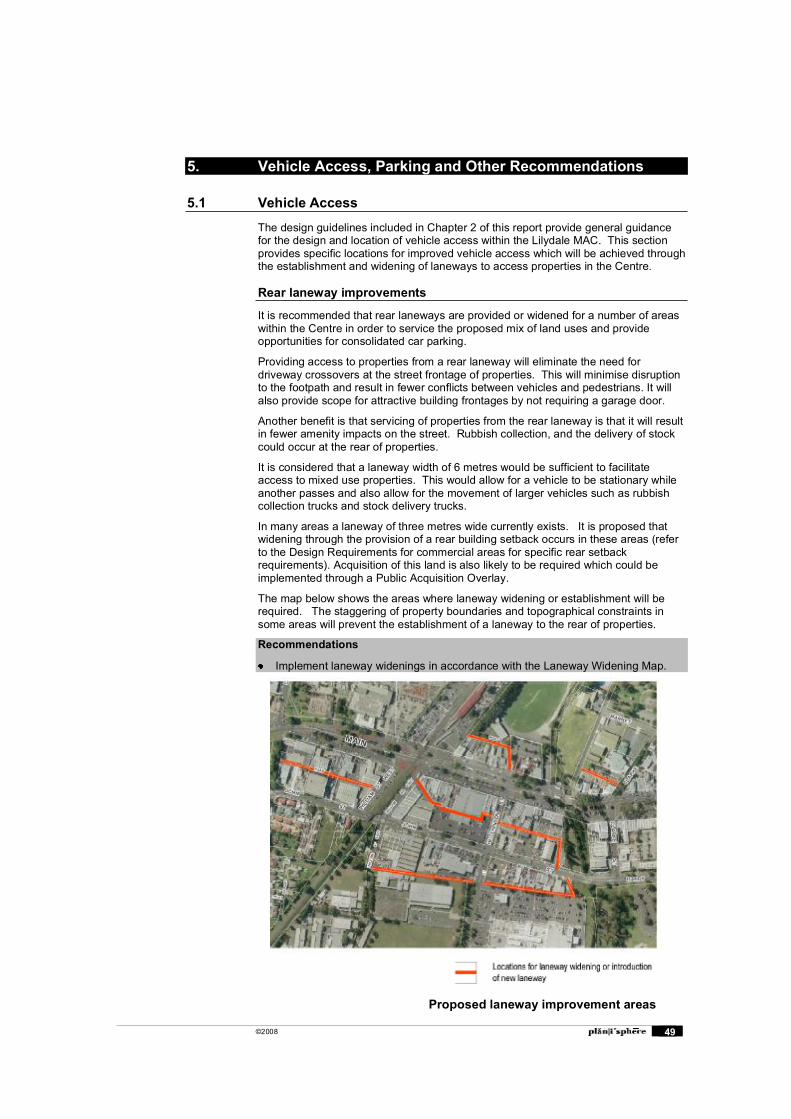
It is recommended that rear laneways are provided or widened for a number of areas within the Centre in order to service the proposed mix of land uses and provide opportunities for consolidated car parking.
Providing access to properties from a rear laneway will eliminate the need for driveway crossovers at the street frontage of properties. This will minimise disruption to the footpath and result in fewer conflicts between vehicles and pedestrians. It will also provide scope for attractive building frontages by not requiring a garage door.
Another benefit is that servicing of properties from the rear laneway is that it will result in fewer amenity impacts on the street. Rubbish collection, and the delivery of stock could occur at the rear of properties.
It is considered that a laneway width of 6 metres would be sufficient to facilitate access to mixed use properties. This would allow for a vehicle to be stationary while another passes and also allow for the movement of larger vehicles such as rubbish collection trucks and stock delivery trucks.
In many areas a laneway of three metres wide currently exists. It is proposed that widening through the provision of a rear building setback occurs in these areas (refer to the Design Requirements for commercial areas for specific rear setback requirements). Acquisition of this land is also likely to be required which could be implemented through a Public Acquisition Overlay.
The map below shows the areas where laneway widening or establishment will be required. The staggering of property boundaries and topographical constraints in some areas will prevent the establishment of a laneway to the rear of properties.
Recommendations
Implement laneway widenings in accordance with the Laneway Widening Map.
Proposed laneway improvement areas
©2008 50
5.2 Estimated numbers of car parks required
Appendix D provides a detailed investigation into the numbers of car parks that will be required in the Centre in order to implement the proposed built form and land use findings in this report.
The number of car parks required for the recommended land uses and building envelopes is significant and may limit development opportunities in the Centre. For developments with at grade car parking, less than 40% of the total site will be available for buildings if the car parking requirements are satisfied. For basement car parking, two basement levels will be required to meet the number of required car parks, which may not be feasible.
There are a number of options that could be explored to reduce car parking requirements on each site, or provide for more efficient forms of car parking.
Cash-in-lieu levy
Where it is impractical to provide parking spaces on the development land in accordance with the rates specified, (or on another suitable site within the Activity Centre), developers could be required to make a payment in-lieu of the parking. This levy would need to be established through the preparation of a Parking Precinct Plan which will determine a suitable levy per car park and identify what the funds should be allocated to.
The cash-in-lieu levy could be used to fund the construction costs of a multi-storey parking facility in the area or fund a range of sustainable transport initiatives including pedestrian access, cycling and public transport, to reduce the need for car parking in the Centre.
Consolidation of existing car parks
Consolidation of existing car parks in the Centre can increase the total car parking supply by providing for more efficient layouts. Section 5.3 provides an example of how car parking could be consolidated for a particular area. A plan for consolidation may need to be implemented through a Parking Precinct Plan.
Reduced car parking rates
Council could introduce reduced car parking rates for particular land uses as part of the Parking Precinct Plan. This could be determined by conducting empirical surveys to estimate the current and future car parking demand for particular land uses in the Centre.
Waiving of car parking requirements
A permit can be issued to waive the number parks required for a particular use. The applicant is required to provide justification for the reduction. Such reasons could include: The availability of car parking in the area Availability of public transport Any credit associated with uses on the land before new rates were introduced Any reduction in car parking demand because of the shared use of spaces or
increased efficiencies in car parking layouts An empirical assessment of the car parking demand.
Recommendations
Investigate some of the options listed above to develop ways to manage car parking for future development in the Centre.
Consider the preparation of a Parking Precinct Plan for the Centre.
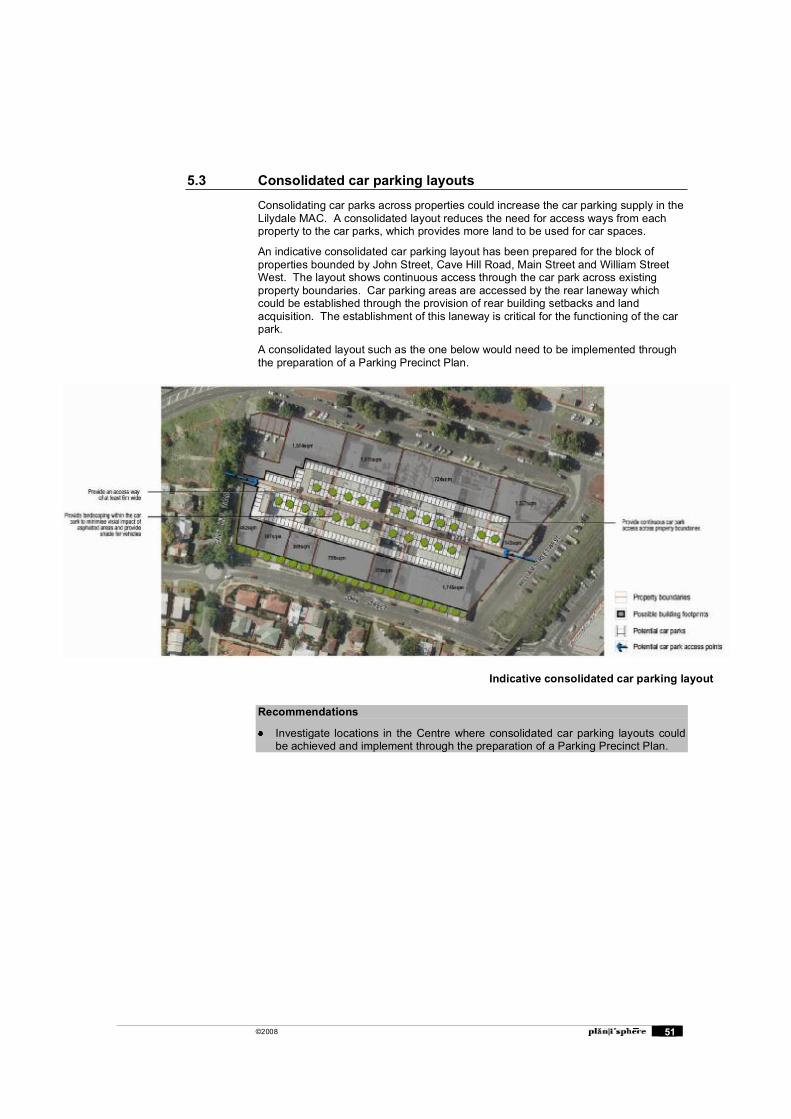
©2008 51
5.3 Consolidated car parking layouts
Consolidating car parks across properties could increase the car parking supply in the Lilydale MAC. A consolidated layout reduces the need for access ways from each property to the car parks, which provides more land to be used for car spaces.
An indicative consolidated car parking layout has been prepared for the block of properties bounded by John Street, Cave Hill Road, Main Street and William Street West. The layout shows continuous access through the car park across existing property boundaries. Car parking areas are accessed by the rear laneway which could be established through the provision of rear building setbacks and land acquisition. The establishment of this laneway is critical for the functioning of the car park.
A consolidated layout such as the one below would need to be implemented through the preparation of a Parking Precinct Plan.
Recommendations
Investigate locations in the Centre where consolidated car parking layouts could be achieved and implement through the preparation of a Parking Precinct Plan.
Indicative consolidated car parking layout
©2008 52
5.4 Rail Station and ancillary uses
The Lilydale rail station and its associated car parking, train stabling, bus and taxi facilities has been the topic of consideration regarding relocation for some time. A key factor in this discussion has been the disruption to traffic at the Main Street level crossing and the consequent use of John Street and smaller connecting streets by traffic avoiding this delay point.
The option of building a new station to the south of Main Street has had some attention, although trains would still need to cross Main Street to access the stabling yards. The possible extension of rail services to Coldstream would further add to the extent of trains crossing Main Street.
The future need for additional commuter car parking is not known, although the Lilydale Structure Plan alludes to the possible provision of multi-level parking in the future.
The prospect of grade separation of Main Street and the rail line has also been canvassed. The low clearance underpass at John Street is a factor in this equation, as is the proposed by-pass route along Melba Avenue. Also, the existing station building is inadequate for the volume of passengers using the station, but its heritage classification (HO399 in the Yarra Ranges Planning Scheme) precludes redevelopment.
These factors all indicate the need for a comprehensive strategic and economic study of future rail services in Lilydale and the most appropriate solution for the rail alignment, possible grade separation and station location.
In the context of this project, it is considered that the feasibility of relocating the station to south side of Main Street is unlikely. This is because of the prospective land area is considered to be insufficient for the ancillary uses (commuter parking, bus terminal, taxi rank, etc.), and due to the high capital cost and questionable economic justification. This report therefore concentrates on urban improvements based on the station remaining in its current location, and the level crossing at Main Street remaining.
There is potential to enhance pedestrian amenity during change of mode and for access to/from station in terms of safety and comfort of bus and taxi passengers. It is beyond the scope of this project to fully investigate this topic and any recommendations for improved pick-up and drop-off facilities and improvement to pedestrian movement routes should be the result of surveys and analysis.
However, it is evident that the intersection of Main Street / William Street East and the station entrance would benefit from the introduction of traffic signals, linked to the railway gates and programmed to facilitate pedestrian movements from the station and bus terminal to the south side of Main Street. This would reduce the random impacts on through traffic of the railway gates and the existing pedestrian crossing.
Recommendations
Consider the preparation of a comprehensive strategic and economic study for the future redevelopment of the transport interchange.
In the short term, consider the introduction of traffic signals at the intersection of Main Street / William Street East and the station entrance to facilitate pedestrian movement across to the south side of Main Street.

©2008 53
6. Implementing the Urban Improvement Project and the Structure Plan
This section provides an overview of the options for Implementation of the Urban Improvement Project and the Structure Plan.
The Urban Improvement Project has provided recommendations and guidelines that build on the built form and public realm findings of the Structure Plan. It is considered that the implementation of the UIP will be focused on Overlay Controls and public works.
The Structure Plan contains the overall vision and directions for the Lilydale MAC and land use recommendations for each of the precincts. It is considered that implementation of the Structure Plan will be focused on changes to the Local Planning Policy Framework and land use rezonings.
6.1 Determining the Appropriate Approach
The statutory options proposed for implementation of the Urban Improvement Project and the Lilydale MAC Structure Plan should be based on the following considerations:
Strategies, policies and controls already contained in the Yarra Ranges Planning Scheme, and changes likely as a result of the Planning Scheme Amendment.
The likelihood of success of approval of any planning scheme amendment to introduce statutory controls by an independent State Government appointed Planning Panel and the Minister for Planning. There is little point in recommending measures to the Council that are unlikely to be approved. The most important aspect of this consideration is the need to determine which areas are those that require additional planning controls and which areas can be successfully managed with existing controls.
The extent of additional resources and time required to process planning applications as a result of new controls of policies.
The likelihood of community / developer acceptance of new policies and controls.
All these factors must be taken into consideration in developing the eventual recommended approach to statutory implementation.
6.2 Statutory Options
The planning provisions introduced into a planning scheme are important as they legally bind the Council, Victorian Civil and Administrative Tribunal (VCAT) and the community to consider the provisions when making a decision on the use and development of land.
The planning provisions available in the VPP provide a range of statutory options, which could be used to apply a minimalist approach, such as making only minor changes to existing controls, or alternatively could be used to undertake a major planning scheme amendment with substantial changes to policy, zones and overlays that apply to land within the Lilydale MAC. Any change to the provisions of the Yarra Ranges Planning Scheme will require a Planning Scheme Amendment to be prepared. Any planning scheme amendment to the Yarra Ranges Planning Scheme must take into consideration revision and update of the Regional Strategy Plan policies in consultation with DSE.
In preparing the Planning Scheme Amendment, it is important to be mindful that we are not starting with a clean slate and that a suite of policy, zones, overlays and provision already apply to land with the Lilydale MAC. As well as determining the new controls to be introduced to implement the Lilydale MAC Structure Plan, it will also be necessary to determine whether existing planning provisions should be altered or removed. Existing planning provisions have been discussed in Appendix A. The
©2008 54
interim planning controls and policies implemented as part of Amendment C57 would form part of this consideration.
Local Planning Policy Framework & the LPPF Review
The Local Planning Policy Framework (LPPF) of the Planning Scheme includes two components, the Municipal Strategic Statement (MSS) and Local Planning Policies (LPP). The Shire of Yarra Ranges is currently undertaking a Review of the LPPF of its Planning Scheme. The LPPF Review provides an opportunity to clearly express the policy direction of the structure plan for Lilydale and to ascribe continuing priority to the implementation of the structure plan � which is informed by this Study.
It is envisaged the LPPF will be the main location for Policy relating to the Structure Plan. There are two options for implementation of the Structure Plan into the LPPF. The first to include the majority of objectives and policies relating to the Structure Plan in the MSS, and the other option is to include the majority of objectives and policies in the Commercial Centres policy at Clause 22.04 of the Planning Scheme (or a new Activity Centres Policy). These options are detailed below.
As part of the Review, Council�s intention is to place a greater focus on locality based planning. This will be informed by the implementation of the Lilydale Structure Plan. This planning and management of Lilydale MAC is fundamental to Vision 2020, the Regional Strategy Plan and Melbourne 2030. The principles of sustainability, strong local communities, good access to local services, focusing medium to high density residential development around activity centres, and better access by walking and public transport are common ground for these strategies. The Local Planning Policy Framework must be revised and updated to better articulate these principles.
MSS
The Municipal Strategic Statement is the Council�s primary statutory tool, and it must provide the strategic rationale and context for all statutory controls introduced into the Yarra Ranges Planning Scheme.
The MSS could provide the main body of policy for the Structure Plan by containing relevant objectives, strategies and actions from the Structure Plan. A new section for Activity Centres could be included under Clause 21.05 Objectives � Strategies � Implementation, under which the Lilydale MAC (and Chirnside MAC) would be located.
This option has recently been favoured by DSE as a way to reduce the amount of LPP in Planning Schemes.
LPP
A Local Planning Policy in the Planning Scheme provides the highest level of strategic direction next to the MSS itself. As a result, Council�s objectives and the measures against which all applications will be assessed are clear.
Local Planning Policies within the LPPF enable the provision of policy guidance for the assessment of planning applications. The Local Policy should serve to provide a set of general considerations that apply to all proposals within the Lilydale MAC for which a planning permit is required, and more specific guidelines that apply to each Precinct.
The Commercial Centres Policy at Clause 22.04 provides general objectives for Structure Plans. This policy should be revised (or replaced as part of the LPPF Review) to include more specific policy relevant to Lilydale MAC. With this option there may be scope to include some high level policy from the Structure Plan in the existing sections of the MSS.
Incorporated Documents
The Structure Plan or Urban Improvement Project could be included in the Planning Scheme as an Incorporated Document.
The disadvantage of this approach is that a Planning Scheme amendment process is required to change any part of the incorporated document. This is cumbersome and
©2008 55
time consuming, therefore the contents of the incorporated document must be relatively �timeless� and not contain information that might become irrelevant or out of date readily.
In addition, it is unclear whether incorporation of Lilydale MAC Structure Plan or UIP would be supported by the Department of Sustainability and Environment, as the Practice Note on incorporated and reference documents discourages the incorporation of documents that contain criteria, performance measures or decision guidelines. Should the key elements of the Lilydale MAC SP be included in the LPPF or in an appropriate zone or overlay, this would be superfluous as well as cumbersome
Reference Documents
This option involved referring to the Lilydale MAC Structure Plan and Urban Improvement Project and other relevant documents in the planning scheme, and thus they would be known as �reference documents�.
The advantage of this option is that it provides some statutory weight to the study at VCAT. However, the DSE advice on reference documents is that they are to be considered as �background� only and similar to incorporated documents, should not contain policies or guidelines that assist in determining upon planning applications. However, referencing of the Structure Plan and any other relevant guidelines is a sound and proper approach in conjunction with other statutory implementation mechanisms.
Overlays
Overlays are an additional level of control that can apply provisions mainly to the development of land, but can also include control over demolitions, tree controls and in limited circumstance, use of land. The VPP include a suite of overlays that can be applied to address specific planning issues in Lilydale MAC. Overlays are being considered for application in the Lilydale MAC as detailed below.
Design and Development Overlay (DDO)
The Design and Development Overlay (DDO) is applied to promote specific urban design outcomes for a particular site or area. A DDO requires that a permit be obtained for all development within the area covered (some types of development can be exempted). A DDO can control, by permit, elements such as height, setback, site coverage, fences and development within certain distance of tree trunks.
A DDO must be applied discriminately, and requires delineation of the exact area to be covered i.e. a Precinct/s within Lilydale MAC. It cannot be applied to the whole municipality or all residential and commercial areas.
The DDO is not specifically a tool for dealing with residential character and it does not provide a specific framework for the variation of standards in Clauses 54 and 55 in the way that the Neighbourhood Character Overlay (NCO) does.
Application of a DDO would be suitable to implement the heights, setbacks and specific design outcomes recommended as part of the Design Guidelines for the Lilydale MAC.
6.3 The Recommended Approach
The diagram above provides an overview of the preferred implementation approach of the Urban Improvement Project and Structure Plan.
It outlines the Planning Scheme implementation recommendations as well as further studies or investigations, and capital works.
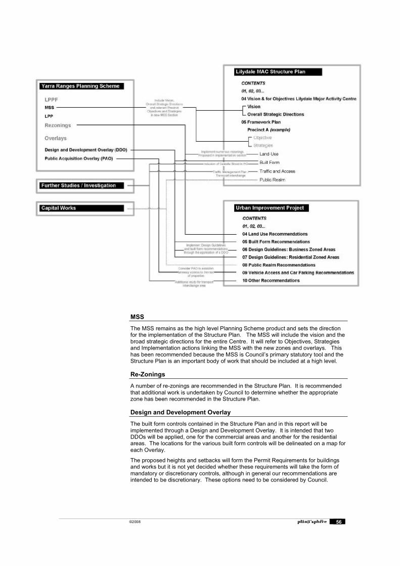
©2008 56
MSS
The MSS remains as the high level Planning Scheme product and sets the direction for the implementation of the Structure Plan. The MSS will include the vision and the broad strategic directions for the entire Centre. It will refer to Objectives, Strategies and Implementation actions linking the MSS with the new zones and overlays. This has been recommended because the MSS is Council�s primary statutory tool and the Structure Plan is an important body of work that should be included at a high level.
Re-Zonings
A number of re-zonings are recommended in the Structure Plan. It is recommended that additional work is undertaken by Council to determine whether the appropriate zone has been recommended in the Structure Plan.
Design and Development Overlay
The built form controls contained in the Structure Plan and in this report will be implemented through a Design and Development Overlay. It is intended that two DDOs will be applied, one for the commercial areas and another for the residential areas. The locations for the various built form controls will be delineated on a map for each Overlay.
The proposed heights and setbacks will form the Permit Requirements for buildings and works but it is not yet decided whether these requirements will take the form of mandatory or discretionary controls, although in general our recommendations are intended to be discretionary. These options need to be considered by Council.
©2008 57
The design guidelines for each area will form part of a table to the DDO Schedule. Decision Guidelines in the DDO will be sourced from the Structure Plan, and the UIP.
Public Acquisition Overlay
It may be necessary for Council to introduce Public Acquisition Overlays for the proposed laneway widenings in the Centre. This Overlay enables Council to acquire land when a planning permit application is received for properties that are affected by the Overlay.
Council needs to consider whether they want to be responsible for management of the laneways, if not, then acquisition may not be necessary.
6.4 Non-Statutory Implementation
In addition to the use of statutory implementation tools, the Urban Improvement Project and the Structure Plan contain numerous actions or recommendations that cannot be implemented through the Planning Scheme, and will require a range of non-statutory implementation measures and actions. These are included in the implementation table in the next section. Some of these relate to:
Landscape, streetscape and public open space improvements. Access improvements � shared pathways, improved footpaths and walk
throughs etc. Additional studies to supplement the findings of the Structure Plan and the
Urban Improvement Project. Implement processes for improving design quality (discussed in more
detail below). Contact key land holders to progress the implementation of key
Objectives, Strategies and Actions that affect individual key sites and precincts.
Marketing strategy or theme, to promote the objectives of the Structure Plan.
Processes for Improving Design Quality
While the bulk of the Lilydale UIP report is devoted to substantive Guidelines that can form part of the Planning Scheme, the processes involved in development approvals are equally important. The Council can take a number of initiatives to improve the quality of planning application and the quality of the Council assessment process.
Context and Site Description Form
Council can require a Context and Site Description Form to be completed by applicants before submitting planning permit applications. The description should consider existing building scale, building setbacks, building design, vegetation and topography. This will ensure that the design of new development responds to the characteristics of the site and its context. A context and site description can be required through the application of the Design and Development Overlay.
Public Education
There are elements of the UIP that could be published in a form that attracts the interest of a wider community. Items such as the diagrams for consolidated allotments could be developed into brochures to assist the public in applying for permits and to encourage the consolidation of allotments. Other guidelines could be illustrated and published and made available at planning enquiry counters and in community facilities around the Shire. They could also be placed on the Council�s website.
Council Design Expertise
The Council�s assessment of the design of planning applications is another area for potential improvement. This applies to the officers who assess applications, and also to those involved in taking the decisions � both officers and Councillors. One
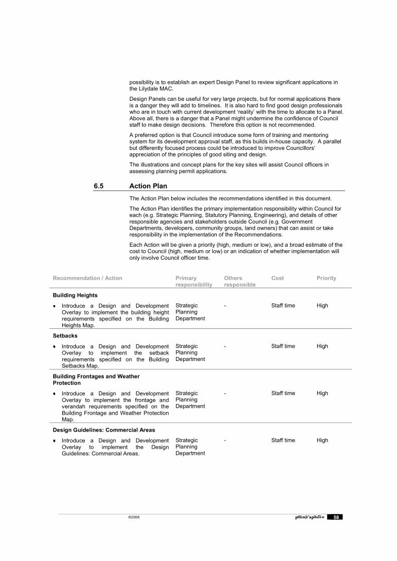
©2008 58
possibility is to establish an expert Design Panel to review significant applications in the Lilydale MAC.
Design Panels can be useful for very large projects, but for normal applications there is a danger they will add to timelines. It is also hard to find good design professionals who are in touch with current development �reality� with the time to allocate to a Panel. Above all, there is a danger that a Panel might undermine the confidence of Council staff to make design decisions. Therefore this option is not recommended.
A preferred option is that Council introduce some form of training and mentoring system for its development approval staff, as this builds in-house capacity. A parallel but differently focused process could be introduced to improve Councillors� appreciation of the principles of good siting and design.
The illustrations and concept plans for the key sites will assist Council officers in assessing planning permit applications.
6.5 Action Plan
The Action Plan below includes the recommendations identified in this document.
The Action Plan identifies the primary implementation responsibility within Council for each (e.g. Strategic Planning, Statutory Planning, Engineering), and details of other responsible agencies and stakeholders outside Council (e.g. Government Departments, developers, community groups, land owners) that can assist or take responsibility in the implementation of the Recommendations.
Each Action will be given a priority (high, medium or low), and a broad estimate of the cost to Council (high, medium or low) or an indication of whether implementation will only involve Council officer time.
Recommendation / Action Primary responsibility
Othersresponsible
Cost Priority
Building Heights
Introduce a Design and Development Overlay to implement the building height requirements specified on the Building Heights Map.
StrategicPlanning Department
- Staff time High
Setbacks
Introduce a Design and Development Overlay to implement the setback requirements specified on the Building Setbacks Map.
StrategicPlanning Department
- Staff time High
Building Frontages and Weather Protection
Introduce a Design and Development Overlay to implement the frontage and verandah requirements specified on the Building Frontage and Weather Protection Map.
StrategicPlanning Department
- Staff time High
Design Guidelines: Commercial Areas
Introduce a Design and Development Overlay to implement the Design Guidelines: Commercial Areas.
StrategicPlanning Department
- Staff time High
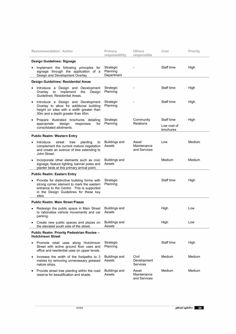
©2008 59
Recommendation / Action Primary responsibility
Othersresponsible
Cost Priority
Design Guidelines: Signage
Implement the following principles for signage through the application of a Design and Development Overlay
StrategicPlanning Department
- Staff time High
Design Guidelines: Residential Areas
Introduce a Design and Development Overlay to implement the Design Guidelines: Residential Areas.
StrategicPlanning
- Staff time High
Introduce a Design and Development Overlay to allow for additional building height on sites with a width greater than 30m and a depth greater than 45m.
StrategicPlanning
- Staff time High
Prepare illustrated brochures detailing appropriate design responses for consolidated allotments.
StrategicPlanning
Community Relations
Staff time
Low cost of brochures
High
Public Realm: Western Entry
Introduce street tree planting to complement the current mature vegetation and create an avenue of tree extending to John Street.
Buildings and Assets
AssetMaintenance and Services
Low Medium
Incorporate other elements such as civic signage, feature lighting, banner poles and planter beds at this primary arrival point.
Buildings and Assets
Medium Medium
Public Realm: Eastern Entry
Provide for distinctive building forms with strong corner element to mark the eastern entrance to the Centre. This is supported in the Design Guidelines for these key sites.
StrategicPlanning
Staff time High
Public Realm: Main Street Piazza
Redesign the public space in Main Street to rationalise vehicle movements and car parking.
Buildings and Assets
High Low
Create new public spaces and plazas on the elevated south side of the street.
Buildings and Assets
High Low
Public Realm: Priority Pedestrian Routes � Hutchinson Street
Promote retail uses along Hutchinson Street with active ground floor uses and office and residential uses on upper levels.
StrategicPlanning
Staff time High
Increase the width of the footpaths to 3 metres by removing unnecessary grassed nature strips.
Buildings and Assets
CivilDevelopment Services
Medium Medium
Provide street tree planting within the road reserve for beautification and shade.
Buildings and Assets
AssetMaintenance and Services
Medium Medium
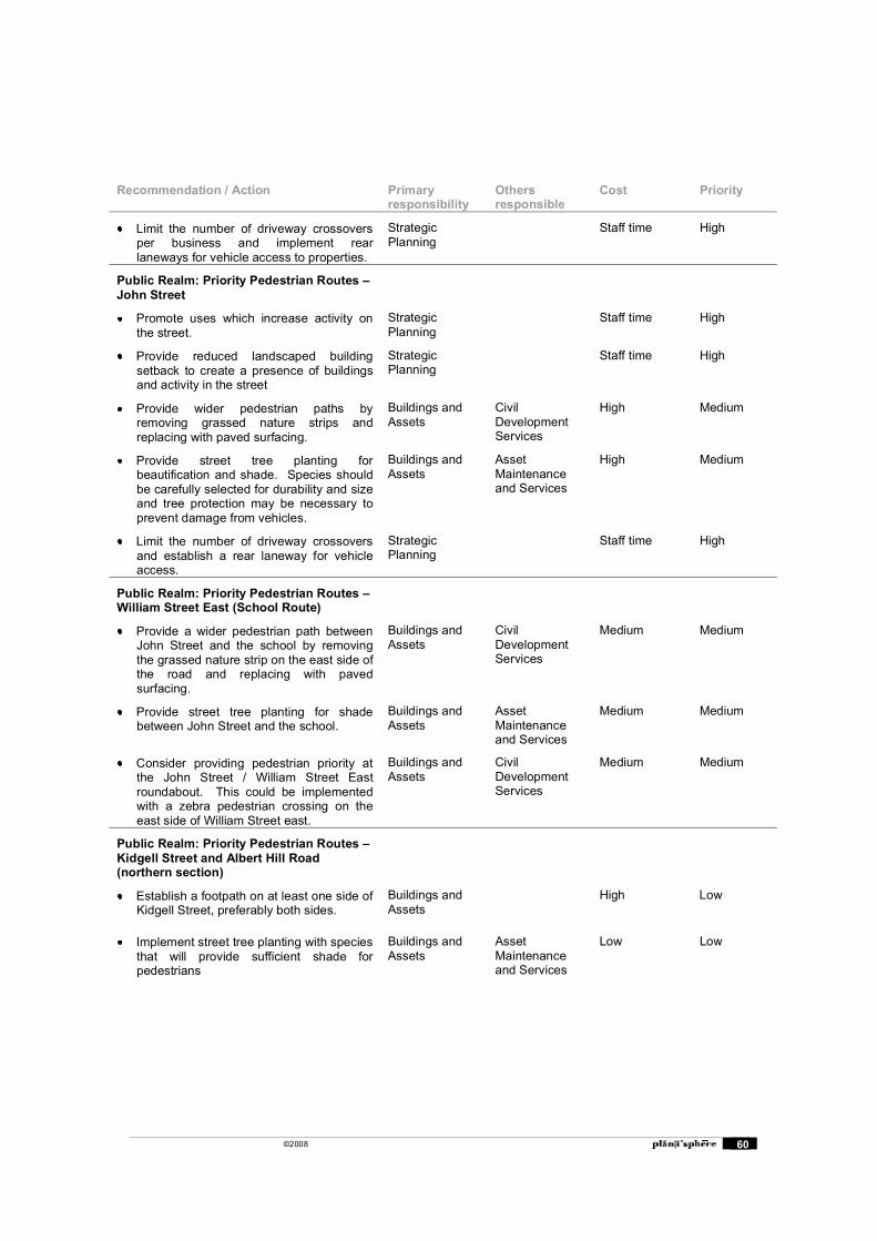
©2008 60
Recommendation / Action Primary responsibility
Othersresponsible
Cost Priority
Limit the number of driveway crossovers per business and implement rear laneways for vehicle access to properties.
StrategicPlanning
Staff time High
Public Realm: Priority Pedestrian Routes � John Street
Promote uses which increase activity on the street.
StrategicPlanning
Staff time High
Provide reduced landscaped building setback to create a presence of buildings and activity in the street
StrategicPlanning
Staff time High
Provide wider pedestrian paths by removing grassed nature strips and replacing with paved surfacing.
Buildings and Assets
CivilDevelopment Services
High Medium
Provide street tree planting for beautification and shade. Species should be carefully selected for durability and size and tree protection may be necessary to prevent damage from vehicles.
Buildings and Assets
AssetMaintenance and Services
High Medium
Limit the number of driveway crossovers and establish a rear laneway for vehicle access.
StrategicPlanning
Staff time High
Public Realm: Priority Pedestrian Routes � William Street East (School Route)
Provide a wider pedestrian path between John Street and the school by removing the grassed nature strip on the east side of the road and replacing with paved surfacing.
Buildings and Assets
CivilDevelopment Services
Medium Medium
Provide street tree planting for shade between John Street and the school.
Buildings and Assets
AssetMaintenance and Services
Medium Medium
Consider providing pedestrian priority at the John Street / William Street East roundabout. This could be implemented with a zebra pedestrian crossing on the east side of William Street east.
Buildings and Assets
CivilDevelopment Services
Medium Medium
Public Realm: Priority Pedestrian Routes � Kidgell Street and Albert Hill Road (northern section)
Establish a footpath on at least one side of Kidgell Street, preferably both sides.
Buildings and Assets
High Low
Implement street tree planting with species that will provide sufficient shade for pedestrians
Buildings and Assets
AssetMaintenance and Services
Low Low
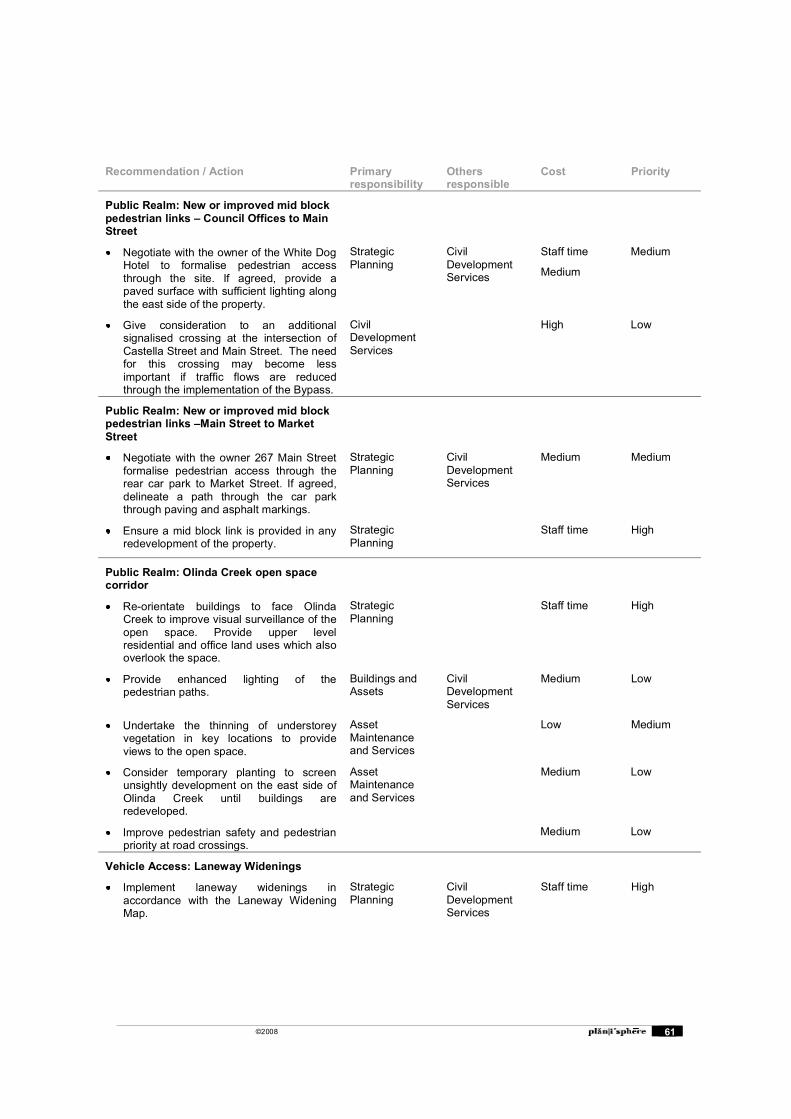
©2008 61
Recommendation / Action Primary responsibility
Othersresponsible
Cost Priority
Public Realm: New or improved mid block pedestrian links � Council Offices to Main Street
Negotiate with the owner of the White Dog Hotel to formalise pedestrian access through the site. If agreed, provide a paved surface with sufficient lighting along the east side of the property.
StrategicPlanning
CivilDevelopment Services
Staff time
Medium
Medium
Give consideration to an additional signalised crossing at the intersection of Castella Street and Main Street. The need for this crossing may become less important if traffic flows are reduced through the implementation of the Bypass.
CivilDevelopment Services
High Low
Public Realm: New or improved mid block pedestrian links �Main Street to Market Street
Negotiate with the owner 267 Main Street formalise pedestrian access through the rear car park to Market Street. If agreed, delineate a path through the car park through paving and asphalt markings.
StrategicPlanning
CivilDevelopment Services
Medium Medium
Ensure a mid block link is provided in any redevelopment of the property.
StrategicPlanning
Staff time High
Public Realm: Olinda Creek open space corridor
Re-orientate buildings to face Olinda Creek to improve visual surveillance of the open space. Provide upper level residential and office land uses which also overlook the space.
StrategicPlanning
Staff time High
Provide enhanced lighting of the pedestrian paths.
Buildings and Assets
CivilDevelopment Services
Medium Low
Undertake the thinning of understorey vegetation in key locations to provide views to the open space.
AssetMaintenance and Services
Low Medium
Consider temporary planting to screen unsightly development on the east side of Olinda Creek until buildings are redeveloped.
AssetMaintenance and Services
Medium Low
Improve pedestrian safety and pedestrian priority at road crossings.
Medium Low
Vehicle Access: Laneway Widenings
Implement laneway widenings in accordance with the Laneway Widening Map.
StrategicPlanning
CivilDevelopment Services
Staff time High
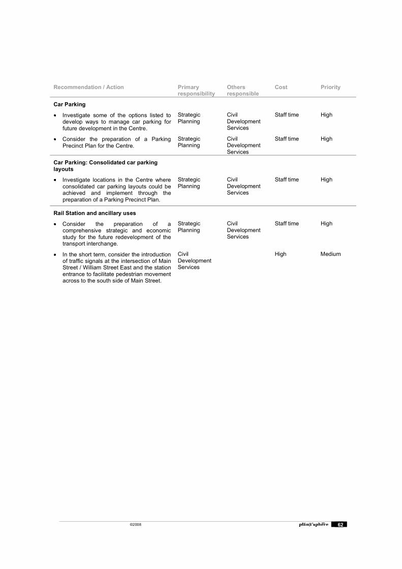
©2008 62
Recommendation / Action Primary responsibility
Othersresponsible
Cost Priority
Car Parking
Investigate some of the options listed to develop ways to manage car parking for future development in the Centre.
StrategicPlanning
CivilDevelopment Services
Staff time High
Consider the preparation of a Parking Precinct Plan for the Centre.
StrategicPlanning
CivilDevelopment Services
Staff time High
Car Parking: Consolidated car parking layouts
Investigate locations in the Centre where consolidated car parking layouts could be achieved and implement through the preparation of a Parking Precinct Plan.
StrategicPlanning
CivilDevelopment Services
Staff time High
Rail Station and ancillary uses
Consider the preparation of a comprehensive strategic and economic study for the future redevelopment of the transport interchange.
StrategicPlanning
CivilDevelopment Services
Staff time High
In the short term, consider the introduction of traffic signals at the intersection of Main Street / William Street East and the station entrance to facilitate pedestrian movement across to the south side of Main Street.
CivilDevelopment Services
High Medium
©2008 63
Appendix A: Strategic Context
The Approved Structure Plan
The Lilydale Major Activity Centre Structure Plan was adopted by Council in June 2006. Within the plan, the vision for the Lilydale Activity Centre is outlined as:
A vibrant regional centre, providing a diverse range of community, recreational, civic, industrial services and professional functions for the local community.
A pedestrian focused, attractive place through which people enjoying walking and cycling and feel safe.
The destination for convenient and attractive public transport, providing reliable access to the Shire, the wider metropolitan region and the Yarra Valley.
An attractive town to visit, with its �country charm�, tree lined streets, well maintained civic and heritage buildings and areas intermingled with newer, high quality buildings, range of dining, entertainment and recreational places.
A centre that features attractive and diverse public parklands with convenient pedestrian and bicycle access along the Olinda Creek Parklands through to the Lilydale Lake.
A convenient place to live and which provides a high standard or residential amenity for its residents.
A centre which values its environmental assets and has incorporated sustainable building designs into new developments.
The Lilydale Major Activity Centre Structure Plan outlines a number of issues and opportunities relating to natural features, land uses, built form and the public realm, and transport and accessibility. Also included are detailed strategies for the use of land, built form, traffic access and the public realm for the following precincts:
Precinct A Town Centre Precinct B West End Mixed Use Precinct C Cavehill Residential Precinct D Industrial Areas Precinct E Northern Residential Precinct F East End Highway Commercial Precinct G Lilydale Market Precinct H John Street/Hardy Street Mixed Use Precinct I Western Residential Precinct J West End Highway Residential
These precincts have been used for the analysis and recommendations of this report.
Implementation of the Structure Plan
The implementation program within the Structure Plan identifies the planning scheme changes and other actions that will be required to implement the strategies contained in the framework plan. It contains a number of general actions and precinct based actions. Key precinct based actions that were identified include:
The use of a Heritage Overlay for Castella Street in Precinct A
The use of a Development Plan Overlay in precincts B, F, G and J
The use of a Design and Development Overlay in precincts C, D, and I
The use of Business 5 zoning in Precinct H
The preparation of design guidelines for housing development in Precinct E
©2008 64
Other Relevant Studies
Lilydale Urban Design Framework
Completed in 2001, the Lilydale Urban Design Framework sets out a fifteen year vision for Lilydale. It identifies future development parameters, strategic goals for land use and design guidelines for future developments. The framework identifies retail and commercial goals as well as desired heritage, cultural and social activities that will enhance the vibrancy of the area. The framework aims to create a vibrant town centre that promotes Lilydale as a �Rural Fringe Centre� for the Yarra Valley, Dandenongs and The Ranges. The framework also identifies the following thirteen precincts for development consolidation:
Town Centre Town Park Lower Town Modal Transport Interchange Upper Town Castella Street Heritage Precinct Research and Technology Civic Entry Avenue Easter Approach Western Approach University Industrial Precinct
A number of the strategies contained in the UDF have been superseded by the Structure Plan, particularly the recommendations on built form. A summary of the UDF recommendations for each of the Structure Plan Precincts is contained in Appendix A.
Yarra Ranges Planning Scheme
MSS
Doing Business in the Shire � Clause 21.04
Key objectives relevant to Lilydale in Clause 21.04 include the following:
To promote the future growth and prosperity of the Shire, especially through business development in the tourism and agricultural industries, which recognise and reinforce the rural and green wedge character and outstanding natural assets of the Shire.
To reinforce the linkages between agricultural production (including viticulture) and tourism, whilst protecting the landscape amenity of the Shire�s rural and green wedge areas.
To recognise and facilitate the development of appropriate tourism opportunities, especially those that integrate with and promote the agricultural, environmental and conservation attributes of the Shire.
To promote Lilydale as a University Town with strong linkages to businesses in the priority industry sectors and other commercial and service based activities in the Shire.
Townships � Large and Small � Clause 21.05
Key objectives relevant to Lilydale in Clause 21.05 include the following:
To encourage a diversity of dwelling types and consolidate residential development in areas that are not subject to physical constraints.
To establish sustainable and attractive townships which can support a range of commercial, retail, community and recreational facilities and services.
©2008 65
To promote proper siting and sustainable design principles and resource minimisation in the construction of all buildings and in the carrying out of works.
To maintain and enhance the rural and green wedge setting and compact form of the rural townships.
Local Planning Policy
Residential Areas � Clause 22.01
Clause 22.01 identifies the following objectives for Metropolitan Residential Areas including Lilydale:
Provide for a range of housing types to meet the varied accommodation needs of the Shire's population.
Maintain a safe and attractive living environment.
Provide for well designed development which utilises existing physical and social infrastructure.
Provide for non residential uses that are primarily aimed at meeting the needs of the local community.
Commercial Centres � Clause 22.04
Clause 22.04 identifies that commercial centres are the preferred location for retail, business and community services. This policy also aims to also encourage commercial centre development that:
Reinforces and strengthens the centre�s viability, vitality and efficiency.
Achieves safe, attractive and functional pedestrian pathways and linkages.
Achieves effective management of vehicular traffic.
Improves the appearance of the built form and open spaces.
Enhances the landscape character of the area.
Tourism � Clause 22.06
The Yarra Ranges Shire is a popular tourist destination. Clause 22.06 aims to encourage tourism and recreation uses that:
Are compatible with conservation objectives.
Minimise adverse impacts on the amenity of local residents.
Relate to their immediate environment, particularly the natural environment.
Enhance the predominantly rural and green wedge character of the Shire.
Development in Residential, Rural Living and Rural and Green Wedge Areas - Clause 22.11
Clause 22.11 sets out a number of design guidelines that aim to protect and enhance the residential character and neighbourhood amenity of residential areas and to ensure that new development is compatible with the scale and bulk of nearby buildings.
Zones
Business 1 Zone
The Business 1 Zone applies to the majority of the Centre. The purpose of this zone is to encourage the intensive development of business centres for retailing and other complementary commercial, entertainment and community uses. A planning permit is not required for the use of land as a shop, but development requires approval. A permit is not required for use as a dwelling but the ground floor level frontage must not exceed 2 metres.
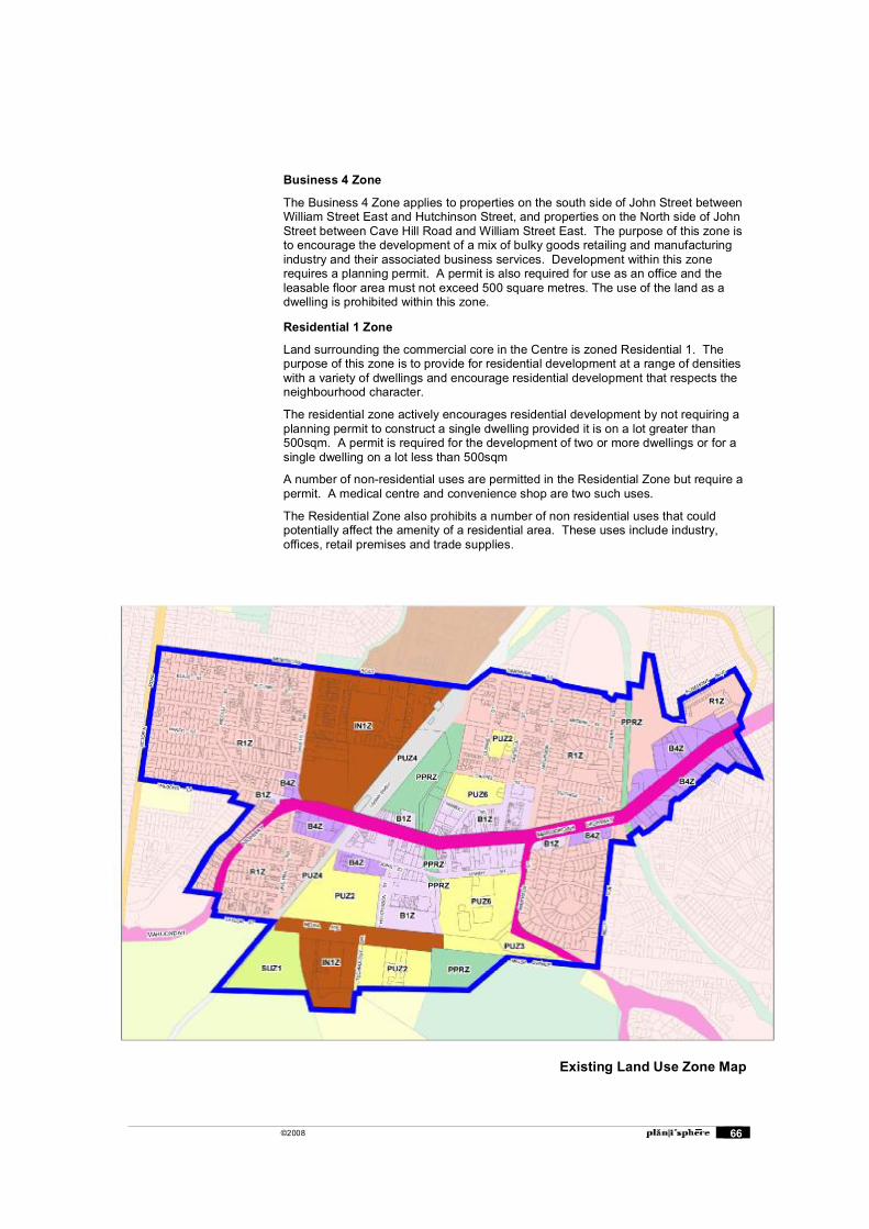
©2008 66
Business 4 Zone
The Business 4 Zone applies to properties on the south side of John Street between William Street East and Hutchinson Street, and properties on the North side of John Street between Cave Hill Road and William Street East. The purpose of this zone is to encourage the development of a mix of bulky goods retailing and manufacturing industry and their associated business services. Development within this zone requires a planning permit. A permit is also required for use as an office and the leasable floor area must not exceed 500 square metres. The use of the land as a dwelling is prohibited within this zone.
Residential 1 Zone
Land surrounding the commercial core in the Centre is zoned Residential 1. The purpose of this zone is to provide for residential development at a range of densities with a variety of dwellings and encourage residential development that respects the neighbourhood character.
The residential zone actively encourages residential development by not requiring a planning permit to construct a single dwelling provided it is on a lot greater than 500sqm. A permit is required for the development of two or more dwellings or for a single dwelling on a lot less than 500sqm
A number of non-residential uses are permitted in the Residential Zone but require a permit. A medical centre and convenience shop are two such uses.
The Residential Zone also prohibits a number of non residential uses that could potentially affect the amenity of a residential area. These uses include industry, offices, retail premises and trade supplies.
Existing Land Use Zone Map
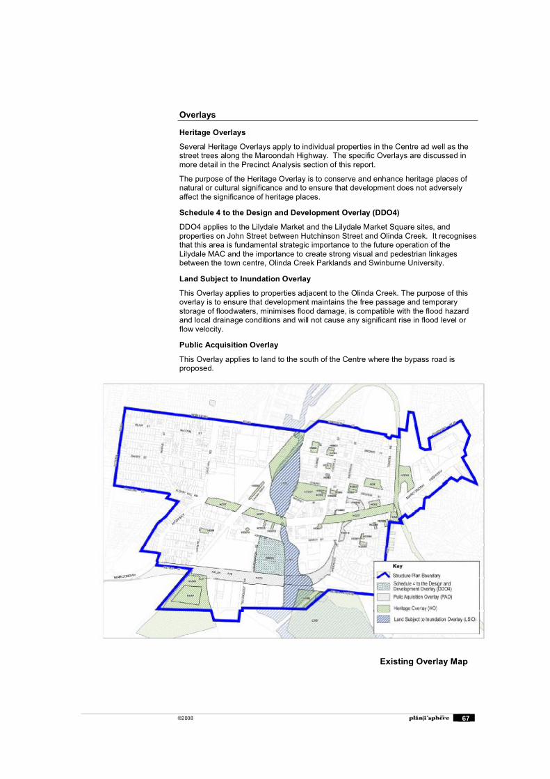
©2008 67
Overlays
Heritage Overlays
Several Heritage Overlays apply to individual properties in the Centre ad well as the street trees along the Maroondah Highway. The specific Overlays are discussed in more detail in the Precinct Analysis section of this report.
The purpose of the Heritage Overlay is to conserve and enhance heritage places of natural or cultural significance and to ensure that development does not adversely affect the significance of heritage places.
Schedule 4 to the Design and Development Overlay (DDO4)
DDO4 applies to the Lilydale Market and the Lilydale Market Square sites, and properties on John Street between Hutchinson Street and Olinda Creek. It recognises that this area is fundamental strategic importance to the future operation of the Lilydale MAC and the importance to create strong visual and pedestrian linkages between the town centre, Olinda Creek Parklands and Swinburne University.
Land Subject to Inundation Overlay
This Overlay applies to properties adjacent to the Olinda Creek. The purpose of this overlay is to ensure that development maintains the free passage and temporary storage of floodwaters, minimises flood damage, is compatible with the flood hazard and local drainage conditions and will not cause any significant rise in flood level or flow velocity.
Public Acquisition Overlay
This Overlay applies to land to the south of the Centre where the bypass road is proposed.
Existing Overlay Map
©2008 68
Appendix B: Precinct Analysis, Issues and Opportunities
This section provides detailed analysis and identifies issues and opportunities for the future development of the precincts identified in the Structure Plan. The inputs to this analysis has included a review of previous documents and existing policies, a field survey, and analysis of GIS data including lot sizes, land ownership, contours, planning zones and controls, and aerial photographs.
Precinct A - Town Centre
Structure Plan context
The Structure Plan designates precinct A as the retail heart of Lilydale and it is recommended that this area retains its Business 1 Zoning.
The objective for this precinct is:
To maintain the Maroondah Highway shopping strip as the main focus of retail and civic activity in a form that reinforces a strong sense of unique identity for Lilydale
A summary of the built form strategies contained in the Structure Plan is as follows:
Limit the height of new development to three storeys.
Ensure that the height of new buildings does not exceed that of nearby iconic buildings (such as the hotels) which are located along the same street frontage.
Encourage new upper level residential developments to take advantage of rural views to the north from elevated sites within the precinct.
Ensure that the redevelopment of the underdeveloped sites in Market Street opposite the southern boundary of Melba Park incorporate stepped setbacks from the street to take advantage of the slope of the land, maximise the opportunities for distant views to the north, and to minimise the visual intrusion of buildings into views from within the park.
Ensure that any new development opposite Melba Park and fronting Market Street or Castella Street is designed to provide a pedestrian scale interface with the street and casual surveillance of the street and parkland areas.
Encourage new development to provide active frontages and effective surveillance of adjoining public spaces such as Olinda Creek parklands.
Promote redevelopment of commercial sites adjoining the transport interchange area to provide an active frontage and improved surveillance of the area.
The implementation recommendations for this precinct are as follows:
Retain the land within a Business 1 Zone. Consider inclusion of the Castella Street Heritage Precinct within a Heritage
Overlay, utilising the historical research previously undertaken by Council. Encourage the Olinda Creek Hotel to redevelop its site by relocating the bottle
shop to the western side of the building, and redeveloping the eastern side of the site as a dining area oriented toward the Reserve
Liaise with VicRoads to investigate the potential to realign Maroondah Highway through the town (depending on the completion of the Lilydale Bypass) to rationalise the current alignment of traffic lanes, medians, service roads and on street parking produce a more functional and pedestrian friendly road.
©2008 69
Existing Built Form Controls
Heritage Overlays
There are a number of Heritage Overlays on Castella Street: Mechanics Institute (HO51)
Old Shire of Lilydale Offices (HO50) Former Methodist Church & Hall (HO56)
Melba Park (HO207)
Main Street is largely covered by HO77 Queen Victoria Jubilee Ave.
The Lilydale Hotel (Dukes Saloon � listed as White Dog in the Overlay) on Main St (HO64) is a prominent Heritage Building. Other Heritage Overlays on Main Street include:
Lawdei Hair Design (HO203)
Lilydale Rural Supplies (HO205) Poon Kee's Store (HO213)
In addition an Olive Tree on John Street is covered by HO215.
Existing Characteristics
Precinct A follows Main Street. The road layout changes through the different areas, however Main Street maintains two lanes of traffic through each section and a thin median planted with exotic avenue trees. The road reservation is very wide at 60m width through the centre.
Three distinct sub-precincts have been identified in Precinct A for the purposes of this analysis.
Main Street west of Olinda Creek Secondary retail area. Retail activity extends down Hutchinson Street and around
to John Street, Coles with most activity on John Street side. The Olinda Hotel a landmark building.
Generally single storey. Coles supermarket with large blank frontage to Main Street.
A combination of large (supermarket) and small (shopfront) lots.
Flat topography with views to surrounding hills. Both sides of Main Street have service roads with angle parking.
Relatively low levels of pedestrian traffic.
Main Street east of Olinda Creek The centre of Lilydale with a core retailing function including cafes and banks. A
fine grain of retain development. The Lilydale Hotel a landmark building.
Generally single storey, occasional 2 storey shopfronts.
Generally small lot sizes however there are some deeper lots in Hardy Street. Hilly topography rising from the Olinda Creek to a high point south of Main Street.
Views down Main Street to the east and west and views of the surrounding hills.
Main Street occupies north side of road reservation, service roads and parking are located on the south side only. Street Cafes.
Highest levels of pedestrian traffic throughout the centre.
Yarra Valley Shopping Centre Area surrounding Melba Park. Rear of shops, with a number of historic buildings
to Castella Street. Generally two storey buildings.
©2008 70
Mixed lot sizes.
Generally flat topography, views across the Park. Little through traffic.
Issues and Opportunities
Opportunity to improve visual and functional connection to Olinda Creek.
Opportunity to improve Olinda Creek as an open space corridor.
Main Street west of Olinda Creek
Northern side of Main Street detached from the southern side with a service business role.
Opportunity to reinforce retail role on southern side of Main Street and increase mixed use function on northern side.
Opportunity for buildings on north side of Main Street to provide active frontages to open space and transport interchange.
Verandahs along both sides of Main Street should be provided to create a visual link between the buildings and also provide weather protection for pedestrians.
Main Street east of Olinda Creek
Future buildings should match the height of historic two storey shop fronts. This will result in a three storey modern equivalent height in some cases, with potential for a fourth level on key corner gateway sites.
Heavy traffic levels detract from the pedestrian environment on the north side of Main Street.
Visual and functional separation of the north and south side of the street.
Opportunity to redesign car parking area to provide for more efficient layouts and more convenient access.
A confusing arrangement of service roads and car parking.
Opportunity to use the wide road area of Main Street east of Olinda Creek where the through carriageway is off-set to create a public/tourist focal point or 'piazza'.
Opportunity to maintain the fine grain pattern of shopfronts in new developments.
Yarra Valley Shopping Centre
This site has potential to be redeveloped for mixed use offices and residential with a development that integrates with the existing street system and provides an appropriate interface with the adjoining open space and heritage areas.
Includes several parcels of land in one ownership
Future use and built form options need to be determined for the rear of Main Street properties which face Market Street between Clarke and Castella Streets, such as residential development opportunities.
Key Development Sites
Key Site A1- Northern Side of Main Street (111-113 Main Street)
This property could be redeveloped with a more active frontage to the parklands and bus terminal and emphasise the corner location through built form.
Key Site A2 - South-west and north-west corners of Main Street and Anderson Street
These are important sites at the eastern entrance to the centre which should be redeveloped with landmark buildings of high design standard. A car showroom and a car park currently occupy these sites.
©2008 71
Key Site A3 - Yarra Valley Shopping Centre
The future options for this site include the relocation of retail activity, including the supermarket, to the existing site west of Hutchinson Street. There is an option to redevelop or convert the site for an office / residential development. The site could provide an attractive built form that emphasises the eastern entrance to Lilydale.
Public Realm Opportunities
Piazzas
There is an opportunity to create piazza spaces on the southern side of the Maroondah Highway. This would require the redesign of car parks and service road on south side to create piazza(s) using mature trees as focus, capitalise on distant views, tourist emphasis (information, etc., outdoor dining.)
Conclusion
The Structure Plan recommendations for built form in this precinct have generally been accepted. Additional work will be undertaken to refine the height and setback recommendations and prepare built form guidelines specific to Precinct A.
A preliminary concept for the public space on the southern side of Main Street will also be prepared.
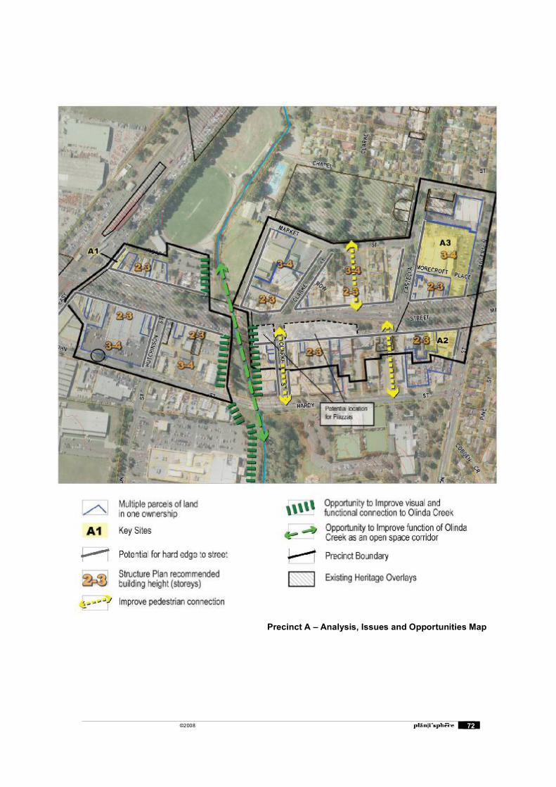
©2008 72
Precinct A � Analysis, Issues and Opportunities Map
©2008 73
Precinct B � West End Mixed Use
Structure Plan context
The Structure Plan designates Precinct B as an area for mixed use residential and commercial development.
The objective for this precinct is:
To be the priority location for comprehensive redevelopment that provides for mixed use residential and commercial development that will invigorate the activity centre.
A summary of the built form strategies contained in the Structure Plan is as follows:
Encourage development to a maximum of four storeys on sites that have been consolidated into parcels of at least 2000 square metres.
Encourage built forms that emphasise the residential character of the building through the use of articulated facades with active frontages to all adjoining streets, and visually interesting pitched rooflines that maximise solar access to dwelling units.
Ensure that any new development, which incorporates a residential component, is designed to provide a high standard of amenity for its residents, with adequate provision of private open space and solar access, and separation from potential sources of disturbance from commercial activities carried on the site.
Ensure that private pedestrian access to the residential component of any new development is to either Cavehill Road or John Street to reinforce their role as residential streets.
Ensure that any new residential development fronting Cavehill Road or John Street is designed to provide a landscaped setback from the street frontage to accentuate the residential scale and character of the street.
The implementation recommendations for this precinct are as follows: Apply a Development Plan Overlay to the precinct and require through a schedule
to the overlay, the preparation of a development plan that addresses specified matters which are derived from the structure plan.
Work with landowners within the precinct to encourage a coordinated response to the opportunities for comprehensive redevelopment of the precinct.
Existing Built Form Controls
Heritage Overlay
Main Street is largely covered by HO77 Queen Victoria Jubilee Ave.
Existing Characteristics Secondary retail area with uses such as trade supply stores. Single storey
shopfronts, often set back from the frontage, some stores with store yards visible from the street.
John Street highway retail role with a number of car dealerships. Buildings set back from the street with cars or other products displayed.
Generally single storey buildings. Larger lot sizes.
Flat topography, views to surrounding hills. Car dominated environment, generally less traffic than Main Street.
Issues and Opportunities Existing highway retailing appears logical although it elongates the Centre.
©2008 74
Potential for office uses to John Street, west of the rail line and on the south side between rail and Hutchinson Street to replace the existing low-intensity uses, if demand exists.
There is potential in this area to introduce upper level residential � however this is prohibited by the current Business 4 Zone.
The Hutchinson Street footpath is in narrow and may need to be widened if this is to become a retail area. Removal of the nature strips would enable widening of the footpath to 3 metres.
The William Street East footpath south of John Street is a major route for school students. The footpath is narrow and cars park on the nature strip. There may be an opportunity to remove the nature strip to enable widening of the footpath.
KEY SITES
B1 � Hutchinson St??
Conclusion
The Structure Plan recommendations for four storey building heights has generally been accepted however additional work will be undertaken to further develop heights and setbacks in specific locations.
Design guidelines will be prepared for the precinct.
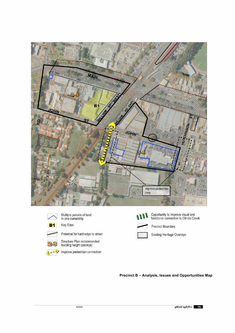
©2008 75
Precinct B � Analysis, Issues and Opportunities Map
©2008 76
Precinct C � Cavehill Residential
Structure Plan Context
The Structure Plan designates precinct C as an area of high density residential uses and it is recommended that this area retains its Residential 1 Zoning.
The objective for this precinct is:
To be the priority location for coordinated redevelopment for high density residential use that takes advantage of the convenient location and increases the level of activity within the centre.
A summary of the built form strategies contained in the Structure Plan is as follows: Encourage development up to two storeys on sites throughout the precinct Provide for residential development of up to three storeys on sites that have been
assembled through the consolidation of lots. Integrate future medium density residential development with the heritage
properties and street trees particularly within Cavehill Road Ensure that new development is designed to retain the scenic vista from the
Maroondah Highway through to the Yarra Valley and distant ranges.
The implementation recommendations for this precinct are as follows: Retain the land in a Residential 1 Zone.
Consider inclusion of the land in a Design & Development Overlay to give effect to built form, land consolidation and other relevant strategies identified in this structure plan.
Existing Built Form Controls
Heritage Overlay
HO59
Applies to a 1860s stone dwelling and property in Cave Hill Road. The dwelling is in poor condition.
Existing Characteristics Predominantly single storey, post war dwellings with a small proportion of
Victorian era dwellings and recent villa unit development. Lot sizes are generally around 1,000sqm in area. There is a particularly large,
vacant allotment in John Street at around 3,500sqm. Allotments are orientated north south with the exception of properties along Cavehill Road which are orientated east west.
The topography rises to the west towards Maroondah Highway.
John Street is a major traffic bypass for the town. Streets have wide nature strips. There is a significant avenue of Oak trees in
Cavehill Road.
Issues and Opportunities Large lot sizes provide opportunities for medium density housing however
consolidation of allotments will be necessary to achieve higher densities with minimal streetscape and amenity impacts.
There are a number of multiple land parcels in single ownership dispersed throughout the precinct that provide opportunities for medium density housing.
Absence of footpaths in some streets would limit access for people with limited mobility.
©2008 77
The existing presence of medium density housing would allow for additional similar housing with minimal streetscape impacts.
The orthogonal shape of most allotments would allow for efficient medium density housing configurations, particularly if amalgamation of two or more adjoining allotments was to occur.
John Street functions as a major bypass for local traffic which could provide a constraint for pedestrian and vehicle access.
Street trees in Cavehill Road provide strong landscape element that could compensate for reduced front setbacks in private allotments.
There is a vacant site to the south of heritage property in Cavehill Road. This site would require a careful design response to respect the scale and spaciousness of the heritage property.
Interwar dwellings along Maroondah Highway between Anderson Street and the Rail Trail will need to be retained. These dwellings are currently covered by a Heritage Overlay.
Key Sites
KSC1
The triangle of properties which is bounded by Maroondah Highway, John Street and Cave Hill Road provides a good redevelopment opportunity at an important entrance to Lilydale. Three parcels are in single ownership, and another large parcel is currently vacant. Smaller allotments along John Street may have greater constraints for redevelopment, particularly those with recent dwellings.
There are opportunities for buildings of 3 storeys on these sites at a higher density. There may be a need to recess upper levels to properties in John Street that are unlikely to be redeveloped.
Conclusion
The recommendation in the Structure Plan to provide for medium density housing of 2-3 storeys is supported. Lot amalgamation should be encouraged as the primary means of achieving medium density housing up to three storeys. The triangle site currently provides good scope for three storey buildings.
General design guidelines will be prepared for medium density housing in the precinct. Incentives for encouraging lot consolidation through the planning scheme will also be investigated.
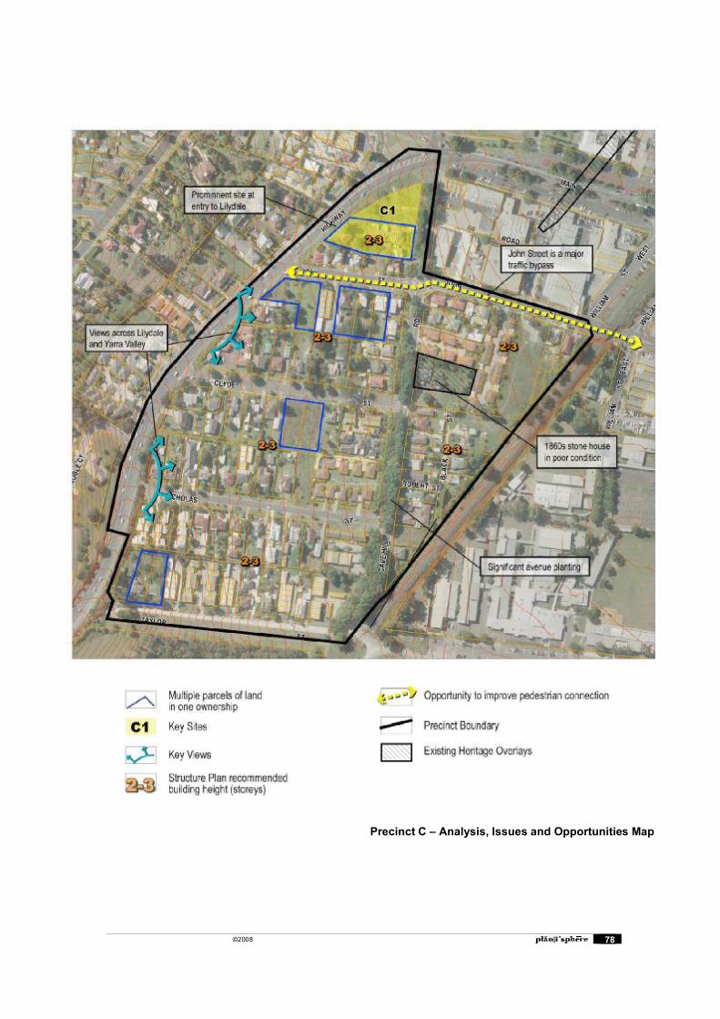
©2008 78
Precinct C � Analysis, Issues and Opportunities Map

©2008 79
Precinct D � Industrial (Olex Cable Site)
The analysis for Precinct D has focussed on the Olex Cable Site at the western entrance to Lilydale on the Maroondah Highway.
Structure Plan Context
The Structure Plan designates precinct D and an area of Industrial Business Activity and recommends that the Industrial 1 zoning is maintained.
The objective for this precinct is:
To provide a concentration of industrial business activity that compliments the range of services and employment opportunities provided within the activity centre.
A summary of the built form strategies contained in the Structure Plan is as follows:
Ensure that new development enhances the appearance of the precinct through the adoption of building designs and landscaping that provide an attractive presentation to the adjoining Cavehill Road and Beresford Road.
Retain the current landscaped setbacks along Beresford Road, Cavehill Road and Melba Avenue which provide an important buffer to non industrial uses and avoid the intrusion of any additional development including car parking within these setback areas.
Limit the height of new development within the precinct to retain the uniform view line from the elevated sections of Maroondah Highway west of Cavehill Road across the precinct to the Yarra Valley and surrounding ranges.
Provide for the future redevelopment of the Maroondah Highway frontage of the Olex Cables site with a form that addresses the Maroondah Highway and establishes an attractive gateway to the activity centre.
The implementation recommendations for this precinct are as follows: Retain the land in an Industrial 1 Zone.
Include the land within a Design & Development Overlay to provide control over height of structures that may intrude into the view lines from the elevated sections of Maroondah Highway.
Existing Characteristics
Site is located at the western gateway to Lilydale and provides a backdrop of surrounding vegetated hills.
The likely area for a future building on the Olex site would be south western corner which is currently used for cable storage.
Issues and Opportunities Opportunity for landmark building at important entrance to Lilydale. Building would need to be of a suitable scale to maintain the views of the
vegetated hillsides behind the site.
Opportunities exist to improve the gateway by public realm works such as construction of a vegetated median, avenue planting, footpaths etc.
Opportunity to use part of the Olex Cables site when redeveloping the railway station.
Conclusion
The site is to retain its industrial use, with commercial uses accepted such as offices at the Maroondah Highway frontage. Maintaining views across the site to the surrounding ranges will be important.
Design guidelines for the future development of the Olex Cables site will be prepared.
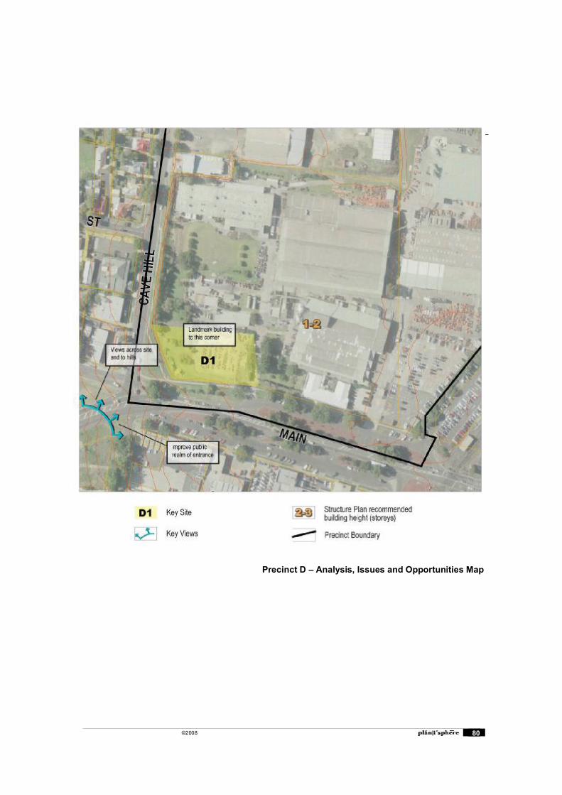
©2008 80
Precinct D � Analysis, Issues and Opportunities Map
©2008 81
Precinct E � Eastern Residential
Structure Plan Context
The Structure Plan designates precinct E as an area to accommodate some additional infill housing development and it is recommended that this area retains its Residential 1 Zoning.
The objective for this precinct is:
To continue to be a residential area that helps define Lilydale�s unique identity whilst accommodating some additional infill housing development.
A summary of the built form strategies contained in the Structure Plan is as follows: Ensure that any new development within the identified Heritage precincts for
�Castella Street� and �The Area subdivision� is designed to protect and reinforce the identified key heritage elements of these precincts.
Ensure that any new development within the area generally bounded by Anderson Street, Gardiner Street, Chapel Street and Olinda Creek, respects the key built form, and landscape elements that contribute to the distinctive character of this area and ensure that:
A mix of public buildings and residential uses is maintained in keeping with existing development.
Current scale and setback of buildings from the street is maintained. New development is not more than two storeys in height except for properties
in Chapel Street opposite the northern side of Melba Park which may be developed up to three storeys on consolidated lots.
Landscaping and street frontage development and fencing incorporates design features that contribute to and complement the overall streetscape. High fences should be discouraged in favour of hedges or plants for screening where necessary.
Mature street trees are retained. Landscaping plans include some substantial trees, where appropriate, to
maintain and enhance the canopy effect in the street and soften/complement rooflines and sightlines.
Ensure that any new development within the �Area� subdivision (Belle Vue & Mont Vue) is designed to:
Not exceed two storeys in height; Respect the architectural significance of the heritage properties, the
subdivision pattern and layout, mature street trees, and is sensitive to the views of existing dwellings across the township and beyond.
Ensure that any new development of the lots located between the Warburton Rail Trail and Precinct F is designed to retain the established trees as a dominant landscape feature as seen from the highway.
Ensure that redevelopment throughout the balance of the precinct does not exceed two storeys in height and is designed to take account of and reinforce the key attributes of the locality such as mature street trees, generally unobtrusive residential structures, and scattering of heritage buildings.
The implementation recommendations for this precinct are as follows:
Retain the land in a Residential 1 Zone. Prepare design guidelines for housing development, specifically reconciling higher
densities with existing character and to address the heritage values in the precinct.
Develop urban design and signage guidelines for the precinct, that have regard to the highway frontage, the proximity of the precinct to the eastern �gateway� to the Lilydale Township and Yarra Valley, and the residential amenity and neighbourhood character of adjoining residential areas.
©2008 82
Develop a streetscape strategy for Maroondah Highway to reinforce the entry to the town centre, and to screen the restricted retail sales and industrial developments.
Existing Built Form Controls
Heritage Overlays
Several Heritage Overlays are located within the precinct, which apply to individual properties and features. A number of public buildings in Castella Street are covered by the Heritage Overlay as well as a church in Clarke Street.
South of the Maroondah Highway, a small number of dwellings in the Mount View estate are covered by a Heritage Overlay. This area abuts Belle Vue which has a significant number of Heritage Overlays.
Existing Characteristics
Two distinct sub precincts have been identified in Precinct E. Precinct E1includes areas north of the Maroondah Highway and E2 includes properties south of the Highway in the Mount View estate.
Precinct E1 Includes pre-1900s public buildings and dwellings from various eras. Lot sizes are generally between 900 and 1,000sqm. Allotments are generally
orthogonally shaped and orientated east west or north south. Topography rises to a hilltop near The Eyrie. There are some areas where the
slope is greater than 20% There are a number of streets with significant avenue tree planting.
Residential properties have frontage to Melba Park.
Precinct E2 The majority of dwellings are from the Interwar period with a small number of pre-
1900s dwellings.
The Mount View estate was subdivided in 1886 is recognised in Council�s Heritage Study and was recommended for a Heritage Overlay. Only a small number of properties within the estate are currently covered by the Heritage Overlay.
Lot sizes vary between 700sqm and 1,800sqm and most are irregularly shaped. The topography rises significantly to small hill in the centre of the precinct where
the slope is greater than 20%.
Issues and Opportunities
Precinct E1 Large lot sizes provide opportunities for medium density housing however the
consolidation of allotments would be necessary to achieve higher densities with minimal streetscape and amenity impacts.
Higher densities could be located close to Melba Park due to the proximity to the commercial area and provide additional passive surveillance and activity in the parklands. The lot sizes in this area are quite small (around 700sqm) which could constrain additional development.
There is a strong sense of history in this area which is due to the presence of heritage public buildings, older dwellings, avenues of street trees, and bluestone channels. New development needs to be carefully designed to maintain the heritage character of the precinct.
The orthogonal shape of most allotments would allow for efficient medium density housing configurations.
©2008 83
Precinct E2 Although the allotments are generally large, their irregular shapes would not allow
for efficient use of properties for medium density housing. The steeply sloping sites could make construction more costly and result in highly
visible buildings from surrounding areas. This area was recommended for a Heritage Overlay in the Heritage Study which
indicates that it has heritage significance.
Conclusions
For precinct E1, the recommendation for two storeys throughout the precinct with the exception of properties facing Melba Park where a 3 storey building height is proposed, is supported.
For precinct E2, it is recommended that the current density of development is maintained. The irregularly shaped properties in this area, the treed character, existing heritage properties, and the steeply sloping land would constrain opportunities for medium density housing. Design guidelines will be prepared for future development in this precinct in order to protect the heritage character.
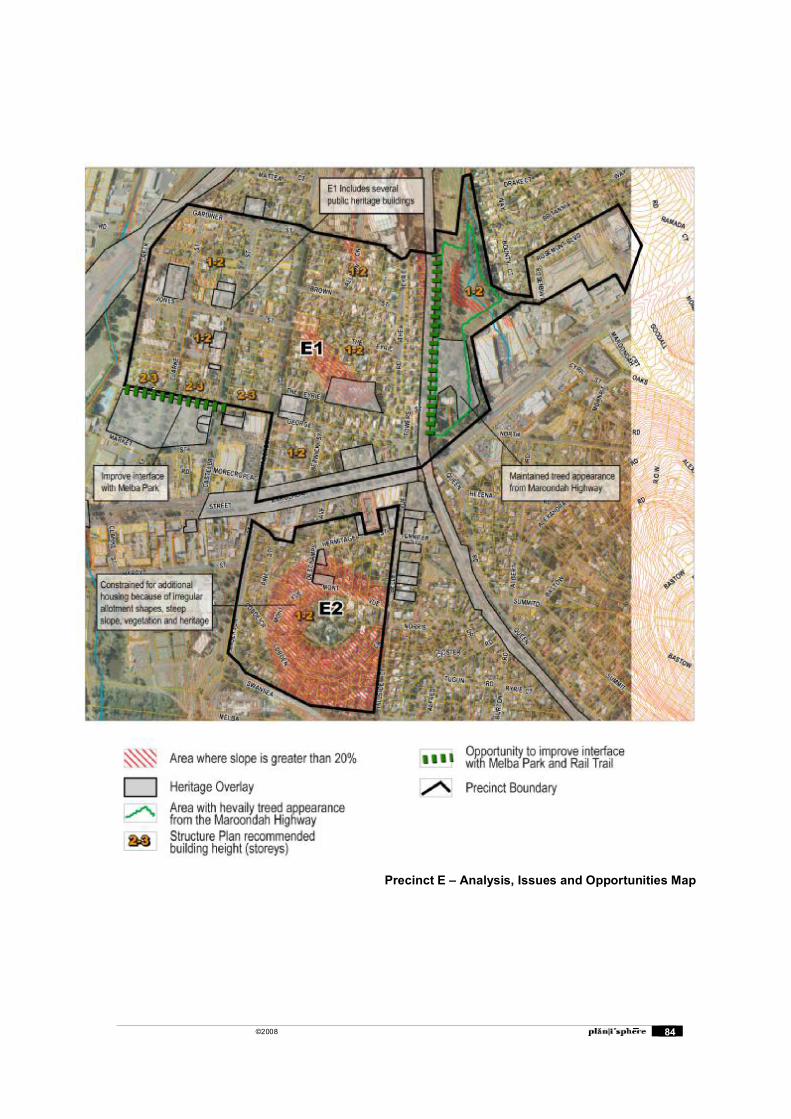
©2008 84
Precinct E � Analysis, Issues and Opportunities Map
©2008 85
Precinct G - Lilydale Market
Structure Plan Context
The Structure Plan designates precinct G as comprehensive redevelopment site with retail and mixed use activities. No recommendations were made about the future zoning of the land.
The objective for this precinct is:
To be a priority location for comprehensive redevelopment that effectively integrates retail uses on the site with the Maroondah Highway shopping strip and other sections of the Activity Centre.
A summary of the built form strategies contained in the Structure Plan is as follows:
Encourage the comprehensive redevelopment of the Lilydale Market Square site and Lilydale Market site in a form that promotes strong visual and pedestrian linkages between the Olinda Creek Parklands, the Town Centre precinct and Swinburne University campus.
Ensure that any redevelopment proposals for the Lilydale Market and Lilydale Market Square sites are designed to:
integrate the development with the redevelopment of the commercial properties fronting the south side of John Street so as to promote visual and pedestrian access between the site and the Town Centre;
replace the current impediments to pedestrian connections between the site and the rest of the Town Centre, such as the open car park areas and petrol station, with new development that encourages pedestrian movement through this area:
provide attractive and active creek interface to the adjoining Olinda Creek parklands which maintains appropriate flood control measures and promotes pedestrian access between the site and the parkland areas;
create active frontages to Hutchinson Street that would assist in promoting pedestrian movement between the Town Centre and the Swinburne University Campus.
recognise the potential gateway function of the site if the Lilydale by-pass is constructed
The implementation recommendation for this precinct is as follows:
Apply a Development Plan Overlay to the precinct and require through a schedule to the overlay, the preparation of a development plan that addresses specified matters which are derived from the structure plan.
Existing Built Form Controls
Schedule 4 to the Design and Development Overlay (DDO4)
DDO4 applies to the Lilydale Market and the Lilydale Market Square sites, and properties on John Street between Hutchinson Street and Olinda Creek.
It recognises that this area is fundamental strategic importance to the future operation of the Lilydale MAC and the importance to create strong visual and pedestrian linkages between the town centre, Olinda Creek Parklands and Swinburne University.
Buildings and works requirements are provided in order to integrate land uses across the area, provide for a cohesive built form, and improve pedestrian access and amenity.
This Overlay is set to expire on April 30, 2009.
©2008 86
Existing Characteristics Safeway supermarket with a large surface car park. Smaller associated retailing
(petrol station, bargains stores, video etc) connected with the supermarket.
Lilydale Market comprises two large shed like structures, with two large surface car parks.
Buildings in the precinct are single storey building, of equivalent two storey height.
The precinct operates as two separate properties, with no real connection between the two.
Issues and Opportunities The market appears to be under-utilised and may not be a viable use in long term. It is located some distance from the core of the activity centre however it is
included in the Business 1 Zone which indicates the desire future use for retail development.
Use of the market could be increased if it were moved closer to the centre, such as north of the Safeway supermarket on John Street. The current market site could be comprehensively redeveloped to a use more suited to its location, such as residential development, �big-box� retailing or a sports related use.
Commercial and industrial uses are currently located along John Street currently diminishes the retail link between the shops in Main Street and the Lilydale Market Square Shopping Centre.
Pedestrian links to the precinct from the retail core to the precinct are very poor with an indirect and poorly maintained footpath with few formalised crossings and traffic infrastructure dominating the environment.
Pedestrian links to the precinct from Clarke Street and the existing Civic Centre are poor, following a �goat track� which leads to a narrow gap in a chain wire fence and excessive understorey planting around the Olinda creek creating an unsafe feeling. These links should be formalised and improved.
Opportunity for revegetation of the Creek Corridor and extensive landscaping of car parks.
Conclusions
Options for the future development of this site will be explored further. Detailed design guidelines and a concept plan will be prepared for this area in order to strengthen the links between the site and the main retail core.
DDO4 applies to the site and will need to be considered in the preparation of guidelines for the site.
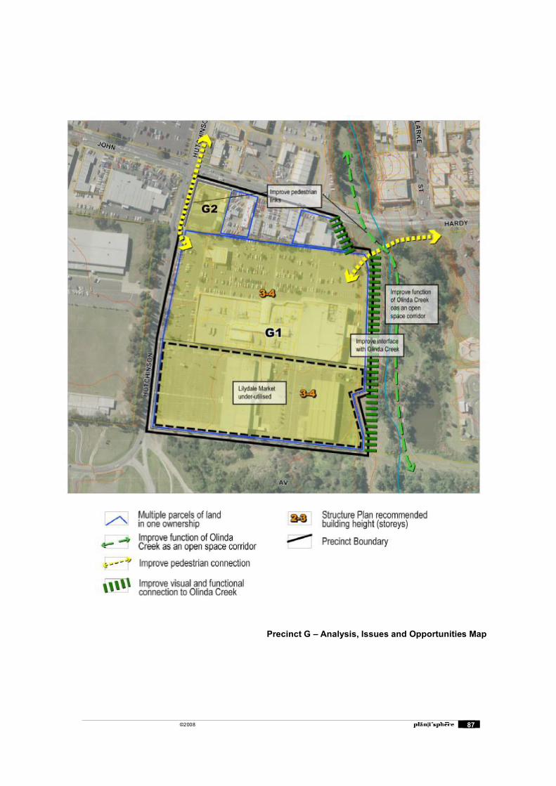
©2008 87
Precinct G � Analysis, Issues and Opportunities Map
©2008 88
Precinct H - John Street/Hardy Street Mixed Use
Structure Plan Context
The Structure Plan designates precinct H as a commercial and residential mixed use area and it is recommended to be rezoned to Business 5.
The objective for this precinct is:
To be an area of managed incremental redevelopment for a range of commercial and mixed use housing that supports the role of the Town Centre
A summary of the built form strategies contained in the Structure Plan is as follows:
Encourage the redevelopment of properties fronting the south side of John Street to incorporate individual shop fronts rather than create simple bland facades and to create active street frontages, with consistent verandahs and signage, and strong pedestrian linkages from John Street through to the Lilydale Market Square site.
Encourage redevelopment of sites abutting key intersections in John Street and Hardy Street to assist in providing a stronger built form presence and increase the range of land uses, activities and enhanced liveability.
Encourage the redevelopment of properties fronting the south side of John Street to be visually and functionally integrated with the adjoining Lilydale Market Square site.
Encourage redevelopment proposals to incorporate pedestrian linkages from the properties fronting Maroondah Highway through to John Street or Hardy Street.
Encourage the establishment of a more intensive built form within the precinct with buildings constructed to provide for residential accommodation on upper floor levels.
Require new development fronting John Street and Hardy Street to be consistent with the setbacks of existing development and to provide active landscaped frontages to the street, and to enable the continuation of consistent avenue tree planting along the length of these streets.
Ensure that new development on the sloping sites on the north side of Hardy Street is constructed with the ground floor access at the same level as the street.
Encourage new development on sites with direct abuttal to Olinda Creek to take advantage of views into the parkland areas and provide active frontages to these open space areas.
The implementation recommendation for this precinct is as follows:
Consider inclusion of the land in a Business 5 Zone.
Existing Characteristics A mix of uses, including large areas of surface car parking. Retail uses to the
west of Olinda Creek. Predominantly commercial uses to the east of Olinda Creek.
The Olinda Creek divides the Precinct.
Land rising to the north, allowing views to the south. Land rises to the east on the east side of Olinda Creek.
There are sections east of Olinda Creek where the footpath is either not formalised, or doesn�t exist.
John Street receives through traffic avoiding Main Street. There are no sensitive interfaces other than the interface to Olinda Creek.
©2008 89
Issues and Opportunities East of the Olinda Creek there is potential for medium density residential
development. This area is more suited to residential development as it commands higher ground with long views south to the Dandenong Ranges across the landscaped Civic Centre site.
West of the Olinda Creek the area should perform a commercial function, as with other uses along John Street.
The frontage along Anderson Street (corner of Hardy Street) is currently developed with car yards. This key site could be redeveloped with mixed use of 2-3 storeys, amalgamated with the adjacent �Holden� site.
Opportunity for pedestrian linkages through the precinct to provide links between the Main Street Shops and the Civic Centre to the south.
Key Sites Car yard at the corner of Hardy Street and Anderson Street. Storage yards between Olinda Creek and Hutchinson Street.
Conclusion
The building heights proposed in the Structure Plan are generally accepted. Additional investigation will be undertaken to refine heights and setbacks throughout the precinct.
Design guidelines will be prepared for the precinct.
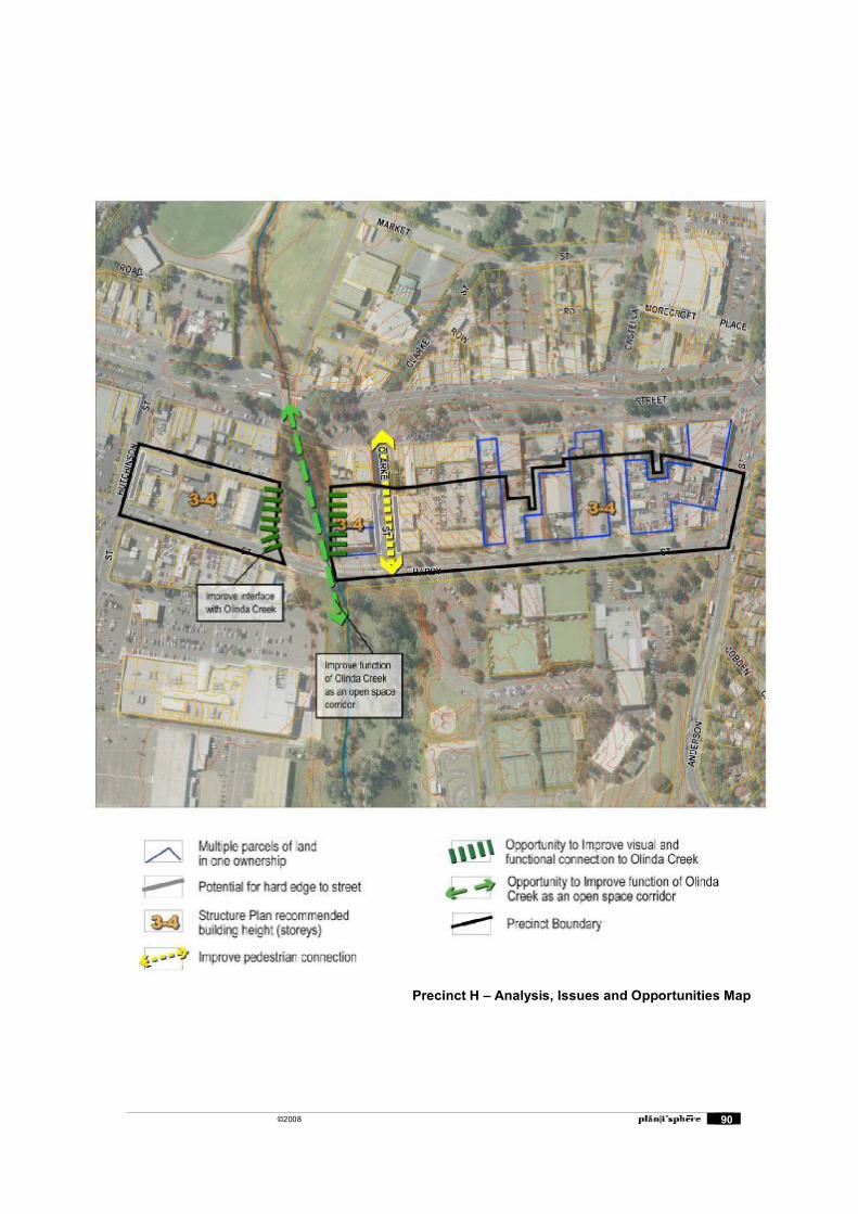
©2008 90
Precinct H � Analysis, Issues and Opportunities Map
©2008 91
Precinct I � Western Residential
Structure Plan Context
The Structure Plan designates precinct I as an area of higher density housing and it is recommended that the Residential 1 Zone remains in place.
The objective for this precinct is:
To be a residential neighbourhood that accommodates extensive change to increase the density of housing in an area that is conveniently located close to the transport interchange and other activity centre facilities.
A summary of the built form strategies contained in the Structure Plan is as follows:
Encourage development up to two storeys on sites throughout the precinct and three storeys on sites that have been consolidated.
Ensure that redevelopment on sites fronting Victoria Road and Beresford Road does not exceed two storeys and is of a scale that is compatible with the streetscape character of residential areas opposite.
Integrate future medium density residential development with identified heritage sites.
Integrate new development with the surrounding dwellings through the provision of domestic scale frontage landscaping, reflecting the prevailing streetscape treatment.
The implementation recommendations for this precinct are as follows:
Retain the land in a Residential 1 Zone. Consider inclusion of the land in a Design & Development Overlay to give effect to
built form, land consolidation and other relevant strategies identified in this structure plan.
Existing Characteristics Predominantly single storey post war dwellings with a small proportion of more
recent villa unit development.
Lot sizes are consistent generally between 850sqm and 1,000sqm. There are some deeper allotments on McComb and Slevin Streets with areas of approximately 1,800sqm. Allotments are orientated north-south.
Topography is hilly and rises to the south west. Elevated aspects to the west provide views across township and to surrounding
hills. There is little intrusive traffic within the precinct.
Many wide nature strips and mature street trees in most areas.
Issues and Opportunities Large lot sizes provide opportunities for medium density housing however the
consolidation of allotments would be desirable to achieve higher densities with minimal streetscape and amenity impacts.
There are a number of multiple land parcels in single ownership dispersed throughout the precinct that provide opportunities for medium density housing.
The existing building stock is relatively low in value and would not provide a constraint for redevelopment.
Absence of footpaths in some streets would limit access for people with limited mobility however this also contributes to the informal character of the streetscapes. Footpaths may need to be provided to accommodate future growth in the area.
©2008 92
Opportunities for housing to provide views across Lilydale to surrounding hills particularly to the west of the precinct.
The existing presence of medium density housing would allow for additional housing of similar densities with minimal streetscape impacts. New development should provide for a significant improvement in design quality
The orthogonal shape of allotments would allow for efficient medium density housing layouts.
Key Redevelopment Sites
The service station on corner of Cave Hill and Albert Hill Road provides a potential redevelopment opportunity at a key location in the entry to Lilydale. Soil contamination issues could provide a constraint.
Conclusion
The recommendation in the Structure Plan to provide for medium density housing of 2-3 storeys is supported. Lot amalgamation should be encouraged as the primary means of achieving medium density housing and buildings of up to 3 storeys.
Design guidelines will be prepared to demonstrate desired design outcomes on consolidated lots. Methods to encourage lot consolidation through the Planning Scheme will be investigated.
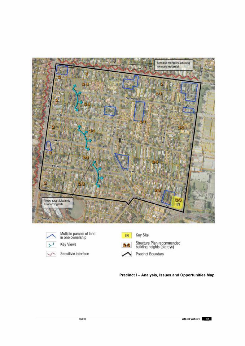
©2008 93
Precinct I � Analysis, Issues and Opportunities Map
©2008 94
Precinct J � West End Highway Residential
Structure Plan Context
The Structure Plan designates precinct J as an area for limited residential development and it is recommended that the Residential 1 Zone remains in place.
The objective for this precinct is:
To be an area of predominantly residential use and with scope for limited residential redevelopment in a form that reinforces the intersection of Maroondah Highway and Cavehill Road as the entry point into the activity centre.
A summary of the built form strategies contained in the Structure Plan is as follows: Provide for limited additional residential development that is designed to take
account of the vehicle access limitations created by the steep slopes and high traffic volumes in the highway.
Limit the height of new developments to a maximum of two storeys to minimise the impact of new development of key vistas into and through the activity centre from the east.
The implementation recommendations for this precinct are as follows:
Retain the land in a Residential 1 Zone.
Apply a Development Plan Overlay to the precinct and require through a schedule to the overlay, the preparation of a development plan that addresses specified matters which are derived from the structure plan.
Existing Characteristics Includes a mix of single storey interwar dwellings and more recent unit
development.
A small group of shops is located to the north. Lot sizes for un-subdivided properties are generally between 1,000sqm and
1,200sqm. Smaller allotments of around 650sqm are located in a recent subdivision in Noble Court. Lot sizes for the shops are around 80sqm.
The topography rises steeply to the west with slopes greater than 20% located to the south of the precinct.
Issues and Opportunities The steeply sloping topography could constrain medium density development
because of increased construction costs and potential visibility of dwellings from the east. However, the slope could also provide opportunities for views across Lilydale to surrounding hills.
Large lot sizes provide opportunities for medium density housing however the consolidation of allotments would be necessary to achieve higher densities with minimal streetscape and amenity impacts.
The small group of shops would be constrained for redevelopment because of the small lot sizes and mixed ownership.
There are only a small number of un-subdivided allotments remaining. Maroondah Highway is a significant access barrier for pedestrians and vehicles.
Traffic noise is also an issue. Potential for civic enhancement of Maroondah Highway / Cavehill road
intersection to create a �gateway� statement, and improve pedestrian and cycle safety and access to the retail and commercial area.
©2008 95
Possible future
The proposal in the Structure Plan to provide for limited medium density development of up to two storeys is supported.
Additional civic enhancements at the intersection of Maroondah Highway and Cavehill Road should be undertaken to enhance the western entry to Lilydale.
Conclusion
The Structure Plan recommendation for building heights of up to two storeys is supported. Design guidelines will be prepared for future medium density housing in the area.
Preliminary design concepts for civic enhancements and Maroondah Highway / Cavehill Road intersection will be prepared.
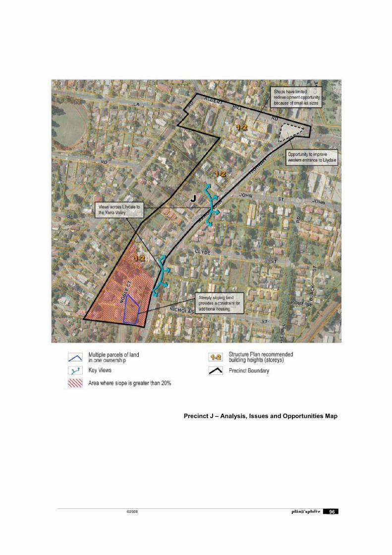
©2008 96
Precinct J � Analysis, Issues and Opportunities Map
©2008 97
Appendix C: Potential Dwelling Yields
Dwelling yields have been estimated for the Lilydale MAC for both business and residential zone areas. The yields take have been calculated on the basis of the land uses proposed in the Structure Plan and the built form recommendations proposed in this report.
A number of assumptions have been made about future residential development in Lilydale to determine realistic dwelling yields. Assumptions have been about which allotments will be redeveloped, the density and height of development, future land uses, and the rate at which particular areas are redeveloped.
Excluded Allotments
A number of allotments have been excluded from the yield calculations because of specific site constraints and the recommendations of the Structure Plan.
Excluded Precincts
Two precincts were excluded from the process, based upon the recommendations in the Structure Plan.
Precinct D �Industrial Areas� was excluded as the objective for this precinct is to �provide a concentration of industrial business activity��
Precinct F �East End Highway Commercial� was excluded as this area is �committed to long term use for bulky goods and other highway oriented retail and commercial uses�
Excluded allotments in Business Zoned Areas
The following properties have been excluded from the dwelling yields in Business Zoned areas:
Properties with area less than 300sqm
Properties already developed for apartments
Larger lots with multiple small factories, due to presumed site consolidation issues
Properties covered by a Heritage Overlay
The Hotel sites have been excluded as the Structure Plan states that they are to be ��supported and reinforced�
Excluded allotments in Residential Zoned Areas
The following properties have been excluded from the dwelling yields in Residential zoned areas:
Existing dual occupancy / multi-unit / apartment developments
Lots with area less than 300sqm
Properties within a Heritage Overlay
Properties unlikely to change use eg. School, Church etc.
The large allotment immediately to the east of the Rail Trail as the Structure Plan identifies this area as having potential for Aged Care facilities.
Development Assumptions
A number of assumptions have been made about the type and form of development so that realistic dwelling yields can be calculated.
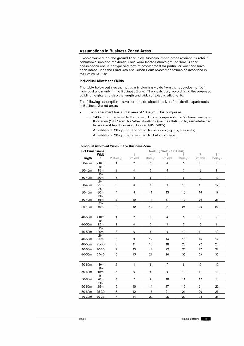
©2008 98
Assumptions in Business Zoned Areas
It was assumed that the ground floor in all Business Zoned areas retained its retail / commercial use and residential uses were located above ground floor. Other assumptions about the type and form of development for particular locations have been based upon the Land Use and Urban Form recommendations as described in the Structure Plan.
Individual Allotment Yields
The table below outlines the net gain in dwelling yields from the redevelopment of individual allotments in the Business Zone. The yields vary according to the proposed building heights and also the length and width of existing allotments.
The following assumptions have been made about the size of residential apartments in Business Zoned areas:
Each apartment has a total area of 180sqm. This comprises: 140sqm for the liveable floor area. This is comparable the Victorian average
floor area (140.1sqm) for �other dwellings (such as flats, units, semi-detached houses and townhouses)� (Source: ABS, 2005)
An additional 20sqm per apartment for services (eg lifts, stairwells). An additional 20sqm per apartment for balcony space.
Individual Allotment Yields in the Business Zone Lot Dimensions Dwelling Yield (Net Gain)
Length Widt
h 2 storeys 3
storeys 4
storeys 5
storeys 6
storeys 7
storeys 8
storeys 30-40m <10m 1 2 3 4 5 6 7
30-40m 10-15m 2 4 5 6 7 8 9
30-40m 15-20m 3 5 6 7 8 9 10
30-40m 20-25m 3 6 8 9 10 11 12
30-40m 25-30m 4 8 11 13 15 16 17
30-40m 30-35m 5 10 14 17 19 20 21
30-40m 35-40m 6 12 17 21 24 26 27
40-50m <10m 1 2 3 4 5 6 7
40-50m 10-15m 2 4 5 6 7 8 9
40-50m 15-20m 3 6 8 9 10 11 12
40-50m 20-25m 5 9 12 14 15 16 17
40-50m 25-30 6 11 15 18 20 22 23
40-50m 30-35 7 13 18 22 25 27 28
40-50m 35-40 8 15 21 26 30 33 35
50-60m <10m 2 4 6 7 8 9 10
50-60m 10-15m 3 6 8 9 10 11 12
50-60m 15-20m 4 7 9 10 11 12 13
50-60m 20-25m 5 10 14 17 19 21 22
50-60m 25-30 6 12 17 21 24 26 27
50-60m 30-35 7 14 20 25 29 33 35
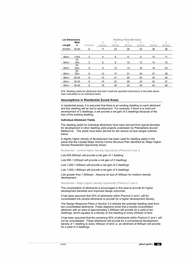
©2008 99
Lot Dimensions Dwelling Yield (Net Gain)
Length Widt
h 2 storeys 3
storeys 4
storeys 5
storeys 6
storeys 7
storeys 8
storeys
50-60m 35-40 9 17 23 28 32 36 38
60m+ <10m 2 4 6 8 9 10 11
60m+10-15m 3 6 8 10 12 14 15
60m+15-20m 5 9 12 14 16 18 20
60m+20-25m 6 12 17 21 24 27 29
60m+ 25-30 8 15 21 26 30 33 35
60m+ 30-35 8 16 23 29 32 34 37 60m+ 35-40 9 18 26 33 39 44 48
N.B. Dwelling yields for allotments that didn�t meet the specified dimensions in the table above were calculated on an individual basis.
Assumptions in Residential Zoned Areas
In residential areas, it is assumed that there is an existing dwelling on each allotment and this dwelling will be lost to development. For example, if there is a multi-unit development of 3 dwellings, it will provide a net gain of 2 dwellings because of the loss of the existing dwelling.
Individual Allotment Yields
The dwelling yields for individual allotments have been derived from typical densities for development in other dwelling yield projects undertaken by Planisphere around Melbourne. The yields have been derived for the various lot size ranges outlined below.
A slightly higher density of development has been used for dwelling yields in the areas that the Lilydale Major Activity Centre Structure Plan identified as �Major Higher Density Residential Opportunity Areas�.
Residential � Limited Higher Density Opportunity (Precinct E and J)
Lots 600-900sqm will provide a net gain of 1 dwelling
Lots 900-1,200sqm will provide a net gain of 2 dwellings
Lots 1,200-1,500sqm will provide a net gain of 3 dwellings
Lots 1,500-1,800sqm will provide a net gain of 4 dwellings
Lots greater than 1,800sqm - Assume lot size of 300sqm for medium density development
Residential � Major Higher Density Opportunity (Precinct C and I)
The consolidation of allotments is encouraged in this area to provide for higher development densities and improved design outcomes.
It has been assumed that 50% of allotments within Precinct C and I, will be consolidated into double allotments to provide for a higher development density.
The Design Response Plans in Section 3.4 indicate the potential dwelling yield from two consolidated allotments. These diagrams show that a double consolidated allotment with an area of approximately 2,000sqm will provide for a yield of ten dwellings, which equates to a density of one dwelling to every 200sqm of land.
It has been assumed that the remaining 50% of allotments within Precinct C and I, will not be consolidated. These allotments will provide for a conventional development density of 1 dwelling to every 300sqm of land i.e. an allotment of 900sqm will provide for a yield of 3 dwellings.
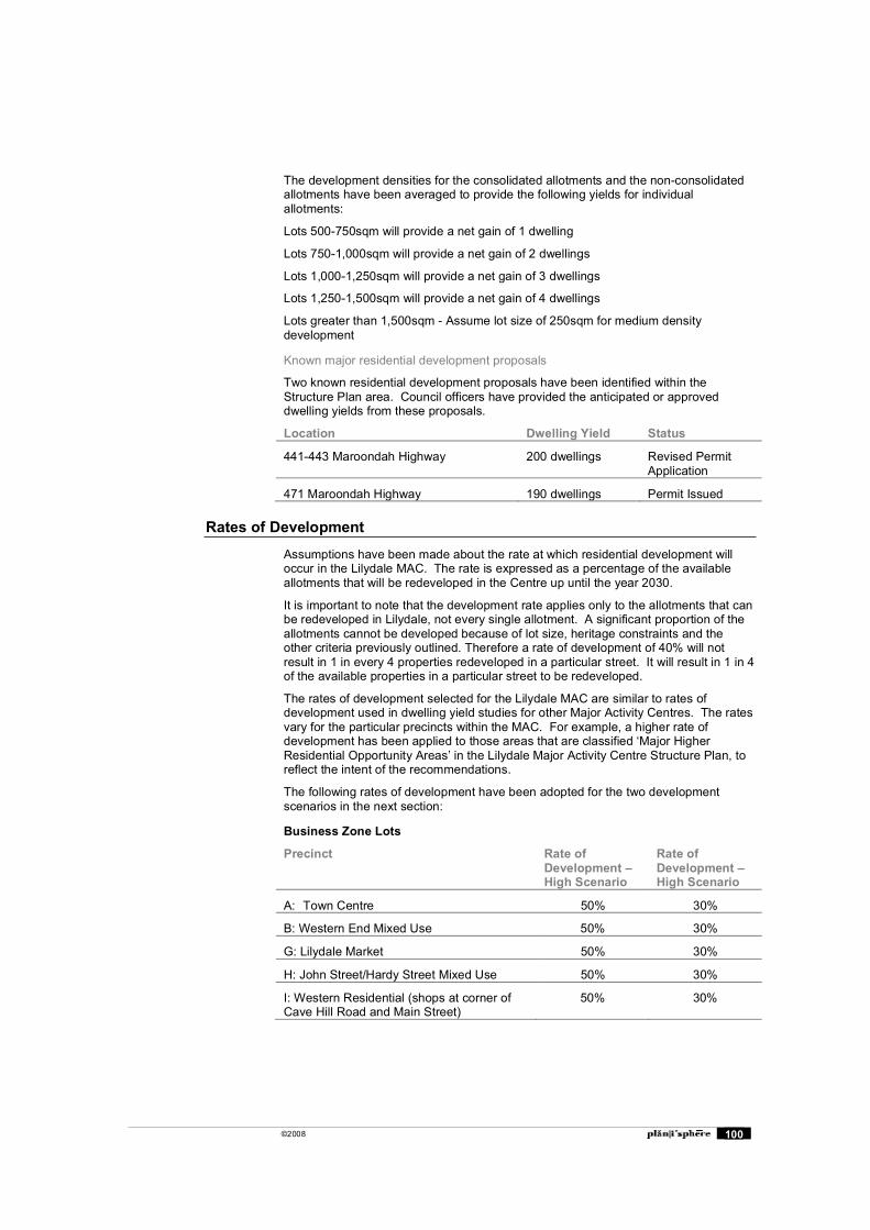
©2008 100
The development densities for the consolidated allotments and the non-consolidated allotments have been averaged to provide the following yields for individual allotments:
Lots 500-750sqm will provide a net gain of 1 dwelling
Lots 750-1,000sqm will provide a net gain of 2 dwellings
Lots 1,000-1,250sqm will provide a net gain of 3 dwellings
Lots 1,250-1,500sqm will provide a net gain of 4 dwellings
Lots greater than 1,500sqm - Assume lot size of 250sqm for medium density development
Known major residential development proposals
Two known residential development proposals have been identified within the Structure Plan area. Council officers have provided the anticipated or approved dwelling yields from these proposals.
Location Dwelling Yield Status
441-443 Maroondah Highway 200 dwellings Revised Permit Application
471 Maroondah Highway 190 dwellings Permit Issued
Rates of Development
Assumptions have been made about the rate at which residential development will occur in the Lilydale MAC. The rate is expressed as a percentage of the available allotments that will be redeveloped in the Centre up until the year 2030.
It is important to note that the development rate applies only to the allotments that can be redeveloped in Lilydale, not every single allotment. A significant proportion of the allotments cannot be developed because of lot size, heritage constraints and the other criteria previously outlined. Therefore a rate of development of 40% will not result in 1 in every 4 properties redeveloped in a particular street. It will result in 1 in 4 of the available properties in a particular street to be redeveloped.
The rates of development selected for the Lilydale MAC are similar to rates of development used in dwelling yield studies for other Major Activity Centres. The rates vary for the particular precincts within the MAC. For example, a higher rate of development has been applied to those areas that are classified �Major Higher Residential Opportunity Areas� in the Lilydale Major Activity Centre Structure Plan, to reflect the intent of the recommendations.
The following rates of development have been adopted for the two development scenarios in the next section:
Business Zone Lots
Precinct Rate of Development � High Scenario
Rate of Development � High Scenario
A: Town Centre 50% 30%
B: Western End Mixed Use 50% 30%
G: Lilydale Market 50% 30%
H: John Street/Hardy Street Mixed Use 50% 30%
I: Western Residential (shops at corner of Cave Hill Road and Main Street)
50% 30%

©2008 101
Residential Zone Lots
Precinct Rate of Development � High Scenario
Rate of Development � High Scenario
C: Cavehill Residential 40% 20%
E: Northern Residential 20% 10%
I: Western Residential 40% 20%
J: West End Highway Residential 20% 10%
Known major residential development proposals
It is assumed that 100% of the known development sites are developed.
Potential Dwelling Yield
The table below shows the potential dwelling yield for the Lilydale MAC. It is estimated that 1,640 dwellings could be accommodated in the Centre with a high development scenario. This is reduced to 1,096 additional dwellings with a low development scenario.
The map on the following page indicates the estimated dwelling yield for each allotment within the Centre.
Lilydale Major Activity Centre Dwelling Yield Net Gain
High Scenario Low ScenarioBusiness Lots Precinct A 379 (50%) 227 (30%) Precinct B and H 294 (50%) 176 (30%) Precinct G 131 (50%) 78 (30%) Precinct I 16 (50%) 9 (30%) Total Business 820 490 Residential LotsPrecinct C 64 (40%) 32 (20%) Precinct E 123 (20%) 62 (10%)Precinct I 232 (40%) 116 (20%) Precinct J 11 (20%) 6 (10%) Known Major Residential Development Proposals 390 (100%) 390 (100%)
Total Residential 820 606
TOTAL 1,640 1,096
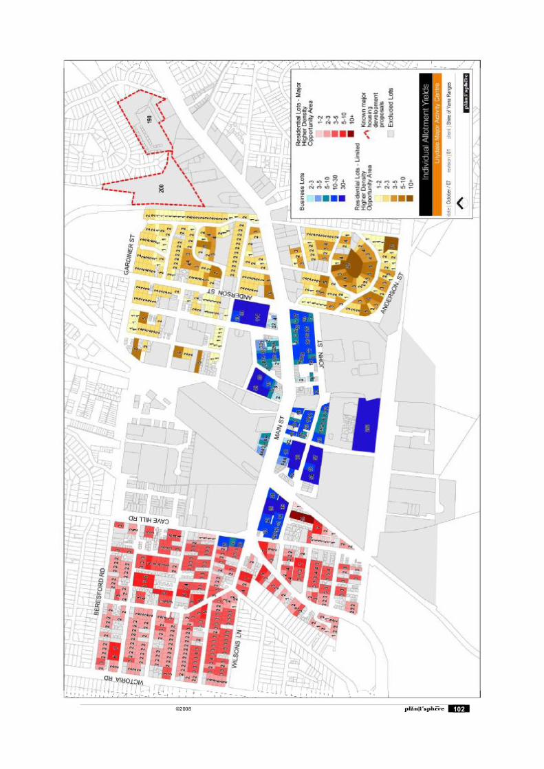
©2008 102
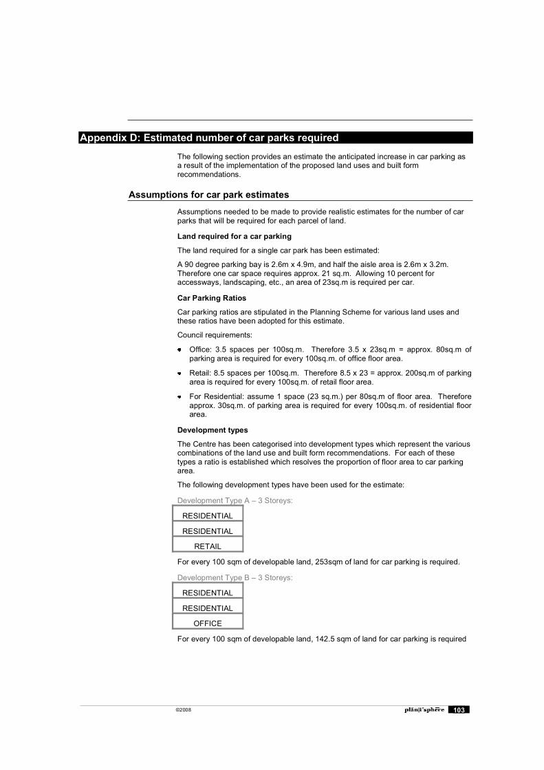
©2008 103
Appendix D: Estimated number of car parks required
The following section provides an estimate the anticipated increase in car parking as a result of the implementation of the proposed land uses and built form recommendations.
Assumptions for car park estimates
Assumptions needed to be made to provide realistic estimates for the number of car parks that will be required for each parcel of land.
Land required for a car parking
The land required for a single car park has been estimated:
A 90 degree parking bay is 2.6m x 4.9m, and half the aisle area is 2.6m x 3.2m. Therefore one car space requires approx. 21 sq.m. Allowing 10 percent for accessways, landscaping, etc., an area of 23sq.m is required per car.
Car Parking Ratios
Car parking ratios are stipulated in the Planning Scheme for various land uses and these ratios have been adopted for this estimate.
Council requirements:
Office: 3.5 spaces per 100sq.m. Therefore 3.5 x 23sq.m = approx. 80sq.m of parking area is required for every 100sq.m. of office floor area.
Retail: 8.5 spaces per 100sq.m. Therefore 8.5 x 23 = approx. 200sq.m of parking area is required for every 100sq.m. of retail floor area.
For Residential: assume 1 space (23 sq.m.) per 80sq.m of floor area. Therefore approx. 30sq.m. of parking area is required for every 100sq.m. of residential floor area.
Development types
The Centre has been categorised into development types which represent the various combinations of the land use and built form recommendations. For each of these types a ratio is established which resolves the proportion of floor area to car parking area.
The following development types have been used for the estimate:
Development Type A � 3 Storeys:
RESIDENTIAL
RESIDENTIAL
RETAIL
For every 100 sqm of developable land, 253sqm of land for car parking is required.
Development Type B � 3 Storeys:
RESIDENTIAL
RESIDENTIAL
OFFICE
For every 100 sqm of developable land, 142.5 sqm of land for car parking is required
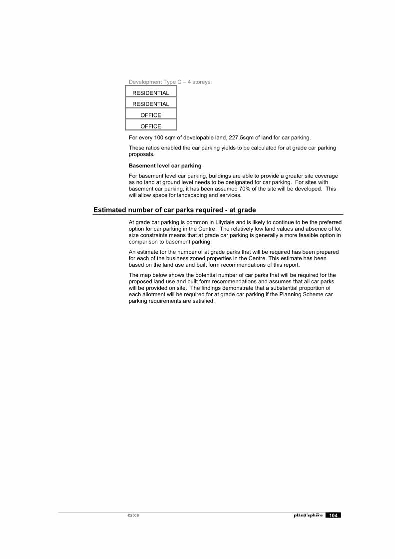
©2008 104
Development Type C � 4 storeys:
RESIDENTIAL
RESIDENTIAL
OFFICE
OFFICE
For every 100 sqm of developable land, 227.5sqm of land for car parking.
These ratios enabled the car parking yields to be calculated for at grade car parking proposals.
Basement level car parking
For basement level car parking, buildings are able to provide a greater site coverage as no land at ground level needs to be designated for car parking. For sites with basement car parking, it has been assumed 70% of the site will be developed. This will allow space for landscaping and services.
Estimated number of car parks required - at grade
At grade car parking is common in Lilydale and is likely to continue to be the preferred option for car parking in the Centre. The relatively low land values and absence of lot size constraints means that at grade car parking is generally a more feasible option in comparison to basement parking.
An estimate for the number of at grade parks that will be required has been prepared for each of the business zoned properties in the Centre. This estimate has been based on the land use and built form recommendations of this report.
The map below shows the potential number of car parks that will be required for the proposed land use and built form recommendations and assumes that all car parks will be provided on site. The findings demonstrate that a substantial proportion of each allotment will be required for at grade car parking if the Planning Scheme car parking requirements are satisfied.
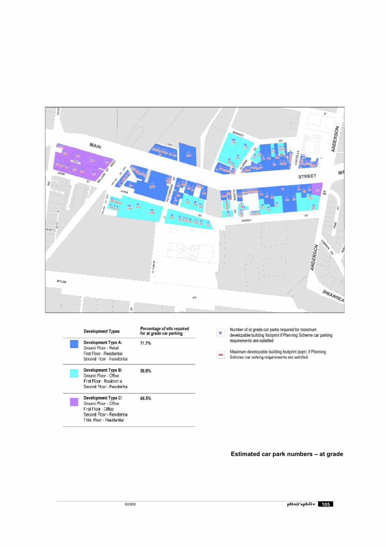
©2008 105
Estimated car park numbers � at grade
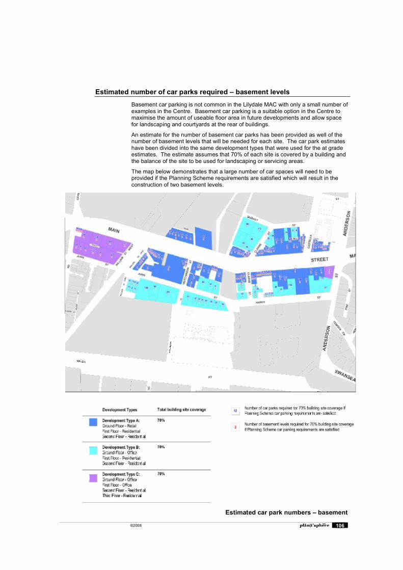
©2008 106
Estimated number of car parks required � basement levels
Basement car parking is not common in the Lilydale MAC with only a small number of examples in the Centre. Basement car parking is a suitable option in the Centre to maximise the amount of useable floor area in future developments and allow space for landscaping and courtyards at the rear of buildings.
An estimate for the number of basement car parks has been provided as well of the number of basement levels that will be needed for each site. The car park estimates have been divided into the same development types that were used for the at grade estimates. The estimate assumes that 70% of each site is covered by a building and the balance of the site to be used for landscaping or servicing areas.
The map below demonstrates that a large number of car spaces will need to be provided if the Planning Scheme requirements are satisfied which will result in the construction of two basement levels.
Estimated car park numbers � basement
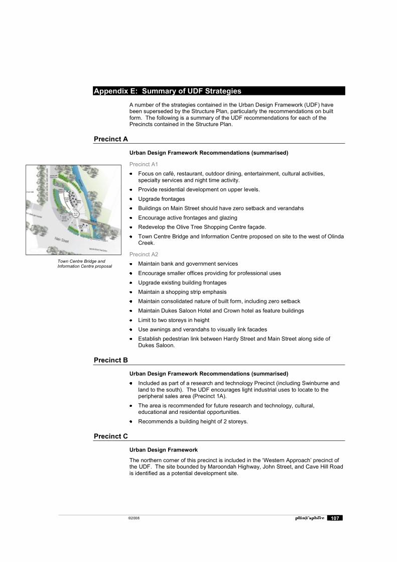
©2008 107
Appendix E: Summary of UDF Strategies
A number of the strategies contained in the Urban Design Framework (UDF) have been superseded by the Structure Plan, particularly the recommendations on built form. The following is a summary of the UDF recommendations for each of the Precincts contained in the Structure Plan.
Precinct A
Urban Design Framework Recommendations (summarised)
Precinct A1 Focus on café, restaurant, outdoor dining, entertainment, cultural activities,
specialty services and night time activity. Provide residential development on upper levels.
Upgrade frontages Buildings on Main Street should have zero setback and verandahs
Encourage active frontages and glazing Redevelop the Olive Tree Shopping Centre façade.
Town Centre Bridge and Information Centre proposed on site to the west of Olinda Creek.
Precinct A2 Maintain bank and government services
Encourage smaller offices providing for professional uses
Upgrade existing building frontages Maintain a shopping strip emphasis Maintain consolidated nature of built form, including zero setback
Maintain Dukes Saloon Hotel and Crown hotel as feature buildings
Limit to two storeys in height Use awnings and verandahs to visually link facades Establish pedestrian link between Hardy Street and Main Street along side of
Dukes Saloon.
Precinct B
Urban Design Framework Recommendations (summarised) Included as part of a research and technology Precinct (including Swinburne and
land to the south). The UDF encourages light industrial uses to locate to the peripheral sales area (Precinct 1A).
The area is recommended for future research and technology, cultural, educational and residential opportunities.
Recommends a building height of 2 storeys.
Precinct C
Urban Design Framework
The northern corner of this precinct is included in the �Western Approach� precinct of the UDF. The site bounded by Maroondah Highway, John Street, and Cave Hill Road is identified as a potential development site.
Town Centre Bridge and Information Centre proposal
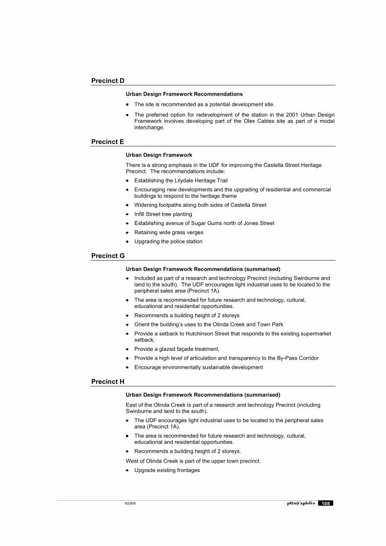
©2008 108
Precinct D
Urban Design Framework Recommendations
The site is recommended as a potential development site.
The preferred option for redevelopment of the station in the 2001 Urban Design Framework involves developing part of the Olex Cables site as part of a modal interchange.
Precinct E
Urban Design Framework
There is a strong emphasis in the UDF for improving the Castella Street Heritage Precinct. The recommendations include:
Establishing the Lilydale Heritage Trail Encouraging new developments and the upgrading of residential and commercial
buildings to respond to the heritage theme Widening footpaths along both sides of Castella Street
Infill Street tree planting Establishing avenue of Sugar Gums north of Jones Street
Retaining wide grass verges Upgrading the police station
Precinct G
Urban Design Framework Recommendations (summarised) Included as part of a research and technology Precinct (including Swinburne and
land to the south). The UDF encourages light industrial uses to be located to the peripheral sales area (Precinct 1A).
The area is recommended for future research and technology, cultural, educational and residential opportunities.
Recommends a building height of 2 storeys Orient the building�s uses to the Olinda Creek and Town Park
Provide a setback to Hutchinson Street that responds to the existing supermarket setback,
Provide a glazed façade treatment, Provide a high level of articulation and transparency to the By-Pass Corridor
Encourage environmentally sustainable development
Precinct H
Urban Design Framework Recommendations (summarised)
East of the Olinda Creek is part of a research and technology Precinct (including Swinburne and land to the south).
The UDF encourages light industrial uses to be located to the peripheral sales area (Precinct 1A).
The area is recommended for future research and technology, cultural, educational and residential opportunities.
Recommends a building height of 2 storeys.
West of Olinda Creek is part of the upper town precinct.
Upgrade existing frontages
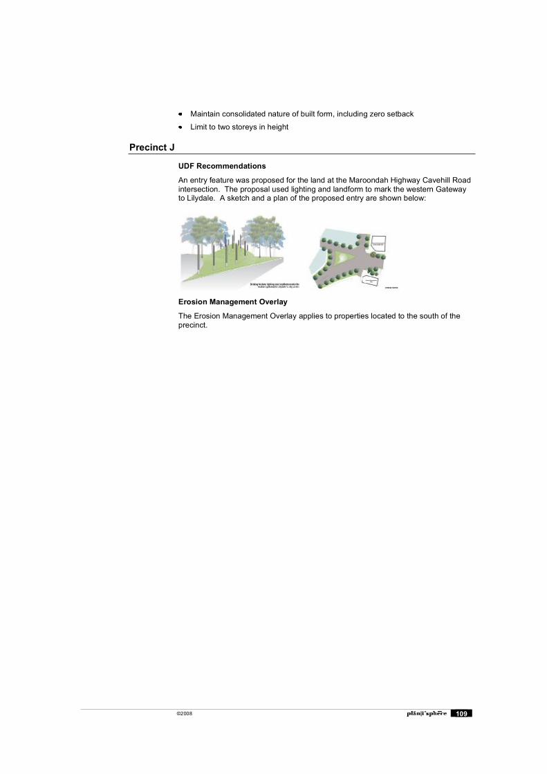
©2008 109
Maintain consolidated nature of built form, including zero setback
Limit to two storeys in height
Precinct J
UDF Recommendations
An entry feature was proposed for the land at the Maroondah Highway Cavehill Road intersection. The proposal used lighting and landform to mark the western Gateway to Lilydale. A sketch and a plan of the proposed entry are shown below:
Erosion Management Overlay
The Erosion Management Overlay applies to properties located to the south of the precinct.

©2008 110
Appendix F: Hardy Street to Melba Park Cross Section
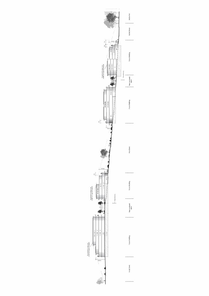

©2008 112