Embed Size (px)
Citation preview

FINAL SCOPING REPORT
FOR THE
PROPOSED CONSTRUCTION OF THE NZHELELE-TRIANGLE
SUBSTATION 2x5OOkV TRANSMISSION LINE, LIMPOPO
PROVINCE
FEBRUARY 2015
Prepared for: ESKOM HOLDINGS SOC LIMITED
P O BOX 1091
Johannesburg
2000
RSA
Compiled by: BAAGI ENVIRONMENTAL CONSULTANCY
PO Box 72847
Lynwood Ridge
0040
RSA

Final Scoping Report Nzhelele-Triangle Project February 2014
2
Document Control
Degree of Confidentiality Client Confidentiality
Title Final Scoping Report for the proposed construction
of Nzhelele-Triangle Substation 2x500kV
transmission line, Limpopo Province.
Date of Issue 24th February 2015
No. of Pages 109
Consultant details:
BAAGI ENVIRONMENTAL CONSULTANCY
PO Box 72847
Lynwood Ridge
0040
RSA
Tel: 012 365 2546
Fax: 012 365 3217 x7
Email: [email protected]
Client details:
ESKOM HOLDINGS SOC LIMITED
P O BOX 1091
Johannesburg
2000
RSA
Tel: 011 800 4057
Fax: 086 602 9207
Email: [email protected]
Compiled by Mr. Lordwick Makhura and Mr. Enock Madumuse
Peer reviewed by Ms Marita Oosthuizen
External reviewed by
Approved by Mr. Lordwick Makhura
Report Number 02/2015
Keywords EIA, PPP,DSR, Specialist, I&APs
Issue Number 01
Copy Number 01
© The content, including format and ideas, is subject to copyright in terms of Copyright Act, Act 98 of 1978.

Final Scoping Report Nzhelele-Triangle Project February 2014
3
EXECUTIVE SUMMARY
INTRODUCTION
The growing demand for electricity places increasing pressure on Eskom’s existing power generation and transmission capacity. Eskom is committed to implementing a sustainable energy strategy that complements the policies and strategies of National Government. Thus, Eskom wants to expand and upgrade the infrastructure in order to improve the reliability of electricity supply to the country, and in particular to provide for the growth in electricity demand in the Limpopo Province.
In response to the imported power allocation in the Integrated Resource Plan (IRP) of the
Government (gazetted May 2011) and the establishment of the Southern Africa Energy (SAE)
unit in Eskom to facilitate the investment in generation and transmission outside of South
Africa, there is an urgent need to identify critical transmission corridors to ensure power
transfer into South Africa from our neighbouring countries. A high level report was compiled,
describing the potential transmission corridors between South Africa, Botswana, Zimbabwe and
Mozambique.
There was report on a follow-up on the Grid Planning Report GP 12/69 “Strategic Transmission
Corridors between South Africa and Zimbabwe to enable Regional Trading”. The focus of the
report was to provide the discussion on the technical impacts and benefits of three different
corridor expansions, by means of technical analysis.The study area incorporates the Eskom
Northern Grid, BPC network, ZESA network and EdM northern network. By strengthening the
ZESA internal network, the power transfer can improve by 173 MW. When comparing the three
corridors, the corridor via Nzhelele and Chibata will provide the highest additional transfer, i.e.
516 MW after the internal ZESA network is strengthened. The second best improvement is the
Nzhelele corridor via Bindura providing additional 351 MW (501 MW). Strengthening the
existing corridor 1 provides an improvement of 22 MW.
The proposed Nzhelele-Triangle 500kV transmission line project entails the following activities:
Construction of a two double 500kV power lines to be operated on 400kV line from Nzhelele Substation to Triangle substation. However, the line from Nzhelele will end at the border of SA and Zimbabwe where it will connect with line from Triangle in Zimbabwe whereby ZESA is responsible for it.
ENVIRONMENTAL IMPACT ASSSEMENT PROCESS
The Environmental Impact Assessment (EIA) process consists of various phases, the current phase is the Scoping Phase. The proposed above-mentioned infrastructure development is a listed activity, in terms of the 2010 Environmental Impact Assessment Regulations, of the National Environmental Management Act, 1998 (Act No. 107 of 1998). Listed activities are regarded as activities that have the potential to cause substantial or significant impacts on the environment. An activity listed in the above-mentioned regulations requires environmental authorisation from the competent authority. The following figure details the various EIA phases that are relevant to the proposed project:

Final Scoping Report Nzhelele-Triangle Project February 2014
4
PUBLIC PARTICIPATION PROCESS
A Public Participation Process (PPP) is required in an EIA process as per chapter 6 section 54 of
R543 of the National Environmental Management Act, 1998 (Act No. 107 of 1998). On the basis
of the EIA regulation, Interested and Affected Parties (I&AP’s) must be given the opportunity to
comment on the proposed project and verify that all issues raised during the commenting
period of the Scoping Phase, have been recorded. The purpose of the Draft Scoping Report
(DSR) is to give I&AP’s the opportunity to comment on the report for inclusion in the final
Scoping Report. I&APs will have 40 calendar days to comment on the Draft Scoping Report.
The following were undertaken during the scoping phase of the public participation process:
Announcement of the project
Registration of I&APs
Public & Stakeholders’ Meetings
Compilation of Issues and Responses Report (IRR).
ALTERNATIVES
It is best practice in environmental management to consider as many alternatives as possible
until a feasible alternative is chosen. During the identification and assessment of alternatives to
be considered for proposed project, the project team consisting of the proponent,
Environmental Assessment Practitioner (EAP), specialists and members of the public, play a key
role in considering and selecting viable alternatives. The following are considered to be the
project alternatives:
Technology Alternative:
Overhead power lines vs. underground power lines
Alignment Alternatives:
Source of Energy Alternative: Renewable Energy
No-Go Alternative
The Final Scoping Report (FSR) provides authorities and I&APs the opportunity to determine the
potential impacts that have been flagged during the Scoping Phase, as well as to indicate how
these impacts will be addressed during the Impact Assessment Phase based on the Plan of Study
Current Phase

Final Scoping Report Nzhelele-Triangle Project February 2014
5
for EIA. The comments received on the DSR will be used in the preparation of the Final Scoping
Report that will be submitted together with the Plan of Study for EIA to the authority (DEA) for
review and consideration.
The specialists were involved at the scoping level and were asked to provide input based on
their respective disciplines. Comprehensive specialist studies will be undertaken during the
Impact Assessment Phase.
CONCLUSIONS
The aim of the final Scoping Report is to provide an opportunity to the authorities and the IAP’s
to assess how many potential impacts have been flagged during the Scoping Phase, as well as to
indicate how these impacts will be addressed during the Impact Assessment Phase based on the
Plan of study for EIA. The comments on the draft Scoping Report will be incorporated into the
final Scoping Report and will be submitted with the plan of Study for EIA to the authorities (DEA)
for review.

Final Scoping Report Nzhelele-Triangle Project February 2014
6
BESTUURSOPSOMMING
INLEIDING
Die groeiende vraag na elektrisiteit plaas groeiende druk op Eskom se bestaande kragopwekking-en-transmissievermoë. Eskom is daartoe verbind om ’n volhoubare energiestrategie te implementeer wat die beleide en strategieë van die Nasionale Regering aanvul. Gevolglik wil Eskom die infrastruktuur uitbrei en opgradeer om die betroubaarheid van elektrisiteitsvoorsiening aan die land te verbeter, en in die besonder om vir die groei in elektrisiteitsvraag in die Limpopo-provinsie te voorsien.
In reaksie op die ingevoerde kragtoewysing in die geïntegreerde hulpbronplan (IRP) van die
Regering (aangekondig Mei 2011) en die stigting van die Suid-Afrikaanse energie-eenheid (SAE)
in Eskom om die belegging in opwekking en transmissie buite Suid-Afrika te fasiliteer, is daar ’n
dringende behoefte om kritieke transmissiekorridors te identifiseer om kragoordrag van ons
buurlande in Suid-Afrika in te verseker. ’n Hoëvlakverslag is saamgestel, wat die potensiële
transmissiekorridors tussen Suid-Afrika, Botswana, Zimbabwe en Mosambiek beskryf het.
Daar is verslag gedoen oor ’n opvolg op die netwerkbeplanningsverslag GP 12/69 “Strategic
Transmission Corridors between South Africa and Zimbabwe to enable Regional Trading”. Die
fokus van die verslag was om die bespreking oor die tegniese impak en voordele van drie
verskillende korridoruitbreidings te voorsien deur middel van tegniese ontleding. Die
studiegebied inkorporeer die Eskom- Noordelike Netwerk, BPC-netwerk, ZESA-netwerk en EdM-
noordelike netwerk. Deur die ZESA- interne netwerk te versterk, kan die kragoordrag met
173 MW verbeter word. Wanneer die drie korridors vergelyk word, sal die korridor via Nzhelele
en Chibata die hoogste bykomende oordrag voorsien, d.w.s. 516 MW ná die interne ZESA-
netwerk versterk is. Die tweede beste verbetering is die Nzhelele-korridor via Bindura wat ’n
bykomende 351 MW (501 MW) voorsien. Versterking van die bestaande korridor 1 voorsien ’n
verbetering van 22 MW.
Die voorgestelde Nzhelele-Triangle 500 kV-transmissielynprojek behels die volgende bedrywighede:
Konstruksie van twee dubbel-500 kV-kraglyne wat op 400 kV-lyn van die Nzhelele-substasie tot die Triangle-substasie bedryf gaan word. Die lyn van Nzhelele sal egter by die grens van SA en Zimbabwe eindig, waar dit aan die lyn sal konnekteer vanaf Triangle in Zimbabwe, waarvoor ZESA verantwoordelik is.
OMGEWINGSIMPAKSTUDIEPROSES
Die Omgewingsimpakstudie- (OIS) proses bestaan uit verskeie fases, waarvan die huidige fase die omvangbepalingsfase is. Die bogenoemde voorgestelde infrastruktuurontwikkeling is ’n gelyste bedrywigheid, ingevolge die 2010-Omgewingsimpakstudieregulasies, van die Wet op Nasionale Omgewingsbestuur, 1998 (Wet Nr. 107 van 1998). Gelyste bedrywighede word beskou as bedrywighede wat die potensiaal het om wesenlike of betekenisvolle impak op die omgewing te hê. ’n Aktiwiteit wat in bogenoemde regulasies gelys is, vereis omgewingstoestemming deur die bevoegde owerheid. Die volgende figuur sit die verskillende OIS-fases uiteen wat op die voorgestelde projek van toepassing is:

Final Scoping Report Nzhelele-Triangle Project February 2014
7
OPENBARE DEELNEMINGSPROSES
’n Openbare Deelnemingsproses (ODP) word volgens hoofstuk 6, artikel 54 van R543 van die
Wet op Nasionale Omgewingsbestuur, 1998 (Wet Nr. 107 van 1998) in ’n OIS-proses vereis.
Ingevolge die OIS-regulasie moet belanghebbende en geaffekteerde partye (B&GP’s) die
geleentheid gegee word om kommentaar te lewer op die voorgestelde projek en moet hulle
bevestig dat alle kwessies wat gedurende die kommentaarperiode van die omvangbepalingsfase
geopper is, opgeteken is. Die doel van die Konsep-omvangsverslag (KOV) is om B&GP’s die
geleentheid te gee om kommentaar te lewer op die verslag sodat dit by die Finale
Omvangsverslag ingesluit kan word. B&GP’s sal 40 kalenderdae hê om op die Konsep-
omvangsverslag kommentaar te lewer.
Die volgende is gedurende die omvangbepalingsfase van die openbare deelnemingsproses
onderneem:
Aankondiging van die projek
Registrasie van B&GP’s
Openbare en belanghebbersvergaderinge
Saamstelling van Kommentaar-en-Reaksieverslag (KRV).
ALTERNATIEWE
Dit is beste praktyk in omgewingsbestuur om soveel alternatiewe as moontlik te oorweeg totdat
’n praktiese alternatief gekies word. Gedurende die identifisering en assessering van
alternatiewe wat vir die voorgestelde projek oorweeg word, speel die projekspan, wat bestaan
uit die aansoeker, Omgewingsassesseringspraktisyn (OAP), spesialiste en lede van die publiek, ’n
sleutelrol in die oorweging en keuse van praktiese alternatiewe. Die volgende word beskou as
die projekalternatiewe:
Tegnologiese alternatief:
Oorhoofse kragdrade teenoor ondergrondse kragdrade
Belyningsalternatiewe:
Energiebronalternatief: Hernubare energie
Onmoontlike alternatief
Huidige fase

Final Scoping Report Nzhelele-Triangle Project February 2014
8
Die Finale Omvangsverslag (FOV) voorsien owerhede en B&GP’s van die geleentheid om die
potensiële impakte te bepaal wat gedurende die omvangbepalingsfase geïdentifiseer is, sowel
as om aan te dui hoe hierdie impakte gedurende die Impakassesseringsfase hanteer sal word,
gebaseer op die Studieplan vir OIS. Die kommentaar wat op die KOV ontvang is, sal gebruik word
vir die voorbereiding van die Finale Omvangsverslag wat saam met die Studieplan vir OIS aan die
owerheid (DEA) ingedien sal word vir beoordeling en oorweging.
Die spesialiste was betrokke op die omvangbepalingsvlak en is gevra om insette te voorsien op
grond van hulle onderskeie dissiplines. Omvattende spesialistestudies sal gedurende die
Impakassesseringsfase onderneem word.
GEVOLGTREKKINGS
Die oogmerk van die Konsep-omvangsverslag is om ’n geleentheid aan die owerhede en B&GP’s
te voorsien om te assesseer hoeveel van die potensiële impakte gedurende die
omvangbepalingsfase geïdentifiseer is, sowel as om aan te dui hoe hierdie impakte gedurende
die Impakassesseringsfase, gebaseer op die Studieplan vir OIS, hanteer sal word. Die
kommentaar op die Konsep-omvangsverslag sal in die Finale Omvangsverslag geïnkorporeer
word en sal saam met die Studieplan vir OIS aan die owerheid (DEA) ingedien word vir
beoordeling.
Final Scoping Report Nzhelele-Triangle Project February 2014
9
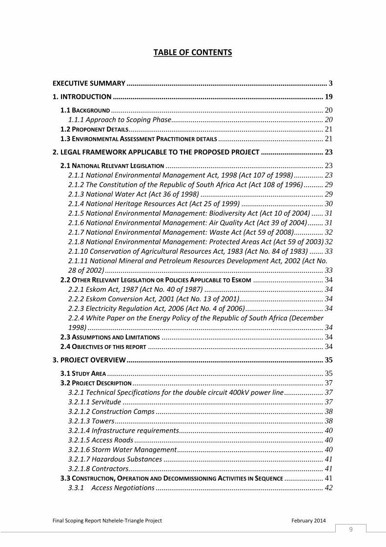
TABLE OF CONTENTS
EXECUTIVE SUMMARY ....................................................................................................... 3
1. INTRODUCTION ............................................................................................................ 19
1.1 BACKGROUND ............................................................................................................. 20
1.1.1 Approach to Scoping Phase.............................................................................. 20
1.2 PROPONENT DETAILS .................................................................................................... 21
1.3 ENVIRONMENTAL ASSESSMENT PRACTITIONER DETAILS ...................................................... 21
2. LEGAL FRAMEWORK APPLICABLE TO THE PROPOSED PROJECT ................................ 23
2.1 NATIONAL RELEVANT LEGISLATION ................................................................................. 23
2.1.1 National Environmental Management Act, 1998 (Act 107 of 1998) ............... 23
2.1.2 The Constitution of the Republic of South Africa Act (Act 108 of 1996) .......... 29
2.1.3 National Water Act (Act 36 of 1998) ............................................................... 29
2.1.4 National Heritage Resources Act (Act 25 of 1999) .......................................... 30
2.1.5 National Environmental Management: Biodiversity Act (Act 10 of 2004) ...... 31
2.1.6 National Environmental Management: Air Quality Act (Act 39 of 2004) ........ 31
2.1.7 National Environmental Management: Waste Act (Act 59 of 2008) ............... 32
2.1.8 National Environmental Management: Protected Areas Act (Act 59 of 2003) 32
2.1.10 Conservation of Agricultural Resources Act, 1983 (Act No. 84 of 1983) ....... 33
2.1.11 National Mineral and Petroleum Resources Development Act, 2002 (Act No. 28 of 2002) ................................................................................................................ 33
2.2 OTHER RELEVANT LEGISLATION OR POLICIES APPLICABLE TO ESKOM .................................... 34
2.2.1 Eskom Act, 1987 (Act No. 40 of 1987) ............................................................. 34
2.2.2 Eskom Conversion Act, 2001 (Act No. 13 of 2001) ........................................... 34
2.2.3 Electricity Regulation Act, 2006 (Act No. 4 of 2006) ........................................ 34
2.2.4 White Paper on the Energy Policy of the Republic of South Africa (December 1998) ......................................................................................................................... 34
2.3 ASSUMPTIONS AND LIMITATIONS ................................................................................... 34
2.4 OBJECTIVES OF THIS REPORT .......................................................................................... 34
3. PROJECT OVERVIEW ..................................................................................................... 35
3.1 STUDY AREA ............................................................................................................... 35
3.2 PROJECT DESCRIPTION .................................................................................................. 37
3.2.1 Technical Specifications for the double circuit 400kV power line .................... 37
3.2.1.1 Servitude ....................................................................................................... 37
3.2.1.2 Construction Camps ...................................................................................... 38
3.2.1.3 Towers ........................................................................................................... 38
3.2.1.4 Infrastructure requirements .......................................................................... 40
3.2.1.5 Access Roads ................................................................................................. 40
3.2.1.6 Storm Water Management ........................................................................... 40
3.2.1.7 Hazardous Substances .................................................................................. 41
3.2.1.8 Contractors.................................................................................................... 41
3.3 CONSTRUCTION, OPERATION AND DECOMMISSIONING ACTIVITIES IN SEQUENCE .................... 41
3.3.1 Access Negotiations ...................................................................................... 42

Final Scoping Report Nzhelele-Triangle Project February 2014
10
3.3.2 Tower Pegging .............................................................................................. 42
3.3.3 Gate Installation............................................................................................ 42
3.3.4 Excavation of Foundation ............................................................................. 42
3.3.5 Foundation for Steelwork .............................................................................. 42
3.3.6 Foundation Pouring ....................................................................................... 42
3.3.7 Delivery of Steel to Tower Site ...................................................................... 42
3.3.8 Assembly Team, Punch and Paint ................................................................. 43
3.3.9 Operation and Maintenance ......................................................................... 43
3.3.10 Decommissioning ...................................................................................... 43
3.4 USE OF SERVICES AND RESOURCES DURING CONSTRUCTION ................................................ 43
3.4.1 Water ............................................................................................................ 43
3.4.2 Sewerage ....................................................................................................... 43
3.4.3 Roads ............................................................................................................. 44
3.5.4 Storm Water Control ..................................................................................... 44
3.4.5 Solid Waste Disposal ..................................................................................... 44
3.4.6 Electricity ....................................................................................................... 44
3.4.7 Economics and Job Creation ......................................................................... 44
3.5 PROJECTED TIME FRAMES ............................................................................................. 44
3.6 THE NEED AND DESIRABILITY OF THE PROJECT ................................................................... 45
4. ALTERNATIVES .............................................................................................................. 47
4.1 ALTERNATIVES CONSIDERED .......................................................................................... 47
4.1.1 Technology Alternatives ................................................................................... 47
4.1.2 Alignment Alternatives .................................................................................... 48
4.1.2.1 Alignment Selection Criteria ......................................................................... 48
4.1.2.1.2 Alternative 1a (Grey+Purple Corridor) ....................................................... 48
4.1.2.1.3 Alternative 1b (Grey+Blue Corridor) .......................................................... 49
4.1.2.1.3 Alternative 2a (Red+Orange Corridor) ....................................................... 49
4.1.2.1.3.1 Alternative 2b (Red+Yellow Corridor) ..................................................... 50
4.1.2.2 Screening Criteria for Rating Alignment Alternatives ................................... 52
4.1.3 Source of Energy Alternative: Renewable Energy ............................................ 56
4.1.4 No-Go Alternative ............................................................................................ 56
5. DESCRIPTION OF THE RECEIVING ENVIRONMENT OF THE STUDY AREA ................... 57
5.1 DESCRIPTION OF SOCIAL ENVIRONMENT .......................................................................... 57
5.1.1 Vhembe District Municipality ........................................................................... 57
5.1.2 Musina Local Municipality ............................................................................... 57
5.2 SOCIAL PROFILE ........................................................................................................... 58
5.2.1 Population Figures ........................................................................................... 58
5.3. INFRASTRUCTURE ........................................................................................................ 59
5.3.3 Roads and Railways ......................................................................................... 63
5.4 TOURISM INDUSTRY ..................................................................................................... 63
6. DESCRIPTION OF THE BIOPHYSICAL ENVIRONMENT .................................................. 64
6.1 CLIMATE ..................................................................................................................... 64
6.2 GEOLOGY ................................................................................................................... 64
6.3 TOPOGRAPHY .............................................................................................................. 66
6.4 SURFACE WATER ......................................................................................................... 66

Final Scoping Report Nzhelele-Triangle Project February 2014
11
6.5 SOIL AND AGRICULTURAL POTENTIAL COMPONENT ........................................................... 66
6.6 ECOLOGY .................................................................................................................... 68
6.6.1 Regional Vegetation ......................................................................................... 68
6.6.2 Vegetation: Species of conservation concern1 ................................................ 70
6.6.3 Fauna ............................................................................................................... 71
6.6.4 Avi-Fauna ......................................................................................................... 75
6.7 VISUAL AND AESTHETIC VALUE ....................................................................................... 79
6.8 HERITAGE RESOURCES .................................................................................................. 79
7. PUBLIC PARTICIPATION PROCESS: SCOPING PHASE ............................................... 80
8. OVERVIEW OF THE EXPECTED EFFECTS ON THE ENVIRONMENT ............................... 86
8.1 OVERVIEW OF THE POTENTIAL IMPACTS ON SOCIAL ENVIRONMENT ...................................... 86
8.1.1 Economic Impacts ............................................................................................ 86
8.1.2 Infrastructure Impacts ..................................................................................... 86
8.1.3 Aesthetic Impacts ............................................................................................. 87
8.1.4 Health - Related Impacts .................................................................................. 87
8.2 OVERVIEW OF THE POTENTIAL IMPACTS ON BIOPHYSICAL ENVIRONMENT .............................. 87
8.2.1 Ecological Impacts............................................................................................ 87
8.2.1 Hydrological and Wetland Impacts .................................................................. 88
9. POTENTIAL CUMULATIVE IMPACTS ............................................................................. 89
9.1 IMPACTS ON AIRFIELDS AND EFFECTIVENESS OF FIRE FIGHTING ............................................. 89
9.2 IMPACTS ON MINING ACTIVITIES AND INFRASTRUCTURE ..................................................... 89
9.3 IMPACTS ON OTHER INFRASTRUCTURE DEVELOPMENT ....................................................... 89
9.4 IMPACTS ON AGRICULTURAL ACTIVITIES ........................................................................... 89
9.5 IMPACTS ON ECOLOGICAL RESOURCES ............................................................................. 89
10. EXPECTED STUDIES FOR IMPACT ASSESSMENT ........................................................ 90
11. PLAN OF STUDY FOR ENVIRONMENTAL IMPACT ASSESSMENT (POS EIA) .............. 91
11.1 INTRODUCTION .......................................................................................................... 91
11.2 DESCRIPTION OF THE ACTIVITY ...................................................................................... 91
11.3 A DESCRIPTION OF THE TASK TO BE PERFORMED .............................................................. 91
11.3.1 Authority Consultation ................................................................................... 91
11.3.2 Public Participation Process (Impact Assessment Phase) .............................. 91
11.3.2.1 Project Advertisement................................................................................. 91
11.3.2.2 Consultation with I&APs and Authorities ................................................... 91
11.3.2.3 Compilation of Issues and Responses Report (IRR) ..................................... 92
11.3.2.4 Announcement of availability of Draft EIR and EMP .................................. 92
11.3.3 Final Environmental Impact Report and Draft EMP ...................................... 92
11.3.4 Authority Review ............................................................................................ 92
11.4 TIMETABLE OF TASKS .................................................................................................. 92
11.5 IMPACT ASSESSMENT METHODOLOGY ........................................................................... 93
11.6 PROCESS TO IDENTIFY ALTERNATIVES AND ISSUES ............................................................. 96
11.7 SPECIALIST ASSESSMENT TERMS OF REFERENCE .............................................................. 96
11.8 COMPOSITION OF PROJECT TEAM ............................................................................... 101
12. CONCLUSIONS .......................................................................................................... 103

Final Scoping Report Nzhelele-Triangle Project February 2014
12
REFERENCES .................................................................................................................... 104
APPENDIX A: ABRIDGED CV OF THE EAP ....................................................................... 105
APPENDIX B: DEA CORRESPONDENCE ........................................................................... 106
APPENDIX C: PUBLIC PARTICIPATION PROCESS ............................................................ 107
APPENDIX D: ISSUES AND RESPONSE REPORT .............................................................. 108
APPENDIX E: ECOLOGICAL SCREENING REPORT ........................................................... 109

Final Scoping Report Nzhelele-Triangle Project February 2014
13
LIST OF FIGURES
Figure 1: Locality map of Nzhelele-Triangle Project ......................................................... 36
Figure 2: 400kV servitude illustration (ACER, 2009) ......................................................... 37
Figure 3: it represents the Southern African Energy Corridor .......................................... 46
Figure 4: Represents the study with the project alignment alternatives ......................... 51
Figure 5: Alignment alternatives to be taken into the Impact Assessment Phase ........... 55
Figure 6: A map representing established facilities potentially to be affected by proposed corridors ................................................................................................... 60
Figure 7: A map representing land uses potentially to be affected by proposed corridors................................................................................................................................... 61
Figure 8: Local Civil Aerodrome Locality Plan ................................................................... 62
Figure 9: Regional Geological Structures .......................................................................... 65
Figure 10: Primary and quaternary catchment affected by the proposed corridors ....... 67
Figure 11: Regional Vegetation Units within the study area ............................................ 69
Figure 12: Map representing where the site notices were placed and geo-referenced. . 83

Final Scoping Report Nzhelele-Triangle Project February 2014
14
LIST OF TABLES
Table 1: Project Proponent Details ................................................................................... 21
Table 2: EAP Contact Details ............................................................................................. 21
Table 3: Listed activities that are applied by proponent for the proposed project ......... 24
Table 4: Screening Of Alignment Alternatives .................................................................. 53
Table 5: Population growth trends in Musina Local Municipality .................................... 58
Table 6: Red Data and Orange Listed plant species .......................................................... 70
Table 7: A list of threatened, “near-threatened” and conservation important faunal species ....................................................................................................................... 72
Table 8: The reporting rates (%) for each Red listed species ........................................... 77
Table 9: Public Meetings for DSR ...................................................................................... 82
Table 10: Places were DSR will be available for review .................................................... 82
Table 12: The anticipated timeframes of the tasks for the proposed project ................. 92
Table 13: The following weights were assigned to each attribute: .................................. 95
Table 14: List of Specialists to be involved ..................................................................... 101
Table 15: Baagi Environmental Consultancy Project Team ............................................ 102

Final Scoping Report Nzhelele-Triangle Project February 2014
15
LIST OF ABBREVIATIONS
BID: Background Information Document
DEA: Department of Environmental Affairs
DSR: Draft Scoping Report
EA: Environmental Authorization
EAP: Environmental Assessment Practitioner
ECO: Environmental Control Officer
EEU: Environmental Evaluation Unit
EIA: Environmental Impact Assessment
EIR: Environmental Impact Report
EMP: Environmental Management Plan
FSR Final Scoping Report
GIS: Geographical Information System
GPS: Global Positioning System
I&APs: Interested and Affected Parties
IDP: Integrated Development Plan
IEM: Integrated Environmental Management
IRP Integrated Resource Plan
kV: Kilovolt
NEMA: National Environmental Management Act (Act No.107 of 1998)
NWA National Water Act
PWV: Pretoria/Witwatersrand/Vereeniging
SAE Southern African Energy

Final Scoping Report Nzhelele-Triangle Project February 2014
16
TABLE OF CONTENTS BASED ON CHARPTER 3 OF THE NATIONAL ENVIRONMENTAL
MANAGEMENT ACT, 1998 (ACT NO. 107 OF 1998), EIA REGULATIONS OF 18 JUNE 2010.
Contents of the draft Scoping Report and alignment with Section 28 Requirements (Content of Scoping Report) of the regulation in terms of Chapter 3 of the National Environmental Management Act, 1998, are presented below.
June2010 Regulations ,Section 28 Requirements Section in Draft
Scoping Report
(1) A scoping report must contain all the information that is necessary for a
proper understanding of the nature of issues identified during scoping
and must include-
a) Details of-
i. the EAP who prepared the report; and
ii. the expertise of the EAP to carry out scoping
procedures
Section 1.3
b) a description of the proposed activity; Section 3.2
c) a description of any feasible and reasonable alternatives that have been
identified;
Section 4
d) a description of the property on which the activity is to be undertaken
and the location of the activity on the property, or if it is –
i. a linear activity, a description of the route of or
ii. An ocean-based activity ,the coordinates where the
activity is to a be undertaken ;
Section 3.1
e) a description of the environment that may be affected by the activity and
manner in which activity may be affected by the environment;
Section 6
f) an identification of all legislation and guidelines that have been
considered in the preparation of the scoping report
Section 2
g) a description of environmental issues and potential impacts, including
cumulative impacts that have been identified;
Section 8 and 9
h) details of the public participation process conducted in terms of
regulation 27 (a), including
i. The steps that were taken to notify potentially interested
and affected parties of the application;
ii. Proof that notice boards, advertisements and notices notify
potentially interested and affected parties of the application
Section 7 and
Appendix C

Final Scoping Report Nzhelele-Triangle Project February 2014
17
June2010 Regulations ,Section 28 Requirements Section in Draft
Scoping Report
have been displayed, placed or given;
iii. A list of all persons or organisations that were identified and
registered in terms of regulation 55 as interested and affected
parties in relation to the application; and
iv. summary of issues raised by interested and A affected parties,
the date of receipt of and the response of the EAP to those
issues;
i) a description of the need and desirability of the proposed activity Section 3.3
j) a description of identified potential alternatives to the proposed activity ,
including advantages and disadvantages that the proposed activity or
alternatives may have on the environment and the community that
might be affected by the activity;
Section 4.1.2
k) copies of any representations, and comments received in connection
with the application or scoping report from interested and affected
parties;
Appendix C
l) copies of the minutes of any meetings held by the EAP with interested
and affected parties and other role players which record the views of the
participants; and
Appendix D
m) any responses by the EAP to those representations and comments and
views;
Appendix D
n) a plan of study for environmental impact assessment which sets out the
proposed approach to the environmental impact assessment of the
application, which include-
i. a description of the tasks that will be undertaken as part of
the environmental impact assessment processes, and the
manner in which such tasks will be undertaken;
ii. an indication of the stages at which the competent
authority will be consulted;
iii. A description of the proposed method of assessing the
environmental issues and alternatives, including the option
of not proceeding with the activity; and
iv. Particulars of the public participation process that will be
conducted during the environmental impact assessment
Section 11

Final Scoping Report Nzhelele-Triangle Project February 2014
18
June2010 Regulations ,Section 28 Requirements Section in Draft
Scoping Report
process;
o) Any specific information required by the competent authority; and N/A
p) Any other matters required in terms of section 24(4) (a) and (b) of the
Act.
N/A
Final Scoping Report Nzhelele-Triangle Project February 2014
19
1. INTRODUCTION
Eskom generates approximately 95% of the electricity used in South Africa and approximately
45% of the electricity generated in Africa. Eskom generates, transmits and distributes electricity
to industrial, mining, commercial, agricultural and residential customers and redistributors. The
majority of sales are in South Africa, and therefore, additional power stations and power lines
need to be constructed in order to meet the growing electricity demand. Eskom is responsible
for providing reliable and affordable power to South Africa.
The growing demand for electricity places increasing pressure on Eskom’s existing power
generation and transmission capacity. Eskom is committed to implementing a sustainable
energy strategy that complements the policies and strategies of National Government. Thus,
Eskom wants to expand and upgrade the infrastructure in order to improve the reliability of
electricity supply to the country, and in particular to provide for the growth in electricity
demand in the Limpopo Province.
In response to the power allocation in the integrated Resource Plan (IRP) of the government
(gazetted May 2011) and the establishment of the Southern African Energy (SAE) unit in Eskom
to facilitate the investment in generation and transmission outside South Africa, there is an
urgent need to identify critical transmission corridors to ensure power transfer into South Africa
from our neighbouring countries. in this case, the proposed project concerned with establishing
500kv line from Nzhelele (RSA) substation to Triangle (Zimbabwe) substation.
The study area covers the jurisdiction of Vhembe District Municipalities whereby Musina Local
Municipality is the affected municipality as far as the proposed development is concerned. The
main places that might be affected are Musina, Nancefield and Mutali.
An application for Environmental Authorisation was submitted to the National Department of
Environmental Affairs (DEA). An environmentally sustainable development is where the parties
involved accept their responsibilities in terms of the:
a. Constitution of South Africa, 1996 (Act No. 108 of 1996) that states that everyone has
the right :
'to an environment that is not harmful to their health or well-being', and
'to have the environment protected, for the benefit of present and future
generations, thorough reasonable legislative and other measures that -
Prevent pollution and ecological degradation;
Promote conservation, and
Secure ecologically sustainable development and use of natural resources
while promoting justifiable economic and social development.'
b. National Environmental Management Act, 1998 (Act No. 107 of 1998), which requires
socially, economically and environmentally sustainable projects.
c. The Environmental Impact Assessment Regulations of 2010.
Baagi Environmental Consultancy cc, as Independent Environmental Consultants were
appointed by Eskom Holdings SOC Limited: Transmission Division to manage and undertake the

Final Scoping Report Nzhelele-Triangle Project February 2014
20
Environmental Impact Assessment (EIA) process for the purpose of obtaining Environmental
Authorisation for the proposed project.
1.1 Background
1.1.1 Approach to Scoping Phase
Taking into consideration that environmental management requires an integrated, holistic,
multi-disciplinary approach, the input of various specialists was obtained at a scoping/desktop
level to inform the scoping report and the way forward. A mandate was given to Baagi
Environmental Consultancy to find a suitable, least environmentally sensitive and most socially
acceptable alignment of a 2x500kV lines between Nzhelele and Triangle substations. However,
the search of a suitable corridor will be from Nzhelele substation to the border as the ZESA will
be responsible for the line from Triangle substation in Zimbabwe to the border where it will join
with SA powerline. The following approach was applied in an attempt to identify possible
alignment alternatives:
a. Literature Review and Desktop Study Analysis
Eskom provided Baagi with the study area boundary, the two substations and key towns with
the study area in GIS format (ESRI: shape files). GIS software (ESRI ArcGIS 10.2 program) was
used to create a study area map, which indicates the location of the existing transmission power
line, distribution power line and other infrastructure such as roads. The developed map was
used as a point of departure for GIS analysis of the study area. The objective of GIS analysis was
to come up with possible corridors that would have the least environmental impact and be
socio-economically viable or feasible.
b. Site Visit
A reconnaissance level site visit was completed during January 2014. The persons present during
the site visit were the Baagi team (project manager, Environmental Officer), Eskom team
(project manager, line designer and surveyor), and specialists (Geotechnical, Flora, Fauna,
Wetland, Social, Visual, and Avifauna). There was drive through of the study area as well as fly
over of the study area by the teams. The specialists were involved at the scoping level and were
asked to provide input based on their respective disciplines.
c. Post Site Visit Meeting
Information gathered during the site visit and desktop study was collected in an attempt to
understand the study area, and provide an amalgamated view, from the various specialists, of
the possible alternative alignments that must be investigated further. The feasibility of the
identified corridors from social, economic and environmental point of view as well as taking into
consideration the technical viabilities were evaluated

Final Scoping Report Nzhelele-Triangle Project February 2014
21
1.2 Proponent Details
Table 1: Project Proponent Details
PROPONENT DETAILS
Company Name Eskom Holdings SOC Limited
Contact Person Mr Henry Nawa
Postal Address P O Box 1091, Johannesburg, 2000
Physical Address Maxwell Drive, Sunninghill Ext 3, Megawatt Park,
Sandton
Telephone 011 800 4057
Fax 086 602 9207
Email [email protected]
1.3 Environmental Assessment Practitioner details
Table 2: EAP Contact Details
ENVIRONMENTAL ASSESSMENT PRACTITIONER (EAP)
Company Name Baagi Environmental Consultancy
Contact person Mr Lordwick Makhura
Physical Address 434 Lois Avenue, Waterkloof Glen, 0181
Postal Address Postnet Suit 412, Private Bag x4, Menlo Park,
Pretoria, 0102
Telephone 012 993 0756
Fax 012 993 0743
Email [email protected] / [email protected]
Mr. Lordwick Makhura is the Principal member of Baagi Environmental Consultancy. He
obtained a degree in Environmental Science and has a BSc (Hons), pending, from the University
of Pretoria. He has at least five years’ experience in the Environmental Management Industry
and is registered with the South African Association of Botanists. For more details about his
expertise and experience please refer to Appendix A.
Final Scoping Report Nzhelele-Triangle Project February 2014
22
Ms. Marita Oosthuizen has an MA Environmental Management where her mini-dissertation
focussed on Public Participation within the South African context. She has more than 10 years
of experience with Public Participation. She is a member of the International Association of
Impact Assessment (IAIAsa) as well as a Member of and Secretary to the Board of the Southern
African Affiliate of the International Association for Public Participation (IAP2 SA).

Final Scoping Report Nzhelele-Triangle Project February 2014
23
2. LEGAL FRAMEWORK APPLICABLE TO THE PROPOSED PROJECT
2.1 National Relevant Legislation
2.1.1 National Environmental Management Act, 1998 (Act 107 of 1998)
There are various elements within the National Environmental Management Act that are
relevant to the Nzhelele-Triangle power lines. The ‘polluter pays’ concept is enforced to ensure
that any party or parties, which undertakes any activity that may cause, causes or caused any
pollution, must prevent, mitigate or remedy the effects.
Section 2 of Chapter 1 of the National Environmental Management provides details of the
environmental management principles that should be adhere to all phases of the development.
The consideration of various factors must be brought into focus:
Avoidance/minimisation of the loss of biodiversity,
Avoidance/minimisation of the disturbance of ecosystems,
Avoidance/minimisation of pollution,
Avoidance/minimisation of cultural and heritage sites,
Avoidance/minimisation/recycling of waste,
Responsible and equitable use of renewable and non-renewable resources, and
Avoidance/minimisation/mitigation of adverse impacts.
In terms of the Government Notice of 2010 EIA Regulations, a number of activities are listed as
requiring a full EIA process. The listed activities that are associated to this project are listed in
Table 3.

Final Scoping Report Nzhelele-Triangle Project February 2014
Table 3: Listed activities that are applied by proponent for the proposed project
Relevant Notice and Activity Number Activity Description Relevance to Project
R 544 No. 13 The construction of facilities or infrastructure for the
storage, or for the storage and handling of dangerous
goods, where such storage occurs in containers with a
combined capacity of 500 cubic metres.
Storage of dangerous goods such as diesoline will occur at
the construction site and camps.
R544 No 20 Any activity requiring a mining permit in terms of section 27 of the Mineral and Petroleum Resources Development Act, 2002 (Act No. 28 of 2002) or renewal thereof.
The proposed project may need borrow pits for access
road construction.
R 544 No. 38 The expansion of facilities for the transmission and
distribution of electricity where the expanded capacity will
exceed 275 kilovolts and the development footprint will
increase.
The proposed 400kV power line will be constructed with
the aim of replacing the existing 275kV power line.
R 545 No. 8 Construction of facilities or infrastructure for the
transmission and distribution of electricity with a capacity
of 275kV or more, outside an urban area or industrial
complex
The project will involve the construction of a 500kV
transmission line outside urban areas or industrial areas.
R545 No. 15 Physical alteration of undeveloped, vacant or derelict land
for residential, retail, commercial, recreational, industrial
or institutional use where the total area to be transformed
20 hectares or more; except where such physical
alterations take place for-
The expansion of the Gumeni Substation will result in the
physical alteration of undeveloped, vacant or derelict land.
Final Scoping Report Nzhelele-Triangle Project February 2014
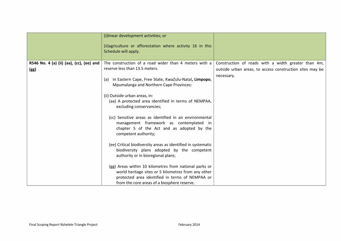
(i)linear development activities; or
(ii)agriculture or afforestation where activity 16 in this Schedule will apply.
R546 No. 4 (a) (ii) (aa), (cc), (ee) and
(gg)
The construction of a road wider than 4 meters with a reserve less than 13.5 meters. (a) In Eastern Cape, Free State, KwaZulu-Natal, Limpopo,
Mpumalanga and Northern Cape Provinces: (ii) Outside urban areas, in:
(aa) A protected area identified in terms of NEMPAA, excluding conservancies;
(cc) Sensitive areas as identified in an environmental
management framework as contemplated in chapter 5 of the Act and as adopted by the competent authority;
(ee) Critical biodiversity areas as identified in systematic
biodiversity plans adopted by the competent authority or in bioregional plans;
(gg) Areas within 10 kilometres from national parks or
world heritage sites or 5 kilometres from any other protected area identified in terms of NEMPAA or from the core areas of a biosphere reserve.
Construction of roads with a width greater than 4m,
outside urban areas, to access construction sites may be
necessary.

Final Scoping Report Nzhelele-Triangle Project February 2014
R546 No 12 (a) and (b) The clearance of an area of 300 square meters or more of vegetation where 75% or more of the vegetative cover constitute indigenous vegetation. (a) Within any critically endangered or endangered
ecosystem listed in terms of section 52 of the NEMBA or prior to the publication of such a list, within an area that has been identified as critically endangered in the National Spatial Biodiversity Assessment 2004.
(b) Within critical biodiversity areas identified in
bioregional plans.
The construction of the power line with its associated
structures such as pylons, and the construction of a
construction camp may require the clearing of vegetation
of more than 300m squared meters.
R 546 No. 13 (2) (c) (ii) (bb), (cc), (ff),
(iii) (bb) and (dd)
The clearance of an area of 1 hectare or more of vegetation where 75% or more of the vegetative cover constitutes indigenous vegetation, except where such removal of vegetation is required for: (2) the undertaking of a linear activity falling below the
thresholds mentioned in Listing Notice 1 in terms of GN No. 544 of 2012
(c) In Eastern Cape, Free State, KwaZulu-Natal, Limpopo,
Mpumalanga, Northern Cape and Western Cape: (ii) Outside urban areas, the following:
(bb) National Protected Area Expansion Strategy Focus areas;
(cc) Sensitive areas as identified in an environmental
management framework as contemplated in chapter 5 of the Act and as adopted by the
The construction of the power line with its associated
structures such as pylons, and the construction of a
construction camp may require the clearing of vegetation
of more than 1 hectare.

Final Scoping Report Nzhelele-Triangle Project February 2014
competent authority; (ff) Areas within10 kilometres from national parks or
world heritage sites or 5 kilometres from any other protected area identified in terms of NEMPAA or from the core area of a biosphere reserve;
(ii) In urban areas, the following:
(bb) Areas designated for conservation use in Spatial Development Frameworks adopted by the competent authority or zoned for a conservation purpose;
(dd) Areas on the watercourse side of the development
setback line or within 100 metres from the edge of a watercourse where no such setback line has been determined.
R546 No. 16 (a) (iii) and (iv) The construction of:
(iii) buildings with a footprint exceeding 10 square metres in size; or
(iv) infrastructure covering 10 square metres or more.
(a) In Eastern Cape, Free State, KwaZulu-Natal, Limpopo, Mpumalanga and Northern Cape:
(ii) Outside urban areas, in:
(dd) Sensitive areas as identified in an environmental management framework as contemplated in
It is anticipated that the construction of the foundations
for the pylons and other structures may occur within 32
meters of watercourses or critical areas as indentified in
systematic biodiversity plans adopted by provincial
authorities.

Final Scoping Report Nzhelele-Triangle Project February 2014
chapter 5 of the Act and as adopted by the competent authority;
(ff) Critical biodiversity areas or ecosystem service areas
as identified in systematic biodiversity plans adopted by the competent authority or in bioregional plans;
(hh) Areas within 10 kilometres from national parks or
world heritage sites or 5 kilometres from any other protected area identified in terms of NEMPAA or from the core area of a biosphere reserve;

Final Scoping Report Nzhelele-Triangle Project February 2014
29
2.1.2 The Constitution of the Republic of South Africa Act (Act 108 of 1996)
The Constitution of South Africa states that everyone has the right to an environment that is not
harmful to his or her health or well-being and to have the environment protected for the benefit
of present and future generations.
The Act implies that measures must be implemented to:
1. Prevent pollution and ecological degradation;
2. Promote conservation, and
3. Secure ecologically sustainable development and use of natural resources while
promoting justifiable economic and social development.
In Accordance with Section 32 of the Constitution of South Africa everyone has the right to
access –
(a) any information held by the state; and
(b) any information that is held by another person and that is required for the exercise or
protection of any rights.
Relevance to Project
The construction of the 500kV power line, in accordance with the Constitution, will not be
undertaken in a manner that results in environmental pollution and ecological degradation.
Therefore, the design and planning, construction and decommissioning phases should be carried
out in a sustainable manner, preventing unjust harm to the environment.
2.1.3 National Water Act (Act 36 of 1998)
The National Water Act (ANWA) is the main legislative piece that controls both private and
public water use within South Africa. Section 19 of the National Water Act provides that:
If there is land where there is an activity or process which causes, has caused or is likely
to cause pollution of water resources, the person in control must take all reasonable
measures to prevent such pollution from occurring, continuing or recurring.
Pollution is defined as the altering of the physical, chemical or biological properties of water
rendering it less fit for anticipated beneficial use or making it potentially harmful to humans,
aquatic and non -aquatic organisms, to the resources quality or to property.
In accordance with Section 21 of the National Water Act the following are considered as water
uses and therefore need to be licensed:
a) Taking water from a water resource.
b) Storing water.
c) Impending or diverting the flow of water in a watercourse.
d) Engaging in a stream flow reduction activity.
Final Scoping Report Nzhelele-Triangle Project February 2014
30
e) Engaging in a controlled activity identified as such in section 37(1) or declared under
section 38(1).
f) Discharging waste or water containing waste into a water resource through a pipe,
canal, sewer, sea outfall or other conduit.
g) “Disposing of waste in a manner which may detrimentally impact on a water resource.
h) Disposing in any manner of water which contains waste from, or which has been heated
in, any industrial or power generation process.
i) Altering the beds, banks, course or characteristics of a watercourse.
j) Removing, discharging or disposing of water found underground if it is necessary for the
efficient continuation of an activity or for the safety of people.
k) Using water for recreational purposes.
Relevance to Project
The Act calls for actions that will prevent and remedy the effects of pollution generated by its
operations and those that will address emergency incidences. Activities that may be relevant to
the construction of power lines will be regarded as a water use, include:
Constructing pylons within a watercourse as well as within the drainage area of a watercourse. This would cause an impediment or alteration of the watercourse.
The taking of water from a watercourse for the use during the construction of the pylons
The accidental spillage and/or purposeful discharge of hazardous substances and/or waste generated during construction and decommissioning phases, into a watercourse
or disposed in such a way it may be detrimental to an water resource.
If the abovementioned water uses are undertaken during either the construction or
decommissioning phase of the development a Water Use Licence Application will need to be
undertaken with the Department of Water Affairs.
2.1.4 National Heritage Resources Act (Act 25 of 1999)
This Act is concerned with the protection of the archaeological or paleontological sites or
meteorites. Furthermore, Section 36 of the National Heritage Resources Act states that:
(3) Any person who discovers archaeological or paleontological objects or material or a
meteorite in the course of development or agricultural activity must immediately report the
find to the responsible heritage resources authority, or to the nearest local authority offices
or museum, which must immediately notify such heritage resources authority.
(3)(a) No person may, without a permit issued by South African Heritage Resources Agency
(SAHRA) or provincial heritage resources Authority-
(a) destroy, damage , alter, exhume, or remove from its original position or otherwise
disturb the grave of a victim of conflict, or any burial ground or part thereof which contains
such graves;
Final Scoping Report Nzhelele-Triangle Project February 2014
31
(b) destroy, damage , alter, exhume, or remove from its original position or otherwise
disturb any grave or burial ground older than 60 years which is situated outside a formal
cemetery administered by a local authority; or
(c) bring onto or use at a burial ground or grave referred to in paragraph (a) or (b) any
excavation equipment, or any equipment which assists in the detection or recovery of
metals.
Relevance to Project
A Heritage Resource Permit from SAHRA and LIHRA will be required for the disturbance,
removal or destruction of any heritage site, archaeological site or paleontological site, burial
ground, grave, or any public monument or memorial that may be affected by the proposed
construction of the 500kV power line from Nzhelele to the border of SA and Zimbabwe. The use
of existing old farm houses, older than 50 years, for offices or other facilities within the
construction camps, may require a Heritage Resource Permit if any alterations are undertaken
to the building.
2.1.5 National Environmental Management: Biodiversity Act (Act 10 of 2004)
The Biodiversity Act provides for the management and conservation of South Africa’s
biodiversity within the framework of NEMA and the protection of species and ecosystems that
warrant national protection. As part of its implementation strategy, the National Spatial
Biodiversity Assessment was established. The Biodiversity Act further requires landowners to
manage and conserve South Africa’s biodiversity for current and future generations. The
National Spatial Biodiversity Assessment classifies areas as worthy of protection based on their
biophysical characteristics, which are ranked according to priority levels.
Relevance to Project
The proposed power lines should be aligned in a manner that avoids threatened or protected
ecosystems and should not use any plants categorised as either a weed or an invasive plant in
the undertaking of mitigation, preventative or rehabilitation measures. Protected species found
within the servitude and individual tower positions are to be taken into consideration and the
respective Protected Trees Removal Permit and Indigenous Vegetation Clearing Permit should
be applied for prior to the commencement of indigenous vegetation clearing activities.
2.1.6 National Environmental Management: Air Quality Act (Act 39 of 2004)
The Act provides for the management of air quality in South Africa. It also works towards
reforming the law regulating air quality in order to protect the environment by providing
reasonable measures for the prevent of pollution and ecological degradation and for securing
ecologically sustainable development while promoting justifiable economic and social
development; to provide for national norms and standards regulating air quality monitoring,
management and control by all spheres of government ; for specific air quality measures; and
for matters incidental thereto.
Relevance to Project

Final Scoping Report Nzhelele-Triangle Project February 2014
32
The construction of the 500kV power line may cause the generation of emissions and dust which
is governed under the regulations stipulated in the NEMAQA. The generation of high levels of
offensive gases and dust may require an Atmospheric Emissions Permit under the NEMAQA.
2.1.7 National Environmental Management: Waste Act (Act 59 of 2008)
The National Environmental Management: Waste Act is the main legislative piece that aims to
consolidate waste management within South Africa. Part 2 of the Waste Act details the general
duty in respect to the management of waste by the holder of the waste. In accordance to
Section 16(1) of the Waste act, ‘a holder of waste must, within the holder’s power, take all
reasonable measures to:
a) avoid the generation of waste and where such generation cannot be avoided to
minimise the toxicity and amounts of waste that are generated;
b) reduce, re-use, recycle and recover waste;
c) where waste must be disposed of, ensure that the waste is treated and disposed of in an
environmentally sound manner;
d) manage the waste in such a manner that it does not endanger health or the
environment or cause a nuisance through noise, odour or visual impacts;
e) prevent any employee or any person under his or her supervision from contravening
this Act; and
f) prevent the waste from being used for an unauthorised purpose.’
Relevance to Project
The NEMWA requires classification of the waste that will be generated from the both
construction and decommissioning activities associated with the construction of the 500kV
power line. Methods for reduction, re-use, recycling and recovery of the waste should be
followed as well as specific requirements set out within the act for the storage, collection and
transportation of waste and the use of authorised methods for the treatment, processing and
disposal of the waste. Certain activities that may be undertaken during the construction and
decommissioning phases will require a Waste Management Licence include facilities for the
storage, transfer, recycling, recovery and treatment of waste as well as the disposal of waste on
land.
2.1.8 National Environmental Management: Protected Areas Act (Act 59 of 2003)
The main objective of this Act is to provide for the protection and conservation of ecologically
viable areas representative of South Africa’s biological diversity and its natural landscapes and
seascapes. It is also for the establishment of a national register of all national, provincial and
local protected areas. The act serves as a tool for management of those areas in accordance
with national norms and standards; for intergovernmental co-operation and public consultation
in matters concerning protected areas.
Relevance to Project

Final Scoping Report Nzhelele-Triangle Project February 2014
33
The 500kV power line and associated infrastructure such as the pylons, may be constructed
within protected areas. The construction activities, therefore, will have to be undertaken with
consideration to the any standards and regulations stipulated within the NEMPAA.
2.1.10 Conservation of Agricultural Resources Act, 1983 (Act No. 84 of 1983)
The Act provides control for over utilisation of the natural agricultural resources in the Republic
of South Africa in order to promote the conservation of soil, the water resources, vegetation
and the combating of weeds and invader plants.
Relevance to Project
This act ensures that no plants categorised as either a weed or an invasive plant in the
undertaking of mitigation, preventative or rehabilitation measures that are associated with
construction and/or decommissioning activities.
2.1.11 National Mineral and Petroleum Resources Development Act, 2002 (Act No. 28 of 2002)
The National Minerals and Petroleum Resources Development Act makes provision for equitable
access to and sustainable development of the mineral and petroleum resources within South
Africa. The objectives of the act are as follows:
a) recognise the internationally accepted right of the State to exercise sovereignty over all the mineral and petroleum resources within the Republic
b) give effect to the principle of the State's custodianship of the nation's mineral and petroleum resources;
c) promote equitable access to the nation's mineral and petroleum resources to all the people of South Africa;
d) substantially and meaningfully expand opportunities for historically disadvantaged persons, including women, to enter the mineral and petroleum industries and to benefit from the exploitation of the nation's mineral and petroleum resources;
e) promote economic growth and mineral and petroleum resources development in the Republic;
f) promote employment and advance the social and economic welfare of all South Africans;
g) provide for security of tenure in respect of prospecting, exploration, mining and production operations;
h) give effect to section 24 of the Constitution by ensuring that the nation's mineral and petroleum resources are developed in an orderly and ecologically sustainable manner while promoting justifiable social and economic development; and
i) ensure that holders of mining and production rights contribute towards the socio-economic development of the areas in which they are operating.
Relevance to Project
The proposed 500kV power line and associated infrastructure such as pylons may be
constructed within mining areas. The NMPRDA regulates the construction of any infrastructure
within mining areas and therefore certain requirements, stipulated within the act, will need to
be taken into consideration.

Final Scoping Report Nzhelele-Triangle Project February 2014
34
2.2 Other Relevant Legislation or Policies Applicable to Eskom
2.2.1 Eskom Act, 1987 (Act No. 40 of 1987)
The Act sets out the objectives of Eskom, being the provision of a system by which the electricity
needs of the consumers may be satisfied in the most cost effective manner, subject to resource
constraints and the national interest. The National Energy Regulator of South Africa (NERSA)
exercises control over the performance of Eskom’s functions and the execution of its powers
and duties. The functions, powers, and duties of Eskom are set out in Section 12 of the Act.
2.2.2 Eskom Conversion Act, 2001 (Act No. 13 of 2001)
The objective of the Eskom Conversion Act is to convert Eskom into a public company in terms
of the Companies Act, and to provide for powers and duties of Eskom.
2.2.3 Electricity Regulation Act, 2006 (Act No. 4 of 2006)
The Act governs the control of the generation and supply of electricity in South Africa, and the
existence and functions of the Electricity Control Regulator.
2.2.4 White Paper on the Energy Policy of the Republic of South Africa (December 1998)
Policy objectives identified include increasing access to affordable energy services, improving
energy governance, stimulating economic development (including the encouragement of cost-
effective energy prices which include quantifiable externalities), managing energy related
environmental and health impacts, and securing supply through diversity.
2.3 Assumptions and Limitations
The findings of this report are affected by the following factors:
The level and scale of the information obtained during the reconnaissance site visit; The accuracy and relevance (most recent) of the information obtained from literature
and desktop resources, The assumption that the information provided by the sub-consultants is accurate; It is assumed that all technical information received from Eskom is accurate and valid.
2.4 Objectives of this report
Provide information to Interested and Affected Parties on the proposed project; Show how I&APs were given an opportunity to comment and contribute to the project,
and verify whether their issues raised during the scoping process were considered; Provide information regarding the alternatives considered; Describe the baseline information of the receiving environment; Present the findings of specialists during the Scoping Phase of this project, and Provide the necessary information that will enable decision-making by the competent
authority (DEA).

Final Scoping Report Nzhelele-Triangle Project February 2014
35
3. PROJECT OVERVIEW
3.1 Study Area
The study area is located within the Limpopo Province, between Nzhelele and the international
border. The proposed Nzhelele-Triangle Project occurs in the northern parts of the Limpopo
Province. The project entails the proposed construction of a 400 kV transmission corridor from
the Nzhelele Substation near Musina to the international border of Zimbabwe (approximately
50 km), from where ZESA will take over to link the corridor with the Triangle Substation
(approximately 181 km). The proposed project only has reference to the corridor that falls
within the ambit of South Africa (Figure 1). Based on the length of the proposed transmission
line, two alternative corridors (each 2km wide and each consisting of two options) have been
proposed (Figure 1):
Alternative 1 A (51.5 km) runs northwards along the N1 Highway whereby it deflects
westwards at the Sand River. From here it runs northwards along the western side of
the Messina Nature Reserve towards Beitbridge;
Alternative 1 B (45 km) runs northwards along the N1 Highway and east of Musina
towards the Limpopo River;
Alternative 2 A (57.5 km) runs eastwards towards the R508 from where it deviates
westwards and following the R508 towards Musina. From here it continues northwards
to the Limpopo River; and
Alternative 2 B (52 km) runs north-eastwards to the R508 and continues northwards and
west of the Nzhelele River towards the Limpopo River.
The study area affects the following Municipalities’ jurisdictions:
Vhembe District Municipality
o Musina Local Municipality

Final Scoping Report Nzhelele-Triangle Project February 2014
Figure 1: Locality map of Nzhelele-Triangle Project

Final Scoping Report Nzhelele-Triangle Project February 2014
37
3.2 Project Description
The proposed Nzhelele-Triangle 500kV transmission line project entails the following activities:
Construction of a two 500kV power lines to be operated on 400kV line from Nzhelele Substation to Triangle substation. However, the line from Nzhelele will end at the border of SA and Zimbabwe where it will connect with line from Triangle in Zimbabwe whereby ZESA is responsible for it.
3.2.1 Technical Specifications for the double circuit 400kV power line
3.2.1.1 Servitude
The proposed 2x500 kV transmission power line to be operated in 400kV will require servitude
of 55m (refer to Figure 2) in width, i.e. 27.5 m both sides of the centre line and cover a distance
of approximately 50km in length. No permanent residence is allowed within the servitude. The
servitude is required for the safe operation of the power line and reliability of electricity supply
to consumers. The preliminary/scoping level studies have assessed an entire 3km wide corridor
per alignment/corridor alternative. The 3km corridor provides sufficient coverage for the
assessment of the power line, servitude and associated infrastructure such as access roads.
Figure 2: 400kV servitude illustration (ACER, 2009)
There are primarily five teams responsible for the excavation of foundations, concrete works,
erection of steel structures, stringing of transmission cables, and rehabilitation. All activities,
including vehicular access and the pylon anchors, are required to take place within the
negotiated servitude. New roads may need to be constructed (depending on which route is
selected) in order to access the transmission lines for construction and subsequent maintenance
activities.

Final Scoping Report Nzhelele-Triangle Project February 2014
38
3.2.1.2 Construction Camps
The location of the construction camp will be determined during the EMP phase of the project
once the alignment has been finalised. The construction camp will be situated within the 3km
alignment corridor and will not be more than a hectare in extent. The construction camp will,
when feasible and viable, utilise existing old farm houses instead of erecting new temporary
offices.
3.2.1.3 Towers
Transmission line towers will be constructed in accordance with the latest designs available.
Different towers are utilised under different circumstances. The technical details regarding the
associated 500kV line-in-line-out power lines are as follows:
Single line servitude size is 55m;
Towers are up to 42m in height;
Distance between towers is between 350 and 500m, depending on terrain and route
angles; and
Minimum conductor clearance is 8.1m, above ground.
In the case of this project, it is envisaged that following tower types will be considered:
Cross-rope Suspension tower

Final Scoping Report Nzhelele-Triangle Project February 2014
39
Guyed-V Suspension tower
Self - supporting suspension tower.

Final Scoping Report Nzhelele-Triangle Project February 2014
40
3.2.1.4 Infrastructure requirements
During construction, there will be a need for bulk services and infrastructure:
Water - will be required for potable as well as construction use.
Sewerage - A negligible sewerage flow is anticipated for the duration of the construction
period. Onsite treatment will be undertaken through the use of chemical toilets and/or
septic tank facilities.
Access Roads - Existing roads will be utilised as far as possible during the construction
and operational periods. The use of roads on private property is subject to the
provisions of an EMP that will be prepared for the project (with individual landowner
specifications being determined during discussions with landowners during the
servitude negotiation process). The flow of traffic to the site during the construction
period will be relatively light and during operations there will be virtually no traffic.
Storm Water - Great care will be taken in making sure that storm water drainage is
carefully designed on all access roads. Storm water will have to be diverted into the
surrounding fields at low energy levels, to make sure that significant erosion problems
are avoided. Storm water will be managed according to the Eskom Guidelines for
Erosion Control and Vegetation Management, as well as the provisions of the EMP.
Waste - All solid waste will be collected at a central location at the construction site, and
will be stored temporarily until removal to an appropriately permitted landfill site.
Recyclable materials will be stored and removed to appropriate recycling facilities.
Generators - Diesel generators will be utilised for the provision of electricity where
there is no electricity connection nearby.
3.2.1.5 Access Roads
Access roads will be aligned and constructed within the provisions and specifications of private
landowners. This is considered important for three primary reasons:
The access road should fulfil multipurpose functions serving the needs of Eskom and the landowners.
Landowners are acutely aware of sensitivities on their land, and will be in an excellent position to inform Eskom of optimum alignments.
During and post construction, Eskom will be responsible for the maintenance of the access road.
The specifications for the access road will be contained within the Environmental Management
Plan (EMP) that will be prepared for construction and which will become legally binding on
Eskom and contractually binding on Eskom-appointed contractors (with special care being taken
with river/stream crossings, where potential environmental impacts are greatest, with due
consideration for licences that must be obtained from the Department of Water Affairs).
3.2.1.6 Storm Water Management
Particular attention will be paid to storm water and the management thereof, with erosion
protection measures being put in place where indicated by the terrain (geology, soils, and
topography) and climate (in particular, rainfall and high rainfall events in short periods of time).

Final Scoping Report Nzhelele-Triangle Project February 2014
41
3.2.1.7 Hazardous Substances
The hazardous substances referred to comprise fuels, oils and lubricants that will be stored and
dispensed at the construction camps. Specifications for the storage and dispensing of fuels, oils
and lubricants include the following:
Types of fuels, oil and lubricants: o diesel; o petrol; o paint thinners; and o Insulating oil.
No more than 20 litres of fuel and between 5 - 10 litres of oils and lubricants will be kept within the construction sites.
Specifically designated areas;
All fuels, oils and lubricants shall be stored above ground and under cover;
Each designated area will be equipped with adequate fire protection equipment appropriate for the nature of the fuels, oils and lubricants that are stored and dispensed;
All areas shall be properly signed in all applicable languages;
All employees must be properly trained in the storage and dispensing of specific fuels, oils and lubricants, and
A specific procedure for emergency situations, including accidental spills, must be formulated and must be available on site at all times.
Specifications will be contained within an EMP that will be prepared for construction. This will
become legally binding on Eskom and contractually binding on Eskom-appointed contractors.
3.2.1.8 Contractors
Most contractors have teams of between 40 and 50 people. The construction of transmission
lines is a fairly technical activity and therefore the majority of contractors use their own teams
of skilled and trained personnel for construction purposes. The opportunities for new/additional
people are, therefore, fairly limited, although there will be a number of activities such as bush
clearing and fencing with which local contractors can be involved.
3.3 Construction, Operation and Decommissioning Activities in Sequence
The actual construction phase for this Transmission Line will require approximately 24 months
to complete. As mentioned before, there are five main teams responsible for construction
(namely teams for the excavation of the foundations, concrete works, erection of steel
structures, stringing of transmission cables and rehabilitation).
It should be noted that construction activities are not continuous and people will be employed
throughout the process for long, but intermittent, periods of time. Therefore, it is anticipated
that any impacts associated with construction workers are likely to be minimized as the low
number of people employed over a large area.
Specification necessary for the construction camps will be contained within the EMP, with
specialist input where required.
A summary of the different construction phases is outlined below:

Final Scoping Report Nzhelele-Triangle Project February 2014
42
3.3.1 Access Negotiations
Negotiations between landowner, contractor and Eskom Transmission are undertaken in order
to determine access routes. Access routes are established through recurring use of the
route(s)(i.e. they are not specially constructed roads) and are only constructed or upgraded
under special circumstances.
3.3.2 Tower Pegging
The contractor appoints a surveyor to undertake this process. Once central line pegging has
taken place, the surveyor sets out the footprint of the transmission line and towers. The centre
points of the proposed route and pylons are marked as well as the position positioning of the
tower peg is marked. The surveying team then makes the first basic track to the proposed site
and pegs the position of the tower.
3.3.3 Gate Installation
Gates are installed where it is necessary to breach existing fence lines. This is required to help
with the access of roads that is utilized for operational and maintenance purpose of the power
line. The EMP will specify criteria used for installation of the farm gates that will provide the
access to the Eskom servitude.
3.3.4 Excavation of Foundation
Holes for the towers are now excavated, with the size depending on the tower type and soil
conditions. The holes are filled with concrete. During construction, fences will be temporarily
erected around the holes as a safety precaution. The anchor holes will be covered with a safety
plate.
3.3.5 Foundation for Steelwork
The foundation structures are positioned into the excavated holes, which are tied together for
support. This is dependent to the excavation of the foundation and vice versa.
3.3.6 Foundation Pouring
A “ready-mix” truck, which contains 6 m3 of concrete, now moves onto site and concrete is
poured into the foundation holes. If there are difficulties in gaining access for the truck,
concrete will be mixed on site.
3.3.7 Delivery of Steel to Tower Site
The steelwork is usually delivered to the site approximately one month after the foundation has
been poured. Where possible, the steel is transported to the site by a truck. Access roads are
clearly marked to facilitate this process.
Final Scoping Report Nzhelele-Triangle Project February 2014
43
3.3.8 Assembly Team, Punch and Paint
A team will assemble the galvanized steel towers. The tower is assembled whilst it is lying on the
ground. Every nut is screwed into the framework and painted with a non-corrosive paint
(“punch and paint”) first. This team also does the stringing of the conductors.
3.3.9 Operation and Maintenance
During operation, Eskom transmission requires access to the servitude to enable maintenance of
the transmission line. This is likely to require access to the private properties. Maintenance is
carried out at regular intervals, and is often done by helicopter so that supply is not disrupted.
Maintenance activities are high specialized and are therefore carried out by Eskom Transmission
employees/contractors.
It is important that the servitude is cleared of vegetation occasionally to ensure that the
vegetation does not interfere with the operation of the line.
3.3.10 Decommissioning
The process of decommissioning any transmission line will contain the following:
The physical removal of the transmission line and towers would entail the reversal of the construction process.
A rehabilitation programme would have to be agreed upon with the landowner before being implemented.
The disposal of materials from decommissioned transmission line (steel, cabling, concrete, etc.) would be at an approved waste disposal facility. Alternatively, recycling opportunities could be investigated and implemented.
Specific considerations regarding servitude and landowner rights would need to be negotiated with the landowner at the time of decommissioning, and fall outside the scope of this EIA.
3.4 Use of Services and Resources During Construction
3.4.1 Water
Water will be required for potable use and in the construction of the foundation for the towers.
The water will be sourced from approved water use points at locations closest to the area of
construction.
3.4.2 Sewerage
A negligible sewage flow is anticipated for the duration of the construction period. Onsite
treatment will be undertaken, through the use of chemical toilets. The supplier will service the
toilets periodically. A clear plan to control those temporary toilets will be outlined.

Final Scoping Report Nzhelele-Triangle Project February 2014
44
3.4.3 Roads
Existing roads will be utilized as far as possible during the construction and operational periods.
The use of roads on landowner property is subject to the provisions of EMP that will be
prepared for the project with individual landowner specifications being determined during
discussions with landowners as part of the negotiation process.
3.5.4 Storm Water Control
Storm water will be managed according to the Eskom Guidelines for Erosion Control and
Vegetation Management, as well as the provisions of the project specific EMP.
3.4.5 Solid Waste Disposal
Eskom has a strong commitment to waste minimisation and recycling. All solid waste will be
collected at a central location at each construction site and will be stored temporarily until
removal for recycling or disposal at an appropriately permitted landfill site in the vicinity of the
construction site. Where waste categorised or listed within the National Environmental
Management Waste Act (Act 59 or 2008) are generated, specific requirements to deal with such
waste will be included in the EMP.
3.4.6 Electricity
Given that Eskom is the main supplier of electricity in South Africa, it is well placed to provide
electricity for use during the construction period. In addition, diesel generators will be utilised
during the construction period.
Diesel generators will be utilized for provision of electricity during the construction phase.
3.4.7 Economics and Job Creation
Eskom will make use of a contractor or sub-contractors to do the construction. These will
include Small, Medium and Micro Enterprises (SMMEs) as well as Affirmative Business
Enterprises (ABEs). There will be an emphasis on job creation during the construction period of
this proposed power line.
It is important to note that the construction of transmission lines is a specialized undertaking
and requires skilled people. It is therefore probable that the appointed contractors will bring in
skilled labour from other areas. By implication, job opportunities for local people will be limited
to unskilled jobs on site and in construction camps. Apart from direct employment however,
local people and businesses will benefit through supply of goods and services to the appointed
contractors.
3.5 Projected Time Frames
In order to stabilize the current situation and meet projected demand, the proposed Nzhelele-
Triangle Transmission lines should be operational by 2018. Construction usually takes up to 24
months, therefore, Eskom wishes to commence with construction early in 2017.

Final Scoping Report Nzhelele-Triangle Project February 2014
45
3.6 The need and desirability of the Project
In response to the imported power allocation in the Integrated Resource Plan (IRP) of the
Government (gazetted May 2011) and the establishment of the Southern Africa Energy (SAE)
unit in Eskom to facilitate the investment in generation and transmission outside of South
Africa, there is an urgent need to identify critical transmission corridors to ensure power
transfer into South Africa from our neighbouring countries. A high level report was compiled,
describing the potential transmission corridors between South Africa, Botswana, Zimbabwe and
Mozambique.
The report was a follow-up on the Grid Planning Report GP 12/69 “Strategic Transmission
Corridors between South Africa and Zimbabwe to enable Regional Trading”. The focus of this
report will be the discussion on the technical impacts and benefits of three different corridor
expansions, by means of technical analysis.The study area incorporates the Eskom Northern
Grid, BPC network, ZESA network and EdM northern network. By strengthening the ZESA
internal network, the power transfer can improve by 173 MW. When comparing the three
corridors, the corridor via Nzhelele and Chibata will provide the highest additional transfer, i.e.
516 MW after the internal ZESA network is strengthened. The second best improvement is the
Nzhelele corridor via Bindura providing additional 351 MW (501 MW). Strengthening the
existing corridor 1 provides an improvement of 22 MW.
The base network results in very similar power transfer limitations. The BPC network is utilised
more when generation is injected from the North than the East. The worst performing corridor
is Corridor 1 which is very dependent on the location of future generation. Corridor 2
outperforms Corridor 1 during this contingency scenario. It supports northern generation very
well, but does not do equally well with generation from the east. Both Corridor 2 routes
perform very similar for generation from either location. Preference would lean towards
Corridor 2B (via Chibata) due to higher transfer limits for east generation and minimal difference
for north generation.
The other contingency that was tested is the outage of the Triangle-Nzhelele 400 kV line.
Matimba-Phokoje 400 kV line contingency is however a worse outage than Triangle-Nzhelele
400 kV line for Corridor 2.Results of this contingency are not shown explicitly in this report.
Steady state and contingency analysis indicate that Corridor 2B would be the preferred corridor
to construct first. This is due to its generally higher increase in power transfers and its better
support for additional generation irrespective of its future location.
Corridor 2B has the most technical and other benefits associated with it when compared to
other corridors. This corridor is recommended as the preferred investment choice from a
strategic perspective (Figure 3). This corridor entails the following substation connections:
Nzhelele to Triangle 400 kV line (this report emphasise on this line only)
Triangle to Orange Grove 400 kV line with Orange Grove 400/330 kV transformation
Orange Grove to Chibata 400 kV line with Chibata 400/220 kV transformation
Chibata to Matambo 400 kV line with Matambo 400/220 kV transformation

Final Scoping Report Nzhelele-Triangle Project February 2014
46
It also assumes that the following infrastructure is available and in service:
Second Songo 330/220 kV transformer
Nzhelele to Borutho 400 kV line
Medupi-Witkop 400 kV line
Both Masa-Selemo 765 kV lines
Figure 3: it represents the Southern African Energy Corridor
Nzhelele
Matambo
Orange Grove
Triangle
Chibata

Final Scoping Report Nzhelele-Triangle Project February 2014
47
4. ALTERNATIVES
It is best practice in environmental management to consider various alternatives until a feasible
alternative is chosen. During the identification and assessment of alternatives to be considered
for the proposed project, the project team comprised a proponent, an Environmental
Assessment Practitioner (EAP), specialists and members of the public, all play a key role in
considering and selecting the viable alternatives.
Taking into consideration the nature, type and extent of the project, the following alternatives
were identified: technology alternatives, alignment alternatives, source of energy alternative
and No-Go alternative. The criteria for selecting a suitable or viable alternative will take into
consideration environmental constraints and social and economical factors.
4.1 Alternatives Considered
4.1.1 Technology Alternatives
4.1.1.1 Overhead vs. Underground Power Lines Alternative
4.1.1.1.1 Overhead Power line
Overhead power lines can be easily modified to meet customer requirements and maintenance
and upgrading can be easily done. The cost of overhead is more feasible compared to the
underground line. Thus, overhead is preferred by Eskom because it has the responsibility to
provide cost effective and reliable energy resources. Another important factor is that overhead
line can generally span and not disturb sensitive features such as cultural resources sites,
streams, wetlands, isolated steep slopes, and sensitive species habitat. The other advantage is
that overhead lines are constantly cooled by air/wind but underground lines need oil for cooling.
4.1.1.1.2 Underground Power line
It is not economically viable to place a transmission line of this high voltage underground (in this
case, a two 500 kV transmission line is proposed) as the cost is estimated at 10 times more than
for conventional overhead transmission lines.
In addition to the cost factor, it must be noted that underground transmission lines are oil
cooled, requiring sealed conductors significantly larger in diameter than overhead conductors,
which are air-cooled. The larger conductors require a larger servitude to keep the conductors
apart. Ultimately, a servitude approximating the width of a 10-lane highway may be required for
one underground transmission line. Of significance with this servitude is that the line would
need to be buried to a depth of between 1.5 m and 2 m, generating significant spoil that will
need to be disposed and the potential pollution to underground water resources in case of oil
spills, etc. Underground cables are difficult to maintain, it takes days to find the exact fault with
the lines as opposed to overhead lines. Also, once completed, the servitudes would need to be
maintained in an open, grassed fashion. Not only is this inappropriate for some parts of the
study area, but, importantly for landowners, the servitude area becomes sterile for the purposes
of continued agricultural activities.

Final Scoping Report Nzhelele-Triangle Project February 2014
48
Taking into consideration the cost implications as well as the technical complexities and
environmental impacts incurred by the underground power lines, this alternative will not be
investigated further in this EIA process.
4.1.2 Alignment Alternatives
All two proposed route alignments identified so far for the project have been buffered with a
2km wide corridor, in which the 55m servitude will be incorporated. These two alignments
alternatives however, do not represent the final scenarios. Alignments/scenarios can be
proposed by I&APs and government departments (e.g. SAHRA) in the attempt to find the best
possible corridor for the construction of the proposed 400kV power line from Nzhelele
Substation to international border of Zimbabwe. The following sections contain descriptions of
the two proposed route corridors (Figure 4) which range from 50km to 58km in length.
Overall, specialist findings and inputs from I&APs play a big role in determining which route is
more suitable and which one is less suitable. Detailed specialist studies of the various
alignments and consultation with I&APs will be undertaken during the EIA phase of the project.
4.1.2.1 Alignment Selection Criteria
4.1.2.1.1 Alternative Alignments (Alternative 1 to Alternative 2)
Alternative alignments 1 to 2 with their sub alignment alternatives were selected using the same
method and criteria. The proposed alignments were selected through the use of satellite
imagery and were based on the following criteria:
Length of proposed alignment;
Existing transmission and distribution lines;
Number of "bend points" in the alignment;
Existing infrastructure;
Topography; and
Accessibility.
4.1.2.1.2 Alternative 1a (Grey+Purple Corridor)
The proposed Alternative 1A is approximately 51.5km in lengths and it runs northwards along
the N1 Highway whereby it deflects westwards at the Sand River. From here it runs northwards
along the western side of the Musina Nature Reserve towards Beitbridge. There are agricultural
practices occurring on the eastern component of the corridor and in this regard it would be
beneficial if the power-lines were positioned along the main road or in the central part of the
corridor. However, there is an agricultural establishment in close proximity to the road where
tunnels are used and although not large scale, could be avoided by moving the direction of the
power-lines toward the centre of the corridor.
Further up the grey corridor there are agricultural practices in the eastern sphere of the
corridor. It would therefore be considered valuable if the power-lines maintain a position in the
centre of the corridor. A component of Nancefield community is positioned within the edges of

Final Scoping Report Nzhelele-Triangle Project February 2014
49
the corridor, which is a sensitive area from a socio-economic perspective. A purple corridor does
affect aerodrome but the status of the aerodrome is not yet confirmed but there is potential
impact on those aerodrome. The proposed corridors are located within the Limpopo River
Catchment. The important rivers and drainage lines to be crossed by the proposed corridors are
few and include the Sand River although numerous seasonal tributaries and drainage lines are to
be crossed. Alternative 1A mostly traverse Limpopo Ridge Bushveld.
4.1.2.1.3 Alternative 1b (Grey+Blue Corridor)
The entire alternative 1b is approximately 45km in length that runs northwards along the N1
Highway and east of Musina towards the Limpopo River. There are agricultural practices
occurring on the eastern component of the corridor and in this regard it would be beneficial if
the power-lines were positioned along the main road or in the central part of the corridor.
However, there is an agricultural establishment in close proximity to the road where tunnels are
used and although not large scale, could be avoided by moving the direction of the power-lines
toward the centre of the corridor. There is an opencast mine positioned within the corridor,
close to its boundaries. This would feature as a highly sensitive socio-economic area, which
should be avoided. Close to the end of the corridor is a section which is highly sensitive from a
socio-economic perspective as there are communities on the outskirts of Musina that are
positioned within the corridor. It features predominantly on the western sphere of the corridor.
The proposed corridors are located within the Limpopo River Catchment. The important rivers
and drainage lines to be crossed by the proposed corridors are few and include the Sand River
although numerous seasonal tributaries and drainage lines are to be crossed. Alternative 1B
mostly traverse Limpopo Ridge Bushveld. In addition, the high spatial heterogeneity in micro-
habitat types presented by these landscape features is more likely to hold a higher floristic
richness to the Musina Mopani Bushveld.
4.1.2.1.3 Alternative 2a (Red+Orange Corridor)
The proposed Alternative 1A is approximately 57.5 km runs eastwards towards the R508 from
where it deviates westwards and following the R508 towards Musina. From here it continues
northwards to the Limpopo River. From a tourism value perspective, the future power-lines
have the potential to affect the intangible value placed on the reserves used for tourism in the
area, such as Musina Nature Reserve and Maremani Nature Reserve. This is as it would affect a
tourist’s perception of the area and their possible expectation of having no obtrusive man-made
infrastructure in reserves. It has the potential to affect the tourism experience. There is however
a power-line currently in the Maremani Nature Reserve which is located close to the N1 road.
The extent and diversity of the land cover categories on each respective corridor show that
Alternative 2A is less transformed when compared to the other corridors. In addition, a large

Final Scoping Report Nzhelele-Triangle Project February 2014
50
section of Alternative 2A traverses the large Maremani nature reserve. The proposed corridors
are located within the Limpopo River Catchment. The important rivers and drainage lines to be
crossed by the proposed corridors are few and include the Sand River although numerous
seasonal tributaries and drainage lines are to be crossed. Alternative 2A mostly traverse Musina
Mopani Bushveld but it also affects Limpopo Ridge Bushveld. In addition, the high spatial
heterogeneity in micro-habitat types presented by these landscape features are more likely to
hold a higher floristic richness to the Musina Mopani Bushveld.
4.1.2.1.3.1 Alternative 2b (Red+Yellow Corridor)
The proposed Alternative 2B is approximately 52 km runs north-eastwards to the R508 and
continues northwards and west of the Nzhelele River towards the Limpopo River. From a
tourism value perspective, the future power-lines have the potential to affect the intangible
value placed on the reserves used for tourism in the area, such as Musina Nature Reserve and
Maremani Nature Reserve.
The extent and diversity of the land cover categories on each respective corridor show that
Alternative 2B is less transformed when compared to the other corridors. Alternative 2B mostly
traverse Musina Mopani Bushveld but it also affects Limpopo Ridge Bushveld. In addition, the
high spatial heterogeneity in micro-habitat types presented by these landscape features are
more likely to hold a higher floristic richness to the Musina Mopani Bushveld.

Final Scoping Report Nzhelele-Triangle Project February 2014
Figure 4: Represents the study with the project alignment alternatives

Final Scoping Report Nzhelele-Triangle Project February 2014
52
4.1.2.2 Screening Criteria for Rating Alignment Alternatives
Alignment alternatives will be rated based on the main environmental and socio-economic
aspects of the study area. The main aspects are as follows:
Socio-economic aspects: o The construction of power lines over mining areas will reduce the amount of
viable minerals that can be extracted therefore impacting on the Gross Domestic Product (GDP) of the area;
o The construction of power lines within agricultural areas would reduce crop yield and impact on the local GDP;
Environmental aspects: o Construction activities occurring within areas that are regarded as being highly
sensitive with regards to the Limpopo Biodiversity and specialist studies; o Construction within ecological corridors connecting sensitive habitats; o Proposed power line being within close proximity to wetlands and other surface
water resources;
Other critical aspects: o Existing infrastructure that may be affected by the proposed power line; o Associated servitude which will increase the overall footprint. Construction
adjacent existing power lines and servitudes will reduce the footprint size due to shared access roads etc;
o Cultural and heritage resources that may be affected by the proposed power line.
All the alignment alternatives were investigated within the scoping phase. The ratings will be
done from Alternative 1a, 1b, 2a and 2b. The higher the scoring in terms of rating alternatives,
the more unfavourable the alternatives will be whereas the lower the scoring the more
favourable the alternative to be taken further into the Impact Assessment Phase of the EIA
process. Detailed in Table 4 are the criteria and ratings selected to determine which alternatives
are most suited to take into the Impact Assessment Phase and which ones needs to be
discarded.
Weighting keys:
0= No significance 1= Low significance 2= Medium significance 3= High significance
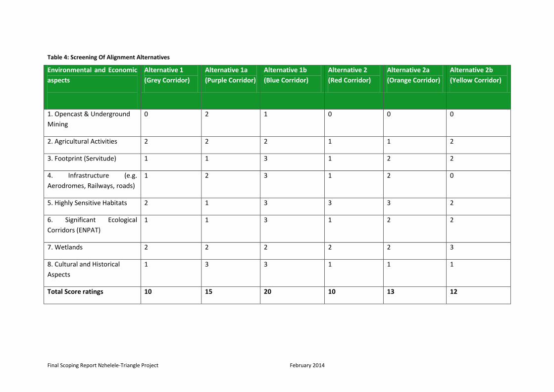
Final Scoping Report Nzhelele-Triangle Project February 2014
Table 4: Screening Of Alignment Alternatives
Environmental and Economic
aspects
Alternative 1
(Grey Corridor)
Alternative 1a
(Purple Corridor)
Alternative 1b
(Blue Corridor)
Alternative 2
(Red Corridor)
Alternative 2a
(Orange Corridor)
Alternative 2b
(Yellow Corridor)
1. Opencast & Underground
Mining
0 2 1 0 0 0
2. Agricultural Activities 2 2 2 1 1 2
3. Footprint (Servitude) 1 1 3 1 2 2
4. Infrastructure (e.g.
Aerodromes, Railways, roads)
1 2 3 1 2 0
5. Highly Sensitive Habitats 2 1 3 3 3 2
6. Significant Ecological
Corridors (ENPAT)
1 1 3 1 2 2
7. Wetlands 2 2 2 2 2 3
8. Cultural and Historical
Aspects
1 3 3 1 1 1
Total Score ratings 10 15 20 10 13 12

Final Scoping Report Nzhelele-Triangle Project February 2014
54
The ratings of the alignment alternatives were based on the identified potential impacts
associated within the study area. The purpose was to screen all the alignment alternatives in
terms of the potential impacts that will eliminate unfeasible alignment alternatives and provide
the viable alignment alternatives that will be assessed during the Impact Assessment Phase.
As detailed in Table 4, the initial screening of the alternative has indicated that the potential
environmental and socio-economic impacts for Alternative 1b is considered to be highly
significant and therefore, Alternative 1b will not be investigated further within the Impact
Assessment Phase.
At this stage, Alternative 1a, Alternative 2a and Alternative 2b will be taken into the Impact
Assessment Phase of the project for further investigation and consideration. Illustrated in
Figure 4, are the alignment alternative that are being taken into the Impact Assessment Phase.

Final Scoping Report Nzhelele-Triangle Project February 2014
Figure 5: Alignment alternatives to be taken into the Impact Assessment Phase

Final Scoping Report Nzhelele-Triangle Project February 2014
56
4.1.3 Source of Energy Alternative: Renewable Energy
Renewable energy is defined as energy that is in constant supply and therefore, cannot run out.
Renewable energy sources include wind, solar, water (hydropower), biomass and geothermal.
Wind, solar and hydropower are all regarded as clean energy because no water or air pollution
is generated during the energy generation process. Most energy in South Africa is generated
through the use of coal fired power stations of which the greatest of coal energy is in the
Mpumalanga Province.
The study area region has the potential to establish solar power as an alternative to the
traditional source of power in South Africa, which is coal. Burning coal is one of the sources of
carbon dioxide (CO2) emitted as end product. Carbon dioxide is one of the greenhouse gases
that contribute to the climate change. The amount of electricity received from solar power
depends on the amount of sun during the year. Globally, solar power is a significant energy
source, producing about 18% of the world’s electricity.
The aim of proposed project is primarily in response to the power allocation in the integrated
Resource Plan (IRP) of the government (gazetted May 2011) and the establishment of the
Southern African Energy (SAE) unit in Eskom to facilitate the investment in generation and
transmission outside South Africa, there is an urgent need to identify critical transmission
corridors to ensure power transfer into between South Africa and neighbouring Southern
African countries (Botswana, Zimbabwe and Mozambique). in this case, the proposed project
concerned with establishing 500kv line from Nzhelele (RSA) substation to Triangle (Zimbabwe)
substation. Therefore, any alternatives regarding renewable energy would not be appropriate as
it will not aid in transmitting electricity from Nzhelele Substation to Triangle Substation or verse
versa .This alternative will not be investigated further during Impact Assessment Phase.
4.1.4 No-Go Alternative
As a norm for any proposed development, the No-Go option should be considered as an
alternative. To maintain the status quo is an attractive option for the reasons outlined below,
but by not taking any action, Eskom Transmission would not be able to ensure the mandate of
the power allocation in the integrated Resource Plan (IRP) of the government (gazetted May
2011) and the establishment of the Southern African Energy (SAE) unit in Eskom to facilitate the
investment in generation and transmission outside South Africa. Doing nothing would have a
major impact on the future planning on the Integrated Resource Plan within the Southern
African Energy unit.
On a positive note this would reduce the impact on the aesthetic value of the natural
environment, because the introduction of power lines into the landscape changes the sense of
place (tourism impacts). It would also benefit the current status quo of the biophysical
environment. However, the need for electricity is a national concern and not increasing the
capacity to generate electricity within Limpopo Province could potentially stunt economic
growth both in Limpopo and South Africa in general. Considering the need for a steady supply of
electricity in the province and country in general, this option will still be further considered
during Impact Assessment Phase.

Final Scoping Report Nzhelele-Triangle Project February 2014
57
5. DESCRIPTION OF THE RECEIVING ENVIRONMENT OF THE STUDY AREA
5.1 Description of Social Environment
5.1.1 Vhembe District Municipality
Vhembe was originally settled by now-expired tribes of Khoisan peoples. It was later settled by the Venda people (recently migrated from what is now Matabeleland South in Zimbabwe), who constitute a majority of the population of Vhembe today. Venda communities are only found in Vhembe district and as a result, there are no existing Venda communities or villages outside the district. Vhembe means Limpopo river in the Venda language.
5.1.2 Musina Local Municipality
Musina Local Municipality falls within the Vhembe District Municipality, which is made up of
four local municipalities, namely Musina, Makhado, Thulamela and Mutale, of which Musina
Local Municipality is bounded by Makhado Local Municipality to the South and Mutale local
Municipality to the east. Musina is also bounded in the South West by the Local Municipality of
Blouberg which falls within the Capricorn District Municipality. Musina Local Municipality is
located in the very North of the Limpopo Province, bordering Botswana and Zimbabwe. Musina
Local Municipality covers an area of approximately 757 829 ha that extends from the confluence
of the Mogalakwena and Limpopo rivers in the West to the confluence of the Nwanedi and
Limpopo rivers in the East and from Tshipise and Mopane in the South to Botswana/Zimbabwe
borders in the North. The municipal area consists mainly of commercial farms and only 0.08% of
the total area is urban in nature.
The spatial structure of the municipality falls within the second order settlement as depicted by
the hierarchy as contained in the Spatial Rational and therefore the spatial framework is aligned
to the NSDP, ASGISA and the LEGDP. The settlement hierarchy of Musina municipality as per the
spatial rationale is as follows:
Musina (Musina and Nancefield) can be described as a provincial growth point (1st order settlement) due to their relative high level of economic activity and rendering of services to local and surrounding communities.
Madimbo, Malale,Tshikhudini,Tanda and Domboni can be described as 5th order settlements due to their small populations and the fact that they are only functioning as residential areas with no economic base. The potential of these settlements for future self-sustainable developments is extremely limited.
Tshipise can be described as a 3rd order settlement (local service point) due to its function in terms of limited service delivery to the surrounding commercial farming areas, tourism attraction and nature conservation.
5.1.2.1 Land Claims and Ownership

Final Scoping Report Nzhelele-Triangle Project February 2014
58
The bulk of state land (National and Provincial) apart from a few individual farms is around the
town of Musina and make up 8% of land holdings of the municipality. Land owned by the local
municipality consists of 27 farms, distributed throughout the municipality and make up 2% of
land holdings within the municipality. Private land consists of 786 (59%) within the municipality.
The institutional land falls in two large clusters mainly owned by de Beers Consolidated Mines
and the South African Development Trust, located around the Venetia diamond mine and the
Domboni/Madimbo areas respectively.
Mixed and ownership sites constitutes parent farms that have been subdivided and the
subdivisions are owned by the state, privately or by an institution. However, they only
constitute some 1% of land ownership within the municipality.
There are 351 land claims lodged on 351 farm subdivisions, covering some 27% of the municipal
area. These claims will have a significant impact on spatial developments within the
municipality. Twenty one of these claims are on state land, located mainly along the National
road and rail routes and adjacent to Mapungubwe.
5.2 Social Profile
5.2.1 Population Figures
The table below indicates that the population of Musina Local municipality from census 2001 was 39 310 and 57 195 from 2007 community survey. It reveals that from 2001 to 2007 the population of Musina has increased by 17 885 people.
Table 5: Population growth trends in Musina Local Municipality
CENSUS 2001 39 310
Community Survey 2007 570195
Population growth 17 885
SOURCE: Census 2001 & Community Survey 2007
5.2.2 Economic Growth And Increased Employment
The main contributors to the economy of Musina municipality are : Agriculture, Forestry and
Fishing (35%), Mining (30%), Transport and communication (15%), Manufacturing (11%),
Finance and business services (9%), wholesale & retail trade, catering and accommodation (6%),
community, social, personal services (6%), government services (5%), construction (5%). The
unemployment rate stands at 25% with the highest percentage amongst the youth aged
between 15 to 19 years and declining with age. Musina local municipality contributes 11% of
GDP to the Vhembe district municipality.

Final Scoping Report Nzhelele-Triangle Project February 2014
59
Table 6: Employment And Income Indicators
5.3. Infrastructure
There are various land uses and established facilities within the proposed corridors that will
need to be taken into consideration in determining the potential the socio-economic effects
(Figure 6-7).
Four aerodromes (Figure 8) have been identified, that have the potential to be impacted on by
the proposed 500kV power line, within the study area as well as within close proximity to the
study area. The identified aerodromes are detailed in Table 7. At the moment the status of
those airfields are not yet known, however the request of the stastus of this airfields were made
with Civil Aviation Authorities and all the identified airfields were buffered with 3km radius.
Employment and
income indicator
Number Percentage
Employed 16 197 41.2%
Unemployed 5 384 13.6%
Not economically active 5 073 12.9%
Total 15-65 years 26 654
Income: None-R800 7 983 69.8%
Income: R801-R3 200 2 341 20.8%
Income: R3 200 and
above
1 253 10.8%
Total households 11 578 100%

Final Scoping Report Nzhelele-Triangle Project February 2014
Figure 6: A map representing established facilities potentially to be affected by proposed corridors

Final Scoping Report Nzhelele-Triangle Project February 2014
Figure 7: A map representing land uses potentially to be affected by proposed corridors

Final Scoping Report Nzhelele-Triangle Project February 2014
Figure 8: Local Civil Aerodrome Locality Plan

Final Scoping Report Nzhelele-Triangle Project February 2014
63
5.3.3 Roads and Railways
The area has a well-developed road network, especially the N1 which stimulates development
between the economic hub of the Musina area to the international border of Zimbabwe. Other
important secondary corridors include the R508 and R572 which connects Musina and other
areas such as Tshipise and Alldays. There is railway line exist within the study area, a railway
linking Musina with Louis Trichardt (Makhado).
5.4 Tourism Industry
From a tourism value perspective, the future power-lines have the potential to affect the
intangible value placed on the reserves used for tourism in the area, such as Musina Nature
Reserve and Maremani Nature Reserve. This is as it would affect a tourist’s perception of the
area and their possible expectation of having no obtrusive man-made infrastructure in reserves.
It has the potential to affect the tourism experience.
Musina has a wide range of tourism attraction spots like Vhembe Dongola National Park, Mapungubwe International heritage site De beers game farm, Musina nature reserve, Poppalin ranch, Ratho crocodile farm, Beit bridge, Limpopo river, Iron ore mine, Musina old copper mine, De beers diamond mine, Spirulina plant, Nwanedi and Tshipise, in the area there are numbers of game farms, conservancies, national parks, nature reserves, and resorts that have been established and developed, and significant initiatives concerning tourism and conservation in or affecting the area are in progress.
The reserves have the following value for tourism:
Musina Nature Reserve: features as a reserve that is known for the conservation of the baobab tree. It has a Day visitor’s area, Educational centre and a tented bush camp.
Maremani Nature Reserve: The significance of the reserve is in it’s the restoration and rehabilitation of animal and plant species as well as its archaeological heritage, such as the rock art. The rock art is representative of the Stone as well as Iron Ages and there are 6 spots that have been set aside for the viewing of the art. They are called “Tombo-la- Thudwa, Yellow Giraffe Shelter, The Work Surface, Shelter of the Moon and Cloud Game Hill”.
Final Scoping Report Nzhelele-Triangle Project February 2014
64
6. DESCRIPTION OF THE BIOPHYSICAL ENVIRONMENT
6.1 Climate
The climate patterns within study area (Musina) experiences a hot semi-arid climate with hot
temperatures most of the year. Average annual precipitation amounts to 372 mm and is highly
concentrated in the summer months from October to April when severe late-afternoon and
evening thunderstorms are common. Winter is extremely dry, with almost no precipitation,
typically recorded in the driest months from June to August. Clear skies and exceptionally low
humidity at this time of the year enable temperatures to plunge close to freezing at night,
although frost is fairly uncommon. Droughts frequently occur during the winter months, and
infrequently during summers when very little rain falls and drought conditions prevail. These
erratic summer droughts are becoming more common as climate change continues. The
elevation of this region varies from 750 to 1,400 m and the annual rainfall from 350 mm in the
west to 600 mm in parts of the northeast.
6.2 Geology
The Bushveld is one of the most mineral-rich regions of the world. This is due to the Bushveld
igneous complex, an extremely rich saucer-shaped geological formation that stretches over
more than 50,000 square kilometers. This formation contains most of the world's reserves of
minerals such as andalusite, chromium, fluorspar, platinum and vanadium. As shown in Figure 9
the rocks originating from the main geological structures within the study area are shale in the
eastern region and Arenite in the western region. The western region of the study area also
contains dolerite, quartzite, basalt, gabbro and tillite instructions.

Final Scoping Report Nzhelele-Triangle Project February 2014
Figure 9: Regional Geological Structures

Final Scoping Report Nzhelele-Triangle Project February 2014
66
6.3 Topography
The topography within the western and south eastern sections of the study area range between
800m and 1800m above sea level. This area is characterised by slight to moderate undulating
hills and plains and pan depressions. The eastern and north eastern sections of the study area
contains high altitude plateaus, undulating plains, mountain peaks and slops as well as hills and
deep valleys. The altitude range within these sections, range from 1260m to 2160m above sea
level.
6.4 Surface Water
The proposed corridors are located within the Limpopo River Catchment and the affected
quartenary catchments are . The important rivers and drainage lines to be crossed by the
proposed corridors are few and include the Sand River (Figure 10) although numerous seasonal
tributaries and drainage lines are to be crossed. It is evident that Alternative 2A and Alternative
2B will cross more drainage lines when compared to Alternative 1.
6.5 Soil and Agricultural Potential Component
The predominant agricultural capability within the study area ranges from high to low grazing
and arable land use. The following land types are associated with the line transects:
Ac – red and yellow dystrophic and/or mesotrophic soils of variable depth, low to high agricultural potential;
Ad – Red-yellow apedal, freely drained soils; yellow, dystrophic and/or mesotrophic;
Ba – Plinthic catena: dystrophic and/or mesotrophic; red soils widespread, upland duplex and margalitic soils rare;
Bb – Dystrophic and/or mesotrophic, red soils not widespread, low to high agricultural potential;
Ea – One or more of: vertic, melanic, red structured diagnostic horizons, undifferentiated;
Fa – Glenrosa and/or Mispah forms (other soils may occur), lime rare or absent in the entire landscape; and
Ib – Miscellaneous land classes, rocky areas with miscellaneous soils.

Final Scoping Report Nzhelele-Triangle Project February 2014
Figure 10: Primary and quaternary catchment affected by the proposed corridors

Final Scoping Report Nzhelele-Triangle Project February 2014
68
6.6 Ecology
6.6.1 Regional Vegetation
The study area corresponds to the Savanna Biome and more particularly to the Mopane
Bioregion as defined by Mucina & Rutherford (2006). The proposed corridors comprehend two
ecological types known as (a) Musina Mopani Bushveld, and (b) Limpopo Ridge Bushveld (Figure
10):
(a) Musina Mopani Bushveld: This vegetation type extends from Baines Drift and Alldays in the west, eastwards and north of the Soutpansberg to Banyini Pan. It is predominantly located on undulating plains that are irregularly interspersed by tributaries of the Limpopo River. On the
(b) study area, it forms a moderately open, albeit arid savanna dominated by Colophospermum mopane, Terminalia prunoides, Commiphora species and Combretum apiculatum. The field layer is well developed and tends to become more open during the dry season. The herbaceous layer is poor in species richness.
This vegetation type was widespread, least threatened and dominant on the study area. (b) Limpopo Ridge Bushveld: This bushveld type is associated with low hills and outcrops (mainly Clarens Formation sandstone) scattered within the Mucina Mopani Bushveld. It conforms to a typical and moderately open savanna, dominated by Kirkia acuminata and Adansonia digitata, especially on areas of calcareous soils. It is evident that both Alternative 1A and 1B traverse a higher percentage of Limpopo Ridge Bushveld compared to Alternative 2. This means that Alternative A is more likely to cross over or be positioned in close proximity to hills and ridges which are often focal habitat for birds of prey and substrate-specialist taxa (e.g. scorpions). In addition, the high spatial heterogeneity in micro-habitat types presented by these landscape features is more likely to hold a higher floristic richness to the Musina Mopani Bushveld.

Final Scoping Report Nzhelele-Triangle Project February 2014
Figure 11: Regional Vegetation Units within the study area

Final Scoping Report Nzhelele-Triangle Project February 2014
70
6.6.2 Vegetation: Species of conservation concern1
The study area consists largely of arid woodland which is widely distributed in the region and
often dominated by near-monotonous stands of Colophospermum mopane. Therefore, the
threatened and near-threatened taxa, in contrast to the Grassland Biome, is poorly represented
on the study area as evidenced by the low richness of confirmed taxa at a quarter-degree level.
However, a preliminary analysis of the typical habitat requirements of these taxa show that
moderate to high probabilities of occurrence is expected on the various ridges and hills (broken
terrain) and deciduous riverine woodland (along the Limpopo and Sand River) in the area as
opposed to the plains. Nevertheless, the direct relationship between these species and areas
where slopes are relative steeper has been proven, and a subsequent high level of
environmental significance should be attributed to these particular areas. Table 4 lists the
conservation important taxa that could occur on the study area, and provides an indication of
their potential occurrence.
Table 6: Red Data and Orange Listed plant species
Species Flowering Season Habitat Probability of
occurrence
Conservation
Status
Orange Listed
Ansellia africana August-October Hot arid mixed
deciduous
woodland,
especially riverine
woodland.
Possible, along tall
riverine woodland
dominated by
Adansonia,
Peltophorum and
Combretum
imberbe..
Declining
Adenia fruticosa
subsp. simplicifolia
September Low deciduous
woodland and
thorny bushveld
on rocky areas
(gneiss, granite
and pegmatite).
High, likely to be
present in arid
woodland on rocky
substrate.
Data Deficient
Peristrophe cliffordii May & August – October
Deep Kalahari sand in mopane bushveld.
Could occur in the
north along the
Limpopo River.
Rare
It is evident that the northern part of the study area appears to hold the highest probability for
these taxa to occur, which corresponds to Alternative 1A, 1B and 2A. It clearly illustrates the
importance of the riverine woodland and bushveld confined to ridges for these taxa to be
present.

Final Scoping Report Nzhelele-Triangle Project February 2014
71
6.6.3 Fauna
The proposed corridors will traverse through extensive areas of natural woodland and game
reserves, especially on the eastern and central section of the study area which provide suitable
habitat for a variety of large and charismatic mammal species. Likewise, the perennial rivers
provide suitable habitat for a number of near-threatened and data deficient taxa that are
wetland-dependant (e.g. shrew taxa of the genus Crocidura). However, the area is likely to
support a high richness of near-threatened meso- and meta-carnivores on a global and national
level (e.g. Leopard Panthera pardus and Brown Hyaena Parahyaena brunnea). The objective is
not to provide a detailed account on the various animal communities present, but merely to
provide an indication of the diversity and potential occurrence of taxa of conservation concern.
Most mammal species are in general highly mobile and therefore able to vacate areas should
adverse environmental conditions prevail. Therefore, direct impacts associated with
construction activities on adult mortality are less likely to occur, although indirect impacts will
have consequences on their “fitness” (e.g. the ability of a species to reproduce). However,
persistent disturbances across extended temporal scales will eventually affect any population’s
ability to sustain itself, and will more than likely result in total abandoning of a particular area.
Species most likely to be affected are either K-selected species or habitat specialists e.g.
substrate specialists (e.g. baboon spiders). K-selected species are mostly long-lived species with
slow reproductive rates, while habitat specialists are those restricted to a particular type of
microhabitat or niche, being it structurally, altitudinal or floristic. Most of these species are
therefore threatened, “near-threatened” or Red Listed.
Faunal compositions are believed to remain the same irrespective of the intensity of the
construction activities (e.g. road construction) associated with the power lines, but the
distribution and abundance of species could effectively change. Many habitat specialists (in
particular those restricted to outcrops) could eventually suffer from local range contraction.
In addition, construction activities go hand in hand with high ambient noise. Although the
construction phase is considered to be of short duration, many of the larger terrestrial species
will vacate the study area during the construction phase and will become temporarily displaced.
Table 10 provides a list of threatened, “near-threatened” and conservation important faunal
species with geographic distribution ranges sympatric (overlapping) to the study area. It is
evident that a high richness (especially mammal species) is expected to occur. This emphasises
the untransformed ecological condition of the various habitat types in the area and the
extensive surface areas occupied by these habitat types. Many of these areas coincide with large
private game reserves which provide sanctuary for taxa with large body sizes.
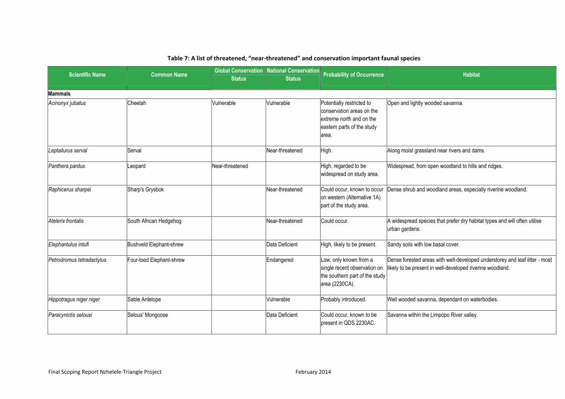
Final Scoping Report Nzhelele-Triangle Project February 2014
Table 7: A list of threatened, “near-threatened” and conservation important faunal species
Scientific Name Common Name Global Conservation
Status
National Conservation
Status Probability of Occurrence Habitat
Mammals
Acinonyx jubatus Cheetah Vulnerable Vulnerable Potentially restricted to
conservation areas on the
extreme north and on the
eastern parts of the study
area.
Open and lightly wooded savanna.
Leptailurus serval Serval Near-threatened High. Along moist grassland near rivers and dams.
Panthera pardus Leopard Near-threatened High, regarded to be
widespread on study area.
Widespread, from open woodland to hills and ridges.
Raphicerus sharpei Sharp's Grysbok Near-threatened Could occur, known to occur
on western (Alternative 1A)
part of the study area.
Dense shrub and woodland areas, especially riverine woodland.
Atelerix frontalis South African Hedgehog Near-threatened Could occur. A widespread species that prefer dry habitat types and will often utilise
urban gardens.
Elephantulus intufi Bushveld Elephant-shrew Data Deficient High, likely to be present. Sandy soils with low basal cover.
Petrodromus tetradactylus Four-toed Elephant-shrew Endangered Low, only known from a
single recent observation on
the southern part of the study
area (2230CA).
Dense forested areas with well-developed understorey and leaf litter - most
likely to be present in well-developed riverine woodland.
Hippotragus niger niger Sable Antelope Vulnerable Probably introduced. Well wooded savanna, dependant on waterbodies.
Paracynictis selousi Selous' Mongoose Data Deficient Could occur, known to be
present in QDS 2230AC.
Savanna within the Limpopo River valley.

Final Scoping Report Nzhelele-Triangle Project February 2014
Scientific Name Common Name Global Conservation
Status
National Conservation
Status Probability of Occurrence Habitat
Pipistrellus rusticus
Rusty Bat Near-threatened High, likely to be present. Well-developed savanna, mainly riparian woodland.
Mellivora capensis Honey Badger Near-threatened High, likely to occur. Catholic, widespread and tolerant to most habitat types.
Crocidura cyanea Reddish-Grey Musk Shrew Data Deficient High. Dry terrain among rocks in dense scrub and grass, in moist places and in
hedges.
Crocidura hirta Lesser Red Musk Shrew Data Deficient High. Wide habitat tolerance.
Crocidura mariquensis Swamp Musk Shrew Data Deficient High. Moist habitats, e.g. thick grass along riverbanks, reedbeds and in swamps.
Graphiurus platyops Rock Dormouse Data Deficient High. Rocky habitat.
Epomophorus gambianus
crypturus
Gambian Epauletted Fruit Bat Data Deficient Could occur. Riverine woodland with a high density of Ficus spp.
Hipposideros caffer Sundevall's Leaf-nosed Bat Data Deficient Likely to be present. Forages over savanna, roost in caves.
Rhinolophus hildebrandtii Hildebrandt's Horseshoe Bat Near-threatened Could occur, especially in the
vicinity of hills and ridges.
Forages over savanna, roost in caves.
Reptiles
Crocodylus niloticus Nile Crocodile Vulnerable High. Mainly confined to the Limpopo River.
Homopholis mulleri Muller's Velvet Gecko Vulnerable Possible, known from the
southern part of the study
area.
Holes in Sclerocarya birrea, Colophospermum mopane and Acacia
nigrescens trees in Mopani woodland.
Chirindia langi occidentalis Soutpansberg Worm Lizard Vulnerable Could occur, probably
peripheral to study site.
Low-lying areas under stones embedded in sandy soils.
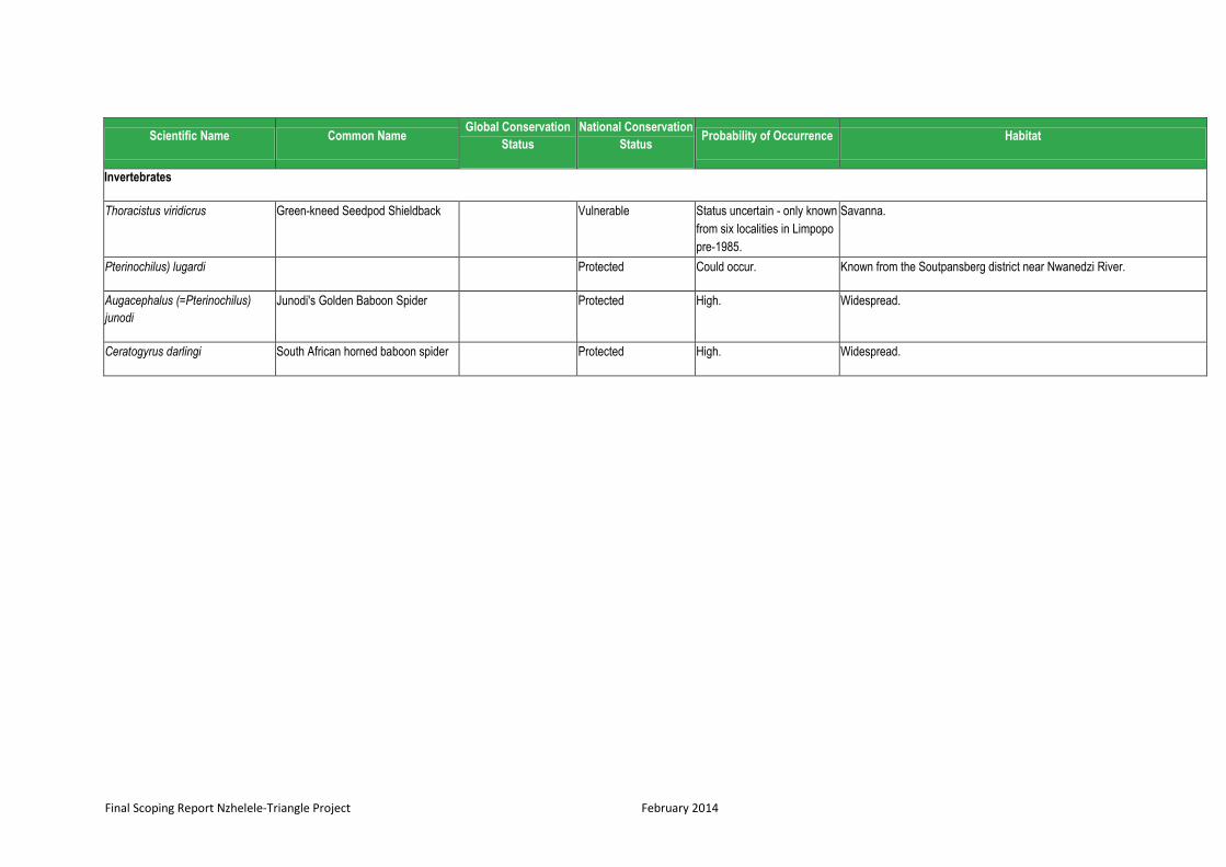
Final Scoping Report Nzhelele-Triangle Project February 2014
Scientific Name Common Name Global Conservation
Status
National Conservation
Status Probability of Occurrence Habitat
Invertebrates
Thoracistus viridicrus Green-kneed Seedpod Shieldback Vulnerable Status uncertain - only known
from six localities in Limpopo
pre-1985.
Savanna.
Pterinochilus) lugardi Protected Could occur. Known from the Soutpansberg district near Nwanedzi River.
Augacephalus (=Pterinochilus)
junodi
Junodi's Golden Baboon Spider Protected High. Widespread.
Ceratogyrus darlingi South African horned baboon spider Protected High. Widespread.

Final Scoping Report Nzhelele-Triangle Project February 2014
75
6.6.4 Avi-Fauna
A number of important micro-habitat units are present in the landscape, and it was necessary to
elaborate on their importance from an avifaunal perspective (mapping of these units together
with detailed descriptions on their spatial position and avifaunal composition will only be dealt
with during the EIA phase of this project):
Open arid woodland with sparse basal cover - A large part of the study area is
characterised by arid Colophospermum- and Commiphora-dominated woodland of
which the field layer is poorly developed. Therefore, the floristic structure and low
presence of human-induced disturbances have facilitated the colonisation and regular
foraging of large terrestrial bird species as evidenced by high reporting rates for Kori
Bustard (Ardeotis kori), Southern Ground Hornbill (Bucorvus leadbeateri) and
Secretarybird (Sagittarius serpentarius);
Limpopo and Sand Rivers – These include large shallow river with wide expansive and
sandy floodplains. Not only do these linear systems facilitate bird dispersal, thereby
linking the study area with other important foraging areas located within the Limpopo
River catchment, but it also provide critical important foraging habitat for various
threatened and near-threatened stork species and numerous other waterbird species.
The riparian woodland is also earmarked by prominent canopy constituents (mainly
Ficus sycomorus) which provide additional refuge and roosting habitat for the large bird
of prey species;
Artificial dams – these represent artificial dams which provide habitat for a variety of
waterbird species which benefited from their presence and utilise these bodies of water
for breeding and foraging purposes;
Arable land and cultivated fields - These are represented by agricultural land, which
provide ephemeral foraging habitat for a number of bird species in particular that of the
nationally Secretarybird (S. serpentarius) and other species that are prone to power line
collisions such as the White Stork (Ciconia ciconia), Abdim's Stork (C. abdimii), Spur-
winged Goose (Plectropterus gambensis) and Egyptian Goose (Alopochen aegyptiaca);
Isolated ridges and hills - These landscape features provide ideal nesting and hunting
habitat for a range of bird of prey species. Typical species include the Lanner Falcon
(Falco biarmicus) and the Verreaux's Eagle (Aquila verreauxii);
Tall canopy trees - The landscape is characterised by prominent individuals of Adansonia
digitata, which also provides ideal nesting and roosting platforms for a diversity of birds
of prey species (e.g. Wahlberg's Eagle Hieraaetus wahlbergi and White-backed Vulture
Gyps africanus).
In general, the study area supports a high richness of birds species (mean of 243.6 spp, n=6
QDGs) which is explained by the extensive area of woodland habitat and the occurrence of
tropical riverine habitat along the Sand and Limpopo Rivers. The latter support many species
with marginal distribution ranges in South Africa, since the majority reach their southern
distribution limits on the study area. The number of bird species recorded for each quarter

Final Scoping Report Nzhelele-Triangle Project February 2014
76
degree square range from 192 species at Kumkusi (2229BD) to as many as 278 species at
Beitbridge (2229BB).
Threatened and Near-threatened Species
The highly seasonal and ephemeral nature of surface water retention in the area, along with the
presence of large rivers with extensive sandy floodplains and pools are responsible for the
occurrence of many threatened and near-threatened stork species (c. five species) in the region.
These habitat features, in combination with the open structure of the woodland habitat (which
favour large terrestrial bird species such as bustards, ground hornbills and Secretarybirds), an
abundance of game species (which favours scavengers), the rural practice of ranching in
neighbouring Zimbabwe (which favours scavengers of the vulture genera Terathopius, Gyps and
Aegyptius) and the presence of isolated, although prominent landscape features (e.g. ridges
which provide optimal hunting habitat for Verreaux's Eagle Aquila verreauxii and Lanner Falcon
Falco biarmicus) have all contributed to the high richness of threatened and near-threatened
bird species in the area, especially large birds of prey. Therefore, a total of 19.5 % (133 spp) of
all national threatened and near-threatened bird species are present on the study area. In
retrospect, the majority of species are also highly prone towards collisions with earth wires, and
therefore at risk.
Table 8 summarizes the Red listed species that could potentially occur on the study area. It is
evident that the highest reporting rates (according to Harrison et al., 1997) were recorded from
the southern and waster parts of the study area corresponding to 2229DB (Mopane), 2229BD
(Kamkusi) and 2230CA (Thipise). Those areas with high reporting rates were well-utilised by the
Kori Bustard (Ardeotis kori), followed by the Lapped-faced Vulture (Aegypius tracheliotos),
Verreaux's Eagle (Aquila verreauxii), Southern Ground Hornbill (Bucorvus leadbeateri) and
Secretarybird (Sagittarius serpentarius).
Non-threatened species
A number of other bird species are also likely to be affected by the proposed transmission line
and include species such as the White Stork (Ciconia ciconia), Woolly-necked Stork (Ciconia
episcopus), African Openbill (Anastomus lamelligerus), African Fish-eagle (Haliaeetus vocifer),
Brown Snake-eagle (Circaetus cinereus), Black-chested Snake-eagle (Circaetus pectoralis) and a
number of waterbird species pertaining to the Anatidae (ducks and geese), Phalacrocoracidae
(cormorants), Anhingidae (darters), Ardeidae (herons and egrets) as well as Threskiornithidae
(ibises).
.

Final Scoping Report Nzhelele-Triangle Project February 2014
Table 8: The reporting rates (%) for each Red listed species
QDGC Global Status
Regional Status
2229BB 2229BD 2229DB 2230AC 2230CA 2230AD
Species Beitbridge Kamkusi Mopane Musina Thipise Esmefour
Great White Pelican (Pelecanus onocrotalus) - V 3 3
Pink-backed Pelican (Pelecanus rufescens) - V 6
White-backed Night-heron (Gorsachius leuconotus) - V 3
Yellow-billed Stork (Mycteria ibis) - EN 8 2 9
Black Stork (Ciconia nigra) - V 3 5 9
Abdim's Stork (Ciconia abdimii) - NT 3 14 2 6
Saddle-billed Stork (Ephippiorhynchus senegalensis) - EN 6 6
Marabou Stork (Leptoptilos crumeniferus) - NT 10 2
Greater Flamingo (Phoenicopterus ruber) - NT 3
Lesser Flamingo (Phoeniconaias minor) NT NT 3
Secretarybird (Sagittarius serpentarius) V V 8 29 2
African White-backed Vulture (Gyps africanus) EN EN 3 8 21 3
Cape Vulture (Gyps coprotheres) V EN 8 21
White-headed Vulture (Aegypius occipitalis) V EN 8
Lapped-faced Vulture (Aegypius tracheliotos) V EN 21
Verreaux's Eagle (Aquila verreauxii) - V 6 31 13
Tawny Eagle (Aquila rapax) - EN 3 7 7 6 15

Final Scoping Report Nzhelele-Triangle Project February 2014
QDGC Global Status
Regional Status
2229BB 2229BD 2229DB 2230AC 2230CA 2230AD
Species Beitbridge Kamkusi Mopane Musina Thipise Esmefour
Martial Eagle (Polemaetus bellicosus) V EN 6 8 21 11 6
Bateleur (Terathopius ecaudatus) NT EN 29 2 6 3
Pallid Harrier (Circus macrourus) NT NT 2 6
Lanner Falcon (Falco biarmicus) - V 10 7 7 6 6
Kori Bustard (Ardeotis kori) NT NT 3 62 50 13 31 15
Greater Painted Snipe (Rostratula benghalensis) - V 6 2 3
Chestnut-banded Plover (Charadrius pallidus) NT NT 3
European Roller (Coracias garrulus) NT NT 3 8 29 15 38 15
Southern Ground Hornbill (Bucorvus leadbeateri) V EN 8 29 12
Average Reporting Rate 4.71 14.00 23.16 7.36 14.00 7.71
Total Richness 17 9 12 14 8 14
Final Scoping Report Nzhelele-Triangle Project February 2014
79
6.7 Visual and Aesthetic Value
It is generally accepted that transmission lines reduce visual amenity and that visual amenity has
a value to local residents and visitors to an area. The visual impact of transmission lines is much
greater per kilometre than distribution lines because of the size of transmission pylons. The
introduction of the new power lines on the landscape affects the natural view of the area, which
leads to a change in the sense of place. Tourism areas are significant for local economic
development and in many cases are earmarked to contribute to profitability and the mitigation
of poverty by their aesthetic and recreational value. The optimal utilisation of these areas is
important and fragmentation/sterilisation of and damage to the aesthetic value should be
avoided.
6.8 Heritage Resources
The Limpopo Province is known to contain archaeological resources dating from Stone Age (Early, Middle & Late Stone Age), Iron Age (Early, Middle & Late Iron Age), the Historical Archaeological Period (the past 500 years covering: Historical, Industrial, Burial Grounds & Graves and Built Environment & Landscape). In this province Rock Art is commonly found in association with the Stone Age archaeology (Late Stone Age) and the historical period. It is also located within a region that contain Archaeozoic, Proterozoic and Phanerozoic geological period rock formations which will influence the palaeontological component of the study. Therefore, the study area will most likely to yield some of the above mentioned archaeological, historical, built environment and landscape features as well as palaeontological resources. The historical period heritage also includes the farming community heritage such as old towns and associated buildings, graves and many other built environment and landscape features such as dams, reservoirs, water furrows, and farming implements etc. This period is also a period known for some of South Africa's defining events such as the Imfecane, the different South African Wars (a.k.a. the Anglo-Boers Wars). The Limpopo, one of the former Transvaal Republic regions and later South African Republic, is well known for some of these events. The totality of the above mentioned heritage resources represent some of the anticipated resources within the broader study area as defined in the study scope terms of reference. Therefore, archaeological, historical and palaeontological records such as journal articles, books and archives about the study area and its immediate surrounding will be studied to give an in-depth archaeological and historical background of the area under consideration. It would therefore be important to access, review and assess heritage databases housed at the following institutions:
The South African Heritage Resources Agency (SAHRA) - Nation o The APM Unit (Archaeological, Palaeontological & Meteorite Unit) o Including the SAHRA-Burial Grounds & Grave Unit (should the need arise)
The Limpopo Provincial Heritage Resources Authority (LIHRA) - Built Environment & Landscape
The Bernard Price Institute for Palaeontology

Final Scoping Report Nzhelele-Triangle Project February 2014
80
7. PUBLIC PARTICIPATION PROCESS: SCOPING PHASE
Public participation forms an integral part of the full EIA process and the EAP is totally reliant on
the Interested and Affected parties (I&AP’s) participation to ensure adherence to the legal
requirements as set out in NEMA.
Sections 54 to 57 of Regulation R543 of the EIA Regulations (August 2010) promulgated under
the National Environmental Management Act No 107 of 1998 are applicable. The important
elements relating to the public participation process that are required by the Regulations are
the following:
The manner in which potential Interested and Affected Parties (I&APs) were notified of the application for authorisation, and that a public participation process was mandatory.
Opening and maintaining a register of the names and addresses of I&APs. These include all persons who have attended meetings, submitted comments, organs of State who have some form of jurisdiction in the assessment process, and all those who have requested that they be placed on the register as registered I&APs.
Registered I&APs are entitled to comment, in writing, on all written submissions made to the competent authority by the applicant or the EAP managing the application, and to bring to the attention of the competent authority any issues which that party believes may be of significance when the application is considered for authorisation. The comments of registered I&APs must be recorded and included in the reports submitted to the competent authority.
The Public Participation (PP) team set out an information program during the Scoping Phase of
the process to ensure that as many I&APs as possible were well informed about the proposed
project as possible in order to form part of the EIA from inception to completion.
During the EIA Phase, the focus was on informing potential I&APs as well as registered I&APs
about the project and to ensure that they (and other stakeholders) have ample opportunity to
comment and give input, especially with regard to their preferred alignment. There was no cut-
off date for registering as I&APs and new stakeholders are welcomed into the process
throughout.
7.1 Developing the I&AP Database
The Public Participation Process in the EIA Phase kicked off with an exercise to ensure that the
team had contact details of parties. The initial stages of the process were conducted in January
2014. This was no easy task, but every endeavour was made to create an up to date database of
I&APs, including all landowners. In this communication I&APs were invited to send their
comments and concerns and to communicate with the PP Team should they have any questions,
etc.
The I&AP Database was updated regularly and will be updated regularly throughout the process.

Final Scoping Report Nzhelele-Triangle Project February 2014
81
7.2 Notifying potential I&APs of the project and creating the database of I&APs
An initial advertisement advertising the proposed project and the process that was to
commence was placed in the Limpopo Mirror and Zoutpansberger of 25 April 2104. This
advertisement asked all those who were affected or felt that they were interested to register as
I&APs. and in addition the advertising informed the public about the Public Meetings for
introduction of the project.
In addition to the advertisements, site notices were placed at places where people gather and
across the study area (figure 12). Landowners were identified through searches on WinDeeds
and calling neighbours to obtain contact details of adjacent farms. The Farmers’ Unions were
also very helpful.
A letter informing landowners of the study was delivered across the study area in April 2014.
Some landowners responded to this letter and their comments and additional contact details
were included into the I&AP Database. Finally, potential I&APs (such as government
departments, municipalities, NGOs, etc.) were pre-identified and placed on the Stakeholder
Database.
7.3 Public Meetings
Three meetings were held in total to inform the public as to the project and how they can be
involved in the project. The following ways were used to inform I&APs of the Public Meetings.
Newspaper advertisements (the Limpopo Mirror and Zoutpansberger); and
Notification within the BID.
7.4 Draft Scoping Report Public Comment Period
The Draft Scoping Report (DSR) was made available to the public and I&AP’s for review and
comment from 11 September to 17 October 2014.
Notifications was send out to all registered I&AP’s and the public was notified with
advertisements, 12 and 26 September 2014, in the Zoutpansberger and Limpopo Mirror
Newspapers of the review period and public meetings.
Table 9a: Focus group meetings with stakeholders
Date Type of Meeting Venue/ Stakeholder Time
6th October 2014 Stakeholder Meeting
LDEDT and DWA
Polokwane – LDEDT and DWA 11H00

Final Scoping Report Nzhelele-Triangle Project February 2014
82
7th October 2014 Stakeholder Meeting Beitbridge 10H00
9th October 2014 Stakeholder Meeting Musina Municipality – Local
Municipality
10H00
9th October 2014 Stakeholder Meeting –
Scott farm Community
Sand River Resort - Scott Farm
Community
12H00
Public meetings will be held in the same week at the following venues:
Table 9: Public Meetings for DSR
Date Type of Meeting Venue Time
7th October 2014 Public Meeting Sand River Resort – N1 18H00
8th October 2014 Public Meeting Musina Lodge – Limpopo Avenue 18H00
9th October 2014 Public Meeting Nancefield Hall – James Chirwa Street 18H00
Hard copies of the Draft Scoping Report were made available at the following places detailed in
table 10.
Table 10: Places were DSR will be available for review
Place Address
Nancefield Library Nancefield Community Centre
Musina Municipality 21 Irwin Street, Musina
Elephant Inn / Sand river resort Sasol Garage N1 high way
Beitbridge Shell Garage N1 just before the Beitbridge Border Post
Musina Nature Reserve Office Off the N1 high way just south of Musina Town
Musina Police Station Flax Avenue Musina
Comments received on the Draft Scoping Report will be included in the Issues and Respond
Report. The public participation followed to date has culminated in the current Issues and
Response Report, see Appendix D.The issues raised by all I&APs have been included in this
report and have been taken into consideration by the Technical Team.
For more detailed information regarding the Public Participation Process, please refer to the
Public Participation Specialist Report under Appendix C.

Final Scoping Report Nzhelele-Triangle Project February 2014
Figure 12: Map representing where the site notices were placed and geo-referenced.

Final Scoping Report Nzhelele-Triangle Project February 2014
84
7.5 Draft Scoping Report Public Comment Period
The Draft Scoping Report will be placed for public comment, for a period of 40 days, from the
15th of August 2014 to the 30th September 2014.
7.6 Summary of concerns raised during the Scoping Phase
Agriculture o Loss of income during construction and operational phase.
Air Quality o No issues recorded.
Alternatives (including Alignment) o No clear indications of a preferred alignment were identified by the public.
Archaeology and Heritage o There are many archaeological sites scattered throughout the area that needs
careful consideration.
Compensation of servitude o Will landowners be compensated? o How will compensation work? o Compensation should be an ongoing matter (not a once-off payment as is
currently the case). o Free electricity should be provided to landowners who have lines on their farms.
Construction and Rehabilitation o Suggestions for the EMP. o Disruption of normal activities and loss of agricultural potential during
construction.
Cumulative Impact o There are too many Eskom power lines (between Transmission and Distribution)
and future planning for both needs to be shared with the public now already so that they can plan ahead as well.
Ecology, Fauna and Flora o Rare, vulnerable and endangered species and large bird species o Loss of habitat. o Loss of biodiversity.
Economy o Loss of income during construction o Loss of eco-tourism.
Employment o Will local labour be used?
Eskom Specific Issues o Maintenance of servitude areas. o The cumulative effect of the many power lines. o Ensuring that recommendations during the EIA phase are adhered to during
construction.
General o Issues recorded here were diverse.
Geology o No issues were recorded.
Ground Water o No issues were recorded

Final Scoping Report Nzhelele-Triangle Project February 2014
85
Health (Human and Animal, including electro-magnetic fields) o The impact of EMFs on people and animals.
Infrastructure o Questions about the types of towers to be used.
Land-Use and Planning o Mostly issues around the alignment.
Legal o No issues were recorded.
Need for the Project o No issues were recorded.
Nuisance (including Noise) o No issues were recorded.
Offers to assist and requests of Baagi o Various issues were recorded, including new potential I&APs to contact.
Process o Time and places for future meetings.
Property Values o Notably, I&APs mentioned that it was difficult to sell farms with transmission
lines on, especially as the payment is not ongoing – but the nuisance is!
Quality of Life / Sense of Place (including Visual Impact) o Some landowners indicated that their farms / homesteads were sensitive to
visual intrusions.
Safety o Power lines near dwellings are not safe.
Security o The fact that Eskom has keys to the locks to farm gates is a security issue.
Surface Water o Wetlands need to be studied. o Wetlands need to be spanned.
Technical Questions o No issues were recorded.
Waste Management o No issues were recorded.
The public participation followed to date has culminated in the current Issues and Response
Report, see Appendix D. The issues raised by all I&APs have been included in this report and
have been taken into consideration by the Technical Team.
For more detailed information regarding the Public Participation Process, please refer to the
Public Participation Report under Appendix C.

Final Scoping Report Nzhelele-Triangle Project February 2014
86
8. OVERVIEW OF THE EXPECTED EFFECTS ON THE ENVIRONMENT
Any development has an impact on the surrounding area and region in which the development
occurs. The proposed construction of a 500kV line from Nzhelele - Triangle Substations will have
an impact on environment. The goal of an EIA process is to determine the impacts, the extent of
the impacts and the mitigating measures that will limit the impacts to acceptable levels for the
social and biophysical environment, society, the local community, I&APs, and all spheres of
government.
During the public participation process, most of the comments received from I&APs have
indicated specific issues of concern and the concerns received will be taken forward to the
Impact Assessment in the attempt to address these concerns.
8.1 Overview of the Potential Impacts on Social Environment
With regard to the need for the project, the additional electricity capacity within Mpumalanga
Province customer load networks will be beneficial to the economic growth of the area or region
in general. This will ensure steady supply of the electricity vital for the daily activities of
government, institutions, industry and communities. The electrification of health facilities,
educational facilities, industrial facilities, security facilities, rural development, and business
development requires a steady and reliable supply of electricity. Thus, the strengthening of the
lowveld consumer load network through the addition of a 400kV power line is necessary.
8.1.1 Economic Impacts
The proposed two corridors and sub-corridors will have an impact on agricultural activities and
eco-tourism (hunting) within the study area. The proposed 2X500kV line will require a 110m
servitude, which will have economic implications for agricultural land. This issue will be
investigated during the Impact Assessment phase by the Agricultural Economic Assessment
study.
The tourism and eco-tourism facilities and activities include nature-based and heritage resource
facilities. A 2x500kV transmission lines could therefore, potentially affect these activities in that
the transmission lines could change the aesthetic appeal and/or sense of place of an area and
cause damage to heritage resources, thereby making it less appealing or attractive to patrons.
The potential impacts of the proposed project on the tourism sector in the area traversed by the
various corridors will be considered as part of a Tourism Assessment, an Economic Overview and
a Socio-economic Assessment.
8.1.2 Infrastructure Impacts
No residential or regularly inhabited structures are allowed within transmission line servitudes.
Although final alignments of the transmission lines within a preferred corridor will be done
giving high priority to avoidance of homesteads and settlements, this may not always be
possible. It will be easier to avoid homesteads within country estates and private nature
reserves than in higher density housing developments.

Final Scoping Report Nzhelele-Triangle Project February 2014
87
From an infrastructure perspective, all two corridors cross over various district, provincial and
national roads. Any other infrastructure identified, such as mining activities, within the study
area will be given due recognition in the Impact Assessment phase.
Future development within the study area was identified based on the SDF and IDP from
affected Municipality. Some of the information was received from the stakeholders indicating
the priority areas that were earmarked for development ranging from residential to commercial
and industrial development. Regional and Town Planning Assessment will be assessing the study
area during the Impact Assessment Phase.
8.1.3 Aesthetic Impacts
In relation to aesthetic and visual concerns, property values may decline as a consequence of
the construction of transmission lines. Similarly, transmission lines, leading to loss of income for
landowners, may negatively affect land-based commercial activities. There is little that can be
done to completely avoid the visual intrusiveness of transmission lines. However, mitigation
measures to lessen impacts are available and should be applied. The aim should be to determine
the least visually sensitive route. A Visual Impact Assessment study will be conducted during the
Impact Assessment phase to investigate these concerns.
8.1.4 Health - Related Impacts
Electromagnetic fields are generated by electric currents and voltages in conductors. There is
considerable concern about the health effects of long-term exposure to these fields. While the
risks remain difficult to quantify, it is clear that the highest exposures occur when people live or
spend significant amounts of time near a power conductor. The findings of the electromagnetic
report commisioned by Eskom on the effects of Electromagnetic fields, will be used during
Impact Assessment Phase.
8.2 Overview of the Potential Impacts on Biophysical Environment
8.2.1 Ecological Impacts
The proposed five corridors traverse various vegetation units that occur within the study area.
The five proposed corridors will impact on three vegetation units with status varying from
vulnerable to endangered. However, vegetation is mostly affected during the relatively short
construction period where the construction of access roads, clearing of vegetation for the
servitude and site establishment for construction has significant impact on vegetation.
Thereafter, impacts are minimal. Flora Study will be conducted in the Impact Assessment Phase
to address these issues.
Fauna species are generally dependent on vegetation which means that where there is habitat
destruction in the form of vegetation clearing, the faunal species will be impacted upon. The
protection of faunal species’ habitat automatically protects the vegetation that occurs within
that habitat and vice versa. The construction activities once again pose many threats to the
faunal communities since construction activities are associated with habitat destruction,

Final Scoping Report Nzhelele-Triangle Project February 2014
88
fragmentation, soil erosion, and accidental injury to wildlife or livestock and poaching. Fauna
Study will be conducted in the Impact Assessment to address these issues.
All five proposed corridors will have impacts on the avi-faunal species within the study area.
Most habitats for bird species are associated with wetland systems. Birds are impacted in three
ways by transmission lines. It is however a common rule that large and heavy-bodied terrestrial
bird species are more at risk of being affected in a negative way when interacting with
transmission lines. These include the following: electrocution, collision and physical disturbances
and habitat destruction caused during construction and maintenance. A study of avi-fauna
species will be conducted in the Impact Assessment Phase.
8.2.1 Hydrological and Wetland Impacts
The study area comprises various quaternary catchments that pose various wetland types
within the study area. It is important to note that wetland in most cases is easily avoided
especially with overhead power lines. The positioning of the towers is critical because it has the
potential to impact on wetlands if it is positioned directly on wetland systems. Once again,
construction activities that include creating access roads, construction camp and movement of
vehicles have the potential to impact on the wetland system; pose the greatest risk of impact.
Wetland and Surface Water Study will be conducted during Impact Assessment in addressing
these issues.

Final Scoping Report Nzhelele-Triangle Project February 2014
89
9. POTENTIAL CUMULATIVE IMPACTS
Cumulative impacts imply the sum total or combined impacts (positive and negative) associated
with the proposed development whether on local or regional scale. Assessment of the
cumulative impacts will be conducted in conjunction with the specialists during the Impact
Assessment phase. However, at this stage possible cumulative impacts associated with this
project include, but are not limited to, the following:
9.1 Impacts on Airfields and effectiveness of Fire Fighting
The proposed power line may impact on the airfield landing strips where light aircrafts and
choppers land during fire fighting. In this case, the position of the proposed power lines should
take into account the airfields’ landing strips within the study area and the effects of power line
on fire fighting capabilities.
9.2 Impacts on Mining Activities and Infrastructure
There are various mining activities occurring within the study area. The electromagnetic effects
of the proposed 2x500kV power line on the various mining activities and infrastructure will need
to be taken into consideration during the Impact Assessment phase.
9.3 Impacts on Other Infrastructure Development
Any housing and other infrastructure development projects planned by municipalities within the
study area will potentially be affected by the proposed transmission line project. All the
proposed infrastructure developments within the study area will be taken into consideration
during the Impact Assessment to determine the most viable route for the proposed new power
line.
9.4 Impacts on Agricultural Activities
There are various agricultural activities occurring within the study area. The cumulative impact
of construction the proposed 2x500kV power line parallel to existing power lines within
agricultural activities will further reduce crop yields and infrastructure development. This will be
taken into consideration during the Impact Assessment phase.
9.5 Impacts on Ecological Resources
The cumulative impact of construction the proposed 2x500kV power line parallel to existing
power lines within significant ecological resources, such as wetlands, drainage areas and
ecological corridors, would cause further habitat fragmentation and habitat degradation in
sensitive ecosystems. Cumulative effects on ecological recourses will need to be taken into
consideration during the Impact Assessment phase.

Final Scoping Report Nzhelele-Triangle Project February 2014
90
10. EXPECTED STUDIES FOR IMPACT ASSESSMENT
The expected impacts of the proposed two corridors for establishing a 2x500kV line between
Nzhelele-Triangle substations triggered the need for specialist studies. The following studies
were identified during the scoping process and will require specialist assessment during the
Impact Assessment Phase:
1. Flora assessment 2. Fauna Assessment 3. Wetland and Hydrological Assessment 4. Avi-fauna (Birds) Assessment 5. Heritage Impact Assessment 6. Visual Impact Assessment 7. Socio-Economic Assessment 8. Electromagnetic Overview 9. Tourism Assessment 10. Geotechnical Overview 11. Soil & Agricultural Potential Assessment 12. Regional and Town Planning Overview

Final Scoping Report Nzhelele-Triangle Project February 2014
91
11. PLAN OF STUDY FOR ENVIRONMENTAL IMPACT ASSESSMENT (POS EIA)
11.1 Introduction
The PoS EIA outlines how Baagi Environmental Consultancy will approach the Environmental Impact
Assessment Phase of the EIA Process and provide information as required for such a document in terms of
Regulations 27 to 36 of the EIA Regulations compiled in terms of Chapter 5 of the National Environmental
Management Act, 1998 (Act 107 of 1998) as amended.
According to DEA’s guideline documents the Plan of Study for Environmental Impact Assessments must
include (as per Regulation) –
1. A description of the tasks that will be undertaken as part of the Environmental Impact Assessment process, including any specialist reports or specialised processes, and the manner in which such tasks will be undertaken;
2. An indication of the stages at which the competent authority will be consulted; 3. A description of the proposed method of assessing the environmental issues and alternatives,
including the option of not proceeding with the activity, and 4. Particulars of the Public Participation Process that will be conducted during the Environmental
Impact Assessment process.
11.2 Description of the activity
The proposed Nzhelele-Triangle 500kV transmission line project entails the following activities:
Construction of a two 500kV power lines to be operated on 400kV line from Nzhelele Substation to Triangle substation. However, the line from Nzhelele will end at the border of SA and Zimbabwe where it will connect with line from Triangle in Zimbabwe whereby ZESA is responsible for it.
11.3 A description of the task to be performed
11.3.1 Authority Consultation
There will be a consultation meeting with the various authorities (DEA, DMR, DWA, SAHRA and DAFF) on
issues that need to be addressed.
11.3.2 Public Participation Process (Impact Assessment Phase)
11.3.2.1 Project Advertisement
Once the authority has commented on the submitted scoping report, the announcement of the impact
assessment phase will be widely broadcast, with an invitation to the public and registered I&APs to
participate in the EIA Phase Public Participation Process.
The methods of announcing the impact assessment phase to I&APs will be through newspaper
advertisements (local, regional and/or national) and a letter, emails and bulk sms will be used to inform or
invite all I&APs within the established database.
11.3.2.2 Consultation with I&APs and Authorities
Meetings will be arranged by Baagi Environmental Consultancy with the authorities if necessary. However,
consultation with authorities will be an ongoing process. Public meetings will be arranged for I&APs to have
an opportunity to deliberate about the approach and issues during Impact Assessment. There will be on-

Final Scoping Report Nzhelele-Triangle Project February 2014
92
going communication through letters or advertisements every time key milestones are achieved (i.e.
availability of Draft EIR and the EMP).
11.3.2.3 Compilation of Issues and Responses Report (IRR)
Compilation of the IRR will be prepared based on the issues identified during the Scoping Phase as well as
the findings from the specialists engaged in the process. Issues from I&APs can be obtained in different
ways, either via fax, postal, telephone and e-mail. The IRR will be regularly updated as more issues arise
during Impact Assessment phase.
11.3.2.4 Announcement of availability of Draft EIR and EMP
A Draft EIR and EMP will be prepared based on the information derived during the scoping process.
Specialist findings will be contributing to the compilation of the draft EIR report. Public comments formed
part of the FSR and, where applicable, some of the comments may be taken further into the Impact
Assessment Phase.
Once the draft EIR and EMP are available, the public will be informed by letters and newspaper
advertisement. The report will also be circulated or distributed to the public venues for public review for a
period of 40 calendar days.
11.3.3 Final Environmental Impact Report and Draft EMP
Once the period for commenting on the draft EIR and EMP has elapsed, the Final Environmental Impact
Report and Draft Environmental Management Plan will be compiled. The compilation of the Final EIR and
EMP will incorporate issues identified during the public review. Final reports will be placed on the Eskom
EIA website and sent to the authority (DEA) for approval.
11.3.4 Authority Review
The final report will be submitted to the competent authority for decision-making. The authority (DEA) may
still require additional information if deemed necessary while reviewing the Final EIR.
11.4 Timetable of tasks
Table 11: The anticipated timeframes of the tasks for the proposed project
TASKS TASKS TIMING
Registration of project with the relevant authority December 2013
Reference Number Received January 2014
Specialist studies April-June 2014
Draft Scoping Report & Public review August-September 2014
Final Scoping Report & Plan of Study for EIA February 2015
Submission to Authority February 2015
Draft EIR & EMP May 2015
Stakeholder & I&AP engagement June 2015
Final Scoping Report Nzhelele-Triangle Project February 2014
93
Final EIR & draft EMP January 2015
Submission to Authority February 2015
Environmental Authorisation May/June 2015
Appeal period June 2015
11.5 Impact Assessment Methodology
The impact methodology will concentrate on addressing key issues. The methodology employed in this
report thus results in a circular route, which allows for the evaluation of the efficiency of the process itself.
The assessment of actions in each phase will be conducted in the following order:
Assessment of key issues; Analysis of the activities relating to the proposed development; Assessment of the potential impacts arising from the activities, without mitigation, and Investigation of the relevant mitigation measures during Impact Assessment.
Activities within the framework of the proposed project give rise to certain impacts. For the purposes of
assessing these impacts, the project has been divided into three phases from which impact activities can be
identified, namely:
Construction phase This phase is concerned with all the construction and construction related activities on site, until the
contractor leaves the site. Thus, the main activities will be the establishment of construction camp sites,
access routes, clearance of servitude to facilitate access, digging the foundations for towers, excavation of
pits for transformer foundation, erection of transformer and associated structures, movement of
construction workforce, equipment, construction vehicles and materials, etc. The above-mentioned
activities result in different types of impacts and some contribute to cumulative impacts.
Operational phase This phase involve activities that are post construction, i.e. the transmission of power between substations.
This phase requires a rehabilitation plan and monitoring system that will ensure the impacts of
construction, such as vegetation pruning, erosion, colonisation of area by alien species, etc. are monitored
and inspected as an ongoing process. This involves the maintenance of the facilities to ensure continuous
proper functioning of the equipment or resource
The impact rating is only exposed when the impact is summarised in terms of its ratings. This approach
enables analysis of the impact results, in terms of:
1. The number of severity criteria applicable as an indicator of influence/ severity; 2. The changes in number of low, moderate and high ratings before and after mitigation, and 3. The changes in quantitative/weighted magnitude before and after mitigation.
The methodology also takes into consideration the three phases of development, construction, operational
and decommissioning when applicable to the activity.

Final Scoping Report Nzhelele-Triangle Project February 2014
94
Assessment Criteria
An impact can be defined as any change in the physical-chemical, biological, cultural and/or socio-economic
environmental system that can be attributed to human activities related to alternatives under study for
meeting a project need.
The significance of the aspects/impacts of the process will be rated by using a matrix derived from Plomp
(2004) and adapted to some extent to fit this process. These matrixes use the consequence and the
likelihood of the different aspects and associated impacts to determine the significance of the impacts.
The significance of the impacts will be determined through a synthesis of the criteria below:
Probability: This describes the likelihood of the impact actually occurring
Improbable: The possibility of the impact occurring is very low, due to the circumstances, design or
experience.
Probable: There is a probability that the impact will occur to the extent that provision must be made
therefore.
Highly Probable: It is most likely that the impact will occur at some stage of the development.
Definite: The impact will take place regardless of any prevention plans and there can only be relied
on mitigatory measures or contingency plans to contain the effect.
Duration: The lifetime of the impact
Short Term: The impact will either disappear with mitigation or will be mitigated through natural
processes in a time span shorter than any of the phases.
Medium Term: The impact will last up to the end of the phases, where after it will be negated.
Long Term: The impact will last for the entire operational phase of the project but will be mitigated by
direct human action or by natural processes thereafter.
Permanent: The impact is non-transitory. Mitigation either by man or natural processes will not occur
in such a way or in such a time span that the impact can be considered transient.
Scale: The physical and spatial size of the impact
Local: The impacted area extends only as far as the activity, e.g. footprint
Site: The impact could affect the whole, or a measurable portion of the above mentioned properties.
Regional: The impact could affect the area including the neighbouring residential areas.
Magnitude/ Severity: Does the impact destroy the environment, or alter its function
Low: The impact alters the affected environment in such a way that natural processes are not affected.
Medium: The affected environment is altered, but functions and processes continue in a modified
way.
High: Function or process of the affected environment is disturbed to the extent where it temporarily or
permanently ceases.
Significance: This is an indication of the importance of the impact in terms of both physical extent and
time scale, and therefore indicates the level of mitigation required.
Negligible: The impact is non-existent or unsubstantial and is of no or little importance to any
stakeholder and can be ignored.

Final Scoping Report Nzhelele-Triangle Project February 2014
95
Low: The impact is limited in extent, has low to medium intensity; whatever its probability of occurrence
is, the impact will not have a material effect on the decision and is likely to require management
intervention with increased costs.
Moderate: The impact is of importance to one or more stakeholders, and its intensity will be medium
or high; therefore, the impact may materially affect the decision, and management intervention will be
required.
High: The impact could render development options controversial or the project unacceptable if it cannot
be reduced to acceptable levels; and/or the cost of management intervention will be a significant factor in
mitigation.
Table 12: The following weights were assigned to each attribute:
Aspect Description Weight
Probability Improbable 1
Probable 2
Highly Probable 4
Definite 5
Duration Short term 1
Medium term 3
Long term 4
Permanent 5
Scale Local 1
Site 2
Regional 3
Magnitude/Severity Low 2
Medium 6
High 8
Significance Sum (Duration, Scale, Magnitude) x Probability
Negligible ≤20
Low >20 ≤40
Moderate >40 ≤60
High >60
The significance of each activity was rated without mitigation measures (WOM) and with mitigation (WM)
measures for both construction, operational and closure phases of the proposed development

Final Scoping Report Nzhelele-Triangle Project February 2014
96
11.6 Process to identify alternatives and issues
The Integrated Environmental Management (IEM) procedure stipulates that an environmental investigation
needs to consider feasible alternatives for any proposed development. The Department of Environmental
Affairs therefore requires that a number of possible alternatives for accomplishing the same objectives
should be considered. The considered alternatives during a Scoping Phase include technical alternative,
technology alternative, alignment alternative, source of energy alternative, No-Go alternative. However,
the following alternatives, namely technical, alignment and No-Go alternatives will be assessed in detail
during the Impact Assessment Phase.
The assessment of these alternatives will be investigated thoroughly to accommodate all the necessary
measures until the alternative preferred by all parties is agreed. The project team, specialists, landowners,
technical advisor, I&APs and authorities (SAHRA, SANRAL etc. and Provincial) will collaborate in determining
the most viable alternative.
Specialists will assist with assessment of the cumulative impacts and later will contribute to the overall
assessment of cumulative impacts when all relevant studies have been completed.
11.7 Specialist Assessment Terms of Reference
FLORAL IMPACT ASSESSMENT
The floral assessment will cover the following key aspects:
A description of the current state of the flora in the areas traversed by the two corridors, outlining important characteristics and components thereof, which may be influenced by the proposed project or which may influence the proposed project during construction and operation. Use will be made of annotated maps where appropriate.
The identification of existing and future planned conservation areas. The identification and categorisation of Red Data species potentially affected by the proposed
project. The identification of potential impacts (positive and negative, including cumulative impacts) of the
proposed project on vegetation, and vice versa, during construction, operation and decommissioning.
Map all sensitive features (including wetlands, drainage lines, habitats for threatened specifies and other areas of conservation significance) and superimpose these on the proposed corridors.
The identification of mitigation measures for enhancing benefits and avoiding or mitigating negative impacts and risks (to be implemented during design, construction and operation of the proposed project).
The provision of clear guidelines to reduce the damage and loss of vegetation and to assist with rehabilitation where damage and loss are unavoidable and to reduce the risk of the spread of alien vegetation.
The formulation of a clear and simple system to monitor impacts, including their management, based on key indicators.
The specialist will be required to adhere and comply with the NEMA regulations as well as provincial and national authorities’ policies, such as the Limpopo Conservation Plan if any.
To aid in the integration of findings, this study must involve close collaboration with the Faunal and Avi-faunal Impact Assessments.
The specialist will be required to attend two integration meetings and where necessary the specialists will be requested to attend public participation meetings.
The specialist should highlight assumptions, exclusions and key uncertainties.

Final Scoping Report Nzhelele-Triangle Project February 2014
97
FAUNAL IMPACT ASSESSMENT
The faunal assessment will cover the following key aspects:
A description of the current state of fauna in the areas traversed by the two corridors, outlining important characteristics and components thereof, including species-specific habitats, which may be influenced by the proposed project or which may influence the proposed project during construction and operation. Use will be made of annotated maps where appropriate.
The identification of Red Data species potentially affected by the proposed project. The identification of potential impacts (positive and negative, including cumulative impacts) of the
proposed project on fauna during construction, operation and decommissioning The identification of mitigation measures for enhancing benefits and avoiding or mitigating negative
impacts and risks (to be implemented during design, construction and operation of the proposed project).
The specialist will be required to adhere and comply with the NEMA regulations as well as provincial and national authorities’ policies, such as the Limpopo Conservation Plan if any.
The formulation of a clear and simple system to monitor impacts, and their management, based on key indicators.
To aid in the integration of findings, this study must involve close collaboration with the Avi-Faunal and Floral Impact Assessments.
The specialist will be required to attend two integration meetings and where necessary the specialists will be requested to attend public participation meetings.
The specialist should highlight assumptions, exclusions and key uncertainties.
WETLAND AND SURFACE WATER RESOURCES ASSESSMENT
This assessment will cover the following key subjects:
Description of current state of wetland and surface water resources and key ground water resources (including geo-hydrological aspects) within the study area. This must outline important characteristics and components thereof, which may be influenced by the proposed transmission line, or which may influence the proposed transmission line during construction and operation.
Description of the functionality of the wetlands within the study area. The identification of the potential impacts (positive or negative, including cumulative impacts, if
relevant) of the proposed transmission line on wetlands during construction, operation and decommissioning. This aspect of study must identify the sensitive “no-go” areas and should also include an analysis of construction constraints associated with wetlands.
The identification of mitigation measures for enhancing benefits and avoiding or mitigating negative impact and risks (to be implemented during design, construction and operation of the transmission line).
The formulation of a simple system to monitor impacts and their management based on key indicators.
The specialist will be required to attend two integration meetings and where necessary the specialists will be requested to attend public participation meetings.
The specialist will be required to adhere and comply with the NEMA regulations as well as provincial and national authorities’ policies, such as the Limpopo Conservation Plan if any. The requirements in terms of river crossing should be highlighted.
Collaboration with the Geotechnical and Soil specialists will be required. The specialist should highlight assumptions, exclusions and key uncertainties.
Final Scoping Report Nzhelele-Triangle Project February 2014
98
AVI-FAUNAL IMPACT ASSESSMENT
The Avi-Faunal assessment will cover the following key aspects:
A description of the current state of avi-fauna in the areas traversed by the two corridors, outlining important characteristics and components thereof, including species-specific habitats and roosting/nesting sites, which may be influenced by the proposed project or which may influence the proposed project during construction and operation. Use will be made of annotated maps where appropriate.
The identification of Red Data and vulnerable species potentially affected by the proposed project. The identification of potential impacts (positive and negative, including cumulative impacts) of the
proposed project on avi-fauna construction, operation and decommissioning. The identification of mitigation measures for enhancing benefits and avoiding or mitigating negative
impacts and risks (to be implemented during design, construction and operation of the proposed project).
The formulation of a clear and simple system to monitor impacts, and their management, based on key indicators.
The specialist will be required to adhere and comply with the NEMA regulations as well as provincial and national authorities’ policies, such as the Limpopo Conservation Plan if any.
To aid in the integration of findings, this study must involve close collaboration with the Faunal and Floral Impact Assessments.
The specialist should highlight assumptions, exclusions and key uncertainties. SOIL AND AGRICULTURAL POTENTIAL ASSESSMENT The terms of reference for this project will include but not be limited to the following:
Description of current state of soil and agricultural potential within the study area. This must outline important characteristics and components thereof, which may be influenced by the proposed transmission line, or which may influence the proposed transmission line during construction and operation. Collaboration with the Geotechnical and Wetland specialists will be required.
Description of the agricultural potential and soil types within the study area. The identification of the potential impacts (positive or negative, including cumulative impacts, if
relevant) of the proposed transmission line on soil and agricultural potential during construction, operation and decommissioning. This aspect of study must identify the sensitive “no go” areas and should also include an analysis of construction constraints associated with the areas with high agricultural potential.
The identification of mitigation measures for enhancing benefits and avoiding or mitigating negative impacts and risks (to be implemented during design, construction and operation of the transmission line).
The formulation of a simple system to monitor impacts and their management based on key indicators.
The specialist will be required to adhere and comply with the NEMA regulations as well as provincial and national authorities’ policies, such as the Limpopo Conservation Plan if any.
The specialist will be required to attend two integration meetings and where necessary the specialists will be requested to attend public participation meetings.
The specialist should highlight assumptions, exclusions and key uncertainties.
VISUAL IMPACT ASSESSMENT
The visual and aesthetics assessment will cover the following key aspects:
Description of visual landscape of the study area, with specific focus on topographical features that offer impact mitigation opportunities and constraints.

Final Scoping Report Nzhelele-Triangle Project February 2014
99
Description of the area from which the project can be seen (the view shed), as well as the viewing distance.
An assessment of the visual absorption capacity of the landscape (i.e. the capacity of the landscape to visually absorb structures and form placed upon it).
The appearance of transmission line from important or critical viewpoints within established and existing planned land uses/activities.
The identification of potential impact (positive or negative, including cumulative impacts, if relevant) of the proposed development on the visual landscape during construction, operation and decommissioning.
The identification of mitigation measures for enhancing benefits and avoiding, reducing or mitigating negative impact and risks (to be implemented during design, construction and operation of the transmission line)
The formulation of a simple system to monitor impacts, and their management, based on key indicators.
The specialist will be required to attend two integration meetings and where necessary specialist will be requested to attend public participation meetings.
The specialist will be required to adhere and comply with the NEMA regulations as well as provincial and national authorities’ policies, such as the Limpopo Conservation Plan if any.
The specialist should highlight assumptions, exclusions and key uncertainties.
SOCIAL AND SOCIO-ECONOMIC IMPACT ASSESSMENT
The social and socio-economic assessment will cover the following key aspects:
Description of the current socio-economic environments within the study area, outlining important characteristics and components thereof, which may be influenced by the proposed infrastructure or which may influence the proposed infrastructure during construction or operation.
The identification of potential impact (positive or negative, regional and local, including cumulative impacts, if relevant) of the proposed development on the social and socio-economic environment during construction, operation and decommissioning. This aspect of the study must consider potential impacts on the existing infrastructure, nuisance impacts, possible traffic effects (in collaboration with the transport specialist), the transmission of diseases, in particular HIV/AIDS, and health and safety impacts (including poaching and stock theft).
The identification of mitigation measures for enhancing benefits and avoiding or mitigating negative impacts and the risks (to be implemented during design, construction and operation of the proposed transmission line).
The formulation of a simple system to monitor impacts and their management based on key indicators.
The specialist will be required to adhere and comply with the NEMA regulations as well as provincial and national authorities’ policies, such as the Limpopo Conservation Plan if any.
To aid in the integration of findings, this study must involve close collaboration with the Economic Assessment.
The specialist will be required to attend two integration meetings and where necessary the specialists will be requested to attend public participation meetings.
The specialist should highlight assumptions, exclusions and key uncertainties.
HERITAGE IMPACT ASSESSMENT
The heritage impact assessment will cover the following key aspects:
The consideration of the impacts on Cultural Heritage resources arising from the construction and operation of the proposed transmission line and the infrastructure.
Information will be provided on the following:

Final Scoping Report Nzhelele-Triangle Project February 2014
100
o Results of the survey of the construction footprint and the identification of cultural heritage resources that may be affected by the proposed infrastructure, or which may affect the proposed infrastructure during construction, operation and decommissioning.
o Recommended mitigation measures for enhancing positive impacts and avoiding or minimizing negative impacts and risks (to be implemented during design, construction and operation).
o Formulation of protocol to be followed by Eskom for the identification, protection and recovery of cultural heritage resources during construction and operation.
The specialist will be required to handle the process of attaining comments from SAHRA. The specialist will be required to adhere and comply with the NEMA regulations as well as provincial
and national authorities’ policies, such as the Limpopo Conservation Plan if any. The identification of heritage resources that will be adversely affected by the proposed
development. The specialist will be required to attend two integration meetings and where necessary the
specialists will be requested to attend public participation meetings. The specialist should highlight assumptions, exclusions and key uncertainties.
ECONOMIC ASSESSMENT
The economic assessment will cover the following key aspects:
Provide a broad understanding of the economic profile of the areas traversed by the five corridors, outlining the key components, characteristics and drivers thereof, which may be influenced by the proposed project or which may influence the proposed project during construction and operation. This must be done in close collaboration with the Social and Socio-Economic Assessment.
The identification and mapping of geographic areas of economic importance (such as areas of important tourism, areas of recreational value, areas of important agriculture). Identify those geographic areas where the proposed project would be incompatible with existing and future planned developments. Where possible, quantification of impacts on the various sectors for comparison between corridor alternatives will be important.
The identification of potential impacts (positive and negative, local and regional, including cumulative impacts) of the proposed project on the economic environment during construction and operation.
To aid in the integration of findings, this study must involve close collaboration with the Social and Socio-Economic Assessment, the Tourism Overview, and the Town and Regional Planning Overview.
The specialist should highlight assumptions, exclusions and key uncertainties.
TOURISM OVERVIEW
The tourism overview will cover the following key aspects:
Description of the current tourism facilities and tourism activities within the areas traversed by the five corridors, outlining important characteristics and components thereof, which may be influenced by the proposed project or which may influence the proposed project during construction and operation.
Identification of potential future tourism development areas, which may be affected by the transmission line corridors (close liaison with the Town and Regional Planning Specialist will be required).
The identification of potential impacts (positive and negative, local and regional, including cumulative impacts) of the proposed project on the tourism sector during construction, operation and decommissioning.

Final Scoping Report Nzhelele-Triangle Project February 2014
101
The identification of mitigation measures for enhancing benefits and avoiding or mitigating negative impacts and risks (to be implemented during design, construction and operation of the proposed project).
The formulation of a clear and simple system to monitor impacts, and their management, based on key indicators.
To aid in the integration of findings, this study must also involve close collaboration with the Agricultural Economic Assessment, Socio-economic Assessment, and Economic Assessment Study.
The specialist should highlight assumptions, exclusions and key uncertainties.
TOWN AND REGIONAL PLANNING ASSESSMENT
The town and regional planning overview will cover the following key aspects:
The identification, description and mapping of all relevant existing and future planned developments within the areas traversed by the five corridors.
The identification and mapping of land claims and land reform initiatives in the areas traversed by the five corridors (where possible).
The identification of geographic areas where the proposed project would be incompatible with existing and future planned developments and the land reform programme.
The specialist should highlight assumptions, exclusions and key uncertainties.
ELECTRO-MAGNETIC FIELD (EMF) OVERVIEW
Electromagnetic fields are generated by electric currents and voltages in conductors. There is considerable
concern about the health effects of long-term exposure to these fields. While the risks remain difficult to
quantify, it is clear that the highest exposures and concerns occur when people live or spend significant
periods of time near a power conductor.
Eskom has recently completed a detailed study on the effects of EMFs on people, plants and animals, which
was externally reviewed by international specialists. The EAP will use the findings of this study to inform
this EIA in addressing the concerns with regards to EMF issues raised by I&APs.
11.8 Composition of Project team
Table 13: List of Specialists to be involved
Company Specialist Field of expertise
EkoInfo cc Mr. Willem de Frey Flora Specialist
Pachnoda Consulting cc Lukas Niemand Fauna & Avifauna
Terralogix Consulting cc Mr. Karsten Drescher Visual Impact Assessment and
geological specialist
Imperata Consulting Mr. Retief Grobler Wetland
Nepid Consultant Mr. Paul Vermaak Soil & Agricultural Potential
Turnscapes Travel and Tourism Ms. Chanel Turner Socio-economic Assessment &
Tourism Overview

Final Scoping Report Nzhelele-Triangle Project February 2014
102
Pachnoda Consulting cc Mr. Lukas Niemand Avifauna Specialist
Bagageso Housing Development Mr. Shady Ramashala Town & Regional Planning
Table 14: Baagi Environmental Consultancy Project Team
Company Name Field of expertise
Baagi Environmental Consultancy cc Lordwick Makhura Project Manager
Baagi Environmental Consultancy cc Sean Hutcheons Public Participation Manager
Baagi Environmental Consultancy cc Enock Madumuse Assistant Project Manager
Baagi Environmental Consultancy cc Abram Setjie Environmental Officer
Final Scoping Report Nzhelele-Triangle Project February 2014
103
12. CONCLUSIONS
During the scoping process every attempt was made to identify possible impacts of the proposed project.
Various possible alternatives were identified on a broad and small scale through consideration of both
specialist inputs and issues raised during the public participation process.
This FSR is submitted to the competent authority (DEA) for consideration and acceptance. The compilation
of the FSR adhered to the relevant regulations that regulate the compilation of the Scoping Report.
The Impact Assessment Phase will continue once the DEA has provided the acceptance letter and approval
of the Plan of Study for EIA. As part of EIR, draft EMP for construction and operation, incorporating all
recommended mitigation measures and conditions contained within the Environmental Authorization, will
be compiled. However the final site specific EMP will only be compiled based on the specialist walk-down
findings as well as the conditions of the EA. The final site specific EMP will be submitted to DEA for approval
and once approved, it will become a legally binding to Eskom Holdings Limited and its contractors.

Final Scoping Report Nzhelele-Triangle Project February 2014
104
REFERENCES
Ecological Screening Report: The proposed Nzhelele-Triangle 500 kV Transmission Line. Pachnoda
Consulting CC,. 2014.
EIA for Venus Sigma Hector Transmission Lines. ACER-Africa Environmental Consultants, 2009
Emakhzeni Local Municipality Integrated Development Plan 2011.
Final Scoping Report for the proposed construction of the Ariadne - Venus 400kV Transmission line, as well
as the extension, upgrade and refurbishment of the Ariadne and Venus Substations, Kwa-zulu Natal. Baagi
Environmental Consultancy, 2011.
Mucina, L. & Rutherford, M.C. (eds.). 2006. The vegetation of South Africa, Lesotho and Swaziland. Strelitzia
19. South African National Biodiversity Institute, Pretoria.
Musina Local Municipality Integrated Development Plan 2010/2011 and 2012/2013
Vhembe District Municipality Integrated Development Plan 2010/2011.

Final Scoping Report Nzhelele-Triangle Project February 2014
105
APPENDIX A: ABRIDGED CV OF THE EAP

Final Scoping Report Nzhelele-Triangle Project February 2014
106
APPENDIX B: DEA CORRESPONDENCE

Final Scoping Report Nzhelele-Triangle Project February 2014
107
APPENDIX C: PUBLIC PARTICIPATION PROCESS

Final Scoping Report Nzhelele-Triangle Project February 2014
108
APPENDIX D: ISSUES AND RESPONSE REPORT

Final Scoping Report Nzhelele-Triangle Project February 2014
109
APPENDIX E: ECOLOGICAL SCREENING REPORT