Embed Size (px)
Citation preview
FIVE-YEAR REVIEW OF THE WHITEWOOD CREEK SUPERFUND SITE
LEAD, SOUTH DAKOTA
August 2007
Prepared by:
US Environmental Protection Agency Region VIII
1595 Wynkoop Street Denver, Colorado 80202

This page intentionally left blank.
EXECUTIVE SUMMARY USEPA Region 8 has conducted the second five-year review of the remedial actions implemented at the Whitewood Creek Superfund Site (Site) located in Butte, Lawrence and Meade Counties. The review was conducted from May through mid-August 2007. The results of the review indicate the remedy is protective of human health and the environment, as long as corrective actions addressed in the findings are followed. There were three deficiencies noted in terms of future development restrictions/county landuse ordinances. First of all, Butte and Lawrence Counties do not issue occupancy permits, as required by the Guide to Building in the Whitewood Creek Tailings Area. Secondly, follow-up is needed on new developments identified during the previous five-year review; these developments were reported to have occurred within, or possibly within, the Tailings Impacted Areas. Lastly, follow-up is necessary on residential soil sampling events undertaken by Homestake Mining Company (Homestake) in 2001. These were not included in the 2002 five-year review due to the unavailability of results at that time. The annual educational program run by Homestake requires improvements in order for it to be fully effective. The mailing list used by Homestake to contact residents affected by the Site is not inclusive or accurate and needs to be updated. Furthermore, all residential properties where soil remediation occurred must be mapped in detail, as recommended from findings from the previous five-year review. These maps should be distributed to the residents and appropriate county offices, with additional copies sent to USEPA. The Disposal Site needs additional work in term of revegetation efforts. In 2001 Homestake reported on seeding efforts and in 2002 they noted areas where supplemental vegetation was required. However, there has been no reported activity in the Homestake annual reports since 2002 and the site inspection in 2007 found many areas where the Disposal Site vegetative cover is severely lacking. Both the revegetation issue must be addressed as well as the lack of sufficient reporting on these conditions at the Disposal Site.
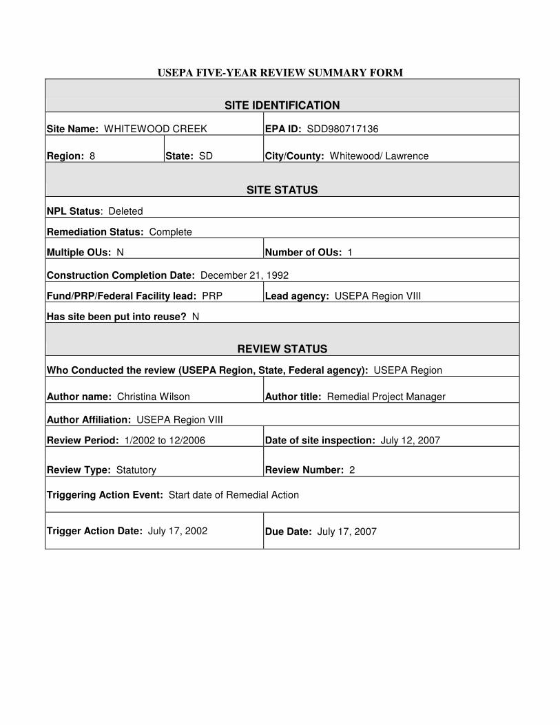
USEPA FIVE-YEAR REVIEW SUMMARY FORM
SITE IDENTIFICATION
Site Name: WHITEWOOD CREEK EPA ID: SDD980717136
Region: 8 State: SD City/County: Whitewood/ Lawrence
SITE STATUS
NPL Status: Deleted
Remediation Status: Complete
Multiple OUs: N Number of OUs: 1
Construction Completion Date: December 21, 1992
Fund/PRP/Federal Facility lead: PRP Lead agency: USEPA Region VIII
Has site been put into reuse? N
REVIEW STATUS
Who Conducted the review (USEPA Region, State, Federal agency): USEPA Region
Author name: Christina Wilson Author title: Remedial Project Manager
Author Affiliation: USEPA Region VIII
Review Period: 1/2002 to 12/2006 Date of site inspection: July 12, 2007
Review Type: Statutory Review Number: 2 Triggering Action Event: Start date of Remedial Action
Trigger Action Date: July 17, 2002 Due Date: July 17, 2007

This page intentionally left blank.
TABLE OF CONTENTS
i
1.0 INTRODUCTION.......................................................................................................... 1 - 1
1.1 Purpose of Review ................................................................................................. 1 - 1 1.2 Statute Requirements ............................................................................................. 1 - 1 1.3 Triggering Action for Review................................................................................. 1 - 2 1.4 Structure of the Five-Year Review Report ............................................................ 1 - 2
2.0 SITE CHRONOLOGY ...................................................................................................... 2 - 1
2.1 Initial Discovery of Contamination........................................................................ 2 - 1 2.2 National Priorities List (NPL) Listing.................................................................... 2 - 2 2.3 Decision and Enforcement Document ................................................................... 2 - 2 2.4 Start and Completion of Remedial Actions .......................................................... 2 - 2
2.4.1 Remediation of Soils at Residences........................................................ 2 - 3 2.4.2 Landuse Institutional Controls ............................................................... 2 - 4 2.4.3 Annual Education Program..................................................................... 2 - 4 2.4.4 Extent of Contamination and Delineation of 100-Year Floodplain........ 2 - 5 2.4.5 Surface Water Monitoring Program........................................................ 2 - 5
2.5 Construction Completion....................................................................................... 2 - 6 2.6 Prior Five Year Reviews ........................................................................................ 2 - 6
3.0 BACKGROUND ........................................................................................................... 3 - 1
3.1 Physical Characteristics ......................................................................................... 3 - 1 3.2 Site Environmental Setting .................................................................................... 3 - 1
3.2.1 Vegetative Cover.................................................................................... 3 - 2 3.2.2 Aquatic Ecology..................................................................................... 3 - 4
3.3 Land and Resource Use.......................................................................................... 3 - 5 3.3.1 Former, Current, and Projected Landuse ................................................ 3 - 5 3.3.2 Human Use of Resources........................................................................ 3 - 5
3.4 History of Contamination....................................................................................... 3 - 7 3.4.1 Historical Activities that Caused Contamination.................................... 3 - 7 3.4.2 Site Contaminants and Risks .................................................................. 3 - 9
4.0 REMEDIAL ACTIONS................................................................................................. 4 - 1
4.1 Remedy Selection .................................................................................................. 4 - 1 4.2 Remedy Implementation ........................................................................................ 4 - 3
4.2.1 Residential Remediation ......................................................................... 4 - 3 4.2.2 Institutional Controls .............................................................................. 4 - 8
4.3 Operation and Maintenance ................................................................................. 4 - 13 4.3.1 Surface Water Monitoring ................................................................... 4 - 14 4.3.2 Annual Site Resident Education Program............................................ 4 - 17 4.3.3 Future Development Restrictions-Annual Review of Residential
Building Activity................................................................................. 4 - 18 4.3.4 Post-Closure Residential Soil Sampling and Remediation................... 4 - 21
ii
4.3.5 Disposal Site Monitoring ...................................................................... 4 - 23 4.3.6 Reporting............................................................................................... 4 - 24
5.0 FIVE YEAR REVIEW FINDINGS............................................................................... 5 - 1
5.1 Five-Year Review Process .................................................................................... 5 - 1 5.1.1 Interview Team Members ...................................................................... 5 - 1 5.1.2 Community Notification ........................................................................ 5 - 1 5.1.3 Five-Year Review Tasks........................................................................ 5 - 1
5.2 Interviews............................................................................................................... 5 - 3 5.2.1 Interviews with Residents ...................................................................... 5 - 3 5.2.2 Interviews with Government Officials................................................... 5 - 5 5.2.3 Interviews with Homestake Mining Corporation................................... 5 - 9 5.2.4 Interviews with Belle Fourche Irrigation District ............................... 5 - 12 5.2.5 Summary of Interview Results............................................................. 5 - 12
5.3 Site Inspection...................................................................................................... 5 - 13 5.3.1 Activities and Summary of Findings ................................................... 5 - 13
5.4 Risk Information Review..................................................................................... 5 - 14 5.4.1 ARARs Reviewed................................................................................ 5 - 14 5.4.2 Review of Site-Specific Cleanup Level .............................................. 5 - 18
5.5 Risk Recalculation/Assessment ........................................................................ 5 - 19 5.5.1 Human Health Risk Assessment........................................................... 5 - 19 5.5.2 Ecological Risk Assessment .................................................................. 5 -19
5.6 Data Review .................................................................................................... 5 -19 5.6.1 Residential Verification Sampling......................................................... 5 -19 5.6.2 Surface Water Quality Sampling ........................................................... 5 -21
6.0 ASSESSMENT.............................................................................................................. 6 - 1
6.1 Have External Conditions Changed Since the Remedy? ....................................... 6 - 1 6.1.1 Changes in Landuse ................................................................................ 6 - 1 6.1.2 Changes in Known Contaminants, Sources and Pathways ..................... 6 - 1 6.1.3 Changes in Known Hydrologic or Hydrogeologic Conditions ............... 6 - 2
6.2 Has the Remedy Been Implemented in Accordance with Decision Documents?.. 6 - 2 6.2.1 Access and Institutional Controls ......................................................... 6 - 2 6.2.2 Remedy Performance .............................................................................. 6 - 6 6.2.3 Adequacy of System Operations/O&M ................................................. 6 - 6 6.2.5 Early Indicators of Potential Remedy Failure ........................................ 6 - 8
6.3 Has Any Risk Information Changed Since the Remedy was Selected?................. 6 - 8 6.3.1 Changes in ARARs ................................................................................. 6 - 9 6.3.2. Changes in Risk Information .................................................................. 6 - 9
7.0 DEFICIENCIES............................................................................................................. 7 - 1
7.1 Deficiencies in the Future Development Restrictions............................................ 7 - 2 7.2 Deficiencies in the Annual Resident Education Program...................................... 7 - 2
iii
7.3 Deficiencies in the Disposal Cell Revegetation and Reporting ............................. 7 - 2 7.4 Deficiencies in Ecological Risk Information ......................................................... 7 - 3
8.0 RECOMMENDATIONS AND REQUIRED ACTIONS.............................................. 8 - 1
8.1 Recommendations for Future Development Restrictions ..................................... 8 - 2 8.2 County Landuse Ordinances ................................................................................. 8 - 2 8.3 Annual Residential Education Program................................................................ 8 - 4 8.4 Ecological Risk Information ................................................................................. 8 - 4
9.0 PROTECTIVENESS STATEMENTS .......................................................................... 9 - 1
9.1 Residential Remediation ......................................................................................... 9 - 1 9.2 Institutional Control Implementation...................................................................... 9 - 1 9.3 Protection of the Environment ................................................................................ 9 - 1
10.0 NEXT REVIEW .......................................................................................................... 10 - 1 11.0 REFERENCES ............................................................................................................ 11 - 1
iv
LIST OF TABLES
Table 2-1 Chronology of the Former Events at the Whitewood Creek Superfund Site Table 4-1 Summary of Quarterly/Annual Reports; Disposal Site Inspections Table 4-2 Dates of Quarterly/Annual Reports Submitted by Homestake Table 5-1 Whitewood Creek Residential Property Inspections Table 5-2 Applicable or Relevant and Appropriate Requirements (ARARs) for the Whitewood Creek Superfund Site Table 5-3 ARAR Revision Dates Table 5-4 Federal and State Chemical-Specific Water Quality ARARs
LIST OF FIGURES
Figure 3-1 Location of Whitewood Creek Superfund Site Figure 4-1 Detailed Boundaries within the Whitewood Creek Superfund Site Figure 5-1 Alan Residence, Erosion of Gravel Cover (looking south) Figure 5-2 Alan Residence, Erosion of Gravel Cover (looking north) Figure 5-3 Lower Balo Residence, Geotextile Material Showing through Gravel Cover Figure 5-4 Kymala Residence, Geotextile Material Showing through Gravel Cover Figure 5-5 Holsclaw Residence, Tailings on Asphalt in Front of Residence Figure 5-6 Unstable Stream Banks, near Holsclaw Site Figure 5-7 Kymala Residence, Drainage Path across Gravel Cover (looking northwest) Figure 5-8 Alan Residence, New Garden Plot of South Side of Driveway Figure 5-9 Alan Residence, Second New Garden Plot on North Side of Driveway (looking northeast)
v
Figure 5-10 Bureau of Reclamation Siphon, Photograph #1 Figure 5-11 Bureau of Reclamation Siphon, Photograph #2 Figure 5-12 Disposal Site (looking south) Figure 5-13 Disposal Site Rip Rap at West Edge (looking southeast) Figure 5-14 Sampling Stations Map Figure 5-15 Station 06436180 – Whitewood Creek above Whitewood, Arsenic Concentrations Figure 5-16 Station 06436198 – Whitewood Creek above Vale, Arsenic Concentrations Figure 5-17 Station 06436180 – Whitewood Creek above Whitewood, Mercury Concentrations
ATTACHMENT
Attachment 2-1 Building Permit Handbook for Butte, Meade and Lawrence Counties
vi
LIST OF ACRONYMS
ARARs Applicable or Relevant & Appropriate Requirements ARSD Administrative Rules of South Dakota AWQC Ambient Water Quality Criteria BOR Bureau of Reclamation CERCLA Comprehensive, Environmental Response, Compensation and Liability
Act CERCLIS Comprehensive, Environmental Response, Compensation and Liability
Information System CFR Code of Federal Regulations CRST Cheyenne River Sioux Tribe DGFP Department of Game, Fish and Parks EA Endangerment Assessment ERA Ecological Risk Assessment ESD Explanation of Significant Difference FDA Food and Drug Administration FS Feasibility Study GS Geological Survey MCL Maximum Contaminant Level NCP National Contingency Plan NPL National Priorities List O&M Operation and Maintenance PNL Pacific Northwest Laboratory PRP Primary Responsible Party QAPP Quality Assurance Project Plan ROD Record of Decision SC Specific Conductance SD South Dakota T&E Threatened and Endangered TSS Total Suspended Solids SRC Syracuse Research Corporation USEPA United States Environmental Protection Agency USGS United States Geological Survey WAD Weak Acid Dissociable (cyanide)
1 − 1
1.0 INTRODUCTION
The United States Environmental Protection Agency (USEPA) Region VIII has conducted the second review of the remedial actions implemented at the Whitewood Creek Superfund Site (Site) in Lead, South Dakota. This review includes Site activities from January 2002 through December 2006. 1.1 Purpose of Review As specified in the Record of Decision (ROD) for the Site, a review of the remedial action will be conducted no less than each five years after initiation of the remedial action to ensure that human health and the environment are being protected (USEPA, 1990). Therefore, the purpose of this five-year review is to determine whether the remedy at the Site remains protective of human health and the environment. The methods, findings and conclusions of the review are documented in this five-year review report. In addition, the five-year review report identifies deficiencies found during the review and provides recommendations to address them. 1.2 Statute Requirements USEPA must implement five-year reviews consistent with the Comprehensive Environmental Response, Compensation and Liability Act (CERCLA) and the National Oil and Hazardous Substances Pollution Contingency Plan (NCP). CERCLA section 121(c), as amended, states:
If the President selects a remedial action that results in any hazardous substances, pollutants, or contaminants remaining at the site, the President shall review such remedial action no less often than each five years after the initiation of such remedial action to assure that human health and the environment are being protected by the remedial action being implemented.
The NCP part 300.430(f)(ii) of the Code of Federal Regulations (CFR) states:
If a remedial action is selected that results in hazardous substances, pollutants, or contaminants remaining at the site above levels that allow for unlimited use and unrestricted exposure, the lead agency shall review such action no less often than every
1 − 2
five years after the initiation of the selected remedial action. 1.3 Triggering Action for Review In keeping with the requirements of CERCLA 121(c) and the NCP, statutory reviews are triggered by the initiation of a remedial action that will result in hazardous substances, pollutants, or contaminants remaining onsite above levels that allow for unlimited use and unrestricted exposure after the remedial action is complete. The earliest remedial action associated with a remedy that will leave hazardous substances, pollutants or contaminants at a site triggers a statutory five-year review (USEPA, 1999). The remedy implemented at the Site resulted in mine tailings remaining onsite above levels that allow unlimited use and unrestricted exposure (USEPA, 1990). Thus, a statutory five-year review is required to ensure that human health and the environment are being protected. The trigger date for the statutory review is September 25, 1991, which is the start date for remedial action activities reported in USEPA's Comprehensive Environmental Response, Compensation and Liability Information System (CERCLIS) database. The Consent Decree (United States v. Homestake, 1991) requires that USEPA review the Site no less often than every five years after initiation of the Remedial Action to assure that human health and welfare and the environment are being protected by the work implemented in the Consent Decree. 1.4 Structure of the Five-Year Review Report The five-year review is completed according to the Comprehensive Five-Year Review Guidance (USEPA, 2001). The document is organized into eleven sections, as recommended by the guidance:
Introduction. Chapter 1 provides the introduction of the five-year review. This is a synopsis of the five-year review process including who performed the review, the purpose of the review, the statutory requirements for the review, the trigger for the review and the structure of the report.
Site Chronology. Chapter 2 provides the chronology of the Site. This includes major events, documents, and remedial actions.
1 − 3
Background. Chapter 3 provides a description of the Site including physical setting, land and resource use, contaminants and initial response.
Remedial Actions. Chapter 4 provides a description of the remedial action objectives, the remedy, remedy implementation, O&M requirements and O&M activities to date.
Five-Year Review Findings. Chapter 5 describes the findings of the five-year review, including the results of interviews, site inspections, an ARAR review, a human and ecological risk assessment, and data review. Assessment. Chapter 6 provides a discussion of the conclusions reached in the five-year review.
Deficiencies. Chapter 7 discusses deficiencies identified in the remedial action.
Recommendations and Required Actions. Chapter 8 provides recommendations and actions required to achieve protectiveness. The recommendations include the responsible parties, agencies with oversight authority and the recommended schedule for completion.
Protectiveness Statements. Chapter 9 provides the protectiveness statements for the Site.
Next Review. Chapter 10 provides a statement on when the next review is required, the trigger for the next review and the tasks to be performed as part of the review.
References. Chapter 11 provides the references for the five-year review document.
2 − 1
2.0 SITE CHRONOLOGY
Table 2-1 summarizes the chronology of events at the Whitewood Creek Site. 2.1 Initial Discovery of Contamination From 1877 to 1977, operations at the Homestake Mine involved the direct discharge of tailings into Whitewood Creek. Since 1977, process materials and water have been treated prior to discharge. In 1960, the South Dakota (SD) Department of Health quantified solids and cyanide loading to Whitewood Creek. In 1965, the SD Department of Game, Fish and Parks (DGFP) concluded that aquatic bottom organisms were absent in Whitewood Creek downstream from the waste discharges. From 1970 to 1971, a series of studies by USEPA, the US Food and Drug Administration (FDA) and the University of SD were conducted to document the magnitude and extent of the tailings. The studies focused on the environmental hazards associated with mercury and their results led to the discontinuation of mercury amalgamation process by Homestake Mining Company (Homestake). In December 1970, results of these studies led to the discontinuance of mercury in gold recovery operations (USEPA, 1990). In the winter of 1974-75, about 50 Holstein cattle that were part of a dairy operation located adjacent to Whitewood Creek died of unknown causes. Later, a study by the SD University Department of Veterinary Science concluded that the cattle had died of arsenic toxicosis due to consumption of corn silage that had been contaminated by the accidental incorporation of mining wastes with fodder during silo-filling operations. A joint study, conducted by the SD Geological Survey (GS) and the SD Water Resources Division between May 1975 and July 1978, investigated the presence of arsenic in surface and groundwater along Whitewood Creek, the Belle Fourche River and portions of the Cheyenne River. This study, published in 1978, found arsenic concentrations ranging from 2.5 to 1,530 µg/L in groundwater from areas with large tailings deposits (USEPA, 1990). One common conclusion of these investigations was that Whitewood Creek would remain highly contaminated until the discharge of tailings was discontinued. To comply with new environmental laws, including the Ore Mining and Dressing Effluent Guidelines, Homestake implemented the Grizzly Gulch Tailings Disposal project, an impoundment area for tailings storage. The tailings disposal system became operational on December 1, 1977. Since 1977, no tailings have been discharged into Whitewood Creek (USEPA, 1990).
2 − 2
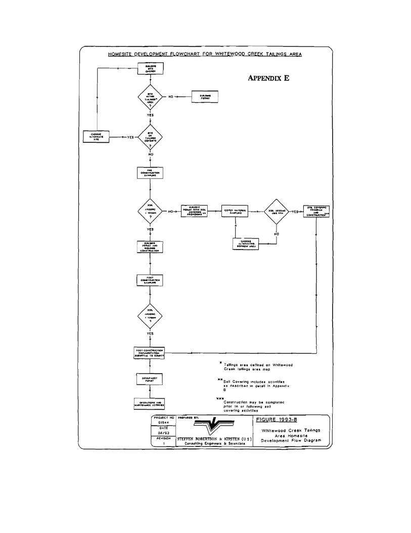
2.2 National Priorities List (NPL) Listing The Site was placed on the interim National Priorities List (NPL) at the request of the governor of South Dakota in September 1981. At this time, USEPA sent a notice letter to Homestake regarding potential liability. On September 8, 1983, the Site was placed on the NPL. Homestake submitted a petition to USEPA to delete Whitewood Creek from the NPL. A report entitled Assessment of Exposure and Possible Effects on Human Health of Gold Mine Tailings in the Whitewood Creek Area of South Dakota was completed in April of 1985 by Environ Corp. to support Homestake's petition for delisting. Homestake also submitted a second petition for delisting the Site in 1985, which was rejected by USEPA as being premature. In 1996, the Site was deleted from the NPL (USEPA, 1990). 2.3 Decision and Enforcement Document In December of 1988, an Administrative Order on Consent was signed by USEPA and Homestake. This order concluded that the studies completed by Fox Consultants, Inc., (1984a and 1984b) constituted the functional equivalent of a remedial investigation, as prescribed by the NCP. The order required that Homestake conduct a Feasibility Study (FS) to identify and evaluate alternatives for remedial action (USEPA, 1990). In July of 1989, the Final Environmental Assessment (EA) was completed by USEPA with the assistance of Jacobs Engineering (Jacobs, 1989). In December of 1989, the FS was completed by ICF technology on behalf of Homestake (ICF, 1989a and 1989b). In January of 1990, the Administrative record was established and in March of 1990 the ROD was issued (USEPA, 1990). In August 1990, USEPA and Homestake signed a Consent Decree for Homestake to implement the ROD through Remedial Design and Remedial Action at the Site. This agreement was lodged in the U.S. District Court for South Dakota on October 10, 1990 (Case Number 90-5101), and entered by the Court on April 4, 1991. 2.4 Start and Completion of Remedial Actions The selected remedial action for the Whitewood Creek site includes:
· Removal and/or covering frequently used areas of residential sites with arsenic levels above 100 mg/kg with clean surface soil (arsenic <20 mg/kg);
· Disposal of the arsenic-contaminated soil;
2 − 3
· Revegetation of the remediated area;
· Visual verification that remedial cover is intact at all remediated areas, with soil
sampling as a follow-up action where necessary;
· Implementing institutional controls including land and access restrictions;
· Conducting an annual education program to inform site residents of the potential health hazards associated with exposure to tailings, soil, and alluvial groundwater contaminated with arsenic;
· Refining knowledge of the extent of contamination and delineating the 100-year
floodplain of Whitewood Creek; and
· Surface water monitoring. USEPA invoked Applicable or Relevant and Appropriate Requirement (ARAR) waivers based on the technical impracticability of remediating contaminated ground and surface waters. The estimated cost of the remedial action at the time of the ROD was $882,813, which includes an annual Operation and Maintenance (O&M) cost of $12,000 for years 1 through 5 and $6,000 for years 6 though 30 (USEPA, 1990). 2.4.1 Remediation of Soils at Residences In 1992, remediation was completed at 16 residences. Approximately 4,500 cubic yards of materials were removed from the individual residences/sites and placed at the on-site disposal facility (USEPA, 1993). On July 16 and 17, 1996, inspections and interviews were conducted for the 2002 five-year review at all remediated sites as part of the five-year inspection and interview program. The residential five-year verification sampling program was conducted on July 18 and 19, 1996 by Homestake at 6 of the residential properties located within the boundaries of the Superfund site. One property contained arsenic concentrations above the site action level of 100 mg/kg. This property (the Holsclaw residence) was remediated in accordance with the Site O&M Plan (WDC, 1994b).
2 − 4
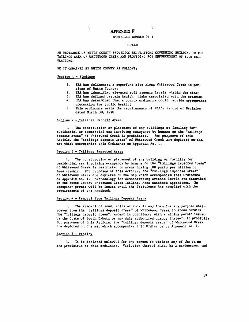
For the 2006 five-year review, interviews with residents of remediated properties were conducted in May through June of 2007 and site inspections of the remediated properties were conducted on July 12, 2007. Results from the interviews and inspections do not immediately indicate that soil sampling of any of the remediated residences is currently necessary. Routine soil sampling is no longer required during the five-year review unless following the visual inspection there is evidence of recontamination. This change was implemented with the amended O&M Plan (WDC, 2003). According to the amended plan, Homestake must conduct soil sampling at a given residence if a visual inspection indicates there may be recontamination of more than 10% of a high use remediated area. 2.4.2 Landuse Institutional Controls Landuse Restrictions The institutional control portion of the remedy was implemented during 1993 and 1994. In accordance with the requirements of the ROD, Butte, Lawrence and Meade Counties adopted ordinances in late 1993 and early 1994 that prohibited construction of new residential or commercial structures on the tailings deposits, restricted future development in tailings-impacted areas of the Site, and prohibited removal and use of tailings from outside the tailings areas. A county building permit handbook, Whitewood Creek Tailings Area Building Permit Handbook; A Guide to Building in the Whitewood Creek Tailings Area (Attachment 2-1) was developed to aid in the future implementation of the proposed ordinances and approved by USEPA on November 29, 1993. The handbook defines the steps necessary for residential development in the Tailings Impacted Areas, defined as areas with arsenic levels greater than 100 mg/kg. State Well Ban Regulation A State well ban regulation prohibiting wells in the 100-year floodplain of Whitewood Creek remains in effect to limit exposure to groundwater from the downgradient alluvial aquifer. 2.4.3 Annual Education Program In 1993, Homestake began distributing an annual fact sheet to educate the public on Site hazards and ways to minimize the risk posed by residual contamination (USEPA, 1994). Educational
2 − 5
materials are distributed annually to residents during the first quarter of each year; this distribution began in 1993 and continues to the present time. 2.4.4 Extent of Contamination and Delineation of 100-Year Floodplain The boundaries of the tailings deposits, tailings impacted soils and the 100-year floodplain boundary of Whitewood Creek were delineated during extensive field programs that began the summer of 1991 and ended in the fall of 1992. The detailed maps for these boundaries were approved by USEPA on April 15, 1993 (WDC, 1994a). 2.4.5 Surface Water Monitoring Program The surface water monitoring program was implemented in May of 1993 to evaluate the unknown rates of release of arsenic from the tailings deposits in Whitewood Creek. Homestake collected water samples 4 times annually from two United States Geological Survey (USGS) gauging stations from May 1993 to present. The first USGS station is 06436180 (Whitewood Creek above Whitewood) and is located at the upper end of the Site boundary, downstream of the Crook City Bridge. The station located downstream of the confluence with Gold Run and downstream of the tailings discharge point on Gold Run. The second USGS sampling station is 06436198 (Whitewood Creek above Vale) is located at the downstream end of the Site boundary, above the confluence with the Belle Fourche River. Sampling times occur (1) in late winter before major snow-melt runoff; (2) during peak runoff in the spring; (3) during the low flow period in late summer; and (4) once immediately following a major precipitation event (Addendum B to WDC, 1994b).
An amended O&M Plan was finalized in May of 2003 (WDC), requiring water sampling to occur twice annually, once in the spring during the peak runoff period and a second time during the late summer low-flow period. This change was proposed and approved based on the now extensive sampling record. However, Homestake has continued to oversee surface water sampling 4 times annually as required in the original O&M Plan (WDC, 1994b). Arrangements were made between the USGS Water Resources Division, South Dakota District Office in Rapid City and Homestake for collection and analysis of the surface water samples (Addendum B to WDC, 1994b). Homestake submitted quarterly reports providing the results of the sampling and analyses until the amended O&M Plan was implemented in 2003 (WDC, 2003). Since May of 2003, Homestake submits yearly reports detailing the annual results of the surface water sampling.
2 − 6
2.5 Construction Completion Remediation activities at the residences began on September 30, 1991, with a pilot remediation project, and were completed during the fall of 1992. Construction of the Disposal Site began on September 30, 1991 and was completed on September 30, 1992. Construction activities at the Topsoil and Topsoil Subgrade Borrow Site were conducted during the period of September 26, 1991 through September 18, 1992. The Temporary Stream Crossing construction began on July 29, 1992 and removal work was completed by September 7, 1992. The re-remediation of the Holsclaw property, began in November of 1997 and was completed by late June, 1998 (WDC, 1998). 2.6 Prior Five Year Reviews This is the second five-year review for the Whitewood Creek site. The first five-year review process was initiated by Homestake in 1996 and the findings are reported in Chadwick et al. (1997). Among other comments and issues raised in the Chadwick et al. report, USEPA identified the need for additional studies to be conducted at the Site to evaluate protectiveness, including an Ecological Risk Assessment (ERA). The five-year review report completed in 2002 (USEPA, 2002) included the findings from the review initiated by Homestake (Chadwick et al., 1997), the findings from several additional studies, the ERA (SRC, 2001b) and data and activities conducted as part of Site O&M.
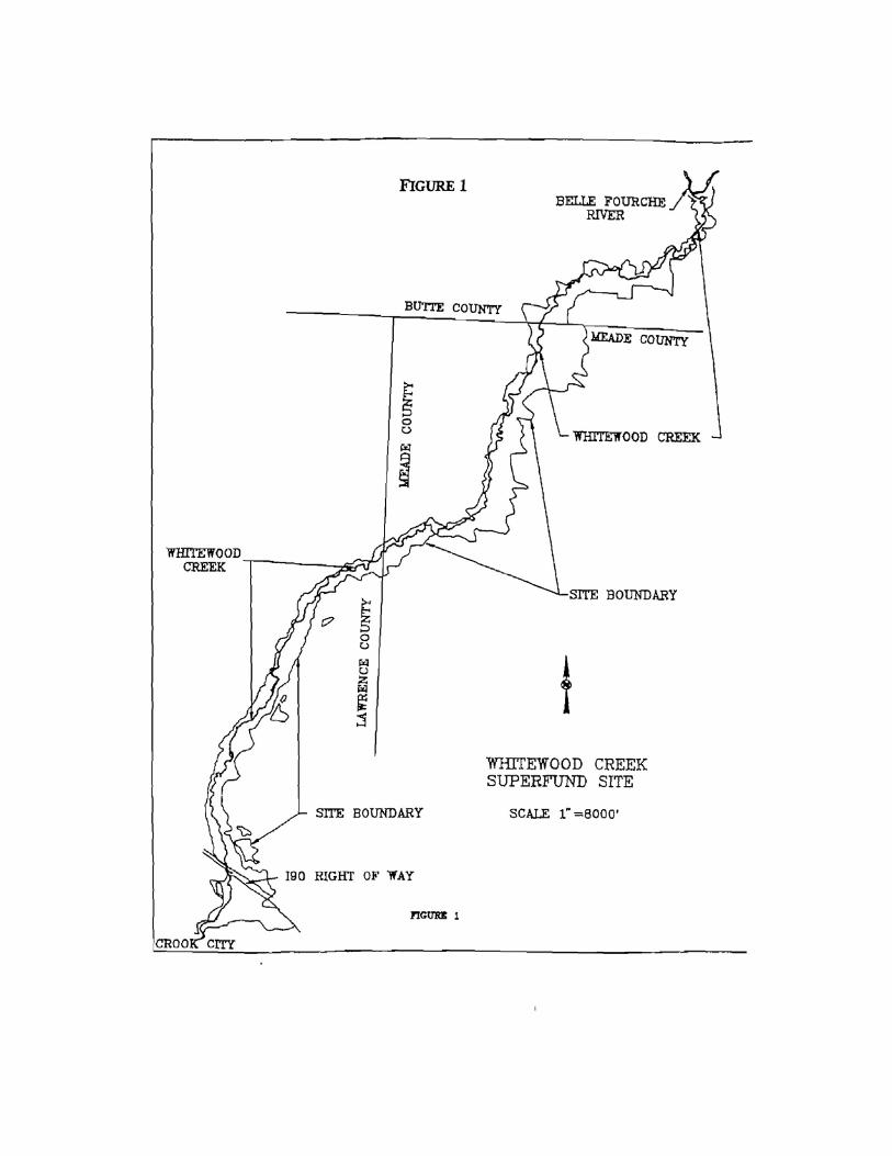
3 − 1
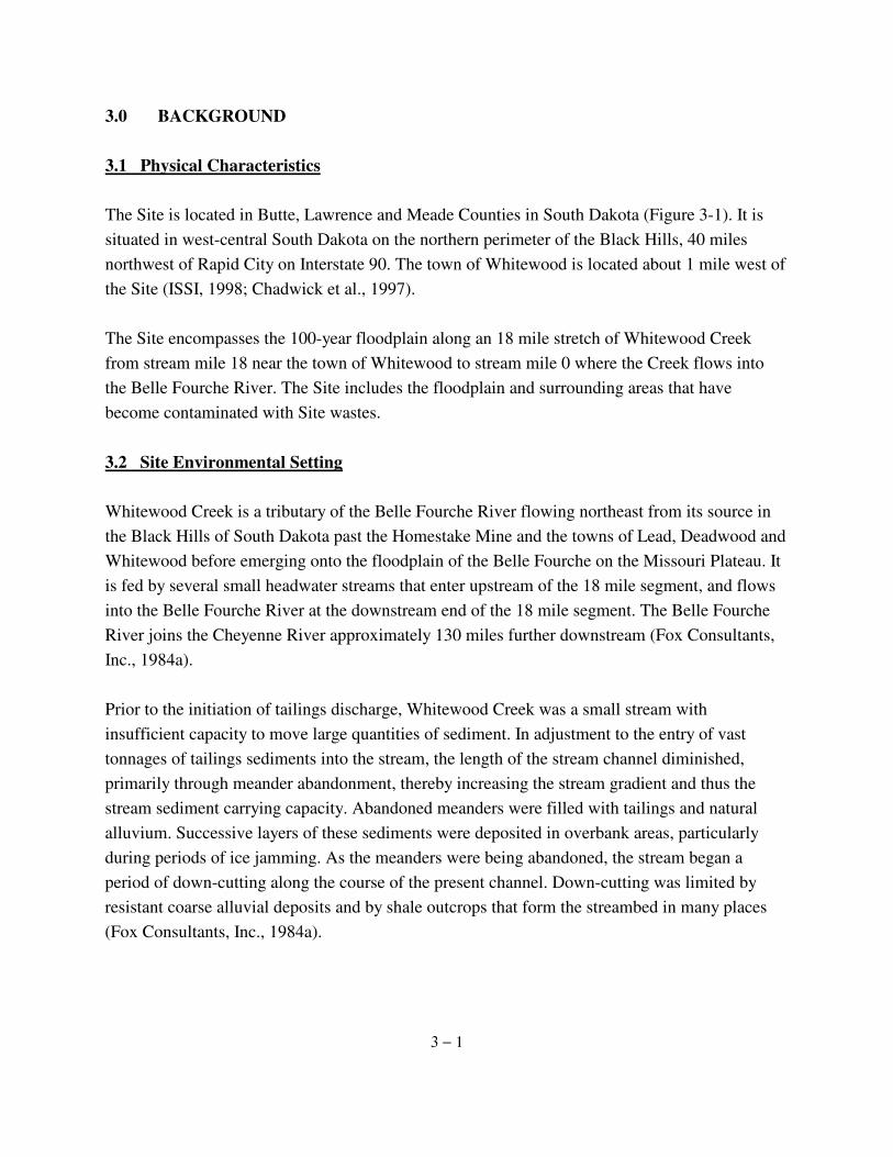
3.0 BACKGROUND 3.1 Physical Characteristics The Site is located in Butte, Lawrence and Meade Counties in South Dakota (Figure 3-1). It is situated in west-central South Dakota on the northern perimeter of the Black Hills, 40 miles northwest of Rapid City on Interstate 90. The town of Whitewood is located about 1 mile west of the Site (ISSI, 1998; Chadwick et al., 1997). The Site encompasses the 100-year floodplain along an 18 mile stretch of Whitewood Creek from stream mile 18 near the town of Whitewood to stream mile 0 where the Creek flows into the Belle Fourche River. The Site includes the floodplain and surrounding areas that have become contaminated with Site wastes. 3.2 Site Environmental Setting Whitewood Creek is a tributary of the Belle Fourche River flowing northeast from its source in the Black Hills of South Dakota past the Homestake Mine and the towns of Lead, Deadwood and Whitewood before emerging onto the floodplain of the Belle Fourche on the Missouri Plateau. It is fed by several small headwater streams that enter upstream of the 18 mile segment, and flows into the Belle Fourche River at the downstream end of the 18 mile segment. The Belle Fourche River joins the Cheyenne River approximately 130 miles further downstream (Fox Consultants, Inc., 1984a). Prior to the initiation of tailings discharge, Whitewood Creek was a small stream with insufficient capacity to move large quantities of sediment. In adjustment to the entry of vast tonnages of tailings sediments into the stream, the length of the stream channel diminished, primarily through meander abandonment, thereby increasing the stream gradient and thus the stream sediment carrying capacity. Abandoned meanders were filled with tailings and natural alluvium. Successive layers of these sediments were deposited in overbank areas, particularly during periods of ice jamming. As the meanders were being abandoned, the stream began a period of down-cutting along the course of the present channel. Down-cutting was limited by resistant coarse alluvial deposits and by shale outcrops that form the streambed in many places (Fox Consultants, Inc., 1984a).
3 − 2
The present course of Whitewood Creek in the 18-mile study area is a 4-braided pattern with occasional bends or meanders within the broader bottomland. In the upper reaches of the study area, the channel is comparatively straight with few meanders and few bends. Although the present channel is not entirely stable, many of the overbank terraces and abandoned meanders have tailings deposits that have been stable for many decades. A dense cover of leaf mulch, grass, and mature trees, some of which are 2 feet in diameter, exist on many of these stable areas (Fox Consultants, Inc., 1984a). For Whitewood Creek within the study area, the width of the stream channel is between 40 and 80 feet and the depths from the floodplain to lowest bottomland are about 5 to 8 feet. Under base flow conditions, the flow is approximately 20 to 50 cubic feet per second. About 10 to 25% of this flow is effluent discharge from the Homestake wastewater treatment plant at Lead (Cherry et al., 1985; Fox Consultants, Inc., 1984a). 3.2.1 Vegetative Cover Native vegetation comprises approximately 75% of the study area. The remaining area consists of irrigated and non-irrigated croplands (approximately 18%) and rangeland/developed areas (7%) (Fox Consultants, Inc., 1984a). Riparian woodlands are the most abundant and widespread native vegetative community type. They are concentrated along both the Whitewood Creek and the Belle Fourche River floodplains. Crops in the study area include corn, oats, alfalfa, and hay from range grasses (primarily smooth brome) (USEPA, 1989). In 1983, Fox Consultants Inc., as part of the Whitewood Creek Study Phase I (Fox Consultants, Inc., 1984a), characterized the vegetative community using visual reconnaissance (4 occasions and 3 seasons) and field sampling. Native floodplain or riparian woodland vegetation communities are dominated by the following tree species: plains cottonwood (Populus sargentii), eastern cottonwood (Populus. deltoides), narrow-leaf cottonwood (Populus. angustifolia), American elm (Ulmus americana), green ash (Fraxinus pennsylvanica), willow (Salix spp.), box elder (Acer negundo), Russian olive (Elaeagnus angus-tifolia), and bur oak (Quercus macrocarpa). Seedlings and saplings of the overstory species typically dominate understory vegetation. Snowberry (Symphoricarpos albus) and perennial grasses are the prevalent ground cover. Dominant grasses include several species of bluegrass (Poa spp.), wheatgrass (Agropyron spp.), as well as smooth brome (Bromus inermis) and prairie cordgrass (Spartina pectinata) (Fox Consultants, Inc., 1984a). Streamside vegetation includes willow and perennial grasses.
3 − 3
General trends in the species abundance and composition of the native vegetation were reported by Fox Consultants Inc. (1984a) between both the upper and lower portions of the study area and the two stream floodplains. The vegetative communities are described as 2 zones with plant communities exhibiting relatively constant species composition within each of the 2 zones. The first zone is bounded by the confluence of Crow Creek and Whitewood Creek continuing south (upstream) to Crook City and Whitewood. In this zone, the topography is steeper and more broken with floodplain width being more restricted. Woodland composition is dominated by bur oak with the plains cottonwood and narrow leaf cottonwood occurring in relatively small quantities. Some ponderosa pine occurs on the edge of the floodplain, near Crook City (Fox Consultants, Inc., 1984a). The second zone begins approximately at the confluence of Whitewood and Crow Creeks, continues along Whitewood Creek and eastward along the Belle Fourche River. Vegetation characteristics change in response to elevation and topography. The reduced gradients and lower elevations downstream of the Whitewood Creek-Crow Creek confluence support an increase in the occurrence of American elm, box elder, green ash, and a decrease in occurrence of bur oak. Cottonwoods and willow increase their prevalence as the transition occurs from the broken terrain of the foothills to the relatively level terrain of the plains. Plains cottonwood and willow dominate the riparian woodlands with the comparative abundance of willow and cottonwood changing on a site-specific basis depending on local hydrology. Russian olive appears as a minor species upstream becoming increasingly more prevalent downstream (Fox Consultants, Inc., 1984a). The riparian corridor along Whitewood Creek generally shows and increase in tree width and height with increasing distance downstream. The boundaries of the woodlands closely coincide with floodplain boundaries. Adjacent plant associations in the valley floor, which is used as rangeland for livestock grazing, include fields of alfalfa, corn and hay. Over-grazing by livestock (cattle and sheep) was apparent along some stream stretches (Fox Consultants, Inc., 1984a). The riparian corridor along the Belle Fourche River is more fragmented than Whitewood Creek due to more intense agricultural activities and as such contains a less developed riparian woodland area. When compared to the Whitewood Creek riparian corridor, the understory is less developed, tree size is greater, fewer species are present and the overhead tree canopy is more open. Cottonwood, willow, Russian olive, green ash, and box elder are the primary overstory and understory species (Fox Consultants, Inc., 1984a).
3 − 4
Mine tailings are reported to be confined to the floodplain (USEPA, 1989). Although some tailings deposits remain barren, it is reported that a plant community with limited diversity has gradually colonized the tailings (USEPA, 1990). The barren areas have been invaded by rhizomatous grasses, forbs and small shrubs (USEPA, 1989). Succession appears to begin when grasses take root in leaf litter trapped in depressions in the surface of the tailings. Some trees in the tailings deposits have been dated at over 100 years old (USEPA, 1990). The available study does not report plant stress in or around the tailings areas (USEPA, 1989). 3.2.2 Aquatic Ecology Whitewood Creek and the Belle Fourche River are the surface waters located within and adjacent to the Site, respectively. These waters are located in the north high plains of the Black Hills region of western South Dakota and are classified as transitional streams located between the eco-regions of Rocky Mountain Forest and Great Plains Shortgrass Prairie (Bailey, 1982). Whitewood Creek originates in the northern Black Hills, while the Belle Fourche River originates in northeastern Wyoming, south of the town of Gillette. Whitewood Creek in the study area is a moderate gradient stream with well-developed riparian areas. Influence of livestock grazing and agricultural use is visible at many locations, and evidence of historic mining activities occurs in the form of tailings deposits (Chadwick et al., 1997). Whitewood Creek is classified by the State of South Dakota as warm water permanent fish life propagation waters in the lower portion (from the Belle Fourche River to Interstate 90) where and a semi-permanent warm water fishery exists (ICF, 1989), and coldwater marginal fish life propagation waters from Interstate 90 to the confluence with Gold Run (South Dakota SL 74:51:03:03). The State of South Dakota has reportedly stocked trout in the upper reaches of Whitewood Creek. This cold water fishery cannot be established on a permanent basis due to high temperature and low flow habitat restrictions (ICF, 1989a).
3 − 5
It is postulated that the aquatic flora and fauna of Whitewood Creek changed in response to improvements in the Homestake mine discharge and municipal water treatment in 1984. Some improvements were effected after completion of biological studies by Herricks (1982), Fox Consultants, Inc. (1984a), and Goddard (1989). The Herricks (1982) study described a creek flowing through 3 ecological zones. The upper third of the creek as a cold, fast-flowing water with the fish community dominated by cold-water species. The middle third of the creek (corresponding to the upper half of the 18-mile site reach) was described as a transitional area where the water becomes warmer and has more pools and riffles, providing a transition to more warm-water species. The lower third of the creek (corresponding to the lower half of the 18 mile site reach) runs onto a low-gradient landscape before emptying into the Belle Fourche River and is dominated by warm-water fish species (Herricks, 1982). The Belle Fourche River in the study area is a relatively wide, low gradient stream, with somewhat less riparian development. Much of the stream is bordered by farmland and is used as an irrigation source during summer months. 3.3 Land and Resource Use 3.3.1 Former, Current, and Projected Landuse The dominant landuse within the 100-year floodplain of Whitewood Creek at the time of the ROD (USEPA, 1990) was native woodlands. These woodlands were estimated to occupy about 83% of the total land area (2,018 acres) within the Site (Fox Consultants, 1984a; 1984b). The remaining land was used for agriculture and residences. These landuse patterns have remained relatively unchanged for more than 100 years and are not anticipated to appreciably change in the foreseeable future (ICF, 1989a; 1989b). Based on the information obtained during the Site interviews and inspections, the current and projected landuses within the Site have not significantly changed. 3.3.2 Human Use of Resources At the time of the ROD (USEPA, 1990), residences were scattered along both sides of Whitewood Creek. Based on 1988 data, 22 households and 5 vacant residential properties were situated within or in close proximity to the Site with a total population of 85. The population was primarily rural, and dominated by families who have lived on the Site for 40 years or longer. The land was used for raising animals and raising crops for animal feed. The water supply sources for
3 − 6
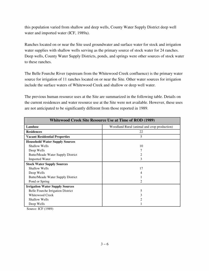
this population varied from shallow and deep wells, County Water Supply District deep well water and imported water (ICF, 1989a). Ranches located on or near the Site used groundwater and surface water for stock and irrigation water supplies with shallow wells serving as the primary source of stock water for 24 ranches. Deep wells, County Water Supply Districts, ponds, and springs were other sources of stock water to these ranches. The Belle Fourche River (upstream from the Whitewood Creek confluence) is the primary water source for irrigation of 11 ranches located on or near the Site. Other water sources for irrigation include the surface waters of Whitewood Creek and shallow or deep well water. The previous human resource uses at the Site are summarized in the following table. Details on the current residences and water resource use at the Site were not available. However, these uses are not anticipated to be significantly different from those reported in 1989.
Whitewood Creek Site Resource Use at Time of ROD (1989) Landuse Woodland Rural (animal and crop production) Residences 22 Vacant Residential Properties 5 Household Water Supply Sources Shallow Wells 10 Deep Wells 7 Butte/Meade Water Supply District 2 Imported Water 3 Stock Water Supply Sources Shallow Wells 17 Deep Wells 4 Butte/Meade Water Supply District 1 Pond or Spring 2 Irrigation Water Supply Sources Belle Fourche Irrigation District 5 Whitewood Creek 3 Shallow Wells 2 Deep Wells 1
Source: ICF (1989)
3 − 7
3.4 History of Contamination 3.4.1 Historical Activities that Caused Contamination Gold Mine Operation A large gold mine once operated and now overseen by Homestake is located in Lead, South Dakota near the headwaters of Whitewood Creek. During the period between 1870 and 1977, tailings generated during the operation of the mine were released directly into Gold Run Creek, which flows into Whitewood Creek. Mining operations over the last century produced about 1,000,000,000 tons of ore from both open pit and subsurface mining (Fox Consultants, Inc., 1984a). The first milling methods at Homestake were primitive and non-mechanized. Gold was recovered by using crude methods of crushing with recovery by gravity or mercury amalgamation. By 1880, the early non-mechanical methods were replaced with more than 1,000 stamp mills (large blocks of cast iron or steel dropped onto replaceable anvils) that crushed the ore to a coarse sand size. The tailings were then discharged to Whitewood Creek or its tributaries. Prior to the turn of the century, much of the ore consisted of near surface, red-colored minerals that were residual oxidation products of the arsenopyrite, pyrrhotite and pyrite mineralization of the original unoxidized ore bodies (Fox Consultants, Inc., 1984a; Chadwick et al., 1997). After the turn of the century, the black and green-colored reduced ores from deeper in the mine (below the zone of oxidation) were the focus of the mining activity. These ores contained large percentages of reduced oxidation-state minerals, including arsenopyrite and pyrrhotite. From 1877 until 1977 (with the exception of 5 years of closure during World War II), the "slimes" and some coarse-grained sands continued to be discharged directly into Whitewood Creek. While historically there were additional mine waste discharge sources, these all ceased around 1920 and Homestake became the only remaining source of tailings discharge. In 1977, Homestake constructed a tailings impoundment in the upper reaches of the watershed and tailings discharges to the creek ceased (Chadwick et al., 1997). Mercury amalgamation of the ores was used over the greater period of the mining operation, being discontinued in January of 1971. Quotes on the volumes of mercury used and lost to the waste stream in this process vary from an eighth of an ounce to almost half an ounce per ton of
3 − 8
ore crushed, with almost 50% of this volume lost to the entire waste stream. Cyanide has also been used in the gold recovery process since the early 1900's to process the lower grades of ore and increase gold and silver recoveries. Since the cessation of mercury use in 1971, cyanide had been used exclusively for gold recovery, until 1987, when a gravity circuit was added. Since 1987, both cyanide and gravity have been used for recovery. The tailings also contained considerable quantities of arsenic derived from minerals in the ore (Fox Consultants, Inc., 1984a). Until the mine closed in 2002, ore was milled in crushers and rod and ball mills. The material from the milling process was separated into 2 size fractions, sand and slimes. These fractions were treated separately by cyanide leach and carbon filter methods. Residual sand material was used to backfill within the mine. Residual slimes and process waters were piped to the Grizzly Gulch tailings impoundment in the upper reaches of the Whitewood Creek watershed. The tailings disposal system became operational in 1977, resulting in cessation of direct discharge of tailings to Whitewood Creek (Chadwick et al., 1997). In 1984 a wastewater treatment plant began treating water from the tailings impoundment and mine. The plant uses rotating biological contactors to remove cyanide and ammonia, iron precipitation and sorption to remove metals, and sand filtration to remove suspended solids. Solids are returned to the tailings pond. Water enters Gold Run Creek that discharges into Whitewood Creek between the towns of Lead and Deadwood. This discharge is monitored to meet requirements of the Clean Water Act (Chadwick et al., 1997). Release and Deposition of Tailings Tailings, consisting of finely ground rock (residual metallic and nonmetallic compounds not extracted from the ore and trace compounds used in the extractive processes), were transported away from the mine via Whitewood Creek. The tailings were deposited downstream from the mine with subsequent deposition along the banks of Whitewood Creek between the Crook City Bridge and the confluence with the Belle Fourche River. The tailings remain along much of this reach of Whitewood Creek (Chadwick et al., 1997). Reports indicate that in 1963 as much as 3,000 tons per day of tailings, together with 12,500 tons per day of water were being discharged to Whitewood Creek (ISSI, 1998; Fox Consultants, Inc., 1984a). Tailings in Whitewood Creek were also transported downstream into the Belle Fourche and Cheyenne Rivers (Goddard et al., 1988, USEPA, 1990). Some limited tailings deposits also exist upstream of the Crook City Bridge (USEPA, 1990).
3 − 9
Deposition of tailings altered the morphology of Whitewood Creek. Before tailings were deposited, Whitewood Creek was reportedly a typical Black Hills ephemeral stream with a thin layer of alluvium deposited over bedrock (ISSI, 1998; USEPA, 1989). It is estimated that approximately 25 to 37 million tons of tailings were deposited in the floodplain (ISSI, 1998; ICF, 1989a). The large mass of tailings transported in the Whitewood Creek basin resulted in a series of depositional and erosional events that distributed tailings throughout the flood plain. In their upper reaches, Gold Run Creek and Whitewood Creek are rather steep and most of the tailings were carried downstream by the flow of the water. Near Crook City, the gradient of Whitewood Creek becomes less steep, allowing the tailings to become deposited along the banks and in the creek sediment. Currently, Whitewood Creek has eroded through the tailings to or near shale bedrock and the stream is braided over much of the Site area (USEPA, 1989; ICF, 1989a). When aggradation of the streambed lessened in the early 1900's, overbank deposits were stabilized in places with vegetation (USEPA,1989). The FS (ICF, 1989a and 1989b) describes the stratigraphy of the tailings deposit areas as: 1) an upper deposit of tailings ranging from approximately 1 to 15 feet thick and 50 to several hundred feet wide on each side of the creek along its full 18 mile length within the Site, 2) an underlying strata of natural alluvium consisting of sandy to sandy silt materials with variable amounts of intermixed tailings, and 3) the thick shale strata that forms the floor of the valley.
3.4.2 Site Contaminants and Risks This section discusses the contaminants of concern for the NPL listing, the Remedial Investigations, the results of the risk assessments completed prior to the ROD (USEPA, 1990) and the determination of the primary health threat at the Site. Elements of NPL Listing The hazardous substances of concern considered in the Hazard Ranking Score (HRS) for the Whitewood Creek site were arsenic, copper, zinc, selenium and mercury. Groundwater and surface water were the two release pathways of concern (USEPA, 1994).
3 − 10
Contaminated Media The contaminated media at the Site include tailings deposits, alluvial materials underlying tailings deposits, surface soil, groundwater in the downgradient alluvial aquifer, surface water and vegetation (USEPA, 1990). The tailings are the major source of the contamination found in other affected media at the Site (USEPA, 1990). Tailings are slowly released into the alluvial aquifers at the Site and transported into the alluvium underneath the tailings deposits. Some of the tailings and their contaminants are released into the surface waters of Whitewood Creek through seepage from tailings and alluvium, erosion of tailings along the creek bank, and heavy rains or periodic flooding. Vegetation growing on tailings deposits contains concentrations of chemicals associated with tailings. Contaminants are transferred into the downgradient alluvial aquifer during the wet periods of the year when the water table rises to be in contact with the tailings and the slow dissolution and infiltration of chemicals downward through the tailings into the groundwater. Portions of the surface soils of croplands irrigated with waters from Whitewood Creek are impacted by chemicals associated with tailings. Surface soils at residences are impacted by windblown tailings, transport of tailings during flooding or the import of tailings materials for use as a soil conditioner or driveway base (USEPA, 1990). Results of Risk Assessments Prior to the ROD Several studies (Fox Consultants Inc., 1984a and 1984b; Environ Corp, 1985; ICF, 1989c; USEPA 1989; Jacobs 1989) have been conducted that evaluate potential human health and environmental impacts at the Site. The Fox study (Fox Consultants, Inc., 1984a and 1984b) was concluded by USEPA to constitute the functional equivalent of a remedial investigation for the Site (USEPA, 1990). The USEPA (1989) and Jacobs (1989) studies were used as the basis for the remedial action objectives for the FS (USEPA, 1990). The findings of each study are briefly summarized below. Fox Consultants, Inc. (1984b) As part of the Phase II Study, Fox Consultants, Inc. (1984b) examined the data collected in the Phase I Study (Fox Consultants, Inc., 1984a) and evaluated the impacts of 14 target substances including arsenic, cadmium, iron, lead, chromium, manganese, mercury, zinc, sulfate, selenium, copper, cyanide, silver and nickel in environmental media. The environmental media examined
3 − 11
included vadose zone water, groundwater, surface water, soil, irrigated crops, natural vegetation, fish and aquatic invertebrates. The study reported that arsenic, sulfate, selenium, cadmium, copper, cyanide and pH posed an environmental concern to one or more of the environmental media examined. Specifically, arsenic, selenium and sulfate were of concern in groundwater. Arsenic, cadmium, copper and cyanide were of environmental concern in surface water. Arsenic was additionally of concern in both soil and native vegetation. The report concluded that of the substances considered to be of environmental concern, arsenic was the most significant throughout the environmental media evaluated. Environ Corp (1985) Environ Corp (1985) evaluated potential impacts to human health from gold mine tailings in the 18-mile area of Whitewood Creek. Exposures to eight chemicals associated with mine tailings (arsenic, cadmium, copper, cyanide, iron, manganese, mercury and silver) were evaluated for adult and child residents living within the Whitewood Creek floodplain. Adults were evaluated for exposure by ingesting contaminated groundwater and fish. In addition to the pathways evaluated for an adult resident, child residents were also evaluated for exposure through ingestion of tailings impacted soil. Estimated daily intakes of arsenic, cadmium, copper, cyanide and mercury were below the Acceptable Daily Intakes (ADIs), and concluded to not pose a risk to human health. Although the estimated daily intakes of iron for both adults and children and manganese and silver in children exceeded the ADIs for the respective chemicals, they were concluded unlikely to pose adverse health risks. The study concluded that exposures to chemicals associated with the mine tailings were very unlikely to pose significant adverse risks to human health.
ICF (1989c) ICF (1989c) summarizes the baseline assessment of potential health impacts used for the FS. The study evaluated potential human health threats to persons living within the Site from consumption of elevated levels of chemicals in shallow groundwater used for drinking water, incidental ingestion of surface soils and consumption of food items (milk, vegetables, meat, eggs, fish) produced within the Site. Potential cancer risks from arsenic and potential non-cancer risk from arsenic, cadmium, chromium, copper, lead, manganese, mercury, nickel and selenium were
3 − 12
evaluated. Potential risks were calculated for both "typical-case" and "potential worst-case" exposure scenarios. The study found that arsenic in surface soils and irrigated croplands may present potential cancer risks to human health and that arsenic in shallow groundwaters within the Site appeared to produce potential carcinogenic risks that are higher than those normally deemed acceptable under CERCLA. However, the study noted that potential cancer risks from arsenic may have been overstated due to uncertainties associated with arsenic availability in soils and the reduced soil ingestion during winter months when the ground is frozen. Other chemicals associated with the tailings were concluded to not pose any unacceptable threats to human health from tailings, agricultural soils, shallow groundwater and surface water within the Site. USEPA (1989) A preliminary Endangerment Assessment (EA) of the Whitewood Creek site was completed by Battelle Pacific Northwest Laboratory (PNL) for the USEPA Office of Health and Environmental Assessment. The study evaluated potential impacts to public health, aquatic species and terrestrial species from hazardous substances associated with the Site. Human health risks from exposure to arsenic, cadmium, chromium, copper, lead, manganese, mercury, nickel and selenium were evaluated at six ranches along Whitewood Creek. Risks to an adult resident exposed by inhalation of suspended tailings, incidental ingestion of soil, ingestion of groundwater, and ingestion of locally grown food items were evaluated. Risks to children were evaluated from the incidental ingestion of soil. Both typical (average) intakes and worst-case (high end) exposure assumptions were used in the risk evaluations. Adult resident cancer risks from arsenic were greater than 1E-04 for both typical and worst-case exposure scenarios. Cancer risks to a child resident from the incidental ingestion of arsenic in soil were greater than 1E-04 at 3 of the 6 residential sites evaluated under the typical exposure scenario, and greater than 1E-04 at all 6 residential sites based on worst-case exposure assumptions. The total Hazard Index (HI) for non-cancer risks to adult residents from all chemicals were greater than 1 under both typical and worst-case exposure scenarios.
Although the EA primarily focused on evaluation of human health risks, ecological impacts to terrestrial and aquatic receptors were also evaluated. The EA evaluated potential ecological impacts from ten metals, including arsenic, cadmium, chromium, copper, lead, manganese, mercury, nickel, selenium and silver.
3 − 13
Impacts to Terrestrial Receptors A limited assessment of impacts to terrestrial receptors was conducted based on historical studies and metal concentrations in vegetation and soil. Historical studies (Bergeland et al. 1976; Hesse et al. 1975; Tveidt, 1981) have documented potential impacts of Site related chemicals on terrestrial animals within Whitewood Creek. Hesse et al. (1975) reported mercury levels in double-breasted cormorants in fish-eating birds in the Cheyenne River, downstream of Whitewood Creek and the Belle Fourche River, which were significantly greater than concentrations observed in a control population from the Missouri River System. Cattle deaths and sickness attributed to arsenic toxicosis have been documented within the Whitewood Creek floodplain (Bergeland et al. 1976) and downstream of Whitewood Creek along the Belle Fourche River (Tveidt, 1981). Potential impacts to terrestrial wildlife from the consumption of vegetation were hypothesized based on native vegetation and irrigated crop samples collected during the Phase I Investigation (Fox Consultants, Inc. 1984a). Samples were compared with levels known to impact both plants and animals. Cadmium concentrations in irrigated crops were at a level reported to cause adverse effects in some animals. Mercury and arsenic concentrations were at levels that may affect livestock and arsenic-sensitive animals. Although chemical concentrations in soils or vegetation indicated possible impacts to terrestrial wildlife along Whitewood Creek, data on metal concentrations in animal tissues correlated with plant and soil concentrations were not available. Therefore exposures were difficult to quantify and impacts difficult to rigorously address. Impacts to Aquatic Receptors Both a screening analysis and quantitative assessment of potential impacts to aquatic ecosystems were conducted. Total recoverable concentrations measured by USGS (1985) were compared to USEPA acute and chronic ambient water quality criteria (AWQC) for the protection of aquatic life. The results of this screening analysis showed six constituents (arsenic, cadmium, copper, lead, mercury and silver) had geometric mean concentrations higher than respective chronic AWQC values. These same six constituents plus zinc had maximum detected concentrations exceeding respective acute AWQC values. Based on the screening results, a more quantitative assessment was performed that examined the relationships between location, aquatic species, constituent speciation and phase, water quality characteristics, duration of exposure and
3 − 14
toxicological criteria. The results of these analyses indicated the potential for unacceptable adverse effects to aquatic species. Elements of most concern were copper, and cyanide. Elements of moderate concern were cadmium, iron, mercury and silver. Lead and nickel were of minor concern. Arsenic, chromium, selenium and zinc were of no concern. Jacobs (1989) The EA for the Whitewood Creek site was finalized by Jacobs Engineering Group Inc. for USEPA Region VIII in July 1989 (Jacobs, 1989). The final EA was based on information in USEPA (1989) and Subsection 1.7 of the Preliminary Draft of the FS prepared by ICF Technology in April of 1989 (ICF, 1989c). Jacobs (1989) examined the potential human health threats to Site residents from elevated levels of chemicals associated with the mine tailings. Potential cancer risks from arsenic and potential non-cancer risk from arsenic, cadmium, chromium, copper, lead, manganese, mercury, nickel and selenium were evaluated in groundwater and surface soils. Cancer and non-cancer risks were calculated for an adult resident exposed to chemicals in surface soils (residential soil, irrigated cropland, tailings areas) and groundwater from the upgradient alluvial aquifer. Risks to a child resident were evaluated for exposure from residential soils and groundwater from the upgradient alluvial aquifer. Risks to a recreational visitor were evaluated from exposure to surface soil. The study concluded that ingestion of contaminated groundwater and surface soils are significant pathways that contribute to health risks at the Site. Cancer risks to adult residents from arsenic were one order of magnitude greater than the cancer risks at a reference site. No potential adverse non-cancer effects were predicted for adult residents. Potential adverse non-cancer health effects were predicted for children from incidental ingestion of Site soils. No adverse cancer or non-cancer risks were predicted for a recreational site visitor. Primary Health Threat Identified in ROD The primary health threat identified in the ROD for potential harm to human health and the environment was exposure to arsenic-rich tailings deposits, alluvial soil, residential soil and alluvial groundwater contaminated with arsenic (USEPA, 1990). Human Health Concentrations of arsenic exceeded background levels and resulted in unacceptable risks to current and future Site residents (USEPA, 1990).
3 − 15
Ecological Risk Dissolved arsenic concentrations in Whitewood Creek approached the ambient water quality criteria established by USEPA for the protection of aquatic life. Since arsenic levels in surface water were not exceeded, the ROD assumed that the aquatic habitat was not threatened or endangered. Some native plants were found to have arsenic concentrations greater than the reference area. However, arsenic was determined to be one of many factors, such as other minerals, clay content, soil pH and permeability, limiting the establishment of a normal plant community (USEPA, 1990). The ROD (USEPA, 1990) referenced a threatened and endangered (T&E) species field survey that was underway at the time the ROD was finalized. This field survey was not specifically noted in the 2002 ERA (SRC, 2001b) and the results have not been located elsewhere. This is of concern due to two endangered species, the least tern and the whooping crane, that have been identified downstream from the Site.
4 − 1
4.0 REMEDIAL ACTIONS 4.1 Remedy Selection The ROD for the Whitewood Creek Superfund Site was signed on March 30, 1990 and addressed arsenic contaminated soil in residential areas (USEPA, 1990). The remedial action objectives identified and outlined in the ROD are:
· Prevent ingestion by Site residents of surface soils from the tailings deposit areas and from other areas within the Site that when combined would pose a potential excess lifetime cancer risk from intake of arsenic that would exceed 1E-04.
· Prevent ingestion, by Site residents, of residential surface soils having an average
arsenic concentration that exceeds 100 mg/kg. · Prevent ingestion by Site residents of drinking water drawn from the
downgradient alluvial groundwater having an average concentration of any inorganic constituent other than selenium that exceeds the Maximum Contaminant Level (MCL) for that constituent specified in the National Primary Drinking Water Regulations.
· Continue monitoring the water quality and flow of Whitewood Creek at the
sampling stations near Whitewood and Vale. The site is managed as a single operable unit. However, the remedy has been implemented in two phases: remediation of contaminated soils in existing residential areas (Phase I) and the implementation of institutional controls to limit access to tailings and groundwater (Phase II). The remedial actions at the Site include:
· Cover and/or remove soils in the existing residential areas containing arsenic levels of 100 mg/kg or greater. Dispose of contaminated materials removed during this activity in an off-site disposal facility.
· Restrict future development in the 100-year floodplain and tailings deposits, as
provided through county ordinances regulating landuse.
4 − 2
· Prohibit excavation of tailings deposits for other uses and prohibit excavation of remediated areas through county ordinance. However, mining would be allowed, subject to the regulations of the State of South Dakota.
· Refine knowledge of the extent of contamination and delineate the 100-year
floodplain. Provide detailed maps to define Site boundaries and specify activities to support county ordinances.
· Set up an educational program to inform residents about hazards presented at the
Site and ways to decrease their personal exposure. · Continue enforcement of the ban on installation of water supply wells within the
100-year floodplain (this is already prohibited by a state regulation). · Continue monitoring the surface waters of Whitewood Creek for significant
releases of hazardous substances. · Resample remediated residential areas after major flood events.
As a result of information obtained during remedial design activities, an Explanation of Significant Differences (ESD) to the remedy outlined in the ROD was issued on June 11, 1991(USEPA, 1991b). The ESD identified one change and one clarification to the original remedy:
· Contaminated materials removed from residential areas during remediation would be disposed of in an on-site facility instead of an off-site facility.
· The term "existing residential areas" was defined to refer to areas within the Site
where residential landuse is occurring as of the effective date of county landuse ordinances. This term was not explicitly defined previously and was used in the ROD to describe those areas of the Site which would undergo soil cleanup as part of the Remedial Action.
New information on the quantities of contaminated materials to be disposed of during the remedial action was identified during remedial design activities. Based on discussions with Site residents regarding their landuse habits, smaller areas around each home (i.e., high use areas)
4 − 3
were identified for remediation. The quantity of material to be disposed of was less than 10,000 cubic yards, less than one-third of the material estimated for disposal during the development of the ROD (30,000 cubic yards) (USEPA, 1990). 4.2 Remedy Implementation The remedy was implemented in two phases: remediation of contaminated soils in existing residential areas (Phase I) and the implementation of institutional controls to control access to tailings and groundwater (Phase II). 4.2.1 Residential Remediation The remedial design for the site was started August 1990 by FMG, Inc.. Homestake, with USEPA oversight, conducted sampling to identify and characterize soil contamination at 31 residences. Twenty-seven (27) residences were identified with soil arsenic concentrations above the 100 mg/kg action level, and thus required remediation. Eleven (11) of the 27 sites with arsenic concentrations above the action level were removed from the scope of the remediation program. The homes were rendered "uninhabitable through voluntary demolition or removal of the housing" (USEPA, 1993). Thus, remedial activities occurred at 16 residences or individual sites. Residential remediation activities included removing and/or covering the soils from gardens, yards and driveways that were above the 100 mg/kg action level for arsenic. The objective of the remedial activities was to have 24 inches of clean topsoil in garden areas, 12 inches of clean topsoil in yards, and 6 inches of clean gravel in road and driveway/parking areas. Fill materials imported into the individual residential sites consisted of topsoil, gravel, trees, shrubs, sod, fencing and other miscellaneous debris, many of which were obtained from residential properties within the Site. The majority of the clean topsoil fill materials were obtained from the Keith Silt Loam soils located on the Phillip Bestgen property. Clean gravel fill materials were primarily obtained from the Bestgen property. Clean fill material was stockpiled at the Topsoil and Topsoil Subgrade Borrow Site (FMG, Inc., 1992).
4 − 4
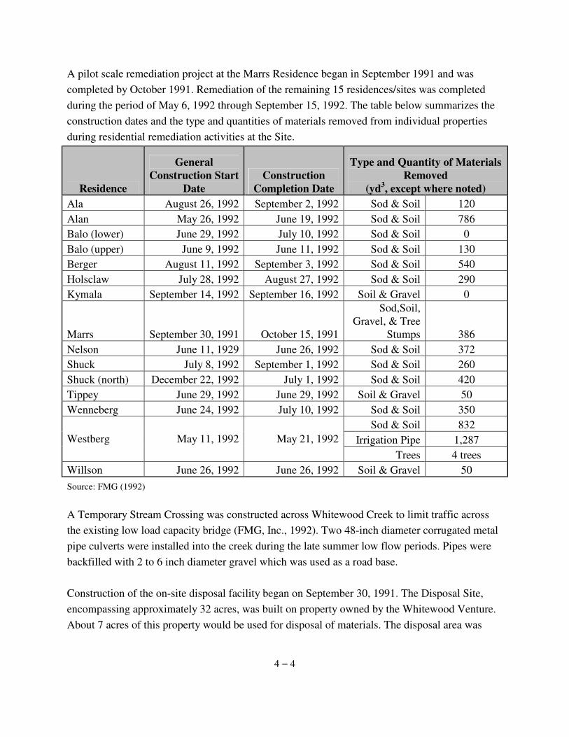
A pilot scale remediation project at the Marrs Residence began in September 1991 and was completed by October 1991. Remediation of the remaining 15 residences/sites was completed during the period of May 6, 1992 through September 15, 1992. The table below summarizes the construction dates and the type and quantities of materials removed from individual properties during residential remediation activities at the Site.
Residence
General Construction Start
Date Construction
Completion Date
Type and Quantity of Materials Removed
(yd3, except where noted) Ala August 26, 1992 September 2, 1992 Sod & Soil 120 Alan May 26, 1992 June 19, 1992 Sod & Soil 786 Balo (lower) June 29, 1992 July 10, 1992 Sod & Soil 0 Balo (upper) June 9, 1992 June 11, 1992 Sod & Soil 130 Berger August 11, 1992 September 3, 1992 Sod & Soil 540 Holsclaw July 28, 1992 August 27, 1992 Sod & Soil 290 Kymala September 14, 1992 September 16, 1992 Soil & Gravel 0
Marrs September 30, 1991 October 15, 1991
Sod,Soil, Gravel, & Tree
Stumps 386 Nelson June 11, 1929 June 26, 1992 Sod & Soil 372 Shuck July 8, 1992 September 1, 1992 Sod & Soil 260 Shuck (north) December 22, 1992 July 1, 1992 Sod & Soil 420 Tippey June 29, 1992 June 29, 1992 Soil & Gravel 50 Wenneberg June 24, 1992 July 10, 1992 Sod & Soil 350
Sod & Soil 832 Irrigation Pipe 1,287 Westberg May 11, 1992 May 21, 1992
Trees 4 trees Willson June 26, 1992 June 26, 1992 Soil & Gravel 50 Source: FMG (1992) A Temporary Stream Crossing was constructed across Whitewood Creek to limit traffic across the existing low load capacity bridge (FMG, Inc., 1992). Two 48-inch diameter corrugated metal pipe culverts were installed into the creek during the late summer low flow periods. Pipes were backfilled with 2 to 6 inch diameter gravel which was used as a road base. Construction of the on-site disposal facility began on September 30, 1991. The Disposal Site, encompassing approximately 32 acres, was built on property owned by the Whitewood Venture. About 7 acres of this property would be used for disposal of materials. The disposal area was
4 − 5
located on an overbank deposit of mine tailings with surface arsenic concentrations ranging from 850 to 10,000 mg/kg. In order to minimize disturbance of the tailings, no sub-grade preparation of the area was performed. Materials removed from the residential sites (contaminated gravel, topsoil, trees, shrubs, sod and other miscellaneous debris) were transported to the Disposal Site and placed at the locations specified in the Transportation and Disposal Plan. Wastes were segregated into separate areas of the Disposal Site during materials placement activities. Fences, trees and other debris from the residential areas removed during construction and remediation would be disposed of adjacent to the fill area of contaminated materials. During residential remedial activities, approximately 4,430 cubic yards of waste materials were placed at the on-site disposal facility. Additional work at the Disposal Site included constructing an access road, placement of rip-rap, constructing a fence around the site and hydroseeding the surface of the disposed soils. Pre-final inspections of the overall site were conducted by the USEPA and the State of South Dakota on September 22, 1992. Punch list items from the inspection included disposal site revegetation, erosion control measures and minor landscaping at an individual site. The final inspection of the overall Site was conducted on November 12, 1992. All punch items were satisfactorily completed (USEPA, 1993). On December 21, 1992, USEPA approved the Construction Completion Report for Remedial Action Activities at the Site. This report was submitted by Homestake and certified by a registered professional engineer that the remedy was operational and functional (USEPA, 1993). The Preliminary Close-Out Report was signed on September 25, 1992. The completion of the residential remedial action at Whitewood Creek Superfund Site was certified by USEPA Region VIII on March 31, 1993. Modifications to the Specifications of the ROD for Residential Remediation During the Remedial Design and Remedial Action, modifications or changes to the specifications in the ROD (USEPA, 1990) were made in addition to those previously described in the ESD (USEPA, 1991b). The changes were made with USEPA approval and are described below (USEPA, 1993):
Design Sampling Approach. The ROD specified that any 900-square-foot area sampled
4 − 6
and determined to exceed the 100 mg/kg arsenic level would be subject to remediation. This approach was applied to 27 of the sampled properties. Homestake developed a statistical approach for evaluating the sampling results of the final 4 properties and for future verification sampling. This approach established a representative population within the grid. Determination of the need for remediation was based on statistical evaluation of the sample results of the representative population as outlined in the Final Sampling and Analysis Plan. The USEPA guidance document "Methods of Attainment of Cleanup Standards" was referenced in development of the approach.
Maximum Allowable Arsenic Concentration in Replacement Fill. The ROD specified that clean imported soil or gravel contain less than 20 mg/kg arsenic. This criterion was changed during the remedial design to 20 mg/kg ± 10 mg/kg following evaluation of actual background concentrations of arsenic in the native soils. Soil samples collected during Remedial Design activities indicated that background arsenic concentrations were potentially higher than 20 mg/kg.
Final Confirmation Sampling Elimination. Confirmation soil samples were required by the ROD to be collected following remediation of residential properties to verify that arsenic levels were below 100 mg/kg. However, USEPA determined that this sampling would be a redundant check to ensure action levels had been achieved and eliminated this requirement. This change was justified because extensive pre-construction arsenic sampling was conducted on soil materials to be used as replacement fill during remediation. This sampling effort was conducted in accordance with the Final Sampling and Analysis Plan. Independent construction observers, representing both USEPA and Homestake, were on-site throughout Remedial Action to ensure that previously sampled materials were used as replacement fill. Homestake conducted additional sampling, beyond that required by the design plans. One (1) sample was collected for every 15 truckloads of fill material.
Difficulties and Unexpected Site Conditions for Residential Remediation The following difficulties and unexpected Site conditions were encountered for each of the Phases of the remediation.
Residential Remediation. During Residential Remediation Activities, some observations were made that would improve remediation and several situations were encountered that
4 − 7
required changes to the individual residential remedial plans. These changes included:
· Additional testing for total arsenic was performed on the fill materials imported to all individual sites to provide additional assurance of the imported material quality. The Field Construction Observer sampled fill materials at a frequency of approximately every 15 truckloads (FMG, Inc., 1993).
· Requests for additional work by residents at their property associated with remedy
implementation. (For example, rocks were hand picked out of the top soil material being replaced at the Holsclaw property, at the request of the owner).
One ongoing problem was identified during remediation activities at the Nelson Residence:
· Removal of construction staking by cattle in the area. FMG, Inc. replaced the
staking on June 16, 1992. However, this problem plagued the construction operations during the entire period (FMG, Inc., 1993).
Construction of Disposal Site. No problems or issues were identified during the construction activities of the Disposal Site, fill material placement area or Temporary Stream Crossing (FMG, Inc., 1993). Several changes to the plans and specifications for the Disposal Site and Temporary Stream Crossing were approved by USEPA and implemented during the construction phase of the project, including:
· Elimination of rip-rap by the creeks' edge at the Disposal Site.
· Addition of rip-rap at the downstream end of the fill materials placed in the canal.
· Approval not to abandon the wells at the Disposal Site.
· Changing the location of the fence line surrounding the Disposal Site. Construction of Topsoil and Topsoil Subgrade Borrow Site. No problems or issues were identified during the construction activities of the Topsoil and Topsoil Subgrade Borrow Site (FMG, Inc., 1993). USEPA approved one change to the plans and specifications for the Topsoil Borrow Site:
4 − 8
· Reseeding the Topsoil and Topsoil Subgrade Borrow Site at the request of the
property owner.
Construction of Temporary Stream Crossing. No problems or issues were identified during the construction activities of the Temporary Stream Crossing (FMG, Inc., 1993). Several changes to the plans and specifications for the Temporary Stream Crossing were approved by USEPA and implemented during the construction phase of the project, including: · Substitution of 2 to 6 inch diameter rock as fill materials for the channel portion
of the Temporary Stream Crossing and as the road surfacing for the crossing (in lieu of a geotextile and 6 inch thick layer for gravel surface coarse material).
· Removal of taller trees and shrubs from the overbank areas of the Temporary
Stream Crossing. · Use of existing soils and low vegetation as the road surface.
· Elimination of installing 1 to 2 foot diameter rip-rap materials at the Temporary
Stream Crossing for erosion control. · Limited operation of equipment into the water for installation and removal
operations at the Temporary Stream Crossing. · Straw bale installation at the Temporary Stream Crossing to limit silt and
sediments entering the creek from construction activities. · Elimination the requirement of revegetating the Temporary Stream Crossing (at
the request of the property owner) following hydroseeding the site.
4.2.2 Institutional Controls The institutional control phase of the remedy includes the implementation of traditional, legal and landuse restriction controls as well as other institutional control items, such as an annual educational program. These components of the remedy are designed to control ingestion of
4 − 9
surface soils/tailings and prevent ingestion of downgradient alluvial groundwater. The Institutional Controls for the Site include the following:
· Identification and mapping of the tailings deposits, tailings impacted soils and the 100-year flood plain.
· Enacting landuse ordinances restricting future development in Butte, Lawrence
and Meade Counties that: 1) Prohibit commercial and residential buildings on the tailings deposits and limit residential development to areas that have less than 100 ppm arsenic in the surrounding soil.
2) Prohibit excavation of the tailings deposits except for mining projects permitted by the State of South Dakota and restrict excavation below remediated areas where covered soils have greater than 100 ppm arsenic.
3) Continue enforcement of the South Dakota shallow well ban in the
Whitewood Creek100-year floodplain. · Conduct an annual educational program to inform people of the hazards
associated with the Site and ways to decrease personal exposure.
· Resample remediated residential areas impacted by flooding of Whitewood Creek, if soil arsenic levels are above 100 mg/kg.
· Monitor the surface waters of Whitewood Creek.
Several of these institutional controls will be ongoing operation and maintenance activities, such as long-term surface water monitoring, distribution of educational materials to Site residents, and resampling of flooded areas. Homestake will conduct these activities for a period of at least 30 years following completion of Site remedial activities. On February 13, 1995, USEPA certified that Homestake had performed and accepted (with the exception of continuing obligations of operation and maintenance activities, enumerated in paragraph 99 of the decree), in accordance with the consent decree the remedial action at the Site,
4 − 10
the Institutional Controls Completion Report for the Site (USEPA, 1995). Extent of Contamination and Delineation of 100-Year Floodplain The tailings deposit, tailings impacted soils and the 100-year floodplain boundaries were determined by extensive field programs beginning the summer of 1991 and ending the fall of 1992. The detailed maps (Figure 4-1) for these boundaries were approved by USEPA April 15, 1993 (WDC, 1994a). These boundary determinations were the first step towards enacting county landuse ordinances. Future Development Restrictions Butte, Lawrence and Meade County Landuse Ordinance Enactment During 1993 and 1994, Butte, Lawrence and Meade Counties adopted ordinances prohibiting construction of new residential or commercial structures on the tailings deposits, restricting future development in tailings-impacted areas of the Site, and prohibiting the removal and use of tailings from outside the tailings areas. A county building permit handbook (Attachment 2-1) was developed to aid in the future implementation of the proposed ordinances, and approved by USEPA on November 29, 1993. The handbook defines the steps necessary for residential development of the Tailings Impacted Areas. The following table lists the dates of the county meetings where discussions of and the formal adoption of these ordinances occurred.
County Meetings for Formal Adoption of Ordinances
First Reading
2nd Reading and
Adoption
Butte County
December 15, 1993
January 12, 1994
Lawrence County
December 8, 1993
January 4, 1994
Meade County
January 4, 1994
February 1, 1994
State Well Ban Regulation A state regulation restricting the construction of wells within the 100-year floodplain of Whitewood Creek (ARSD 74:02:04:26) remains in place. The regulation has a provision that allows variances to be granted by the State's Chief Engineer for the construction of wells within
4 − 11
the floodplain, if wells are constructed to prevent contamination from the tailings deposits and will not cause groundwater pollution. The state well ban regulation is included as part of the county building permit handbook for development activities within the Site. Annual Education Program In 1993, Homestake began distributing an annual fact sheet to educate the public on Site hazards and ways to minimize risks from residual contamination (USEPA, 1994). Educational materials have been distributed annually to residents during the first quarter of each year from 1993 to the present. Surface Water Monitoring Program The surface water monitoring program was implemented in May of 1993 to evaluate the effect of unknown rates of release of arsenic from the tailings. Surface water samples have been collected 4 times annually from 2 USGS gauging stations from May 1993 to present. The first USGS station, 06436180 (Whitewood Creek above Whitewood) is located downstream of the confluence of Whitewood Creek with Gold Run. The second USGS sampling station is 06436198 (Whitewood Creek above Vale). Sampling events have occurred at the following times: (1) in late winter before major snow-melt runoff; (2) during peak runoff in the spring; (3) during the low flow period in late summer; and (4) once immediately following a major precipitation event (Addendum B to WDC, 1994b). The O&M Plan (WDC, 2003) was amended in 2003. With over 10 years of data from the above listed sampling stations, USEPA determined the sampling program could be modified to require 2, as opposed to 4, annual samples. These samples are to be taken from the existing locations in May, during peak runoff, and in September, during the late-summer. Arrangements were made between Homestake and the USGS, Water Resources Division, South Dakota District Office, Rapid City, South Dakota for the USGS to collect the surface water samples. USGS provides the services for collection of the surface water samples and the analyses of these samples in USGS laboratories (WDC, 2003). Residential Flood Monitoring A program was established for the monitoring of the residential areas along the Whitewood
4 − 12
Creek that have the potential to be re-contaminated by the redistribution of contaminants during flooding events. Monitoring and procedures for sampling and remediating re-contaminated areas under this plan are specified in the O&M Plan (WDC, 2003). Modifications to the Specifications of the ROD for Institutional Controls Changes and modifications to specifications in the ROD (USEPA, 1990) were made during implementation of the institutional control phase of the remedy. These changes were approved by USEPA and are described below (USEPA, 1993):
Ordinance restrictions on future digging in remediated areas. The remedy outlined in the ROD (USEPA, 1990) requires counties to adopt ordinances that restrict future digging in areas that have been previously remediated. Information from sampling programs and a negative community response to this restriction prompted the deletion of this requirement. This modification to the ordinances was approved by USEPA in a letter dated November 29, 1993. Removal of construction of public works projects on tailings provision from ordinances. To meet a need expressed by the City of Whitewood during ROD (USEPA, 1990) development, the ROD provides for the construction of public works projects on the tailings after remediation to be included in the county ordinances. In a letter dated November 8, 1993, the City of Whitewood stated that they no longer had a need for this provision. USEPA approved the deletion of this provision in a letter dated November 29, 1993.
Change in reviewing agency for future house sites. The South Dakota Department of Natural Resources was identified to be the reviewing agency for sampling and remediation plans for future house sites in Tailings Impacted Areas. The USEPA, State and local communities determined that this program would be more effectively administered at the county level, and to rely on the State DENR for technical support as requested by the Counties. USEPA approved this modification in a letter dated November 29, 1993.
Difficulties and Unexpected Site Conditions for Institutional Controls While no difficulties were identified in the Institutional Controls Completion Report (WDC,
4 − 13
1994a) with the implementation of this portion of the remedy at the Site, recent information suggests the institutional controls are not fully functional. Butte and Lawrence Counties, as a matter of policy, do not issue occupancy permits. In order for the institutional controls to be protective, this aspect of the remedy must be addressed. 4.3 Operation and Maintenance In 2003, USEPA and Homestake agreed to modify future O&M obligations for surface water and soil monitoring, as originally outlined in the 1994 Post Closure Operations, Maintenance, and Reporting Plan (WDC, 1994b). Conclusions summarized in EPA’s 2002 Five-Year Review (USEPA, 2002) and ERA (SRC, 2001b), including over 10 years of data collected from surface water as well as experience as to the effectiveness of the soil remediation carried out pursuant to the ROD (USEPA, 1990) under normal use and flood conditions, indicate that the remediation continues to be effective of human health and the environment. As a result, an amended O&M plan has been implemented, the Whitewood Creek Superfund Site Post-Remedy Operations, Maintenance, and Reporting Plan, Amended May 1, 2003 (WDC, 2003). The amended O&M activities include the following:
· Annual report - to be submitted by March 31 of each year; · Remediated residential site inspections - visual inspection of the remediated areas
to be completed by July 17, 2007 and every 5 years thereafter for as long as these inspections are required;
· Soil sampling - where visual observation after major flood events (50-year floods) and/or routine visual inspections indicate there may be recontamination of more than 10% of a high-use remediated area:
· Renewed remediation activities - to be completed 1 year after determination that remediation is necessary;
· Surface water monitoring at two USGS stations on Whitewood Creek - to be conducted once in May (peak runoff) and once in September (late summer), with findings included in annual report;
· Disposal Site monitoring - to be conducted annually with findings reported in annual report;
· Annual site resident education program - mailings to be sent out during the first calendar quarter after USEPA approval of information package;
· Future development restrictions - annual review of residential building activity within Site; and
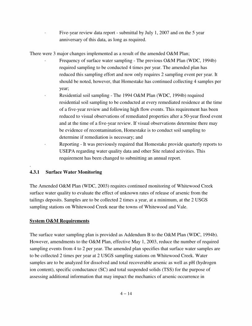
4 − 14
· Five-year review data report - submittal by July 1, 2007 and on the 5 year anniversary of this data, as long as required.
There were 3 major changes implemented as a result of the amended O&M Plan;
· Frequency of surface water sampling - The previous O&M Plan (WDC, 1994b) required sampling to be conducted 4 times per year. The amended plan has reduced this sampling effort and now only requires 2 sampling event per year. It should be noted, however, that Homestake has continued collecting 4 samples per year;
· Residential soil sampling - The 1994 O&M Plan (WDC, 1994b) required residential soil sampling to be conducted at every remediated residence at the time of a five-year review and following high flow events. This requirement has been reduced to visual observations of remediated properties after a 50-year flood event and at the time of a five-year review. If visual observations determine there may be evidence of recontamination, Homestake is to conduct soil sampling to determine if remediation is necessary; and
· Reporting - It was previously required that Homestake provide quarterly reports to USEPA regarding water quality data and other Site related activities. This requirement has been changed to submitting an annual report.
. 4.3.1 Surface Water Monitoring The Amended O&M Plan (WDC, 2003) requires continued monitoring of Whitewood Creek surface water quality to evaluate the effect of unknown rates of release of arsenic from the tailings deposits. Samples are to be collected 2 times a year, at a minimum, at the 2 USGS sampling stations on Whitewood Creek near the towns of Whitewood and Vale. System O&M Requirements The surface water sampling plan is provided as Addendum B to the O&M Plan (WDC, 1994b). However, amendments to the O&M Plan, effective May 1, 2003, reduce the number of required sampling events from 4 to 2 per year. The amended plan specifies that surface water samples are to be collected 2 times per year at 2 USGS sampling stations on Whitewood Creek. Water samples are to be analyzed for dissolved and total recoverable arsenic as well as pH (hydrogen ion content), specific conductance (SC) and total suspended solids (TSS) for the purpose of assessing additional information that may impact the mechanics of arsenic occurrence in
4 − 15
Whitewood Creek. Flow measurements are also to be recorded (WDC, 2003). The surface water samples are to be taken, at a minimum, during the following time periods:
(1) peak runoff in the spring, and (2) low flow period in late summer.
Based on historical flow data from the two USGS Gauging Stations within the Site, the most appropriate months and/or conditions for sampling are expected to be:
(1) May - for peak run-off flow in the spring, and (2) September - for late-summer low flow.
The Water Quality Sampling and Analysis Plan (Addendum B to WDC, 1994b) recommends, to the degree that weather and sampling conditions allow, that the surface water samples be collected during any given month in an upstream-to-downstream sequence. The sampling data are included in annual O&M reports to USEPA, as the data are available. System Activities to Date Surface water quality monitoring commenced in May of 1993. The following table summarizes the water quality monitoring data submitted by Homestake in its Quarterly and/or Annual Reports to USEPA. Surface water samples were collected on the following dates:
Yea
r
1993 1994 1995 1996 1997 1998 1999 200
0 2001 2002 2003 2004 2005 2006
6, May
21, Apr
8/9, May
8/9, Aug
7/8, Jan
28, Apr 5, May
26, Apr 24, Jan
6/7-May
6/7, May
22, Apr 6, Apr
6/7, Apr
9, Sep 1, Sep 24,
May 8,
May 7/8, May
9, Jun 3, Jun
16, Jun 2, May
3, Jun
25, Jun
21, May
9, May
9/10, May
28, Dec
20/21, Dec 30, Aug
25, May
26, Aug
2, Sep
13, Sep
13, Sep 6, Jun
4/5, Sep
8/9, Sep
1/2, Sep 1, Sep
30/31, Aug
-- -- -- 25/26,
Jun 22/23, Dec
16, Dec
29, Dec --
13, Sep
16/17, Dec
3/4, Dec
14/15, Dec
13/14, Dec
11/12, Dec
-- -- -- 20, Aug -- -- -- --
13/14, Dec -- -- -- -- --
Sam
plin
g E
vent
Dat
e
-- -- -- 23/24,
Oct -- -- -- -- -- -- -- -- -- Source: HSM (2007)
4 − 16
Problems Encountered No major problems were encountered with the surface water monitoring program. Seasonal variations, as well as other circumstances, resulted in only three of the four sampling events being conducted in 1993, 1994, 1995, and 2000:
· Three of the four sample types were collected during 1993. Snowmelt and high flow had already occurred when the monitoring program began in May of 1993. Thus, a high flow sample was not collected during this sampling year. Total suspended solids were not collected during the major precipitation event of 1993. The routine sampler was on vacation and the replacement personnel did not collect the TSS sample.
· A sample was not collected during a major precipitation event in the summer of 1994. Thus, the high flow sample collected on 4/21/94 was used to represent both high flow conditions and a major precipitation event.
· Only three samples were collected during 1995. The winter low flow sample for
1995 was not collected in December, due to the partial government shutdown. The sampling personnel were considered non-essential federal government employees and were unable able to work during the partial shut down.
· A flow measurement was not reported at USGS Station 06436180 during the 1995
major precipitation event. However, this information is available for download from the USGS website.
· A major precipitation event sample was not collected during 1997. However, two
late winter samples were collected. Explanations for theses deviations from the Surface Water Monitoring Plan were not available from the Monthly or Quarterly reports reviewed.
· Late winter and high flow samples were not reported during 2000. However, two
low flow samples were collected. Explanations for theses deviations from the Surface Water Monitoring Plan were not available from the Monthly or Quarterly reports reviewed.
4 − 17
4.3.2 Annual Site Resident Education Program The ROD (USEPA, 1990) requires an annual site resident education program to inform Site residents of the potential health hazards associated with exposure to the tailings soils and downgradient alluvial ground waters within the Site, and methods for minimizing incidental ingestion of contaminated materials. The education program is additionally prescribed to inform both identified and potential property owners of possible health hazards. Homestake annually distributes educational materials to Site residents during the first calendar quarter of the year. System O&M Requirements An informational package must be distributed to landowners within the Site on an annual basis. The package shall include a discussion of the USEPA's established risks associated with the tailings and tailings impacted soils. The scope of the remedial action program will be outlined and a compilation of the land-use restrictions and discussion of the intent of these ordinances will also be discussed. Individual maps are to be provided to each landowner to aid in their understanding of the areas affected by the USEPA's risk calculations. System Activities to Date The educational mailing program was initiated in 1993 and generally takes place during the first quarter of each year. The following table documents the dates that the annual educational mailings were sent to Site residents, as recorded in Homestake's Quarterly and Annual Reports.
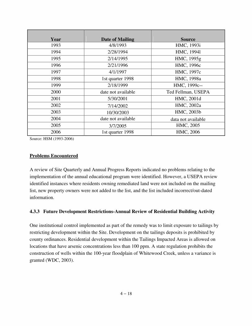
4 − 18
Year Date of Mailing Source 1993 4/8/1993 HMC, 1993i 1994 2/28/1994 HMC, 1994l 1995 2/14/1995 HMC, 1995g 1996 2/21/1996 HMC, 1996c 1997 4/1/1997 HMC, 1997c 1998 1st quarter 1998 HMC, 1998a 1999 2/18/1999 HMC, 1999c-- 2000 date not available Ted Fellman, USEPA 2001 5/30/2001 HMC, 2001d 2002 7/14/2002 HMC, 2002a 2003 10/30/2003 HMC, 2003b 2004 date not available data not available 2005 3/7/2005 HMC, 2005 2006 1st quarter 1998 HMC, 2006
Source: HSM (1993-2006)
Problems Encountered A review of Site Quarterly and Annual Progress Reports indicated no problems relating to the implementation of the annual educational program were identified. However, a USEPA review identified instances where residents owning remediated land were not included on the mailing list, new property owners were not added to the list, and the list included incorrect/out-dated information. 4.3.3 Future Development Restrictions-Annual Review of Residential Building Activity One institutional control implemented as part of the remedy was to limit exposure to tailings by restricting development within the Site. Development on the tailings deposits is prohibited by county ordinances. Residential development within the Tailings Impacted Areas is allowed on locations that have arsenic concentrations less than 100 ppm. A state regulation prohibits the construction of wells within the 100-year floodplain of Whitewood Creek, unless a variance is granted (WDC, 2003).
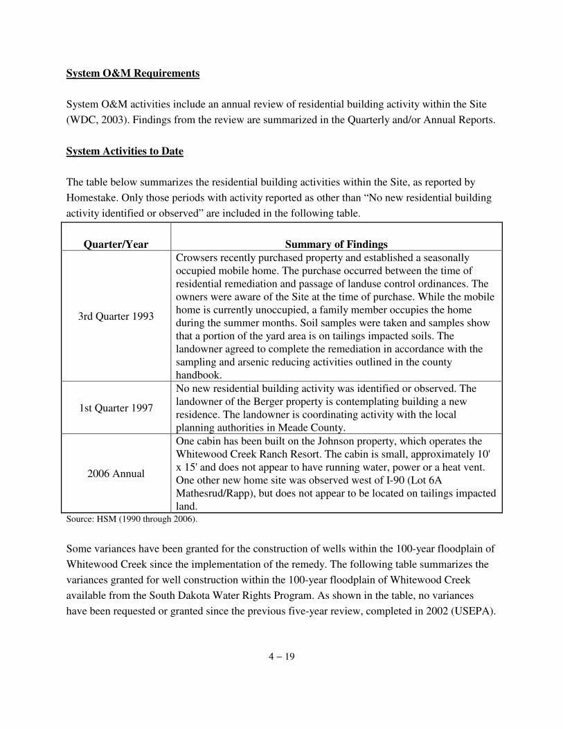
4 − 19
System O&M Requirements System O&M activities include an annual review of residential building activity within the Site (WDC, 2003). Findings from the review are summarized in the Quarterly and/or Annual Reports. System Activities to Date The table below summarizes the residential building activities within the Site, as reported by Homestake. Only those periods with activity reported as other than “No new residential building activity identified or observed” are included in the following table.
Quarter/Year Summary of Findings
3rd Quarter 1993
Crowsers recently purchased property and established a seasonally occupied mobile home. The purchase occurred between the time of residential remediation and passage of landuse control ordinances. The owners were aware of the Site at the time of purchase. While the mobile home is currently unoccupied, a family member occupies the home during the summer months. Soil samples were taken and samples show that a portion of the yard area is on tailings impacted soils. The landowner agreed to complete the remediation in accordance with the sampling and arsenic reducing activities outlined in the county handbook.
1st Quarter 1997
No new residential building activity was identified or observed. The landowner of the Berger property is contemplating building a new residence. The landowner is coordinating activity with the local planning authorities in Meade County.
2006 Annual
One cabin has been built on the Johnson property, which operates the Whitewood Creek Ranch Resort. The cabin is small, approximately 10' x 15' and does not appear to have running water, power or a heat vent. One other new home site was observed west of I-90 (Lot 6A Mathesrud/Rapp), but does not appear to be located on tailings impacted land.
Source: HSM (1990 through 2006).
Some variances have been granted for the construction of wells within the 100-year floodplain of Whitewood Creek since the implementation of the remedy. The following table summarizes the variances granted for well construction within the 100-year floodplain of Whitewood Creek available from the South Dakota Water Rights Program. As shown in the table, no variances have been requested or granted since the previous five-year review, completed in 2002 (USEPA).
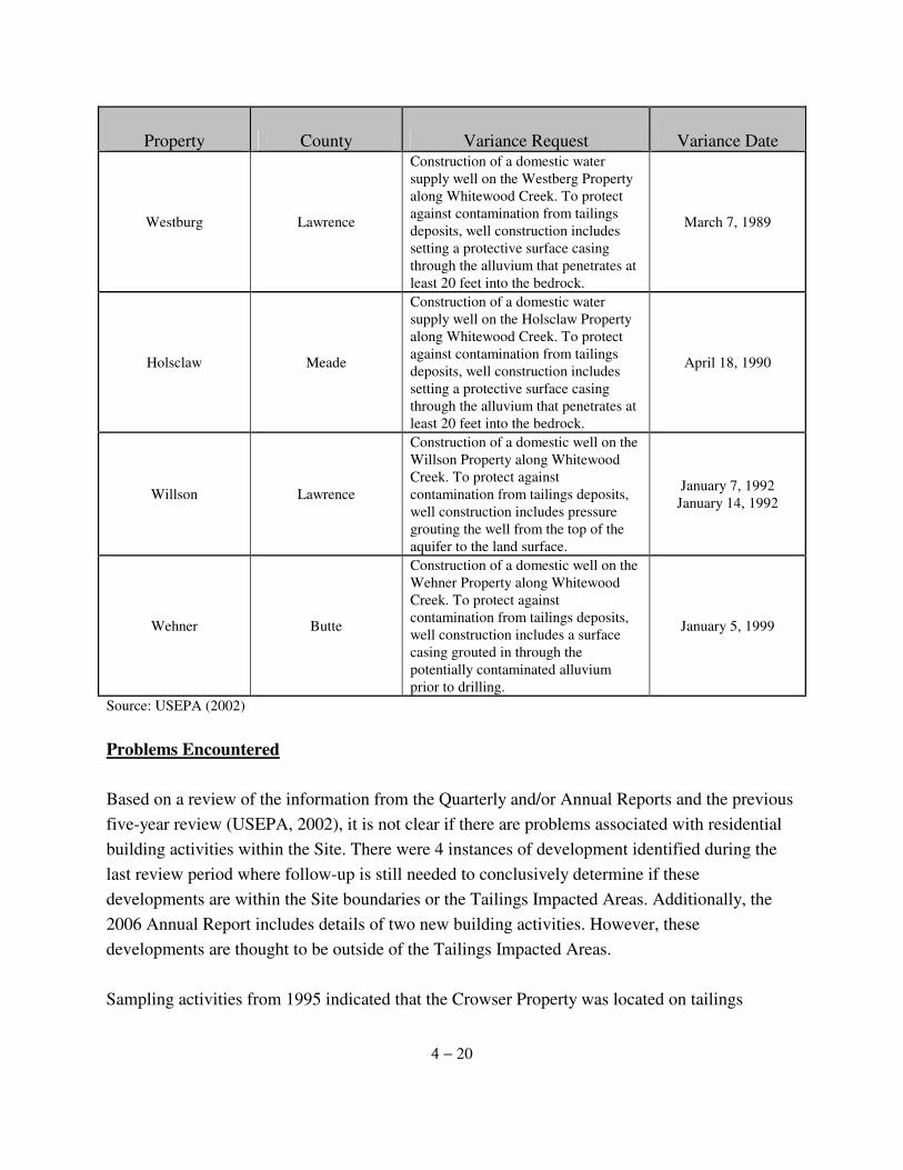
4 − 20
Property County Variance Request Variance Date
Westburg Lawrence
Construction of a domestic water supply well on the Westberg Property along Whitewood Creek. To protect against contamination from tailings deposits, well construction includes setting a protective surface casing through the alluvium that penetrates at least 20 feet into the bedrock.
March 7, 1989
Holsclaw Meade
Construction of a domestic water supply well on the Holsclaw Property along Whitewood Creek. To protect against contamination from tailings deposits, well construction includes setting a protective surface casing through the alluvium that penetrates at least 20 feet into the bedrock.
April 18, 1990
Willson Lawrence
Construction of a domestic well on the Willson Property along Whitewood Creek. To protect against contamination from tailings deposits, well construction includes pressure grouting the well from the top of the aquifer to the land surface.
January 7, 1992 January 14, 1992
Wehner Butte
Construction of a domestic well on the Wehner Property along Whitewood Creek. To protect against contamination from tailings deposits, well construction includes a surface casing grouted in through the potentially contaminated alluvium prior to drilling.
January 5, 1999
Source: USEPA (2002)
Problems Encountered Based on a review of the information from the Quarterly and/or Annual Reports and the previous five-year review (USEPA, 2002), it is not clear if there are problems associated with residential building activities within the Site. There were 4 instances of development identified during the last review period where follow-up is still needed to conclusively determine if these developments are within the Site boundaries or the Tailings Impacted Areas. Additionally, the 2006 Annual Report includes details of two new building activities. However, these developments are thought to be outside of the Tailings Impacted Areas. Sampling activities from 1995 indicated that the Crowser Property was located on tailings
4 − 21
impacted soil and the landowner agreed to complete remediation as outlined in the county development handbook and in accordance with Site project plans. Information at the time of the previous or current five-year review was not available to confirm that remedial activities were completed at this property. Based on a review of the available variances from the SD DENR Water Rights Program, there do not appear to be any problems associated with the state well ban regulation. From the beginning of this project to the present, 4 wells have been installed within the 100-year floodplain following variance requests from the Counties involved. Information on wells installed within the 100-year floodplain without prior application or variances were not uncovered during this five-year review.
4.3.4 Post-Closure Residential Soil Sampling and Remediation The remedy outlined in the ROD (USEPA, 1990) requires the following activities associated with Post-Closure Residential Soil Sampling and Remediation Operations and Maintenance:
· Flood impact soil sampling at remediated residences, · Five-year review remedial action verification soil sampling, and · Residential soil remediation.
In 2003 the O&M Plan was amended (WDC, 2003). The most recent O&M Plan requires only a visual inspection of remediated properties following a 50-year flood event and at the time of a five-year review. System O&M Requirements – Flood Events
The O&M Plan requires the surface soils at remediated residences to be visually inspected after a 50-year, or greater, flood event (WDC, 2003). This is to ensure that in the event that contaminated materials may potentially be redistributed during flooding, residential soil concentrations remain below the 100 ppm arsenic residential soil action level. If during an inspection, conditions indicate recontamination may have occurred, Homestake will conduct soil sampling. If results support recontamination, Homestake will remediate the contaminate area(s) per the project selected remedy. Properties will be remediated within one year of the determination that remediation is necessary (WDC, 2003).
4 − 22
System Activities to Date – Flood Events During May 8 and 9, 1995, a 20 to 25-year flood event occurred within the Whitewood Creek floodplain. Flooding did not impact any remediated residences. Thus, flood impact soil sampling was not conducted (HMC, 1995c).
Problems Encountered – Flood Events No problems were identified with this operation and maintenance requirement. System O&M Requirements – Visual Inspections
The remedy outlined in the ROD (USEPA, 1990) required an inspection and soil sampling to be conducted at remediated residences. When the O&M Plan was amended in 2003, this requirement was changed; requiring only a visual inspection at the remediated residences. Properties are to be inspected to examine property use and the condition of the remedial cover materials. If a visual inspection indicates a residence(s) may have been re-contaminated, Homestake will carry out soil sampling and remediation as necessary. If sampling is required and soil concentrations are determined to statistically exceed remediation standards, those specific areas will be remediated per the project selected remedy. Properties will be remediated within one year of the determination that remediation is necessary (WDC, 2003). System Activities to Date – Visual Inspections In 2007, 12 properties were inspected (see Section 5.3). Maintenance of the remedial cover is required for at least 5 of these properties. Two properties, the Crowser and Swanson, still need to be inspected in order for Homestake to complete this remedy requirement. Problems Encountered – Visual Inspections Two (2) problems were encountered during the most recent visual inspections. At the Swanson property, an unfriendly/territorial dog hindered the inspection. Additionally, the Crowesr property was omitted form the inspection list and must still be inspected.
4 − 23
System O&M Requirements - Residential Soil Remediation (as necessary) If a visual inspection indicates sampling activities are necessary, and soil concentrations are determined to statistically exceed remediation standards, those specific areas will be remediated per the project selected remedy. Properties will be remediated within one year of the determination that remediation is necessary (WDC, 2003). System Activities to Date - Residential Soil Remediation (as necessary) During verification sampling activities in 1996, one property was identified with concentrations exceeding the remediation standard of 100 ppm. This property was remediated within one year of its discovery (WDC, 1998), in accordance with the Site Remedial Action Plan. Problems Encountered - Residential Soil Remediation (as necessary) No problems were identified with this operation and maintenance requirement in the Quarterly and Annual Reports reviewed. 4.3.5 Disposal Site Monitoring An annual review of the disposal site conditions is required to ensure that site conditions are consistent with the Transportation and Disposal Plan for the Whitewood Creek Superfund Site. System O&M Requirements – Disposal Cell The integrity of the Disposal Site fencing, vegetative cover, surface slopes, and rip-rap are reviewed during annual inspections and at the time of the five-year review. Site conditions that are not consistent with the Transportation and Disposal Plan are corrected according to a timetable agreed upon by USEPA and Homestake. If the repair or correction of such conditions is not feasible, the disposal site design will be re-evaluated (WDC, 2003). In the event the Disposal Site is reopened to accommodate disposal of contaminated soils identified during sampling following flooding or as part of the five year review, Site activities will be conducted in accordance with the Transportation and Disposal Plan (WDC, 1994b).
4 − 24
System Activities to Date – Disposal Cell Table 4-1 summarizes the dates, observations and remedial actions taken during the annual inspections of the Disposal Site. Problems Encountered – Disposal Cell Only minor problems have been reported during Homestake Disposal Site monitoring activities. In 1998, unauthorized rubble was observed outside of the disposal site. Homestake coordinated with the SD DENR and the rubble was placed in the disposal facility (HMC, 1998b). In 2002, the fence wiring was down in a few places and some areas required revegetation. In 2006 the livestock exclusion fence was found to be in need of minor repairs and maintenance. In 1996 it was noted by Homestake that there was good vegetative establishment observed on the Disposal Site. In 2000 it was again noted as stable. However, in 2001 Homestake noted that seeding efforts were completed and in 2002 it was reported that supplemental vegetation was required. Since 2003, the annual reports from Homestake have not addressed the vegetation issue. During the 2007 site inspection, it was noted that the vegetative cover is not fully established and requires attention.
4.3.6 Reporting Annual reports of O&M activities and a five year review report assessing Site conditions are required as a part of O&M reporting requirements for the Site. System O&M Requirements - Reporting Homestake submits annual reports to USEPA describing all O&M activities that have occurred during the previous year and those planned for the upcoming year. The annual report includes a description of activities that have occurred at the Site including surface water monitoring, residential soil sampling, residential remediation, disposal site inspection and maintenance, flood impact monitoring, residential building activity within the site and the education program. The annual reports are prepared and submitted within the first quarter of each calendar year. A five-year review is required to assess Site conditions and the adequacy of remedial actions that have been taken at the Site. The review will evaluate the protectiveness of the remedy by
4 − 25
examining changes in Site conditions, changes in Site risks and an evaluation of the remedy implementation, in accordance with decision documents. System Activities to Date – Reporting Table 4-2 lists dates of all quarterly and annual reports submitted to USEPA by Homestake to USEPA. These reports are available from the Superfund Records Center. Problems Encountered - Reporting While no major problems pertaining to the preparation or submittal of the quarterly, annual, or five-year review reports were identified, it has been noted that the conditions at the Disposal Site have not been adequately represented in the annual reports.
5 − 1
5.0 FIVE YEAR REVIEW FINDINGS 5.1 Five-Year Review Process 5.1.1 Interview Team Members The Whitewood Creek five-year review team was lead by Rebecca Thomas, the USEPA Remedial Project Manager for the Site, and Christina Wilson. The following team members assisted in the review:
· Rob Henneke, USEPA Region VII, Community Involvement Coordinator; · Richard Sisk, USEAP Region VIII, Site Attorney; · Robyn Blackburn, US Fish and Wildlife Service, Liaison to USEPA; · Joane Lineburg, South Dakota Department of Environment and Natural
Resources; · Mark Lawrensen, South Dakota Department of Environment and Natural
Resources; and · Todd Deux, Homestake Mining Company, Closure Manager – Lead Operations.
5.1.2 Community Notification
Notice of the upcoming five year review was placed in the Rapid City Journal on June 6, 2007, allowing for a 30-day comment period. Additionally, the annual reports sent to residents by Homestake mentioned the upcoming review in both the 2005 and 2006 reports. Finally, the community was notified about the review during interviews with site residents and government officials conducted by USEPA in May through June of 2007 (Section 5.2). This completed Five-Year Review Report for Whitewood Creek is available in the information repository. Notice of its completion was placed in the local newspaper in August of 2007. 5.1.3 Five-Year Review Tasks The Five-Year Review for Whitewood Creek consists of the following tasks:
Review of relevant documents. A review of documents for the Whitewood Creek Site was completed for the purpose of determining the scope of the remedy, the goals of the remedy and its current status. Documents pertaining to the Whitewood Creek Site were

5 − 2
reviewed to determine the following:
· The remedial action objectives and cleanup levels specified in the ROD (USEPA, 1990) and other decision documents;
· The remedial actions and their design; · Any changes to the assumptions underlying cleanup levels; · The status of the implementation of the remedy and O&M; · The status of the implementation and enforcement of institutional controls; and · The effectiveness of the remedy in meeting remedial action objectives.
Interviews. Interviews were conducted by USEPA staff with local regulatory officials, response agencies and residents to identify any problems with the implementation and to evaluate the effectiveness of the remedy. The results of the interviews completed for the Whitewood Creek Five Year Review are provided in Section 5.2.
Site Inspection. A site inspection was completed by SD DENR and Homestake to visually confirm and document the conditions of the Site, remedy and surrounding area. The results of the site inspection are reported in Section 5.3.
Risk Information Review. The risk information review includes a review of the Site ARARs and the site-specific, risk based cleanup level. An evaluation was completed to identify if changes in ARARs, toxicity or other characteristics affect the protectiveness of the remedy. The risk information review is provided in Section 5.4.
Risk Recalculation/Assessment. A recalculation of potential site risks and an ecological risk assessment were completed for the Whitewood Creek Site during the previous five-year review. This section, 5.5, reviews the results from the previous report and addresses current concerns. Data Review. A review of surface water monitoring data and residential soil samples taken by Homestake in 2001 was completed for the Whitewood Creek site. This information is provided in Section 5.6.
The results of these tasks are used as the basis of the assessment of the effectiveness of the selected remedy in Section 6, to identify any deficiencies in Section 7, and to provide any recommendations and required actions to ensure the protectiveness of the remedy to human
5 − 3
health and the environment in Section 8. 5.2 Interviews
Interviews were conducted by USEPA with local regulatory officials and residents to review the effectiveness of the remedy. The interview findings are summarized in the following sections. 5.2.1 Interviews with Residents Property owners at remediated properties or property owners within the site were interviewed via phone calls, where residents were available. Attempts were made to contact 15 property owners; out of those 15, 12 individuals were interviewed. The following questions were asked of each:
1. Have any tailings materials been imported? 2. Has Whitewood Creek flooding impacted any high-use area? 3. Have any water wells been constructed within Tailings Impacted Areas? 4. Do you use surface water from the Whitewood Creek? 5. Has property use changed, impacting the previously delineated high-use areas? 6. Have there been any excavating activities since remediation? 7. Is the remedial cover intact? Is any geofabric below cover materials visible?8. Are there any special problems related to previously completed remedial
activities? 9. What is you general impression of the project? 10. What is you impression of the risks? 11. Are you informed about site progress? 12. Do you have any comments, suggestions, or recommendations for the Site?
Interview findings are summarized below:
1. Have any tailings materials been imported? All interviewed residents indicated that no tailings materials have been imported.
2. Has Whitewood Creek flooding impacted any high-use area?
There were 2 reports of instances where high-use areas were impacted by flooding (Balo and Kymala). Homestake was made aware of both so that they may follow-up with the property owners.
5 − 4
3. Have any water wells been constructed within Tailings Impacted Areas?
All interviewed residents indicated that no new water wells have been constructed in the Tailings Impacted Areas.
4. Do you use surface water from the Whitewood Creek? Three (3) residents indicated that they use surface water from Whitewood creek; 2 in the case of crop irrigation (Alan and Berger) and the other for livestock (Shuck).
5. Has property use changed, impacting the previously delineated high-use areas? All interviewed residents indicated that there has been no property use change impacting the previously delineated high-use areas.
6. Have there been any excavating activities since remediation? All interviewed residents indicated that no excavation activities have occurred since remediation.
7. Is the remedial cover intact? Is any geofabric below cover materials visible? Three (3) respondents answered that the remedial cover is not intact and geofabric is showing (Berger, Holsclaw and Kymala). Homestake and SD DENR were made aware of these instances prior to the site inspection in July of 2007 so that they could assess the individual situations and decide if any actions were required.
8. Are there any special problems related to previously completed remedial activities? Other than some instances of erosion, as covered by Question #7, no other problems were identified during the interview process.
9. What is you general impression of the project? When asked as to their general impression of the project, there were mixed responses. While many of those interviewed expressed the opinion that the project was not necessary, others expressed they were of the opinion that more should have been done to remove the impacted tailings rather than merely covering them.
10. What is you impression of the risks? Nine (9) of those interviewed expressed that their impression of the risks was low, while 2 were unsure
5 − 5
11. Are you informed about site progress? All but 1 interviewed resident stated they were informed about the site progress via the annual Residential Information Sheet. Homestake was made aware of the instance where the resident was not on their mailing list (Swanson) so that they could update their contact information. 12. Do you have any comments, suggestions, or recommendations for the Site? The majority of residents did not have any additional comments, suggestions or recommendations not covered by the previous questions. One interviewee, however, expressed that he would like the covenants removed from his property (Holsclaw). 5.2.2 Interviews with Government Officials
To review the implementation and effectiveness of the county ordinance institutional controls specified by the ROD (USEPA, 1990), interviews with government officials from each of the 3 Counties, Butte, Lawrence and Meade, responsible for administering the controls were conducted. The interviews were intended to help USEPA determine if the institutional controls at the Site remain in place, are effective and if there have been any changes in site conditions or resource use. The following 6 questions were initially asked of each government official:
1. Are there routine communications or activities (site visits, inspections, reporting activities, etc.) conducted by your office regarding the site? If so, please give purpose and results.
2. Have there been any complaints, violations, or other incidents related to the site requiring a response by your office? If so, please give details of the events and results of the responses.
3. What institutional control programs do you have? 4. What documents do you rely on to implement your responsibilities? 5. What do you do to implement your restrictions in building, well drilling and other
activities? 6. Describe your procedures. Are there any associated difficulties or costs?
After the initial interviews, USEPA contacted one of the Counties in regards to an occupancy permit. It then became apparent that this issue was overlooked during the first round of interviews. Therefore, all three Counties were again contacted and asked a seventh question: 7. Does your county issue occupancy permits?
5 − 6
The parties interviewed and findings are as follows:
Butte County Planning Office – Paul Gremse, the Butte County Planning Director, was initially interviewed by Rob Henneke of USEPA Region VIII on May 31, 2007, with the follow-up question (question #7) addressed by Christina Wilson of USEPA Region VII on June 27, 2007. The following is a list of the questions asked and responses received: 1. Are there routine communications or activities (site visits, inspections, reporting
activities, etc.) conducted by your office regarding the site? If so, please give purpose and results.
No. However, Homestake and their contractor do a routine walk-through and report to the County. 2. Have there been any complaints, violations, or other incidents related to the site
requiring a response by your office? If so, please give details of the events and results of the responses.
No. 3. What institutional control programs do you have? The County has a separate ordinance for building permits in the tailings area of Whitewood Creek. 4. What documents do you rely on to implement your responsibilities? The County has an ordinance and a handbook (that EPA may have produced) for the Site. 5. What do you do to implement your restrictions in building, well drilling and other
activities? The County uses guidelines in the ordinance. Seven sections are impacted by the area. 6. Describe your procedures. Are there any associated difficulties or costs? There are no extra difficulties or costs. 7. Does your County issue occupancy permits? No.
5 − 7
Lawrence County Planning and Zoning Office – Amber Vogt, the Lawrence County Planning and Zoning Administrator, was initially interviewed by Rob Henneke of USEPA Region VIII on May 31, 2007, with the follow-up question (question #7) addressed by Christina Wilson of USEPA Region VII on June 13, 2007. The following is a list of the questions asked and responses received: 1. Are there routine communications or activities (site visits, inspections, reporting
activities, etc.) conducted by your office regarding the site? If so, please give purpose and results.
No. If something comes up, Homestake informs the County. 2. Have there been any complaints, violations, or other incidents related to the site
requiring a response by your office? If so, please give details of the events and results of the responses.
One. The County received a report that a building was constructed too close to the impacted area. An inspection showed that the building was actually out of the area. This was the only complaint in the last three years. 3. What institutional control programs do you have? The programs include: a zoning ordinance, building permits and ordinances governing the Superfund site. 4. What documents do you rely on to implement your responsibilities? The documents include a zoning ordinance and a comprehensive plan. 5. What do you do to implement your restrictions in building, well drilling and other
activities? The County requires building permits, zoning permits and changes, and variances and conditional uses. 6. Describe your procedures. Are there any associated difficulties or costs? There are no difficulties or added costs. 7. Does your County issue occupancy permits? No.
5 − 8
Meade County Equalization and Planning Office – Bill Rich, the Director of Equalization/Engineer for Meade County, was interviewed by Christina Wilson of USEPA Region VIII on June 4 and 27, 2007. The following is a list of the questions asked and responses received: 1. Are there routine communications or activities (site visits, inspections, reporting
activities, etc.) conducted by your office regarding the site? If so, please give purpose and results.
No. 2. Have there been any complaints, violations, or other incidents related to the site
requiring a response by your office? If so, please give details of the events and results of the responses.
No. 3. What institutional control programs do you have? The County follows the permit program. 4. What documents do you rely on to implement your responsibilities? The EPA documents and Homestake building handbook. 5. What do you do to implement your restrictions in building, well drilling and other
activities? Follow guidelines from the Homestake building handbook. 6. Describe your procedures. Are there any associated difficulties or costs? There are no difficulties or added costs. 7. Does your County issue occupancy permits? Yes.
5 − 9
5.2.3 Interview with Homestake Mining Corporation
Homestake Closure Manager – Todd Deux, the Closure Manager – Lead Operations, for Homestake Mining Company was interviewed by Rob Henneke of USEPA Region VIII on July 19, 2007. The interview was conducted in order assess the remedy effectiveness through an understanding of any problems, successes or changes that have occurred since the last review. The questions asked and responses given are summarized below:
1. What is your impression of the project? It is in good shape; managed as designed. 2. What is your impression of the risk? It is my impression that there is low risk. 3. Have there been routine communications or activities (site visits, inspections,
reporting activities, etc.) conducted by your office regarding the site? If so, please give purpose and results.
Homestake conducts an annual inspection, at a minimum; more often in some areas. We have found no significant problems. 4. Have there been any complaints, violations, or other incidents related to the site
requiring a response by your office? If so, please give details of the events and results of the responses.
There have been minor complaints and routine maintenance. Nothing significant, as stated in #3. 5. Do you feel well informed about the Site’s activities and progress? Yes. 6. Do you have any comments, suggestions or recommendations regarding the Site’s
management or operation? No. 7. Have any tailings materials been imported. Have any tailings been removed
from the Creek? No.
5 − 10
8. Have any new water wells or other irrigation structures been constructed within
the Tailings Impacted Areas? If so, describe the wells or structures. No. 9. Has surface water usage changed, and what impact does the change have on the
impacted surface water and surrounding area? No. 10. Has Whitewood Creek flooding impacted any high-use areas? No. 11. Has property use changed, impacting the previously delineated high-use areas? Minor changes that do not impact high-use areas. 12. Have there been any excavation activities since remediation? No. 13. Is the remedial cover intact? Yes, with minor maintenance. 14. Is any geofabric (used beneath remedial cover materials in select areas) visible? Yes, with minor maintenance. 15. Are there any special problems related to previously completed remedial
activities? No. 16. What programs do you have to restrict building, well drilling and other activities
in the contaminated floodplain? How is the program executed? Give examples. These all fall within the local governments’ responsibility. 17. Can you discuss Homestake's land agreements along Whitewood Creek? How
does this relate to efforts to maintain institutional controls? The land agreements are primarily agricultural agreements that allow for normal
agricultural use and fit into the institutional controls.
5 − 11
18. During the previous five-year report Homestake stated they would check on the
1995 soil sampling results from Ray and Becky Crowser's property (associated with building permit 3788)? Crowser states that Homestake already took samples, and they are outside 100 mg/kg limit for arsenic. Has Homestake ever followed up on this?
I will research this question and get back to the project manager. 19. Do you have any comments, suggestions, or recommendations regarding the
project (i.e., design, construction documents, constructability, management, regulatory agencies, etc.)?
No. 20. Is there a continuous onsite O&M presence? If so, please describe staff and
activities. If there is not a continuous onsite presence, describe staff and frequency of site inspections and activities. Have there been any significant changes in the O&M requirements, maintenance schedules, or sampling routines since start-up or in the last five years? If so, do they affect the protectiveness or effectiveness of the remedy? Please describe changes and impacts.
There are regular, periodic inspections. There have been no significant changes in O&M. 21. Have there been unexpected O&M difficulties or costs at the site since start-up or
in the last five years? If so, please give details. No. 22. Have there been opportunities to optimize the operation, maintenance, or
sampling efforts? Please describe changes and resultant or desired cost savings or improved efficiency.
There have been no significant changes with O&M, as stated in question # 20. USGS provides quality water sampling

5 − 12
5.2.4 Interview with Belle Fourche Irrigation District Belle Fourche Irrigation District Manager – Clint Pitts, the manager of the Belle Fourche Irrigation District was interviewed by Christina Wilson of USEPA Region VIII on August 18, 2007. This interview was conducted in regards to the Whitewood Creek Siphon. This Bureau of Reclamation (BOR) structure is maintained by the Belle Fourche Irrigation District and lies within the Site boundaries. The following list the questions asked and responses received.
1. Have you in the past, or will you in the future use surface water from the Whitewood Creek?
No. And there are no plans for future use. 2. Have any new water wells or other irrigation structures been constructed within
the Tailings Impacted Areas? No. 3. Have there been any excavation, stabilizing or other activities conducted by the
irrigation district since the remediation? No. 4. Are there continuous O&M activities undertaken at the siphon? There has been general maintenance on the roads on either side of the siphon, but not on the siphon itself.
5.2.5 Summary of Interview Results Residential Interviews. No significant changes in Site conditions were reported during the 2007 residential interviews. However, there were a few instances of erosion of the remedial cover and cases where the geofabric below the cover material was visible. These instances were reported to Homestake and the SD DENR prior to their site inspection so that these cases could be further investigated. Governmental Interviews. The one area of concern that arose from the interviews with the county officials relates to the issuing of occupancy permits. Of the 3 Counties involved with the project, Butte, Lawrence, and Meade, only Meade issues occupancy permits.
5 − 13
Irrigation District Interview. The District manager did not have any concerns related to the general maintenance of the BOR Whitewood Creek siphon. Successes and Problems in the Implementation of Institutional and Access Controls The 2007 site interviews did not reveal any instances of development at residential properties within the Whitewood Creek Site. However, interviews with government officials indicated that institutional controls limiting such building may not be functioning effectively to limit residential exposures to arsenic impacted soils. Successes and Problems with System Operations and Maintenance (O&M) Homestake did not report any unexpected difficulties with O&M activities or costs at the Site since startup. No other problems were reported during the site interviews. Unusual Situations or Problems No unusual situations or problems were reported during the site interviews. 5.3 Site Inspection A Whitewood Creek Site Inspection was completed by Joane Lineburg of SD DENR and Todd Deux of Homestake on July 12, 2007 to visually confirm and document the conditions of the Site, remedy and surrounding area. 5.3.1 Activities and Summary of Findings Residential properties that were remediated during the remedy were inspected. The properties were examined for any degradation in or changes to remedial cover and for changes in landuse that may have occurred since remediation. The findings from the property inspections are displayed in Table 5-1. The following summarizes where follow-up is needed, as indicated by the property inspections: 1. Five (5) properties showed evidence of erosion of the gravel cover and are in need of
maintenance. They are as follows: Alan (Figures 5-1 and 2), Balo, Berger, Holsclaw and Kymala. At 2 of these properties the geotextile material is showing, Balo (Figure 5-3) and
5 − 14
Kymala (Figure 5-4). 2. One (1) property, the Holsclaw residence, showed evidence of recontamination via
tracking of tailings into the remediated area (Figure 5-5). 3. Unstable stream banks were observed near the Holsclaw site (Figure 5-6) and drainage
issues were noted at the Kymala residence (Figure 5-7). 4. One (1) property on the inspection list was not inspected due to an unfriendly dog
(Swanson). 5. One (1) property was overlooked on the checklist and must be inspected (Crowser). 6. One (1) property owner, Alan, has planted 2 new garden plots on either side of their
driveway; follow-up is needed to ensure these are not within the Tailings Impacted Areas and if so, there is at a minimum 24” of clean topsoil on the garden plots (Figures 5-8 and 5-9).
In addition to inspecting the remediated residences, the BOR Whitewood Creek siphon was inspected. The conclusions reached by the SD DENR and Homestake inspection team were that the fencing and rip rap were intact and there was no evidence of erosion. Photographs of the siphon are shown in Figures 5-10 and 5-11. Lastly, the Disposal Site was inspected. The inspection team noted that the fencing and rip-rap were intact and there was no evidence of erosion (Figures 5-12 and 5-13). However, the revegetation efforts have not been fully successful as there are areas where the vegetation is still not established (Figures 5-14 and 5-15). 5.4 Risk Information Review 5.4.1 ARARs Reviewed Remedial actions under CERCLA are required by the NCP and USEPA guidance and policy to comply with applicable or relevant and appropriate standards, requirements, criteria, or limitations during and at the completion of the action. These Applicable or Relevant and Appropriate Requirements (ARARs) include both state and federal environmental laws and state facility siting laws. These requirements are threshold standards that any selected remedy must meet, unless an ARAR waiver is invoked. ARARs are contaminant, location, or action specific. Contaminant specific ARARs establish acceptable amounts or concentrations of chemicals which may be found in or discharged to the ambient environment. Location specific ARARs relate to the geographical or physical positions of sites and place restrictions on the conduct of cleanup activities or concentrations of hazardous
5 − 15
substances. Action specific ARARs are usually technology based or activity based requirements or limitations on actions taken with respect to hazardous substances, pollutants or contaminants. As part of the five-year review, the ARAR requirements identified in the ROD (USEPA, 1990) for the remedy are examined to assess, as part of the remedy, whether they are still protective of human health and the environment. ARARs are examined for new or revised requirements that have occurred since the signature of the ROD. Only those ARARs that address risks posed to human health or the environment are reviewed (USEPA, 1999). Table 5-2 lists the ARARs for the Whitewood Creek Superfund Site specified by the ROD (USEPA, 1990) and by the 1991 ESD (USEPA, 1991b). According to the ROD for this Site, a waiver was invoked for complying with maximum contaminant levels for arsenic under the Safe Drinking Water Act and the arsenic ambient water quality criteria for the protection of human health by consumption of fish because of the technical impracticability of meeting these requirements. A review of all the ARARs specified in the ROD (USEPA, 1990) was carried out to assure no changes had been implemented that would affect the protectiveness of the remedy. Table 5-3 includes the ARARs reviewed and the date they were last revised. Those ARARs determined to not be applicable or relevant and appropriate were not included in this review. Since the remediation at individual properties and disposal of tailings material has been completed, several of the ARARs listed in the ROD are not applicable or relevant to the ongoing O&M activities. However, if in the future it becomes necessary to perform additional remediation, or add material or implement any changes to the disposal site, many of the ARARs that currently do not apply to the Site will have to be revisited.
Chemical Specific ARARs ARARs for the contaminants of concern identified in the 1990 ROD (USEPA, 1990) were reviewed for changes that may affect the protectiveness of the remedy to human health and the environment. Table 5-4 summarizes changes in the chemical-specific state and federal water quality ARARs by comparing the 2007 regulations with both the regulations in effect at the time of the last five-year review in 2002 and at the signing of the ROD in 1990. These standards are relevant to Site groundwater as a potential future drinking water source, the surface waters of Whitewood Creek for the protection of human health from fish consumption and for the protection of aquatic life and ambient air. Some federal and state regulations for various
5 − 16
chemicals have been revised since the signing of the ROD in 1990 to be either more or less stringent. As shown in Table 5-4, relatively few changes have occurred since the last review. Table 5-4 presents both the total recoverable and dissolved ambient water quality criteria for the protection of aquatic life. However, the federal and state surface water quality criteria in effect at the time the ROD (USEPA, 1990) were based on total recoverable metals. Since the signing of the ROD, the federal and state regulations have changed to add criteria specific to dissolved metals concentrations. Thus, the total recoverable and dissolved concentrations of metals provided in Table 5-4 are for comparison purposes only. According to the ROD, a waiver was invoked for complying with maximum contaminant levels (MCLs) for arsenic in groundwater under the Safe Drinking Water Act and the water quality criteria for the protection of human health by consumption of fish because of the technical impracticability of meeting these requirements (USEPA, 1990). Thus, the changes in the federal and state arsenic surface water quality criteria, drinking water standards, and state groundwater quality standards do not affect the protectiveness of the remedy because under the waiver, these standards are not required to be attained. Site-specific water quality criteria for 10 metals were specified for the upper reach of Whitewood Creek, from Interstate 90 to its confluence with Gold Run Creek at the time the ROD (USEPA, 1990) was signed in 1990. During the period from the signing of the ROD to the previous review (1990 to 2002), there were several changes in the water quality criteria, as noted in the table below. However, since the last review in 2002 (USEPA), the only change has been the removal of copper from the site-specific water criteria. The following table lists the site-specific water quality criteria, expressed as total concentrations, from 1990, the year the ROD was signed, 2002, the year of the last review, and 2006, for the present review. Metals without a site-specific standard are subject to South Dakota water quality standards (Table 5-4).
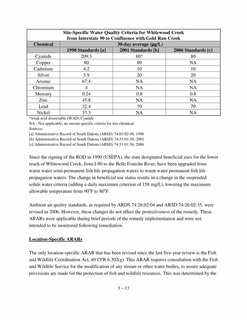
5 − 17
Site-Specific Water Quality Criteria for Whitewood Creek from Interstate 90 to Confluence with Gold Run Creek
Chemical 30-day average (µg/L) 1990 Standards [a] 2001 Standards [b] 2006 Standards [c]
Cyanide 209.3 80* 80 Copper 80 80 NA
Cadmium 4.2 10 10 Silver 3.9 20 20
Arsenic 67.4 NA NA Chromium 4 NA NA Mercury 0.24 0.8 0.8
Zinc 45.8 NA NA Lead 32.4 70 70
Nickel 37.3 NA NA *weak acid dissociable (WAD) Cyanide NA - Not applicable; no stream specific criteria for this chemical. Sources: [a] Administrative Record of South Dakota (ARSD) 74:03:02:48, 1990 [b] Administrative Record of South Dakota (ARSD) 74:51:01:56, 2001 [c] Administrative Record of South Dakota (ARSD) 74:51:01:56, 2006 Since the signing of the ROD in 1990 (USEPA), the state designated beneficial uses for the lower reach of Whitewood Creek, from I-90 to the Belle Fourche River, have been upgraded from warm water semi-permanent fish life propagation waters to warm water permanent fish life propagation waters. The change in beneficial use status results in a change in the suspended solids water criteria (adding a daily maximum criterion of 158 mg/L), lowering the maximum allowable temperature from 90oF to 80oF. Ambient air quality standards, as required by ARDS 74:26:02:04 and ARSD 74:26:02:35, were revised in 2006. However, these changes do not affect the protectiveness of the remedy. These ARARs were applicable during brief periods of the remedy implementation and were not intended to be monitored following remediation. Location-Specific ARARs The only location-specific ARAR that has been revised since the last five-year review is the Fish and Wildlife Coordination Act, 40 CFR 6.302(g). This ARAR requires consultation with the Fish and Wildlife Service for the modification of any stream or other water bodies, to assure adequate provisions are made for the protection of fish and wildlife resources. This was determined by the
5 − 18
ROD (USEPA, 1990) to be applicable for modifications made to Whitewood Creek. The changes made to this ARAR in 2006 do not currently affect the protectiveness of the remedy as there have been no modifications made to the creek. However, if in the future changes to the creek are necessitated, the changes made to this ARAR will need to be reviewed. Action-Specific ARARs Of the 17 action-specific ARARs required by the ROD (USEPA, 1990), 5 have been revised since the last five-year review. They are as follows:
· Occupational Safety and Health Act, 29 U.S.C. Sections 651-678; · Solid Waste Disposal Act, 40 CFR 257.3; · Surface Mining Control and Reclamation Act, 30 CFR 816-816.111; · Surface Mining Control and Reclamation Act, 30 CFR 784-784.13; and · Clean Water Act, 40 CFR 230 and 231.
None of the above listed ARAR changes affect the protectiveness of the remedy at the present time. However, if circumstances necessitate future work be performed at the Site, beyond general O&M activities, the revisions to these ARARs will need to be reviewed. 5.4.2 Review of Site-Specific Cleanup Level In addition to federal and state regulations, a site-specific risk-based cleanup level for arsenic was established for residential soils (USEPA, 1990). This action level assumed that remedial action efforts aimed at groundwater, the tailings area and the irrigated cropland area were in place and thus only addressed exposure to residential soils (Jacobs, 1989). A soil action level of 100 mg/kg arsenic for residential soils was derived in the Endangerment Assessment (Jacobs, 1989) based on a 1E-04 target cancer risk protectiveness level selected by USEPA. This soil action level was also determined to reduce non-cancer risks to an acceptable level (USEPA, 1990). At the time of the last five-year review, the soil action level for arsenic was reviewed. Although there had been some changes in the toxicity factors and exposure parameters recommended by USEPA for evaluating cancer and non-cancer risks from arsenic (SRC, 2001a), USEPA still considers the soil action level of 100 mg/kg to be adequately protective of human health.
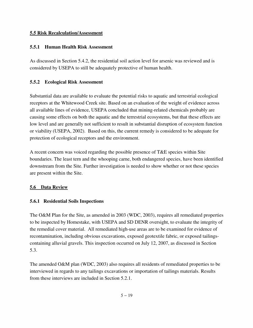
5 − 19
5.5 Risk Recalculation/Assessment 5.5.1 Human Health Risk Assessment As discussed in Section 5.4.2, the residential soil action level for arsenic was reviewed and is considered by USEPA to still be adequately protective of human health. 5.5.2 Ecological Risk Assessment Substantial data are available to evaluate the potential risks to aquatic and terrestrial ecological receptors at the Whitewood Creek site. Based on an evaluation of the weight of evidence across all available lines of evidence, USEPA concluded that mining-related chemicals probably are causing some effects on both the aquatic and the terrestrial ecosystems, but that these effects are low level and are generally not sufficient to result in substantial disruption of ecosystem function or viability (USEPA, 2002). Based on this, the current remedy is considered to be adequate for protection of ecological receptors and the environment. A recent concern was voiced regarding the possible presence of T&E species within Site boundaries. The least tern and the whooping carne, both endangered species, have been identified downstream from the Site. Further investigation is needed to show whether or not these species are present within the Site. 5.6 Data Review
5.6.1 Residential Soils Inspections The O&M Plan for the Site, as amended in 2003 (WDC, 2003), requires all remediated properties to be inspected by Homestake, with USEPA and SD DENR oversight, to evaluate the integrity of the remedial cover material. All remediated high-use areas are to be examined for evidence of recontamination, including obvious excavations, exposed geotextile fabric, or exposed tailings-containing alluvial gravels. This inspection occurred on July 12, 2007, as discussed in Section 5.3. The amended O&M plan (WDC, 2003) also requires all residents of remediated properties to be interviewed in regards to any tailings excavations or importation of tailings materials. Results from these interviews are included in Section 5.2.1.
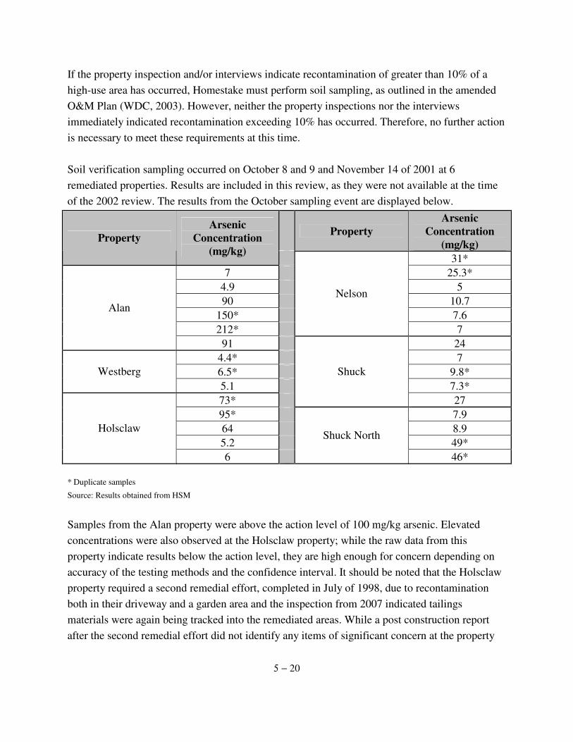
5 − 20
If the property inspection and/or interviews indicate recontamination of greater than 10% of a high-use area has occurred, Homestake must perform soil sampling, as outlined in the amended O&M Plan (WDC, 2003). However, neither the property inspections nor the interviews immediately indicated recontamination exceeding 10% has occurred. Therefore, no further action is necessary to meet these requirements at this time. Soil verification sampling occurred on October 8 and 9 and November 14 of 2001 at 6 remediated properties. Results are included in this review, as they were not available at the time of the 2002 review. The results from the October sampling event are displayed below.
Property
Arsenic Concentration
(mg/kg) Property Arsenic
Concentration (mg/kg)
31* 7 25.3*
4.9 5 90 10.7
150* 7.6 212*
Nelson
7
Alan
91 24 4.4* 7 6.5* 9.8* Westberg 5.1 7.3* 73*
Shuck
27 95* 7.9 64 8.9 5.2 49*
Holsclaw
6
Shuck North
46* * Duplicate samples Source: Results obtained from HSM Samples from the Alan property were above the action level of 100 mg/kg arsenic. Elevated concentrations were also observed at the Holsclaw property; while the raw data from this property indicate results below the action level, they are high enough for concern depending on accuracy of the testing methods and the confidence interval. It should be noted that the Holsclaw property required a second remedial effort, completed in July of 1998, due to recontamination both in their driveway and a garden area and the inspection from 2007 indicated tailings materials were again being tracked into the remediated areas. While a post construction report after the second remedial effort did not identify any items of significant concern at the property
5 − 21
(WDC, 1998), elevated results from the 2001 sampling event may indicate recontamination has again occurred. The elevated soil samples from the Alan property necessitated a more through sampling event; this was conducted on November 14, 2001. Thirty (30) samples were taken; results are shown below.
Sample Number
Arsenic Concentration
(mg/kg) Sample Number
Arsenic Concentration
(mg/kg) Sample Number
Arsenic Concentration
(mg/kg) 1 4 12 44 23 52 2 5 13 3.8 24 92 3 4.3 14 4.2 25 84 4 3.8 15 4.1 26 79 5 4.2 16 16 27 69 6 3.8 17 6.3 28 64 7 4 18 4.9 29 52 8 3.9 19 4.3 30 76 9 4.1 20 4.4 31 81
10 3.9* 21 51* 32 64* 11 4.1* 22 53* 33 77*
* Duplicate samples Source: Results obtained from HSM The results currently available to USEPA (those show in the above table) are not conclusive. It is unclear from where on the property the samples were taken; if the possible hot spot identified during the October sampling event was resampled. At the time of this report, further information was not available. USEPA has requested a report from Homestake regarding these 2 sampling events in order to more effectively assess the results. 5.6.2 Surface Water Quality The Site remedy requires long term monitoring of surface water quality to evaluate the effects of uncertain rates of release of arsenic into the surface waters of Whitewood Creek. Therefore, as part of the five-year review, these data were reviewed to determine if any significant time trends were apparent and to determine if concentrations of arsenic in the surface waters of Whitewood Creek are protective of human health and aquatic life (USEPA, 1990).
5 − 22
Furthermore, it is noted that the Cheyenne River Sioux Tribe (CRST) has issued a reservation-wide fish consumption advisory associated with mercury found in fish tissue collected from various water bodies on the reservation, including the reach of the Cheyenne River which is immediately downstream of the Site. Since it is known that mercury was used for many years in the processing of gold at the Homestake mine, mercury levels in Whitewood Creek have been analyzed in order to determine if the Site is significantly contributing to the elevated mercury levels in the Cheyenne River. USEPA and the CRST have performed an extensive investigation related to mercury contamination in fish in the Cheyenne River and other water bodies on the reservation. The investigation concluded that mercury found in the fish from the Cheyenne River and on CRST lands is probably not coming from upstream mining sites, but is more likely coming from a combination of naturally occurring mercury in soil and mercury that is released in the air from sources such as coal burning power plants. To concur with these findings, mercury concentrations were analyzed from a USGS sampling station located on Whitewood Creek within Site boundaries. Surface Water Data Surface water data were collected from two USGS sampling stations on Whitewood Creek within the Site boundaries. The upper USGS Station (06436180) is located along Whitewood Creek near the Crook City Bridge, about 1.1 miles south of the city of Whitewood, South Dakota. The lower Whitewood Creek USGS Station (06436198) is located about 3.2 miles above the confluence with the Belle Fourche River and approximately 3.7 miles west of Vale, South Dakota (Figure 5-14). Surface water quality data for arsenic and mercury, available electronically from USGS, were reviewed. Several other parameters that are not included in this analysis are also available online at the USGS website. Time Trends Surface water data for dissolved and total recoverable arsenic and filtered and recoverable, unfiltered mercury were plotted for both USGS sampling stations to examine trends in concentrations over time. The results are provided in Figures 5-15 and 5-16 (arsenic) and 5-17 (mercury). Neither sampling station showed statistically significant positive or negative trends with time for arsenic concentrations.
5 − 23
The data for mercury indicate that concentrations in water have decreased substantially over the past 5 years, with a significant reduction in 2001. This supports the conclusion that mercury in Cheyenne River is probably not coming from the Site. It should be noted that a very few sampling events, where substantially higher mercury concentrations were observed, were removed from the graphed data set in order to most effectively depict the overall trends; the full data set is available from the online USGS database. Protectiveness of Human Health Surface water concentrations of arsenic at both the upper and lower USGS sampling stations were compared to federal ambient water quality criteria (AWQC) for human health from fish consumption. This criterion of 0.14 µg/L was exceeded 100% of the time at both the upstream and downstream sampling locations within the Site. However, this AWQC does not take into account the finding that much of arsenic in fish is non-toxic. Furthermore, this ARAR has been waived at this Site. In order to evaluate the potential risks to humans from arsenic in fish, an evaluation based on measured concentrations of arsenic in fish tissue was performed (SRC, 2002). The potential risks from arsenic to recreational fishermen consuming fish from Whitewood Creek are below the level identified by USEPA (1991a) as typically requiring action at Superfund sites. Thus, the current remedy is judged to remain protective of human health. Protectiveness of Aquatic Life The current remedy is considered to be adequate for protection of currently identified ecological receptors and the environment.
6 − 1
6.0 ASSESSMENT
This section summarizes the conclusions of this five-year review report, based on the information presented in previous sections. In assessing the protectiveness of the remedy, the following questions are examined:
· Have conditions external to the remedy changed since the selection of the remedy?
· Has the remedy been implemented in accordance with decision documents? · Has any risk information changed since the remedy was selected?
6.1 Have External Conditions Changed Since the Remedy? This section evaluates if conditions external to the remedy have changed at the Site since the selection of the remedy. Changes in landuse, known contaminants, sources of contaminants, exposure pathways, hydrologic and hydrogeological conditions at the Site are evaluated in the following subsections. 6.1.1 Changes in Landuse Based on the site inspections and site interviews no major changes were identified in landuse at the Whitewood Creek site, with one minor exception. The site inspections identified 2 new garden plots on the Alan property that should be investigated to ensure they are in compliance with Site institutional controls. No planned changes in the future use of the Site were identified. 6.1.2 Changes in Known Contaminants, Sources and Pathways Changes in Known Contaminants No known changes in exposure pathways were identified as part of the five-year review. Changes in Known Sources No changes in known sources of contaminants were identified during the five-year review. Erosion of tailings in the stream banks and floodplain continue to be a source of contaminants for
6 − 2
Whitewood Creek. Changes in Known Pathways No known changes in exposure pathways were identified as part of the five-year review. 6.1.3 Changes in Known Hydrologic or Hydrogeologic Conditions No known changes in hydrologic or hydrogeologic conditions were identified as part of the five-year review. 6.2 Has the Remedy Been Implemented in Accordance with Decision Documents? This section evaluates if the remedy, including institutional controls, and its subsequent operation and maintenance are implemented in accordance with project plans and are effective. Access and institutional controls, remedy performance, adequacy of system operations/O&M requirements, optimization and early indications of potential remedy failure are evaluated in the following subsections. 6.2.1 Access and Institutional Controls Most all institutional controls at the Site, including contamination and floodplain boundary determination, county landuse ordinances and state well ban regulations, annual educational program, surface water monitoring, residential flood monitoring and the five-year review visual site inspections and resident interviews are currently in place. They have been implemented as part of the remedy selected in the ROD (USEPA, 1990) and in accordance with the Site Institutional Control Plan. The one aspect of the institutional controls that needs to be addressed is the Counties’ issuance of occupancy permits. Contamination and Floodplain Boundary Determination The tailings deposit areas, tailings impacted soils and 100-year floodplain boundaries were delineated during 1991 and 1992 and approved by USEPA in 1993 (USEPA). These boundaries were used in the enactment of the county landuse ordinances institutional control.
6 − 3
Future Development Restrictions County Landuse Ordinances Landuse ordinances restricting development on tailings deposits and in Tailings Impacted Areas within the Site were adopted by Butte, Lawrence and Meade Counties in 1993 and 1994. These institutional controls remain in place in each of the Counties. Instances of unauthorized development within the Tailings Impacted Areas of the Site were identified during the 2002 five-year review (USEPA, 2002). These instances indicate that this institutional control is not functioning effectively. By county ordinance, residential developments within the Tailings Impacted Areas of the Site are allowed only in locations where soil concentrations are below the 100 ppm arsenic soil action level. Developers are required to demonstrate that their building sites have arsenic levels below 100 ppm by soil sampling. When arsenic concentrations are determined to be greater than 100 ppm in soil at a building site, they must be reduced by soil tillage or soil covering before development can occur (WDC, 2003). While no new developments were identified within the last 5 years within the Tailings Impacted Areas, there have been no documented changes to indicate this institutional control has been modified to assure it is protective of human health. Development was reported, in the previous five-year review, to occur within the 100 ppm Tailings Impacted Areas at two residential properties (Crowser and Thompson) without the prior application or soil sampling required by the county ordinances (USEPA, 2002). Sampling results are not available for either of these properties. Therefore, it is unknown if the arsenic concentrations in the soils at these properties are below or above the residential soil action level. Homestake has stated they will follow-up on obtaining information on these properties. Two additional properties (Berger and an Unknown Property "across the Creek from the Holsclaw property") were reported to have been developed during the last review (USEAP, 2002). Information on the location of these activities is still not available to determine if they occurred in the Tailings Impacted Areas of the Site. Thus, these properties may or may not be in compliance with applicable county development guidelines and the residential soil action level. Again, Homestake has stated they will follow-up on obtaining information on these properties. The Site lies within 3 counties. Only 1 of these 3 counties, only Meade, issues occupancy permits. According to the Guide to Building in the Whitewood Creek Tailings Area (Attachment
6 − 4
2-1) if a proposed residential building site is within the Tailings Impacted Areas, a landowner wishing to build must perform several precautionary steps prior to being issued an occupancy permit. These steps are in place to safeguard the landowner from being exposed to unacceptable levels of arsenic. However, 2 of the 3 counties involved with the Site do not issue occupancy permits, as a matter of practice. Therefore, this institutional control does not and cannot function in accordance with the decision documents unless changes are made to the county permit issuing practices or an alternate method of strengthening this institutional control is devised. Based on the information available during the last 2 reviews, as summarized above, this institutional control is not consistently functioning effectively to limit residents' exposures to arsenic impacted soils. State Well Ban Regulation The state well ban regulation prohibits the construction of wells for residential or agricultural uses in the 100-year floodplain, unless a variance has been granted by the State Chief Engineer, remains in place. Within the last 5 years, there have been no requests for a variance from the SD DENR. Thus, based on the available information, the State well ban regulation appears to be functioning effectively. Educational Program Educational materials were distributed on an annual basis during the period 1993 through 2006 as required by the ROD (USEPA, 1990) and in accordance with the Institutional Controls Plan. This institutional control remains in place. The potential pathways hypothesized as the sources of recontamination of the Holsclaw property, identified during the most recent property inspection conducted on July 12, 2007 and the one performed during the 2002 five-year review, suggest that this institutional control is not entirely effective. One of the objectives of the annual educational program is to inform residents about ways to minimize personal exposures. Recontamination of garden and driveway materials discovered during five-year review inspections are speculated to be the result of the importation of contaminated materials into the garden (USEPA, 2002), and by tracking tailings materials onto the property from driving through Tailings Impacted Area (2002 and 2006 reviews). An effective education program should assist in eliminating these pathways as potential sources of re-contamination.
6 − 5
Additionally, it was noted in the 2002 five-year review that the content and type of educational materials distributed annually do not seem to vary significantly from year to year (USEPA, 2002). Furthermore, it was suggested that a more effective implementation method may be to vary the content and type of education materials on a yearly basis to ensure that the information is effectively communicated and not ignored because it is the same material over and over. The educational materials distributed during the last 5 years and since the previous suggestions, however, have not shown any significant changes along these lines. Furthermore, Homestake has an extensive list of residents to whom they routinely mail the education materials. The majority of households on the mailing list are not located within the Tailings Impacted Areas. However, they receive the same precautionary information as do those residents within the Site. It was suggested by Homestake, and the idea is supported by USEPA, to tailor the mailings to those with in the Site and to those who may be affected but are not located within the Site delineated boundaries; possibly mailing out 2 or 3 different educational material depending on location of the property owned by the recipients. Lastly, USEPA noted a few cases of omissions and/or errors on the Homestake mailing list. For example, Kymala, Swanson, nor Willson were included on the mailing list provided to USEPA by Homestake (this is not necessarily an inclusive list of omissions). All of these individuals own property with in the Site and remediation has occurred on at least 2 of the properties, if not all 3. Additionally, there were instances of incorrect and incomplete contact information for several residents. In order for this institutional control to function effectively, these cases of omissions need to be corrected and/or updated to reflect the correct and current recipients of the educational materials. Surface Water Monitoring Surface water monitoring activities have been ongoing at the Site since the program's implementation in 1993. This institutional control remains in place. The program is effective in collecting data to monitor trends of arsenic concentrations in surface water over time and during various flow conditions.
6 − 6
Residential Flood Monitoring Plans for resampling remediated properties after flood events and as part of the five-year review are in place as part of the institutional control plan. No residential properties were reported to have been impacted by the flooding events since the implementation of the remedy. Therefore soil sampling has not been required and the effectiveness of the flood monitoring program cannot be evaluated. 6.2.2 Remedy Performance The residential remediation portion of the remedy is in place and remains effective, so long as suggested follow-up activities are carried out. Several instances of erosion of the remedial gravel cover were identified during the property inspections and maintenance is required. Instances of unauthorized development within the 100 ppm Tailings Impacted Area, identified during the previous five-year review (USEPA, 2002), suggest that the county landuse ordinances and the annual education program institutional controls are not functioning effectively. 6.2.3 Adequacy of System Operations/O&M System O&M activities include the long-term maintenance of several of the Site institutional control items. Brief summaries of the institutional control items evaluated in previous sections are included below with the evaluation of other O&M activities. Surface Water Monitoring As summarized in Section 4.3.1, surface water samples have been collected during various flow conditions throughout the period of 1993 to 2006. The O&M Plan was amended in 2003 (WDC, 2003) to require only 2 sampling events, 1 during peak runoff and 1 in the late summer, as opposed to the 4 previously required. Annual Education Program
As discussed in Section 4.3.2 educational materials have been distributed annually, during the period of 1993 to 2006, in accordance with the Site O&M Plan (WDC, 2003). While the annual
6 − 7
maintenance of this institutional control is adequate, USEPA has made recommendations to improve this program. Future Development Restrictions-Annual Review of Residential Building Activity
As reported in Section 4.3, the findings from the review of residential development activities within the Site have been reported in the Quarterly and Annual Reports in accordance with the O&M Plan (WDC, 2003). No new development was identified since the last review. However, developments identified during the 2002 five-year review still require follow-up (USEPA, 2002). Based on information from the South Dakota Water Rights Program, the state well ban regulation appears to be functioning effectively. There have been no requests for well variances within the last 5 years. Post-closure Residential Site Soil Sampling Activities and Remediation Flood Impact Soil Sampling A plan for resampling residential properties following flood events is in place. No residential properties are reported to be impacted by flooding events since the implementation of the remedy. Thus, the adequacy of the maintenance of this institutional control item cannot be evaluated at this time. Five-Year Remedial Action Verification Program
If the visual property inspections, combined with the resident interviews, as required at the time of a five-year review, produce evidence of possible recontamination of a remediated property, the institutional control plan requires resampling (WDC, 2003). Results from the inspections and interviews conducted in 2007 do not support the need for resampling at this time. . Residential Soil Remediation (as necessary) While the eroding remedial gravel cover at several properties must be addressed, no properties were identified during five-year review inspections and interviews as needing soil remediation. While results from the inspections and interviews conducted in 2007 do not immediately support the need for residential soil remediation at this time, it would seem that this institutional control
6 − 8
is in place and functioning effectively. Disposal Site Monitoring Annual inspections of the disposal site have not been adequate in identifying conditions needing repair. While ,maintenance of vegetative cover and rip-rap at the disposal site have been conducted as needed in order to maintain the conditions specified in the Transportation and Disposal Plan (see Section 4.3.5), the vegetative cover is not adequate and has not been addressed in the recent annual reports.
Reporting Quarterly/Annual Reports Quarterly (2002 through 1st quarter of 2003) and annual reports (from 2003 through 2007) of Site O&M activities and the Five-Year Review report of the Site remedy have been submitted in accordance with the amended Site O&M Plan (WDC, 2003). This O&M activity has not been fully adequate in reporting the respective activities at the Site, as the need for revegetation at the Disposal site was overlooked. 6.2.4 Early Indicators of Potential Remedy Failure O&M costs can be an indicator of potential remedy failure. Large variances in O&M costs may indicate frequent equipment breakdowns and repairs, suggesting that contaminants are not being contained and/or treated as required. Costs that are unusually high or inconsistent with original cost estimates may indicate a potential problem for maintaining long-term O&M activities. Cost information was not available for consideration or evaluation as an indicator of potential remedy failure. Thus, conclusions regarding potential remedy failure based on operations and maintenance costs could not be reached during this review. 6.3 Has Any Risk Information Changed Since the Remedy was Selected? This section evaluates changes in regulations or other risk information that have changed since the implementation of the remedy. Changes in ARARs, human health and ecological risk information are evaluated in the following subsections.
6 − 9
6.3.1 Changes in ARARs This five-year review identified several instances of changes to the ARARs, as listed in the ROD (USEPA, 1990). The ARARs that have changed since the last five-year review are as follows: Clean Water Act, Surface Mining Control and Reclamation Act, Solid Waste Disposal Act, Occupational Safety and Health Act, Dredge or Fill Requirements, Ambient Air Quality Standards, National Primary Drinking Water Standards, National Ambient Air Quality Standards, and State ground water, drinking water and surface water standards. These are all highlighted in Section 5.4. None of the ARAR changes currently affect the protectiveness of the remedy. However, if future work is required on the Site, these ARAR changes must be revisited. 6.3.2 Changes in Risk Information
Human Health USEPA considers the soil action level of 100 mg/kg to still be adequately protective of human health. Ecological From data collected during the previous five-year review (USEPA, 2002), USEPA concluded that mining-related chemicals probably are causing some toxicological effects on both the aquatic and the terrestrial ecosystems, but that these effects are generally low level and are probably not sufficient to cause substantial disruption of aquatic or terrestrial ecosystem function or viability. The ROD (USEPA, 1990) stated that a T&E filed survey was underway at the time the ROD was finalized. However, the 2002 ERA (SCR, 2001b) does not explicitly mention this study, nor are its results found elsewhere. This is of concern due to evidence of T&E species found downstream of the Site along the Cheyenne River, the least tern and the whooping crane. Until there is further evidence that these, or other, T&E species are not located within the Site boundaries, a conclusion can not be made that the current remedy is considered adequate for the protection of ecological receptors and the environment.
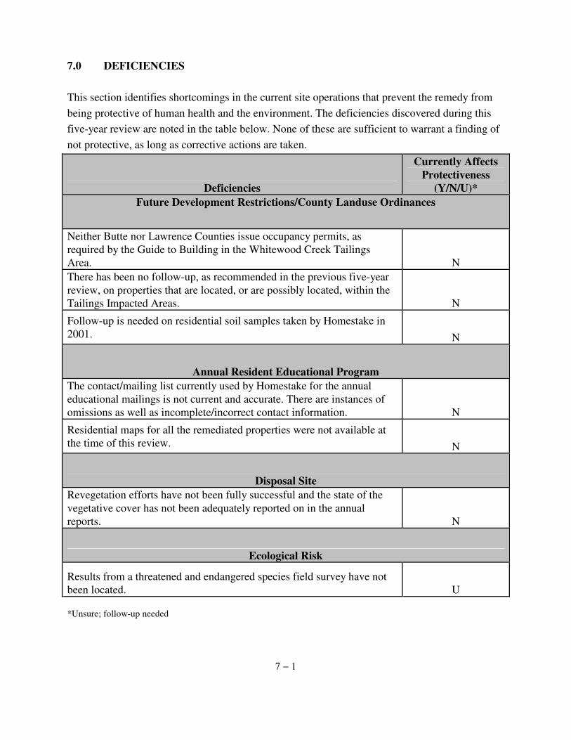
7 − 1
7.0 DEFICIENCIES
This section identifies shortcomings in the current site operations that prevent the remedy from being protective of human health and the environment. The deficiencies discovered during this five-year review are noted in the table below. None of these are sufficient to warrant a finding of not protective, as long as corrective actions are taken.
Deficiencies
Currently Affects Protectiveness
(Y/N/U)* Future Development Restrictions/County Landuse Ordinances
Neither Butte nor Lawrence Counties issue occupancy permits, as required by the Guide to Building in the Whitewood Creek Tailings Area. N There has been no follow-up, as recommended in the previous five-year review, on properties that are located, or are possibly located, within the Tailings Impacted Areas. N
Follow-up is needed on residential soil samples taken by Homestake in 2001. N
Annual Resident Educational Program The contact/mailing list currently used by Homestake for the annual educational mailings is not current and accurate. There are instances of omissions as well as incomplete/incorrect contact information. N
Residential maps for all the remediated properties were not available at the time of this review. N
Disposal Site Revegetation efforts have not been fully successful and the state of the vegetative cover has not been adequately reported on in the annual reports. N
Ecological Risk
Results from a threatened and endangered species field survey have not been located. U *Unsure; follow-up needed
7 − 2
7.1 Deficiencies in the Future Development Restrictions While part of the remedy includes the issuance via the Counties of occupancy permits, it is not policy for Butte and Lawrence to issue occupancy permits. The previous five-year review identified 2 properties where there was development activity in the Tailings Impacted Areas and 2 instances of development where information could not confirm that the developments were not within the Tailings Impacted Areas (USEPA, 2002). Residential soil samples were taken from 6 properties in 2001; results were not available at the time of the last review and are therefore included in the current review. The results currently available to USEPA are inconclusive. 7.2 Deficiencies in the Annual Resident Education Program The contact/mailing list used by Homestake for distribution of educational materials is not current or accurate. For example, the county contacts are out of date, property transfers are not reflected on the mailing list and there are property owners who own property in or around the Site that are not included in the mailings. One of the required actions identified in the 2002 five-year review was that Homestake prepare and distribute updated maps of each property, showing property use, tailings, deposits and Tailings Impacted Areas (USEPA, 2002). Information currently available to EPA indicates that not all affected properties were mapped. 7.3 Deficiencies in the Disposal Cell Revegetation and Reporting Vegetation on the disposal cell is not fully established. A couple of the Homestake annual inspection reports note seeding and revegetation efforts, but these have not resulted in a fully vegetated Disposal Cell, as noted in the 2007 site inspection. Furthermore, the most recent annual reports submitted by Homestake have not noted the lack of vegetation on the Disposal Cell. 7.4 Deficiencies in Ecological Risk Information Results from a T&E field survey being conducted in 1990 are not documented in the references currently available to USEPA.
8 − 1
8.0 RECOMMENDATIONS AND REQUIRED ACTIONS
This section specifies the required and suggested improvements to current site operations to address the deficiencies that currently affect protectiveness. These recommendations are summarized in Table 8-1, along with the parties responsible for actions, milestone dates, and agencies with oversight authority. 8.1 O&M Activities Remedial Cover During the site inspections in July of 2007, 5 properties were identified where erosion of the remedial gravel cover has occurred. The properties in need of maintenance are as follows: Alan, Balo, Berger, Holsclaw and Kymala. Additionally, 2 new garden plots located on the Alan property were identified during the residential site inspection. Follow-up is needed to ensure they are not within the Tailings Impacted Areas, and if they are that there is at minimum 24” of clean topsoil, as required by the ROD (USEPA, 1990). Property Inspections There are 2 properties within the Site that still need to be inspected. The property owned by Eric Swanson (formerly owned by Tippy), did not get inspected during the site inspection that occurred in July of 2007 due to a territorial dog on the property. Additionally, the Crowser property is still in need of an inspection. Due to an oversight on the part of USEPA, this property was not included on the list of properties to be inspected. Arrangements should be made with both Mr. Swanson and the Crowsers to reschedule an inspection date. Residential Soil Sampling The results from the 2001 residential sampling events are not conclusive. One sample from the Alan property was significantly above the 100 mg/kg action level for arsenic, duplicate samples showed concentrations of 150 and 212 mg/kg, and one sample from the Holsclaw was just barely below this action level, at 95 mg/kg. Based on the results, further sampling was conducted at the Alan property. The more intensive sampling effort did not detect any areas of high
8 − 2
concentrations, as were evidenced by the initial sampling. Follow-up, preferably in the form of a report on the sampling event to come from Homestake, is recommended in order to conclusively verify the soils are below the arsenic action level. Additionally, in light of the tracking of tailings identified at the 2002 and 2007 site inspections of the Holsclaw property, coupled with the high concentrations identified during the 2001 sampling event, further investigation of possible contamination is recommended. Disposal Cell and Reporting Annual reports from Homestake have noted the need for supplemental vegetation and reseeding efforts twice during the last 5 years (HSM 2001b, and 2002b). However, since 2002 no further efforts, or need for efforts, have been documented. In order to maintain the integrity of the Disposal Cell and reduce erosion, it is recommended the Homestake again attempt to establish a stable vegetative community on the entirety of the Disposal Cell. Additionally, further reporting is requested on this effort in the annual reports submitted to USEPA. Annual Inspections Homestake is to continue its O&M activity of annual visits to the properties within the Site to check for both authorized and unauthorized developments. In the event that Homestake becomes aware of development in the tailings-impacted areas, the appropriate county agency should be notified to ensure compliance with applicable ordinances. A brief narrative description of these periodic visits and contact with the respective county agency shall be included in the annual report submitted to USEPA. This narrative description of development activities within the Site is currently required as part of Site O&M activities (WDC, 2003). 8.2 County Landuse Ordinances Property Maps During the 2002 five-year review, residential development activities were identified within the Site (USEPA, 2002). Some of these occurred within the 100 ppm Tailings Impacted Areas without prior application or compliance with county development guidelines. Additionally, there were developments that occurred where there was, and still is, uncertainty as to if they are within the Tailings Impacted Areas or not. At the time of the last review, it was recommended that updated maps of the individual residential properties affected by the county ordinances be
8 − 3
prepared and distributed to the residents, county officials and USEPA. These maps were to detail the current property use and high-use areas, tailings deposit areas and Tailings Impacted Areas, as applicable to each residence. Furthermore, they were to serve as informational tools for residents and county officials, providing data on areas within a property that are governed by the county landuse ordinances and development guidelines. Homestake provided a set of maps in 2003 and 2005 of properties where remediation occurred. However, this set does not seem to include all of the remediated properties. USEPA records indicate that 5 out of a possible 16 of the remediated properties were mapped in detail, including “as constructed” drawings of the residential property following soil remediation and Satellite Image Ortho maps. USEPA does not have records showing detailed maps were created for the following property owners where remediation occurred: Ala, Balo, Berger, Crowser, Kymala, Marrs, Swanson (formerly Tippey) and Wennerberg. Occupancy Permits The Guide to Building in the Whitewood Creek Tailings Area (Attachment 2-1) outlines specific steps and regulatory obligations necessary for a landowner to obtain an occupancy permit for any new residential development. This is to safeguard against exposure to unsafe levels of arsenic. However, it is not practice for either Butte or Lawrence Counties to issue occupancy permits. A change in this institutional control, to be decided upon jointly by USEPA, SD DENR and the Counties, is recommended to remedy this shortcoming. Follow-up on Developments The site inspection portion of the previous five-year review identified 4 properties where development activities had occurred (USEPA, 2002). While recent inquires have been made to ensure that these building activities were in compliance with applicable county ordinance development guidelines and state well ban regulations, evidence to this effect is not currently available. It is therefore again recommended that representatives from the appropriate county agencies consult maps of the Site boundaries and visit these 4 properties (Crowser, Thompson, Berger and the Unknown Property located "across the Creek from the Holsclaw property”) to gain the necessary additional information on these development activities. It is further recommended that the results from these follow-up visits (including soil sampling results where necessary) be submitted to SD DENR and USEPA.
8 − 4
8.3 Annual Residential Education Program Mailing List It is recommended that Homestake update its contact/mailing list used for their annual resident education program. Information currently available to USEPA indicates instances of omissions and errors. A current and up-to-date contact/mailing list is necessary to effectively convey pertinent information to the affected public. Distribute Property Maps Once a complete set of property maps, detailing all residences where soil remediation occurred, has been completed, they should be distributed to all affected property owners. These maps will assist in informing residents as to areas where arsenic concentrations are above the soil action level and the location of tailings deposits in order to limit exposure and activities in these areas. Tailored Mailings A suggestion put forth by Homestake during this five-year review process was the tailoring of the education program mailings to the degree the Site affects different residents. At present, it is USEPA’s understanding that all residents within and near the Site boundaries are sent the same annual information sheet. These information sheets could be changed to speak more directly to the specifics of the residents involved. For instance, those property owners of land where remediation has occurred would be sent information regarding what to look for in terms of erosion of the remedial cover and how to reduce erosion to maintain the protectiveness of the remedy. Those who do not own property that has been remediated would receive more generic Site information, with their specific concerns taken into account. 8.4 Ecological Risk Information The 1990 ROD (USEPA) refers to a threatened and endangered species field survey that was underway at that time. USEPA has been unable to locate the results. This is of concern due to threatened species, the least tern and whooping crane, identified downstream from the Site. It is recommended that USEPA follow-up on this field survey and it results.
9 − 1
9.0 PROTECTIVENESS STATEMENTS 9.1 Residential Remediation Residential remediation activities are considered to remain protective of human health, with recommended maintenance. The current residential soil action level for arsenic is considered to still be adequately protective of human health. 9.2 Institutional Control Implementation The institutional controls implemented at the Site are considered to remain protective of human health and the environment, provided that the corrective actions outlined in Section 8.0 (Recommendations and Required Actions) are taken. Contamination and floodplain boundaries have been determined and are incorporated into county ordinances to restrict development in certain areas of the Site. The state well ban regulation remains in place and is functioning effectively. The surface water monitoring program, annual resident educational program, flood monitoring and five-year visual inspection programs, remain in place and are functioning effectively. Annual inspections of the disposal site have not proved to effectively identify and address conditions that have needed attentions, specifically in terms of the vegetative cover. Incorporating the recommendations identified in Section 8.0 into the annual resident education program and in increasing the implementation and enforcement of the county landuse ordinance requirements, specifically as they apply to the issuance of occupancy permits, will ensure that these institutional controls are consistently functioning effectively and are protective of human health.
9.3 Protection of the Environment The current remedy is considered to be adequate for protection of ecological receptors and the environment, assuming T&E species are not identified within Site boundaries. Based on an evaluation of the weight of evidence across all available lines of evidence, mining-related chemicals probably are probably causing some effects on both the aquatic and the terrestrial ecosystems, but these effects are generally low level and are not likely to be sufficient to cause substantial disruption of aquatic or terrestrial ecosystem function or viability.
10 − 1
10.0 NEXT REVIEW The Whitewood Creek Superfund Site requires ongoing five-year reviews. These reviews will be required, as stated by the NCP, as long as hazardous substances, pollutants or contaminants remain at this Site above levels allowing for unlimited use and unrestricted exposure. The next review will be conducted within five years of the completion of this five-year review report, which is five years from the date listed on this report's signature cover page. The schedule for the five-year review data collection activities remains as outlined in the O&M Plan, to be completed by September 25, 2011, the 20 year anniversary of the remedial action start date.
11 − 1
11.0 REFERENCES Bailey, R.G. 1982. Classification systems for habitat and ecosystems. Pages 16-26. In Research on Fish and Wildlife Habitat. USEPA 600/8-82-022 (as cited in Chadwick et al. 1997). Bergeland ME, GR Rugh, RL Stack and RJ Emerick. 1976. Arsenic Toxicosis in Cattle Associated With Soil and Water Contamination from Mining Operations. In Proceedings of the 19th Annual Meeting of the American Association of Veterinary Laboratory Diagnosticians (as cited in USEPA 1989). Chadwick Ecological Consultants Inc. (Chadwick), KRW Consulting, Inc., Remediation Technologies, Inc., and Times Limited. 1997. Status Report and Technical Support Document for the 1997 five-year Review, Whitewood Creek Superfund Site. Prepared for Homestake Mining Company, January 31, 1997. Cherry JA, FMM Morel, JV Rouse, JL Schnoor, and MG Wolman. 1985. Hydrogeochemistry of Sulfide and Arsenic-Rich Tailings and Alluvium Along Whitewood Creek, South Dakota. US Geological Survey, Rapid City, South Dakota. Environ Corp (Environ). 1985. Assessment of Exposure and Possible Effects on Human Health of Gold Mine Tailings in the Whitewood Creek Area of South Dakota. Prepared by Environ, Corp for Homestake Mining Corporation. April 10, 1985. Draft. FMG, Inc. (FMG). 1992. Construction Completion Report for Residential Remediation Whitewood Creek Superfund Site Lawrence, Meade, and Butte Counties, South Dakota. FMG, In. Rapid City, South Dakota. December 21,1992. Fox Consultants, Inc. 1984a. Whitewood Creek Study, Phase I. Prepared for the South Dakota Department of Water and Natural Resources Office of Air Quality and Solid Waste. April 16, 1984. Fox Consultants, Inc. 1984b. Whitewood Creek Study, Phase II. Prepared for the South Dakota Department of Water and Natural Resources Office of Air Quality and Solid Waste, Homestake Mining Company and the United States Environmental Protection Agency. November 1984.
11 − 2
Goddard K.E., A.J. Horowitz, and C. K. Shearer. 1988. Distribution of Solid-Phase Arsenic and Trace Elements in Bottom and Suspended Sediments, Whitewood Creek and the Belle Fourche and Cheyenne Rivers, Western South Dakota. USGS. Water Resources Investigation Report 87-764. Pages 13-18.
Herricks, E.E. 1982. Bioassessment of Whitewood Creek Lawrence and Meade Counties, South Dakota. Prepared for the Homestake Mining Company, Lead, South Dakota. Hess, W.L., R.L. Brown and J.F. Heisinger. 1975. Mercury Contamination of Birds from a Polluted Watershed. Journal of Wildlife Management, 39 (2):299-304. Homestake Mining Company (HMC). 2006. Whitewood Creek Superfund Site Annual Report, 2003. Homestake Mining Company, San Francisco California. Homestake Mining Company (HMC). 2005. Whitewood Creek Superfund Site Annual Report, 2003. Homestake Mining Company, San Francisco California. Homestake Mining Company (HMC). 2004. Whitewood Creek Superfund Site Annual Report, 2003. Homestake Mining Company, San Francisco California. Homestake Mining Company (HMC). 2003a. Whitewood Creek Superfund Site Annual Report, 2003. Homestake Mining Company, San Francisco California. Homestake Mining Company (HMC). 2003b. Whitewood Creek Superfund Site Quarterly Report, 1st Quarter 2003 (Report Number 39). Homestake Mining Company, San Francisco California. Homestake Mining Company (HMC). 2002a. Whitewood Creek Superfund Site Quarterly Report, 4th Quarter 2002 (Report Number 38). Homestake Mining Company, San Francisco California. Homestake Mining Company (HMC). 2002b. Whitewood Creek Superfund Site Quarterly Report, 3rd Quarter 2002 (Report Number 37). Homestake Mining Company, San Francisco California. Homestake Mining Company (HMC). 2002c. Whitewood Creek Superfund Site Quarterly
11 − 3
Report, 2nd Quarter 2002 (Report Number 36). Homestake Mining Company, San Francisco California. Homestake Mining Company (HMC). 2002d. Whitewood Creek Superfund Site Quarterly Report, 1st Quarter 2002 (Report Number 35). Homestake Mining Company, San Francisco California. Homestake Mining Company (HMC). 2001a. Whitewood Creek Superfund Site Quarterly Report, 4th Quarter 2001 (Report Number 34). Homestake Mining Company, San Francisco California. Homestake Mining Company (HMC). 2001b. Whitewood Creek Superfund Site Quarterly Report, 3rd Quarter 2001 (Report Number 33). Homestake Mining Company, San Francisco California. Homestake Mining Company (HMC). 2001c. Whitewood Creek Superfund Site Quarterly Report, 2nd Quarter 2001 (Report Number 32). Homestake Mining Company, San Francisco California. Homestake Mining Company (HMC). 2001d. Whitewood Creek Superfund Site Quarterly Report, 1st Quarter 2001 (Report Number 31). Homestake Mining Company, San Francisco California. Homestake Mining Company (HMC). 2000. Whitewood Creek Superfund Site Quarterly Report, 2nd Quarter 2000 (Report Number 28). Homestake Mining Company, San Francisco California. Homestake Mining Company (HMC). 1999a. Whitewood Creek Superfund Site Quarterly Report, 4th Quarter 1998 (Report Number 22). Homestake Mining Company, San Francisco California. January 1999. Homestake Mining Company (HMC). 1999b. Whitewood Creek Superfund Site Quarterly Report, 3rd Quarter 1999 (Report Number 25). Homestake Mining Company, San Francisco California. October 1999. Homestake Mining Company (HMC). 1999b. Whitewood Creek Superfund Site Quarterly Report, 2nd Quarter 1999 (Report Number 24). Homestake Mining Company, San Francisco
11 − 4
California. July 1999. Homestake Mining Company (HMC). 1999c. Whitewood Creek Superfund Site Quarterly Report, 1st Quarter 1999 (Report Number 23). Homestake Mining Company, San Francisco California. April 1999. Homestake Mining Company (HMC). 1998a. Whitewood Creek Superfund Site Quarterly Report, 3rd Quarter 1998 (Report Number 21). Homestake Mining Company, San Francisco California. October 1998. Homestake Mining Company (HMC). 1998b. Whitewood Creek Superfund Site Quarterly Report, 4th Quarter 1997 (Report Number 18). Homestake Mining Company, San Francisco California. January 1998. Homestake Mining Company (HMC). 1997a. Whitewood Creek Superfund Site Quarterly Report, 3rd Quarter 1997 (Report Number 17). Homestake Mining Company, San Francisco California. October 31, 1997. Homestake Mining Company (HMC). 1997b. Whitewood Creek Superfund Site Quarterly Report, 2nd Quarter 1997 (Report Number 16). Homestake Mining Company, San Francisco California. July 29, 1997. Homestake Mining Company (HMC). 1997c. Whitewood Creek Superfund Site Quarterly Report, 1st Quarter 1997 (Report Number 15). Homestake Mining Company, San Francisco California. April 30, 1997. Homestake Mining Company (HMC). 1997d. Whitewood Creek Superfund Site Quarterly Report, 4th Quarter 1996 (Report Number 14). Homestake Mining Company, San Francisco California. January 31, 1997. Homestake Mining Company (HMC). 1996a. Whitewood Creek Superfund Site Quarterly Report, 3rd Quarter 1996 (Report Number 13). Homestake Mining Company, San Francisco California. October 31, 1996. Homestake Mining Company (HMC). 1996b. Whitewood Creek Superfund Site Quarterly Report,(Report Number 12). Homestake Mining Company, San Francisco California. July 31,
11 − 5
1996. Homestake Mining Company (HMC). 1996c. Whitewood Creek Superfund Site Quarterly Report,(Report Number 11). Homestake Mining Company, San Francisco California. April 30, 1996. Homestake Mining Company (HMC). 1996d. Whitewood Creek Superfund Site Quarterly Report,(Report Number 10). Homestake Mining Company, San Francisco California. January 31, 1996. Homestake Mining Company (HMC). 1995a. Whitewood Creek Superfund Site Quarterly Report, 3rd Quarter 1995 (Report Number 9). Homestake Mining Company, San Francisco California. October 31, 1995. Homestake Mining Company (HMC). 1995b. Whitewood Creek Superfund Site Quarterly Report, 2nd Quarter 1995 (Report Number 8). Homestake Mining Company, San Francisco California. July 31, 1995. Homestake Mining Company (HMC). 1995c. Whitewood Creek Superfund Site Quarterly Report, 1st Quarter 1995 (Report Number 7). Homestake Mining Company, San Francisco California. April 30, 1995 Homestake Mining Company (HMC). 1995d. Whitewood Creek Superfund Site Final Monthly Progress Report, (Report Number 53). Homestake Mining Company, San Francisco California. March 10, 1995. Homestake Mining Company (HMC). 1995e. Whitewood Creek Superfund Site Monthly Progress Report, (Report Number 52). Homestake Mining Company, San Francisco California. February 10, 1995. Homestake Mining Company (HMC). 1995f. Whitewood Creek Superfund Site Monthly Progress Report, (Report Number 51). Homestake Mining Company, San Francisco California. January 10, 1995. Homestake Mining Company (HMC). 1995g. Whitewood Creek Superfund Site Quarterly Report, 4th Quarter 1994 (Report Number 6). Homestake Mining Company, San Francisco
11 − 6
California. January 31, 1995. Homestake Mining Company (HMC). 1994a. Whitewood Creek Superfund Site Monthly Progress Report, (Report Number 50). Homestake Mining Company, San Francisco California. December 9, 1994. Homestake Mining Company (HMC). 1994b. Whitewood Creek Superfund Site Monthly Progress Report, (Report Number 49). Homestake Mining Company, San Francisco California. November 10, 1994. Homestake Mining Company (HMC). 1994c. Whitewood Creek Superfund Site Quarterly Report, (Report Number 5). Homestake Mining Company, San Francisco California. October 31, 1994. Homestake Mining Company (HMC). 1994d. Whitewood Creek Superfund Site Monthly Progress Report, (Report Number 48). Homestake Mining Company, San Francisco California. October 10, 1994. Homestake Mining Company (HMC). 1994e. Whitewood Creek Superfund Site Monthly Progress Report, (Report Number 47). Homestake Mining Company, San Francisco California. September 10, 1994. Homestake Mining Company (HMC). 1994f. Whitewood Creek Superfund Site Monthly Progress Report, (Report Number 46). Homestake Mining Company, San Francisco California. August 10, 1994. Homestake Mining Company (HMC). 1994g. Whitewood Creek Superfund Site Quarterly Report,(Report Number 4). Homestake Mining Company, San Francisco California. July 31, 1994. Homestake Mining Company (HMC). 1994h. Whitewood Creek Superfund Site Monthly Progress Report, (Report Number 45). Homestake Mining Company, San Francisco California. July 8, 1994. Homestake Mining Company (HMC). 1994i. Whitewood Creek Superfund Site Monthly Progress Report, (Report Number 44). Homestake Mining Company, San Francisco California.
11 − 7
June 10, 1994. Homestake Mining Company (HMC). 1994j. Whitewood Creek Superfund Site Monthly Progress Report, (Report Number 43). Homestake Mining Company, San Francisco California. May 10, 1994. Homestake Mining Company (HMC). 1994k. Whitewood Creek Superfund Site Monthly Progress Report, (Report Number 42). Homestake Mining Company, San Francisco California. April 8, 1994. Homestake Mining Company (HMC). 1994l. Whitewood Creek Superfund Site Quarterly Report, (Report Number 3). Homestake Mining Company, San Francisco California. April 29, 1994. Homestake Mining Company (HMC). 1994m. Whitewood Creek Superfund Site Monthly Progress Report, (Report Number 41). Homestake Mining Company, San Francisco California. March 10, 1994. Homestake Mining Company (HMC). 1994n. Whitewood Creek Superfund Site Monthly Progress Report, (Report Number 40). Homestake Mining Company, San Francisco California. February 10, 1994. Homestake Mining Company (HMC). 1994o. Whitewood Creek Superfund Site Quarterly Report,(Report Number 2). Homestake Mining Company, San Francisco California. January 28, 1994. Homestake Mining Company (HMC). 1994p. Whitewood Creek Superfund Site Monthly Progress Report, (Report Number 39). Homestake Mining Company, San Francisco California. January 10, 1994. Homestake Mining Company (HMC). 1993a. Whitewood Creek Superfund Site Monthly Progress Report, (Report Number 38). Homestake Mining Company, San Francisco California. December 10, 1993. Homestake Mining Company (HMC). 1993b. Whitewood Creek Superfund Site Quarterly Report, (Report Number 1). Homestake Mining Company, San Francisco California. November
11 − 8
18, 1993. Homestake Mining Company (HMC). 1993c. Whitewood Creek Superfund Site Monthly Progress Report, (Report Number 37). Homestake Mining Company, San Francisco California. November 10, 1993. Homestake Mining Company (HMC). 1993d. Whitewood Creek Superfund Site Monthly Progress Report, (Report Number 36). Homestake Mining Company, San Francisco California. October 8, 1993. Homestake Mining Company (HMC). 1993e. Whitewood Creek Superfund Site Monthly Progress Report, (Report Number 35). Homestake Mining Company, San Francisco California. September 10, 1993. Homestake Mining Company (HMC). 1993f. Whitewood Creek Superfund Site Monthly Progress Report, (Report Number 34). Homestake Mining Company, San Francisco California. August 10, 1993. Homestake Mining Company (HMC). 1993g. Whitewood Creek Superfund Site Monthly Progress Report, (Report Number 33). Homestake Mining Company, San Francisco California. July 9, 1993. Homestake Mining Company (HMC). 1993h. Whitewood Creek Superfund Site Monthly Progress Report, (Report Number 32). Homestake Mining Company, San Francisco California. June 10, 1993. Homestake Mining Company (HMC). 1993i. Whitewood Creek Superfund Site Monthly Progress Report, (Report Number 31). Homestake Mining Company, San Francisco California. May 10, 1993. Homestake Mining Company (HMC). 1993j. Whitewood Creek Superfund Site Monthly Progress Report, (Report Number 30). Homestake Mining Company, San Francisco California. April 10, 1993. Homestake Mining Company (HMC). 1993k. Whitewood Creek Superfund Site Monthly Progress Report, (Report Number 29). Homestake Mining Company, San Francisco California.
11 − 9
March 10, 1993. Homestake Mining Company (HMC). 1993l. Whitewood Creek Superfund Site Monthly Progress Report, (Report Number 28). Homestake Mining Company, San Francisco California. February 10, 1993. Homestake Mining Company (HMC). 1993m. Whitewood Creek Superfund Site Monthly Progress Report, (Report Number 27). Homestake Mining Company, San Francisco California. January 10, 1993. Homestake Mining Company (HMC). 1992a. Whitewood Creek Superfund Site Monthly Progress Report, (Report Number 26). Homestake Mining Company, San Francisco California. December 10, 1992. Homestake Mining Company (HMC). 1992b. Whitewood Creek Superfund Site Monthly Progress Report, (Report Number 25). Homestake Mining Company, San Francisco California. November 10, 1992. Homestake Mining Company (HMC). 1992c. Whitewood Creek Superfund Site Monthly Progress Report, (Report Number 24). Homestake Mining Company, San Francisco California. October 10, 1992. Homestake Mining Company (HMC). 1992d. Whitewood Creek Superfund Site Monthly Progress Report, (Report Number 23). Homestake Mining Company, San Francisco California. September 10, 1992. Homestake Mining Company (HMC). 1992e. Whitewood Creek Superfund Site Monthly Progress Report, (Report Number 22). Homestake Mining Company, San Francisco California. August 10, 1992. Homestake Mining Company (HMC). 1992f. Whitewood Creek Superfund Site Monthly Progress Report, (Report Number 21). Homestake Mining Company, San Francisco California. July 10, 1992. Homestake Mining Company (HMC). 1992g. Whitewood Creek Superfund Site Monthly Progress Report, (Report Number 20). Homestake Mining Company, San Francisco California.
11 − 10
June 10, 1992. Homestake Mining Company (HMC). 1992h. Whitewood Creek Superfund Site Monthly Progress Report, (Report Number 19). Homestake Mining Company, San Francisco California. May 10, 1992. Homestake Mining Company (HMC). 1992i. Whitewood Creek Superfund Site Monthly Progress Report, (Report Number 18). Homestake Mining Company, San Francisco California. April 10, 1992. Homestake Mining Company (HMC). 1992j. Whitewood Creek Superfund Site Monthly Progress Report, (Report Number 17). Homestake Mining Company, San Francisco California. March 10, 1992. Homestake Mining Company (HMC). 1992k. Whitewood Creek Superfund Site Monthly Progress Report, (Report Number 16). Homestake Mining Company, San Francisco California. February 10, 1992. Homestake Mining Company (HMC). 1992l. Whitewood Creek Superfund Site Monthly Progress Report, (Report Number 15). Homestake Mining Company, San Francisco California. January 10, 1992. Homestake Mining Company (HMC). 1991a. Whitewood Creek Superfund Site Monthly Progress Report, (Report Number 14). Homestake Mining Company, San Francisco California. December 10, 1991. Homestake Mining Company (HMC). 1991b. Whitewood Creek Superfund Site Monthly Progress Report, (Report Number 13). Homestake Mining Company, San Francisco California. November 10, 1991. Homestake Mining Company (HMC). 1991c. Whitewood Creek Superfund Site Monthly Progress Report, (Report Number 12). Homestake Mining Company, San Francisco California. October 10, 1991. Homestake Mining Company (HMC). 1991d. Whitewood Creek Superfund Site Monthly Progress Report, (Report Number 11). Homestake Mining Company, San Francisco California.
11 − 11
September 10, 1991. Homestake Mining Company (HMC). 1991e. Whitewood Creek Superfund Site Monthly Progress Report, (Report Number 10). Homestake Mining Company, San Francisco California. August 10, 1991. Homestake Mining Company (HMC). 1991f. Whitewood Creek Superfund Site Monthly Progress Report, (Report Number 9). Homestake Mining Company, San Francisco California. July 10, 1991. Homestake Mining Company (HMC). 1991g. Whitewood Creek Superfund Site Monthly Progress Report, (Report Number 8). Homestake Mining Company, San Francisco California. June 10, 1991. Homestake Mining Company (HMC). 1991h. Whitewood Creek Superfund Site Monthly Progress Report, (Report Number 7). Homestake Mining Company, San Francisco California. May 10, 1991. Homestake Mining Company (HMC). 1991i. Whitewood Creek Superfund Site Monthly Progress Report, (Report Number 6). Homestake Mining Company, San Francisco California. April 10, 1991. Homestake Mining Company (HMC). 1991j. Whitewood Creek Superfund Site Monthly Progress Report, (Report Number 5). Homestake Mining Company, San Francisco California. March 10, 1991. Homestake Mining Company (HMC). 1991k. Whitewood Creek Superfund Site Monthly Progress Report, (Report Number 4). Homestake Mining Company, San Francisco California. February 10, 1991. Homestake Mining Company (HMC). 1991l. Whitewood Creek Superfund Site Monthly Progress Report, (Report Number 3). Homestake Mining Company, San Francisco California. January 10, 1991.
11 − 12
Homestake Mining Company (HMC). 1990a. Whitewood Creek Superfund Site Monthly Progress Report, (Report Number 2). Homestake Mining Company, San Francisco California. December 10, 1990. Homestake Mining Company (HMC). 1990b. Whitewood Creek Superfund Site Monthly Progress Report, (Report Number 1). Homestake Mining Company, San Francisco California. November 9, 1990. ICF Incorporated (ICF). 1989a. Feasibility Study for Whitewood Creek, South Dakota, CERCLA Site Volume I. Prepared for Homestake Mining Company by ICF Technology for submission to USEPA Region VIII. December 8. ICF Incorporated (ICF). 1989b. Feasibility Study for Whitewood Creek, South Dakota, CERCLA Site, Volume II. Prepared for Homestake Mining Company by ICF Technology for submission to USEPA Region VIII. December 3. ISSI Consulting Group, Inc. (ISSI). 1998. Screening Level Ecological Risk Assessment, Whitewood Creek Site, Lead, South Dakota. Prepared by ISSI, Inc. for USEPA Region 8. October. Jacobs Engineering. 1989. Final Endangerment Assessment Summary Document for Whitewood Creek Superfund Site. Prepared by Jacobs Engineering for USEPA Region VIII. July 1989. Syracuse Research Corporation (SRC). 2002. Whitewood Creek Five-Year Review Human Health Risk Findings from Fish Consumption. Prepared by SRC for USEPA Region VIII. April 15, 2002. Syracuse Research Corporation (SRC). 2001a. Whitewood Creek Five-Year Review Human Health Risk Findings. Prepared by SRC for USEPA Region VIII. June 25, 2001. Syracuse Research Corporation (SRC). 2001b. Ecological Risk Assessment Whitewood Creek Site Five Year Review Lead, South Dakota. Prepared by SRC for USEPA Region VIII. August 24, 2001. United States v. Homestake. 1991. Consent Decree, US vs Homestake Mining Company of California, Civil Action No. 90-5101. Entered by US District Court for South Dakota on April 4,
11 − 13
1991. United States Environmental Protection Agency (USEPA). 2002. Five Year Review of the Whitewood Creek Superfund Site, Lead, South Dakota. Prepared by SRC for USEAP Region VIII. July 2002. United States Environmental Protection Agency (USEPA). 2001a. Comprehensive Five-Year Review Guidance. Office of Emergency and Remedial Response. USEPA, Washington, D.C. EPA 540-R-01-007. United States Environmental Protection Agency (USEPA). 2001b. Update of Ambient Water Quality Criteria for Cadmium. Office of Water, EPA-822-R-01-001. United States Environmental Protection Agency (USEPA). 1999. National Recommended Water Quality Criteria - Correction. Office of Water, EPA-822-Z-99-001. April. United States Environmental Protection Agency (USEPA). 1998. Notes from Whitewood Creek Five Year Review Inspection Interviews. Michael H. McCeney, USEPA Region VIII. Denver, Colorado. March 13. United States Environmental Protection Agency (USEPA). 1993. Remedial Action Report: Whitewood Creek Superfund Site Butte, Meade and Lawrence Counties, South Dakota. USEPA, Region VIII. Denver, Colorado. March 31. United States Environmental Protection Agency (USEPA). 1991a. Role of the Baseline Risk Assessment in Superfund Remedy Selection Decisions. OSWER Directive 9355.0-30. April, 1991. United States Environmental Protection Agency (USEPA). 1991b. Explanation of Significant Differences (ESD): Whitewood Creek Superfund Site Lawrence Meade, and butte Counties, South Dakota. USEPA, Region VIII. Denver, Colorado. June 1991. United States Environmental Protection Agency (USEPA). 1990. Superfund Record of Decision: Whitewood Creek, South Dakota. Office of Emergency and Remedial Response. EPA/ROD/R08-90/028, March, 1990.
11 − 14
United States Environmental Protection Agency (USEPA). 1989. Endangerment Assessment for the Whitewood Creek Superfund Site, Southwestern South Dakota. Volumes I and II. Office of Health and Environmental Assessment, Office of Research and Development, Washington, D.C., OHEA-E-269. Final Draft. March 1989. U.S. Geological Survey (USGS). 1985. Composition, Distribution and Hydrologic Effects of Mine and Mill Wastes Discharged to Whitewood Creek at Lead/Deadwood, South Dakota. Draft. Water Resources Investigation Report 85. Whitewood Development Corporation (WDC). 2003. Whitewood Creek Superfund Site Post Remedy Operations, Maintenance and Reporting Plan, (Amended May 1, 2003). Homestake Mining Company, San Francisco, California. Whitewood Development Corporation (WDC). 1998. Construction Completion Report for Holsclaw Site. August, 1998. Whitewood Development Corporation (WDC). 1994a. Whitewood Creek Institutional Controls Completion Report. Whitewood Development Corporation. Lead, South Dakota. July 27, 1994. Whitewood Development Corporation (WDC). 1994b. White wood Creek Superfund Site Post Closure Operations, Maintenance, and Reporting Plan Volume I. Whitewood Development Corporation. Lead, South Dakota. July 27, 20

TABLES
Table 2-1 - Chronology of Events at the Whitewood Creek Superfund Site
EVENT DATE ACTIVITY Initial Discovery 1960 Quantified solids and cyanide loading to Whitewood Creek.
of Problem or
Contamination 1965 South Dakota (SD) Dept of Game, Fish and Parks determined
aquatic bottom organisms not present in Whitewood Creek.
1970-1971 The USEPA and the US Food and Drug Administration
characterized tailing discharge to Whitewood Creek and the
extent of resultant pollution. A University of SD study focused
on the environmental hazard of mercury contamination.
May 1975 - July 1978 SD Geological Survey and Water Resources Division investigated
the presence of arsenic in surface water and groundwater along
Whitewood Creek, the Belle Fourche River and portions of the
Cheyenne River. Arsenic concentrations were found ranging
from 2.5 to 1,530 ug/L in groundwater.
NPL listing September 1981 Interim listing.
September 1983 Official listing.
Remedial July 1989 Endangerment Assessment (EA) released by USEPA and Jacobs
Investigation and Engineering).
Feasibility Study
December 1989 Feasibility Study (FS) completed by ICF Technology Inc.
ROD Signature March 30, 1990 Record of Decision (ROD) completed.
ROD Amendments June 1991 Explanation of Significant Difference (ESD) signed modifying
or ESDs the remedy to dispose of contaminated soils on-site.
Enforcement December 1988 Administrative Order on Consent signed by USEPA and
Documents Homestake requiring Homestake to conduct an FS for the site.
August 1990 Consent Decree signed by USEPA and Homestake to implement
the ROD through remedial design and remedial action at the site.
Case No. 90-5101 was lodged in U.S. District Court of South
Dakota on October 10, 1990 and entered by the Court on April 4,
1991).
Enforcement 1981 USEPA sent notice letter to Homestake notifying them of
Action potential liability at Whitewood Creek and requesting
information about their activities. Page 1 of 3
Table 2-1 - Chronology of Events at the Whitewood Creek Superfund Site
EVENT DATE ACTIVITY Enforcement 1982 USEPA, State of SD and Homestake began negotiations for
Action Homestake to perform necessary studies.
August 11, 1982 USEPA, the State of SD and Homestake completed negotiations
and signed a memorandum of understanding among the three
parties to conduct a study of the Whitewood Creek area.
September 1988 Special Notice Letter sent to Homestake and Goldstake
Explorations, Inc. informing them that both companies were
Primary Responsible Parties (PRPs) for cleanup of the site.
Notice gave both parties the opportunity to conduct the feasibility
study. Goldstake elected not to participate in the FS studies.
Remedial Design August 1990 Homestake conducted sampling to identify and characterize soil
Start contamination at 32 residences, 27 of which were identified for
remediation.
June 14, 1991 USEPA approval to proceed with the Institutional Controls
Component to the remedy.
Actual Remedial September 1991 Began a pilot remediation project of one residence/site.
Action Start
May 1992 Began remediation of 15 remaining residences/sites.
Construction Dates Sept. - Oct. 1991 Pilot remediation project.
(start to finish)
Disposal Site construction and completion.
Remediation of remaining 15 residences/sites.
Construction and removal of the Temporary Stream Crossing.
Institutional Controls implemented at the site.
Quarterly Operations and Maintenance (O&M) Reports
Commenced.
Surface Water Monitoring Program initiated.
Construction December 21, 1992 Construction completion date for residential remediation.
Completion Date Page 2 of 3
Table 2-1 - Chronology of Events at the Whitewood Creek Superfund Site
EVENT DATE ACTIVITY Construction July 1994 Institutional Controls Completion Report.
Completion Date July 1998 Construction completion of Holsclaw property re-remediation.
Final Close Out September 26, 1994 Documents that ROD was fully implemented at the Whitewood
Report Creek Site.
NPL Delisting August 1996 Whitewood Creek Site delisted from NPL.
Source: USEPA, 2002 Page 3 of 3

Table 4-1 - Summary of Quarterly/Annual Reports; Disposal Site Inspections
Inspection Date Comments Remedial Action Taken December 3, 1993 All areas of site appeared stable, no work
necessary. None.
June 3, 1994 All areas of site appeared stable, no work
necessary. None.
May 12, 1995 All areas of site appeared stable, no work
necessary. None.
May 13, 1996 All areas of site appeared stable. Minor fence repairs were completed
Inspection Date Comments Remedial Action Taken July 15, 1996 No items of concern requiring immediate Future inspection will need to observe
response noted. Good vegetative whether any new creek bank cutting occurs next to the monitoring well site.
establishment observed on disposal site.
No problems noted.
September 1, 1997 No problems identified during visit to
the disposal site. None.
July-September 1998 Inspected only to evaluate unauthorized Removal of the unauthorized rubble
rubble piles placed on the site to develop anticipated to be addressed during the 4th
a appropriate disposal or removal plan. quarter of 1998.
October-December 1998 Unauthorized rubble was placed in the
disposal facility. Rip-rap was replaced and the disturbance seeded. Some scrap
materials were removed from the Site
and disposed of at a local landfill.
None.
April-June 1999 Visual inspection conducted; incidental
to field review and assessment of the
Whitewood Creek channel adjacent to
the disposal site area; no problems or
issues related to the disposal cell were
noted.
None.
October-December 1999 No formal inspection conducted. However,
a small bank stabilization project on a short
section of Whitewood Creek near the
disposal site during the report period was
conducted. Observations of the disposal
None.
Page 1 of 3
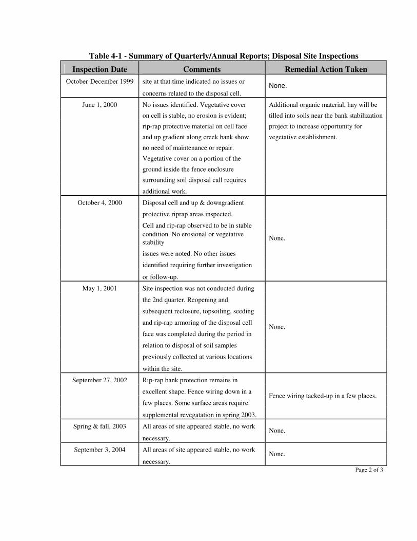
Table 4-1 - Summary of Quarterly/Annual Reports; Disposal Site Inspections
Inspection Date Comments Remedial Action Taken October-December 1999 site at that time indicated no issues or
concerns related to the disposal cell. None.
June 1, 2000 No issues identified. Vegetative cover Additional organic material, hay will be
on cell is stable, no erosion is evident; tilled into soils near the bank stabilization
rip-rap protective material on cell face project to increase opportunity for
and up gradient along creek bank show vegetative establishment.
no need of maintenance or repair.
Vegetative cover on a portion of the
ground inside the fence enclosure
surrounding soil disposal call requires
additional work.
October 4, 2000 Disposal cell and up & downgradient
protective riprap areas inspected.
Cell and rip-rap observed to be in stable
condition. No erosional or vegetative stability
issues were noted. No other issues
identified requiring further investigation
or follow-up.
None.
May 1, 2001 Site inspection was not conducted during
the 2nd quarter. Reopening and
subsequent reclosure, topsoiling, seeding
and rip-rap armoring of the disposal cell
face was completed during the period in
relation to disposal of soil samples
previously collected at various locations
within the site.
None.
September 27, 2002 Rip-rap bank protection remains in
excellent shape. Fence wiring down in a
few places. Some surface areas require
supplemental revegatation in spring 2003.
Fence wiring tacked-up in a few places.
Spring & fall, 2003 All areas of site appeared stable, no work
necessary. None.
September 3, 2004 All areas of site appeared stable, no work
necessary. None.
Page 2 of 3
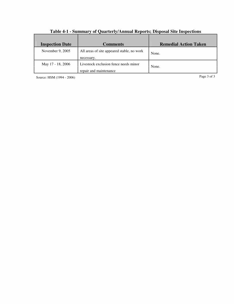
Table 4-1 - Summary of Quarterly/Annual Reports; Disposal Site Inspections
Inspection Date Comments Remedial Action Taken November 9, 2005 All areas of site appeared stable, no work
necessary. None.
May 17 - 18, 2006 Livestock exclusion fence needs minor
repair and maintenance None.
Source: HSM (1994 - 2006) Page 3 of 3
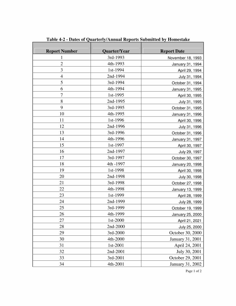
Table 4-2 - Dates of Quarterly/Annual Reports Submitted by Homestake
Report Number Quarter/Year Report Date 1 3rd-1993 November 18, 1993
2 4th-1993 January 31, 1994
3 1st-1994 April 29, 1994
4 2nd-1994 July 31, 1994
5 3rd-1994 October 31, 1994
6 4th-1994 January 31, 1995
7 1st-1995 April 30, 1995
8 2nd-1995 July 31, 1995
9 3rd-1995 October 31, 1995
10 4th-1995 January 31, 1996
11 1st-1996 April 30, 1996
12 2nd-1996 July 31, 1996
13 3rd-1996 October 31, 1996
14 4th-1996 January 31, 1997
15 1st-1997 April 30, 1997
16 2nd-1997 July 29, 1997
17 3rd-1997 October 30, 1997
18 4th -1997 January 20, 1998
19 1st-1998 April 30, 1998
20 2nd-1998 July 30, 1998
21 3rd-1998 October 27, 1998
22 4th-1998 January 13, 1999
23 1st-1999 April 28, 1999
24 2nd-1999 July 28, 1999
25 3rd-1999 October 19, 1999
26 4th-1999 January 25, 2000
27 1st-2000 April 21, 2021
28 2nd-2000 July 25, 2000
29 3rd-2000 October 30, 2000 30 4th-2000 January 31, 2001 31 1st-2001 April 24, 2001 32 2nd-2001 July 30, 2001 33 3rd-2001 October 29, 2001 34 4th-2001 January 31, 2002
Page 1 of 2
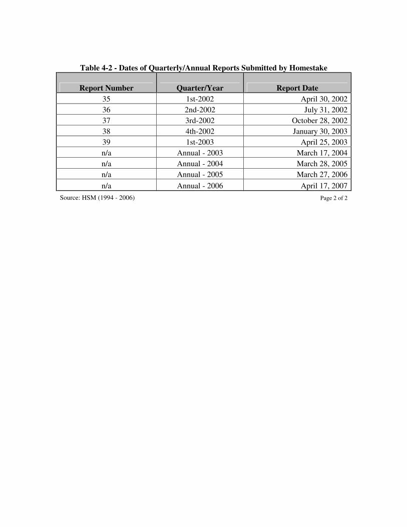
Table 4-2 - Dates of Quarterly/Annual Reports Submitted by Homestake
Report Number Quarter/Year Report Date 35 1st-2002 April 30, 2002 36 2nd-2002 July 31, 2002 37 3rd-2002 October 28, 2002 38 4th-2002 January 30, 2003 39 1st-2003 April 25, 2003 n/a Annual - 2003 March 17, 2004 n/a Annual - 2004 March 28, 2005 n/a Annual - 2005 March 27, 2006 n/a Annual - 2006 April 17, 2007
Source: HSM (1994 - 2006) Page 2 of 2
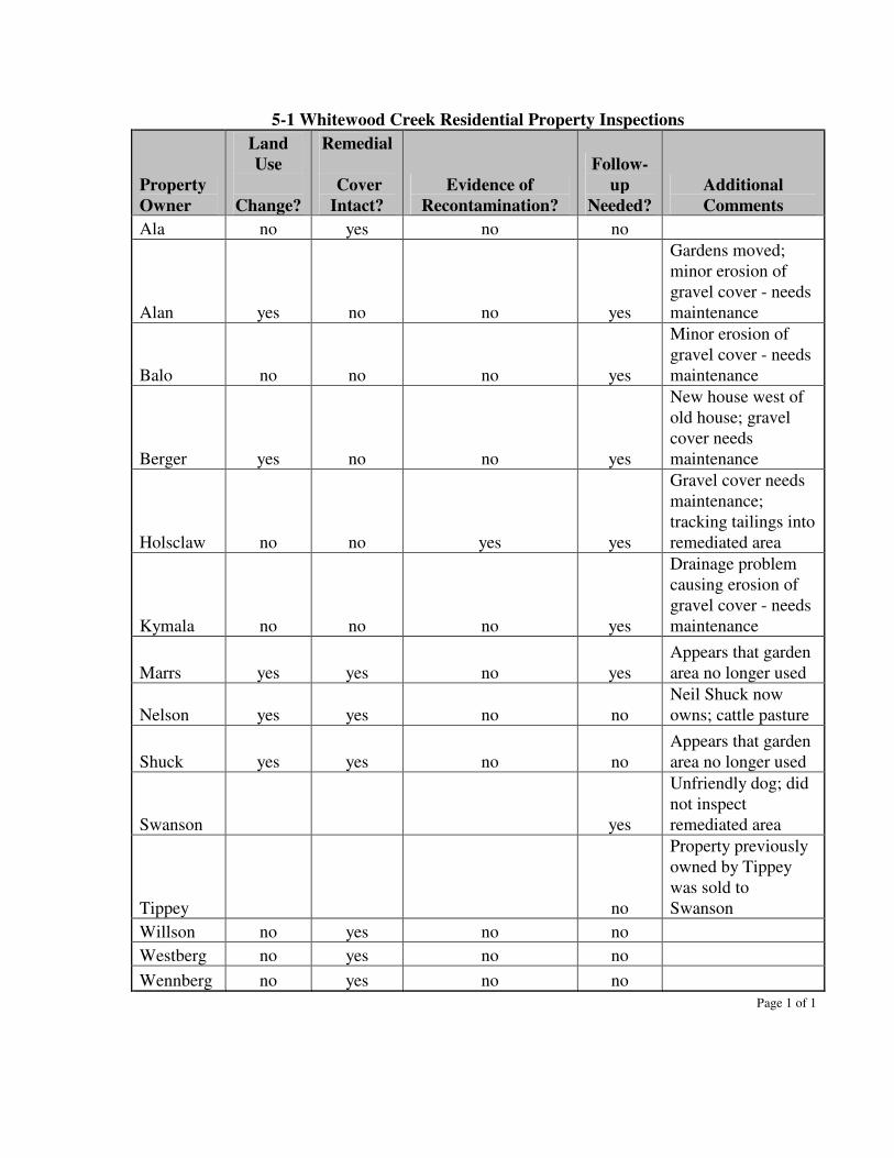
5-1 Whitewood Creek Residential Property Inspections
Property Owner
Land Use
Change?
Remedial
Cover Intact?
Evidence of Recontamination?
Follow-up
Needed? Additional Comments
Ala no yes no no
Alan yes no no yes
Gardens moved; minor erosion of gravel cover - needs maintenance
Balo no no no yes
Minor erosion of gravel cover - needs maintenance
Berger yes no no yes
New house west of old house; gravel cover needs maintenance
Holsclaw no no yes yes
Gravel cover needs maintenance; tracking tailings into remediated area
Kymala no no no yes
Drainage problem causing erosion of gravel cover - needs maintenance
Marrs yes yes no yes Appears that garden area no longer used
Nelson yes yes no no Neil Shuck now owns; cattle pasture
Shuck yes yes no no Appears that garden area no longer used
Swanson yes
Unfriendly dog; did not inspect remediated area
Tippey no
Property previously owned by Tippey was sold to Swanson
Willson no yes no no Westberg no yes no no Wennberg no yes no no Page 1 of 1
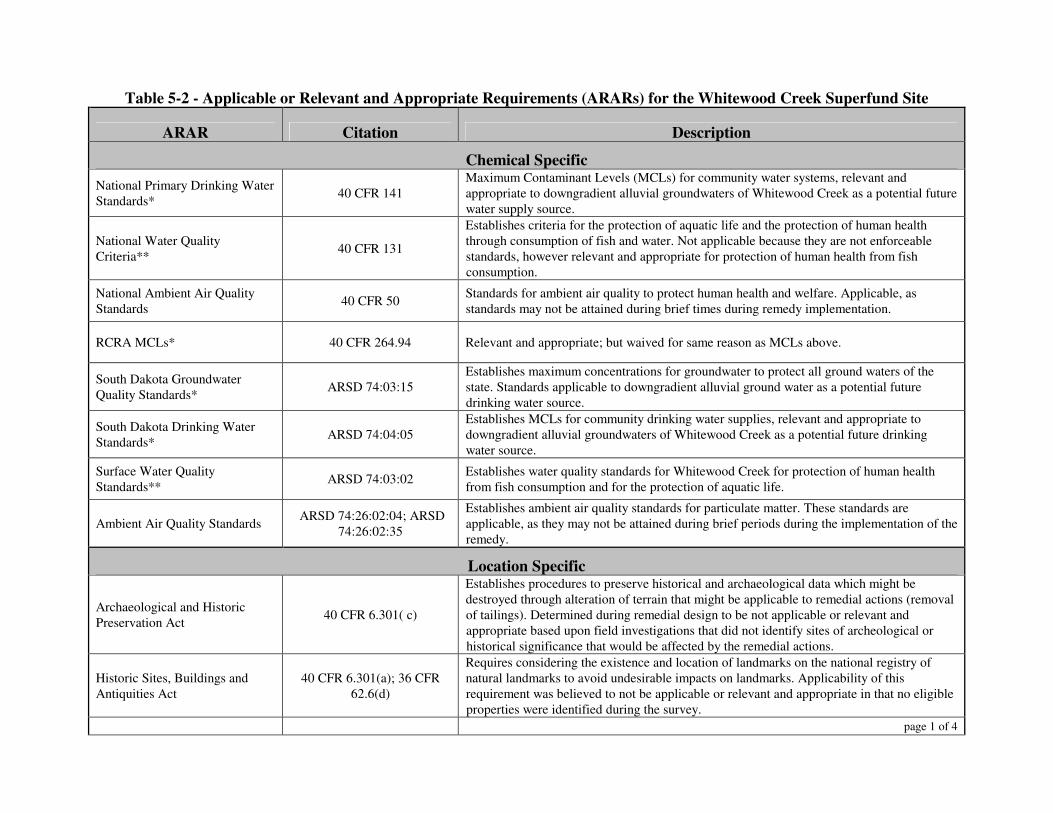
Table 5-2 - Applicable or Relevant and Appropriate Requirements (ARARs) for the Whitewood Creek Superfund Site
ARAR Citation Description
Chemical Specific National Primary Drinking Water Standards* 40 CFR 141
Maximum Contaminant Levels (MCLs) for community water systems, relevant and appropriate to downgradient alluvial groundwaters of Whitewood Creek as a potential future water supply source.
National Water Quality Criteria** 40 CFR 131
Establishes criteria for the protection of aquatic life and the protection of human health through consumption of fish and water. Not applicable because they are not enforceable standards, however relevant and appropriate for protection of human health from fish consumption.
National Ambient Air Quality Standards 40 CFR 50 Standards for ambient air quality to protect human health and welfare. Applicable, as
standards may not be attained during brief times during remedy implementation.
RCRA MCLs* 40 CFR 264.94 Relevant and appropriate; but waived for same reason as MCLs above.
South Dakota Groundwater Quality Standards* ARSD 74:03:15
Establishes maximum concentrations for groundwater to protect all ground waters of the state. Standards applicable to downgradient alluvial ground water as a potential future drinking water source.
South Dakota Drinking Water Standards* ARSD 74:04:05
Establishes MCLs for community drinking water supplies, relevant and appropriate to downgradient alluvial groundwaters of Whitewood Creek as a potential future drinking water source.
Surface Water Quality Standards** ARSD 74:03:02 Establishes water quality standards for Whitewood Creek for protection of human health
from fish consumption and for the protection of aquatic life.
Ambient Air Quality Standards ARSD 74:26:02:04; ARSD 74:26:02:35
Establishes ambient air quality standards for particulate matter. These standards are applicable, as they may not be attained during brief periods during the implementation of the remedy.
Location Specific
Archaeological and Historic Preservation Act 40 CFR 6.301( c)
Establishes procedures to preserve historical and archaeological data which might be destroyed through alteration of terrain that might be applicable to remedial actions (removal of tailings). Determined during remedial design to be not applicable or relevant and appropriate based upon field investigations that did not identify sites of archeological or historical significance that would be affected by the remedial actions.
Historic Sites, Buildings and Antiquities Act
40 CFR 6.301(a); 36 CFR 62.6(d)
Requires considering the existence and location of landmarks on the national registry of natural landmarks to avoid undesirable impacts on landmarks. Applicability of this requirement was believed to not be applicable or relevant and appropriate in that no eligible properties were identified during the survey.
page 1 of 4
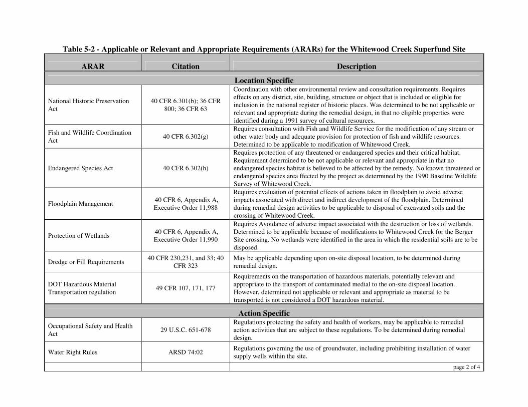
Table 5-2 - Applicable or Relevant and Appropriate Requirements (ARARs) for the Whitewood Creek Superfund Site
ARAR Citation Description
Location Specific
National Historic Preservation Act
40 CFR 6.301(b); 36 CFR 800; 36 CFR 63
Coordination with other environmental review and consultation requirements. Requires effects on any district, site, building, structure or object that is included or eligible for inclusion in the national register of historic places. Was determined to be not applicable or relevant and appropriate during the remedial design, in that no eligible properties were identified during a 1991 survey of cultural resources.
Fish and Wildlife Coordination Act 40 CFR 6.302(g)
Requires consultation with Fish and Wildlife Service for the modification of any stream or other water body and adequate provision for protection of fish and wildlife resources. Determined to be applicable to modification of Whitewood Creek.
Endangered Species Act 40 CFR 6.302(h)
Requires protection of any threatened or endangered species and their critical habitat. Requirement determined to be not applicable or relevant and appropriate in that no endangered species habitat is believed to be affected by the remedy. No known threatened or endangered species area ffected by the project as determined by the 1990 Baseline Wildlife Survey of Whitewood Creek.
Floodplain Management 40 CFR 6, Appendix A, Executive Order 11,988
Requires evaluation of potential effects of actions taken in floodplain to avoid adverse impacts associated with direct and indirect development of the floodplain. Determined during remedial design activities to be applicable to disposal of excavated soils and the crossing of Whitewood Creek.
Protection of Wetlands 40 CFR 6, Appendix A, Executive Order 11,990
Requires Avoidance of adverse impact associated with the destruction or loss of wetlands. Determined to be applicable because of modifications to Whitewood Creek for the Berger Site crossing. No wetlands were identified in the area in which the residential soils are to be disposed.
Dredge or Fill Requirements 40 CFR 230,231, and 33; 40 CFR 323
May be applicable depending upon on-site disposal location, to be determined during remedial design.
DOT Hazardous Material Transportation regulation 49 CFR 107, 171, 177
Requirements on the transportation of hazardous materials, potentially relevant and appropriate to the transport of contaminated medial to the on-site disposal location. However, determined not applicable or relevant and appropriate as material to be transported is not considered a DOT hazardous material.
Action Specific Occupational Safety and Health Act 29 U.S.C. 651-678
Regulations protecting the safety and health of workers, may be applicable to remedial action activities that are subject to these regulations. To be determined during remedial design.
Water Right Rules ARSD 74:02 Regulations governing the use of groundwater, including prohibiting installation of water supply wells within the site.
page 2 of 4
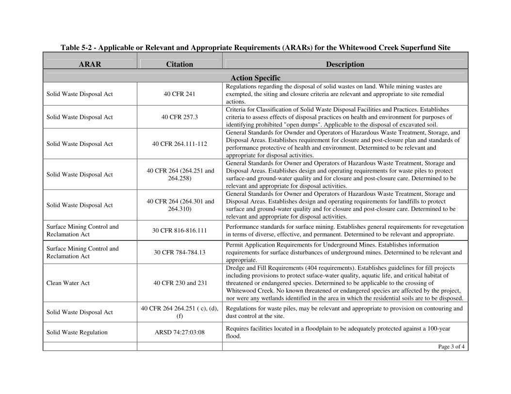
Table 5-2 - Applicable or Relevant and Appropriate Requirements (ARARs) for the Whitewood Creek Superfund Site
ARAR Citation Description
Action Specific
Solid Waste Disposal Act 40 CFR 241 Regulations regarding the disposal of solid wastes on land. While mining wastes are exempted, the siting and closure criteria are relevant and appropriate to site remedial actions.
Solid Waste Disposal Act 40 CFR 257.3 Criteria for Classification of Solid Waste Disposal Facilities and Practices. Establishes criteria to assess effects of disposal practices on health and environment for purposes of identifying prohibited "open dumps". Applicable to the disposal of excavated soil.
Solid Waste Disposal Act 40 CFR 264.111-112
General Standards for Ownder and Operators of Hazardous Waste Treatment, Storage, and Disposal Areas. Establishes requirement for closure and post-closure plan and standards of performance protective of health and environment. Determined to be relevant and appropriate for disposal activities.
Solid Waste Disposal Act 40 CFR 264 (264.251 and 264.258)
General Standards for Owner and Operators of Hazardous Waste Treatment, Storage and Disposal Areas. Establishes design and operating requirements for waste piles to protect surface-and ground-water quality and for closure and post-closure care. Determined to be relevant and appropriate for disposal activities.
Solid Waste Disposal Act 40 CFR 264 (264.301 and 264.310)
General Standards for Owner and Operators of Hazardous Waste Treatment, Storage and Disposal Areas. Establishes design and operating requirements for landfills to protect surface and ground-water quality and for closure and post-closure care. Determined to be relevant and appropriate for disposal activities.
Surface Mining Control and Reclamation Act 30 CFR 816-816.111 Performance standards for surface mining. Establishes general requirements for revegetation
in terms of diverse, effective, and permanent. Determined to be relevant and appropriate.
Surface Mining Control and Reclamation Act 30 CFR 784-784.13
Permit Application Requirements for Underground Mines. Establishes information requirements for surface disturbances of underground mines. Determined to be relevant and appropriate.
Clean Water Act 40 CFR 230 and 231
Dredge and Fill Requirements (404 requirements). Establishes guidelines for fill projects including provisions to protect suface-water quality, aquatic life, and critical habitat of threatened or endangered species. Determined to be applicable to the crossing of Whitewood Creek. No known threatened or endangered species are affected by the project, nor were any wetlands identified in the area in which the residential soils are to be disposed.
Solid Waste Disposal Act 40 CFR 264 264.251 ( c), (d), (f)
Regulations for waste piles, may be relevant and appropriate to provision on contouring and dust control at the site.
Solid Waste Regulation ARSD 74:27:03:08 Requires facilities located in a floodplain to be adequately protected against a 100-year flood.
Page 3 of 4
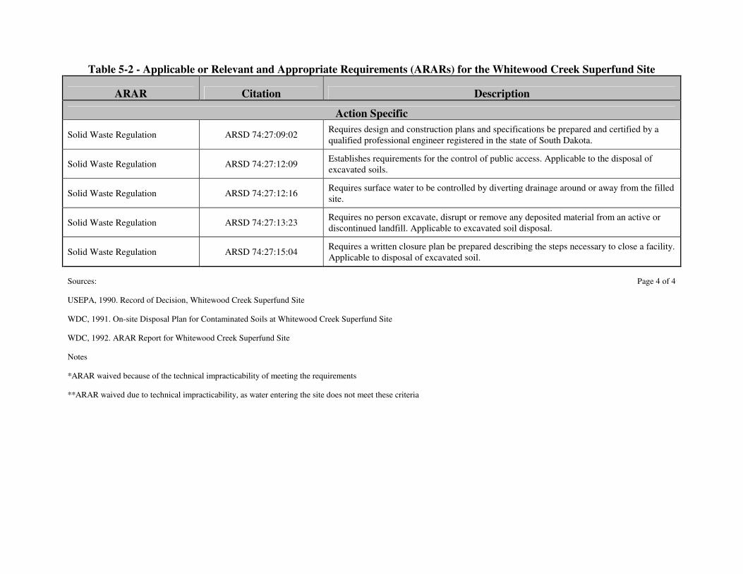
Table 5-2 - Applicable or Relevant and Appropriate Requirements (ARARs) for the Whitewood Creek Superfund Site
ARAR Citation Description
Action Specific
Solid Waste Regulation ARSD 74:27:09:02 Requires design and construction plans and specifications be prepared and certified by a qualified professional engineer registered in the state of South Dakota.
Solid Waste Regulation ARSD 74:27:12:09 Establishes requirements for the control of public access. Applicable to the disposal of excavated soils.
Solid Waste Regulation ARSD 74:27:12:16 Requires surface water to be controlled by diverting drainage around or away from the filled site.
Solid Waste Regulation ARSD 74:27:13:23 Requires no person excavate, disrupt or remove any deposited material from an active or discontinued landfill. Applicable to excavated soil disposal.
Solid Waste Regulation ARSD 74:27:15:04 Requires a written closure plan be prepared describing the steps necessary to close a facility. Applicable to disposal of excavated soil.
Sources: Page 4 of 4
USEPA, 1990. Record of Decision, Whitewood Creek Superfund Site
WDC, 1991. On-site Disposal Plan for Contaminated Soils at Whitewood Creek Superfund Site
WDC, 1992. ARAR Report for Whitewood Creek Superfund Site
Notes
*ARAR waived because of the technical impracticability of meeting the requirements
**ARAR waived due to technical impracticability, as water entering the site does not meet these criteria
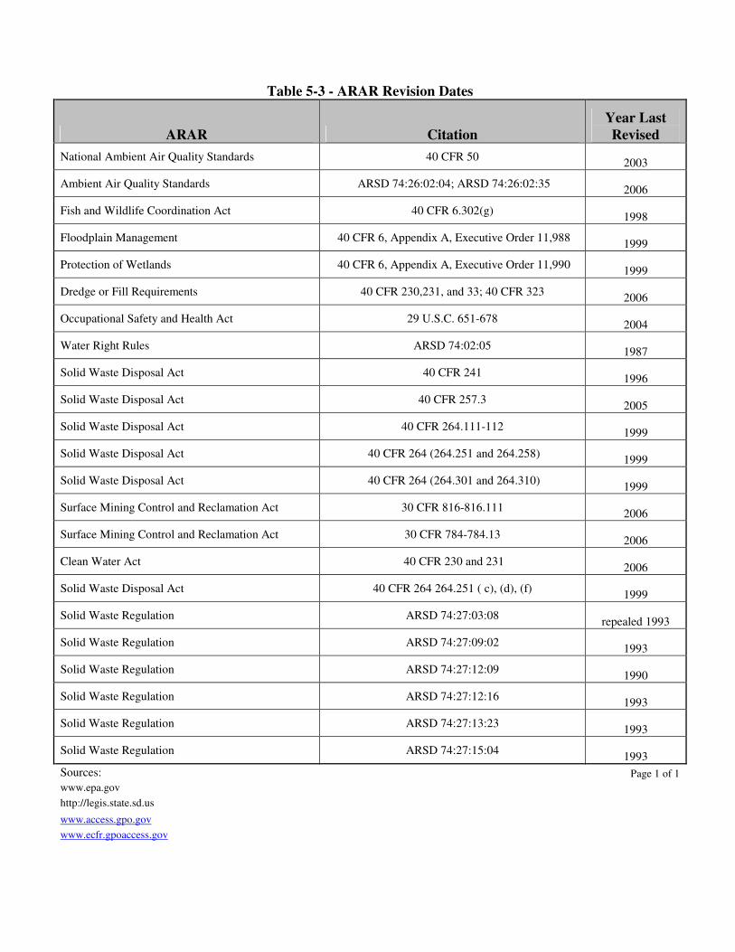
Table 5-3 - ARAR Revision Dates
ARAR Citation Year Last Revised
National Ambient Air Quality Standards 40 CFR 50 2003
Ambient Air Quality Standards ARSD 74:26:02:04; ARSD 74:26:02:35 2006
Fish and Wildlife Coordination Act 40 CFR 6.302(g) 1998
Floodplain Management 40 CFR 6, Appendix A, Executive Order 11,988 1999
Protection of Wetlands 40 CFR 6, Appendix A, Executive Order 11,990 1999
Dredge or Fill Requirements 40 CFR 230,231, and 33; 40 CFR 323 2006
Occupational Safety and Health Act 29 U.S.C. 651-678 2004
Water Right Rules ARSD 74:02:05 1987
Solid Waste Disposal Act 40 CFR 241 1996
Solid Waste Disposal Act 40 CFR 257.3 2005
Solid Waste Disposal Act 40 CFR 264.111-112 1999
Solid Waste Disposal Act 40 CFR 264 (264.251 and 264.258) 1999
Solid Waste Disposal Act 40 CFR 264 (264.301 and 264.310) 1999
Surface Mining Control and Reclamation Act 30 CFR 816-816.111 2006
Surface Mining Control and Reclamation Act 30 CFR 784-784.13 2006
Clean Water Act 40 CFR 230 and 231 2006
Solid Waste Disposal Act 40 CFR 264 264.251 ( c), (d), (f) 1999
Solid Waste Regulation ARSD 74:27:03:08 repealed 1993
Solid Waste Regulation ARSD 74:27:09:02 1993
Solid Waste Regulation ARSD 74:27:12:09 1990
Solid Waste Regulation ARSD 74:27:12:16 1993
Solid Waste Regulation ARSD 74:27:13:23 1993
Solid Waste Regulation ARSD 74:27:15:04 1993 Sources: Page 1 of 1 www.epa.gov http://legis.state.sd.us www.access.gpo.gov www.ecfr.gpoaccess.gov
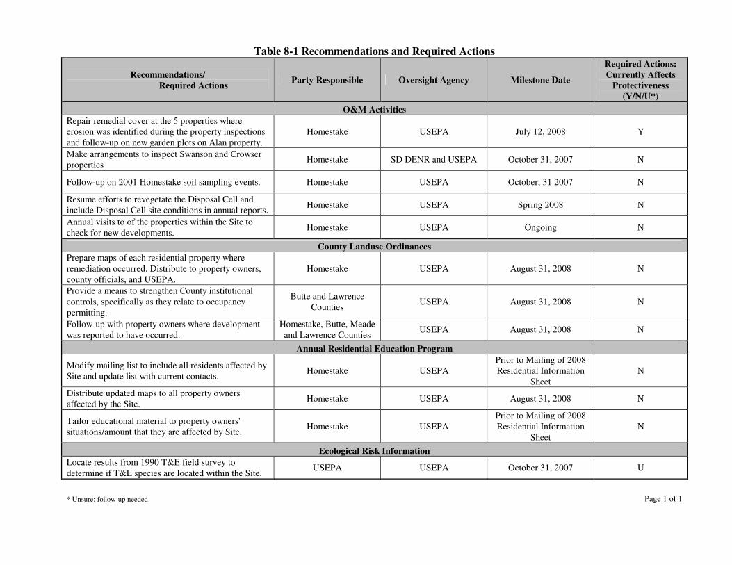
Table 8-1 Recommendations and Required Actions
Recommendations/ Required Actions Party Responsible Oversight Agency Milestone Date
Required Actions: Currently Affects
Protectiveness (Y/N/U*)
O&M Activities Repair remedial cover at the 5 properties where erosion was identified during the property inspections and follow-up on new garden plots on Alan property.
Homestake USEPA July 12, 2008 Y
Make arrangements to inspect Swanson and Crowser properties Homestake SD DENR and USEPA October 31, 2007 N
Follow-up on 2001 Homestake soil sampling events. Homestake USEPA October, 31 2007 N
Resume efforts to revegetate the Disposal Cell and include Disposal Cell site conditions in annual reports. Homestake USEPA Spring 2008 N
Annual visits to of the properties within the Site to check for new developments. Homestake USEPA Ongoing N
County Landuse Ordinances Prepare maps of each residential property where remediation occurred. Distribute to property owners, county officials, and USEPA.
Homestake USEPA August 31, 2008 N
Provide a means to strengthen County institutional controls, specifically as they relate to occupancy permitting.
Butte and Lawrence Counties USEPA August 31, 2008 N
Follow-up with property owners where development was reported to have occurred.
Homestake, Butte, Meade and Lawrence Counties USEPA August 31, 2008 N
Annual Residential Education Program
Modify mailing list to include all residents affected by Site and update list with current contacts. Homestake USEPA
Prior to Mailing of 2008 Residential Information
Sheet N
Distribute updated maps to all property owners affected by the Site. Homestake USEPA August 31, 2008 N
Tailor educational material to property owners' situations/amount that they are affected by Site. Homestake USEPA
Prior to Mailing of 2008 Residential Information
Sheet N
Ecological Risk Information Locate results from 1990 T&E field survey to determine if T&E species are located within the Site. USEPA USEPA October 31, 2007 U
* Unsure; follow-up needed Page 1 of 1

FIGURES
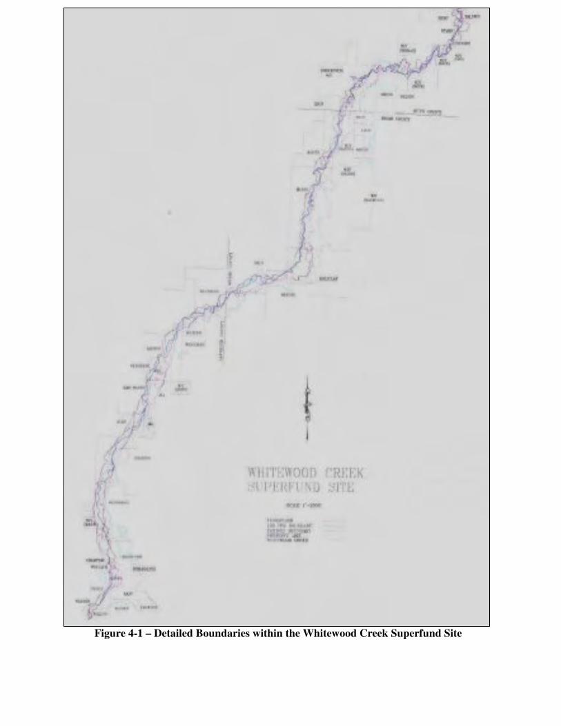
Figure 4-1 – Detailed Boundaries within the Whitewood Creek Superfund Site
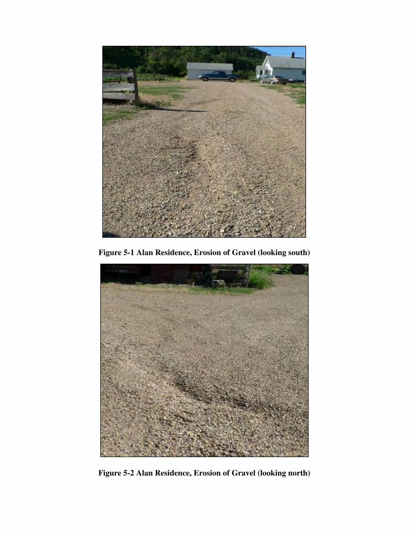
Figure 5-1 Alan Residence, Erosion of Gravel (looking south)
Figure 5-2 Alan Residence, Erosion of Gravel (looking north)
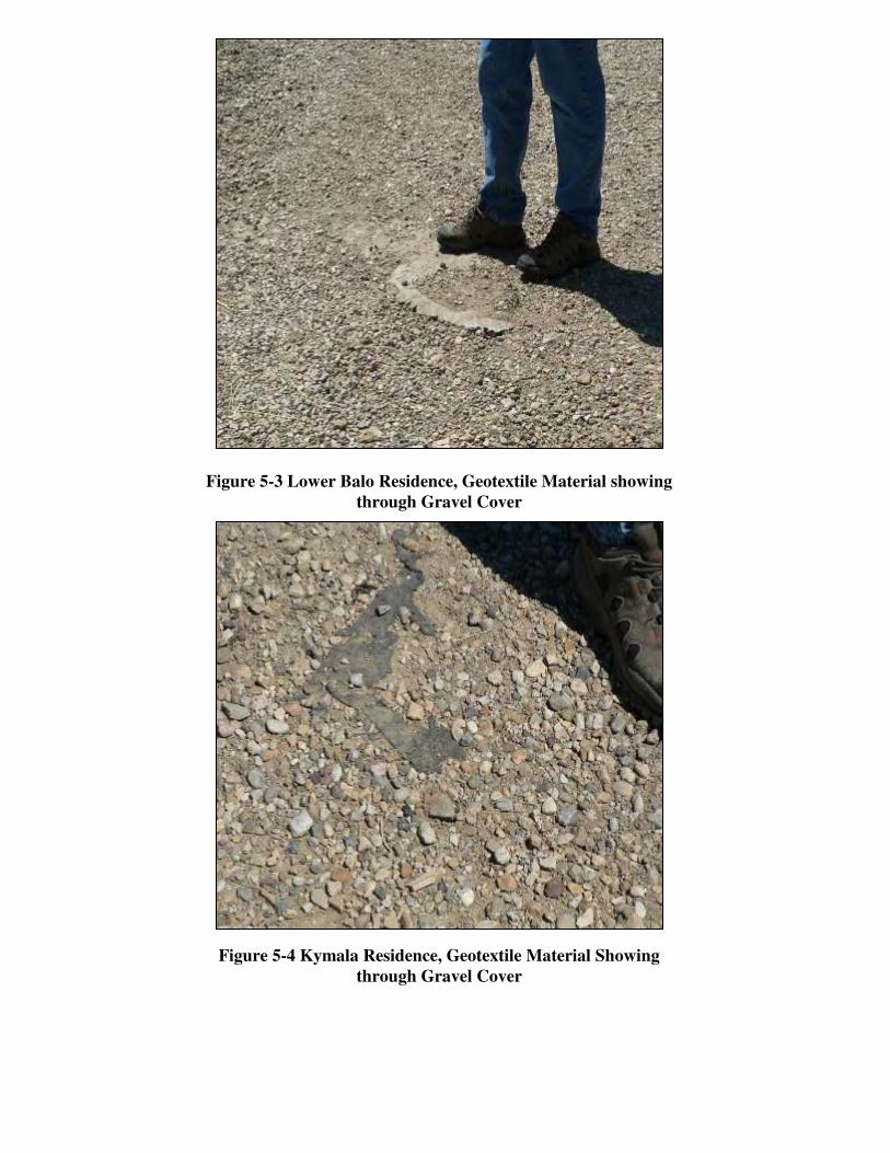
Figure 5-3 Lower Balo Residence, Geotextile Material showing
through Gravel Cover
Figure 5-4 Kymala Residence, Geotextile Material Showing through Gravel Cover
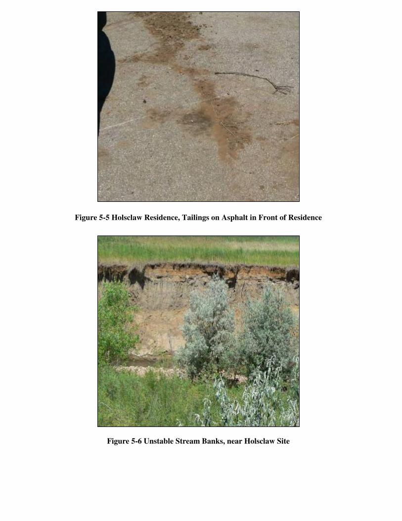
Figure 5-5 Holsclaw Residence, Tailings on Asphalt in Front of Residence
Figure 5-6 Unstable Stream Banks, near Holsclaw Site
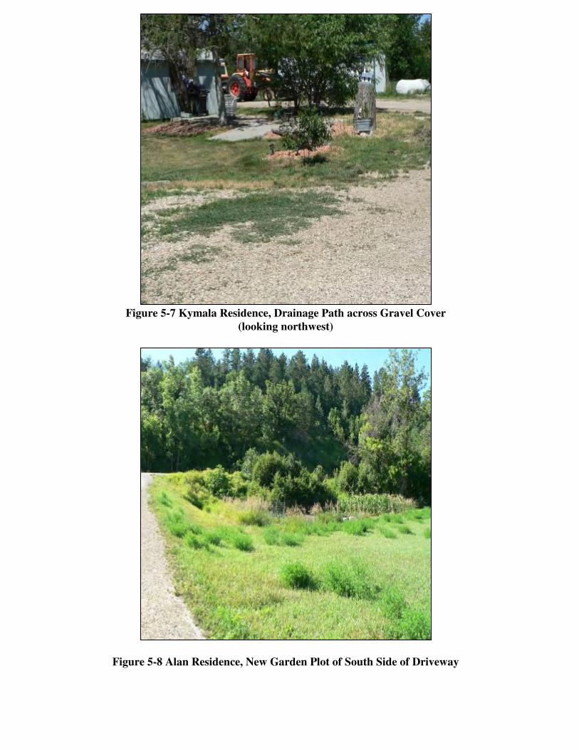
Figure 5-7 Kymala Residence, Drainage Path across Gravel Cover
(looking northwest)
Figure 5-8 Alan Residence, New Garden Plot of South Side of Driveway
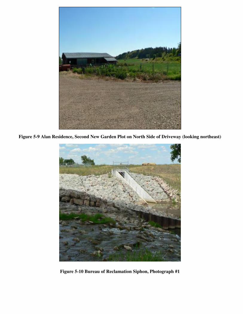
Figure 5-9 Alan Residence, Second New Garden Plot on North Side of Driveway (looking northeast)
Figure 5-10 Bureau of Reclamation Siphon, Photograph #1
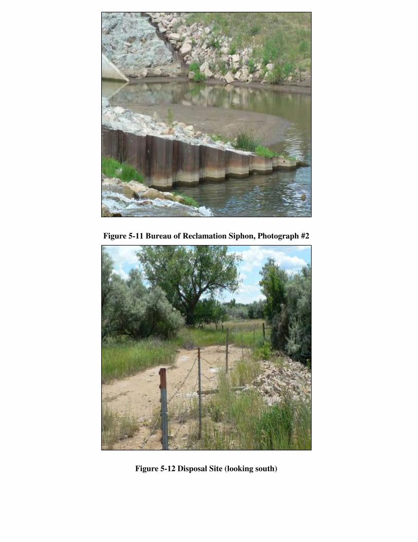
Figure 5-11 Bureau of Reclamation Siphon, Photograph #2
Figure 5-12 Disposal Site (looking south)
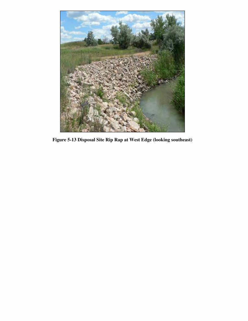
Figure 5-13 Disposal Site Rip Rap at West Edge (looking southeast)
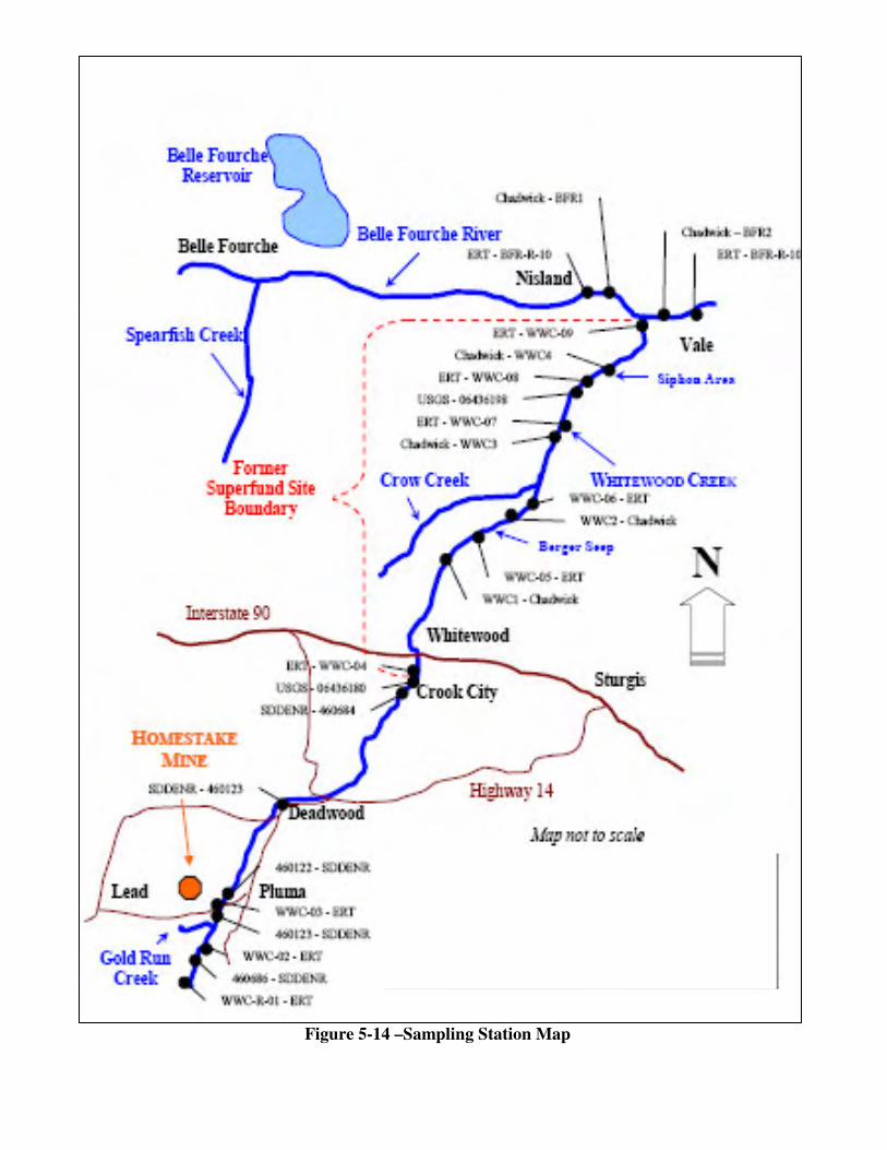
Figure 5-14 –Sampling Station Map
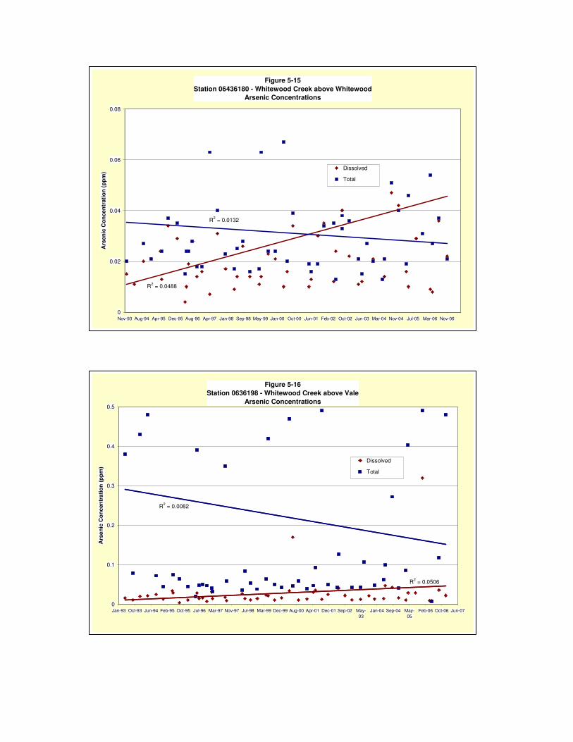
Figure 5-15 Station 06436180 - Whitewood Creek above Whitewood
Arsenic Concentrations
R2 = 0.0488
R2 = 0.0132
0
0.02
0.04
0.06
0.08
Nov-93 Aug-94 Apr-95 Dec-95 Aug-96 Apr-97 Jan-98 Sep-98 May-99 Jan-00 Oct-00 Jun-01 Feb-02 Oct-02 Jun-03 Mar-04 Nov-04 Jul-05 Mar-06 Nov-06
Ars
enic
Con
cent
ratio
n (p
pm)
Dissolved
Total
Figure 5-16 Station 0636198 - Whitewood Creek above Vale
Arsenic Concentrations
R2 = 0.0506
R2 = 0.0082
0
0.1
0.2
0.3
0.4
0.5
Jan-93 Oct-93 Jun-94 Feb-95 Oct-95 Jul-96 Mar-97 Nov-97 Jul-98 Mar-99 Dec-99 Aug-00 Apr-01 Dec-01 Sep-02 May-03
Jan-04 Sep-04 May-05
Feb-06 Oct-06 Jun-07
Ars
enic
Con
cent
ratio
n (p
pm)
Dissolved
Total
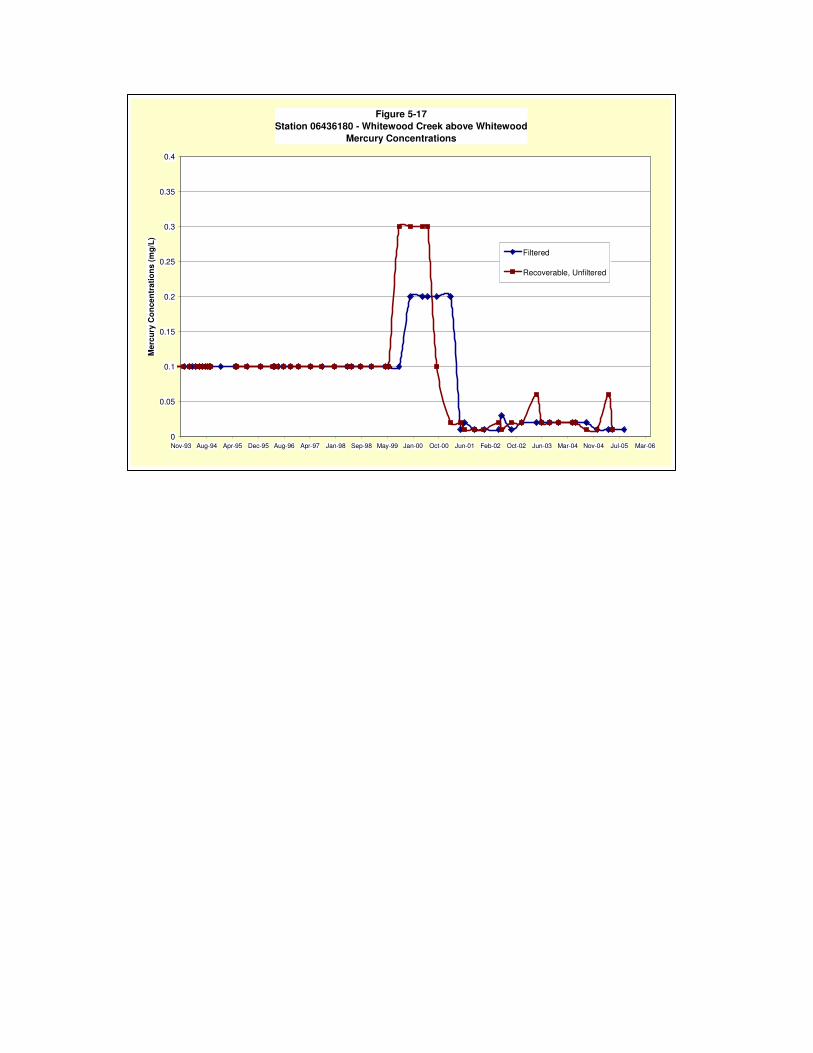
Figure 5-17 Station 06436180 - Whitewood Creek above Whitewood
Mercury Concentrations
0
0.05
0.1
0.15
0.2
0.25
0.3
0.35
0.4
Nov-93 Aug-94 Apr-95 Dec-95 Aug-96 Apr-97 Jan-98 Sep-98 May-99 Jan-00 Oct-00 Jun-01 Feb-02 Oct-02 Jun-03 Mar-04 Nov-04 Jul-05 Mar-06
Mer
cury
Con
cent
ratio
ns (m
g/L)
Filtered
Recoverable, Unfiltered

ATTACHMENT 2-1