Embed Size (px)
Citation preview
Background on the March 13-14, 2007 Flooding in Browns Valley (Traverse County), Minnesota
Report to the Minnesota Governor’s Office
Prepared by:
Minnesota Department of Natural Resources Waters Division April 20, 2007
4/20/2007 Revision

This page intentionally left blank
4/20/2007 Revision
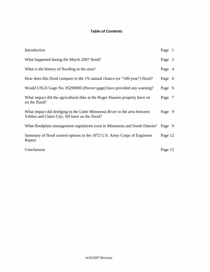
Table of Contents
Introduction Page 1 What happened during the March 2007 flood? Page 2 What is the history of flooding in the area? Page 4 How does this flood compare to the 1% annual chance (or “100-year”) flood? Page 6 Would USGS Gage No. 05290000 (Peever gage) have provided any warning? Page 6 What impact did the agricultural dike at the Roger Haanen property have on Page 7 on the flood? What impact did dredging in the Little Minnesota River in the area between Page 9 Veblen and Claire City, SD have on the flood? What floodplain management regulations exist in Minnesota and South Dakota? Page 9 Summary of flood control options in the 1972 U.S. Army Corps of Engineers Page 12 Report Conclusions Page 12
4/20/2007 Revision
Figures and Tables
Figure 1. Location of Browns Valley Page 1 Figure 2. Aerial photo of Browns Valley area that shows the transition from Page 1 high lands in the north to the valley where the city is located. Source: Google Earth Figure 3. Schematic of flows during March 13-14, 2007 flood in Browns Page 3 Valley (Traverse County) Table 1 - Summary of peak flows during historical floods and flows associated Page 4 with Flood Insurance Study (FIS) flood frequencies Figure 4. Spot elevations of high water from March 14-15, 2007 flood in Page 6 Browns Valley (Traverse County) overlaid on the Flood Insurance Rate Map for Browns Valley Figures 5a & 5b. JOR Engineering aerial photos taken March 14, 2007 Page 8 Figure 6. Location of Veblen, SD Page 9 Figure 7. Approximate location of structures with possible damage during Page 11 the March 13-14, 2007 flood in Browns Valley (Traverse County)
4/20/2007 Revision
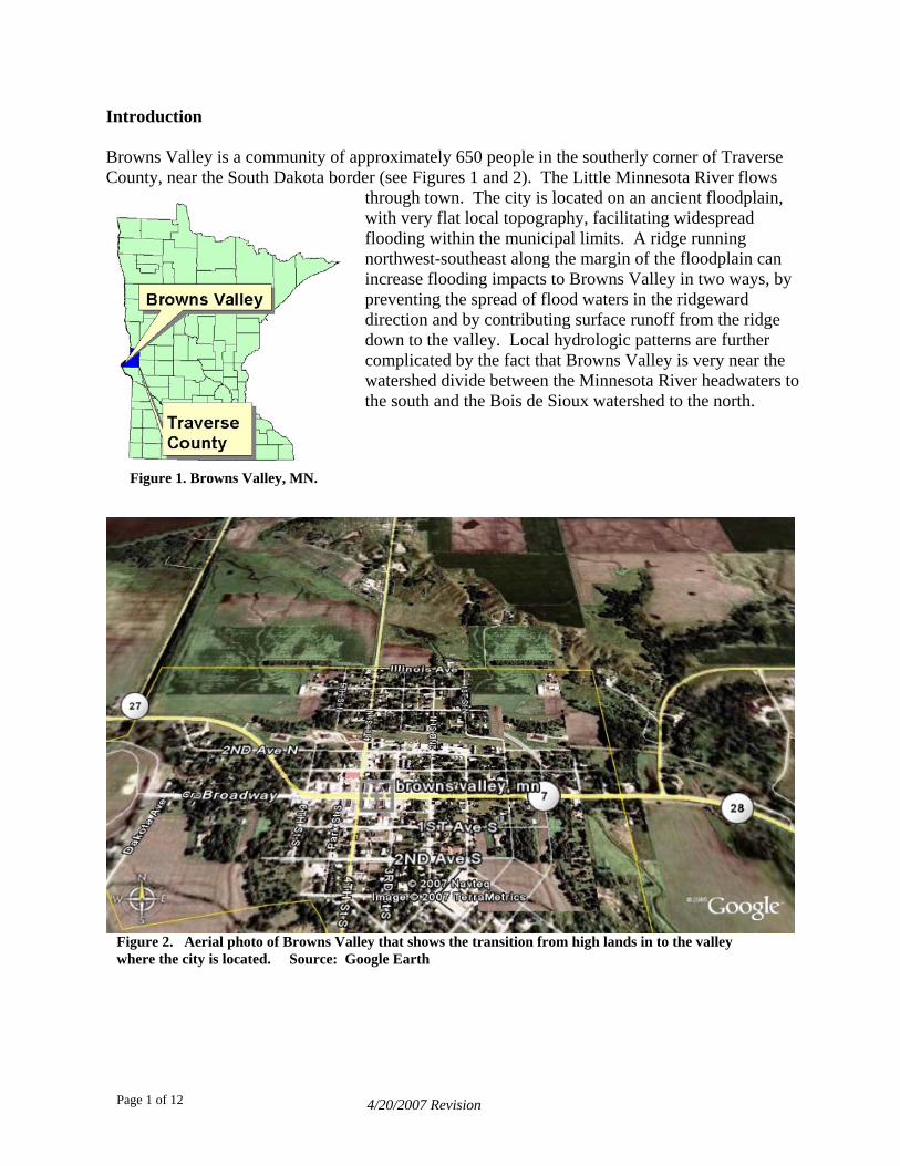
Introduction Browns Valley is a community of approximately 650 people in the southerly corner of Traverse County, near the South Dakota border (see Figures 1 and 2). The Little Minnesota River flows
through town. The city is located on an ancient floodplain, with very flat local topography, facilitating widespread flooding within the municipal limits. A ridge running northwest-southeast along the margin of the floodplain can increase flooding impacts to Browns Valley in two ways, by preventing the spread of flood waters in the ridgeward direction and by contributing surface runoff from the ridge down to the valley. Local hydrologic patterns are further complicated by the fact that Browns Valley is very near the watershed divide between the Minnesota River headwaters to the south and the Bois de Sioux watershed to the north.
Figure 1. Browns Valley, MN.
Figure 2. Aerial photo of Browns Valley that shows the transition from high lands in to the valley where the city is located. Source: Google Earth
4/20/2007 Revision Page 1 of 12
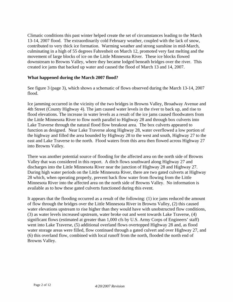
Climatic conditions this past winter helped create the set of circumstances leading to the March 13-14, 2007 flood. The extraordinarily cold February weather, coupled with the lack of snow, contributed to very thick ice formation. Warming weather and strong sunshine in mid-March, culminating in a high of 55 degrees Fahrenheit on March 12, promoted very fast melting and the movement of large blocks of ice on the Little Minnesota River. These ice blocks flowed downstream to Browns Valley, where they became lodged beneath bridges over the river. This created ice jams that backed up water and caused the flood of March 13 and 14, 2007. What happened during the March 2007 flood? See figure 3 (page 3), which shows a schematic of flows observed during the March 13-14, 2007 flood. Ice jamming occurred in the vicinity of the two bridges in Browns Valley, Broadway Avenue and 4th Street (County Highway 4). The jam caused water levels in the river to back up, and rise to flood elevations. The increase in water levels as a result of the ice jams caused floodwaters from the Little Minnesota River to flow north parallel to Highway 28 and through box culverts into Lake Traverse through the natural flood flow breakout area. The box culverts appeared to function as designed. Near Lake Traverse along Highway 28, water overflowed a low portion of the highway and filled the area bounded by Highway 28 to the west and south, Highway 27 to the east and Lake Traverse to the north. Flood waters from this area then flowed across Highway 27 into Browns Valley. There was another potential source of flooding for the affected area on the north side of Browns Valley that was considered in this report. A ditch flows southward along Highway 27 and discharges into the Little Minnesota River near the junction of Highway 28 and Highway 27. During high water periods on the Little Minnesota River, there are two gated culverts at Highway 28 which, when operating properly, prevent back flow water from flowing from the Little Minnesota River into the affected area on the north side of Browns Valley. No information is available as to how these gated culverts functioned during this event. It appears that the flooding occurred as a result of the following: (1) ice jams reduced the amount of flow through the bridges over the Little Minnesota River in Browns Valley, (2) this caused water elevations upstream to rise higher than they would have with unobstructed flow conditions, (3) as water levels increased upstream, water broke out and went towards Lake Traverse, (4) significant flows (estimated at greater than 1,000 cfs by U.S. Army Corps of Engineers’ staff) went into Lake Traverse, (5) additional overland flows overtopped Highway 28 and, as flood water storage areas were filled, flow continued through a gated culvert and over Highway 27, and (6) this overland flow, combined with local runoff from the north, flooded the north end of Browns Valley.
4/20/2007 Revision Page 2 of 12
Gated Culvert East
Box Culvert
Overflow
Overflow
Gaging Station
Breakout flow path
Gated CulvertSouth End
Ice jam @ Broadway A
Little MN River
Little MN River
Ice jam @4th Street
Figure 3. Schematic of flows during March 13-14, 2007 flood in Browns Valley (Traverse County)
4/20/2007 Revision
Page 3 of 12
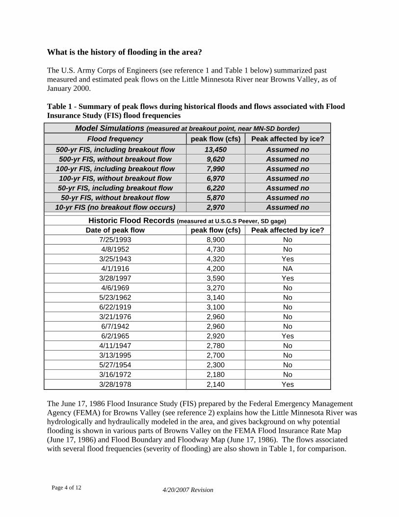
What is the history of flooding in the area? The U.S. Army Corps of Engineers (see reference 1 and Table 1 below) summarized past measured and estimated peak flows on the Little Minnesota River near Browns Valley, as of January 2000. Table 1 - Summary of peak flows during historical floods and flows associated with Flood Insurance Study (FIS) flood frequencies
Model Simulations (measured at breakout point, near MN-SD border) Flood frequency peak flow (cfs) Peak affected by ice?
500-yr FIS, including breakout flow 13,450 Assumed no 500-yr FIS, without breakout flow 9,620 Assumed no
100-yr FIS, including breakout flow 7,990 Assumed no 100-yr FIS, without breakout flow 6,970 Assumed no 50-yr FIS, including breakout flow 6,220 Assumed no 50-yr FIS, without breakout flow 5,870 Assumed no
10-yr FIS (no breakout flow occurs) 2,970 Assumed no
Historic Flood Records (measured at U.S.G.S Peever, SD gage) Date of peak flow peak flow (cfs) Peak affected by ice?
7/25/1993 8,900 No 4/8/1952 4,730 No
3/25/1943 4,320 Yes 4/1/1916 4,200 NA
3/28/1997 3,590 Yes 4/6/1969 3,270 No
5/23/1962 3,140 No 6/22/1919 3,100 No 3/21/1976 2,960 No 6/7/1942 2,960 No 6/2/1965 2,920 Yes
4/11/1947 2,780 No 3/13/1995 2,700 No 5/27/1954 2,300 No 3/16/1972 2,180 No 3/28/1978 2,140 Yes
The June 17, 1986 Flood Insurance Study (FIS) prepared by the Federal Emergency Management Agency (FEMA) for Browns Valley (see reference 2) explains how the Little Minnesota River was hydrologically and hydraulically modeled in the area, and gives background on why potential flooding is shown in various parts of Browns Valley on the FEMA Flood Insurance Rate Map (June 17, 1986) and Flood Boundary and Floodway Map (June 17, 1986). The flows associated with several flood frequencies (severity of flooding) are also shown in Table 1, for comparison.
4/20/2007 Revision Page 4 of 12
The FIS indicates that for the 10% annual chance (“10-year”) flood there is a discharge (flow volume) of 2,970 cubic feet per second (cfs). At the 2% annual chance (“50-yr”) flood level, there is a discharge of 6,220 cfs. However, the modeling shows that at the 50-year flood level it is expected that part of the flow (350 cfs of the total 6,220 cfs) will “breakout” of the Little Minnesota River and go north before reaching Highway 28 and through a box culvert under Highway 28 into Lake Traverse. At the 100-year flood level, the modeling anticipated 1,020 cfs of breakout flow (of the 7,990 cfs) going north to Lake Traverse and not flowing through the City of Browns Valley. At the 500-year flood level, the modelers anticipated 3,830 cfs of breakout flow (out of the total 13,450 cfs of flow), with 1,600 cfs of the breakout flow going into Lake Traverse and the remainder of the breakout flow of 2,230 cfs going north around Browns Valley and reentering the Little Minnesota River. So, with unobstructed flow conditions (i.e., no ice jams), it is expected that there is breakout flow into Lake Traverse and, if there is too much flow for the culvert into Lake Traverse, it is expected that the flow goes overland to the north end of Browns Valley. The FIS report is not clear on the route the flood flows were anticipated to take around or through Browns Valley to get to the Little Minnesota River.
4/20/2007 Revision Page 5 of 12
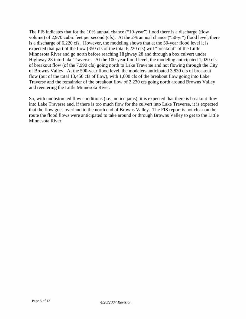
How does this flood compare to the 1% annual chance (or “100-year”) flood? Since the gage was compromised by ice, it is not possible to determine how the discharge (flow volume) for this flood compares to the 1% annual chance (100-year) flood discharge in the FIS. It was possible to compare the elevations of a few high water marks in the city and surrounding area with the 100-year flood elevation published by FEMA on the city’s Flood Insurance Rate Map (FIRM). See figure 4 below.
980.31
981.42 981.51
978.98
979.58
Figure 4. Spot elevations of high water from March 13-14, 2007 flood in Browns Valley (Traverse County) shown on the Flood Insurance Rate Map for Browns Valley The FIS 1% annual chance (100-year) flood level elevations are indicated on the Flood Insurance Rate Map by waved contour lines labeled with the appropriate elevation. This reveals that the observed high water marks were higher than the 100-year flood elevation of 980 feet MSL at the north end of the city, and just below the 100-year flood elevation as you go further south towards Broadway. Would USGS Gage No. 05290000 (Peever gage) have provided any warning? Use of the Peever gage, which is located several miles upstream of Browns Valley, was discontinued in 2002. Since there were data on the relationship of the stage (water level at the gage) and the discharge (flow in cfs at the gage), DNR Waters’ staff examined the gage site on 3/26/07. It must be noted that this relationship between flood stage and flood discharge at the Peever gage is based on unobstructed flow conditions. The DNR Waters’ staff found evidence
4/20/2007 Revision Page 6 of 12
that the high water mark at the gage for the recent flooding had been affected by ice. Therefore, the crew was not able to determine the flood discharge in cfs at the time of the peak flows, its frequency and what the corresponding flood stage would have been in Browns Valley had ice jamming not occurred. If the actual peak flood discharge for this event was known, then it could be: (1) compared against the 10, 50, 100, and 500 year flood frequency discharges noted in Table 1; and (2) used to determine how much the corresponding flood stage was affected by ice jamming. The gage was not designed as a flood warning gage when it was operating. It was used to obtain baseline information about flows in the Little Minnesota River. The impacts of this flood were exacerbated by the ice jams, but to what degree is unknown. It is believed that ice jams caused water level increases that were above what would have been expected for the flow going by the gage several miles upstream. The gage, if operating, would not have provided warning for this type of event. What impact did the agricultural dike at the Roger Haanen property have on the flood? Another potential factor in this event was diking in South Dakota by a farmer, Roger Haanen, on the side of the Little Minnesota River as the river enters the river valley from the Sisseton Hills of South Dakota. As discussed earlier, floodwaters typically breakout of the river channel here flowing north toward Lake Traverse. It has been reported but not verified that the dikes in the floodplain are higher on the south side of the river and lower on the north side. Locals report the south side dike may have been breached slightly. Evidence on the ground supports this, as the only flood debris in the flood plain is located in close proximity to the main river channel, and not at any obvious breakout locations, further toward the foothills. Roberts County, South Dakota participates in the National Flood Insurance Program (NFIP), as do the City of Browns Valley and Traverse County, Minnesota. Roberts County adopted a floodplain management ordinance to enroll in the NFIP. Minnesota DNR Waters, as the state coordinating agency for the NFIP, was advised by the NFIP State coordinator for South Dakota that Roberts County did not issue the required permit for this diking pursuant to its floodplain ordinance that would have required a hydraulic analysis to determine the impacts of the dike on increasing flood levels in the area. Therefore, the impact of the dike on increasing flood levels is unknown at this time. Photos taken by JOR Engineering on March 14, 2007, just after the peak of the flood, are included in figures 5a and 5b (on page 8). The location of the diking in question is labeled on the first photo. It can be observed that flood waters were backed up to the area that included the diking.
4/20/2007 Revision Page 7 of 12
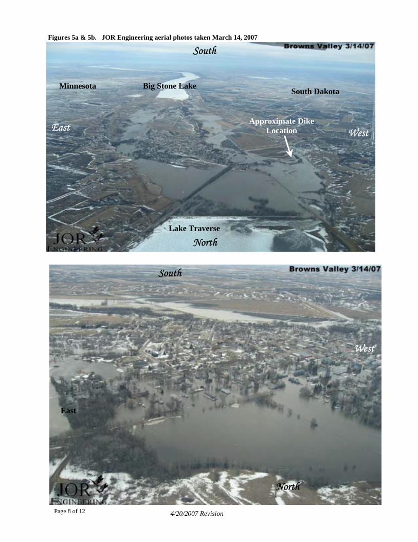
Figures 5a & 5b. JOR Engineering aerial photos taken March 14, 2007
South
Minnesota Big Stone Lake South Dakota
Approximate Dike LocationEast West
Lake Traverse
North
Lake Traverse
4/20/2007 Revision
North
South
West
East
Page 8 of 12
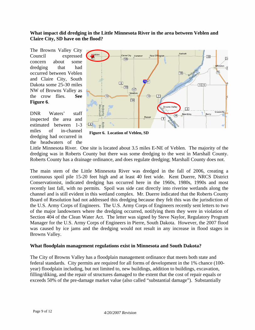
What impact did dredging in the Little Minnesota River in the area between Veblen and Claire City, SD have on the flood? The Browns Valley City Council expressed concern about some dredging that had occurred between Veblen and Claire City, South Dakota some 25-30 miles NW of Browns Valley as the crow flies. See Figure 6. DNR Waters’ staff inspected the area and estimated between 1-3 miles of in-channel dredging had occurred in the headwaters of the Little Minnesota River. One site is located about 3.5 miles E-NE of Veblen. The majority of the dredging was in Roberts County but there was some dredging to the west in Marshall County. Roberts County has a drainage ordinance, and does regulate dredging; Marshall County does not.
Figure 6. Location of Veblen, SD
The main stem of the Little Minnesota River was dredged in the fall of 2006, creating a continuous spoil pile 15-20 feet high and at least 40 feet wide. Kent Duerre, NRCS District Conservationist, indicated dredging has occurred here in the 1960s, 1980s, 1990s and most recently last fall, with no permits. Spoil was side cast directly into riverine wetlands along the channel and is still evident in this wetland complex. Mr. Duerre indicated that the Roberts County Board of Resolution had not addressed this dredging because they felt this was the jurisdiction of the U.S. Army Corps of Engineers. The U.S. Army Corps of Engineers recently sent letters to two of the major landowners where the dredging occurred, notifying them they were in violation of Section 404 of the Clean Water Act. The letter was signed by Steve Naylor, Regulatory Program Manager for the U.S. Army Corps of Engineers in Pierre, South Dakota. However, the 2007 flood was caused by ice jams and the dredging would not result in any increase in flood stages in Browns Valley. What floodplain management regulations exist in Minnesota and South Dakota? The City of Browns Valley has a floodplain management ordinance that meets both state and federal standards. City permits are required for all forms of development in the 1% chance (100-year) floodplain including, but not limited to, new buildings, addition to buildings, excavation, filling/diking, and the repair of structures damaged to the extent that the cost of repair equals or exceeds 50% of the pre-damage market value (also called “substantial damage”). Substantially
4/20/2007 Revision Page 9 of 12
damaged structures must be elevated or floodproofed to the regulatory flood protection elevation in accordance with Browns Valley’s floodplain ordinance. To assist the City of Browns Valley with substantial damage determinations, DNR Waters hired a building official from NW Minnesota to inspect damaged structures in the 1% chance (100-year) floodplain and provide a preliminary cost of repair for each damaged structure. The contractor evaluated 100 houses on site, and another four rental properties that were preliminarily assessed by city personnel. The preliminary results for the inspected structures, as located on Figure 6, indicate that the vast majority of these structures had damage essentially to the basement only (i.e., primarily building utilities and electrical wiring) and were likely not substantially damaged. These structures can be repaired without having to comply with the city’s floodplain ordinance once the city formally determines them to not be substantially damaged. Compliance would mean that the structure would need to be elevated or floodproofed. Eleven of the 100 non-rental properties had water on the first floor and appear to have suffered major damage. An additional five properties may not have had first floor flooding but appear to be substantially damaged anyway. The city will use the inspection data and market values of these 16 structures to make the final determination of which structures were substantially damaged, as defined in the city’s floodplain management ordinance. Any substantially damaged structures must be retrofitted to meet the elevation or floodproofing requirements of the city’s floodplain ordinance or be relocated from the floodplain. The structures with water on the first floor that were not substantially damaged (3 properties) can be repaired without having to fully elevate or floodproof the structure to the regulatory flood protection elevation. DNR staff were unable to obtain the market values of the rental properties so could not determine whether they incurred 50% (substantial) damage. The City can seek state and federal assistance from various grant programs to help with the cost of retrofitting existing structures to meet current floodplain ordinance requirements. For example, state and federal cost-share programs were used after the 1993 flood to remove more than 20 structures from the floodplain, mainly in areas closer to the Little Minnesota River along Broadway Avenue West and 2nd Street. Relocating a structure from the floodplain permanently removes the future flood risk. At the time of the March 2007 flood, FEMA records indicate there were 26 flood insurance policies in force in Browns Valley. Thirteen of the insured structures suffered damages in the flood, and it appears four may be substantially damaged (cost of repair exceeds 50% of the market value). The flood insurance proceeds will assist the homeowners in rebuilding. If a home was substantially damaged, the city’s ordinance (consistent with federal and state regulations) requires the structure to be brought into compliance with current floodplain management standards, including elevating the lowest floor. An Increased Cost of Compliance (ICC) rider on the flood insurance provides substantially damaged structures up to $30,000 for the costs associated with elevating, moving, or demolishing residential structures.
4/20/2007 Revision Page 10 of 12

4/20/2007 Revision
Figure 7. Approximate location of structures with possible damage during the March 13-14, 2007 flood in Browns Valley (Traverse County)
Page 11 of 12
Potential major damage (first floor flooding)
Mostly minor damage Little Minnesota River
City boundary
4/20/2007 Revision
Summary of Flood Control Options Analyzed in 1972 COE Study In 1972, the St. Paul District Corps of Engineers completed a Section 205 Flood Control Reconnaissance Study for the Little Minnesota River at Browns Valley. The report reached several conclusions relevant to the current flooding situation in Browns Valley. The primary conclusion is that while some of the potential solutions may be technically feasible, none of the flood control alternatives that were investigated were feasible from a benefit-cost perspective. The study looked briefly at bypass channels, levees and evacuation and while the levee solution provided the most economical solution, none of the alternatives had a benefit-cost ratio greater than one. The benefit-cost ratio for the levee alternative was 0.65. The study did identify the raising of Roberts County SD Highway No. 24 as a factor in routing additional floodwater through Browns Valley that previously would have overtopped the highway and flowed to the southeast to rejoin the Little Minnesota River downstream of town. Other efforts to protect agricultural land from flooding by the construction of agricultural levees also prevent flood water from following the natural drainage pattern to the south of Browns Valley. The magnitude of the additional flooding in Browns Valley resulting from the road raise and other levee activity was not determined. Conclusion This report is a preliminary summary of what happened during the March 13-14, 2007 flooding in Browns Valley, and related background. The DNR has contracted with JOR Engineering to: list past Browns Valley flood studies and reports, summarize the impacts of the 2007 flood event, evaluate the causes of the 2007 flood event, and to evaluate options and make a recommendation for flood damage reduction in Browns Valley. The study will be completed by May 15, 2007. A copy of the report will be forwarded to the Governor’s office at that time, and the report will be made public. References: 1. Browns Valley Dike - Browns Valley, Minnesota - La y and Potential for Interbasin Flow, Kenton Spading, U.S. Army Corps of Engineers, July 1999, Revised January 2000 2. Flood Insurance Study, City of Browns Valley, MinnesoEmergency Management Agency, June 17, 1986 3. Section 205, Flood Control Reconnaissance Report, Littl a Browns Valley, Minnesota-U.S. Army Corps of Engineers, 1972.
Page 12 of 12
ke Traverse Project, Histor
ta - Traverse County, Federal
e Minn River atesot